Cost Estimate to Extend the I-75 (Alligator Alley) …...Cost Estimate to Extend the I-75 (Alligator...
17
Cost Estimate to Extend the I-75 (Alligator Alley) Wildlife Fencing Final Report to Florida Wildlife Federation Daniel J. Smith, Ph.D., A.I.C.P. Research Scientist/Ecological Consultant 2361 S Oak Park Dr Deland, FL 32724 August 11, 2015
Transcript of Cost Estimate to Extend the I-75 (Alligator Alley) …...Cost Estimate to Extend the I-75 (Alligator...

Cost Estimate to Extend the I-75 (Alligator Alley) Wildlife Fencing
Final Report
to
Florida Wildlife Federation
Daniel J. Smith, Ph.D., A.I.C.P.
Research Scientist/Ecological Consultant
2361 S Oak Park Dr
Deland, FL 32724
August 11, 2015
2
Notes:
Please refer all questions regarding this report to Daniel Smith, [email protected], (352) 213-3833.
To estimate fence requirements and obtain quotes on fencing costs, assistance was provided by
Stephen Tonjes, independent consultant, [email protected], (386) 848-1189.
Acknowledgements:
Funding for this report was provided by the Florida Wildlife Federation, Tallahassee, FL
3
Introduction
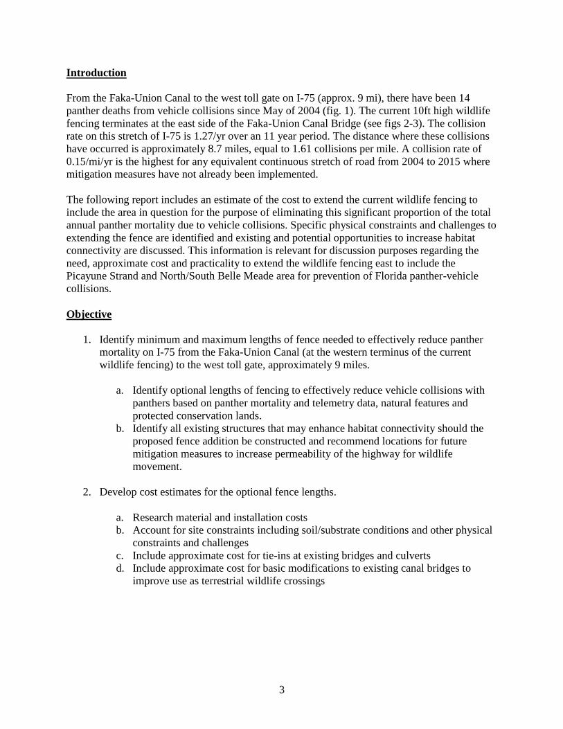
From the Faka-Union Canal to the west toll gate on I-75 (approx. 9 mi), there have been 14
panther deaths from vehicle collisions since May of 2004 (fig. 1). The current 10ft high wildlife
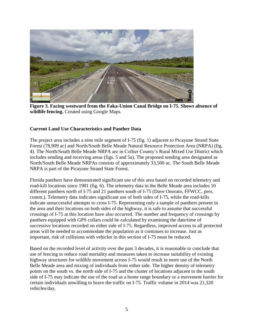
fencing terminates at the east side of the Faka-Union Canal Bridge (see figs 2-3). The collision
rate on this stretch of I-75 is 1.27/yr over an 11 year period. The distance where these collisions
have occurred is approximately 8.7 miles, equal to 1.61 collisions per mile. A collision rate of
0.15/mi/yr is the highest for any equivalent continuous stretch of road from 2004 to 2015 where
mitigation measures have not already been implemented.
The following report includes an estimate of the cost to extend the current wildlife fencing to
include the area in question for the purpose of eliminating this significant proportion of the total
annual panther mortality due to vehicle collisions. Specific physical constraints and challenges to
extending the fence are identified and existing and potential opportunities to increase habitat
connectivity are discussed. This information is relevant for discussion purposes regarding the
need, approximate cost and practicality to extend the wildlife fencing east to include the
Picayune Strand and North/South Belle Meade area for prevention of Florida panther-vehicle
collisions.
Objective
1. Identify minimum and maximum lengths of fence needed to effectively reduce panther
mortality on I-75 from the Faka-Union Canal (at the western terminus of the current
wildlife fencing) to the west toll gate, approximately 9 miles.
a. Identify optional lengths of fencing to effectively reduce vehicle collisions with
panthers based on panther mortality and telemetry data, natural features and
protected conservation lands.
b. Identify all existing structures that may enhance habitat connectivity should the
proposed fence addition be constructed and recommend locations for future
mitigation measures to increase permeability of the highway for wildlife
movement.
2. Develop cost estimates for the optional fence lengths.
a. Research material and installation costs
b. Account for site constraints including soil/substrate conditions and other physical
constraints and challenges
c. Include approximate cost for tie-ins at existing bridges and culverts
d. Include approximate cost for basic modifications to existing canal bridges to
improve use as terrestrial wildlife crossings
4
Figure 1. Project area including location of existing bridges (yellow pins), Florida panther
(red triangles) and black bear (orange circles) road-kills. Green shading indicates public
conservation lands.
Figure 2. Terminus of existing wildlife fence at Faka-Union Canal on I-75 (facing south).
Created using Google Maps.
9 mi (total project length)
5
Figure 3. Facing westward from the Faka-Union Canal Bridge on I-75. Shows absence of
wildlife fencing. Created using Google Maps.
Current Land Use Characteristics and Panther Data
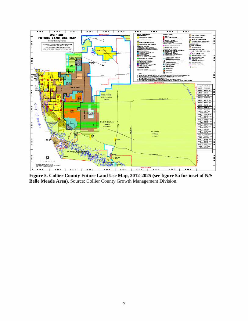
The project area includes a nine mile segment of I-75 (fig. 1) adjacent to Picayune Strand State
Forest (78,909 ac) and North/South Belle Meade Natural Resource Protection Area (NRPA) (fig.
4). The North/South Belle Meade NRPA are in Collier County’s Rural Mixed Use District which
includes sending and receiving areas (figs. 5 and 5a). The proposed sending area designated as
North/South Belle Meade NRPAs consists of approximately 33,500 ac. The South Belle Meade
NRPA is part of the Picayune Strand State Forest.
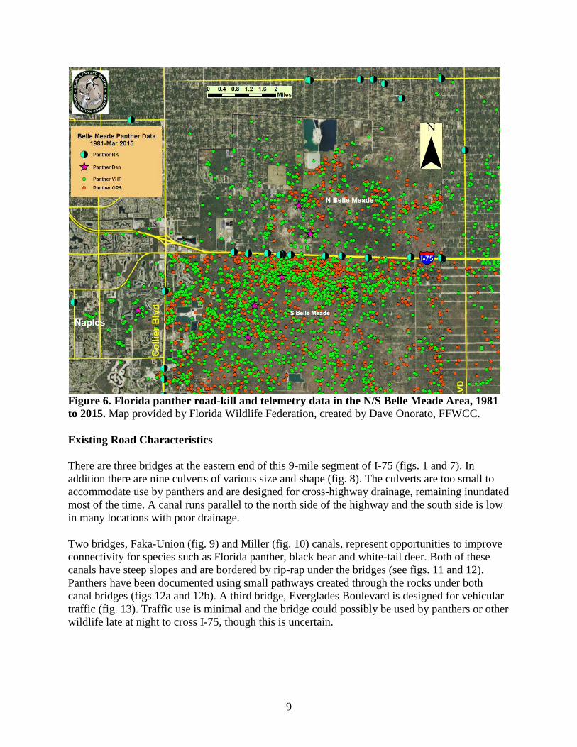
Florida panthers have demonstrated significant use of this area based on recorded telemetry and
road-kill locations since 1981 (fig. 6). The telemetry data in the Belle Meade area includes 10
different panthers north of I-75 and 21 panthers south of I-75 (Dave Onorato, FFWCC, pers.
comm.). Telemetry data indicates significant use of both sides of I-75, while the road-kills
indicate unsuccessful attempts to cross I-75. Representing only a sample of panthers present in
the area and their locations on both sides of the highway, it is safe to assume that successful
crossings of I-75 at this location have also occurred. The number and frequency of crossings by
panthers equipped with GPS collars could be calculated by examining the date/time of
successive locations recorded on either side of I-75. Regardless, improved access to all protected
areas will be needed to accommodate the population as it continues to increase. Just as
important, risk of collisions with vehicles in this section of I-75 must be reduced.
Based on the recorded level of activity over the past 3 decades, it is reasonable to conclude that
use of fencing to reduce road mortality and measures taken to increase suitability of existing
highway structures for wildlife movement across I-75 would result in more use of the North
Belle Meade area and mixing of individuals from either side. The higher density of telemetry
points on the south vs. the north side of I-75 and the cluster of locations adjacent to the south
side of I-75 may indicate the use of the road as a home range boundary or a movement barrier for
certain individuals unwilling to brave the traffic on I-75. Traffic volume in 2014 was 21,320
vehicles/day.

6
Figure 4. Collier County existing land inventory (modified from Collier County Growth
Management Division, January 2015). Area of interest circled in red includes N/S Belle
Meade.
7
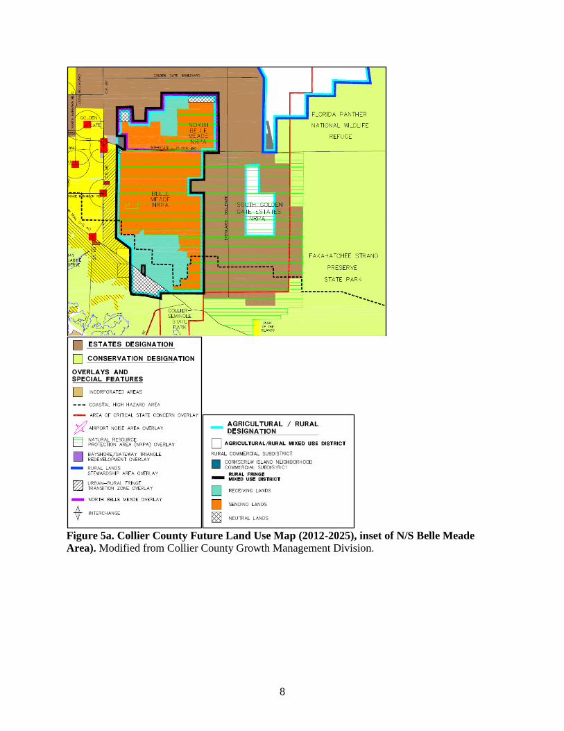
Figure 5. Collier County Future Land Use Map, 2012-2025 (see figure 5a for inset of N/S
Belle Meade Area). Source: Collier County Growth Management Division.
8
Figure 5a. Collier County Future Land Use Map (2012-2025), inset of N/S Belle Meade
Area). Modified from Collier County Growth Management Division.
9
Figure 6. Florida panther road-kill and telemetry data in the N/S Belle Meade Area, 1981
to 2015. Map provided by Florida Wildlife Federation, created by Dave Onorato, FFWCC.
Existing Road Characteristics
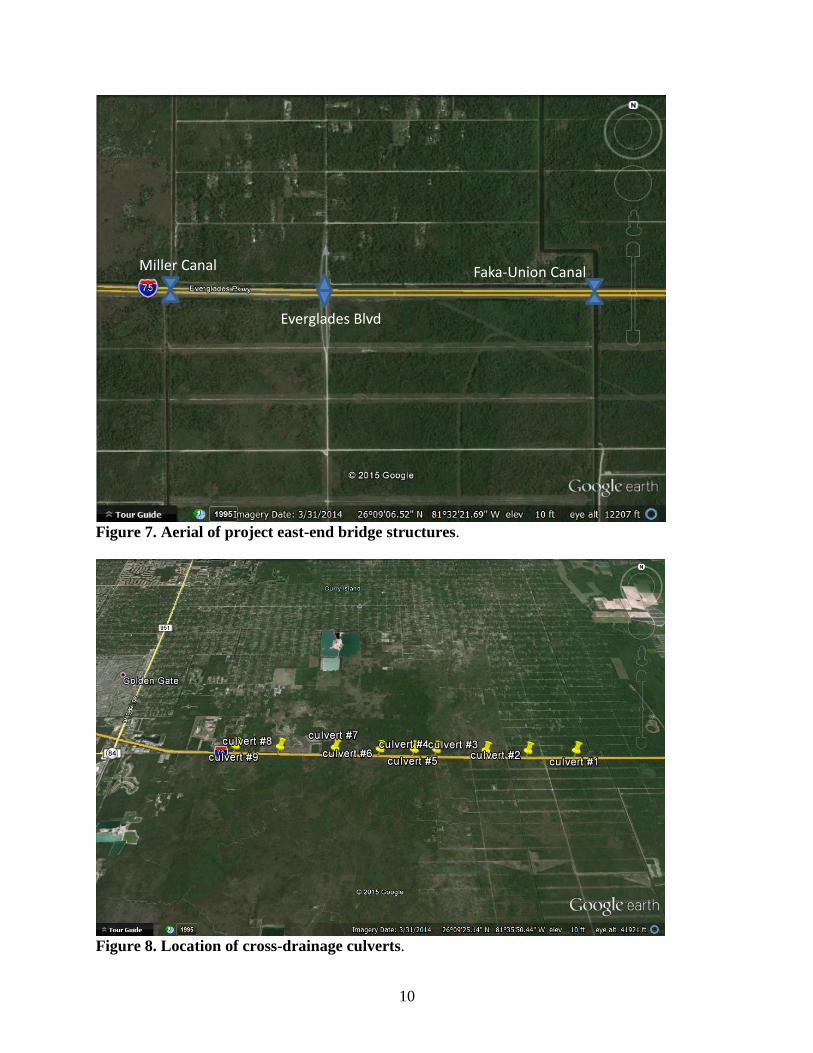
There are three bridges at the eastern end of this 9-mile segment of I-75 (figs. 1 and 7). In
addition there are nine culverts of various size and shape (fig. 8). The culverts are too small to
accommodate use by panthers and are designed for cross-highway drainage, remaining inundated
most of the time. A canal runs parallel to the north side of the highway and the south side is low
in many locations with poor drainage.
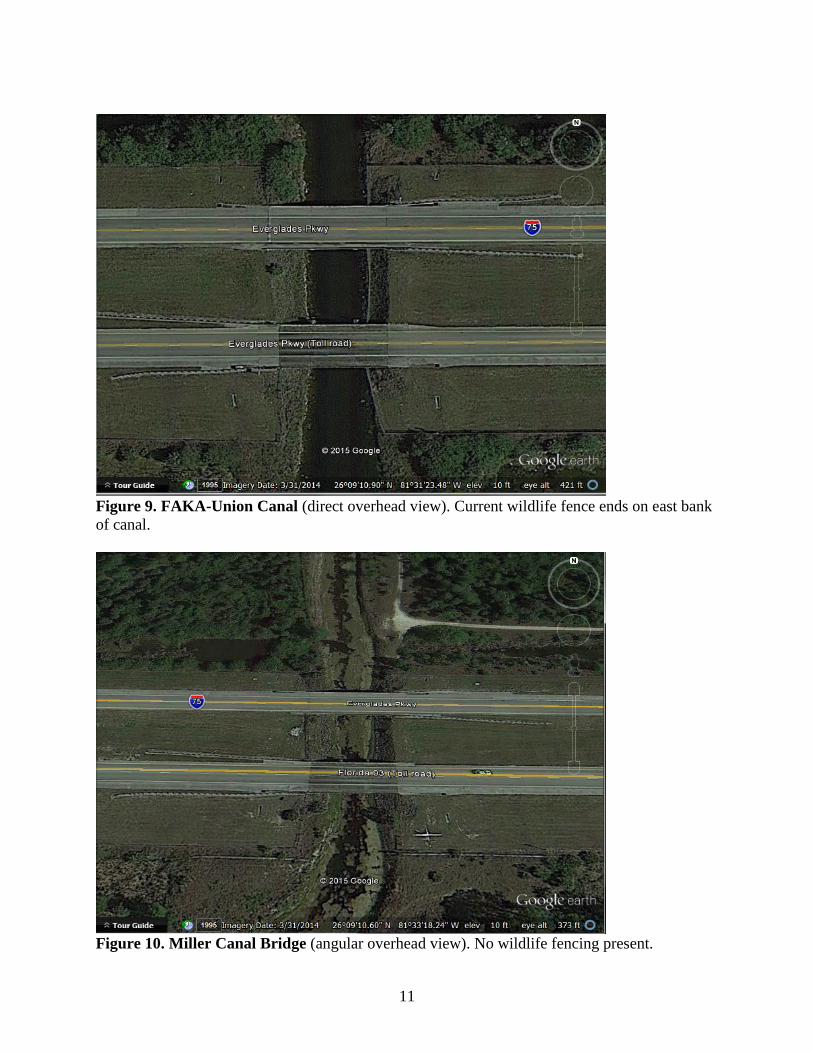
Two bridges, Faka-Union (fig. 9) and Miller (fig. 10) canals, represent opportunities to improve
connectivity for species such as Florida panther, black bear and white-tail deer. Both of these
canals have steep slopes and are bordered by rip-rap under the bridges (see figs. 11 and 12).
Panthers have been documented using small pathways created through the rocks under both
canal bridges (figs 12a and 12b). A third bridge, Everglades Boulevard is designed for vehicular
traffic (fig. 13). Traffic use is minimal and the bridge could possibly be used by panthers or other
wildlife late at night to cross I-75, though this is uncertain.
10
Figure 7. Aerial of project east-end bridge structures.
Figure 8. Location of cross-drainage culverts.
Everglades Blvd
Miller Canal Faka-Union Canal
11
Figure 9. FAKA-Union Canal (direct overhead view). Current wildlife fence ends on east bank
of canal.
Figure 10. Miller Canal Bridge (angular overhead view). No wildlife fencing present.
12
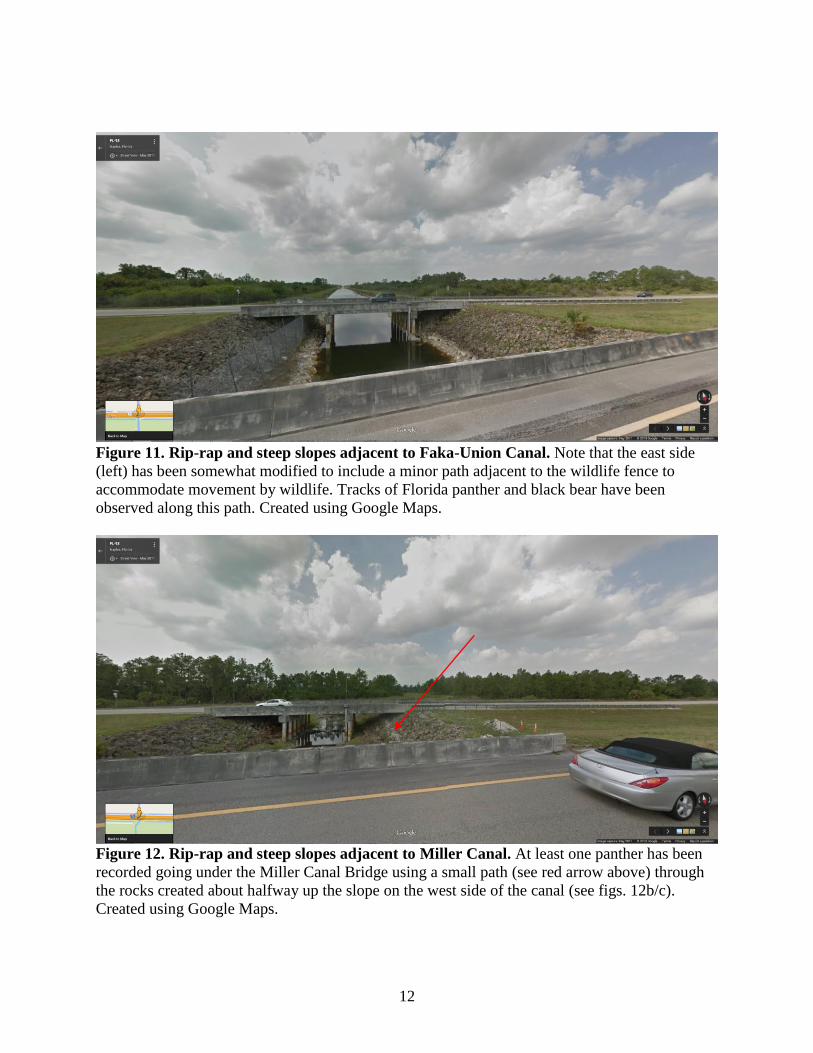
Figure 11. Rip-rap and steep slopes adjacent to Faka-Union Canal. Note that the east side
(left) has been somewhat modified to include a minor path adjacent to the wildlife fence to
accommodate movement by wildlife. Tracks of Florida panther and black bear have been
observed along this path. Created using Google Maps.
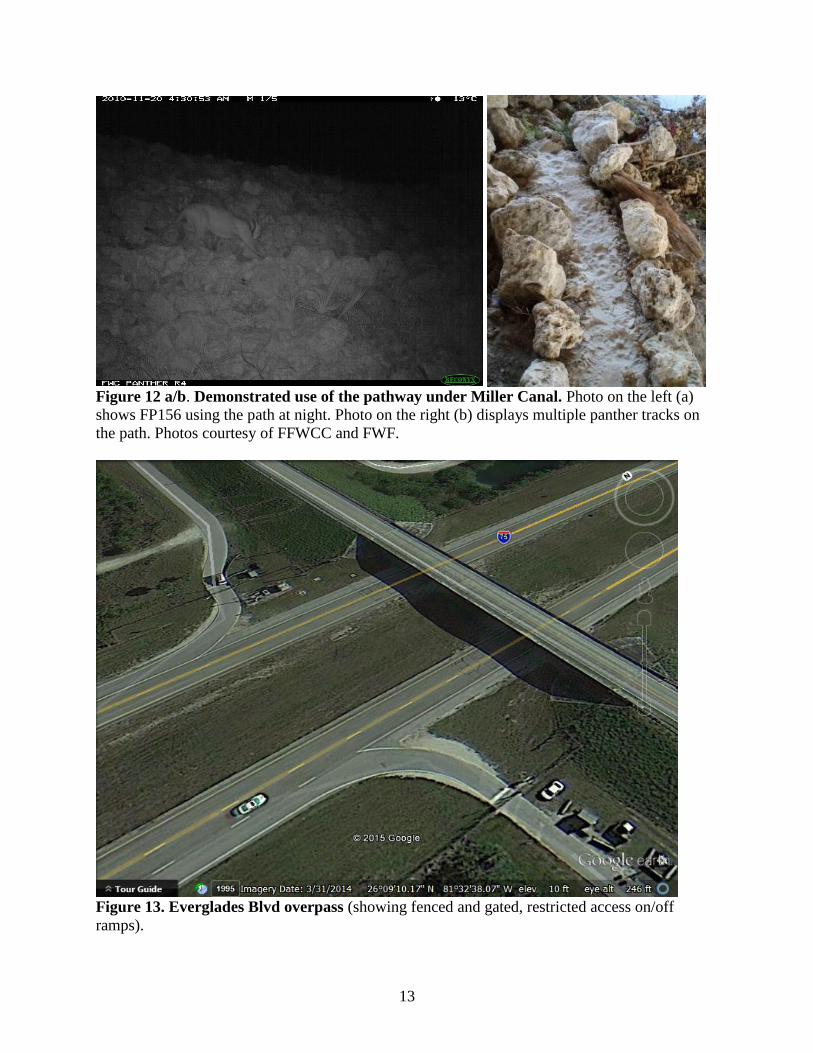
Figure 12. Rip-rap and steep slopes adjacent to Miller Canal. At least one panther has been
recorded going under the Miller Canal Bridge using a small path (see red arrow above) through
the rocks created about halfway up the slope on the west side of the canal (see figs. 12b/c).
Created using Google Maps.
13
Figure 12 a/b. Demonstrated use of the pathway under Miller Canal. Photo on the left (a)
shows FP156 using the path at night. Photo on the right (b) displays multiple panther tracks on
the path. Photos courtesy of FFWCC and FWF.
Figure 13. Everglades Blvd overpass (showing fenced and gated, restricted access on/off
ramps).
14
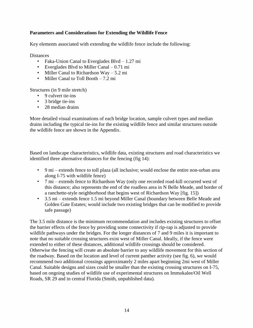
Parameters and Considerations for Extending the Wildlife Fence
Key elements associated with extending the wildlife fence include the following:
Distances
• Faka-Union Canal to Everglades Blvd – 1.27 mi
• Everglades Blvd to Miller Canal – 0.71 mi
• Miller Canal to Richardson Way – 5.2 mi
• Miller Canal to Toll Booth – 7.2 mi
Structures (in 9 mile stretch)
• 9 culvert tie-ins
• 3 bridge tie-ins
• 28 median drains
More detailed visual examinations of each bridge location, sample culvert types and median
drains including the typical tie-ins for the existing wildlife fence and similar structures outside
the wildlife fence are shown in the Appendix.
Based on landscape characteristics, wildlife data, existing structures and road characteristics we
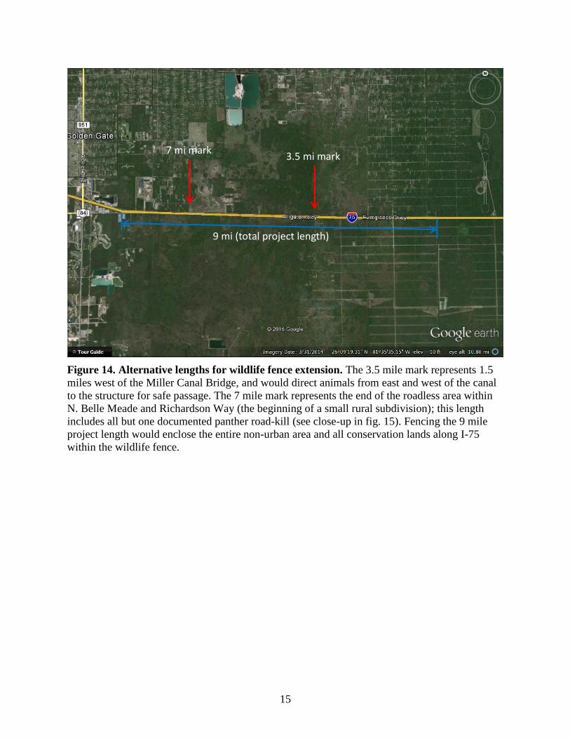
identified three alternative distances for the fencing (fig 14):
• 9 mi – extends fence to toll plaza (all inclusive; would enclose the entire non-urban area
along I-75 with wildlife fence)
• 7 mi – extends fence to Richardson Way (only one recorded road-kill occurred west of
this distance; also represents the end of the roadless area in N Belle Meade, and border of
a ranchette-style neighborhood that begins west of Richardson Way [fig. 15])
• 3.5 mi – extends fence 1.5 mi beyond Miller Canal (boundary between Belle Meade and
Golden Gate Estates; would include two existing bridges that can be modified to provide
safe passage)
The 3.5 mile distance is the minimum recommendation and includes existing structures to offset
the barrier effects of the fence by providing some connectivity if rip-rap is adjusted to provide
wildlife pathways under the bridges. For the longer distances of 7 and 9 miles it is important to
note that no suitable crossing structures exist west of Miller Canal. Ideally, if the fence were
extended to either of these distances, additional wildlife crossings should be considered.
Otherwise the fencing will create an absolute barrier to any wildlife movement for this section of
the roadway. Based on the location and level of current panther activity (see fig. 6), we would
recommend two additional crossings approximately 2 miles apart beginning 2mi west of Miller
Canal. Suitable designs and sizes could be smaller than the existing crossing structures on I-75,
based on ongoing studies of wildlife use of experimental structures on Immokalee/Oil Well
Roads, SR 29 and in central Florida (Smith, unpublished data).
15
Figure 14. Alternative lengths for wildlife fence extension. The 3.5 mile mark represents 1.5
miles west of the Miller Canal Bridge, and would direct animals from east and west of the canal
to the structure for safe passage. The 7 mile mark represents the end of the roadless area within
N. Belle Meade and Richardson Way (the beginning of a small rural subdivision); this length
includes all but one documented panther road-kill (see close-up in fig. 15). Fencing the 9 mile
project length would enclose the entire non-urban area and all conservation lands along I-75
within the wildlife fence.
9 mi (total project length)
7 mi mark 3.5 mi mark
16
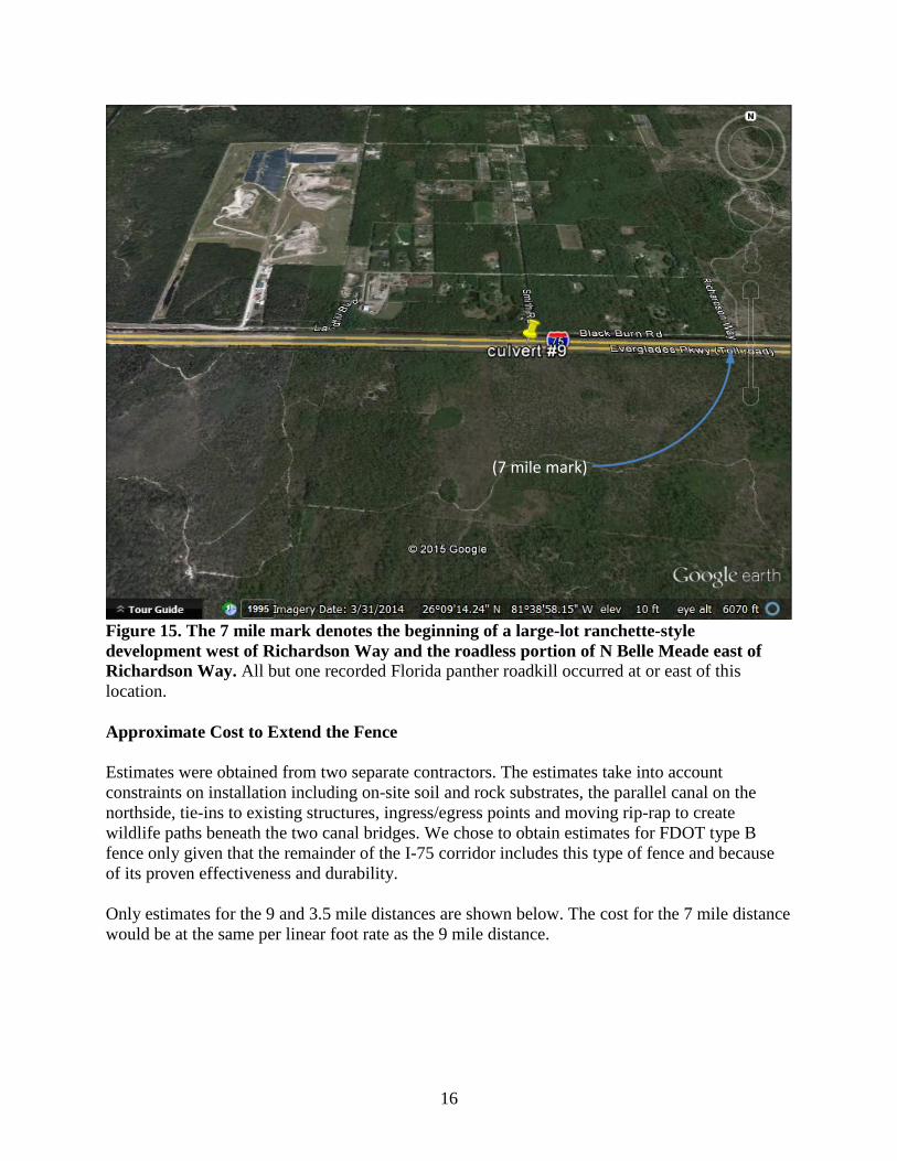
Figure 15. The 7 mile mark denotes the beginning of a large-lot ranchette-style
development west of Richardson Way and the roadless portion of N Belle Meade east of
Richardson Way. All but one recorded Florida panther roadkill occurred at or east of this
location.
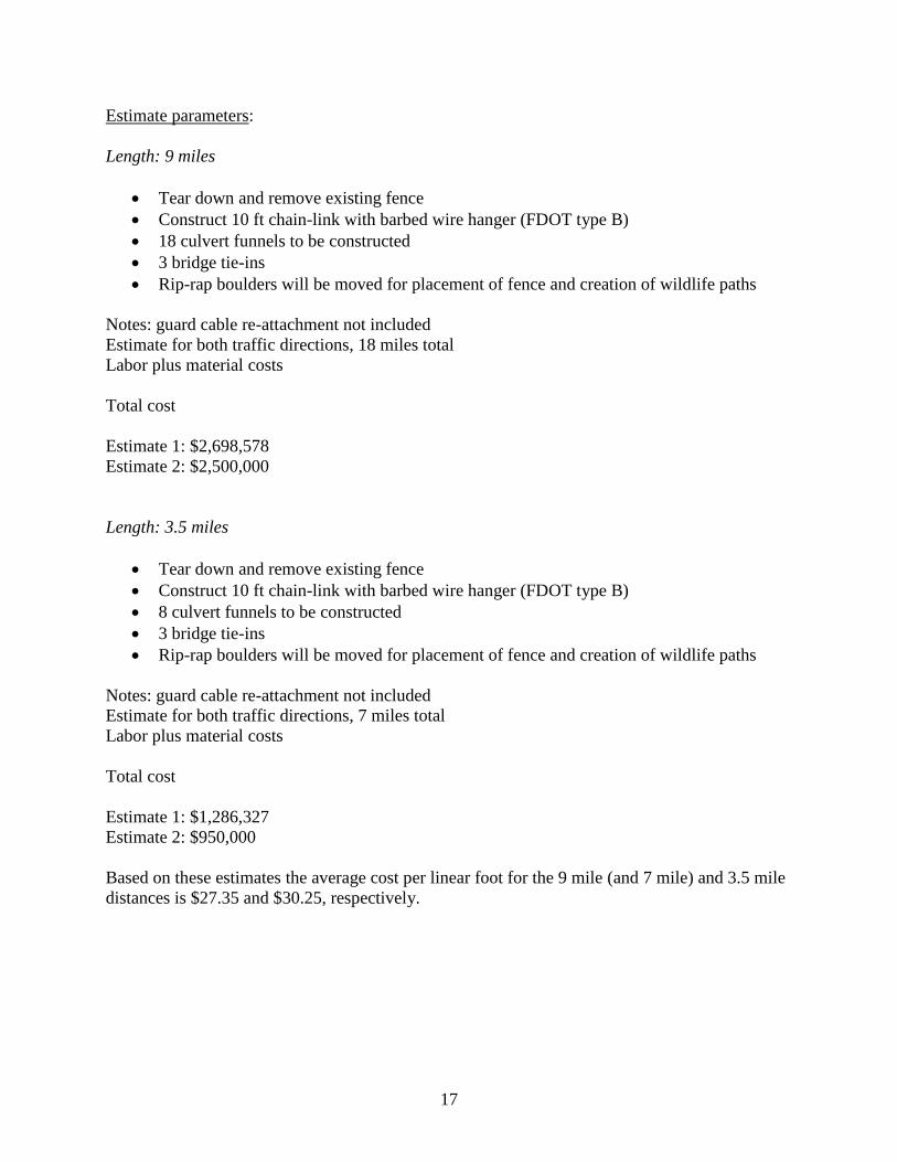
Approximate Cost to Extend the Fence
Estimates were obtained from two separate contractors. The estimates take into account
constraints on installation including on-site soil and rock substrates, the parallel canal on the
northside, tie-ins to existing structures, ingress/egress points and moving rip-rap to create
wildlife paths beneath the two canal bridges. We chose to obtain estimates for FDOT type B
fence only given that the remainder of the I-75 corridor includes this type of fence and because
of its proven effectiveness and durability.
Only estimates for the 9 and 3.5 mile distances are shown below. The cost for the 7 mile distance
would be at the same per linear foot rate as the 9 mile distance.
(7 mile mark)
17
Estimate parameters:
Length: 9 miles
Tear down and remove existing fence
Construct 10 ft chain-link with barbed wire hanger (FDOT type B)
18 culvert funnels to be constructed
3 bridge tie-ins
Rip-rap boulders will be moved for placement of fence and creation of wildlife paths
Notes: guard cable re-attachment not included
Estimate for both traffic directions, 18 miles total
Labor plus material costs
Total cost
Estimate 1: $2,698,578
Estimate 2: $2,500,000
Length: 3.5 miles
Tear down and remove existing fence
Construct 10 ft chain-link with barbed wire hanger (FDOT type B)
8 culvert funnels to be constructed
3 bridge tie-ins
Rip-rap boulders will be moved for placement of fence and creation of wildlife paths
Notes: guard cable re-attachment not included
Estimate for both traffic directions, 7 miles total
Labor plus material costs
Total cost
Estimate 1: $1,286,327
Estimate 2: $950,000
Based on these estimates the average cost per linear foot for the 9 mile (and 7 mile) and 3.5 mile
distances is $27.35 and $30.25, respectively.