corrrUJprre ecy ggqâe Mgece 268 LOOK saa qoe 80 · PDF filebLO'6CÇ!OLJ Bosq...
2
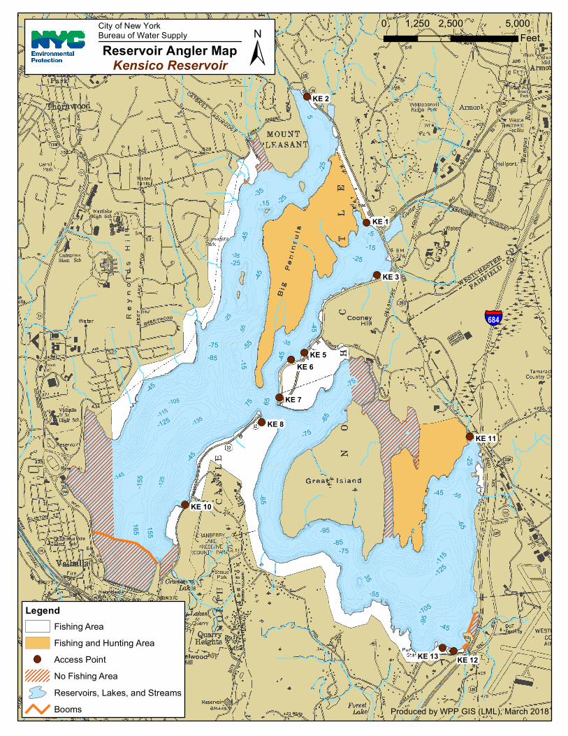
-35 -25 -35 -115 -105 -135 -55 -145 -125 -55 -65 -25 -45 -85 -45 -125 155 165 5 -95 -15 5 5 -45 -65 75 -105 -75 -65 -45 -45 -115 -75 65 -75 -125 -155 -45 -45 -55 -85 -25 -25 -25 -75 -45 -95 35 15 -35 -5 -15 -25 -55 KE 2 KE 1 KE 3 KE 5 KE 6 KE 7 KE 8 KE 13 KE 12 KE 11 KE 10 0 2,500 5,000 1,250 Feet Produced by WPP GIS (LML), March 2018 ± Reservoir Angler Map Kensico Reservoir City of New York Bureau of Water Supply § ¨ ¦ 684 Legend Fishing Area Fishing and Hunting Area Access Point No Fishing Area Reservoirs, Lakes, and Streams Booms
Transcript of corrrUJprre ecy ggqâe Mgece 268 LOOK saa qoe 80 · PDF filebLO'6CÇ!OLJ Bosq...
-35
-25
-35
-115-105
-135
-55
-145
-125
-55
-65
-25
-45
-85
-45
-125155
165
5
-95
-15
5
5
-45
-65
75
-105
-75
-65 -45
-45
-115
-75
65
-75
-125
-155
-45
-45
-55
-85
-25
-25
-25
-75
-45
-95
3515
-35
-5-15
-25
-55
KE 2
KE 1
KE 3
KE 5KE 6
KE 7
KE 8
KE 13 KE 12
KE 11
KE 10
0 2,500 5,0001,250Feet
Produced by WPP GIS (LML), March 2018
±Reservoir Angler MapKensico Reservoir
City of New YorkBureau of Water Supply
§̈¦684
LegendFishing AreaFishing and Hunting AreaAccess PointNo Fishing AreaReservoirs, Lakes, and StreamsBooms

General Restrictions:
Please stay back 500’ from all buildings and water supply structures
No floating booms or structure shall be crossed, and if present, shall serve as a marker for restricted areas.
No trespassing on islands
KENSICO
Dam and Spillway area:
Located on the southwestern end of the reservoir, boaters must stay back from the dam and spillway. The
eastern border runs roughly from the tip of the peninsula on the north to the floating boom, which designates
the southernmost restricted area.
Great Island and Louden Point:
No entrance into Dark Hollow Cove starting at the southernmost portion of the channel. Boating within the
eastern end of cove north of Great Island is also restricted.
Kensico North End Restriction:
No entrance into the cove located directly south of Nanny Hagen Road.