Corridor Management Plan for the Scenic Highway Scenic …Corridor Management Plan for the Lady...
32
Corridor Management Plan for the Lady Slipper Scenic Byway 3/12/2015
Transcript of Corridor Management Plan for the Scenic Highway Scenic …Corridor Management Plan for the Lady...

Corridor Management Plan for the Lady Slipper Scenic Byway
3/12/2015

1
Introduction
The Lady Slipper Scenic Byway is located in Northern Minnesota along a 28-mile drive that follows County Road 39 between the small, northwoods town of Blackduck and Highway 2 east of the Town of Cass Lake. The largest nearby city is Bemidji, about 20 miles west of the byway.
The Byway has a portion in common with the Great River Road National Scenic Byway, which follows the course of the Mississippi River for 3,000 miles from northern Minnesota to the Gulf of Mexico. The scenic route passes through 10 states and hundreds of river towns. Scenic Byways are roads that have been nominated by local communities to introduce travelers to the uniqueness of the area. Byways can be designated at the national, state or local level. The National Scenic Byways Program began in 1989 and is administered by the Federal Highway Administration. Communities support scenic byways for various reasons including tourism revenue, resource management and protection, and economic development assistance. Scenic Byway designation also provides links to professional expertise and information sources to assist with implementing future projects along the byway. The following Corridor Management Plan (CMP) was developed to guide the management and future development of the intrinsic resources that form the character of the Lady Slipper Scenic Byway. The CMP will provide those agencies, organizations, and individuals who have an interest in the byway with a common vision and a set of common goals and objectives for managing and developing the byway and the property adjacent to it.
2
THE STORY The landscape that attracts visitors to the Lady Slipper Scenic Byway today is a product of its history. It is a rich, yet subtle history that is quietly told by the terrain and waterways, the vegetation and wildlife, and finally by the human settlement patterns which compose the landscape. The landscape waits quietly, telling its stories to those who stop long enough, and care enough, to listen. It is a history of a landscape that was formed by glaciers, inhabited by Native Americans, and employed by European Americans. The stories the landscape holds are more than a mere collection of historical facts, however. They are stories of how humanity and the landscape belong to each other and how one without the other can become lost. This deeper story is more subtle. It engages tourists and residents in a more thorough and thoughtful manner as it explains the relationship between the landscape and the people who have been nurtured by it for thousands of years. Although premised on historical facts, it tells a compelling story that changes our perspective of the landscape and ourselves. The Lady Slipper Scenic Byway – perhaps more than other byways in the state – provides an opportunity to explore not only the relationship people have with their landscape but more precisely the way a person and the landscape have a responsibility to each other – that both are stewards of the other; by restoring one, the other is restored. It is this ability of the landscape to re-create people, to provide recreation, which is central to the purpose of this byway. Recreation is the pivotal intrinsic resource that must be maintained and developed if this byway is to be successful. Natural resources, which form the basis for recreational activities, must also be conserved and access to them enhanced. Archeological and historical resources provide lessons to the byway traveler about the different ways that the landscape has nurtured the societies that have inhabited it for thousands of years. Modern cultural resources may provide opportunities for the byway traveler to participate in community celebrations or observe – and possibly even practice – traditional arts and crafts. Woven together, these five types of resources – recreation, natural, archeological, historical, and cultural, become the scenic resources that gave the byway its original name.
AN EVOLVING RELATIONSHIP Historically, the corridor has sustained many people throughout many eras. It was the homeland for generations of Native Americans and provided the resources necessary for their traditional way of life. It supplied European and American fur traders with animal pelts. It supplied trees to loggers and logging provided a reason to establish communities. It gave the men in Civilian Conservation Corps a purpose, a job, and training while they restored the area’s natural resources and constructed its infrastructure, including the . Today, residents and visitors come to the Lady Slipper Scenic Byway to experience the majestic character of the great North Woods and a chance to connect to the natural world through recreational activities such as fishing, camping, hiking, and snowmobiling. It is a combination of the awe-inspiring natural beauty of the lakes and woods and the awareness that generations of
3
humans have worked with and learned from this landscape that creates the legacy that attracts the tourist and sustains the resident. Tomorrow, the Lady Slipper Scenic Byway will continue to provide visitors with a scenic route to recreational opportunities that can only be found in a natural environment. It will enable future generations of travelers to experience the “up north” character of the area. The byway will continue to link people with their surroundings. The recreational resources will engage and challenge people physically, emotionally, and intellectually. It will provide them with opportunities for exercise, opportunities to be inspired, and opportunities to learn about the land and the people who have lived on it. THE TARGET AUDIENCE The Byway’s target audience includes campers, outdoor recreation enthusiasts, and naturalists. These visitors want to participate and connect with the landscape rather than be entertained, the audience will tend to be composed of individuals or limited to small groups and families. The byway is best positioned to attract those who want to travel “off the beaten path” by themselves or in small groups. Developing interruptive sites and recreation resources that attract these customers will be important to the byway’s success.

4
Purpose of the CMP Update The purpose of this update is twofold. First, MnDOT and the HRDC are summarizing new information for the Lady Slipper Scenic Byway and all state byways concerning Federal and state funds. With the introduction of the recent Federal transportation bill titled “Moving Ahead for Progress in the 21st Century Act” (MAP-21), Federal funding for scenic byway infrastructure has been combined with transportation enhancements and Safe Routes to School into the Transportation Alternatives Program (TAP). Because of this change, MnDOT and the HRDC need to prepare byway groups for the following changes:
• Some Scenic Byway projects allowed under previous funding are no longer eligible under new TAP guidelines. Projects that are now ineligible under TAP include acquisition of scenic easements & historic sites, landscaping, historic preservation, promotional materials, and general recreation facilities (park benches, playground equipment, sports fields).
• Because 3 former Federal funding sources are now 1 program, there is less money available to byways each year. Byway groups will need to be able to match more funding sources together to create complete improvement projects.
• TAP criteria for project selection is still focused on bike & pedestrian improvements. MnDOT and the HRDC are creating these updates to help byways to consider new trail and multimodal projects that fit the TAP criteria. MnDOT and the HRDC will also work to broaden the TAP criteria and selection process in Minnesota, allowing for better consideration of traditional scenic byway projects.
The HRDC and MnDOT have created a more complete list of funding available for byway groups, available in the Implementation section of this plan. The other reason for updating the Lady Slipper Scenic Byway CMP is to create an updated list of projects for the byway group to pursue. The focus was to find some new projects that could fit the new TAP guidelines, as well as identify additional priorities that could fit other funding sources. The Lady Slipper Scenic Byway group has been very active in completing improvements in the past decade, so most projects from the byway’s original CMP have been scheduled or completed. This warranted a need for an updated list of potential projects and a thorough review of the group’s original CMP from 2005. The following sections are an update of the 2005 CMP, originally submitted by HNTB. Through the 2014-15 planning process, the byway group updated the information in the Administration and Intrinsic Qualities sections. A new Goals and Objectives section outlines new projects to pursue with TAP and other funding, and maps in the Appendix show the location of these projects and other areas of interest.

5
Administration Responsibility for managing the experience along the scenic byway is handled primarily by the Lady Slipper Scenic Byway Leadership Board. The Byway Leadership Board governs the byway by a set of bylaws and consists of a Board of Directors including representatives from the following organizations:
• Byway Officers and Board Members as of 2015 • President-Mike Supan • Vice President-Steve Ross • Treasurer- Joe Rossi • Secretary-Shirley Gilmore • Local Residents: George-Ann Maxson, Steve Ross, Deb Hudak • Leech Lake Band of Ojibwe and Local Resident: Sally Fineday • Beltrami County Highway Department Advisors: John Noehring, Bruce Hasbargen • Chippewa National Forest Advisors: Christine Brown, Ken Hanson • MNDOT Advisors: Carol Zoff
MISSION STATEMENT: The Byway Board implements and updates the Corridor Management Plan by maintaining partnerships to ensure that the values of the community are being incorporated.
VISION STATEMENT: The vision of the Lady Slipper Scenic Byway is to enhance the experience of visitors, the quality of life for residents and the economic vitality of the community by preserving and improving the byway corridor’s intrinsic resources.
STATEMENT OF COMMUNITY RESPONSIBILITY • To define the value that the scenic byway corridor has to the local community and to
understand the value it has to the visitor. • To manage the corridor in a way that sustains us, our way of life and attracts visitors. • To protect the character of the byway corridor by fostering an appreciation of the
byway’s intrinsic values and the stewardship that sustains those values. • To ensure that our activities and developments protect and enhance these resources and
reinforce these values. • To create the opportunity for visitors to discover the value this corridor has for us,
particularly how its’ inherent beauty and its’ recreational resources refresh, restore and rejuvenate people.

6
Intrinsic Qualities The Lady Slipper Scenic Byway corridor is home to abundant resources. There are numerous unique resources that give the byway marvelous character and provide unique experiences for the resident and visitor alike. The following identification and evaluation of the byway’s existing intrinsic resources will allow resource managers to define the condition of the resources they are mandated to oversee. Most of the resources listed in this plan are subject to other jurisdictional controls, regulations, and plans that have been produced by the agencies or organizations that are legally responsible for their management. The Byway Leadership Board is purposefully composed of representatives from these regulatory and management agencies. It will be the responsibility of these representatives to act as a liaison between the board and their agencies to coordinate management goals and strategies for the resources they are obligated to manage. Intrinsic qualities are the essential resource attraction of scenic byways and are defined as “features that are considered representative, unique, irreplaceable, or distinctly characteristic of an area.” Intrinsic qualities arise from a byway’s particular combination of resources that define its character, interest and appeal. These resources are the special views, places, buildings, sites and other features that residents enjoy and that provide the byway’s drawing power and interest for travelers. A resource can be natural, such as a forest or lake; or it may be the result of human activity, such as a historic building, a statue, or developed recreation area. The Scenic Byways program recognizes six intrinsic resource categories.
RECREATIONAL RESOURCES Recreational Resources involve outdoor recreational activities directly associated with and dependent upon the natural and cultural elements of the corridor’s landscape. The recreational activities provide opportunities for active and passive recreational experiences. Many recreational activities are seasonal, but some recreational facilities can serve activities in several seasons.
CAMPING The Chippewa National Forest offers many scenic campsites near the byway. Near the southern end of the byway you’ll discover the Norway Beach Recreation Area, where there are 170 campsites in four campgrounds, including sites that can be reserved and ones with electric hook-ups. There are also 14 campsites at Knutson Dam and 24 at the Webster Lake Campground; both are located just off of the byway. Camping opportunities include:
• Cass Lake Campground • Chippewa Campground

7
• Knutson Dam Campground • Pine Tree Park • Norway Beach Campground • Nushka Group Campground • Schram Lake Primitive Camping • South Pike Bay Campground • Star Lake Dispersed Campsites • Wanaki Campground • Webster Lake Campground • Winnie Campground
HIKING The Byway corridor offers a wealth of hiking opportunities for all types of users including but not limited to hikers, birders, hunters, and equestrians. The corridor is enhanced by these existing opportunities and opportunities for new trails, extensions, and connections exist. Hiking opportunities include:
• Camp Rabideau Trails • Meadow Lake Trails • Norway Beach Interpretive Trail • Star Island Trails • Tower Lake Trails • Webster Lake Trails
BICYCLING Travelers to the byway will find more than 300 miles of trails on and near the Lady Slipper Scenic Byway. The Mississippi River Trail (MRT) has been designated as Minnesota’s first U.S. Bike Route. The Minnesota Department of Transportation has mapped a route along the entire length of the river in Minnesota. This trail connects to and follows a portion of the Lady Slipper Byway just south of Pennington. Very near the southern end of the byway is the paved Migizi Bike Trail, sometimes spelled Mi-Ge-Zi, which is the Ojibwe word for eagle. The trail, great for both biking and rollerblading, circles around three sides of Pike Bay Lake. A 1.5 mile spur links the trail to the Norway Beach Recreation Area, adjacent to Cass Lake. This 7-mile stretch of trail along Pike Bay takes you past beautiful Red and White Pine forests that are especially scenic. The Migizi Trail is a 14-mile circle route around Pike Bay, with other “links” going in all directions. One link is to the Heartland Bike Trail, leading you into the City of Cass Lake. This trail is paved and stretches 34 miles from Walker to Park Rapids. Another takes you to the Paul Bunyan Trail, linking Bemidji, Cass Lake and Brainerd. Bicycling opportunities include: • Mississippi River Trail (MRT)
• Heartland Trail • Mi-Gi-Zi Paved Bike Trails
8
ATV/SNOWMOBILING The byway offers an amazing array of opportunities to explore the area on snowmobile or ATV. The region boasts almost 400 miles of groomed snowmobile trails and countless recreational ATV Trails. ATV/Snowmobiling opportunities include
• Heartland Trail • Soo Line ATV Trail
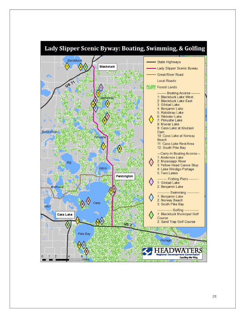
SWIMMING Designated Swimming beaches include:
• Benjamin Lake • Norway Beach • South Pike Bay
FISHING PIERS • Benjamin Lake • Gilstad Lake
BOATING ACCESS When people think about the byway, one of the first things that comes to mind is the many lakes, rivers, and streams that are located within the Byway. Boating Access
• Benjamin Lake • Blackduck Lake East Landing • Blackduck Lake West Landing • Cass Lake at Knutson Dam • Cass Lake at Norway Beach • Cass Lake at Roadside Park • Gilstad Lake • Pimushe Lake • Moose Lake • Rabideau Lake • South Pike Bay • Webster Lake
Carry-in Boating Access • Anderson Lake

9
• Mississippi River • South & North Twin Lakes • Lake Windigo Portage • Yellow Head Canoe Stop
GOLF 2 Golf courses are located along the Byway and within the corridor.
• Blackduck Municipal Course • Sand Trap Golf Course
I M P L I C A T I O N S : There are many recreational opportunities throughout the corridor, most tied to being outside in nature. Some of these recreational activities compete or conflict with each other. Some competition and conflict stems from having different agencies or organizations managing competing or conflict activities. Some are just naturally at odds, such as motorized and non-motorized use of trails.
SCENIC RESOURCES Scenic resources are the views of the natural and cultural environment that compose the scenic byway corridor. The visual character of the landscape, especially those elements that are strikingly distinct and offer a pleasing and most memorable visual experience, will be identified and maintained. Although natural resources will dominate a list of scenic resources, human made artifacts in this case may also contribute to the quality of the corridor’s visual environment. Scenic resources of the byway include:
• Fall Color Drives • Great River Road • Summer Showy Lady’s Slipper viewing • Forests • Chippewa National Forest • Pine Tree Park • Star Island • Ten Section Area • Wetlands • Webster Lake Bog • Pennington Bog • Gilfillan Biotic Area • Lakes • Anderson Lake • Benjamin Lake • Big Rice Lake • Blackduck Lake • Carls Lake

10
• Cass Lake • Gilstad Lake • Kitchi Lake • Moose Lake • Pike Bay • Pimushe Lake • Rabideau Lake • Schram Lake • Tank Lake • North & South Twin Lakes • Webster Lake • Lake Winnibigoshish • Rivers and Streams • Mississippi River • Turtle River
NATURAL RESOURCES Natural resources are those features that are a result of geological or biological processes, limited in this case, to those resources that would typically be experienced by a byway traveler. These natural resources are usually considered scenic and have already been listed in the previous section on scenic resources. Significant natural resources in the Scenic Byway corridor include landform, water bodies, vegetation, and wildlife.
LANDFORMS The landforms visible to a traveler on the Scenic Byway are the result of glaciation. Glacial drift, 200 to 600 feet deep, obscures bedrock over most of the area. The terrain is level to gently rolling with some areas becoming quite hilly. The level areas are the remnants of glacial lakes or outwash plains. The gently rolling topography is the consequence of moraines, although lakes and outwash plains. The gently rolling topography is the consequence of moraines, although lakes and outwash plains can also create similar features. Soil type is used to differentiate the actual glacial mechanism that created the rolling landscape with lakes having fine sands and clays; outwash plains composed of sandy soils; and moraines having loamy soils. The hilliest regions are the result of stagnation moraines. The story of ancient geological history, stored in the bedrock is not of particular interest to the average traveler or resident since bedrock is typically not visible in the corridor. The surface terrain, subsequently, creates the most interest providing topographic and ecological variety and determining the pattern of lakes, streams, and rivers. Using the existing landforms to explain glacial history, ecological relationships, and other interpretive topics, including settlement patterns, has good recreational and interpretive potential for the travel and resident.
11
WATER BODIES Approximately one-third of the land adjacent to the byway is covered by water. The area is covered with a web of small streams and rivers and dotted with lakes, ponds, and wetlands of various types and sizes. The nation’s largest river, the Mississippi, crosses the Byway near Knutson Dam as an outlet from Cass Lake. Two large bodies – Cass Lake and Lake Winnibigoshish – and several smaller water bodies that are also attractive for recreational use, such as Benjamin, are present along the corridor. A significant hydrological feature of the Chippewa National Forest and the Byway corridor is the Laurentian Divide, a continental divide which the Lady Slipper Scenic Byway crosses between Pennington and Blackduck. Water that falls south of the divide flows south through the Mississippi River Watershed. The corridor boasts some unique hydrological features. Pennington Bog is a Scientific and natural Area that is reserved for serious study, requiring a DNR permit to enter. A more assessable water body that is still unusual exists on Star Island in Cass Lake where a lake exists on an island in a lake. I M P L I C A T I O N S : The variety of lakes, ponds, bogs, wetlands, streams, and rivers provide for a wide range of recreational opportunities for canoeing, boating, fishing, water-fowl hunting, and other water-related sports. Landings, beaches and frequently day-use picnic grounds are associated with lakes. When frozen, the lakes make good paths for snowmobiles. Campgrounds adjacent to lakes and rivers are particularly popular. Understanding the hydrology of the region and how important it has been to human settlement patterns has good interpretive potential. The Mississippi River and Laurentian Divide provide two excellent continentally significant resources for interpretation and the lake on Star Island provides and unusual interpretive opportunity.
VEGETATION The original vegetation was a mixture of deciduous and conifer trees. White pine and red pine were present on the moraines. Jack pine was the dominant cover type on outwash plains and sandy lake plains. Hardwoods (red oak, sugar maple and basswood) grew in sheltered areas of the moraines, generally close to large lakes. Forested lowlands were occupied by black spruce, tamarack, white cedar, and black ash. Non-forested wetlands were dominated by sedge meadow communities. Much of the corridor is presently forested with aspen the most common tree species in Chippewa National Forest. Forestry is one of the primary land uses with tourism and recreation increasingly competitive. The three primary ecosystems within the Lady Slipper Scenic Byway corridor are forests including Dry Mesic Pine and Oak; Mesic Northern Hardwoods; and Boreal Hardwood

12
Conifer forest types. Aspen, birch, maple, oak, white spruce, jack pine, red pine and white pine tree species are common as indicator species within each ecosystem type. In addition to the dominant forests, there are several wetland communities that have particular interest to tourists who are interested in wildflowers, especially orchids. These colorful and unusual flowers are found in several locations although access can be difficult. A vegetative management plan was completed in 2010. The Vegetation Management plan focused on strategies to conserve and manage vegetation within a 200 foot corridor along the byway including the showy lady’s slipper. Additionally the plan mapped uplands and wetlands on the east and west side of the road corridor. The plan also made recommendations on protecting the showy lady’s slipper habitat which is of interest given that The Lady Slipper Scenic Byway (Beltrami County Highway 39) is undergoing major reconstruction. Based on these recommendations, the Lady Slipper Scenic Byway Board, in partnership with Beltrami County Highway Department, Chippewa National Forest, Minnesota Department of Natural Resources, Beltrami Electric Cooperative and the Rabideau Conservation Academy and Learning Center, have been and will be rescuing the lady's slippers prior to the construction of each phase, holding them in a temporary nursery, and restoring them to the roadway when that area's construction is completed. I M P L I C A T I O N S : The diverse vegetative patterns create an attractive array of ecological diversity. This is particularly evident in the fall as the leaves turn color on deciduous species and contrast sharply with stands of conifers. Even the subtle variation of the vegetation patterns found in wetland communities, can become more pronounced in autumn. It is not surprising therefore, that “Fall Color Tours” are a very popular recreational and interpretive pastime. Native wildflowers are of particular interest to many travelers. Both the forests and wetlands are home to several seasonal flowers. Orchids are especially popular and the area is well known for the abundance of the state flower, the Showy Lady’s Slipper. To provide a safe, accessible site to view orchids, a boardwalk was completed in 2013 at the Lady’s Slipper Interpretive Site at Pennington. Other boardwalks are located at nearby Lake Bemidji State Park and at Webster Lake Campground. Forests provide other recreational opportunities (see recreation section); homes for animals (see next section); and commodities for the timber and food industries. Explaining how people and industry have historically used the forests and how this has changed through time, would provide interesting interpretive opportunities for byway travelers.
ANIMALS The Chippewa National Forest is home to a wide variety of animal species, including a number of threatened and endangered species including the gray wolf and the Canada lynx. There are more than 300 vertebrate species in the Chippewa National Forest and approximately 239 species of birds. Waterfowl, wading birds, and others associated with the aquatic environment are especially abundant. Bald eagles are common on the Chippewa with the largest population of

13
breeding pairs in the lower 48 states; over 100 pairs are known to breed in the forest. Ospreys and other raptors are also common. There are eleven species of sport fish in the lakes and rivers on the Chippewa. They include the muskellunge, northern pike, walleye, rainbow trout, brown trout, lake trout, bass, perch, crappie, and bluegill and pumpkin seed. The Chippewa boasts a population of thirteen mussels including Wabash pigtoe, paper pondshell, giant floater, cylindrical papershell, dtrange floater, white heelsplitter, fluted-shell, creek heel splitter, black sandshell, and the fatmucket. Implications: Fishing, hunting, and animal watching are favorite recreational pursuits of people visiting the corridor. Locating and designing the facilities that support these pursuits is instrumental in managing the natural resource and the experience of people. Ongoing coordination between users, public agency resource managers, and private interests is essential and should be a top priority of the Leadership Board.
ECOLOGY Description: Several unique ecological features are located within the Scenic Byway corridor. Remnant old-growth forests and special wetlands that contain rare and unusual plants are attractions for visitors. The Ten Section Area at the southeast corner of Cass Lake is unique because it was protected from logging and contains large, old-growth white and red pine trees. The Webster Lake Bog is home to wide variety of bog plant species and the Gilfillan Biotic Area contains numerous wild orchids and white spruce. Ecological areas of the byway corridor include:
• Gilfillan Biotic Area • Ten Section Area • Webster Lake Bog
Pennington Bog
I M P L I C A T I O N S : The uniqueness and sensitivity to disturbance of certain ecological areas may preclude wholesale interpretive activities but most ecological patterns can be observed and explained to a public that is deeply interested in learning about nature and natural systems. They Byway Leadership Board should encourage coordination of interpretive efforts between public agencies.
HISTORIC RESOURCES Historic Resources encompasses legacies of the past that are distinctly associated with physical elements of the landscape, whether natural or manmade, that are of such historic significance that they educate the viewer and stir an appreciation of the past. The historic elements reflect the actions of people and my include buildings, settlement patterns, and other examples of human activity that have occurred in the era since European contact. Native American History is rich along the Byway. At the time of the white man’s arrival into Minnesota, the Ojibwe occupied over half of the state. Visitors have a tremendous opportunity

14
to learn about this history at the Leech Lake Cultural History Center & Ojibwe Village located on the byway near the Tribal College. Other historic resources of the Scenic Byway corridor include four sites associated with the Civilian Conservation Corps (CCC). The CCC constructed the Norway Beach Visitor Center, the Chippewa National Forest Supervisor’s Office, the Blackduck Lookout Tower, and Camp Rabideau. I M P L I C A T I O N S : Various plans for preserving, managing, and interpreting the CCC resources have been made by the Forest Service. These plans should be used as guidance for how to incorporate these resources into the promotion and management of the scenic byway. Historic resources of the byway corridor include:
• Norway Beach Visitor Center • Chippewa National Forest Supervisor’s Office • Blackduck Lookout Tower • Camp Rabideau • Ten Section Area
There are two museums in Cass Lake that celebrate the local history and culture of the area. The Cass Lake Museum and Lyle’s Logging Camp highlight important moments in the history of the Scenic Byway region. At the north end of the Byway, the Blackduck Area History and Art Center provides a “stepping back in time” experience of the nearby communities. These museums may become anchors, orienting the traveler and resident to the historic context of the Byway and its resources.
CULTURAL RESOURCES Cultural resources are the evidence and expressions of the customs or traditions of a distinct group of people. Customs including, but not limited to, crafts, music, dance, rituals, festivals, speech, food, special events, vernacular architecture, as they are currently or were practiced. The cultural qualities of the corridor could highlight one or more significant communities or ethnic traditions. The communities of the have annual festivals that celebrate their culture and their community. The Lady Slipper Scenic Byway crosses through the Leech Lake Indian Reservation and there are many opportunities to experience both traditional and modern Native American culture. During the spring, summer and fall, Pow Wow’s are held each year. These are spiritual and social gatherings of the Indian people and visitors are invited to participate. The grand entry march that begins each Pow Wow is a spectacular display of colorful outfits and traditional meanings associated with the earth, birds and wildlife; interpreted by the dancers themselves. Tribal and community sponsored Pow-Wows on Memorial Day, July 4th, Veterans Day, and New Years are held at the Leech Lake Reservation Veterans Memorial Grounds near Cass Lake.

15
Traditional crafts and foods are available at pow-wows. These events are open to the public and some have a minimal entrance fee. The festivals and events include:
• Blackduck Woodcarver’s Festival • Cass Lake Pow Wow • Cass Lake Rib Fest • Chippewa Triathlon stationed at Norway Beach
I M P L I C A T I O N S : Interacting with the community is frequently important to visitors; it creates a more genuine experience. Community celebrations are particularly good at welcoming visitors. This is especially true if the visitors are part of an extended family. Offering reasons for out-of-town relatives to visit a more remote, less populated region is frequency overlooked as a generator of economic activity but the Byway Leadership Board may want to consider how it can use festivals in Blackduck and Cass Lake (and perhaps Bemidji) to attract visitors to the .
ARCHAEOLOGICAL RESOURCES Archaeological resources are those that provide physical evidence of historic or prehistoric human life or activity that are capable of being publicly displayed or described. The Scenic Byway corridor’s archeological interest, as identified through ruins, artifacts, and other physical evidence have scientific and frequently spiritual significance, that would educate the viewer and stir an appreciation for the past. About 2800 cultural resource sites have been identified within the Chippewa National Forest boundary with approximately 1600 of these located on National Forest System lands. Most of these sites have been identified by cultural resource surveys. The Chippewa National Forest averages 8000 to 10,000 acres of survey each year for 80 to 100 project areas. Common projects requiring surveys include timber sales, creating wildlife openings, utility installations, gravel pit development and expansions, land exchanges, special use permit activities, prescribed burns, and recreation facility development of maintenance. In the mid-1970s the Chippewa National Forest Heritage Program was created to manage the cultural resources of the Chippewa. The Heritage Program focuses on compliance with federal and state preservation laws and regulations, and it provides opportunities and resources for research and public education. Historic Camp Rabideau provides a glimpse of a past time along the byway. CCC Camp Rabideau was established in 1935 as a Civilian Conservation Corps Camp, to provide work and housing for approximately 300 young men during the Great Depression. Though it is not prehistoric, Camp Rabideau allows visitors a glimpse of what life was like for the men that participated in this historic program. Camp Rabideau is one of only three CCC camps to be preserved nation-wide and is the most intact CCC Camp in the United States, and was added to the US National Register of Historic Places in 1976 and was designated as a U.S National Historic Landmark in 2006. Archeological resources of the byway corridor include:

16
• Camp Rabideau • Blackduck Train Trestle – Register of Historic Places
I M P L I C A T I O N S : Most archaeological resources are protected sites and not available for public review. Unfortunately this gives the impression that the landscape belongs only to modern humans and doesn’t allow the visitor or the resident to understand that humans have occupied this landscape for thousands of years. Fortunately, the general interpretation of the archaeological evidence is possible as demonstrated by several excellent displays in the USFS Superintendent’s Office in Cass Lake. Locating displays and interpretive signs about archaeological resources at popular recreational sites would expand the audience of people who incorporate archaeological resources into their experience of the scenic byway.
SUMMARY OF RESOURCES ASSESSMENT The Lady Slipper Scenic Byway highlights the best of the Chippewa National Forest and the best of the “north woods experience” that is so coveted by Minnesotans and many others around the country. Though very scenic, the byway corridor offers many other quality resources including natural, historic, cultural, archaeological and recreational resources. The corridor is anchored on the north by Blackduck and on the south by Cass Lake. Midway along the scenic byway is Pennington, an unincorporated town offering services for travelers. There are numerous resorts on nearby lakes that provide a “home base” for visitors in all seasons. The corridor’s scenic resources are closely associated with the natural features of the area. There are many lakes – large and small, most of which are largely undeveloped and offer incredible scenic views and experiences. The forests that surround the lakes vary in form from boreal hardwood and conifer forest in the north to a mesic pine forest in the south. The look and feel of these forests is very important to the scenic quality of the corridor. In the fall, the rich color palette changes depending on the forest type. So, too does the look in winter and in spring when the young hardwoods begin to leaf out among the stately pines that offer color and texture during the long winter. Very unique wetlands offer special views of rare plants and surprise vistas both along the roadway and for visitors who travel the forest roads and trails elsewhere in the corridor. The natural resources of the Lady Slipper Scenic Byway corridor are magnificent. The landscape, once covered by massive glaciers is now level to gently rolling terrain with many lakes and the Mississippi River flowing gently through the area. The natural resources are a major attraction of the area and provide for various recreation, economic, and cultural opportunities. The birds, fish and mammals of the area are as varied as the landscape. The area is home to many threatened and endangered species including the bald eagle, gray wolf and Canada lynx. The proximity of the lakes, the forests and the wetlands to the anchor communities of Cass Lake and Blackduck provides for immediate immersion in natural environments, a feature that is quite uncommon of many communities in other parts of Minnesota.

17
The Civilian Conservation Corps (CCC) is responsible for creating many of the resources that are now considered historic in the Byway corridor. Projects of the CCC, including the Chippewa National Forest Supervisor’s Office and the Blackduck fire tower are well preserved and accessible to the public. The CCC Camp Rabideau is one of the last remaining, in-tact CCC camps in the country and is a real treasure. Aside from the manmade historic resources, the corridor contains the Ten Section Area with old-growth trees situated in the heart of one of the most heavily used areas of the corridor, the Norway Beach Area. The area of the Chippewa National Forest around the corridor is also the Tribal land of the Leech Lake Band of Ojibwa. Their culture, as well as the culture of the anchor communities is an important part of the Scenic Byway’s character. Local celebrations, including pow-wows and festivals provide locals and visitors a way to celebrate a unique place and way of life. The historic uses of the land around the byway date back many centuries for the Native American tribes and man decades for more recent settlers. The Chippewa National Forest contains thousands of cultural resource sites from the area’s first inhabitants and one site that are well preserved from a more recent historic period. Camp Rabideau is the most accessible archaeological site in the corridor and offers visitors self-guided tours around the buildings and site. Many of the cultural resource sites are well documented but not publically identified to protect the cultural artifacts. For years the Chippewa National Forest has been a destination for recreational pursuits. The Scenic Byway corridor provides eleven campgrounds, eight established hiking trails, two paved bicycle trails, one ATV trail, two snowmobile trails, and three swimming beaches, two fishing piers, fourteen boating access points on more than seventeen lakes, six carry-in boating access points and two golf courses as well as opportunities for lake and river fishing, shopping, gambling and scenic driving. There is truly something for everyone. Many of the recreation opportunities are managed by the Chippewa National Forest. Many of the recreation al resources are clustered in common areas. The Norway Beach area contains the largest number of developed recreation opportunities. There are many dispersed recreation sites and countless places to find solitude or off-the-beaten-path adventures.

18
Implementation
PERIODIC EVALUATIONS & UPDATES Planning for the Byway is an ongoing process because the Byway will continually change in the years to come. The CMP must be reviewed and updated periodically to ensure that information, recommendations, and projects contained in this Plan remain relevant. With implementation and regular updating, the time and effort involved with the development of the CMP will have a lasting impact.
PROGRAM COORDINATION AND PUBLIC PARTICIPATION Upon the completion of the CMP, the Byway Council and the communities throughout the Byway will be responsible for implementing the plan. The Byway Council meets throughout the year and communities along the route are members and participate in Byway decisions.
EVALUATION Reconvening the Byway Stakeholders will provide an opportunity for all stakeholders to review, evaluate, and make decisions on how to move forward with implementing the CMP. Also, assessing changes occurring along the Byway concerning transportation, development, and resources is important to guiding the development of the Byway. Most of the improvement projects listed in the CMP are items that participating stakeholders are involved in. New ideas will be welcomed and continued participation among federal, state, and local agencies, marketing entities, and the public is essential for the development of the Byway into the future.
FUNDING Various funding sources are available to help assist the implementation of projects listed in this CMP. At the time of the completion of this CMP, potential funding sources for projects include:
EXPLORE MINNESOTA Explore Minnesota Tourism (EMT): Explore Minnesota Tourism’s mission is to promote and facilitate increased travel to and within the Minnesota. The goals of Explore Minnesota Tourism are to:
• Increase the number of resident and nonresident travelers to Minnesota • Grow travel-related sales and employment in Minnesota

19
• Generate increased sales tax revenue from travel-related industries • Develop industry partnerships to expand marketing reach
Explore Minnesota’s grants program has recently changed. Currently, the grant program focuses on building marketing programs. Grant funding can be used for advertising, trade and sports shows, familiarization tours, direct mail, international sales missions and research. For more information, visit: http://www.exploreminnesota.com/industry-minnesota/ways-to-get-involved/grants/
MINNESOTA DEPARTMENT OF NATURAL RESOURCES Minnesota Department of Natural Resources offers many different types of grant opportunities. Some grants are directly related to byway enhancement activities. These include: O U T D O O R R E C R E A T I O N P R O G R A M : The purpose of this program is to increase and enhance outdoor recreation facilities in local and community parks throughout the state. Eligible projects include park acquisition and/ or development/redevelopment including internal park trails, picnic shelters, playgrounds, athletic facilities, boat accesses, fishing piers, swimming beaches and campgrounds. This program will grant a maximum of 50% of the total eligible project costs. Applications are typically due in the spring and reviewed and ranked in the summer. R E G I O N A L P A R K G R A N T P R O G R A M : The purpose of this program is to provide grants to local units of government to support parks of regional or statewide significance. Eligible projects include acquisition, development, improvement, and restoration of park facilities. Applicants must match at least 40% of the project costs. Applications are typically due in the spring with a summer ranking. L O C A L T R A I L C O N N E C T I O N S P R O G R A M : The purpose of this program is to provide grants to local units of government to promote relatively short trail connections between where people live and desirable locations. Grants are reimbursed based up to 75% of the total eligible project costs, and recipients must provide non-state cash match of at least 25%. Applications are typically due in the spring and the DNR reviews and ranks them in the summer. R E G I O N A L T R A I L G R A N T P R O G R A M : The purpose of this program is to provide grants to local units of government to promote the development of regionally significant trails outside the seven-county metropolitan area. Priority for trail project funding is given to projects that develop trails of significant length, expected amount and type of use, and quality and attractiveness of natural and cultural resources. Grant recipients must provide a non-state cash match of at least 25%. The minimum grant request is $5,000 and the maximum grant award is $250,000. Applications are typically due in the spring and are reviewed and ranked in the summer. For more information on these and more MN DNR grants, visit:

20
http://www.dnr.state.mn.us/grants/recreation/index.html
GREATER MINNESOTA LEGACY GRANTS Starting in 2015, the 20% allocation of Legacy Parks & Trails funding allocated to Greater MN will be solicited through this new source. The Greater Minnesota Parks and Trails Commission aims to assist in the acquisition, development, improvement, or restoration or regionally significant parks or trails outside the seven-county metro area. Projects are first prioritized based on criteria that will rank the park or trail’s regional significance. Parks and trails with higher regional draw are then welcome to apply for specific projects related to facility development or restoration. All local units of government are eligible to apply. No in-kind or cash match is needed, but match can improve the likelihood of funding. Previous facility projects have ranged from $20,000 to $1.5 million. http://gmrptc.webs.com/ *Please note that the MN DNR has a separate Parks and Trails Legacy Grant Program, with similar criteria and goals. Then main difference is that the DNR program will also support state parks and trails. More information can be found at: http://www.dnr.state.mn.us/grants/recreation/pt_legacy.html
FEDERAL RESOURCES R E C R E A T I O N A L T R A I L P R O G R A M : The purpose of this program is to encourage the maintenance and development of motorized, non-motorized, and diversified trails by providing funding assistance to local units of government, preferably in cooperation with a local trail organization. Eligible projects include motorized and non-motorized trail projects; maintenance/restoration of existing recreational trails; development/rehabilitation of recreational trail linkages, including trail side and trail head facilities; environmental awareness and safety education programs relating to the use of recreational trails; and redesign/relocation of trails to benefit/minimize the impact to the natural environment. A 25% cash or inkind match for eligible elements of the project is required. The minimum grant request is $1,000, and the maximum grant award is $150,000. E A S T E R N F O R E S T R O A D S F E D E R A L L A N D S A C C E S S P R O G R A M : The Federal Lands Access Program was created by the “Moving Ahead for Progress in the 21st Century Act” (MAP-21) to improve state and local transportation facilities that provide access to and through federal lands for visitors, recreationists and resource users. Proposed projects or studies must be located on a public highway, road, bridge, trail or transit system that is located on, is adjacent to, or provides access to Federal lands for which the facility title or maintenance responsibility is vested with a State, county, city, township, tribal, municipal, or local government. A 20% matching share is required for this program. Other Federal (non-title 23 or 49) funds may be used as match, including TAP funding.
21
http://flh.fhwa.dot.gov/programs/flap/ W A T E R R E C R E A T I O N C O O P E R A T I V E A C Q U I S I T I O N & D E V E L O P M E N T P R O G R A M : Counties, cities, townships, and recognized tribal bands are eligible to apply for projects that include the acquisition, development and improvement of public boat accesses, parking lots, docks, and boat launching ramps. Engineering and design assistance is also available. The level of grant and technical assistance fluctuates depending on the project scope, sponsor’s need, and program’s level of funding. Projects are selected based on ranking the criterion which includes, but is not limited to public demand, location, gamefish present, size of water body, accessibility, and sponsor donation. Because there are no applications for this program, applicants must contact their Local Parks and Trails Area Supervisor. R U R A L C O M M U N I T Y D E V E L O P M E N T I N I T I A T I V E G R A N T S : The objective of these grants is to develop the capacity and ability of private, nonprofit community-based housing and community development organizations, and low income rural community’s to improve housing, community facilities, community and economic development projects in rural areas.
MINNESOTA DEPARTMENT OF TRANSPORTATION C O R R I D O R I N V E S T M E N T M A N A G E M E N T S T R A T E G Y ( C I M S ) : Through CIMS, MnDOT funds trunk highway projects with the greatest potential to improve quality of life, economic competitiveness and environmental health. The CIMS solicitation intentionally casts a wide net for types of projects, as the funding is provided to address issues for which MnDOT has no system performance target and is unlikely to address through the normal programming process. Projects must have at least 10% of the total project costs covered by non-MnDOT sources of funding. http://www.dot.state.mn.us/cims/index.html T R A N S P O R T A T I O N E C O N O M I C D E V E L O P M E N T ( T E D ) : This program is a joint effort of the Department of Transportation and the Department of Employment and Economic Development. The program provides state funding to close financing gaps for transportation infrastructure improvement construction costs. These improvements are intended to enhance the statewide transportation network while promoting economic growth through the preservation or expansion of an existing business– or development of a new business. The program’s purpose is to fund construction, reconstruction, and improvement of state and local transportation infrastructure in order to:
• Create and preserve jobs • Improve the state’s economic competiveness • Increase the tax base • Accelerate transportation improvements to enhance safety and mobility • Promote partnerships with the private sector
http://www.dot.state.mn.us/funding/ted/index.html
22
T R A N S P O R T A T I O N A L T E R N A T I V E S P R O G R A M ( T A P ) : In 2012, the federal government developed and passed a new transportation bill titled “Moving Ahead for Progress in the 21st Century Act” or simply MAP-21. This program establishes a consolidated program that provides funding for a variety of alternative transportation projects, including many that were previously eligible activities under separately funded programs. The TAP replaces the funding from pre-MAP-21 programs including Transportation Enhancements, Scenic Byways, and several other discretionary programs with a competitive program. All TAP projects require a 20% non-Federal local match. Applications will be due in the fall/winter and reviewed and ranked in the spring. Funds for awarded projects become available four federal fiscal years in the future. Please note that TAP funding is from a Federal source, but is administered by MnDOT Districts. This means that TAP cannot be matched with most other Federal sources but could match state funds. http://www.dot.state.mn.us/map-21/tap.html
MINNESOTA HISTORICAL SOCIETY M I N N E S O T A H I S T O R I C A L & C U L T U R A L H E R I T A G E G R A N T S P R O G R A M : The Minnesota Historical Society has a grant program to preserve and enhance access to the state’s historical and cultural resources and support projects of enduring value to history and historic preservation statewide. Eligible projects fall into three project categories: community history projects, historic preservation projects, and structured grants. Grants are awarded through a tiered competitive grant process. Applications for Small grants (up to $10,000) have rolling deadlines. Applications for Mid-size ($10,001 - $50,000) and Large ($50,001 and up) grants are awarded in two cycles, one for each fiscal year. http://legacy.mnhs.org/grants
UNIVERSITY OF MINNESOTA EXTENSION R E G I O N A L S U S T A I N A B L E D E V E L O P M E N T P A R T N E R S H I P S ( R D S P ) : RDSPs through the University of Minnesota are excellent for planning and design work necessary to create a larger project. Two areas that the RSDP can assist byways include Sustainable Tourism & Resilient Communities, and Natural Resources focus areas. In each focus area, the U of M provides staff time and expertise in planning solutions to local problems. This program is not designed to directly pay for facilities, instead the RDSP can provide mini-grants and lead byway groups in designing innovative programs. http://www.extension.umn.edu/rsdp/
MINNESOTA DESIGN TEAM (MDT) The Minnesota Design Team is a branch of the American Institute of Architects that helps rural communities in the state improve their built environments. MDT is another resource that is not
23
designed to fund projects, but is funded by AIA to design projects. Byways looking for additional help in facility design can contact MDT for affordable design assistance. There is an August 15 and a January 15 deadline for applications. http://www.aia-mn.org/get-involved/committees/minnesota-design-team/
LOCAL FUNDING AND SUPPORT F O U N D A T I O N S Either primary or matching funding can come from local organizations. In the Bemidji area, the Northwest Minnesota Foundation is an excellent resource to help fund certain types of planning work. This foundation supports community planning and natural resource planning as part of its mission, so byways can take advantage of funding that bridges project ideas to implementation. Also in the Bemidji area, the Nielson Foundation is available for infrastructure and facilities funding. The Nielson Foundation selects projects to fund on a monthly basis. R D C S The HRDC and RDCs throughout the state can serve as partners in locating additional funding and coordination for any byway project. Thanks to the strong partnership between the RDCs, MnDOT, and local byway groups, the HRDC is available for facilitating partnerships and researching other sources of funding that will help to initiate or spur a new byway project.

24
GOALS AND OBJECTIVES The following is a list of preliminary goals for the Lady Slipper Scenic Byway. They are listed under six general headings to facilitate further discussion and to help prioritize their development.
PROJECT PRIORITIES TABLE
Project Name Parties Involved Cost Funding Sources
Mississippi Pedestrian Bridge
LSSB Beltrami County LL Band of Ojibwe DNR U.S. Forest Service
$703,000 • TAP • MNDOT Byways
Program • US Forest Service • DNR Legacy Funds • Local Funding
Nushka Interpretive Site
LSSB Beltrami County DNR U.S. Forest Service
$150,000 • MNDOT Byways Program
• DNR Legacy Funds
• Local Funding Interpretive Signs LSSB
Beltrami County $10,000 • MNDOT Byways
Program • DNR Legacy
Funds • Explore MN? • Local Funding
Entrance signs for all Interpretive Sites
LSSB Beltrami County
$10,000 • MNDOT Byways Program
• DNR Legacy Funds
• Explore MN? • Local Funding
Introduce Orchids to Cass County
LSSB Cass County
$11,000 • Legacy fund? • Local Funding
Harden trail Mississippi Orchids
LSSB $2500 • Local Funds
Bike Trail from Norway Beach to Pennington
LSSB Beltrami County LL Band of Ojibwe DNR U.S. Forest Service
$1,200,000 • TAP • MNDOT Byways
Program • US Forest Service • DNR Legacy Funds • Local Funding

25
Mississippi Overlook at Current Amenity Site
LSSB Beltrami County DNR
$10,000 • DNR • Local Funds
Mississippi Canoe Landing at Current Amenity Site
LSSB Beltrami County U.S. Forest Service
$8,000 • DNR • Local Funds
Camp Rabideau Historic Landmark Sign on Byway
LSSB Beltrami County
$3,000 • Mn Historic Society
• DNR • Beltrami County
Clean up Junk on the Byway
LSSB Beltrami County
N/A • Local Funding
Create paved trail connections between the major recreation areas at Norway Beach, Knutson Dam, and Pennington
LSSB Beltrami County LL Band of Ojibwe DNR U.S. Forest Service
TBD • TAP • MNDOT Byways
Program • US Forest Service • DNR Legacy Funds • Local Funds
Picnic Table and Toilet at Lady Slipper Interpretive Site
LSSB Beltrami County
$8,000 • Beltrami County • Local Funding • DNR
Improve a bog walk near Pennington to facilitate the needs of spontaneous visitors unable to enter the nearby SNA without a permit
LSSB DNR U.S. Forest Service
$30,000 • MNDOT Byways Program
• US Forest Service • DNR Legacy Funds • Local Funding
Monitor the mix of open and closed tree canopy along the byway.
LSSB N/A N/A
Create a comprehensive sign plan for the corridor that incorporates all resources along the byway
LSSB Beltrami County
TBD • Local Funding • NWMF
Identify upcoming wayside areas as “Viewpoints” or “Points of Interest”
LSSB N/A N/A
Consider developing a unique milepost system linked to future interpretive and marketing initiatives
LSSB TBD TBD

26
Develop a Marketing Plan designed to promote the natural beauty of the Byway and ecotourism
LSSB Visit Bemidji Cass Lake Chamber of Commerce
TBD • Local Funding • NWMF • Explore
Minnesota
INDICATORS OF SUCCESS This Corridor Management Plan is a living document. It provides a method for determining if the designation as a scenic byway, particularly its vision and guiding principles, remain relevant for the community or if adjustments to the CMP are necessary. New goals and objectives will be added in time and others will be deleted, if they are no longer relevant. The goals and objectives listed in the Management and Development section, and any additional directives that the Byway Leadership Board adds to this list will be reviewed and revised periodically to maintain accuracy and to track the progress of each project. It is the responsibility of the Byway Leadership Board to track the progress of the goals and objectives.

27
Appendix A: Maps
28

29

30

31