CORRIDOR DATA SHEET STATE ROUTE 17 - Caltrans ... 17 Corridor Data Sheet Prepared by District 5...
62
\images\17_Cover.jpg Appendices to include in PDF: 1 Pavement Conditions yes 2 Traffic Performance yes 3 Historic AADT Details yes 3 Ramp Details no 3 Traffic Methodology no 4 Glossary and Referen yes CONTENT: TRAFFIC DATA PLANNING DATA APPENDICES - Daily Traffic Data - Location Description - Appendix A: Pavement Conditions - Peak Hour Traffic Data - Highway Type and Designations - Appendix B: Traffic Performance - Historic AADT by Year - Highway Characteristics - Appendix C: Historic AADT Details - Historic AADT by Location - Modal - Appendix D: Glossary and References - 2013 Peak Hour Congestion Maps - Intelligent Transportation Systems - 2040 Peak Hour Congestion Maps - Freight - Cultural & Scenic - Environmental CORRIDOR DATA SHEET STATE ROUTE 17 1 of 17 02/25/15
Transcript of CORRIDOR DATA SHEET STATE ROUTE 17 - Caltrans ... 17 Corridor Data Sheet Prepared by District 5...

\images\17_Cover.jpg
Appendices to include in PDF:1 Pavement Conditionsyes
2 Traffic Performance yes
3 Historic AADT Details yes
3 Ramp Details no
3 Traffic Methodology no
4 Glossary and Referencesyes
CONTENT: TRAFFIC DATA PLANNING DATA APPENDICES
- Daily Traffic Data - Location Description - Appendix A: Pavement Conditions
- Peak Hour Traffic Data - Highway Type and Designations - Appendix B: Traffic Performance
- Historic AADT by Year - Highway Characteristics - Appendix C: Historic AADT Details
- Historic AADT by Location - Modal - Appendix D: Glossary and References
- 2013 Peak Hour Congestion Maps - Intelligent Transportation Systems
- 2040 Peak Hour Congestion Maps - Freight
- Cultural & Scenic
- Environmental
CO
RR
IDO
R D
ATA S
HEET
STATE R
OU
TE 1
7
1 of 17 02/25/15

2 of 17 02/25/15

Inputs: PM Peak Hour Analyzed
Base Year 2013
Horizon Year 2040
AMBAG Regional Model 2014
Section: Page: Section: Page:Segment 1 Traffic Data 4 Appendix A: Pavement Conditions 12
Segment 1 Planning Data 6 Appendix B: Traffic Performance 13
Segment 2 Traffic Data 8 Appendix C: Historic AADT Details 15
Segment 2 Planning Data 10 Appendix D: Glossary and References 16
Last Saved: 2/25/2015
SR 17 Corridor Data SheetPrepared by District 5 Transportation Planning
The information and data contained in this document are for planning purposes only and should not be relied upon for final design of any project. Any information in
this TCR is subject to modification as conditions change and new information is obtained. Although planning information is dynamic and continually changing, the
District 5 System Planning Division makes every effort to ensure the accuracy and timeliness of the information contained in the TCR. The information in the TCR
does not constitute a standard, specification, or regulation, nor is it intended to address design policies and procedures and shall not be used as a substitute for
project specific analysis, including but not limited to, traffic impact studies, that pertain to any private or public development proposal.
3 of 17 02/25/15

Segment 1 Traffic Data: SR 17Daily Traffic Data Historic AADT by Year
AADT Base Year 2013
AADT Horizon Year 2040
AADT: Growth Rate
(Vehicles/Year)
VMT Base Year 2013
VMT Horizon Year 2040
Northbound Southbound
Segment Length (Miles)
PM Peak Hour Directional Split
Base Year 201341.1% to 53.3% 46.7% to 58.9%
PM Peak Hour Directional Split
Horizon Year 204041.9% to 51.4% 48.6% to 58.1%
2,100 to 2,900 2,500 to 2,500
2,700 to 3,400 3,100 to 3,700 Historic AADT by Location
PM Peak Hour Growth Rate
(vehicles/year)PM Peak Hour VMT
Base Year 201313,300 15,800
PM Peak Hour VMT
Horizon Year 204015,900 19,000
PM Peak Hour VHT
Base Year 2013 (Model based)244 301
PM Peak Hour VHT
Horizon Year 2040 (Model 329 445
PM Peak Hour V/C
Base Year 20130.468 to 0.662 0.581 to 0.695
PM Peak Hour V/C
Horizon Year 20400.591 to 0.776 0.712 to 0.817
PM Peak Hour LOS
Base Year 2013B to C C
PM Peak Hour LOS
Horizon Year 2040C to D C to D
PM Speed (mph)
Base Year 2013 (Model based)
47.4 to
64.8 mph
44.3 to
63.2 mphPM Speed (mph)
Horizon Year 2040 (Model
based)
37.5 to
64.0 mph
32.2 to
57.5 mph
54,000 to 63,000
68,200 to 77,100
520 to 710
320,000
389,700
PM Peak Hour Traffic Data
42 to 62
5.453
6,000 to 6,700PM Peak Hour Volume Horizon
Year 2040
PM Peak Hour Volume
Base Year 2013
5,200 to 5,700 0
10,000
20,000
30,000
40,000
50,000
60,000
70,000
80,000
19
92
19
94
19
96
19
98
20
00
20
02
20
04
20
06
20
08
20
10
20
12
PM 0.000 AheadSr-1
PM 0.737 AheadPasatiempo Interchange
PM 2.180 AheadSims Road
PM 3.442 AheadScott Valley, Mt. Hermon Road
PM 5.453 BehindScott Valley, Granite Creek Road
0
10,000
20,000
30,000
40,000
50,000
60,000
70,000
80,000
PM
0.0
00
Ah
ead
Sr-1
PM
0.7
37
Ah
ead
Pas
atie
mp
o In
terc
han
ge
PM
2.1
80
Ah
ead
Sim
s R
oad
PM
3.4
42
Ah
ead
Sco
tt V
alle
y, M
t. H
erm
on
Ro
ad
PM
5.4
53
Be
hin
dSc
ott
Val
ley,
Gra
nit
eC
ree
k R
oad
2005
2010
2013
4 of 17 02/25/15

Segment 1 Traffic Data: SR 17
PM Peak Hour Congestion**
Image Location:
\images\17_Segment1VC.jpg
Segment DropDown Formulation Used for dropdown and table formulas
0 1 Segment 1 Segment Chart Position
1 2 Segment 2 1 1
2 3
4
5
6
7
8
9
10
11
12
2013 LOS # NB 2013 LOS # SB
Low 2 3
High 3 3
2040 LOS # NB 2040 LOS # SB
Low 3 3
High 4 4
**Last Modified: 1/22/2015 3:04:34 PM
5 of 17 02/25/15

Segment 1 Planning Data: SR 17Location Description Status Map
Segment Description Image Location:
Urban/Rural \images\17_Seg_1_LU.jpg
Local Planning Jurisdiction
County
City
Prevalent Land Use
Highway Type
Freeway/Expressway System
Facility Type
Functional Classification
Highway Designations Profile Legend
National Highway System
Interregional Road System Landscape Legend
Scenic Highway
Highway Characteristics
Number of Lanes
Pavement Condition Right
Pavement Condition Left Image Location:
Shoulder Width Right (ft) \images\17_Seg_1_SW.jpg
Shoulder Width Left (ft)
Modal
Airports Served
Bicycle Access
AMTRAK Bus Stations
AMTRAK Rail Stations
AMTRAK Thruway Bus
Other Adjacent/Near Facilities
Rail/SHS Crossings
Rail Crossing Description
Intelligent Transportation Systems SW Legend
Signals/Mile
Shoulder Width
0
Other Features: Call Box(s); Changeable Message Sign(s); Closed Circuit TV;
Vehicle Detection
From SR 1 to Granite Creek Rd
Urban
SCCRTC/AMBAG
Santa Cruz
Santa Cruz; Scotts Valley
Low Density Residential
Yes
Expressway/Freeway
Freeway or Expressway
No
High Emphasis Route
Eligible
4
No Distress
No Distress
0 ft @ Madrona Dr; Carbonera Crk o/c
8 ft+ all other locations (left & right)
N/A
No
N/A
Closed
Cavallaro Transit Center, Scotts Valley
N/A
Yes
17 Express
6 of 17 02/25/15

Segment 1 Planning Data: SR 17Freight Culverts
Percent Trucks Image Location:
Key Freight Highway \images\17_Seg_1_FR.jpg
California Truck Network
Annual Freight Tonnage
Freight VMT
Cultural & Scenic
Historic Bridges
Lighthouses Profile Legend
Vista Points
Parks
Federal Lands Landscape Legend
Landmarks
Environmental
Surrounding Vegetation
Coastal Zone Image Location:
Water Crossing Description \images\17_Seg_1_CH.jpg
Flood Zone
Critical Habitat
Air Quality Standards: Monterey Bay Unified APCD
Criteria Pollutant State Federal
Ozone Nonattainment Unclassified/Attain.
Carbon Monoxide Unclassified/Attain. Unclassified/Attain.
Nitrogen Dioxide Attainment Unclassified/Attain.
Sulfer Dioxide Attainment Attainment
Particulate Matter (10) Nonattainment Attainment
Particulate Matter (10) Attainment Unclassified/Attain.
Lead Attainment Unclassified/Attain. CH Legend
Puma GPS Points
Approx. 3%
No
Zayante Band-Winged Grasshopper
100 Year Flood Plain @ Carbonera Creek
N/A
Reported Freight Issues: SR 17 truck climbing lane project previously
denied for environmental concerns.
No
Carbonera Creek
No
No
N/A
N/A
Coastal Scrub
No
Terminal Access
20,000,001+
10,001 - 20,000
7 of 17 02/25/15

Segment 2 Traffic Data: SR 17Daily Traffic Data Historic AADT by Year
AADT Base Year 2013
AADT Horizon Year 2040
AADT: Growth Rate
(Vehicles/Year)
VMT Base Year 2013
VMT Horizon Year 2040
Northbound Southbound
Segment Length (Miles)
PM Peak Hour Directional Split
Base Year 201335.9% 64.1%
PM Peak Hour Directional Split
Horizon Year 204037.1% 62.9%
1,600 2,900
2,300 3,800 Historic AADT by Location
PM Peak Hour Growth Rate
(vehicles/year)PM Peak Hour VMT
Base Year 201311,500 20,500
PM Peak Hour VMT
Horizon Year 204016,000 27,200
PM Peak Hour VHT
Base Year 2013 (Model based)240 534
PM Peak Hour VHT
Horizon Year 2040 (Model 355 more than 980*
PM Peak Hour V/C
Base Year 20130.412 0.761
PM Peak Hour V/C
Horizon Year 20400.576 1.009
PM Peak Hour LOS
Base Year 2013B D
PM Peak Hour LOS
Horizon Year 2040C F
PM Speed (mph)
Base Year 2013 (Model based)47.9 mph 38.4 mph
PM Speed (mph)
Horizon Year 2040 (Model
based)*
47.9 mph 27.8* mph
*Speeds and VHT cannot be determined for subsegments with LOS F
54,500
75,000
1030
387,000
532,600
PM Peak Hour Traffic Data
79
7.1
6,100PM Peak Hour Volume Horizon
Year 2040
PM Peak Hour Volume
Base Year 2013
4,500 0
10,000
20,000
30,000
40,000
50,000
60,000
70,000
19
92
19
94
19
96
19
98
20
00
20
02
20
04
20
06
20
08
20
10
20
12
PM 5.453 AheadScott Valley, Granite Creek Road
PM 12.553 BehindScr/Scl County Line
0
10,000
20,000
30,000
40,000
50,000
60,000
70,000
PM
5.4
53
Ah
ead
Sco
tt V
alle
y, G
ran
ite
Cre
ek
Ro
ad
PM
12
.55
3 B
eh
ind
Scr/
Scl C
ou
nty
Lin
e
2005
2010
2013
8 of 17 02/25/15

Segment 2 Traffic Data: SR 17
PM Peak Hour Congestion**
Image Location:
\images\17_Segment2VC.jpg
Segment DropDown Formulation Used for dropdown and table formulas
0 1 Segment 1 Segment Chart Position
1 2 Segment 2 2 2
2 3
4
5
6
7
8
9
10
11
12
2013 LOS # NB 2013 LOS # SB
Low 2 4
High 2 4
2040 LOS # NB 2040 LOS # SB
Low 3 6
High 3 6
**Last Modified: 1/23/2015 11:25:10 AM
9 of 17 02/25/15

Segment 2 Planning Data: SR 17Location Description Status Map
Segment Description Image Location:
Urban/Rural \images\17_Seg_2_LU.jpg
Local Planning Jurisdiction
County
City
Prevalent Land Use
Highway Type
Freeway/Expressway System
Facility Type
Functional Classification
Highway Designations Profile Legend
National Highway System
Interregional Road System Landscape Legend
Scenic Highway
Highway Characteristics
Number of Lanes
Pavement Condition Right
Pavement Condition Left Image Location:
Shoulder Width Right (ft) \images\17_Seg_2_SW.jpg
Shoulder Width Left (ft)
Modal
Airports Served
Bicycle Access
AMTRAK Bus Stations
AMTRAK Rail Stations
AMTRAK Thruway Bus
Other Adjacent/Near Facilities
Rail/SHS Crossings
Rail Crossing Description
Intelligent Transportation Systems SW Legend
Signals/Mile
Shoulder Width
0
Other Features: Call Box(s); Changeable Message Sign(s); Closed Circuit TV;
Vehicle Detection
From Granite Creek Rd to SCL county
Both urban (SV) & rural
SCCRTC/AMBAG
Santa Cruz
Scotts Valley
Low Density Residential
No
Conventional
Principle Arterial
No
High Emphasis Route
Eligible
4
Ride
Major/Ride
0-8+
0-8+
N/A
No
N/A
Open
N/A
N/A
Yes
17 Express
10 of 17 02/25/15

Segment 2 Planning Data: SR 17Freight Culverts
Percent Trucks Image Location:
Key Freight Highway \images\17_Seg_2_FR.jpg
California Truck Network
Annual Freight Tonnage
Freight VMT
Cultural & Scenic
Historic Bridges
Lighthouses Profile Legend
Vista Points
Parks
Federal Lands Landscape Legend
Landmarks
Environmental
Surrounding Vegetation
Coastal Zone Image Location:
Water Crossing Description \images\17_Seg_2_CH.jpg
Flood Zone
Critical Habitat
Air Quality Standards: Monterey Bay Unified APCD
Criteria Pollutant State Federal
Ozone Nonattainment Unclassified/Attain.
Carbon Monoxide Unclassified/Attain. Unclassified/Attain.
Nitrogen Dioxide Attainment Unclassified/Attain.
Sulfer Dioxide Attainment Attainment
Particulate Matter (10) Nonattainment Attainment
Particulate Matter (10) Attainment Unclassified/Attain.
Lead Attainment Unclassified/Attain. CH Legend
Puma GPS Points
Approx. 3%
No
Scotts Valley Polygonum
100 Year Flood Plain @ Carbonera Creek
N/A
Reported Freight Issues: SR 17 truck climbing lane project previously
denied for environmental concerns.
No
Carbonera Creek
No
No
N/A
Vine Hill Elementary School
Coastal Oak Woodland
No
Terminal Access
20,000,001+
10,001 - 20,000
11 of 17 02/25/15

Appendix A: Pavement Conditions
\images\17_AppendixA.jpg
12 of 17 02/25/15

Appendix B: Traffic PerformanceSe
gmen
t La
bel
Beg
in C
o
Rte
Beg
in P
M
End
PM
Beg
in N
ame
End
Nam
e
2013
AD
T V
olu
me
2013
Dai
ly V
MT
2013
PM
Vo
lum
e
2013
PM
NB
Vo
lum
e
2013
PM
SB
Vo
lum
e
2013
PM
Pea
k D
irec
tio
n
2013
PM
VM
T
2013
PM
NB
VM
T
2013
PM
SB
VM
T
2013
PM
NB
Ad
just
ed C
apac
ity
2013
PM
SB
Ad
just
ed C
apac
ity
2013
PM
NB
VC
2013
PM
SB
VC
2013
PM
NB
LO
S
2013
PM
SB
LO
S
2013
PM
NB
Mo
del
Bas
ed
Sp
eed
2013
PM
SB
Mo
del
Bas
ed
Sp
eed
2013
PM
VH
T (M
od
el)
2013
PM
NB
VH
T (M
od
el)
2013
PM
SB
VH
T (M
od
el)
AMBAG 2014 SCS Model Growth Rates and Splits
1a SCR 17 0.000 0.737 SR-1Pasatiempo
Interchange63,000 46,431 5,400 2,880 2,520 NB 3,980 2,123 1,857 4,348 4,335 0.66 0.58 C C 47.4 49.5 82 45 38
1b SCR 17 0.737 2.180 Pasatiempo Interchange Sims Road 61,000 88,023 5,200 2,521 2,679 SB 7,504 3,638 3,866 4,400 4,400 0.57 0.61 C C 48.3 44.3 163 75 87
1c SCR 17 2.180 3.442 Sims RoadScott Valley, Mt.
Hermon Road61,000 76,982 5,700 2,574 3,126 SB 7,193 3,249 3,944 4,480 4,500 0.57 0.69 C C 56.4 50.1 136 58 79
1d SCR 17 3.442 5.453Scott Valley, Mt. Hermon
Road
Scott Valley, Granite
Creek Road54,000 108,594 5,200 2,135 3,065 SB 10,457 4,293 6,164 4,560 4,607 0.47 0.67 B C 64.8 63.2 164 66 97
2a SCR 17 5.453 12.553Scott Valley, Granite
Creek RoadScr/Scl County Line 54,500 386,950 4,507 1,617 2,891 SB 32,001 11,477 20,523 3,920 3,800 0.41 0.76 B D 47.9 38.4 774 240 534
Sources:
Base Year Peak Hour Volumes - Caltrans Traffic Data Branch and TSN
Growth Rates - AMBAG Regional Model 2014
Directional Splits - Model
13 of 17 02/25/15

Appendix B: Traffic PerformanceSe
gmen
t La
bel
Beg
in C
o
Rte
Beg
in P
M
End
PM
Beg
in N
ame
End
Nam
e
AMBAG 2014 SCS Model Growth Rates and Splits
1a SCR 17 0.000 0.737 SR-1Pasatiempo
Interchange
1b SCR 17 0.737 2.180 Pasatiempo Interchange Sims Road
1c SCR 17 2.180 3.442 Sims RoadScott Valley, Mt.
Hermon Road
1d SCR 17 3.442 5.453Scott Valley, Mt. Hermon
Road
Scott Valley, Granite
Creek Road
2a SCR 17 5.453 12.553Scott Valley, Granite
Creek RoadScr/Scl County Line
Sources:
Base Year Peak Hour Volumes - Caltrans Traffic Data Branch and TSN
Growth Rates - AMBAG Regional Model 2014
Directional Splits - Model
PM
Gro
wth
Rat
e
AD
T G
row
th R
ate
2040
AD
T V
olu
me
2040
Dai
ly V
MT
2040
PM
Vo
lum
e
2040
PM
NB
Vo
lum
e
2040
PM
SB
Vo
lum
e
2040
PM
Pea
k D
irec
tio
n
2040
PM
VM
T
2040
PM
NB
VM
T
2040
PM
SB
VM
T
2040
PM
NB
Ad
just
ed C
apac
ity
2040
PM
SB
Ad
just
ed C
apac
ity
2040
PM
NB
VC
2040
PM
SB
VC
2040
PM
NB
LO
S
2040
PM
SB
LO
S
2040
PM
NB
Mo
del
Bas
ed
Sp
eed
2040
PM
SB
Mo
del
Bas
ed
Sp
eed
2040
PM
VH
T (M
od
el)
2040
PM
NB
VH
T (M
od
el)
2040
PM
SB
VH
T (M
od
el)
43 521 77,058 56,792 6,564 3,373 3,191 NB 4,838 2,486 2,352 4,348 4,335 0.78 0.74 D C 37.5 41.1 124 66 57
42 524 71,477 103,142 6,034 2,903 3,131 SB 8,706 4,189 4,518 4,400 4,400 0.66 0.71 C C 40.3 32.2 244 104 140
51 614 73,281 92,480 6,716 3,039 3,676 SB 8,475 3,836 4,640 4,480 4,500 0.68 0.82 C D 51.8 39.8 191 74 117
62 712 68,245 137,241 6,435 2,697 3,738 SB 12,941 5,423 7,518 4,560 4,607 0.59 0.81 C D 64.0 57.5 216 85 131
79 1,026 75,020 532,643 6,094 2,259 3,835 SB 43,264 16,039 27,225 3,920 3,800 0.58 1.01 C F 45.2 27.8 1,335 355 980
14 of 17 02/25/15

Appendix C: Historic AADT Details
AADT 1992 1993 1994 1995 1996 1997 1998 1999 2000 2001 2002 2003 2004 2005 2006 2007 2008 2009 2010 2011 2012 2013
Segment 1
PM 0.000 Ahead
Sr-170,000 72,000 72,000 65,000 65,000 65,000 65,000 65,000 66,000 66,000 68,000 68,000 68,000 69,000 69,000 69,000 65,000 65,000 65,000 63,000 63,000 63,000
PM 0.737 Ahead
Pasatiempo Interchange67,000 68,000 68,000 62,000 62,000 62,000 62,000 62,000 63,000 63,000 65,000 65,000 65,000 66,000 66,000 66,000 63,000 63,000 63,000 61,000 61,000 61,000
PM 2.180 Ahead
Sims Road65,000 66,000 66,000 62,000 62,000 62,000 62,000 62,000 63,000 63,000 65,000 65,000 65,000 66,000 66,000 66,000 63,000 63,000 63,000 61,000 61,000 61,000
PM 3.442 Ahead 54,000 55,000 55,000 52,000 52,000 52,000 52,000 52,000 53,000 53,000 56,000 56,000 56,000 59,000 59,000 59,000 56,000 56,000 56,000 54,000 54,000 54,000
PM 5.453 Behind 54,000 55,000 55,000 52,000 52,000 52,000 52,000 52,000 53,000 53,000 56,000 56,000 56,000 59,000 59,000 59,000 56,000 56,000 56,000 54,000 54,000 54,000
Segment 2
PM 5.453 Ahead
Scott Valley, Granite Creek Road
62,000 63,000 63,000 49,000 57,000 57,000 61,000 61,000 62,000 55,000 60,000 60,000 60,000 61,000 61,000 61,000 57,000 57,000 57,000 55,000 55,000 55,000
PM 12.553 Behind
Scr/Scl County Line#N/A #N/A #N/A 49,000 57,000 57,000 61,000 61,000 62,000 55,000 60,000 60,000 60,000 61,000 61,000 #N/A #N/A #N/A #N/A #N/A 54,000 54,000
15 of 17 02/25/15
Appendix D: Glossary and References
100-YEAR FLOOD – Areas of 1-percent-annual-
chance flooding (FEMA, 2010).
CALIFORNIA LEGAL – Trucks up to 65 feet are
allowed on the SHS except where otherwise
prohibited (Caltrans, 2014).
FREEWAY/EXPRESSWAY SYTEM – Concept of
how the route is managed as defined in the
Streets and Highways Code (Caltrans, 2014).
500-YEAR FLOOD – Areas of 0.2-percent-annual-
chance-flooding (FEMA, 2010).
CALIFORNIA TRUCK NETWORK – California
Vehicle Code sections related to trucks,
summarized here at the planning level only
FREIGHT VMT – Truck VMT (Freight Analysis
Framework, 2007).
AIR QUALITY STANDARDS – Designations in
relation to the California standards and National
standards (ARB/EPA, 2013).
FUNCTIONAL CLASSIFICATION – System by which
roads are grouped according to the type of
service and amount of traffic the facility carries.
Used to determine design standards of roads AM/PM PEAK – The part of day when most
traffic congestion occurs.
ANNUAL AVERAGE DAILY TRAFFIC (AADT) – Total
volume of vehicle traffic for a year divided by
365 days (Caltrans, 2013).
CRITICAL HABITAT – Critical habitat for
threatened and endangered species (US Fish and
Wildlife Service, 2014)
GROWTH RATE – The forecasted change in
vehicles per year from the base year to the
horizon year.
ANNUAL FREIGHT TONNAGE – Tons per year
(Freight Analysis Framework, 2007).
DISTRICT KEY FREIGHT HIGHWAY FACILITY –
Route key to freight operations (Based on the
California Central Coast Commercial Flows
HIGH EMPHASIS ROUTE – Route with high
interregional importance (Caltrans, 2014).
ATTAINMENT – Air quality in the area meets the
standard (ARB/EPA, 2013).
HORIZON YEAR – 2040 - The future forecast year
used in the long range model.
ATTAINMENT/UNCLASSIFIED – An EPA
designation which, in terms of planning
implications, is essentially the same as
FACILITY TYPE – Description of existing
operations (Caltrans, 2014).
INTERREGIONAL ROAD SYSTEM – Subset of State
Highway System that provides connectivity
among all California’s regions (Caltrans, 2014).
FLOOD ZONE – Special flood hazard areas
(FEMA, 2010).
BASE YEAR – 2013 - The initial year of the
forecast period.
FOCUS ROUTE – Highest priority routes for
completion to minimum facility concept
standards (Caltrans, 2014).
MAJOR (PAVEMENT CONDITION) – Poor
condition, extensive cracks. Requires
rehabilitation/resurfacing (Caltrans, 2013).
100-YEAR FLOOD – Areas of 1-percent-annual-chance flooding. Source: FEMA Digital Flood Insurance Rate Map, 2010. www.fema.gov/msc
500-YEAR FLOOD – Areas of 0.2-percent-annual-chance-flooding. Source: FEMA Digital Flood Insurance Rate Map, 2010. www.fema.gov/msc
AIR QUALITY STANDARDS – Designations in relation to the California standards and National standards Source: California Air Resource Board (ARB), 2013. www.arb.ca.gov/desig/desig.htm
AM/PM PEAK – The part of day when most traffic congestion occurs. Source: Caltrans Historical Counts.
ANNUAL AVERAGE DAILY TRAFFIC (AADT) – Total volume of vehicle traffic for a year divided by 365 days. Source: Caltrans Traffic Operations, 2012. http://traffic-counts.dot.ca.gov/
ANNUAL FREIGHT TONNAGE – Tons per year. Source: Freight Analysis Framework, 2007. www.ops.fhwa.dot.gov/freight/freight_analysis/faf/
ATTAINMENT – Air quality in the area meets the standard. Source: California ARB, 2013. www.arb.ca.gov/desig/desig.htm
ATTAINMENT/UNCLASSIFIED – An Environmental Protection Agency (EPA) designation which, in terms of planning implications, is essentially the same as Attainment. Source: California ARB, 2013. www.arb.ca.gov/desig/desig.htm
BASE YEAR – The initial year of the forecast period. Source: Caltrans Historical Counts.
CALIFORNIA LEGAL – Trucks up to 65 feet are allowed on the SHS except where otherwise prohibited. Source: Caltrans Traffic Operations, 2013. www.dot.ca.gov/hq/traffops/engineering/trucks/
CALIFORNIA TRUCK NETWORK – California Vehicle Code sections related to trucks, summarized here at the planning level only. Note: Caltrans is not responsible for authorizing commercial trucks, other than issuing permits for oversize or overweight loads. Source: Caltrans Traffic Operations, 2013. www.dot.ca.gov/hq/traffops/engineering/trucks/
CRITICAL HABITAT – Critical habitat for threatened and endangered species . Source: US Fish and Wildlife Service, 2014. www.fws.gov/gis/data/national/index.html
DISTRICT KEY FREIGHT HIGHWAY FACILITY – Route key to freight operations. Source: California Central Coast Commercial Flows Study, 2012. www.dot.ca.gov/dist05/planning/goods_movement.htm
FACILITY TYPE – Description of existing operations. Source: Caltrans TSN, 2011.
FLOOD ZONE – Special flood hazard areas. Source: FEMA Digital Flood Insurance Rate Map, 2010. www.fema.gov/msc
FOCUS ROUTE – Highest priority routes for completion to minimum facility concept standardsSource: Caltrans Interregional Transportation Strategic Plan, 2013. www.dot.ca.gov/hq/tpp/offices/oasp/itsp.html
FREEWAY/EXPRESSWAY SYTEM – Concept of how the route is managed as defined in the Streets and Highways Code §250-257. Source: Caltrans, 2014. www.leginfo.ca.gov/.html/shc_table_of_contents.html
FREIGHT VMT – Truck Vehicle Miles Traveled. Source: Freight Analysis Framework, 2007. www.ops.fhwa.dot.gov/freight/freight_analysis/faf/
FUNCTIONAL CLASSIFICATION – System by which roads are grouped according to the type of service and amount of traffic the facility carries. Used to determine design standards of roads and determines Federal Aid funding eligibility. Source: FHWA, 2012. http://dot.ca.gov/hq/tsip/hseb/func_clas.html
GROWTH RATE – The forecasted change in vehicles per year from the base year to the horizon year. Source: AMBAG Regional Model 2014.
HIGH EMPHASIS ROUTE – Route with high interregional importance. Source: Caltrans Interregional Transportation Strategic Plan, 2013. www.dot.ca.gov/hq/tpp/offices/oasp/itsp.html
HORIZON YEAR – 2040 - The future forecast year used in the long range model. Source: AMBAG Regional Model 2014.
INTERREGIONAL ROAD SYSTEM – Subset of State Highway System that provides connectivity among all California’s regions. Source: Caltrans Interregional Transportation Strategic Plan, 2013. www.dot.ca.gov/hq/tpp/offices/oasp/itsp.html
SERVICE ACCESS – National Network trucks may travel PEAK HOUR DIRECTIONAL SPLIT – The percent of traffic MAJOR (PAVEMENT CONDITION) – Poor condition,
16 of 17 02/25/15

Appendix D: Glossary and References
MINOR (PAVEMENT CONDITION) – Poor
condition, significant cracks. Requires capital
preventative maintenance (Caltrans, 2013).
PREVALENT LAND USE – California County and
local government existing land use designations
(UC Davis Information Center for the
Environment, 2007).
UNCLASSIFIED – Insufficient data to designate
area, or designations have not been made
(ARB/EPA, 2013).
NATIONAL HIGHWAY SYSTEM – The national
system designated by Congress that includes the
Interstate Highway System and other nationally
significant highways and thoroughfares used for
interstate and interregional travel, national
RAIL/SHS CROSSINGS – At-grade crossings
(National Transportation Atlas Database, 2011).
URBAN - Represent densely developed territory
and encompass residential, commercial, and
other non-residential urban land uses (US
Census, 2000).
RIDE (PAVEMENT CONDITION) – Poor ride
quality. May require corrective maintenance
and/or capital preventative maintenance
(Caltrans, 2013).
VEHICLE HOURS OF TRAVEL – A statistic
representing the total number of vehicles
multiplied by the total number of hours vehicles
are traveling.
NATIONAL NETWORK – Allows for conventional
tractor/semitrailer combinations (Caltrans,
2014).
RURAL – Areas outside urban land uses (US
Census, 2000)
VEHICLE MILES TRAVELED (VMT) – Number of
miles vehicles travel. Can be calculated for the
peak hour and/or the entire day.
NONATTAINMENT – Air quality in the area fails
to the applicable standard (ARB/EPA, 2013).
SCENIC HIGHWAY PROGRAM – Program to
protect and enhance the natural scenic beauty
of California highways and adjacent corridors,
through special conservation treatment
(Caltrans, 2014).
VOLUME TO CAPACITY RATIO (V/C) – The ratio
of demand volume to capacity.
PAVEMENT CONDITION – Measurement of
surface characteristics including roughness,
cracking, and faulting (Caltrans, 2013).
SERVICE ACCESS – National Network trucks may
travel up to one mile from the off ramp to
obtain services (Caltrans, 2014).
PEAK HOUR DIRECTIONAL SPLIT – The percent of
traffic volume in the predominant direction of
flow as determined from the regional travel
model.
SURROUNDING VEGETATION – Land cover
dataset (US Forest Service & California
Department of Forestry and Fire Protection,
1979).
PERCENT TRUCKS – Rounded percentage of truck
counts (Caltrans).
TERMINAL ACCESS – National Network trucks
may exit and travel on these SHS routes
(Caltrans, 2014).
SERVICE ACCESS – National Network trucks may travel up to one mile from the off ramp to obtain services . Source: Caltrans Traffic Operations, 2013. www.dot.ca.gov/hq/traffops/engineering/trucks/
SURROUNDING VEGETATION – Land cover dataset. Source: US Forest Service & California Department of Forestry and Fire Protection, 1979. http://frap.fire.ca.gov/data/frapgisdata-land_cover.php
TERMINAL ACCESS – National Network trucks may exit and travel on these SHS routes Source: Caltrans Traffic Operations, 2013. www.dot.ca.gov/hq/traffops/engineering/trucks/
UNCLASSIFIED – Insufficient data to designate area, or designations have not been made Source: California ARB, 2013. www.arb.ca.gov/desig/desig.htm
URBAN - Represent densely developed territory and encompass residential, commercial, and other non-residential urban land uses. Source: US Census, 2000. http://www.census.gov/
VEHICLE HOURS OF TRAVEL (VHT) – A statistic representing the total number of vehicles multiplied by the total number of hours vehicles are traveling.
VEHICLE MILES TRAVELED (VMT) – Number of miles vehicles travel. Can be calculated for the peak hour and/or the entire day.
VOLUME TO CAPACITY RATIO (V/C) – The ratio of demand volume to capacity.
PEAK HOUR DIRECTIONAL SPLIT – The percent of traffic volume in the predominant direction of flow as determined from the regional travel model. Source: AMBAG Regional Model 2014.
PEAK HOUR TRAFFIC VOLUME – Represents an estimate of the heaviest traffic flow during the peak hour. Source: Caltrans Traffic Operations, 2012. http://traffic-counts.dot.ca.gov/
PERCENT TRUCKS – Rounded percentage of truck counts. Source: Caltrans Traffic Operations, 2012. http://traffic-counts.dot.ca.gov/
PREVALENT LAND USE – California County and local government existing land use designations. Source: UC Davis Information Center for the Environment, 2007. http://ice.ucdavis.edu/projects/land_use
RAIL/SHS CROSSINGS – At-grade crossings. Source: National Transportation Atlas Database, 2011. http://www.rita.dot.gov/bts/
RIDE (PAVEMENT CONDITION) – Poor ride quality. May require corrective maintenance and/or capital preventative maintenance. Source: Caltrans Pavement Condition Survey, 2013. http://dot.ca.gov/hq/maint/Pavement/Offices/Pavement_Management/index.html
RURAL – Areas outside urban land uses. Source: US Census, 2000). http://www.census.gov/
SCENIC HIGHWAY PROGRAM – Program to protect and enhance the natural scenic beauty of California highways and adjacent corridors, through special conservation treatment. Source Caltrans Landscape Architecture, 2014. http://www.dot.ca.gov/hq/LandArch/scenic_highways/scenic_hwy.htm
MAJOR (PAVEMENT CONDITION) – Poor condition, extensive cracks. Requires rehabilitation/resurfacing Source: Caltrans Pavement Condition Survey, 2013. http://dot.ca.gov/hq/maint/Pavement/Offices/Pavement_Management/index.html
MINOR (PAVEMENT CONDITION) – Poor condition, significant cracks. Requires capital preventative maintenance. Source: Caltrans Pavement Condition Survey, 2013. http://dot.ca.gov/hq/maint/Pavement/Offices/Pavement_Management/index.html
NATIONAL HIGHWAY SYSTEM – The national system designated by Congress that includes the Interstate Highway System and other nationally significant highways and thoroughfares used for interstate and interregional travel, national defense, intermodal connection, and interstate commerce. Source: Caltrans Highway System Engineering, 2013.http://dot.ca.gov/hq/tsip/hseb/map21nhs.html
NATIONAL NETWORK – Allows for conventional tractor/semitrailer combinations. Source: Caltrans Traffic Operations, 2013. www.dot.ca.gov/hq/traffops/engineering/trucks/
NONATTAINMENT – Air quality in the area fails to the applicable standard. Source: California ARB, 2013. www.arb.ca.gov/desig/desig.htm
PAVEMENT CONDITION – Measurement of surface characteristics including roughness, cracking, and faulting (Caltrans, 2013). Source: Caltrans Pavement Condition Survey, 2013. http://dot.ca.gov/hq/maint/Pavement/Offices/Pavement_Management/index.html
17 of 17 02/25/15

Transportation Concept ReportFor
State Route 17 in District 5
DEPARTMENT OF TRANSPORTATION, DISTRICT 5System Planning Branch
JANUARY 2006


Table of Contents
EXECUTIVE SUMMARY ........................................................................................................ 1INTRODUCTION ................................................................................................................. 3
System Planning and the Transportation Concept Report ............................................................... 3The Transportation Concept Report.............................................................................................. 3TCR in the Planning Process ........................................................................................................ 3State Route 17 in District 5.......................................................................................................... 4Organization of Report ................................................................................................................ 4
PART ONE: BACKGROUND FOR TRANSPORTATION CONCEPT DEVELOPMENT ....................... 7Route/Corridor Purpose and Characteristics .................................................................................. 7Route Designations..................................................................................................................... 7Route Segmentation ................................................................................................................... 8Performance Measures................................................................................................................ 8Present and Future Operating Conditions...................................................................................... 9Alternatives for Managing Travel Demand..................................................................................... 9Goods Movement........................................................................................................................ 9Intelligent Transportation Systems (ITS)..................................................................................... 10Context Sensitive Solutions........................................................................................................ 10HOV Lanes............................................................................................................................... 10
PART TWO: SUB-CORRIDOR ANALYSIS AND DETAIL .......................................................... 11Area Description and Trends...................................................................................................... 11Corridor and Interregional Concerns........................................................................................... 12Operating Conditions and Segment Summaries ........................................................................... 13Alternatives for Managing Travel Demand................................................................................... 15Transportation Concept and Strategies ....................................................................................... 18
PART THREE: FUTURE CONSIDERATIONS.......................................................................... 20Programming Concept Facilities ................................................................................................. 20Environmental Factors............................................................................................................... 20Ultimate Transportation Corridor ................................................................................................ 22Conclusion ............................................................................................................................... 22
SOURCES CONSULTED...................................................................................................... 23
APPENDIX A: DEFINITIONS, ACRONYMS, AND ABBREVIATIONSAPPENDIX B: MAPS AND SEGMENT DATAAPPENDIX C: PROGRAMMED AND CANDIDATE PROJECTS

Transportation Concept Report State Route 17 01/03/06
The District 5 Planning Division/System Planning Branch prepared the TransportationConcept Report for State Route 17. The following individuals contributed to the document:
Tim Rochte System Planning Branch Chief - OversightGina Kirk Principal AuthorCarl Hilbrants System Planning - Santa Cruz County contact, 805-549-3682Jeff Berkman Travel Modeling and Forecasting - Traffic Volumes and LOS
CalculationsErin Toyama Traffic Volumes and LOS CalculationsSteve Cadenasso Traffic Safety - Traffic Collision DataAndy Richardson GIS - Mapping and Format Consultation

Transportation Concept Report__________ State Route 17 _____01/03/06
1
EXECUTIVE SUMMARY
This Transportation Concept Report (TCR) is the California Department of Transportation’s(Caltrans’) long-term planning document for State Route 17 in District 5. The TCR (1) evaluatescurrent and projected conditions along the route; (2) establishes a twenty-year planning visionor concept; and (3) recommends long-term improvements to achieve the concept.
Route 17 originates in District 5 at SR 1 in the City of Santa Cruz. The Route extends northeast12.55 miles to the Santa Cruz County/Santa Clara County line where it enters District 4. Inpreparing this TCR, Caltrans has consulted with the Santa Cruz County Regional TransportationCommission (SCCRTC) and the City of Scotts Valley as well as the District 4 System Planning unitand the Santa Clara Valley Transportation Authority.
In addition to accommodating local and regional demand on a state route, Caltrans must ensurethat its highways provide reasonable interregional traffic flow, safety, continuity, and efficientgoods movement to sustain the State’s economy. The TCR identifies areas where goodsmovement and interregional travel are constrained.
Due to geometric and environmental limitations of the Route 17 corridor, additional travel laneswill not be feasible in the 20-year planning timeframe or the likely longer-term horizon.Therefore, this report addresses interactions between transportation and land use, operationalimprovements, new technologies, and relationships among providers of transportation servicesand facilities to a greater extent than is the norm for a TCR. The TCR reviews opportunities toaccommodate or reduce travel demand through modal alternatives, local land use policies, andtransportation demand management efforts. Here the document reflects analysis presented inthe Highway 17 Transportation Improvement Study prepared for the SCCRTC in the year 2000.
As in past concept reports, the Route 17 corridor in Santa Cruz County was analyzed as a singlesegment. Based upon the major interchange at Granite Creek Road and changes in roadwaycharacteristics beyond the interchange, the route was divided into two sub-segments at thatlocation. For each sub-segment, recent (2003) average traffic counts were compared withprojections for the year 2023. The traffic analysis, along with a consideration of alternative waysto accommodate or reduce travel demand, local plans, the flow of interregional traffic, and otherfactors, became the basis for establishing a traffic concept for the route.
Historically, District 5 has targeted a peak hour concept of LOS C or better for state highwaysunder its jurisdiction. In a growing number of areas in the District, existing developmentpatterns, environmental values, local plans and/or projected growth are such that the concepthas been set at LOS D for particular route segments. In a few settings, including Route 17 inSanta Cruz County, additional capacity is not an acceptable or realistic option for realizing LOS Dduring peak hours. To attain even LOS E on Route 17, the transportation concept must embracea combination of actions to manage demand and improve operations for vehicles that use theroute. Partnerships and commitments have developed that will enhance the effectiveness ofoperational improvements and other alternatives to widening the highway.
The chart below summarizes the setting, major considerations, and route concept proposed forRoute 17 in District 5. The background and analysis that was the basis for the concept ispresented in Part Two of this report.

Transportation Concept Report State Route 17 01/03/06
2
Route 17 in Santa Cruz County: Concept Summary for 2025
ROUTELIMITS MAJOR CONSIDERATIONS Route
CONCEPT
SR 1/17Interchange
at OceanStreet in
Santa Cruzto Santa
Cruz/SantaClara
County line
4-lane freeway transitioning beyond Scotts Valley to a 4-laneconventional highway in rolling and mountainous terrain; largecomponents of week-day regional/interregional commuter trafficbetween Santa Cruz County communities and job-sites in SantaClara, Alameda, Contra Costa, and San Mateo Counties and week-end/summer regional/interregional recreational/tourist trafficbetween inland locations and coastal destinations; mix of slow andsometimes excessively fast-moving vehicles; frequent weather-related obstructions and roadway damage; safety concerns andtraffic delay during construction and maintenance activities; non-standard width shoulders in many locations; significant topographicand environmental constraints to widening; multiple at-gradeintersections and driveways along sub-segment 1B; inadequacy ofSR 9 as reliable parallel alternative route
Peak LOS E orbetter withoperational
improvements tooptimize capacity,transit and traffic
demandmanagementmeasures to
accommodatedemand, andmaintenancepractices to
improve reliability

Transportation Concept Report State Route 17 01/03/06
3
INTRODUCTION
SYSTEM PLANNING AND THE TRANSPORTATION CONCEPT REPORT
System planning is Caltrans’ long-range planning process, pursuant to Government CodeSection 65086(a) and Caltrans policy. System planning identifies, at the earliest stage,capacity and operational improvements, new technologies, and various alternatives that willoptimize corridor capacity, thereby laying the groundwork for transportation systeminvestments that will meet future needs. The system planning process is recorded in threeinterrelated sets of planning documents: (1) Transportation Concept Reports, (2) DistrictSystem Management Plan (DSMP), and (3) Transportation System Development Program(TSDP).
THE TRANSPORTATION CONCEPT REPORT
The Transportation Concept Report (TCR) is Caltrans’ long-term planning document for anindividual state route corridor. The TCR (1) evaluates current and projected conditions for theroute; (2) establishes a 20-year planning vision or concept; and (3) recommends long-termimprovements to achieve the concept. The TCR documents strategies from long-range plansprepared by Regional Transportation Planning Agencies (RTPAs), Metropolitan PlanningOrganizations (MPOs), and transit agencies. The TCR also identifies alternatives foraccommodating demand within the state highway corridor. When State highways passthrough more than one regional planning agency jurisdiction, the District-level TCR addressesthe role of the corridor in interregional travel and goods movement. In doing so, the TCR maymodify or augment regional strategies to create a single comprehensive, corridor-specificdocument.
Improvements identified in a TCR are not necessarily tied to a funding source, nor does thedocument project future funding. Collectively, the TCRs provide the basis for developing theTSDP, State Transportation Improvement Program (STIP) and State Highway Operation andProtection Program (SHOPP) which do address funding availability and are project specific.
TCR IN THE PLANNING PROCESS
Several documents including the TCR and Regional/Metropolitan Transportation Plans preparedby RTPAs and MPOs can lead to identifying transportation needs. The TCR process seeks toattain and reflect a general agreement on the direction of transportation improvements thatwill meet both local and interregional needs. The diagram at the end of this section representsthe interdisciplinary planning effort involved in generating a concept report and how the TCRserves in the project identification process.
The process of generating a TCR involves identifying and evaluating transportation needs incollaboration with internal and external partners including:
1. Caltrans staff from multiple disciplines including safety and operations, forecasting,programming, transit and non-motorized travel, and environmental analysis, fortechnical and programmatic information

Transportation Concept Report State Route 17 01/03/06
4
2. Local government agencies and members of the public, for community values andconcerns
3. Regional and metropolitan transportation agencies, for regional priorities.
Although the TCR does not function as a programming tool for transportation projects, itserves as a starting point for infrastructure improvements. With a need identified, a projectstudy report evaluates alternatives to achieve the desired transportation improvements. TheProject Study Report (PSR) identifies the scope, cost, and schedule for delivering an individualproject. The PSR then allows the project to compete for capital funding.
STATE ROUTE 17 IN DISTRICT 5
State Route 17 originates at SR 1 in the City of Santa Cruz in Santa Cruz County and extendsnortheast 12.55 miles to the Santa Cruz County/Santa Clara County line where it entersCaltrans District 4. The route continues for 13.94 miles in Santa Clara County where ittransitions to a six-lane urban freeway before continuing as I-880 from the junction of I-280and I-880 in the City of San Jose.
The largest component of weekday traffic on the District 5 portion of Route 17 is regionaltraffic, mainly commuters traveling from Santa Cruz County residences to job sites in SantaClara, Alameda, Contra Costa and San Mateo Counties. On weekends and summer weekdayoff-hours, Santa Cruz County becomes the attractor for regional and interregional recreationaland tourist trips from Santa Clara County and beyond. The highway also carries local andregional traffic including commuter traffic generated in the cities of Santa Cruz and ScottsValley, the community of Pasatiempo, and other unincorporated areas.
The high traffic volumes, rugged topography, roadway geometrics, and the environmentalsensitivity of the Route 17 corridor present challenges for the District’s transportation planners,project managers, and construction and maintenance crews. Numerous projects to improvedrainage, add railing, and provide additional warning signage have been completed in the pastdecade. This TCR presents an opportunity for District 5 to develop a concept for thisimportant facility in consultation with its regional and local partners.
ORGANIZATION OF REPORT
The TCR comprises three parts. Part One provides a broad overview of Route 17, includingcurrent characteristics and designations and relevant considerations for developing a vision orconcept for the facility.
Part Two presents a detailed analysis of the route. Part Two begins by identifying issueswhere the statewide perspective reveals concerns that are larger than the single county. Thissection is followed by a corridor analysis including area description and trends; present andfuture operating conditions of the highway; and alternatives for improving operations. Theanalysis concludes by identifying an appropriate 20-year transportation concept. Part Threeconsiders strategies for achieving the 2025 transportation concept for Route 17 through futureplanning and programming. Environmental factors that will need to be considered areidentified. Finally, the ultimate Route 17 transportation corridor, looking beyond the 20-yearplanning period, is presented.

Transportation Concept Report State Route 17 01/03/06
5
Three Appendices complete the document. Appendix A provides a glossary of terms used inthe TCR. Maps, segment summaries, and data sheets are found in Appendix B. Appendix Cidentifies programmed and candidate improvements.

Transportation Concept Report State Route 17 01/03/06
6
THE TCR IN THE TRANSPORTATION PLANNING PROCESS
KEY
DSMP District System Management Plan ITSP Interregional Transportation Strategic Plan
MPO Metropolitan Planning Organization
MTP Metropolitan Transportation Plan
RTP Regional Transportation Plan
RTPA Regional Transportation Planning Agency
TCR Transportation Concept Report
TSDP Transportation System Development Program
Regular Process
ProjectStudy Project
CALTRANSDOCUMENTS
CTP, DSMP,ITSP, TSDP
PUBLIC
COUNTY
CITIES
CALTRANS
RTPAMPO
RTPMTP
IdentifyNeed
FIGURE 1
SPECIALSTUDIES
CorridorStudy
System, Community,Regional & Environmental
Planning; Modeling &Forecasting; Traffic
Operations & Safety;Maintenance; Adjacent
Districts
Special Circumstances
CTP California Transportation Plan
TCR

Transportation Concept Report State Route 17 01/03/06
7
PART ONE: BACKGROUND FOR TRANSPORTATION CONCEPT DEVELOPMENT
ROUTE/CORRIDOR PURPOSE AND CHARACTERISTICS
Although State Route 17 is a lifeline route for residents of Scotts Valley, the community ofPasatiempo, and rural unincorporated areas north and east of Santa Cruz, the route ischaracterized by the heavy inter-county commuter and tourist traffic passing through itscorridor. Despite steep grades, narrow shoulders, tight curves, and scenic beauty, Route 17has become a specialized workhorse highway. Intelligent transportation system (ITS)components such as closed circuit cameras and changeable message signs help monitor andmanage traffic, thereby facilitating regional and interregional travel between Santa CruzCounty residences and job sites in Santa Clara County and beyond. On weekends and summerweekdays, Route 17 brings residents of these inland areas to coastal recreational sites andtourist attractions. The route also plays an important role in regional goods movement. As themost direct route between Santa Clara County and the City of Santa Cruz, Route 17 carries asignificant amount of truck traffic, more than 30 percent of which are large trucks with 5 ormore axles.
For the first six miles, Route 17 is a four-lane freeway over rolling terrain. The remaining sixmiles are four-lane conventional highway. The latter stretch includes steep sections, sharpcurves, non-standard width shoulders, and multiple at-grade intersections and uncontrolledaccess points. Route 17 continues into Santa Clara County as a four-lane conventionalhighway.
The major alternate route between Santa Cruz and Santa Clara County is State Route 9, a two-lane facility that follows a longer, more winding circuit through the mountains. The trip fromSanta Cruz to Los Gatos that is 17 miles via Route 17 is 38 miles long on SR 9.
ROUTE DESIGNATIONS
The strategic location and environmental setting of Route 17 have resulted in specialdesignations, which provide information regarding status of the facility itself and its intendeduse. They also indicate the availability of special purpose funding related to the designation.
In 1959, the entire route was named as part of the Freeway and Expressway System (F & E)whose completion has been declared essential to the future development of the State, withprovision for control of access to the extent necessary to preserve the value and utility of thefacilities. The portion from Granite Creek Road to Los Gatos was deleted from the F & Esystem in 1973.
The portion of Route 17 between the northern urban limit of Santa Cruz and the southernurban limit of San Jose in Santa Clara County is part of the Interregional Road System (IRRS).The IRRS is a statutorily defined system of 87 state highways that serve the interregionalmovement of people and goods. Route 17 is one of 34 High Emphasis Routes on the IRRS,

Transportation Concept Report State Route 17 01/03/06
8
indicating a higher priority for programming and construction to minimum facility standardsthan other IRRS routes, or non-IRRS routes.
The Federal functional classification of Route 17 is Principal Arterial. This classificationrecognizes trip lengths and travel densities that are indicative of substantial statewide andinterstate travel as Route 17 passes through urban and rural areas and delivers trips betweenthe Central Coast and inland areas. Route 17 is designated as a Federal Aid Primary Route forits entire length.
The entire District 5 portion of Route 17 is eligible for designation as a State Scenic Highway.
ROUTE SEGMENTATION
As in past concept reports, the 12-mile Route 17 corridor in Santa Cruz County has beenanalyzed as a single segment. The route consists of two sub-segments divided at theinterchange with Granite Creek Road. The sub-segment is the basic unit for analysis of thetravel volumes, forecasts and associated levels of service, and collision rates upon which thetransportation concept has been built. For each sub-segment, recent (2003) average trafficcounts were compared with projections for the year 2023. The traffic analysis, along with aconsideration of alternative ways to accommodate or reduce travel demand, local plans, theflow of interregional traffic, and other factors, became the basis for establishing a trafficconcept for the route. Maps and data sheets with technical descriptions of both sub-segmentsare included in Appendix B.
PERFORMANCE MEASURES
In this Transportation Concept Report performance of the state highway facility is measuredprimarily using level of service (LOS) as the indicator for a single desired outcome, mobility.Other indicators address three additional outcomes. Local freight moving facilities are identifiedand evaluated qualitatively as a measure of the goods movement capability intended to furthereconomic well-being. Collision rates are compared with state averages as a measure of safetyand security. Environmental resources known to exist along the transportation corridor areidentified in anticipation of the comprehensive evaluation of environmental quality that wouldattend a major transportation project.
The Safe on 17 Task Force is made up of stakeholder groups including the California HighwayPatrol (CHP), local emergency services providers, Caltrans, state and local elected officials, theSanta Cruz County Regional Transportation Commission (SCCRTC), the MetropolitanTransportation Commission, and business groups. Since publication of the Highway 17Improvement Study in 2001, the Task Force has continued to meet regularly to review projectsand programs being planned or implemented for Route 17, which has also been designated asa Safety Corridor by the CHP. An on-going public awareness and enforcement program by theCHP responds to patterns of highway use. Caltrans monitors safety, operations, andmaintenance needs on Route 17 on an on-going basis. These combined efforts constitute adynamic performance measurement and response system.

Transportation Concept Report State Route 17 01/03/06
9
PRESENT AND FUTURE OPERATING CONDITIONS
The TCR uses traffic forecasts based on local and regional land use designations to projecttravel demand over a 20-year period. The traffic forecasts are used to determine the resultinglevel of service (LOS) and to estimate the measures required for acceptable levels of service.If land use patterns and development rates and modal splits change significantly, the timeframes in which recommended actions to mitigate congestion are needed will also change.
ALTERNATIVES FOR MANAGING TRAVEL DEMAND
With the Intermodal Surface Transportation Efficiency Act of 1991 (ISTEA) and its 1998successor Transportation Equity Act for the 21st Century (TEA-21), the federal government seta new course for planning and funding transportation facilities. These laws stressinterconnectivity among transportation modes, enlarge the roles of regional planning agencies,and require the preparation of regional and state transportation plans that are comprehensiveand linked. The recently-passed Safe, Accountable, Flexible and Efficient Transportation EquityAct of 2005: A Legacy for Users (SAFETEA-LU) continues this basic framework. In 1997,California Senate Bill 45 directed Caltrans and regional planning agencies to address commonissues as partners. All this federal and state transportation legislation promotes balanced andmodally-integrated systems with alternatives to single-occupant vehicle driving andalternatives to roadway travel.
In the same time frame, the practice of land use planning has also reacted to the automobiledependence that arises from low-density development with segregated land uses. Thereaction has found positive expression in proposals for livable communities. Common featuresof livable communities are higher densities, mixed uses, and development that are convenientfor pedestrians, bicyclists, and transit users. Several communities in District 5 haveincorporated aspects of the new models in their General Plans and zoning ordinances.
Transportation professionals have understood for more than two decades that a range ofalternatives to the single-occupant automobile must be in place to accommodate demand totravel Route 17. Opportunities for reducing and managing traffic demand have been evaluatedwhile the potential of Intelligent Transportation Systems (ITS) in traffic management has alsobeen recognized and exploited. The TCR identifies major alternative modes and measures thatwill reduce, accommodate, or manage demand for travel on Route 17 in future years.
GOODS MOVEMENT
In recognition of the critical role of transportation in sustaining economic vitality, the CaliforniaLegislature in 1989 identified the Interregional Road System (IRRS) that serves interregionalpeople and goods movement in the State of California. Although Route 17 is just over 25miles in total length through both Santa Cruz and Santa Clara Counties, the route has beendesignated a High Emphasis Route on the IRRS.
The original blueprint legislation called for a minimum facility of standard of freeway andexpressway for most High Emphasis routes with lower volume or mountainous routes meeting

Transportation Concept Report State Route 17 01/03/06
10
standards for fully improved 32’-40’ pavement and improved alignments. As a mountainousroute, Route 17 would be expected to attain minimum standard for a conventional highway.Priorities have changed somewhat since the IRRS was identified. First, two 1998 documents,the Interregional Transportation Strategic Plan (ITSP) and the Statewide Goods MovementStrategy directed that a subset of the High Emphasis Routes, the ten Focus Routes, receivethe highest priority for Interregional Transportation Improvement Program (ITIP) funding.Second, the most recent planning for goods movement in California has focused on facilitiessuch as seaports, cargo airports, and major intermodal transfer facilities, none of which existsin District 5.
INTELLIGENT TRANSPORTATION SYSTEMS (ITS)
ITS applies advanced technologies and management strategies to increase the safety andefficiency of the surface transportation system. The Central Coast ITS Strategic DeploymentPlan, completed in June 2000, provides a framework for developing a variety of ITS activitiesin Caltrans District 5.
Santa Cruz County, formerly part of heavily urbanized District 4, has the longest experiencewith Intelligent Transportation Systems elements of any county in District 5. District 4installed, and continues to manage, certain ITS elements on Route 17; District 5 is deployingothers. Existing and future ITS applications that will improve operations on Route 17 areaddressed in Part Two.
CONTEXT SENSITIVE SOLUTIONS
In many settings, Caltrans employs Context Sensitive Solutions (CSS) measures. CSS makesuse of innovative and inclusive approaches that balance community, aesthetic, historic, andenvironmental values with transportation safety, maintenance, and performance goals. CSSincorporates a collaborative, interdisciplinary approach involving all stakeholders in findingtransportation solutions that support community goals and natural environments. CSS requirescareful, imaginative, and early planning, and continuous community involvement.
On Route 17, Caltrans will use CSS as appropriate to ensure that physical improvements reflectcommunity values, honor the route’s outstanding scenic qualities, and meet environmentalstandards.
HOV LANES
The California Transportation Commission requires Caltrans to evaluate the efficacy of HighOccupancy Vehicle (HOV) lanes when considering any freeway-widening project within anurban area. Since widening will not be proposed for the largely rural Route 17, HOV lanes willnot be a consideration.

Transportation Concept Report State Route 17 01/03/06
11
PART TWO: SUB-CORRIDOR ANALYSIS AND DETAIL
State Route 17 passes through a single county, Santa Cruz County, before it leaves District 5and enters Santa Clara County in District 4.
AREA DESCRIPTION AND TRENDS
Santa Cruz County is the northernmost county in District 5. The County has the smallest landarea in the District and the second smallest in the State. With a population of 259,000 in theyear 2000, Santa Cruz County ranks third in the District and 37th in the State.
Most of the urban population of Santa Cruz County is concentrated in coastal areas along theheavily traveled SR 1 corridor between the principal cities of Watsonville and Santa Cruz. (Seemaps in Appendix B.) In addition, this area includes Capitola, several unincorporatedcommunities and the campus of the University of California at Santa Cruz (UCSC). Theremaining and third largest city in the county is Scotts Valley, which is accessed from Route17.
Agriculture, tourism, education, and government are major sectors of the Santa Cruz Countyeconomy. A number of world-class marine research facilities are located in the county – afortunate result of the bayside location and proximity to top-ranked institutions of higherlearning. The County has demonstrated a long history of support for conservation andenvironmental protection as evidenced by an early adoption of urban limit lines, publicacquisition of land for greenbelts, and high levels of transit and bicycle use.
Increasingly, the county has been affected by the economy of Santa Clara County, wherecreation of technology-based jobs has exceeded housing production. The SCCRTC estimatesthat more than 20,000 county residents commute to Silicon Valley job sites on a daily basis.The high tech sector has also gained footing in Santa Cruz County. Technological research anddevelopment is a major component of the economy of the City of Scotts Valley, locatedmidway between Santa Cruz and Santa Clara County.
Four state routes carry traffic between Santa Cruz County’s coastal cities and inland areasincluding the Silicon Valley. State Routes 129 and 152 run from Watsonville, the County’sfastest-growing city to junctions with US 101 in rural areas of San Benito and Santa ClaraCounties respectively. Route 17 originates at SR 1 in Santa Cruz and follows creek drainagesand natural passes through the Santa Cruz Mountains to the community of Pasatiempo, theCity of Scotts Valley, and on to Santa Clara County where it terminates in the City of San Jose.SR 9 also originates at SR 1 in the City of Santa Cruz. SR 9 winds along the San Lorenzo Riverand through the mountains before joining Route 17 at Los Gatos in Santa Clara County.
For most Santa Cruz County residents, SR1/SR 17 is the most direct route to inland job sitesand other business opportunities. It should be noted that the Association of Monterey Bay AreaGovernments (AMBAG) forecasts significant growth in employment for Santa Cruz County. Newemployment opportunities could lessen the extreme jobs/housing imbalance with Santa ClaraCounty, possibly attracting residents of the latter county to local employment centers. TheSanta Clara Valley Transportation Authority (VTA) has modeled 2030 traffic for its Santa Cruz

Transportation Concept Report State Route 17 01/03/06
12
Gateway (State Routes 17 and 9 and local roads). VTA forecasts a small increase in total peakhour traffic through the gateway, and a much less pronounced directional split.
According to census figures adjusted by the State’s Department of Finance, the population ofSanta Cruz County was 260,200 in January 2005. While the county’s population increased 13percent between 1990 and 2005, the fast-growing cities of Watsonville and Scotts Valley grew59 percent and 34 percent, respectively, together accounting for 70 percent of the county’sgrowth over the period. Area growth and in particular growth in the number of commuterswho rely on Routes 1 and 17, has increased roadway congestion. Broad support now existsfor widening SR 1 from Aptos to Route 17 in Santa Cruz. Historically, proposals to addcapacity to Route 17 have not received appreciable support, with environmental issues, costsrelated to the difficult terrain, and lack of adequate alternative facilities during a prolongedconstruction project cited as obstacles.
CORRIDOR AND INTERREGIONAL CONCERNS
State Route 17 is an important corridor linking coastal and inland activity centers. Inrecognition of its strategic importance, Route 17 was designated a High Emphasis Route onthe Interregional Road System (IRRS).
Interregional Commuter/Recreational Travel – Route 17 serves as a the primary interregionalcommuter route between residences in the City of Santa Cruz and nearby communities and jobcenters in Santa Clara, Alameda, Contra Costa, and San Mateo Counties. Route 17 is also theroute of choice between the Santa Clara Valley and popular recreational destinations in SantaCruz. Recreational travel peaks on summer weekends.
Alternatives for crossing the Santa Cruz Mountains from the City of Santa Cruz include SR 9and SR 152, both of which require significant out-of-direction travel. Therefore, despite steepslopes and tight curves, Route 17, fulfills a critical role in the interregional system. Given thefacility’s unique geometry and vulnerability to weather-related travel conditions and damage,the heavy demand to travel Route 17 presents safety and congestion concerns. The fact thatcommuters and travelers bound for recreational destinations share the highway with largetrucks is another complicating factor in planning for Route 17.
Goods Movement - Although Route 17 serves primarily for the movement of people, it is theprincipal and shortest route for delivering goods from Bay Area and Silicon Valleymanufacturers and distributors to commercial centers in Santa Cruz County. Trucks accountfor only about three percent of Average Annual Daily Traffic (AADT). However, 30% of thesetrucks are large (5 axles or more). While trucks traveling at low speeds in the mountainoussections of the highway have impacts on operations, a Regional Freight Study prepared forAMBAG in 1995 concluded that Route 17 would operate at LOS F even if all truck traffic wereremoved from the highway.
In the early 1990s and again in the 1999-2001 timeframe, Caltrans evaluated alternatives forconstructing a 1.1-mile northbound truck-climbing lane near the grade summit. Based uponproject studies completed in the latter timeframe, none of the alternatives would achieveestablished safety and mobility objectives. With each alternative, new operational problems

Transportation Concept Report State Route 17 01/03/06
13
would arise from speed differentials of vehicles traveling in the #2 lane and trucks reenteringthe #2 lane at the end of the climbing lane. A revised project to extend the truck lane over thecrest of the grade would have entailed massive cuts into the mountainside, major visual andother environmental impacts, and significantly greater costs than the programmed project.Therefore a revised project was not pursued. Caltrans and the Californian TransportationCommission dropped the programmed project; the SCCRTC did not carry the concept ofclimbing lanes forward in its most recent Regional Transportation Plan.
Interregional travel issues and goods movement were addressed in the Highway 17Transportation Improvement Study (May 2000), a comprehensive evaluation of all aspects ofthe corridor: traffic volumes and characteristics, safety, geometrics, and pavement, as well asmeasures to improve operations. The SCCRTC commissioned and led this effort withparticipation by Santa Clara Valley Transportation Agency, Monterey Bay Unified Air PollutionControl District, transit operators, and California Highway Patrol representatives from SantaCruz and Santa Clara Counties. A team of Caltrans representatives from both Districts 5 and 4also participated. This TCR references findings and recommendations of the Highway 17Transportation Improvement Study.
Route 17 is not a route on which local traffic is likely to conflict with regional or interregionaltraffic. The vast majority of highway trips are for other than local purposes. Therefore anyactions that will improve highway operations will facilitate interregional travel.
OPERATING CONDITIONS AND SEGMENT SUMMARIES
State Route 17 in District 5 extends through the Santa Cruz Mountains from SR 1 in the City ofSanta Cruz to the Santa Cruz/Santa Clara County line. The entire route experiences week-daycommuter traffic between Santa Cruz County communities and job centers in Santa Clara,Alameda, Contra Costa, and San Mateo Counties as well as week-end/summerregional/interregional recreational/tourist traffic between inland locations and coastaldestinations. Although the percentage of trucks is not high on Route 17 – around 3 percent,the slow speed of large trucks on steep grades effectively reduces the capacity of the facility;vehicles that can maintain higher speeds collect in the #1 (inside) lane.
Heavy traffic volumes on Route 17, highway geometrics, and travel at excessive speeds,especially during the rainy season have given rise to safety concerns that are shared bytransportation professionals, public officials, and the public. The Highway 17 TransportationImprovement Study (2000) identified four locations in Santa Cruz County where the excessivevehicle speed for highway geometrics contributed to collisions: the SR1 interchange, Mt.Hermon Road interchange, Laurel Curve, and Glenwood Curve. Each of these locations and theoverall use and condition of the facility were addressed through a series of recommendations infour categories: (1) speeding prevention and enforcement, (2) safety improvements, (3)incident prevention and management, and (4) capital projects to improve geometrics. The Safeon 17 Task Force, whose members come from SCCRTC, Metropolitan TransportationCommission, CHP, and Caltrans, still meets regularly to consider traffic issues along the routeand develop recommendations.
For purposes of this report, Route 17 has been divided into two sub-segments.

Transportation Concept Report State Route 17 01/03/06
14
Sub-segment 1A (P.M. 0.00 /5.45) This sub-segment extends from Ocean Street, just south ofthe SR1/17 interchange to Granite Creek Road in the City of Scotts Valley. With the exception ofa 0.40-mile stretch of expressway through the unincorporated community of Pasatiempo, Sub-segment 1A is a four-lane freeway. The SR 1/17 interchange features a tight hairpin curveknown locally as the fishhook. The outdated interchange structure has long been a focus ofconcern and study. Caltrans is currently completing the design of merge lanes on SR 1 at theinterchange. This project will improve safety and operations, but will not replace the hairpincurves or add capacity through the intersection.
The greatest portion of traffic on Sub-segment 1A is regional and interregional traffic movingbetween SR 1 and destinations northeast of Santa Cruz County. High tech employmentopportunities in Scotts Valley also generate commuter trips on Route 17. The sub-segmentaccommodates local travel and regional trips linking residents of the City of Scotts Valley withemployment, shopping and educational opportunities in Santa Cruz. Scotts Valley has expressedinterest in developing an additional interchange with an adjacent park and ride facility betweenthe existing interchanges at Mt. Hermon and Granite Creek Roads.
In 2003, ADT on Sub-segment 1A was 62,000 and the facility operated at LOS F during thepeak hour. Demand is forecast to reach 70,000 in the year 2023, which would greatly exceedfacility capacity. LOS will remain at F.
Sub-segment 1B (P.M. 5.45/12.55) continues from Scotts Valley to the county line. The initialhalf-mile beyond Granite Creek Road continues as a four-lane freeway. Beyond post-mile 5.95,Route 17 is a 4-lane conventional highway. As it crosses the Santa Cruz Mountains, Sub-segment 1B presents sharp curves and steep grades. Non-standard shoulder widths exist inmany areas. A concrete barrier is in place through most of the four- to eight-foot medianseparating the left and right roadbeds, except where channelization provides for turningmovements.
The mountainous portion of the highway is prone to landslides and rockfalls. Heavy winterrains also contribute to roadway damage. Maintenance activity is made difficult by the narrowroadway and shoulders and heavy traffic on the facility. Both planned and responsive(emergency) maintenance activities necessitate lane closures, which affect the reliability of thefacility. Safety concerns arise from two main recurring sources: (1) vehicles traveling too fastfor the roadway, especially when slow-moving vehicles are present in the outside lanes, and (2)vehicles turning to or from the numerous roads and driveways along the conventional highway.In addition, incidents such as collisions, construction work zones, vehicle breakdowns, andweather effects contribute to concerns for safety, operations, and reliability.
Factors such as topography, environmental resources and construction costs related totopography have ruled out highway widening (additional travel lanes). A truck-climbing laneproject was recently considered, but set aside after traffic analyses showed minimal overallimprovements to operations and excessive financial and environmental costs. As withmaintenance work, any type of construction is complicated by the absence of a suitablealternate route.

Transportation Concept Report State Route 17 01/03/06
15
In 2003, ADT was 60,000 on Sub-segment 1B and peak hour LOS was F. For the year 2023,volume could reach 77,000, which is well over the theoretical capacity of the facility. The sub-segment would continue to operate at LOS F.
Linkages – SR 1 connects with Route 17 in Santa Cruz County. State Route 35 originates atRoute 17 just inside Santa Clara County (Summit Road). SR 35 enters Santa Cruz Countyapproximately 0.20 mile from Route 17 and continues northwest as Skyline Boulevard throughSanta Cruz County for approximately eight miles before re-entering Santa Clara County.
ALTERNATIVES FOR MANAGING TRAVEL DEMAND
Passenger Rail -- Passenger rail is not available along the Route 17 corridor in Santa CruzCounty. A rail line that formerly linked Santa Cruz and Los Gatos would be prohibitivelyexpensive to reestablish because much of the right-of-way has been sold and original facilitiessuch as tunnels and bridges have deteriorated.
County residents are currently able to access the Bay Area and Sacramento via CalTrain andAmtrak trains by riding the Highway 17 Express Bus from the Metro Station in Santa Cruz to theHighway 17 Express Bus stop in San Jose. (See Urban and Inter-city Transit, below.)
Passenger rail service may be reestablished at some point between the City of Santa Cruz andPajaro Station in Monterey County where additional passenger services will be available for LosAngeles or San Jose and the Bay Area. Because a train trip from Santa Cruz to Pajaro wouldentail out-of direction travel for Santa Cruz County residents whose ultimate destination is northor east, it is not clear how travel demand on Route 17 would be affected.
Freight Rail – There are no existing or planned rail facilities through the Route 17 corridor. Anexisting rail line through the SR 1 corridor is used to haul sand and gravel and cement from aplant in Davenport to the main Southern Pacific rail line in Pajaro. The availability of this freightservice satisfies demand that could otherwise result in additional truck traffic on Route 17.
Urban and Inter-city Transit – Santa Cruz County residents have historically shown strongsupport for transit services through both ridership and funding. In a ranking of the nation'scounties for local transit rides per capita, Santa Cruz falls in the top quartile. The Santa CruzMetropolitan Transit District (SCMTD) operates a system that serves city residents as well asresidents of outlying settlements throughout the County. The County also collects a half-centsales tax for the exclusive benefit of transit.
Morning and evening inter-county commuter trips have long been the largest components ofdaily travel on Route 17. Severe roadway damage from the 1989 Loma Prieta earthquakeserved as the occasion for developing the Highway 17 Express Bus service to accommodatecommuters. This highly successful transit service was initially a joint project of the county’stransit operator, SCMTD and the Santa Clara Valley Transportation Agency (VTA) toaccommodate travel during reconstruction work. The service was put into place quickly withfederal emergency funding and cooperation and consent of employee unions in the twocounties. In 1999, the SCMTD assumed operational responsibility for the service; VTA

Transportation Concept Report State Route 17 01/03/06
16
continues to participate in funding and oversight of the service through a Joint PowersAuthority.
The Highway 17 Express Bus is a critical element in accommodating and managing traveldemand on Route 17. The service is continually evaluated and enhanced with new servicessuch as week-end service, services to the reverse commuter, route extension, and improvedintermodal facilities. The recent combination of the Highway 17 Express Bus and the AmtrakConnector Bus function has resulted in overall efficiencies and added utility for the Expressservice.
With no additional roadway capacity under consideration for Route 17, continued adjustmentsto optimize transit services must be assumed in planning for acceptable future levels ofoperation for the facility.
Bikeways – Santa Cruz County offers an extensive network of bike lanes and facilities for thebenefit of commuting workers and students as well as recreational cyclists. Through much ofSanta Cruz County, bicycling is a viable alternative to motorized travel.
For this TCR, the consideration of bicycle use is driven by the search for ways to reducedemand to travel on the highway. Bicycle use is prohibited on the freeway portions of Route17. However, an alternate bike route runs parallel to the east of Route 17 from the SR1/17interchange to Granite Creek Road (i.e., Sub-segment 1A). This is an option for commuterstraveling between Scotts Valley and Santa Cruz. While the majority of bicycle use in the ruralmountainous parts of the county is recreational rather than a modal alternative to commutertravel, cycling can be an important link in multi-modal travel (i.e., a mode for reaching a busstop, or a meeting place for vanpool or carpool). Intermodal facilities such as storage lockersmake such travel more attractive. All SCMTD buses including the Highway 17 Express Bus areequipped to carry a maximum of two bicycles on the front bumper.
Transportation Demand Management (TDM) – For some employees and students, transit is notworkable or attractive. Commute Solutions, under the direction of the Santa Cruz CountyRegional Transportation Commission, Santa Cruz Area Transportation Management Association,and Pajaro Valley Transportation Management Association, provides additional TDM programsand services in Santa Cruz County. The most common TDM strategies are carpooling andvanpooling, which match or “pool” persons who travel to a common employment site or area.These alternatives are cheaper than single-occupant vehicle (SOV) driving and faster and moredirect than transit, with departure and arrival times often tailored to the pool of participants.Telecommuting is another TDM alternative that works well for some workers in the high techindustry and some professional fields. All of these are available and encouraged as alternativesto SOV driving on Route 17.
New Land Use Patterns – Local governments and transportation planning agencies in SantaCruz and Santa Clara Counties promote mixed-use development that features walkabledistances between residences, shopping areas and job-sites. However, the traffic situation onRoute 17 reflects regional rather than local land use relationships. A major jobs/housingimbalance underlies commuting patterns between Santa Cruz County and the Silicon Valley.

Transportation Concept Report State Route 17 01/03/06
17
AMBAG forecasts that the employment growth rate in Santa Cruz County will outpace that of theSilicon Valley over the next 30 years. This could provide welcome opportunities for local residentsto live and work in the same community, while balancing out the directional split of commutertraffic on Route 17. Well-planned siting of employment centers and sensitive infill development inSanta Cruz County will provide opportunities to realize more of the transportation benefits ofmixed-use development.
The Highway 17 Transportation Improvement Study concluded that the current concentrationof Silicon Valley commuters along the SR 1 corridor south of Soquel Drive warrants explorationof opportunities to construct additional park and ride lots for the convenience of thesecommuters.
Intelligent Transportation Systems (ITS) – Santa Cruz County, formerly part of District 4, hasthe longest experience with ITS elements of any county in District 5. District 4 installed ITSelements on SR 1 and Route 17 in 1996 and continues to manage certain elements includingclosed circuit television cameras, changeable and extinguishable message signs, and highwayadvisory radio from its Transportation Management Center (TMC). Continued management byDistrict 4 is warranted by the high volume traffic flows between Santa Cruz and Santa ClaraCounties and the “24/7” operations of the District 4 TMC. The SCCRTC has identified a need forsoftware upgrades to allow personnel in the District 4 TMC to view monitoring station data inreal time. District 5’s TMC currently operates 12 hours a day, weekdays only.
Additional ITS elements are planned for the Highway 17 Traffic Operations System (TOS) inSanta Cruz County. When the Central Coast ITS Strategic Plan is fully implemented, theHighway 17 TOS will include the following elements:
- System of smart call boxes along route- Closed circuit television cameras at approximately one mile spacing through route- Surveillance station loops at one-half mile spacing through route- Permanent Changeable Message Signs on route and nearby local roads- Preprogrammed Extinguishable Message Signs at appropriate locations- Permanent Highway Advisory Radio at the SR 1/SR 17 interchange- Road Weather Information System with environmental sensors and information
dissemination- Transit Management including vehicle tracking and surveillance, schedule management,
and fare collection.
New ITS technologies are likely to be developed over the 20 year planning horizon replacing orimproving some of the existing elements.
Freeway Service Patrol – A collision or disabled vehicle on Route 17 can quickly bring traffic toa crawl or a halt. While ITS can detect and convey information quickly, timely arrival of towtrucks to assist the CHP in clearing collisions and debris is another key element in managingtraffic on the highway. The SCCRTC-sponsored Freeway Service Patrol (FSP) provides freeservice to motorists during commute hours and some weekends. The FSP has been found tobe an effective component in minimizing incident-related congestion and maintaining trafficflow on Route 17.

Transportation Concept Report State Route 17 01/03/06
18
TRANSPORTATION CONCEPT AND STRATEGIES
The previous Route Concept Report (RCR) was prepared by District 4 in 1984. That documentindicated that the capacity needed for Route 17 to operate at LOS D in Santa Cruz Countywould be an 8-lane freeway for Sub-segment 1A and a “6-lane divided including slow movingvehicle lane to the summit” for Sub-segment 1B. Recognizing that existing policy of the SantaCruz County Regional Transportation Commission would prevent widening, the concept setforth and adopted for Route 17 in Santa Cruz county was “4-lane divided facility with passinglanes for slow moving vehicles.”
Subsequent to the 1984 RCR, Caltrans evaluated a northbound truck climbing lane project in a1.1 stretch of Route 17 approaching the grade summit. Detailed traffic analyses indicated thatnone of the project alternatives would improve traffic operations. A revised project to extend theproject limits over the summit would have entailed major earthmoving with attendant visual andother environmental impacts as well as significantly greater costs than the programmed project.
The transportation concept for Route 17 to the year 2025 is LOS E. The concept facility forSub-segment 1A is 4-lane freeway; for Sub-segment 1B it is 4-lane expressway. While it isunlikely that Sub-segment 1B can be fully converted to expressway standards, the conceptprovides direction to minimize, consolidate, and control access to the extent possible. District 4is not proposing significant changes to Route 17 as it transitions from the Santa Cruz/SantaClara County line. It will remain a four-lane conventional highway. Passing/climbing lanes arenot included in the transportation concept for Route 17.
Recommendations for Route 17 include:
- Coordinate all construction, installation of operational improvements, and maintenance workto minimize lane blockage and traffic delay.
- Improve non-standard interchanges where possible.*- Convert expressway to freeway where possible (Sub-segment 1A).- Convert conventional highway sections to expressway where possible (Sub-segment 1B).- Lengthen turn lanes where possible to minimize deceleration in through lanes (Sub-segment
1B).*- Construct grade-separated crossings to minimize traffic conflicts (Sub-segment 1B).*- Construct additional turnouts (Sub-segment 1B).*- Minimize and consolidate access points (Sub-segment 1B).- Widen non-standard width travel lanes, shoulders, and bridges (Sub-segment 1B).- Install/maintain/upgrade ITS elements to maintain operations during incidents, and improve
operations.- Evaluate opportunities to enhance highway projects on Route 17 by incorporating ITS
elements.- Continue to focus on transit, TDMs, and intermodal facilities to reduce demand.- Support regional ride matching services and dissemination of information on alternatives to
solo driving.- Support incident management program to increase safety, mobility, and reliability on Route
17.
Transportation Concept Report State Route 17 01/03/06
19
- Consider an additional freeway interchange between existing interchanges at Mt. HermonRoad and Granite Creek Road in Scotts Valley along with intermodal facilities such as a parkand ride lot in the context of corridor operations and community access issues.
- Continue to support efforts of the Safe on 17 Task Force and the Traffic Operations SystemOversight Committee to monitor conditions and to identify, develop, and deploy interagencyresponses.
- Continue coordination among Caltrans Districts 5 and 4, SCCRTC, MetropolitanTransportation Commission, transportation service providers, and others in transportationplanning, programming, service provision, and addressing operational issues.
* Recommendation identified in Highway 17 Transportation Improvement Study.

Transportation Concept Report State Route 17 01/03/06
20
PART THREE: FUTURE CONSIDERATIONS
The transportation concept for Route 17 was identified in Part Two along with recommendedactions for achieving the year 2025 concept. Part Three addresses additional considerationsincluding programming responsibilities, environmental factors to be considered prior to futureimprovements on Route 17, and looking beyond the year 2025, concerns related to the UltimateTransportation Corridor.
PROGRAMMING CONCEPT FACILITIES
This TCR supports efforts to implement Transportation Demand Management such as enhancedtransit, intermodal facilities, vanpooling, and carpooling. While local agencies would haveprimary responsibility for actions such as these, Caltrans supports inclusion of related provisionsin Regional Transportation Plans and other regional and local planning and programmingdocuments to maximize the utility of Route 17.
Caltrans will take the lead in undertaking many of the actions to improve the highway itself,often in partnership with the RTPA. Under SB 45, the RTPAs program highway improvements inthe urbanized areas while Caltrans is responsible for the non-urbanized areas. Caltrans is alsocharged to plan and provide for interregional travel and goods movement. Caltrans programsand participates in funding projects according to state and regional priorities, type of project(e.g., capacity increasing or safety and operations improvements), location (e.g., metropolitanor rural area), and traffic characteristics (e.g., local, regional, interregional).
Major programmed and candidate projects for Route 17 are identified in Appendix C. Additionalnon-roadway projects such as the Safe on 17 Task Force, a freeway service patrol, andexpansion of the Highway 17 Express Bus service contribute to improved safety and operationsor reduce travel demand on the facility.
ENVIRONMENTAL FACTORS
The purpose of this section is to provide a broad overview of the major environmental issues tobe considered in planning for appropriate transportation facilities along the Route 17 corridor inCaltrans District 5.
Scenic and Aesthetic Resources – The Route 17 corridor offers vistas of great beauty as itpasses through the heavily forested Santa Cruz Mountains. Route 17 is eligible for designationas a Scenic Highway under the State Scenic Highway Program.
Cultural Resources - The Route 17 corridor travels through areas of sensitivity for culturalresources. Numerous prehistoric archaeological sites have been documented in Scotts Valleyand along Carbonera Creek and its tributaries. Historic-period cultural resources are alsoscattered throughout the Santa Cruz Mountains. Potential project-related impacts toarchaeological, cultural, and historical resources must be evaluated in compliance with theCalifornia Environmental Quality Act (CEQA) and, if federal funds are involved, the NationalEnvironmental Policy Act (NEPA) for a project proposing changes to Route 17. Environmentalcompliance could require a complete assessment of cultural resources through a detailed

Transportation Concept Report State Route 17 01/03/06
21
cultural resources study, further investigation of known cultural sites, as well as redesign of theproject or mitigation of impacts.
Biological Resources – The Route 17 corridor in Santa Cruz County extends from its southernend at Route 1 in the City of Santa Cruz, northeast to the Santa Clara County line. The Routepasses through the Santa Cruz, Felton, Laurel, and Los Gatos US Geologic Survey QuadrangleMaps. Away from the cities of Santa Cruz and Scotts Valley, the route passes through forestedrural residential lands. Although corridor habitats have been altered, there is still the potentialfor sensitive biological resources, especially in and around major drainages. The first eightmiles of the route parallels Carbonera Creek, which crosses under the roadway three times, theupper reaches of Burns Creek cross under the route near P.M. 12.4, and other smallintermittent drainages are present along the entire route.
Sensitive biological resources known to occur along Route 17 include, but may not be limited to,State or Federal listed species such as California red-legged frog (Rana aurora draytonii),steelhead trout (Oncorhynchus mykiss irideus), Zayante band-winged grasshopper(Timerotropis infantilis), Ohlone tiger beetle (Cindela ohlone), Scotts Valley spineflower(Chorizanthe robusta var. hartwegii), Ben Lomond spineflower (Chorizanthe pungens var.hartwegiana), Scotts Valley polygonum (Polygonum hickmanii), Santa Cruz wallflower (Eysimumtetetifolium), and marsh sandwort (Arenaria paludicola). Potential project-related impacts tobiological resources must be evaluated in compliance with the California Environmental QualityAct (CEQA) and the National Environmental Policy Act (NEPA). Environmental compliancewould require further investigation to determine the full extent and nature of biologicalresources present in the State right-of-way.
Air Quality – Route 17 in District 5 is located within the North Central Coast Air Basin (NCCAB).The Monterey Bay Unified Air Pollution Control District has jurisdiction over the air quality in theNCCAB (which includes Santa Cruz, San Benito, and Monterey Counties). Under the FederalClean Air Act, the area has recently been re-designated as an Attainment area for ozone. Underthe California Clean Air Act, the air basin has been designated non-attainment for ozone andinhalable particulates (also known as particulate matter smaller than 10 microns in diameter, orPM10). The NCCAB has been designated either unclassified or in attainment of all other stateand federal ambient air quality standards for criteria pollutants.
Noise - Any proposal on Route 17 that will change either the horizontal or vertical alignment orincrease the number of through traffic lanes will require analysis of potential noise impacts. If itis determined through the noise analysis that significant impacts may result, mitigationmeasures may be required. Typical noise mitigation measures include barriers such as earthenberms and sound walls.
Route 17 passes through rural areas with few sensitive receptors such as residences or schools.The potential for noise impacts will increase in the more developed areas.
Water Quality – Route 17 is located within the Central Coast Regional Water Quality ControlBoard’s (RWQCB) jurisdiction. The design and construction of road projects must adhere to therequirements found in the Caltrans National Pollutant Discharge Elimination System (NPDES)permit (Order No. 99-06-DWQ, No. CAS000003), the Caltrans Storm Water Management Plan

Transportation Concept Report State Route 17 01/03/06
22
(SWMP), the Caltrans Project Planning and Design Guide, the Construction Site BestManagement Practices Manual, and Caltrans Standard Specifications.
Hazardous Materials - A hazardous material is any substance, including waste, which may resultin adverse effects to health, safety, and the environment. Caltrans policy is to manage ahazardous materials program to protect its activities, employees, the public, and theenvironment from the injurious effects of hazardous materials and waste. Any proposed projecton Route 17 will include an assessment during the planning phase of the potential to encounterhazardous materials. If found, Caltrans policy is to avoid or fully mitigate these materials priorto construction.
ULTIMATE TRANSPORTATION CORRIDOR
The ultimate transportation corridor (UTC) is viewed as the maximum development of a statehighway corridor, including parallel facilities, beyond the 20-year planning horizon. The UTC isused to identify potential widenings, realignments, future facilities and rights-of-way required tocomplete the development of each corridor. This information is critical for working with localand regional land use planning agencies to address right-of-way preservation.
Ultimately, Route 17 should be completed as a four-lane freeway with standard median andshoulders and additional slow vehicle lanes on steep slopes. Caltrans owns a minimum of 160feet of right-of-way through the Route 17 corridor. This right-of-way would be adequate forstandard traveled way, shoulders, and median for a four-lane freeway centered within thecurrent right-of-way. However, additional right-of-way could be required to provide fordrainage and slopes or major horizontal or vertical realignments, and would certainly berequired for each of two to three interchanges that could be constructed along Sub-segment1B.
CONCLUSION
In preparing this report, Caltrans has used traffic forecasts to determine the future levels ofservice on Route 17. Based on these forecasts and a qualitative analysis of alternatives,Caltrans identified concept levels of service for the route as well as recommended actions formaintaining acceptable operations. The land use patterns and development adjacent to thestate facility have a substantial impact on LOS. Most alternative transportation modes and theland use changes are in the hands of the local agencies and are therefore up to them toimplement and monitor. Caltrans District 5 will continue to work with regional and localagencies in planning and programming transportation projects to meet demand for safe andefficient travel through the Route 17 corridor. Additionally, in the interest of preserving thesafety and operational integrity of the State Highway, the District’s Development Review(IGR)/California Environmental Quality Act (CEQA) program will continue to work with localagencies to identify and evaluate transportation issues at an early stage of planning for newdevelopment.

Transportation Concept Report State Route 17 01/03/06
23
SOURCES CONSULTED
California State Highway Log, District 5, Caltrans in cooperation with US DOT, FHWA, 1997
Draft 2005 Santa Cruz County Regional Transportation Plan, Santa Cruz RegionalTransportation Commission, February 2005.
“E-1 City / County Population Estimates, with Annual percent Change, January 1, 2004 and2005”, Demographic Research Unit of the California Department of Finance, May 2005.
Highway 17 Transportation Improvement Study, (Final Report and Technical Appendix),prepared for Santa Cruz County Regional Transportation Commission by CSS Planning andEngineering Incorporated and Nelson/Nygaard Consulting Associates, May 2000.
Interregional Transportation Strategic Plan: a Guide to Development of the InterregionalTransportation System, California Department of Transportation, June 1998.
“Interim County Population Projections,” Demographic Research Unit of the CaliforniaDepartment of Finance, June 2001.
Regional Travel Demand Model, 2002 Conformity, Association of Monterey Bay AreaGovernments, 2002.
Regional Freight Study, prepared for the Association of Monterey Bay Area Governments byJack Faucett Associates, August 1995.
Route Concept Report, Route 17/880 , Caltrans District 4, 1984.
Status of Projects, Central Region, District 5, Caltrans, May 2005.
Transportation Concept Report, Route 17, Caltrans District 4, Office of Advance Planning,System Planning Unit, June 1999.
Valley Transportation Plan 2030, Santa Clara Valley Transportation Authority, February 2005.
2000-2001 California Statewide Household Travel Survey Final Report, Department, June2002.
2001 Santa Cruz County Regional Transportation Plan, Santa Cruz County RegionalTransportation Commission, December 2001.
2003 Traffic Volumes on California State Highways, Caltrans Traffic Operations Program,June 2004.

Transportation Concept Report State Route 17 01/03/06
APPENDIX A: Definitions, Acronyms, and Abbreviations

Transportation Concept Report__________ State Route 17 _____01/03/06
1
Access Control The condition where the right of owners or occupants of abutting land or other persons toaccess a highway is fully or partially controlled by public authority.
ADA
Americans with Disabilities Act – Landmark 1990 civil rights legislation barringdiscrimination against people with disabilities in all major areas of life. As it relates toprovision of transportation services, the ADA requires transportation providers ensurenondiscriminatory, accessible service for disables individuals, and that public transportationproviders operating fixed route bus service provide paratransit service comparable to thefixed routes.
ADTAverage Daily Traffic – The average number of vehicles passing a specific point during a24-hour period. Similarly, Average Annual Daily Traffic is AADT, where the average isfurther normalized by averaging an entire year’s traffic flows.
Air Basin An area or territory containing similar meteorological and geographic conditions. InCalifornia, the Air Resources Board (ARB) has established nine air basins.
ArterialHighway
A general term denoting a highway primarily used for through traffic usually on acontinuous route.
AuxiliaryLane
The portion of the roadway for traffic weaving, truck climbing, speed change, or otherpurposes supplementary to through traffic movement.
Average TravelSpeed (ATS)
One of the performance measures used to estimate level-of-service (LOS) on a highway.The facility length divided by the average travel time of all vehicles traversing the facility,including all stopped delay times.
CEQACalifornia Environmental Quality Act (1970) - A law requiring governmental decision-makers be provided adequate information about the potentially significant environmentalimpacts of proposed projects. CEQA also mandates ways to avoid or significantly reducedamage to the environment.
ChannelizationThe separation or regulation of conflicting traffic movements into definite paths of travelby the use of pavement markings, raised islands, or other suitable means to facilitate thesafe and orderly movement of both vehicles and pedestrians.
Clear RecoveryZone
An area clear of fixed objects adjacent to the roadway established to provide a recoveryzone for vehicles that have left the traveled roadway. Minimum distances have beenestablished. However, when an object (i.e., a tree) is desired to be retained, guardrails orsome other similar structure are used to prevent head-on collisions with those fixedobjects.
Climbing Lane A lane added on an uphill grade for use by trucks, recreational vehicles and other heavyvehicles when their speeds are significantly reduced by the grade.
Concept A strategy for future improvements that will reduce congestion, improve the mobility ofpeople and goods and/or maintain the existing level of service on a specific route.
ConformityProcess to assess the compliance of any Federally funded or approved transportation plan,program, or project with air quality implementation plans. The conformity process isdefined by the Clean Air Act.
ContinuousLeft-turn lane
A lane that simultaneously serves left turning vehicles traveling in opposite directions.
ConventionalHighway
A highway without access control, which may or not be divided by a median. Gradeseparations at intersections or access controls may be used when justified at spotlocations.
CMP
Congestion Management Program – A comprehensive program designed to reduceauto-related congestion through roadway improvements, travel demand management(TDM) and coordinated land-use planning among all local jurisdictions. This program isvoluntary, but had been required of every county in the state prior to the implementationof the CMS.

Transportation Concept Report State Route 17 01/03/06
2
CMS
Congestion Management System – A system required of all TransportationManagement Areas (TMA). Often adopted as a part of the CMP, the CMS is primarilycomposed of the principal arterials in the region.
- ALSO -Changeable Message Signs – Electronic signs that can change the message it displaysand often used along highways to alert and redirect traffic when travel conditions demandor provide “Amber Alert” notifications.
CTCCalifornia Transportation Commission – A body appointed by the governorresponsible for the State Transportation Improvement Program (STIP), the development ofthe Regional Transportation Plan Guidelines, and statewide transportation policy.
Collector Surface street providing access and traffic circulation within residential, commercial, andindustrial areas to adjacent parcels of land.
CoupletA pair of parallel one-way roadways running in opposite directions. This offers the potentialfor increasing capacity within tight city blocks where the existing roadway cannot bewidened, and a parallel roadway exists that either can accommodate additional traffic orcan be modified to do so.
DesignException
Written record documenting the engineering decision(s) leading to an exception to adesign standard. Exceptions are possible for both mandatory and advisory designstandards.
DSMPDistrict System Management Plan – A document prepared by each Caltrans district.The DSMP identifies Caltrans priorities for highway system improvement and is used byboth Caltrans and external agencies.
Design Speed A speed selected to establish specific minimum geometric (horizontal, vertical, sitedistance) design elements for a particular segment of road.
Easement A right to use or control the property of another for designated purposes.
EIR/EIS
Environmental Impact Report/Environmental Impact Statement – An analysis ofthe environmental impacts of proposed land development and transportation projects. AnEIR is prepared in response to State requirements found in CEQA. An EIS is conducted forfederally funded or approved projects per the National Environmental Policy Act (NEPA –1969). The normal procedure is to circulate a “draft” document to the public and involvedagencies for comments.
ERMEmergency Response Management – A component of the ITS system, these systemsenable the rapid deployment of emergency vehicles and personnel to the scene of anaccident.
Expressway An arterial highway with at least partial control of access, which may or may not bedivided or have grade separations at intersections.
FHWA Federal Highway Administration - An agency under the U.S. Department ofTransportation (US DOT) responsible for all federal highway programs.
Focus RoutesThese routes are a subset of the 34 High Emphasis (HE) IRRS routes. They represent theten routes or corridors that should be the highest priority for completion to minimumfacility standards in order to serve higher volume interregional trip movements.
Freeway
A divided arterial highway with full control of access and with grade separations atintersections. A freeway, as defined by statue, is also a highway in respect to which: (1)the owners of abutting lands have no right or easement of access to or from their abuttinglands; or (2) such owners have only limited or restricted right or easement of access. Thisstatutory definition also includes expressways.
F & E System
Freeway and Expressway System – The statewide system of highways declared by theLegislature to be essential to the future development of California. The F&E System hasbeen constructed with a large investment of funds for the ability of control access, in orderto ensure the safety and operational integrity of the highways.

Transportation Concept Report State Route 17 01/03/06
3
FreewayCapacity
The maximum sustained 15-minute flow rate, expressed in passenger cars per hour perlane (pc/h/ln), that can be accommodated by a uniform freeway segment under prevailingtraffic and roadway conditions in one direction of flow.
Frontage RoadA local street or road auxiliary to and located on the side of an arterial highway for serviceto abutting property and adjacent areas. These roads also allow for control of access ontothe highway system.
FunctionalClassifications
A grouping of streets and highways sorted as to the character of service they are intendedto provide.
GISGeographic Information Systems – Computerized data management system designedto capture, store, retrieve, analyze, and report on geographic and demographicinformation in a visual format, usually in the form of a map.
GoodsMovement
The general term referring to the flow of commodities, modal good movement systems,and goods movement institutions.
GradeSeparation
A crossing of two highways or a highway and a railroad at different levels with onebridging the other.
Interchange A system of interconnecting roadways in conjunction with one or more grade separationsproviding for the interaction of traffic between two or more roadways on different levels.
HE Routes High Emphasis Routes - The most critical routes of the Interregional Road System(IRRS), as well as the most critical for interregional travel and the state as a whole.
HCMHighway Capacity Manual – A manual describing the relationships between roadwaycapacity and travel/flow characteristics, and containing procedures for calculating thelevel-of-service (LOS) of a roadway or intersection.
HOV lanesHigh Occupancy Vehicle lanes – A travel lane on a roadway segment whose use isrestricted to vehicles where a predetermined minimum number of occupants are in thevehicle, usually more than one person.
Initial Study A preliminary study prepared by the lead agency to determine whether an environmentalimpact report (EIR) or negative declaration (ND) must be prepared pursuant to CEQA.
IRRSInterregional Road System – A series of interregional state highway routes, outside theurbanized areas, which provides access to, and links between, the State’s economiccenters, major recreational centers, and urban and rural areas.
ISTEA
Intermodal Surface Transportation and Efficiency Act – Federal transportationlegislation signed into law in 1991 that substantially changed the way transportationfunding decisions are made. The Act emphasized diversity, balance of modes, and thepreservation of the existing system. It was superseded by TEA 21 in 1998 and SAFETEA-LU in 2005.
IntermodalTransportation
The process of applying a system approach to transportation in which goods and peopleare transported in a continuous and efficient manner between origin and destination, usingtwo or modes in the most efficient manner.
ITIPInterregional Transportation Improvement Program – A program preparedbiennially by Caltrans that includes interregional highway and intercity rail projectsproposed for funding through the STIP. This program represents 25% of the total STIPbudget, with the other 75% in the RTIP. Sixty percent of the ITIP funds are programmedand expended for improvements to state highways outside the boundaries of urbanizedareas (populations greater than 50,000) and for intercity rail projects. RTPAs/MPOs maypropose projects for consideration by Caltrans for inclusion in the ITIP.

Transportation Concept Report State Route 17 01/03/06
4
ITSIntelligent Transportation System – This is a general term to describe a range ofadvanced electronic and information technologies that can be used to improve the safety,operational efficiency, and productivity of the transportation system.
ITSP
Interregional Transportation Strategic Plan – A plan identifying six key objectives forimplementing the Interregional Improvement Program (IIP) and strategies and actions tofocus improvements and investments. This document also addresses development of theIRRS and intercity rail in California, and defines a strategy that extends beyond the currentSTIP.
InterstateHighway
System
The system of highways that connects the principal metropolitan areas, cities, andindustrial centers of the United States. The Interstate System also connects the US tointernationally significant routes in Mexico and Canada.
LCPLocal Coastal Plan – A guide for the development of land within the coastal areas ofCalifornia. The zoning ordinances of the jurisdictions within the region implement provisionof the LCP.
LOS
Level of Service - Term used to describe the quality of operation of a highway facility. Itis a qualitative measure of the effect of such factors as speed and travel time, trafficinterruptions, freedom to maneuver, driving comfort, convenience, safety and operationcost. In this report, LOS is based on peak traffic hours. On urban street systems, thequality of flow is most frequently controlled by traffic conditions at signalized intersections.The flow characteristics are defined in six levels of service.
LOS ADescribes a condition of free flow, with low volumes and high speeds. Traffic density islow, with speeds controlled by driver desires, speed limits, and physical roadwayconditions.
LOS BThis zone allows stable flow, with operating speeds beginning to be restricted somewhatby traffic conditions. Drivers still have reasonable freedom to select their speed and laneof operation.
LOS CThis zone still allows stable flow, but the higher volumes more closely control speeds andmaneuverability. Most of the drivers are somewhat restricted in their freedom to selecttheir own speed, change lanes, or pass.
LOS DThis level approaches unstable flow, with tolerable operating speeds being maintainedthough considerably affected by changes in operating conditions. Fluctuations in volumesand temporary restrictions to flow may cause substantial drops in operating speeds.
LOS EThis level cannot be described by speed alone, but represents operations at even loweroperating speeds than in level D, with volumes at or near the capacity of the highway.Flow is unstable, and there may be stoppages for brief periods of time.
LOS F
Describes forced flow operation at low speeds, where volumes are below capacity. Theseconditions usually result from vehicles backing up from a restriction downstream. Speedsare reduced substantially and stoppages may occur for short or long periods of timebecause of the downstream congestion. In the extreme, both speed and volume can dropto zero.
Median The portion of a divided highway separating the traveled ways for traffic in oppositedirections.
MPO
Metropolitan Planning Organization – The organization designated by the governor asresponsible for transportation planning and programming activities, as required underfederal law, in an urbanized area. The MPO serves as the forum for cooperative decisionmaking by a regional board made up of local elected officials and city and county staff.The MPO is responsible for development of the federal long-range transportation plan andmulti-year funding programs, and the selection and approval of transportation projectsusing federal funds.

Transportation Concept Report State Route 17 01/03/06
5
NAAQSNational Ambient Air Quality Standards – Standards set by the federal EPA for themaximum levels of air pollutants that can exist in the outdoor air without unacceptableeffects on human health or the public welfare.
NEPANational Environmental Policy Act (1969) – Federal legislation establishing therequirements and procedures for documenting the environmental impacts of federallyfunded projects, including transportation improvements.
NHSNational Highway System – Required under Section 1006 for ISTEA, the NHS is a155,000-mile system comprised of major highways serving interstate and interregionaltravel, connecting major population centers, ports, airports, public transportation facilities,major travel destinations, international border crossings, and major military installations.
NTNNational Truck Network – This network is comprised of the National System ofInterstate and Defense Highways. Sometimes referred to as just National Network (NN).This network is part of the larger Surface Transportation Assistance Act (STAA) networkthat also includes Terminal Access (TA) and Service Access (SA) routes.
Park and RideLots
Parking lots along highway corridors that allow for drivers to park their car/truck and ridewith another individual or use a transit system, reducing the number of vehicles on theroad. Some lots may also offer bicycle lockers.
Platoon A group of vehicles traveling together as a group, either voluntarily or involuntarilybecause of signal control, geometrics, lack of passing opportunities or other factors.
Programming The process of scheduling high-priority projects for development and implementation.
PID
Project Initiation Document – A document required for all projects before it can beconsidered for funding or programming into the STIP or the SHOPP. The PID may be anyof a number of documents including a Project Study Report (PSR), Project StudyReport/Project Development Support (PSR/PDS), Project Scope and Summary Report(PSSR), or a Noise Barrier Scope and Summary (NBSSR).
PTSFPercent time spent following – A performance measure used to estimate level ofservice on a two-lane highway. It is the average percentage of the travel time that vehiclesmust travel in platoons behind slower vehicles due to the inability to pass.
PublicParticipation
The active and meaningful involvement of the public in the development of transportationplans and programs.
Ramp meteringA traffic management strategy that utilizes a system of traffic signals on freeway entranceand connector ramps to regulate the volume of traffic entering a freeway corridor. This isto maximize the efficiency of the freeway and thereby minimize the total delay in thetransportation corridor.
Relinquishment A transfer of the State’s rights, title and interest in and to a highway, or portion thereof, toa city or county.
RTP
Regional Transportation Plan – the RTP is a long-range plan (20-year horizon) toimprove a region’s state highways; local streets, roads and bikeways; airport and marinefacilities; transit, paratransit, and passenger rail services. As a guide for the developmentof these facilities, the RTP describes the priorities for making investments in a region’stransportation system.
RTPA
Regional Transportation Planning Agency – The county level, or multi-county level,agency responsible under state law for the preparation of RTPs and allocation of funds.RTPAs can be local transportation commissions, Councils of Governments, MPOs, orstatutorily created agencies.
Right-of-WayReal estate acquired for transportation purposes, which includes the facility itself (highway,fixed guideway, etc.) as well as associated uses (maintenance structures, drainagesystems, roadside landscaping, etc.).

Transportation Concept Report State Route 17 01/03/06
6
Roadbed Those portions of the roadway extending from curb line to curb line or shoulder line toshoulder line. Divided highways are considered to have two roadbeds.
RoadwayCharacteristics
The geometric characteristics of the roadway segment under study, including the numberand width of lanes, right-shoulder lateral clearance, interchange/intersection spacing,vertical alignment, and lane configurations.
RWISRoad Weather Information System – This ITS system collects pavement temperature,visibility, wind speed and direction, and precipitation data and presents the data in ausable format to transportation system operators, for the public.
Rural An area with a population under 5000.
Rural Local Roadways that provide access to adjacent lands and provide service to travel overrelatively short distances as compared to collectors or other highway systems.
Rural OtherPrincipal
Arterial
All non-Interstate Principal Arterials which will serve corridor movements having trip lengthand travel density characteristics indicative of substantial statewide or interstate travel.These roadways will also serve all urban areas of 50,000 and over population and a largemajority of those with population of 25,000 and over. They should also provide anintegrated network without stub connections except where unusual geographic or trafficflow conditions dictate otherwise.
SAFEService Authority for Freeway Emergencies – State legislation (SB-1199), enacted in1985, authorized the establishment of local SAFEs for the purposes of installing,maintaining, and operating a network of motorist-aid call boxes. The program is funded bya $1 per year fee on all registered motor vehicles within the county.
SAFETEA-LU
The Safe, Accountable, Flexible, Efficient Transportation Equity Act – A Legacyfor Users – Federal legislation enacted in 2005. SAFETEA-LU authorizes the FederalSurface Transportation Programs (FSTP) for highways, highway safety, and transit for the5-year period from 2005-2009. This legislation superseded TEA-21, but maintains its basicstructure and builds on its key initiatives.
Scenic Corridor A band of land that is visible from and generally adjacent to, but outside of, the highwayright-of-way having scenic, historical, or other aesthetics characteristics.
Scenic HighwayAn officially designated portion of the State Highway System traversing areas ofoutstanding scenic beauty and/or historic character. Designations include: All AmericanRoad, National Scenic Byway, U.S. Forest Service Byway, Historic Highway and StateScenic Highway.
ScopingAn activity of the lead agency in the environmental process ensuring the inclusion of allsignificant issues and maximum participation for the development of the EIR/EIS.
Segment A portion of the highway identified for analysis that is homogenous in nature.
SB-45 (1997)
Senate Bill 45 of the 1997 California State Legislature – State legislation enacted in 1997that substantially changed the process for allocating state and federal transportation fundsthrough the STIP. The major changes include consolidation of several prior STIP fundingprograms into two broad programs, increased programming flexibility, authority, andaccountability for regional agencies and full accounting of all project costs in the STIP. SB-45 initially shortened the STIP period from 7 to 4 years. However, a five-year program wasestablished with the 2002 STIP under Assembly Bill (AB) 2928.
ShoulderThe portion of the roadway contiguous with the traveled way for accommodating stoppedvehicles, for emergency use, and for lateral support of the roadbed base and surfacecourses.

Transportation Concept Report State Route 17 01/03/06
7
SHOPP
State Highway Operation and Protection Plan – A program of projects adopted byCaltrans to preserve and protect the state highway system and provides for its safeoperation. SHOPP projects include traffic safety, pavement and bridge rehabilitation,seismic retrofit, earthquake and storm damage repair and traffic operationalimprovements. These projects are maintained on a four-year list that is updated every twoyears.
SIP
State Implementation Plan – A document prepared by each State, with input from localAir Pollution Control Districts (APCDs) describing the existing air quality conditions andmeasures that will be taken to attain and maintain national ambient air quality standards(NAAQS). In California, the California Air Resources Board (CARB or ARB) prepares theSIP.
SRState Route – State highways within the State, other than Interstate and US routes,which serve interstate and intrastate travel. These highways can be freeways, expresswaysor conventional highways depending on their access control.
STAA NetworkSurface Transportation Assistance Act Network – This network was created byfederal legislation in 1982 and is made up of the National Network (NN), Terminal Access(TA) and Service Access (SA) routes. This legislation requires states to allow large truckson these specific routes.
STIPState Transportation Improvement Program – A statewide program of transportationprojects adopted biennially by the CTC that governs the expenditure of state revenues fortransportation. The STIP consists of transportation projects proposed in the RTIPs andITIP, and approved by the CTC.
STRAHNET Strategic Highway Network - a federal designation for the system of highwaysproviding access to major U.S. military installations.
TA RouteTerminal Access Route – Portions of State routes and local roads that canaccommodate STAA trucks. TA routes allow STAA trucks to (1) travel between NTN routes,(2) reach a truck’s operating facility, or (3) reach a facility where freight originates,terminates, or is handled in the transportation process.
TASAS
Traffic Accident Surveillance and Analysis System – A system providing a detailedlist or summary of collisions occurring on highways, ramps, or intersections in the StateHighway System. Collision histories can be accessed by location, highway characteristics,accident data codes or any combination of these by State safety engineers for evaluationand recommendations.
TCMTransportation Control Measure – Any strategy to reduce vehicle trips, vehicle use,vehicle miles traveled, vehicle idling, or traffic congestion for the purpose of reducingmotor vehicle emissions.
TDMTransportation Demand Management – The implementation of measures thatencourage people to change their mode of travel, travel during off-peak periods, or notmake the trip alone at all, e.g., ridesharing, telecommuting, pricing incentives and parkingmanagement.
TE
Transportation Enhancements – A program under ISTEA, TEA-21, and SAFETEA-LU,which sets aside a portion of Surface Transportation Program (STP) funds for severalcategories of projects whose purpose is to enhance the transportation system.Enhancement funds can be used for bicycle and pedestrian facilities, landscaping andscenic highway programs, restoration of historic rail stations, and various other purposes.
TEA-21
Transportation Equity Act for the 21st Century – Federal legislation enacted in 1998.TEA-21 authorizes the Federal Surface Transportation Programs (FSTP) for highways,highway safety, and transit for the 6-year period from 1998-2003. This legislationsuperseded ISTEA, but maintained its basic structure and built on its key initiatives. TEA-21 has bee superceded by SAFETEA-LU.

Transportation Concept Report State Route 17 01/03/06
8
TMCTraffic Management Center – A building, or portion of a building, that serves as a focalpoint to monitor traffic and road conditions, as well as train and transit schedules, andairport and shipping advisories. From this point, information about accidents, road closuresand emergency notifications is relayed to the public.
TransportationStakeholders
In transportation, stakeholders include FHWA, CTC, RTPA/MPO(s), transportationdepartments and commissions, cities and counties, Native American Tribal Governments,economic development and business interests, resource agencies, interest groups, thepublic, the Legislature, and the Governor.
TSDPTransportation System Development System – A TSDP identifies a reasonable,comprehensive and effective range of transportation improvements on State highways. Itis Caltrans statement of priorities for improvements after negotiating and joint planningefforts with regional agencies.
TSMTransportation System Management – TSM is (1) a process orientated approach tosolving transportation problems considering both long and short-range implications, and(2) a services and operations process, in which low capital, environmentally-responsive,efficiency-maximizing improvements are implemented on existing facilities.
TTAC
Technical Transportation Advisory Committee - A regional advisory committee thatserves as a communication link between a RTPA/MPO and all other transportation agencieswithin a county or specified area. TTACs review and make policy recommendations onfiscal matters, fund allocations, special studies, and planning documents for submittal tothe appropriate board(s). The committee will usually consist of representatives from thecities, county, transit agencies, APCD, RTPA/MPO, and Caltrans.
Urbanized AreaOne or more places and the adjacent densely settled surrounding area that togetherinclude at least 50,000 people. "Densely settled" means having a population density of1000 persons per square mile (generally) based on census blocks. Some small portions ofan area not reaching the density threshold are included for spatial continuity
Urban Collector
The collector street system provides land access service and traffic circulation withinresidential neighborhoods, commercial and industrial areas. It differs from the arterialsystem in that facilities on the collector system may penetrate residential neighborhoods,distributing trips from the arterials through the area to the ultimate destination.Conversely, the collector street also collects traffic from local streets in residentialneighborhoods and channels it into the arterial system. In the central business district,and in other areas of like development and traffic density, the collector system mayinclude the street grid, which forms a logical entity for traffic circulation.
Urban LocalComprised of all facilities not on one of the higher systems. It serves primarily to providedirect access to abutting land and access to the higher order systems. It offers the lowestlevel of mobility and usually contains no bus routes. Service to through traffic movementusually is deliberately discouraged.
Urban MinorArterial
Interconnects with and augments the urban principal arterial system and provides serviceto trips of moderate length at a somewhat lower level of travel mobility than principalarterials. This system also distributes travel to geographic areas smaller than thoseidentified with the higher system. The minor arterial street system includes all arterials notclassified as a principal and contains facilities that place more emphasis on land accessthan the higher system, and offers a lower level of traffic mobility. Such facilities maycarry local bus routes and provide intra-community continuity, but ideally should notpenetrate identifiable neighborhoods. This system should include urban connections torural collector roads where such connections have not been classified as urban principalarterials.
Urban OtherPrincipal
ArterialThis system consists of all non-Interstate principal arterials.

Transportation Concept Report State Route 17 01/03/06
9
Urban PrincipalArterial – Other
Fwys/Expwys
Connecting links of non-Interstate rural principal arterials. Connecting links of rural minorarterials.
US Route A network of highways of statewide and national importance. These highways can befreeways, expressways, or conventional highways.

APPENDIX B: Maps and Segment Data

Æm
#*
#*
#*#* #*
#*#*
!R
!R
!R !R
!R
SantaCruz
Capitola
Los Gatos
ScottsValley
Watsonville|}129
|}152
|}1
|}1
|}9
|}17
|}236
|}35
|}17
|}85|}9
San Mateo
Monterey SanBenito
Santa Clara
Development CentersSanta Cruz County
CaltransDistrict 5SystemPlanning
0 5 10Miles
State Route 17
Rail
Urban Areas
!R Cities
#* Park & Ride
Æm Airport
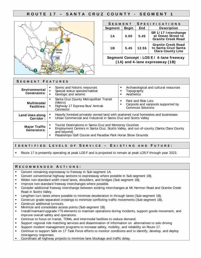
R O U T E 1 7 – S A N T A C R U Z C O U N T Y - S E G M E N T 1
S E G M E N T S P E C I F I C A T I O N SSegment Begin End Description
1A 0.00 5.45SR 1/17 Interchange
at Ocean Street toGranite Creek Road
1B 5.45 12.55Granite Creek Roadto Santa Cruz/Santa
Clara County Line
Segment Concept : LOS E / 4-lane freeway(1A) and 4-lane expressway (1B)
S E G M E N T F E A T U R E S
EnvironmentalConstraints:
Scenic and historic resources Special status species/habitat Geologic and seismic
Archaeological and cultural resources Topography Aesthetics
MultimodalFacilities:
Santa Cruz County Metropolitan Transit(Metro)
Highway 17 Express Bus/ AmtrakConnector
Park and Ride Lots Carpools and vanpools supported by
Commute Solutions
Land Uses alongCorridor :
Heavily forested privately owned land with scattered rural homesites and businesses Urban Commercial and Industrial in Santa Cruz and Scotts Valley
Major TrafficGenerators:
Tourist Destinations in Santa Cruz and Monterey Counties Employment Centers in Santa Cruz, Scotts Valley, and out-of-county (Santa Clara County
and beyond) Pasatiempo Golf Course and Paradise Park Horse Show Grounds
I D E N T I F I E D L E V E L S O F S E R V I C E – E X I S T I N G A N D F U T U R E :
Route 17 is presently operating at peak LOS F and is projected to remain at peak LOS F through year 2023.
R E C O M M E N D E D A C T I O N S : Convert remaining expressway to freeway in Sub-segment 1A. Convert conventional highway sections to expressway where possible in Sub-segment 1B). Widen non-standard width travel lanes, shoulders, and bridges (Sub-segment 1B). Improve non-standard freeway interchanges where possible. Consider additional freeway interchange between existing interchanges at Mt Hermon Road and Granite Creek
Road in Scotts Valley. Lengthen turn lanes where possible to minimize deceleration in through lanes (Sub-segment 1B). Construct grade-separated crossings to minimize conflicting traffic movements (Sub-segment 1B). Construct additional turnouts. Minimize and consolidate access points (Sub-segment 1B). Install/maintain/upgrade ITS elements to maintain operations during incidents, support goods movement, and
improve overall safety and operations. Continue to focus on transit, TDMs, and intermodal facilities to reduce demand. Support regional ride matching services and dissemination of information on alternatives to solo driving Support incident management programs to increase safety, mobility, and reliability on Route 17. Continue to support Safe on 17 Task Force efforts to monitor conditions and to identify, develop, and deploy
interagency responses. Coordinate all highway projects to minimize lane blockage and traffic delay.

!R
!R !RSantaCruz
ScottsValley
Capitola|}1
|}9
|}17
|}1
PM 0.0
PM 5.45
PM 12.55
1A
1B|}129
|}152|}1
|}1
|}9|}17
|}236
|}35San
Monterey SanBenito
Santa Clara
Mateo
Santa
Cruz
CaltransDistrict 5SystemPlanning
State Route 17Segment 1
Sub-Segment 1A PM 0.0/5.45Sub-Segment 1B PM 5.45 - 12.55RailUrban Areas
0 1 2 3 4 5
Miles

Route 17 1A
PM start PM end Length
0.00 5.45 5.45
4 12 ft.Rolling 160 ft.None 3-8 ft.
Prohibited 22-60 ft.
2003 2023 2003 2023 2003 202362,088 70,164 1.33 1.52 F F
ADT Ann. Growth (2003-2023) 1.00% Directional Split 65%Peak Hour Volume (2003) 5,992 Peak Hour Truck 3%
2003 2023 2003 2023
Segment Statewide*Total Collision Rate 0.69 0.88Fatality Collision Rate 0.011 0.010
0.22 0.33
Proposed Transportation Concept
Location
Proposed Concept* Average collision rates statewide for this type facility
Functional Classification
Through-traffic flow Analysis
LOSOperating Characteristics
Comments: Additional right-of-way may be required for interchange at Sims Road to complete freeway through Sub-segment 1A and also for additional interchange in Scotts Valley.
(none)
3-year period evaluated
Rates are incidents per million vehicle miles from 01/01/01 to 12/31/03
Collision Data
Fatality & Injury Collision Rate
Signalized Intersection
Analysis
LOS E/ 4-Lane Freeway
Trucking Designations
Lane WidthROW WidthShoulder WidthMedian Width
Freeway and ExpresswayPrincipal Arterial
LOSDelay Time (seconds)
Terminal Access RouteNo Yes
V/C Ratio
No
Caltrans District 5 - Segment Data Sheet
Description
Number of lanes
Segment/(Sub-segment)
TerrainSignalized IntersectionsBicycle Facilities
Route Designations
ADT
National Highway System
Focus RouteInterregional Road System
Santa Cruz County
Facility Type:
Segment/sub-segment Location
SR 1 to Granite Creek Road
Existing Roadbed Information

Route 17 1B
PM start PM end Length
5.45 12.55 7.10
4 11-12 ft.Mountainous 160-170 ft.
None 3-8 ft.Legal Access 4-34 ft.
2003 2023 2003 2023 2003 202360,000 76,900 1.20 1.44 F F
ADT Ann. Growth (2003-2023) 0.84% Directional Split 65%Peak Hour Volume (2003) 6,000 Peak Hour Truck 3%
2003 2023 2003 2023
Segment Statewide*Total Collision Rate 1.77 1.67Fatality Collision Rate 0.011 0.017
0.48 0.63
Proposed Transportation Concept
Santa Cruz County
Facility Type:
Segment/sub-segment Location
Granite Creek Road to Santa Cruz/Santa Clara County Line
Existing Roadbed Information
ADT
National Highway System
Focus RouteInterregional Road System
Caltrans District 5 - Segment Data Sheet
Description
Number of lanes
Segment/(Sub-segment)
TerrainSignalized IntersectionsBicycle Facilities
Route Designations
LOSDelay Time (seconds)
Terminal Access RouteNo Yes
V/C Ratio
No
Trucking Designations
Lane WidthROW WidthShoulder WidthMedian Width
Freeway and ConventionalPrincipal Arterial
Comments: Projects to widen shoulders, improve drainage, consolidate access, install TOS elements, construct or improve channelization, improve alignments, or rehabilitate pavement should be planned, sequenced, and phased to minimize construction time and delay.
(none)
3-year period evaluated
Rates are incidents per million vehicle miles from 01/01/01 to 12/31/03
Collision Data
Fatality & Injury Collision Rate
Signalized Intersection
Analysis
LOS E/4-lane Expressway
Location
Proposed Concept* Average collision rates statewide for this type facility
Functional Classification
Through-traffic flow Analysis
LOSOperating Characteristics

APPENDIX C: Programmed Projects

MAJOR PROGRAMMED AND PLANNED PROJECTS ON SR 17
County Location(Postmiles) Funding EA Project
Programmed
SCr 9.4/9.6 SHOPP 0G410 Widen lanes and shoulders;upgrade drainage and guardrail
SCr 0.2/1.1 STIP 12910
Construct merge lanes (Thisproject also includes construction
of merge lanes on SR 1 south of SR1/SR 17 I/C)
PID/Candidates*
SCr 5.5/5.8 STIP 49380 Reconstruct interchange at GraniteCreek Road
SCr 10.1/11.3 SHOPP 0K320 Improve drainage
* Additional candidate projects may be included in the 2006 SHOPP to be approved bythe California Transportation Commission in April 2006.
Planned: (Source: SCCRTC’s RTP)
SCr Scotts Valley Unconstrained Auxiliary lanes; interchangeimprovements
SCr Scotts Valley UnconstrainedProvide emergency access fromGranite Creek Road to SR 17 viaNavarra Drive to Sucinto Drive
SCr Scotts Valley UnconstrainedConstruct new interchange midway
between Mt. Hermon Road andGranite Creek Road interchanges
SCr Vine Hill UnconstrainedCorrect a skew; lengthen a turn
pocket; prohibit left turns onto SR17 from an adjacent driveway