Volcano observations with ASTER and ASTER image database for volcanoes

ADDRESS PHONE EMAIL Unit 5, Ground Floor +61 (8) 9486 4036 [email protected] 1 Centro Ave, Subiaco ABN WEBSITE WA, 6005 Australia 96 095 684 389 www.frontierresources.com.au
ASX: FNT Market Announcements Platform 6th March 2018
Corporate and Exploration Update
Frontier Resources Limited (Frontier) announces an update in relation to corporate and exploration activities.
Chairman / Managing Director Peter McNeil has resigned as a director of Frontier for personal reasons. Peter led the company to its ASX listing 15 years ago. The Board thanks him, on behalf of shareholders, for his long-term efforts. Peter will remain associated with Frontier as a Consultant Chief Geologist as required.
Non-Executive Director Paige McNeil BEd,GradDipEd(Trng&Dev),GradDipACG,AGIA,GAICD,FAIM has been appointed Non-Executive Chairman and Peter Swiridiuk BSc(Hons), DipEd, MAIG remains a Non-Executive Director. Mr John Kirakar BSc has been appointed to the board as a Non-Executive Director. John Kirakar acts as the Papua New Guinean (PNG) resident director of the company’s two wholly owned subsidiaries Frontier Copper PNG Ltd and Frontier Gold PNG Ltd. John is a geologist with 34 years professional experience working in all regions of PNG since 1981, including several field periods in Australia, New Zealand, Indonesia, Solomon Islands and Vanuatu. He has extensive and varied mineral exploration experience with epithermal gold-silver, porphyry copper-gold-molybdenum, copper-zinc-lead-silver-gold skarns, nickel-Cobalt, and Coal and Platinum-rich PGM mineral deposit types and has worked throughout PNG for companies with Esso, City Resources, CRA Exploration, Elders Resources, Annapurna, Dolerite Mining, Highlands Gold, Highlands Pacific, Ok Tedi Mining, New Guinea Gold Corp, Cybele Resources, Papuan Precious Metals, Newcrest Mining, Pacific Mining Partners and Quintessential Resources Ltd. An Agreement was signed on 22/12/2017 for a A$6 million Placement into Frontier at 1.6c per share, with Forise Investment Sydney Pty Ltd (Forise is a subsidiary of one of the largest non-bank financial institutions in China). The parties have agreed to extend the timeframe to completion by 2 months (to mid-May, 2018), due to difficulties in obtaining the required information in PNG for the Independent Expert’s Report (IER), that is now being finalised. An additional A$40,000 loan facility has also been provided. The Notice of Extraordinary General Meeting and IER will be lodged with regulators and a date set for the EGM to obtain shareholder approval. This is normally about an 8 week process.
Aimex Geophysics (Director Swiridiuk) completed an Aster satellite imagery study that delineated a total of 37 Aster targets (up to 31 Ha in size) that were recommended for future geochemical sampling and geological mapping. There were 17 anomalies at the Tingi Block, 13 at Baia and 7 at Cecelia. Lineament and volcanic structural features were plotted (over areas not obscured by cloud cover). Aster Targets are areas which have potentially been altered by mineralising fluids. The report is attached as Appendix 1.
The Muller (EL 2356) renewal Warden’s Court Hearing was rescheduled for 6th March, 2018 in Tari, Southern Highlands Province however due to the recent 7.5 magnitude earthquake, the hearing has been further delayed until 17th April 2018. The proposed Muller and Bulago exploration programs have also been deferred due to the extra logistical issues created by the earthquake.
For additional information relating Frontier and our projects, please visit the website at www.frontierresources.com.au.
FRONTIER RESOURCES LTD
Paige McNeil, B.Ed,GradDipEd(Trng&Dev),GradDipACG,AGIA,GAICD,FAIM Non-Executive Chairman

Licence
Name Number Date From Date To Ownership
Area (SQ KM)
Lat. Sub
Blocks
Bulago EL 1595 7/07/2016 6/7/2018 100% Frontier Gold PNG Ltd 73 22
Muller EL 2356 31/12/2015 30/12/2017 100% Frontier Copper PNG Ltd 187 56
Granted Els = 260 SQ KM
Gazelle ELA 2529 100% *Frontier Copper PNG Ltd 703 211
Tolukuma ELA 2531 100% *Frontier Copper PNG Ltd 433 130
1,136 SQ KM
NB:
Frontier Resources Ltd Exploration Licence Information
Application SECOND
Application
The PNG Mining Act- 1992 stipulates that ELs are granted for renewable 2 year Terms (subject to Work and
Financial Commitments) and the PNG Government maintains the right to purchase up to 30% project equity at
"Sunk Cost" if/when a Mining Lease is granted.
EL Applications =
BACKGROUND: Frontier Resources Ltd is focussed on mineral exploration in highly prospective Papua New Guinea (PNG). The Company is targeting copper+/- gold +/-molybdenum porphyries and intrusive related epithermal gold deposits on its Exploration Licences (Els), plus 2 significant EL Applications. Continued exploration and drilling is strongly warranted. The Papuan Fold Belt contains Frontier’s Bulago and Muller ELs and the Ok Tedi porphyry copper-gold Mine (located 80km WNW of Bulago), Porgera intrusive/ epithermal related gold Mine (120km east of Bulago) and Kili Teke porphyry copper-gold Deposit (50km east of Bulago).

APPENDIX 1.
FRONTIER COPPER PNG Ltd MULLER RANGE (EL 2356) - ASTER SATELLITE INTERPRETATION
January, 2018
Peter Swiridiuk (Principal Consultant) - AIMEX GEOPHYSICS
CONTENTS
1.0 EXECUTIVE SUMMARY 2.0 HISTORICAL EXPLORATION 3.0 ASTER SATELLITE ACQUISITION AND IMAGERY ......................................................................... Table 1: Aster Bands 4.0 TINGI BLOCK ASTER INTERPRETATION ...................................................................................... Table 2: Muller Range Northern Tingi Block Aster Target Areas ............................................. 5.0 BAIA BLOCK ASTER INTERPRETATION ........................................................................................ Table 3: Central Baia Block Aster Target Areas......................................................................... 6.0 CECELIA BLOCK ASTER INTERPRETATION .................................................................................. Table 4: Southern Cecelia Block Aster Target Areas .................................................................. 7.0 CONCLUSION
LIST OF FIGURES
Figure 1: PNG Location Map of Muller Range EL 2356 ............................................................................. Figure 2: Muller Range Tenement SRTM Topography ............................................................................. Figure 3: Muller Range Regional Published Geology ................................................................................ Figure 4: Tingi Block Aster Targets with Historical Gold in Soil Samples .................................................. Figure 5: Tingi Prospect Area Aster Targets (Abdelsalam Image) ............................................................ Figure 6: Tingi Prospect Area Aster Targets (Smectite Image) ................................................................. Figure 7: Tingi West Area Aster Targets ................................................................................................... Figure 8: Tingi West Area Aster (Alunite Image) Targets ......................................................................... Figure 9: Tingi West Area Aster (Volesky Image) Targets ......................................................................... Figure 10: Tingi North Area Aster Targets .................................................................................................. Figure 11: Tingi North Area Aster (Alunite Image) Targets ........................................................................ Figure 12: Tingi North Area Aster (Jarosite Image) Targets........................................................................ Figure 13: Tingi North-East Area Aster Targets .......................................................................................... Figure 14: Tingi North-East Area Aster (Alteration Image) Targets ............................................................ Figure 15: Tingi North-East Area Aster (Alunite Image) Targets ................................................................ Figure 16: Baia Block Aster Targets Figure 17: Baia Block Aster Scene II (Clay Alteration Image) with Targets ................................................. Figure 18: Baia Block Aster (Dickite-Jarosite-Pyrophyllite Image) with Targets ......................................... Figure 19: Baia Block Aster (Jarosite Image) with Targets .......................................................................... Figure 20: Cecelia Block Aster Imagery with Targets .................................................................................. Figure 21: Cecelia North Aster (Clay Image) with Targets .......................................................................... Figure 22: Cecelia North Aster (Jarosite Image) with Geology and Targets ............................................... Figure 23: Cecelia South Aster (Dickite-Jarosite-Pyrophyllite Image) with Targets ................................... Figure 24: Cecelia South Aster (Jarosite Image) with Targets ....................................................................

EXECUTIVE SUMMARY The Muller Range exploration licence in the Western and Southern Highlands Provinces is about 150km south east from the Ok Tedi mine (Figure 1). The tenement is split into three separate areas which include the northern Tingi Block, central Baia Block and southern Cecelia Block (Figure 2). The northern Tingi Block (16 sub-blocks; Figure 2) contains the Tingi, or Tingi Valley, prospect with porphyry Cu-Au-Mo mineralisation, polymetallic (Au-Cu-Pb-Zn-Ag) skarns, breccia hosted basemetal mineralisation, fault controlled massive sulphides and gold veining. The central Baia Block (13 sub-block; Figure 2) contains the large porphyry Baia prospect, with a copper-gold-molybdenum in soils anomaly and small skarns present. Historical exploration by Barrick confirmed Baia as a weakly mineralised porphyry system dominated by propylitic and structurally controlled phyllic alteration. Figure 1: PNG Location Map of Muller Range EL 2356 and Figure 2 Muller Range Tenement SRTM Topography. Within the southern Cecelia Block (27 sub-blocks; Figure 2), the northernmost Cecelia prospect has historical outcrop rock samples of 0.62% copper. Strong argillic and propylitic alteration has been covered by recent agglomerate with pebble dykes being common. Two rock chip samples taken between 1986-88 are of advanced argillic alteration returning 0.616 g/t gold and 710 ppm copper. This report focusses on utilising Aster satellite imagery to map lineaments and circular volcanic features; and to define targets related to clay alteration (i.e., minerals such as kaolinite, dickite, smectite are known to be associated with gold and copper deposits) and variations related to jarosite/hematite iron oxides. Historical surface geochemistry has been utilised to determine any anomalous gold related to any of the selected Aster target areas in the Tingi Block. A total of 37 Aster targets (17 Tingi Block: 13 Baia Block targets: 7 Cecelia Block) were selected in size up to 31 Ha. Lineament and volcanic structural features have been plotted over areas not obscured by cloud cover. Aster Targets are areas which have potentially been altered by mineralising fluids and are recommended for future geochemical sampling and geological mapping. 2.0 HISTORICAL EXPLORATION The Tingi Valley Copper-Gold Porphyry Prospect area is covered by Mesozoic sediments (mudstone, siltstone, sandstone) overlain by early Tertiary limestone intruded by Tertiary–Pleistocene monzonite and diorite stocks (Figure 3). Within the prospect, several small diorite stocks and sill complexes intrude Darai Limestone and underlying Mesozoic sediments. Cu–Au mineralisation appears to be associated with these intrusive bodies. In the early 70s, CRA Exploration and BP completed regional stream sediment sampling. In 1991 Kennecott interpreted airborne magnetics to delineate two separate porphyry targets beneath Darai Limestone and completed soil sampling and mapping, receiving spot gold assays of 4.9 g/t gold, 30 g/t gold and 12 g/t gold. Wantok Mining completed channel sampling in 1996, delineating anomalous copper within andesite porphyry and brecciated massive sulphide skarn. Carson-Pratt Exploration completed mapping and sampling in 2004 after which they recommended additional follow-up on the intrusive/limestone contact for possible gold bearing veins. It is expected that analysis of satellite Aster imagery will help define structural related mineralisation targets and mineralised zones of alteration related to porphyry deposits. In 2016, historical data from for the Baia and Cecelia prospects from Barrick were compiled into a number of diagrams to analyse ridge and spur soil geochemical samples together with interpreted lithology, fact mapped geology and airborne geophysics. Barrick confirmed Baia as a weakly mineralised porphyry system dominated by propylitic and structurally controlled phyllic alteration. Copper in soil geochemistry demonstrates a 900m x 600m wide anomaly with a typical zinc/lead halo around the copper system. Dominant alteration is propylitic, with structurally controlled phyllic and patchy un-mineralised potassic alteration. A total of seven skarn targets, identified previously by Aimex Geophysics, are related to near surface magnetic bodies at the contact between limestone and intrusive. The Aster satellite imagery analysis in this report helps define additional alteration targets which may also be related to previously undefined mineralisation within the tenement block.

The Cecelia prospect is defined from stream sediment (> 250ppm Copper) sampling and rock chip sampling by Kennecott in 1970. Best results included in rock float samples included 0.18% copper within granodiorite with bornite-chalcopyrite in altered intrusive in the upper reaches of the prospect. Vuggy quartz-alunite-pyrophyllite rock has been described from the upper reaches of Cecelia. High sulphidation epithermal advanced argillic alteration, with vuggy quartz-alunite- pyrophyllite is present, but no significant gold noted in follow-up. Strong argillic and propylitic alteration covered by recent agglomerate and pebble dykes is common, indicating a probable buried porphyry copper-gold-molybdenum target. Additional targets defined from the Aster satellite imagery in this report may indicate near surface alteration from underlying hydrothermal events related to mineralisation. Volcanics throughout much of the tenement Block (Figure 3) has been tracked/mapped from airborne magnetic imagery.
3.0 ASTER SATELLITE ACQUISITION AND IMAGERY A number of Aster satellite scenes were searched and acquired from the NASA Earthdata catalogue web site and processed using ERMapper software into numerous images to help highlight areas relating to geological structure and alteration related to potential mineralisation. Short Wave Infared (SWIR) bands (Table 1) are utilised in coloured imagery to help map areas of alteration related to hydrothermal events including porphyry related intrusives, epithermal veins and hydrothermal breccia.
Figure 2 Location plan showing the northern Tingi Block, central Baia Block and southern Cecelia Blocks Figure 3: Muller Range Regional Published Geology The SWIR sensors on the ASTER satellite failed in April 2007, hence there are only approximately seven years’ worth of captured satellite scenes from around the globe. In the PNG Highlands, cloud coverage is quite extensive year-round and no cloud free ASTER images could be found. Satellite scenes were selected on basis of a minimum amount of cloud free zones over the Muller Range tenement blocks.

BANDBand
Type
Band Range
nm
Resolution
(m)Absorption Reflection
Mineral
peak nm
1 VNIR 520 - 600 15 Ferric Iron Green - Veg
2 VNIR 630 - 690 15 Red - Haematite
3 NIR 780 - 860 15 Jaros i te
30
4 MIR 1600 - 1700 30 Vegetation
5 SWIR 2145 - 2185 30 Pyrophyl l i te 2160
6 SWIR 2185 - 2225 30 dicki te 2190
serici te 2190
kaol ini te 2190
i l l i te/smecti te 2200
Montmori l lonite 2200
7 SWIR 2235 - 2285 30 Jaros i te 2270
8 SWIR 2295 - 2365 30 alunite 2330
actinol i te 2310
phlogopite 2330
Calci te 2345
9 SWIR 2360 - 2430 30 phlogopite 2380
actinol i te 2390
10 TIR 90 Si l ici fication
11 TIR 90 Si l ici fication
12 TIR 90 Si l ici fication
13 TIR 90 Si l ici fication
14 TIR 90 Si l ici fication
4.0 TINGI BLOCK ASTER INTERPRETATION A number of Aster scenes were downloaded to determine those with least cloud coverage over the Tingi Northern Block. Numerous images were created including the Band 3,2,1 (RGB) scene which is used to define lineaments and volcanic structures (Figure 4). A total of 17 “MR” targets have been selected within the Northern Tingi Block (Figure 4) based on the image enhancements (Figure 5 to 15) utilising the Short Wave Infared bands. These target zones range in size from 0.8 Ha to 31 Ha (Table 2) and are based on potentially hydrothermal alteration including clays such as pyrophyllite, dickite, sericite, kaolinite, illite, smectite and montmorillonite. Zones of anomalous jarosite and hematite may be potential areas for skarns and gossans. Lowly anomalous jarosite and hematite seem to be often related to the presence of hydrothermal related clays.
The Abdelsalam Image (Figure 5) is useful for mapping structures in the immediate area of the Tingi Prospect, where soil sampling shows anomalous gold (Figure 10) in the vicinity of target MR01. In particular, target MR10 has a concentric halo of anomalous clays and anomalous smectite clays at its centre (Figure 6), indicating a potential porphyry copper-gold target at depth. Other targets in this area include MR12, 13 & 16 which are topographically circular with associated clay alteration (Table 2). Further west of Tingi, additional targets MR03, 15 & 17 are anomalous in topography and clay style alteration.
Figure 3: Tingi Prospect Area Aster Targets (Abdelsalam Image). The “Abdelsalam” Red-Green-Blue false colour image (Figure 5) was created to help map geological volcanic structures and clay anomalies of potential porphyry styles of mineralisation. The “Smectite” image (Figure 6) shows clay style argillic alteration related to porphyry related mineralisation.

Figure 4: Tingi Prospect Area Aster Targets (Smectite Image). The “Band 321” Red-Green-Blue false colour image (Figure 7) shows target MR03 as an elongated topographic anomaly with minor alunite style alteration (Figure 8). MR15 is also an interesting topographic anomaly associated with alunite type argillic alteration

Figure 7: Tingi West Area Aster Targets. The pseudo-colour Aster Alunite (Figure 8) imagery helps define clay styles of alteration in a typical porphyry and epithermal mineralising environment. False colour Red-Green-Blue images including the “Volesky Ratio” enhancement (Figure 9) are used to define possible gossanous material in red and clay alteration as green. MR15 is anomalous along a structure mapped by Kennecott, acting as a possible conduit for mineralising fluids and therefore upgrading this target.

Figure 5: Tingi West Area Aster (Alunite Image) Targets

Figure 6: Tingi West Area Aster (Volesky Image) Targets

To the north of the Tingi Prospect (Figure 10), target MR14 occurs as a linear vein related feature anomalous in gold from soil samples; and alunite clays (Figure 11) from Aster imagery. Target number MR05 has a distinct inner halo in Jarosite iron (Figure 12), which may represent gossan float from weathered ore in the phyllic zone. MR06 is topographically anomalous and low in alunite clays image; and also low in jarosite type irons (Table 2). Numerous lineaments are plotted as mainly occurring in a northwest orientation with some circular volcanic structures surrounding the MR04 and MR14 target areas (Figure 10). The MR07 is an 8 Ha target area, mainly associated with anomalous Hematite iron, possibly gossanous. To the northeast of the Tingi Prospect area (Figure 13), the MR11 target occurs as an outer halo along an interpreted circular volcanic structure; and anomalous in clay alteration (Figure 14). This target may be related to porphyry style mineralisation in a propylitic zone and should be check with ground sampling and mapping. Other targets in the north-eastern area include MR09; which has two discrete topographic anomalies similar to that at the Tingi MR01 target area. The MR08 target area has a circular alunite clay alteration halo along its south-eastern rim (Figure 15) indicating potential for mineralisation beneath an argillic alteration halo.
Figure 7: Tingi North Area Aster Targets

Figure 8: Tingi North Area Aster (Alunite Image) Targets
Figure 9: Tingi North Area Aster (Jarosite Image) Targets

Figure 10: Tingi North-East Area Aster Targets
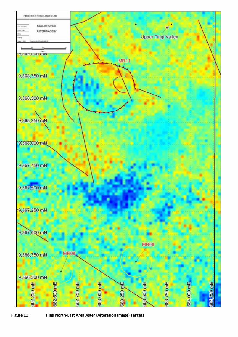
Figure 11: Tingi North-East Area Aster (Alteration Image) Targets

Figure 12: Tingi North-East Area Aster (Alunite Image) Targets

• Table 2: Muller Range Northern Tingi Block Aster Target Areas
Target Location
Description AGD66, Z56)
MR01 658410e, 9365640n This 9 Ha area is the main exploration zone of the Tingi prospect and includes Jerrys Skarn and Hogo Ck prospects along Angali Ck; with corresponding anomalous gold in soils. The Aster imagery shows zones of anomalous clay alteration which can be used as a diagnostic tool for selecting additional target areas.
MR02 657290e, 9365350n This 15 Ha zone is anomalous in silver and gold soil samples and has a clay alteration zone on its south-eastern flanks along a structure which is anomalous in gold in soils. From the Aster topography, it occurs as a large oval shaped zone, possibly representing an intrusive.
MR03 657120e, 9367180n A north-northeast elongated topographic anomaly 15Ha in size with smectite type alteration on its northern edges.
MR04 658150e, 9367040n This large 31 Ha topographic anomaly has associated Alunite type alteration.
MR05 658580e, 9367310n A smaller anomaly similar in appearance to that in the Tingi MR01 target. Minor alteration is associated with a skarn like halo of jarosite iron alteration.
MR06 660440e, 9366800n Discrete circular 2Ha topographic target anomalous in alteration (alunite/kaolinite/pyrophyllite).
MR07 660780e, 9365950n Circular 8 Ha topographic target associated with a Hematite gossan type signature at its centre co-ordinate.
MR08 662530e, 9366580n A circular topographic 5 Ha anomaly with an alteration halo along its south-eastern rim.
MR09 663390e, 9366690n Two discrete circular anomalies similar to that at the Tingi MR01 target with minor alteration in the north-western corner.
MR10 659790e, 9364790n A small patch of anomalous alteration occurs at the centre of this 12 Ha circular anomaly which exists within an outer volcanic rim; and is a porphyry style target.
MR11 663050e, 9368850n This volcanic centre is 700 southwest from the Upper Tingi Valley prospect with the target marked as a zone of alteration along its outer north-eastern rim.
MR12 657820e, 9366150n Small circular 1 Ha anomaly with an associated linear smectite type alteration extending to the northeast.
MR13 657410e, 9365920n A circular 4 Ha topographic anomaly with smectite alteration at its centre.
MR14 658460e, 9366570n Linear 260m long epithermal target with smectite alteration associated with gold anomalous soil samples.
MR15 657190e, 9366110n Circular alunite alteration target coincident with a structure previously mapped by Kennecott. The circular volcanic area 150m to the north-west is also an area of interest, being associated alunite clay alteration; similarly, 200m to the west.
MR16 658210e, 9365180n Small 0.8Ha circular topographic target, 390m south of Jerry’s skarn.
MR17 656560e, 9366730n Discrete oval shaped area of alunite related alteration.
5.0 BAIA BLOCK ASTER INTERPRETATION Published geological mapping (Figure 3) and the topographic image (Figure 2) shows the Baia prospect, occurring on the southern side of a partly collapsed strato-volcano. All Aster scenes with SWIR bands in this area have existing cloud coverage; however, 13 targets (Table 3) have been defined within the central Baia Block (Figure 16), which has mapped feldspar porphyry in contact with limestone and mudstone. Aster imagery (Figure 18) shows the mapped mudstone and limestone extending throughout the tenement block. A second Aster scene with differing cloud coverage (Figure 17) was used to increase the area that could be interpreted. In the southwestern portion of the Baia tenement Block, five Aster Targets BA05, 06, 07, 08 & 13 occur as anomalous “Dickite’ type clay alteration (Figure 18). Targets 05 & 06 have corresponding anomalously low jarosite iron (Figure 19). Target BA03 is a linear clay alteration target for potential epithermal style mineralisation within mapped limestone. Similarly, BA10 is a linear target within mapped silicate mudstone (Figure 16). BA09, in the southernmost part of the tenement block, occurs as a small topographic feature. Circular targets BA04 and BA11 have a red/blue colour in Figure 18, indicating potential for hydrothermal alteration, as with the smaller target area BA12 (Figure 17). All targets are slightly anomalous in clay/dickite alteration with some anomalously low in jarosite iron. BA01 & 02 occur as small reddish anomalies in Figure 18, indicating potential for alteration and mineralisation at depth.

These target areas identified from the Aster imagery are recommended for additional geological mapping and rock sampling prior to further trench sampling and ground geophysics.
Figure 13: Baia Block Aster Targets

Figure 14: Baia Block Aster Scene II (Clay Alteration Image) with Targets
Figure 15: Baia Block Aster (Dickite-Jarosite-Pyrophyllite Image) with Targets
Figure 16: Baia Block Aster (Jarosite Image) with Targets

• Table 3: Central Baia Block Aster Target Areas
Target Location (AGD66, Z56)
Description
BA01 666910e, 9343300n A 1 Ha circular anomaly anomalous in dickite and low in Jarosite.
BA02 667370e, 9342920n Small 2 Ha area anomalous in dickite related alteration and low in jarosite iron.
BA03 669880e, 9342630n Elongated north-south zone 360m in length anomalous in dickite and low in jarosite iron, within mapped limestone.
BA04 668280, 9340230n A 9.5 Ha circular area of anomalous dickite and low jarosite, indicating potential alteration and mineralisation within mapped mudstone.
BA05 665170e, 9339330n A 1.7 Ha anomalous area of dickite clay alteration and low jarosite.
BA06 664960e, 9339220n A 1.8 Ha anomalous area of dickite clay alteration and low jarosite.
BA07 666380e, 9339040n Anomalous topographic feature with elevated dickite type of alteration.
BA08 664630e, 9339440n Small topographic anomaly with elevated dickite alteration.
BA09 668990e, 9338920n Small 0.7 Ha topographic feature with anomalous clay alteration.
BA10 669230e, 9341200n Elongated 290m anomalous clay and iron orientated north-east within mapped mudstone.
BA11 668700e, 9341450n An 8 Ha area anomalous in dickite style alteration and correspondingly low in iron on the contact of mapped mudstone and limestone.
BA12 671140e, 9341430n A 1.3 Ha area of anomalous clay alteration.
BA13 664750e, 9339550n Circular topographic feature with anomalous alunite style alteration.

Figure 17: Cecelia Block Aster Imagery with Targets

Figure 18: Cecelia North Aster (Clay Image) with Targets
Figure 19: Cecelia North Aster (Jarosite Image) with Geology and Targets

Figure 20: Cecelia South Aster (Dickite-Jarosite-Pyrophyllite Image) with Targets

Figure 21: Cecelia South Aster (Jarosite Image) with Targets

6.0 CECELIA BLOCK ASTER INTERPRETATION Numerous Aster scenes were searched over the larger Cecelia southernmost Muller Range tenement package. Although all satellite scenes had significant cloud occurrence, two Aster scenes were utilised to interpret volcanic structures and alteration within the extensive volcanic pile mapped throughout the tenement block (Figure 3). Two Aster scenes were used for interpretation (Figure 20) and a number of volcanic circular structures have been identified along with lineaments and six targets (Table 4). Interpretation was split into the northern area of the Cecelia porphyry copper-gold-molybdenum system (Figures 21 and 22) and the southern area (Figures 23 and 24); which excludes the Mt. Sisa (Figure 20) porphyry/volcano system because it is obscured by cloud cover due to its extensive elevation in height (Figure 2). The Cecelia prospect lies on the contact between Wongop Sandstone and Andesitic Lava. A further 140m south exists the CE06 alteration target; anomalously low in jarosite iron (Figure 22). Within an interpreted volcanic complex, the CE05 alteration Aster target is elongated north-south occurring on the contact between Andesitic Lava and Pyroclastics (Figure 22). CE07 is an area with distinct alteration ‘spots’ (Figure 21) and correspondingly low jarosite (Figure 22). Four other Aster Targets are interpreted in the southern section (Figure 23) where CE01, 02, 03 & 04 are related to clay “dickite” type alteration. The southernmost target CE02 has a circular halo of anomalous jarosite (Figure 24) and is an interesting target for potential mineralisation at depth. A number of circular volcanic centres were interpreted southwest and southeast of the Cecelia prospect with bedding type structures outlined further south over the cloud free areas of the Aster imagery, between CE01 and CE02 (Figure 20). Additional interpretation is recommended to be completed on relatively cloud free Landsat and Sentinel-2 satellite imagery; but these scenes would require additional searching beyond the scope of this report.
Table 4: Southern Cecelia Block Aster Target Areas
Target Location (AGD66, Z56)
Description
CE01 687300e, 9327470n Circular topographic 2.2 Ha feature anomalous in alunite style alteration.
CE02 689450e, 9324000n A 5.6 Ha circular topographic feature associated with anomalous concentric rings of anomalous clays and iron.
CE03 688540e, 9325360n A 2.2 Ha area of clay alteration.
CE04 688040e, 9326790n Unusual small circular topographic feature.
CE05 684900e, 9332650n A 3 Ha north-south elongated area of anomalous clay alteration within a circular volcanic rim.
CE06 682810e, 9333160n A 5.7 Ha area of clay alteration 140m south the Cecelia prospect with the contact of mapped sandstone and andesitic lava.
CE07 684250e, 9335820n An 8.4 Ha circular target anomalous in pyrophyllite and low iron.
7.0 CONCLUSION A total of 17 Tingi Block targets, 13 Baia Block targets and 7 Cecelia Block targets have been defined from a number of different Aster scenes. Each scene has been processed into a number of coloured images to help map out areas of volcanic circular structures, lineaments and alteration due to potential mineralisation related to porphyry copper deposits, gossanous zones, epithermal gold and hydrothermal breccia systems. The most common images created and used for interpretation includes Dickite-Jarosite-Pyrophyllite Ratio (Red-Green-Blue false colour), Haematite Ratio (pseudo colour), Jarosite Ratio (Pseudo colour), Alunite Ratio (pseudo colour), Clay Ratio (pseudo colour), ‘Volesky Ratio’ (Red Gossan-Green Alteration-Blue host rock false colour), ‘Abdelsalam Ratio’ (Red-Green-Blue false colour), ‘Sultan Ratio’ (Red-Green-Blue false colour). Aster Targets are recommended for future geochemical sampling and geological mapping. Additional interpretation is recommended to be completed Landsat and Sentinel-2 satellite imagery that require extensive searching for relatively cloud free scenes. Competent Person Statement: The information in this report that relates to Exploration Results and Mineral Resources is based on information compiled by, or compiled under the supervision of Peter Swiridiuk - Member of the Aust. Inst. of Geoscientists. Peter Swiridiuk is the Principal Consultant for AIMEX Geophysics, that consults to the Company. Peter has sufficient experience which is relevant to the type of mineralisation and type of deposit under consideration to qualify as Competent Person as defined in the 2012 Edition of the Australasian Code of Reporting Exploration Results, Mineral Resources and Ore Resources. Peter Swiridiuk consents to the inclusion in the report of the matters based on the information in the form and context in which it appears.