CORNUBIA RETAIL AND BUSINESSES PARK - PLANNING …
23
JULY 2013 CORNUBIA- RETAIL AND BUSINESS PARK- PLANNING REPORT CORNUBIA RETAIL AND BUSINESSES PARK - PLANNING REPORT 10.07.2013 REVERT 4
Transcript of CORNUBIA RETAIL AND BUSINESSES PARK - PLANNING …
1 JULY 2013 CORNUBIA- RETAIL AND BUSINESS PARK- PLANNING REPORT
CORNUBIA RETAIL AND BUSINESSES PARK -
PLANNING REPORT 10.07.2013 REVERT 4
2 JULY 2013 CORNUBIA- RETAIL AND BUSINESS PARK- PLANNING REPORT
www.iyer.co.za
28 DEVONSHIRE AVENUE GLENWOOD DURBAN 4001
P.O. BOX 17390 CONGELLA 4013
T +27 31 202 9550
F +27 31 202 9551
1st FLOOR THE MEDIA MILL 7 QUINCE ROAD
BRAAMFONTEIN WERF JOHANNESBURG 2001
T +27 11 482 8681
F +27 11 482 8681
BY:
www.cornubia.co.za
FOR:
3 JULY 2013 CORNUBIA- RETAIL AND BUSINESS PARK- PLANNING REPORT
3
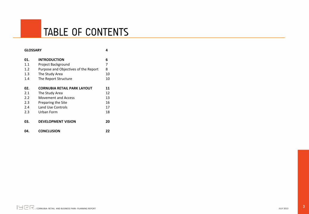
TABLE OF CONTENTS
GLOSSARY 4
01. INTRODUCTION 6 1.1 Project Background 7 1.2 Purpose and Objectives of the Report 8 1.3 The Study Area 10 1.4 The Report Structure 10
02. CORNUBIA RETAIL PARK LAYOUT 11 2.1 The Study Area 12 2.2 Movement and Access 13 2.3 Preparing the Site 16 2.4 Land Use Controls 17 2.3 Urban Form 18
03. DEVELOPMENT VISION 20
04. CONCLUSION 22

4 JULY 2013 CORNUBIA- RETAIL AND BUSINESS PARK- PLANNING REPORT
00
GLOSSARY
5 JULY 2013 CORNUBIA- RETAIL AND BUSINESS PARK- PLANNING REPORT
5
GLOSSARY 00
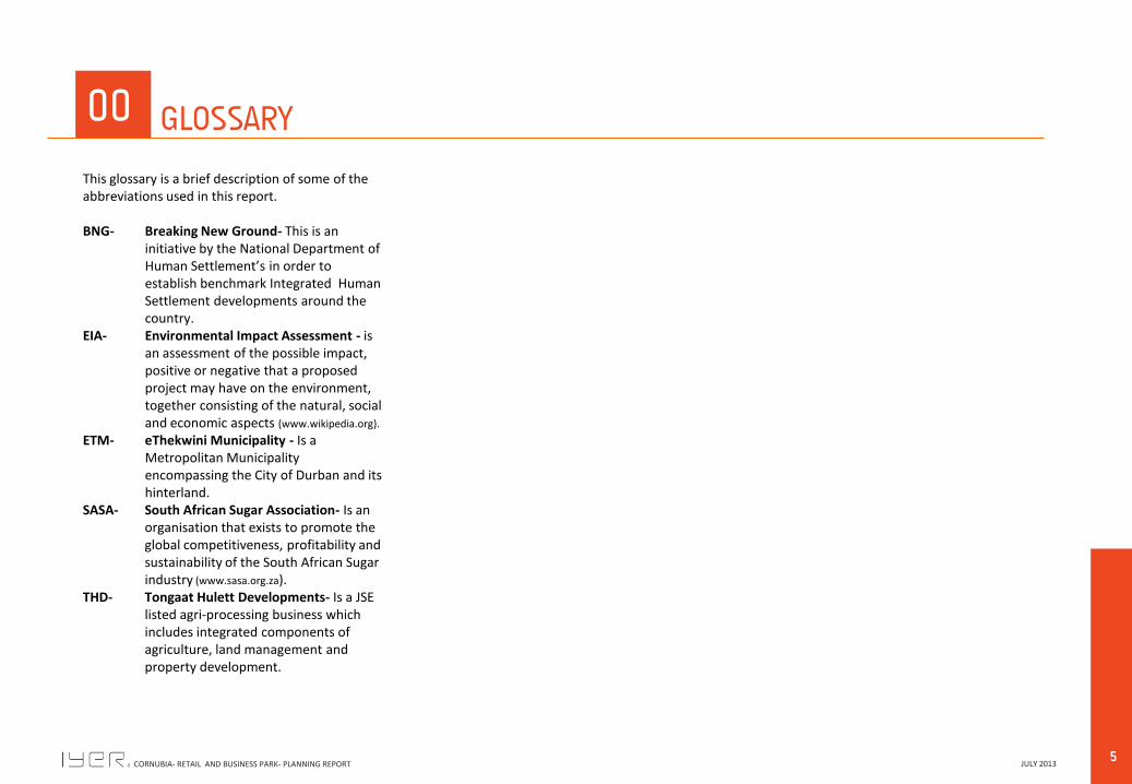
This glossary is a brief description of some of the abbreviations used in this report. BNG- Breaking New Ground- This is an
initiative by the National Department of Human Settlement’s in order to establish benchmark Integrated Human Settlement developments around the country.
EIA- Environmental Impact Assessment - is an assessment of the possible impact, positive or negative that a proposed project may have on the environment, together consisting of the natural, social and economic aspects (www.wikipedia.org).
ETM- eThekwini Municipality - Is a Metropolitan Municipality encompassing the City of Durban and its hinterland.
SASA- South African Sugar Association- Is an organisation that exists to promote the global competitiveness, profitability and sustainability of the South African Sugar industry (www.sasa.org.za).
THD- Tongaat Hulett Developments- Is a JSE listed agri-processing business which includes integrated components of agriculture, land management and property development.
6 JULY 2013 CORNUBIA- RETAIL AND BUSINESS PARK- PLANNING REPORT
01
INTRODUCTION Background
Study Area Significance Purpose of the Report
Structure of the Report
7 JULY 2013 CORNUBIA- RETAIL AND BUSINESS PARK- PLANNING REPORT
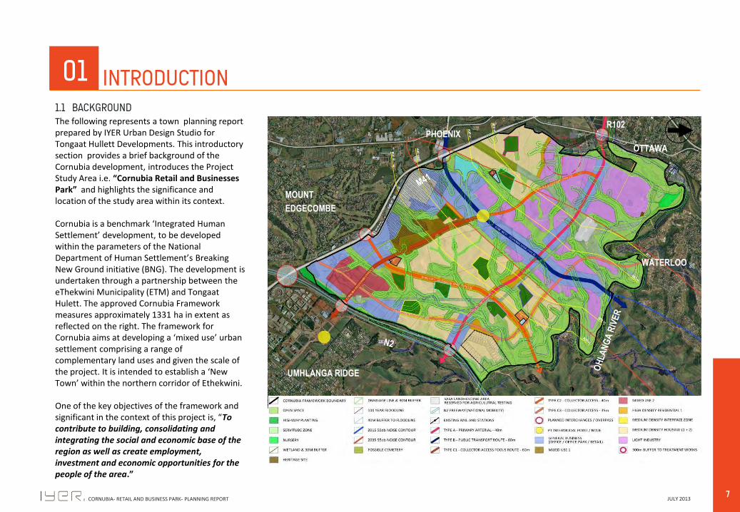
The following represents a town planning report prepared by IYER Urban Design Studio for Tongaat Hullett Developments. This introductory section provides a brief background of the Cornubia development, introduces the Project Study Area i.e. “Cornubia Retail and Businesses Park” and highlights the significance and location of the study area within its context. Cornubia is a benchmark ‘Integrated Human Settlement’ development, to be developed within the parameters of the National Department of Human Settlement’s Breaking New Ground initiative (BNG). The development is undertaken through a partnership between the eThekwini Municipality (ETM) and Tongaat Hulett. The approved Cornubia Framework measures approximately 1331 ha in extent as reflected on the right. The framework for Cornubia aims at developing a ‘mixed use’ urban settlement comprising a range of complementary land uses and given the scale of the project. It is intended to establish a ‘New Town’ within the northern corridor of Ethekwini. One of the key objectives of the framework and significant in the context of this project is, “To contribute to building, consolidating and integrating the social and economic base of the region as well as create employment, investment and economic opportunities for the people of the area.”
01 INTRODUCTION
MOUNT
EDGECOMBE
UMHLANGA RIDGE
OTTAWA
WATERLOO
R102 PHOENIX
1.1 BACKGROUND
8 JULY 2013 CORNUBIA- RETAIL AND BUSINESS PARK- PLANNING REPORT
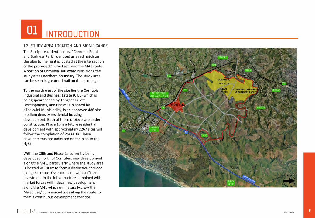
The Study area, identified as, “Cornubia Retail and Business Park”, denoted as a red hatch on the plan to the right is located at the intersection of the proposed “Dube East” and the M41 route. A portion of Cornubia Boulevard runs along the study areas northern boundary. The study area can be seen in greater detail on the next page. To the north west of the site lies the Cornubia Industrial and Business Estate (CIBE) which is being spearheaded by Tongaat Hulett Developments, and Phase 1a planned by eThekwini Municipality, is an approved 486 site medium density residential housing development. Both of these projects are under construction. Phase 1b is a future residential development with approximately 2267 sites will follow the completion of Phase 1a. These developments are indicated on the plan to the right. With the CIBE and Phase 1a currently being developed north of Cornubia, new development along the M41, particularly where the study area is located will start to form a distinctive corridor along this route. Over time and with sufficient investment in the infrastructure combined with market forces will induce new development along the M41 which will naturally grow the Mixed use/ commercial uses along the route to form a continuous development corridor.
01 INTRODUCTION
CORNUBIA
PHASE 1B
PILOT PHASE
CORNUBIA INDUSTRIAL & BUSINESS ESTATE
STUDY AREA
1.2 STUDY AREA LOCATION AND SIGNIFICANCE

9 JULY 2013 CORNUBIA- RETAIL AND BUSINESS PARK- PLANNING REPORT
There has been strong interest by private sector for business and retail park development within Cornubia particularly along the M41 which land predominantly is under Tongaat Hulett ownership. The study area therefore is strategically placed and plays an important role in the future growth of the corridor. The Cornubia Retail and Businesses Park Development will form part of Special Zone 19: Cornubia Town Centre. This zone applies to the Cornubia Town Centre development, the commercial, mixed use component of the Cornubia Integrated Human Settlement. The purpose of this zone is to accommodate a wide range of shopping, business, commercial, residential, social and Business Park activities, in such a way that the uses contribute towards the creation of a dynamic, harmonious and well balanced town centre of the highest aesthetic, landscaping and urban design quality. The plan on the right and below shows a more detailed images of the study area. It lies just behind the existing Flanders Drive commercial zone. The site also has good access and visibility from the M41.
01 INTRODUCTION
STUDY AREA
1.2 STUDY AREA LOCATION AND SIGNIFICANCE ( continued)
THE STUDY AREA
MOUNT EDGECOMBE
WASTE TRANSFER
FACILITY TO BE
RELOCATED
SASA
10 JULY 2013 CORNUBIA- RETAIL AND BUSINESS PARK- PLANNING REPORT
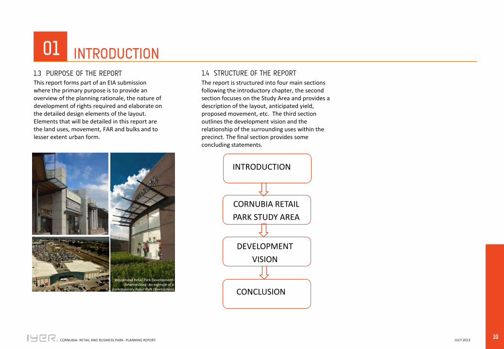
This report forms part of an EIA submission where the primary purpose is to provide an overview of the planning rationale, the nature of development of rights required and elaborate on the detailed design elements of the layout. Elements that will be detailed in this report are the land uses, movement, FAR and bulks and to lesser extent urban form.
01 INTRODUCTION 1.3 PURPOSE OF THE REPORT
Woodmead Retail Park Development- Johannesburg- An example of a
contemporary Retail Park Development
1.4 STRUCTURE OF THE REPORT The report is structured into four main sections following the introductory chapter, the second section focuses on the Study Area and provides a description of the layout, anticipated yield, proposed movement, etc. The third section outlines the development vision and the relationship of the surrounding uses within the precinct. The final section provides some concluding statements. INTRODUCTION
CORNUBIA RETAIL
PARK STUDY AREA
DEVELOPMENT
VISION
CONCLUSION

11 JULY 2013 CORNUBIA- RETAIL AND BUSINESS PARK- PLANNING REPORT
02
CORNUBIA RETAIL PARK LAYOUT The Study Area
Movement and Access Preparing the site
Land Use and Controls Urban Form
12 JULY 2013 CORNUBIA- RETAIL AND BUSINESS PARK- PLANNING REPORT
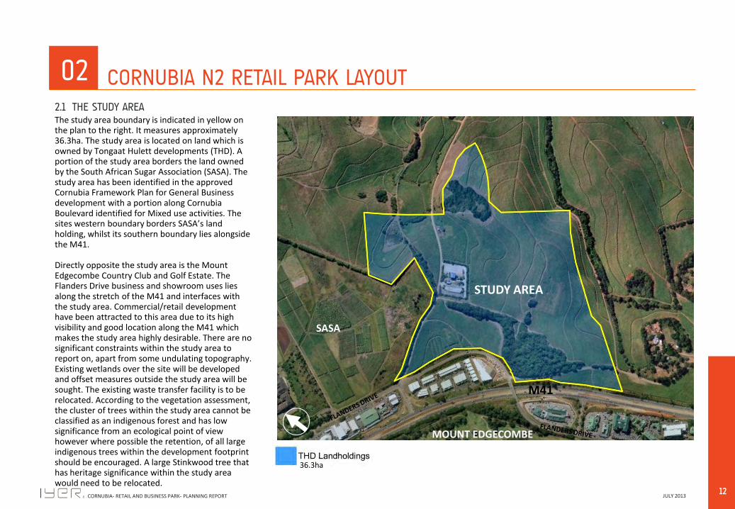
The study area boundary is indicated in yellow on the plan to the right. It measures approximately 36.3ha. The study area is located on land which is owned by Tongaat Hulett developments (THD). A portion of the study area borders the land owned by the South African Sugar Association (SASA). The study area has been identified in the approved Cornubia Framework Plan for General Business development with a portion along Cornubia Boulevard identified for Mixed use activities. The sites western boundary borders SASA’s land holding, whilst its southern boundary lies alongside the M41. Directly opposite the study area is the Mount Edgecombe Country Club and Golf Estate. The Flanders Drive business and showroom uses lies along the stretch of the M41 and interfaces with the study area. Commercial/retail development have been attracted to this area due to its high visibility and good location along the M41 which makes the study area highly desirable. There are no significant constraints within the study area to report on, apart from some undulating topography. Existing wetlands over the site will be developed and offset measures outside the study area will be sought. The existing waste transfer facility is to be relocated. According to the vegetation assessment, the cluster of trees within the study area cannot be classified as an indigenous forest and has low significance from an ecological point of view however where possible the retention, of all large indigenous trees within the development footprint should be encouraged. A large Stinkwood tree that has heritage significance within the study area would need to be relocated.
02 CORNUBIA N2 RETAIL PARK LAYOUT 2.1 THE STUDY AREA
STUDY AREA
MOUNT EDGECOMBE
SASA
M41
36.3ha

13 JULY 2013 CORNUBIA- RETAIL AND BUSINESS PARK- PLANNING REPORT
At a district scale, movement within the precinct is defined on the plan to the right. An interchange upgrade is proposed at the M41-MtEdgecombe and the N2 in order to compensate for the increased traffic demands within the area. It is also proposed that the Flanders Drive and Dube East interchange will be upgraded to accommodate this new development but also future development anticipated from the overall Cornubia project. Cornubia boulevard will serves as the primary movement network and will contain in the first phase the Bus Rapid Transit (BRT) network. This is significant as it will provide people with an alternative, efficient and reliable mode of transport in accessing opportunities within Cornubia particularly getting people from all parts of the surrounding area right on the doorstep of the retail development.
02 CORNUBIA N2 RETAIL PARK LAYOUT 2.2 MOVEMENT AND ACCESS- DISTRICT SCALE
MOUNT EDGECOMBE
SASA
DU
BE
EAST
CORNUBIA BOULEVARD
UMHLANGA
NEW TOWN
CENTRE
CORNUBIA TOWN CENTRE
PROPOSED FLANDERS DRIVE
INTERCHANGE PROPOSED MT EDGECOMBE
INTERCHANGE UPGRADE
14 JULY 2013 CORNUBIA- RETAIL AND BUSINESS PARK- PLANNING REPORT
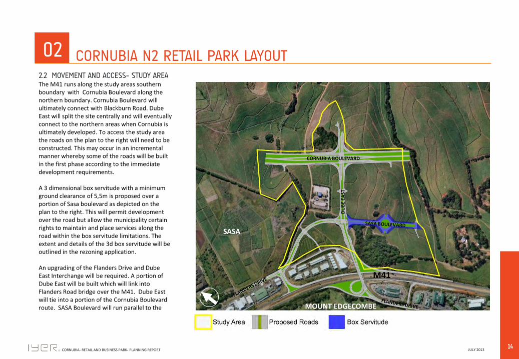
The M41 runs along the study areas southern boundary with Cornubia Boulevard along the northern boundary. Cornubia Boulevard will ultimately connect with Blackburn Road. Dube East will split the site centrally and will eventually connect to the northern areas when Cornubia is ultimately developed. To access the study area the roads on the plan to the right will need to be constructed. This may occur in an incremental manner whereby some of the roads will be built in the first phase according to the immediate development requirements. A 3 dimensional box servitude with a minimum ground clearance of 5,5m is proposed over a portion of Sasa boulevard as depicted on the plan to the right. This will permit development over the road but allow the municipality certain rights to maintain and place services along the road within the box servitude limitations. The extent and details of the 3d box servitude will be outlined in the rezoning application. An upgrading of the Flanders Drive and Dube East Interchange will be required. A portion of Dube East will be built which will link into Flanders Road bridge over the M41. Dube East will tie into a portion of the Cornubia Boulevard route. SASA Boulevard will run parallel to the
02 CORNUBIA N2 RETAIL PARK LAYOUT 2.2 MOVEMENT AND ACCESS- STUDY AREA
MOUNT EDGECOMBE
SASA
M41
DU
BE
EAST
CORNUBIA BOULEVARD

15 JULY 2013 CORNUBIA- RETAIL AND BUSINESS PARK- PLANNING REPORT
M41, intersect with Dube East and then run parallel to the western boundary of SASA and join Flanders Drive. SASA Boulevard will provide the main ingress and egress points into the various sites. The road design conforms to all geometric design standards as set out by Ethekwini Traffic Authority (ETA) as well as is in line with the Traffic Impact Assessment undertaken for the Cornubia development and a Cornubia Retail and Businesses Park TIA undertaken by Vela VKE (SMEC).
02 CORNUBIA N2 RETAIL PARK LAYOUT 2.2 MOVEMENT AND ACCESS- STUDY AREA continued…
MOUNT EDGECOMBE
SASA
M41
DU
BE
EAST
CORNUBIA BOULEVARD

16 JULY 2013 CORNUBIA- RETAIL AND BUSINESS PARK- PLANNING REPORT
Given the nature of the existing topography and uses proposed, the primary starting point for the design of the study area has been the integration of the various aspects of design. In this regard, the first stage of the design focused on establishing a uniform grade across each site and enables a greater design integration with the street and site. The existing wetlands over Erf 602 and Portion 7 of Erf 27 will be developed over as the heads of these wetlands are severed by Cornubia Boulevard therefore they do not form part of the larger open space system and are too small to be functional on their own. This will be elaborated in greater detail within the EIA/wetland study report.
The diagram on the right indicates the proposed platforms with embankments denoted in red. As mentioned earlier on in the report, the Waste Transfer facility located on Erf 602 and Portion 9 of 27 will be relocated to Portion 3 of Erf 11. A planning assessment was conducted and it was determined that this location was desirable as there are very few constraints. The location of the facility has been setback and screened by Mixed use development along Cornubia Boulevard. It is in close proximity to the existing facility therefore the relocation is within the same zone. There are no pure residential uses within 150m from its location apart from mixed use residential apartments, therefore based on the planning assessment, this site was regarded as the preferred location. The relocation will be elaborated at greater length in the EIA study which is currently being undertaken.
02 CORNUBIA N2 RETAIL PARK LAYOUT 2.3 PREPARING THE SITE
MOUNT EDGECOMBE
SASA
M41
DU
BE
EA
ST
CORNUBIA BOULEVARD
ERF 601
ERF 601
ERF 602
PTN 9 OF
ERF 27
PROP
PTN 7 OF
ERF 27
PTN 15
OF ERF 27 PTN 14
OF ERF 27
PTN 3
OF ERF
11 PTN 4 OF
ERF 11

17 JULY 2013 CORNUBIA- RETAIL AND BUSINESS PARK- PLANNING REPORT
The General Business use is the dominant use within the study area. This is in line with the approved Cornubia Development Framework. The General Business use permits retail, office and office park type of developments. The remaining uses are Mixed use 1, along Cornubia Boulevard which permits retail and residential uses. The site identified for the DSW Transfer facility has been identified for administration. As mentioned previously, the Cornubia Retail and Businesses Park zone will fall under Special Zone 19-Cornubia Town Centre. There has been interest to develop the sites for retail /’big box’ developments due to its good location as well as it could serve as a potential major node when the Cornubia development is fully developed. A major property group plans to develop the portion denoted as Erf 601 on the plan to the right for retail development. The total Study area measures, 36.3 ha in extent. The General Business use totals 23. 8 ha which is 65.6% of the total study area. Mixed use 1 equates to 3.6% of the study area with administration occupying only 1% of the study area. The balance of the site consists of road reserves which equates to 30%.
02 CORNUBIA N2 RETAIL PARK LAYOUT 2.4 LAND USE AND CONTROLS
MOUNT EDGECOMBE
SASA
M41
CORNUBIA BOULEVARD
ERF 601
ERF 601
ERF 602
PTN 9 OF
ERF 27
PROP
PTN 7 OF
ERF 27
PTN 15
OF ERF 27 PTN 14
OF ERF 27
PTN 3
OF ERF
11 PTN 4 OF
ERF 11
DU
BE
EA
ST
18 JULY 2013 CORNUBIA- RETAIL AND BUSINESS PARK- PLANNING REPORT
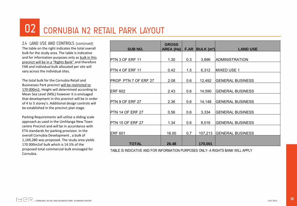
The table on the right indicates the total overall bulk for the study area. The table is indicative and for information purposes only as bulk in this precinct will be in a “Rights Bank” and therefore FAR and individual bulk allocated per site will vary across the individual sites. The total bulk for the Cornubia Retail and Businesses Park precinct will be restricted to 170 000m2. Height will determined according to Mean Sea Level (MSL) however it is envisaged that development in this precinct will be in order of 4 to 5 storey’s. Additional design controls will be established in the precinct plan stage. Parking Requirements will utilise a sliding scale approach as used in the Umhlanga New Town centre Precinct and will be in accordance with ETA standards for parking provision. In the overall Cornubia Development , a bulk of 1,169,280 was proposed. The study area yields 170 000m2of bulk which is 14.5% of the proposed total commercial bulk envisaged for Cornubia.
02 CORNUBIA N2 RETAIL PARK LAYOUT 2.4 LAND USE AND CONTROLS (continued)
SUB NO.
GROSS
AREA (Ha) F.AR BULK (m²) LAND USE
PTN 3 OF ERF 11 1.30 0.3 3,896 ADMINISTRATION
PTN 4 OF ERF 11 0.42 1.5 6,312 MIXED USE 1
PROP. PTN 7 OF ERF 27 2.08 0.6 12,492 GENERAL BUSINESS
ERF 602 2.43 0.6 14,590 GENERAL BUSINESS
PTN 9 OF ERF 27 2.36 0.6 14,148 GENERAL BUSINESS
PTN 14 OF ERF 27 0.56 0.6 3,334 GENERAL BUSINESS
PTN 15 OF ERF 27 1.34 0.6 8,016 GENERAL BUSINESS
ERF 601 16.00 0.7 107,213 GENERAL BUSINESS
TOTAL 26.48 170,001
TABLE IS INDICATIVE AND FOR INFORMATION PURPOSES ONLY- A RIGHTS BANK WILL APPLY
19 JULY 2013 CORNUBIA- RETAIL AND BUSINESS PARK- PLANNING REPORT
02 CORNUBIA N2 RETAIL PARK LAYOUT
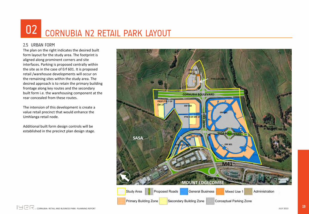
The plan on the right indicates the desired built form layout for the study area. The footprint is aligned along prominent corners and site interfaces. Parking is proposed centrally within the site as in the case of Erf 601. It is proposed retail /warehouse developments will occur on the remaining sites within the study area. The desired approach is to retain the primary building frontage along key routes and the secondary built form i.e. the warehousing component at the rear concealed from these routes. The intension of this development is create a value retail precinct that would enhance the Umhlanga retail node. Additional built form design controls will be established in the precinct plan design stage.
2.5 URBAN FORM
MOUNT EDGECOMBE
SASA
M41
CORNUBIA BOULEVARD
DU
BE
EA
ST ERF 601
ERF 601
ERF 602
PTN 9 OF ERF 27
PROP PTN 7 OF
ERF 27
PTN 15 OF ERF
27
PTN 14 OF ERF
27
PTN 3 OF
ERF 11
PTN 4 OF ERF 11

20 JULY 2013 CORNUBIA- RETAIL AND BUSINESS PARK- PLANNING REPORT
03
DEVELOPMENT VISION
21 JULY 2013 CORNUBIA- RETAIL AND BUSINESS PARK- PLANNING REPORT
03 DEVELOPMENT VISION
CORNUBIA BOULEVARD
DU
BE
EA
ST
SASA
LANDHOLDING
DU
BE
WE
ST
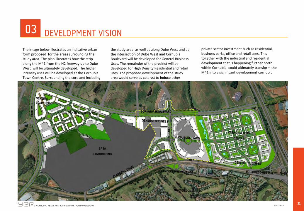
The image below illustrates an indicative urban form proposed for the areas surrounding the study area. The plan illustrates how the strip along the M41 from the N2 freeway up to Dube West will be ultimately developed. The higher intensity uses will be developed at the Cornubia Town Centre. Surrounding the core and including
the study area as well as along Dube West and at the intersection of Dube West and Cornubia Boulevard will be developed for General Business Uses. The remainder of the precinct will be developed for High Density Residential and retail uses. The proposed development of the study area would serve as catalyst to induce other
private sector investment such as residential, business parks, office and retail uses. This together with the industrial and residential development that is happening further north within Cornubia, could ultimately transform the M41 into a significant development corridor.

22 JULY 2013 CORNUBIA- RETAIL AND BUSINESS PARK- PLANNING REPORT
04
CONCLUSION

23 JULY 2013 CORNUBIA- RETAIL AND BUSINESS PARK- PLANNING REPORT
04 CONCLUSION
This report outlined the approach, vision and layout for the development of the study area. The report has demonstrated that the proposal is; • In line with the approved Cornubia
Framework Plan and vision. The location of the development is in line with planning intent as the study area is in a prime location for the nature of uses proposed;
• It was also established that this development would serve as a catalyst to induce future private sector investment within this area;
• It will also generate much needed employment opportunities for people of Cornubia and surrounds. Since the Medium Density residential development is already under construction with approximately 2500 units envisaged in the short term, the development of the study area may contribute in creating much needed employment opportunities in the area.
• Initial Feasibilities indicated that the precinct would be able to provide a number of short and permanent jobs as well as contribute significantly to the rates base of Ethekwini Municipality per annum.