
CORALYILLE LAKE IGNA V IUNCLSSIFIED · 5 t9 buton is unlrwitod. * Jefry .Anero, eoorhloiso,- ........
97
r 0-M63:12? TIMElARCHAEOLOGY OF CORALYILLE LAKE IGNA VOLUME 3 SAMPLE V I SURVEY (INTERIM R.. CU) GREAT LAKES ARCHAEOLOGICAL I RESEARCH CENTER INC HAUNATOSR HI D F OVERSTREET ET AL. IUNCLSSIFIED MAR 85 D C2-4 - C-6633FO 5 /6 M
Transcript of CORALYILLE LAKE IGNA V IUNCLSSIFIED · 5 t9 buton is unlrwitod. * Jefry .Anero, eoorhloiso,- ........
r 0-M63:12? TIMElARCHAEOLOGY OF CORALYILLE LAKE IGNA VOLUME 3 SAMPLE VI SURVEY (INTERIM R.. CU) GREAT LAKES ARCHAEOLOGICALI RESEARCH CENTER INC HAUNATOSR HI D F OVERSTREET ET AL.IUNCLSSIFIED MAR 85 D C2-4 - C-6633FO 5 /6 M
:7 --7'. 7 : 7.-.P %, 7 -.
2-5.
1. 4 0
1-8c
NATIONAL BUREAU OF STANDARDSMICROCOPY RESOLUTIONi TEST CHART
f, GREAT LAKESSARCHAEOLOGICAL 4
o RESEARCH CENTER, INC.
Reports of Investigation No. 167
THE ARCHAEOLOGY OF CORALVILLE LAKE, IOWA
VOLUME III: SAMPLE SURVEY (INTERIM REPORT I1
p
RECT E-* JAN 14 1986
WAUWATOSA. WISCONSIN
86 "13 118
'-. ~THE ARCHAEOLOGY OF CORALVILLE LAKE, IOWA ?-2:
- VOLUM4E III: SAMPLE SURVEY (INTERIM REPORT 1)
P 0. - -
Prepared By: Great Lakes Archaeological Research Center, Inc. .-.-"7509 West Harwood Avenue ...Wauwatosa, WI 53213 -"-
David F. Overstreet, Ph.D., Principal Investigator .
James G. Stark, Research Associate
• Jeffrey D. Anderson, Geomorphologist ,-
DTIRI
Prepared For: Department of The Army -..
Rock island District "Corps of Engineers ^/EL..ECTEI!l[I9 ..Clock Tower Building :Rock Island, IL 61201 JANI
Under Provisions of Contract No. DACW25-84-C-0033
March 1985 ".---2: , ,-2- ' "Peae ByGetLk Arhelroi ase cad sln-te, nc. .
5 t9 buton is unlrwitod.
* Jefry .Anero, eoorhloiso
,- .." ... _'.?_.,.'Prepared- i -°. .' '.-' For:Depa tmen ofi''- The; Army''-'"..'':_- £-.,--'_, ¢_ 2 ''' :'' "i3|..-%.t

• %..'"""- .4 .
-A B S T R A C T
- Reports of Investigations No. 156 entitled"Archaeological Investigations At Coralville Lake - Resultsof Mangement Phases 0-I" is an interim report. Essentially,the report is a comprehensive progress report that detailswork completed to date under the auspices of contract numberDACW25-84-C-0033. AManagement Phases 0-I entail development -.
of a management data base for Coralville Lake and thecompletion of a 20% stratified random sample survey of theproject area. In addition to these two primary tasks,ancillary work included test excavations at 5 archaeologicalsites, none of which are considered eligible for TheNational Register of Historic Places. Finally, the results
. of both literature and archives search and field . 4investigations related to the surficial geology of theproject lcoality are incorporated in this interim report.
A total of 1858 hectares comprising 21.5% of theCoralville Lake project area was subjected to archaeologicalsurvey. Sixty-four previously unrecorded sites were foundwithin the sample units. Twenty-five previously reported ,sites, located within the sample units were revisited. Newsite boundaries were determined and additioinal culturalmaterials were collected. Information from field and
" lab-based investigations were incorporated within theautomated data management system.
Accession For
NTIS " "
Distr-,t , !t
Avnt1, "
Dist.1
...................... , D t .. 4 .
TABLE OF CONTENTS
Abstract...................... . .. ...... . . .. .. .. .... i
List of Figures..............................iv
List of Tables...............................iv pList of Appendices.............................iv
Introduction.................................
Management Phase 0.................. . . ... . .. .. .. .. .......
Management Phase I ........................... 2
Pre-field Research........................2
Methods and Techniques of Investigat! . ns. ........ 6
Survey Technique.........................12
Site Records..........................14
Excavation Strategy ....................... 14
Artifact Processing ......................... 16
Results of Management Phase I Survey. ................. 17
Historic Sites............................32
Prehistoric Sites.......................34..
Sites with Diagnostic Art ifacts- .
- Revisited-East.........................37
Sites with Diagnostic Artifacts-New-East............................38
Sites with Diagnostic Artifacts-West of 1-380 Bridge......................46
Revisited Sites.........................46
New Sites-West of 1-380 Bridge ............... 47
Survey Summary.................................50
Surficial Geology of Coralville Lake. ................. 55
Introduction...........................55
* Quaternary History.........................55
* Bedrock Units...........................55
he Pleistocene. . . .. ....... .. .. .. .... .. .. .. ....... ... ..
.55
- TABLE OF CONTENTS (continued)
The Holocene.......................59
Climatic History ..................
Geomorphic Episodes. ................. 60Coralville Site Characteristics. ............. 61 :
Previous Investigation ................ 64
The Floodplain.....................64
Preliminary Site Investigations. ............. 65
13 JH500 ....................... 65
13 JHl 482 ........................ 67
13 Jil 492 ....................... 69
13 JiI 202 ....................... 69
13 JHl 479 ....................... 72 L
Discussion.......................74
- References-- Citd...................................8
oFLIST OF FIGURES
1. Sketch Map, 13 JH 479 ...... ................. . 41
2. Transit Map, 13 JH 482 ................ 43
3. Transit Map, 13 JH 492 ..... ................ 45
4. Transit Map, 13 JH 500 ..... ................ 49
5. Schematic East-West Cross Section, Eastern Iowa. . .. 57
6. Schematic North-South Cross Section, Eastern Iowa. . 58
7. Holocene Variation in the Magnitudeof mean annual floods ........... ......... 62
- 8. Iowan Surface and pre-Illinoisan "Kansan" Drift Plain. 63
9. Stratigraphy at 13 JH 500 .... ............... . 66
10. Stratigraphy at 13 JH 482 .... ............... . 68
11. Stratigraphy at 13 JH 492. ............... 70
12. Stratigraphy at 13 JH 202 ...... ............. .. 71
13. Stratigraphy at 13 JH 479 ..... .............. ... 73
14. Swisher 107-Core No. 1 ..... ................ 75
15. Swisher 107-Core No. 2 ..... ................ 76
16. Amana 37-Core No. 1 ...... .................. . 78
17. Position of 2d Order Watershed at Coralville Lake. . 79
LIST OF TABLES
1. Map Legend-Physical Environments of Coralville Lake. 8
2. Coralville Survey Coverage (Hectares) ........... .. 10
3. Codes for Review of Existing Archaeological Record 18
4. Coralville Known Site Summary ... ............. . 19
5. Status Update - Previously Known Sites ......... . 28
6. Coralville Site Totals by Component ... .......... .. 29
7. Coralville Site Distribution ... ............. . 52
LIST OF APPENDICES
A. Lot Check Lists - Coralville Lake .... .......... .. 2d Vol.
' B. Iowa Site Records - Coralville Lake ........... ... 2d Vol.
C. Level Records - Coralville Lake .... ........... .2d Vol.
D. Detail Maps - Coralville Lake ..... ............ .2d Vol.
iv. " "-*.
T. - oZ" 'K°1m"-
V _._. . -
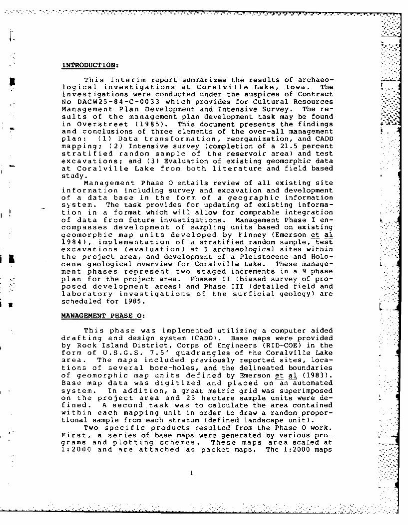
INTRODUCTION:
This interim report summarizes the results of archaeo-, logical investigations at Coralville Lake, Iowa. The
investigations were conducted under the auspices of ContractNo DACW25-84-C-0033 which provides for Cultural ResourcesManagement Plan Development and Intensive Survey. The re-sults of the management plan development task may be found %in Overstreet (1985). This document presents the findingsand conclusions of three elements of the over-all managementplan: (1) Data transformation, reorganization, and CADDmapping; (2) Intensive survey (completion of a 21.5 percentstratified random sample of the reservoir area) and testexcavations; and (3) Evaluation of existing geomorphic dataat Coralville Lake from both literature and field basedstudy.
Management Phase 0 entails review of all existing siteinformation including survey and excavation and developmentof a data base in the form of a geographic informationsystem. The task provides for updating of existing informa-tion in a format which will allow for comprable integrationof data from future investigations. Management Phase I en-compasses development of sampling units based on existinggeomorphic map units developed by Finney (Emerson et al1984), implementation of a stratified random sample, testexcavations (evaluation) at 5 archaeological sites within
5 the project area, and development of a Pleistocene and Holo-cene geological overview for Coralville Lake. These manage-ment phases represent two staged increments in a 9 phaseplan for the project area. Phases II (biased survey of pro-posed development areas) and Phase III (detailed field andlaboratory investigations of the surficial geology) are
6 scheduled for 1985.
MANAGEMENT PHASE 0:
This phase was implemented utilizing a computer aideddrafting and design system (CADD). Base maps were providedby Rock Island District, Corps of Engineers (RID-COE) in theform of U.S.G.S. 7.5' quadrangles of the Coralville Lakearea. The maps included previously reported sites, loca-tions of several bore-holes, and the delineated boundariesof geomorphic map units defined by Emerson et al (1983).Base map data was digitized and placed on an automatedsystem. In addition, a great metric grid was superimposedon the project area and 25 hectare sample units were de-fined. A second task was to calculate the area containedwithin each mapping unit in order to draw a random propor-tional sample from each stratum (defined landscape unit).
Two specific products resulted from the Phase 0 work.First, a series of base maps were generated by various pro-grams and plotting schemes. These maps area scaled at1:2000 and are attached as packet maps. The 1:2000 maps
1 '-".
-2-
include a regional base map, sample units and archaeologicalsites, land-use units, geomorphic units, and an index mapfor the second product. The second product consists of aseries of detail maps at a scale of 1:600. The 1:600 mapsinclude the locations of sites located during the samplesurvey (including isolated finds) and the revised boundariesof previously known sites at Coralville Lake that were con-tained within the sample units. For a more detailedpresentation of data files and CADD mapping refer to Over-street (1985).
MANAGEMENT PHASE I:
As previously noted, Phase I includes operationalizingthe stratified random sample of Coralville Lake Landscapes.Results of this effort are presented in the following narra-tive that includes a discussion of pre-field investigations,methods and techniques of survey and excavation, and theresults of the the survey. In addition to this, a geologi-cal overview is presented for Coralville Lake along with theresults of preliminary field investigations. Finally, thesummary of surficial geology in the project area includes a ...discussion of data limitations and addresses the ways andmeans to resolve such limitations.
Pre-field Research:
A thorough examination of the pertinent records ofprevious archaeological investigations is one of the primarygoals of Phase I of a Cultural Resources Management Plan forCoralville Lake. Thus, this report includes a detailedreview of the existing literature regarding archaeologicalstudy of the Coralville Reservoir area. As an earlierreport (Emerson et al 1984) details such information inpart, that effort will not be entirely duplicated here.Rather a summary of previous investigations, in part fromEmerson et al (1984) is presented below. The reader isinvited to consult Emerson et al (1984), Weichman andTandarich (1974), Zieglowsky and Zalesky (1981), and the Lreferences cited for more detailed consideration.
Early archaeological studies in the eastern UnitedStates often focused on the various types of mounds foundthroughout the area. The vicinity of the Iowa River inJohnson County was no exception. The Rev. James L. Scott(1843) and Captain F.M. Irish (1868) were two earlytravelers through Iowa who recorded Indian tumuli near IowaCity. In the History ofJohnson County, Iowa by M.W.Davis and A.C. Trowbridge ( 1883), four mound groups andthree historic Mesquakie villages are reported along theIowa River. Some 100 mound groups in Johnson Co. werereported in the Smithsonian Institution's First AnnualReport (Webster (1888). This work was also reported in theProceedings of the Davenport Academy of Natural Science(Starr 1895). Early work in Iowa is representative of most
.............................
*~~~7 W7 -.. rr r
archaeology carried out prior to 1900 in the Eastern UnitedS;ta t o s w ith I an oimpha.; )1 plc on oxcavat i on or, 1-rt-11 worksand burials.
Th, ,.i r 1y 1900':; saiw I ho hog innings of anthropologicalarchadeoLogy in Iowa with the work of Rev. Oweni J.H. Ward. Adi scuss ion of anthropoloqy as a science as well as themnethods and re-sults of anarchaeological survt.y along theIow, R ive-?r wtere presented in a series fatce pblsdin the Iowa Journal of History and Politics (Weichrnan andTandar ich 1974). Charles- R. Keyes, director of the IowaS t ate Archaoolog icalI Su rve2y, for over thirty years workedo x tens! it .L Iy to (. a L ttr in( f ormIat i oni I owit's. prei., stor ics itezs. Although much of the information Keyes gathered wasn -v e r published, his research has been organized and a"F in dr'Is ISIti do" to h is not--5- which summar ize (s ) the mater-ial by county has been pub!Lisihed (Tiffany 198L).
In conjunction with construction of the Coralville Dam,Ithie Sm3ini rhIts on ia n T n sL it ut i or)'s R ivo-r Bas in Survey sponsoredtwe p-)r o ioc t - a i Ind a t idornt i f yi ng andi ia I vagI 1 ng~ itrchaool og i -
ca L -3i t es wi ichf igqh t bt- Ioa t IWi wth Ii n t he a rea t o be flo(-)od -ed. in 1946 , Richard P. Wheeler surveyed the area and re-ported nine sites in the project area (Wheeler 1949).Warre-n W. Caldwell did a follow up study in 1956, conductingLexcavation and surface collection of 10 sites within theRed ervoir. Caldwell's surve2y was apparently limited to anarea within the conservation pool.
Beginning in the 1960's, several Federal laws androg u 1at ions mnandate d the mnanagemetnt of cultural resources onfedt r ii y owne d land anhd on l and effected by federally fund-cid and'-/or licensed pro:j2ct- These laws in conjunction withat t I uo rtosenco of theo I-.-t i I awa reness on thte p)art ofa rcha,-oloq ists led to an increase in the quality and quanti-t y of arnvdo lo i ali ;et ij t ions Conducted throughout thle1in i te.-d S taites. These I wo phenomena inf luenced the mostrecent work within the Corailville Reservoir.
I n t ho I aite 19 60 ' s , Air ian Anderson di rectedl a se-r iescoI Li in ainer e I cd s c1. ooIs v It 1h s tude ntLs f r om the tini v-er'si ty ofr ow a i n t he pro jec t -irea . Two reports published inPrehistoric Investigat ions edited by Marshal. McKusickd r i4 ved f roin t h i s work h f i rst ,Review of Iowa RiverVallIey _Arc haeol1oqy ( And r -o n 19 713) doc ume nts culItureh1i Sto0r Y a nd ce raic St YlIes in1 thle a rea., It presents resultsof a suarve.y of the shoro l me, of Coralville Lake, apparently
d -rc t-,d t f rield -heck I n.) sites renported by local (:!-lec to rs. AlIt hoI' ijh It rv pa raimntors3 arc not d i scussed,A n der in r-,:) or t locai nj tn s i fs and tes t i ng t wo. Hedo tr in i no d t iIt t hes, 4i 1 tiin I i t h ic( sca Lters w i th lit tletr,, i arch vii i I t aj;t ii~ 1-r) 1n, Anders;on also reconnnnd-a] An) i nt -i:;lvrv-y, pi ,;r in for the Iowa River in order
ao dIol p I t 1 11fl t~nn 1,t ne l; I r)II(,,I-I in hi:; scum],jn articleoA nde! r m ri /71:)) - -p-) I x .oj V<.'. I I)s It the1 W.1 I rs S;i te(1 H1 .1 1 r I e I Io Ii Il "Nn -11 t)-] haO it it ion :;i t .
'1w 4mIti' :, J7 i r?(t-d by Michael S. Weichinanm K , : Oi, i I< in in it I -I *-r. J1 ler taken i n the
-4-
mid-1970's. The first is an extensive literature search ofreferences to archaeology of the Iowa River Valley betweenCoralville Dam and the Cedar River. This article is
U apparently the source of much of the information on investi- .gations presented in Emerson (et al 1984) and has signi-ficant influcence here. Weichman presents summary informa-tion on 33 of the sites in the project are. Among hisrecommendations, Weichman calls for an intensive survey ofthe Coralville Lake shoreline and a long term Cultural
- Resource Management program for Coralville Lake.Weichman's second project was a survey along several
highway corridors in the vicinity of the Lake for theJohnson County Highway Department (Weichman 1975). Thissurvey located five new sites and relocated one previouslyreported site. It is noteworthy in that it was the onlysystematic fieldwork known for the project area west of the1-380 bridge prior to MPI.
James Zalesky, an avocational archaeologist, has pre-pared a paper, A Collection of Surface Finds from EastCentral Iowa (Zalesky 1977). This report, prepared for aclass at Iowa State University, presents an inventory ofsites the author located in Iowa, Linn and Johnson Counties,Iowa. The paper documented 67 sites within the CoralvilleReservoir boundaries. Although the report has limitationscharacteristic of student papers, it is the only referencefor many of the reported sites in the project area.
Duane L. Miller, another avocational archaeologistliving in Iowa City, has also shown a keen interest in thearchaeology of Coralville reservoir. Beginning in 1979, Mr.Miller has reported sites he located along the shore ofCoralville Lake. From the information available in the sitefiles it appears than Miller and Zalesky often collectedmany of the same sites.
In 1979 (Lewis 1979) a reconnaissance survey, and in1980 (Roetzel and Strachan 1980 ) an intensive testingproject, were carried out at the site of a sewage lagoon 1/2mile southeast of the Coralville Dam (13 Jh 253).
In 1981, a survey of the shoreline of Coralville Lakewas undertaken by the Office of the State Archaeologistunder the direction of Shirley Schermer (Schermer 1983).Although conceptualized as a 20% stratified random sample ofthe entire lake shore, approximately 7% of the shoreline wassurveyed, all of which was east of the 1-380 bridge. TheIowa Office of the State Archaeologist also sponsored astatus report of the known archaeolog-,al resources in theproject area. The report prepared by Debby Zieglowsky andJames Zalesky (1981) was designed to review o rvious work inthe area, dc termine the condition of selected sites and makerecommendations for resource management. The report notesthat many of the sites along Coralville Lake are badlyeroded (31 of 79 checked), while others have suffered littleor no ill effects due to erosion. Zeiglowsly and Zaloskycall for development of a long range problem orientatedmanagement plan for Coralville Lake.
An attempt to investigate possible correlations betweene n vironmental variables and settlement was presented byShirley Schermner (1982). Statistical te chniques were used
a o t -5 :i or corr-] at ion h-t w-on to-rt a in onvi roninontiIvar iables and Late Woodlaind habitation sites. Scherinter ~found a positive correlation between Late Woodland habita-tion site:s and the following variables; amount and type ofenyv i r onime n ta I d ive rs i ty , la ndf o r e levat ion , exp)os Ure , soidr a inage capab ili t ies , prox iiity to a wate r source and >prox imitVy to a forest Vgation zone. 'Late Woodland habi ta-t on wa,; not (-(r rl ii at-d wi th proximi ty to lithir orcsupland i -s htzs , prairie indi mi-xed prai rie zonies. Scherii11,2rsuggests that short termn cainpsit2!s are likely to be found inflIoodplIa in , hi gh ter race, ind uipland areas, whle, long te-rmninult ist-asonal sites wi ll be located on low terraces.
4While Schermer's results are of interest, several ofher .issumnpt-ions hive Ae uest ioned by Emerson et al( 1984) . Specifically, it is doubtful that her samnple of 108sit-.s have eint ovid,nce,- of habitation, or, that theyare a representative ianpi-e of Late Woodland sites in theCoralville Reservoir (Emerson et al 1984).
rhe most recent work at the reservoir prior to imnple-mentat ion of this manageme.nt- plan was carried out by ImpactServices Inc. (Emerson ot al 1984). Its primary goals
weeto rev iew the c~xi-; i ng3 archaeological data for theCoralvilLe Lake area and1 to develop a preliminary model ofthe gjeoinorphology of Coralville Lake and surrounding
i I environs. Othetr gjoaI ,; i n clu ded f ield checki ng prev iouslyre-!co rd ed( s i t,?s- a nd i intoermiv exca va tion s It th tree sit -?- i nthe Sugar Bottoms Recreat ional Are a to determine eligibilityof those site-s for noininat ion to the National Register ofi s t or ic PlIa ces . Thnt- revie w of the literature appears comn-
p r2teen s i v a~ n ad a s nt ibo v t2 f rmins t-het- basisi f or thetp pr2c ee d ing s c t io()n. Th g' oinorphological model, althoughpr. l Iimi nary in nature, .ind not as de-fine2(i as imight. be con-s3ide-re!d idealI, -was u-3ed isi the start ing po int for ourstLrIt i f e d sape
In our review of I h- pre vious irivs tigaticens, several!311in t points sta:nd o-ut. Several of thle investi i tors havepcall,?d for intenisive siirve y (Anderson 197L1a, Weichman andTan da ri ch 1974 ) and or do~ve lopmnent of a long range manage:-in it pI a n Fo()r thIte a r ch ae(olIog i c l re-source s of CoraIv iIleLakre (Wiechinan and Tandarich 1974, Zieglowsky andi Zalesky1 981). Desp)i t ? a rather suabstantiail amount of work and a1irj- and 1dive2r.-e body ()I docurnontat--ion, neither of these
oa1sia: beenr nignat l dd rossed.A s el1 :1onin c n tio0n ci i t- gl1ar i ng deIiai n y ini th e
:01iv,- V corpus of . ir ahawologjy at the re-se7-rvo:ir is thealmost, comnpiet- laci(k o)I iniformation on sites in the areawest- ,t the 1-380U/Higiwiy 218 bridgf-s. With the xepIoof Weiebman's surve-y of County Road F along the north edgeof this a enochaoo a investigations ar reported.
Wh iLIc bnl ingj on thii -xt ,nsi ye and ge(n-rally gJ.od workt haV h ; ben one in tb, .ir -l, the present report addresses
" "" ~-6- -'"'
the question of systematic survey and implements a long-termcomprehensive management plan.
Despite almost 30 years of professional archaeologicalinvolvement at Coralville, it is the activity of amateurcollectors which has brought the largest number of sitesinto the state site files. James Zalesky and Duane Millerhave reported respectively, 73 and 57 sites each. A quickreview of the site files indicates that between the two ofthem, they have probably visited nearly every known site inCoralville Reservoir.
The survey strategy of avocational archaeologists isnot always clearly stated and the goals of their surveyactivity may be somewhat different than that espoused by theprofessional community. At Coralville Reservoir, the hardwork and dedication of Zalesky and Miller are to becommended. Between them they have reported fully two thirdsof all the sites known in the reservoir. Their apparentwillingness to share their information with other archae-ologists has contributed to a vastly greater number ofrecorded sites than might otherwise have been possible.
Methods and Techniques of Investigations:
The primary technique used during MPI Survey at Coral-ville was a systematic stratified random sample. The sampleuniverse was taken to be the land around the reservoir underjurisdiction the U.S. Army Corps of Engineers. The Corpsdesigned their dam and reservoir to maintain a pool eleva- Ltion of approximately 680' above mean sea level as normalpool elevation. The dam is designed to impound flood watersto a level of 712' above mean sea level. This maximum floodpool level serves as the approximate boundary of corpsmanaged and 1:ased land.
The Corps of Engineers has responsibility for 24,118acres (9760 .5 hectares ) of land for its Coralville opera-tion. It holds flood easements on an additional 9,567 acres(3871.8 hectares). The pool at maximum flood elevation
covers approximately 24,800 acres. These figures are takenfrom Emerson et. al. 1984. A portion of the federallymanaged land is perpetually under water in the reservoir.This includes Lake McBride, Coralville Lake and floodedportions of the Hawkeye Wildlife Area. In addition somelands were excluded from survey because the exact USACEproperty boundary is in dispute or the lands surround LakeMcBride which was excluded from the current project.Excluded area totals 12,407 acres (5021.3 hectares). Thisr- snlts in a total of approximately 21,278 acres (8611hictare s) of land for the sampling universe.
The final figure for surveyable land at Coralville wasderived from the CADD system maps. Due to digitizing error,erosion, uncertain bouindaries and fluctuating water levels,a completely accurate measure of surveyable land in theproject area was not attained.
-7-- h
I. 4
The sampling universe was initially subdivided intonatural landscape categories by Harlan Finney (Emerson et.al. 1984) as part of a geoinorphological survey of CoralvilleReservoi r undortaken by Tinihlct Services, Inc. These units,called geomorphic mapping units, are based upon landlortosoils and relief. These geomorphic mapping units were
recorded on U.S.G.S. 7.5' maps by Impact Services andsupplied to GLARC, Inc. by the Corps of Engineers. Thegeomorphic unit definitions and mapping symbols are providedin Table 1. This delineation of geomorphic units formed the
i bas is for a series of computer generated maps of the project
area.. Production of these maps was an integral part of theoverall project design and the system is described below.
As part of it's proposal for managing the culturalr.souros of Cralvil1et Rts,,rvoir, GLARC, Inc. recommendedrecording all pertinent cultural and geomorphic features ofthe reservoir in a computer aided design and drafting (CADD)system. For this purpose we enlisted the aid of Donohue andAs3oi~atf,?s Tnc., for CAD) system support. The system isc.-ipable of recording 64 levels of spatial data (example;contours, drainage, road systems, prehistoric sites, etc.)for a liven area. These data may then be presented in any
, 1.-: r ,d co nbination of features and at a variety of scales.
,)n- oft ch., features ot CADD system is that numerical valuesa. c at.] with the graphic (i.e. area of sites or geomor-phic inits, length of roads, etc.) are maintained within thesys tn. This facilitates rapid updates and measurements ofirregular features. An additional feature of CADD systemsI is that they allow easy conversion between various landmeasurement schemes. This proved especially useful as weused t 25 hectare survey unit and recorded site locationsusing UTM coordina, s as well as the more traditional legaldescription with section, township and range designations.Although uti lization of a CADD system for archaeologicalsurvey includes substantial investment, once developed thesystems offer significant benefit as a research and manage-ment tool.
At the beginning of Fieldwork, a set of base data hadbeen entered into the CADD system, and a series of naps show-ing Corps boundaries, a TJTM grid and geomorphic mappingunits was produced. These maps were the base from which asample was drawn for survey. The area of Corps managed landwas overlain with a grid composed of 25 hectare squares.These squares were numbered consecutively and a 20% samplewas selected using a table of random numbers. The samplewas adjusted in such a way as to ensure that at least 20% ofthe area of each of Finney's geomorphic mapping units wasselected. Most sampling designs involving real estate tendto hayv, ionmo i nherent h i ,.es which to a greatr or lessordegree skew the samiple. One form of bias in our sample in-volved the small and irregular nature of portions of some ofthe geomorphic mapping units within the project area. Inseveral cases, the area involved was small enough that agreater than 20% sample was surveyed, often 100%. In no
grae
-8-
TABLE 1: MAP LEGEND - PHYSICAL ENVIRONMENTS OF CORALVILLE LAKE(From Emerson et. al. 1984)
NAME SYMBOL
Iowan Surface
Soils formed under forest:in thick aeolian sediments SFAin glacial till or a thin mantle of aeolian orerosional sediments and in underlying glacial till SFT
Soils formed under savannah in a thin mantle of aeolianor erosional sediments and underlying glacial till: SST
Soils formed under prairie in a thin mantle of aeolianor erosional sediments and in underlying glacial till: SPT
Southern Iowa Drift Plain
Soils formed under forest on valley slopes,hillsides, and interfluves:
in thick aeolian sediments PHAin a thin mantle of aeolian sediments and in under-lying glacial till or entirely in glacial till PHT
Soils formed under forest in thick loess onprominent high lying ridgetops: PSA
Physical environments occurring in both of the abovelandform regions
I%Floodplains, alluvial fans, and footslopes: F
Terraces:Lacking a mantle of aeolian sediments withsoils formed under:
forest TLFprairie TLPsavannah TLS
having a thick mantle of loess with soilsformed under forest: TAF
having a thick mantle of aeolian sedimentswith soils formed under prairie: TAP
having at least a thin mantle of aeolianS -sediments with soils formed under savannah: TAS
Undifferentiated in valleys of small streams: TU
- Altered Lands
Limestone quarry: XQ
Cut and fill: XC
. . . . . .. . . . .. .. . . .. ...
- • -- () -
case, however, was coverage of a geomorphic unit less than20%. Table 2 shows the area of each geomorphic unit inhectares, its percentage of the total and the area to becovor.d for a 20% samplo.
The Coralvi Lie" Reservuir cove.!rs portions OL the trearepresented on four U.S.G.S. 7.5' quadrangle maps, Ely,Amana, Swisher and Iowa City West. Copies of these mapsserved as field and laboratory guides during the course of
" the survey. The scale of these maps, 1:240C) was duplicatedby the CADD system. This allowed rapid coordination of thecomplementary sets of data from these two resources.
In any survey situation, a sample unit must be chosento ineet several criteria. Large sized units might distortsome of the variation in the landscape, on the other handsmall anits, while providing a fine grained sample of anarea, are difficult and tine consuming in field operations.We selected a 25 hectare sample unit. It was felt that itreasonably satisfied th,, ,iove criteria and could easily beincorporated into the UTM coordinate system.
A grid system comprised of 25 hectare units was drawnon the four topographic maps as well as being incorporatedinto the CADD data base. These units were numbered for eachtopographic map and a sample (without replacement) was drawnwith the aid of a table of random numbers to ensure that thesurvey covered the entire reservoir area in a proportionedmanner. In effect, a 20% sample of the project lands wasdrawn from each of the four topographic maps. CADD maps ofthe various geomorphic mapping units (GMU) were overlain onthe topographic maps with survey units selected. Propor-tions of the GMU selected by the sample were tabulated andadjustment made to ensure that at least 20% of each of thegeomorphic units were selected. These adjustments werenecessary because land forms are not randomly distributedacross the project land and because some of the geomorphicunits are so small that the random sample by topographic mapmissed them completely. Geomorphic units SFT, SST, and TASwere not chosen by the original sample. These units orportions there of were surveyed "out of sample". Adjust-ments made to the sample consisted of rejecting submergedunits and occasionally selecting additional random units inorder to obtain at least a 20% sample.
Any attempt at systematic archaeological survey in thereal world is subject to bias. Some of the bias is intro-duced by the researcher while other aspects are the resultof the physical and cultural features of the landscape to besampled. The only introduced bias which might have beencontrolled was the over sampling of some geomorphic units.This occurred in part because our 25 hectare sample unitswere not always contained within a single geomorphic unit.Wherever possible, the entire 25 hectare area of a selectedunit was surveyed. In many cases, this resulted in greaterthan 20% coverage for certain of the geomorphic units.
The nature of property ownership and the irregularshape of many of the geomorphic units introduced (some) bias
. - . -.
TABLE 2: CORALVILLE SURVEY COVERAGE (Hectares) -c
Geomorphic Area in AreaMapping Unit Corps Boundary Percentage Sample (20%) Surveyed
SFA 310 316 62 115 (37%)
SFT 9 0.1 2 9 (100%)
-SST 5 0.06 1 5 (100%)
PS 62 0.72 13 22 (35%)
F4229 49.11 845 675 (16%)
TLF 0 0 0 0
r LP 1647 19.13 330 365 (22%)
rPLS 304 3.53 61 164 (54%)
r 'AF 486 5.64 97 109 (22%)
TAP 490 5.69 98 160 (32%)L
* TAS 10 0.12 2 2 (20%)
-. - . '-
8611 99.99 1723 1858 (21.5%)
*not infludod(h~ in t otal
.. Gomopbi Are inAre ". "
...... ...... ..... ...... ..... ...... .....

'" " • - "X:" .- < . . . . - -
"" - I - k
into the sample. East of the 1-380 bridge, the reservoir isenclosed by a relatively narrow steep sided valley. Thelandscape is marked by significant relief and the boundary
a of Corps managed land is. ,xtremely irregular. Locating theCorps boundary markers in the field was generally challeng-ing and occasionally impossible. Survey units east of the1-380 bridge rarely enclosed 25 hectares of surveyable land.With very few exceptions a typical unit consisted ofanywhere from 5 - 50% Corps land with the remainder either
- water or private property.The Corps of Engineers maintains Coralville Reservoir
at a normal pool elevat ion of 680' A. M. S. L. In the fall ofthe year, from September 25th through December 15th, thepool is raised to 683' A.M.S.L. to provide greater water
- surface for migratory waterfowl. Since part of our surveywas carried out during this time period, the amount of dryland available for survey was reduced by approximately 1865acres (755 hectares). No exact figure was available for thearea covered by the increased water level. The figure givenabove is an extrapolation based on the assumption that thearea of the lake increa.se4s by a constant amount for eachincremental rise in the water level.
in addition to a regular cyclical fluctuation in thereservoir's water level, the area is subject to periodicflooding. Several of these floods have been major episodesincluding a flood during the spring and early sunmer of 1984when the level of the reservoir exceeded 711' A.M.S.L. Theeffects of the most recent flood episode were noticeablethroughout the survey area. Virtually the entire reservoireast of the 1-380 Bridg, has suffered severe and extensiveerosion. Much of the Corps land here is devoid of vegeta-tion and has ancient (ca. 200,000 B.P.) exposed sedimentarysurfaces. The survey by Emers-i *t al (1984) documentedthe extent of the erosion at the Sugar Bottoms recreationalarea as well as throughout the pool east of the 1-380Bridge. The MPI survey of the area noted severely erodedlandscapes throughout and the complete elimination of someislands and land spits displayed on the most rt7cent U.S.G.S.topographic maps. In all instances, our estimates of thearea of geomorphic units, and land surveyed were based uponthe U.S.G.S. quadrangles.
The noted discr epencies between field observation andnap representation suggests that less shoreline was avail-able for walkover than is shown on the naps. The net resultis that our surv,.ey probably covered less land per unit sur-veyed than the measurement of that area on the maps wouldindicate. The best way to deal with this problem was toincrease the number ot units surveyed to ens{ure a ninimum20% sample. The dirff, rnce between reality and maps varieswith th ,inonint of s;horline in each unit, but we estimateit: to , , r l, , ' . 10 - 1', A..' '
West of the 1-380 Bridge, a combination of nittiral and
cultural phe nomn i itiin 7ombin.-d to bias our sample. ThisPortion of the Corps ownd land is managed by the State of

-.. .-. -.
-12-
Iowa as the Hawkeye Wildlife Area and Refuge. Access to theWildlife Refuge was prohibited during the majority of ourfield operation by regulation and most of this was notsurveyed.
* . Relief west of the 1-380 Bridge is much less marked,with a wide low floodplain and terrace system. The recent
* flooding and fall pool level left a large portion of thefloodplain geomorphic unit completely flooded and/or in-accessible. The combination of flooding and refuge regula-tions reduced the area of floodplain available for survey byan estimated 25% (from 4229 to 3172 hectares).
In summary, biases to the sample can be characterizedas restrictions in access to land due to high water, irregu-lar boundaries and Iowa Department of Conservation regula-
i tions. Our general response to this suite of problems wasto select additional random units for survey in order to Lmaintain at least a 20% sampling fraction for each geomor-phic unit and the survey area as a whole. Despite theseproblems our confidence in the sample procedure remains veryhigh, both in terms of representative coverage and in termsof our ability to generate statements concerning the cultur-al resources of the reservoir as a whole. L
In addition to the random sample, some units wereselected non-randomly in order to examine particular land-scapes. Two units were selected because they containedsmall sections of geomorphic units which the random sample
5 had missed. Four contiguous units in a peninsula configura-tion formed by a bend in the Iowa River, were also surveyed,because they represented a relatively large area of moder-ate relief adjacent to the reservoir east of the 1-380
* Bridge.
Survey Technique:
The survey utilized two standard techniques to examinesample units for evidence of historic and prehistoric occupa-tion. The majority of the survey was carried out by pedes-trian walkover survey, a function of cultivated lands. Asurvey unit would be located in the field and a convenientstarting point sele:ted, usually near a unit corner orprominent local landmark. Crew members, numbering three tosix, would line up at 10 meter intervals and traverse thesurvey unit, examining the ground surface for evidence ofprior occupation. At the end of a traverse, the crew wouldturn and sweep in the opposite direction. The cycle wouldbe repeated until the survey unit was covered. Any .areawith at least 1% ground visibility was stirv-yed in thismanner.
Due to the recent flooding, much of the survy airta hadrelatively "clean" exposed sediment. Vegetation was slow "orecover and even wooded areas generally laeke-d the usuialforest detritus which had apparently been swept away in the --
flood.
-1 3-
On rare occasions, the ground surface of a selectedunit was completely obscured by vegetation, and it wasdeemed necessary to employ shovel testing. Shovel testing
I or shove_!l probing involv,-s digging a small (ca. 30cm. x30cm. x 30cm. ) hole in the ground with a shovel and passingthe sediment removed through a small hand held screen. Thescreen is 1/4" mesh hardware cloth. Crews line up andtraverse the area to be surveyed -,topping at 10 meter inter-vals to excavate. A grid pattern of shovel tests is thus
-. established over the survey area.Shovel testing examines less than 1% of the ground sur-
face, but has the added advantage of examining subsurfacephenomena. Due to high costs and low coverage, shovel test-ing is reserved for areas with minimal surface visibility orsituations with suspected near surface buried material.
Crew chiefs kept records of each sweep, noting groundcover, estimate of visibility, rough sediment description,local landmarks as well as general comments on such mattersas weather, time of day, and crew disposition.
When historic or prehistoric material was located, sitelimits were determined and the site recorded on a U.S.G.S.topographic map. After establishing site limits, the areaof a site would be surveyed at close (2 meter) interval and 4all material visible collected. The site would be given afield number and photographed. A brief description of localsite environs and landmarks was recorded to facilitatefuture relocation.
A problem which occurs in survey situations is how torecord sites with very few artifacts. It is sometimes in-appropriate to designate a locality with only one or twoflakes or other artifacts as a site. The Office of theState Archaeologist of iowa has recently decided to classifysuch localities as "find spots" rather than sites. In theIowa Site records system, find spots are recorded using aseparate numbering system. Consultations with DebbieZi,,lowsky, who is responsible for maintaining archaeologic-al files, determined that the cut-o[L point for find spot/site designation was three items. Any locality with threeor fewer artifacts was designated as a find spot. Four ormore art i facts earned a locality the designation of a"site." In some cases, no collection was made of historicsites, in particular those sites with intact foundations.These localities were nevertheless classified as sites inthe Iowa records.
Survey units east of the 1-380 Bridge were oftendifficult to reach froin the existing road network. Tofaci litate survey of these units, a johnboat with an out-board motor was employed to gain access to survy units fromthe river.
Surv,2y was generally not conducted on s,,vra l types oflandscape. Bare limestone outcrops found throughout thearea east of the 1-380 Bridge were only visually inspected.In addition, very step slopes, some almost perpendicular,
I
%/ "..
* -14-I -L
were avoided unless we had to walk over and scale them to
reach other tracts.
1 U Site Records:
All material recovered from survey and test excavationsare identified on a site inventory form developed for theCoralville Survey (see Appendix A). Copies are included in - -this report. Copies of all forms, notes, photographs andmaps used in the project are temporarily housed at the GreatLakes Archaeological Research Center, Inc. laboratory inWauwatosa, WI.
A standard site record form supplied by the Office ofthe State Archaeologist of Iowa was completed for each site
- located. Original forms were completed for new sites whileU updated information is provided for previously reported
sites (see Appendix B).
Excavation Strategy:_
The Coralville Reservoir project was designed primarilyP as a survey operation. That is, the goal was to inspect a
portion of the landscape in order to gather information onwhere evidence of archaeological sites were and were notlocated. However, several sites were excavated in order toget some idea of the integrity of at least a small sample of
' the sites located during the survey. Due to time and
weather constraints, only five sites; 13 Jh 492, 13 Jh 500,13 Jh 482, 13 Jh 202, 13 Jh 479 were subjected to limitedtest excavations.
A standardized excavation strategy was utilized at eachof the five sites. At four of the sites results of thesurface collection were used to determine locations of thetest units. The fifth site is a rockshelter (13 Jh 202)reported to have been completely excavated by Warren W.Caldwell (1961). No surface collection was made at thissit e. Test units were located on an impressionistic basisrather than as a result of any previous examination.
Test units were usually 1 x 2 meter rectangles,excavated in arbitrary 10cm. levels. Four 1 x 2 meter testunits were excavated at 13 Jh 492, Jh 500 and Jh 482. Threeunits were dug at 13 Jh 479. At the rockshelter (13 Jh 202)two 2m. x 2m. squares and a third unit, a 1 x 2 meter, wereexcavated. Test units were excavated to a depth appropriateto determine the geomorphological context, usually 30 - 50cm. Occasionally a test unit or portion thereof wasr!xcavated to a depth of a meter or more in order to get arelatively deep profile for geomorphological rather thanarchaeological purposes. Excavation was by trowel and/orskimming shovel, sediment was screened through a 1/4" meshhardware cloth when possible.
The goals of the testing program in descending orderwere as follows:
....... .... .... ... . . . . .
- . .-~~~~ .. . --.---- .- -1 5 -
I. Determine which if any geomorphological contextswere likely to contain intact subsurfacearchaeological remains.
2. Determine the depth to which artifacts were likelyto be found, and the processes responsible fortheir vertical-distribution.
3. Obtain a larger sample of artifacts as an aid inthe analysis of site function and temporal/cultural affiliation.
4. Obtain a better idea of horizontal site boundariesthan might be obtained from surface collectionalone.
5. Locate subsurface features in order to generateadditional data on site function andcultural/temporal affiliation.
Prior to testing each of the sites we had fairly strongexpectations of the success we might have meeting the abovegoals. In particular, we were virtually certain some siteswould not have subsurface integrity while others would havefairly deep or intact archaeological deposits. As can beseen in the discussion of the results of the excavations,j ~ our expectations generally coincided with reality.
Following completion of the survey, we had someimpress ions regarding the nature of the presentarchaeological resources and a general idea of therecommendations which might be made to the RID-COE in regardto managing these resources. As our recommendations are
j ~ potentially controversial, it was thought that testingseveral sites representative of varying geomorphological . -
conditions would strengthen our argument.Excavation began with laying out three or [our ,inits on
the site surface. The excavations were aligned with axesalong the cardinal directions using a Brunton Hand Transit.Readings for contour maps of four sites were taken with atransit and stadia rod. The fifth site, 13 Jh 479 wasrelatively inaccessible. Here, readings were taken with aBrunton Hand Transit for drawing a sketch map of the siteenvirons.
Excavation was by hand troweling and shovel skimmingwith sediment passed through a 1/4" mesh hardware clothscreen when feasible. Some classes of sediment, notablyclays, fine silts and combinations thereof are difficult tocoerce through a screen. In such sediments, careful trowelexcavation was utilized, but seldom was the sedimentscreened.
A standard excavation level form (see Appendix C) wascompleted for each level excavated. Profile drawings,
-16-
profile photographs, and where appropriate, plan viewdrawings were used to document the excavations. Jeffrey D.Anderson described all profiles and sediments.
Artifact Processing:
Material recovered during the course of the survey andtesting at Coralville was initially stored in bags labeledwith date, provenience information and surveyor/excavator.In the lab, the ,iaterial was washed, labeled andinventoried. Since the vast majority of artifacts recoveredwere lithic tools, fragments and debitage, the inventoryprocess emphasized lithic variables (see inventory forms).
* Lithic debitage was sorted according to chert type,presence/absence of evidence for heat alteration and stageof reduction sequence.
Two categories of chert type were thought to havevalidity for the analysis of debitage from Coralville. Thecategories are grey nodular chert and other. The tabularchert is a light to dark grey chert generally found inrelatively thin, (3cm. or less) flat nodules with a cortexof limestone. The chert is the most predominant varietyfound during the survey. It is frequently heat treated andof generally good quality. The chert occurs in nodules thinenough that they may be transformed into tools with onlymoderate thinning. Two complete projectile points wereKlocated which were made of this chert and had cortexremaining on both faces of the tool. The grey tabular chertis available throughout the project area and may have been
*• one of the important resources which attracted prehistoricinhabitants.
Presence of heat alteration and stage of debitage inthe biface reduction sequence are important variables in the
U study of lithic technology. Types and frequencies ofdebitage also provide a primary source of data fordetermination of site function.
Formal lithic tools, pottery and historic artifactswere compared with known samples and described in accordancewith local and regional sequences. These artifacts are usedprincipally to indicate temporal/cultural affiliation of asite. The analysis of lithic tools including bifaces,unifaces, fragments and worked but informal implements,provides additional information pertinent to artifactfunction, site utilization and changing lithic techniques.Analysis was limited to tool morphology, identification,breakage patterns and rudimentary edge wear analysis (nonmicroscopic). It should be noted that the sample of,nodified lithic items is small. Few sites have more thanone or two items. The analysis of these items primarilyprovides an aid to temporal/cultural affiliation, and seldomprovides insights as to how the tools themselves were usedand the activities carried out at the sites from which theywere recovered.

RESULTS OF MANAGEMENT PHASE I SURVEY:
Tho , i nitn i n,1 , t 3 , ( -6) summariz .i dati for allknown sites on federal l nd at CordiviLle Lake. Thes, datareveal certain characteristics of the sites from thereservoir. For example, approximately two thirds of thesites hav. no recorded cultural af fi Liation other than"indeterminate prehistoric " In some cases this may reflectbias of the collector/recorder. For instance, 55 of the 58sites recorded by Duane Miller are listed as indeterminatein t r ins of ,-utlurllr I affiliation. ttow vr, a 1 istin of thematerial reported as recovered from Miller's sites indicatesthat there is justification in assigning at least a broadcultural aff iliation, such as General Woodland, to some ofthese sit s. Miller apparently used a conservative approachwhen assigning cultural affiliation to sites he reported.
L n aId i -i on to t th n i l e r mi nat c t,-i ejory, LateWoodland and general Archaic are the most common culturalaffiliations. Very few Paleoindian, distinct Archaic orOneota sites ar,? noted. Those sites which have Paleoindian,Archaic or Oneota relat,.d art i facts ar. usuallymulticomponent sites with only surface collections forrecovery. With this level of information it is difficult ifnot impossible to separate the components into individualfunctional units. Presumably one or more groups of peoplerepresenting lifestyles widely separated in time andutilizing unique styles of material goods and adaptivestrategies occupied the same physical space over the course Lof several millenia. What the archaeologist sees andrecovers on the ground is a jumble of artifacts, mostlydebris, with a few tantalizinj diagnostic points or ceramicfragments. These diagnostic materials allow one to suggestthat the site was utilized by "Late Middle Archaic HeltonPhase" hunters or "Early Late Woodland" agriculturalists.However, unless the site is relatively undisturbed andprimarily of a single component, it is very difficult todetermine how the various peoples might have used aparticular site.
Compounding the problem at Coralville is the fact thatthere is a relatively small ratio of diagnostic tools orfragments to stone chipping debris. Even large dense sitesoften have only a few diagnostic artifacts and hundreds offlakes. One of the sites discovered during the recentsurvey had over 1100 pieces of debitage of various types,but fewer than 10 lithic tools or fragments and 16 ceramicfragments. It is probably possible for such a ratio ofdebitage to tools to be produced by a prehistoric group. Amore likely explanation, however, is that this site andpr.-sumably most of the shoreline sites east of the 1-380Bridge have been visited by amateur collectors on one ormore occasions. Collectors often tend to retrieve onlyfo rina 1 tools and of ten only complete or unique spec inens.The site mentioned above, 13 Jh 482, had been col 1ctd by
-•- .-f.. . • -,
. -18- -
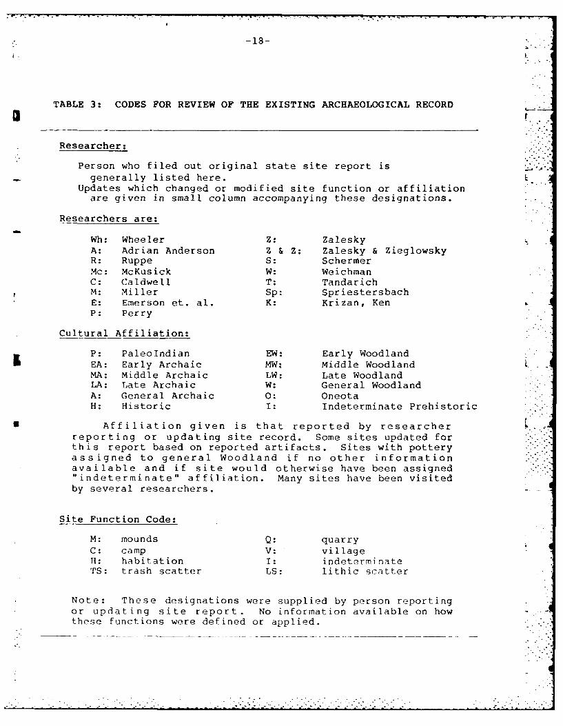
TABLE 3: CODES FOR REVIEW OF THE EXISTING ARCHAEOLOGICAL RECORD
Researcher:
Person who filed out original state site report isgenerally listed here.
Updates which changed or modified site function or affiliationare given in small column accompanying these designations.
Researchers are:
Wh: Wheeler Z: ZaleskyA: Adrian Anderson Z & Z: Zalesky & ZieglowskyR: Ruppe S: SchermerMc: McKusick W: WeichmanC: Caldwell T: TandarichM: Miller Sp: SpriestersbachE: Emerson et. al. K: Krizan, KenP: Perry
Cultural Affiliation:
P: PaleoIndian EW: Early WoodlandEA: Early Archaic MW: Middle WoodlandMA: Middle Archaic LW: Late WoodlandLA: Late Archaic W: General WoodlandA: General Archaic 0: OneotaH: Historic I: Indeterminate Prehistoric
* Affiliation given is that reported by researcher .reporting or updating site record. Some sites updated forthis report based on reported artifacts. Sites with potteryassigned to general Woodland if no other informationavailable and if site would otherwise have been assigned"indeterminate" affiliation. Many sites have been visitedby several researchers.
Site Function Code:
M: mounds Q: quarryC: camp V: villageH: habitation I: indeterminateTS: trash scatter LS: lithic scatter
Note: These designations were supplied by person reportingor updating site report. No information available on howthese functions were defined or applied.
* * * * -. . . . . . . . . . . . . . . . . '- . . ..
TABLE 4: CORALVILLE KNOWN SITE SUMMARY
Table code:O.R. original ReportC.A. Cultural AffiliationU.R. Updated ReportS.F. Site FunctionS.T. Survey TechniqueC. Condition
Site# O.R. C.A. U.R. S.F. S.T. C. Notes
2 Wh. W, AO VM S,T FI.
3 Wh W M,H E DReported as Completely Exc..
6 Wh W M S D Mounds destroyed (Emerson)
25 A EW-O Z H S SE Visited by most area researchers
27 Z EW H S SE____________
1 L29 R I IS SE_ _ _ _ _ _ _
30 Z A, LW S HS E Cond. Poor (Z) and slight E (S)
31 Z A,E-MW H S SE_________Emerson reports high research
I* 33 Z M-LW H S SE __ootential and recommends testing
36 Z A,E-LW H S ME ___
37 Z A,E-LW H S ME Z & Z report high research
42 A LW House E D Field house, completely excav.E -x-c ava -ted b~y-Anh-crson, Emerson
43 McK E-LW W,Z H S,E ME believes portion may be intactReportedc -as- Jes-troyed, eroded
44 A A,W S H S SE and cultivated
1 45 A 11W W,T TC S D Under water (Anderson)
46 A L1W S 'PC S SETuisY~~ es-U rye(A) n
47 A 1LW H S SE recomn nded for testing (Z&Z)-n~c~ -c-ooT1T, R-esearch pot.
49 A,Z A-LW Z H S SE ifstinq recoimmended (Z&Z)S --- -- --- h~ri~dibITFF6~5WThistoric
50 A I H U F farmstead ____
S_____ - -iii h rsarc Fpotenti (S)~
51 A,Z A-LW Z H S,T SE No research potential (A)
52 A,Z F, LW Z H S MF _l~ijh research potentiL al (A&S)
-20-
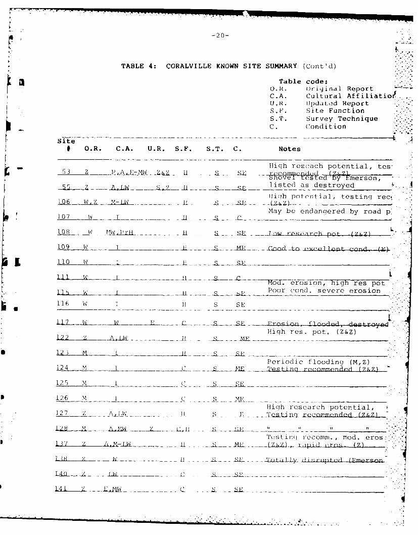
TABLE 4: CORALVILLE KNOWN SITE SUMMARY (Cont'd)
Table code:
O.R. oriyinal ReportC.A. Cultural Affi.liatio.U. R. IJpdLed ReportS.F. Site FunctionS.T. Survey TechniqueC. Condition
Site -- _# O.R. C.A. U.R. S.F. S.T. C. Notes
High rescach potential, tes-- 53 Z SE~-W - l- - i ±ee(j -d y Eerson,
55 Z A. I W listed as destroyed L55~__ __ ji A;i, C;Z r!. . ._ __ _High potential, testing rect.
106 W. Z M-LW-ii L ........... -_.___..... _ . . . )_May be endangered by road p,
107 w I Sl - s C .__
108 W P-19 Lri ... - £ Ll...ww research pno- (Z7kZ)
109 w 1 H ... / o& ito wclen cond. () (F4
1 1 0 w . . . . . _s . . . . _
- ~ Tod.erosonhigh res pot_ .Poor cond. severe erosion
116 W 1 11 S SE
117 W -S_ _ -'G-l d, troy.ed
High res. pot. (Z&Z)-z_ _ _ _ m m -f _1 - -_ . ... __F__..-_-_.-______
123 M __ L - _ . --........... " "_Periodic flooding (M,Z)
124 M I C S l E Testing recommended (Z&Z)
125 M C _ _ ...... __s_....___
126 M I C S ME ................High research potential,
127 Z AW . II .$ -S . _Tc Uacj rCcomended (Z,Z')
T'.stingi recomm., mod. eros..37------ -... L 2 . (IZZ o p LLrn. (Z)•,
- .. .i ............... 11 . -. . -- ... E- -. -- _itLLy- i ~ r (f;'m ezrc
.... "- , -". ¢ - -- _ __._ __,,,_._ _ _ _ ..
77 " 7.7 .. .
-21-
TABLE 4: CORALVILLE KNOWN SITE SUMMARY (Cont'd)
Table code:O.R. Original ReportC.A. Cultural AffiliationU.R. Updated ReportS.F. Site FunctionS.T. Survey TechniqueC. Condition
Site# O.R. C.A. U.R. S.F. S.T. C. Notes
142 Z ALW C S ME
143 Z AEW H S SE
144 Z LW T S P Periniall!y flinat,, winA eros. "
145 Z MW T S SE " " LHigh res. pot. testing recom.
146 Z LW T S (Z&7) nnrm]II3Z f Innnd, (Z.-
- 150 M I H S SE site probably dstrnypi.
1 151 Z I H S SE salvadga rcom- (Z)High res. pot.,testing recom.
152 9 T T S ME j7)
153 Z T T S ME ,, ,, of
* 154 Z S ME "" ""
155 Z I I S fi" "f of
156 Z I I S S E perindirall flnodpd, wind vrn."
157 z LW,H S I ZS_ tesjg recommended (Z&Z)
i58 Z I I S S- _-al-yadge " "
159 z I I S SE testing "_"__,
171 Z AEW I S C _ _ _
. 172 Z AEW 1 __s _--
173 Z - I S_ 8_ C '___ ______"'
____
180 zI ___ C
1R7 7 C .. Lesting dd (7&7)
I_9,I 7L . T _ __ S _ME .. ..... ...-.- "..-
/ -2 __Z_ S _p . . .. ... . . . . .
-22-
TABLE 4: CORALVILLE KNOWN SITE SUMMARY (CQflt'd)
Table code:O.R. original ReportC.A. Cultural AffiliationU.R. Updated ReportS.F. Site Function .:s.11'. Survey TechniqueC. Condition
Site# O.R. C.A. U.R. S.F. S.T. C. Notes
195 7 T PBast~_________________
196 I z~- _ _ _____________
197 z I . ridclyf1nn~jr-Cj
198 z I T P. Cnnsfr'ic-inn F& progion clm
200 zI T ~S. __________________
202 C, A.EMLW R.M RS.I Qm.ItlyP711~-
204 CI ,M I1 I
205 C w,0 R,M V 1' 1) Completely excavated
206 C W R,M 0 S,1T I
207 R,M IC I
208 C EMLW C fi C
211 Z 11 I Cultivated &flooded
212 Z II C
226 Z I S C
227 z 11 S Ei
~ . 228 zI S E
231 Z I I S SE
232 z I I S Ba d no-rmil ly linderwater
234 Z I S
.238 z I ------ __ __ _ __ _ __ _
-23-
TABLE 4: CORALVILLE KNOWN SITE SUMMARY (Cont'd)
IL Table code:O.R. original ReportC.A. Cultural AffiliationU.R. Updated Report
*S.F. Site FunctionS.T. Survey TechniqueC. Condition
Site# O.R. C.A. U.R. S.F. S.T. C. Notes
240 Z I IS SE
243 zI TS SP
244 z TTS F
m 247 z T
24P z. T TR
2ffi~il MF moderate pot. testing rec. (Z&Z)
1 253 L I H S,T D Excavated by Roetzel & Strachan
256 M I I S E
257 z I H S U Material found in dirt road
259 Z I H S ME
* 260 Z I H S ME
261 Z I H S SE
262 M I H S E
263 M I H S E
264 M I H S ME
268 Z I H S ME
270 Z 11W) ST H S ME
* 272 MwF H S- G nL9 Upland sii-P ri-I ~ntact (Pmex.)
* 273 M- W H S SE
* 274 z T-H- S-S F a alcvrie r-ommend-d (7Z)
* 275 z I H .~SE
276 Z I H S C No artifacts
-" 4-24-
TABLE 4: CORALVILLE KNOWN SITE SUMMARY (Cont'd)
Table code:O.R. Original ReportC.A. Cultural AffiliationU.R. Updated ReportS.F. Site FunctionS.TI. Survey TechniqueC. Condition
Site# O.R. C.A. U.R. S.F. S.T. C. Notes
277 Z 1 qp .. }ih pn n llnt-ji&l ; . 1 "-~q
27R 7 T H_
279 Z I H S ME (Z&Z)
" 281 Z I C,H S ME Moderate . ..
282 Z I S SF
298 M I if S ITestin4q recommended (Z&Z)
300 M I H S ME Usually under water (M)
301 M I Hf S C
302 M I If S Poor Usually under water
303 z W H S ME Testing recommended (Z&Z)
304 Z LW S II S SE
, 305 Z I I S SE
306 Z I I S ME
307 Z W H S ME Salvadge recommended (Z&Z)
3Q8 M I H S C.E- Shovel tested hy Emor n - -
309 M I 0 S SE Ouarry & Workshop (Emor~nn)
310 M I .
312 M T qr. TJ, -pci 1f find in, C"+1- f-
0 313 M __ _ _ _ _ _ _ _ _ _ _ _ _ _
315 M i ii C" "
316 M I 1 S C Listed as spot find in cult. fi(
--- - . . - -.. - - . .. .. -.. . -*. . ... ... . - .
-25-
TABLE 4: CORALVILLE KNOWN SITE SUMMARY (Cont'd)
Table code:O.R. Original ReportC.A. Cultural AffiliationU.R. Updated ReportS.F. Site FunctionS.T. Survey TechniqueC. Condition
Site# O.R. C.A. U.R. S.F. S.T. C. Notes
- 3 17 M i IH S C _______
317
318 M. I I I E __-
319 H S SE "__ _ _
320 1 ) 11 2 F: __________________
32 1 . I H E LMay be disturbed by constructior.
322 r i! S I Partially illwoods (Emerson)
323 M I If S B E_ _ __ _ _ _ _
324 M I H! S E _.
325 M I C 2C __________ ______
326 M I (A) F C"____ I.,F; Dvs1 tt indicates Archaic (E)
327 M I i S V
328 M I H F _ _ _ _ _ _ _ _ _
Usually underwater (M)330 M I S 1 1 SF Moderate erosion (S)
331 M I (t) ST M. S POOR Possible mound
333 M I I: I S D
334 M A 1 S F Durst pt. indicates Archaic si
338 M I If S C
339 M I I S C
h 340 M I 11 S SE
354 M I II S C
355 M I II S C
• 359 M I II S C
"
-26- .,I-
TABLE 4: CORALVILLE KNOWN SITE SUMMARY (Cont'd)
I" Table codesO.R. Original ReportC.A. Cultural AffiliationU.R. Updated ReportS.F. Site FunctionS.T. Survey TechniqueC. Condition
Site# O.R. C.A. U.R. S.F. S.T. C. Notes
Single sherd may have come from- 360 S LW H S SE., annthr sitp (Empr-nn)
361 S IW 11 ME.....
362 A.,MW H .... _SE Tofinq rcmmee (S)
164 .q H ] _q P Histo~ric arl, s .,
T H P_
6 -C; T T_ MP Find _por t.
367 S I if S SE .
368 S I H S ME
369 S I ii S SE
370 S A,LW if S ME . ,
371 S im,Wl C,11 S E
372 S A,LW 11 S E Part of site dredqed for const.
373 S I H S ME Cultivated, mod to sev. erosion
374 S I I S E Spot find in eroded field road
375 S 1I S E Spot find in trail cut
376 S I I S ME HH
377 S LW H S SE Salvadge recommended
378 S I II S SE Testing & salvadge recommened
379 S LW, I If S ME
380 S&S L1W l SE
381 S&S LW II S SE Salvadge recommended
: <4"-.......-. ,. --.. -.. -.. -..--. . . ... ... . ....,.' . .'. . . .. - . ., . ..- , .
-27-
TABLE 4: CORALVILLE KNOWN SITE SUMMARY (Cont'd)
Table code%.3 O.R. Original Report
C.A. Cultural AffiliationU.R. Updated ReportS.F. Site FunctionS.T. Survey TechniqueC. Condition
Site# O.R. C.A. U.R. S.F. S.T. C. Notes
384 M I H S Poor Normally underwater
385 M I(W) ST H S E
386 M 1(W) ST H S E
389 S I H S SE
390 S I H S E "slow erosion" (S) L..
391 S M,LW, H H S E ___
392 S H I S SE Historical material, not coil.
393 S I if S MEFlakes found eroding from trail.'
394 S&S T If S Good cut, portion may be in wnnds"
395 S A,LW S S SE Immediate testing IS)Spot find, Archaic pt. from
396 S 1 I S F disturbed contextPoint from disturbed context
397 S I i1 S SE suggests MW (Emerson)
" 398 M I 1i S E Located on R.V. trail
399 M I S E Sandy area eroded by R.V. 'S .
409 K I(W) LS S SE Lithics & potsherds indicate W
422 M I H S SE Construction, flooding, eros.E
425 M I II S C
428 M I H S C
434 M I H S C . . .
435 M I I S C Liste i as spot find
436 M I I1 S C _
• >*- "- • ~~~~~. . . . .. - . . . . . . . ....• . . ---- '> -- ',. .. . . ,. . . . . . ..-.* .:.,*, *-. ,. * ,,*-.. .....

* -28-
TABLE 5: STATUS UPDATE - PREVIOUSLY KNOWN SITES
Med-Sev SlightlyFlooded Erosion Destroyed Eroded Indet. Cultivated Good
2, 45, 26,27,29, 3*,6,42*, 30,50, 8,203, 107,111, 272,. 232,302, 31,33,36, 202*,205* 127,144, 204,206, 171,173, 394* 384 37,43,44, 253 146,155, 207,211, 180,187,
46,47,49, 172,228, 257,298 193,20851,52,53, 228,238, 322 212,226,55,106,108, 243,244, 247,248,110,115,116, 256,262, 276,301,117,122,123, 263,310, 308,312,124,125,126, 318,320, 313,314, .1,8,137,138, 321,323, 316,317,140,142,143, 324,326, 325,338,145,150,151, 327,328, 339,354,152,153,154, 364,365, 355,425,156,157,158, 371,372, 428,434,159,191,196, 374,375, 435,436197,198,200, 385,386,227,231,234, 390,391,240,252,259, 396,398,260,261,264, 399268,270,273,
274,275,277,278,279,281,"' " 282,300,303, "'
304,305,306,307,309,319,
- i 329,330,333,
334,340,360,361,362,363,
366,367,368,369,370, 373,
376,377,378,379,380,381,
389, 392, 393,395,397,409,422
5 103 6 36 9 30 2
Other Site Conditions: 192 - threatened by construction,195 - in pasture359 - in pasture331 - possibl mound
* (Reported as comlnletely . xcwivL .d)
TABLE 6: CORALVILLE SITE TOTALS BY COM4PONENT 4
I - Indeterminate 153 -
Paleo~ndian I
General Archaic 28
Early Archaic I
-Middle Archaic I
Late Archaic I
Generatl Woodland 27
Early Woodland 1
Middle Woodland 2 J
Late Woodland 42
Mound Sites 5
Historic 8
I KOneota I
305
-30-a-
I 4
the adjacent landowner. He was kind enough to allow us toexamine and photograph five points recovered from the site.It is not beyond the realm of possibility to suggest that
a othor ,:o lct ors hav also visited this site.The problem of a biased collection due to amateur -*
collector act ivity was also noted by Emerson et al(1984). This problem is reflected in the multiplecollections of many of the sites in the state site files. -It is not uncommon for four or five researchers to have
EL visited, collected, and reported a site. This multiplecollection phenomenon results in several groups ofartifacts, rej)resentinJ t.h, collecting biases of a number ofresearchers, to be housed in separate facilities. Thevariety of collectors, techniques and storage facilitiescompounds the problems of cultural and functionalidentification for prehistoric sites.
In addition to the aforementioned problems associatedwith the prehistoric (archaeological) resources atCoralville, looms the most prominent factor in the projectarea. This is the lake itself and the associated effects onthe local landscape. In plain and simple terms, theflooding and erosion associated with operation of CoralvilleReservoir has destroyed the context of the majority ofrecorded Coralville sites. Of the 195 recorded sites atCoralville, 9 are listed as destroyed, 4 are known to beunderwater, 102 are suffering from moderate to severeerosion, 36 are recorded as eroded with no reference toseverity, 9 have indeterminant preservation, 32 are incultivated fields or pastures and only 2 sites are believedto have relatively undisturbed context.
Based upon the reported sites in the project area andon our own systematic survey, there is a high probabilitythat almost any prehistoric archaeological sites located on
* the shore of Coralville Lake is effectively destroyed.Previous research and our survey show that the vast majorityof Coralville sites are located on the eroded shore of thelake. These sites ar easy to locate since all originalcontext sediment has been stripped away leaving the heavierartifacts exposed on more resilient and in many cases veryancient surfaces.
An archaeological site consists of those portable andnonportable artifacts and living debris left by a group ofpeople and the surface and subsurface sediment upon which(and in which) those people lived. The more the site andits context are disturbed after original deposition, theless significant is the information available for thearchaeologist. In the case of the shoreline sites atCoralvi lle, all of the original sediment is gone along withany hope of floral and faunal remains and subsurfacefeatures. With the activity of collectors often focused ondiagnostic artifacts, the remainiiig information from mostCoralville sites dwindles to a minor percentage.
Al I of the researchers at Coralville hav.? noted theeros ion and sevtrl ha v. recoi ,,,nded that threattned sites
be immediately salvaged. Despite their best intentions, wefeel that any excavation of a main shoreline site atCoralville is a futile effort. Test excavations at Sugar
I L Bottom by Emerson ot al (1984) and at several shorelinesites during the current project have documented the poorstate of this class of sites. Most if not all of thesesites are scatters of lithic and occasionally ceramic debrisresting on an eroded surface with absolutely no subsurfacecontext. While additional information may be gathered by
I A means of surface collections and perhaps coordination of allpreviously collected materials, any subsurface excavation islikely to yield only negligible results.
Although the overall picture of archaeologicalresources at Coralville is somewhat dismal, there aregeomorphic contexts likely to retain intact archaeologicalsites. Three general classes of landscape are candidatesfor relatively undisturbed sites and further archaeologicalresearch.
The relatively narrow, level, upland areas surroundingCoralvitle Lake east of the 1-380 Bridge (Southern IowaDrift Plain with soils formed under forest in thick loess onprominent high lying ridge tops; mapping symbol PSA) is onesuch context. The amount of land area in this category isrelatively small because of the contour based boundary offederal land and because these lands are prime developmentspot s around the lake. Roads, houses and other constructionare common on ridge tops around Coralville Reservoir.
i I A second context is the floodplain/terrace systems ofsmalI tributary streams fe-ding into Coralville Lake. Thesesmall -r valleys are large enough so that a portion escapesthe major erosion of the mnain valley. The floodplain - -
terrace system of these streams is usually wide and flatenough to allow adequate living space.
Third, is the large, broad floodplain/terrace systemalong the Iowa River, east of the 1-380 Bridge. This areaincludes ovet half the land owned by RID-COE, but has hadve ry littl]2 survey. Much of this land has difficult accessand requires survey techniques different from the erodedshoreline areas.
A few sit.s have b,,en reported from these threelandforms, bit in general they have not been surveyed withthe sam, intensity as tha- of the main reservoir shore.Furthermore, survey and location of sites is not as easy onthose srl [Ice:s ,:; on th, e roded shoreline. The ridgetopsett i ng is usual I y forested and covered with othervegetation. While the Floodplain/terrace context of thesinaI I t r ibutary streams nay require shovel testing, thelarge Iowa River floodp Iin may be adequately surveyed bysurface collection as much of it is currently or has beenunder cultivation. liowev,_?r, both floodplain/terrace areasare comp I , x and subject t,) ,pos it ion and erosional forces.FurL h er archaeological investigations should be undertakenin conjunction with geom nrphological study in order toidentify pos ihie(, ber i'd sot ces.
. ~~~ . .• . . . ..
-32-
In summary, including the present project, over 250archaeological sites have been recorded from CoralvilleReservoir. The vast majority are sites located on badly
I eroded surfaces along the shore of the reservoir. In virtu-ally all cases these sites may be considered functionallydestroyed. Future management of archaeological resourcesshould focus on survey of those landscapes likely to haverelatively intact archaeological sites. Future work atsites on the eroded shoreline should be avoided as counter
* productive unless mandated by specific research and ormanagement goals. Future research at Coralville might bestb_ dir,.ct ed to tu(2st ioris rclating to the use of the threeabove mentioned landscapes. The original shoreline environ-ment of the Iowa River from the dam to the 1-380 Bridge iseffectively nonexistent.
Historic Sites:
Historic foundation sites are differentiated fromhistoric sites on the basis of the presence/absence of a con-crete or stone foundation. Non-foundation sites were usual-ly small scatters of historic ceramics, glass, metal or com-binations of these artifact classes.
The historic sites present an interesting anomaly toboth the historian/archaeological researcher and the RID-COE. The non-foundation historic sites are difficult tointerpret as they usually consist of a small quantity (ca.10 items) of ceramic or glass fragments. Except that theydelimit the approximate location of the disposal of variousrecent historic manufactured goods, it is difficult todiscern either a management or research concern for thesesites. The historic foundation sites are quite anothermatt r.
Several hundred builings were obtained and documentedby RID-COE when it purchased the land for the CoralvilleReservoir. Extensive documentation of the nature and typeof buiLdings obtained by the Corps are presented in the 1984report by Emerson et al. This report also includesinformation pertaining to early settlement and deed filingsfor counties and townships in the Coralville Reservoir andvicinity. 4
Emerson et al note that no particularlydistinguished persons or architecture are represented by thehistoric buildings in the Corps lands (1984: 96). Theycharacterize most historic sites as farmsteads generallyrepresentative of the "general expansion of farming andsettlements into less than prime areas during the period1850 - 1890", (1984: 97). The report points out thathistoric/non-Indian sites are virtually absent from thecurrent site records for Coralville Lake. This isattributed to disinterest on the part of investigators andto a lack of specific historic site survey. Our field workindicates it is also due t,) limited survey west of the 1-380Br idg,..-..-'
-33-
The report by Emerson et al leaves the impressionthat historic sites are missing from the Coralville area.They indicate that "historic remains, if they are presentin th_ Corilviil, projc ara, should occur alonq many ofthe same ridges and terraces where prehistoric remains arefound", (1984: 97, emphasis in original). These commentsobviously pertain to the limited survey to date along theshoreline of Coralville Lake east of the 1-380 Bridge. Inthis limited context, the above assessment is relevant. How-ever, the recently completed survey located 24 historicsites, 16 of which consisted of one or more foundationsr k:jr2s2nting f armnstL(ad:;, honesteads, or cottages. Of thehistoric sites relocated, It foundation sites and 3 historicspot finds were located west of the 1-380 Bridge. With the
- exception of several foundations located on the shore of alarge inlet of Coral'ille Lake formed by Hoosier Creek, thefoundat ions are probably common farmsteads or homesteads.The foundations along Hoosier Creek appear to be sufmnerhomes or vacation cottages. The condition of the vastmajority of the foumndat iorl sites indicates that they wereprobably occupied up to the tim- of purchase by RID-COE.There is a high probability that RID-COE effected thedestruction of the majority of the buildings which formerlystood on the various foundations. One of the sites werecorded, 13 Jh 505, consists of several foundations andextensive debris resulting from recent destruction of thebuildings via mechanized equipment. At least two of thei L historic sites, 13 Jh 495 and 13 Jh 499 are represented on
the contemporary U.S.G.S. maps of the area.These several conditions present the aforementioned
anomaly. On one hand the Office of the State Archaeologistwould like historic foundations recorded as archaeologicalsites. On the other hand it is apparently RID-COE policy to
I acquire buildings in the flood zone of reservoirs and removethem. The foundations usually remain intact and stable andthere appear to be photographs and locational informationfor each building in RID-COE files. Nevertheless therewould seem to be some distinct damage to the historicalrecord by the destruction of these buildings.
As noted by Emerson et al, none of the buildingsacquired by RID-COE, including the remains located duringour survey, are of any particular importance, either as un-usual architectual entities or as the locus of famous eventsor people. However, despite their overly common nature,such sites may be important to future researchers interestedin the lifeways of the "common man", in this case, EastCentral Iowa farmers. While our society is fame conscious,and records and preserves records of a variety of importantthings, people and evints, the ordinary people and mundanelifestyles generally fail to merit preservation. Thematerial remains of comnon activity meet the fate that suchgoods have met for nil Ilenia; use, discard, often disin-tegrat ion and perhaps eventual recovery years or centurieslat-r.
*. . .- 'q
- 11-
II
Despite the destruction of the super-structures thecondition of the foundation sites is not altogether bad.Razing the buildings resulted in an obvious loss of informa-tion concerning the buildings' construction and decoration.However, in many cases photographs and legal descriptionsare available so that there is a documentary record of atleast the exterior appearance of these structures. Contem-porary structures undoubtedly exist in the vicinity of theproject area for those researchers with an interest in the
* architecture. Since the buildings have been destroyed andare generally "reverting to nature", further occupation orus, of these sites is probably not likely. Thus, the aquisi-tion and destr-t ion has served in one sense to preservethese sites for future researchers. The architectual re-mains and associated artifacts are likely to date from arolat ive_ ly narrow time span beginning in the late 19thctntury and ending in the inid 20th century. Given govern- p;nuit )wn,,rship and Iowa Conservation Commission Management,th- hist-oric foundation sites west of 1-380 Bridge willprob,:ibly be maintained in a reasonably good, stable condi-tion for the foreseeable future. The only probable destruc-t i v- ict ivity which will effect these sites is the growth oftrees and other vegetation. Over the years, this destruc-tion could be considerable as all of foundations west of the1-380 Bridge are in wooded areas. The foundation sites eastat the 1-380 Bridge are similarly protected, being locatedin wood lots or along isolated areas of shoreline. Barring
* development, these sites should diso remain stable for theforeseeable future.
Prehistoric Sites:
A total of 40 new prehistoric sites and spot finds wererecorded during our survey of Coralville Reservoir. Sixteenof these sites had diagnostic materials which allowed atleast a rough assessment of cultural affiliation. Anadditional 25 pre:viously recorded sites were revisitedduring the present project. Of these, nine had diagnosticartifacts which allowed us to assign them to at least ageneral temporal/cultural affiliation. The remaining 16sites were assigned to indeterminate status based uponmatr ials recovered during the present survey. Of a totalof 65 prehi:storic sites we located, 40 were of indeterminatecultural affiliation.
In some instances, it is possible to make an accurateassessm;nt of activities performed at a site and/or overallsite function without diagnostic materials (c.f. S.A. Ahler1977, S.R. Ahler 1984, Raspit 1979). Such an evaluation isus La 1y made tising an anaI ysis of lithic debitage. This wasgeneral ly not the case at Coralville. Sixty of the sixty-five prehistoric sites located could not be assigned a dis-tinct function with any confidence. These sites were usual-ly composed of a sinal I I i thic scatter with an occasionaldi a Jnost ic I i th i tool or potsherd . Due to the sever ero-
I
- - ----.--- ---- .- ----. ~ . -- -- ..-. .-
-35%
sion characterizing most of the site locations, we could notbe certain that some materials had not eroded away andothers reached the site by way of secondary deposition.IGiven these constraints, there is very little that may bedone with these sites except to note that they probably markthe location of some indeterminate prehistoric activity in-volving the production, use, or maintenance of lithic tools.
These results, while disappointing, are not particular-ly surprising given the previous condition of known sites inthe project locality and the distribution of the sites wefound. Despite a survey designed to cover all portions ofthe Coralville landscape proportionately, the vast majority(55 of 65) of prehistoric sites were located east of the1-380 bridge. As was the case with the bulk of the previous-ly recorded sites, the prehistoric sites we located east ofthe 1-380 bridge tended to be lithic scatters on badlyeroded shorelines. Twenty of the sites had one or more cera-mic fragments which allowed us to assign them to at least ageneral Woodland category. Where distinct pottery or lithictypes were found, the sites were assigned to the appropriatecultural/temporal affiliation.
Detailed information on the sites located are presentedin Appendix B, copies of state site reports, and Appendix C,the detailed inventory forms completed for each site. Thissection will present further information on the overallarchaeological collection from Coralville sites withdiagnostic artifacts and the five tested sites.
In their review of the current state of archaeology atCoralville, Emerson et al, rightly called attention to Lsome glaring deficiencies in the quality of informationavailable from archaeological investigations to date in theproject area. One of these deficiencies is the lack of anoverall sampling survey of the area. The surveys done up tothe time of Emerson's report had been primarily opportunis- .tic surface collection. Likewise, both amateur and pro-fessional surveys have tended to examine only the erodedshoreline of Coralville Lake east of the 1-380 bridge. Oursurvey was designed to correct some of these deficiencies
* and allow at least a reconnaissance level overview of cultur-al resources of all the federal land at Coralville.
Archaeological survey involves a systematic examinationof a given area with the express purpose of aiding the deter-mnination of where archaeological remains are likely to befound and not found. Analysis of the artifacts recoveredshould yield considerably more information on the temporalaffiliation and function of the sites located. Combined,the locational data and analysis of materials may be used toaddress a broad range of questions dealing with prehistoric/historic subsistence and settlement. While archaeologists,both amateur and professional, are usually most interestedin finding sites and artifacts, it is important to realizethat a proper survey provides data on where sites are not,as well as where sites are. A knowledge of those landscapecategories not utilized is as important for planning and
* * * - . .. - ,*.•-* *
• " ~- 36 - ii '
[,.
research as the knowledge that certain landscapes areroutinely utilized for certain tasks/functions by certaincultural/temporal groups.
Presentation of the results of the survey for prehistor-ic sites is divided into sites located east and west of the1-380 Bridge. Information and analysis of sites found eastof the bridge is presented first.
The overall picture of archaeological resources atCoralville is somewhat dismal. The sites we located alongthe shore east of the 1-380 Bridge are routinely in poor tobad (terrible) condition. Interpretation of the materialrecovered from shoreline sites is somewhat difficult.
The primary cause of the difficulty is erosion of theshoreline. The erosion destroys context, rearranges arti-facts to an unknown but probably non-trivial extent and ex-poses artifacts on the surface. While the exposed artifactsare easier to locate, as evidenced by the number of siteslocated on the eroded shoreline, they also invite the selec-tive collection of diagnostic materials by amateurs. Thenet result is that most sites are lithic scatters made upexclusively of debitage.
A firm determination of site function is also difficultgiven the condition of the shoreline sites. The sitefunctions of "habitation" or "camp" that have often beenassigned to previously recorded sites are generally meaning-less given the lack of diagnostic materials, condition ofthe sites, and lack of subsurface testing. Sites may bemeaningfully analyzed using surface data exclusively (c.f.Ahler, 1984) but only if one is reasonably sure that thematerial on the surface is representative of all materialsdeposited at the site and of the activities responsible fortheir deposition. Neither of these premises apply to theshoreline sites at Coralville.
An analysis of the debitage from surface collectionscan provide insights into the features of the lithic indus-try represented by that debitage. In the case of the erodedsites at Coralville, much of the sequence of a lithic manu-facturing trajectory is likely to be missing or under repre-sented, in particular small tertiary and bifacial thinningflakes. While our inventory categorized debitage in meaning-ful stages in a biface production sequence, further analysiswas not attempted for the majority of the sites.
We are left then, with some 64 new prehistoric sitesand spot finds located during or survey and an additional 25previously recorded sites which can add very little to anunderstanding of prehistoric lifeways around the presentCoralville Reservoir. Those sites with diagnostic artifactscan contribute more and will be discussed below. As we havenoted previously, the majority of eroded sites from theshoreline of Coralville Lake do not appear to have signifi-cant value either from a management or research perspective.
West of the 1-380 Bridge, the picture of archaeologicalresources is somewhat diffErent. In an area larger than thelands east of the bridge, our survey located a total of 10
7
': ,"-37-
prehistoric sites and spot finds including two previouslyrecorded sites. As noted above, the landforms in this areaare different from those east of the bridge. The west area
~ [ is dominatod by a largo floodplain/terrace system withrelatively mild relief and a drainage system which includes
. a meandering main channel and numerous sloughs, meanderscars and oxbow lakes. Small active streams also cross thearea. Such an environment is known to be a relatively richhabitat for various flora and fauna. Given such a rich en-
ML vironment and generally adequate survey conditions, we wouldhave expected a somewhat larger number of sites than wered~ctual ly locaLt.d.
In general sites tend to be found on terraces nearwater sources rather than on the floodplain. Two of thelargest sites, 13 JH 26 and 13 JH 500 were found on promin-ent sandy terraces. Both have suffered severe damage fromwind and water erosion probably intensified by agriculturalactivities.
Presented below is a detailed discussion of the siteswith diagnostic artifacts and the five sites tested from theCoralville survey.
Sites with Diagnostic Artifacts - Revisited - East
Seven of the revisited sites produced diagnostic mater-ials. The materials are diagnostic to a greater or lesserdegree. In some cases, artifacts allow assignment of thesites to a known archaeological time period or phase. Theseartifacts are often examples of well known named and dated L
categories (types). In either instance, the artifacts allowa general cultural/temporal, and/or activity description.The revisited sites with diagnostic materials are:
13 JH 143:Material was recovered from a relatively narrow stretch L
of eroded shoreline. Site 13 Jh 143 is a large (ca. 100m x175m) dense scatter of lithir debris and ceramic fragments.Almost 300 flakes and other pieces of lithic debris wererecovered during our collection. The debris covers the fullrange of a biface production (lithic reduction) sequence in-cluding heat aIt, ration of chert. Diagnostic material in-cludes eight small grit tempered boly sherds and a triangu-lar flake point. These artifacts indicate a Late Woodlandoccupation and possibly Middle Woodland occupation.Previously reported materials (Emerson et al, 1984)assign the site to Archaic-Early Woodland. In alllikelihood the site was occupied throughout the Early toLate Woodland continuum. The density and range of lithicdebris would support a long term habitation function for 13JH 143.
*13 JH 145:Site consists of a light lithic scatter (total 10
pieces ) on a badly erodt-d reach of shoreline. The only
.......- .. . - - n. - .: _m . = _ - . . - . .' " . . . . _ - . - .. .. -. ,, . . .
-38-
4."
diagnostic item recovered was the base of a small triangularpoint indicating a Late Woodland occupation. The site ispresently classified as Middle Woodland. No designation ofsite function is possible with the present data.
13 JH 191:Small, light lithic scatter on terrace of McAlister
Creek. Area is subject to periodic erosion and flooding.Previous material recovered includes debitage and scrapers.No cultural affiliation is indicated in existing records.G.L.A.R.C. survey recovered a small lithic debitage collec-tion and a sina- I side notc(-hed bifurcate point base. Thebase has ground edges and is basily thinned. Although thepiece is not readily identifiable, the attributes suggestMiddle Archaic. No functional assignment is possible.
13 JH 227:A medium lithic scatter (44 pieces) collected from a
long stretch of severely eroded shoreline. Debitage con-sists predominantly of bifacial thinning flakes, tertiaryflakes and broken flakes suggesting maintenance activitiesand/or later stages in the biface production sequence.Diagnostic material consists of large well made biface withbroken base. Point has indications of slight barbs and cor-ner notching at base. Point is made of heat treated greytabular chert with cortex on both faces, and is similar toSynders Points.
13 JH 256:We recovered only two lithic items as evidence of this
site from a steep, severely eroded shoreline. One of theitems is a well made point with deep corner notching, sharpbarbs and a flaring, bifurcate base. The base exhibitsminor grinding and basal thinning. It may be a MiddleWoodland variety but identification is speculative at this [point. Previously reported material includes debitage, ascraper/knife and cores.
13 JH 319:Medium lithic scatter was collected on a severely
eroded shoreline. A small grit tempered cordmarked body .sherd was also recovered and indicates a Woodland, probablyLate Woodland presence. No diagnostic material is reportedfrom previous collections. Debitage from G.L.A.R.C. surveyprovides some support for activities associated with laterstages in a bi face reduct ion sequence, but this is verytenuous.
13 JH 409:This site has been collected by Krizan (1981) and
Emerson et al (1984). They each recovered a few arti-facts from a severely eroded shoreline/gully setting.
-39-
Reported artifacts include a point and potsherds, (Krizan)and a side notched point, point tip and debitage (Emerson).No cultural or functional identification is offered in the
-existing documentation. Our survey recovered flakes and aKramer point. The point is made of the grey tabular chertand has cortex or, both faces. One face exhibits severe "potlid" fractures, the result of exposing the point to heat,probably after manufacture.
The revisited sites east of the 1-380 bridge are moreI .or less typical of all sites in this half of the project
area. All were located on eroded surfaces, most on the kshore of the main lake. In most cases cultural affiliationis tenuous at best and identification of function oractivities virtually impossible due to the erosion. Al-though we did not conduct subsurface testing at any of therevisited sites, it is extremely unlikely that any of thesesites posses subsurface integrity which would warrant largescale excavation.
Sites with Diagnostic Artifacts - New - East
Thirty-two new prehistoric sites and spot finds werelocated east of the 1-380 Bridge during the course of oursurvey. These sites are generally very similar to thepreviously recorded sites, in terms of preservation, typesof material recovered and geomorphic position. Of theprcviously reported sites we visited, 7 of 25 (28%) yielded"diagnostic" artifacts. Twelve of the 26 (46%) new sitesand two of the six (33%) new spot finds had diagnostics.The r)ercentage of new sites with diagnostics (43.7%) is some-what higher than that of revisited sites. This is most like-ly due to the fact that the known sites have been subject tomultiple collections with diagnostics most commonly removed.New 3ites with diagnostic artifacts are:
13 JH 464:This site was located on the severely eroded shore of
an inlet of Coralville Lake. The material recovered in-cludes the largest single sherd from the survey, a thickgrit tempered cordmarked body sherd, and the only decoratedrim sherd from the survey. The rim definitely resemblesSpring Hollow Incised, (Logan 1976) a generalized MiddleWoodland Complex. The large thick sherd could easily be aportion of the body of the same vessel or Spring HollowCordmarked. We also collected a small quantity of lithic
- debitage including acrude biface fragment.
13 JH 467:A very smalL lithic scatter (three items total) on the
severely eroded shore of an inlet to Coralville Lake, com-prises this site. The diagnostic item is a biface made ofgrey heat treated chert with a broken stem, corner notching,and sharp barbs. The item is similar to Snyders Points.
-I J - " . . . . . : -' -" . " ". . - - - - . - -. , - .: i -. i.i ::-:' .i i . I'. , i. - --- ? . -- : ;? .- .:;-
-40-
13 JH 472:This site is located ca. 100m due east of 13 JH 143,
just down stream from 13 Jh 143. It consists of a smalllithic s3cat t, r including a dirill base. It also includes asmall grit tempered body sherd. Although distinctlyseparate in the field during our survey, 13 JH 472 may berelated to or a part of 13 JH 143. It is recorded as aseparate site and assigned to general Woodland affiliationon the basis of the single sherd.
13 JH 474:This site is a small [ithic scatter loctaL(d on a
terrace near the maximum flood pool elevation. It is sub-ject to moderate erosion and periodic flooding. A dozenflakes and three ceramic "crumbs" were collected. On thebasis of the ceramics, the site is tentatively identified asgeneral Woodland. No functional assessment is practical forthis site.
13 JH 475:This site is located on an eroded, level terrace which
is also the location of four historic foundations (13 JH476 ) . Material collected at the site consists of fourflakes and a large point made of a heat treated pinkishchert. The point is somewhat anomalous as one side isclearly side notched while the other is corner notched. Thebase of the stem is convex and the overall shape resemblesMiddle Woodland corner notched projectile point styles.
13 JH 479:13 JH 479 was one of the sites we tested while at Coral-
vi le. It is located on a terrace of a small stream leadinginto an inlet of Coralville Lake. We tested this sitebecause it offered an excellent chance of intact subsurfaceintegrity. We collected surface materials from the slope ofthe terrace. Surface material included: nine small grittempered body sherds (five with cordmarking), eleven flakesand two crude biface fragments. The pottery fragmentssuggest a Late Woodland occupation. The test excavationsresulted in very little additional material. Two 1 x 2mtest units were excavated near the edge of the terrace(Figure 1). Of these units, one was sterile, while theother had six additional small grit tempered body sherds anda rim sherd. The rim sherd is grit tempered with a sharplyeverted rim similar in shape to some late Oneota styles.The unit with pottery also had two pieces of fire crackedrock and a piece of burned sandstone. This is one of thefew sites that may warrant Further testing.
13 JH 480:The artifacts representing 13 JH 480 were located on a
moderately sloping, severely eroded reach of shoreline atthe junction of an inlet and the main lake. Artifacts
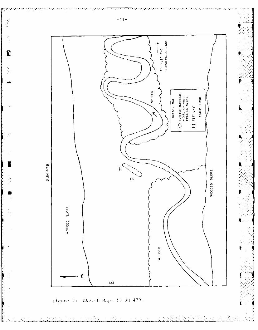
-4*] -
S
L~J
4-J
L.~
.4-i-2L.J>
-CL0
V
0
C, 4
C -iw o4~
~ 2x~' ~ -
o w~t~ z hiI-. ~ ~~ I-
U) ~ U) U)-~ *) hi)n~w I-.9
I.
K a)r-. ~ N
LiiN. ~
" 0~0
EJ
0Lii0
U 00
LiiCL0
'I)
OLii00
0
00
2
I1(Jurc 1 Sk~t''h MA[) , I JII 479.I.

* ,-42-
recovered were: nine flakes, a single grit tempered bodysherd with eroded surfaces, and a rather interestingscraper/graver. The pottery fragment suggests a Woodlandoccupation. The scraper/graver is likely a wood or boneworking tool.
,. ~13 JH 482:.-.'This site is located on a point of land formed by two
small inlets of Coralville Lake. The entire site area isseverely eroded and subject to flooding. This site had the
PC largest surface collection of any site in the project area.Approximately 1200 lithic items and 15 grit tempered ceramicfragments were collected from the surface. Two of the pot-sherds are rims which resemble Linn Ware (Late Middle Wood-land). The lithic material is overwhelmingly debitage andrepresents the entire range of a biface reduction sequence.Lithic tools include fragments of two bifaces, two brokenpoint tips, a drill base and a biface/preform.
The owner of the land directly adjacent to the sitereported that his sons had periodically collected pointsfrom the site. He allowed us to examine and photographthese materials. These points include a Snyders Point andseveral corner notched varieties similar to points fromother Middle Woodland contexts.
This site was severely eroded. Around the entire peri-meter of the point limestone bedrock is currently exposed.The landowner noted above informed us that no limestone wasvisible when he constructed his house ca. 5-10 years before.He estimated that as much as a foot of sediment has washed Laway since that time. We tested this site in order to deter-mine if any of the site remained intact. Although theslopes of the point exhibited severe erosion, the centralpart of the peninsula had some vegetation and did not appearto be as badly eroded. The results of testing were informa-tive but disappointing. Four I x 2m units were excavated in Lthe central portion of the site (Figure 2). One of thesedid not have any material while the others had relativelylittle considering the density of debitage on the site. Asingle pot sherd was recovered from unit #1. The piece is abody sherd with what appears to be smoothed over cordmark-ing. This places the piece within the Lane Farm Style,which is consistent with the other diagnostic materials fromthe site.
We would caution the reader in regard to the identifica-tion of the ceramic styles. All ceramic fragments areeroded to some degree and we have a total of three decoratedpieces. The associations offered here are tentative atbest.
The excavations demonstrated that the site did not haveany subsurface integrity. All of the sediment on and inwhich the site was originally deposited has been removed by .
erosion. The sediment now exposed is significantly olderthan the archaeological materials. More detailed discussion
. ........-

7.1
-43-
B. q
cr 0
----
" " L
OD /\ \\4
EE44 44 4
ID
Figur 2 rn i'a4
-44-
is provided in a subsequent presentation of geomorphic con-texts. In this respect, 13 JH 482 was similar to the otherexcavated shoreline site. In both instances, erosion hasr,,inovted a I rect.nt sr'dimnnt and exposed sediments at least100,000 years old. Excavation at these sites as well asobservation of the same surface at many of the shoreline 0sites led to our conclusion that most, if not all of thisclass of site location is essentially destroyed. The majorremnant of sites on these severely eroded landscapes is - -lithic debitage.
13 JH 485:A small lithic scatter on an eroded section of shore-
line. The site consists of nine pieces of lithic debitageand the base of a small thin triangular point. The point isan indicator of a Late Woodland occupation.
13 JH 489:Site 13 JH 489 is a small lithic scatter consisting of
eleven flakes and a triangular point fragment. The point ismade on heat treated chert and appears to be corner notchedor stemmed. It is tentatively identified as general Middleor Late Woodland.
13 JH 492:This site is situated atop a limestone bluff on the
shore of Coralville Lake. Although no diagnostic materialswere recovered, this site was tested because we felt thatit's position would have protected it from the most damagingeffects of erosion. Unfortunately, this was not the case.Three units excavated within the limits of the surface
I I collection (Figure 3) resulted in the recovery of twoflakes. A single unit placed in an undisturbed area abovethe maximum flood stage was sterile. Several expandedshovel tests placed on the ridge top above the site werealso sterile. Test excavations at 13 JH 492 revealed thatthe site is destroyed for all intents and purposes.
13 JH 496:This site is located just above the maximum flood level
above the terrace/floodplain of a major inlet formed byHoosier Creek. Three flakes and a point fragment werecollected from a plowed agricultural field. The point frag-ment is a side notched piece with a broken tip made of whitechert. The base is thinned and heavily ground. Theseattributes are indication of Middle Archaic manufacture.The size of the base indicates that the original piece wassomewhat larger. The present size is due to one or moreepisodes of resharpening.
13 JH 497:Material from 13 JH 497 was scattered along a long
,;tr-tch of floodplain/terrace just north of a small streamflowinj into Coralvilie Lake. Approximately 30 lithic items
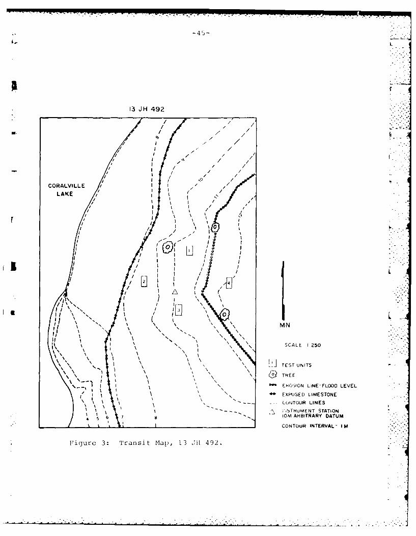
- 4 5 - L
3 JH 492
i.-.
7L ,
It I/
0
I /
/ I // /
fil
Ii I / /
/SCVLL 1 2 5.
/ /
ItI
LA/ N /
EROSILL I ,"F/ /L VONT I I R /
F I /
/\ " / /"
,, , I
/ f / If / I
"' - .-
.•-.-..I_ /Li I - .II I"
Io
/I / LJ i
I II
\ I " \ / ", "i L\ \', /,," 0 M
S C A L E
I2 5 0
-
I-- \
N \\ MN
L 'i. TEST UN TS
- - -
-\ '1 I \ \ 4 REE
-N - - E O SIO N L IN E -F L O O D L E V E L,I \\
\ "' -- - EXI-SE LIMESTONE"/ I
,x - -- - CONTOUR LINESI
' IW .TNuMENT STATION.t 1 - IOM ARBITRARY DATUM'
"'
CONTOUR INTERVAL- I MFigure 3: Transit Map, 13 011 492.
: -'
-46-
were collected including the base of a small triangularpoint. The point is a Late Woodland style.
13 JH -7:This is a spot find consisting of a sincle piece of r
angular shatter and a medium sized point. The projectilepoint is side notched with basal thinning. One corner andmost of the base/haft element are broken. Attributessuggest a Middle Archaic affiliation. The single side notchand base fragment are ground. The point is morphologicallysimilar to Big Sandy points. The site was located on thesteep eroded shore of a small inlet formed by a stroam flow-ing into Coralville Lake.
13 JH -15:This site is represented by a surface find located on
the eroded shore of an inlet of Coralville Lake formed byseveral small drainages. A single flake and a small grittempered body sherd are the only materials recovered. Thepotsherd derives from a Woodland occupation, possibly LateWoodland.
Sites with diagnostic Artifacts - West of 1-380 Bridge: .The number of prehistoric sites located west of the
1-380 Bridge is somewhat smaller than the number found eastof +-he bridge. This is in spite of the fact that more areawas surveyed west of the bridge (ca. 1200ha surveyed west ofthe bridge vs. 700ha surveyed east of the 1-380 bridge).Only 10 prehistoric sites and spot finds were located in thewestern section of the project. Two of these sites were .,reported previously. Of these ten sites, four havediagnostic material and will be discussed below.
* Revisited Sites:
13 JH 26:The Swan Lake site has a long history of visitation and
collection by both amateur and professional archaeologists.Surface collections have been made by Anderson (1971),Zalesky (1977), Zieglowsky and Zalesky (1981), and Emersonet al (1984). Each of these successive collections pre- ,sents a slightly different surface assemblage. All col-lectors recovered lithic tools and debitage. Anderson notesthat collectors have recovered Black Sand Incised, SisterCreek Punctated and Madison Cord Impressed pottery. Zaleskyreports collecting shell tempered pottery with toolimpressions on interior lips and dentate markings onshoulders. He also recovered grit tempered cordmarkedceramic fragments. The Emerson survey recovered a singlebody sherd. The G.L.A.R.C. survey collected only lithicdebitage and a single biface fragment with a broken tip.Approximately 350 pieces of lithic debitage were collected,covering the entire range of a lithic reduction sequence,but especially the latter stages. That is, the minimal
-47-
number of primary and secondary decortification flakes wouldindicate the initial reduction occurred elsewhere, probablyat a quarry site or near the source of raw materials.
The biface fragment is a thin medium sized pieceprobably made on a blade. It can best be characterized as apreform for a point or knife. Although not reminiscent ofany distinct point it seems to fit in with the generalWoodland designation applied to this site (Zalesky 1977).
The site is located on a sandy terrace and has beenbadly damaged by wind and water erosion as well as numerouscollections. It is listed as having high research potentialand is recommended for testing by Zieglowski and Zalesky(1981) . However, recent visits by Emerson (1984) andG.L.A.R.C. characterize its condition as poor to bad due tosevere erosion.
The Swan Lake site is in a geomorphic setting similarto 13 JH 500. Testing at the latter site demonstrated thatit had no subsurface integrity. While we did not test at 13JH 26, we believe that this site has no subsurface integri-ty. Between the erosion caused by wind and water and theactivity of various collectors, the site has suffered sub-stantial damage. We could not recommend further work atthis site. Finally, 13 JH 26 was the only previously report-ed site we visited which yielded diagnostic material.
New Sites - West of the 1-380 Bridge:
i 1 13 JH -457:This site is located on a terrace in the far western
portion of the project area. The site consists of a lightscatter of material recovered from a relatively large areain a plowed field. The material was found primarily alongthe northern edge of the field and may extend north of the
* plowed field into an adjacent woodlot. If this is the case,the site may be undisturbed in the wood lot and woulddefinitely warrant testing.
Material recovered from the site includes two brokenbiface fragments. One is a small side notched point made onwhite chert with a broken tip. The point shows basalthinning and is heavily ground along the base and stem. Itis similar to Matanzas points and would fit comfortably in aMiddle Archaic sequence. The second point fragment consistsof the base of a piece produced on mottled red pine chertand is probably heat treated. The piece is corner notchedwith an expanding stem and exhibits basal thinning with both . -
base and notches ground. It is morphologically similar toTable Rock points and also indicates a Middle Archaicmanufacture. On the basis of these points, the site isa s s i g n e d a M i d d 1 e A r c h a i c a f f i 1 i a-tion.
. .i . " . .
-48- "'
13 JH 500:This site is located on a sandy terrace between an
agricultural field and several bodies of water. The siter area and adjacent plowed field have suffered from severe
erosion due to water and wind action. Excavation at this 4site recovered fragments of barbed wire and wire staples. Aportion of the site was formerly fenced and probably plowedas part of the agricultural field. The site is currentlydevoid of vegetation (Fall 1984) and the sediment ispredominantly sand.
Surface collection at the site recovered approximately80 lithic pieces and 50 potsherds. The ceramics are grittempere-d and predominantly cordmarked. Twenty-three pieceshave one or both faces eroded away. A single rimsherd wasrecovered. Ceramics as a whole can be placed in a generalLinn Ware category. However, because of the small andgenerally deteriorated condition of the sample, this is some-what- tentative.
Lithics cover the nanufacturing spectrum with anomphasis on later stages. Comments made on the lithics at13 JH 26 would also apply here. The lithic collection in-cludes three small thin triangular points. The points aremorphologically dissimilar but all fall into a general LateWoodland category. Based on the surface materials, the sitewould be classified as a Late Middle Woodland/Late Woodlandoccupation. Function is3 less certain but a small,relatively long term or repeated short term habitation maybe suggested.
This site was subjected to test excavations. Four I x2m test units (Figure 4) were placed selectively on thesite. Locations were selected in part by density of surfacematerial, but also in an attempt to locate site limits. Atotal of 18 pieces of lithic debitage and 14 additional pot-sherds were recovered. No material was located in Unit #4.Prehistoric material was recovered from as deep as 60cmbelow the present surface, but a nail was recovered from 40cm below surface as well. The subsurface structure of thesite did not indicate that subsurface integrity waspossible. We conclude that the historic and prehistoricmaterials found below the surface were located there due toa variety of soil turbation processes.
The present site might best be considered a site rem-nant . Indeed this is probably the case with 13 JH 26 andall other exposed, eroded sites at Coralville.
13 JH -6:A single biface with a broken base is the only item
recovered in a large plowed agricultural field on a levelterrace. It is difficult to definitely identify the pointbecause of the broken base, but it seems to fall into ageneral Late Woodland classification. The point is made ofa white chert with brown mottles. The tip and base haveboth been damaged with the ontire haft element snapped off.The piece is corner notched. Aside from the probable Late , 4
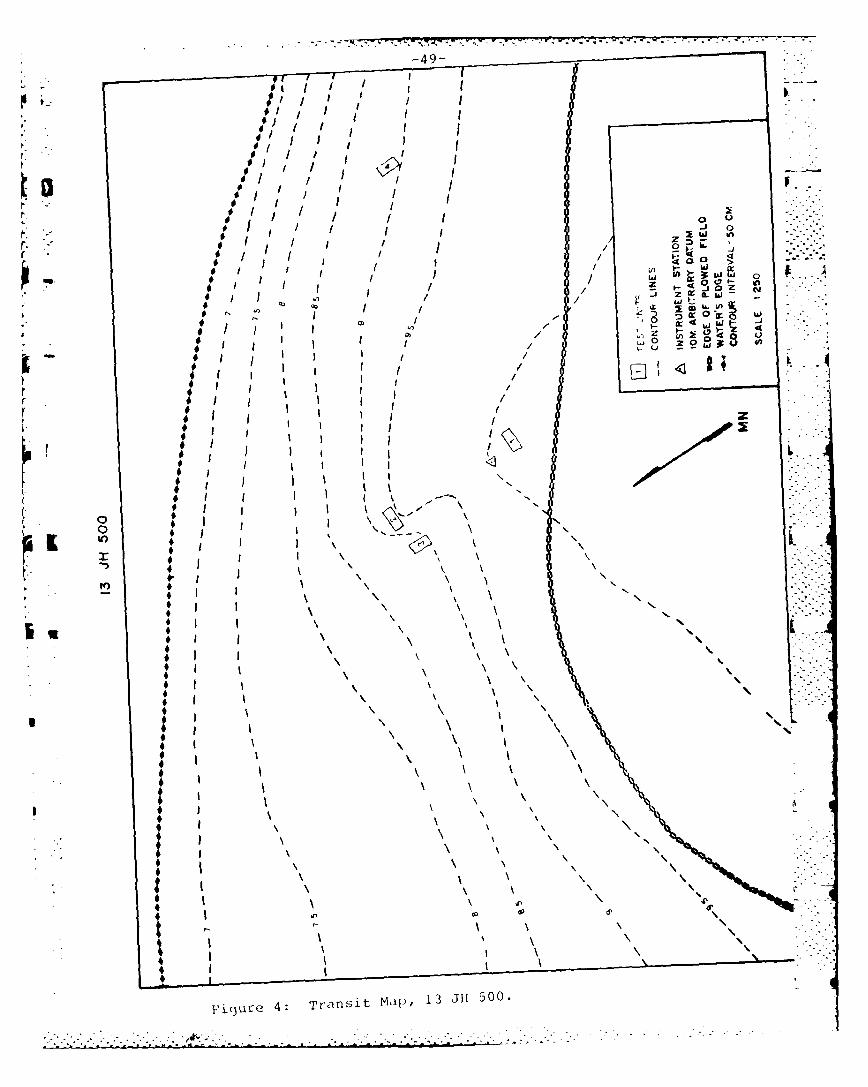
p 49-
I I-
* I t
- - - - - - - - -
4~~~~~~ ~ Trniq,1,13J150

-50-
Woodland identification, no other information is availablefor this spot find.
SURVEY SUMMARY:
The location and condition of sites recorded during theMPI survey provide a sound basis for continued managementefforts at Coralville Lake. Most of the sites from erodedcontexts should be considered lost to the resource base. Afew of these sites might be profitably investigated in orderto further document the lack of integrity.
Several types of landscapes were identified as the mostpromising potential localities for encountering intact sitesand these should be the focus o" further archaeologicalresearch. East of the 1-380 Bridge, along the main lake arenumerous small tributary streams with associated inlets andvalleys. These tributary valleys are the only landformseast of the 1-380 Bridge that we would recommend for furthersurvey. These valleys are subject to alluvial and colluvialdeposition depending on their geomorphological characteris-tics. The sediment buildup would require some type of sub-surface testing. One alternative is to carryout close inter-val shovel testing on all or a sample of these valleys.Another technique calls for random 1 x 2m test excavationsin favorable portions of the valleys. A mandatory precursorto either technique would be soil probe coring of the smallvalleys to determine the depth to stable buried surfaces. Acombination of all three techniques will yield informativeresults.
West of the 1-380 Bridge are several landforms worthinvestigating. Terrace edges, alluvial fans, the shore ofsloughs and oxbow lakes as well as the low terrace/flood-plain complex of the Iowa River. A distinct problem of theareas near to the current river channel is that the vastmajority of this land was under water during our survey.Adequate investigation of the active floodplain and landaround sloughs and oxbows will require a low water stage ofat least several weeks duration. Terrace edges, tributaryvalleys and alluvial fans some distance from the presentriver may be investigated during "normal" pool levels.These landforms will require one or more subsurface testingtechniques in order to identify buried surfaces and subse-quent examination for archaeological sites.
It is strongly recoimnended that any further archaeologi-cal work at Coralville be carried out in conjunction withgeomorphological investigations. The landscape west of the1-380 Bridge in particular is extremely complex. An under-standing of the evolution of these landscapes is essentialfor an adequate assessment of the archaeological resourcesin Coralville Reservoir.
Some tentative general comments are possible for theCoralville sites as a whole. in terms of prehistoric occupa-tion, it would appear that the project area was most inten- -sively occupied during the Woodland period, with a slight
• . ..
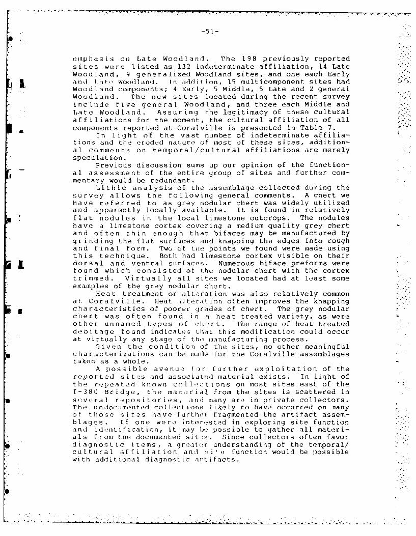
-5 1-
emphasis on Late Woodland. The 198 previously reportedsites were listed as 132 indeterminate affiliation, 14 LateWoodland, 9 generalized Woodland sites, and one each Early
i I and Lato Woodland. In addition, 15 multicomponent sites hadWoodland components; 4 EarLy, 5 Middle, 5 Late and 2 generalWoodland. The new sites located during the recent surveyinclude five general Woodland, and three each Middle andLate Woodland. Assuring the legitimacy of these culturalaffiliations for the moment, the cultural affiliation of allcomponents reported at Coralville is presented in Table 7. -"
In light of the vast number of indeterminate affilia-tions and the eroded nature of most of these sites, addition-al comments on temporal/cultural affiliations are merelyspeculation.
Previous discussion sums up our opinion of the function-al assessment of the entire group of sites and further com-mentary would be redundant.
Lithic analysis of the assemblage collected during thesurvey allows the following general comments. A chert wehave referred to as grey nodular chert was widely utilizedand apparently locally available. It is found in relativelyflat nodules in the local limestone outcrops. The noduleshave a limestone cortex covering a medium quality grey chertand often thin enough that bifaces may be manufactured bygrinding the flat surfaces and knapping the edges into roughand final form. Two of tUe points we found were made usingthis technique. Both had limestone cortex visible on theirdorsal and ventral surfaces. Numerous biface preforms werefound which consisted of the nodular chert with the cortextrimmed. Virtually all sites we located had at least someexamples of the grey nodular chert.
Heat treatment or alteration was also relatively commonat Coralville. Heat tIteration often improves the knapping
5 characteristics of poorer grades of chert. The grey nodularchert was often found in a heat treated variety, as wereother unnamed types of cht, rt. The range of heat treateddebitage found indicates that this modification could occurat virtually any stage of the manufacturing process.
Given the condition of the sites, no other meaningfulcharacterizations can be made for the Coralville assemblagestaken as a whole.
A possible avenue for further exploitation of thereported sites and associated material exists. In light ofthe repeated known collections on most sites east of the1-380 Bridge, the material from the sites is scattered inse;veral repositories, anti many are in private collectors.The undocumented collections likely to have occurred on nanyof those sites have further fragmented the artifact assem-blages. If one were interested in exploring site functionand identification, it may be possible to gather all materi-als from the documented sites. Since collectors often favordiagnostic items, a greater understanding of the temporal/cultural affiliation and si' e function would be possiblewith additional diagnostic artifacts.
." - -.- ; -'.i _.. ..- . -' " [ -" "-- '"- - L L . - . ". ' " " "
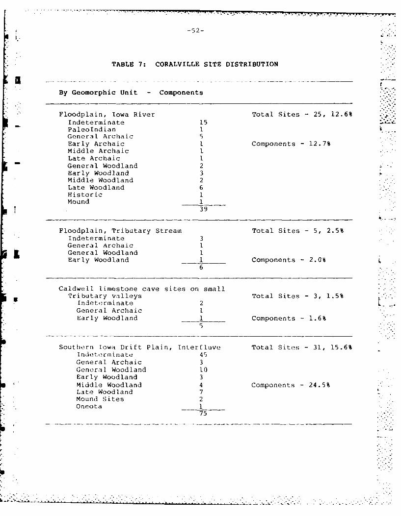
-52-
TABLE 7: CORALVILLE SITE DISTRIBUTION
By Geomorphic Unit - Components
Floodplain, Iowa River Total Sites - 25, 12.6%Indeterminate 15
- Paleolndian 1General Archaic 5Early Archaic . Components - 12.7%Middle Archaic 1Late Archaic 1General Woodland 2Early Woodland 3Middle Woodland 2Late Woodland 6Historic IMound 1
39
Floodplain, Tributary Stream Total Sites - 5, 2.5%Indeterminate 3General Archaic I
5 General Woodland IEarly Woodland 1 Components - 2.0% L
6
Caldwell limestone cave sites on smallTributary valleys Total Sites - 3, 1.5%
Indeterminate 2 LGeneral Archaic IEarly Woodland 1 Components - 1.6%
Southern Iowa Drift Plain, Interfluve Total Sites - 31, 15.6%Indeterminate 45General Archaic 3General Woodland 10Early Woodland 3Middle Woodland 4 Components - 24.5%Late Woodland 7Mound Sites 2Oneota 1
75
- - ---- .. -
'. -.* _ . - -. 2. . .. .. -. -. _.
- - . -- __- *. - - -. - - •. . " - "- - . .
-53-
TABLE 7: (Continued)
Southern Iowa Drift Plain,high lying ridge tops Total Sites - 9, 4.5%
Indeterminate 7General Archaic I.
. . General Woodland 2
Mound Sites 2 Components - 3.9%12
Southern Iowa Drift Plain, hillside,valley slope and steep hillside Total Sites - 43, 21.7%
Indeterminate 32General Archaic 3General Woodland 6 -Early Woodland 1 Components - 17.3%Middle Woodland 3Late Woodland 8
53
Terrace with thick mantle of less Total Sites -60, 30.3%Indeterminate 33General Archaic 13General Woodland 6Early Woodland 7Middle Woodland 8 Components - 29.1%Late Woodland 17Historic 5
89
Terrace, lacking mantle of loess, Lp.
savannah and prairie soils Total Sites - 14, 7.0%Indeterminate 11
*Early Woodland IMiddle Woodland 3Late Woodland 2 Components - 6.2%Historic 2
19
Iowan surface, forest soils inthick aeolian sediment Total Sites - 6, 3.0%
Indeterminate 4Late Woodland 2 Components - 2.0%
6
Altered Land Total Sites - 2, 0.1%Indeterminate -General Archaic 1 Components - 0.6%
2
(Total Components - 306 Total Sites - 198)
-54-
The above procedure is not necessarily recommended forCoralville. It is presented as perhaps the most viableresearch which would yield results and aid in interpretationof the body of known sites in the Coralville project area.Such an endeaver, however, is given a very low priority.
We do strongly recommend a joint geomorphological/archaeological examination of landforms in the western por-tion of the project area and appropriate landforms east ofthe 1-380 Bridge not destroyed by erosion. The primarygoals of such a project are to: 1) develop an accuratedescription of landform evolution, 2) identify surfaceslikely to have been stable and favorable for occupation inthe past, and 3) examine these surfaces for archaeologicalsites.
This type of investigation will not yield the quantityof sites located by surveying the eroded landscapes. How-ever, the sites located using this approach will be found inundisturbed contexts and have the potential to yield signifi-cantly more information than the eroded sites.
. .' ...
* .. . . . . . . . .
L.L~ "" -5
SURFICIAL GEOLOGY OF CORALVILLE LAKE:
Introduction: This narrative provides supplementaldata not presented by Emerson et al (1984). In orderfor evaluation an overview of the geology and paleocli-matology is presented. Subsequent to presentation of theoverview, various site contexts are evaluated. In addition, .-site-specific studies are presented. Finally, recommenda-tions for further delailed studies are reviewed.
Quaternary History:
Underlying bedrock units:
Beneath the deposits associated with Pleistocene glacia-tion lie carbonate bedrock of primarily Devonian age. Theoldest rock units are observed in the northeastern corner ofJohnson county and are Silurian age, while progressivelyyounger units are exposed along a transect from northeast tosouthwest across the county.
-!In the Coralville reservoir area the underlying bedrockis primarily of the Devonian System. The Middle Devonianunits belong to the Wapsipinicon Formation of crystallinelimestone, dolomite, sandy shale, argillaceous limestone andcrystalline dolomitic limestone (Hershey, 1969). The young-er units of the Cedar Valley Limestone group are seen inmany of the bedrock exposures in the Coralville Lake area.These units are composed of crystalline and clastic lime- Lstone, dolomitic limestone with coral, and fossiliferous .limestone.
The Upper Devonian series including the Lime Creek andShell Rock Formations consisting of fossiliferous limestone, "--,
p fossiliferous gray shale, and massive limestone and dolo-mite, can also be observed in portions of the Lake MacBrideand Coralville reservoir areas. Further away from thereservoir in the southwestern part of the county UpperDevonian shales, dolomites, and siltstones of the YellowSpring Group are exposed.
The Pleistocene:
Considerable debate ensued regarding the glacialhistory of the early Pleistocene in east central Iowa.Classically, two major glacial stages were considered sinceonly two tills were recognized. These older tills represent-ed deposits from glacial advances during the Nebraskan, and - .Kansan stages (Leighton, 1916, Alden and Leighton, 1917,Cable, 1921). However, more recent study indicates thatmultiple tills exist and represent a number of glacialadvances during the early Pleistocene.
Most of the older studies recognized a post Illinoiandeposit which was primarily composed of a gravel lag orpebble band. This band was considered to be the Iowan drift
I
- -"- 6 -
41
.-
which was overlying much older Kansan till (Alden andLeighton, 1915). The presence of the Iowan drift remainedunquestioned for several decades, but by the 1950's doubtswere being raised about its existence.
Studies conducted on pahas in the east central Iowarefuted the earlier claims of an Iowan drift. A paha is anerosion remnant of an older land surface standing above theIowan erosion surface at interstream divides (Ruhe, 1969).These topographically higher landforms are linear andgenerally are aligned in a northwest to southeast orienta-tion. In the Coralville area, a paha ridge is identifiedjust to the east of Solon (Prior, 1976).
Transects across several pahas and onto the lower Iowansurface suggest that the pebble band is not a thin veneer oftill. A number of investigators have demonstrated that theformerly called Iowan drift is actually an erosion surface(Ruhe et al., 1965, Ruhe et al., 1968, Vreeken, 1975,Hallberg et al., 1978, Hallberg, 1980). These more recentstudies have provided convincing evidence precluding theexistence of Iowan drift. T h e s trat ig raphic unitsoccurring in the pahas show multiple tills separated bypaleosols and undifferentiaLed alluvial deposits. The pahascontain the most complete Pleistocene record in northeasternIowa but do not contain the pebble band formerly believed tobe Iowan drift. The pahas correlate stratigraphically withthe pre-Illinoian (formerly Kansan) surface seen in southernIowa by showing resemblance to those units observed furtherto the south.
A typical stratigraphic column through the top of apaha would show a surface soil developed in thick Wisconsin-an eolian silt and sand. Beneath the loess would be a basalpaleosol of Late Sangamon or Yarmouth-Sangamon age. Belowthe paleosol would be till and alluvial deposits consideredpre-Illinoian (formerly Kansan and Nebraskan) in age.
These pre-Illinoian deposits have been recently evalua-ted by Hallberg (1980), and consist of multiple units oftill, stratified alluvial sediments, and organic enrichedhorizons. The youngest of the pre-Illinoian (formerlyKansan) tills belong to the Wolf Creek Formation and consistof the youngest Hickory Hills, the Aurora, and the oldestWinthrop members. The oldest of the pre-Illinoian(formerly Nebraskan) deposits belong to the Alburnett Forma-tion. These deposits lie below the Wolf Creek Formation andconsist of undifferentiated tills, paleosols, and alluvialsediments (Figures 5-6).
Two well developed paleosols are recognized in the pre-Illinoian depo,': The Dysart paleosol is developed in theAurora till subjacent to the Hickory Hills member. TheWestburg paleosol is developed in the uppermost till of theAlburnett Formation. Other weakly developed undifferenti-atod pa loosols are observod in both the Wolf Creek andAlburnett Formations.
Durin the Wisconsinan the Iowan erosion surface wasbeing developed in northeastern Iowa. This surface was
%. I
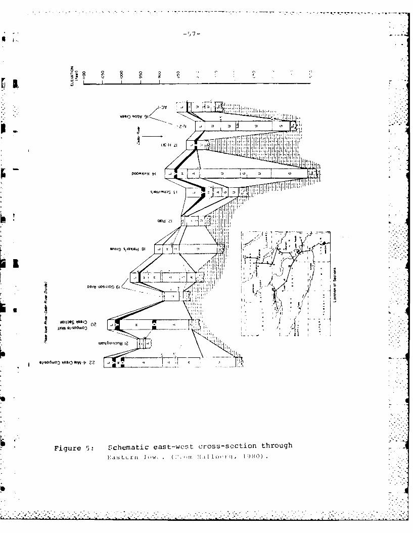
- - - - -. - --O=..----.--'-~- ~- ~ --- ---
o 0044-If 0
9A019Op 21~dD
.3 O0 ~ DUOS JJO %JO1~ 91
uo~t~s~sg~o~ - -I -t
DIjv BP~OdWOZ 6
to~bu~n8 I ' S
CE. .~V~T'
Fiur 5:0IM Sceaices-w0 rosSJt lthog02 dtr w .(.r i 1~q JO
-. . . . . . . . . . . . . . . .o:
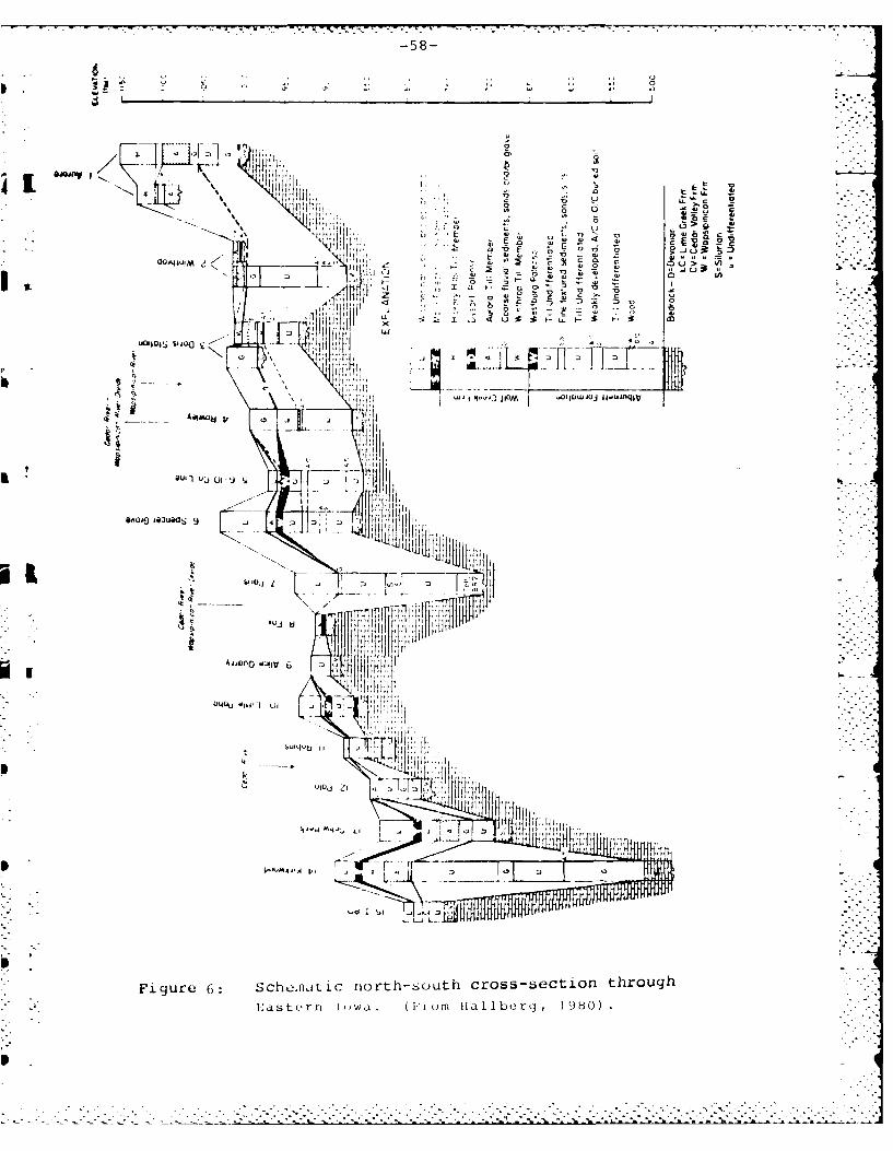
-58-
::! C
u 7 "
1 L au I0jUlb
0- 4. .....
Figue 6 Sch~aaic nrth6out crss-sctin thoug
____ a r r n IIa1 9 0
iiij
-- -- 5- *l- ' • rr r. -.
being cut while loess was being deposited in the region.Unlike the more complete stratigraphic record observed inthe paha inliers, the Iowan surface which is capped by
i 3 Wisconsinan loess truncates older paleosols and till. Thisis observed near Geneseo Iowa, where the Iowan surfaceabutting Hayward's paha truncates the Yarmouth-Sangamonpaleosol, the subjacent till, the Aftonian paleosol and theNebraskan till (Ruhe et al., 1968).
The Iowan surface presumably formed from episodes offluvial erosion and concomitant eolian deposition whichbegan during the Farmdalian about 30,000 B.P. and extendedthrough the Woodfordian. However after the last incrementof loessal deposition occurred about 14,000 B.P., componentsof the Iowan surface continued well into the Holocene (Ruheet al., 1968).
The Holocene:
Climatic history:Atmospheric circulation patterns were greatly affected
by the wasting of Laurentide ice to the north of east cen-tral Iowa. The early Holocene brought about the persistenceof an upper atmospheric circulation pattern dominated by acool relatively dry northwesterly flow out of Canada (Knox,1983). Maritime tropical air masses derived from the Gulfof Mexico were effectively blocked by the persistent north-westerly component.
i L As the Laurentide ice mass wasted further to the north,
a more westerly upper atmospheric component penetrated intothe upper midwest. This intrusion of Pacific derived aircontinued to block the maritime tropical air to the south.Hence, the middle Holocene was characterized by warmer dryerconditions, which effectively lowered local water tables anddestabilized vegetation. From 9500 to 4700 B.P. in eastcentral Minnesota there was an increase in the duration ofPacific air producing a 2 inch decrease in precipitationduring the maximum penetration of westerly air about 7200B.P. (Webb and Bryson, 1972).
Holocene climatic changes occurring in the upper mid-west have produced a migration and succession of severalplant species (Webb, Cushing, and Wright, 1983, Wright1976). The early Holocene advance and later retreat ofecotones suggest changes in the dominant upper atmosphericcirculation regimes. The zonal upper atmospheric circula-tion pattern increased the frequency of warm dry Pacificderived air masses, causing the prairie/forest ecotone toadvanced eastward across Iowa prior to 8000 B.P. T h ewaning of Laurentide ice continued during the middle Holo-cene and by 6500 B.P. the ice had retreated to the Quebec/-Labrador plateau. In response to the deteriorating icemass, the dominant westerly atmospheric component becameless persistent in the upper midwest. As a result theinflux of maritime tropical air from the Gulf of Mexico a n dpolar air from Canada began to increase in frequency.
-60-
The shift in dominant upper air patterns occurredrapidly between 6000 and 5000 B.P., changing the frequencyof air mass dominance toward a more persistent meridional0 upper aitmospheric circulation. Meridional circulationpatterns provide the mechanism necessary for the mixing ofunlike tropical and polar air which results in an increasein the frequency and magnitude of precipitation events(Knox, 1975).
The late Holocene climate including contemporary
M twentieth century climate, is characterized by persistentepisodes of either meridional of zonal circulation. Theorientation of the upp[er air jet stream over the uppermidwest d, termines whether the prevailing climate will berelatively cool/moist, cool/dry, warm/moist, or warm/dry(Knox, 1979). Persistence of any one of these climaticA scenarios can change the magnitude and direction of geomor-
phic processes controlling landscape evolution.
Geomorphic episodes:
Geomorphic responses found in alluvial chronologies arestrongly affected by the magnitude and direction of Holoceneclimatic changes. Alluvial chronologies imply that a shiftto drier conditions promote hilislope erosion, while a shiftto wetter conditions institutes hillslope stability andvalley incision (Knox, 1984). Whether the geomorphicr-sponse is aggradation or degradation apparently dependsiupon the direction of climatic shift relative to the exist-
ing climate, and on the relative location of stream reachwithin the drainage net hierarchy (Knox, 1972). Spatiallythis suggests that in a relatively large watershed perhaps a6th order basin (Strahler ordering method), a shift in cli-mate may produce different geomorphic responses in the head-
j *water as opposed to the middle and lower reaches.One of the reasons for the apparent episodic be-
havior in landscape evolution is the lag time produced whenvegetation is out of balance with a new climatic regime. Ashift in dominant upper air patterns which occurred rapidlybetween 6000 and 5000 B.P., produced a condition where theestablished vegetation was not adjusted to the new moremoist climatic regime. The lag time involving at least 100years in the adjustment of vegetation (Wendland and Bryson,1974), produced a biogeomorphic response which initiatedlateral reworking of alluvial floodplains particularly insouthwestern Wisconsin (Knox, 1972, 1976).
Although external (extrinsic) climatic factors oftenproduce episodes of hi I[s lope and/or valley instability,intrinsic factors that periodically exceed thresholds ofslope stability will also initiate episodic geomorphicbehavior. Trenching of alluvial fans are common, and as afan develops it steepens finally exceeding a threshold slopewhere incision begins to occur (Schumm, 1973). Likewise,sediment storage in a valley occurs through time aggradingthe valley slope until oversteepening produces degradation.
____________________________________________-

• . k . - -, -.- - . ,- , . k .. - -< - -- -
-61-
These are types of intrinsic geomorphic thresholds whichproduce landform change through time to a condition ofincipient instability without a change of external (ie.
E Qclimatic) influences (Schumm, 1973, 1977:8).
During the early Holocene valley alluviation includingalluvial fan development appears to have buen proceeding(Knox, 1972, 1976) in many parts of the midwest. Evidencefrom Sumner Bog, Bremer county (VanZant, and Hallberg,1976), suggests that organic enriched valley fill depositswere accumulating on a sandy Woodfordian terrace during theearly Holocene. However, increased aridity associated withthe middle Holocene likely changed both vegetation type anddensity promoting surficial instability. Radiocarbon datesrecovered from the bog indicate that the period of maximum 1dryness occurred between 7,200 and 6,200 B.P. This resulted
in the lowering of local water tables which oxidized organic Lmaterial and produced incision. The evidence for an episodeof erosion was illustrated by an unconformable surface whichwas later buried by peaty sediments beginning around 6,100B.P.
Between 6,000 and 4,500 B.P. valley floor sedimentswere being eroded and reworked through rapid lateral channel Lmigration in western Wisconsin. This fluvial activitydecreased from 4,500 to 3,000 B.P. but again intensifiedafter 3,000 B.P. (Knox, 1984). By 1,800 B.P. alluvialvalleys in western Wisconsin again stabilized in favor ofmodest vertical accretion (Figure 7).
In Tama county Iowa, the Thoms basin first reveals ahistory of valley entrenchment in the form of gullies duringthe early to mid Holocene. By about 6200 B.P. slope wash
* deposits began to fill the valley bottom gullies (Vreeken,1975). Valley alluviation proceeded throughout the remaind-er of the Holocene in the Thoms basin until recently whenagricultural land use has promoted an episode of destabiliza- .tion.
Coralville Site Characteristics:
The Coralville area lies within the Iowan erosion sur-face (Figure 8), and the pre-Illinoian drift region (Ruheand Prior, 1970, Prior, 1976). Both surfaces are capped byWisconsinan loess. Older pre-Holocene alluvial terracesurfaces that date prior the 14,000 B.P. are also capped byloess. Younger alluvial surfaces of Holocene age are foundcloser to the Iowa river course.
To the east and south of interstate 380, the Iowa rivervalley is confined to a bedrock gorge of presumably post-Kansan age (Leighton, 1916, Salisbury et al., 1968). Up-stream and to the west of the interstate the valley widensand passes through a region of unconsolidated pre-Illinoiandrift (Salisbury et al., 1968). Within the relatively widevalley, Wisconsinan age eolian dunes can be observed(Finney, 1984).
-----------------. .-.* - *

V . -62-
Climatic Influence on HoloceneU 1.58-Year Floods - Southwestern Wisconsin
verical accretion 0.02-0 08 cm/yr vertical .iccrelion 0.002-0.02 cm/yrrapid lateral channel migration slow lateral O~annell migration
2 0
20- _ _ _ _
Un 10- I standard errorof estimated age
0-
-10 _ _ _
0-200 radiocarbon date
0 -30 In channel
-4010-0 2000 4000 6000 8000 h
Radiocarbon years B.P.
Figure 7. Holocener. variation in the magnitude
of the mean annual (1.58-year) floods in westernWisconsin expressed as a percentage larger or
smaller than the modern mean annual floods.
(From Knox, 1984)
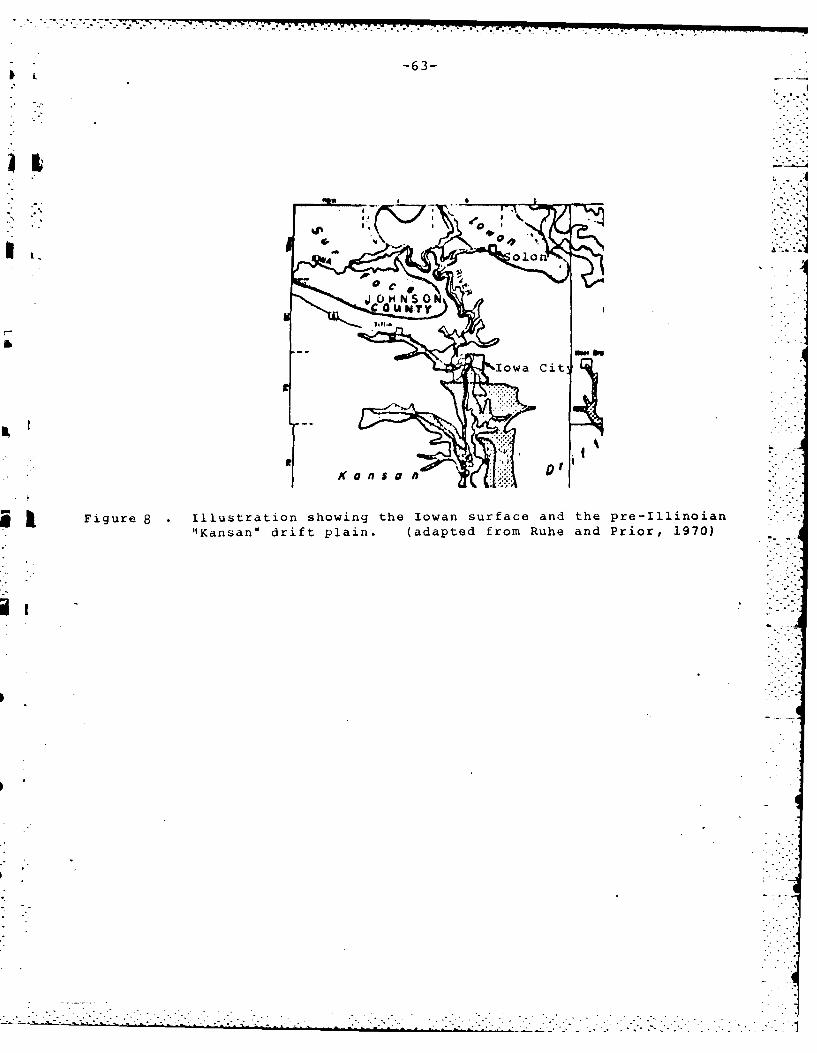
-63-
Ii ol1
j t Figure 8 illustration showing the Iowan surface and the pre-Illinoian"Kansan" drift Plain. (adapted from Ruhe and Prior, 1970)
-64-
The climate of the Coralville area would be consideredhumid continental with cold winters dominated by continentalpolar air masses and warm summers dominated by maritimepolar (Pacific) and maritime tropical air masses. The sum-mer average temperature is 73 degrees F. and the averagewinter temperature is 24 degrees F. Total annual rainfallis about 34 inches with 70 percent of the precipitationoccurring between the months of April and September(Schermerhorn, 1983).
Most of the soils in the Coralville area are developedin loess with dark organic rich surface horizons and sub-surface argillic horizons. Many of the soils would be class-ified as Udolls and Udalfs, particularly in the uplandareas. However, in areas closer to the Iowa river coursesoils have formed in coarser textured alluvial and eoliansediments and have rather poorly developed subsurface hori-zons. Many of these soils trend toward Fluvent and Psammentsuborder classification.
Previous investigation:
A study of the Coralville Reservoir area by Emerson(1983), examined several geomorphic surfaces contained with-in the reservoir area. From a number of boreholes and soilsurvey studies, delineation of a number of "physical environ-ments" were mapped surrounding the Coralville reservoir(Emerson, 1983: 17). These mapped units were particularlyconcerned with surfaces located above the main Iowa rivervalley therefore excluding the modern floodplain, low Holo-cene terraces, alluvial fans and colluvial footslopesabutting the main valley. Lower Holocene terrace and modernfloodplain surfaces adjacent to the Iowa river course areoften impounded throughout much of the year, and were simply
* mapped as floodplain in this former study.
The Floodplain:
Considerable discussion and often confusion surroundsthe concept of the "floodplain". This is primarily due tothe differences in definition used by investigators ofdifferent disciplines or concerns. Engineers and land useplanners usually refer to any area that is subject to flood-ing (Dunne and Leopold, 1978: 428) as the floodplain. Thiswould include areas adjacent the river course that would beflooded only during rare hydrologic events. For example, a50 year (2% recurrence probability per year) flood eventwould be considered as part of the floodplain to the landuse planner.
In constrast, the floodplain to the geomorphologistconsists of that area adjacent the river course which isinundated frequently in response to the present hydrologicregime. The floodplain in this sense is actively beingreworked and constitutes that area which is presently underconstruction. The floodplain under construction is flooded
-65-
frequently and at a relatively consistent recurrence inter-val of 1.5 years in the annual duration flood series (Dunneand Leopold, 1978: 607) and 1.0 years in the partial dura-
U 5tion flood series. In the field the floodplain under con-struction is marked by the top of the fining-upward lateralaccretion point bar deposit (Knox, 1984). Consequently, thefloodplain to the geomorphologist constitutes a much smallerarea and does not include slightly higher alluvial surfacesabutting the modern floodplain surface.
* Alluvial valleys often contain multiple relict surfacesthat relate to past hydrologic regimes, and in many casesthese surfaces show only small topographic changes that areperceptible only through field observations. These moresubdued terrace surfaces should be of particular concern tothe archaeologist since they may contain preserved buriedsurfaces of considerable cultural significance.
Preliminary Site Investigations:
13 JH 500 (Swisher 107):
This site which is located adjacent Hawkeye WildlifeRefuge shows evidence for considerable surficial reworking(Figure 9). The cultural material observed either at ornear the surface constitute a lag deposit which has accumula-ted due to severe surface erosion. Little evidence remainsof an organic enriched A horizon which has been oxidized anderoded through intensive agricultural land use. The wellsorted sands and their concomitant rapid infiltrationcapacities constitute the parent material seen at theSwisher site. The rapid infiltration promotes drought con-ditions and inhibits surface vegetation. As a result thesurface is highly unstable and is subject to frequentepisodes of reworking.
Since this site is inundated during the spring, thesurface is subject to alluvial cut and fill episodes. How-ever after the annual high magnitude spring flows areattenuated, the surface is subjected to eolian reworking.Evidence that both eolian and fluvial processes are current-ly active at the site was seen in the form of surface flooddebris, and in the form of small scale dunes parallel to thewinter wheat rows in the adjacent field.
Unit 2 provided the most complete profile observed at13 JH 500. There was a generally coarsening in texture fromthe surface to the base of the excavated unit. A silt probecore extended the profile from the bottom of the excavationunit (120cm.) to 415cm. Clay enrichment in the form oflamellae began about 65cm. below the surface and continuedto 235cm. As the clay fraction decreased, overall texturebegan to increase. Granules and pebbles were observedbeginning at 385cm. and continued to the bottom of theprofile at 415cm. The entire profile was leached ofcarbonates.
• .

-66-
SOUTH PROFILE13 JH 500- UNIT 2
A p
32
SAND WITH MINOR SILT 75YR 3/3'4/4 E
65
LCLAVL1Y SAND "AAD scm T14ICK ___ &
MED, SAND IOYR 7/3
R SCALE 1510
Figure 9: Stratigraphy at 13 J11 500.
-67-
Particularly characteristic of coarse textured soils isa banded B horizon. Due to a lack of fine grainedmaterial, subsurface illuvial horizons will develop lamellae
[ Ivarying in thickness from less than imm. to several centi-meters. Subsurface lamellae observed at a Mississippi riverterrace (Overstreet, 1984b) found late Archaic materialstratigraphically above these textural lamellae. The timenecessary to develop subsurface lamellae vai.,es, howeverBerg (1984) showed that these bands required a few thousand
* years to develop in sand dunes along Lake Michigan. Theorigin of these bands may not be entirely pedogenic.Dijkerman et al. (1967), suggests that these bands mayresult from both alluvial and pedogenic processes. If analluvial sequence of coarse grained deposits are interruptedby an episode of fine grained deposition the fine graineddeposit may act to impede subsequent downward clay migrationand promote illuviation.
From the observations made at Unit 2, this site is like-ly developed in leached reworked outwash sediments that havebeen mobilized during the Holocene. Lateral migration andsubsequent downcutting of the Iowa river has produced aterrace composed of lateral accretion point bar depositscharacterized by a fining upward sequence grading frompebbly sand at the base, to medium sand, and finally tosilty sand at the top. Due to the highly mobile nature ofthe surficial sediments, erosion has concentrated culturalmaterial at or near the surface as a lag component.
13 JH 482:
13 JH 482 is a site located on a spur which dips to thesoutheast toward the Iowa river from the main northeast-southwest trending ridge (Figure 10). This site ispositioned on the Southern Iowa drift plain which is com-posed of Wisconsinan loess overlying pre-Illinoian till andcarbonate bedrock.
This site has experienced severe erosion particularlywhere seasonal high water has stripped a large portion ofthe solum. This condition is observed at Unit 1 which iswithin close proximity to the impoundment margin. The northprofile of Unit 1 shows a small scarp indicating where thelatest seasonal high water level scoured the surface Alhorizon. The east profile of the same unit shows no surfaceAl horizon.
Topographically higher than Unit 1, Unit 2 illustratesconsiderably less erosion by comparison. But both unitsare developed in silt derived from loess which has beenthoroughly leached of carbonates. These Units reflect thecharacteristic subsurface Bt horizon of the Fayette siltloam. Because of the apparent surface erosion at this site,cultural material has concentrated as a lag close or nearthe surface.
- -" ", ' . . * >.-. . . * -- .*. 7 . .
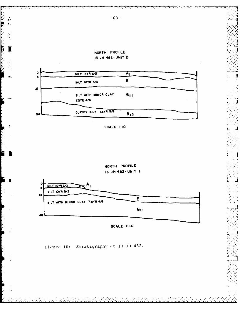
-68-
NORTH PROFILE13 JH 482- UNIT 2
0 SILT 10YR 33A
SILT IOYRk 5/3 E
SILT WITH MINOR CLAY B7.SYR 4/G
CLAYCY SILT 7.5YR 5/
SCALE 110 ~-
NORTH PROFILE
13 J H482 -UNIT I
14
SCALE 1-10
Figure 10: Stratigraphy at 13 JHi 482.
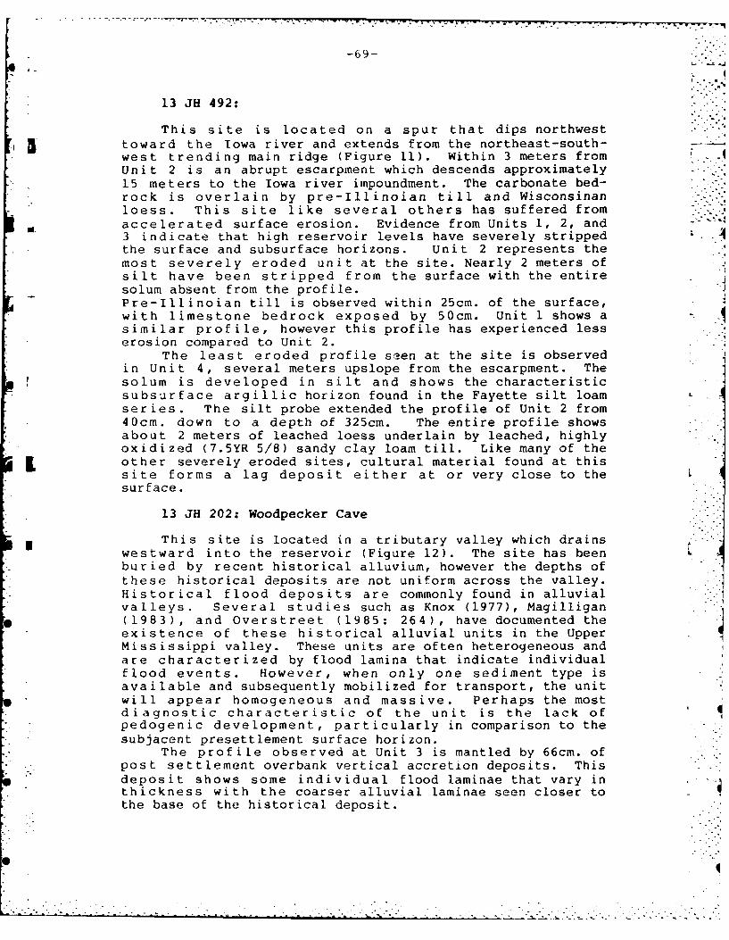
-69-
13 JH 492:
This site is located on a spur that dips northwest-i 5 toward the Iowa river and extends from the northeast-south-
west trending main ridge (Figure 11). Within 3 meters fromUnit 2 is an abrupt escarpment which descends approximately15 meters to the Iowa river impoundment. The carbonate bed-rock is overlain by pre-Illinoian till and Wisconsinanloess. This site like several others has suffered fromaccelerated surface erosion. Evidence from Units 1, 2, and3 indicate that high reservoir levels have severely stripped -4the surface and subsurface horizons. Unit 2 represents themost severely eroded unit at the site. Nearly 2 meters ofsilt have been stripped from the surface with the entiresolum absent from the profile.Pre-Illinoian till is observed within 25cm. of the surface,with limestone bedrock exposed by 50cm. Unit 1 shows asimilar profile, however this profile has experienced lesserosion compared to Unit 2.
The least eroded profile seen at the site is observedin Unit 4, several meters upslope from the escarpment. Thesolum is developed in silt and shows the characteristicsubsurface argillic horizon found in the Fayette silt loam -
series. The silt probe extended the profile of Unit 2 from40cm. down to a depth of 325cm. The entire profile showsabout 2 meters of leached loess underlain by leached, highlyoxidized (7.5YR 5/8) sandy clay loam till. Like many of theother severely eroded sites, cultural material found at thissite forms a lag deposit either at or very close to thesurface.
13 JH 202: Woodpecker Cave
This site is located in a tributary valley which drains5 westward into the reservoir (Figure 12). The site has been L
buried by recent historical alluvium, however the depths ofthese historical deposits are not uniform across the valley.Historical flood deposits are commonly found in alluvialvalleys. Several studies such as Knox (1977), Magilligan(1983), and Overstreet (1985: 264), have documented theexistence of these historical alluvial units in the UpperMississippi valley. These units are often heterogeneous andare characterized by flood lamina that indicate individualflood events. However, when only one sediment type isavailable and subsequently mobilized for transport, the unitwill appear homogeneous and massive. Perhaps the mostdiagnostic characteristic of the unit is the lack ofpedogenic development, particularly in comparison to thesubjacent presettlement surface horizon.
The profile observed at Unit 3 is mantled by 66cm. of• post settlement overbank vertical accretion deposits. This
deposit shows some individual flood laminae that vary in *
thickness with the coarser alluvial laminae seen closer tothe base of the historical deposit.
..0
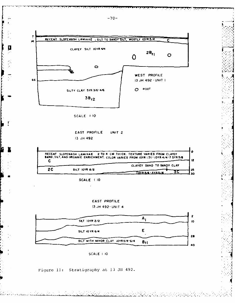
-70-
RECENT SLOPEWASH LAMINAE SILT TO SANDY ILT, MOSTLY IOYR 5/4
*66 1 H42UI
SILTY CLAY 5YR3/64/6RO
3 Bt2
SCALE 1:10
t
EAST PROFILE UNIT 2
13 JH 492
RECENT SLOPEWASt4 LAMINAE 2 TO 4 CM THICK. TEXTURE VARIES FROM CLAYEYSAND, SILT, AND ORGANIC ENRICHMENT COLOR VARIES FROM IQYR 1.7/1- IOYR 4/4-7 5YR 54
C ICLAYEY SAND TO SANDY CLAY
2 C SILT IOYR 6/2 30
SCALE 1 10
EAST PROFILE13 JH 492- UNIT 4
2
SILT 1 YR 6/
28
SILT WITH MINOR CLAY IOYR5/4- ell40
SCALE 1 10
Figure 11: Stratigraphy at 13 J1I 492.
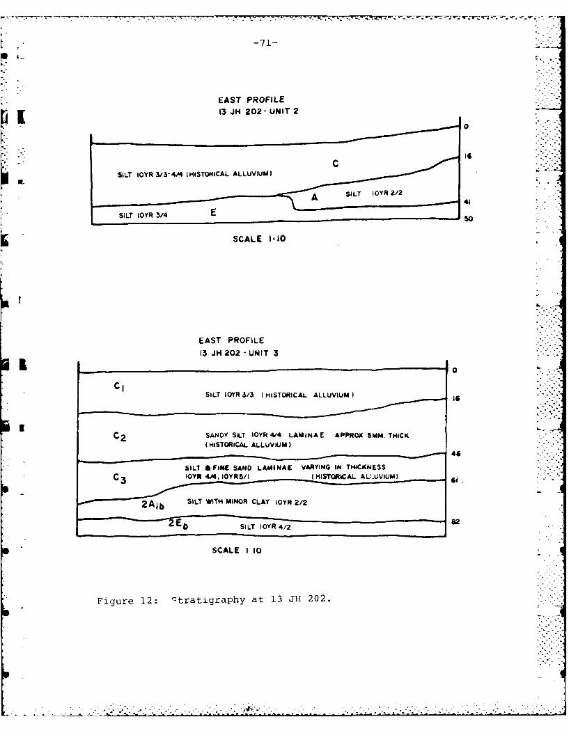
-71-
EAST PROFILE0
OL SILT IOYR 3/3-4/4 (HISTORICAL ALLUVIUM)
41SILT IOYR 3/4o
SCALE 1 10
EAST PROFILE3 JH 202 - UNIT 3
0
SILT IQYR 3/3 (HISTORICAL ALLUVIUM)
46
CIOYR 4/4, IOYR 5/I (HISTORICAL Al-i-UVIUMI S
2A, SILT WITH MINOR CLAY iOYR 2/2
E b SILT IOYR4/2
SCALE 1 10
Figure 12: qtratigraphy at 13 JH 202.
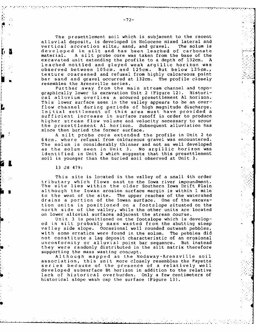
-. -. - .. ..
' -" :-72-
The presettlement soil which is subjacent to the recentalluvial deposit, is developed in Holocene mixed lateral andvertical accretion silts, sand, and gravel. The solum isdeveloped in silt and has been leached of carbonatematerial. A silt probe core was taken from the base of theexcavated unit extending the profile to a depth of 132cm. Aleached mottled and gleyed weak argillic horizon wasobserved between 105cm. and 125cm. But below 125cm.,texture coarsened and refusal from highly calcareous pointbar sand and gravel occurred at 132cm. The profile closelyresembles the Arenzville series.
Further away from the main stream channel and topo-graphically lower is excavation Unit 2 (Figure 12). Histori-cal alluvium overlies a scoured presettlement Al horizon.This lower surface seen in the valley appears to be an over-flow channel during periods of high magnitude discharge.Initial settlement of this area must have provided asufficient increase in surface runoff in order to producehigher stream flow volume and velocity necessary to scourthe presettlement Al horizon. Subsequent alluviation hassince then buried the former surface.
A silt probe core extended the profile in Unit 2 to64cm. where refusal from calcareous gravel was encountered.The solum is considerably thinner and not as well developedas the solum seen in Unit 3. No argillic horizon wasidentified in Unit 2 which suggests that this presettlementsoil is younger than the buried soil observed at Unit 3.
13 JH 479:
This site is located in the valley of a small 4th ordertributary which flows east to the Iowa river impoundment.The site lies within the older Southern Iowa Drift Plain
* although the Iowan erosion surface margin is within I mileto the west of the site. The upper reaches of the watersheddrains a portion of the Iowan surface. One of the excava-tion units is positioned on a footslope situated on thenorth side of the valley, while the other units are locatedon lower alluvial surfaces adjacent the stream course.
Unit 3 is positioned on the footslope which is develop-ed in silt probably mass wasted from the abutting steepvalley side slope. Occasional well rounded outwash pebbles,with some erratics were found in the solum. The pebbles didnot constitute a lag deposit characteristic of an erosionalunconformity or alluvial point bar sequence. But insteadthey were randomly distributed in the silt matrix thereforesupporting the mass wasting concept.
Although mapped as the Nodaway-Arenzville soilassociation, this unit more closely resembles the Fayetteseries because of the presence of a relatively welldeveloped subsurface Bt horizon in addition to the relative I..
lack of historical overburden. Only a few centimeters ofhistorical slope wash cap the surface (Figure 13). 7
0- i i
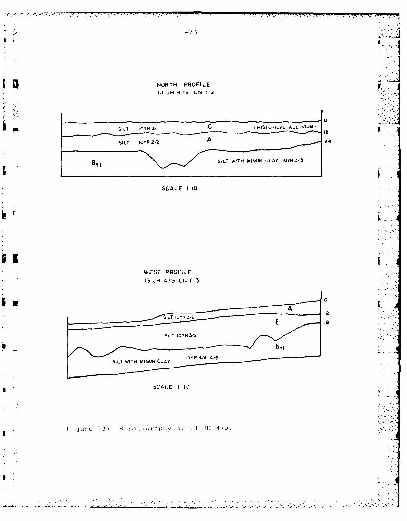
NORTH PROFILE13 JH 479- UNIT 2
SIL WY 3/ c(HISTOWiCAL ALLUVIUM)
stl ~SILT WVITH MINk CLAY JOYN 3/3
SCALE I 10
WEST PROFILE13 JH 479-UNIT 3
0
A2
SALT IY e12
.................................
- - - - - - - - - - -- - - - - - - - - - --T ---------3- - -
-74-
A s i I t probe cor- was taken from the bottom ofexcavat ion Unit 3 and continued to a depth of 190cm where . .-
refusal from sand and gravel occurred. The Bt horizon whichbegins about 30cm. continues to approximately 150cm., thentexture begins to coarsen toward the base of the profile.The entire profile is leached of carbonates with theexception of the basal sand and gravel which is highlycalcareous.
U nit 2 (Figure 13) is located on a low alluvial terraceclose to the modern floodplain and stream course. The
OL ~terrace is composed of mixed lateral and vertical accretiondeposits, with a thin veneer of post settlement alluviumcapping the surface. This terrace has apparently beenstable for a considerable period of time. Evidencesupport ing this idea was se en in the subsurface B horizonwhich showed argillans coating the ped faces. Clay skindevelopment requires a considerable length of time which hasbeen demonstrated by Parsons et al. (1962) in northeastIowa. In his study, clay Cilms were absent from the theyoungest 1000 year old effigy mound profiles, while theoldest 2500 year old mound profiles showed prominent clayfilm development along ped faces.
A silt probe core continued the profile from the bottomof the excavation unit to a depth of 200cm. Texture beganto coarsen by 115cm. and by 200cm. refusal was encounteredfrom sand and gravel. The entire profile of Unit 2 wasleached of carbonate matorial.
Discussion: L
The Coralville reservoir area can be divided into 2physiographic regions; the Hawkeye Wildlife area located inthe Iowan physiographic region and the pre-Illinoian driftregion which contains the Iowa river gorge. Historical landuse inodi.Cications beginning with the arrival of European L.sottlers during the first half of the nineteeth centiry, hasproduced significant landscape modifications in bothphysiographic provinces. The impoundment of the Iowa riverhas further complicated the multiple effects of modern land
The Hawkeye Wildlife area which constitutes a broadvil ley incorporates multiple alluvial surfaces. Evidenceillustrating this is seen in 2 additional cores taken near13 311 500 (Figures 14-15). Swisher 107 Core No. I was takenon a lower Holocene terrace about 200 meters west of 13 JH500. The profile shows relatively little post settlementalluvium capping the surface and a presettlement soildeveloped in apparent channel fill deposits. Although it isimpossible to evaluate the- stratigraphic significance andareal extent of an alluvial chronology from a single siltprobe core, this core suggests that an entirely differents,d i mnentolog ical sequence is found only a few hundred metersaway froln a hi qhor terr,t-,, ,xpr ioncing rectnt dramaticfluvial and eolian reworking.
I---
-. - ~.2 *.-. -.. i-. .-- ->. ~ *______________________________________.___"__.__,]
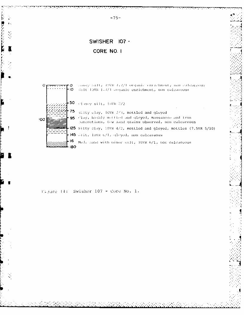
17
-75-
SWISHER 107 -
CORE NO. I
I.
10 i t L IUYR 1. //I )riwnic enrichlunL, non CdcdJuuuus - -
. . . . . . . . . .-. 5/7 -50 (1 iyy silL, 10YR 2/2
"'l/ -75 . ilty clay, IYP 2/3, mottled and (leyed
10 0 9 5 c l ai y , h i h l y i ) t t mto t ln d a dley e d , mo tl esi a n d5O 5 / 1 0
:oncretions, tLw sand cjrains observed, non calcareous, -_125 Silty clay, IOYP 4/-,, mottled and gleyed, mottles (7.5YR 5/10) "
145 :,IL, IoYR (/I, lit'yeai, non calcareous
...................... 16 Mcd. :said with mlino silt, I0YR 6/1, non calcareous............ 1 0- "
I ]
I'iurc 14: Swisher 107 - Core No. 1.
I
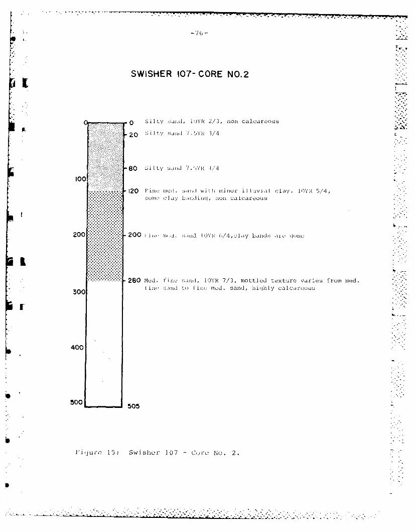
-76(1-
SWISHER 107- CORE NO.2
.............0 Silty sand, IOYk 2/3, non calcareous
20 Sil ty sand 7 S.YR V/4
80 Sil ty San1d '/ . AR 4/4
100
.............. -.. 120 1in -d sandi withI minor illuvia-l clay, IYR 5/4,solmalc clay banid inq , non calcareous
........................
....... ..... 8 o.tlosnlY /,mtldtxuevre rmmd
200 20 IOU mn to til nod,ca sand, irehl alacu
.. ... ..
280ur 15:Swibo 17 - Curc. No.R 2,mtldtxue aisfo e.%
tiw sid t itIi(d ad ihyclaeu
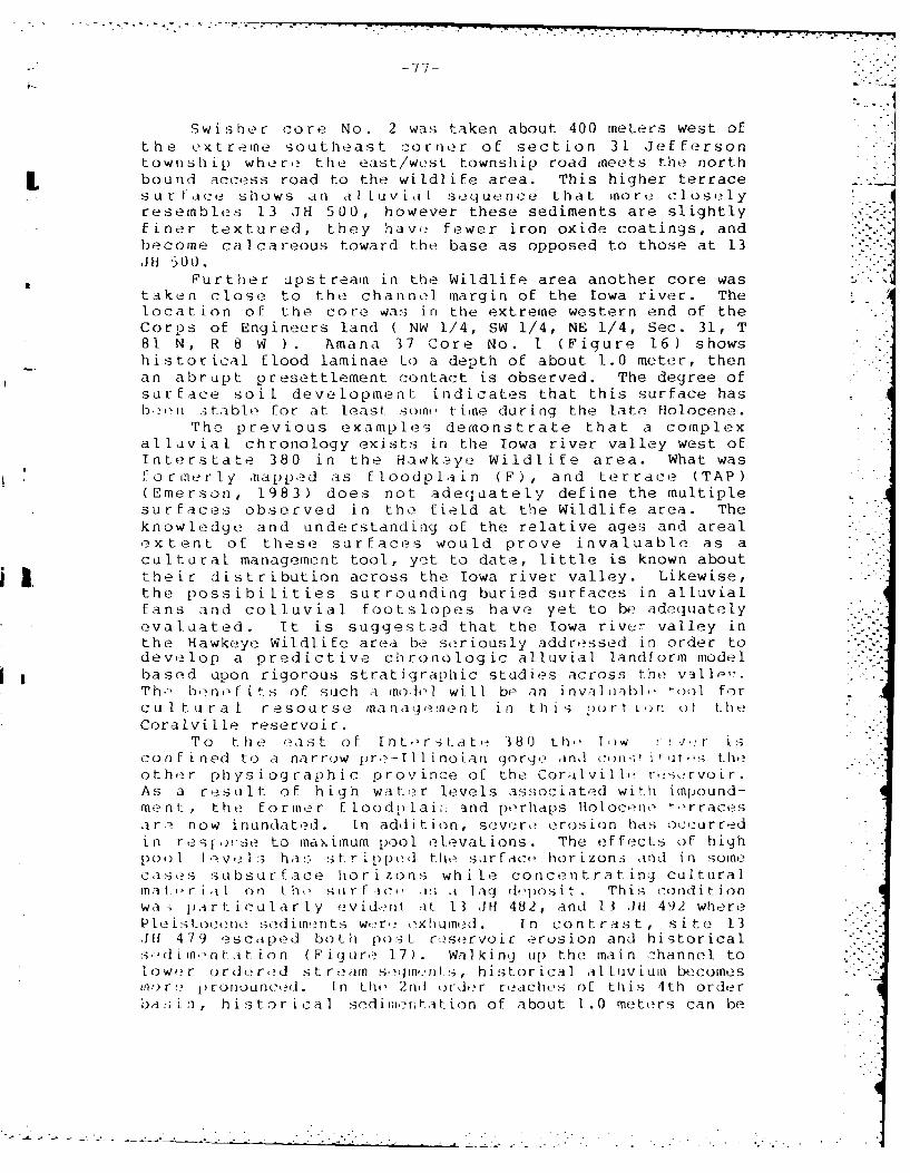
-77-
Swisher core No. 2 was taken about 400 meters west ofthe extreme southeast corner of section 31 Jefferson jtownship where the east/west township road meets the north
I bound access road to the wildlife area. This higher terracesur face shows an a[lLuvial sequence that more closelyresembles 13 JH 500, however these sediments are slightlyfiner textured, they have fewer iron oxide coatings, andbecome calcareous toward the base as opposed to those at 13JH 500.
Further upstream in the Wildlife area another core wastaken close to the channel margin of the Iowa river. Thelocation of the core was in the extreme western end of theCorps of Engineers land ( NW 1/4, SW 1/4, NE 1/4, Sec. 31, T81 N, R 8 W ). Amana 37 Core No. I (Figure 16) showshistorical flood laminae to a depth of about 1.0 meter, thenan abrupt presettlement contact is observed. The degree ofsurface soil development indicates that this surface hasb.?on :>stable for at least somt, tiine during the late Holocene.
The previous examples demonstrate that a complexalluvial chronology exists in the Iowa river valley west ofInterstate 380 in the Hawkeye Wildlife area. What wasformer ly napped as floodplain (F), and terrace (TAP)(Emerson, 1983) does not adequately define the multiplesur faces observed in the field at the Wildlife area. Theknowledge and understanding of the relative ages and arealextent of these surfaces would prove invaluable as acultural management tool, yet to date, little is known about
j their distribution across the Iowa river valley. Likewise,the possibilities surrounding buried surfaces in alluvialfans and colluvial footslopes have yet to be adequatelyevaluated. It is suggested that the Iowa river valley inthe Hawkeye Wildlife area be seriously addressed in order todevelop a predictive chronologic alluvial landform modelbased upon rigorous stratigraphic studies across the valli,:.-.Th., b, nofits of such a model] will be an inval uab], tool forcultural resourse managemnent in this, port in ol theCoralville reservoir.
To the east of Interstate 380 th, low r ! i,-r isconfined to a narrow pre-Illinoian gorge and cm-,o i it ,s theother physiographic province of the CoralviIlte r,-,.irvoir.As a restilt of high water levels associated with impound-ment, the former floodp lai; and perhaps Holoceno trracesar a now inundated. In addition, severe erosion has occurredin resj,)i'se to maximum pool elevations. The effects of highpool lve 1s has. stripped thIe surf-ic, horizons and in somecases subsurface horizons while concentrating culturalmater jul on th, surf-i !,; ,a lag d'posit. This conditionwa- p rticularty evid,nt at 13 JH 482, and 13 ,JH 492 wherePleistocene sedimentswr xhuid. In conrast, site 13,lI 479 escaped both post reservoir erosion and historicals:.d imn nt-at ion (Figure 17). Walking up the main channel tolower ordered str eain sgmnts, historical alluvium becomesto r' c )romou nccd . n th, 2rni orir reaches of this 4th orderbasin, historical sedinntation of about 1.0 meters can be
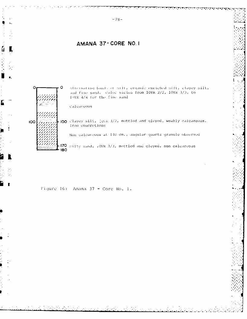
AMANA 37- CORE NO. IIL
- 00 ~iIi iiii';biin. ,I :iH, 01jilic, 0iliichnd !nil ,cIYe-Y silt-,J"Id Fine sand. co I vaies from 10Th 2/2, lOYR 3/3, to
)YR 4/4 Fur th, f irw sand
100 -100, CQ layey silt, iu~3/2, mottled and (ilcyed, weakly Calcareous.
e111111'o Iron conicretionse11111111
Nun calcareous at 4() CmT. ,anijullar quartz granule obsurved
170 ,;ilty sand, IOYR 3/3, mottled and qleyed, non calcareous180
iAuNre 16: Amana 37 Core No. I".
S_
, . ... .
-...--..

-79-
/ I I 4 .- 4
WA~
1 I, 4 -1
,,, S j .,~ j \\ 41
L N .
,- F 4T H'. R 11
SC L 1; 2 4,0 0 ."
I~- -'.-1 .
;jw;1,~ c I 1rap'
'I /ahi r v 1
-80-
observed. The historical slope wash debris stored in the2nd order drainages has steepened the valley gradientsufficiently to initiate an episode of entrenchment. Thefine grained sediment hcing actively eroded in thesedrainages appears to be transported out of the basin assuspended load, whereas the coarser bedload material isbeing mobilized for local transport remaining higher up in
* the drainage network. The probability of a rare highmagnitude hydrologic event occurring sometime in the furtureML may mobilize this bedload material stored upstream for --transport downstream toward the mouth of this 4th orderedbas in.
This example iLLustrates the complex relationshipbetween cut and fill episodes found within a relativelysmall drainage network. The geomorphic processes occurringin the headwater reaches are likely to differ in bothmagnitude and direction when compared to processes actingdownstream. Important questions surrounding watersheds ofthis nature focus upon identifying reaches where sedimentstorage and sediment flushing are actively occurring asopposed to reaches where: grade has been maintain forrelatively long periods of time. Watersheds of this typelocated in the Iowa River gorge require careful geomorphic Lconsideration when used to assist a comprehensive culturalmanagement program in this area of Coralville Reservoir.
Therefore, in order to identify these stable reacheslocated in the lower ordered basins and the preserved
L surfaces in the main valley upstream from Interstate 380, arigorous and comprehensive geomorphic study should beconducted. The study should include detailed alluvialchronologies which can only be attained through intensivefield investigations.
The field methodology should begin with a program- designed to obtain as much indirect morphologic information
about the reservoir area before the implementation of directfield studies. This would include an analysis of originalland survey documents in order to determine the extent oflateral stream migration particularly in the Iowa rivervalley west of Interstate 380 during the last century.Information obtained from these historical documents andcompared to the current topographic maps would provide Jinitial information about the areas within the valley thatha-_v been reworked over the last century.
Stereographic air photographs should be used toidentify discrete topographic changes throughout the Iowariver valley and along the valley margin. Terrace outliersand alluvial fans contained within the valley walls, wouldhave a high potential for site burial and could beidentified through areal photographic interpretation.
Discussion with professionals familiar with the Iowariver valley should be conducted. This is important becausepeople associated with the Iowa Geologic Survey, theUniversity of Iowa, and the Soil Conservation Service areimost familiar with the study area. Communication with these
,.~ -7-
-- 8l - ._
individuals should help to refine the geomorphologist'sfield strategy before implementation of a coring andsampling program.
r After the indirect field information has been compiledand evaluated direct field operations should be implemented.In the Hawkeye Wildlife area and in the small orderedwatersheds in the Iowa River gorge, close interval coringacross the valleys should be conducted in order to determinethe chronology of geomorphic events. The use of silt probecore, and bucket auger should provide the major samplingmethodology because these tools can access areas wheremechanized equipment is unsuitable. The combination of thesilt probe which produces intact cores and the bucket augerwhich provides a large sample can reconstruct detailedstratigraphy to depths often greater than 3 meters which maybe sufficient in reconstructing alluvial chronologies onHolocene surfaces in the Coralville reservoir area. In factthe silt probe has the capability of recovering cores fromdepths greater than 6.0 meters (Overstreet, 1985:79).However, in areas accessible by power equipment such ashigher terraces and alluvial fans the Giddings power probeand backhoe trenches should be employed since they generallyprovide the best stratigraphic preservation. The pointbeing that stratigraphic studies should not be biased orlimited because of the dependence upon only one fieldtechnology.
Upon completion of detailed field work the samplesshould be processed for particle size determination, organic
Icarbon analysis, and for the presence of carbonates. Thesemethodologies will provide documentation of pedogenicdevelopment (or lack of development) associated with surfacestability (or instability). Furthermore when coring inalluvial valleys near or below the water table, the mottledand gleyed conditions of the sediments and the presence of r-iron and manganese concretions can sometimes mask weaklydeveloped buried surfaces. In environments above the watertable particularly in alluvial fans and higher terracesurfaces, buried surface (Al) horizons usually becomeoxidized and lose their characteristic black (10YR 2/1)color. The prescribed laboratory proceedures are sensitiveand should be able to identify weakly developed buriedsurface and subsurface horizons if they are not obvious inthe field.
An effective research model aimed at determining thegeochronology of the Coralville Reservoir area must producea rigorous program designed to incorporate intensiveindirect and direct field methodology with meaningfullaboratory procedures. The result of this effort willprovide a useful evolutionary landscape model based upondirect emnpiricle studies of different aged surfaces withinthe reservoir margins. A ,;t.u(y of this nature would enhance.the desired predictive archaeological site distributionmodel. Such a model of course is predicated upon soundunderstanding of past landscapes and associated climatic

* -,... ..
-82-
patterns. In turn, the feedback between models of pastlandscapes and models of past cultural systems will resultin more effective management of the archaeological database.
IL
I- .
. . . .° .
-83-
REFERENCES CITED
ALDEN, W.C. and M.M. LEIGHTON1917 The Iowan Drift: A Review of the Evidences of the
Iowan Stage of Glaciation. Iowa Geological SurveyVol. XXVI, Annual Report for 1915.
AHLER, STEVEN R. .1984 archaic settlement strategies in the Modoc
Locality, Southwest Illinois. Ph.D. Dissertation,University of Wisconsin-Milwaukee.
- ANDERSON, ADRIAN D.1971 Review of Iowa River Valley Archaeology. In:
Prehistoric Investigations, Marshall McKusick (ed.),Report No . 3. Iowa City: Office of the StateArchaeologist.
1971a The Late Woodland Walters Site. In: PrehistoricInvestigations, Marshall McKusick (ed.), Report No. 3.Iowa City: Office of the State Archaeologist.
BERG, R.C.1984 The Origin and Early Genesis of Clay Bands in
Youthful Sandy Soils along Lake Michigan, U.S.A.Geoderma 24: 71-85.
CABLE, E.J.1921 Some Phases of the Pleistocene of Iowa, PhD
dissertation, The University of Iowa, Iowa City.
I CALDWELL, WARREN W...1961 Archaeological Investigations at the Coralville
Reservoir, Iowa. River Basin Survey Papers No. 22,Bureau of American Ethnology Bulletin No. 179.Washington, D.C., Smithsonian Institution.
DAVIS, M.W. and TROWBRIDGE1883 Mound Builders and Indians. In: History of
Johnson County, Iowa, pp. 289-290. Johnson CountyHistory Company. Iowa City, IA.
DIJKERMAN, J.C., M.G. CLINE and G.W. OLSON1967 Properties and Genesis of Textural Subsurface
" Lamellae. Soil Science 104: 7-16.
DUNNE, T. and L.B. LEOPOLD
1978 Water in Environmental Planning. W.H. Freeman andCo., San Francisco. 818p.
L ."O"l
-84-
EMERSON, PATRICIA M., HARLAN R. FINNEY, FREDERICK W.LANGE and DAVID S. RADFORD
1984 The Cultural Resources and Geomorphology ofCoralville Lake, Johnson County, Iowa. Reportsubmitted to U.S. Army Corps of Engineers, Rock Island P...District, Contract No. DACW25-83-C-0065. Impact .,Services Incorporated. Mankato, Illinois.
FINNEY, H.R. .' .
1984 Detailed Descriptions and Laboratory Analysis of \- Soils and Underlying Materials, In: The Cultural U
Resources and Geomorphology of Coralville Lake JohnsonCounty, Iowa P.M. Emerson author, Vol. II ImpactServices, Inc. Mankato, Mn.
HALLBERG, G.R.1980 Pleistocene Stratigraphy In East-Central Iowa U.
Technical Information Series #10, Iowa GeologicalSurvey
HALLBERG, G.R., T.E. FENTON, G.A. MILLER and A.J.LUTENEGGAR1978 The Iowan Erosion Surface: An Old Story, and -.
Important Lesson, and some New Wrinkles. in R.R.Anderson (ed. ) 42nd Annual Tri-State Geological FieldConference Guidebook, Iowa Geological Survey.
HERSHEY, H.G.1969 Geologic Map of Iowa Iowa Geological Survey.
Scale l:5C0,000
. IRISH, CAPT. F.M.1868 History of Johnson County, Iowa. In: Annals of
Iowa, Series I, Vol. 6: 23-331. Iowa City, IA.
KNOX, J.C.1972 Valley Alluviation in Southwestern Wisconsin
Annals of the Association of American GeographersVol. 62: 401-410.
1975 The Response of Floods and Sediment Yields toClimatic Variation and Land Use in the UpperMississippi Valley. Institute for EnvironmentalStudies, Report 52, University of Wisconsin, Madison.
1976 Impact of Fluvial Erosion on the Great PlainsAltithermal Cultural Hiatus. Anthropology on theGreat Plains: The State of the Art 1976 SymposiumJoint Plains-Midwest Anthropological Conference, Mpls. .- *.-
Mn. Oct. 20-22, 1976.
• ~1.Ii:)
.. . .. ... ...... ....- .....-... • '(-" .. '-.. . . . .. . .-. . .* .- .. ,
• - - "" " .' " -' - -- -" . -, - . . . - -'.V -. -,I --- .,
-85-
1 977, Human Impacts on Wisconsin Stream Channels.Annals of the Association of American GeographersVol. 67, 3: 323-342.
1979 flydrogeomorphic Implications of Climatic Chanqe.Center for Geographic Analysis and Department ofGeography, University of Wisconsin, Madison.
1983 Responses of River Systems to Holocene Climates.In: Late-Quaternary Environments of the UnitedStates: The Holocene, H.E. Wright Jr. ed.University of Minnesota Press. Minneapolis, Mn.
1984 Fluvial responses to Small Scale Climatic Changes.In: Developments and Applications of Geomorphology.John E. Costa and P. Jay Fleisher (eds.)Springer-Verlag, 1984 p. 318-342.
LEIGHTON, M.M.1916 The Pleistocene History of the Iowa River Valley,
North and West of Iowa City in Johnson County. Iowar Geological Survey Vol. XXV, Annual Report for 1914.
LEWIS, RICHARD1979 Archaeological Reconnaissance Survey: Proposed
Sewage Lagoon, Dam Site Recreation Area, CoralvilleLake, Iowa River, Iowa. U.S. Army Corps of Engineers,a Rock Island District. Rock Island, IL.
LOGAN, WILFRED D.1976 Woodland Complexes in Northeastern Iowa. U.S.
Department of the Interior National Park ServicePublications in Archaeology 15. Washington D.C.
- |MAGILLIGAN, F.J. IV.1983 Historical Floodplain Sedimentation in the Galena
River Basin, Southwest Wisconsin, Northwest Illinois.Unpublished M.S. thesis, University of Wisconsin,Madison.
OVERSTREET, DAVID F.1984b Archaeological Investigations at the Grant River
Public Use Area. Great Lakes Archaeological ResearchCenter, Inc., Reports of Investigations No. 149.Wauwatosa, Wi.
1985 Archaeological investigations, Navigation Pool 11,Upper Mississippi River Basin. Great LakesArchaeological Research Center, Inc., Reports ofIn-v-e-st qatons No. 15-1. Wauwatosa, Wi.
• . -.° -
• ; . . . . . -. . . . - . . .. " "
-86-
PARSONS, R.B., W.H. SHOLTES and F.F. RIEKEN1962 Soils of Indian Mounds in Northeastern Iowa a-
Benchmarks for Studies of Soil Science. Soil ScienceSociety Proceedingps, p.491-496.
PRIOR, J.C.1976 A Regional Guide to Iowa Landforms Iowa
Geological Survey Education Series, No. 3.
RASPET, CAROL A.1979 A production stage analysis of lithic artifacts from
the Lightline Lake Site, Le Flore County, Mississippi.M.A. Thesis, University of Mississippi, Oxford.
ROETZEL, KATHLEEN A. and RICHARD A. STRACHAN1980 An Archaeological Investigation of the Proposed
Lagoon Site, Dam Site Recreation Area, Coralville Lake,Iowa. Report submitted to the U.S. Army Corps ofEngineers, Rock Island District. Rock Island, IL.
RUHE, R.V.1969 Quaternary Landscapes of Iowa Iowa State
University Press, Ames, Iowa. 255p.
RUHE, R.V., W.P. DIETZ, T.E. FENTON and G.F. HALL1965 The Iowan Problem: Field Trip Guidebook, 16th
Annual Midwest Friends of the Pleistocene Meeting,Iowa Geological Survey.
1968 Iowan Drift Problem, Northeastern Iowa, Report ofInvestigations 7, Iowa Geological Survey.
RUHE, R.V. and J.C. PRIOR1970 Pleistocene Lake Calvin, Eastern Iowa. GeologicalSociety of America Bulletin, Vol. 81, p. 919-924.
SALISBURY, N.E., J.C. KNOX and R.A. STEPHENSON1968 THE VALLEYS OF IOWA-i: Valley Width and Stream
Discharge Relationships in the Major Streams. IowaStudies in Geography, Department of Geography, TheUniversity of Iowa, Iowa City, Iowa. 107p.
SCHERMER, SHIRLEY1983 Coralville Reservoir Shoreline Survey. Research
Papers, Volume 8, Number 2, Office of the StateArchaeologist. University of Iowa. Iowa City, Iowa.
SCHERMERHORN, E.J.1983 Soil Survey of Johnson County, Iowa. U.S.D.A.
Soi1 Conservation Service and the Department of SoilConservation, State of Towa.
----------- ---------
-87-71
SCHUMM, S.A.1973 Geomorphic Thresholds and Complex Response of
Drainage Systems. In: Fluvial Geomorphology. MarieMorisawa (ed.), Proceedings of the Fourth AnnualGeomorphology Symposia Series, Binghamton, New York.Allen and Unwin, London. p. 299-310.
1977 The Fluvial System. Wiley and Sons Inc., 338p.
SCOTT, REVEREND JAMES L.S18 4 3 A Journal of a Missionary Tour through
Pennsylvania, Ohio, Indiana, Illinois, Iowa, Wisconsinand Michigan. Privately Published. Providence, RI.
STARR, FREDDIICK1895 Summary of the Archaeology of Iowa. In:
Proceedings of the Davenport Academy of NaturalSciences, Vol. 6: 53-124. Davenport, Iowa.
TIFFANY, JOSEPH A.1981 The Keyes Archaeological Collection: A Finder's
Guide. Iowa State Historical Department. Des Moines,Iowa.
VAN ZANT K.L. and G.R. HALLBERG1976 A Late-Glacial Pollen Sequence From Northeastern
Iowa: Sumner Bog Revisited, Technical InformationZ Series #3, Iowa Geological Survey.
VREEKEN W.J.1975 Quaternary Evolution in Tama County, Iowa. Annals
of the Association of American Geographers Vol. 65,2: 283-296.
WARD, REVEREND DUREN J.H.
190 3 Historic-Anthropological Possibilities in Iowa.Iowa Journal of History and Politics, Vol. 2: 34-68.
1904 Some Iowa Mounds: An Anthropological Survey. IowaJournal of History and Politics, Vol. 2: 34-68.
L9 0 5 The Problems of the Mounds. Iowa Journal ofHistory and Politics, Vol. 3: 20-40.
WEBB, THOMPSON III and R.A. BRYSON1972 Late-and Postglacial Climatic Change in the Northern
Midwest, USA. Quantitative Estimates Derived fromFossil Pollen Sprectra by Multivariate StatisticalAnalysis. Quaternary Research 2: 70-115.
. WEBB, T. III, E.J. CUSHING and H.E. WRIGHT Jr.1983 Holocene changes in the vegetation of the Midwest.
In Late-Quaternary Environments of the United States,The Holocene, H. E. Wright Jr ., (ed.) University ofMinnesota Press. Minneapolis, MN.
-88-
WEICHMAN, MICHAEL S.1975 The Johnson County - Coralville REservoir Road
Improvement Project. Environmental Research Center,
Research Report No. 20.
* WEICHMAN, MICHAEL S. and JOHN TANDARICH1974 An Overview of Known Archaeological Sites within
the Iowa River Valley: Coralville to the CedarRiver. Environmental Research Center, Report No. 10.
WENDLAND, W.M. and R.A. BRYSON1974 Dating Climatic Episodes of the Holocene.
Quaternary Research 4: 9-24
WHEELER, RICHARD P.1949 Appraisal of the Archaeological Resources of the
Coralville Reservoir, Iowa River, Iowa. SmithsonianRiver Basin Surveys, Washington D.C.
WRIGHTr 1976 The Dynamic nature of Holocene Vegetation: Holocene
Stratigraphy and Paleoclimatology, Biogeography, andStratigraphic Nomenclature: Quaternary Research 6:581-596.
ZALESKY, JAMES1977 A Collection of Surface Finds from East Central
Iowa. Manuscript, Iowa State University, Ames.
ZIEGLOWSKY, DEBBY and JAMES ZALESKY1981 The Coralville Reservoir: A status Report,
1980. Research Papers, Vol. 6, No. 4. Office of theState Archaeologist. University of Iowa, Iowa City,Iowa.
-1
- • -
:. : ..:.
FILMED
T C'
Dric... .. :