Transportation Utility Feasibility Analysis City of Janesville

f f i c e o f L e g i s l a t i v e O v e r s i g h t
OOOO LLLL OOOO
Report Number 2013-5 June 11, 2013
Aron Trombka Leslie Rubin
Coordinating Utility and
Transportation Work in
County Rights-of-Way

Office of Legislative Oversight i
Coordinating Utility and Transportation Work in County Rights-of-Way OLO Report Number 2013-5 June 11, 2013
Rights-of-way are public land dedicated for roadways and for other transportation, electricity, natural
gas, water, sewer, and telecommunication infrastructure. Both the County’s Department of
Transportation (DOT) and utility companies build and maintain infrastructure in County rights-of-way.
Utilities often cut through existing roadway pavement to install, repair, or improve underground lines.
The County Government's Department of Permitting Services (DPS) regulates construction work in rights-
of-way by issuing utility work permits. The vast majority of utility work in County rights-of-way involves
water and sewer lines, followed second by gas lines. Major pavement cutting is less common for
electricity and telecommunications lines.
County Roadway Maintenance
DOT maintains County roads through systematic maintenance and rehabilitation. DOT periodically
rates the condition of pavement of all County maintained roads based on criteria that include the level
of (1) pavement distress, (2) pavement patching and utility cuts, (3) depressions and rutting, (4)
pavement weathering, and (5) the volume and type of traffic using the road. DOT last rated the
roadway pavement conditions in 2010 and plans to conduct a new survey beginning in the Spring of
2013. The table below summarizes the 2010 ratings.
Pavement Condition of County-Maintained Roads – 2010
Condition Lane Miles Percent of Total Lane Miles
Condition Lane Miles Percent of Total Lane Miles
Residential/Rural Roads Primary/Arterial Roads
Very Good 414 miles 10% Very Good 174 miles 18%
Good 663 miles 16% Good 232 miles 24%
Fair 2,486 miles 60% Fair 454 miles 47%
Poor 414 miles 10% Poor 58 miles 6%
Very Poor 166 miles 4% Very Poor 48 miles 5%
The annual schedule for roadway preventative maintenance, repair, resurfacing, and rehabilitation
projects is subject to funding availability – funding roadway maintenance through the annual operating
budget and roadway resurfacing projects through the capital improvements program. Annual funding
for Fiscal Years 2008 through 2013 is summarized in the table below.
Pavement Management Program Funding History ($ in millions)
FY08 FY09 FY10 FY11 FY12 FY13
Resurfacing (CIP) $8.2 $11.0 $25.7 $23.7 $8.0 19.3
Rehabilitation (CIP) -- $1.0 $1.7 $4.1 $5.4 $6.6
Permanent Patching (CIP) -- -- -- $3.0 $3.0 $6.5
Resurfacing (Operating Budget) $2.5 $2.7 $2.7 $0.3 $0.9 $1.8
TOTAL $10.7 $14.7 $30.1 $31.1 $17.3 $34.2

Office of Legislative Oversight ii
Permitting
Utilities must obtain a permit for construction projects in County rights-of-way. DPS issues permits only to
utilities that register with “Miss Utility,” have a franchise agreement with the County, and that submit an
application for each work location (applications identify whether a project will include pavement cuts).
DPS issued the following number of permits to utilities between 2010 and 2012:
2010: 1,181 permits 2011: 1,596 permits 2012: 2,181 permits
DPS permits require all utility right-of way construction to comply with the standards in DPS’ Montgomery
County Specifications for Utility Construction Permit. DPS permits are valid for 18 months with the option
of a 12-month extension. Utilities must meet with DPS inspectors at least 48 hours before the start of work
to review permit requirements for a project and DPS staff inspect a site during and after construction to
ensure compliance with permit and regulatory requirements.
DPS does not routinely transmit utility permit information to DOT or the utilities. While DOT and WSSC
both have access to DPS’ database of permit data, WSSC representatives report that the system does
not allow users to search the status of their own projects and others projects in a user friendly manner.
WSSC staff primarily receive and exchange information with DPS staff about pending and/or existing
permits via telephone communications.
Effects of Pavement Cutting on County Roadways
A review of research literature finds universal agreement that cutting roads has a measurable negative
impact on road performance and maintenance costs. For example, a 2003 research report submitted
to the Transportation Research Board of the National Academy of Sciences found that pavement cuts
lead to structural deterioration (relating to pavement condition affecting load-carrying capacity) and
functional deterioration (relating to the smoothness of the riding surface) of roads. The study found that
cutting roads reduces the life of roads and increases repair and remediation costs.
In 1995, a San Francisco State University research team found that utility cuts accelerate the pavement
aging process and estimated that cuts reduce the service life of pavement by 30% to 50%. A
subsequent study commissioned by the City of San Francisco confirmed these findings.
Road Moratoriums
DPS’ Specifications for Utility Construction Permit prohibits cutting a newly built road for five years or a
newly reconstructed road for three years (except in emergency situations and new service
connections). A road goes under moratorium once resurfacing is complete, and if a project includes
multiple roads, DOT will restart the three-year moratorium period for all roads in the project when the
entire project is complete. DOT sends a list of roads under moratorium to utilities quarterly, but does not
GIS-code the information.
DPS reviews whether a road is under moratorium when issuing a permit, but does not routinely check the
moratorium status of roads or DOT’s project schedules before renewing permits. Currently, DPS does not
notify utilities that hold valid permits to work on a road when a road goes into moratorium.

Office of Legislative Oversight iii
Interagency Coordination
When DOT and a utility learn through exchanged information that both agencies have pavement work
planned for the same road segment, the agencies attempt to sequence and time the projects to
minimize the construction impact on the neighborhood and to assure that utility pavement cuts occur
before DOT begins any roadway reconstruction or pavement resurfacing.
Information Sharing. To identify potential project conflicts, DOT shares information about right-of-way work with utilities that operate in the County. Although the Department has no written policies or
standards for information sharing, DOT staff routinely exchange project information with utilities, including:
Exchange Period Description
Annual Project Schedules Annually in May A spreadsheet of County road rehabilitation, resurfacing, and patching projects planned for the next four fiscal years.
GIS Information Quarterly
Electronically map-able current and planned road projects
(County) and current and planned water and sewer
projects (WSSC).
Electronic Documents Ongoing
Project files, drawings, photographs, and other data shared through “e-Builder” – an electronic construction document
management product.
Quarterly Project Status
Meetings Quarterly – in person
Roadway (County), water and sewer (WSSC), and gas
(Washington Gas) project-specific status meetings to identify
and resolve potential project conflicts. DOT meets
separately with WSSC and Washington Gas staff.
Pavement Cut
Moratorium Report Quarterly
A list of newly built or reconstructed streets that utilities are
prohibited from cutting for 3-5 years.
Bi-Weekly Project Status Reports
Updated every two weeks
A spreadsheet of current fiscal year pavement projects that includes: project location; the type of work; estimates of
project costs; start and completion dates; the contractor
performing the work; and a DOT inspector’s contact
information. Send to WSSC and Washington Gas.
Current information sharing practices help identify potential conflicts between County Government and
utility construction plans. Nonetheless, utility representatives report that information currently received
from the County Government is not in optimal form because much of the data is not GIS-coded, the
County provides infrequent status updates, and data is not standardized.
MOUs. When possible, DOT will schedule a resurfacing project immediately following completion of a utility project on the same road segment, allowing the utility to put in a temporary patch over its work in
anticipation of the imminent County resurfacing. In these instances, DOT and the utility enter into a
memorandum of understanding (MOU) to share the cost of the pavement restoration – with the
County’s contractor performing road repair and the utility paying the County an amount equal to the
cost of pavement restoration work that would have been required absent the DOT project.
Case Studies. DOT and utilities have developed practices to share information about current and planned project work that promote project coordination. In multiple cases, DOT and WSSC have
identified potential conflicts in advance and adjusted project schedules to minimize both pavement
degradation and community disruption (see Middlebrook Road case study in Chapter IV). Some
limitations of current practices, however, came to light in the fall of 2012 when a WSSC contractor
nearly trench cut a newly reconstructed road in the Forest Glen area of Silver Spring (see Chapter IV).

Office of Legislative Oversight iv
Assessment of Current Practices and Opportunities for Improvement
In the past five years, the Department of Transportation (DOT), the Department of Permitting Services
(DPS), the Washington Suburban Sanitary Commission (WSSC), and others have improved interagency
communication about right-of-way construction programs in order to minimize pavement cuts, reduce
community disruption, and share costs. The system for sharing information, however, still has limitations,
which include:
Absence of central information repository. No single, central repository exists to house and connect
County Government and utility project level information such as maps, permits, design plans,
construction status, contact information, or schedules – leading to gaps in information. For example,
shared GIS data does not include data about project start dates or road moratoriums, and utilities
have no way to learn of right-of-way permits issued by the County for other utilities.
Non-standardized data. No standards exist for data shared among DOT, DPS, and the utilities. For
example, some agency data give non-standardized names to different sections of a road
preventing other systems from identifying or mapping the location of the section.
Uneven processes for updating project status. Project schedules for road and utility work are
unavoidably subject to change (e.g., funding changes, weather), affecting the timing and
sequencing of pavement work. The County Government and the utilities do not have a practice for
frequent mid-year updating of project schedules, leading to potential project delay and leaving
staff unaware of important status changes, such as new road moratoriums.
Uncertainty regarding road moratorium status. DOT does not provide GIS-coded data with the
location of roads under moratorium and utilities cannot easily integrate moratorium data into their
GIS-based project management systems. Additionally, no mechanism exists to notify utilities with
existing permits that a road has gone into moratorium status.
Inability to present consolidated information to the public. The County Government and some utility
websites provide the public with information about planned right-of-way work. However, no
website or other source currently exists for members of the public to view consolidated information
about all planned County and utility right-of-way work.
Office of Legislative Oversight Recommendations
#1: Interagency Right-of-Way Project Tracking System
The County Government DOT, DPS and Department of Technology Services (DTS) should evaluate the
feasibility and cost of creating a GIS-based standard data set stored in a single repository with an
integrated application – for sharing right-of-way project data among DOT, DPS, and utilities. The
Executive should report back to the Council by November 1, 2013 about the feasibility of developing a
system, which should also include ways to provide the public with up-to-date information about
pending rights-of-way construction projects.
#2: Pavement Cutting Moratoriums
The effectiveness of the pavement cut moratorium policy is limited by several current conditions, such
as the lack of GIS-coded data, lack of notification to permit holders when roads go under moratorium,
and changing moratorium end dates. To address each of these conditions, OLO recommends that the
County Government:
a. Develop a protocol to routinely share GIS-coded moratorium data with utilities.
b. Establish a mechanism to notify permit holders when a roadway goes into moratorium and include a permit condition that authorization to cut pavement automatically terminates (absent
a waiver) when a road goes into moratorium.
c. Refine the definition of the moratorium period for resurfaced and reconstructed roads.

Coordinating Utility and Transportation Work in County Rights-of-Way
OLO Report 2013-5, Table of Contents June 11, 2013 v
Office of Legislative Oversight Report 2013-5
COORDINATING UTILITY AND TRANSPORTATION WORK
IN COUNTY RIGHTS-OF-WAY
TABLE OF CONTENTS
Executive Summary ............................................................................................................................................ i
I. Authority, Scope, Organization ............................................................................................................... 1
II. Pavement Work in County Rights-of-Way.............................................................................................. 3
III. Communication and Coordination: Current Practices ............................................................................. 9
IV. Local Case Studies................................................................................................................................. 20
V. Practices in Other Jurisdictions ............................................................................................................. 25
VI. Findings ................................................................................................................................................. 28
VII. Recommendations.................................................................................................................................. 31
VIII. Agency Comments................................................................................................................................. 33
Appendices

Coordinating Utility and Transportation Work in County Rights-of-Way
OLO Report 2013-5, Chapter I June 11, 2013 1
CHAPTER I. AUTHORITY, SCOPE, AND ORGANIZATION
A. Authority
Council Resolution 17-517, FY 2013 Work Program for Office of Legislative Oversight, adopted July 31, 2012.
B. Scope, Purpose, and Methodology
Rights-of-way are public land dedicated for roadways as well as for other transportation, electricity, natural
gas, water, sewer, and telecommunication infrastructure. While some utility lines extend from poles above
ground, many lines traverse rights of way underground, below paved roadways and sidewalks. Utilities often
cut through existing pavement to install, repair, or improve underground lines.
In order to perform work on their infrastructure buried in rights-of-way, utilities must obtain a permit from
the County Government's Department of Permitting Services (DPS), which regulates and issues permits for
all utility construction, reconstruction, or maintenance activities performed in County Government rights-of-
way. The County Government’s Department of Transportation (DOT) Division of Highway Maintenance
also works in County rights-of-way by building and maintaining County roadway infrastructure.
This report describes how the DOT, DPS, and utilities1 exchange information about planned and on-going
construction projects in County rights-of-way. The report also identifies opportunities to improve
coordination of right-of-way projects among DOT, DPS, and the utilities. The report does not address
emergency repair work in rights-of-way or work performed in rights-of-way maintained by the State of
Maryland or municipalities. The report examines the County Government's processes for:
• Exchanging information about planned and on-going construction work in County rights-of-way,
• Granting County Government approval for utility work performed in County rights-of-way, and
• Coordinating the scheduling of right-of-way work.
The report also highlights specific examples of past coordination between the County Government and
utilities for work in rights-of-way, identifies opportunities to improve coordination of future work, and
examines practices found in other jurisdictions to coordinate rights-of-way work.
C. Organization of Report
Chapter II, Pavement Work in County Rights-of-Way, describes the County’s pavement management
system, summarizes its recent funding history, identifies the utility infrastructure within County rights-of-
way, and describes the effect of cutting pavement on the structural integrity of roads;
Chapter III, Communication and Coordination: Current Practices, describes how the County and
utilities share information on current and planned road projects and their practices for coordinating work in
County rights-of-way, and it describes how the County Government and utilities provide the public with
information about right-of-way construction projects;
1 Utilities that maintain infrastructure within and perform work in County rights-of-way include Washington Suburban
Sanitary Commission (WSSC), Washington Gas, Potomac Electric Power Company (PEPCO), Comcast, Verizon, and others.

Coordinating Utility and Transportation Work in County Rights-of-Way
OLO Report 2013-5, Chapter I June 11, 2013 2
Chapter IV, Local Case Studies, describes recent cases where the County and local utilities planned right-
of-way infrastructure construction projects for the same roads;
Chapter V, Practices in Other Jurisdictions, summarizes practices employed in other jurisdictions by the
local government and public utilities to exchange information about construction projects in rights-of-way, to
coordinate work in rights-of-way, and to inform the public of on-going and planned projects;
Chapters VI and VII summarize the report’s key Findings and Recommendations for Council action; and
Chapter VIII includes the Executive Branch’s and agency comments on the final draft of the report.
D. Acknowledgements
OLO received a high level of cooperation from the many individuals who helped compile this report. OLO
appreciates the information shared and insights provided by all who participated. In particular, OLO would
like to acknowledge the time and expertise of the following individuals:
Mark Behe, WSSC
Mayauda Bowens, Washington Gas
Kathleen Boucher, Office of County Executive
Michael Brown, Pepco
Matt Brunnings, City of Palo Alto, California
Rick Brush, DPS
Keith Compton, DOT
Theresa Curtis, Washington Gas
Dan Hoffman, Office of County Executive
Arthur Holmes, DOT
Hala Flores, WSSC
Nancy Gibson, Pepco
Stephen Jumper, Washington Gas
Fariba Kassiri, Office of County Executive
Brian Kim, DPS
Dieter Klinger, DTS
Timothy Knight, City of Baltimore
Stephen Law, WSSC
Ted Martin, Forest Estates Community Association
Don Noble, DOT
Atiq Panjshiri, DPS
Jerry Pasternak, Pepco
Randy Paugh, DOT
Michael Pepper, Pepco
Mary Pickell, Pepco
Al Roshdieh, DOT
Diane Schwartz Jones, DPS
Javad Shayan, DPS
Curtis Smith, Pepco
Sam Thomas, Pepco
Marcia Tucker, WSSC
Keith Tyson, WSSC
Peggy Urban, DPS
John Weber, Pepco
Crystal Wheadon, WSSC
Tyrone Williams, WSSC
We would also like to thank the Council staff members Jeff Zyontz, Costis Toregas, Keith Levchenko, and
Glenn Orlin and Office of Legislative Oversight staff member Kelli Robinson for their invaluable assistance.

Coordinating Utility and Transportation Work in County Rights-of-Way
OLO Report 2013-5, Chapter II June 11, 2013 3
CHAPTER II. PAVEMENT WORK IN COUNTY RIGHTS-OF-WAY Rights-of-way1 are crowded spaces. In addition to being public land dedicated for roadways and other transportation infrastructure, rights-of-way house multiple utility lines including those for electricity, natural gas, water, sewer, and telecommunication services. While some utility lines extend from poles above ground, many lines traverse rights-of-way underground, below paved roadways and sidewalks. Utilities often cut through existing pavement to install, repair, or improve underground lines. A. County’s Pavement Management System
The Department of Transportation (DOT) Division of Highway Maintenance is responsible for the maintenance of the roadway infrastructure within County rights-of-way. As part of its management of roadway infrastructure, DOT administers a “pavement management system.” According to the Federal Highway Administration, pavement management is “a system which involves the identification of optimum strategies … and maintains pavements at an adequate level of serviceability. These include, but are not limited to, systematic procedures for scheduling maintenance and rehabilitation activities based on optimization of benefits and minimization of costs.”2 Through the County’s pavement management system, DOT periodically inspects and evaluates the condition of pavement of all County maintained roads and rates roads’ condition based on criteria that include:
• the severity and extent of pavement distress (potholes, cracks);
• the presence of pavement patching and utility cuts;
• the presence of depressions and rutting;
• pavement weathering; and
• the volume and type of traffic that uses the road. DOT rates road segments as falling into one of five pavement condition categories: Very Good, Good, Fair, Poor, or Very Poor. Tables 2-1 and 2-2 on the following page shows the pavement condition ratings for the 4,143 lane miles of residential/rural and 966 lane miles of primary/arterial road pavement maintained by the County (as of the 2010 survey of pavement conditions).3
1 The County Code, Chapter 50, § 50-1 defines a right-of-way as “a strip of land occupied or intended to be occupied by a road, pedestrian path, railroad, electric transmission line, oil or gas pipeline, water main, sanitary or storm sewer main, or for other special use.” 2 Federal Highway Administration, Public Roads, Volume 62, Number 1, July/August 1998; http://www.fhwa.dot.gov/publications/publicroads/98julaug/pavement.cfm. 3 DOT plans to conduct a new survey of pavement road conditions beginning in the Spring of 2013.

Coordinating Utility and Transportation Work in County Rights-of-Way
OLO Report 2013-5, Chapter II June 11, 2013 4
Table 2-1: Pavement Condition of County-Maintained Residential/Rural Roads
Condition Lane Miles Percent of Total Lane Miles
Very Good 414 miles 10%
Good 663 miles 16%
Fair 2,486 miles 60%
Poor 414 miles 10%
Very Poor 166 miles 4%
Table 2-2: Pavement Condition of County-Maintained Primary/Arterial Roads
Condition Lane Miles Percent of Total Lane Miles
Very Good 174 miles 18%
Good 232 miles 24%
Fair 454 miles 47%
Poor 58 miles 6%
Very Poor 48 miles 5%
Based on the findings of the pavement inspections, DOT establishes preventative maintenance, repair, resurfacing, and rehabilitation priorities. The extent of pavement improvements performed each year is subject to funding availability. As described in the next section, the County Government’s annual operating budget includes funding for roadway maintenance and the capital improvements program includes roadway resurfacing projects. B. County Government Roadway Maintenance and Resurfacing Programs The County Government capital and operating budgets include millions of dollars annually for roadway maintenance and resurfacing.
1. Program Descriptions The County funds roadway maintenance and resurfacing both in the capital improvements program (CIP) and in the annual operating budget. Roadway Resurfacing (CIP). Two CIP projects fund the resurfacing of County maintained roads. Project #500511 funds the resurfacing work for the more than 4,000 lane miles of residential and rural roads maintained by the County; Project #508527 funds the resurfacing for the nearly 1,000 lane miles of County-maintained primary and arterial roads. DOT sequences the repaving of specific road segments based on the pavement condition ratings determined through the pavement management system (see previous section). Both CIP projects are on-going with expenditures expected to continue indefinitely. The FY13-18 approved CIP shows a six-year funding schedule totaling $32.8 million (with $9.3 million appropriated for FY13) for residential and rural road resurfacing and a six-year total of $40.0 million (with $10.0 million appropriated for FY13) for primary and arterial road resurfacing. Project description forms for the two roadway resurfacing projects appear in Appendix A.
Coordinating Utility and Transportation Work in County Rights-of-Way
OLO Report 2013-5, Chapter II June 11, 2013 5
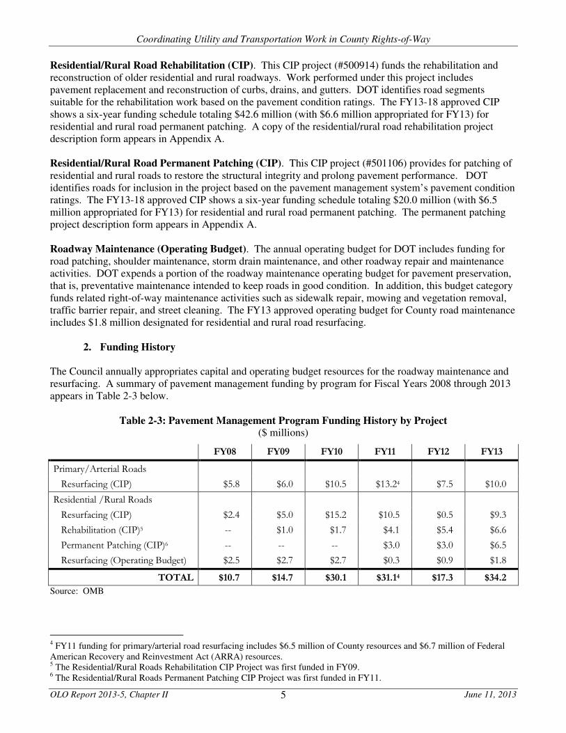
Residential/Rural Road Rehabilitation (CIP). This CIP project (#500914) funds the rehabilitation and reconstruction of older residential and rural roadways. Work performed under this project includes pavement replacement and reconstruction of curbs, drains, and gutters. DOT identifies road segments suitable for the rehabilitation work based on the pavement condition ratings. The FY13-18 approved CIP shows a six-year funding schedule totaling $42.6 million (with $6.6 million appropriated for FY13) for residential and rural road permanent patching. A copy of the residential/rural road rehabilitation project description form appears in Appendix A. Residential/Rural Road Permanent Patching (CIP). This CIP project (#501106) provides for patching of residential and rural roads to restore the structural integrity and prolong pavement performance. DOT identifies roads for inclusion in the project based on the pavement management system’s pavement condition ratings. The FY13-18 approved CIP shows a six-year funding schedule totaling $20.0 million (with $6.5 million appropriated for FY13) for residential and rural road permanent patching. The permanent patching project description form appears in Appendix A. Roadway Maintenance (Operating Budget). The annual operating budget for DOT includes funding for road patching, shoulder maintenance, storm drain maintenance, and other roadway repair and maintenance activities. DOT expends a portion of the roadway maintenance operating budget for pavement preservation, that is, preventative maintenance intended to keep roads in good condition. In addition, this budget category funds related right-of-way maintenance activities such as sidewalk repair, mowing and vegetation removal, traffic barrier repair, and street cleaning. The FY13 approved operating budget for County road maintenance includes $1.8 million designated for residential and rural road resurfacing.
2. Funding History
The Council annually appropriates capital and operating budget resources for the roadway maintenance and resurfacing. A summary of pavement management funding by program for Fiscal Years 2008 through 2013 appears in Table 2-3 below.
Table 2-3: Pavement Management Program Funding History by Project ($ millions)
FY08 FY09 FY10 FY11 FY12 FY13
Primary/Arterial Roads
Resurfacing (CIP) $5.8 $6.0 $10.5 $13.24 $7.5 $10.0
Residential /Rural Roads
Resurfacing (CIP) $2.4 $5.0 $15.2 $10.5 $0.5 $9.3
Rehabilitation (CIP)5 -- $1.0 $1.7 $4.1 $5.4 $6.6
Permanent Patching (CIP)6 -- -- -- $3.0 $3.0 $6.5
Resurfacing (Operating Budget) $2.5 $2.7 $2.7 $0.3 $0.9 $1.8
TOTAL $10.7 $14.7 $30.1 $31.14 $17.3 $34.2
Source: OMB
4 FY11 funding for primary/arterial road resurfacing includes $6.5 million of County resources and $6.7 million of Federal American Recovery and Reinvestment Act (ARRA) resources. 5 The Residential/Rural Roads Rehabilitation CIP Project was first funded in FY09. 6 The Residential/Rural Roads Permanent Patching CIP Project was first funded in FY11.

Coordinating Utility and Transportation Work in County Rights-of-Way
OLO Report 2013-5, Chapter II June 11, 2013 6
As with other County programs, the pavement management program must compete for finite operating and capital budget resources. DOT annually adjusts its schedule of future pavement projects to accommodate variations in program funding. As a result, future year project schedules (which are dependent on yet-to-be determined funding levels) have an inherent degree of uncertainty and susceptibility to change.
C. Ongoing Utility Infrastructure Projects
1. Water Lines
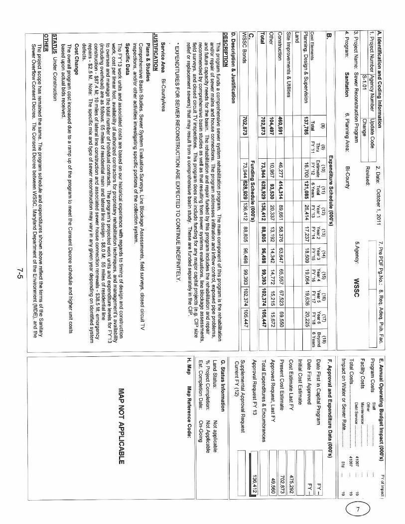
WSSC maintains a network of about 5,500 miles of underground water lines. Approximately one-quarter (about 1,380 miles) of WSSC’s water lines are 50 or more years old. As the infrastructure ages, water lines deteriorate and occasionally leak or break. The WSSC capital improvements program includes multiple major water line replacement projects in Montgomery County. In addition, the WSSC Water Reconstruction Program is intended to extend the useful life of aging water mains. This project includes the selected replacement of water lines as necessary to supply water in sufficient quantity, quality and pressure for domestic and fire fighting use. Water line reconstruction projects undergo regulatory and permitting processes, including review of erosion, sediment control and other environmental impacts. A water pipeline replacement project can include up to five miles of pipeline replacement in a single neighborhood and can take up to 18 months to design and permit followed by six months to award the bid for construction. One construction crew can typically complete up to a mile of water main replacement work per construction year. The FY13-18 approved WSSC CIP shows a six-year funding schedule totaling $641.3 million (with $77.4 million appropriated for FY13) for the water line reconstruction. A copy of the WSSC Water Reconstruction Program project description form appears in Appendix B.
2. Sewer Lines
The WSSC sewerage network contains more than 5,400 miles of pipeline, most of which is located underground. The aging sewer system has experienced overflows in many lines during recent years. Sewer overflows can cause damage to environmentally sensitive areas (such as streams) and can pollute the water supply. In 2005, WSSC entered into a Consent Decree with the United States Environmental Protection Agency, the Maryland Department of the Environment, and four citizens’ groups to implement a multi-year plan to minimize sewage overflows and to reduce groundwater infiltration into cracked sewer lines. Under the Consent Decree plan, WSSC is systematically working to identify and repair infrastructure problems within the system. Through this effort, WSSC is replacing and re-lining sewer lines throughout Montgomery and Prince George’s Counties. The WSSC capital improvements program includes multiple major sewer system infrastructure improvement projects in Montgomery County. In addition, the Sewer Reconstruction capital project funds the systematic repair, rehabilitation, and replacement of sewer mains and house connections. The FY13-18 approved WSSC CIP shows a six-year funding schedule totaling $628.9 million (with $136.4 million appropriated for FY13) for the sewer reconstruction project. A copy of the WSSC Sewer Reconstruction Program project description form appears in Appendix B. WSSC reports that it expends $5 million annually for pavement restoration following water and sewer line repair and replacement work.
Coordinating Utility and Transportation Work in County Rights-of-Way
OLO Report 2013-5, Chapter II June 11, 2013 7
3. Gas Lines
Earlier this year, the Maryland General Assembly approved Senate Bill 8, “Gas Companies - Rate Regulation - Infrastructure Replacement Surcharge.” This legislation authorizes Washington Gas, Baltimore Gas & Electric, and other gas companies in the State to request Public Service Commission (PSC) approval to assess a surcharge on customers’ bills to recover the costs of certain infrastructure replacement projects. Under the new law, the surcharge could raise revenue to defray the cost of replacement of existing gas lines as needed to improve public safety or infrastructure reliability or reduce greenhouse gas emissions. As the legislation takes effect June 1, 2013, gas companies may soon petition the PSC to authorize surcharges for gas line replacement projects.
4. Other Utility Lines
From conversations with DOT and utility representatives, OLO learned that the vast majority of trench pavement cuts are performed to replace or repair water, sewer, and gas lines. Major pavement cutting is uncommon for electricity and telecommunications lines. OLO is not aware of any systematic infrastructure replacement or relocation involving significant pavement cutting planned by electricity and telecommunications utilities in the County.
D. Effects of Pavement Cutting Several communities and research organizations have studied the impact of pavement cuts on the structural integrity and functionality of roads. While there has not been a study of this sort conducted in Montgomery County, a review of the literature finds universal agreement that cutting roads has a measurable negative impact on road performance and maintenance costs. Summaries of two representative studies follow:
• A 2003 research report submitted to the Transportation Research Board of the National Academy of Sciences reviewed multiple studies of the effect of pavement cuts on roads.7 The report identified two types of roadway degradation that may result from pavement cuts: structural deterioration and functional deterioration. Structural deterioration relates to “pavement condition, or level of distress, which would affect its load-carrying capacity or would require maintenance or rehabilitation.” Functional deterioration occurs “when the pavement no longer provides a smooth riding surface for vehicles and passengers.”8 The report concluded that “street cuts not only cause damage to the life of the streets but also costs millions of dollars to agencies in premature repair and street remediation expenses. Other financial impacts from utility cuts and poor repairs include traffic delays, increased congestion … and damage to both public and private vehicles.”9
• In 1995, a research team at San Francisco State University presented a study to the City of San Francisco addressing whether utility cuts shortened the life of roadway pavement. The study found that increased levels of utility cuts accelerate the pavement aging process. The study authors estimated that utility cuts reduce the service life of pavement by 30% to 50%.10 A subsequent study commissioned by the City of San Francisco
7 “Controlling and Reducing the Pavement Utility Cuts.” Wilde, W. James, Grant, Carolyn, and White, George T.; submission to 2003 Annual Meeting of the Transportation Research Board, http://www.ltrc.lsu.edu/TRB_82/TRB2003-000534.pdf. 8 Ibid., page 4. 9 Ibid., page 3. 10 “The Effect of Utility Cuts on the Service Life of Pavements in San Francisco”, Tarakji, Ghassan Report, May 1995 as reported in “Pavement Degradation, How Other Cities Are Dealing With It.” American Public Works Association, 2002, http://www2.apwa.net/documents/About/TechSvcs/ROW/Products/Pavement_Degradation-9-02.pdf.

Coordinating Utility and Transportation Work in County Rights-of-Way
OLO Report 2013-5, Chapter II June 11, 2013 8
confirmed these findings and further concluded that “utility cuts inevitably and irreparably disrupt the subsurface of a street, and that this damage extends beyond the perimeter of the trench.”11
In many cases, DPS requires utilities to use a “mill and overlay” process to repair road cuts. The mill and overlay process involves removal (through milling) of the top two-inch layer of roadway pavement followed by the placement of a new layer of hot mix asphalt. This process prevents road degradation caused by the infiltration of water through the edges of a pavement cut patch. Nonetheless, resurfacing pavement does not restore the structural degradation caused by the trench cutting of roadways.12
11 “The Impact of Excavation on San Francisco Streets,” San Francisco Department of Public Works and the Blue Ribbon Panel on Pavement Damage, September 1998 as reported in http://www.scribd.com/doc/121338692/pavement-Management-System-text-book. 12 “Impact of Utility Trenching and Appurtenances of Pavement Performance,” Stephen Q. S. Lee and Katherine A. Lauter, Environment and Transportation Department, Regional Municipality of Ottawa-Carleton, 1999, http://www2.apwa.net/documents/organization/Lee_Lauter2_Apr00.pdf.

Coordinating Utility and Transportation Work in County Rights-of-Way
OLO Report 2013-5, Chapter III June 11, 2013 9
CHAPTER III. COMMUNICATION AND COORDINATION: CURRENT PRACTICES
This chapter describes current practices employed by the County Government and local utilities to exchange
information about planned and on-going construction work in County rights-of-way. In addition, this chapter
discusses how agencies coordinate the scheduling of right-of-way work. The final section of this chapter
provides an overview of how the County Government and utilities provide the public with information about
right-of-way construction projects.
A. Communication between DOT and Utilities
During the past several years, DOT has adopted a series of practices to share information about right-of-way
work with utilities that operate in the County. Although the Department has no written policies, standards, or
requirements for this information sharing, DOT staff routinely exchange information with utilities regarding
the pavement management program and specific pavement projects. Information sharing practices include:
1. Distribution of Annual Project Schedules
2. Exchange of GIS Information
3. Electronic Document Sharing
4. Quarterly Project Status Meetings
5. Distribution of Bi-Weekly Project Status Reports
Each of these practices is detailed below.
1. Distribution of Annual Project Schedules
In May of each year, DOT notifies WSSC and Washington Gas of all road rehabilitation, resurfacing, and
patching projects planned for each of the four upcoming fiscal years.1 This notification names the specific
road segments scheduled for pavement improvement by type of work (e.g., hot mix asphalt paving, double-
shot micro resurfacing, patching), but is not presented in a geographic information system (GIS) map-able
format. The project work schedule is subject to change based on variations in program funding, changes in
pavement conditions, utility work schedules, and other factors. Nonetheless, this annual notification alerts
WSSC and Washington Gas of County maintained roads that are likely to undergo pavement work in the
next four years. Pepco reports that it does not regularly receive right-of-way project scheduling information
from the County Government. Sample pages from the FY13 road rehabilitation, resurfacing, and patching
project schedule sent to WSSC and Washington Gas appear in Appendix C.
2. Exchange of GIS Information
Until earlier this year, project data sent by DOT to WSSC was not coded for mapping by means of GIS. As a
result, WSSC was unable to incorporate DOT project information into its GIS system without investing
many hours of staff time converting the data. Recently, DOT began to maintain GIS generated maps
showing the location of County right-of-way projects planned through FY14. DOT began sharing this GIS
data with WSSC in January 2013.
1 DOT sends WSSC and Washington Gas preliminary notification of planned rehabilitation and resurfacing projects in March
of each year. DOT updates the list in May to reflect final County Council budget action.

Coordinating Utility and Transportation Work in County Rights-of-Way
OLO Report 2013-5, Chapter III June 11, 2013 10
Conversely, WSSC transmits GIS data to DOT to indicate the locations of current and planned water and
sewer projects. Although the agencies maintain separate GIS platforms, the two GIS systems are sufficiently
compatible to allow each agency to produce maps that display road, water, and sewer projects. These maps
provide an additional tool to identify potential conflicts between County and WSSC right-of-way work.
Nonetheless, WSSC staff indicate that project coordination could be improved if the County provided GIS
data for projects planned for up to the next five years (rather than the current practice of sharing GIS data
only for projects planned for the upcoming fiscal year). WSSC works on the design of water main projects
three to five years before construction, and so, would benefit from receiving GIS information for County
projects over a similar time frame. In addition, WSSC staff report that current GIS analysis tools are not
developed sufficiently to allow for optimum coordination and notification.
DOT also provides a third-party company, Envista, with GIS-coded information about the County’s planned
pavement work schedule. Envista is a private vendor that has developed a web-based application that maps
and provides project details for infrastructure projects managed by different agencies in public rights-of-
way.2 Agencies that subscribe to this service can access a clickable map showing real-time project
information. WSSC and Washington Gas currently subscribe to the Envista service. At present, the County
Government and Pepco do not subscribe.
WSSC reports that County data in the Envista system is often out of date and is inconsistent with the most recent
moratorium data provided by DOT. As the County does not subscribe to use Envista software, the vendor’s
support services are unable to assure WSSC of the quality and accuracy of data received from the County.
3. Electronic Document Sharing
DOT and WSSC share right-of-way project files using construction program management software known as
“e-Builder.” e-Builder is an electronic document management product that provides a central repository for
construction project files, including drawings, photographs, and other large files that are not easily attached
or exchanged through email. Electronic document sharing offers DOT and WSSC project teams immediate
access to current project files, thereby allowing for better coordination and collaboration of right-of-way
work.
4. Quarterly Project Status Meetings
DOT holds quarterly meetings with WSSC construction and design staff to exchange information about
current and planned right-of-way projects. At these meetings, DOT presents project-specific status reports
on roadway rehabilitation and resurfacing projects. WSSC shares similar information about on-going and
planned water and sewer projects. The purpose of these quarterly meetings is to identify and resolve
potential conflicts between the right-of-way work of the two agencies. In addition, DOT sends WSSC
quarterly updates of the list of roads under a pavement cut moratorium (see page 13 below).
DOT holds similar quarterly meetings with Washington Gas construction and design personnel.
2 The Federal Highway Administration cites Baltimore City’s use of Envista as a “best practice” (see Chapter V).

Coordinating Utility and Transportation Work in County Rights-of-Way
OLO Report 2013-5, Chapter III June 11, 2013 11
5. Distribution of Bi-Weekly Project Status Reports
DOT maintains a spreadsheet that summarizes the status of each pavement project scheduled for the current
fiscal year. The spreadsheet includes:
• the project location (road segment or subdivision);
• the type of work to be performed;
• an estimate of project costs;
• project start and completion dates;
• the name of the contractor performing the work; and
• the name and phone number of the DOT inspector overseeing the work.
DOT updates this information every two weeks and sends copies of the spreadsheet to WSSC and Washington Gas.
WSSC reports that the information in the bi-weekly status reports would be more useful if it were GIS-coded.
B. Right-of-Way Permitting Process
Montgomery County requires a permit for construction projects on roads, sidewalks, bikeways, curbs,
gutters, and drainage systems in County rights-of-way.
1. Permit Application Process
Utilities apply to the Department of Permitting Services (DPS) for a permit to perform any construction,
relocation, and maintenance activities on infrastructure located within a right-of-way. DPS will issue a
utility construction permit only to companies that have registered with “Miss Utility” and have entered into a
franchise agreement with the County. To obtain a right-of-way work permit, a utility must submit an
application indicating the location of the planned work. In addition, the application must specify:
• the anticipated construction start date;
• the planned duration of work;
• a description of the number and type of pavement cuts;
• field staff contact information; and
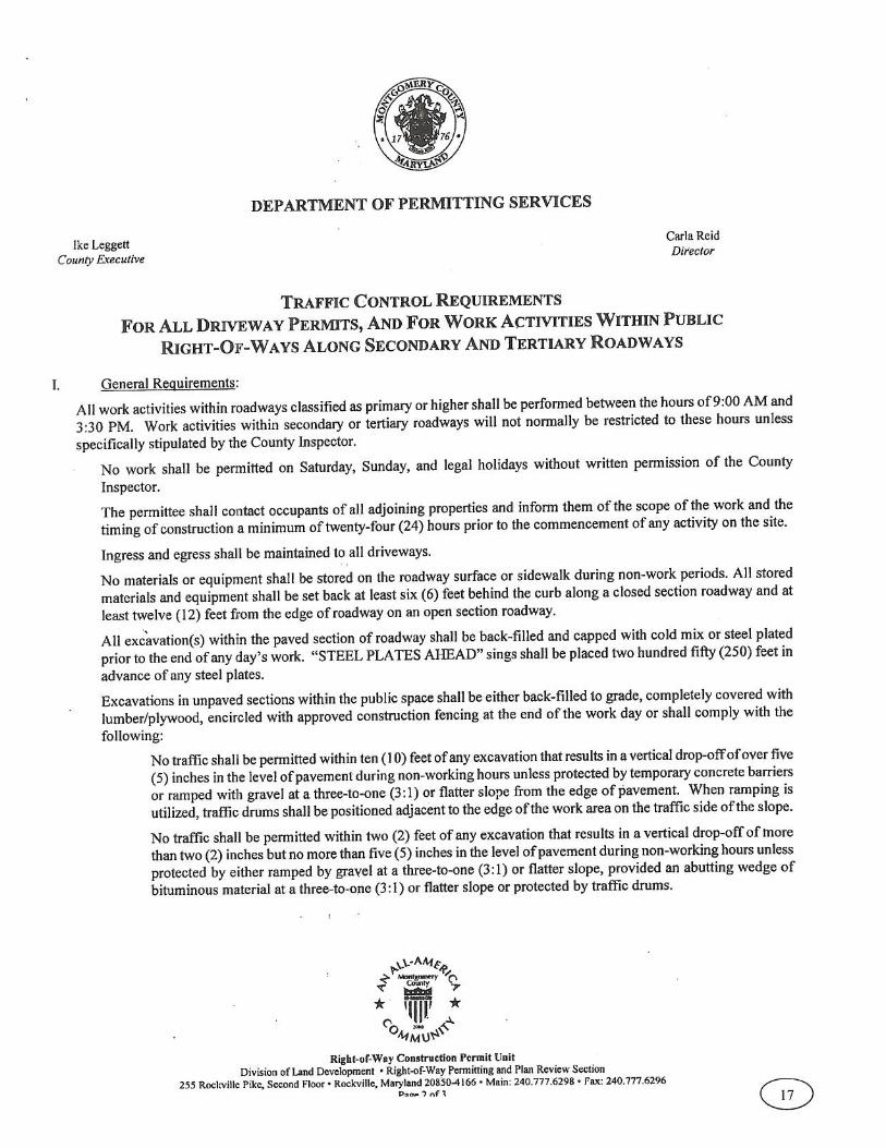
• a traffic control plan.

Coordinating Utility and Transportation Work in County Rights-of-Way
OLO Report 2013-5, Chapter III June 11, 2013 12
A utility must apply for a separate permit for each work location. DPS does not issue blanket permits
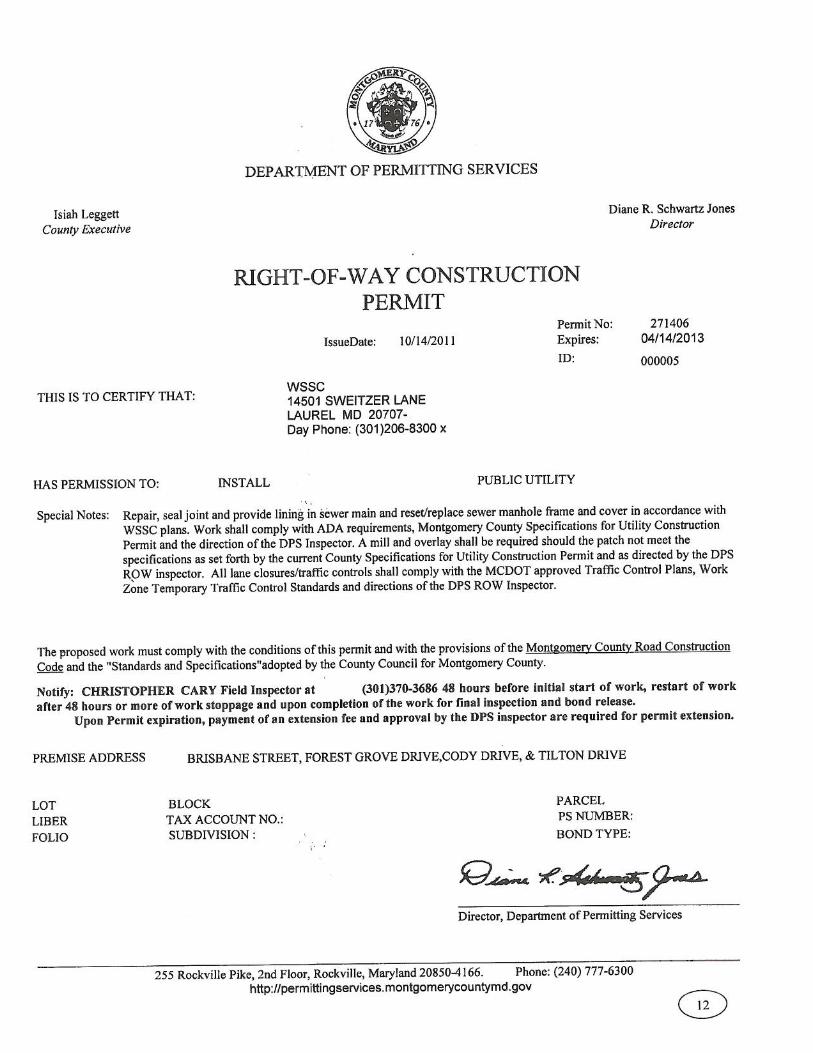
covering multiple work sites. A copy of a utility construction permit appears in Appendix D. The data in the
table below show the number of permits that DPS issued to utilities in the past three years. The data show
that the number of permits issued by DPS rose approximately 35 percent from year to year.
Table 3-1: Number of Utility Permits Issued by
the Department of Permitting Services, 2010-2012
Source: DPS
The County charges a fee for a utility construction permit. The fee schedule for rights-of-way permits are
established through regulation. Current permit fees are included in Executive Regulation 6-11 (July 1, 2011).
However, while other utilities pay permit processing fees, state law prohibits the County from charging WSSC
any fees for right-of-way construction permits.
Under terms of the permit, all utility construction must comply with all standards and requirements included
in a document entitled Montgomery County Specifications for Utility Construction Permit, prepared by DPS.3
Utility right-of-way construction permits are valid for 18 months. Prior to the expiration of a permit, a utility
may apply for a 12-month extension of the permit. DPS does not routinely check the moratorium status (see
below) of roads or DOT’s project schedules before renewing permits.
DPS does not require DOT to apply for a right-of-way construction permit for roadway reconstruction or
resurfacing projects.
2. DPS Permit Review
Upon receipt of a permit application, DPS staff review the information submitted by the utility to ensure that
construction is performed in a safe manner and that the right-of-way is restored properly. In some cases,
DPS stipulates additional special conditions required for approval of the permit (such as traffic control plans
for adjacent roads). In addition, DPS checks permit applications to see if the planned work conflicts with an
existing pavement cut moratorium (see below).
Once DPS approves a permit, the utility must contact DPS at least 48 hours before the start of work to
schedule a pre-construction meeting. At the pre-construction meeting, a DPS inspector will review permit
requirements for the specific site with utility representatives. DPS staff also inspect the site during the
construction period to ensure compliance with permit and regulatory requirements. A final DPS inspection
occurs after completion of construction.
At present, utility permit information is not routinely transmitted to DOT or utilities nor is this data
converted into GIS code for mapping with other right-of-way work.
3 http://permittingservices.montgomerycountymd.gov/DPS/pdf/SpecificationForUtilityConstructionPermit.pdf.
Year Number of Permits Issued to Utilities
2010 1,181
2011 1,596
2012 2,181

Coordinating Utility and Transportation Work in County Rights-of-Way
OLO Report 2013-5, Chapter III June 11, 2013 13
3. Pavement Cut Moratorium
The County has a policy establishing a moratorium on pavement cutting for newly paved roads. As specified
in the document, Specifications for Utility Construction Permit, no pavement cutting may occur for five
years following the completion of a newly constructed road and for three years following the completion of a
reconstruction or resurfacing project. As stated in the Specifications, the intent of the moratorium is “to
maintain the integrity … of … newly constructed or refurbished roadways.”4
The moratorium applies to planned installation, replacement, and repair of utility lines. Emergency utility
repairs are exempt from the moratoriums. Utility service connections to new residences or businesses are not
subject to a moratorium. Under certain circumstances, a utility may be exempted from the pavement cut
moratorium when DPS determines that no alternative is available. In these cases, the utility must repair the
cut consistent with the “mill and overlay” standards described in the Specifications.5
Moratorium end dates for resurfaced or reconstructed roads are subject to change. DOT includes a road on
its moratorium list once the resurfacing of a specific road in a project is complete. Upon completion of the
project, DOT will restart the three-year moratorium period, pushing back the moratorium end date.
Currently, DPS does not have an established process in place to notify current permit-holders when a road goes
into moratorium. If the County Government reconstructs or resurfaces a road, triggering a moratorium, DPS
does not notify utilities that hold valid permits to work on the road that the status of the road has changed.
DOT provides a list of roads under moratorium to utilities on a quarterly basis, but does not GIS-code the data.
C. Interagency Coordination
In several instances, DOT and a utility have learned through their exchange of information that both agencies have
pavement work planned for the same road segment. In those cases, staff from DOT and the utility begin a
dialogue about the sequencing and timing of the planned right-of-way construction. When possible, the agencies
will revise their project schedules to minimize the construction impact on the neighborhood and to assure that
utility pavement cuts occur before DOT begins any roadway reconstruction or pavement resurfacing. As an
example, Chapter IV describes the recent case of improvements in the Middlebrook Road right-of-way where
DOT adjusted its planned schedules to accommodate the WSSC’s work on the road.
In multiple instances, DOT has arranged to schedule resurfacing immediately following completion of a
utility line replacement project. As a result of this coordinated project scheduling, the planned DOT
repaving project replaced the need to repair the pavement cut by the utility. In these cases, DOT and the
utility entered into a memorandum of understanding (MOU) to share the cost of the pavement restoration.
Through these cost sharing MOUs, the County’s contractor performs road repair following completion of
utility work. In return, the utility agrees to pay the County an amount equal to the cost of pavement
restoration work that would have been required absent the DOT project. Chapter IV describes several recent
MOUs in more detail. A sample copy of a recent MOU between DOT and WSSC appears in Appendix E.
4 Montgomery County Specifications for Utility Construction Permit, page 3.
5 Montgomery County Specifications for Utility Construction Permit, page 12.

Coordinating Utility and Transportation Work in County Rights-of-Way
OLO Report 2013-5, Chapter III June 11, 2013 14
D. Public Access to Right-of-Way Work Scheduling Information
DOT and the utilities have developed their own methods of providing the public with information about
planned right-of-way.
1. DOT
DOT informs the public about its right-of-way projects both online and through newsletters sent to residents
in neighborhoods with upcoming resurfacing projects.
Online List of Projects: The DOT/Division of Highway Services website lists on-going and planned
resurfacing projects for the current fiscal year.6 The web page for the primary/arterial resurfacing program
lists the road segments (e.g., Germantown Road from MD Route 355 to Scenery Drive) planned for repaving.
In addition, the web page identifies the type of pavement work (e.g., hot mix asphalt paving, double-shot
micro resurfacing, patching), the planned start date, and the status (percent complete) for each project.
The web page for the residential resurfacing program lists the neighborhoods or subdivisions planned for
repaving. The web page also identifies the type of pavement work, the planned start date, and the status for
each project. This list also provides links to the community newsletter prepared by DOT for specific projects
(see below). Exhibit 3-1 on the next page shows the residential resurfacing program web page for the winter
of 2012-2013.
Newsletters: Before beginning construction on a residential resurfacing project, DOT mails a newsletter to
residents of the community informing them of the upcoming construction. The newsletter contains
information about the purpose and scope of the project, the planned construction schedule, and the type of
work to be performed. The newsletter also includes contact names and telephone numbers for DOT staff
managing the project. Exhibit 3-2 on pages 16-17 shows an example of a recent DOT newsletter to inform a
community about a planned resurfacing project.
6 http://www6.montgomerycountymd.gov/hwytmpl.asp?url=/content/dot/highway/Hwy_MainLinkPg/ResurfacingProjects.asp.

Coordinating Utility and Transportation Work in County Rights-of-Way
OLO Report 2013-5, Chapter III June 11, 2013 15
Exhibit 3-1: DOT Online Listing of Residential Resurfacing Projects

Coordinating Utility and Transportation Work in County Rights-of-Way
OLO Report 2013-5, Chapter III June 11, 2013 16
Exhibit 3-2: Example of DOT Resurfacing Project Community Newsletter (page 1)

Coordinating Utility and Transportation Work in County Rights-of-Way
OLO Report 2013-5, Chapter III June 11, 2013 17
Exhibit 3-2: Example of DOT Resurfacing Project Community Newsletter (page 2)
Coordinating Utility and Transportation Work in County Rights-of-Way
OLO Report 2013-5, Chapter III June 11, 2013 18
2. WSSC
WSSC alerts the public about its right-of-way water and sewer projects through an interactive online map
and through targeted neighborhood information.
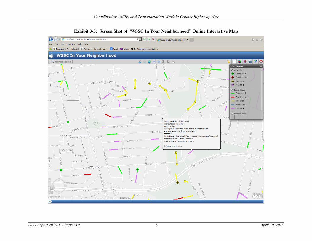
Online Interactive Map: WSSC recently launched an online interactive map known as “WSSC In Your
Neighborhood.”7 Using this feature, residents may enter an address to see all sewer projects within one-half
to three miles of the address.8 The color codes projects to indicate their current status (completed, in
construction, under design, in permitting, or planned). The interactive map allows users to click on a
mapped project to reveal a brief description of the project as well as the estimated start and end dates. The
online user may also navigate the map to view projects in other parts of the WSSC service area. A screen
shot depicting the “WSSC In Your Neighborhood” application appears in Exhibit 3-3 on the next page.
Neighborhood Information: Before and during a water or sewer project, WSSC informs residents of the
affected neighborhood of the planned work. WSSC sends a mailing or places door hangers to alert residents
of upcoming projects. In addition, WSSC posts signs in the neighborhood that display the name and
telephone number of the project manager. Some WSSC sign posts also include a box with project
information sheets for residents to take.
3. Other Utilities
Other utilities send out letters, post signs, or place door hangers to inform residents of upcoming work in
their neighborhood.
Washington Gas is currently developing a web page to inform residents of current and planned construction
projects.9 OLO has not found construction project web pages for other utilities that operate in the County.
4. Public Access to Consolidated Agency Information
No website or publication provides the public with consolidated information about current and planned
construction in County rights-of-way. County residents or businesses must access information from each
agency separately to learn about government and utility construction work that will affect their neighborhood.
7 http://gisweb.wsscwater.com/InYourNeighborhood/.
8 WSSC will soon add water projects to the interactive map.
9 http://www.washgas.com/pages/ConstructionProjects.
Coordinating Utility and Transportation Work in County Rights-of-Way
OLO Report 2013-5, Chapter III April 30, 2013 19
Exhibit 3-3: Screen Shot of “WSSC In Your Neighborhood” Online Interactive Map

Coordinating Utility and Transportation Work in County Rights-of-Way
OLO Report 2013-5, Chapter IV June 11, 2013 20
CHAPTER IV. LOCAL CASE STUDIES Chapter III describes the practices employed by the Department of Transportation, the Department of Permitting Services and local utilities to coordinate potentially overlapping work in the rights-of-way. This chapter examines several recent examples of projects where County Government and utility work intersected. The chapter focuses on WSSC’s work because WSSC performs the majority of utility work in County rights-of-way. The examples detailed below are:
A. Forest Glen Rehabilitation (2010-2013) and WSSC Consent Decree Work;
B. Middlebrook Road Micro-Resurfacing and WSSC Water Main Extension; and
C. Memorandums of Understanding. The chapter ends with OLO’s observations from these case studies on efforts to coordinate overlapping work in rights-of-way. A. Forest Glen Rehabilitation
Background. In December 2009, a Department of Transportation pavement condition survey indicated that the condition of 17.16 miles of neighborhood roads in the Forest Glen area of Silver Spring1 was poor or very poor. In August 2011, DOT began the Forest Glen Rehabilitation project (hereinafter “Forest Glen Project”) to rebuild the neighborhood roads – grinding off the existing road surface, replacing the road base where needed, resurfacing the roads, and replacing concrete sidewalks, curbs, and gutters. DOT completed the road rebuilding in August 2012. As required by DPS’ Specifications for Utility Construction Permit, the neighborhood roads were placed under a three-year moratorium on road cutting (except in emergency situations).2 See Appendix F for a map of the roads that were a part of the project. Three WSSC water main replacement projects between March 2008 and May 2010 degraded the condition of the roads in the same neighborhoods. Through open trenching of the roads, WSSC replaced approximately four miles of 2” to 10” water mains in the neighborhood. WSSC’s projects also included replacement of approximately 440 house connections between the water main and the property line for each house. In September 2011, the County Government and WSSC entered into a memorandum of understanding (MOU) in which WSSC agreed to pay $408,652 to the County Government for its share of the cost of resurfacing work in the Forest Glen Project (see Section C, below, about MOUs). Because the County Government intended to rebuild the Forest Glen roads following WSSC’s 2008-2010 water main replacement projects, DOT and DPS allowed WSSC to put a temporary patch on WSSC’s trench cuts in the roads. WSSC then paid the County Government the amount it would have cost WSSC to repave the roads according to the specifications in WSSC’s permit from DPS.
1 The neighborhoods are bordered by Georgia Avenue on the east, Sligo Creek Parkway on the west, Dennis Avenue on the north, and Forest Glen Road on the south. 2 See Chapter III for description of the County’s moratorium policy.

Coordinating Utility and Transportation Work in County Rights-of-Way
OLO Report 2013-5, Chapter IV June 11, 2013 21
WSSC Consent Decree. In 2005, WSSC entered into a Consent Decree with the United States government, the State of Maryland, WSSC, and citizens groups that requires WSSC to improve sewer collection system performance and reduce sewer overflows and backups by December 7, 2015 (see Chapter II). At the end of November 2012, approximately four months after DOT completed rebuilding the roads in the Forest Glen Project, a WSSC contractor hired to perform work under the Consent Decree arrived in the neighborhood with a backhoe and told neighbors that its work required cutting the newly-paved street. WSSC’s contractor was working under a permit that WSSC applied for in June 2011 and that DPS issued in October 2011 – to perform work on four streets in Forest Glen Project neighborhoods. WSSC’s application indicated that the work could include pavement cutting. During the period when WSSC’s permit application was pending DPS review, WSSC and the County Government executed the September 2011 MOU to share the cost of rebuilding the streets in the Forest Glen Project. Executive Branch representatives report that DOT staff were aware that WSSC’s permit for the Consent Decree work that authorized pavement cutting, but that DOT and WSSC staff had a verbal agreement that WSSC would use trenchless technology to perform the work. In August 2012, when DOT finished rebuilding the Forest Glen roads, the roads were placed under moratorium. Although WSSC held a valid DPS permit at that time for work that could include cutting the pavement on these roads, neither DPS nor DOT notified WSSC that the roads were placed under moratorium. In October 2012, DOT sent an updated Moratorium List to the utilities, including WSSC. The list, however, only identified eight of the more than 20 roads in the Forest Glen Project as being under moratorium. Regardless of DOT’s omission, three of the four roads covered by WSSC’s permit for the Consent Decree work were included on the Moratorium List, including the road where WSSC’s contractor arrived in November 2012.3 WSSC reports that it would not review an October 2012 moratorium list against a project where WSSC applied for a permit in June 2011. WSSC checks moratorium lists against projects in the planning stage before they are permitted. WSSC assumes that permitted projects do not require further coordination unless WSSC is planning on requesting a permit extension. In November 2012, WSSC’s contractor moved pavement cutting equipment to Brisbane Street to begin Consent Decree work. Permits issued by DPS, including WSSC’s permit for the Consent Decree work, require the permit holder to contact a DPS field inspector at least 48 hours before beginning work under the permit. WSSC’s contractor neglected to notify DPS of its intent to begin construction. After many neighbors contacted the County Government and WSSC, WSSC temporarily postponed the work to “re-evaluate whether the necessary work can be performed without an open cut.”4 In February 2013, WSSC representatives attended a community meeting with residents in the Forest Glen Project neighborhoods to explain the Consent Decree work and WSSC’s plans for performing the work. At that time, WSSC officials reported that they would be able to perform the required work through a trenchless process that would require WSSC to excavate in grassy areas, but not in the roads. As a result of the Forest Glen case, DPS modified its utility construction permit review procedures. DPS now checks permit applications against DOT reconstruction and resurfacing plans to identify potential conflicts. When a utility applies for permit in a right-of-way with a planned future reconstruction or resurfacing project, DPS requires approval from DOT before issuing the permit.
3 An updated moratorium list that DOT sent to WSSC in March 2013 included the additional roads in the Forest Glen Project and extended the moratorium end date from December 2014 to July 2015. 4 11-30-12 email from Jim Neustadt, WSSC Director of Communications and Community Relations, to neighbors and Councilmembers.

Coordinating Utility and Transportation Work in County Rights-of-Way
OLO Report 2013-5, Chapter IV June 11, 2013 22
Exchange of Data. WSSC’s permit from DPS for the Consent Decree work was valid between October 2011 and April 2013. While the County Government and WSSC were actively trading project data during that time to identify conflicts, a WSSC representative reports that the utility did not begin actively comparing DOT and WSSC project data to identify potential conflicts until January 2013, when DOT began providing its data to WSSC in a GIS map-able format. Before January 2013, WSSC staff report that WSSC used only Envista to identify potential project conflicts. Because County Government project data was not in Envista, WSSC could not identify potential conflicts. WSSC staff estimated that mapping DOT project data provided in an excel spreadsheet would require approximately 60 hours of staff time per update, compared to 30 minutes of staff time required to overlay a layer from DOT with GIS map-able data. Washington Gas Work. In the spring of 2012, after DOT had begun rehabilitation work on streets in Forest Glen, Washington Gas sent a letter to residents indicating that it soon would perform pavement work that could include “keyhole technology” – cutting an 18-24” round opening in the pavement. Residents on at least two Forest Glen streets – Woodman Avenue and Julep Avenue – received the letter. The County Government had yet to place neighborhood roads under moratorium as the reconstruction project was ongoing. After residents alerted DOT to the issue, the Department postponed repaving the street to allow Washington Gas to complete its work. In the end, Washington Gas decided that it would postpone work on this street for several years until after the moratorium period expired. County Government representatives reported to neighborhood residents that they notified Washington Gas representatives of the Forest Glen Project before it began to meet and coordinate any needed utility work and that Washington Gas representatives never responded to the meeting request. B. Middlebrook Road Micro-Surfacing and WSSC Water Main Extension
In April 2010, DOT staff became aware of a WSSC water extension project that potentially overlapped with a planned resurfacing project on Middlebrook Road in Germantown. DOT staff contacted WSSC and the two organizations exchanged details about their project schedules. The County’s project consisted of base repair, utility adjustments, crack sealing, and micro-resurfacing. WSSC’s project consisted of installing a 12” water main and fire hydrants and required cutting of pavement on a portion of Middlebrook Road. As WSSC’s project was nearing the construction phase in the summer of 2011 – over a year after DOT’s and WSSC’s first contact – DOT’s project was underway, having been pushed back from its original schedule. To accommodate WSSC’s need to cut the pavement to install new water mains, DOT performed patching work on Middlebrook Road, but offered to reschedule micro-resurfacing the road until after WSSC had completed its work. In email correspondence to WSSC, DOT staff observed that rescheduling the work “would be a better use of taxpayers’ money.” Based on the scope of WSSC’s work, WSSC agreed that rescheduling DOT’s work until after completion of the water main installation would be the preferred course for both agencies. C. Memoranda of Understanding
In recent years, the County Government and WSSC have entered into several memoranda of understanding (MOUs) to share the cost of road repaving. These MOUs arise when WSSC has performed water or sewer work in a segment of road shortly before the County Government repaves or reconstructs the same road segment. Rather than require WSSC to fully repave a portion of a road, the County allows WSSC to patch their work and County Government contractors subsequently repave the road segment.

Coordinating Utility and Transportation Work in County Rights-of-Way
OLO Report 2013-5, Chapter IV June 11, 2013 23
To arrive at an MOU, WSSC and County Government representatives jointly identify the section of road that WSSC would have been obligated to repave under the requirements in DPS’ Specifications for Utility
Construction Permit. The MOUs require WSSC to pay DOT’s Division of Highway Services for the total estimated cost of the repaving work attributable to WSSC’s project. The table below summarizes four recent MOUs between the County Government and WSSC. Table 4-1: Summary of Recent MOUs between the County Government and WSSC for Repaving Costs
Date Area/Subdivision Road Segment(s) WSSC
Reimbursement
September 2, 2011 Forest Estates and Forest Grove Many $408,652
November 15, 2011 Wheaton/Silver Spring Andrew Street Valleywood Drive
$51,132
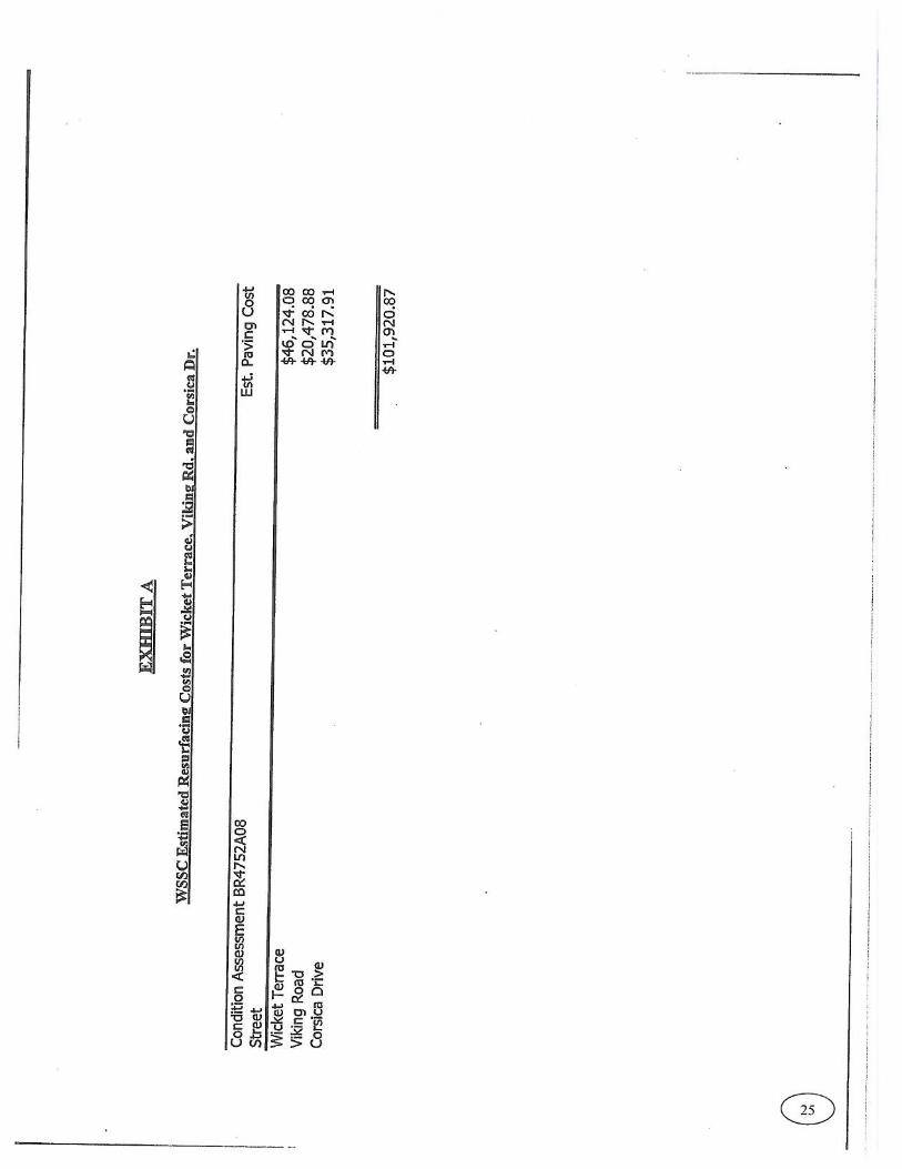
December 6, 2011 Pooks Hill Subdivision Corsica Drive Viking Road Wicket Terrace
$101,921
August 1, 2012 Brookmont Broad Street Valley Road
$23,560
Source: Department of Transportation
WSSC also reimburses the County for “surface adjustment” work, where DOT adjusts the height of sewer and/or storm drain manholes and water value boxes to the new height of a repaved or rebuilt road. DOT estimates that WSSC reimburses the County approximately $100,000 annually for this work.
D. Observations
The Department of Transportation and WSSC have developed a system of cooperation and information sharing in the past several years – to keep each other abreast of current and planned project work and to coordinate work when projects overlap. DOT and WSSC have adjusted project schedules to sequence work logically and in ways that will save resources, as they did with the Middlebrook Road work described above. They also share the cost of paving when both entities have performed road work in the same location. At the same time, several current practices and/or recent occurrences increase the chance that County Government and WSSC projects will conflict and that the conflict will not be detected in a timely manner – potentially leading to delay or to the cutting of recently repaved or rebuilt roads.
• WSSC project sequencing. WSSC replaced water mains in the Forest Glen neighborhoods between 2008 and 2010 having been informed that the County intended to rebuild the neighborhood roads following WSSC’s work. The sequencing of the work allowed WSSC to simply patch the roads after its water main work, rather than repaving them, and WSSC subsequently paid the County for the cost it would have incurred repaving the roads. At the same time, however, WSSC was required under a Consent Decree to perform sewer work in the same neighborhood that could require it to cut pavement. WSSC did not schedule the Consent Decree work for the same time as its water main work and it had an application pending with DPS for a permit to cut neighborhood roads as DOT was beginning to rebuild those roads (that WSSC paid to repave).

Coordinating Utility and Transportation Work in County Rights-of-Way
OLO Report 2013-5, Chapter IV June 11, 2013 24
WSSC reports that it was performing the investigative phase of Consent Decree projects at the time of the Forest Glen water replacement project and therefore would have been unable to coordinate the construction phases of the water and sewer projects in that neighborhood. County Government staff report that the County had a verbal agreement with WSSC to not cut the pavement in the Forest Glen neighborhoods when performing the Consent Decree work.
• Issuing of DPS permits. While DPS representatives report that its staff review DOT data on road
projects and DOT’s road moratorium list before issuing utility permits for work in County rights-of-way, in the Forest Glen Project, DPS issued WSSC a permit that would allow WSSC to cut pavement in a neighborhood at a time when DOT was actively rebuilding the neighborhoods’ roads. County Government staff report that DOT knew of the permit and had an agreement with WSSC that the utility would use trenchless technology to perform the work. Nonetheless, WSSC ‘s contactor apparently was unaware of this agreement and prepared to trench cut the newly reconstructed County road.
DPS also does not notify entities that hold valid permits when a road goes under moratorium and can no longer be cut. DPS did not notify WSSC that the roads in the Forest Glen Project had gone under moratorium. At the same time, WSSC reports that it does not recheck DOT’s Moratorium List before performing work – checking the list only during the project planning stage and before applying for a permit (or before applying for an extension to a permit). WSSC, however, applied for its permit for the Consent Decree work in June 2011, but did not begin to perform the work until November 2012, over 16 months later. The County Government has taken steps to improve coordination between DPS and DOT regarding utility permit review. Following the incident where a WSSC contractor nearly cut a recently reconstructed road in the Forest Glen neighborhood, DPS modified its permit review procedures. As of early 2013, DPS checks permit applications against DOT reconstruction and resurfacing plans and requires approval from DOT before issuing a permit to a utility for a project in a right-of-way with a planned DOT reconstruction or resurfacing project.
• Inaccurate DOT data on road moratoriums. When DOT finished rebuilding the roads in the Forest Glen Project in August 2012, the roads fell under moratorium and could not be cut for three years. The Moratorium List that DOT distributed to the utilities in October 2012 only included eight of the more than 20 streets in the Forest Glen Project and it listed the moratorium end date as December 2014, which was less than three years from the August 2012 project completion date. Only one of the four streets covered by WSSC’s permit for the Consent Decree work was included on the October 2012 Moratorium List. When DOT distributed an updated list in March 2013, all of the roads in the Forest Glen Project (except one) were included on the list and the moratorium end date was extended from December 2014 to July 2015, three years after completion of the entire Forest Glen Project.

Coordinating Utility and Transportation Work in County Rights-of-Way
OLO Report 2013-5, Chapter V June 11, 2013 25
CHAPTER V. PRACTICES IN OTHER JURISDICTIONS This chapter summarizes practices employed by local governments and public utilities in other jurisdictions to:
• Exchange information about construction projects in rights-of-way;
• Coordinate the scheduling of right-of-way work; and
• Inform the public about on-going and planned right-of-way construction projects.
A. Baltimore, Maryland: GIS-Based Project Coordination System
In 2008, the City of Baltimore sought a means to better coordinate construction activities in public rights-of-way. The City chose to contract with a vendor (Envista Corporation) to implement a GIS-based project coordination system to track municipal and utility roadway construction and maintenance activities. Before implementing the system, City staff met with government and utility representatives to identify current data collected by each agency and define system needs and uses. Participants agreed that all agencies would maintain control of their data and would retain their construction projection tracking systems. The new shared system would input GIS-based data (using a cloud computing concept) in a common information repository. After a two year development period, the City launched a web-based system that provides government agencies and utilities with real-time information on infrastructure projects across the City. The system presents users with a clickable map that provides project details for each project such as location, timeline, scope, schedule, cost, and points of contact. The Federal Highway Administration (FHWA) lists the Baltimore system as a best practice for reducing the number of roadway cuts and increase pavement life. According to the FHWA, “the system enables stakeholder awareness of upcoming and ongoing projects, and encourages them to come to the table to discuss the projects and coordinate.” The City reports that during the first year after implementation, the resulting reduction in roadway cuts reduced City pavement costs by $350,000 to $500,000.1 B. Palo Alto, California: GIS Mapping
In 2006, the City Auditor of Palo Alto, California completed an audit of the City’s street maintenance program. The audit found that street excavations degrade and shorten the life of the City streets. Moreover, the auditor’s report concluded that “this degradation increases the frequency and cost to the public for necessary resurfacing, maintenance, and repair.”2 The City Auditor determined that the City’s Public Works Department and the (mostly City-run) utilities did not have cross-departmental information about project schedules and the moratorium status of streets. Operations crews also lacked access to GIS data to review, monitor, or record repair and maintenance work. As a result, departments did not coordinate their activities with one another resulting in operational conflicts and inefficiencies. One of the auditor’s recommendations was that all departments that cut City streets use GIS to coordinate their projects and summarize work completed in a timely manner.
1 http://ops.fhwa.dot.gov/wz/construction/crp/baltcasestudy/index.htm. 2 http://www.cityofpaloalto.org/civicax/filebank/documents/6195.

Coordinating Utility and Transportation Work in County Rights-of-Way
OLO Report 2013-5, Chapter V June 11, 2013 26
In response to the audit, the Public Works Department developed a program (using in-house GIS capabilities) to create a GIS-based system to coordinate rights-of-way construction. Public Works and utility staff input construction schedules, routinely update project status, and check for conflicting work on street segments. In addition, the City’s web site offers the public an up-to-date map of planned and current paving and storm drain projects (http://www.cityofpaloalto.org/gov/depts/pwd/streetwork/default.asp). The map displays pavement and storm drain construction projects that are active or planned within 14 days. The map also shows projects planned for the next four years.
Exhibit 5-1: Screen View of City of Palo Alto Street Projects Map
C. New York City, New York: Data Sharing, Mapping, and Financial Incentives
New York City requires utilities to obtain a “street opening permit” to excavate or perform other work in a right-of-way that may cause damage to the street surface. In 2011, the City launched a data sharing and on-line mapping system to help improve coordination among utility companies, contractors, and government agencies. At the same time, the City created a financial incentive for utilities to comply with permit regulations and requirements by increasing fines for street work violations.
Coordinating Utility and Transportation Work in County Rights-of-Way
OLO Report 2013-5, Chapter V June 11, 2013 27
Data Sharing and Mapping. In October 2011, the City Department of Transportation executed agreements with major utility companies to share rights-of-way construction project information. Each month, the City and utilities provide updated data regarding:
• The location and status of active street excavation permits;
• The current inventory of "protected streets" (the term for recently repaved/reconstructed streets);
• City street resurfacing schedules; and
• Utility excavation plans and project schedules. Utilities and the public may access this information via the City's public online map portal known as “NYCityMap” (http://gis.nyc.gov/doitt/nycitymap). Fines. To reduce street work violations, the City raised fines for non-permitted construction. For example, the fine for opening a non-protected street without a permit was increased from $800 to $1,500; the penalty for restoring a protected street surface without notifying City inspectors was increased from $250 to $750. Taken together, these actions will reduce the incidence of street work undertaken without permits, provide a stronger incentive for collaboration and coordination between city government and private sector stakeholders that engage in work on city streets, and better facilitate public mobility and safety. The FHWA identified the above initiatives as best practices to improve coordinated road construction projects. FHWA noted that these initiatives will “minimize the number of times streets are dug up, reduce construction congestion, and extend the life of resurfacing projects.”3 D. Charlotte, North Carolina: Pavement Degradation Fee
In 2007, the Charlotte City Council voted to implement a “Utility Cut Pavement Degradation Fee.”4 A utility (or developer) is charged a pavement degradation fee for the right to cut pavement in a public right-of-way. The intent of this type of fee is to recover the cost of repairing the long term damage caused by pavement cutting. Based on the findings of a University of North Carolina-Charlotte study, the City determined that pavement cutting – even when repaired to specifications – results in a measurable decrease in the functional life of a road. In addition, pavement degradation fees also create an economic incentive for utilities (and developers) to coordinate construction projects to minimize pavement cuts. All public and private utility companies are subject to the Charlotte pavement degradation fee. The City’s fee schedule is based on the type (e.g. asphalt, concrete) and thickness of the cut pavement.5 Revenue collected from this fee is dedicated for street maintenance and resurfacing programs. City regulations stipulate that the Department of Transportation will stop issuing street cut permits to any utility that has not fully paid past pavement degradation fee obligations.
3 http://ops.fhwa.dot.gov/wz/construction/crp/index.htm. 4 http://charmeck.org/city/charlotte/Transportation/divisionsandcontacts/Documents/Utility%20Cut%20Degradation%20Policy%2010252007.pdf. 5 Other municipalities have more complex pavement degradation fee schedules that include variable fees based on the age, condition, and type of pavement, the size of the impacted area, and the roadway’s level of use.

Coordinating Utility and Transportation Work in County Rights-of-Way
OLO Report 2013-5, Chapter VI June 11, 2013 28
CHAPTER VI. FINDINGS
A large portion of public infrastructure in Montgomery County – including roads and underground utility
lines – were constructed in the 1950s and 1960s. After half a century of use, much of this infrastructure is
now in need of repair and replacement. With increasing frequency, Montgomery County roadway
resurfacing needs coincide geographically with local utilities’ underground line replacement programs.
Without proper information sharing and coordination, conflicts might arise between concurrent right-of-way
construction programs. With well-developed information sharing and interagency coordination, roadway
pavement cutting can be minimized, reducing both costs and impact on neighborhoods.
1. Assessment of Current Practices
During the past five years, the Department of Transportation (DOT), the Department of Permitting Services
(DPS), the Washington Suburban Sanitary Commission (WSSC), and other local utilities have made significant
progress in improving interagency communication regarding planned right-of-way construction programs. In
several cases in recent years, DOT and utilities have been able to coordinate their scheduling of right-of-way
work to minimize pavement cuts and disruption to the community and to jointly share repaving costs.
As detailed in Chapter III, the County Government and local utilities have established multiple channels of
communication to share information about right-of-way pavement work. As a result of this communication, in
many cases, DOT and the utilities have been able to coordinate their scheduling of right-of-way work to
minimize pavement cuts and disruption to the community and to jointly share some repaving costs.
At the same time, the current practices employed by DOT, DPS, and the utilities have not yet been fully
developed into an integrated information sharing system. Without such a system, optimal right-of-way
program coordination will be difficult to achieve. Current limitations include:
Absence of central information repository. The County Government and utilities share much
pertinent information about right-of-way pavement work. This information is contained in different
formats (including GIS data, spreadsheets, plan drawings, and memoranda). However, no single,
central repository exists to house and connect project level information such as maps, permits, design
plans, construction status, contact information, or schedules. As a result, links do not always exist to
connect different types of information for the same project or for the same right-of-way. For
example, GIS data shared between agencies does not link with information about project start dates
or roadway moratorium status. In addition, no means currently exists for utilities to learn of right-of-
way permits issued by the County for other utilities.
Non-standardized data. No set of standards exists for data shared among DOT, DPS, and the
utilities. For example, in some cases, agency data give non-standardized names to different sections
of a roadway (e.g., “East Franklin Avenue, Section 03”). When this data is shared, the receiving
agency’s technology systems may be unable to identify the location of the roadway section. Another
example of non-standardized data involves the future year timeframe for planned projects. Different
agency data sets show scheduled projects, one, two, three, or more years into the future.
Uneven processes for updating project status. Given the nature of right-of-way work, project
schedules are unavoidably subject to change. Agencies must adjust the timing and sequencing of
pavement work as a result of fluctuations in program funding as well as changes in weather and
operational conditions. While the County Government and the utilities periodically transmit to one
another revised fiscal year schedules, a mechanism does not yet exist for routine and timely mid-year
updating of project schedules. Without access to up-to-date schedules of all planned right-of-way

Coordinating Utility and Transportation Work in County Rights-of-Way
OLO Report 2013-5, Chapter VI June 11, 2013 29
work, an agency may unknowingly invest resources in a project that may be subject to imminent
delay. In addition, the lack of timely updates (accessed through a common data repository) may
leave field personnel and other project staff unaware of important status changes, such as a newly
imposed pavement cut moratorium on a particular roadway.
Uncertainty regarding road moratorium status. Current practices may leave utilities and the public
uncertain about the start and end dates of a pavement cut moratorium. First, as DOT does not yet
provide GIS-coded data specifying the location of roads under moratorium, utilities cannot easily
integrate moratorium information into their GIS-based project management systems. Second, no
mechanism exists to notify utilities with existing permits that a road has gone into moratorium status.
Third, while DOT may include a road on its moratorium list once resurfacing of a specific road is
complete, the Department will restart the three-year moratorium period upon completion of all roads
in a project.
Inability to present consolidated information to the public. The County Government and some utility
websites provide the public with information about planned right-of-way work. However, no
platform currently exists for members of the public to view consolidated information about all
planned County and utility right-of-way work.
2. Opportunity for Improvement: Interagency Project Tracking System
An opportunity exists to address the above limitations through development of a standardized interagency
GIS-based data repository and application to access and view real-time information about all planned right-of-
way construction and maintenance activities. The GIS-based data and application would allow for mapping of
recently-completed, current, and planned projects. In addition, the data set and application could provide
agency staff with direct links to up-to-date information such as project location, scope, design plans, permit
status, schedule, cost, moratorium status, and points of contact.
Under this approach, each agency would continue to control, manage, and update its own data and would
continue to use its existing in-house technology systems. The agencies would collaborate to identify which
data sets to input into the shared technology system. A shared multi-agency GIS based application based on
a shared repository would provide integrated access to designated data sets from existing agency systems for
shared use by all participants. This approach also provides flexibility as to how the repository is constructed
and linked to each participant’s data sources.
A shared interagency repository and application would provide staff with a refined communication tool, but
would not replace the need for human interaction among agencies. Nonetheless, development of such a
system would offer multiple advantages. These advantages include:
• Access to a single repository of complete, up-to-date project information would provide agency staff
timely and complete project information, and thereby promote improved and more efficient
coordination and sequencing of pavement work.
• Shared data that include pending and approved right-of-way permits would create a channel of inter-
utility communication that could create opportunities for utilities to replace or repair underground
infrastructure at the same time to reduce cost and community impact.
• A standardized shared data set would enhance data quality and would relieve agency staff of the
burden of transmitting updated project data to other agencies.

Coordinating Utility and Transportation Work in County Rights-of-Way
OLO Report 2013-5, Chapter VI June 11, 2013 30
• Interagency coordination of right-of-way work would allow DOT and the utilities to develop
improved traffic management plans during construction periods.
• The data set and application could serve as the platform for an online tool to provide the public with
consolidated, up-to-date information about right-of-way construction projects.
Creating an integrated, interagency data set and application could be achieved using in-house agency
resources or could be procured through a private vendor. To pursue this strategy, further work is required to
develop a detailed program of requirements and to estimate system development and maintenance costs. The
complexity of this undertaking may warrant incremental system development and phased implementation.
Coordinating Utility and Transportation Work in County Rights-of-Way
OLO Report 2013-5, Chapter VII June 11, 2013 31
CHAPTER VII. RECOMMENDATIONS
Based on the findings of this report, OLO offers the following two recommendations for Council
consideration.
Recommendation #1: Request that the Executive report to the Council about the feasibility,
implementation requirements, and cost of creating an interagency right-
of-way project tracking system.
OLO recommends that the County Government work with local utilities to develop a more systemized
approach to the sharing of information and coordination of infrastructure improvements in County rights-of-
way. Specifically, DOT, DPS, and the Department of Technology Services (DTS) should evaluate the
feasibility and cost of creating a GIS-based standard data set for sharing information about right-of-way
projects from the County Government and the utilities. The data should be stored in a single repository with
an integrated application that would allow access to the data by DOT, DPS, and participating utilities.
The purpose of this standardized, consolidated data set and application would be to provide agency staff with
direct links to project information including location, design plans, permit status, schedule, cost, moratorium
status, and points of contact. The standardized data-set and application could be developed using in-house
agency resources or a commercial application could be purchased through a private vendor. For example,
the County Government should evaluate the feasibility of incorporating the data set and application into the
dataMontgomery digital government initiative using the Socrata software platform.
Furthermore, OLO does not recommend agencies abandon their existing in-house systems. Rather, the
shared data set and application system should draw designated data sets from existing agency systems and
integrate this information through a single multi-agency GIS application.
OLO also recommends that the County Government (including the Public Information Office) evaluate the
possibility of using data from a shared project tracking system to develop an online tool to provide the public
with consolidated, up-to-date information about right-of-way construction projects.
OLO recommends that the Council request that the Executive report back to the Council by November 1,
2013, about implementation of an interagency right-of-way project tracking system. The report should:
• Describe the detailed functional requirements of the application;
• Estimate development and maintenance costs for the standardized data set and application using in-
house resources and/or a commercial product; estimate the staff time savings resulting from data
standardization and automated inter-agency project tracking;
• Describe interagency agreements (e.g., memoranda of understanding, service level agreements)
needed to standardize, integrate, and share data sets;
• Present a plan to develop an online tool to provide the public with consolidated information about
right-of-way construction projects;
• Identify the relative priority of a right-of-way infrastructure data set compared to other items on the
dataMontgomery implementation plan; and
• Include a recommendation from the Executive of whether the benefits of the system justify the
estimated costs.

Coordinating Utility and Transportation Work in County Rights-of-Way
OLO Report 2013-5, Chapter VII June 11, 2013 32
Should the Executive not recommend the creation of an interagency tracking system (or should the Executive
indicate that system implementation would take several years), then OLO suggests that the Council request
that the Executive develop an alternative method for providing the public with up-to-date, interagency
information about pending rights-of-way construction projects.
Recommendation #2: Request that the Executive refine and provide more specificity regarding the
implementation requirements of pavement cutting moratoriums.
OLO recommends that the Executive further define the implementation requirements for pavement cutting
moratoriums. As specified in the DPS document, Specifications for Utility Construction Permit, no
pavement cutting may occur for five years following the completion of a newly constructed road and for
three years following the completion of a reconstruction or resurfacing project. The moratorium applies to
planned (non-emergency) installation, replacement, and repair of utility lines. As detailed in Chapters III, IV
and VI, the effectiveness of the moratorium policy is limited by several current conditions, including:
• DOT does not yet provide utilities with GIS-coded data specifying the location of roads in pavement
cut moratorium. As a result, utilities cannot easily integrate moratorium information into their GIS-
based project management systems.
• Once DPS issues a right-of-way construction permit to a utility, the status of the permit does not
change when DOT begins a resurfacing or reconstruction project triggering a moratorium.
Moreover, no process exists to notify utility permit-holders when a road goes into moratorium. As a
result, a utility may hold a valid permit to cut pavement for a road that is in moratorium.
• Moratorium end dates for resurfaced or reconstructed roads are subject to change. DOT may include
a road on its moratorium list once the resurfacing of a specific road in a project is complete. Upon
completion of the project, DOT will restart the three-year moratorium period for the entire project,
extending the moratorium end date.
To address each of these conditions, OLO recommends that the County Government:
a. Develop a protocol to routinely share GIS-coded moratorium data with utilities. This could be
achieved either as part of the project tracking system described in Recommendation #1 or as a
separate practice.
b. Establish a mechanism to notify permit holders when a roadway goes into moratorium. In addition,
DPS could add a condition to utility permits stating that the authorization to cut pavement under the
permit automatically terminates when a road goes into moratorium (unless a waiver is granted).
c. Refine the definition of the moratorium period for resurfaced and reconstructed roads. For example,
DPS could amend the Specifications for Utility Construction Permit to stipulate that a road goes
under moratorium once the resurfacing of a specific road is complete and that the moratorium
continues for three years after completion of the entire project.
Coordinating Utility and Transportation Work in County Rights-of-Way
OLO Report 2013-5, Chapter VIII June 11, 2013 33
CHAPTER VIII. AGENCY COMMENTS
The Office of Legislative Oversight circulated a final draft of this report to the County Government, the
Washington Suburban Sanitary Commission, Pepco, and Washington Gas. OLO appreciates the time taken
by agency representatives to review the draft report and provide feedback.
OLO’s final report incorporates technical comments and corrections submitted by the agencies. Written
comments on the final draft report from the Chief Administrative Officer begin on the next page. Written
comments from WSSC begin on page 36. Written comments from Pepco begin on page 39.


Coordinating Utility Work Requiring Pavement Cuts With Agencies and Municipalities
Proof of Concept using ArcGIS Online
WSSC Comments
What is ArcGIS Online?
ArcGIS Online is a collaborative, cloud-based platform that lets members of an organization and associated
contractors create, share, and access maps, applications, and data, including authoritative basemaps
published by Esri or by the agencies participating in the Utility Coordination solution. Through ArcGIS Online,
access is gained to Esri’s secure cloud, to manage, create, store, and access hosted web services and
associated files including pdfs, Excel files, Word documents, and image files. Because ArcGIS Online is an
integral part of the Esri platform, it can be used to extend the capabilities of ArcGIS for Desktop, ArcGIS for
Server, web-based ArcGIS applications, and the ArcGIS APIs and Runtime SDKs.
http://resources.arcgis.com/en/help/arcgisonline/index.html#//010q00000074000000
Why use ArcGIS Online?
Most stakeholders are already using Esri technologies such as the ArcGIS for Desktop application, which
enables the creation and maintenance of project boundaries. These stakeholders and stakeholders without
access to existing Esri technologies can create and modify their project information directly in the ArcGIS
Online interface. . ArcGIS Online utilizes Javascript technology making published maps platform independent.
In other words, Smartphones, Tablets, Laptops and Desktops can view and, if needed, edit the published maps
as long as they have an Internet connection and a browser (Firefox, Google Chrome, Internet Explorer, Safari
or Android’s default browser) or the ArcGIS native applications for Android or iOS, which can be found in the
Google Play and Apple App Store respectively.
Because ArcGIS Online requires a login for each individual accessing the system, viewing and editing access
can be limited by each individual user’s login and group assignment. For example, a user from a County
organization can be limited to only edit data associated with projects for that County. They may, however, be
allowed to view all on-going projects from all agencies within their area of focus. Or, if this information is not
required for the editor to effectively perform their duties, they can be limited to only edit and view projects that
fall under the direct responsibility of the County. This model can be applied to all organizations participating
within the Utility Coordination ArcGIS Online-based platform.
In addition, most organizations have contractors that perform work on their behalf. An individual at the
contracting firm can be granted permission to edit a project boundary for a specific agency, and can then be
removed from the system once their editing duty and/or the life of the contract ends.
Proof of Concept Pilot
A quick win would be to establish a team derived from a representative of each organization. The team will
identify issues, gaps and scope for the pilot.
The pilot shall include at a minimum,
• Search/View all Planned and Active project/activity schedules from each participating organization

• Conflict Detection, Resolution and Planning Tool
• Communication/Alerts
• Mapping Standards - Layers, Datums, Projections, etc.
• Data Ownership and Responsibilities
• Lessons Learned
• Next Steps
o Scope, Requirements, Stakeholders, etc. after POC
o Future Business Opportunities


LIST OF APPENDICES
Appendix Title Begins on Circle Number
A Descriptions of County Government Roadway Maintenance and Resurfacing Projects in the Capital Budget
1
B Description of WSSC Water and Sewer Reconstruction Programs 5
C Example from DOT FY13 Road Rehabilitation, Resurfacing, and Patching Project Schedule 9
D Example of DPS Utility Construction Permit 11
E Memorandum of Understanding between the County Government and WSSC 21
F Map of Rebuilt Roads from the Forest Glen Rehabilitation Project 26