Coordinating Group National Wildfire Smoke and Roadway ...
63
A publication of the National Wildfire Coordinating Group Smoke and Roadway Safety Guide PMS 477 OCTOBER 2020
Transcript of Coordinating Group National Wildfire Smoke and Roadway ...

A publication of the National Wildfire Coordinating Group
Smoke and Roadway Safety Guide
PMS 477 OCTOBER 2020

The National Wildfire Coordinating Group (NWCG) provides national leadership to enable interoperable wildland fire operations among federal, state, tribal, territorial, and local partners. NWCG operations standards are interagency by design; they are developed with the intent of universal adoption by the member agencies. However, the decision to adopt and utilize them is made independently by the individual member agencies and communicated through their respective directives systems.
Smoke and Roadway Safety Guide
October 2020 PMS 477
The Smoke and Roadway Safety Guide provides wildland fire personnel the tools and methods to effectively plan and forecast for roadway smoke impacts and to monitor, respond to, and mitigate smoke on roadways to reduce the risk to the public and fire personnel. This publication:
• Outlines a sequential process which readers may follow to help prepare for and build awareness of hazards posed by smoke on the roadways and how serious impacts can be.
• Supports the “Smoke, Roadways and Safety” video with detailed methods, tools, and discussion of key indices.
• Highlights fuel conditions, topography, and meteorological situations which promote smoke movement and could result in hazardous situations when near roadways.
• Characterizes smoke on roadways, from light impacts to the most visibility impairing, and highest risk situation called superfog, which can’t be driven through safely.
• Provides specific criteria to plan for and mitigate both night and day smoke visibility impacts. This publication may be used by many personnel from Prescribed Fire Burn Bosses to Safety Officers on wildfires to improve safety around all wildland fires that are near roadways.
• Clearly ties the elements and tasks of assessing and mitigating smoke impacts on roadways with the appropriate elements of the NWCG Prescribed Fire Plan Template, PMS 484-1, as outlined in the Interagency Prescribed Fire Planning and Implementation Procedures Guide, PMS 484, https://www.nwcg.gov/publications/484.

Smoke and Roadway Safety Guide i
Authors Gary Curcio IPA – Fire Environment Specialists David Mueller Natural Resource Specialist Bureau of Land Management Peter Lahm Air Resource Specialist USDA Forest Service Mark Fitch Smoke Management Specialist National Park Service Josh Hyde Fire Research Scientist Forest Rangeland and Fire Sciences, College of Natural Resources University of Idaho
Acknowledgements We would like to thank the following individuals and institutions for their contributions in the creation and review of this publication:
• NWCG Smoke Committee, Training Subcommittee.
• Funding support from the National Wildfire Coordinating Group via the USDA Forest Service.
• Academic support from Dr. Alistair Smith, Professor, University of Idaho College of Natural Resources.
• The scientists of the USDA Forest Service’s Southern Research Station without whose work much of the indices referenced in this publication would not be available.

Smoke and Roadway Safety Guide ii
Table of Contents
Authors........................................................................................................................................................ i Acknowledgements .................................................................................................................................... i Introduction ............................................................................................................................................... 1 Identifying the Hazard: Characteristics Common to Wildland Fire Smoke Impacts to Roadways . 2
Landscape Features and Proximity ........................................................................................................ 3 Burn Area ............................................................................................................................................... 5 Fuels ....................................................................................................................................................... 5 Air Quality ............................................................................................................................................. 5 Weather .................................................................................................................................................. 5
Planning and Responding to the Hazards .............................................................................................. 9 Risk Management................................................................................................................................... 9 Minimum Acceptable Visibility (MAV) .............................................................................................. 12 Monitoring ........................................................................................................................................... 12 Roadway Response Plans (RRPs) ........................................................................................................ 14 Management Action Points (MAPs) .................................................................................................... 14 Pre-Season Coordination ...................................................................................................................... 15 Fire Management Plans (FMP) ............................................................................................................ 15
Prescribed Fire Roadway Smoke Mitigation and Response ............................................................... 16 Prescribed Fire Planning ...................................................................................................................... 16
Wildfire Smoke Mitigation and Response ............................................................................................ 23 Initial Assessments ............................................................................................................................... 24 Thresholds for Response and/or MAPs................................................................................................ 25 Wildfire Smoke Mitigation and Response ........................................................................................... 26
Tools for Decision Support ..................................................................................................................... 29 Expanded Assessment for Potential Risk (EAPR) ............................................................................... 31 Minimum Acceptable Visibility (MAV) .............................................................................................. 33 Weather Tools for Decision Support ................................................................................................... 35 Modeling Decision Support Tools ....................................................................................................... 43
References ................................................................................................................................................ 51 Appendix 1 – Roadway Visibility Forecast (RVF) Checklist .............................................................. 53 Appendix 2 – Roadway Response Plan (RRP) Process and Checklist ............................................... 54
Step 1 – Complete the Roadway Smoke Risk Assessment Process: ................................................... 54 Step 2 – RRP Development Checklist: ................................................................................................ 54
Appendix 3 – MAP Template for Incidents .......................................................................................... 56 Appendix 4 – Expanded Assessment for Potential Risk (EAPR) ....................................................... 58

Smoke and Roadway Safety Guide 1
Introduction The Smoke and Roadway Safety Guide is a comprehensive resource for addressing the significant risk when smoke from wildfire and prescribed fire impacts roadways used by the public and fire personnel. Fatalities and serious injuries have occurred across the U.S. on roadways impacted by smoke. Maintaining situational awareness is important throughout the duration of an incident in a wildland fire environment, be it wildfire or prescribed fire. The contents of this publication are developed to assist anyone using wildland fire for land management (federal, state, tribe, county, and private landowners), though some chapters are more heavily weighted towards federal use. Throughout this publication there are references to smoke, superfog, and smoke-induced fog. While superfog and smoke-induced fog are more prevalent in the southeast U.S. compared to the west, it is important to be aware of these impacts regardless of your home base as they can occur anywhere. This publication addresses:
• The development of a Roadway Response Plan (RRP) to address the risks posed by smoke visibility impacts on roadways.
• Characteristics common to wildland fire smoke impacts to roadways. • Assessment and planning for risks posed to firefighters, support personnel, and the public from
smoke on roadways. • Smoke mitigation and operational responses for both prescribed fires and wildfires. • Forecasting tools used to assess smoke impacts to roadways.
Terms to Know Smoke: Small particles of carbon, tarry, and water vapor resulting from the incomplete combustion of
carbonaceous materials such as wood, coal, or oil. Smoke-induced fog: A dense fog (water droplets suspended in the atmosphere) that forms away from a
fire site when surface smoke, comprised of increased fine particulates and water vapor, combines with ambient air that is already prone to natural fog formation. Under these conditions, smoke serves as a catalyst and induces surface fog formation, reducing visibility to a greater extent than smoke or fog individually.
Superfog: An extremely dense surface fog (water droplets suspended in the atmosphere) that reduces visibility to less than three meters (ten feet). It must form at the site of combustion when warm humid smoke from smoldering combustion mixes with cold humid air. It is sometimes referred to as whiteout events.
Roadway and roads: For the purposes of this publication, road and roadway are used interchangeably and refer to paved or unpaved ways of passage primarily intended for vehicle traffic.
Watchout and Critical: Throughout this publication, the terms watch out and critical are used, often when describing thresholds or weather values: Watchout: Smoke impacts are possible, pay attention. Critical: Smoke impacts are more likely, be on high alert. Watch out and critical thresholds build on each other, impacts become more likely as the number of watch out or critical thresholds predicted or observed increases. Models and thresholds identified in this document have regional and local limitations, see table 3 and table 4 in Tools for Decision Support. It is important to validate tools and thresholds in your local area.

Smoke and Roadway Safety Guide 2 of 59
Identifying the Hazard: Characteristics Common to Wildland Fire Smoke Impacts to Roadways Wildland fire smoke assessment, mitigation, and response continues to evolve concurrently as smoke on roadways has received increased attention. Recent roadway vehicle incidents where wildland fire smoke severely reduced roadway visibility resulting in unsafe driving conditions have led to fatalities and serious bodily injuries. These injuries and fatalities have occurred on wildfires and prescribed fires and involved both fire personnel and the public. Fire management agencies have developed new information and tools to prepare for such events. The continued smoke-related accidents from wildland fire across the country underscore the critical need for including smoke and roadway safety in wildland fire planning and response. The risks are serious, especially when dense smoke is suddenly encountered on roadways. They range from minor cases where smoke impacts roadway visibility, to extreme cases such as whiteout conditions or superfog which cause the most severe impairment of visibility under which driving is not possible. Anytime there is a wildland fire it’s possible for smoke to drift down drainages, or loft and settle during the evening or night. Sometimes smoke disperses across roadways; this is true for large and small incidents. This risk increases when smoke is held close to the ground by an inversion. Under certain weather conditions, characterized by high humidity, rapidly cooling temperatures, a stable atmosphere, low wind speeds, and low mixing heights, smoke can interact with existing fog or act as a catalyst in accelerating dense fog formation (smoke-induced fog) away from the burn site. Additionally, smoldering fire and its smoke can create especially hazardous fog events (superfog or whiteout events) where visibility can drop to less than 10 feet. A speeding vehicle encountering a sudden and unexpected wall of dense smoke or superfog poses a serious risk to anyone in this situation: drivers, passengers, or incident personnel. There are tools available to help identify the hazard of superfog and thereby forecast its likelihood. Therefore, evaluate all areas where smoke may impact roadways. The ambient conditions in these areas should also be monitored, especially at night, and planning needs to accommodate for this.
Figure 1. Vehicle incident on a smoke covered road.
Figure 2. A reporter steps only a few feet into the superfog and becomes nearly impossible to see.

Smoke and Roadway Safety Guide 3 of 59
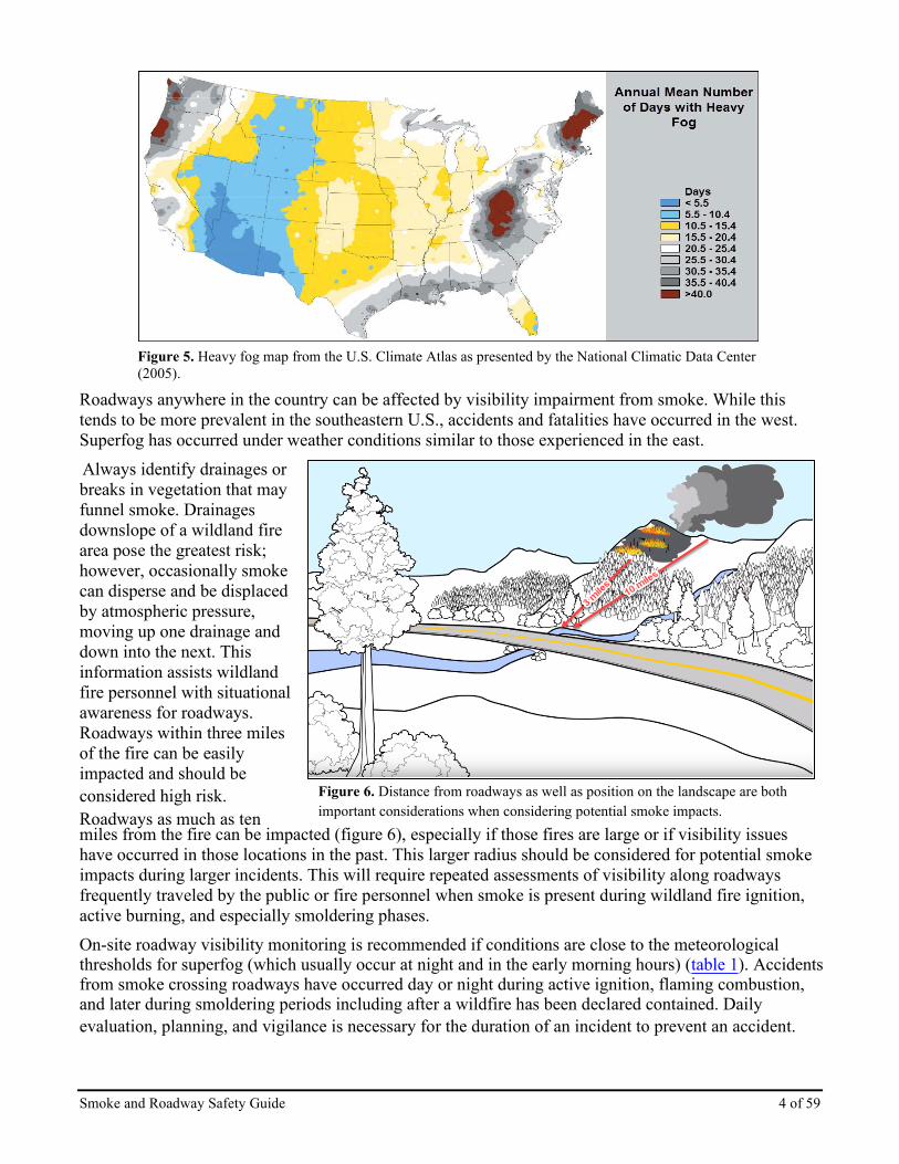
Landscape Features and Proximity Prescribed fire and wildfire suppression personnel can minimize smoke-related consequences by being aware of conditions that reduce roadway visibility and by knowing when to implement timely mitigation measures. Be aware of wildland fires within regions that are prone to fog formation or that have existing pollution such as from fine particles, sulfates, and nitrates from power plants, etc. (figure 3). This existing pollution can contribute to poor visibility, especially when humidity is high. Figures 4 and 5 are examples of tools that are available to help assess meteorological conditions that could increase the likelihood of smoke-induced fog or superfog. Additional climatologic research is ongoing across the U.S. to identify meteorological conditions that support formation of superfog. For example, Superfog Potential Occurrences based on climatology and historical weather data, shown in figure 4, were developed by Dan McEvoy, Matt Fearon, and Tim Brown at the Desert Research Institute using historical weather data for the period 2005-2014. The data has hourly temporal resolution at 12 km spatial resolution. Temperature and relative humidity (RH) variables were used to compute superfog potential. The original Superfog Potential Table based on Achtemeier (2008) was refined for both temperature and RH which resulted in an hourly superfog potential. To aid field users, a climatology for medium potential (50%-80%) and high potential (80%-100%) superfog occurrence is being developed.
Figure 3. Mean satellite-derived PM2.5 between 2001 and 2006, as estimated by vanDonkelaar et al. 2010.
Figure 4. Shows the number of counts for each grid cell that fell in the high superfog potential occurrence category for October at 11 coordinated universal time (UTC).
Smoke and Roadway Safety Guide 4 of 59
Figure 5. Heavy fog map from the U.S. Climate Atlas as presented by the National Climatic Data Center (2005).
Roadways anywhere in the country can be affected by visibility impairment from smoke. While this tends to be more prevalent in the southeastern U.S., accidents and fatalities have occurred in the west. Superfog has occurred under weather conditions similar to those experienced in the east. Always identify drainages or breaks in vegetation that may funnel smoke. Drainages downslope of a wildland fire area pose the greatest risk; however, occasionally smoke can disperse and be displaced by atmospheric pressure, moving up one drainage and down into the next. This information assists wildland fire personnel with situational awareness for roadways. Roadways within three miles of the fire can be easily impacted and should be considered high risk. Figure 6. Distance from roadways as well as position on the landsca
pe are both
Roadways as much as ten important considerations when considering potential smoke impacts.miles from the fire can be impacted (figure 6), especially if those fires are large or if visibility issues have occurred in those locations in the past. This larger radius should be considered for potential smoke impacts during larger incidents. This will require repeated assessments of visibility along roadways frequently traveled by the public or fire personnel when smoke is present during wildland fire ignition, active burning, and especially smoldering phases. On-site roadway visibility monitoring is recommended if conditions are close to the meteorological thresholds for superfog (which usually occur at night and in the early morning hours) (table 1). Accidents from smoke crossing roadways have occurred day or night during active ignition, flaming combustion, and later during smoldering periods including after a wildfire has been declared contained. Daily evaluation, planning, and vigilance is necessary for the duration of an incident to prevent an accident.

Smoke and Roadway Safety Guide 5 of 59
Burn Area The size of the area with active fire and/or smoldering fire is important to evaluate. A large area of hundreds of acres has a higher likelihood to influence visibility impairment on roadways; however, do not discount small fires for they can have a significant impact if close to a roadway.
Fuels Consider the presence of heavy and surface fuels, and fuel conditions that can lead to greater smoke emissions. The presence and availability of large fuels, organic soils, or deep duff increases the potential for dense smoke which, if caught in a drainage flow and crosses nearby roadways, could result in visibility impairing conditions. This risk is compounded at night when such smoke is frequently held close to the ground due to stable meteorological conditions (such as low wind speeds, cool temperatures, and low mixing heights). Long duration smoldering is of most concern. Unless they are clean and dry, burning piles can create significant smoke production through the day and into the night creating a risk of increased surface smoke which can move down drainage and impact a roadway.
Air Quality It is important to understand local sources of air pollution near the burn and the outlook for local air quality conditions. Mixing of a plume from wildland fire with an industrial source of sulfur dioxide (SO2) exacerbates the health effects downwind and may lead to greater visibility reduction, especially when RH is high (Mobley 1976). Be aware of this potential interaction and if possible, avoid the mixing of smoke plumes with industrial sources. Air quality and visibility can also be degraded by cumulative impacts from other sources such as wildfires, dust, etc., either regionally or moving into the area by way of long-range transport. If the current conditions show elevated air pollutants or significantly reduced visibility due to transported air pollution, consider what the addition of more smoke will do to cumulative air pollutant levels and subsequent visibility reduction.
Weather Knowing basic weather elements, including cloud cover, surface air temperature, RH, and wind speed, is vital to assess the risk of reduced roadway visibility and minimize smoke impacts. The ambient weather conditions should be monitored for thresholds that could support the formation of smoke-induced fog and/or superfog and be evaluated during day and night periods. Watchout thresholds for smoke-induced fog and superfog weather elements start at the following values (table 1):
Table 1. General weather elements and their collective watchout thresholds for possible dense fog or superfog.
These elements can be best acquired from several National Weather Service (NWS) products produced by the local weather forecasting office. The best product is the NWS Spot Forecast. The Hourly Tabular Weather is the next best product. Other products provide this information but are different in scale of resolution and time period.
General Weather Elements Watchout Thresholds Cloud cover (%) ≤60 % Surface air temperature ≤70⁰F Surface RH ≥70 % Surface wind speed <7 mph

Smoke and Roadway Safety Guide 6 of 59
Spot Forecasts (figure 7) are used by many land management agencies and can be available for private individuals through state forestry agencies. Another source of information is real-time observations acquired through various agency weather station networks. For example, MesoWest provides quick access to current weather observations from weather stations for a desired location. It has been designed for use by NWS meteorologists and other wildland fire professionals for protection of life and property and can be viewed at http://mesowest.utah.edu/. Note that MesoWest includes Remote Automated Weather Stations (RAWS) and NWS data. It also has road weather station data and other surface weather data sources, though these have not been quality checked. Refer to the Tools for Decision Support chapter for more detailed information on weather sources.
Figure 7. Spot weather forecast information can include several useful indices in addition to basic weather parameters.

Smoke and Roadway Safety Guide 7 of 59
Area Fire Weather (AFW) Forecast Matrix is an experimental NWS product. It displays modeled weather and calculated indices. It represents the average conditions across the Fire Weather Zone. It can be used as a rough approximation of weather conditions. In highly variable terrain coupled with a weather zone’s area the AFW information may be quite different from observed conditions at any point within the zone. Point Fire Weather (PFW) Forecast Matrix is an experimental NWS product (figure 8). It displays modeled weather and calculated indices for a specific point. This specific point is usually associated with a RAWS, other weather station site, prescribed fire location, or wildfire location. The PFW information usually comes from a fine resolution weather grid, 2.5 km or ~1.55 miles. It supports land managers in assessing fire behavior and smoke dispersion. Because the PFW information is acquired from a fine weather grid, it better projects weather conditions for a specific point in highly variable terrain. Use Considerations for AFW and PFW: They are not to be substituted for an official NWS Spot Forecast. They provide fire personnel a view
of modeled weather in three-hour intervals. The standard format supports fire behavior weather parameters and can be enhanced by request of the weather forecast office. These additional fire weather indices are very useful in assessing how wildland smoke disperses.
These products are calculated from modeled parameters; data should be validated for the specific location before it is used.
At the time of this writing both products may not be available nationwide. They can be made available by making requests for these products to your local weather forecast office.
The AFW is available to private as well as federal land managers. For private burners, requesting a PFW from the NWS may be feasible by asking your state forestry agency. For information on tools to help evaluate severity of smoke, watchout, and critical thresholds, and dispersion conditions, including regional considerations and the pros and cons of specific tools, see the Tools for Decision Support chapter.

Smoke and Roadway Safety Guide 8 of 59
Figure 8. Example of a PFW. Customized products for the local area are highlighted at the bottom of the graphic.
Figure 9. Fire weather planning information can include several useful indices in addition to basic weather parameters.

Smoke and Roadway Safety Guide 9 of 59
Planning and Responding to the Hazards This chapter addresses the overall framework of operational daily planning to address smoke and transportation safety. The content is applicable to all types of wildland fire (prescribed and wildfire) as well as agricultural burning. Specific guidance for wildfire and prescribed fire is presented in individual chapters. In the following sections we will introduce concepts that will be elaborated upon in more depth within the Prescribed Fire and Wildfire planning chapters, including:
• Risk Management
• Minimum Acceptable Visibility
• Monitoring
• Roadway Response Plans
• Management Action Points
• Pre-Season Coordination
• Fire Management Plans
Risk Management The Roadway Smoke Risk Assessment Process (figure 10) is composed of sequential steps to identify and assess roadway visibility conditions and risks based on both science and practical field experience. Each of the steps outlined below may be used to determine trigger points for contingency planning and monitoring daily. All steps are intended to be performed daily, though some steps may be more applicable than others, or have more information available to work with. Figure 10 provides a starting point for all wildland fires near roadways or having terrain that can allow for smoke to move towards roadways during the day or night. Local enhancement of the basic processes and tools should be expected as most research on the topic and practical experience has been centered in the southeast; however, accidents elsewhere in the U.S. indicate assessment for potential roadway smoke impacts should be a routine occurrence on all wildland fires.

Smoke and Roadway Safety Guide 10 of 59
Roadway Smoke Risk Assessment
Process For situational awareness of smoke impacts on roadway
visibility.
1. Assess smoldering fuel availability.
2. Assess fire weather (surface and upper air).
3. Assess fire behavior (surface and ground).
4. Identify major smoke sources and pathways,
and prioritize and group roadways.
5. Model surface smoke and winds and review
roadways at risk.
6. Evaluate and identify sites for air quality/
weather stations.
7. Prepare Roadway Visibility Forecast (RVF).
8. Evaluate/monitor RVF and smoke impacts.
Figure 10. Roadway Smoke Risk Assessment Process.
Roadway Smoke Risk Assessment Process Sequential Steps 1. Assess smoldering fuel availability:
• Are 100-hr and1000-hr fuels available for consumption due to low fuel moisture content?
• Do indices such as Energy Release Component (ERC), Keetch-Byram Drought Index (KBDI), and 1000-hr fuel moisture suggest sustained ignition of duff and/or organic soils?
2. Assess fire weather (surface and upper air):
• Utilize observed or forecasted weather conditions to assess day and night dispersion. (Will winds transport smoke across roadways or allow smoke to drain across roadways at night?)
• Utilize the Expanded Assessment for Potential Risk (EAPR) to assess smoke impacts on roadway visibility regardless of fuel type and availability.
• Do fire weather elements and indices support dense smoke or superfog formation?
• Can the ambient air mass support natural fog (wind speed, temperature, cloud cover, and humidity)?
• What is the superfog potential according to the Superfog Potential Table or the Superfog

Smoke and Roadway Safety Guide 11 of 59
Assessment Model (SAM)? 3. Assess fire behavior (surface and ground):
• Are 100-hr and 1000-hr fuels involved with the fire behavior and contributing to prolonged flaming or smoldering combustion and smoke production?
• Is duff or organic soil sustaining ignition over night?
• What is duff consumption (depth and extent) over 24 hours? 4. Identify major smoke sources and pathways, and prioritize and group roadways:
• Where is most of the smoke being produced in the fire area?
• What is indicated from crew line debriefing and infra-red aircraft flights?
• Where is the site of smoke production and its relationship to topography that could facilitate smoke movement at night?
• Roadways should be prioritized based on their distance from the smoke source (0-3, 4-7, 8-10 + miles), type, and use.
• Utilize topographical maps or local knowledge to identify potential smoke pathways. 5. Model surface smoke and winds and review roadways at risk:
• What does Planned Burn-Piedmont (PB-Piedmont), the Hybrid Single Particle Lagrangian Integrated Trajectory Model (HYSPLIT), BlueSky, or other models indicate for smoke plume impacts?
• What do surface wind models such as WindNinja indicate for smoke movement?
• Are there suspect drainages that can serve as primary travel paths appearing in the model output? 6. Evaluate and identify sites for air quality/weather stations:
Is there a need for monitoring stations (air quality or weather) based on the major smoke sources, key drainages, smoke dispersion model runs, and roadways of concern that you’ve identified? If so, where? Develop key thresholds for each type of monitoring, e.g., wind speed and direction that supports smoke moving across a roadway.
7. Prepare Roadway Visibility Forecast: The Roadway Visibility Forecast (RVF) projects potential roadway smoke impacts. The scope of the forecast depends on factors such as incident size, complexity, and proximity to roadways. The RVF may drive the development or implementation of a RRP, mitigation action, or be used in establishing Management Action Points (MAPs). The temporal forecast could be 12 hours or cover the hours of concern which extend for two hours after sunrise. See the RVF checklist in Appendix 1 for details on developing RVFs.
8. Evaluate and monitor RVF and smoke impacts:
• The RVF accuracy should be evaluated daily and adjusted if necessary.
• What happened or did not happen?
• The planning process is repeated in preparation for the next RVF (Appendix 1).

Smoke and Roadway Safety Guide 12 of 59
PB-Piedmont is a land surface model designed to simulate smoke movement/dispersion near the ground under nighttime conditions. The smoke plume is simulated as an ensemble of particles that are transported by local winds over complex terrain characteristic of the shallow (30-50 m) interlocking ridge/valley systems typical of the Piedmont of the South. PB-Piedmont does not predict smoke concentrations because emissions from smoldering combustion are usually unknown. It is designed to work in the southern Piedmont but has applicability elsewhere where shorter-range surface smoke flow estimation is needed. It displays the simulated ground smoke on a map of the area that can be impacted. With the modeled weather and local topography, it shows where risks of 1) smoke crossing a road may occur, and 2) areas of smoke, fog, or fog and smoke occur. Both conditions can pose risk of smoke impaired visibility. This web-based tool can be found at https://piedmont.dri.edu//.
Minimum Acceptable Visibility (MAV) In planning, it is useful to know driver braking distances and the minimum line of sight a driver needs to recognize obstacles or roadway conditions and brake safely on pavement. The MAV methodology was adapted from California Highway Patrol developed in 1984 and outlines braking distances for attentive drivers given varying speeds and visibility conditions (NPS 1991). These braking distances are helpful to inform planners as to how much visibility drivers require to safely respond to conditions on the roadway. The full table as well as information about its application is discussed in the Tools for Decision Support chapter.
Monitoring Monitoring is a crucial aspect to risk management. Once characteristics that contribute to dangerous conditions have been identified, they must be monitored so personnel can respond promptly if conditions become dangerous. When developing a Monitoring Plan, consider where, when, and how it will be carried out.
Where:
• Impacts are expected on the roadway.
• Drainages or cold air flows lead to potential impact areas.
• Impacts have been known to occur based on past experience.
• Consumption of fuels that generate a lot of smoke is likely such as large woody debris, ground fuels, etc.
When:
• When smoke is forecasted to likely move into the monitoring area at the ground surface (See Tools for Decision Support).
• Monitoring should be planned ahead of time to take into account changing conditions such as diurnal wind shifts or movement of the active fire over ridges or drainages.
How:
• Commonly, individuals are assigned to visually monitor the presence and density of smoke in potentially impacted areas (see prescribed fire planning Elements 11 & 20), while considering personal safety (see prescribed fire planning Element 13).

Smoke and Roadway Safety Guide 13 of 59
• Individuals responsible for monitoring must know the trigger points for implementing roadway response plans, commonly referred to as Management Action Points (MAPs) and have the ability to recognize the factors that lead to them. This may take some preparation. For example, establishing the distance to a specific point next to the road, such as a telephone pole or mile marker, would be one way of determining when visibility decreases to a specific point.
• Webcams may be useful for visually monitoring an area.
• Particulate ambient air quality monitors or sensors are other useful tools to quantify smoke concentrations but be aware of the limitations of the unit used.
Meteorological Monitoring:
• Monitor meteorological conditions that could impact roadway visibility such as RH and their watchout versus critical thresholds (table 4).
• Portable RAWS stations (figure 11) can provide a minimum of wind speed, direction, temperature, and RH, all of which are important in the formation of fog and visibility reduction. It’s important to establish the parameters and thresholds (watchout versus critical) to be tracked in advance. RAWS placement in key drainages leading to a road at risk should be considered. This placement up-drainage from a road and below the burned area allows for determining when the wind shift occurs to down-drainage flow and the wind speed at which smoke may be transported towards the road.
Figure 11. Firefighters setting up a portable RAWS.
Air Monitors vs. Air Quality Sensors: Air monitors, such as beta attenuation monitors (E-BAMs) and ESamplers, are designed to capture smoke concentrations to a high degree of accuracy. They tend to be expensive and are placed in areas where air quality for human health is of concern. Air quality sensors, such as Purple Air, AirVisual, etc., are relatively inexpensive, compact, and used for a variety of purposes. At the time of this writing, air sensors are more useful in tracking the relative change in air quality, and lack the precision needed to reliably capture concentrations.
Monitoring is an important consideration when developing your RRP. Make sure to consider different levels of roadway visibility impacts, how they will be detected via monitoring, and what the appropriate level of response will be for each one. In developing the response plan, also identify who will carry out which part, when response will occur, where it will occur, and who has the jurisdiction to carry it out (some tasks may need to involve the state highway patrol, department of transportation, or other authority).

Smoke and Roadway Safety Guide 14 of 59
Roadway Response Plans (RRPs) For effective smoke and transportation safety, mitigation and RRPs should be in place preemptively. Waiting until smoke impacts a roadway is too late.
The RRP outlines when and how to respond to smoke visibility impacts on roadways. Smoke mitigation and roadway response planning is critical to all wildland fire operations. The many smoke-related accidents from prescribed fires and wildfires across the country underscore the critical need for good planning. To protect public and fire personnel safety on roadways all prescribed fire planners or wildfire management personnel, regardless of agency, should carefully consider and plan for measures to address smoke-related safety risks. The RRP may be as simple as a list of standardized contacts and responsibilities for an area, but a more detailed approach, outlined below, is recommended. The intent of response planning is to identify actions to minimize the potential for smoke impacts to roadways. Effective roadway response planning also addresses actions to take if smoke impacts a road and should:
• Involve preemptive collaboration between land managers/forestry officials and local/state transportation, and public safety authorities.
• Use best available science to help identify where smoke/road hazards exist, assess the potential impacts, and provide decision support to mitigate hazards and respond to impacts.
• Clearly outline thresholds, actions, and responsibilities when smoke impacts roadways.
• Include steps for continual monitoring of conditions (meteorological, air quality, roadway visibility).
• Be supported with daily evaluation of conditions following the Roadway Smoke Risk Assessment Process (figure 10).
RRPs should be in place well before hazardous conditions occur. This allows personnel time to coordinate with appropriate authorities, so plans are in place well before a trigger point for action is reached. When planning and implementing prescribed fires, RRPs can be created or referenced as part of Contingency Planning (Prescribed Fire Plan, Element 17) or Smoke Management (Element 19), both of which are covered in the next chapter. For the federal practitioner, prescribed fire plans must be provided to responsible dispatch offices. RRPs should be included so any identified actions can be activated if smoke begins to impact roadways. For wildfire incidents, RRPs already in place can be provided to local Initial and Extended Attack Incident Commanders (ICs), incoming Incident Management Teams (IMTs), or can be created as a part of the wildfire’s MAP development. RRPs may also be referenced in a federal unit’s Fire Management Plan (FMP). In developing an RRP, keep the process in mind. See Appendix 2 for a basic checklist on elements, contacts, etc., to use in the development of an RRP.
Management Action Points (MAPs) MAPs are geographic points on the ground or specific points in time where an escalation or alternative of management actions is warranted. MAPs may indicate the need to implement the RRP. In the following chapters we will address MAPs in more depth for wildfire and prescribed fire scenarios. Helpful information on developing MAPs is also outlined in Appendix 3.

Smoke and Roadway Safety Guide 15 of 59
Pre-Season Coordination Because multiple parties or agencies are often involved in responding to roadway smoke impacts, pre-season coordination is needed to ensure all parties know their role and how to fulfill it. Wildland fire managers and fire planning and implementation personnel should work annually with local law enforcement and other appropriate transportation officials such as the state department of transportation (or other agencies appropriate to your area/state) before the fire season to discuss responses to smoke impacts on transportation routes. Personnel should be identified in advance to respond in the event an emergency road closure is needed for prescribed fire or wildfire. Add appropriate contacts to the notification section of prescribed fire plans (Prescribed Fire Plan, Element 9) and periodically update the RRP throughout the season to ensure specific tasks, roles, and responsibilities are clearly outlined before the need arises. Pre-season coordination should include dialogue and agreements with the local weather forecast office to determine any changes to forecast request protocol, and identify elements necessary for roadway safety forecasts including:
• Access to variables including surface air temperature, RH, stability, and cloud cover (See Tools for Decision Support, Expanded Assessment for Potential Risk (EAPR).
• Access to useful tools and indices such as the Atmospheric Dispersion Index (ADI), Low Visibility Occurrence Risk Index (LVORI), and Turner Stability (Tools for Decision Support).
• Access to day and night dispersion forecasts (Weather Forecasts section, Tools for Decision Support chapter).
Weather forecast can also be helpful in developing MAPs (Appendix 3).
Fire Management Plans (FMP) Federal FMPs frequently identify key partners and responsibilities as they pertain to wildfires. If significant smoke impacts a busy roadway, the potential for an “incident within an incident” is high. Key roadways where smoke impacts pose a significant risk to the public or fire personnel can be pre-identified and included in the FMP. The FMP can cite the importance and responsibility to monitor such roadways for safety. If a smoke impact occurs, the FMP can trigger the implementation of the RRP which can lead to timely mitigation of the smoke and visibility risk. As FMPs are now transitioning to virtual and GIS platforms, the overlay of high priority roadways in terms of smoke risk can be identified well in advance of active prescribed fire or wildfires. If an FMP is not used (for example state or private burning), the key roadways where smoke impacts pose a significant risk should still be identified and a RRP can still be valuable.

Smoke and Roadway Safety Guide 16 of 59
Prescribed Fire Roadway Smoke Mitigation and Response Prescribed fire plans provide the information needed to safely ignite and hold a fire under prescriptive parameters to achieve identified objectives. The Interagency Prescribed Fire Planning and Implementation Procedures Guide, PMS 484, https://www.nwcg.gov/publications/484, provides standardized procedures specifically associated with planning and implementation of prescribed fire. The NWCG Prescribed Fire Plan Template, PMS 484-1, https://www.nwcg.gov/publications/484-1 is a supplement to the guide. All references here to plan elements refer specifically to the NWCG template. These procedures meet all federal policy requirements, direction, and guidance for prescribed fire planning and implementation for the Department of the Interior (DOI); Bureau of Indian Affairs (BIA); Bureau of Land Management (BLM); the National Park Service (NPS); the U. S. Fish and Wildlife Service (USFWS); and the U.S. Department of Agriculture Forest Service (USFS). For these federal agencies, a prescribed fire must be implemented in conformance with the approved plan. Some states also require prescribed fires to be implemented according to an approved prescribed fire or smoke plan. Private landowners may be required by state, or in some cases county, regulations to implement prescribed fire through a plan. Private landowners should become familiar with the laws and regulations regarding prescribed fire in their state and local area. Regardless if one is required by law and or local area regulations, a plan should be developed to provide the needed information to safely implement a prescribed fire and address smoke and roadway safety.
Prescribed Fire Planning The prescribed fire plan can be considered both a mitigation and response plan. When developing a prescribed fire plan, protecting public and firefighter safety is the first priority. Avoidance or mitigation of the risks associated with smoke impacts to roadways, day or night, is key to protecting people’s safety. A prescribed fire plan should identify possible smoke impacts, the burning techniques to limit or prevent smoke impacts to roadways, and the response if smoke from the prescribed fire begins to impact them. When planning a prescribed fire, the Roadway Smoke Risk Assessment Process provides the preliminary information to determine if there is a risk to roadways during prescribed fire implementation. The information is then used during the prescribed risk assessment process to identify specific potential risks and the actions needed to mitigate them. The risks associated with prescribed fires should be identified in terms of values that could be impacted, how severe the threat may be, and the likelihood of undesirable effects. Federal policy requires prescribed fire managers identify risks and conduct a risk assessment through the process found in the Prescribed Fire Complexity Rating System Guide, PMS 424, https://www.nwcg.gov/publications/424. The process rates the prescribed fire risk to values identified both in and outside the treatment area (such as roadways or sensitive areas) and the technical difficulty of managing the risks to them. As part of the process, smoke impact risks to roadways can be identified and assessed by two means:
• Roadways identified as “values.” Roadways down drainage or down slope should be considered as a value when there is a distinct risk for smoke impacts from the prescribed fire. Consider proximity to a roadway and wind conditions which would support the transportation of smoke to the road, the type of road (interstate, primary, secondary, Jeep trail, etc.), and how often it’s used. Are there times when it experiences increased use? Can mitigation measures or constraints to the prescribed fire be developed in the prescribed fire plan to prevent impacts?
• Roadways assessed as part of the Prescribed Fire Complexity Rating System, Element 6: Smoke

Smoke and Roadway Safety Guide 17 of 59
Management. Be sure to include smoke impacts to roadways when rating this element.
Elements of Prescribed Fire Planning The prescribed fire plan is developed while considering the risks associated with the values identified. Smoke risks to roadways and associated mitigation measures should be addressed in the following prescribed fire plan elements from the NWCG Prescribed Fire Plan Template, PMS 484-1, https://www.nwcg.gov/publications/484-1. Element 4: Description of Prescribed Fire Area: For all burners, the description of the prescribed fire area lays a foundation for identifying the values at risk and developing mitigation measures in other elements of the prescribed fire plan. For the federal planner and implementer, the description must include physical and vegetative descriptions, description of values (including major roadways) in the vicinity, and project maps. If a roadway was identified as a value be sure to include it on the project map. If roadways are at risk of smoke impact from the prescribed fire, during the treatment design consider:
• The possibility of dividing the prescribed fire area into smaller units to shorten ignition and burn out time and/or reduce total smoke production or smoldering.
• Isolating pockets of heavy fuel, duff, or organic soil. If the area burned can be reduced or isolated, or burned under conditions that discourage smoldering, smoldering emissions may be reduced. Be sure to consider this when developing the other prescribed fire planning elements such as Element 7: Prescription, Element 15: Ignition Plan, and Element 16: Holding Plan. Element 7: Prescription: For all burners, the prescription should be thought of as the environmental conditions (amount of fuel, moisture of fuel, topography, time of day, etc.) and fire conditions (flame length, heat produced, etc.) needed to safely ignite the fire and meet the treatment objectives. For the federal planner and implementer, the prescription is the measurable criteria during which a prescribed fire may be ignited to meet the plan objectives and be safely implemented. For smoke management concerns the prescription should take into consideration:
• Fuel moistures. The moistures for 100-hr (1–3-inch diameter) and 1000-hr (3 inch and above) fuels should match those laid out in the burn objectives to avoid long-term smoldering and long-term heavy smoke production. Burning under extremes touch most every other element to account for increased holding resources and contingency planning.
• Duff layers. When a deep duff layer is present, consider burning when the duff is wet or when moisture is high to minimize ignition; thus, avoiding a longer smoldering phase and subsequently long-term heavy smoke.
• Wind speed and direction. Consider constraining the day and night wind direction in the prescribed fire plan to prevent impacts to roadways. Be sure to consider wind direction and speed when determining how you will ignite the prescribed fire. In the prescribed fire plan, link this with your Element 15: Ignition Plan and Element 19: Smoke Management Plan. Consider wind direction constraints as a MAP when developing contingencies, Element 17: Contingency Plan. Don’t forget night wind shifts!
• Residual burn time. Identifying residual burn time related to pockets of heavy fuels (i.e., deep duff layers, large downed-woody fuels, timber slash, fallen beetle-killed timber, masticated fuel beds, woody-material from storm damage, or higher fuel loads due to infrequent burning) that

Smoke and Roadway Safety Guide 18 of 59
could burn and smolder for long periods. Be sure to take this into consideration when developing your Element 16: Holding Plan, since this element includes mop-up procedures and criteria.
• Long duration prescribed fires. Long duration (multiple day ignition or active fire) prescribed fires and environmental changes over time could influence fire behavior and subsequent smoke production and dispersion. Consider using the skills of a Fire Behavior Analyst (FBAN) or Long Term Analyst (LTAN) to help develop prescriptions, or using a regional air resource specialist to help provide smoke production and dispersion information for longer duration prescribed fires. For exceptional circumstances, consider using the skills of an Air Resource Advisor (ARA). Consider long-term smoke production and dispersion related to the prescription when developing your Element 19: Smoke Management and Air Quality Plan, the Element 17: Contingency Plan, and the Element 20: Monitoring.
• Decision support tools. Consider the application of ADI thresholds, and/or the LVORI thresholds (see the Tools for Decision Support chapter, Weather Forecast section) to help determine parameters to minimize smoke impacts to roadways. In some locations, (states, counties) laws and regulations require the use of ADI thresholds or other indices to determine if you can ignite a prescribed fire.
Element 8: Scheduling: For all burners, the schedule should consider and identify when the prescribed fire can or cannot be implemented in terms of smoke impact to roadways. For the federal planner/implementer this element identifies the general implementation schedule including season for ignition, time of day for ignition, duration of ignition, projected duration of the prescribed fire, and any constraints.
• Identify if there are any times when environmental conditions are most conducive to superfog development (more information on these conditions described in Tools for Decision Support). Consider constraining ignitions during this time as smoke dispersion is very poor to stagnant. Constraints may include daily ignition limits, unit size limits, or postponing ignition altogether during seasonal times of potential superfog development. Be sure to consider constraints and identify time frames when developing Element 19: Smoke Management and Air Quality. If environmental and fire behavior parameter constraints (wind direction, fuel moistures, etc.) are critical to mitigate or prevent the effects of smoke on values be sure to include them when developing the Element 7: Prescription.
• Consider identifying the day dispersion window or time of day when active ignition (usually at burn off temperature or when inversions begin to break) can take place to maximize dispersion and identify time of day when ignition needs to stop. Be sure ignition time frames are identified when developing the Element 15: Ignition Plan.
• Consider whether residual in-place burning will cease and the smoke will disperse before the onset of night dispersion conditions. Smoke dispersion at night is generally poorer than dispersion during the day because nighttime conditions become more stable. Be sure to take this into consideration when developing the Element 16: Holding Plan and mop-up procedures.
• Consider linking the duration of the project with plans for Element 19: Smoke Management and Air Quality and Element 20: Monitoring to ensure road safety is continually monitored for roadway visibility through the duration of the fire, for both flaming and smoldering phases (combustion phases are described in NWCG Smoke Management Guide for Prescribed Fire, PMS 420-3, https://www.nwcg.gov/publications/420-3).

Smoke and Roadway Safety Guide 19 of 59
Element 9: Pre-Burn Considerations and Weather: For all burners, obtain necessary weather information prior to ignition. Also, identify the on- and off-site burn activities needed to safely implement the burn and meet objectives. Federal prescribed fire plans must describe the on-site and off-site pre-burn actions to be addressed prior to implementation including the method and frequency for obtaining weather and smoke management forecast(s) and a list of pre-burn notifications to be made. To address and/or mitigate smoke impacts to roadways pre-burn considerations may include:
• Improving human-made or natural barriers to allow flexibility in modifying daily ignition size, or to allow ignitions to be stopped safely to mitigate impacts in the event road safety thresholds for smoke are breached. Be sure to identify natural and human-made barriers when developing contingencies, Element 17: Contingency.
• Identifying areas of heavy fuels, duff, or organic soils that may smolder for longer periods and determine if those areas can be excluded from ignitions. Use higher fuel moistures to reduce the likelihood of igniting these fuels. What actions are required to ensure the areas are excluded (hand/dozer lines, modified ignition patterns, wind directions)? Be sure to take this into consideration when developing your ignition procedures Element 15: Ignition Plan. Also, consider if this needs to be identified as a MAP when developing contingencies, Element 17: Contingency Plan. Consider implementing more intense mop-up procedures to limit smoke impacts, Element 16: Holding Plan and Element 13: Public and Personnel Safety, Medical. For more information on MAPs see the MAP section of this publication and Appendix 3.
• Identifying, preparing, and notifying communities that may be affected by smoke impacts to roadways. Work with local law enforcement and other appropriate transportation officials such as the state department of transportation (or other agencies appropriate to your area/state) to discuss possible smoke impacts on transportation routes and identify points of contact. Be sure to identify these contacts as part of the notification list, specifying who is responsible for making the notifications, and when the notifications will be made.
• Identifying where on roadways smoke warning signs will be placed before the prescribed fire is ignited, when, and who is responsible for placing them. Be sure to identify sign needs when developing your equipment list, Element 11: Organization and Equipment, and Element 19: Smoke Management and Air Quality.
Element 10: Briefing: For all burners, every member on a prescribed fire should understand the road smoke safety procedures if there is a possibility for smoke to impact roadways. For the federal implementer, all personnel assigned to a prescribed fire must be briefed at the beginning of each operational period to ensure personnel safety considerations and prescribed fire objectives and operations are clearly defined and understood, including possible impacts related to roadway safety.
• Be sure to identify any roadways identified as a value or smoke sensitive features (Element 4: Description of Prescribed Fire Area and Element 19: Smoke Management and Air Quality) that may be impacted by smoke.
• Be sure to discuss roadway smoke safety as identified in Element 13: Public and Personnel Safety, Medical, and any roadway smoke contingency planning (if identified in Element 17: Contingency Plan). An RRP may be an element of this Contingency Plan.
• The responsibilities of personnel assigned to smoke roadway visibility monitoring (Element 11: Organization and Equipment and Element 20: Monitoring) should be communicated and understood.

Smoke and Roadway Safety Guide 20 of 59
Element 11: Organization and Equipment: For all burners, a prescribed fire plan should identify the personnel and equipment needed to safely implement the prescribed fire. A federal prescribed fire plan must identify organizational capabilities needed to safely achieve the plan objectives.
• Consider identifying someone to perform roadway visibility monitoring duties (day and night if warranted). Identify the position on the organization chart.
• Identify the need for meteorological monitoring equipment such as RAWS if conditions approaching meteorological thresholds are present.
• Identify the need for a smoke monitoring device for particulate matter 2.5 microns in diameter (PM2.5), or a camera, in potential smoke drainage areas or other smoke transport pathways.
Be sure Element 19: Smoke Management and Air Quality, and Element 20: Monitoring Plans clearly describe the monitoring duties (roadway monitoring or monitoring device deployment and retrieval) and procedures to follow if smoke begins to impact roadways. Element 13: Public and Personnel Safety, Medical: All burners should manage risks from smoke impacts to protect the public and burn personnel. Federal personnel should identify any measures developed in other elements to reduce roadway smoke. Public and personnel safety considerations touch all other areas of prescribed fire planning and implementation. Key links for roadway safety include Element 10: Briefing, Element 17: Contingency Plan, Element 19: Smoke Management and Air Quality, and Element 20: Monitoring.
• Mop up is frequently used on prescribed fires to manage smoke. Take into consideration personnel safety and the potential for smoke impacts to roadways when considering mop up (Element 16: Holding Plan).
• Take into account safety considerations for personnel assigned to roadway visibility monitoring.
Figure 12. Firefighter managing traffic on an incident.
Element 15: Ignition Plan: General ignition operations are described in a prescribed fire plan to allow for adjustments dictated by topographic, fuels, and weather factors. When there is a possibility of smoke impacts to roadways, the Ignition Plan should:
• Consider special firing methods, sequences, devices, and techniques that may be implemented to reduce smoke impacts.
• Reference any daily active ignition size limits, timing, or exclusion areas identified in Element 4:

Smoke and Roadway Safety Guide 21 of 59
Description of Prescribed Fire Area, Element 8: Scheduling, and Element 19: Smoke Management and Air Quality.
Element 16: Holding Plan: Holding plans for all burners, at a minimum, should identify the general procedures for operations to maintain the fire within the project area. A federal prescribed fire plan must also describe how values at risk (consistent with Element 4: Description of Prescribed Fire Area) will be protected until the fire is declared out. It must also include instructions on how mop up will be implemented to ensure the prescribed fire is controlled or completely out. When there is a possibility of smoke impacts to roadways, plans should describe mop-up procedures and criteria to limit possible smoke impacts.
• Consider increasing the organization (Element 11: Organization and Equipment) to increase the speed of mop up when there are heavy fuels, duff layers, and/or organic soils present, which could smolder for long periods if ignited.
• Ensure smoke exposure safety and rotation of crews during mop up if necessary (Element 13: Public and Personnel Safety, Medical).
• Consider smoke-related mop-up needs, especially for long duration prescribed fires where the fuel bed is not uniform and pockets of heavy fuel and or organic soils are present.
• Consider how fire will be excluded from areas if identified in the description of the area (Element 4), and your identified pre-burn considerations (Element 9: Pre-Burn Considerations and Weather).
Element 17: Contingency Plan: Though many prescribed fires do not impact roadways, the consequences when they do occur can be fatal. Contingency planning considers low probability, but high consequence events and the response or actions needed to mitigate them. For a federal prescribed fire plan, it is the determination of what additional actions or additional resources (or both) are needed to keep the prescribed fire within the scope of the prescribed fire plan or from being declared a wildfire. Contingency planning links with most other elements in the prescribed fire plan when issues, constraints, safety needs, and risks to values (including roadways) are identified. Consider the addition of MAPs to the Contingency Plan. In the context of smoke and road safety, contingency planning:
• Should address failure in meeting prescribed fire objectives including smoke management considerations such as impacts to critical smoke receptors (including roadways), staffing, accidents, and other unanticipated events.
• Using the MAV to help quantify the level of impact, should identify the response and actions to take if smoke impacts a road, and by whom. Include partner agencies such as law enforcement and the department of transportation and a protocol for clear communication, jurisdiction, and roles for all parties. These roles should be established in pre-season coordination and Element 9: Pre-Burn Considerations and Weather. This is equivalent to the RRP.
• Should identify specific actions to take, including criteria for road closure or other mitigation measures up to and including if a smoke-related accident were to occur.
• May identify the implementation of “incident within an incident” protocols if smoke impacts a critical roadway posing a significant safety risk including an accident.
• Should develop a smoke RRP (see RRP section) as the official protocol to be followed if smoke from a prescribed fire could impact a road. It can be inserted into the prescribed fire plan as an appendix. Be sure the RRP is identified as part of the prescribed fire briefing (Element 10).

Smoke and Roadway Safety Guide 22 of 59
Consider inclusion into your FMP if appropriate.
• Track weather and smoke for conditions that contribute to visibility impairment on the roadway, this could include checking for advisories and/or Special Weather Statements (SPSs).
• If conditions indicate visibility impairment from smoke, smoke-induced fog, or superfog, request the NWS issue a SPS or an advisory for the area.
See Tools for Decision Support to help determine the appropriate contingency response to severity of smoke impacts, the type of road, and speed limit. Prescribed fire planners should coordinate contingency planning with the appropriate law enforcement and/or transportation agencies or on-site roadway visibility monitoring personnel. Element 19: Smoke Management and Air Quality: For all burners, be aware of public and firefighter safety issues caused by smoke on roadways. Although this document focuses on roadways, consider other transportation corridors such as airports, airstrips, airways, and railways. Smoke sensitive receptors should be identified, possible and real impacts need to be analyzed and communicated and specific actions to mitigate impacts should be planned and implemented. For federal prescribed fire plans this element must identify smoke sensitive receptors (including roadways), actions to mitigate impacts, and outline specific monitoring of potential smoke impacts.
• It should identify special considerations in other elements in the prescribed fire plan including those covered above. Identify smoke impacts to roadways and associated mitigation measures including referencing RRPs already in place or developed as part of Element 17: Contingency Plan.
• It should include dispersion modeling outputs (some currently available modeling options include Bluesky, HYSPLIT, or PB-Piedmont). It should also include mitigation strategies and techniques to reduce smoke production impacts (including to roadways).
• It should consider the duration of the prescribed fire. The longer the duration the greater the likelihood of smoke impacting a nearby road. The need for forecasts that address the long-term dispersal of smoke should be identified as a part of Element 9: Pre-Burn Considerations and Weather, and Element 7: Prescription.
Element 20: Monitoring: For all prescribed fires, if smoke has the potential to impact a roadway, personnel should be assigned to monitor visibility and assess smoke conditions and report any hazardous conditions. If a person is assigned a roadway visibility monitor role, be sure to identify the position as part of your organization (Element 11: Organization and Equipment) even if the duties are part of a concurrent assignment such as public information, road guard, etc. Be sure the duties are communicated as part of the Element 10: Briefing. Monitoring of smoke transport and dispersion is important for long duration prescribed fires. For further information on monitoring for road safety see the Monitoring section in Planning and Responding to the Hazards chapter.

Smoke and Roadway Safety Guide 23 of 59
Wildfire Smoke Mitigation and Response To protect public and fire personnel safety on roadways, all wildfire management personnel, regardless of agency, should carefully consider and plan to address smoke-related safety risks; ensure steps are taken to minimize smoke impacts on roadways and mitigate if necessary especially when visibility is significantly impaired. Addressing smoke-related safety risks and mitigation activities are initiated by the Federal Land Management Agency Administrator as a part of the fire management objectives identified in a unit FMP or a wildfire’s Wildland Fire Decision Support System (WFDSS) decision and should be reflected in the delegation of authority and identified in the wildfire management Incident Team in-brief discussion. Serious roadway incidents caused by wildfire smoke are becoming more predictable and therefore, can be responded to more effectively. Roadway risk due to wildfire smoke can now be addressed by IMTs using an ARA or personnel assigned the responsibility of assessing forecasted weather, monitoring air quality, weather observations, current and expected fire behavior, and smoke dispersion models. For success, it requires due diligence and cooperation among key elements of the fire organization.
Air Resource Advisors (ARAs): ARAs are Technical Specialists (THSP) who deploy smoke monitors, analyze data and dispersion modeling information, and forecast smoke impacts of wildland fires. They work with IMTs, Public Information Officers (PIOs), FBANs, meteorologists, and others to address smoke issues. ARAs help coordinate with multiple agencies to address public health risks and concerns, risks to transportation safety, and fire personnel exposure concerns including impacts on base and spike camps when needed.
During initial attack and extended attack wildfire situations, smoke impacts to roadways may be harder to predict and respond to as usually there is not an assigned technical smoke specialist, ARA, or Safety Officer. Initial attack ICs may be more concerned with the fire’s immediate organizational and operational needs and safety considerations of the personnel involved. They may be less concerned with potential smoke impacts to roadways, especially if they are located a perceived distance from the fire (although they still may be within the 10 mile distance zone). If the wildfire is in the Wildland Urban Interface, the initial attack IC may be more in tune with roadway smoke safety related to possible evacuation needs. The transition from initial attack to extended attack may be a critical time for road smoke safety. On a wildfire growing in both size and complexity an initial attack IC transitioning out to an incoming IMT may be overwhelmed with transitional duties. They may be more focused on providing for the safety of the resources on the fire perimeter and any adjacent or nearby public. As a result, smoke impacts may be taken for granted or may simply not be a duty they are aware of yet. Based on past fatalities due to smoke on roadways during initial attack and extended attack, building awareness and the tools to predict such impacts is very important. Having a RRP in place that identifies possible critical smoke impact areas, addresses possible smoke issues and mitigation of impacts before the fire starts, and ensuring local and incoming resources are familiar with it, can help increase the IC’s situational awareness related to smoke and roadway safety. Wildfire roadway response planning and smoke mitigation response planning should:
• Identify assessment criteria, thresholds, mitigation and specific response actions to take if smoke impacts to roadways were to occur up to and including criteria for road closure or other mitigation measures.
• Encompass the points in this chapter and be clearly communicated to initial and extended attack resources.

Smoke and Roadway Safety Guide 24 of 59
• Be included in the pre-brief package for incoming IMTs. If an RRP is not in place, IMTs should consider using the services of an ARA to develop a basic RRP to address possible smoke impacts. The ARA can coordinate with local resources, officials, the IMT’s Safety Officer, and Liaison Officer to develop an effective incident specific response plan whereby mitigating measures can be timely, coordinated, and implemented by the responsible entity. IMT standard operating procedures (SOPs) could identify the requirements for this plan (criteria, thresholds, time frames, contacts etc.). When wildfires are transitioned from higher complexity management teams to local level or lower complexity teams, be sure that smoke impact and risk mitigation continues. Even though the complexity of the wildfire may be lessened, smoke impacts may not. There may still be large amounts of residual burn out smoke production which must be monitored and responded to if roadways are impacted. Local unit fire management staff may already be aware that an RRP is in place. Be sure that all incoming wildfire management leadership and personnel are aware of RRPs in place or recently developed smoke risks and mitigation measures. When planning for wildfire smoke mitigation, the Roadway Smoke Risk Assessment Process (figure 10) is critical to assessing the need for mitigation. If smoke from previous fires has routinely flowed down drainages or across roadways, then the area should become a critical part of the wildfire response planning process for mitigation.
Initial Assessments The successful mitigation of roadway smoke risks by the fire organization starts with initial assessment and subsequent updates. This is true for initial attack response personnel as well as for pre-assembled IMTs. Wildfire smoke is becoming more inclusive in wildfire response as it is being included in FMP preparation, developing WFDSS (2018) decision(s), in the delegation of authority for IMTs, and identified as a part of safety messaging in Incident Action Plans (IAPs). Fire personnel are trained to assess the fire’s situation. Initial attack ICs are required to relay an initial size up of a wildfire as they arrive on the scene. Checklists are always used to facilitate gathering and relaying initial fire information. Extended attack managers are required to collect information to produce daily reports addressing the status of wildfires. Both initial attack size-ups and daily fire situation information gathering should include wildfire smoke risks to roadways. Smoke and roadway safety should be assessed as part of the following:
• Incident Action Plan Safety Analysis (ICS 215A)
• Division Group Assignment List (ICS 204 WF)
• Safety Message/Plan (ICS 208)
• Incident Status Summary (ICS 209) ICS Forms are available on the NWCG website, https://www.nwcg.gov/publications/ics-forms. On wildfires with fire activity near or adjacent to roadways, the need for a daily transportation assessment should be considered. Possible smoke impacts to roadways should be assessed and mitigation actions identified when developing the incident’s MAPs. This is true for day and night planning periods for visibility impairing smoke ranging in impact from light visibility reduction to the worst-case scenario of superfog when warranted.

Smoke and Roadway Safety Guide 25 of 59
Assessing wildfire smoke risk to roadways is an evaluation process that is followed by planning and then ordering required resources needed to mitigate the potential hazard. The Simple Roadway Screening Assessment for Potential Risk (table 2) provides quick guidance to assess the potential risk for reduced roadway visibility. Table 2. Simple Roadway Screening Assessment for Potential Risk.
A. Is there active burning and/or smoldering? If YES, continue B. Are there roadways within 10 miles of the fire?
If YES, continue C. Are winds transporting smoke towards road, day or night? If YES, continue D. Do drainages lead from the fire site to the road? (Natural drainages, fuel breaks, etc.) If YES, continue E. Are the predicted low temperatures less than 70 °F? If YES, continue F. Is predicted RH higher than 70%? If YES, continue If answers are all “Yes” to A-D then there is high risk for reduced roadway visibility due to smoke.
If answers are all “Yes” to A-F then there is a high risk for reduced visibility caused by superfog.
Both scenarios warrant the Roadway Smoke Risk Assessment Process (figure 10) to be initiated to assess and mitigate if necessary, any potential hazards and perils to roadways.
If roadway safety concerns from smoke are raised after using table 2, roadway monitoring should be implemented, and MAPs and mitigation measures identified. If an RRP is present, its implementation may be warranted. If an RRP is not present, one may need to be developed or mitigation measures initiated. The Simple Roadway Screening Assessment for Potential Risk encompasses Tier one and part of Tier two of the EAPR (table 4). For further support on your decision you may refer to table 4. Answering yes to A-D or A-F in table 2 supports the preparation or implementation of an RRP, mitigation measures, or transportation safety message/plan for the public and fire personnel.
Thresholds for Response and/or MAPs Consider the following questions: Just because smoke is impacting a road and visibility is reduced, does it pose a safety hazard? What are the critical roadway visibility thresholds that trigger some type of required action? What are the required actions, and who is responsible to implement them? As a component of mitigation planning, MAPs are clearly specified conditions or thresholds that, if reached, prompt implementation of tactical and/or other non-tactical actions to meet objectives (figure 13). Safety is always identified as a primary objective of all wildfires and the potential for smoke on roadways can threaten safety of both the public and fire personnel. MAPs are usually spatial but can also be temporal or otherwise tied to conditions that cannot be conveyed geographically using points, lines, or polygons. In terms of roadway safety, MAPs should include information from the assessment phase to help determine roadway visibility thresholds, or critical thresholds for possible smoke on the roadway or superfog formation with actions needed to mitigate the event. Mitigation actions should be based on the type of road and how much visibility is potentially reduced. For a MAP template, see Appendix 3.

Smoke and Roadway Safety Guide 26 of 59
Figure 13. An example of an object at a known distance, in this case a telephone pole, used as a reference point by personnel on site to identify a MAP tied to visibility reduction from smoke.
On large complex fires MAPs may be developed by the Strategic Operational Planner (SOPL) in coordination with the planning and operations staffs. ARAs (or other local or regional experienced, knowledgeable, or qualified air quality personnel available) should provide input in developing smoke-related MAPs, if needed, to address this safety hazard and risk in coordination with others on the IMT [Safety Officer (SOFR), Liaison Officer (LOFR), Incident Meteorologist (IMET), Logistics Chief, as applicable]. On lower complexity wildfires with limited management personnel, ICs, and other Command and General Staff (C&G) positions may be required to develop smoke-related MAPs. Input to help wildfire managers develop needed MAPs could come from ARAs, local and/or regional smoke managers or air quality specialists, the local NWS weather forecasting office (WFO) Fire Meteorologist, and/or local personnel or public with prior experience of smoke issues or information from this document. An already existing RRP for a unit or area or a section in the local FMP addressing the hazard will all be valuable to identify or help determine MAPs. Roadway safety MAPs should be tied to geographic features and identifiable on the ground or by air. MAPs may include predicted or projected action points such as identifying thresholds and actions to take if weather and smoke dispersion forecasts call for unsafe conditions. Minimum Acceptable Visibility thresholds can be identified to trigger a mitigation response to reduced roadway visibility (See the MAV for Paved Roads section of the Tools for Decision Support chapter). If the conditions defined by the MAP are met, it’s critical to act quickly. The key factor in any possible implementation of a MAP action is anticipation. Actions must be identified and performed before being forced to do so. If an action is forced or reactive, it may be too late.
Wildfire Smoke Mitigation and Response Incident Action Plans – IAPs (sometimes called shift plans) are written documents that provide overall incident strategy, specific tactical activities, and supporting information needed for specific operational periods (daily, day and night, if applicable). If smoke impacts to roadways or MAPs thresholds are forecasted to be reached, especially during night operations, IAPs should include smoke and roadway safety as part of the IAP (ICS 208, Safety Messages). Specific division assignments (ICS 204 WF) should contain a special safety message related to smoke and roadway safety.

Smoke and Roadway Safety Guide 27 of 59
Daily Briefings – Daily wildfire briefings may be conducted over radios, conference calls, and face-to-face meetings. Printed copies of briefings or IAPs usually include fire weather and fire behavior forecasts. If critical smoke and roadway areas have been identified, ICs and fire management resources can be alerted to possible safety concerns based on the day’s spot weather and fire behavior forecast(s). Forecasts can also include a specifically prepared Smoke Forecast developed by an ARA, IMET, and in some cases a FBAN or LTAN. IAP Safety Messages may include roadway smoke safety. During the fire season, initial attack resources receive daily fire weather forecasts usually as part of a daily wildfire briefing. During an extended attack or long duration wildfire, spot weather forecasts, SPSs, or IMET reports can be obtained daily. These would then be included in the IAP and resources briefed at the start of each operational period. Key fire weather intelligence related to day and night smoke dispersion and weather conditions conducive to smoke movement towards roadways and even superfog development can be identified by cross-walking the forecasts with the Simple Roadway Screening Assessment for Potential Risk table (table 2). Possible smoke impacts to roadways, mitigation measures, and response should be communicated to resources and the public as needed. Planned Ignitions During Wildfires – Planned ignitions (burn outs, backfiring, etc.) may be implemented as part of tactics to control wildfires. These tactics can have serious impacts to visibility during the day and night because the planned ignition emissions combined with those already present from the wildfire can overload the atmosphere. Often, timing of these activities is critical to ensure success and safety. If time permits, an evaluation of increased impacts to visibility should be part of the planning process for planned ignitions for wildfires. If possible, impacts are identified and timing allows, ignition situations should consider:
• Reducing the ignition area. Reducing the ignition area may decrease both amount and duration of smoke production.
• Delaying ignition if possible, for more favorable smoke dispersion meteorology. Waiting for a different wind direction, more persistent winds, higher mixing height, or inversion break-up could aid in minimizing smoke impacts to roadways.
• Reducing the intensity of ignitions. Igniting with the objective to eliminate ground and ladder fuels rather than full consumption of the entire canopy can decrease smoke production.
• Fuel manipulation or preparation. When possible, reduce smoldering combustion by burning when materials likely to smolder will be minimized through consideration of fuel moisture or by isolating these materials.
Holding Actions – Personnel can be impacted through decreased visibility and overexposure to smoke when roadways are used to contain the fire or hold ignition operations. Consider rotating holding resources in and out of smoky areas. Allow road access to only ignition, holding, and mop-up personnel. Operational briefings should include safety considerations related to possible reductions in roadway visibility and smoke exposure. Mop up – Mop up can reduce smoldering fuels substantially. Implementing intense and rapid mop up, when and if it is safe to do so, can limit smoke production and possible impacts to roadways. Mop up poses safety risks to fire personnel and should be considered in the context of exposure to all hazards including smoke, silica, and other physical dangers before establishing overall mop-up objectives where the benefit may be smoke and roadway safety. Roadway Monitoring – As with prescribed fire, if smoke has the potential to impact a roadway a monitor person (and/or a RAWS and/or air quality monitoring may be considered as well) may be required to patrol roadways, monitor smoke conditions, and report hazardous impacts. Patrolling

Smoke and Roadway Safety Guide 28 of 59
roadways during the night and early morning hours may be necessary. Personnel involved in night patrols anticipated to have low visibility may be working with an increased risk of accident. If smoke is impacting a roadway, they may not be able to see other vehicles, and other drivers may not be able to see them. All roadway monitoring resources should be aware of the increased risk and take appropriate mitigation and safety measures. High visibility safety apparel should be worn when personnel are working on roadways or in the right-of-way (Interagency Standards for Fire and Fire Aviation Operations, https://www.nifc.gov/policies/pol_ref_redbook.html, Chapter 7). Smoke impacts to roadways should be assessed and promptly communicated to the appropriate level of supervision. Be sure roadway monitors and operational supervisors have clear assessment and chain of command communication protocol established. The response to these impacts, as outlined in either the RRP or FMP, should also be clearly understood and communicated. Signs – Warning signs may be posted on nearby roadways to alert motorists and fire personnel of possible or confirmed roadway smoke conditions (figure 14). The posting of signs should be coordinated with appropriate state and local authorities (i.e., highway patrol or department of transportation). Be sure the jurisdiction for this task is understood by all parties. Signage responsibilities may be included in the RRP and FMP if such impacts are anticipated. Notifications – Notifications to appropriate supervisors, communities, and local, state, and county officials, and other designated agencies should be made when smoke is projected to impact roadways, not when conditions deteriorate to a hazardous situation. Notification lists should be developed, updated frequently, and made available to wildland fire managers as part of the MAP, RRP, or FMP for the area. Managers and personnel on the incident need to be notified when weather conditions are predicted or developing which are conducive to producing hazardous smoke impacts to roadways. Special Weather Statements (SPSs) are provided by the NWS for possible hazardous weather that has not yet reached a warning or advisory status. Special Weather Statements may be issued for possible hazardous fire weather or a dense smoke advisory. Protocols for obtaining SPSs should be known by fire managers. Road Closure – Trigger points for closing roadways should be clear and established well in advance, the MAP is one potential resource for this. Details on road closure should outline the closure points where the road is to be closed, identify who will carry out the closure (jurisdiction), and the procedure for doing so; the procedure must ensure the closure personnel also remain safe while working in reduced visibility conditions.
Figure 14. Examples of smoke signs and lighted boards.

Smoke and Roadway Safety Guide 29 of 59
Roadway Response Resources – Roadway response resources may be assigned to address emergency roadway visibility impacts. As part of procedures or objectives identified in an FMP, RRP, IAP, or MAP identify the resources that can be used to protect public and fire personnel safety on roadways impacted by smoke hazards. Contacts, authorities, and roles and responsibilities should be identified in advance, and their availability communicated to the wildfire leadership. If an Accident Occurs – If an accident occurs the response procedures for monitoring personnel and responders needs to be considered or established. Such information is generally found in documents such as the unit safety plan, RRP, MAP, IAP, and/or FMP. Safety of all responders and road closure procedures should be planned whenever possible and clearly communicated. Follow the appropriate federal, state, or local protocol. Follow incident within an incident type ICS protocols. For federal personnel, reference IMT developed SOPs; ICS 206, Medical Plan; Emergency Medical Care, Incident Response Pocket Guide (IRPG), PMS 461, https://www.nwcg.gov/publications/461; and Interagency Standards for Fire and Fire Aviation Operations (Red Book) Guidelines for Accidents, https://www.nifc.gov/policies/pol_ref_redbook.html.
Tools for Decision Support The tools and thresholds described here are scientifically based, field-proven, and commonly used to help inform decisions but are not policy of any federal agency. Some states have established set thresholds to help burners avoid critical conditions which could lead to high risk if smoke were to cross a road.
All models and tools make assumptions. When using those introduced here for decision support, the user should become proficient and understand the strengths and weaknesses for proper interpretation of outputs.
Whenever smoke from any wildland fire, regardless of fuel type, crosses a road the reduced visibility can pose a safety risk that should be planned for, forecasted, monitored, and mitigated if possible. If smoke combines with meteorological conditions that support fog formation, this increases the risk of superfog formation. Fine particulate and water vapor emissions from smoldering and flaming combustion can overload and saturate nearby air, leading to fog formation and decreasing visibility to unsafe levels. This is especially likely when smoke produced by night fires is trapped by surface inversion and mixes with cool night air under light wind speeds (less than seven mph). Using tools to evaluate the probability and severity of a smoke impact helps determine the level of mitigation needed to limit the impacts if possible as well as determine the type of response to smoke crossing a road. Response measures and roadway visibility monitoring should always be in place to react to low visibility. Smoke from smoldering combustion is usually associated with superfog related roadway accidents. They have usually occurred at night or in the early morning hours. Table 3 briefly summarizes the use and limitations of tools discussed in this chapter.

Smoke and Roadway Safety Guide 30 of 59
Table 3. Summary of tools used for decision support.
Tool Use Limitations Expanded Assessment for Potential Risk
In-depth assessment for determining risk of reduced roadway visibility.
Accuracy can be improved with local knowledge and experience.
Minimum Acceptable Visibility (MAV)
Informs how much visibility drivers require to safely respond to paved roadway conditions.
For use on paved roadways only.
Weather Forecasts
Forecast of basic weather elements affecting wildland fire behavior and associated smoke production and possible impacts.
Beware of departures from forecasted values by verifying on-site periodically.
Super Fog Potential
Provides an estimated probability of a superfog event given temperature and humidity.
Developed from observations of smoldering prescribed fires. Accuracy is uncertain for fires burning under high windspeeds or active fire behavior, flaming combustion.
Atmospheric Dispersion Index (ADI)
Estimates the atmosphere’s ability to disperse smoke from a wildland fire.
Should not be used as a single source for dispersal information. Should be used in concert with Turner Stability, and/or LVORI.
Low Visibility Occurrence Risk Index (LVORI)
Combines with the ADI and humidity to create an index and thresholds based on historic traffic accidents reported due to smoke-induced reduced visibility.
Primarily developed and tested in the southeast, but LVORI thresholds may be used as a guide elsewhere. Best used at night.
Turner Stability Identifies classes representing the stability within the mixing layer. Useful for gauging smoke dispersion.
Only offered by some National Weather Services Offices.
Planned Burn– Piedmont (PB-Piedmont)
Model which simulates smoke movement/dispersion near the ground under nighttime conditions.
Does not predict concentrations.
HYSPLIT Trajectories
Model provides ability to identify probable direction and extent of travel of wildland fire plumes.
May or may not represent the movement of heat-influenced smoke plumes. Does not represent smoke concentrations.
Wind Ninja Model simulates terrain-driven wind flow for a given time.
Rather than ‘forecasting’ WindNinja provides information for a given time, depending upon the inputs the user enters.
BlueSky Playground
Custom single fire smoke model providing wildland fire consumption, emissions calculations, and dispersion.
The gridscale can be of limited utility when at 12 km resolution in gentle terrain.
VSmoke Model estimates downwind emission concentrations plume rise and dispersion.
Not designed for complex terrain.
Estimated Smoldering Potential (ESP)
Predictive tool used to evaluating the risk of smoldering combustion of organic soils on the North Carolina coastal plain.
Current availability limited to North Carolina.

Smoke and Roadway Safety Guide 31 of 59
Expanded Assessment for Potential Risk (EAPR) The EAPR (table 4) expands on the simple roadway screening assessment for risk (table 2) by providing further analysis and support for response. It is a tiered series of questions to ask, day or night, that can trigger the use of an RRP or mitigation measures. Use this tool:
• Day or night.
• On prescribed fire or wildfire.
• To serve as a guide for present or future fire management decisions and actions. Table 4. EAPR. The EAPR contains key factors to trigger the use of an RRP or mitigation strategies. While the Simple Roadway Screening Assessment for Potential Risk (table 2) addresses smoke and smoke combined with fog, this EAPR also addresses the potential for superfog.
Weather Elements & Indices to Evaluate
Questions (Y/N) Thresholds &
Indices (watchout/critical)
Critical Threshold Reached (Yes/No)
Specific Hours occur & when
do hours coincide
(Hrs & Yes/No)
Comments (Weather and/or Smoke Models
agree?)
Tier 1. Basic questions to ask to see if wildland fire smoke may impact roadways Are there roadways within 10 miles of the smoke source/fire site?
(Y/N) 0-3 mi. critical
4-7 mi. watchout 7-10 mi. be Aware
Are winds blowing smoke towards the roadway with potential for direct impacts or plume collapse?
(Y/N)
Are drainages leading from fire site forming a direct smoke pathway to a roadway?
(Y/N)
Time of possible roadway smoke impacts?
Nighttime – critical (2 Hrs before sunset to 2 Hrs after sunrise)
Daytime – watchout
Is there extended smoldering fuels?
(Y/N) Nighttime – critical Daytime – watchout
Tier 2. Evaluate these four weather elements as a set. Threshold of watchout to critical corresponds with increasing likelihood for conditions that further decrease roadway visibility
through dense smoke, smoke-induced fog, or superfog formation. Surface air temperature ≤ 55⁰ F – critical
≤ 70⁰ F – watchout
Surface relative humidity (RH)
≥ 90% – critical ≥ 70% – watchout
Surface wind speed ≤ 4 mph – critical < 7 mph – watchout
Percent cloud cover < 40% – critical < 60% – watchout

Smoke and Roadway Safety Guide 32 of 59
Weather Elements & Indices to Evaluate
Questions (Y/N) Thresholds &
Indices (watchout/critical)
Critical Threshold Reached (Yes/No)
Specific Hours occur & when
do hours coincide
(Hrs & Yes/No)
Comments (Weather and/or Smoke Models
agree?)
Tier 3. Evaluate these indices to further support the likelihood of critical visibility reduction as caused by dense smoke, smoke-induced fog, or superfog).
Stability or Turner Stabilitya
Stable or E, F, or G – critical Neutral or D – watchout
Night Atmospheric Dispersion Index (ADI)
≤ 5 – critical < 10 – watchout
Low Visibility Occurrence Risk Index (LVORI)
≥ 9 – critical ≥ 7 – watchout
Superfog Potential ≥ 80% – critical ≥ 70% – watchout
a Turner Stability (TS), mixing height, and transport wind speed are inputs to calculate ADI. Stability is an important consideration that influences smoke dispersion. TS bolsters the interpretation and overall assessment of smoke dispersion. To obtain TS, call your local NWS Forecast Office.
Tiers One and Two: Tiers One and Two, present questions, environmental factors, and meteorological conditions which can trigger MAPs and/or monitoring of nearby roads. Use of mitigation strategies or the implementation of the RRP may be based on the severity of current or projected visibility impacts. Tier Three: Tier Three indices support the conclusion of Tiers One and Two and can further substantiate the decisions to use mitigation strategies or implement the RRP. Tier Three provides a clearer picture of projected reduced roadway visibility. The indices in Tier Three are described in further detail throughout the rest of this chapter. Usage and Response: As the user answers yes and specifies whether conditions are watch out or critical, the potential for smoke to impact nearby roads becomes clearer. The more parameters that meet or exceed the thresholds at once, the more severe smoke impacts can be expected. All these tiers need to be evaluated for both daytime and nighttime which includes the early evening and early morning hours when many smoke-related accidents tend to occur. When roadways are being impacted by smoke:
• Implement the mitigation measures identified in the RRP if available. • If an RRP is not available use the EAPR in conjunction with table 4 and the MAV, to help
identify immediate mitigation measures. Reference the rest of this publication to become familiar with these or other mitigation measures.
o Depending on the MAV’s specific roadway visibility distance and how seriously smoke is reducing roadway visibility, immediate action of reducing speeds may be required in order to maintain safe travel for the motoring public and fire personnel.
Considerations for Use
• The environmental factors in Tier One and meteorological conditions in Tier Two are critical for assessment and can always be determined, regardless of where in the US you are.
• The indices in Tier Three may not be available everywhere by default but can be specifically requested of your local NWS Forecasting Office prior to the prescribed fire season and/or

Smoke and Roadway Safety Guide 33 of 59
requested at the annual state Fire Weather Operating Plan cooperator meeting.
• Smoldering fuels require extra vigilance. While flaming fuels can still produce smoke that leads to serious visibility reduction and accidents, smoke generated from smoldering is more often the cause of reduced roadway visibility – that is why smoldering is included in the first Tier of this table.
o Smoldering can occur with surface fuels (stumps, snags, logs or other woody debris) or ground fuels (deep duffs or organic soil).
o Smoldering combustion generates less heat and plume rise than flaming combustion, leaving high smoke concentrations to disperse at the surface. Smoldering fuels also tend to burn longer, including into the night, potentially for hours, days, or weeks.
o While smoldering fuels usually do not generate a sense of urgency or concern like short lived intense flaming combustion, their contribution to high smoke concentrations at night, when visibility is already low, smoke dispersion is usually very poor, and relative humidity is higher, can dramatically reduce visibility and lead to smoke-induced fog or superfog.
A print-friendly version of table 4, with the above text and additional details, is available as Appendix 4.
Minimum Acceptable Visibility (MAV) The MAV methodology is guidance adapted from California Highway Patrol, 1984 (NPS 1991). The steps required to meet highway visibility safety standards are based on smoke density or sight distance along the travel route and then apply a "reduced visibility braking factor" similar to that required for braking in radiation fog. This MAV adjustment factor (AF) is 1.75 according to the California Highway Patrol (as cited by NPS 1991). It is multiplied by the normal braking distance required for a vehicle to stop on a paved road if traveling at a posted speed limit, given dry (< 70% RH) and clear (ideal) conditions (table 5).
MAV for paved roads is calculated using the California Highway Patrol formula: MAV = (EB + FB) (AF)
Where: EB = Eye-to-brain reaction distance under clear conditions. FB = Foot-to-brake reaction distance under clear conditions. EB + FB = Total distance traveled while braking under ideal conditions. AF = 1.75 (constant) MAV = minimum acceptable visibility on paved roads at posted speed.

Smoke and Roadway Safety Guide 34 of 59
Table 5. MAV estimated for a range of speed limits given typical driver reaction times and total distance a vehicle will travel once brakes are applied under ideal conditions for paved roads for day or night.
Posted Speed Limit Day MAV (feet) Divided Road
Night MAV (All Roadways) Or Day Undivided Road (feet)
10 28 56 15 50 100 20 76 152 25 108 216 30 144 288 35 185 370 40 232 464 45 283 566 50 338 676 55 399 798 60 465 930 65 535 1,070
Based on NPS 1991, when visibility is reduced consider the following mitigation responses: 1. Twice MAV or less: Post signage. 2. Equal to MAV or less: Reduce posted speed. 3. Half MAV or less: Use a lead car or close the road to traffic. 4. 1/5 of MAV or less Close the road to all traffic, or to all but fire personnel.
The MAV is doubled if smoke and reduced visibility are present along the road at night as shown in table 5. The MAV should also be doubled when the road is a simple divided highway, because there is an increased chance of head-on collisions. The visibility AF does not take into account a head-on encounter of two vehicles traveling in opposite directions. The MAV approach can also be applied to unpaved roads (gravel and dirt) as well as in snowy or icy road conditions; however, the braking distances in both cases are much longer. In the case of unpaved roads, consider doubling the values listed in the MAV so there is even more braking time due to the lower coefficient of friction present on the gravel or dirt surface. The same common-sense approach can be applied to snow and ice conditions but even more distance is required to stop a vehicle due to an even lower coefficient of friction. Note day or night conditions should also be considered. In wildfire situations where road access can be controlled, managing a dirt road for one-way traffic, placement of warning signs and setting lower speed limits are common-sense approaches frequently employed where both dust and smoke contribute to low visibility. Fire personnel and ground support driving the impacted road will likely have first-hand knowledge of the location and severity of visibility reduction which can aid in addressing these conditions and whether further mitigation is needed.
Application of the MAV Table in Reduced Visibility Situations Consider taking the following steps to mitigate for reduced visibility when a paved road is affected by smoke. These actions are presented in order of decreasing visibility; implementation of step three, for example, means that steps one and two have already been taken. If a road can be impacted by smoke, even by light levels, it’s recommended to use temporary signage warning drivers of smoke on the roadway.

Smoke and Roadway Safety Guide 35 of 59
1. Ensure "Smoke on Road" signs are in place before visibility reaches twice the MAV value or less. For example, observed daytime visibility is reduced to 600 feet, on a 55 mph divided road. The MAV is 399 feet, so signs would be placed because 600 feet is less than 798 (2*399).
2. Reduce posted speed limit when visibility is at MAV value, or less. For example, observed nighttime visibility is 370 feet and the posted speed is 45 mph. The MAV for 45 mph at night is 566 feet; therefore, the posted speed must be reduced to approximately 35 mph or less.
3. Unless a lead car is on scene, strongly consider stopping traffic by closing the road to travel when the ratio of actual observed visibility to MAV is 1/2 or less. For example, the observed daytime visibility is 50 feet on a divided road and the posted speed limit is 25 mph. Daytime MAV for 25 mph on a divided road is 108 feet The ratio of observed visibility to MAV, 50 feet /108 feet is approximately ½. Lead car use or road closure is warranted.
Closing the road touches on jurisdiction; please see the Pre-Season Coordination section for considerations. However, in an emergency situation where smoke impacts to roadways are directly threatening the public and/or responder safety, immediate road closure may be warranted.
4. When the ratio of actual observed visibility to MAV is less than or equal to ⅕, close the road to all but administrative use. For example, observed daytime visibility is 214 feet on an undivided road with a 65 mph speed limit. The recommended MAV for 65 mph on an undivided road is 1070.
Weather Tools for Decision Support
Weather Forecasts The recommended first stop for forecast information pertinent to wildland fire and smoke is the NWS Fire Weather Portal at https://www.weather.gov/fire/. At this website, the user can retrieve the pertinent AFW, review or request Spot Forecasts, and review Special Fire Outlooks. For more specific point fire weather information that can be locally enhanced for assessing smoke dispersion, individual local WFO websites are a valuable resource (see callout in Identifying the Hazard section). Indices such as ADI and LVORI,(described later in this chapter), may vary depending upon the mixing height calculation methods employed by different NWS offices. Mixing heights and ventilation indices may not always be included in requested forecasts by default, be sure to specify these and any other needed information when requesting a forecast. This can be accomplished by contacting the Fire Weather Focal Point of the respective NWS WFO. As part of pre-season coordination discuss the need for these indices with your weather service contact. It is best to make this request well before the data is needed. An official request is made by federal, state, or tribal entities for specific indices and weather elements to be included in future forecasts and products. This augmented information supports the ability to assess smoke dispersion and further promotes roadway safety. You may also consult the ARA or IMET for this information if one is assigned.

Smoke and Roadway Safety Guide 36 of 59
Superfog Potential Table The Superfog Potential Table (table 6) provides an estimated probability of a superfog event given temperature and RH. Table 6 is applicable when wind speeds are less than or equal to 4 mph for both day and night periods. It was developed from measured observations collected from prescribed fires. Fuel availability and fire danger were at acceptable levels to conduct prescribed fires. The table shows the probability when smoke mixes with ambient air and facilitates a supersaturated condition producing superfog and visibility is reduced to less than three meters, and winds are calm and stable. As wind speed increases so does mixing which prevents superfog formation, though dense smoke may still be present on roadways. Built on observations from smoldering prescribed fires, the table’s application to wildfires burning under more severe conditions comes with uncertainty. It is emphasized that it addresses only the smoldering combustion phase. Flaming combustion generates more buoyant conditions and supports smoke lofting. If flaming combustion is intense, it can facilitate smoke rise through the night surface inversion that usually is present. Smoke from flaming combustion can still severely reduce roadway visibility making driving unsafe without superfog forming. Table 6. The Superfog Potential Table derived from research conducted by Achtemeier (2008). At the time of this writing, work is ongoing to make the probabilities in this table available on a national grid.
RH
(%)
Temperature (°F) 30 35 40 45 50 55 60 65 70 75 80
20 0 0 0 0 0 0 0 0 0 0 0 25 0 0 0 0 0 0 0 0 0 0 0 30 0 0 0 0 0 0 0 0 0 0 0 35 0 0 0 0 0 0 0 0 0 0 0 40 0 0 0 0 0 0 0 0 0 0 0 45 10 0 0 0 0 0 0 0 0 0 0 50 20 0 0 0 0 0 0 0 0 0 0 55 30 10 0 0 0 0 0 0 0 0 0 60 40 10 0 0 0 0 0 0 0 0 0 65 50 20 10 0 0 0 0 0 0 0 0 70 60 40 10 0 0 0 0 0 0 0 0 75 80 50 30 10 0 0 0 0 0 0 0 80 80 70 40 20 10 0 0 0 0 0 0 85 90 80 70 40 10 10 0 0 0 0 0 90 100 90 80 70 40 20 10 0 0 0 0 95 100 100 90 90 70 50 40 10 0 0 0 100 100 100 100 100 100 90 70 50 40 20 10
Super Fog Index (SFI) is an operational tool currently in development based on research completed for the development of the Superfog Potential Table. It considers the contribution of moisture from wildland fire smoke and its interaction with ambient RH and other weather elements to form fog. SFI will be an index from one to ten. It is still to be used with other developed tools in order to fully understand how smoke will disperse at night. As of this writing it is projected that night SFI values greater than or equal to eight in the presence of smoke will require on-site mitigating actions. This tool acknowledges the potential risk that additional moisture from smoke can place on ambient conditions. This smoke moisture can increase the density of existing fog or trigger fog in areas where fog might otherwise not have occurred.

Smoke and Roadway Safety Guide 37 of 59
The Atmospheric Dispersion Index (ADI)
• ADI is a numerical index estimating the lower part of the atmosphere’s ability to disperse wildland fire smoke for day and night periods.
• The ADI was originally developed to help assess the “diluting power” of the lower atmosphere for prescribed fires.
• ADI depicts the effect of diurnal changes more clearly because it incorporates stability.
• ADI takes into consideration the buoyancy of the atmosphere to disperse smoke.
The Lavdas ADI (Lavdas 1986) was designed to estimate the atmosphere’s ability to disperse smoke from a prescribed fire. The ADI incorporates transport wind speed, mixing height, and stability class to develop an index value from one to over 100. Values of ADI range from ≥100 indicating “excellent” dispersion to equal or less than six indicating “very poor” dispersion. It is important to note that there are specific tables for daytime and nighttime ADI. High values indicate potential clearing events while low values indicate the potential for smoke to concentrate nearer the fire (tables 7 and 8) leading to possible impact to a road if nearby. Additional information may be found in Lavdas 1986 or NWCG Smoke Management Guide for Prescribed Fire, PMS-420-3, https://www.nwcg.gov/publications/420-3, chapter 5.2. At sunrise, ADI is normally low. As the sun gets higher and induces more heating (increasing wind speed and the atmosphere becoming more unstable), the dispersion index will climb. At first, the amount of improvement will be minimal. About three or four hours after sunrise, the amount of improvement is usually significant. On average, the best dispersion will occur early to mid-afternoon. After this period, dispersion will start to degrade and towards sunset it rapidly drops where vertical lifting is practically nonexistent which is typical for night. When trying to assess wildland fire smoke, the immediate lower part of the atmosphere is a major concern.
The ADI is not to be viewed as the one index that provides a simple clear answer to a complex issue concerning smoke dispersion and risk of smoke impacting a roadway. It should be used in concert with TS, LVORI, and surface weather variables.

Smoke and Roadway Safety Guide 38 of 59
Table 7. Daytime ADI and their meaning (Lavdas 1986, Lavdas and Achtemeier 1995, and Wade and Mobley 2007). This table has been developed for use with prescribed fire involving fuels that are less than one inch in diameter, typical of the southeast. These index values can also be extended to wildfire, or prescribed fire involving larger fuels with longer combustion periods but should be used with additional metrics as described in this chapter. If roadway impacts appear likely, take mitigation actions or consult the RRP.
Day ADI Smoke Dispersion Description
Interpretation Table – Sunrise to Sunset Conditions
>70 Excellent Ground impacts are unlikely, however very dense low surface smoke could impact nearby roadway visibility.
60 – 69 Very Good Ground impacts are unlikely, however very dense low surface smoke could impact nearby roadway visibility. Single fire smoke issues seem unlikely but be aware of cumulative smoke effects from multiple fires.
50 – 59 Good Ground impacts may occur. At this ADI level, only very dense low surface smoke can obstruct roadway visibility.
41 – 49 Generally Good
Impacts are more likely under these typical afternoon meteorological conditions. Generally good dispersion assuming fuels are mostly consumed in this dispersion window, before night, with minimal smoldering of larger surface (1000-Hr) or ground fuels.
21 – 40 Fair Characterized by persistent low wind speeds which facilitate poor air movement and can cause reduced roadway visibility. At this ADI level any residual smoke is likely to result in problems if surface wind speed is less than 3 mph. If nearby roadways are impacted at this ADI level, the RRP or mitigation actions will likely need to be implemented. For example, the MAV may indicate drivers should reduce vehicle speed due to low visibility. Some states, when solely using ADI, do not permit prescribed burning with ADI values ≤ 30.
13 – 20 Generally Poor
Nearby roadways are very likely to be impacted at this ADI level, the RRP or mitigation actions will likely need to be implemented. If ADI is the sole criteria, risk for smoke impacts is high. Other criteria are recommended to support decisions such as dispersion models, air monitors, or other metrics (light fuels, small acreage, burn within day dispersion window, etc.).
7 – 12 Poor Nearby roadways are highly likely to be impacted at this ADI level. The RRP or mitigation actions will need to be implemented. If ADI is sole criteria, risk for smoke impacts is very high. Prescribed fires are permissible under certain circumstances if other criteria are used to support decisions. Other criteria could include dispersion models, air monitors, or other metrics (i.e. light fuels, small acreage, burn within day dispersion window, etc.).
1 – 6 Very Poor Visibility will be reduced on nearby roadways at this ADI level. The RRP or mitigation actions will need to be implemented. If ADI is sole criteria, risk for smoke impacts is extremely high.

Smoke and Roadway Safety Guide 39 of 59
Table 8. Night ADI is based on the work of Lavdas 1986, Lavdas and Achtemeier 1995, and Wade and Mobley 2007. This table has been developed for use for prescribed fire involving fuels that are less than one inch in diameter, typical of the Southeast. These index values can also be extended to wildfire, or prescribed fire involving larger fuels with longer combustion periods but should be used with additional metrics as described in this chapter. If roadway impacts appear likely, take mitigation actions or consult the RRP. The approaches below reflect the fact that nighttime MAV is doubled compared to the daytime.
Night ADI Smoke Dispersion Description
Interpretation Table – Sunset to Sunrise Conditions
13 – 20 Good At this ADI level, night smoke dispersion is “GOOD,” surface wind speed > 12 mph. Roadway visibility is only likely to be impacted due to dense surface smoke crossing the roadway, take mitigation actions or consult the RRP.
8 – 12 Fair At this ADI level, night smoke dispersion is “FAIR” with surface wind speed eight to 12 mph (Lavdas and Achtemeier 1995). Roadway visibility may be impacted due to dense surface smoke. If there is dense surface smoke it may require adjusting vehicle speed to existing conditions, take mitigation actions or consult the RRP.
5 – 7 Poor At this ADI level, night smoke dispersion is “POOR” with surface wind speeds five to seven mph (Paul et al. 1987). Roadway visibility is likely to be reduced. RRP or mitigation actions will likely need to be implemented. Traffic control beyond reduced speed may be required, for example the use of an unoccupied lighted law enforcement vehicle.
1 – 4 Very Poor At this ADI level, night smoke dispersion is “VERY POOR” with surface wind speeds less than 5 mph (Lavdas 1997). Roadway visibility will be reduced due to smoke, smoke-induced fog, or natural fog. RRP or mitigation actions will need to be implemented. MAV needs to be used and traffic control is very likely required.
With surface wind speeds less than 2 mph (Princevac et al. 2013), night smoke dispersion is “STAGNANT.” Roadway visibility will be seriously reduced, and road closure should be considered. RRP or mitigation actions will be needed.
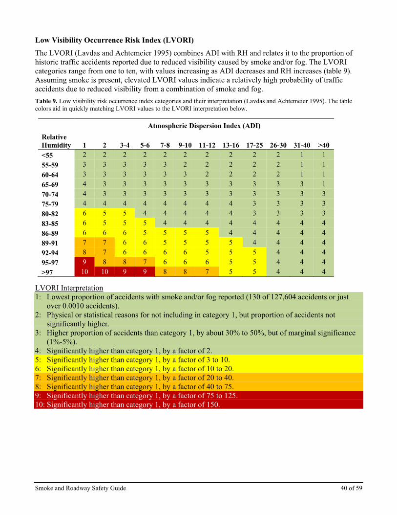
Smoke and Roadway Safety Guide 40 of 59
Low Visibility Occurrence Risk Index (LVORI) The LVORI (Lavdas and Achtemeier 1995) combines ADI with RH and relates it to the proportion of historic traffic accidents reported due to reduced visibility caused by smoke and/or fog. The LVORI categories range from one to ten, with values increasing as ADI decreases and RH increases (table 9). Assuming smoke is present, elevated LVORI values indicate a relatively high probability of traffic accidents due to reduced visibility from a combination of smoke and fog. Table 9. Low visibility risk occurrence index categories and their interpretation (Lavdas and Achtemeier 1995). The table colors aid in quickly matching LVORI values to the LVORI interpretation below.
Atmospheric Dispersion Index (ADI) Relative Humidity
ADI 1
ADI 2
ADI 3-4
ADI 5-6
ADI 7-8
ADI 9-10
ADI 11-12
ADI 13-16
ADI 17-25
ADI 26-30
ADI 31-40
ADI >40
<55 2 2 2 2 2 2 2 2 2 2 1 1 55-59 3 3 3 3 3 2 2 2 2 2 1 1 60-64 3 3 3 3 3 3 2 2 2 2 1 1 65-69 4 3 3 3 3 3 3 3 3 3 3 1 70-74 4 3 3 3 3 3 3 3 3 3 3 3 75-79 4 4 4 4 4 4 4 4 3 3 3 3 80-82 6 5 5 4 4 4 4 4 3 3 3 3 83-85 6 5 5 5 4 4 4 4 4 4 4 4 86-89 6 6 6 5 5 5 5 4 4 4 4 4 89-91 7 7 6 6 5 5 5 5 4 4 4 4 92-94 8 7 6 6 6 6 5 5 5 4 4 4 95-97 9 8 8 7 6 6 6 5 5 4 4 4 >97 10 10 9 9 8 8 7 5 5 4 4 4
LVORI Interpretation 1: Lowest proportion of accidents with smoke and/or fog reported (130 of 127,604 accidents or just
over 0.0010 accidents). 2: Physical or statistical reasons for not including in category 1, but proportion of accidents not
significantly higher. 3: Higher proportion of accidents than category 1, by about 30% to 50%, but of marginal significance
(1%-5%). 4: Significantly higher than category 1, by a factor of 2. 5: Significantly higher than category 1, by a factor of 3 to 10. 6: Significantly higher than category 1, by a factor of 10 to 20. 7: Significantly higher than category 1, by a factor of 20 to 40. 8: Significantly higher than category 1, by a factor of 40 to 75. 9: Significantly higher than category 1, by a factor of 75 to 125. 10: Significantly higher than category 1, by a factor of 150.

Smoke and Roadway Safety Guide 41 of 59
Turner Stability Classes Turner Stability classes (sometimes referred to as Pasquill-Turner Stability classes) are a means of describing turbulence within the mixed layer that is generated at the ground either convectively due to surface heating or mechanically by air flowing over a rough surface. Turner Stability class is derived from the combination of wind speed, solar radiation, and cloud cover. These stability classes were first developed by Pasquill (1961), modified by Gifford (1961), then reformatted by Turner (1964) and are most commonly used in conjunction with air quality models to describe how plumes are likely to spread in both the vertical and horizontal directions. This makes it a useful system for gauging transportation safety-related stability as it addresses stability near the ground. Turner Stability classes (tables 10-12) represent the stability within the mixing layer and take into account wind speed, temperature, moisture, and other factors. It is comprised of classes A through G (or one through seven in some applications) defining different meteorological conditions characterized by wind speed and solar radiation during the day, and cloud cover at night. The conditions in these classes influence atmospheric turbulence which, in turn, influences smoke dispersion. Smoke will disperse best when the Turner Stability class is lower in the alphabet (or a lower number) and becomes worse as it increases, with class G (or 7) representing extremely stable atmospheric conditions and very poor smoke dispersion potential. Table 10. Turner Stability classes and their interpretation (Turner 1964).
Turner Stability Class Interpretation
A Extremely unstable
B Unstable
C Slightly unstable
D Neutral
E Slightly stable
F Stable
G Extremely stable

Smoke and Roadway Safety Guide 42 of 59
Table 11. Turner Stability classes during the day for strong, moderate, and slight incoming solar radiation levels, modified from Turner 1971.
Surface wind speed (33’ AGL) Strong
(sunny) Moderate
(partly cloudy) Slight
(cloudy)
Miles per hour
<4.5 A A-B B
4.5 to 6.5 A-B B C
6.5 to 11 B B-C C
11 to 13.5 C C-D D
>13.5 C D D
Table 12. Turner Stability classes at night, modified from Turner 1971.
Surface wind speed (33’ AGL)
Thinly overcast or ≥ 4/8 low clouds
≤ 3/8 Cloud
Miles per hour
<4.5 F G
4.5 to 6.5 E F
6.5 to 11 D E
11 to 13.5 D D
>13.5 D D

Smoke and Roadway Safety Guide 43 of 59
Modeling Decision Support Tools
Planned Burn-Piedmont (PB-Piedmont) PB-Piedmont is a land surface model designed to simulate smoke movement/dispersion near the ground under nighttime conditions. The smoke plume is simulated as an ensemble of particles that are transported by local winds over complex terrain characteristic of the shallow (30-50 m) interlocking ridge/valley systems typical of the Piedmont of the South. PB-Piedmont does not predict smoke concentrations because emissions from smoldering combustion are usually unknown. It is designed to work in the southern Piedmont but has applicability elsewhere where shorter-range surface smoke flow estimation is needed. It displays the simulated ground smoke on a map of the area that can be impacted. With the modeled weather and local topography, it shows where risks of 1) smoke crossing a road may occur, and 2) areas of smoke, fog, or fog and smoke occur. Both conditions can pose risk of smoke impaired visibility. Figure 15 displays an example PB-Piedmont run output assessing smoke drift and the modeled occurrence of smoke and fog. This web-based tool can be found at https://piedmont.dri.edu/.
Figure 15. PB-Piedmont run overlay for September 15, 2017, at 0730 am from Projection Point 1 created on September 14. Yellow dots display smoke drift while red dots display area of smoke and fog. Knowing the presence, location, and timing of smoke and smoke and fog combinations can facilitate the timely implementation of mitigation measures.

Smoke and Roadway Safety Guide 44 of 59
HYSPLIT Model Trajectories The HYSPLIT model (Draxler and Hess 1997, Draxler and Rolph 2015) computes simple air parcel trajectories. With trajectory modeling, HYSPLIT provides the user with the ability to examine potential smoke plume center-line travel in both the horizontal and vertical directions. This can help indicate the direction and extent of travel of wildland fire plumes. It is also useful for showing a plume potentially descending to the ground which may result in surface smoke that could cross a roadway. It’s important to remember that HYSPLIT trajectories represent the movement of air parcels thus it may or may not represent the movement of a heat-influenced smoke plume and does not represent smoke concentrations. Figure 16 shows an example output indicating smoke trajectories from releases (ignitions) at different times during the day using 500-meter initial trajectory height. Note the air parcel is predominantly traveling east by north east but contacting the ground (and potentially roadways) at different locations. For potential roadway impact assessment in non-complex terrain, consider using 10-meter or less if the MET file can support this initial trajectory height. For additional details on HYSPLIT, see the NWCG Smoke Management Guide for Prescribed Fire, PMS 420-3.
Figure 16. Plume rise varies by ignition time: A HYSPLIT model (Stein et al. 2015) results example assessing the varying nature of smoke trajectories from point-source ignition during a daytime burn.
Figure 17. Modeled PC HYSPLIT 10 meter trajectories initiated for 4 AM (blue line) and 6:00 AM (green line) showing the probable center lines of the ground level smoke plume from an actual superfog event. At 6:15 AM Highway 17 North of Jacksonville NC was closed (red lines). Visibility was observed at less than 10 feet.

Smoke and Roadway Safety Guide 45 of 59
WindNinja WindNinja is useful to assess wind flow at a high spatial resolution of 100-200 meters. This diagnostic wind model simulates terrain wind flow; it does not forecast wind flow, rather simulates the spatial variation of wind for a given time based on the meteorological input provided by the user. There are three ways to initiate WindNinja.
1. The first method is manually inputting a single wind speed and direction, such as wind from the northwest at 10 mph.
2. Secondly, WindNinja can read direct RAWS data format. Older WindNinja versions required users to input the wind data manually. The program now searches for weather sites in the area, then uses the surface wind data from a selected weather station to simulate terrain wind flow.
3. The last method is using wind data from weather prediction models (NWP), there are 20 different NWP the user can selected from; housed at the NOAA Operational Model Archive and Distribution System (NOMADS).
Whichever method the user decides to employ, WindNinja uses the input to produce a train flowing high-resolution surface wind field. Output from WindNinja is available for viewing on maps and used in fire simulation models. A common means to view the surface wind vectors includes Google Earth Pro—wind output *.kmz file; an option to output in GIS programs such as ArcView, ArcGisor, or QGis—shape file format *.shp, or FlamMap—in a *.asc. Grid file. WindNinja simulations may also enhance fire spread models like FARSITE and FlamMap—using the output *.asc grid files and *.atm atmosphere files. Figures 18-19 are examples of downscaled wind field using the High-Resolution Rapid Refresh (HRRR) weather prediction model for the Highland Fire in Arizona on 17 June 2017, at 0700 MST. The large arrows in figure 18 are the HRRR wind fields that initiate the WindNinja model. While the small square area in the center of the figure is the WindNinja downscaled wind domain. Figure 19 zooms in on the Highland Fire perimeter and the terrain flowing WindNinja wind field, the large wind vectors represent the HRRR winds. WindNinja started with HRRR 3-km wind fields and produced downscaled train following wind field at 200-meter resolution in this example.
Figure 18. Highland fire 17 June 2017, showing HRRR input wind field and WindNinja model domain.

Smoke and Roadway Safety Guide 46 of 59
Figure 19. Highland fire 17 June 2017, showing HRRR input wind field, large wind arrows, and WindNinja model wind field at 200 meters.

Smoke and Roadway Safety Guide 47 of 59
BlueSky Playground BlueSky Playground (figure 20) (https://pgv3.airfire.org/playground/v3/emissionsinputs.php) allows custom single fire smoke modeling. It provides wildfire and prescribed fire consumption and emissions calculations and a while-you-wait mechanism to model a simple smoke impact assessment using the HYSPLIT dispersion model. Only the Chrome web browser is needed to use this tool. Uses include a rapid-fire emissions calculator, an assessment of potential smoke impacts from a planned prescribed burn or anticipated wildfire growth, and capability to perform gaming or what-if analyses for emissions and smoke impacts under user-established conditions. Customization that is helpful for assessing roadway impacts includes:
• The type and quantity of fuel, fuel moisture,
• Fuel consumption parameters,
• Timing of the fire’s emissions throughout the day and night for both flaming and smoldering combustion phases,
• Plume rise and vertical allocation of emissions, and
• Choice of meteorology domains from high-resolution 1.33-km to 12-km continental-scale dependent on location and choice of model dates from historical to forecast.
Figure 20. An example of BlueSky Playground output showing ground-level fire smoke impacts to a roadway.

Smoke and Roadway Safety Guide 48 of 59
VSmoke VSmoke-GIS (figure 21) is a tool that estimates downwind emission concentrations and visibility, primarily intended to represent the effects of a single prescribed fire (Lavdas 1996). It generates an estimate of emissions, plume rise, and dispersion based on a Gaussian plume dispersion model, which indicates smoke concentrations at distances directly downwind from the fire. Visibility (figure 22) is estimated at the same downwind distances as emissions. ADI, Turner Stability, and LVORI values are also generated. The VSmoke-GIS tool is used extensively by managers in the southeast but is applicable elsewhere; however, it was not designed for complex terrain. VSmoke-GIS can be downloaded from the Forest Service Region 8 or Region 9 Air Resource Management website (U.S. Forest Service, Air Resource Management 2015). There is also an online version, VSmoke-Web, (http://weather.gfc.state.ga.us/GoogleVsmoke/vsmoke-Good2.html) which can be run online. A VSmoke user guide is available from the Georgia Forestry Commission’s website, and a North Carolina version hosted by the NWCG Smoke Committee.
Figure 21. VSmoke-GIS output with varying concentrations of smoke crossing roadways.
Figure 22. Visibility from VSmoke which shows visibility estimated at the same downwind distances as emissions.

Smoke and Roadway Safety Guide 49 of 59
Estimated Smoldering Potential (ESP) The ESP model is a predictive tool developed to assist managers in evaluating the risk of smoldering combustion of organic soils in the pocosin/pond pine vegetation communities on the North Carolina coastal plain (Reardon et al. 2007). It uses soil properties and soil moisture to reflect the chance of continued smoldering after a successful ground ignition. The ESP model is not currently in operational use due to the lack of efficient means to monitor changing soil moisture conditions in the field with the spatial and temporal resolution needed. Remote sensing platforms from NASA may provide a future means of ESP calculation. The applicability of ESP to other peat areas is another future research possibility. Separate ESP models were developed for the root mat1 and muck2 soil horizons and are displayed in figures 23–24. The probability that root mat soils will smolder can be estimated for moisture contents between 0 and 200% (figure 23). Between 68% and 128% soil moisture content, the predicted ESP probability is most sensitive to moisture content. The probability that muck soil will smolder is modeled over a wider moisture content range than root mat soil, 0 to 300% (figure 24). Between 166% and 236% soil moisture, predicted ESP decreases rapidly from 79% to 21% and at 270% moisture the ESP is less than 7%. For more detail on the ESP, see the NWCG Smoke Management Guide for Prescribed Fire, PMS 420-3, https://www.nwcg.gov/publications/420-3, Practical Tools chapter.
1 Root mat soil horizon describes the upper organic soil horizon composed of small roots and moderately decomposed organic soil. 2 Muck soil horizon describes the lower organic soil horizon composed of highly decomposed sapric soils.
Figure 23. The ESP root mat model response assuming 5% mineral content. Dashed lines at 68% and 128% indicate where ESP is most sensitive to soil moisture content change.
Figure 24. Moisture content of muck soil can be used to estimate the smoldering potential. Dashed lines at 166% and 236% indicate where ESP is most sensitive to soil moisture content changes.

Smoke and Roadway Safety Guide 50 of 59
Superfog Analysis Model (SAM) The SAM is a product developed by the Joint Fire Science Program (JFSP) funded project “Superfog Formation: Laboratory Experiments and Model Development” (Princevac et al. 2013). The program use numeric and physical models as well as experiments to understand the formation of extremely low visibility smoke that, in extreme conditions, becomes superfog. The physical model verifies the meteorological parameters that support superfog formation and the density of small particles that limit roadway visibility. The findings support earlier research. In summary, the research determines the following meteorological parameters (table 13) are likely to produce superfog. Table 13. Summary of parameters likely to produce superfog from Princevac et al. 2013.
Parameter Superfog Conditions Droplet size <1 µm CCN concentration 105 #cm-3 Liquid water content >2 g kg-1 Ambient temperature <40oF (4.44oC) Ambient RH >80% Fuel moisture content >40% Wind velocity <1m s-1(2.2 mph)
The SAM is being further developed for operational use by University of Nevada, Reno Desert Research Institute. The meteorological inputs needed to assess superfog formation are derived from a weather prediction model like the North American Mesoscale Model (NAM) or by using data from the fire site if available. The output identifies the likelihood of superfog formation in the format of text boxes and graphs (figure 25). The project is anticipated to be completed by fall 2020.
Figure 25. Example output from SAM, which is currently being modified for operational use.

Smoke and Roadway Safety Guide 51 of 59
References Achtemeier G.L. 2008. Effects of moisture released during forest burning on fog formation and implications for visibility. Journal of Applied Meteorology and Climatology, 47, 1287-1296. Department of Interior, Bureau of Land Management and Department of Agriculture, Forest Service, 2018. Interagency Standards for Fire and Fire Aviation Operations. NFES 2724. https://www.nifc.gov/policies/pol_ref_redbook.html van Donkelaar, Aaron; Martin, Randall V, Brauer, Michael; Kahn, Ralph; Levy, Robert; Verduzco, Carolyn; Villeneuve, Paul J. 2010. Global estimates of ambient fine particulate matter concentrations from satellite-based aerosol optical depth: development and application. Environmental Health Perspectives. https://ehp.niehs.nih.gov/0901623/. (Accessed 23 March 2018.) Draxler, R.R.; Hess, G.D. 1997. Description of the HYSPLIT_4 Modeling System. NOAA Tech. Memo. ERL ARL-224. Silver Spring, MD. NOAA Air Resources Laboratory. 24 pp. Draxler, R.R.; Rolph, G.D., 2015. HYSPLIT—HYbrid Single-Particle Lagrangian Integrated Trajectory Model. http://ready.arl.noaa.gov/HYSPLIT.php. (15 January 2018). Gifford, F.A., Jr. 1961. Use of Routine Meteorological Observations for Estimating Atmospheric Dispersion. Nuclear Safety, 2:47-51. Lavdas, L.G. 1997. Accuracy of National Weather Service wind-direction forecasts at Macon and Augusta, Georgia. National Weather Digest, 22(1):22-26. Lavdas, L.G. 1996. Improving control of smoke from prescribed fire using low visibility occurrence risk index. USDA Forest Service, Southern Research Station, Dry Branch, GA. Southern Journal of Applied Forestry, 20(1):10-14. Lavdas, L.G. and Achtemeier, G.L. 1995. A Fog and Smoke Risk Index for Estimating Roadway Visibility Hazard. USDA Forest Service, Southern Research Station, Dry Branch, GA. National Weather Digest, 20(1):26-33. Lavdas, L. (1986). An atmospheric dispersion index for prescribed burning. Research Paper SE-256. Asheville, NC. USDA Forest Service, Southeastern Forest Experiment Station. 33 pp. Mobley, Hugh E. [senior compiler] (1976). Southern Forestry Smoke Management Guidebook. General Technical Report GTR-SRS-010, USDA Forest Service, Southern Forest Experiment Station. https://www.srs.fs.usda.gov/pubs/viewpub.php?index=683. National Climatic Data Center. 2005. Slide presentation available at: https://www1.ncdc.noaa.gov/pub/data/images/olstore/SelClimMapsPubOnlineReduced_3.pdf. (Accessed 2 March 2018.) National Park Service. 1991. Fire Monitoring Handbook, Chapter 2, Minimum Acceptable Visibility table. https://www.frames.gov/catalog/57700. National Wildfire Coordinating Group. NWCG Smoke Management Guide for Prescribed Fire. PMS 420-3, https://www.nwcg.gov/publications/420-3. National Wildfire Coordinating Group. Prescribed Fire Complexity Rating System Guide. PMS 424, https://www.nwcg.gov/publications/424.

Smoke and Roadway Safety Guide 52 of 59
National Wildfire Coordinating Group. Interagency Prescribed Fire Planning and Implementation Procedures Guide. PMS 484. https://www.nwcg.gov/publications/484. Pasquill, F. 1961. The estimation of the dispersion of windborne material. Meteorological Mag. 90, 33-49. Paul, J.T.; Lavdas, L.G.; Wells, W. 1987. Use of general weather and dispersion index to minimize the impact of smoke on highway visibility. Georgia Forest Research Paper 69, Research Division Georgia Forestry Commission. Princevac, M.; Weise, D.; Venkatram, A.; Achtemeier, G.; Mahalingam, S.; Goodrick, S.; Bartolome, C. 2013. Superfog Formation: Laboratory Experiments and Model Development. Final Project Report for Project ID: 09-1-04-5. Prepared for: Joint Fire Science Program. Available online: https://www.firescience.gov/projects/09-1-04-5/project/09-1-04-5_final_report.pdf. Reardon, J.; Hungerford, R.; Ryan, K. 2007. Factors affecting sustained smoldering in organic soils from pocosin and pond pine woodland wetlands. International Journal of Wildland Fire, 16(1): 107-118. Stein, A.F.; Draxler, R.R.; Rolph, G.D.; Stunder, B.J.B; Cohen, M.D. Ngan, F. 2015. NOAA's HYSPLIT atmospheric transport and dispersion modeling system, Bull. Amer. Meteor. Soc. 96: 2059-2077 Turner, D.B. 1971. Workbook of atmospheric dispersion estimates. Office of Air Programs. Publication AP-26. 84 pgs. Turner, DB. 1964. A diffusion model for an urban area. Journal of Applied Meteorology, 3:83-91. USDA, Forest Service. 2015. VSmoke and VSmoke-GIS Smoke Dispersion Models. http://webcam.srs.fs.fed.us/tools/vsmoke/index.shtml. (15 January 2018.) Wade, Dale and Mobley, Hugh, 2007. Managing Smoke at the Wildland-Urban Interface. Gen. Tech. Rep. SRS-103. Asheville, NC. USDA, Forest Service, Southern Research Station. 28 p. Wildland Fire Decision Support System [WFDSS]. 2018. Wildland Fire Decision Support System home page. https://wfdss.usgs.gov/wfdss/WFDSS_Home.shtml.

Smoke and Roadway Safety Guide 53 of 59
Appendix 1 – Roadway Visibility Forecast (RVF) Checklist The Roadway Visibility Forecast (RVF) checklist below provides guidance to develop an RVF. It can be customized to the scope of the wildland fire and its impacts.
� Incident Information: Include the fire name and type (wildfire or prescribed).
� Forecast Information: Date of forecast, operational period, preparer’s name and signature (optional).
� Smoke Synopsis: A brief survey of the overall smoke situation including what has happened and what is expected to happen. Be sure to highlight any critically forecasted smoke event using font, boldness, or other formatting. Weather conditions can be mentioned as they will dictate smoke dispersion. Key topography that can influence surface smoke movement can also be mentioned. Clearly describe what needs to be communicated to drivers.
� Smoke Plume Area: Present this visually (photograph, map, or KML file from model results or GIS overlay) and in text with local names and plume extent. What is the localized overall impact area for smoke for a 24-hour period? The more serious area for smoke impacts and reduced visibility can be mentioned in text and highlighted.
� Specific Information: Use text to identify major smoke source locations, roadways impacted, and the specific roadways expected to receive the most severe visibility reduction.
� Roadways Affected: If it’s necessary or convenient, identify the roadways by quadrants (North, East, West or South) by using photographs and/or maps (i.e. Google Earth would be excellent for this).
� Safety Message: Make a statement as to driving safety (e.g., reduce driving speed, use alternative routes, plan for delays, longer driving times). If available, reference applicable NWS products (i.e., Advisories, Special Weather Statement, etc.,) or use of MAV stopping distance and vehicle speed, or use of additional public information outlets (e.g., radio, TV, etc.). If the RVF indicates potential hazard, coordinate with appropriate authorities (IMT, Agency Administrator, PIO, LOFR, etc.) and collaborate with the NWS to release an advisory or special weather statement.

Smoke and Roadway Safety Guide 54 of 59
Appendix 2 – Roadway Response Plan (RRP) Process and Checklist The following provides general guidance for developing an RRP. The level of detail, complexity, and scale should be determined by each administrative unit’s needs and each incident’s uniqueness. An RRP with multiple critical transportation corridors and high complexity could be placed in an FMP and intended for pre-season coordination; while an RRP developed for a specific wildland or prescribed fire with a single critical area of concern may not need the level of detail required with complex incidents. The RRP is an optional but important tool to help fire managers better prepare for situations where smoke could impair visibility and become hazardous to travelers. Preparing a unit level RRP can be time well spent as these can be easily incorporated into prescribed fire plans or other wildland fire implementation plans, saving preparers of those plans considerable time, effort, and reducing risk.
Step 1 – Complete the Roadway Smoke Risk Assessment Process: When roadways are subject to smoke impacts, the Roadway Smoke Risk Assessment Process is an essential part of every RRP (simple or complex) and should be completed. Use of this assessment can be independent of an RRP or indicate the need for an RRP. The Roadway Smoke Risk Assessment Process is composed of a series of steps to identify and assess roadway visibility conditions and risks. Each of the steps in the process can be used to determine trigger points for contingency planning and monitoring of conditions on a daily basis.
� If, after the process is completed and determination of no risk or minimal risk of smoke impacts to roadways is made, no further action is required. However, the process must be performed continually until smoke poses no threat to roadways. Be sure to take steps for continual monitoring of smoke conditions (fire behavior, meteorological, air quality, roadway visibility).
� If results of the Roadway Smoke Risk Assessment Process reveal transportation routes likely to be at risk of smoke impacts, subsequent follow-up actions are needed:
• Review the RRP for the area and implement identified actions.
• If an RRP is not available, use the Step 2 checklist below to develop an RRP.
Step 2 – RRP Development Checklist: � General Information: Unit or Wildland Fire Name and type (prescribed or wildfire), RRP
completion date, operational time frame (if applicable).
� Specific Information: Identify the actions pertaining to meteorology, modeling, monitoring, and messaging that are to be addressed.
� Location of Potential Smoke Impacts: Identify both general and specific locations where smoke/road hazards exist or are forecasted. Provide road designations (numbers, names, etc.), mile marker numbers, general areas, topographic features, intersections, etc. Unit level RRPs may identify locations of historical smoke impacts to transportation routes. Use information from the Roadway Smoke Risk Assessment Process including the RVF to identify potential impacts and provide the necessary information needed for decision support to mitigate hazards and respond to impacts.
• Monitoring Requirements: Use the Where, When and How information identified in the Monitoring section of the Planning and Responding to the Hazard chapter of this publication to help develop monitoring requirements related to potential locations, impacts, and identified MAPs.

Smoke and Roadway Safety Guide 55 of 59
• MAPs: Clearly outline thresholds or trigger points to implement risk mitigation actions when smoke impacts roadways at a location.
• Risk Mitigation Actions: List mitigation activities required if MAPs are reached, include special processes or procedures required to implement actions (roadway closure or sign placement process, etc.).
• Permissions: Obtain any permissions required to implement actions as necessary to meet public safety requirements (such as signs or guards for temporary traffic control operations).
• Responsibilities: Identify who takes identified actions such as placing signs, monitoring, road guards, etc., including making required notifications to authorities, communities, local and state governments, and others.
• Notifications and Contacts: Complete list of personnel as needed. For example, IMT personnel, local and regional authorities, transportation departments, media, communities, local city, county, state, and/or tribal governments.
• RRP Recipients: List the personnel, authorities, contacts, etc., that the RRP should be provided to (include local or regional dispatch offices).
• Signatures: The RRP should be approved and signed by the appropriate authority. For example, Planning Section Chief, IC, Agency Administrator, or point of contact, state agency, etc.

Smoke and Roadway Safety Guide 56 of 59
Appendix 3 – MAP Template for Incidents Below you will find a template with guidance and examples for a typical MAP.
Template: MAP for Reduced Roadway Visibility MANAGEMENT ACTION POINT #_____Reduced Roadway Visibility
• Cost: (for specific actions like obtaining/using pilot car, installing a monitor, signage, etc.)
• Activated Date:
• Deactivated Date: CONDITION:
• Values at Risk: Describe the values at risk if the MAP is reached. For example: Public and firefighter transportation safety at risk due to reduced roadway visibility on XX (specified roadways).
• Intent of MAP: Describe why MAP is important. For example, maintain roadway safety by evaluating reduced roadway visibility and implementing actions to reduce smoke hazards.
• Trigger Condition: Identify the conditions that will require the implementation of actions. Some examples include: o A road is 10 miles or less from the fire perimeter and smoke is being transported towards it
(via drainage or direct transport). o Smoke is beginning to impact a roadway. o Nighttime inversion conditions are forecasted or anticipated. o Fire is burning adjacent to the road. o Weather conditions are approaching thresholds that support superfog formation. o Cumulative impacts of multiple fires on roadways in the area.
ACTION: Describe recommended actions to be taken if a MAP is reached. Some examples could include:
• Develop or implement an RRP or mitigation actions that outline when and how to respond to smoke visibility impacts on roadways.
• Placement of road monitoring personnel and/or equipment (describe strategic positions) to detect smoke transport across roadways during day and night periods.
• Contact local law enforcement, road maintenance agencies, IMT personnel, etc., to implement day and night roadway patrols or mitigation actions.
• Set up a network of reliable non-incident/IMT personnel who can report on deteriorating roadway visibility.
• When visibility is compromised take necessary actions as specified by MAV guidance (signs, reduce speed limits, pilot car systems, partial lane closures, road closures, use of unoccupied lighted law enforcement vehicles, etc.).
• When severe reduction in visibility is forecasted or occurs, corroborate the forecast with NWS personnel to issue a special weather statement (SPS).

Smoke and Roadway Safety Guide 57 of 59
• Work with PIO and LOFR to develop media notifications of reduced roadway visibility and attend community meetings to assist in informing the public as appropriate.
RESOURCES RECOMMENDED: Describe the resources or capability needed to carry out the recommended actions. Examples could include:
• Operations Section Chief, LOFR, SOFR, dispatch, etc., to make required contacts to implement recommended actions.
• Four road monitors with radios.
• Two pilot cars and road guards.
• Two electronic message signs.

Smoke and Roadway Safety Guide 58 of 59
Appendix 4 – Expanded Assessment for Potential Risk (EAPR) Below is a printer-friendly version of the EAPR. Note that information may not be available for all of the variables below, the matrix is a tool to guide decisions.
Weather Elements & Indices to Evaluate
Questions (Y/N) Thresholds
& Indices
(watchout/critical)
Critical Threshold Reached (Yes/No)
Specific Hours occur & when do
hours coincide (Hrs. & Yes/No)
Comments (Weather and/or Smoke Models
agree?)
Tier 1. Basic questions to ask to see if wildland fire smoke may impact roadways
1 Are there roadways within 10 miles of the smoke source/fire site?
(Y/N) 0-3 mi. critical
4-7 mi. watchout 7-10 mi. be Aware
2 Are winds blowing smoke towards the roadway with potential for direct impacts or plume collapse?
(Y/N)
3 Are drainages leading from fire site forming a direct smoke pathway to a roadway?
(Y/N)
4 Time of possible roadway smoke impacts?
Nighttime – critical (2 Hrs after sunset to 2
Hrs after sunrise)
Daytime – watchout
5 Are there extended smoldering fuels?
(Y/N) Nighttime – critical Daytime – watchout
Tier 2. Evaluate these four weather elements as a set. Threshold of watchout to critical corresponds with increasing likelihood for conditions that further decrease roadway visibility through dense smoke, smoke-induced fog, or superfog
formation. 5 Surface air temperature ≤ 55⁰ F – critical
≤ 70⁰ F – watchout
6 Surface relative humidity (RH)
≥ 90% – critical ≥ 70% – watchout
7 Surface wind speed ≤ 4 – critical < 7 mph – watchout
8 Percent cloud cover < 40% – critical < 60% – watchout
Tier 3. Evaluate these indices to further support the likelihood of critical visibility reduction as caused by dense smoke, smoke-induced fog, or superfog).
9 Stability or Turner Stabilitya
Stable or E, F, or G – critical Neutral or D – watchout
10 Night Atmospheric Dispersion Index (ADI)
≤ 5 – critical < 10 – watchout
11 Low Visibility Occurrence Risk Index (LVORI)
≥ 9 – critical ≥ 7 – watchout
12 Superfog Potential ≥ 80% – critical ≥ 70% – watchout
a Turner Stability (TS), mixing height, and transport wind speed are inputs to calculate ADI. Stability is an important consideration that influences smoke dispersion. Turner Stability bolsters the interpretation and overall assessment of smoke dispersion. To obtain TS, call your local NWS Forecast Office.
Smoke and Roadway Safety Guide 59 of 59
The Smoke and Roadway Safety Guide is developed and maintained by the Smoke Committee (SmoC), an entity of the National Wildfire Coordinating Group (NWCG). Previous editions: first edition. While they may still contain current or useful information, previous draft editions are obsolete. The user of this information is responsible for confirming that they have the most up-to-date version. NWCG is the sole source for the publication. This publication is available electronically at https://www.nwcg.gov/publications/477. Comments, questions, and recommendations shall be submitted to the appropriate agency program manager assigned to the Smoke Committee. View the complete roster at https://www.nwcg.gov/committees/smoke-committee/roster. Publications and training materials produced by NWCG are in the public domain. Use of public domain information, including copying, is permitted. Use of NWCG information within another document is permitted if NWCG information is accurately credited to NWCG. The NWCG logo may not be used except on NWCG authorized information. “National Wildfire Coordinating Group,” “NWCG,” and the NWCG logo are trademarks of NWCG. The use of trade, firm, or corporation names or trademarks in NWCG products is solely for the information and convenience of the reader and does not constitute endorsement by NWCG or its member agencies of any product or service to the exclusion of others that may be suitable. This NWCG publication may contain links to information created and maintained by other non-federal public and/or private organizations. These organizations may have different policies from those of NWCG. Please note that NWCG does not control and cannot guarantee the relevance, timeliness, or accuracy of these outside materials.