CONVECTIVE INITIATION WFO MIAMI. 50-60 in Hendry and Glades county. 50 in North Collier county. 30...
17
CONVECTIVE INITIATION WFO MIA MI
-
Upload
henry-nicholas-sims -
Category
Documents
-
view
224 -
download
2
Transcript of CONVECTIVE INITIATION WFO MIAMI. 50-60 in Hendry and Glades county. 50 in North Collier county. 30...

CONVECTIVE IN
ITIA
TION
WF O
MI A
MI
50-60 in Hendry and Glades county. 50 in North Collier county. 30 and 70 in Palm Beach county.
Storms affected the Palm Beach area and storms formed in Hendry and Collier later that afternoon. = No convection was detected until 19:05. These storms originally formed just South of the area and eventually moved North into this area. The false lead time for this area was 93 minutes.
7/12/12 17:32
Palm Beach
Broward
Miami-DadeMonroe
Collier
Glades
Hendry
Signal Strength Evolution
(True Lead time, white circles, is 30 minutes)
Case 1
Note: The evolution of the signal strength needs to be analyzed carefully not to attribute false long lead times to it.

7/12/12 18:02 RADAR IMAGERY
Case 1

7/12/12 19:05 RADAR IMAGERY
Case 1

40 in Miami-Dade. 50 in Broward. 60 in Southern Hendry county.
Cloud cover slowly swept Miami and Fort Lauderdale which is why the signals went down. =Didn’t see convection in this area until 16:26. The storms actually formed south of this area. False lead time for this area was 101 minutes. =Didn’t see any convection in this area within a 2 hour period.
7/12/12 14:45
Palm Beach
Broward
Miami-Dade
Monroe
Collier
Glades
Hendry
Signal Strength Evolution
Case 2

7/12/12 15:42 RADAR IMAGERY
Case 2

7/12/12 16:26 RADAR IMAGERYCase 2

70-90 in West Miami-Dade county. 20-40 in East Miami-Dade county. 60-70 in Monroe county. 20 in Southern Broward county. 80 in Northern Collier county.
Signals strengthened for much of the region. Storms continued to develop in Miami-Dade and Collier county.
= No convection was seen until 18:05. The storms formed in this area. The false lead time for this area was 110 minutes.
7/16/12 16:15Signal Strength Evolution
(True Lead time, white circles, is 15-20 minutes)
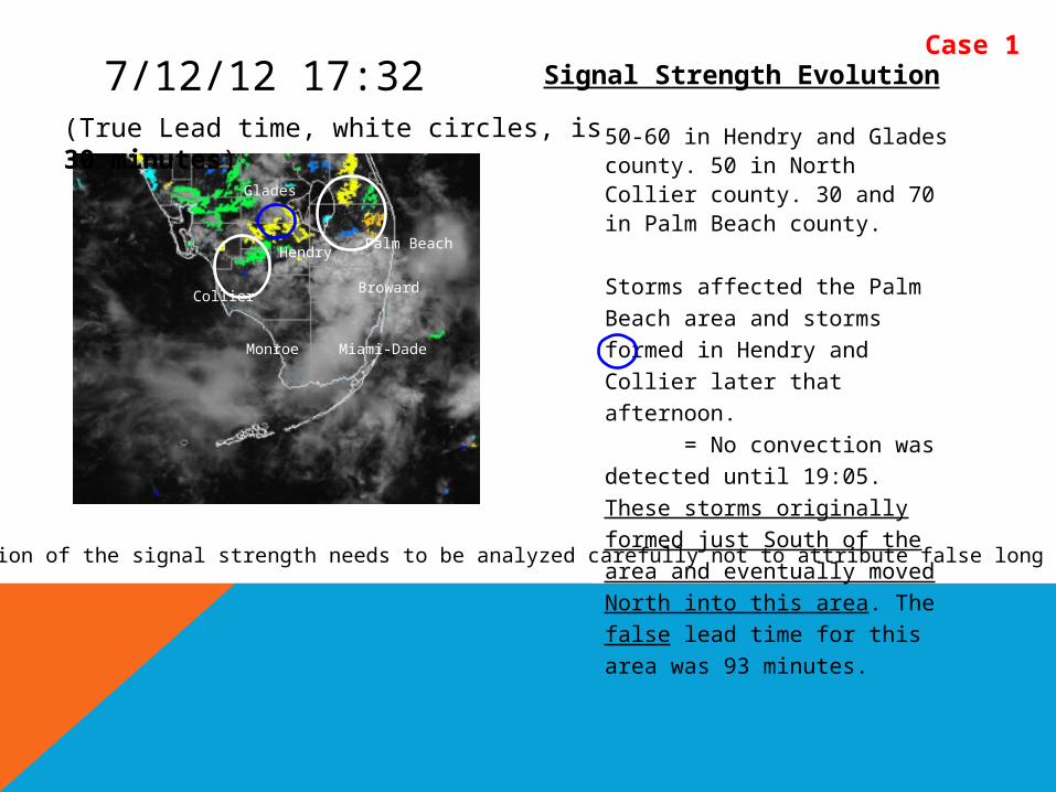
Case 3
Note: The evolution of the signal strength needs to be analyzed carefully not to attribute false long lead times to it.Even with slow sea-breeze convection true lead times did not exceed 30 to 45 minutes.

7/16/12 16:32 RADAR IMAGERY Case 3
7/16/12 18:05 RADAR IMAGERYCase 3

40-80 in Miami-Dade county. 80 in Monroe county. 40-50 in Collier county. 50-70 in Glades county. 30-70 in Broward county.
Larger storms developed in Miami-Dade and Glades. Storms affected Collier and Western Miami-Dade.
= There was a little bit of convection on the right side of the large orange area but not anywhere else until 18:43. The storms eventually formed here. The false lead time was 118 minutes.
7/16/12 16:45
Hendry
Glades
Collier
Palm Beach
Broward
Miami-DadeMonroe
Signal strength Evolution
(True Lead time, white circles, is 15-20 minutes)
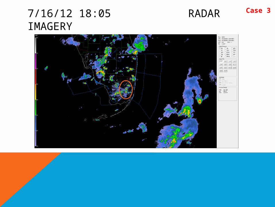
Case 4
Note: The evolution of the signal strength needs to be analyzed carefully not to attribute false long lead times to it.The trend is important.

7/16/12 17:00 RADAR IMAGERY
Case 4
7/16/12 18:43 RADAR IMAGERYCase 4

70 in most of Broward and in parts of Miami-Dade and Monroe. 60 in Eastern Miami-Dade. 90 in Western Miami-Dade and Glades. 50 in Collier and Northern Broward. 20 in Hendry.
Storms moved East in Miami-Dade, Collier, and Glades county. Chances of storms increased across the region. Storms formed a large line in western Miami-Dade.
= No convection was detected until 17:56. The storms formed in this area. The false lead time was 54 minutes.
7/16/12 17:02
Palm Beach
Broward
Miami-DadeMonroe
Collier
Hendry
Glades
Signal Strength Evolution
= No convection was detected until 19:02. The storms formed in this area. The false lead time was 2 hours.
Case 5
(True Lead time, white circles, is 13-15 minutes)
Note: The evolution of the signal strength needs to be analyzed carefully not to attribute false long lead times to it.The trend is important.
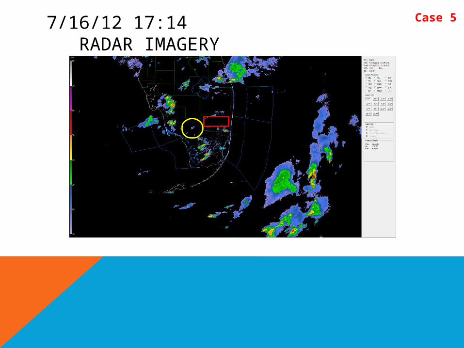
7/16/12 17:14 RADAR IMAGERY
Case 5
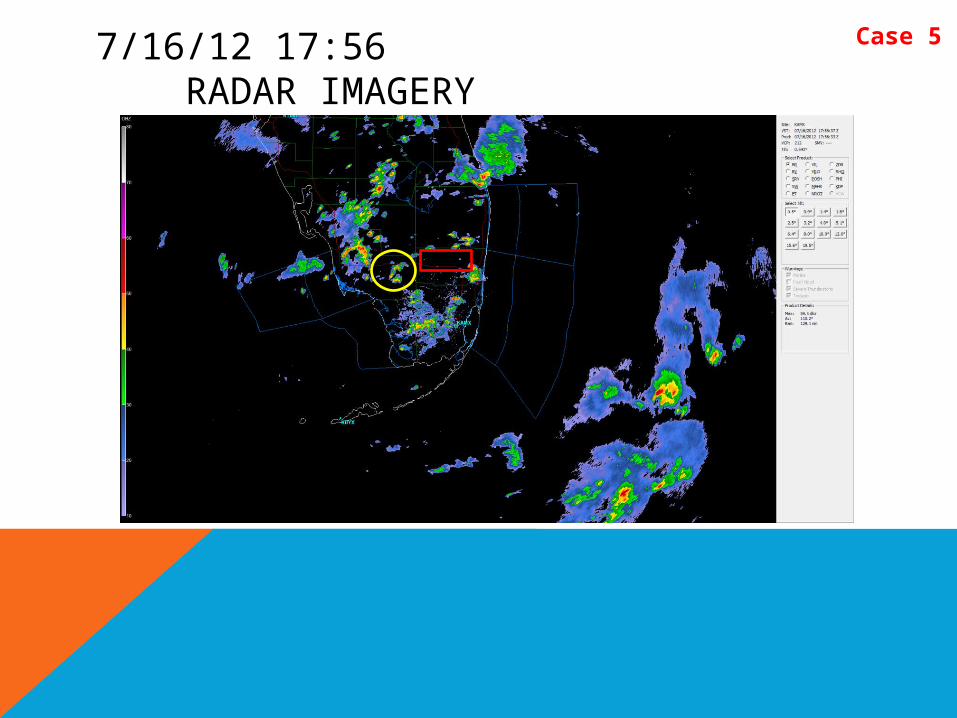
7/16/12 17:56 RADAR IMAGERY
Case 5

7/16/12 19:02 RADAR IMAGERY
Case 5