Contribution of Earth Observation (EO) to emerging ...
1
Contribution of Earth Observation (EO) to emerging environmental challenges in Africa Tobias Landmann 1 , Olena Dubovyk 2 1 International Centre of Insect Physiology and Ecology (icipe), Earth Observation Unit, Nairobi, Kenya, www.icipe.org; [email protected] & Centre for International Migration and Development (CIM), Eschborn, Germany, www.cimonline.de; [email protected] 2 Institute of Crop Science and Resource Conservation (INRES), University of Bonn, Katzenburgweg 5, 53115 Bonn, Germany, [email protected] Introduction The effects of emerging environmental problems associated with climate change and human-induced land cover change often directly impede livelihoods of the rural populace in Africa. Erratic rainfalls, flooding, forest cover loss, and land degradation are causing unstable agricultural yields and incomes. Earth Observation (EO) has the potential to monitor landscape dynamics in relation to climate or human-induced environmental ef- fects. Moreover, EO can provide seamless and integrative, that is multi-data and multi-scale, geo- spatial monitoring solutions that are of particu- lar use within data scarce environments (Figure 1). Figure 1: Integrative Earth Observation Figure 1 (left) : We define Earth Observation (EO) as an integrative, dynamic and bi-directional concept . Herein several data sets or information levels can be used in an integrative way to create products. Users can access EO-based products through a web-portal (or interface) or various data sets can be directly ac- cessed and utilized. The challenge is to determine the degree of overlap between the various data sets and how to deal with redundancies. Full contact address: Tobias Landmann, Earth Observation Unit- Adaptation to Climate Change & Ecosystems (ACCES) cluster, International Center of Insect Physiology and Ecology (icipe), Duduville, P.O. Box 30772, 00100 Nairobi, KENYA; Phone: +254 (0)20 8632716, Fax: +254 (0)208632001/2, Mobile: +254 (0)715 286 949 Acknowledgements: We thank David Makori and Gladys Mosomtai for data processing and the University Helsinki, Geomatics Department, for hyperspectral data acquisitions and pre-processing, specifically Rami Piiroinen and Professor Petri Pellikka Objectives & Approach This paper illustrates examples, possibilities and future perspectives from current EO research to address emerging environmental issues in Africa . Two experimental EO examples from eastern Africa are presented; 1) A multi-sensor approach to map human–induced vegetation productivity decline over eastern Africa, and 2) An integrative (multi-data) approach to map the spatial distribution of flowering plants at a local to landscape scale. 1) 2) 1) A multi-sensor approach to map human-induced vegetation productivity decline over eastern Africa In the first example a vegetation productivity decline map is produced for a study region in eastern Africa using time-series of 250-meter MODIS NDVI (Normalized Differential Vegetation Index) imagery (from 2001 to 2012). The vegetation productivity map is related to very high resolution (VHR) imagery in Google Earth to confirm if the vegetation productivity is indeed caused by human-induced land transformation processes such as deforestation or conversions of near-to-natural savanna to croplands. Linear (per pixel) trends were computed from the annual NDVI and Rainfall (RF) means. The RF trends were derived from passive radar TRMM (Tropical Rainfall Measuring Mission) time-series satellite data sets (from 1998 to current). Rain Use Efficiencies (RUE) were furthermore computed for each pixel to map areas of particular ‘severe’ productivity decline. RUE is defined as the ratio between vegetation productivity (NDVI) and rainfall (from TRMM). The MODIS-based productivity data could be effectively linked to land transformation processes (i.e. “Deforestation”) using the bi-temporal VHR imagery. Negative trends from the TRMM rainfall observations, are used to mask areas where a decrease in rainfall can be considered the key driver for negative vegetation productivity trends. Figure 2: Productivity mapping workflow Figure 2 (left) shows the multi-data and multi-scale vegetation productivity mapping approach used over eastern Africa. The arrows are data linkages. The checked box illustrates input data, square boxes are output products and ellip- ses are processing steps. Areas of negative RF trends were excluded, masked, from the final map since we are only interested in mapping human-induced change. Figure 3: NDVI/RF trends illustration Figure 3 (right) illustrates a negative linear NDVI trend for one selected pixel in the data set. The x-axis is the number of years, whilst the y-axis is the mean annual NDVI (or rainfall (RF)) trend. For each linear trend the coefficient of determination (R 2 ) was also computed. Low significant trends (pixels) were excluded from the final mapping result. 2) Multi-data approach to map the spatial & temporal distribution of flowering plants In the second example a workflow is devised to map the distribution and abundance as well as floral cycle of melliferous (flowering) plants in semi -arid Africa. Airborne AISA hyperspectral data (440nm to 990nm), smartphone geo-tagging of flowering plants in the field and spectral mixture modeling as well as scaling is used in an integrative way. A 100km 2 area in north-eastern Kenya (Mwingi) is chosen as an experimental study site. Figure 4: Integrative flower and the floral cycle mapping workflow The data sets and integration techniques are presented in Figure 4 (left). Two aircraft mounted hyperspectral campaigns in February 2013 (peak of the flowering season) and in January 2014 (beginning of the flowering season) were conducted respectively. Spectral mixture modeling (SMM) was performed by extraction spectral ‘pure’ endmembers (EM) of flower- ing tree and shrub species from the AISA imagery. The spectral EM are shown in the bottom right in Figure 4. A linear unmixing algorithm was applied to map abundances of flowering plants. The more than 100 flow- ering reference plants from the field geo-tagging exercise were used in as- sessing the accuracy of the final result (i.e. flower map). Figure 5: Up– and down-scaling options Figure 5 (right) shows how spectral EMs can be up– or down-scaled for physical and repeat- able monitoring of the floral cycle using for instance satellite imagery. In the up-scaling part (top right in Figure 5), the spectral EM for ‘green’ tree, flowering tree and bare soil are “fitted” to simulate a multi-spectral image. In this study we re-sampled the AISA EM to the specifica- tions of a multi-spectral 2-meter resolution Worldview-2 image. In the down-scaling part (bottom left) the same EM are used in the AISA 0.6-meter imagery for sub-pixel abundance mapping (downscaling) of the same features. Results & Discussion 1) Integrative approach for mapping human-induced vegetation productivity decline in eastern Africa Figure 6a below shows the final vegetation productivity map for eastern Africa between 2001 and 2012. Figure 6b shows the Mau Forest area in Kenya specifically, where mostly deforestation was found to the enabling factor for vegetation productivity decline. As negative rainfall trends were masked out the productivity declines can be largely attributed to human activity. This was further confirmed by the very high resolution imagery (VHR) in Google Earth (GE). Figure 6c shows how the vegetation productivity map can be used to map deforestation, selective logging as well as afforestation for the Kakamega forest area in Kenya. County Governments can use the map to control deforestation and instigate interventions. Figure 6: Final vegetation productivity decline map over eastern Africa (2001-2012) a) b) Areas where the RUE was particularly low were mapped as ‘severe’. From the reference data comparison, areas of ‘severe’ transformation were mostly due to conversion of wetlands to agricultural areas, and conversion from savannas to bare sur- faces. c) Figure 7: In GE discernible change between 2001 and 2009 Figure 7 (right) shows how areas of human-induced change were extracted from the VHR reference data in GE. Only clearly discernible land transformation processes (change) in the bi-temporal GE VHR imagery were considered for the cross-referencing. The respective MODIS pixel was overlaid on the VHR imagery (white box in Figure 7). We attained an overall accuracy of 87% for wetland conversion, and 80 % for ‘savanna to bare soil’ land changes. Deforestation was mapped with an overall accuracy of 78% when using the GE imagery as reference data to cross-verify the MODIS productivity decline map. 2) Integrative flower mapping results for a test site in Kenya Figure 8 below shows the spectral unmixing result (abundance map) for the spectral endmembers (EM) flowering tree (in red), ‘green’ tree (green) and bare soil (blue shades). The sub-pixel EM abundance mapping means that essentially the spectral information is downscaled to produce a soft classification result. Figure 8: Abundance map (downscaling result) for the endmembers ‘green’, flowering tree, and bare soil Figure 8, left, illustrates that the flower- ing intensity of trees and shrubs is higher within riverside vegetation. Sparsely flowering shrubs, visible in pink shades throughout the map (Figure 8), are found scattered through- out the landscape. Knowledge about the distribution and abundance of flow- ering trees in the landscape, in view of the net value of flowering plants for honey flow and production, would in- evitable serve as a incentive for their protection Figure 9, right, shows the tree and flowering plant species that we mapped in the field using Smartphone geo-tagging. The smartphone based field data, collected simultaneously to the two AISA hyerspectral acquisitions, serves as a validation source but the data can also be used to develop a site specific floral calendar. We found an overall accuracy of 98% for hyperspectral mapping of riverside flowering Acacia tortilis. Lower accuracies were found for mapping other flowering species, but in general all overall accuracies were above 55% for all species. The same EM as used in the downscaling were fitted (upscaled) to simulate a 2-meter World View-2 multi-spectral (MS) image (Figure 10) . Figure 10: Scaling AISA Eagle (HS) (0.60-m) to World View-2 (MS) (2-m) Figure 10, left (right image), shows the upscaling result. Green shades show ‘green’ non-flowering vegetation and ‘yellow’ pixels are flowering plants. A spectral weighting function was used to upscale the EM from the AISA Hyperspectral (HS) to fit the World-View 2 spectral and geometric configurations. The World-View 2 satellite system has a high temporal resolution, making regular and wide area monitoring of flowering vegetation essentially possible. Tropentag, September 17 - 19, 2014, Czech University of Life Sciences ,Prague, Czech Republic Conclusions 1. Up-to-date and wide-area land productivity decline and deforestation maps can be seamlessly and accurately derived from time- series satellite data and used by decision makers and resource managers to identify areas of concern and instigate land rehabilita- tion measures 2. Flowering maps offer an important insight into where bee keeping would be most optimal and, if a relationship can be established between honey flow and the availability of flowering plants in the landscape, flower maps can be utilized to support conservations in- centives 3. Combination of data sets, models and time-observations increases the effectiveness & robustness of integrative monitoring 4. Smart data integration techniques are paramount in seamless monitoring of emerging environmental issues in Africa • To offset data scarcity in Africa • Smartphone crowd-sourcing can be utilized to increase effectiveness & accuracy of EO monitoring routines; mobile phones in Africa will increase 20-fold in the next five years - double the rate of growth as in the rest of the world • Global Change in Africa often a function of small scale human and/or climate as well as abrupt, vs. gradual (subtle) change 2001 2009 ‘Green’ Tree Flowering Tree Bare soil
Transcript of Contribution of Earth Observation (EO) to emerging ...
Contribution of Earth Observation (EO) to emerging environmental challenges in Africa
Tobias Landmann1, Olena Dubovyk2
1International Centre of Insect Physiology and Ecology (icipe), Earth Observation Unit, Nairobi, Kenya, www.icipe.org; [email protected] & Centre for International Migration and Development (CIM), Eschborn, Germany, www.cimonline.de; [email protected]
2Institute of Crop Science and Resource Conservation (INRES), University of Bonn, Katzenburgweg 5, 53115 Bonn, Germany, [email protected]
Introduction The effects of emerging environmental problems associated with climate change and human-induced land cover change often directly impede livelihoods of the rural populace in Africa. Erratic rainfalls, flooding, forest cover loss, and land degradation are causing unstable agricultural yields and incomes. Earth Observation (EO) has the potential to monitor landscape dynamics in relation to climate or human-induced environmental ef-fects. Moreover, EO can provide seamless and integrative, that is multi-data and multi-scale, geo- spatial monitoring solutions that are of particu-lar use within data scarce environments (Figure 1). Figure 1: Integrative Earth Observation
Figure 1 (left) : We define Earth Observation (EO) as an integrative, dynamic and bi-directional concept . Herein several data sets or information levels can be used in an integrative way to create products. Users can access EO-based products through a web-portal (or interface) or various data sets can be directly ac-cessed and utilized. The challenge is to determine the degree of overlap between the various data sets and how to deal with redundancies.
Full contact address: Tobias Landmann, Earth Observation Unit- Adaptation to Climate Change & Ecosystems (ACCES) cluster, International Center of Insect Physiology and Ecology (icipe), Duduville, P.O. Box 30772, 00100 Nairobi, KENYA; Phone: +254 (0)20 8632716, Fax: +254 (0)208632001/2, Mobile: +254 (0)715 286 949 Acknowledgements: We thank David Makori and Gladys Mosomtai for data processing and the University Helsinki, Geomatics Department, for hyperspectral data acquisitions and pre-processing, specifically Rami Piiroinen and Professor Petri Pellikka
Objectives & Approach This paper illustrates examples, possibilities and future perspectives from current EO research to address emerging environmental issues in Africa. Two experimental EO examples from eastern Africa are presented; 1) A multi-sensor approach to map human–induced vegetation productivity decline over eastern Africa, and 2) An integrative (multi-data) approach to map the spatial distribution of flowering plants at a local to landscape scale. 1) 2)
1) A multi-sensor approach to map human-induced vegetation productivity decline over eastern Africa In the first example a vegetation productivity decline map is produced for a study region in eastern Africa using time-series of 250-meter MODIS NDVI (Normalized Differential Vegetation Index) imagery (from 2001 to 2012). The vegetation productivity map is related to very high resolution (VHR) imagery in Google Earth to confirm if the vegetation productivity is indeed caused by human-induced land transformation processes such as deforestation or conversions of near-to-natural savanna to croplands. Linear (per pixel) trends were computed from the annual NDVI and Rainfall (RF) means. The RF trends were derived from passive radar TRMM (Tropical Rainfall Measuring Mission) time-series satellite data sets (from 1998 to current). Rain Use Efficiencies (RUE) were furthermore computed for each pixel to map areas of particular ‘severe’ productivity decline. RUE is defined as the ratio between vegetation productivity (NDVI) and rainfall (from TRMM). The MODIS-based productivity data could be effectively linked to land transformation processes (i.e. “Deforestation”) using the bi-temporal VHR imagery. Negative trends from the TRMM rainfall observations, are used to mask areas where a decrease in rainfall can be considered the key driver for negative vegetation productivity trends. Figure 2: Productivity mapping workflow
Figure 2 (left) shows the multi-data and multi-scale vegetation productivity mapping approach used over eastern Africa. The arrows are data linkages. The checked box illustrates input data, square boxes are output products and ellip-ses are processing steps. Areas of negative RF trends were excluded, masked, from the final map since we are only interested in mapping human-induced change. Figure 3: NDVI/RF trends illustration
Figure 3 (right) illustrates a negative linear NDVI trend for one selected pixel in the data set. The x-axis is the number of years, whilst the y-axis is the mean annual NDVI (or rainfall (RF)) trend. For each linear trend the coefficient of determination (R2) was also computed. Low significant trends (pixels) were excluded from the final mapping result. 2) Multi-data approach to map the spatial & temporal distribution of flowering plants In the second example a workflow is devised to map the distribution and abundance as well as floral cycle of melliferous (flowering) plants in semi-arid Africa. Airborne AISA hyperspectral data (440nm to 990nm), smartphone geo-tagging of flowering plants in the field and spectral mixture modeling as well as scaling is used in an integrative way. A 100km2 area in north-eastern Kenya (Mwingi) is chosen as an experimental study site. Figure 4: Integrative flower and the floral cycle mapping workflow
The data sets and integration techniques are presented in Figure 4 (left). Two aircraft mounted hyperspectral campaigns in February 2013 (peak of the flowering season) and in January 2014 (beginning of the flowering season) were conducted respectively. Spectral mixture modeling (SMM) was performed by extraction spectral ‘pure’ endmembers (EM) of flower-ing tree and shrub species from the AISA imagery. The spectral EM are shown in the bottom right in Figure 4. A linear unmixing algorithm was applied to map abundances of flowering plants. The more than 100 flow-ering reference plants from the field geo-tagging exercise were used in as-sessing the accuracy of the final result (i.e. flower map).
Figure 5: Up– and down-scaling options Figure 5 (right) shows how spectral EMs can be up– or down-scaled for physical and repeat-able monitoring of the floral cycle using for instance satellite imagery. In the up-scaling part (top right in Figure 5), the spectral EM for ‘green’ tree, flowering tree and bare soil are “fitted” to simulate a multi-spectral image. In this study we re-sampled the AISA EM to the specifica-tions of a multi-spectral 2-meter resolution Worldview-2 image. In the down-scaling part (bottom left) the same EM are used in the AISA 0.6-meter imagery for sub-pixel abundance mapping (downscaling) of the same features.
Results & Discussion 1) Integrative approach for mapping human-induced vegetation productivity decline in eastern Africa Figure 6a below shows the final vegetation productivity map for eastern Africa between 2001 and 2012. Figure 6b shows the Mau Forest area in Kenya specifically, where mostly deforestation was found to the enabling factor for vegetation productivity decline. As negative rainfall trends were masked out the productivity declines can be largely attributed to human activity. This was further confirmed by the very high resolution imagery (VHR) in Google Earth (GE). Figure 6c shows how the vegetation productivity map can be used to map deforestation, selective logging as well as afforestation for the Kakamega forest area in Kenya. County Governments can use the map to control deforestation and instigate interventions. Figure 6: Final vegetation productivity decline map over eastern Africa (2001-2012) a) b) Areas where the RUE was particularly low were mapped as
‘severe’. From the reference data comparison, areas of ‘severe’ transformation were mostly due to conversion of wetlands to
agricultural areas, and conversion from savannas to bare sur-faces. c)
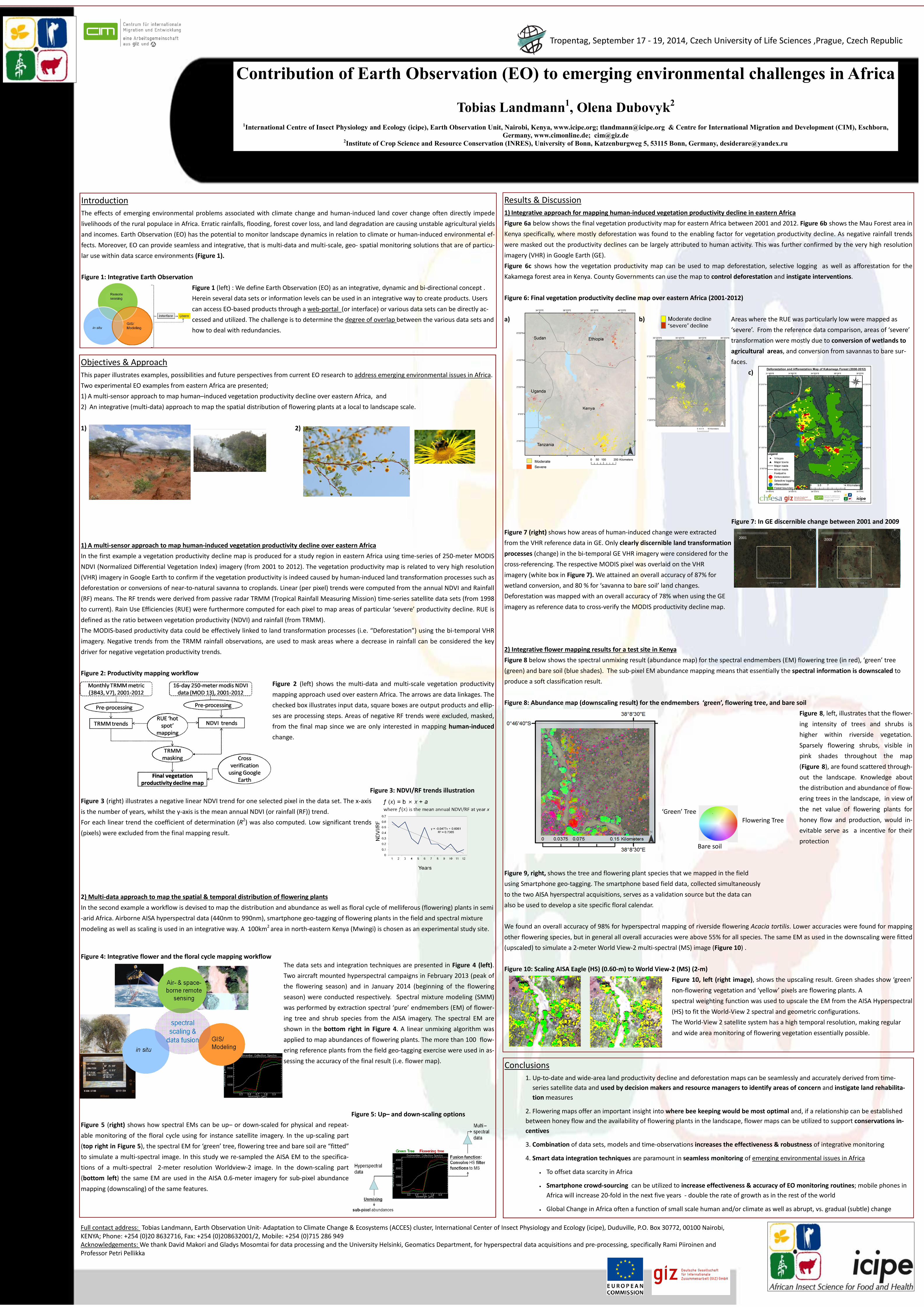
Figure 7: In GE discernible change between 2001 and 2009 Figure 7 (right) shows how areas of human-induced change were extracted from the VHR reference data in GE. Only clearly discernible land transformation processes (change) in the bi-temporal GE VHR imagery were considered for the cross-referencing. The respective MODIS pixel was overlaid on the VHR imagery (white box in Figure 7). We attained an overall accuracy of 87% for wetland conversion, and 80 % for ‘savanna to bare soil’ land changes. Deforestation was mapped with an overall accuracy of 78% when using the GE imagery as reference data to cross-verify the MODIS productivity decline map. 2) Integrative flower mapping results for a test site in Kenya Figure 8 below shows the spectral unmixing result (abundance map) for the spectral endmembers (EM) flowering tree (in red), ‘green’ tree (green) and bare soil (blue shades). The sub-pixel EM abundance mapping means that essentially the spectral information is downscaled to produce a soft classification result. Figure 8: Abundance map (downscaling result) for the endmembers ‘green’, flowering tree, and bare soil
Figure 8, left, illustrates that the flower-ing intensity of trees and shrubs is higher within riverside vegetation. Sparsely flowering shrubs, visible in pink shades throughout the map (Figure 8), are found scattered through-out the landscape. Knowledge about the distribution and abundance of flow-ering trees in the landscape, in view of the net value of flowering plants for honey flow and production, would in-evitable serve as a incentive for their protection
Figure 9, right, shows the tree and flowering plant species that we mapped in the field using Smartphone geo-tagging. The smartphone based field data, collected simultaneously to the two AISA hyerspectral acquisitions, serves as a validation source but the data can also be used to develop a site specific floral calendar. We found an overall accuracy of 98% for hyperspectral mapping of riverside flowering Acacia tortilis. Lower accuracies were found for mapping other flowering species, but in general all overall accuracies were above 55% for all species. The same EM as used in the downscaling were fitted (upscaled) to simulate a 2-meter World View-2 multi-spectral (MS) image (Figure 10) . Figure 10: Scaling AISA Eagle (HS) (0.60-m) to World View-2 (MS) (2-m) Figure 10, left (right image), shows the upscaling result. Green shades show ‘green’ non-flowering vegetation and ‘yellow’ pixels are flowering plants. A spectral weighting function was used to upscale the EM from the AISA Hyperspectral (HS) to fit the World-View 2 spectral and geometric configurations. The World-View 2 satellite system has a high temporal resolution, making regular and wide area monitoring of flowering vegetation essentially possible.
Tropentag, September 17 - 19, 2014, Czech University of Life Sciences ,Prague, Czech Republic
Conclusions 1. Up-to-date and wide-area land productivity decline and deforestation maps can be seamlessly and accurately derived from time-
series satellite data and used by decision makers and resource managers to identify areas of concern and instigate land rehabilita-tion measures
2. Flowering maps offer an important insight into where bee keeping would be most optimal and, if a relationship can be established between honey flow and the availability of flowering plants in the landscape, flower maps can be utilized to support conservations in-centives
3. Combination of data sets, models and time-observations increases the effectiveness & robustness of integrative monitoring
4. Smart data integration techniques are paramount in seamless monitoring of emerging environmental issues in Africa
• To offset data scarcity in Africa
• Smartphone crowd-sourcing can be utilized to increase effectiveness & accuracy of EO monitoring routines; mobile phones in Africa will increase 20-fold in the next five years - double the rate of growth as in the rest of the world
• Global Change in Africa often a function of small scale human and/or climate as well as abrupt, vs. gradual (subtle) change
2001 2009
‘Green’ Tree Flowering Tree
Bare soil


![TWEED ROAD CONTRIBUTION PLAN - tweed.nsw.gov.au - [EO-OC] Tweed...and Assessment Regulation 2000, the following contribution plans are repealed by the approval of this Tweed Road ...](https://static.fdocuments.us/doc/165x107/5b3bae9e7f8b9a895a8cabfe/tweed-road-contribution-plan-tweednswgovau-eo-oc-tweedand-assessment.jpg)