"Contourites at the eastern Agulhas Ridge and Cape Rise ... · Contourites at the eastern Agulhas...
2
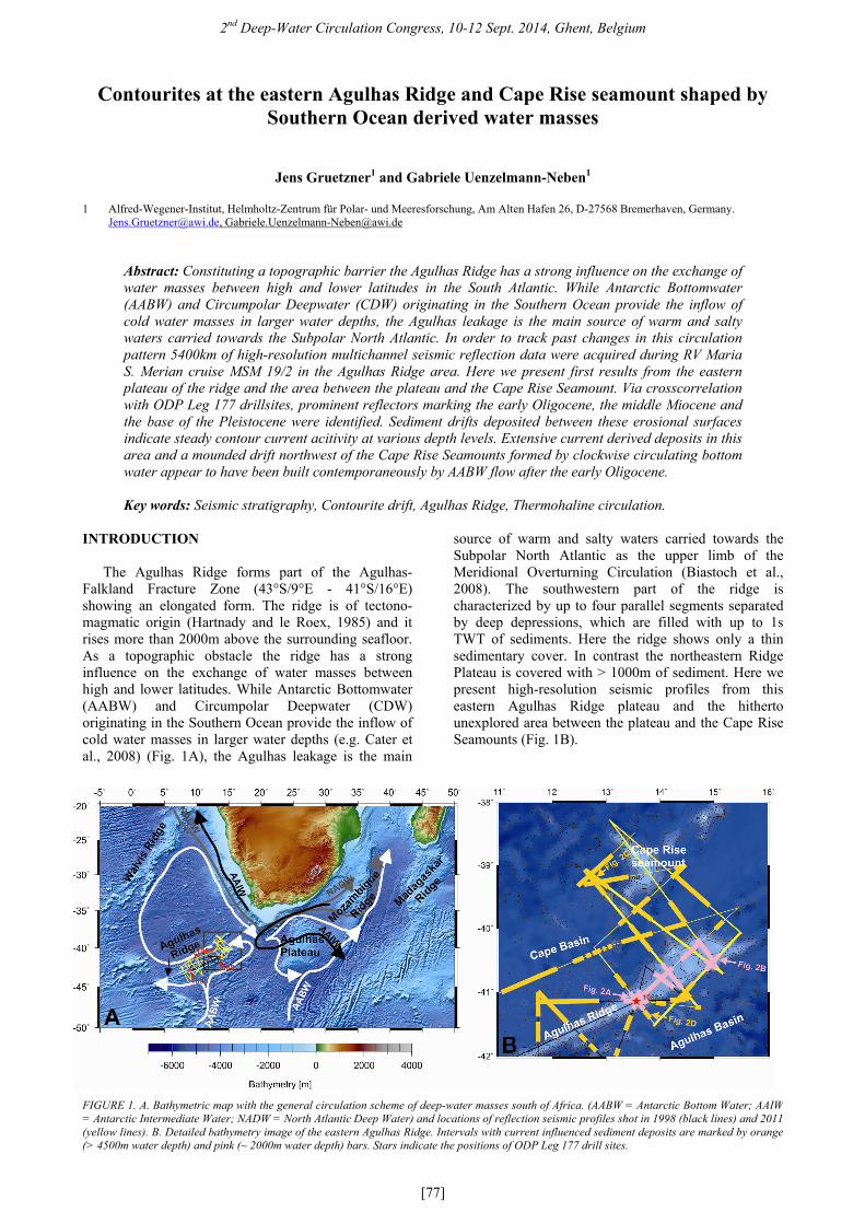
2 nd Deep-Water Circulation Congress, 10-12 Sept. 2014, Ghent, Belgium [77] Contourites at the eastern Agulhas Ridge and Cape Rise seamount shaped by Southern Ocean derived water masses Jens Gruetzner 1 and Gabriele Uenzelmann-Neben 1 1 Alfred-Wegener-Institut, Helmholtz-Zentrum für Polar- und Meeresforschung, Am Alten Hafen 26, D-27568 Bremerhaven, Germany. [email protected], [email protected] Abstract: Constituting a topographic barrier the Agulhas Ridge has a strong influence on the exchange of water masses between high and lower latitudes in the South Atlantic. While Antarctic Bottomwater (AABW) and Circumpolar Deepwater (CDW) originating in the Southern Ocean provide the inflow of cold water masses in larger water depths, the Agulhas leakage is the main source of warm and salty waters carried towards the Subpolar North Atlantic. In order to track past changes in this circulation pattern 5400km of high-resolution multichannel seismic reflection data were acquired during RV Maria S. Merian cruise MSM 19/2 in the Agulhas Ridge area. Here we present first results from the eastern plateau of the ridge and the area between the plateau and the Cape Rise Seamount. Via crosscorrelation with ODP Leg 177 drillsites, prominent reflectors marking the early Oligocene, the middle Miocene and the base of the Pleistocene were identified. Sediment drifts deposited between these erosional surfaces indicate steady contour current acitivity at various depth levels. Extensive current derived deposits in this area and a mounded drift northwest of the Cape Rise Seamounts formed by clockwise circulating bottom water appear to have been built contemporaneously by AABW flow after the early Oligocene. Key words: Seismic stratigraphy, Contourite drift, Agulhas Ridge, Thermohaline circulation. INTRODUCTION The Agulhas Ridge forms part of the Agulhas- Falkland Fracture Zone (43°S/9°E - 41°S/16°E) showing an elongated form. The ridge is of tectono- magmatic origin (Hartnady and le Roex, 1985) and it rises more than 2000m above the surrounding seafloor. As a topographic obstacle the ridge has a strong influence on the exchange of water masses between high and lower latitudes. While Antarctic Bottomwater (AABW) and Circumpolar Deepwater (CDW) originating in the Southern Ocean provide the inflow of cold water masses in larger water depths (e.g. Cater et al., 2008) (Fig. 1A), the Agulhas leakage is the main source of warm and salty waters carried towards the Subpolar North Atlantic as the upper limb of the Meridional Overturning Circulation (Biastoch et al., 2008). The southwestern part of the ridge is characterized by up to four parallel segments separated by deep depressions, which are filled with up to 1s TWT of sediments. Here the ridge shows only a thin sedimentary cover. In contrast the northeastern Ridge Plateau is covered with > 1000m of sediment. Here we present high-resolution seismic profiles from this eastern Agulhas Ridge plateau and the hitherto unexplored area between the plateau and the Cape Rise Seamounts (Fig. 1B). FIGURE 1. A. Bathymetric map with the general circulation scheme of deep-water masses south of Africa. (AABW = Antarctic Bottom Water; AAIW = Antarctic Intermediate Water; NADW = North Atlantic Deep Water) and locations of reflection seismic profiles shot in 1998 (black lines) and 2011 (yellow lines). B. Detailed bathymetry image of the eastern Agulhas Ridge. Intervals with current influenced sediment deposits are marked by orange (> 4500m water depth) and pink (~ 2000m water depth) bars. Stars indicate the positions of ODP Leg 177 drill sites.
-
Upload
trinhthuan -
Category
Documents
-
view
214 -
download
0
Transcript of "Contourites at the eastern Agulhas Ridge and Cape Rise ... · Contourites at the eastern Agulhas...
2nd Deep-Water Circulation Congress, 10-12 Sept. 2014, Ghent, Belgium
[77]
Contourites at the eastern Agulhas Ridge and Cape Rise seamount shaped by Southern Ocean derived water masses
Jens Gruetzner1 and Gabriele Uenzelmann-Neben1
1 Alfred-Wegener-Institut, Helmholtz-Zentrum für Polar- und Meeresforschung, Am Alten Hafen 26, D-27568 Bremerhaven, Germany. [email protected], [email protected]
Abstract: Constituting a topographic barrier the Agulhas Ridge has a strong influence on the exchange of water masses between high and lower latitudes in the South Atlantic. While Antarctic Bottomwater (AABW) and Circumpolar Deepwater (CDW) originating in the Southern Ocean provide the inflow of cold water masses in larger water depths, the Agulhas leakage is the main source of warm and salty waters carried towards the Subpolar North Atlantic. In order to track past changes in this circulation pattern 5400km of high-resolution multichannel seismic reflection data were acquired during RV Maria S. Merian cruise MSM 19/2 in the Agulhas Ridge area. Here we present first results from the eastern plateau of the ridge and the area between the plateau and the Cape Rise Seamount. Via crosscorrelation with ODP Leg 177 drillsites, prominent reflectors marking the early Oligocene, the middle Miocene and the base of the Pleistocene were identified. Sediment drifts deposited between these erosional surfaces indicate steady contour current acitivity at various depth levels. Extensive current derived deposits in this area and a mounded drift northwest of the Cape Rise Seamounts formed by clockwise circulating bottom water appear to have been built contemporaneously by AABW flow after the early Oligocene. Key words: Seismic stratigraphy, Contourite drift, Agulhas Ridge, Thermohaline circulation.
INTRODUCTION
The Agulhas Ridge forms part of the Agulhas-Falkland Fracture Zone (43°S/9°E - 41°S/16°E) showing an elongated form. The ridge is of tectono-magmatic origin (Hartnady and le Roex, 1985) and it rises more than 2000m above the surrounding seafloor. As a topographic obstacle the ridge has a strong influence on the exchange of water masses between high and lower latitudes. While Antarctic Bottomwater (AABW) and Circumpolar Deepwater (CDW) originating in the Southern Ocean provide the inflow of cold water masses in larger water depths (e.g. Cater et al., 2008) (Fig. 1A), the Agulhas leakage is the main
source of warm and salty waters carried towards the Subpolar North Atlantic as the upper limb of the Meridional Overturning Circulation (Biastoch et al., 2008). The southwestern part of the ridge is characterized by up to four parallel segments separated by deep depressions, which are filled with up to 1s TWT of sediments. Here the ridge shows only a thin sedimentary cover. In contrast the northeastern Ridge Plateau is covered with > 1000m of sediment. Here we present high-resolution seismic profiles from this eastern Agulhas Ridge plateau and the hitherto unexplored area between the plateau and the Cape Rise Seamounts (Fig. 1B).
FIGURE 1. A. Bathymetric map with the general circulation scheme of deep-water masses south of Africa. (AABW = Antarctic Bottom Water; AAIW= Antarctic Intermediate Water; NADW = North Atlantic Deep Water) and locations of reflection seismic profiles shot in 1998 (black lines) and 2011(yellow lines). B. Detailed bathymetry image of the eastern Agulhas Ridge. Intervals with current influenced sediment deposits are marked by orange(> 4500m water depth) and pink (~ 2000m water depth) bars. Stars indicate the positions of ODP Leg 177 drill sites.
2nd Deep-Water Circulation Congress, 10-12 Sept. 2014, Ghent, Belgium
[78]
DATA
In order to track past changes in the paleo-circulation pattern 5400 km of high-resolution multichannel seismic reflection data were acquired during RV Maria S. Merian cruise MSM 19/2 in the Agulhas Ridge area. Seismic processing comprised Common Depth Point (CDP) sorting with a CDP spacing of 25m, velocity analysis (every 50 CDP) for normal moveout correction, stacking, and time-migration.
Sites 1088, 1089 and 1090 of ODP Leg 177
(Gersonde et al., 1999) were crossed during profiling to enable a correlation of the seismic data with geological information. Based on this crosscorrelation and a reconnaissance survey (e.g. Wildeboer Schut and Uenzelmann-Neben, 2005), prominent reflectors marking the early Oligocene, the middle Miocene and the base of the Pleistocene were identified.
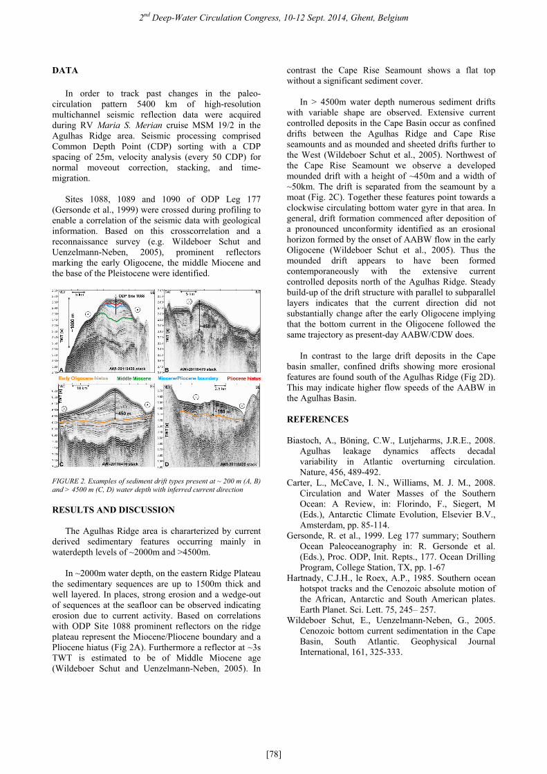
FIGURE 2. Examples of sediment drift types present at ~ 200 m (A, B) and > 4500 m (C, D) water depth with inferred current direction
RESULTS AND DISCUSSION
The Agulhas Ridge area is chararterized by current
derived sedimentary features occurring mainly in waterdepth levels of ~2000m and >4500m.
In ~2000m water depth, on the eastern Ridge Plateau
the sedimentary sequences are up to 1500m thick and well layered. In places, strong erosion and a wedge-out of sequences at the seafloor can be observed indicating erosion due to current activity. Based on correlations with ODP Site 1088 prominent reflectors on the ridge plateau represent the Miocene/Pliocene boundary and a Pliocene hiatus (Fig 2A). Furthermore a reflector at ~3s TWT is estimated to be of Middle Miocene age (Wildeboer Schut and Uenzelmann-Neben, 2005). In
contrast the Cape Rise Seamount shows a flat top without a significant sediment cover.
In > 4500m water depth numerous sediment drifts
with variable shape are observed. Extensive current controlled deposits in the Cape Basin occur as confined drifts between the Agulhas Ridge and Cape Rise seamounts and as mounded and sheeted drifts further to the West (Wildeboer Schut et al., 2005). Northwest of the Cape Rise Seamount we observe a developed mounded drift with a height of ~450m and a width of ~50km. The drift is separated from the seamount by a moat (Fig. 2C). Together these features point towards a clockwise circulating bottom water gyre in that area. In general, drift formation commenced after deposition of a pronounced unconformity identified as an erosional horizon formed by the onset of AABW flow in the early Oligocene (Wildeboer Schut et al., 2005). Thus the mounded drift appears to have been formed contemporaneously with the extensive current controlled deposits north of the Agulhas Ridge. Steady build-up of the drift structure with parallel to subparallel layers indicates that the current direction did not substantially change after the early Oligocene implying that the bottom current in the Oligocene followed the same trajectory as present-day AABW/CDW does.
In contrast to the large drift deposits in the Cape
basin smaller, confined drifts showing more erosional features are found south of the Agulhas Ridge (Fig 2D). This may indicate higher flow speeds of the AABW in the Agulhas Basin. REFERENCES Biastoch, A., Böning, C.W., Lutjeharms, J.R.E., 2008.
Agulhas leakage dynamics affects decadal variability in Atlantic overturning circulation. Nature, 456, 489-492.
Carter, L., McCave, I. N., Williams, M. J. M., 2008. Circulation and Water Masses of the Southern Ocean: A Review, in: Florindo, F., Siegert, M (Eds.), Antarctic Climate Evolution, Elsevier B.V., Amsterdam, pp. 85-114.
Gersonde, R. et al., 1999. Leg 177 summary; Southern Ocean Paleoceanography in: R. Gersonde et al. (Eds.), Proc. ODP, Init. Repts., 177. Ocean Drilling Program, College Station, TX, pp. 1-67
Hartnady, C.J.H., le Roex, A.P., 1985. Southern ocean hotspot tracks and the Cenozoic absolute motion of the African, Antarctic and South American plates. Earth Planet. Sci. Lett. 75, 245– 257.
Wildeboer Schut, E., Uenzelmann-Neben, G., 2005. Cenozoic bottom current sedimentation in the Cape Basin, South Atlantic. Geophysical Journal International, 161, 325-333.