Contents - Gob · 8 9 Cotacachi 4, 944 Cuicocha Atuntaqui Cotacachi Otavalo Ta n g a l í L. San...
17
Transcript of Contents - Gob · 8 9 Cotacachi 4, 944 Cuicocha Atuntaqui Cotacachi Otavalo Ta n g a l í L. San...
b
Contents
Map of Ecuador’s NaturalHeritage Sites (PANE)
Cayambe Coca National ParkA network of rivers uniting the jungle and the snow
Geographic map of the Park
Faces and tracesKayambis and Cofanes: “people of the sun” and the “true people”
Tourist map
Not to be missed
Things to do
Getting there
Directory
List of outstanding wildlife species
2
4
8
10
14
16
20
24
26
28
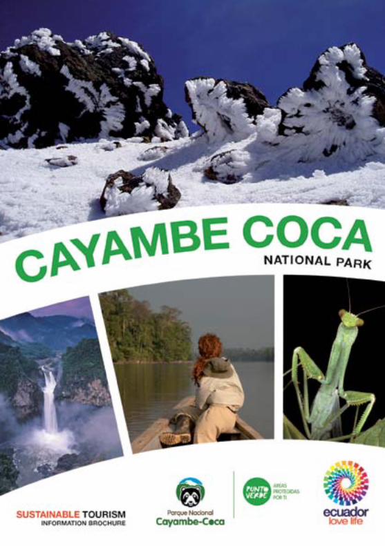
This brochure offers a panoramic view of the biological and cultural diversity of Cayambe Coca National Park (CCNP), as well as practical information for the visitor: a geographic and a tourist map, must-see sites, outstanding tourist activities, some useful recommendations for your trip, and a directory of services.
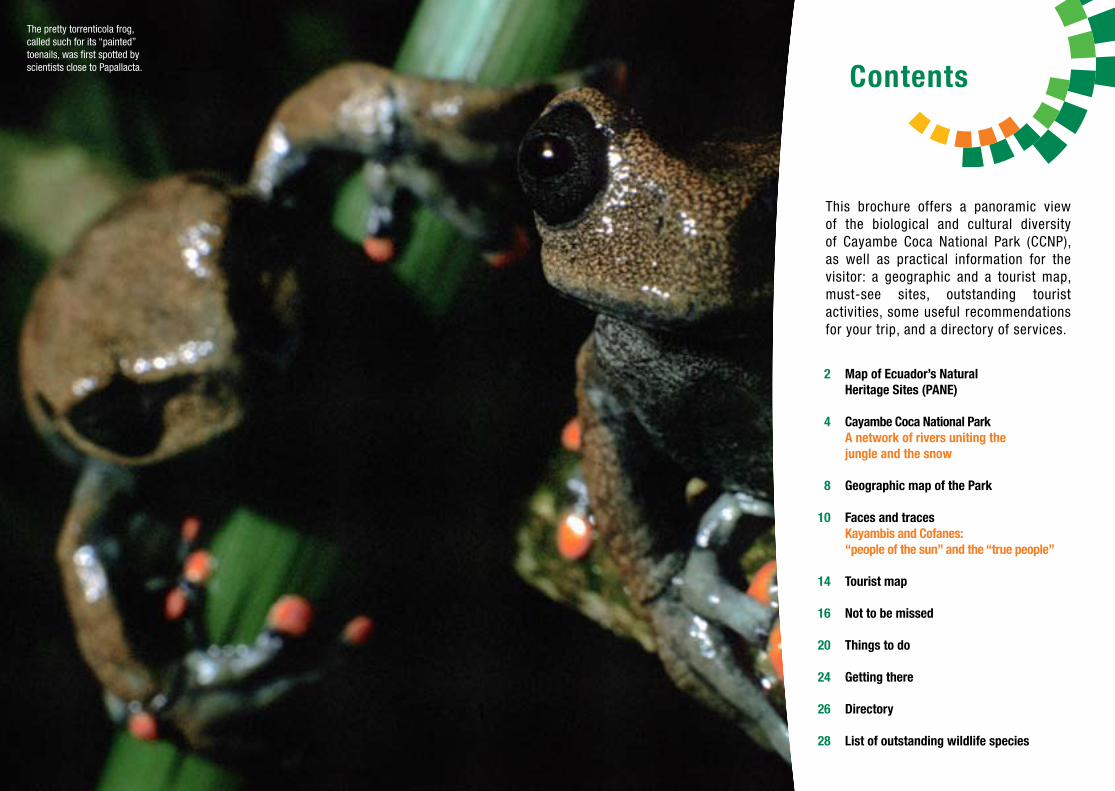
The pretty torrenticola frog, called such for its “painted” toenails, was first spotted by scientists close to Papallacta.

3
GALÁPAGOS NATIONAL PARK
GALÁPAGOS MARINE RESERVE
GALERA SAN FRANCISCO MARINE RESERVE
MACHALILLA NATIONAL PARK
MANGLARES CHURUTE ECOLOGICAL RESERVE
MACHE CHINDUL ECOLOGICAL RESERVE
SANTA CLARA ISLAND WILDLIFE REFUGE
MUISNE RIVER ESTUARY MANGROVES WILDLIFE REFUGE
EL SALADO MANGROVES FAUNA PRODUCTION RESERVE
SANTA ELENA PENINSULA MARINE FAUNA WILDLIFE REFUGE
EL MORRO MANGROVES WILDLIFE REFUGE
PACOCHE WILDLIFE REFUGE
PARQUE LAGO NATIONAL RECREATION AREA
ARENILLAS ECOLOGICAL RESERVE
ISLAS CORAZÓN Y FRAGATAS WILDLIFE REFUGE
CAYAPAS MATAJE ECOLOGICAL RESERVE
ESMERALDAS RIVER ESTUARY MANGROVES WILDLIFE REFUGE
LA CHIQUITA WILDLIFE REFUGE
ISLA SANTAY AND ISLA DEL GALLO NATIONAL RECREATION AREA
PAMBILAR WILDLIFE RESERVE
LOS SAMANES NATIONAL RECREATION AREA
PLAYAS DE VILLAMIL NATIONAL RECREATION AREA
EL PELADO MARINE RESERVE
LOS ILINIZAS ECOLOGICAL RESERVE
COTACACHI CAYAPAS ECOLOGICAL RESERVE
EL ÁNGEL ECOLOGICAL RESERVE
PULULAHUA GEOBOTANICAL RESERVE
PASOCHOA WILDLIFE RESERVE
ANTISANA ECOLOGICAL RESERVE
EL BOLICHE NATIONAL RECREATION AREA
COTOPAXI NATIONAL PARK
CHIMBORAZO FAUNA PRODUCTION RESERVE
CAJAS NATIONAL PARK
YACURI NATIONAL PARK
QUIMSACOCHA NATIONAL RECREATION AREA
PODOCARPUS NATIONAL PARK
LLANGANATES NATIONAL PARK
SANGAY NATIONAL PARK
CAYAMBE COCA NATIONAL PARK
CUYABENO FAUNA PRODUCTION RESERVE
LIMONCOCHA BIOLOGICAL RESERVE
YASUNÍ NATIONAL PARK
EL ZARZA WILDLIFE REFUGE
COFÁN BERMEJO ECOLOGICAL RESERVE
SUMACO NAPO-GALERAS NATIONAL PARK
EL CÓNDOR BIOLOGICAL RESERVE
EL QUIMI BIOLOGICAL RESERVE
CERRO PLATEADO BIOLOGICAL RESERVE
GALÁPAGOS
PACIFIC COAST
COAST - ANDES
ANDES
ANDES - AMAZON
AMAZON
1
2
3
4
5
6
7
8
9
10
11
12
13
14
15
16
17
18
19
20
21
22
23
24
25
26
27
28
29
30
31
32
33
34
35
36
37
38
39
40
41
42
43
44
45
46
47
48
N
S
W E
Pacific Ocean
23
0o
1
2
3
4
5
6
7
8
9
10
11
12
13
14
15
16
17
18
19
20
21
26
24
25
27
29
28
31
37
32
33
36
4834
4039
41
42
38
43
44
45
4647
Quito
Tulcán
Ibarra
Nueva Loja
Francisco de Orellana
Esmeraldas
Pto. BaquerizoMoreno
Sto. Domingo
Latacunga
Ambato
Riobamba
Macas
Azogues
Guayaquil
Machala
Portoviejo
Santa Elena
Cuenca
Loja Zamora
Guaranda
Babahoyo
Puyo
Tena
100 km
Perú
Colombia
22
30
35
MAP ofNATURAL HERITAGE SITES
Patrimonio de Áreas Naturales del Estado, PANE

5
Cayambe Coca National Park
A network of rivers uniting the jungle and the snow
T he Andean mountain range in Ecuador creates a mosaic of landscapes with sur-prising biological and cultural diversity.
One example of this diversity is Cayambe Coca National Park (CCNP): a snowy volcano on the equator, mega-diverse páramos only an hour from Quito, cloud forests, and tropical jungles. Even its name points to the Park’s diversity: Cayambe is its highest mountain and Coca is one of the large rivers that flows toward the Amazon.
The highland slopes of the Park’s land area are home to the Kayambi culture, an indig-enous people of great historical and political significance. Farther east is Oyacachi, a village in the páramos without automobile access until recently, but once a hub on the traditional trade routes between the Andes and the Amazon;
4
Starting in the glaciers, páramos (high plains) and Andean forests slide down the eastern slopes of the mountain range and meet up with the Amazon. Cayambe Coca has some of the most diverse landscapes of all the protected areas in Ecuador and in the world.
Cayambe, with an altitude of 5,790 masl, is the third highest mountain in Ecuador. It’s the only point on land at which the equator passes through a glacier or, in other words, where the latitude and the temperature are both zero.
to the south and east of the Park, hot baths in Papallacta, boating in Baeza and El Chaco, and the awe-inspiring sight of San Rafael Falls. Below, in the mystical jungle atmosphere, sits the Cofán village Sinangüé above the Aguarico River, a gate to the Amazon.
This area has only been a national park since 2010, as Cayambe Coca was an eco-logical reserve up until then. The topography in the higher altitudes is very rough, domi-nated by Cayambe (5,790 masl) and other mountains such as Saraúrco (4,725 masl) and Puntas (4,452 masl). Toward the east,
Biodiversity and endemic species in CCNP*
Flora MammalsBirdsReptilesAmphibians
CCNPno. of species
2,500200900140
15,306380
1,616350
16.352.055.640.0
Ecuador / no. of species
n/d2.9 - 4.32.9 - 8.1
n/d116 464 23.74.7 - 44.6
% endemism
% of national total
* These figures are, of necessity, estimates and subject to change.• Between the altitudes with the lowest and highest concentrations of endemic species. Source: MAE, 2010.
Cayambe (5,790 masl) seen from the slopes of Saraúrco (4,725 masl).
7
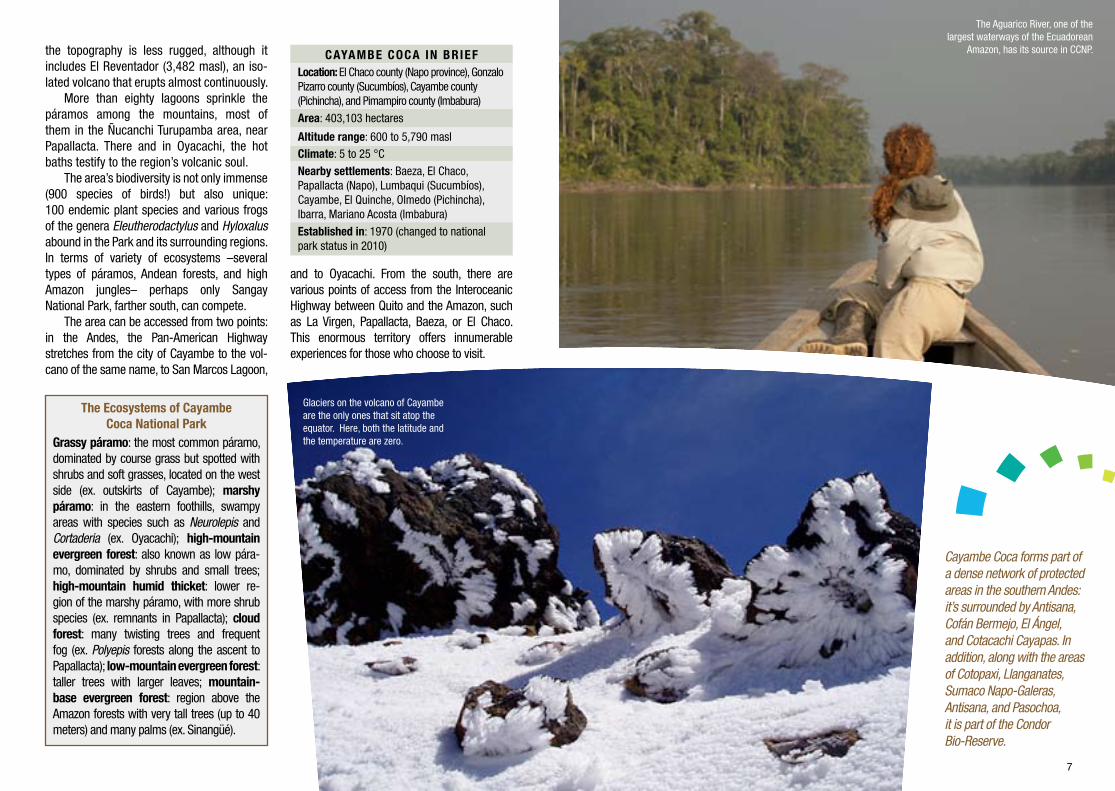
the topography is less rugged, although it includes El Reventador (3,482 masl), an iso-lated volcano that erupts almost continuously.
More than eighty lagoons sprinkle the páramos among the mountains, most of them in the Ñucanchi Turupamba area, near Papallacta. There and in Oyacachi, the hot baths testify to the region’s volcanic soul.
The area’s biodiversity is not only immense (900 species of birds!) but also unique: 100 endemic plant species and various frogs of the genera Eleutherodactylus and Hyloxalus abound in the Park and its surrounding regions. In terms of variety of ecosystems –several types of páramos, Andean forests, and high Amazon jungles– perhaps only Sangay National Park, farther south, can compete.
The area can be accessed from two points: in the Andes, the Pan-American Highway stretches from the city of Cayambe to the vol-cano of the same name, to San Marcos Lagoon,
CAYAMBE COCA IN BRIEFLocation: El Chaco county (Napo province), Gonzalo Pizarro county (Sucumbíos), Cayambe county (Pichincha), and Pimampiro county (Imbabura) Area: 403,103 hectares
Altitude range: 600 to 5,790 maslClimate: 5 to 25 °C
Nearby settlements: Baeza, El Chaco, Papallacta (Napo), Lumbaqui (Sucumbíos), Cayambe, El Quinche, Olmedo (Pichincha), Ibarra, Mariano Acosta (Imbabura)
Established in: 1970 (changed to national park status in 2010)
and to Oyacachi. From the south, there are various points of access from the Interoceanic Highway between Quito and the Amazon, such as La Virgen, Papallacta, Baeza, or El Chaco. This enormous territory offers innumerable experiences for those who choose to visit.
The Ecosystems of Cayambe Coca National Park
Grassy páramo: the most common páramo, dominated by course grass but spotted with shrubs and soft grasses, located on the west side (ex. outskirts of Cayambe); marshy páramo: in the eastern foothills, swampy areas with species such as Neurolepis and Cortaderia (ex. Oyacachi); high-mountain evergreen forest: also known as low pára-mo, dominated by shrubs and small trees; high-mountain humid thicket: lower re-gion of the marshy páramo, with more shrub species (ex. remnants in Papallacta); cloud forest: many twisting trees and frequent fog (ex. Polyepis forests along the ascent to Papallacta); low-mountain evergreen forest: taller trees with larger leaves; mountain-base evergreen forest: region above the Amazon forests with very tall trees (up to 40 meters) and many palms (ex. Sinangüé).
Cayambe Coca forms part of a dense network of protected areas in the southern Andes: it’s surrounded by Antisana, Cofán Bermejo, El Ángel, and Cotacachi Cayapas. In addition, along with the areas of Cotopaxi, Llanganates, Sumaco Napo-Galeras, Antisana, and Pasochoa, it is part of the Condor Bio-Reserve.
The Aguarico River, one of the largest waterways of the Ecuadorean
Amazon, has its source in CCNP.
Glaciers on the volcano of Cayambe are the only ones that sit atop the equator. Here, both the latitude and the temperature are zero.

8 9
Cotacachi 4, 944
Cuicocha
Atuntaqui
Cotacachi
Otavalo
Tangalí
L. San Pablo
Imbabura 4, 610 m
L. Mojanda
L. Puruhanta
Cubi
La Chimba
Pisque
CayambeTabacundo
Cayambe5, 790 m
Pambamarca(Quito Loma)
4, 075 mCangahua
El Quinche
Yaruquí
Oyacachi
Oyacachi
Pifo
Guayllabamba
Chiche
Guam
bi
L. Nunalviro
Paracocha
L. Sucus
L. Encantada
Papallacta
CuyujaL. Papallacta
L. Muerte Pungu
L. Tucurrasín
Antisana 5, 720 mL. Miracocha
Papallacta
Quijos
Baeza
Cosa
nga
Borja
Quijos
Pan de Azúcar
Cerro Negro
Suno
Molino
Negro
Murallas
Yaguana
Malo
Reventador3, 560 m
Saraúrco4, 676 m
San Rafael
Salado
Azuela
Due G
rande
Anango
Dué
Coca
Tigre
Dashino
Lumbaqui
SunoPayamino
Divino
Cabeno
CabenoAguarico
La Rinconada
Shanshipamba
Blanco
Fuya Fuya 4, 290m
Cusín 3,990 m
Ilaló 3, 185 m
Puntas4, 452 m
PROVINCE OF PICHINCHA
to Quito
to Q
uito
to Ib
arra
PROVINCE OF IMBABURA
Olmedo (Pesillo)
to P
imam
piro
El Chaco
3, 830 m
Reventador
Sinangüé
Puerto Libre
Cofanes
PROVINCE OF SUCUMBÍOS
PROVINCE OF NAPO
to Lago Agrio
N
S
O E
main road
riverprovince limitrailway
summitReserve limit
Sources: ETI, 2011; Jarvis, 2008; MAE, 2011Credits: S. Crespo, P. Cabrera, X. Cordovez
Ecuador Terra Incognita
villageinterest site
access to Reserve
CAYAMBE COCANATIONAL PARK MAP
access to Reserve
secondary road
Elevation

10 11
History tells us that, in pre-Columbian times, the heart of what is today the national park was then densely populated. The inhabitants were
the Quijos, cultural and commercial inter-mediaries between the Amazon plains and the Andes. During the period of coloniza-tion, these populations were decimated, and a space that was once a center of activity became marginalized.
There has, however, been continuity in the occupation of the more western and eastern regions. The Kayambi people have dwelt in the inter-Andean range since at least 2500 B.C., according to archaeological evidence such as that from Puntiatzil, in the urban area
Kayambis and Cofanes: the “people ofthe sun” and the “true people”
Cayambe Coca sits in a region that has for centuries enabled dialogue between human beings and nature, a focal point of the dynamics of interchange between the Andes and the Amazon.
Faces and traces
There are various sites of archaeological significance in Cayambe Coca and nearby areas, such as in the Caranqui ruins of Cochasquí and Zuleta and Quijo petroglyphs in El Chaco, Baeza, and Borja.
of Cayambe. Kayambi traditions and festivals are in many cases connected to sun worship and to the peculiarity of the community’s prox-imity to the equator (which crosses through the Park). During the Festival of the Sun or Inti Raymi, which takes place in Cayambe around the summer solstice (from June 16th to July 2nd), they give thanks for the year’s harvest. The festivals of San Pedro and San Pablo, June 29th throughout the region, seem to have a similar origin, as well as Octavas,
which is celebrated in Juan Montalvo with bulls and dancing at the end of July.
At the other extreme of the Park, the community of Sinangüé on the shores of the Aguarico River heralds the beginning of the Cofán territory. In fact, Sinangüé, which to-day is this people’s westernmost community, marks what was once their original territory. The current distribution of their other com-munities, lower in the Amazon, is a result of displacement by oil drilling in the 1970s.
The community of Sinangüé, in the Park, remains within what was once the traditional territory of this group of people.

12 13
Diversely flavored food: corn, trout, and fava beans with cheese in the Andes; peach palm, chucula (fresh plaintains), and maito (wrapped fish) in the east.
The a’i, or “true people” as they call themselves, are known throughout the jungle for their shamans’ knowledge of the medicinal uses of native plants (in contrast with other ethnic groups, who stand out for their command of magic powers). Their traditional dress includes striking headbands made with bird feathers and the cushma, a long garment inherited from the missionaries of the 18th century.
Perhaps the group that best embodies the shared nature of the Quijos is the indigenous community of Oyacachi, resting in a hidden pocket between the Quito basin and the Quijos River valley in the Amazon.
The legend of the community’s origin tells of a Kayambi and a Cofán family who met there and adopted Kichwa as their common language. Up un-til 1995, the only way to get to the town was on foot. After the construction of a highway, the region has become well-known for its landscape, thermal baths, handicrafts, and curious history.
Oyacachi has many tales related to native wildlife, such as those that tell of the worship of bear and tapir heads. For these practices, the church punished the population by moving the Virgen del Quinche, originally situated in Oyacachi, to its current sanctuary, recently declared one of the “seven wonders of Quito.” Another tradition is crafting utensils and notable wildlife sculp-tures from alder wood. These can be seen in the Expoferia, which occurs once a year on a flexible date, and which also offers natural products and local dishes such as guinea pig and maito (trout cooked in pompano leaves). Activities also occur every January 28th for the Festival of the Virgen.
Maito, grilled plaintain, and chucula are some of the
delicious Amazon dishes that can be enjoyed in the Park.
Mantises are part of the immense diversity of insects that tourists can explore.
South American or ring-tailed coati.

Cofanes Dantupam
ba
Azuela
Salado
Papallacta
Dué
Aguarico
Quijos
Quijo
s
Atuntaqui
Cayambe
Cangahua
La Rinconada
Sigsipamba
L. Encantada
L. Papallacta
El Quinche
Yaruquí
Pifo
Papallacta
Baeza
El Chaco
San RafaelSan Rafaelwaterfall
El Reventador
To Quito
Puerto Libre
Saraúrco4, 676 m
Cayambe5, 790 m
Ilaló3, 185 m
Fuya Fuya4, 290 m
Pambamarca(Quito Loma)
4, 075 m
L. de Puruhanta
L. San Marcos
Cotacachi
Otavalo
Imbabura4, 610 m
Reventador3, 560 m
Cotacachi4, 944 m
L. de Mojanda
L.Cuicocha
Ibarra
PROVINCE
OF PICHICHA
PROVINCE OF NAPO
PROVINCE OF IMBABURA
PROVINCE OF SUCUMBÍOS
To Quito
Oyacachi
ToPimampiro
N
S
O E
Olmedo
Tabacundo
L. San Pablo
Cusín 3, 990 m
Puntas4, 452 m
Cuyuja
Sinangüé
Quito
Tulcán
Ibarra
PapallactaBaeza
Lumbaqui
Nueva Loja(Lago Agrio)
Tulcán-Ibarra: 125 km Ibarra-Quito: 115 km Quito-Nueva Loja: 265 km
Oyacachi
L. Nunalviro
L. Paracocha
l. Sucus
Azu
ela
ACCESS TORESERVE
ACCESS TORESERVE
Sigsipamba
information lodging restaurant camping
birdwatching
lookoutpoint
forest excursion refuge
communitytourism
�ora touristcycling
volcano
horsebackriding
climbing
handicraftlagoonfauna
hot springpanoramicview
Andesarchaeological
zone
waterfall
rafting
kayak
To Lago Agrio
Railway
trail
main roadsecondary road
province limit
Sources: ETI 2011; Jarvis et al. 2008; MAE 2011Credits: Esteban Garcés and Ximena Cordovez
Ecuador Terra Incognita
river
summit
protected area
TOURIST MAP OF CAYAMBE COCA
NATIONAL PARK
villageinterest point
Tulcán-Parque: 106 km
Ibarra-Parque: 94 km
Quito-Parque: 100 km Papallacta-Parque: 8 km

16 17
Oyacachi
Hot baths and bears in the mist
O yacachi is an indigenous community within the Park, situated 3,200 meters
above sea level in a valley that opens to-ward the Amazon. For centuries, the people of Oyacachi have connected and shared their culture with many other east-ern Andean communities by traveling on foot. Today, visitors can arrive via a road from Guachalá, next to the Pan-American Highway, crossing through the páramos of Cangahua. Oyacachi has a spectacled bear conservation program and a community tourism project (telephone: 0985071925) that offers hikes, lodging, and meals. Visi-tors can hike the trail to El Chaco, which takes two to three days. The thermal baths (entrance fee of US$ 3) retain their natural atmosphere by being located near the river.
Thermal baths in Papallacta
Lagoons and forests an hour and a half from Quito
M oving along the Interoceanic Highway toward Cayambe Coca National Park,
agricultural and suburban valleys give way to Andean forests and páramos speck-led with lagoons. The largest of these is Papallacta, where some of the water con-sumed in Quito comes from. After crossing seemingly enchanted forests of polylepis (“paper trees”), myrtle, and asters, one ar-rives in the town of Papallacta, where there are thermal pool options for all budgets and tastes. These pools, with tempera-tures between 36 and 40 °C, are known to cure intestinal, muscular, respiratory, and nervous maladies. On clear days, the vol-cano Antisana makes the landscape even more breathtaking.
San Marcos Lagoon
Sacred waters that irrigate the fields
F rom the town of Olmedo toward snowy Cayambe lie fields that are watered
by ancient irrigation systems. They are lands that once belonged to large estates of the past but now are the property of indigenous communities. Near the commu-nity of La Chimba –where the pioneering indigenous leader Tránsito Amaguaña was born– is the San Marcos Lagoon, still within the Park. It’s the most easily accessible of the many lagoons and marshes surround-ing the great mountain. In San Marcos, 3,400 meters in altitude and formed by thawing waters from Cayambe, visitors can observe ducks, condors, carunculated caracaras, black-chested buzzard-eagles, and hummingbirds. There are good sites for camping and a trail between the high Andean forests and the páramos, whose
In the lower part of the Park, visitors can walk among the giants of the moist tropical forest.
The spectacled bear is one of the emblems of this protected area.
Of all the forms of tourism, camping is the friendliest to nature.
Not to be missed

18 19
difficulty varies with the moisture and the season (dryer between July and September and at the beginning of the calendar year).
San Rafael Falls
An Amazon flow plunging 160 meters
A t the point where the provinces of Napo and Sucumbíos meet, 50 kilometers be-
low El Chaco, we find this site where water from the Quijos River forms three waterfalls and explodes into mist in the middle of a for-est full of birds, to then continue its course with the name Coca. Cocks-of-the-rock can be spotted with some ease, although one must take a special hike to observe their mating dance. Other iconic birds are the Ecuadorean piedtail, the blue-gray tanager, and the Amazon umbrellabird. To observe the waterfall, walk 600 meters from the road to the Environmental Ministry’s guard station in San Rafael and then two more kilometers to the observation point.
Sinangüé
Coexisting with nature on the banks of the Aguarico River
This Cofán community is in the lowest region of the Park, at 600 meters of al-
titude. Here, visitors can learn something of this people’s worldview, sharing with them shaman ceremonies, preparation of
traditional foods and crafts, and celebrations. Walking forest trails with an indigenous guide is an amazing and entertaining way of learning about the Park’s flora and fauna and the ways in which the natives make use of them. To get there, travel toward La Bonita on the Quito-Lago Agrio road. Buses leave from Lago Agrio and can also be picked up on the bridge above the Aguarico.
The areas surrounding San Rafael Falls are an excellent place to spot the cock-of-the-rock (above).
21
Visit and climb Cayambe
C ayambe’s bulk is divided between the Northern and Southern Hemispheres, as
the equator lies close to its peak (5,790 masl). From the city of Cayambe, one can reach the comfortable Ruales Oleas Berge refuge, which is close to the Hermoso glacier (4,700 masl) and has the capacity to sleep up to 80 people. From there, climbers begin their ascent to the top, with specialized guides only. The climb is of medium difficulty, but there are stretches of séracs (places where the glacier becomes brittle and breaks) that require technical knowledge and caution. From the refuge, one can enjoy this paradoxically icy landscape above the tropics.
There is a road for four-wheel-drive vehicles from Cayambe. From there, transport can be hired for US$ 50.
Mountaineering Group of San Gabriel High School: http://cotopaxi.8m.com
Sleeping in the refuge: US$ 10. Climbs: between US$ 300 and 500 per person.
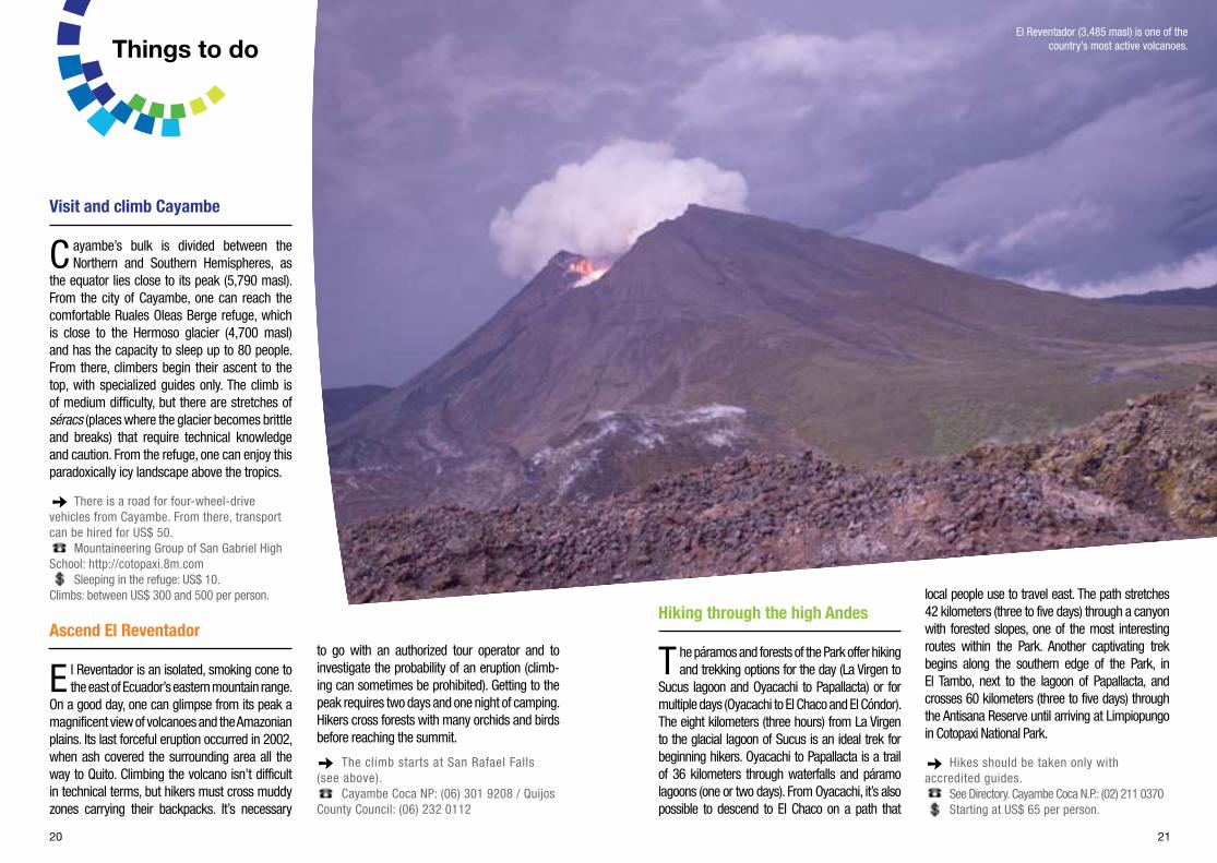
Ascend El Reventador
El Reventador is an isolated, smoking cone to the east of Ecuador’s eastern mountain range.
On a good day, one can glimpse from its peak a magnificent view of volcanoes and the Amazonian plains. Its last forceful eruption occurred in 2002, when ash covered the surrounding area all the way to Quito. Climbing the volcano isn’t difficult in technical terms, but hikers must cross muddy zones carrying their backpacks. It’s necessary
to go with an authorized tour operator and to investigate the probability of an eruption (climb-ing can sometimes be prohibited). Getting to the peak requires two days and one night of camping. Hikers cross forests with many orchids and birds before reaching the summit.
The climb starts at San Rafael Falls (see above).
Cayambe Coca NP: (06) 301 9208 / Quijos County Council: (06) 232 0112
20
Hiking through the high Andes
The páramos and forests of the Park offer hiking and trekking options for the day (La Virgen to
Sucus lagoon and Oyacachi to Papallacta) or for multiple days (Oyacachi to El Chaco and El Cóndor). The eight kilometers (three hours) from La Virgen to the glacial lagoon of Sucus is an ideal trek for beginning hikers. Oyacachi to Papallacta is a trail of 36 kilometers through waterfalls and páramo lagoons (one or two days). From Oyacachi, it’s also possible to descend to El Chaco on a path that
local people use to travel east. The path stretches 42 kilometers (three to five days) through a canyon with forested slopes, one of the most interesting routes within the Park. Another captivating trek begins along the southern edge of the Park, in El Tambo, next to the lagoon of Papallacta, and crosses 60 kilometers (three to five days) through the Antisana Reserve until arriving at Limpiopungo in Cotopaxi National Park.
Hikes should be taken only with accredited guides.
See Directory. Cayambe Coca N.P.: (02) 211 0370Starting at US$ 65 per person.
El Reventador (3,485 masl) is one of the country’s most active volcanoes.Things to do

22 23
Bird watching
Ecuador is famous for its diversity of birds, and Cayambe Coca offers a sen-
sational sample: from condors, carunculated caracaras, and ibises in the high altitudes, to parrots and toucans in the Amazon. Al-most any site in the Park is exceptional for bird watching. San Rafael Falls has already been mentioned, with its eastern subspe-cies of the cock-of-the-rock. Hummingbirds such as the sword-billed hummingbird, the tourmaline sunangel, the chestnut-breasted coronet, and the gorgeted woodstar are only four of the many species that can easily be observed from the eastern hills. The San Marcos Lagoon is a highly regarded spot for seeing high Andean birds, and Sinangüé is valued for seeing tropical birds. Various places in the area of Quijos are well-known destinations for special tours.
See Directory
Water sports in El Quijos
Bordering the Park to the south, the Quijos River offers particularly good
conditions for Class IV (very difficult) white-water sports; important interna-tional rafting events have taken place here, including the world championship of 2005, and, every year at the beginning of November, there is a national rafting and kayaking competition. Trips should be taken with qualified tour guides.
Tours generally include transportation from Quito; the Quijos River is entered from the Interoceanic Highway on the second Quijos bridge, from the bypass or from the parish of Borja.
Quijos County Council: (06) 232 0112From US$ 150 to 400 per person.
Rock climbing
F ive minutes from Pifo toward Papallacta is Sigsipamba, the location of the
Machuco climbing rock. Another interesting destination is Cuyuja, between Papallata and Baeza. This spot has become a mecca for climbers. The vertical rock, up to 75 meters high, is first-class and offers many routes and variations. Specialized equip-ment should be used.
Cuyuja is 16.4 kilometers to the east of Papallacta on the Interoceanic Highway. To reach the wall, cross the Papallacta River.
monodedo.com/web/paginas/topos/cuyuja.html Use of the climbing wall is free.
The Pifo-Baeza road offers many magnificent places, such as Sigsipamba, ideal for rock climbing.
The carunculated caracara inhabits the páramos as well as Andean legends and songs.
24 25
started sustainable tourism projects that help to improve their livelihoods and, at the same time, make visitors more aware of the neces-sity of conserving this irreplaceable environment. Choosing these options is recommended.• Indigenous communities like Oyacachi and Sinangüé are experiencing rapid cultural changes due to the recent appearance of high-ways. It’s of utmost importance that visitors be respectful of and sensitive to this reality.
Money matters
In Cayambe and Lago Agrio, travelers can use credit cards in many establish-ments; there are banks and ATMs in the city centers. Payments for various activi-ties can be made via phone or online. In the smaller cities and in villages, it’s nec-essary to use cash. Transportation must almost always be paid for in cash.
Important contact information
- 1 800 TURISMO (1 800 887 4766)- Cayambe Coca N.P.: (02) 211 0370- San Rafael guard station: (06) 301 9208- El Chaco guard station: (06) 232 9743- Quijos County Council: (06) 232 0112 (06) 232 0002- Baeza Hospital: (06) 232 0117- Cayambe Hospital: (02) 236 1150- Baeza Police: (06) 232 0430- Cayambe Police: (02) 278 4071
Getting there
Transportation
• To get to the city of Cayambe, take a bus that leaves from Quito (US$ 1.25) from the Carcelén or the Ofelia terminal (Cooperative Flor del Valle). From Ibarra, the fares are the same in the opposite direction.• From Cayambe, take a Cayambe company bus to La Chimba (US$ 0.60) to get to the San Marcos Lagoon. From there, one can rent a pickup truck to the lagoon (≈US$ 5); passengers should request that the driver wait at the site for the ride back. A pickup truck to the lagoon can also be rented from Cayambe (US$ 15).• To get to the refuge from Cayambe, one can rent a pickup truck, but the road is sometimes impassable. Trucks can take up to 10 people (≈US$ 50). The chauffer must also be contracted for the return trip.• For the Amazon zone, Lago Agrio is a good base from which to continue to the Park. TAME (02 396 3239) and Aerogal (1 800 AEROGAL) fly from Quito to Lago Agrio every day between 7:00 am and 4:00 pm (≈US$ 160 round trip, discounts for minors and senior citizens).• Certain bus cooperatives (Baños, Loja, Occidental, Putumayo, Transesmeraldas, among others) travel every day at vari-ous times from Quito’s main bus terminal to Lago Agrio (US$ 8). It’s possible to
disembark at any of the intermediate points: Baeza, El Chaco, San Rafael Falls, El Reventador, La Bonita (to go to Sinangüé), and Cascales.
Security and health
In the higher zones
• Take precautions against the cold and the altitude, especially when mountain climbing.• Lemon balm tea can ease the effects of altitude sickness.• Hikers must be prepared with warm clothing, including hats and gloves, but should also be prepared to shed some lay-ers; at certain times of day, the highland heat can be intense. Visitors should use goggles in the snow and hiking books on irregular surfaces.• Because of the intensity of ultraviolet rays even on cloudy days, it is essential to use sunblock.• While there are no pests or dangerous plants in the páramo, visitors should always take care not to eat unfamiliar wild fruits or hurt themselves on sharp or spiky leaves.• It is recommended that visitors carry durable bottles or canteens with plenty of water and avoid using disposable plastic bottles.
In the lower zones
• Use tall rubber boots to protect yourself from mud, from thorns and branches, and from possible stings.• Visitors should use insect repellent and, while sleeping, a mosquito net (malaria has been reported in certain areas).• For water sports, it’s necessary to be familiar with the difficulty of the passages you want to traverse and to be aware of possible flooding.
When to visit
Even though traditional weather cycles have changed in the last decades, the least rainy season continues to be between June and September and near the beginning of the calendar year. This is true both for the páramos and the Andean forests, as well as for the lower regions. Nevertheless, one can visit at any time of year. To predict rain in the short term, it’s useful to know that winds carry water from the Amazon, and as such clouds from the east signal potential bad weather. Other criteria for planning a visit are local festival dates.
Sustainable tourism practices
• The páramos and the Andean forest are fragile ecosystems where one must be very cautious; walk only on marked trails, always collect trash, and put out fires completely (if it’s permitted to build one). We shouldn’t leave any signs of our presence.• We may not remove anything from the Park except for crafts or foods that we find in the communities.• Various communities throughout the Park have
Entrance to all PANE continental protected areas is free for residents and foreigners.
26 27
CAYAMBE
Hostal Mitad del Mundo Natalia Jarrín S57-74 and Córdova Galarza 7.50 (breakfast not included, shared bathroom) (02) 236 0226 second
Hostal Imperial Ascázubi 62 and pasaje La Libertad 9.50 (breakfast not included) (02) 236 4417 second
Hostal Miraflores de Yasnan Pan-American Highway South and Rosalía Arteaga, Miraflores sector 10 (breakfast not included) 099 990 5854 third
Pensión El Sol de Cayambe Rocafuerte S9-016 and 29 de Septiembre 15 (breakfast not included) (02) 211 0420 second
Hostería Jatun Huasi Pan-American Highway North, kilometer 1.5 33.50 (02) 236 3777 / 098 269 [email protected] first
Hostería Guachalá La Bola district, San Luis de Guachalá Street 44.50 (breakfast not included) (02) 236 3042 / (02) 236 [email protected] first
EL CHACO
Pensión El Chaco 13 de Junio and 13 de Enero streets 8.96 (breakfast not included) (06) 232 9165 third
Hostería La Guarida del Coyote Bellavista Los Guabos development 10 (06) 232 9421 second
Pensión Katheryne Marco Chacón and Quito 11.20 (breakfast not included) (06) 232 9146 third
Pensión Carlita Between La Revolución and Quito streets 8.96 (breakfast not included) (06) 232 9055 third
GONZALO PIZARRO
Hostal Paladines Cristóbol Colón and Los Cofanes Ave. 11.20 (breakfast not included) (06) 234 0222 third
Hostal Sandrita Chiriboga Alcalá and Río Dorado 16.80 (private bathroom); 5.60 (sha-red bathroom) (breakfast not included) (06) 234 0192 third
1. Thermal baths 2. Horseback riding 3. Guided tours 4. Cycling 5. Tree climbing 6. Mountaineering
7. River boating 8. Rafting and kayaking 9. Cultural tours 10. Community tourism
Tour operators
Activities
Quito
Ecoandes Travel Andesadventure(02) 222 [email protected] 2 3 4 5 9
Ecomontes Tour(02) 290 3629 / 099 709 [email protected] 3 5 6 7 9
Ecuadorian Alpine Institute(02) 256 [email protected] 3 4 6 9 10
Ecuadorian Tours(02) 256 [email protected] 3 5 6 7 8 9
Explorandes(02) 222 2699 / 255 [email protected] 3 6 7 8 9
Julio Verne(03) 296 3436 / 099 416 [email protected] 3 4 5 6 7
Sierra Nevada Expeditions(02) 255 [email protected] 3 4 6 9
South American Tours(02) 227 [email protected]/sat_ecuador.html1 3 5 6 7
Wayra Routers(02) 604 6800 / 099 500 [email protected] 2 3 4 5 6 7 8 9
Zona Travel Ecuador(02) 333 [email protected]/turismo_kichwa_shayari.html1 3 5 6 7 8 9 10
Surtrek(02) 250 [email protected] 3 4 5 6 7 8 9
Cayambe
Cayambe Explorer(02) 211 [email protected] 6 9
Inti Explorer(02) 236 [email protected] 6 8 9 10
U&A Cayambitours(02) 236 48453 6 9
Quijos
Small World Adventures099 792 0120 / 098 963 [email protected] 8
Termas de Papallacta(02) 256 8989 / (06) 289 [email protected] 3 8
QUIJOS
Pensión La Casa de Gina Baeza Vieja 8 (breakfast not included) (06) 232 0471 third
Hostal Coturpa Papallacta 20.30 (06) 289 5000 / 098 628 0274info@ hostalcoturpa.comwww.hostalcoturpa.com second
Hostería La Campiña del Quijos Interoceanic Highway, Atanasio Minda Street 22 (06) 232 [email protected] first Hostería Termas de Papallacta Papallacta 139 (three-person room, breakfast not included) Entrance to thermal baths: US$ 7 adults; 3.50 children (02) 256 8989 / (06) 289 [email protected] first
Hostería Guango Lodge Pifo-Baeza road, kilometer 53 140.30 (includes three meals) (02) 382 2310 / 099 358 [email protected]. cabanasanisidro.com second
Lodging
address categoryreference price contact
Prices are per guest and include taxes but not breakfast, unless otherwise indicated.
Directory

Series director: Andrés VallejoEditorial design and edition: Nadesha MontalvoTexts: Patricio MenaDesign: Esteban GarcésPhotographic research: Martina Avilés and Alegría AcostaMaps: Susana Crespo and Pablo CabreraMap coordination: Ximena CordovezEnglish translation: Amanda BlewittText revision: David Padgham
Photo credits:Andrés Vallejo (content); Pablo Larrea (5); Enrique de la Montaña (7:canoe);Gustavo Proaño (7:glacier); Elliot Smith (11); Juan Pablo Verdesoto E. (12:food, 17:forest);Rafael Cárdenas / biographica.com.ec (12:mantis); Murray Cooper (12: coati, 17:bears, 23:curunculated caracara); Joe Italiano / .lahesperia.com (17:campsite); Richard Parsons / Bellavista Lodge (17:bird); Pete Oxford (17:waterfall, 21); Esteban Barrera (23:climber)
Coordination, Ministry of Tourism: Mónica Burbano Montalvo and Liliam FigueroaRevision, Ministry of Tourism: Undersecretaryship for Tourism Management, Undersecretaryship for Tourism Promotion and Undersecretaryship for Information and CommunicationRevision, Ministry of the Environment: National Biodiversity Directorate and Area Chief
References • Coloma-Santos, Andrea, 2007. Reserva Ecológica Cayambe Coca. En: ECOLAP and MAE. Guía del Patrimonio de Áreas Naturales Protegidas del Ecuador. ECOFUND / FAN / DarwinNet / IGM, Quito• Fundación Antisana, 1998. Plan de manejo de la Reserva Ecológica Cayambe Coca. Ministerio del Ambiente, Quito• Instituto Geofísico, 2012. Reventador. Escuela Politécnica Nacional (www.igepn.edu.ec/index.php/volcan-reventador.html)• Kohn, Eduardo, 2002. Infidels, virgins, and the black-robed priest: a backwoods history of Ecuador’s montaña region. Ethnohistory 49(3):545-582• Lasso, Geovanna, 2009. Guión turístico de la Reserva Ecológica Cayambe Coca. Ministerio del Ambiente, Quito• MAE, 2010. Propuesta de manejo para el Parque Nacional Cayambe Coca. Ministerio del Ambiente, manuscrito, Quito• Mena, Patricio, Galo Medina and Robert Hofstede (eds.), 2001. Los Páramos del Ecuador: Particularidades, Problemas y Perspectivas. Proyecto Páramo and Abya Yala, Quito• Rachowiecki, Rob and Mark Thurber, 2008. Ecuador: Climbing and Hiking Guide. Viva Travel Guides, Poulsbo
This document may be cited as:Ecuador Terra Incognita, 2012. Informative brochure for sustainable tourism in Cayambe Coca National Park. Ministry of Tourism / Ministry of the Environment, Quito
© Ministry of Tourism of Ecuador, 2012
Produced by:
si no
quie
re g
uard
ar este ejemplar, por favor com
pártalo
Mammals Mountain pacaCuniculus taczanowskii
Humboldt’s woolly monkeyLagothrix lagothricha
White-bellied spider monkeyAteles belzebuth
JaguarundiPuma yagouaroundi
South American coati •Nasua nasua
Little red brocket deerMazama rufina
JaguarPanthera onca
Collared anteaterTamandua tetradactyla
Silky anteaterCyclopes didactylus
Mountain tapir •Tapirus pinchaque
South American tapir •Tapirus terrestris
Spectacled bear •Tremarctos ornatus
Birds
Black-billed mountain toucan •Andigena nigrirostris
Cobalt-winged parakeetBrotogeris cyanoptera
Sickle-winged guanChamaepetes goudotii
Black-chested buzzard-eagle •Geranoaetus melanoleucus
Speckled chachalacaOrtalis guttata
Andean guanPenelope montagnii
Black-headed parrot •Pionites melanocephalus
Variable hawkButeo polyosoma
Salvin’s curassowMitu salvini
Andean cock-of-the-rock •Rupicola peruviana peruviana
Golden-collared toucanet •Selenidera reinwardtii
Andean condor •Vultur gryphus
Carunculated caracara •Phalcoboenus carunculatus
Black-faced ibis •Theristicus melanopis
Sword-billed hummingbird •Ensifera ensifera
Tourmaline sunangel •Heliangelus exortis
Chestnut-breasted coronet •Boissonneaua matthewsii
Gorgeted woodstar •Chaetocercus heliodor
Ecuadorean piedtail •Phlogophilus hemileucurus
Blue-gray tanager •Thraupis episcopus
Amazon umbrellabird •Cephalopterus ornatus
Aquatic birds
Black-bellied whistling-duck •Dendrocygna autumnalis
Torrent duck •Merganetta armata
Amphibians and reptiles
Peter’s stubfoot toad †Atelopus petersi
Cosanga rocket frog •Hyloxalus pulchellus
Pretty torrenticola frog •Hyloscirtus lindae
Glass cochran frogCochranella resplendens
Napo plump toad*Osornophryne antisana
Robber frogEleutherodactylus spp. •various species
Spectacled caimanCaiman crocodilus
Yellow-spotted river turtlePodocnemis unifilis
Plants Alder •Alnus acuminata
Burret*Astrocaryum urostachys
Peach palm •Bactris gasipaes
Myrtle •Myrcianthes rhopaloides
Polylepis •Polylepis incana
Pampas grass •Cortaderia spp.
South American bamboo •Neurolepis spp.
Pampano •Calathea lutea
Aster* •Gynoxys hallii
* species endemic to Ecuador • species mentioned in the text † possibly extinct
Below is a short list of some outstanding wildlife found in Cayambe Coca. Given the extraordinary diversity in this area, it is, of necessity, an incomplete list. Enjoy filling it in!
CONSCIOUS TOURISMIs Love for Life
Conscious tourism is a life-transforming experience that leads to personal growth, making us better human beings.
This new concept is based on principles of sustainability and ethics, and promotes peace, friendship, respect, and love for life as the essence of tourism.
It is a pact to live together in a responsible, mutually respectful fashion, in communion with tour agents from sending and receiving communities, the tourist, and the natural and cultural heritage.
Conscious tourism is a living, dynamic concept in constant development. It is an experience in giving and receiving.
Distributed
free of charge
El Telégrafo E7-58 and Av. de los ShyrisAv. 6 de Diciembre N59-161 and Manuel Zambrano
Quito-EcuadorTelephone: (02) 399 9333