contents & acknowledgements - Home - Macedon … contents & acknowledgements macedon village centre...
33
-
Upload
duongxuyen -
Category
Documents
-
view
229 -
download
2
Transcript of contents & acknowledgements - Home - Macedon … contents & acknowledgements macedon village centre...


1co
nten
ts &
ack
now
ledg
emen
tsmacedon village centre study | hansen partnership pty ltd
contents figures acknowledgementsfigure 1 study area 3figure 2 existing planning zones 4figure 3 existing overlays 5figure 4 site analysis: pathways and connections 9figure 5 site analysis: buildings, streetscapes and spaces 11figure 6 site analysis: destinations and places 13figure 7 site analysis: views and landscape scenery 15figure 8 framework plan 19figure 9 bushfire analysis 20
macedon ranges shire council team ▪ Katie Xaio
▪ David Nevin
▪ Jillian McQuade
study teamHansen Partnership (Lead Consultants, Planning Urban Design, Landscape) ▪ Craig Czarny
▪ Richard Stevenson
▪ Goksel Karpat
Tim Nott: Economic Analysis and Strategy ▪ Tim Nott
EcoTide (Bushfire Analysis) ▪ Paul Barnard
▪ Nicholas Symons
funding sourceFunding provided by Macedon Ranges Shire Council and Department of Transport, Planning and Local Infrastructure.
1 introduction 21.1 what is a framework plan 21.2 project objectives 2
2 site context 32.1 regional context 32.2 township context 3
3 policy context 43.1 zones 43.2 overlays 53.3 influence of overlays 5
4 stakeholder / community engagement 64.1 main themes / key issues 6
5 the vision for mt macedon village centre 7
6 site analysis 86.1 pathways and connections 86.2 buildings, streetscapes and spaces 106.3 destinations and places 12 6.4 views and landscape scenery 14
7 economic analysis 16
8 bushfire analysis 17
9 framework plan 189.1 framework plan overview 18 9.2 how the framework plan will be used? 189.3 framework plan: key directions 189.4 macedon village centre design guidelines 18
10 key actions 2010.1 development 2010.2 connections 2010.3 public realm 2010.4 general design guidelines 2110.5 bushfire management 22
11 implementation 23
11.1 implementation strategy 2311.2 funding and partnerships 2311.3 statutory planning 23
version title date issuer changes
A macedon village centre study report
(preliminary draft)
08.11.13 RS
B macedon village centre study report 03.06.14 RS Revisions following Council feedback.
C macedon village centre study report 01.07.14 RS Revisions following resolution from Ordinary Council meeting on 25 June 2014
D macedon village centre study report and design guidelines
14.11.14 RS Revisions following exhibition process
tables
appendices
table 1 summary of defendable space distances 20
Appendix 1 background policy reviewAppendix 2 economic analysis backgroundAppendix 3 development implications for bushfire risk categories
2
intro
duct
ion
macedon village centre study | hansen partnership pty ltd
The following report outlines the background work that has led to the development of the Macedon Village Centre Study which incorporates the Macedon Village Centre Framework Plan. Section 1.1 below explains what a Framework Plan is, including its role and function.
This project constitutes a strategic urban design based study which has focused on the commercial core of the Macedon Village. This project has examined the Macedon Village Centre and has provided commentary and guidance on how it should look and feel in the future, including what facilities and services are needed. One of the critical project drivers has been to ensure that the valued ‘village township character’ of Macedon is recognised, interpreted and expressed through the Framework Plan’s recommendations addressing future land use activities, built form, streetscape works and landscaping.
An additional and critical aspect of the Macedon Village Centre Study has been the consideration of how bushfire risk can be best managed through any recommendations of the study. It is acknowledged that Macedon is located entirely within the Bushfire Management Overlay (BMO). Fire authorities have identified Macedon as having an ‘extreme’ bushfire risk. Consequently the Macedon Ranges Settlement Strategy 2011 has recommended that the current population be maintained. This allows for some infill development where design is suitable for relevant planning constraints.
The main output of the Macedon Village Centre Study constitutes this Macedon Village Centre Study and the associated Macedon Village Centre Framework Plan (page 19).
1.1. what is a framework plan?A Framework Plan is a document that sets out the future form and character of a particular place or locality. It is principally an urban design tool that provides a physical framework for managing change and setting new directions for the development of a place over time. Community values are considered alongside the needs of government departments, servicing agencies and commercial stakeholders in the overarching desire to contribute positively to the urban form of a place. A Framework Plan also integrates non-physical initiatives and opportunities with the built form outcomes.
Framework Plans are more detailed than Town Structure Plans and aim to create a flexible framework for the creation of practical actions, ideas and solutions that consider constraints and provide guidance for capital budgets and future planning scheme controls.
The preparation of a Framework Plan for the Macedon Village Centre represents an important stage in the development of Macedon. The Framework Plan will identify land use, built form, public realm and transport directions that embrace opportunities for redevelopment in the Town Centre. Such directions are anticipated to assist the Village Centre to reach its full potential as a vibrant, appealing and sustainable place, which is the primary location for business, retail and community activities.
1 introduction1.2 project objectives
The objectives of the Macedon Village Centre Study, including the preparation of this Macedon Village Centre Framework Plan are:
▪ Understand the nature of the existing commercial centre in Macedon and its land use zoning and overlays.
▪ Strengthen the role and functionality of the Macedon Village Centre.
▪ Determine whether there is a need to provide for more commercial land / activities in the Macedon Village Centre.
▪ Assess and manage bushfire risk.
▪ Acknowledge and respect the highly valued rural / natural / landscape and built form character of Macedon.
▪ Identify important views, vistas and vegetation in the Macedon Village Centre and how they can be protected or enhanced.
▪ Identify how the functionality and quality of pedestrian and vehicle links, as well as parking, can be improved.
▪ Prepare design guidelines and public realm recommendations to influence the appearance of future buildings, streetscape works and changes to public space.
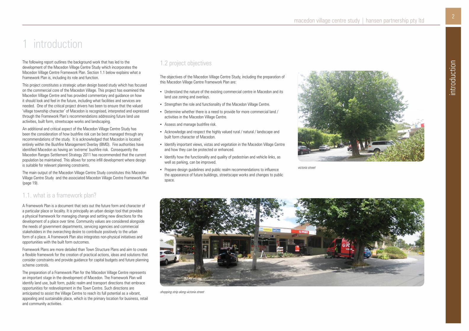
shopping strip along victoria street
victoria street

3macedon village centre study | hansen partnership pty ltd
site
cont
ext 2.1 regional context
Macedon is a small commuter village located approximately 60 kilometres to the north-west of Melbourne, just off the Calder Freeway. Macedon is located to the south of/ at the foot of Mount Macedon within an attractive bushland setting, accommodating both mountain and valley view sheds. The township accommodates a population of approximately 1,400 and is located on and serviced by the Melbourne-Bendigo railway line.
Within the broader Macedon Ranges region Macedon is designated as a ‘Village/ Service Centre’ where a static population is preferred in acknowledgement of the significant bushfire risk Macedon is subject to.
2.2 township contextThe township of Macedon accommodates modest housing set in a gently sloping, heavily treed terrain, of both exotic and native species. Macedon Village Centre provides a limited range of convenience retail services for both Macedon and Mt Macedon, including a small supermarket and post office. Many of the existing houses have been converted to low scale commercial uses which contributes to the village character.
The main elements of infrastructure servicing within Macedon includes: reticulated sewer, water and gas, railway station, a primary school, maternal and child health centre and kindergarten.
2 site context
figure 1: study arearegional context
The Macedon Village Centre Study focuses on the retail core of Macedon, which is centred along the east/ west aligned Victoria Street. The broader study area includes the Macedon Catholic Church and maternal child health centre (located to the east) and the Macedon Train Station and surrounds (located to the west). Refer to Figure 1 Study Area. The study area allows connectivity and access between public and community infrastructure and the retail core.

4macedon village centre study | hansen partnership pty ltd
polic
y co
ntex
t
3 policy contextA range of State, Regional and Local Planning Policies, plans and reports are relevant to the planning, development and management of the Macedon Village Centre. A Background Policy Review in Appendix 1 provides a brief summary and analysis of the relevant policy context.
3.1 zonesA number of zones apply within the study area. Each of the relevant zones present within the study area are outlined below.
Commercial 1 ZoneThe majority of the study area is included with the Commercial 1 Zone (shown on planning scheme map as B1Z). This is the main zone applied in most retail/commercial areas across the State. It allows a wide range of commercial activities to take place, which is considered appropriate for a Town Centre. The purpose of the Commercial 1 Zone is:
▪ To create vibrant mixed use commercial centres for retail, office, business, entertainment and community uses.
▪ To provide for residential uses at densities complementary to the role and scale of the commercial centre.
As the Commercial 1 Zone constitutes the primary commercial zone within the Victorian Planning Provisions, which allows a wide range of retail, commercial and business activity, this is considered to be the appropriate zoning for the Macedon Village Centre. The economic analysis provided at Section 5 considers the adequately of supply of such commercial land based on current and future demand.
Public Use ZoneWithin the Macedon Town Centre, the Public Use Zone (PUZ) applies to a number of areas including:
▪ Ash Wednesday Park and land located to the north west corner of Victoria and Smith Street (PUZ6)
▪ Macedon Train Station, its commuter car park and immediate surrounds (PUZ4).
▪ The maternal and child health centre (PUZ6)
The purpose of the PUZ is:
▪ To recognise public land use for public utility and community services and facilities.
▪ To provide for associated uses that are consistent with the intent of the public land reservation or purpose.
The public use designations which apply to these areas indicate the purpose for which this public land is designated, including:
▪ PUZ4 – Transport
▪ PUZ6 – Local Government
Noting that the PUZ applies to specific public and community based land use and activity, it is considered that it has been appropriately applied within the Macedon Village Centre.
Road Zone Category 2The north/ south aligned Smith Road is included in the Road Zone Category 2 (RDZ2), which highlights its role as a significant Council road. The purpose of the RDZ2 is:
▪ To identify significant existing roads, and
▪ To identify land which has been acquired for a significant proposed road.
Under the RDZ2 designation, it does not raise any particular implication for the Macedon Village Centre Study.
Low Density Residential Zone The Low Density Residential Zone (LDRZ) generally applies to land surrounding the commercial core of Macedon Village Centre and study area . The purpose of the LDRZ is:
▪ To provide for low-density residential development on lots which, in the absence of reticulated sewerage, can treat and retain all wastewater.
Land use and activity located on LDRZ land which is located within the study area is noted to constitute Council owned vacant land (located on north east and south east corners of Victoria Street and Bruce Street), and the Macedon Catholic Church located to the north side of Victoria Street. The requirements of the LDRZ would trigger planning approval for any expansion or modification to the existing Macedon Catholic Church.
figure 2: existing planning zones

5po
licy
cont
ext
macedon village centre study | hansen partnership pty ltd
3.2 overlaysA number of overlays apply within the study area. Each of the relevant overlays present within the study are outlined below.
bushfire management overlayThe entirety of the study area is covered by the Bushfire Management Overlay (BMO) which is reflective of the acknowledgment of fire authorities that Macedon has an ‘extreme’ bushfire risk. The nominated purposes of the BMO includes:
▪ To assist to strengthen community resilience to bushfire.
▪ To identify areas where the bushfire hazard requires specified bushfire protection measures for subdivision and buildings and works to be implemented.
▪ To ensure that the location, design and construction of development considers the need to implement bushfire protection measures.
▪ To ensure development does not proceed unless the risk to life and property from bushfire can be reduced to an acceptable level.
restructure overlayThe entirety of the study area is covered by the Restructure Overlay (RO). The nominated purposes of the RO include:
▪ To identify old and inappropriate subdivisions which are to be restructured.
▪ To preserve and enhance the amenity of the area and reduce the environmental impacts of dwellings and other development.
environmental significance overlayPart of the Macedon Railway Station land is affected by the Environmental Significance Overlay (ESO5), and relates to the designation and protection of regional water catchments from inappropriate development. The ESO5 has been applied on the basis of a wider regional catchment, of which the edge of the overlay partly extends into the study area along its western edge.
figure 3: existing overlays
3.3 influence of overlaysWith regard to the above listed overlays, only the BMO and RO applies to the entire of the study area. From a broad level strategic assessment, the application of the above listed overlays are considered to have been applied in a logical manner to nominate and highlight the range of bushfire, environmental and restructure requirements which apply within the Macedon Village.
Noting the varying role and focus of the applicable overlays, each individual overlay needs to be considered and appropriately addressed during the consideration and assessment of a specific development application proposal.

6macedon village centre study | hansen partnership pty ltd
stak
ehol
der /
com
mun
ity e
ngag
emen
tStakeholder and Community Engagement provided important insight into the preparation of the Macedon Village Centre Framework Plan, where conducted engagement activates included:
▪ Agency Stakeholder workshop;
▪ Community Bulletin/s;
▪ Community workshop / ‘walkshop’ (held 18 August, 2013)
4.1 main themes / key issuesConducted engagement activities were extremely important in enabling a detailed understanding of the Macedon Village Centre, as well as to identify main themes and key issues. Following below is a summary of the main themes and key issues generated through engagement activates.
streetscape character / ‘look and feel’ of the centre ▪ The Macedon / Mt Macedon Community Plan 2012 is an important record of
the community aspirations.
▪ Opportunity to upgrade and ‘refresh’ the Station Precinct and surrounds.
▪ Opportunity for the Station Precinct to be a positive tourist gateway to Macedon (and more widely Mt Macedon).
▪ Opportunity for the provision of special paving treatment along Victoria & Margaret Streets. The existing pavement surface treatment on the north side of Victoria Street (patterned concrete) is performing adequately and consistent with the village character.
▪ Streetscape character of the village centre should achieve a balance between elements of trees, open space and landscaping to maintain rural village character.
4 stakeholder / community engagement ▪ Facilitate the undergrounding of power lines as a priority (for both safety and
aesthetics).
▪ Opportunity to provide consistent streetscape amenities such as bins, seating, lighting etc.
▪ Opportunity for ‘wayfinding’ signage within the centre.
▪ The existing village centre character is based on its rural environmental character. No need to change this existing character other than improve what is already i.e. maintain unique/ point of difference with buildings/ landscape to maintain rural village feel.
▪ Opportunity to upgrade/ formalise current open space located to east of the village centre with seating, play equipment etc.
▪ Improve the overall flow and linkages throughout the village centre as it currently feels disjointed.
▪ Although the street tree planting has been heavily pruned, the existing trees make a positive contribution to the street character and should be protected and maintained.
▪ Implement an early and progressive replacement programme of street trees (which would have assisted in reducing the impact of the most recent removal of trees on the south side of Victoria Street).
▪ The use of grass verge areas is considered a desirable feature, even if these are sometimes replaced by synthetic grass.
▪ Ensure the overall streetscape design and feel is not too regimented.
landuse / urban form / built form / infrastructure ▪ The village centre had more amenities/ services pre-ash Wednesday and
opportunity for more services should be facilitated.
▪ Maintain diversity of buildings and landscaping and seek for the built form outcomes to not be too contrived.
▪ Drainage along Victoria Street eastern end of village centre needs to be improved and also at Margaret Street.
▪ Desire for complimentary built form design - possibly mock heritage rather than modern/ contemporary styles.
▪ The use of verandahs, pitched roofs and separate parapets are positive features of the village centre on the north side of the street, and should be elements of future infill development.
▪ The use of hedges and wooden semi-transparent fences is a positive feature of the streetscape.
▪ The setback and landscape treatment of some properties, including non-commercial uses is a positive feature of the streetscape. This provides a punctuation of the street and contributes to the relaxed rural feel.
▪ The vacant corner site (Victoria & Margaret Streets) next to the Hotel is an important location and future development of this site, if it is to occur, should be a strongly contributing element to the village character of Macedon.
parking / traffic / pedestrian movement ▪ Ensure pedestrian safety within the village centre. Noted that vehicles in peak
times are not adhering to speed limits.
▪ Formalise parking along Margaret Street, immediately to the north and south of Victoria Street.
▪ Investigate opportunity for further indentation of parking spaces located to south side of Victoria Street (west of Margaret Street).
▪ Parking accessibility within the village centre is extremely important and should be facilitated and supported i.e. no loss of parking spaces.
▪ Avoid the use of roundabouts within the village centre.
▪ Provision of a dedicated ‘disabled’ parking space to be located outside of the Post Office.
▪ Improve pedestrian access to church and health care centre located to the eastern edge of the village centre.
▪ Improve amenity and welcoming appearance of station, usable public space and associated pedestrian paths/ linkages.
▪ Current condition of the Station Carpark is unsatisfactory and should be upgraded. Comment made that VicTrack has a proposed 600K upgrade to Station Parking – this should be investigated to establish status and potential design.
▪ The condition of the pedestrian underpass under the railway line needs to be improved.
▪ Links to the station, bicycle and pedestrian paths need to be given higher priority.
▪ Station carpark needs pedestrian paths and security lighting, but to be designed in a sensitive way for its locational context.
macedon walkshop, august 2013

7th
e vis
ion
for m
aced
on v
illage
cen
tremacedon village centre study | hansen partnership pty ltd
A vision for Macedon Village Centre was developed following stakeholder and community consultation processes. The vision for Macedon Village Centre can be expressed as follows:
Macedon Village Centre will be a Village in trees with:
▪ A thriving and sustainable Village Centre as the primary location for retail, entertainment and community activities, providing a range of goods, services and facilities for the local population, and tourists.
▪ Development on vacant/infill sites which provide opportunities for canopy trees and respect the low scale site coverage and character of the existing built form in the village centre.
▪ An attractive and vibrant tourism destination where valued rural village characteristics, environmental setting and occasional views to Mount Macedon have been retained.
▪ A streetscape character which has a strong emphasis on established street trees, uniformity in public realm infrastructure (paving, bins, seating etc) and which celebrates diversity in building siting and architectural form to reflect the rural village character as outlined in the design guidelines.
▪ Having dedicated pedestrian links and associated wayfinding signage between Macedon Train Station and the Village Centre.
▪ Having a road traffic network which maximises parking opportunities, appropriately manages vehicle movements through the Village Centre and minimises pedestrian and vehicle conflict.
▪ Having a sustainable local economy providing limited employment opportunity for the local community and region.
▪ Advocating for the undergrounding of powerlines, and for all new buildings to be constructed to applicable standards as part of an appropriate bushfire response for Macedon.
5 the vision for macedon village centre
victoria street

8
site
anal
ysis
macedon village centre study | hansen partnership pty ltd
Macedon Village Centre is small localised rural service centre, constituting the main focus of activity within the village and for the surrounding low density residential settlements and rural areas. The Village Centre will continue to serve the primary retail, office, civic and community needs of Macedon.
An analysis of the study area, surrounds and broad urban structure has been undertaken and graphically mapped under a number of themes (Figure 4-7). Each of the main features of the thematic maps is briefly outlined below.
6.1 pathways and connections
For a graphic analysis of pathways and connections with the Macedon Village Centre, refer to Figure 4 – site analysis: pathways and connections. Key findings of this analysis include:
▪ The Village Centre is focused along the east-west aligned Victoria Street, extending from the Macedon Train Station in the west, to just beyond Bruce Street to the east.
▪ Formalised, sealed pedestrian footpaths are located along the length of Victoria Street (between Smith and Bruce Streets). Beyond this core area pedestrian footpaths are less consistent, including gravel paths, or no footpaths at all.
▪ The intersection of Smith Street and Victoria Street form a key intersection within the Village Centre. The pedestrian crossing at this intersection is informal, without any dedicated crossing point.
6 site analysis ▪ Pedestrian paths from the intersections of Smith Street and Victoria Street
to Macedon Train Station are informal, with no dedicated pedestrian paths, meaning pedestrians must walk on the road and through the unsealed carpark.
▪ Pedestrian access across the alignment of the railway tracks is either via a pedestrian underpass within proximity of the station building (with stairs and low height clearance), or via an ‘at grade’ crossing with automatic gates located to the north of the station. Due to the positioning of the ‘at grade’ crossing, it requires pedestrians to walk a large loop to access the station building and platform on either side of the tracks.
▪ Car parking within the Village Centre predominantly consists of on street parking in both formal and informal configurations. A large informal carparking area is located at Macedon Train Station, noting this is located on VicTrack owned land. There is potential to maximise car parking areas, and particularly on street parking, within the Village Centre core through their reconfiguration and formalisation.
pedestrian underpass
station precinct carparking
footpath along victoria street
▪ Poor quality pedestrian connections between key destinations, including the train station.
▪ Lack of consistent footpaths and safe pedestrian crossings.
▪ A noted lack of ‘wayfinding’ and directional signage within the Station precinct and throughout the Macedon Village Centre.
▪ Informal car parking arrangements at the train station hub.
▪ Strong street grid pattern with inconsistent streetscape treatments, paving and parking arrangements.
key findings

9sit
e an
alys
ismacedon village centre study | hansen partnership pty ltd
figure 4: site analysis; pathways and connections

10
site
anal
ysis
macedon village centre study | hansen partnership pty ltd
residential frontages traditional shopping strip
active frontages
6.2 buildings, streetscapes and spaces
For a graphic analysis of streetscapes, buildings and public space within the Macedon Village Centre, refer to Figure 5 – site analysis: buildings, streetscapes and spaces. Key findings of this analysis include:
▪ The Village Centre has developed over time along the western end of Victoria Street which comprises the retail and commercial core of the Village Centre, and provides a traditional strip-shopping centre experience.
▪ The urban structure of the Village Centre is primarily informed by the existing grid street network, and broadly demarcated by Smith Street to the west and Bruce Street to the east, although it is acknowledged that some community based facilitates are located further east of Bruce Street.
▪ Commercial attractions and activities within the Village Centre are fragmented and contain a mixture of built form and activity, ranging from residential, medical and commercial/ retailing.
▪ Built form within the centre is varied along the length of Victoria Street, in the context of siting and scale. Some buildings are zero lot aligned (which are predominantly commercial in activity), whilst other buildings (including the many residential dwellings located within the Village Centre core), accommodate varied frontage setbacks. The variation in setbacks has facilitated significant soft landscaping within the Village Centre, which is an additional positive contributor to the streetscape.
▪ Sites within the Macedon Village Centre have been developed with a low or moderate site coverage with setbacks and significant oopportunities for landscaping.
▪ Buildings are predominantly single storey with the occasional double storey built form contained within a gabled roofline.
▪ Architectural style is equally mixed, based on age and activity, ranging from the utilitarian design of the commercial buildings to the south east corner of Victoria and Margaret Streets, to the more replica heritage style of recent dwellings.
▪ A number of underutilised / undeveloped parcels of land are scattered throughout the Centre. A large currently vacant, commercially zoned land parcel is located to the south west corner of Victoria and Margaret Streets. The car parking area associated with the IGA supermarket located on the north west corner of Victoria and Margaret Streets is also considered to be an underutilised site.
▪ The blank side elevation of the IGA supermarket facing Margaret Street and views of the visible ‘back of house’ functions of the commercial properties located on the corner of Victoria and Margaret Streets provide a poor presentation to the streetscape.
▪ Existing established street trees are a strong contributor to streetscape character, however the long term health and future sustainability of the existing mature elms needs to be considered. Should the health of the trees be assessed to have finite lifespan, early planning for replacement planting strategy needs to be undertaken. Diversity of species could provide visual interest, relationship to street scale and reduction in disease.
▪ The Village Centre displays a variety of street setbacks and edge conditions.
▪ Consistent low scale built form characteristic of a traditional town centre.
▪ The varied setbacks of buildings and low/moderate site coverage on individual sites have created opportunity for significant soft landscaping within the Village Centre, which should be acknowledged and addressed through particular design guidelines.
▪ Development of vacant land and sites with external street interfaces require design guidance.
▪ Management, health and future sustainability of existing vegetation / street trees requires consideration, including the development of a replacement street tree planting strategy if required.
key findings

11sit
e an
alys
ismacedon village centre study | hansen partnership pty ltd
figure 5: site analysis; buildings, streetscapes and spaces
12
site
anal
ysis
macedon village centre study | hansen partnership pty ltd
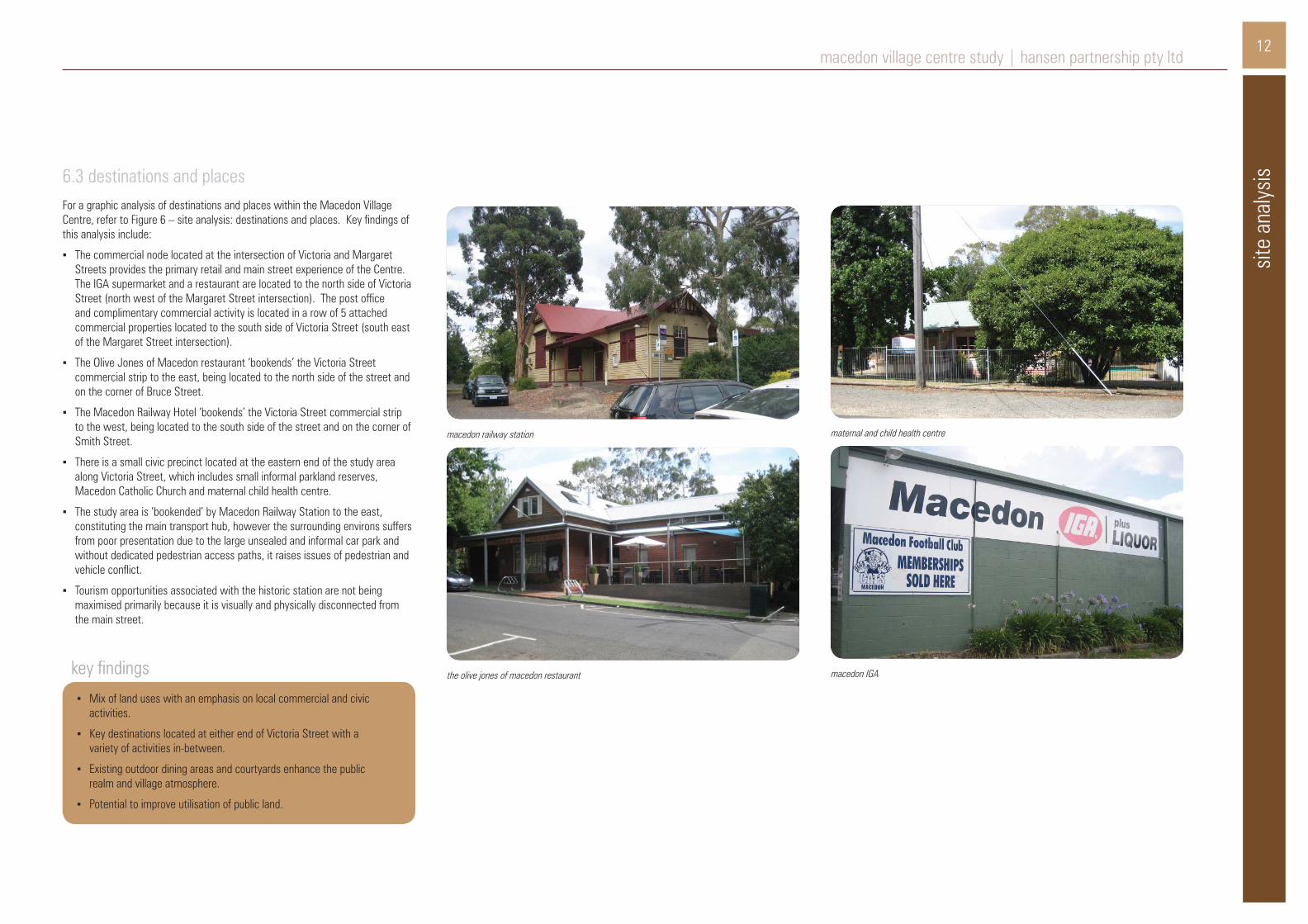
the olive jones of macedon restaurant macedon IGA
maternal and child health centremacedon railway station
6.3 destinations and placesFor a graphic analysis of destinations and places within the Macedon Village Centre, refer to Figure 6 – site analysis: destinations and places. Key findings of this analysis include:
▪ The commercial node located at the intersection of Victoria and Margaret Streets provides the primary retail and main street experience of the Centre. The IGA supermarket and a restaurant are located to the north side of Victoria Street (north west of the Margaret Street intersection). The post office and complimentary commercial activity is located in a row of 5 attached commercial properties located to the south side of Victoria Street (south east of the Margaret Street intersection).
▪ The Olive Jones of Macedon restaurant ‘bookends’ the Victoria Street commercial strip to the east, being located to the north side of the street and on the corner of Bruce Street.
▪ The Macedon Railway Hotel ‘bookends’ the Victoria Street commercial strip to the west, being located to the south side of the street and on the corner of Smith Street.
▪ There is a small civic precinct located at the eastern end of the study area along Victoria Street, which includes small informal parkland reserves, Macedon Catholic Church and maternal child health centre.
▪ The study area is ‘bookended’ by Macedon Railway Station to the east, constituting the main transport hub, however the surrounding environs suffers from poor presentation due to the large unsealed and informal car park and without dedicated pedestrian access paths, it raises issues of pedestrian and vehicle conflict.
▪ Tourism opportunities associated with the historic station are not being maximised primarily because it is visually and physically disconnected from the main street.
key findings
▪ Mix of land uses with an emphasis on local commercial and civic activities.
▪ Key destinations located at either end of Victoria Street with a variety of activities in-between.
▪ Existing outdoor dining areas and courtyards enhance the public realm and village atmosphere.
▪ Potential to improve utilisation of public land.

13sit
e an
alys
ismacedon village centre study | hansen partnership pty ltd
figure 6: site analysis; destinations and places

14
site
anal
ysis
macedon village centre study | hansen partnership pty ltd
view to vegetated roads; from margaret street towards north
views to mountains from smith street towards northeast
views to town centre from east
6.4 views and landscape sceneryFor a graphic analysis of landscapes and views within the Macedon Village Centre, refer to Figure 7 – site analysis: views and landscape scenery. Key findings of this analysis include:
▪ The visual setting of Macedon is strongly influenced by its topography and its siting on the Mt Macedon foothills. Such elements contribute to establishing a distinctive and memorable Village Centre character.
▪ The Village Centre is characterised by undulating topography with a number of crests located within proximity of the commercial core, being located at: the intersection of Victoria and Smith Streets, on Victoria Street east of Bruce Street, both of which provide long range views to the Village Centre.
▪ An avenue of large mature elms located on Victoria Street between Margaret and Bruce Streets contributes significantly to framing the streetscape.
▪ A variety of other trees (both mature and establishing), within the public realm and boundary hedges and formal/ informal garden planting of private property further contributes to the overall vegetated streetscape character of the Village Centre. Existing powerlines add visual clutter to its streetscape setting.
▪ The lack of formalised kerb and channel on the side streets immediately off Victoria Street further fosters the semi-rural character of the Macedon Village Centre.
▪ Some long range views and limited view shed glimpses of Mount Macedon are available from some elevated positions within the Macedon Village Centre, including: the frontage of the Macedon Railway Hotel and the elevated sections of the currently vacant site located to the south west corner of Victoria and Margaret Streets.
▪ Avenues of street trees, located within the Village Centre and throughout the surrounding street network, provides a cohesive element which frames the streetscape.
▪ Borrowed landscape contributes to the town centre’s natural setting.
▪ Key landscape features include views to Mt Macedon through breaks in the streetscape and views from higher grounds.
▪ Council reserves on the east side of Bruce Street retain mature native tree and ground cover species.
▪ Undulating topography provides strong directional views to the town centre.
▪ Power lines add visual clutter to the streetscape.
key findings

15sit
e an
alys
ismacedon village centre study | hansen partnership pty ltd
figure 7: site analysis; views and landscape scenery

econ
omic
ana
lysis
16macedon village centre study | hansen partnership pty ltd
Fundamental to the study is an understanding of supply and demand of commercial land and activities. Economic Geographer Tim Nott has undertaken an economic analysis of the Macedon Village Centre (project study area) to assist the understanding of the supply and demand for commercial land and activities. The key findings are summarised below and detailed background analysis is included in Appendix 2 – Economic Analysis Background:
▪ Macedon Village centre is a small neighbourhood activity centre that serves the township of Macedon and the village of Mt Macedon. The town centre is a multi-functional activity centre anchored by a small IGA supermarket, with a small range of specialty shops.
▪ The centre has approximately 3,800 sq m of activity space, of which 1,300 sq m (35%) is devoted to retailing. Other activities are the hotel, train station, CFA, church, maternal and child health centre, the post office and real estate agent.
▪ Based on the floorspace, the centre accommodates approximately 80 jobs, both full and part-time, and is therefore an important employment node for the district.
▪ Retail spending at the centre is around $7.3 million per year. Around $5.7 million of this is undertaken by residents and the remainder by visitors to the area. Total retail expenditure in shops by residents of the trade area is around $44.4 million per year. Current escape spending is therefore approximately $38.7 million per year or 87%.
▪ There is currently scope for a little more retail provision at Macedon (for example, a chemist, hairdresser and improved food offering). However, most residents will continue to undertake their main grocery shopping in the larger centres of Gisborne, Woodend and other centres that have full-scale supermarkets.
▪ The demand for future development of the centre is dependent on many factors, the most important of which will be the size of the local population and the increase in their retail spending. Two scenarios include:
▪ A low change scenario in which population continues to decline at recent rates, reaching 2,750 (census catchment, including Mt Macedon) by 2036.
▪ A moderate change scenario, in which population in the trade area stabilises around the present level of 3,280, mainly through higher occupancy of existing dwellings.
▪ In the low change scenario, the commercial floorspace remains at present levels over the period to 2036. Under the moderate change scenario, there is potential for up to 500 sq m of additional commercial floorspace in the village centre including 300 sq m of retailing or 2 to 4 extra shops.
▪ It’s Council’s preference that additional retail and commercial development provided under the moderate change scenario be provided on existing vacant sites to include provision for on-site car parking.
7 economic analysis
victoria street shops

17macedon village centre study | hansen partnership pty ltd
unmade footpath along Victoria Street
bush
fire
anal
ysis EcoTide, a specialist bushfire consultancy, has undertaken an analysis of the
Macedon Village Centre (project study area) and surrounding environs to assist the Project Team, Council and community understand bushfire risk in the context of the potential for future development of the study area. EcoTide assessed the specific bushfire risks associated with the development of the defined study area which is entirely subject to the Bushfire Management Overlay (BMO).
The methodology for assessing the bushfire risk utilised contemporary, best practice bushfire evaluation tools, and is consistent with the outcomes of the Black Saturday Royal Commission. The standard defendable space distances of the BMO (as detailed in Clause 52.47 Bushfire Protection: Planning Requirements of the Macedon Ranges Planning Scheme), have been mapped around the study area to determine the bushfire risk ratings for properties in the township. The bushfire risk ratings have been aligned with the Bushfire Attack Levels (BAL) utilised in the BMO and detailed in the Australian Standard – Construction of buildings in bushfire prone areas (AS3959-2009).
As a general summation of the bushfire threat to Macedon Village Centre, potentially large and high intensity bushfires could approach the towns from the north, north-west, and south-west. The proximity of relatively continuous forest vegetation to the perimeters of the Village Centre equates to a relatively high risk for people and development. It is estimated that, in a bushfire scenario, Macedon could be exposed to significant smoke and ember attack, with varying levels of radiant heat depending on the site in the area.
The mapping analysis of the defendable space has highlighted that the majority of the study area of Macedon Village Centre is able to meet the requirements for potential development associated with residential, industry, retail and office use. Development may be somewhat limited to the west of the study area around the train line, particularly for land uses other than those previously mentioned to which the BMO applies.
Based on the bushfire risk posed to Macedon Village Centre, the building requirements stipulated in the BMO and associated Clause 52.47 Bushfire Protection: Planning Requirements should be applied to developments within the study area on a case-by-case basis. Specific Schedules to the BMO have not been designed for the township, and it is expected that the relevant BMO standards will continue to be applied as per the regulations.
For ease of reference the Macedon Village Bushfire Analysis Map and Framework Plan (refer Figure 9 and the Framework Plan) illustrates the extent of the Macedon Village Centre which is subject to ‘moderate’ and ‘high’ bushfire risk. In addition, Section 10.1 Bushfire Management incorporates, a table of the relevant BAL ratings and defendable space distances as listed in Clause 52.47 Bushfire Protection: Planning Requirements of the Macedon Planning Scheme.
8 bushfire analysisThe key findings and conclusions relating to Macedon in terms of bushfire implications are summarised below:
key findings ▪ In a bushfire, the township of Macedon could be exposed to the varied
impacts of smoke, ember attack and debris, as well as varying levels of radiant heat and potentially direct flame contact around the outskirts of the town.
▪ In the study area, patches of vegetation near the train line increase the bushfire risk to the western section of the study area, resulting in ‘moderate’ risk.
conclusions ▪ The majority of the study area, not marked as ‘high’ or ‘moderate’ risk,
particularly to the east of Smith Street, could be developed for the purposes of dwellings, office or retail.
▪ Individual assessments would be required for potential development associated with accommodation, child care and education centres, hospitals, leisure and recreation, and places of assembly. These developments would, at least, be limited to the east of Smith St.
recommendations/ design guidelines ▪ It is recommended that development such as dwellings, office or retail
(subject to relevant land zoning controls) be limited to within areas not marked as ‘high’ or ‘moderate’ risk.
▪ Areas of ‘high’ risk are not recommended for future development based on current conditions. Additional fire prevention works, such as vegetation clearing, may enable development in some areas. However it should be noted that vegetation clearing and management in classified vegetation areas is only highlighting that there is the potential for further works, but not making a specific recommendation to undertake it.
18macedon village centre study | hansen partnership pty ltd
24 victoria street, macedon
fram
ewor
k pl
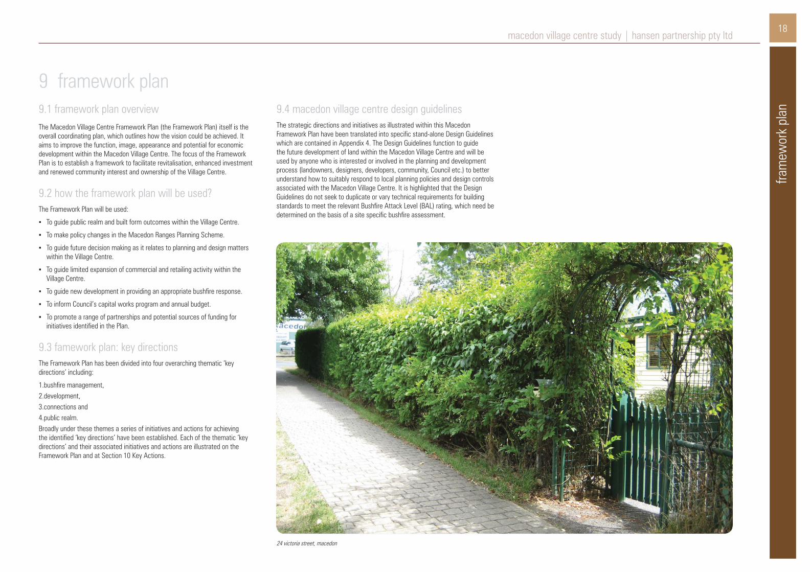
an9.1 framework plan overviewThe Macedon Village Centre Framework Plan (the Framework Plan) itself is the overall coordinating plan, which outlines how the vision could be achieved. It aims to improve the function, image, appearance and potential for economic development within the Macedon Village Centre. The focus of the Framework Plan is to establish a framework to facilitate revitalisation, enhanced investment and renewed community interest and ownership of the Village Centre.
9.2 how the framework plan will be used?The Framework Plan will be used:
▪ To guide public realm and built form outcomes within the Village Centre.
▪ To make policy changes in the Macedon Ranges Planning Scheme.
▪ To guide future decision making as it relates to planning and design matters within the Village Centre.
▪ To guide limited expansion of commercial and retailing activity within the Village Centre.
▪ To guide new development in providing an appropriate bushfire response.
▪ To inform Council’s capital works program and annual budget.
▪ To promote a range of partnerships and potential sources of funding for initiatives identified in the Plan.
9.3 famework plan: key directionsThe Framework Plan has been divided into four overarching thematic ‘key directions’ including:
1.bushfire management,2.development, 3.connections and 4.public realm. Broadly under these themes a series of initiatives and actions for achieving the identified ‘key directions’ have been established. Each of the thematic ‘key directions’ and their associated initiatives and actions are illustrated on the Framework Plan and at Section 10 Key Actions.
9 framework plan9.4 macedon village centre design guidelinesThe strategic directions and initiatives as illustrated within this Macedon Framework Plan have been translated into specific stand-alone Design Guidelines which are contained in Appendix 4. The Design Guidelines function to guide the future development of land within the Macedon Village Centre and will be used by anyone who is interested or involved in the planning and development process (landowners, designers, developers, community, Council etc.) to better understand how to suitably respond to local planning policies and design controls associated with the Macedon Village Centre. It is highlighted that the Design Guidelines do not seek to duplicate or vary technical requirements for building standards to meet the relevant Bushfire Attack Level (BAL) rating, which need be determined on the basis of a site specific bushfire assessment.

19fra
mew
ork
plan
macedon village centre study | hansen partnership pty ltd
figure 8: framework plan
20
key
actio
ns
macedon village centre study | hansen partnership pty ltd
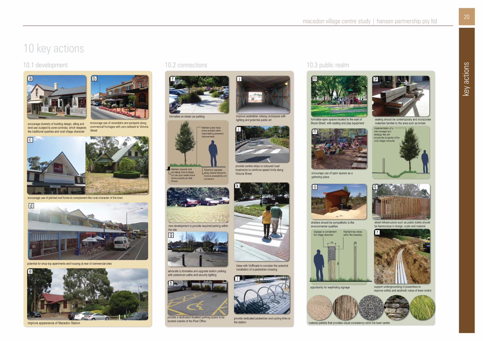
10 key actions10.1 development 10.2 connections 10.3 public realm

21ke
y ac
tions
macedon village centre study | hansen partnership pty ltd
10.4 general design guidelines ▪ New developments should incorporate active frontages with awnings along
Victoria Street boundaries and continue active frontages for a minimum of 10m of any side street boundary.
▪ New development should respect the existing low to moderate site coverage to allow for setbacks, landscaping and provision of car parking on site.
▪ Existing dwelling styles particularly to the east of Bruce Street should be retained.
▪ Access to car parking should be provided from side streets; the number of street crossings should be minimised; and on-site parking should not be visible from public spaces.
▪ Any upper levels should respect the low scale and be designed to be visually recessive from public vantage points (for example, setback from the ground level footprint or incorporated within attic style roof form).
▪ Commercial buildings should have spatial setbacks from adjacent residential development and where necessary at sensitive interfaces.
▪ Any upper level should provide surveillance of the street.
▪ Built form can demarcate the key junction of Victoria and Margaret Streets.
▪ Maintain a mix of activity with at least 50% of floor area comprising commercial activity.
▪ Overall building height in any part of the centre should not exceed 2 storeys (8.5 metres) at the street frontage.
▪ Apply sufficient side setbacks to upper levels to allow canopy planting which can screen a two storey wall from neighbouring properties and oblique views from the street.
▪ New development and associated access ways should follow contours and the prevailing slope of the land to avoid significant excavation works and minimise use of retaining structures.
▪ Potential shop-top development should provide equitable and sufficient private open space / common space for residential uses.
▪ Building design must have regard to the potential for future development of adjoining properties, so as not to compromise them through overshadowing or placement of services, loading or car parking.
▪ Façade designs should incorporate horizontal and vertical features such as fenestration, columns, cladding, framing etc. to correspond with neighbouring buildings within the streetscape.
▪ Traditional roof styles within the area should be incorporated which are predominately pitched, gabled or hipped.
▪ An ‘earthy’ appearance should be emphasised through the use of natural and textured materials such as timber, stone and brick.

22
figure 9: macedon village bushfire analysis, Ecotide 06.11.13
key
actio
ns
macedon village centre study | hansen partnership pty ltd
10.5 bushfire management ▪ All new development will be subject to the building requirements of the BMO
and Clause 52.47 Bushfire Protection: Planning Requirements.
▪ For general guidance the BAL construction standard and defendable space distances for development in ‘moderate’ and ‘high’ risk areas are summarised in the table below.
▪ Individual bushfire assessments would be required for potential development associated with accommodation, child care and education centres, hospitals, leisure and recreation, and places of assembly (NOTE: these developments should be limited to the east of Smith St).
Refer to Appendix 3: Development Implications for Bushfire Risk Categories for further information on anticipated construction requirements to meet the relevant BAL standards.
table 1: summary of defendable space distances for Macedon study area, Ecotide Macedon & Mt Macedon Bushfire Analysis Report, 06.11.13

23im
plem
enta
tion
macedon village centre study | hansen partnership pty ltd
11.1 implementation strategyThe Framework Plan identifies a series of initiatives and actions necessary to implement the key directions articulated for the Macedon Village Centre. A range of statutory and non-statutory actions will be needed to ensure success of the Framework Plan and realise ‘on-the-ground’ change. Given the emphasis on improving aspects of public and private realms, in addition to non-physical and community actions, the development of strong partnerships between Council, community organisations and State Government departments, and potential funding sources will also need to be achieved.
It should be noted that the Framework Plan is the overarching tool that establishes the preferred future land use, building design, public realm, and infrastructure directions for the Macedon Village Centre. Further detailed planning and design, as well as investigations will be needed to implement many of its recommendations.
11.2 funding and partnershipsGiven the nature of the proposals focused on public realm and capital works initiatives, a significant amount of funding will need to be sought from various sources, which are likely to be local and state government based. Therefore partnerships and the availability of funding will be key factors in successful delivery of much of the Macedon Framework Plan.
VicTrack will have a significant role to play regarding any parking, public realm and station upgrades to potentially be implemented within the Station precinct, whilst a large proportion of other public realm projects will be the responsibility of Macedon Ranges Shire Council to fund and implement.
11 implementation11.3 statutory planningOnce the study has been finalised following community consultation, it is recommended that Council formally adopt the Macedon Village Centre Study and Framework Plan and prepare a Planning Scheme Amendment to implement the recommendations of the Framework Plan into the Macedon Ranges Planning Scheme.
As there are a number of statutory planning mechanisms which could be utilised to implement the study within the the Planning Scheme context, a range of options are outlined below.
local policyExisting Local Polices Clause 21.02 Municipal Snapshot and Clause 21.03 Key Trends and Urban Growth provide varying degrees of policy context for the Macedon Village Centre. Given the location of these policies within the Municipal Strategic Statement, it provides the overall strategic directions for the Macedon Village Centre. Accordingly such clauses should be amended to policy context for the Macedon Village Centre Study & Macedon Framework Plan.
Noting that Clause 22.01 Macedon Ranges and Surrounds and Clause 22.02-9 Macedon provides more detailed policy context for Macedon, both polices should be amended and updated to refer to the Framework Plan’s key directions and initiatives.
Although built form guidance resulting from the actions and recommendations of the Framework Plan could potentially be incorporated into a local policy, consideration needs to be given to whether or not it would be better addressed though the specific application of a Design and Development Overlay (DDO) to be applied to all land located within the Macedon Village Centre. Options relating to built form controls, either within a local policy or within a Design and Development Overlay (DDO), will be further considered once the Framework Plan has been adopted by Council.
zoningWith regard to potential zoning of the study area, based on the background analysis, the application of existing zones is considered to be logical and straight forward based on established land use and activity. Notwithstanding, that some anomalies do exist, including a number of existing residential properties are located within the Commercial 1 Zone (C1Z). These properties predominantly front Victoria Street, being located on the north side of the street (east of Smith Street and Margaret Street) and the south side of the street (west of Bruce Street) and may allow adaptation to low scale commercial activities in the medium to long term.
overlaysNo modification is proposed to existing overlay controls (including: Bushfire Management Overlay (BMO), Restructure Overlay (RO) or Environmental Significance Overlay (ESO).
Regarding potential built form guidance resulting from the actions and recommendations of the Framework Plan, consideration needs to be given to whether or not it would be better addressed though the specific application of a Design and Development Overlay (DDO) to be applied to all land located within the Macedon Village Centre, or otherwise could potentially be incorporated into a local policy. An identified advantage of containing built form guidance within a local policy, means such requirements would provide statutory weight, whilst avoiding the application of another overlay for the Macedon Village. However one potential disadvantage of containing built form guidance within a local policy is that it reduces transparency, as a planning property report would not pick up on its status, whereas a Design and Development Overlay (DDO) would. Notwithstanding the ‘pros’ and ‘cons’ of each option relating to built form controls, either within a local policy or within a Design and Development Overlay (DDO), will be further considered once the Framework Plan has been adopted by Council.

Appendix 1:
background policy review

back
grou
nd p
olic
y re
view
appe
ndix
1: b
ackg
roun
d po
licy
revie
w
macedon village centre study | hansen partnership pty ltd
state planning policy frameworkState Planning Policies are overarching policies that affect land use and development throughout Victoria. The State Planning Policy Framework (SPPF) covers strategic issues of State importance addressing settlement, environmental and landscape values, environmental risks, natural resource management, built environment and heritage, housing, economic development, transport and infrastructure.
Clause 11.05 Regional Settlement of the SPPF contains sub Clause 11.05-2 Melbourne’s Hinterland area. The specific objective of Clause 11.05-2 is: “Provide for development in selected discrete settlements within the hinterland of Metropolitan Melbourne having regard to complex ecosystems, landscapes, agricultural and recreational activities in the area” and includes a range of strategies to achieve this objective, including:
▪ “Maintain the attractiveness and amenity of hinterland towns.
▪ Prevent dispersed settlement.
▪ Site and design new development to minimise risk to life, property, the natural environment and community infrastructure from natural hazards such as bushfire and flooding.
▪ Manage the growth of settlements to ensure development is linked to the timely and viable provision of physical and social infrastructure and employment.
▪ Strengthen and enhance the character and identities of towns.
▪ Improve connections to regional and metropolitan transport services”.
Clause 12.04 Significant Environments and Landscapes of the SPPF contains a sub Clause 12.04-1 Environmentally Sensitive Areas. The specific objective of Clause 12.04-1 is: “To protect and conserve environmentally sensitive areas” where the strategy to implement this objective seeks to protect environmentally sensitive areas with significant recreational value (such as Macedon Ranges) from development which would diminish their environmental conservation or recreation values.
Clause 13 of the SPPF identifies the need to adopt a best practice environmental management and risk management approach which aims to avoid or minimise environmental degradation and hazards, which in the context of Macedon, specifically relates to the natural bushland environment and the associated bushfire risk it creates. The specific objective of Clause 13.01 Bushfire is: “to strengthen community resilience to bushfire” and includes a range of strategies to achieve this objective, including overarching strategies of:
▪ “Prioritise the protection of human life over other policy considerations in planning and decision-making in areas at risk from bushfire.
▪ Where appropriate, apply the precautionary principle to planning and decision-making when assessing the risk to life, property and community infrastructure from bushfire.”
Clause 15 of the SPPF sets out 10 principles to guide positive built environment and heritage outcomes. These principles provide the foundation for the recommendations of this project and primarily seek to “create urban environments that are safe, functional and provide good quality environments with a sense of place and cultural identity.” The responsiveness of development and planning to the particular location and site context of an area is of key importance. The clause encourages the protection and enhancement of key landmarks and vistas, and places of heritage significance. Architectural and landscape architectural quality is also emphasised as an important factor in new development in existing urban areas. Additional objectives include design of places and spaces to ensure and support community safety and the protection of ‘neighbourhood character’.
Clause 17.01 Commercial of the SPPF contains a sub- Clause 17.01-1 Business. The specific objective of Clause 17.01-1 is: “To encourage development which meet the communities’ needs for retail, entertainment, office and other commercial services and provides net community benefit in relation to accessibility, efficient infrastructure use and the aggregation and sustainability of commercial facilities”. Relevant strategies to achieve this objective include:
▪ “Locate commercial facilities in existing or planned activity centres.
▪ Provide new convenience shopping facilities to provide for the needs of the local population in new residential areas and within, or immediately adjacent to, existing commercial centres.
▪ Provide small scale shopping opportunities that meet the needs of local residents and workers in convenient locations”.
The above quoted polices, objectives and associated strategies of the SPPF have particular influences and implications on the study, and highlight at a broad policy level the important strategic matters which should be considered and addressed as appropriate through the current project. Such issues relevant to Macedon/ Mt Macedon can be summarised as follows:
▪ Protection of the character and role of hinterland areas from inappropriate use and development.
▪ Protection of environmental, conservation and recreational values.
▪ Manage and respond to the risk to life, property and community infrastructure from bushfire.
▪ Encourage good quality design to create safe, functional good quality environments with a sense of place and cultural identity.
▪ Facilitate commercial activity in planned activity centres to service the needs of the local community.
Each of the above polices has been broadly considered and have informed the development of the Macedon Village Centre Study & Macedon Framework Plan. With further reference to the relevant policy framework context, it is nominated that more detailed local level focused polices are provided within the Local Planning Policy Framework (LPPF). Relevant polices contained within the LPPF are summarised below at Section 3.2.
loddon mallee south regional growth plan, may 2014The State Government has recently completed Regional Growth Plans for each part of the State. Amendment VC106 introduced the Loddon Mallee South Growth Plan at Clause 11.05 and Clause 11.12, in May 2014.
The Loddon Mallee South Regional Growth Plan (May 2014) was prepared for the region including Macedon Ranges, Greater Bendigo, Central Goldfields, Loddon and Mount Alexander Shires and exhibited for public comment in April-May, 2013.
The plan anticipates that most of the growth within this region will occur in Greater Bendigo, Macedon Ranges and Mount Alexander, mainly due to rail and road infrastructure improvements in the Calder corridor and the increasing attractiveness of the region as an alternative to Metropolitan Melbourne. The plan identifies that capacity for expansion of many settlements in the region is limited by surrounding forest, and that urban expansion needs to carefully consider fire risk.
The main urban centres of Macedon Ranges Shire are denoted as ‘key hinterland towns’ for the region, where growth and expansion can ‘capitalise on excellent access to Melbourne and/or Bendigo’.
The plan directs most of this growth to Gisborne and Kyneton, identified as locations to ‘manage and support growth’, or Riddells Creek and Romsey, identified as ‘rural towns’ with capacity for growth.
The Plan has not identified Macedon for high or moderate growth.
municipal strategic statement and local planning policiesThe Local Planning Policy Framework (LPPF) contains the Municipal Strategic Statement (MSS) and local planning policies. The framework identifies long term directions about land use and development in the Shire; presents a vision for the community and other stakeholders; and provides the rationale for the zone and overlay requirements and particular provisions in the Macedon Ranges Planning Scheme.
Clause 21.02 Municipal Snapshot highlights the role of Macedon as a ‘Village/ Service Centre’ and notes its role as: ”Small township servicing immediate area with limited services. A railway station is located in the town”.
Clause 21.03 Key Trends and Urban Growth notes there are limits to growth in Macedon, and under the heading of Wildfire notes: “Much of the Shire is at risk from wildfire and has a history of severe bushfires. Wildfires in forest and bushland areas around Mount Macedon have caused considerable damage to property and loss of life or injury. Land use and development planning in the Shire must recognise and minimise the level of fire risk.”

appe
ndix
1: b
ackg
roun
d po
licy
revie
w
back
grou
nd p
olic
y re
view
macedon village centre study | hansen partnership pty ltd
Clause 22.02-9 Macedon is the policy mechanism to implement the Macedon Village Centre Study, and nominates that the role and character of: “Macedon is a rural village which provides a high quality residential environment. A significant proportion of the working population commute to Melbourne. Limited retail and business services are available in the town focus area.”
The following objectives of Clause 22.02-9 Macedon apply to the entire settlement of Macedon, (which includes the residential areas outside of the current study area):
▪ To protect residential lifestyle by the protection of important landscape and environmental values.
▪ To ensure that fire prevention is a priority consideration for development.
▪ To protect heritage features.
▪ To ensure environmentally sustainable levels of development.
▪ To prevent the loss of vegetation and soil disturbance.
▪ To protect significant view lines to Mount Macedon and surrounding areas.
Clause 22.10 Wildfire Fire Risk acknowledges that the entirety of the Macedon Ranges Shire is at high risk of wildfire, and contains an objective: “To ensure that residential and other forms of development catering for people in rural areas and on the fringes of urban areas are sited and designed so as to minimise risk from wildfire.”
The range of local policies summarised above clearly illustrates the context of Macedon as being a small settlement defined as a ‘village/ service centre’ which provides for limited retail and business within the town centre. It also highlights significant environmental and landscape character attributes, which also have significant limitations on development, primarily based on risks associated with bushfires. This policy context is a critical consideration for the Macedon Village Centre Study & Macedon Framework Plan.
macedon ranges settlement strategyThe Macedon Ranges Settlement Strategy (MRSS) was completed in 2011 following extensive consultation with the community. It is Council’s currently adopted position on the strategic growth of the Shire, including the Macedon township.
The aim of the MRSS was to apportion growth across the Shire and establish the role of each urban centre. A hierarchy of the role and function of each town was recommended.
The MRSS recommended that Macedon “could accommodate a population of approximately 1400 in 2036 which represents a no-growth scenario” (page 45). This is discussed in further detail in Appendix 2: Economic Analysis Background.
The MRSS further states: “There is some argument that Macedon should be permitted to grow to support the viability of the commercial centre, yet while this rationale has merit, such growth should be limited. In the case of Macedon, historic growth does not provide an indicator to demand since the restructure overlay has essentially prevented development since 1980. Hence, it is difficult to determine underlying demand. If fire constraints do not prohibit development in Macedon, it is expected council should plan to accommodate moderate development ... given the range of constraints that exist”.
The key directions of the MRSS will be translated into the Planning Scheme through Amendment C84 (below).
amendment C84 – revised municipal strategic statement (MSS)Amendment C84 proposed an updated MSS and Local Planning Policies for Macedon Ranges. A Final Panel Report and the Panel’s ‘Recommended MSS’ supports some growth in Macedon., as indicated by the following statement:
“This Panel reaffirms its view in the Interim Report that the ‘no growth’ designation in the Settlement Strategy is appropriate. We note that some for (sic) infill and redevelopment is anticipated and this is appropriate. The Panel considers the references in the current version of the MSS to significant constraints in Macedon (and Mount Macedon) and the intent that ‘Growth is not proposed in Macedon and Mt Macedon due to the high bushfire risk and other environmental constraints’ reflected in Clauses 21 .02-1, 21.04 and 21.13 are consistent with the Settlement Strategy and the Interim Panel Report recommendations”(page 24-25).
Relevant objectives and strategies in the C84 Panel report is revised MSS at Clause 21.13-6 include:
Objective 2
▪ To ensure orderly infill development and redevelopment that respects the development constraints of Macedon.
Objective 4
▪ To provide for limited commercial development within Macedon.
Strategies
▪ Ensure new commercial development in Victoria Street, Macedon is limited to the east of Bruce Street.
▪ Plan for extension of Victoria Street, Macedon, westwards towards the railway precinct, with active frontages comprising a mix of commercial and civic uses.
▪ Ensure development of key sites on the corner of Victoria and Smith Streets and Victoria and Margaret Streets protects the rural village atmosphere through the use of appropriate scale, materials and building setbacks.
▪ Promote tourism development in Macedon that retains the area’s key characteristics.
non-statutory documents
macedon ranges small towns studyMacedon Ranges Small Towns Study, 2006 proposed policy outcomes for small towns and communities in the Shire. The Future Character Statement in the Study states:
Macedon will be a viable and sustainable township, which protects and builds upon its village character.
The Study noted community concern that the village and landscape character was endangered by ongoing and more intensive residential development.
Recommendations to achieve this include:
▪ Develop guidelines to ensure sympathy with the existing rural village atmosphere of the town including: street planning, built form, building setbacks and public space; active commercial frontages, scale, colour and materials, footpaths, car parking, undergrounding of power, street furniture, lighting and landscaping. Entries to the town centre from Bruce Street and Smith Street also need to be addressed.
▪ Specific guidelines for the development of vacant land on the south side of Victoria Street (19 Victoria Street).
▪ Provide landscaping and directional signage to the commercial centre at entries from Bruce and Smith Street.

back
grou
nd p
olic
y re
view
macedon village centre study | hansen partnership pty ltd
As part of the preparation of this study the Macedon / Mt Macedon Community Plan 2012 was reviewed and considered in detail. This document does not constitute a Council authored document, rather it is noted to have been prepared by the the Macedon/ Mt Macedon Community Planning Group. Therefore whilst it holds no formal statutory weight, it constitutes an important record of the community’s aspirations for both townships of Macedon and Mt Macedon.
In summary the Community Plan focuses on the entire township areas of both settlements of Macedon and Mt Macedon and nominates 4 Community Plan Priorities as follows:
▪ Priority 1: Planning Controls
▪ Priority 2: Streetscape
▪ Priority 3: Fire Safety
▪ Priority 4: Transport
The Community Plan also provides vision statements which correspond with the above priorities as follows:
▪ Planning Controls Vision: To promote sensitive and controlled town planning sympathetic to our local character and sensitive to the environment.
▪ Streetscape Plan Vision: To protect, maintain and enhance the rural characrer of our unique, iconic landscape.
▪ Macedon Bushfire Mitigation Plan Vision: On days of extreme fire danger the Madedon community no longer lives in fear of a devastating inferno.
▪ Transport Improvement Plan Vision: To improve the appearance and utilisation of our transport assets.
Whilst the scale of the Community Plan is noted to be broader than the focus of the Macedon Village study, it nevertheless constitutes a useful and informative document to the preparation of the current study.

appe
ndix
1: b
ackg
roun
d po
licy
revie
w
Appendix 2:
economic analysis background
econ
omic
ana
lysis
back
grou
ndmacedon village centre study | hansen partnership pty ltd
economic analysis backgroundFundamental to the study is an understanding of supply and demand of commercial land and activities. Economic Geographer Tim Nott has undertaken an economic analysis of the Macedon Village Centre (project study area) to assist the understanding of the supply and demand for commercial land and activities.
From an economic perspective Macedon Village centre is a small neighbourhood activity centre that serves the villages of both Macedon and the village of Mt Macedon. The village centre (being the subject of this study) is a multi-functional activity centre anchored by a small IGA supermarket, with a small range of specialty shops, cafes and restaurants. Presently Macedon Village can be considered larger than a typical local centre, but smaller than a typical neighbourhood centre.
An analysis of the centre noted that it has approximately 3,800 sq m of activity space, of which 1,300 sq m (35%) is devoted to retailing. Other non-retailing activities include the hotel, train station, CFA, church, maternal and child health centre, post office and real estate agent. Based on the floorspace assessment, the centre accommodates approximately 80 jobs, full and part-time, and is therefore an important employment node for the local area.
The estimated resident population of Macedon is approximately 1,864 (according to 2011 ABS data). This population figure is slightly higher than the 1,400 population figure nominated in the Macedon Ranges Shire Council Settlement Strategy: July 2011, however it is acknowledged that this lower figure of 1,400 was based on 2006 ABS data and a slightly different statistical area based on modifications to statistical boundaries. Notwithstanding this minor variance in population figures for Macedon, it is nominated that the Settlement Strategy acknowledged the existing role of Macedon as a Small Town (500-2,000 residents) and made a specific recommendation that based on the level of environmental constraints and hazards identified, that Macedon should not accommodate further populatio growth and retain its current approximate population.
For the purposes of analysing the retail health of Macedon Village its trade area needs to be defined. The trade area of an activity centre is the catchment area from which most of its business is drawn. People within this area will naturally opt to source goods and services from this activity centre rather than elsewhere. For residents located towards the boundary of the trade area, they may choose from two or more centres that provide equivalent services. The extent of a trade area is influenced mainly by the location of competing centres and the travel patterns of residents. The precise boundaries are usually set to coincide with convenient statistical areas. For the purposes of this study, the trade area is broadly defined as the designated suburban areas of both Macedon and Mt Macedon. It has also been influenced by the location of larger surrounding commercial centres such as: Woodend, Gisborne, Riddells Creek, Romsey and Sunbury. The larger centres of Gisborne and Woodend have full line supermarkets and significant speciality stores which attract Macedon residents.
Alternately Sunbury provides the closest discount department store.
Whilst the extent of the trade area of Macedon Village provides a service to visitors and local community of both Macedon, Mt Macedon and surrounds, it is highlighted that there is significant loss of retail activity to larger surrounding commercial centres located outside of the trade area. An analysis of the loss of retail expenditure is expanded below.
As of 2012 the estimated resident population of the Macedon trade area was 3,122 (ABS (2012a). Over the period of 2001 to 2011 there has been a population decline of 0.7% per year, particularly based on very few additional houses being built, coupled with decline in household size. This population decline is consistent with the Macedon Ranges Settlement Strategy (CPG, 2010) which identifies that the population of Macedon should not grow, largely because environmental factors make this both dangerous (high bushfire risk) and undesirable (high landscape values). In fact, the population of the area has been declining for the past decade as no significant housing development has taken place and household sizes have declined.
Based on these population growth characteristics two scenarios have been devised which will impact on future commercial floorspace requirements:
▪ A moderate change scenario, in which population in the trade area stabilises around the present level of 3,280, mainly through higher occupancy of existing dwellings.
▪ A low change scenario in which population continues to decline at the rate experienced in the Macedon Statistical Area (SA2) over the period 2001 to 2011, reaching 2,750 by 2036.
Both these scenarios are used to understand how retail development potential will change over the study period to 2036.
Based on an analysis of current retail spending within Macedon Village, this is noted to be around $7.3 million per year. Of this figure around $5.7 million of this is undertaken by residents, with the remainder by visitors to the area. However when this level of retail spending is contrasted with the total retail expenditure by residents of the trade area, which is around $44.4 million per year, it highlights a significant level of current escape spending which amounts to approximately $38.7 million per year (or 87% of retail expenditure of the trade area is lost from Macedon Village).
In order to potentially capture some of this current escape of retail expenditure there is currently scope for further retail activity within Macedon Village without significantly affecting its role. For example the centre could provide a chemist, hairdresser and additional food and grocery provision (i.e. such as a slightly expanded supermarket or new butcher). However it also needs to be acknowledged that most residents will continue to undertake their grocery shopping in the larger centres of Gisborne, Woodend and other centres that have full-scale supermarkets, which will still cause loss of retail spending from the trade area.
Under the low growth scenario outlined above, it would mean there is essentially no requirement for additional retail floorspace over the period to 2036.
However under the moderate growth scenario outlined above, the maximum likely development would be for additional floorspace of not more than 500 sq m over the period to 2036 including 300 sq m of retail and the remaining 200 sq m for other commercial activities (eg. cafe, restaurant). This floorspace would accommodate shops and offices, with offices potentially located above the shops. With the requisite car parking provided on site, the overall site area required for new development could be up to 1,000 sq m.
For example, the vacant site at the corner of Victoria Street and Margaret Street would be more than sufficient to accommodate such development, having a total site area of approximately 2,800 sq m. Alternatively, space might be found through redevelopment of existing residential properties on Victoria Street within the heart of the town centre precinct on land which is commercially zoned.
Beyond commercial activity, there are considerations relating to non-retail development. Presently, Macedon Village accommodates a range of community and commercial services besides retailing, which amounts to around 65% of non-residential building space. This includes the hotel and real estate agent, CFA building, train station, church and child care centre. There are also several community services just outside the town centre to the north along Smith Street, including the Jubilee Hall and the primary school.
In the future, there may be some demand for office space for small-scale professional or medical services. The presence of the railway station makes this a location that is well-connected to the Melbourne CBD and other centres along the route. It would be possible for local professionals to have an office in Macedon and service clients in central Melbourne. However, such professionals could also work from home. The demand for office space from this quarter would therefore be small – perhaps one or two small office units over the period, with the possibility of a doctor’s surgery. However further community services in the town centre are unlikely in a district where population is static or declining, particularly given that other parts of the municipality will be growing quite strongly.

appe
ndix
2: e
cono
mic
ana
lysis
back
grou
nd
Appendix 3:
development implications for bushfire risk categories

deve
lopm
ent i
mpl
icat
ions
for b
ushf
ire ri
sk c
ateg
orie
s
appe
ndix
3: d
evel
opm
ent i
mpl
icat
ions
for b
ushf
ire ri
sk c
ateg
orie
s
macedon village centre study | hansen partnership pty ltd
development implications for bushfire risk categories
considerations for developing within the bushfire management overlayFollowing below is an outline of the implications for development relating to the ‘low’, ‘moderate’ and ‘high’ bushfire risk categories. These bushfire risk categories correspond to the following Bushfire Attack Level (BAL) construction levels as follows:
▪ High Risk = BAL 40 and above
▪ Moderate Risk = BAL 29
▪ Low Risk = BAL 19 or below
Any potential development would have to consider the following specific planning implications and requirements to gain approval to build under a Bushfire Management Overlay (BMO). Based on the current analysis of Macedon, the following three categories apply to properties within the villages.
high risk properties (limited to outer areas west of smith street) ▪ The site is under the Bushfire Management Overlay (BMO).
▪ Bushfire impacts are likely to include direct flame contact, high levels of radiant heat (>40kW/m²) and ember deposition.
▪ Development will currently not meet the Bushfire Management Overlay (BMO) objectives, and mandatory standards.
moderate risk properties (limited to outer areas west of smith street) ▪ The site is under the Bushfire Management Overlay (BMO).
▪ Bushfire impacts are likely to include moderate levels of radiant heat (<29kW/m²) and ember deposition.
▪ A Bushfire Management Statement (BMS) is required to address the provisions of the BMO.
▪ New development must meet the bushfire protection measures for defendable space, construction of buildings in bushfire prone areas (AS 3959), access, siting and water supply requirements.
▪ Significant sitting constraints may prevent achieving defendable space within the bounds of the property.
▪ Defendable space may incorporate adjacent residential land which will need to be managed in accordance with defendable space prescriptions (subject to private agreements).
▪ All sites will be required to provide a static water supply solely for fire-fighting purposes.
▪ All sites need to consider the likely bushfire behaviour in the wider landscape.
▪ Development will also need to meet the planning requirements of the relevant overlays as applicable.
low risk properties (applies to all land in the stucy area east of smith street) ▪ The site is under the Bushfire Management Overlay (BMO).
▪ Bushfire impacts are likely to include low to moderate levels of radiant heat (<19kW/m²) and ember deposition.
▪ A Bushfire Management Statement (BMS) is required to address the provisions of the BMO.
▪ New development must meet the bushfire protection measures for defendable space, construction of buildings in bushfire prone areas (AS 3959), access, siting and water supply requirements.
▪ Significant sitting constraints may prevent achieving defendable space within the bounds of the property.
▪ Defendable space may incorporate adjacent residential land which will need to be managed in accordance with defendable space prescriptions (subject to private agreements).
▪ All sites will be required to provide a static water supply solely for fire-fighting purposes.
▪ All sites need to consider the likely bushfire behaviour in the wider landscape.
▪ Development will also need to meet the planning requirements of relevant overlays as applicable.
construction standards for meeting BAL ratingThe Building Commission has prepared and published a detailed and particularly relevant document entitled: A Guide to Building in Victoria after the Bushfires. The aim of the new building standard is to improve the ability of buildings to withstand a bushfire attack. Importantly the document contains a section under the heading of ‘What my home might look like’ which based on the bushfire assessment and analysis has been deemed to have specific relevance to the context of Macedon.
Specifically the new building standard assessment has six levels of risk based on the Bushfire Attack Level (BAL), with increasing construction requirements ranging from ember protection at the low levels (BAL-12.5) to fire-rated construction at the highest (BAL-FZ [Flame Zone]). For reference it is reiterated that the designated study area of Macedon has been designated to be categorised as either BAL19, BAL 29 or BAL40.
Under the ‘What my home might look like’ section of A Guide to Building in Victoria after the Bushfires it contains a table which steps out the likely design and construction requirements to meet each of the nominated BAL standards. For ease of reference only the design and construction requirements to meet BAL19, BAL 29 or BAL40 are replicated below, as these are the specific categories which apply to land within the Macedon Village Centre.
What my home might look like: Summary Table

appe
ndix
3: d
evel
opm
ent i
mpl
icat
ions
for b
ushf
ire ri
sk c
ateg
orie
s
macedon village centre study | hansen partnership pty ltd
deve
lopm
ent i
mpl
icat
ions
for b
ushf
ire ri
sk c
ateg
orie
s
BAL19 BAL29 BAL40
Subfloor support
No special construction requirements
Enclosure by external wall or by steel, bronze or aluminium mesh, non-combustible supports where the subfloor is unenclosed, naturally fire resistant timber stumps or posts on 75 mm metal stirrups
If enclosured by external wall refer below ‘External Walls’ section in table or non-combustible subfloor supports or tested for bushfire resistance to AS 1530.8.1
Floors No special construction requirements
Concrete slab on ground, enclosure by external wall, metal mesh as above or flooring less than 400 mm above ground level to be non-combustible, naturally fire resistant timber or protected on the underside with sarking or mineral wool insulation
Concrete slab on ground, enclosure by external wall or protection of underside with a non-combustible material such as fibre cement sheet or be non-combustible or be tested for bushfire resistance to AS 1530.8.1
External walls
External walls – Parts less than 400 mm above ground or decks etc to be of non-combustible material, 6 mm fibre cement clad or bushfire resistant/naturally fire resistant timber
Non-combustible material (masonry, brick veneer, mud brick, aerated concrete, concrete), timber framed, steel framed walls sarked on the outside and clad with 6 mm fibre cement sheeting or steel sheeting or bushfire resistant timber
Non-combustible material (masonry, brick veneer, mud brick, aerated concrete, concrete) or timber framed or steel framed walls sarked on the outside and clad with 9 mm fibre cement sheeting or steel sheeting or be tested for bushfire resistance to AS 1530.8.1
External windows
Protected by bushfire shutter, completely screened with steel, bronze or aluminium mesh or 5 mm toughened glass or glass blocks within 400 mm of ground, deck etc. Openable portion metal screened with frame of metal or metal reinforced PVC-U or bushfire resisting timber
Protected by bushfire shutter or completely screened with steel, bronze or aluminium mesh, or 5 mm toughened glass with openable portion screened and frame of metal or metal reinforced PVC-U, or bushfire resisting timber and portion within 400 mm of ground level screened
Protected by bushfire shutter or 5 mm toughened glass. Openable portion screened with steel or bronze mesh
External doors
Protected by bushfire shutter, or screened with steel, bronze or aluminium mesh or glazed with 5 mm toughened glass, non-combustible or 35 mm solid timber for 400 mm above threshold, metal or bushfire resisting timber framed for 400 mm above ground, decking, etc, tight-fitting with weather strips at base
Protected by bushfire shutter, or screened with steel, bronze or aluminium mesh or noncombustible, or 35 mm solid timber for 400 mm above threshold. Metal or bushfire resisting timber framed tight-fitting with weather strips at base
Protected by bushfire shutter, non-combustible or 35 mm solid timber, metal framed tight-fitting with weather strips at base
RoofsNon-combustible covering. Roof/wall junction sealed. Openings fitted with non-combustible ember guards. Roof to be fully sarked
Non-combustible covering. Roof/wall junction sealed. Openings fitted with non-combustible ember guards. Roof to be fully sarked
Non-combustible covering. Roof/wall junction sealed. Openings fitted with non-combustible ember guards. Roof to be fully sarked and no roof mounted evaporative coolers
Verandas
Enclosed sub-floor space – no special requirement for materials except within 400 mm of ground. No special requirements for supports or framing. Decking to be non-combustible or bushfire resistant within 300 mm horizontally and 400 mm vertically from a glazed element
Enclosed sub-floor space or non-combustible or bushfire resistant timber supports. Decking to be non-combustible
Enclosed sub-floor space or non-combustible supports. Decking to be non-combustible
Please note: The information in the table is a summary of the construction requirements in the new standard and not intended as a design guide. You should consult the standard for the full technical details.
Source: Building in Victoria after the Bushfires: the Building Commission