Construction Productivity and - Geospatial World … - V1-1 Short.pdfMay 21, 2007 · Autodesk...
38
Geoff Zeiss Director Utility Industry Program Autodesk Construction Productivity and Convergence of BIM, GIS, and 3D Gaming
Transcript of Construction Productivity and - Geospatial World … - V1-1 Short.pdfMay 21, 2007 · Autodesk...

Geoff Zeiss
Director Utility Industry Program
Autodesk
Construction Productivity and
Convergence of BIM, GIS, and 3D Gaming

The world economy is expanding at an unprecended rate

The world economy is expanding at an unprecended rate

International focus: Energy intensity
IEA Energy Outlook

Greening the building/infrastructure market
Globally $6-7 trillion annually
Today 6% qualifies as “green”
In 2020 75% will be “green”
Green buildings and infrastructure driven by regulation, owner and
investor demands, resource cost, security concerns, and third party
standards.
Source: Global Insight

Worldwide Infrastructure Expenditure
2005-2030
http://www.strategy-business.com/article/07104?pg=all
$24 trillion
to
$41 trillion

Governments don’t have this kind of money
$

Québec Plan Nord
http://www.plannord.gouv.qc.ca/english/overview/index.asp
The Plan Nord will be carried out over a
period of 25 years. It will lead to over
$80 billion in investments during that
time and create or consolidate, on
average, 20 000 jobs a year, equivalent
to 500 000 man-years. The Plan Nord
will be to the coming decades what La
Manicouagan and James Bay were to
the 1960s and 1970s.
Target 70% private funding

UK National Infrastructure Plan
http://www.hm-treasury.gov.uk/national_infrastructure_plan2011.htm
The National Infrastructure Plan brings together the first
ever comprehensive cross-sectoral analysis of the UK’s
infrastructure networks and sets out a clear pipeline of
over 500 infrastructure projects. worth over £250 billion
over the next 5 years.
The Government will use all the tools at its disposal to
facilitate the private investment that will finance the
majority of the UK’s infrastructure.
Est £400 billion over next decade
Target 70% private funding

© 2009 Autodesk
Who is going to do all this ?

11 © 2007 Autodesk
Historical Productivity in Construction
McKinsey & Company

12 © 2007 Autodesk
European economies face steep labor declines
Adele Hayutin, Labor Force Implications and Pension Vulnerabilities, Briefing to the Senate Special
Committee on Aging, May 21, 2007

13 © 2007 Autodesk
Aging utility workforce in Europe
Source: Stuart Ravens, Ovum

14 © 2007 Autodesk
Germany
• Needs 400,000 engineers, master
craftsmen and skilled workers.
• 80,000 unfilled positions for
engineers
(Association of German Engineers)
http://www.economist.com/node/18621769
http://taxguru.in/chartered-accountant/germany-relaxes-immigration-laws-professionals.html
• GDP growth reduced by one percent by the labour shortage and
problem is growing worse
(German Chamber of Industry and Commerce )
• Could be faced with a labor shortage of five million people within the
next 15 years. (The Economist)

15 © 2007 Autodesk
Productivity gains could reduce cost of infrastructure
McKinsey & Company
Technology is rapidly evolving to meet these challenges
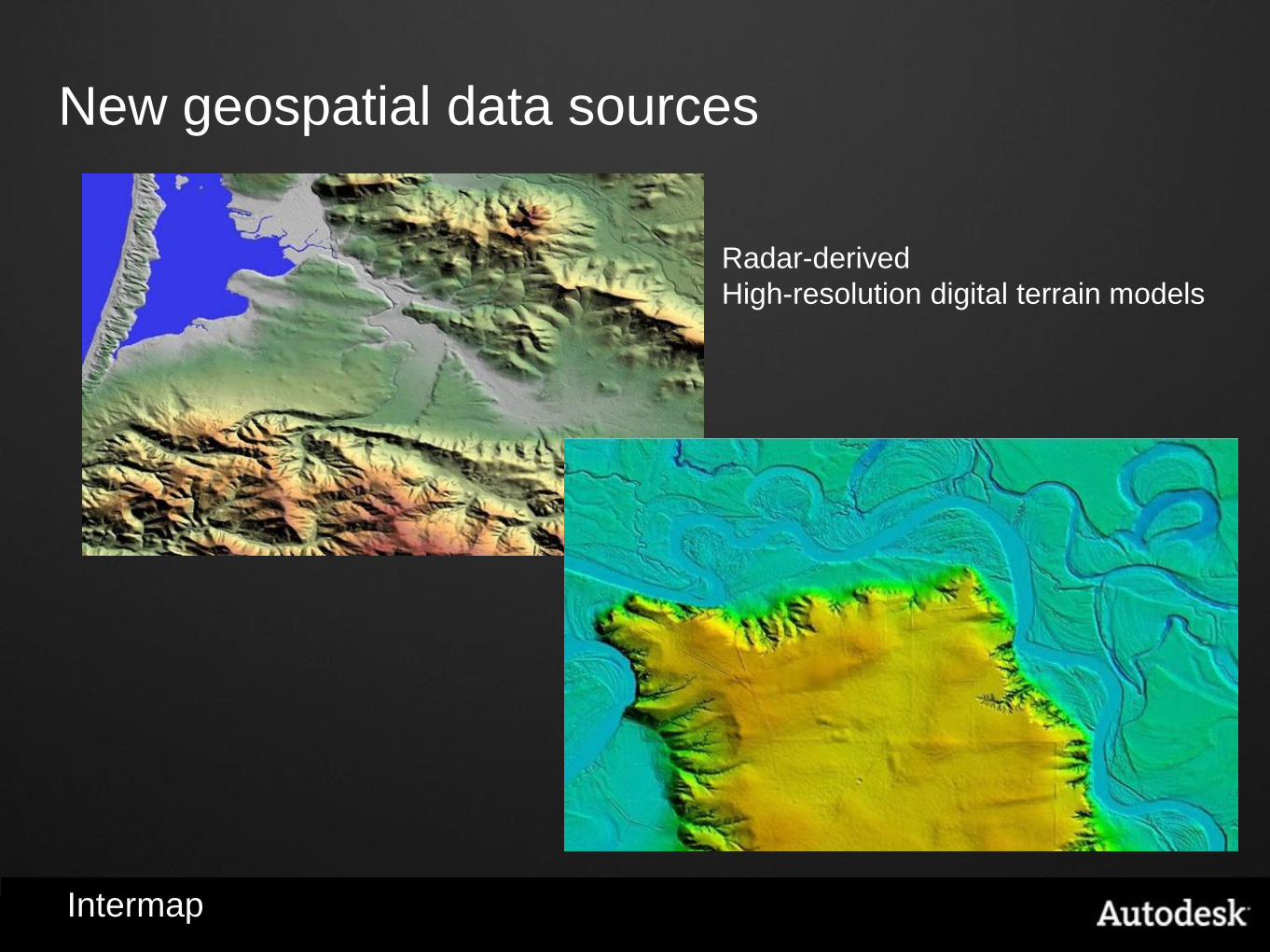
New geospatial data sources
Intermap
Radar-derived
High-resolution digital terrain models
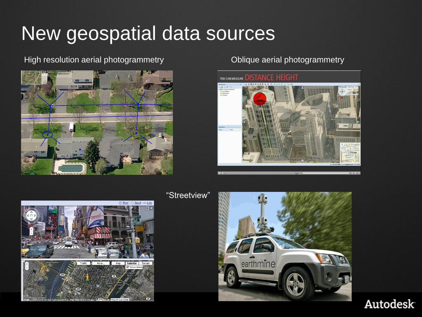
New geospatial data sources High resolution aerial photogrammetry Oblique aerial photogrammetry
“Streetview”

New geospatial data sources: laser scanning

Transportation Planning SF Presidio Parkway Project
Laser Scanning to Models for ROW, Planning, Design, Construction and O&M
Caltrans - Parsons Brinckerhoff

Evolution of CAD to Model Based Design or BIM
Graphics only
Lacks intelligence
Lacks domain
knowledge
CAD
Integrates geospatial and engineering
design data
Enforces business and engineering
rules
Automates clash detection
Automates change propagation
Reduces data redundancy
Improves collaboration among design
teams
Automates bill of materials and job
costing
3D visualization involves non-technical
stakeholders in design process
Model based design or BIM
Benefits
Increases productivity
Reduces risk
Reduces costs
Improves design quality
Deliverable is paper Deliverable is an intelligent digital model
Intelligent models

Gaming and 3D visualization
Now used by
engineers

Gaming and 3D visualization Lighting Design & Analysis
Caltrans - Parsons Brinckerhoff
SF Presidio Parkway Project

5D for financial control
Caltrans - Parsons Brinckerhoff
SF Presidio Parkway Project

Analysis and simulation
Building performance
simulation
Visualize environmental
performance
Visualization of building
performance and
environmental characteristics
Visualize environmental factors
Solar, Shading, Daylighting, Weather
Conceptual design analysis
such as basic form and building
orientation, internal layout, and
external materials.
Technology is changing many domains

Advanced wastewater treatment plant design
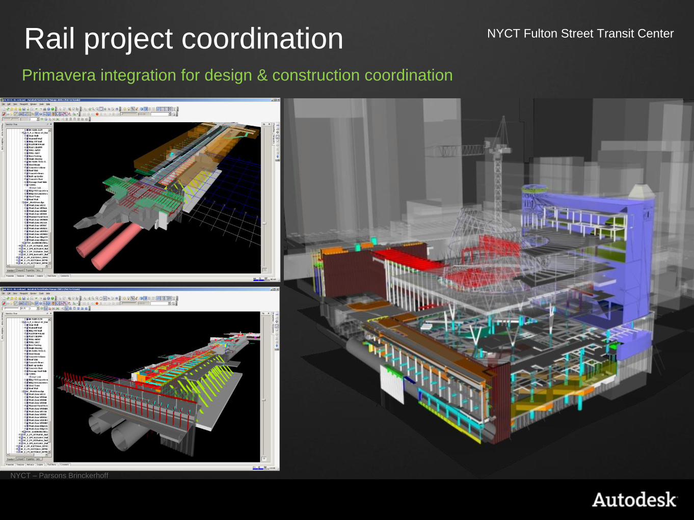
Rail project coordination NYCT Fulton Street Transit Center
NYCT – Parsons Brinckerhoff
Primavera integration for design & construction coordination

Substation design
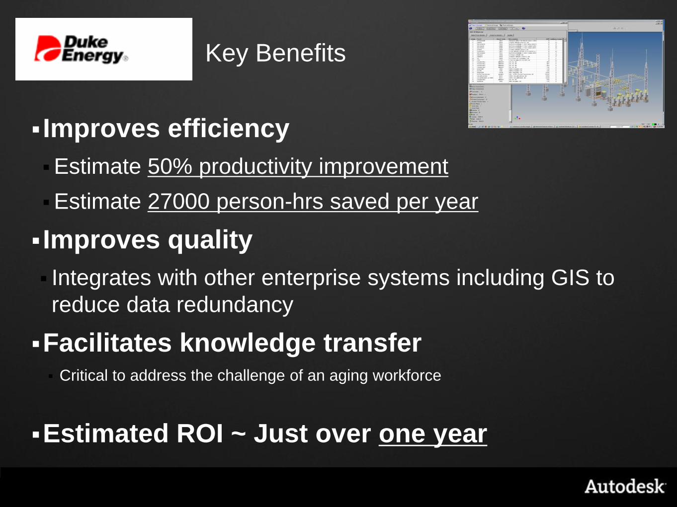
Key Benefits
Improves efficiency
Estimate 50% productivity improvement
Estimate 27000 person-hrs saved per year
Improves quality
Integrates with other enterprise systems including GIS to
reduce data redundancy
Facilitates knowledge transfer
Critical to address the challenge of an aging workforce
Estimated ROI ~ Just over one year

Immediate business benefit of
these technologies are
efficiencies in the $6.1 trillion
construction industry
© 2008 Autodesk
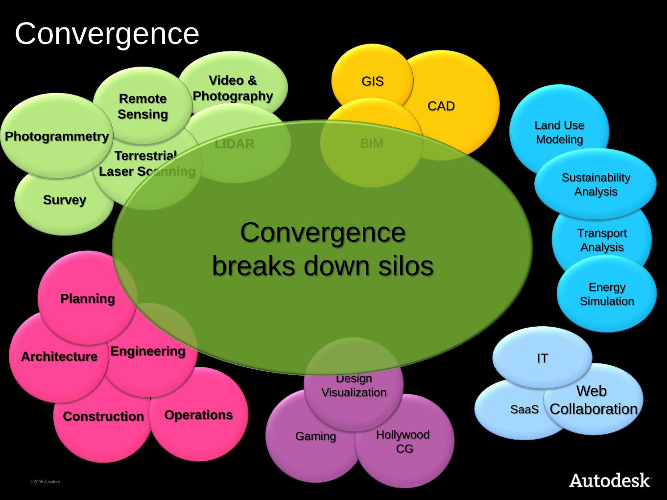
Land Use
Modeling
Construction
Video &
Photography
LIDAR
Convergence
Operations SaaS
Engineering Architecture
Gaming Hollywood
CG
Survey
Web
Collaboration
CAD
Transport
Analysis
Terrestrial
Laser Scanning
IT
GIS
Remote
Sensing
Photogrammetry
Energy
Simulation
Sustainability
Analysis
Design
Visualization
Planning
BIM
Convergence
breaks down silos

Interoperability
Revit
Ecotect
LandXplorer
Green
Build
Studio
Inventor
3ds Max
Maya AutoCAD
AutoCAD
Map3D
FME
FBX
gbXML
LandXML
DXF
DWF MotionBuilder
IFC
GIS
CAD
BIM 3D
Visualization
Sustainability
Analysis
Urban
Modeling
Laser
Scanning
Imagery
FDO Civil3D
NavisWorks
CityGML
OWS Standards

City 3D Model
Conceptual design – integrate architectural
and engineering designs and city 3D model
Vision for sustainable city design Reality Capture Energy Modeling Mapping
BIM models
Environmental impact

Modeling urban underground infrastructure

© 2009 Autodesk
Communication Los Angeles
Los Angeles County Metropolitan Transportation Authority
Planning, Design, Visualization, Collaboration, Public Outreach, Agency Approvals

© 2009 Autodesk
We are facing global challenges: increasing
urbanization means increasing energy
demand, water stress, and environmental
impact
more to do, fewer people to do it
Technology is changing how we design
and build
BIM, smart design, convergence
Convergence of BIM, geospatial, 3D
visualization enables
intelligent models of entire cities
Some takeaways