Consolidated Pre-Clearance Report KP413.57 to KP419.69 Final€¦ · · 2017-09-26Pre-clearance...
48
Transcript of Consolidated Pre-Clearance Report KP413.57 to KP419.69 Final€¦ · · 2017-09-26Pre-clearance...


Pre-clearance Survey Report 3380-GLNG-4-1.3-0167
Page ii
Contents
Abbreviations iv
Definitions vi
1 Introduction 1 1.1 Background 1 1.2 Scope of works 1 1.3 Pre-clearance surveys 2
2 Survey methodology 3 2.1 Introduction 3 2.2 Desktop review 3 2.3 Field surveys 5 2.3.1 Flora field survey 5 2.3.2 Fauna field survey 5 2.4 Weeds 8 2.5 Watercourses 9
3 Pre-clearance survey results – Flora 10 3.1 Desktop analysis 10 3.1.1 Referable wetlands 10 3.1.2 Threatened Ecological Communities 10 3.1.3 Environmentally Sensitive Areas 10 3.1.4 Type A species 10 3.1.5 Commonwealth and State Government EVNT species 11 3.2 Survey results 12 3.2.1 Environmentally Sensitive Areas 12 3.2.2 Threatened Ecological Communities 12 3.2.3 Type A Species mapped within KP413.57 to KP419.69 of the GTP RoW 13 3.2.4 EVNT flora species mapped within KP413.57 to KP419.69 of the GTP RoW 13
4 Pre-clearance survey results – fauna 14 4.1 Desktop analysis 14 4.2 Survey results 19
5 Declared weeds and feral pests 21 5.1 Declared weeds 21 5.2 Other environmental weeds 22 5.3 Feral pests 22
6 Habitat features 24
7 Isolated Trees 26
8 Watercourse Assessments 27
9 Erosion 28
10 Ponds and dams 29
11 Specific Survey Results 30 11.1 KP409.04 to KP413.57 30 11.2 KP413.57 to KP419.69 30

Pre-clearance Survey Report 3380-GLNG-4-1.3-0167
Page iii
12 Conclusion 36
13 References 37

Pre-clearance Survey Report 3380-GLNG-4-1.3-0167
Page iv
Abbreviations
CAMBA China-Australia Migratory Bird Agreement
cm Centimetre
CSG Coal Seam Gas
Cwlth Commonwealth
DBH Diameter Breast Height
DEHP Department of Environment and Heritage Protection
DEWHA Department of Water, Heritage and the Arts
E Endangered
EA Environmental Authority
EIS Environmental Impact Statement
EP Act Environmental Protection Act 1994
EPBC Act Environment Protection and Biodiversity Conservation Act 1999
ESA Environmentally Sensitive Areas
EVNT Endangered, Vulnerable and Near Threatened species
GIS Geographical Information System
GLNG Gladstone Liquefied Natural Gas
GTP Gas Transmission Pipeline
GTP RoW Gas Transmission Pipeline Right of Way
ha Hectares
HERBRECS Queensland Herbarium database
HVR High Value Regrowth
JAMBA Japan-Australia Migratory Bird Agreement
KP Kilometre Point
LC Least Concern
LNG Liquefied Natural Gas
LP Act Land Protection (Pest and Stock Route Management) Act 2002
m Metre
Mi Migratory
mm Millimetres
MNES Matters of National Environmental Significance
NC Act Nature Conservation Act 1992
NT Near Threatened
PESS Pre-Clearance Ecological Survey Sheet
PWMP Pest and Weed Management Plan
QLD Queensland
RE Regional Ecosystem
REDD Regional Ecosystem Description Database
ROKAMBA Republic of Korea-Australia Migratory Bird Agreement
RoW Right of Way

Pre-clearance Survey Report 3380-GLNG-4-1.3-0167
Page v
SEIS Supplementary Environmental Impact Statement
SEQ South East Queensland
SEVT Semi-evergreen Vine Thicket
SEWPaC Department of Sustainability, Environment, Water, Population and Communities
SMP Species Management Plan
SO Stream Order
SSMP Significant Species and Ecological Communities Management Plan
TEC Threatened Ecological Communities
The Project The GLNG GTP Project
V Vulnerable
VM Act Vegetation Management Act 1999
WONS Weeds of National Significance
Pre-clearance Survey Report 3380-GLNG-4-1.3-0167
Page vi
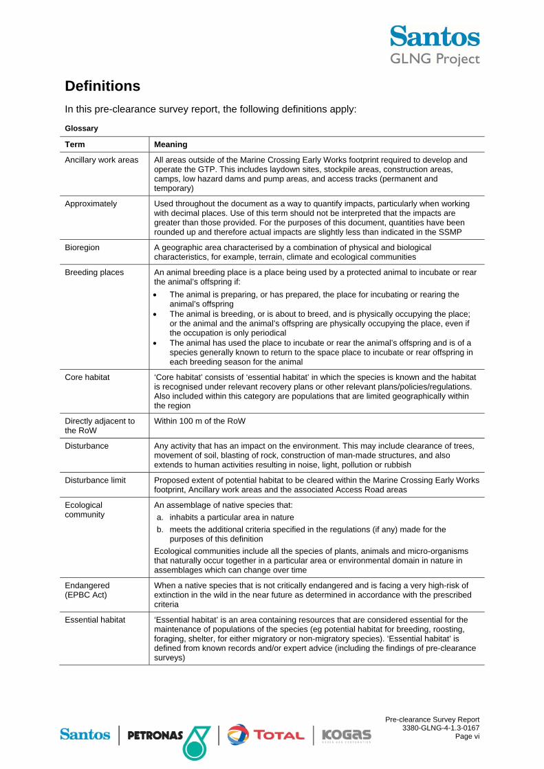
Definitions
In this pre-clearance survey report, the following definitions apply:
Glossary
Term Meaning
Ancillary work areas All areas outside of the Marine Crossing Early Works footprint required to develop and operate the GTP. This includes laydown sites, stockpile areas, construction areas, camps, low hazard dams and pump areas, and access tracks (permanent and temporary)
Approximately Used throughout the document as a way to quantify impacts, particularly when working with decimal places. Use of this term should not be interpreted that the impacts are greater than those provided. For the purposes of this document, quantities have been rounded up and therefore actual impacts are slightly less than indicated in the SSMP
Bioregion A geographic area characterised by a combination of physical and biological characteristics, for example, terrain, climate and ecological communities
Breeding places An animal breeding place is a place being used by a protected animal to incubate or rear the animal’s offspring if:
The animal is preparing, or has prepared, the place for incubating or rearing the animal’s offspring
The animal is breeding, or is about to breed, and is physically occupying the place; or the animal and the animal’s offspring are physically occupying the place, even if the occupation is only periodical
The animal has used the place to incubate or rear the animal’s offspring and is of a species generally known to return to the space place to incubate or rear offspring in each breeding season for the animal
Core habitat ‘Core habitat’ consists of ‘essential habitat’ in which the species is known and the habitat is recognised under relevant recovery plans or other relevant plans/policies/regulations. Also included within this category are populations that are limited geographically within the region
Directly adjacent to the RoW
Within 100 m of the RoW
Disturbance Any activity that has an impact on the environment. This may include clearance of trees, movement of soil, blasting of rock, construction of man-made structures, and also extends to human activities resulting in noise, light, pollution or rubbish
Disturbance limit Proposed extent of potential habitat to be cleared within the Marine Crossing Early Works footprint, Ancillary work areas and the associated Access Road areas
Ecological community
An assemblage of native species that:
a. inhabits a particular area in nature
b. meets the additional criteria specified in the regulations (if any) made for the purposes of this definition
Ecological communities include all the species of plants, animals and micro-organisms that naturally occur together in a particular area or environmental domain in nature in assemblages which can change over time
Endangered (EPBC Act)
When a native species that is not critically endangered and is facing a very high-risk of extinction in the wild in the near future as determined in accordance with the prescribed criteria
Essential habitat ‘Essential habitat’ is an area containing resources that are considered essential for the maintenance of populations of the species (eg potential habitat for breeding, roosting, foraging, shelter, for either migratory or non-migratory species). ‘Essential habitat’ is defined from known records and/or expert advice (including the findings of pre-clearance surveys)
Pre-clearance Survey Report 3380-GLNG-4-1.3-0167
Page vii
Term Meaning
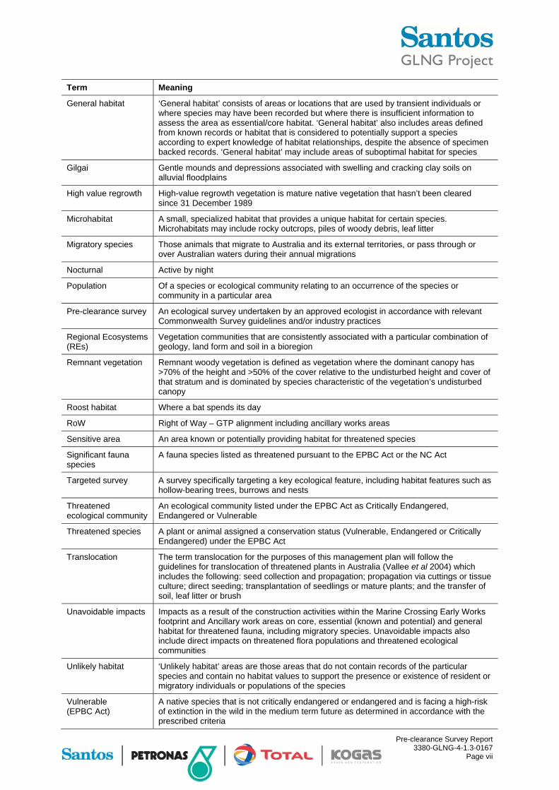
General habitat ‘General habitat’ consists of areas or locations that are used by transient individuals or where species may have been recorded but where there is insufficient information to assess the area as essential/core habitat. ‘General habitat’ also includes areas defined from known records or habitat that is considered to potentially support a species according to expert knowledge of habitat relationships, despite the absence of specimen backed records. ‘General habitat’ may include areas of suboptimal habitat for species
Gilgai Gentle mounds and depressions associated with swelling and cracking clay soils on alluvial floodplains
High value regrowth High-value regrowth vegetation is mature native vegetation that hasn’t been cleared since 31 December 1989
Microhabitat A small, specialized habitat that provides a unique habitat for certain species. Microhabitats may include rocky outcrops, piles of woody debris, leaf litter
Migratory species Those animals that migrate to Australia and its external territories, or pass through or over Australian waters during their annual migrations
Nocturnal Active by night
Population Of a species or ecological community relating to an occurrence of the species or community in a particular area
Pre-clearance survey An ecological survey undertaken by an approved ecologist in accordance with relevant Commonwealth Survey guidelines and/or industry practices
Regional Ecosystems (REs)
Vegetation communities that are consistently associated with a particular combination of geology, land form and soil in a bioregion
Remnant vegetation Remnant woody vegetation is defined as vegetation where the dominant canopy has >70% of the height and >50% of the cover relative to the undisturbed height and cover of that stratum and is dominated by species characteristic of the vegetation’s undisturbed canopy
Roost habitat Where a bat spends its day
RoW Right of Way – GTP alignment including ancillary works areas
Sensitive area An area known or potentially providing habitat for threatened species
Significant fauna species
A fauna species listed as threatened pursuant to the EPBC Act or the NC Act
Targeted survey A survey specifically targeting a key ecological feature, including habitat features such as hollow-bearing trees, burrows and nests
Threatened ecological community
An ecological community listed under the EPBC Act as Critically Endangered, Endangered or Vulnerable
Threatened species A plant or animal assigned a conservation status (Vulnerable, Endangered or Critically Endangered) under the EPBC Act
Translocation The term translocation for the purposes of this management plan will follow the guidelines for translocation of threatened plants in Australia (Vallee et al 2004) which includes the following: seed collection and propagation; propagation via cuttings or tissue culture; direct seeding; transplantation of seedlings or mature plants; and the transfer of soil, leaf litter or brush
Unavoidable impacts Impacts as a result of the construction activities within the Marine Crossing Early Works footprint and Ancillary work areas on core, essential (known and potential) and general habitat for threatened fauna, including migratory species. Unavoidable impacts also include direct impacts on threatened flora populations and threatened ecological communities
Unlikely habitat ‘Unlikely habitat’ areas are those areas that do not contain records of the particular species and contain no habitat values to support the presence or existence of resident or migratory individuals or populations of the species
Vulnerable (EPBC Act)
A native species that is not critically endangered or endangered and is facing a high-risk of extinction in the wild in the medium term future as determined in accordance with the prescribed criteria

Pre-clearance Survey Report 3380-GLNG-4-1.3-0167
Page 1
1 Introduction
1.1 Background
Santos GLNG has awarded Saipem Australia (Saipem) the detailed design, procurement and construction of the 420 km long gas transmission pipeline (GTP), a joint venture between Santos GLNG Pty Ltd (Santos), PAPL (Downstream) Pty Ltd (Petronas) and Total GLNG Australia (TOTAL). This pipeline will transport the extracted and compressed Coal Seam Gas (CSG) from the gas fields between Roma and the Arcadia Valley to the LNG processing facility at Curtis Island, off Gladstone (hereafter referred to as the GTP Project).
In order to meet the Environmental Protection and Biodiversity Act 1999 (EPBC Act) approval (Referral 2008/4096) Conditions 5, 6 and 7, pre-clearance surveys have to be undertaken. In addition, these surveys are also undertaken to support clearing permit applications under the Queensland Nature Conservation Act 1992 (NC Act) and associated regulations. In addition, the surveys were undertaken to meet the conditions in Schedule F of the Department of Environment and Heritage Protection (DEHP) Environmental Authority PEN102968511 (PPL 168) dated 22 November 2011, which specifically requires identification of Endangered, Vulnerable or Near-threatened fauna species and identification and marking of hollow-bearing trees.
This report details the methodology and results of an ecological survey conducted by Ausecology and Footprints Environmental Consultants for a 6.1 km section of the 420 km GTP right of way (RoW) between KP413.57 and KP419.69 (refer Figure 1). The results include identification of habitat features, particularly with respect to threatened flora and fauna species, ground-truthing of Regional Ecosystem (RE) mapping and Threatened Ecological Communities (TEC) in addition to general landscape, habitat modifications and occurrence of weeds and pests.
1.2 Scope of works
In accordance with the requirements of conditions 5, 6 and 7 of the EPBC Act controlled action approval and requirements under the NC Act and the DEHP Environmental Authority for PPL168, the scope of the ecological investigations for the pre-clearance surveys included:
Threatened flora and fauna species under both the EPBC Act and NC Act
TEC and migratory species pursuant to the EPBC Act
Ground-truthing of category A, B and C environmentally sensitive areas (ESA) as defined under the Environmental Protection Act 1994 (EP Act) and other relevant Queensland legislation where applicable
Assessment of the type and ecological value of vegetation not classified as being remnant or high value regrowth vegetation by DEHP (ie standalone paddock trees, stands of apparently intact vegetation)
Opportunistic observations of fauna or evidence of fauna activity (eg droppings, recent scratch marks etc)
Detailed assessment of fauna habitat features (eg logs, hollows or rocky outcrops etc)
Observations of areas of disturbance or habitat modification (eg fire, clearing or thinning of vegetation)
Wetlands, springs, watercourses and ephemeral creeks
Pest species (including both flora and fauna)

!(
!(
!(
!(
!(
!(
!(
!R
!R
!R
!R
!R
Cal l i de
Rang
e
Cal l iope Range
Curtis Island Coral Sea
KP 413.57 to 419.69
Ca
r na
rvo
nH
igh
wa
y
Le
ich
ha
rdt
Hig
hw
ay
Bru
ceH
ighw
ay
Burnett Highway
Le
ich
ha
rdt
Hig
hw
ay
Capricorn Highway
Capricorn Highway
Dawson Highway
Bu
rnett
Hig
hw
ay
Daw
son Highw
ay
Bruce HighwayLeichhardt H
ighway
Moura
Emerald
Biloela
Gladstone
Blackwater
Mount Morgan
KP0
KP200
KP400
KP100
KP300
\\au
recon
.info
\sha
res\A
UB
NE
\Pro
jects
\GIS
\Pro
jects
\214
20
8_
Sa
nto
s_
EM
P\S
EM
P_
359
.mxd
05
/04
/201
3 0
8:5
5
Coordinate system: GCS_GDA_1994
Map
by:
RB
°05/04/2013Date:
0 20 40 60km
A1 scale:1:600,000
GLNG No: XXXX-XX-XXXX
GLNG Gas TransmissionPipeline Corridor
GLNG GTP RoW andPre-Clearance Ecology Survey
Project AreaKP413.57 to KP419.69
Figure 1
a
!R Kilometre Post Distance Marker (km)
GLNG GTP ROW and Ancillary Work Areas
Source:Gas Transmission Pipeline (GTP): Santos, Apr 2012.
Aerial: BING, Feb 2011.
Version:
Queensland
Mackay
Cairns
Brisbane
Gladstone
Townsville

Pre-clearance Survey Report 3380-GLNG-4-1.3-0167
Page 2
1.3 Pre-clearance surveys
The KP413.57 to KP419.69 section (including ancillary works areas) of the RoW alignment was surveyed in full through surveys undertaken by Ausecology and Footprints Environmental Consultants in 2012 with areas possessing habitat potentially suitable for MNES and State listed fauna species targeted to assess the micro habitat attributes in more detail. The surveys included:
Table 1.1 Pre-clearance surveys undertaken within KP413.57 to KP419.69 of the GTP RoW
Pre-clearance survey
Source Team members Field work dates
Pre-clearance ecological survey for KP413.5 to KP419.6 (Curtis Island)
Ausecology Lead by Ralf Regeer (Senior Ecologist) (DSEWPaC approved ecologist for the GLNG GTP Project) with assistance from Simon Bush (Ecologist)
13 and 14 November 2012
Pre-clearance ecological survey for NC Act and EPBC Act listed fauna species within KP350 to KP419
Footprints Environmental Consultants
Lead by Andrew Veary (BSc (Hons) and Elle Veary (BAppSc) (DSEWPaC approved ecologists for the GLNG GTP Project) with assistance from Dr Kris Murray (PhD). Greg Ford (BAppSc, Grad Dip Resource Management) of Balance Environmental, was commissioned by Footprints Environmental Consultants to undertake the Anabat microchiropteran bat call recording analysis and Barbara Triggs of Dead Finish, undertook the hair tube sample analysis
Mid-December 2011 to end of March 2012
Dr Chris Schell (Aurecon), a DSEWPaC approved ecologist for the GLNG GTP Project, reviewed the Ausecology and Footprints Environmental Consultants pre-clearance ecological survey reports to ensure they were prepared in accordance with the requirements of conditions 6 and 7 of the EPBC Act controlled action approval (EPBC No. 2008/4096).
The pre-clearance survey reports were verified to ensure that the listed threatened and migratory species, their habitat and listed threatened ecological communities were surveyed using the correct ecological survey guidelines, the lead ecologists were approved with DSEWPaC to undertake the pre-clearance survey for the GLNG GTP Project and the survey methodology, results and significant findings were documented.

Pre-clearance Survey Report 3380-GLNG-4-1.3-0167
Page 3
2 Survey methodology
2.1 Introduction
The pre-clearance surveys for this section of the GTP alignment were undertaken over two periods between mid-December 2011 to end of March 2012 and 13 to 14 November 2012.
In order to assess the ecological values of the site, the following activities were conducted:
Initial desktop review of existing information on the vegetation communities, flora species and fauna species of the study area
Baseline botanical surveys and broad habitat assessment to confirm and enhance information collated during the desktop review
A targeted threatened fauna species habitat assessment within areas determined to be conducive to the occurrence of significant species, as identified from the desk-top assessments, reviews of the baseline botanical surveys and vegetation habitat assessments
Detailed methods for each of these components are provided in Sections 2.2 to 2.5.
2.2 Desktop review
A desktop study was undertaken before conducting the KP413.57 to KP419.69 pre-clearance ecological survey. The following databases were interrogated:
HERBRECS data encompassing the Moura to Gladstone area to account for previously unmapped outlying populations/individuals
Regrowth Vegetation Map (DEHP) v2.1
Property Map of Assessable Vegetation (DEHP)
VM Act RE and Remnant Map v6.1 (DEHP)
VM Act Essential Habitat Map v3.1 (DEHP)
ESA mapping (DEHP)
Wildlife Online database search (DEHP)
Referable Wetlands mapping (Queensland wetland data Version 3) (DEHP)
EPBC Act Protected Matters Search (DSEWPaC)
Environment Australia Database
Curtis Coast Regional Coastal Management Plan (2003)
Regional assessments which have relevance to the ecological values of the study site, ie. Covacevich et al 1997; Deer 1996; McDonald et al 1991; Young et al 1999; McFarland et al 1999; and Woinarski & Catterall 2004
Commonwealth survey methodology guidelines for threatened species groups as follows;
Micro-bats (DEWHA, 2010a)
Birds (DEWHA, 2010b)
Mammals (DSEWPaC, 2011a)
Reptiles (DSEWPaC, 2011b)
Pre-clearance Survey Report 3380-GLNG-4-1.3-0167
Page 4
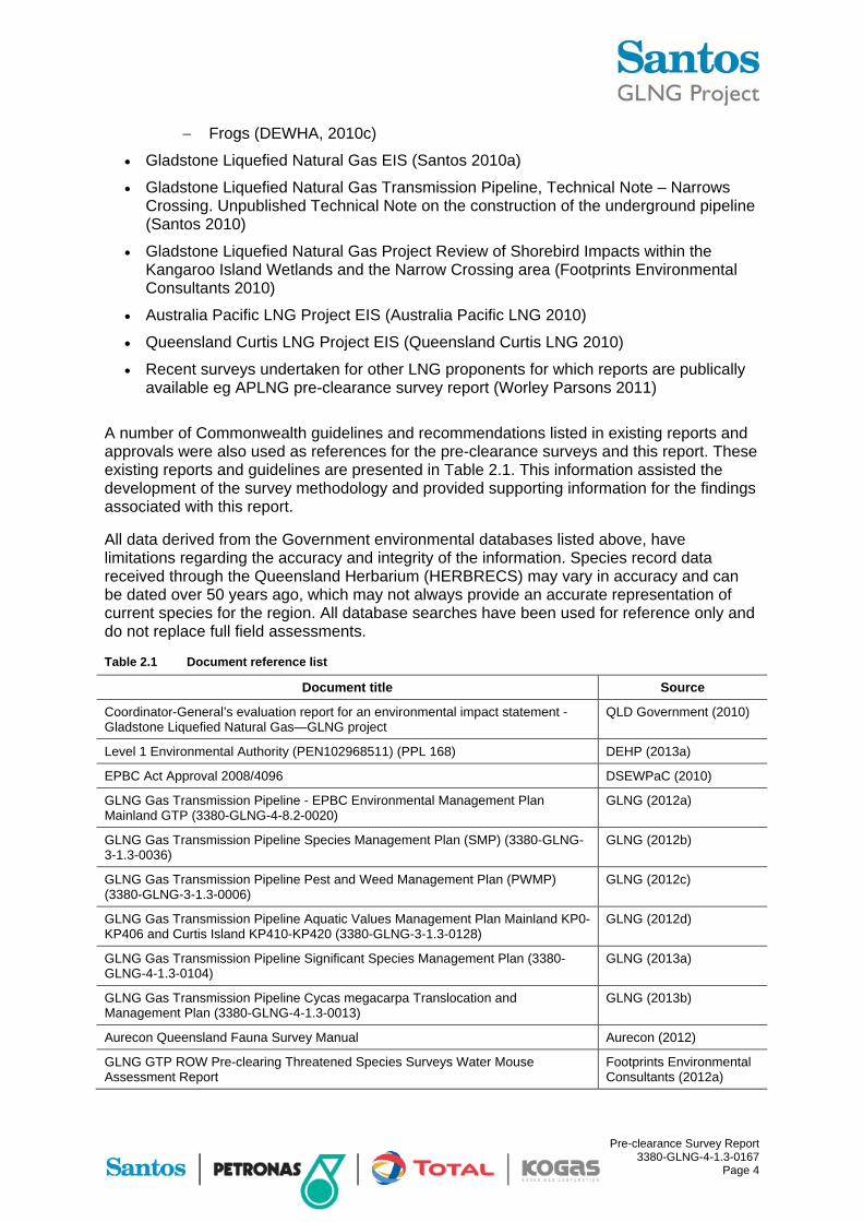
Frogs (DEWHA, 2010c)
Gladstone Liquefied Natural Gas EIS (Santos 2010a)
Gladstone Liquefied Natural Gas Transmission Pipeline, Technical Note – Narrows Crossing. Unpublished Technical Note on the construction of the underground pipeline (Santos 2010)
Gladstone Liquefied Natural Gas Project Review of Shorebird Impacts within the Kangaroo Island Wetlands and the Narrow Crossing area (Footprints Environmental Consultants 2010)
Australia Pacific LNG Project EIS (Australia Pacific LNG 2010)
Queensland Curtis LNG Project EIS (Queensland Curtis LNG 2010)
Recent surveys undertaken for other LNG proponents for which reports are publically available eg APLNG pre-clearance survey report (Worley Parsons 2011)
A number of Commonwealth guidelines and recommendations listed in existing reports and approvals were also used as references for the pre-clearance surveys and this report. These existing reports and guidelines are presented in Table 2.1. This information assisted the development of the survey methodology and provided supporting information for the findings associated with this report.
All data derived from the Government environmental databases listed above, have limitations regarding the accuracy and integrity of the information. Species record data received through the Queensland Herbarium (HERBRECS) may vary in accuracy and can be dated over 50 years ago, which may not always provide an accurate representation of current species for the region. All database searches have been used for reference only and do not replace full field assessments.
Table 2.1 Document reference list
Document title Source
Coordinator-General’s evaluation report for an environmental impact statement - Gladstone Liquefied Natural Gas—GLNG project
QLD Government (2010)
Level 1 Environmental Authority (PEN102968511) (PPL 168) DEHP (2013a)
EPBC Act Approval 2008/4096 DSEWPaC (2010)
GLNG Gas Transmission Pipeline - EPBC Environmental Management Plan Mainland GTP (3380-GLNG-4-8.2-0020)
GLNG (2012a)
GLNG Gas Transmission Pipeline Species Management Plan (SMP) (3380-GLNG-3-1.3-0036)
GLNG (2012b)
GLNG Gas Transmission Pipeline Pest and Weed Management Plan (PWMP) (3380-GLNG-3-1.3-0006)
GLNG (2012c)
GLNG Gas Transmission Pipeline Aquatic Values Management Plan Mainland KP0-KP406 and Curtis Island KP410-KP420 (3380-GLNG-3-1.3-0128)
GLNG (2012d)
GLNG Gas Transmission Pipeline Significant Species Management Plan (3380-GLNG-4-1.3-0104)
GLNG (2013a)
GLNG Gas Transmission Pipeline Cycas megacarpa Translocation and Management Plan (3380-GLNG-4-1.3-0013)
GLNG (2013b)
Aurecon Queensland Fauna Survey Manual Aurecon (2012)
GLNG GTP ROW Pre-clearing Threatened Species Surveys Water Mouse Assessment Report
Footprints Environmental Consultants (2012a)

Pre-clearance Survey Report 3380-GLNG-4-1.3-0167
Page 5
2.3 Field surveys
2.3.1 Flora field survey
The 6.1 km section (ie KP413.57 to KP419.69) of the 420 km GTP RoW on Curtis Island, from the launch pad at KP413.57 to the GLNG facility tie-in at KP419.69 located in the Gladstone Regional Council, was surveyed on foot (where access was permitted by land holders) with emphasis placed on the following ecological features:
Locations of Type A species listed under the provisions of the Queensland NC Act as these require translocation prior to construction. Type A Restricted Plants as defined in the Nature Conservation Act (Regulation) 2006 include the families Cycadaceae, Orchidaceae, and Zamiaceae; and species in the genera Brachychiton, Livistona, Platycerium and Xanthorrhoea
Locations of Class 2 declared weeds as listed under the provisions of the Queensland Land Protection (Pest and Stock Route) Management Act 2002 (LP Act) and weeds of national significance (WONS) as these require treatment prior to construction
Verification of high value regrowth or remnant vegetation mapped as ‘endangered’ or ‘of concern’ under the provisions of the Queensland VM Act, as these need to be reported to DEHP prior to construction
Locations of Endangered, Vulnerable and Near Threatened species (EVNT) flora species as listed under the provisions of the NC Act and/or the EPBC Act, that require a clearing permit before construction can commence. The presence of potential fauna habitat (hollow-bearing trees, scats, rocky outcrops etc)
Targeted habitat areas associated with threatened fauna species listed under the provision of the EPBC Act and/or the NC Act within and adjacent to the Mainland GTP RoW potentially occurring within the RoW
Assessment of the type and ecological value of vegetation not classified as being remnant or high value regrowth vegetation under the provisions of the VM Act (ie standalone paddock trees, stands of apparently intact vegetation)
Wetlands, gilgai/melon holes, springs, watercourses and ephemeral creeks
Observations of areas of disturbance (eg fire or thinning of vegetation)
2.3.2 Fauna field survey
Fauna were recorded by the following methods as detailed below:
Opportunistically in association with the vegetation surveys conducted by Ausecology. Fauna was identified by direct observation and/or via characteristic vocalisations (eg bird and frog calls)
Targeted active searches for rare and threatened species by Footprints Environmental Consultants
The survey methodologies used by Footprints Environmental Consultants for the targeted fauna surveys were based on the individual significant species survey guidelines recommended by the Federal Government. The methods used included Cage/Elliot Type B Trapping for mid-sized ground mammals, pitfall trapping for reptiles and frogs, diurnal bird surveys, diurnal herpetofauna ground searches, nocturnal ground searches, insectivorous bat surveys, hair tube surveys, remote trigger cameras, targeted area searches, call

Pre-clearance Survey Report 3380-GLNG-4-1.3-0167
Page 6
playback surveys, driving spotlight transects and inferential evidence. The details regarding each of these methodologies are outlined below.
Cage/Elliot Type B trapping
Mid-sized ground mammals were surveyed using medium sized cage traps and Elliot type B traps. These were deployed at eight locations covering the primary habitats and survey areas of the study site. At each survey site, ten traps were set along a transect which optimised sampling coverage of each sub-habitat type at that location. Traps were opened for three consecutive nights at each survey site, providing a minimum total trapping effort of 30 trap nights per site (ie number of traps open multiplied by the number of nights), totalling 90 trip nights for the survey. Traps were baited with either salami, peanut butter-oats mix or half a pilchard. Fish oil was sprayed around the entrance to each trap. Baits were replaced as required.
Pitfall trapping
Pitfall traps were employed to survey for reptiles and frogs. Each trap line consisted of five, 20 litre plastic buckets sunk in to the ground approximately five metres apart and connected by a drift fence line (30 cm high, embossed, polyethylene dampcourse) pitfall trap lines were set at eight survey sites as discussed above. Traps were opened for a minimum of three consecutive nights providing a total trapping effort of 15 trap nights per site, totalling 45 trap nights for the survey.
Diurnal bird surveys
Diurnal birds were surveyed using timed (20 minutes per session), area search methods which were comprised of early morning census. The total minimum census time varied for each of the targeted species depending on the recommended survey methodology. Area searches were conducted at eight survey sites and at other selected locations where suitable habitat for target species were supported. Census surveys were undertaken within three hours of sunrise and sunset. Birds were identified from either direct observations and/or their call vocalisations.
Diurnal herpetofauna ground searches
Dedicated active daytime ground searches were conducted for a minimum period of one-person hour at each of the eight survey sites and at other selected locations where suitable habitat for target species was supported. Surveys were conducted on each of the survey days to locate active/inactive reptiles and inactive frogs. Total search effort for each of the targeted species was dictated by the recommended survey methodology applicable. This method involved:
Rolling logs and rocks
Raking soil at the base of trees and shrubs
Searching under decorticating /exfoliating bark on logs and standing dead or live trees
Examination under debris
Additionally, as part of the active searches, upper section of trees was scanned with binoculars searching for basking or active arboreal/scansorial reptiles. Ground search sessions were conducted prior to 11 am.

Pre-clearance Survey Report 3380-GLNG-4-1.3-0167
Page 7
Nocturnal ground searches
Spotlighting searches were undertaken on foot using 30-watt hand-held spotlights and headlamps. These were conducted for two person hours at eight survey sites and at other selected locations where suitable habitat for target species was supported. Searches were conducted for 60 minutes per site and replicated as dictated by survey requirements for the threatened species of interest.
During each nocturnal spotlighting session, approximately one person hour was dedicated to arboreal searches with the remaining time spent on ground searches for nocturnal herpetofauna and ground mammals (ie bandicoots). Arboreal surveys targeted mammals (ie possums and gliders), nocturnal birds (ie owls and nightjars), reptiles (ie snakes and geckos) and flying mammals (ie flying foxes and fruit bats).
Insectivorous bat surveys
The survey program for insectivorous bat fauna was undertake using electronic bat detectors and harp traps, as dictated by the relevant threatened species survey guidelines. Anabat detection involved both remote and active detection techniques with an Anabat II detector, used to record the ultrasonic signals of active bats. Remote detection (ie equipment programmed for unattended, fixed point, overnight detection of microbat calls) was conducted over four survey nights at eight primary survey sites. Active Anabat detection was employed during nocturnal spotlighting surveys.
Ultrasonic bat calls and locality details were recorded during the survey and subsequently analysed by Greg Ford (Balance Environmental) for species identification.
Harp trapping was undertaken at four sites within areas of the GTP RoW that supported suitable habitat for the targeted species, with the level of effort dictated by the relevant survey guidelines. These surveys produced a total of 20 harp trap nights per survey site, totalling 60 trap nights.
Hair tube surveys
Hair tubes (a cylindrical tube with a mesh-sealed bait container at one end, with double sided sticky tape attached to the top side of the entrance to the tube) were specifically employed to survey for the northern quoll at those site that supported potentially suitable habitat, or were in close proximity to areas that may support northern quoll. Twenty hair tubes, baited with salami, were deployed at three survey sites for 14 night/days.
Remote trigger cameras
Two remote trigger cameras were deployed at 3 sites for 14 nights and days, totalling 84 camera trap nights/days. These cameras were deployed to survey specifically for northern quoll. Incidental observations of other fauna were noted where relevant.
Targeted area searches
A series of rapid biodiversity assessments and target species surveys were undertaken in a range of representative and/or distinctive habitat types throughout the study site. Areas surveyed excluded those areas subject to the primary survey program as previously discussed.
For diurnal activities, each survey area, nominally comprised of up to one or two hectares, was surveyed for up to one person hour. At each selected survey area, a combination of

Pre-clearance Survey Report 3380-GLNG-4-1.3-0167
Page 8
active diurnal ground searches, primarily for reptiles, and bird surveys were undertaken. For nocturnal assessments, an area of approximately two hectares was surveyed for a minimum of one survey person hour where spotlighting searches on foot were undertaken using 30-watt spotlights and headlamps.
Targeted area searches were also undertaken for specific species, such as Glossy black cockatoo, in specific habitat types, such as stands of Casuarina littoralis and C. torulosa which are known Glossy black cockatoo food trees. Searches for Casuarina orts (characteristically chewed seed pods) were undertaken in such habitat types.
Call playback surveys
Nocturnal call playback surveys for Powerful owl were undertaken at potentially suitable locations throughout the study site.
The procedure included broadcasting, through a vehicle’s stereo system, powerful owl calls for approximately three to five minutes. Several minutes of listening for responses and visual scanning of the immediate surrounds with a hand-held spotlight followed the call playback.
Call recordings for nocturnal mammals and birds were sourced from Stewart (2000).
Driving spotlight transects
Driving spotlight searches (driver plus one observer with a 100-watt spotlight) were undertaken from a 4WD along the road/track network within the study site primarily to survey for larger arboreal and ground mammals (eg Owls, Koalas, Echidnas, Macropods, Possums, Foxes, Cats and Dogs).
Inferential evidence
Inferential evidence of fauna occurrence was sought and found throughout the study site. This included:
Visual inspection of trees for trunk scratches/rubbings
Searches for both predator and non-predator scats (eg northern quoll and yakka skink latrine sites)
Fauna tracks
Other signs of fauna occurrence (eg shed skins/nests etc)
Only definitive evidence was used to record a species occurrence on the study site. Scats or pellets found were identified in the field (using Triggs 1999).
Hollow bearing tree mapping
As an additional element to the survey program, the location of any trees bearing hollows, within approximately 60 m of the centreline of the RoW alignment (at the time of commissioning by GLNG), were marked by GPS.
2.4 Weeds
Declared plants under the provisions of the Queensland LP Act are those species that have, or could potentially cause, serious economic, environmental or social impacts.
“A Class 1 pest is one that has the potential to become a very serious pest in Queensland in the future. By law, all landholders are required to keep their land free of Class 1 pests.

Pre-clearance Survey Report 3380-GLNG-4-1.3-0167
Page 9
A Class 2 pest is one that has already spread over substantial areas of Queensland. However, its impact is so serious that control is needed to avoid further spread onto properties that are still free of the pest. By law, all landholders must try to keep their land free of Class 2 pests and it is an offence to possess, sell or release these pests without a permit.
A Class 3 pest is one that is commonly established in parts of Queensland but its control by landowners is not deemed to be warranted unless the plant is impacting, or has the potential to impact, on a nearby ’environmentally significant area’ (eg a national park)” (DAFF, 2012),
Furthermore, weeds that warrant a nationally strategic approach are listed on the Weeds of National Significance (WoNS) list. This list was established in 1999 and was recently reviewed in April 2012. The assessment of WoNS is based on four major criteria:
Invasiveness
Impacts
Potential for spread
Socio-economic and environmental values
Although both the LP Act declared weeds and WoNS were the focus of the survey, the presence of other environmental weeds was noted during site assessments. Environmental weeds were considered to be those species that may have a high invasive capacity or non-native flora species that are considered to be undesirable for cropping and grazing practices.
2.5 Watercourses
All watercourses encountered during the pre-clearance ecological surveys were recorded and verified to determine if they meet the definition of a watercourse under the provisions of the Queensland Water Act 2000.
The following data was recorded (where applicable) for each watercourse as per the requirements identified in the GLNG Aquatic Values Management Plan Mainland KP0 to KP406 and Curtis Island KP410 to KP420 (GLNG, 2012d):
Riparian zone and condition (eg weeds, erosion, vegetation present and regrowth/remnant)
Physical habitat features of the channel (eg undercut banks, in-stream timber, overhanging and trailing-bank vegetation, substrate diversity and deep pools)
Biological diversity and overall ecological values of each watercourse (ie aquatic flora, macroinvertebrate, fish, turtles and platypus)
Animal breeding places for conservation significant species and riverine corridors for aquatic animal migration
Habitat for species with high conservation value, with specific focus on Elseya albagula (White-throated snapping turtle), Rheodytes leukops (Fitzroy river turtle) and Ornithorhynchus anatinus (Platypus)
Although these areas were assessed from an overall potential habitat perspective, precedence on the aquatic values of each watercourse shall be given to the GLNG Aquatic Values Management Plan Mainland KP0 to KP406 and Curtis Island KP410 to KP420 (GLNG, 2012d).

Pre-clearance Survey Report 3380-GLNG-4-1.3-0167
Page 10
3 Pre-clearance survey results – Flora
3.1 Desktop analysis
3.1.1 Referable wetlands
The desktop surveys undertaken for the RoW between KP413.57 and KP419.69, determined that there are three Wetland Management Areas mapped as intersecting the RoW.
Table 3.1 summarises the Wetland Management Areas mapped to intersect the RoW in the section KP413.57 and KP419.69.
Table 3.1 Mapped wetland areas intersecting the RoW in section KP413.57 and KP419.69
KP location Wetland Protection Area (WPA) or Wetland Management Area (WMA)
KP416.08 WMA
KP417 WMA
KP417.78 WMA
3.1.2 Threatened Ecological Communities
No EPBC Act listed TEC has been mapped to intersect (or found in close proximity) to theKP413.57 to KP419.69 section of the GTP RoW.
3.1.3 Environmentally Sensitive Areas
Two ESA categories (Category B and Category C) were mapped (DEHP) for the GTP RoW within section KP413.57 and KP419.69. A summary of the features that have resulted in the Category B and Category C areas is presented in Table 3.2.
Table 3.2 Mapped ESA categories
ESA Presence (mapped) in GTP RoW section KP413.57 and KP419.69
Category B Endangered vegetation community RE 12.3.3
World Heritage Area
Marine plants
Category C Of Concern vegetation community RE 12.3.11
Of Concern vegetation community RE 12.11.14
Essential habitat for Phascolarctos cinereus (Koala)
3.1.4 Type A species
Type A restricted plants are listed and protected under the NC Act and its provisions. These plants include native plants such as orchids, bottle trees, grass trees and other popular horticultural species that are not considered sufficiently rare to be classified as near threatened or threatened plants, but are harvested and traded to the extent that a potential threat to the species might exist. Hence, these plants are protected to ensure populations are not depleted to the point where they become threatened. Table 3.3 contains a list of Type A listed species mapped as being possibly present in the KP413.57 and KP419.69 GTP RoW section as extracted from HERBRECS database and other reports reviewed during the Ausecology survey.

Pre-clearance Survey Report 3380-GLNG-4-1.3-0167
Page 11
Table 3.3 Type A listed species expected in the KP413.57 and KP419.69 section of the GTP RoW
Scientific name Common name
Cymbidium canaliculatum Black orchid
Dipodium variegatum Hyacinth orchid
Livistona decora Ribbon fan palm
Xanthorrhoea latifolia subsp. latifolia Forest grass tree
3.1.5 Commonwealth and State Government EVNT species
Under the provisions of the EPBC Act native flora and fauna species are categorised in one of the following classes:
Extinct
Extinct in the wild
Critically endangered (CE)
Endangered1 (E)
Vulnerable1 (V)
Conservation dependent
Under the provisions of the NC Act native wildlife (ie flora and fauna) is categorised in one of the following classes:
Extinct in the wild
Endangered1 (E)
Vulnerable1 (V)
Near threatened1 (NT)
Least concern (LC)
Special least concern (SLC)
Some of the species previously recorded as EVNT species under the NC Act have been delisted to least concern. Species can be delisted if their population sizes have increased (or are increased due to increased survey efforts in a particular area), their threats have been abated or reduced, with the result that it is then considered that their population sizes are now deemed sufficiently large enough to be delisted to a ‘least concern’ status.
Table 3.4 lists the EVNT species as recorded in the HERBRECS database and Wildlife Online database supplemented with data records of previous surveys undertaken by GLNG.
1 This report will refer to EVNT species in the context of both the QLD NC Act and the Commonwealth EPBC Act as highlighted

Pre-clearance Survey Report 3380-GLNG-4-1.3-0167
Page 12
Table 3.4 EVNT species recorded in the HERBRECS database as occurring on Curtis Island, which contains the GTP RoW KP413.57 and KP419.69 region
Scientific name Common name NC Act EPBC Act
Acacia storyi Story’s wattle Near threatened -
Actephila sessilifolia Scrub daphne Near threatened -
Cupaniopsis shirleyana Wedge-leaf tuckeroo Vulnerable Vulnerable
Cycas megacarpa Large fruited zamia Endangered Endangered
Cycas ophiolitica Marlborough blue zamia palm
Endangered Endangered
Phaius australis Lesser swamp orchid Endangered Endangered
Samadera bidwillii Quassia Vulnerable Vulnerable
Taeniophyllum muelleri Ribbon-root orchid - Vulnerable
3.2 Survey results
3.2.1 Environmentally Sensitive Areas
Two ESA categories (Category B and Category C) were confirmed, as described in Table 3.5.
Table 3.5 Confirmed ESA Categories contained within the GTP RoW between KP413.57 and KP419.69
ESA Survey result: presence in GTP RoW KP413.57 to KP419.69
Category B Endangered vegetation community RE 12.3.3 present within the RoW at:
KP416.00 to KP416.28 (1.12 ha*)
World Heritage Area
Marine plants
Category C Of Concern vegetation community RE 12.3.11 present within the RoW at:
KP415.13 to KP415.27 (0.56 ha*)
Of Concern vegetation community RE 12.11.14 present within the RoW at:
KP413.60 to KP413.835 (0.94 ha*)
KP415.11 to KP415.13 (0.08 ha*)
KP416.28 to KP416.58 (1.20 ha*)
KP417.70 to KP417.97 (1.08 ha*)
KP417.97 to KP418.72 (3.00 ha*)
Essential habitat for Phascolarctos cinereus (Koala)
Table note: *The RE area (ha) is based on clearance of a 40 m RoW
3.2.2 Threatened Ecological Communities
No TEC’s were identified during the pre-clearance ecological survey between KP413.57 and KP419.69.
Pre-clearance Survey Report 3380-GLNG-4-1.3-0167
Page 13
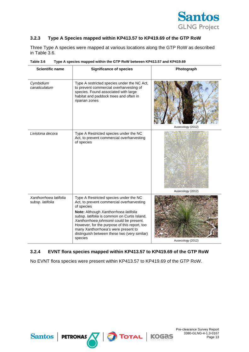
3.2.3 Type A Species mapped within KP413.57 to KP419.69 of the GTP RoW
Three Type A species were mapped at various locations along the GTP RoW as described in Table 3.6.
Table 3.6 Type A species mapped within the GTP RoW between KP413.57 and KP419.69
Scientific name Significance of species Photograph
Cymbidium canaliculatum
Type A restricted species under the NC Act, to prevent commercial overharvesting of species. Found associated with large habitat and paddock trees and often in riparian zones
Ausecology (2012)
Livistona decora Type A Restricted species under the NC Act, to prevent commercial overharvesting of species
Ausecology (2012)
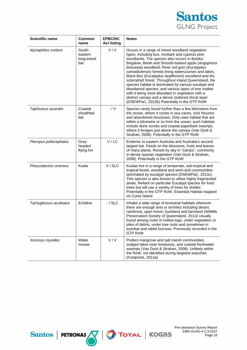
Xanthorrhoea latifolia subsp. latifolia
Type A Restricted species under the NC Act, to prevent commercial overharvesting of species
Note: Although Xanthorrhoea latifolia subsp. latifolia is common on Curtis Island, Xanthorrhoea johnsonii could be present. However, for the purpose of this report, too many Xanthorrhoea’s were present to distinguish between these two (very similar) species
Ausecology (2012)
3.2.4 EVNT flora species mapped within KP413.57 to KP419.69 of the GTP RoW
No EVNT flora species were present within KP413.57 to KP419.69 of the GTP RoW.
Pre-clearance Survey Report 3380-GLNG-4-1.3-0167
Page 14
4 Pre-clearance survey results – fauna
4.1 Desktop analysis
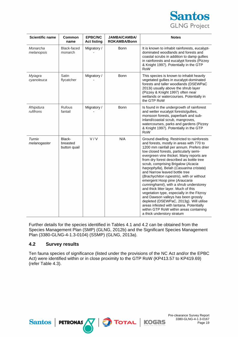
Tables 4.1 and 4.2 identify the fauna species that may occur in the RoW based on desktop analyses. These species were the focus of opportunistic fauna sightings within the GTP RoW (KP413.57 to KP419.69). Species identified in Tables 4.1 and 4.2 were deemed significant either under the provisions of the EPBC Act, NC Act, JAMBA and/or ROKAMBA and/or CAMBA. The notes contained within Tables 4.1 and 4.2 refer to their preferred habitat and their potential to occur (or existing record) within the GTP RoW.
Based on the current GTP RoW alignment, the RoW does not impact on the mudflats, mangrove communities and estuaries and their associated species on Curtis Island. This document will therefore not cover species (such as wader birds, seabirds etc) associated with these ecosystems.
Table 4.1 Potential conservation significant fauna species within the GTP RoW between KP413.57 and KP419.69
Scientific name Common name
EPBC/NC Act listing
Notes
Reptiles
Delma torquata Collared delma
V / V Ground-dwelling. The Collared delma is often associated with westerly facing ridge-top areas which support dry open Eucalypt and Acacia dominated woodlands with a 3 to 10 cm depth of leaf litter and a sparse understorey of tussock grass and shrubs or SEVT. Within this habitat the Collared delma can be located under weathered loose rocks, flattish bedrock outcroppings, logs or mats of leaf litter, or in cracks and crevices among tussock grasses. It is often found in areas with many small rocks (less than 30 cm) and fewer large rocks, and in areas with reasonably sparse vegetation. (Curtis et al, 2012; EPA, 2006a). Potentially in the GTP RoW
Denisonia maculata Ornamental snake
V / V Ground-dwelling. Suitable habitat is lower-lying subtropical areas with deep-cracking clay soils and adjacent slightly elevated ground of clayey and sandy loams, is the preferred habitat for this species. The species is also found in vegetation of woodland and shrub land, including some Brigalow (Acacia harpophylla), and also riverside woodland and open forest, particularly on natural levees. Restricted to the Dawson and Fitzroy Rivers drainage systems (DEHP, 2013a). Unlikely in the GTP RoW
Furina dunmalli Dunmall’s snake
V / V Ground-dwelling. Suitable habitat is open forest and woodland, particularly Brigalow (Acacia harpophylla) forest and woodland growing on floodplains of deep-cracking black clay and clay loam soils, provide habitat for this species. Most of the habitat supporting this species has been extensively modified for agriculture and grazing (DEHP, 2013b). Potentially in the GTP RoW

Pre-clearance Survey Report 3380-GLNG-4-1.3-0167
Page 15
Scientific name Common name
EPBC/NC Act listing
Notes
Paradelma orientalis Brigalow scaly foot
V / V Ground-dwelling. The Brigalow scaly-foot is found on sandstone ridges in woodlands and vine thickets, and in open forests and woodlands, especially ironbark, Cypress pine, Brigalow, Bull oak, Spotted gum and vine scrubs. The species is found in a wide variety of remnant and non-remnant open forest to woodland habitats. The species is known to persist in highly disturbed vegetation types, for example those areas invaded by Buffel grass (Pennisetum ciliaris), Parthenium (Parthenium hysterophorus) and other weeds (Brigalow Belt Reptiles Workshop, 2010). Potentially in the GTP RoW
Egernia rugosa Yakka skink V / V Yakka skink habitat is amongst dense ground vegetation, fallen timber or rock outcrops in open dry sclerophyll forest (ironbark) or woodland, Brigalow forest, open shrub land, and lancewood forest on coarse gritty soils in the vicinity of low ranges, foothills and undulating terrain with good drainage (Cogger 2000; DEHP, 2013c; Richardson, 2006). Important microhabitats for this species include rocky outcrops, hollow logs, animal burrows and ground cover (including perennial grass clumps, leaf litter, rocks, fallen timber etc) (Richardson, 2006). Potentially in the GTP RoW
Strophurus taenicauda Golden tailed gecko
- / NT Arboreal. The golden-tailed gecko lives in open woodland and open forest where it shelters under loose bark and hollow limbs (DEHP, 2013d). Potentially in the GTP RoW
Mammals
Chalinolobus dwyeri Large-eared pied bat
V / V The species requires a combination of sandstone cliff/escarpment to provide roosting habitat that is adjacent to higher fertility sites, particularly box gum woodlands or river/rainforest corridors that are used for foraging (DSEWPaC, 2013a). Potentially in the GTP RoW
Chalinolobus picatus Little pied bat
- / NT Occurs most frequently in dry, open woodland communities throughout its range but has also been recorded in dry sclerophyll forests dominated by Corymbia citriodora, Eucalyptus moluccana, Eucalyptus tereticornis and ironbark species, Araucarian notophyll vine forests, Callitris/Allocasuarina dominated forests with scattered eucalypt emergents such as Eucalyptus dealbata and Eucalyptus fibrosa, Mulga (Acacia aneura) woodlands, Eucalyptus largiflorens woodlands and riverine Eucalyptus camaldulensis dominated communities (Environment Australia, 1999). Previously recorded in the GTP RoW
Pre-clearance Survey Report 3380-GLNG-4-1.3-0167
Page 16
Scientific name Common name
EPBC/NC Act listing
Notes
Nyctophilus corbeni South-eastern long-eared bat
V / V Occurs in a range of inland woodland vegetation types, including box, ironbark and cypress pine woodlands. The species also occurs in Buloke, Brigalow, Belah and Smooth-barked apple (Angophora leiocarpa) woodland; River red gum (Eucalyptus camaldulensis) forests lining watercourses and lakes, Black Box (Eucalyptus largiflorens) woodland and dry sclerophyll forest. Throughout inland Queensland, the species habitat is dominated by various eucalypt and bloodwood species, and various types of tree mallee with it being most abundant in vegetation with a distinct canopy and a dense cluttered shrub layer (DSEWPaC, 2013b) Potentially in the GTP RoW
Taphozous australis Coastal sheathtail bat
- / V Species rarely found further than a few kilometres from the ocean, where it roosts in sea caves, rock fissures and abandoned structures. Only uses habitat that are within a kilometre or so from the ocean; such habitats include dune scrubs and coastal paperbark swamps, where it forages just above the canopy (Van Dyck & Strahan, 2008). Potentially in the GTP RoW
Pteropus poliocephalus Grey-headed flying fox
V / LC Endemic to eastern Australia and Australia’s second largest bat. Feeds on the blossoms, fruits and leaves of many plants. Roosts by day in “camps”, commonly in dense riparian vegetation (Van Dyck & Strahan, 2008). Potentially in the GTP RoW
Phascolarctos cinereus Koala V / SLC Koalas live in a range of temperate, sub-tropical and tropical forest, woodland and semi-arid communities dominated by eucalypt species (DSEWPaC, 2013c). This species is also known to utilise highly fragmented areas. Reliant on particular Eucalypt species for food trees but will use a variety of trees for shelter. Potentially in the GTP RoW, Essential Habitat mapped on Curtis Island
Tachyglossus aculeatus Echidna - / SLC Inhabit a wide range of terrestrial habitats wherever there are enough ants or termites including desert, rainforest, open forest, bushland and farmland (Wildlife Preservation Society of Queensland, 2013) Usually found among rocks in hollow logs, under vegetation or piles of debris, under tree roots and sometimes in wombat and rabbit burrows. Previously recorded in the GTP RoW
Xeromys myoides Water mouse
V / V Prefers mangrove and salt marsh communities, sedged lakes near foredunes, and coastal freshwater swamps (Van Dyck & Strahan, 2008). Unlikely within the RoW, not identified during targeted searches (Footprints, 2012a)

Pre-clearance Survey Report 3380-GLNG-4-1.3-0167
Page 17
Table 4.2 Potential conservation significant bird species within the GTP RoW between KP413.57 and KP419.69
Scientific name Common name
EPBC/NC Act listing
JAMBA/CAMBA/ ROKAMBA/Bonn
Notes
Erythrotriorchis radiatus
Red goshawk
V / E N/A The Red goshawk nests in large trees, frequently the tallest and most massive in a tall stand, and nest trees are invariably within 1 km of permanent water (DSEWPaC, 2013d). Red goshawks occupy a range of habitats, often at ecotones, including coastal and sub-coastal tall open forest, tropical savannahs crossed by wooded or forested watercourses, woodlands, the edges of rainforest and gallery forests along watercourses, and wetlands that include Melaleuca and Casuarina species (EPA, 2006b). Unlikely in the GTP RoW
Epthianura crocea macgregori
Yellow chat (Dawson)
CE / E N/A Inhabits marine plain wetlands that are subject to extensive seasonal inundation and varying degrees of both fresh and saltwater (tidal) influence. The Yellow chat (Dawson) typically occupies portions of the marine plain that have a network of shallow drainage channels and depressions supporting a mosaic of vegetation that consists of grassland, dense beds of rush or sedge, patches of Samphire (Halosarcia spp.) and areas of bare or sparsely-vegetated mud and/or shallow water (DSEWPaC 2013h). An isolated breeding population has previously been identified on the north side of Curtis Island. Unlikely in the GTP RoW
Geophaps scripta scripta
Squatter pigeon
V / V N/A Ground dwelling. Occurs mainly in grassy woodlands and open forests that are dominated by eucalypts. It has also been recorded in sown grasslands with scattered remnant trees, disturbed habitats (ie around stockyards, along roads and railways, and around settlements). The species is commonly observed in habitats that are located close to bodies of water (DSEWPaC, 2013e). Potentially in the GTP RoW
Haliaeetus leucogaster
White-bellied sea-eagle
Migratory / -
CAMBA Is found in coastal habitats and around terrestrial wetlands in tropical and temperate regions of mainland Australia and its offshore islands. The habitats are characterised by the presence of large areas of open water (larger rivers, swamps, lakes, the sea). Birds have been recorded in (or flying over) a variety of terrestrial habitats (Marchant & Higgins, 1993). Builds a very large nest of sticks generally in a tall, live tree near water. General nesting habitat likely in the GTP RoW
Pre-clearance Survey Report 3380-GLNG-4-1.3-0167
Page 18
Scientific name Common name
EPBC/NC Act listing
JAMBA/CAMBA/ ROKAMBA/Bonn
Notes
Hirundapus caudacutus
White-throated needle tail
Migratory / -
JAMBA/CAMBA Is almost exclusively aerial and although they occur over most types of habitat, they are probably recorded most often above wooded areas, including open forest and rainforest (DSEWPaC, 2013f). Spend the non-breeding season in Australasia, mainly in Australia. Unlikely to be found directly in the GTP RoW; if found it will be flying overhead
Lophoictinia isura
Square-tailed kite
- / NT N/A Forages over coastal and sub-coastal, eucalypt-dominated open forests and woodlands, and inland riparian woodland. It particularly favours productive forests on the coastal plain, box-ironbark-gum woodlands on the inland slopes, and Coolibah / River red gum on the inland plains (Marchant & Higgins, 1993). Potentially within the GTP RoW
Merops ornatus Rainbow bee-eater
Migratory / -
JAMBA Occurs mainly in open forests and woodlands, shrub lands, and in various cleared or semi-cleared habitats, including farmland and areas of human habitation (Higgins, 1999). Uses stream banks for nesting; the breeding season extends from August to January. Likely in the GTP RoW
Ninox strenua Powerful owl
- / V N/A Found in open forests and woodlands, as well as along sheltered gullies in wet forests with dense understoreys, especially along watercourses. Requires old growth trees to nest (Birds in Backyards, 2013d). Potentially in the GTP RoW
Accipiter novaehollandiae
Grey goshawk
- / NT N/A Found in a variety of forest types, especially tall closed forests, including rainforests (Birds in Backyards, 2013e). Potentially in the GTP RoW
Hirundo rustica Barn swallow
Migratory / -
JAMBA/CAMBA/ ROKAMBA
It is recorded in open country in coastal lowlands, often near water, towns and cities. Birds are often sighted perched on overhead wires and also in or over freshwater wetlands, paperbark Melaleuca woodland, mesophyll shrub thickets and tussock grassland (DSEWPaC 2013i). Unlikely in the GTP RoW
Monarcha trivirgatus
Spectacled monarch
Migratory / -
Bonn Inhabits both dense low vegetation and habitats with fairly open understoreys and prefers understorey of mountain and lowland rainforests, thickly wooded gullies and waterside vegetation; mostly well below the canopy (Pizzey & Knight 1997). Potentially in the GTP RoW
Pre-clearance Survey Report 3380-GLNG-4-1.3-0167
Page 19
Scientific name Common name
EPBC/NC Act listing
JAMBA/CAMBA/ ROKAMBA/Bonn
Notes
Monarcha melanopsis
Black-faced monarch
Migratory / -
Bonn It is known to inhabit rainforests, eucalypt-dominated woodlands and forests and coastal scrubs in addition to damp gullies in rainforests and eucalypt forests (Pizzey & Knight 1997). Potentially in the GTP RoW
Myiagra cyanoleuca
Satin flycatcher
Migratory / -
Bonn This species is known to inhabit heavily vegetated gullies in eucalypt-dominated forests and taller woodlands (DSEWPaC 2013i) usually above the shrub layer (Pizzey & Knight 1997) often near wetlands or watercourses. Potentially in the GTP RoW
Rhipidura rufifrons
Rufous fantail
Migratory / -
Bonn Is found in the undergrowth of rainforest and wetter eucalypt forests/gullies, monsoon forests, paperbark and sub-inland/coastal scrub, mangroves, watercourses, parks and gardens (Pizzey & Knight 1997). Potentially in the GTP RoW
Turnix melanogaster
Black-breasted button quail
V / V N/A Ground dwelling. Restricted to rainforests and forests, mostly in areas with 770 to 1200 mm rainfall per annum. Prefers drier low closed forests, particularly semi-evergreen vine thicket. Many reports are from dry forest described as bottle tree scrub, comprising Brigalow (Acacia harpophylla), Belah (Casuarina cristata) and Narrow leaved bottle tree (Brachychiton rupestris), with or without emergent Hoop pine (Araucaria cunninghamii), with a shrub understorey and thick litter layer. Much of this vegetation type, especially in the Fitzroy and Dawson valleys has been grossly depleted (DSEWPaC, 2013g). Will utilise areas infested with lantana. Potentially within GTP RoW within areas containing a thick understory stratum
Further details for the species identified in Tables 4.1 and 4.2 can be obtained from the Species Management Plan (SMP) (GLNG, 2012b) and the Significant Species Management Plan (3380-GLNG-4-1.3-0104) (SSMP) (GLNG, 2013a).
4.2 Survey results
Ten fauna species of significance (listed under the provisions of the NC Act and/or the EPBC Act) were identified within or in close proximity to the GTP RoW (KP413.57 to KP419.69) (refer Table 4.3).

Pre-clearance Survey Report 3380-GLNG-4-1.3-0167
Page 20
Table 4.3 Fauna species observed within the GTP ROW between KP413.57 and KP419.69
Scientific name Common name
EPBC Act / NC Act / JAMBA / CAMBA / ROKAMBA / Bonn
KP location Source
Birds
Merops ornatus Rainbow bee-eater
Migratory / - / JAMBA / - / - / - KP413.57 to KP419.19
Footprints
Pandion cristatus Eastern osprey Migratory / - / - / - / - / Bonn KP413.57 to KP419.19#
Footprints
Cuculus optatus Oriental cuckoo Migratory / - / JAMBA / CAMBA /
ROKAMBA / - KP413.60 to KP414.34
Footprints
Esacus magnirostris
Beach-stone curlew
- / V / - / - / - / - KP413.57 to KP415.4#
Footprints
Egretta sacra Eastern reef egret
Migratory / - / - / CAMBA / - / - KP413.57 to KP419.19#
Footprints
Ninox strenua Powerful owl - / V / - / - / - / - KP418.10 Footprints
Haliaeetus leucogaster
White-bellied sea-eagle
Migratory / - / - / CAMBA / - / - KP414.20#* Footprints
Mammals
Phascolarctos cinereus
Koala V / V / - / - / - / - KP413.57 to KP419.19**
Footprints
Tachyglossus aculeatus
Short-beaked echidna
- / SLC / - / - / - / - / - KP413.57 to KP419.19
Footprints
Table notes: # Species identified outside of the RoW * Possible nest identified ** Scratches possibly from Koala

Pre-clearance Survey Report 3380-GLNG-4-1.3-0167
Page 21
5 Declared weeds and feral pests
5.1 Declared weeds
A total of four declared weed species as listed under the provisions of the LP Act were identified as occurring within the GTP RoW (KP413.57 to KP419.69). These species are presented in Table 5.1 and Table 5.2. Three of the four species are also listed as weeds of national significance (WoNS). Further information and management measures for declared weeds and feral pests can be found in the GLNG Gas Transmission Pipeline Pest and Weed Management Plan (GLNG, 2012c).
Table 5.1 WoNS and LP Act listed weeds observed within the GTP RoW between KP413.57 and KP419.69
Scientific name Common name WoNS listed
LP Act Class
Baccharis halimifolia Groundsel No 2
Cryptostegia grandiflora Rubber vine Yes 2
Lantana camara Lantana Yes 3
Opuntia stricta Prickly pear Yes 2
Table 5.2 WoNS and LP Act listed weeds found within the GTP RoW between KP413.57 and KP419.69
Description Significance of species Photograph
Baccharis halimifolia (Groundsel)
Class 2 declared weed under the LP Act
Ausecology (2012)
Cryptostegia grandiflora (Rubber vine)
WoNS listed this is a Class 2 declared weed under the LP Act
Ausecology (2012)
Lantana camara (Lantana) WoNS listed, this is a Class 3 declared weed under the LP Act
Ausecology (2012)

Pre-clearance Survey Report 3380-GLNG-4-1.3-0167
Page 22
Description Significance of species Photograph
Opuntia stricta (Prickly pear) WoNS listed, this is a Class 2 declared weed under the LP Act
Ausecology (2012)
Table notes: 1Further information pretaining to control methods for LP Act declared species can be found on the Queensland Government Department of Agriculture, Fisheries and Forestry Declared Plants of Queensland webpage: http://www.daff.qld.gov.au/4790_7005.htm 5.2 Other environmental weeds
While mapping for this pre-clearance survey focused on the WoNS and LP Act listed weeds, details of other non-native flora species identified as being of environmental concern/undesirable were noted during field investigations. These species are presented in Table 5.3.
While these weeds are a low priority and consisted primarily of annual species, they were noted as they may potentially become a nuisance as a result of population explosion following ground disturbance in areas where they currently exist. Native species occurring within their natural range have not been listed as weeds as these species can be, at worst, a mild nuisance for agriculturalists. However species such as native chenopods can provide food and shelter for many species of native fauna.
Table 5.3 Other environmental weeds identified within the GTP RoW between KP413.57 and KP419.69
Family Scientific name Common name
Apocynaceae Gomphocarpus physocarpus Balloon cotton bush
Asteraceae Bidens pilosa Spanish needle or Beggar's ticks
Asteraceae Cirsium vulgare Spear thistle
Malvaceae Sida cordifolia Bala, Country mallow, Flannel weed
Passifloraceae Passiflora foetida Stinking passionfruit
Passifloraceae Passiflora suberosa Corky passion flower
Poaceae Megathyrsus maximus var. pubiglumis Guinea grass
Poaceae Melinis repens Red natal grass
5.3 Feral pests
No feral pest species were noted within the KP413.57 to KP419.69 section of the GTP RoW. It is likely, although not sighted during the field survey, that Felis catus (feral Cat), Canis familiaris dingo (Dingo/Wild dog), Vulpes vulpes (European fox), Sus scrofa (feral Pig) and Oryctolagus cuniculus (European rabbit), declared as Class 2 species under provisions of the LP Act are present throughout this region. Evidence of stock animals including Equus caballus (Horse) within the RoW was also noted although Equus caballus are not declared animals under Queensland legislation.

Pre-clearance Survey Report 3380-GLNG-4-1.3-0167
Page 23
Rhinella marina (Cane toad), a key threatening process listed under the EPBC Act, although not recorded in within the GTP RoW (KP413.57 to KP419.69), is also thought to be present.

Pre-clearance Survey Report 3380-GLNG-4-1.3-0167
Page 24
6 Habitat features
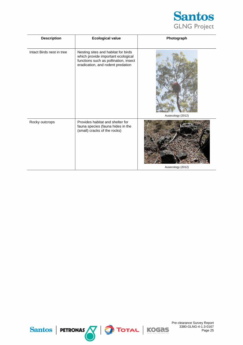
Habitat features present within the KP413.57 to KP419.69 section of the GTP RoW included numerous hollow-bearing trees, dead trees and fallen logs. Leaf litter and other small woody debris were abundantly present throughout the entire section of the GTP RoW, in particular in RE 12.11.6 and RE 12.11.14. Rocky outcrops were limited to one small patch where exposed rocks were present.
One nest was located outside the GTP RoW, most likely belonging to Haliaeetus leucogaster (White-bellied sea eagle). A summary of the key habitat features located within the GTP RoW between KP413.57 and KP419.69 are listed in Table 6.1.
Table 6.1 Habitat features identified within GTP RoW between KP413.57 and KP419.69
Description Ecological value Photograph
Fallen logs, large branches, log/timber
Habitat for reptiles (snakes, geckos etc), mammals and birds
Ausecology (2012)
Trees of various sizes with loose bark – trees can be dead or alive
Habitat for reptiles (snakes, geckos etc), birds and bats
Ausecology (2012)
Dead tree Strong value in hollows
Ausecology (2012)
Pre-clearance Survey Report 3380-GLNG-4-1.3-0167
Page 25
Description Ecological value Photograph
Intact Birds nest in tree Nesting sites and habitat for birds which provide important ecological functions such as pollination, insect eradication, and rodent predation
Ausecology (2012)
Rocky outcrops Provides habitat and shelter for fauna species (fauna hides in the (small) cracks of the rocks)
Ausecology (2012)

Pre-clearance Survey Report 3380-GLNG-4-1.3-0167
Page 26
7 Isolated Trees
Due to the vegetated nature of the KP413.57 to KP419.69 section of the GTP RoW (remnant vegetation) no stand-alone paddock trees were recorded.

Pre-clearance Survey Report 3380-GLNG-4-1.3-0167
Page 27
8 Watercourse Assessments
A total of two watercourse crossings were identified between KP413.57 and KP419.69 of the GTP RoW. These areas and their respective location along the GTP RoW are provided in Table 8.1. Watercourses were assessed to verify that they are consistent with the definition of a watercourse under the Water Act 2000. Further information with respect to watercourse aquatic values is provided in the GLNG Gas Transmission Pipeline Aquatic Values Management Plan Mainland KP0-KP406 and Curtis Island KP410-KP420.
Table 8.1 Watercourse crossings along the GTP RoW between KP312 and KP408.81
Watercourse name KP location Stream order Vegetation status
Unnamed Minor watercourse 205 KP416.14 1 Remnant
Unnamed Minor watercourse 206 KP418.17 1 Remnant

Pre-clearance Survey Report 3380-GLNG-4-1.3-0167
Page 28
9 Erosion
In general, erosion was limited to drainage lines and watercourses between KP413.57 and KP419.69 of the GTP RoW.. Plate 1 to Plate 3 provides examples of the erosion features within this section of the GTP RoW.
Plate 1 Bank erosion at the KP416.29 watercourse Plate 2 Bank erosion at KP417.72
Plate 3 Bank erosion at KP418.35

Pre-clearance Survey Report 3380-GLNG-4-1.3-0167
Page 29
10 Ponds and dams
No ponds and dams were present within the KP413.57 to KP419.69 section of the GTP RoW.

Pre-clearance Survey Report 3380-GLNG-4-1.3-0167
Page 30
11 Specific Survey Results
11.1 KP409.04 to KP413.57
Although not assessed as part of the pre-clearance surveys, the crossing between the mainland and Curtis Island has high ecological value for a number of EVNT and migratory species. The crossing intersects The Narrows (between KP409.12 and KP409.56) and Port Curtis (between KP409.56 and KP413.29), both nationally important wetlands which form part of the Great Barrier Reef World Heritage Area.
Ecological features of the GTP crossing include extensive mangrove forests and shrublands, seagrass beds and saltflats. Seagrass beds are the preferred feeding grounds of several JAMBA and/or CAMBA and/or ROKAMBA and/or Bonn migratory waders, Dugongs (Dugong dugon) and marine turtles.
Based on the high ecological value of the crossing between the mainland and Curtis Island, Santos GLNG has adopted a bored tunnelling construction methodology for the GTP crossing and will not impact The Narrows and Port Curtis wetland areas.
11.2 KP413.57 to KP419.69
The majority of the GTP RoW from KP413.57 to KP419.69 traverses remnant vegetation. Small sections of the GTP RoW have been mapped as non-remnant because of past clearing activities
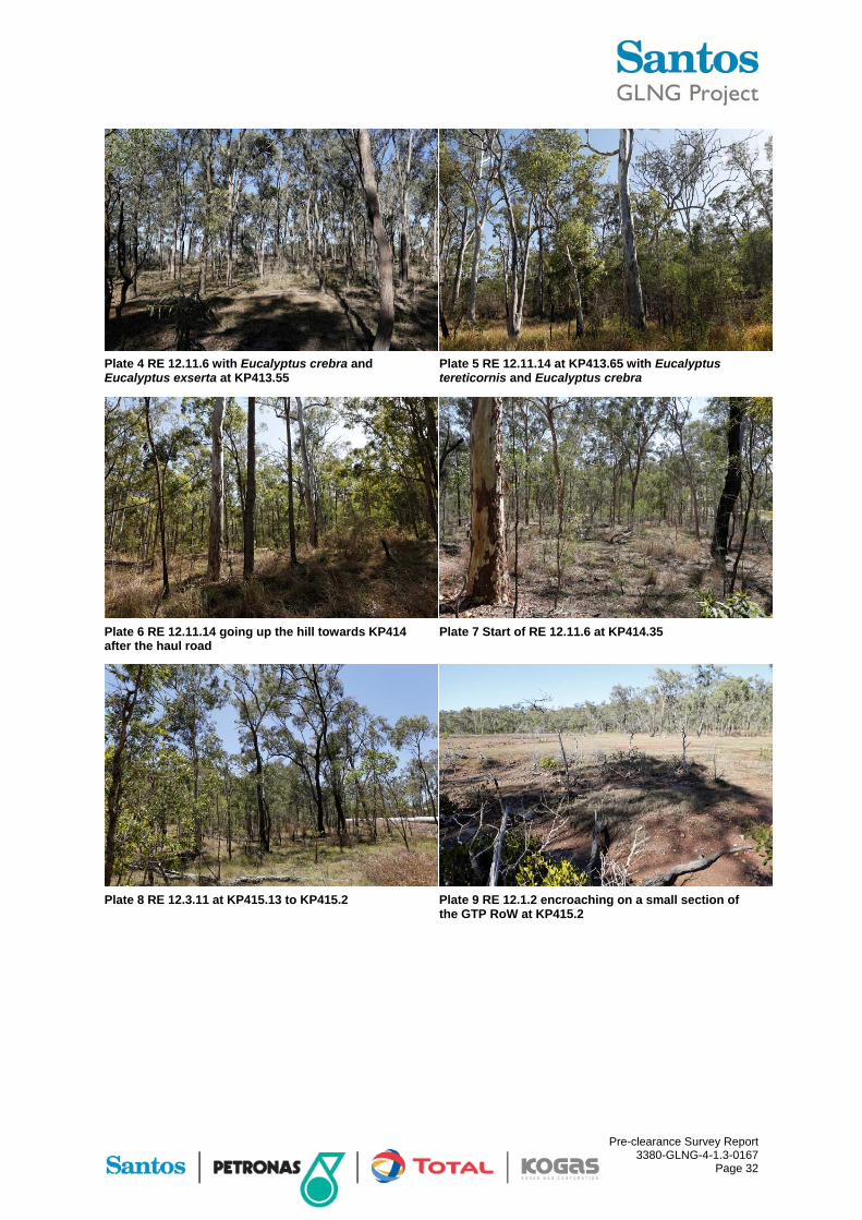
The mixed polygon RE 12.11.6/RE 12.11.14 was fine-tuned into individual RE’s wherever possible. The main discrepancy in the DEHP mapping was evident from KP413.59 to KP415.11, where a large section mapped as RE 12.11.6 was verified as RE 12.11.14. In the KP413.60 to KP414.34 section, no Corymbia citriodora is present in the GTP RoW or in close proximity. The vegetation consisted of Eucalyptus tereticornis (ranging from 80% at the bottom to 20% at the top of the slope). Eucalyptus tereticornis was progressively replaced by Corymbia species going up the hill. This area was also slightly wetter resulting in some “rainforest” species being present (refer Plate 5 to Plate 6). At KP414.34, vegetation consisting of a mix of Corymbia citriodora (90%) and Eucalyptus crebra/Eucalyptus exserta (10%) began to appear (refer Plate 7).
RE 12.11.6 and RE 12.11.14 are dominant within the GTP RoW, either as individual RE’s or as heterogeneous polygons (refer Plate 4 and Plate 11 to Plate 14). RE 12.11.6 is characterised by Corymbia citriodora and Eucalyptus crebra with a shrubby understorey (Acacia leiocalyx, Pogonolobus reticulatus), often with Xanthorrhoea latifolia subsp. latifolia present in various sections. Eucalyptus exserta is also dominant in the canopy in this section. RE 12.11.14 is dominated by Eucalyptus tereticornis and Eucalyptus crebra, often with other canopy species present such as Corymbia tessellaris, Corymbia erythrophloia, Corymbia clarksoniana and Corymbia intermedia. In wetter areas, Lophostemon suaveolens was locally dominant.
At KP414.3, the habitat was open woodland on hill slopes dominated by Eucalyptus crebra. Hollows were uncommon although ground timber was common, including logs, branches and fallen sticks. The shrub layer was dense, with large areas of Lantana camara and Acacia sp. Ground cover was dominated by native grasses and the ground consisted primarily of loose rocks and stones with little soil/humus. There was some evidence of horse activity at this site.

Pre-clearance Survey Report 3380-GLNG-4-1.3-0167
Page 31
Mixed polygon RE 12.3.7/RE 12.3.11 at KP415.13 to KP415.27 was verified as RE 12.3.11 (refer Plate 8) due to the absence of a watercourse fringing vegetation community. RE 12.1.2 intersects marginally with the GTP RoW in this area (refer Plate 9).
At KP415.4, the habitat was tall open woodland on hill slopes dominated by Eucalyptus crebra. Hollows were uncommon and ground timber was very sparse, primarily fallen sticks. The shrub layer was also very sparse, with small patches of Lantana camara and Acacia sp. Ground cover was dominated by native grasses with evidence of horse activity at this site. The site had been recently burnt, and there was extensive evidence of frequent and hot fires which has resulted in a very simplified habitat structure.
Although Casuarina cunninghamiana and Melaleuca viminalis were absent from the KP416.29 watercourse, the mixed polygon RE 12.3.3/RE 12.3.7 was accepted (though at 90/10%) based on a range of other species fringing this creek (Timonius timon, Glochidion lobocarpum, Lomandra longifolia, Mallotus philippensis). RE 12.3.3 was present as a Eucalyptus tereticornis and Lophostemon suaveolens community with an Acacia disparrima dominated understorey (refer Plate 10).
At KP416.1, the habitat was tall open woodland on alluvial flats, dominated by Eucalyptus tereticornis and Eucalyptus crebra, with Lophostemon confertus, Corymbia tesselaris and Corymbia citriodora scattered through the woodland. Hollows in both trees and stags were abundant with hollows recorded over 30 cm diameter in old growth trees. Ground timber was sparse, ranging from fallen sticks to a couple of large hollow logs. The shrub layer was dominated by Acacia sp. and ground cover was dominated by Imperata cylindrica. There was some evidence of horse activity and extensive evidence of frequent fires which has resulted in a very simplified habitat structure and the establishment of an almost monoculture of Imperata cylindrica.
At KP418, the habitat was tall open woodland on alluvial flats bounded by a drainage channel on either side. Canopy was dominated by Eucalyptus tereticornis and Eucalyptus crebra, with Corymbia tesselaris, Corymbia citriodora and Corymbia clarksoniana scattered through the woodland. Hollows in both trees and stags were abundant with hollows recorded over 30 cm diameter in old growth trees. Ground timber was sparse, predominantly fallen sticks. The shrub layer was dominated by Acacia sp. with patches of Lantana camara and the ground cover was dominated by Imperata cylindrica. There was some evidence of horse activity and extensive evidence of frequent fires which has resulted in very simplified habitat structure and the establishment of an almost monoculture of Imperata cylindrica.
The DEHP mapped heterogeneous polygon RE 12.3.3/RE 12.3.7 (KP419.04 to KP419.45) was not identified in the field. No Eucalyptus tereticornis was identified in this section and the RE was therefore confirmed as a continuation of RE 12.11.6 (refer Plate 15 to Plate 16). Furthermore, the watercourse that is present in this area does not run through the GTP RoW. KP419.085 to KP419.157 is non-remnant.
Pre-clearance Survey Report 3380-GLNG-4-1.3-0167
Page 32
Plate 4 RE 12.11.6 with Eucalyptus crebra and Eucalyptus exserta at KP413.55
Plate 5 RE 12.11.14 at KP413.65 with Eucalyptus tereticornis and Eucalyptus crebra
Plate 6 RE 12.11.14 going up the hill towards KP414 after the haul road
Plate 7 Start of RE 12.11.6 at KP414.35
Plate 8 RE 12.3.11 at KP415.13 to KP415.2 Plate 9 RE 12.1.2 encroaching on a small section of the GTP RoW at KP415.2

Pre-clearance Survey Report 3380-GLNG-4-1.3-0167
Page 33
Plate 10 RE 12.3.3/RE 12.3.7 at KP416.00 to KP416.28 dominated by Eucalyptus tereticornis and Lophostemon suaveolens with some riparian zone fringing vegetation at the watercourse
Plate 11 RE 12.11.6/RE 12.11.14 at KP 416.3, looking south to south-east
Plate 12 Patch of Xanthorrhoea latifolia in RE 12.11.6 at KP417.65
Plate 13 RE 12.11.6/RE 12.11.14 at KP418.10
Plate 14 RE 12.11.6/RE 12.11.14 at KP418.35 looking north to north-west
Plate 15 RE 12.11.6 at KP419 looking south to south-east

Pre-clearance Survey Report 3380-GLNG-4-1.3-0167
Page 34
Plate 16 GLNG private property fence at KP419.31 looking south-west
Vegetation on the GTP RoW within the GLNG boundary resembles least concern RE 12.11.6 dominated by Corymbia citriodora, Eucalyptus crebra and the occasional Corymbia clarksoniana and Eucalyptus tereticornis (refer Plate 17). A drainage line is present in this area (refer Plate 18).
Plate 17 Vegetation at KP419.33 Plate 18 Watercourse at KP419.356
Based on the habitat structure within KP413.57 to KP419.69, suitable habitat has been identified for EPBC listed EVNT species and is presented in Table 11.1.
Table 11.1 Suitable habitat for EPBC Act EVNT species within KP413.57 to KP419.69
EPBC listed species Comments
Phascolarctos cinereus (Koala) Throughout KP413.57 to KP419.69
Delma torquata (Collared delma) Area surrounding KP414.3
Furina dunmalli (Dunmall’s snake) Area surrounding KP414.3
Paradelma orientalis (Brigalow scaly-foot) Area surrounding KP414.3
Although not physically recorded during the surveys, scratch marks possibly from Phascolarctos cinereus (Koala) were observed on smooth barked eucalypt trees on Curtis Island.
The GTP RoW between KP413.57 and KP419.69 also provides suitable habitat for various EPBC listed migratory bird species such as Haliaeetus leucogaster (White-bellied sea-eagle) where a possible nest was identified approximately 50 m south of KP414.2. Suitable habitat

Pre-clearance Survey Report 3380-GLNG-4-1.3-0167
Page 35
was also identified for the EPBC listed migratory bird species Merops ornatus (Rainbow bee-eater), Monarcha melanopsis (Black-faced monarch), Monarcha trivirgatus (Spectacled monarch), Myiagra cyanoleuca (Satin flycatcher), Rhipidura rufifrons (Rufous fantail) and Cuculus optatus (Oriental cuckoo) within this section of the GTP RoW.
Pre-clearance Survey Report 3380-GLNG-4-1.3-0167
Page 36
12 Conclusion
The GTP RoW section located between KP413.57 and KP419.69 was surveyed by experienced ecologists between mid-December 2011 to end of March 2012 and 13 to 14 November 2012. Results of these surveys are presented in detail within this report. This report is to be used during planning, construction and rehabilitation phases and contributes to the SSMP as required pursuant to the EPBC Referral approval conditions.
No EVNT flora species were identified within this section of the GTP RoW.
Three Type A species listed under the NC Act were identified during these surveys and included Cymbidium canaliculatum (Black orchid), Livistona decora and Xanthorrhoea latifolia subsp. latifolia.
Four declared weed species as listed under the provisions of the LP Act were identified as occurring within the GTP RoW including Baccharis halimifolia (Groundsel),Cryptostegia grandiflora (Rubber vine), Lantana camara (Lantana) and Opuntia stricta (Prickly pear) along with a number of other non-native flora species.
Two EVNT fauna species were identified within or in close proximity to this section of the GTP RoW (KP413.57 to KP419.69) with suitable habitat identified for eight more significant species (of which three are listed under the EPBC Act). The two identified fauna species of significance (listed under the provisions of the NC Act and/or the EPBC Act) included Ninox strenua (Powerful owl) and Esacus magnirostris (Beach stone-curlew) In addition, scratch marks possibly from Phascolarctos cinereus (Koala) were identified on smooth barked eucalypt trees on Curtis Island. Tachyglossus aculeatus (Short-beaked echidna), which is listed as Special Least Concern under the NC Act, was also identified during the pre-clearance survey.
Migratory bird species listed under the EPBC Act were also identified within or in close proximity to this section of the GTP RoW. These included Merops ornatus (Rainbow bee-eater), Egretta sacra (Eastern reef egret), Pandion cristatus (Eastern osprey), and Cuculus optatus (Oriental cuckoo). In addition, a raptor nest, possibly a Haliaeetus leucogaster (White-bellied sea-eagle) nest, was identified in close proximity to the GTP RoW on Curtis Island. Suitable habitat was also identified for a further 34 migratory species listed under the EPBC Act.
No feral pest species listed under the LP Act were identified within this section of the GTP RoW. It is likely, although not sighted during the field survey, that a number of Class 2 species may be present in the area along with stock animals including horses.
In general, erosion present is low to moderate, with a few erosion risk areas mainly associated with drainage and creek lines.

Pre-clearance Survey Report 3380-GLNG-4-1.3-0167
Page 37
13 References
Birds in Backyards (2013d) Powerful owl, Accessed [Online] February 2013, Available from: http://www.birdsinbackyards.net/species/Ninox-strenua
Birds in Backyards (2013e) Grey goshawk, Accessed [Online] February 2013, Available from: http://www.birdsinbackyards.net/species/Accipiter-novaehollandiae
Brigalow Belt Reptiles Workshop (2010) Proceedings from the workshop for the nine listed reptiles of the Brigalow Belt bioregions, 18-19 August 2010, Brisbane: Queensland Herbarium
Cogger (2000) Reptiles and Amphibians of Australia, Reeds Books, NSW
Curtis, L., A. Dennis, K. McDonald, P. Kyne & S. Debus (2012) Queensland’s Threatened Animals, CSIRO Publishing
Department of Agriculture, Fisheries and Forestry (DAFF) (2012) Declared Plants of Queensland Fact Sheet, Available from: http://www.daff.qld.gov.au/documents/Biosecurity_EnvironmentalPests/IPA-Declared-Plants-Qld-PP1.pdf
Department of Environment & Heritage Protection (DEHP) (2012a) Environmental Protection Act 1994 Level 1 Environmental Authority (chapter 5A activities) PEN103428811, 7 September 2012
Department of Environment & Heritage Protection (DEHP) (2012b) Denisonia maculata, Accessed [Online] February 2013, Available from: http://www.ehp.qld.gov.au/wildlife/animals-az/ornamental_snake.html
Department of Environment & Heritage Protection (DEHP) (2013a) Environmental Protection Act 1994 Level 1 Environmental Authority (chapter 5A activities) PEN102968511, 22 November 2011
Department of Environment & Heritage Protection (DEHP) (2013b) Furina dunmalli, Accessed [Online] February 2013, Available from: http://www.ehp.qld.gov.au/wildlife/animals-az/dunmalls_snake.html
Department of Environment & Heritage Protection (DEHP) (2013c) Egernia rugosa, Accessed [Online] February 2013, Available from: http://www.ehp.qld.gov.au/wildlife/animals-az/yakka_skink.html
Department of Environment & Heritage Protection (DEHP) (2013d) Strophurus taenicauda, Accessed [Online] February 2013, Available from: http://www.ehp.qld.gov.au/wildlife/threatened-species/near-threatened/goldentailed_gecko.html
Department of Environment & Heritage Protection (DEHP) (2013f) Esacus magnirostris, Accessed [Online] February 2013, Available from: http://www.ehp.qld.gov.au/wildlife/animals-az/beach_stonecurlew.html
Department of Environment and Heritage Protection (DEHP) (2013g) Queensland Regional Ecosystem Description Database, Version 6.0b [REDD]
Department of Environment, Water, Heritage and the Arts (DEWHA) (2010a) - Survey Guidelines for Australia’s Threatened Bats, Available from: http://www.environment.gov.au/epbc/publications/threatened-bats.html

Pre-clearance Survey Report 3380-GLNG-4-1.3-0167
Page 38
Department of Environment, Water, Heritage and the Arts (DEWHA) (2010b) - Survey Guidelines for Australia’s Threatened Birds, Available from: http://www.environment.gov.au/epbc/publications/threatened-birds.html
Department of Environment, Water, Heritage and the Arts (DEWHA) (2010c) - Survey Guidelines for Australia’s Threatened Frogs, Available from: http://www.environment.gov.au/epbc/publications/threatened-frogs.html
Department of Sustainability, Environment, Water, Population and Communities (DSEWPaC) (2010) EPBC approval to develop, construct, operate and decommission a 430km pipeline network to link coal seam gas fields to a proposed LNG facility on Curtis Island as described in referral EPBC No 2008/4096, 22 October 2010, Available from: http://www.environment.gov.au/epbc/notices/assessments/2008/4096/approval-4096.pdf
Department of Sustainability, Environment, Water, Population and Communities (DSEWPaC) (2011a) Survey guidelines for Australia's threatened mammals, EPBC Act survey guidelines 6.5 [Online], EPBC Act policy statement: Canberra, ACT. Available from: http://www.environment.gov.au/epbc/publications/threatened-mammals.html
Department of Sustainability, Environment, Water, Population and Communities (DSEWPaC) (2011b) Survey guidelines for Australia's threatened reptiles, EPBC Act survey guidelines 6.6 [Online], Canberra, ACT. Available from: http://www.environment.gov.au/epbc/publications/threatened-reptiles.html
Department of Sustainability, Environment, Water, Population and Communities (DSEWPaC) (2013a) Chalinolobus dwyeri in Species Profile and Threats Database, Canberra, Available from: http://www.environment.gov.au/sprat
Department of Sustainability, Environment, Water, Population and Communities (DSEWPaC) (2013b) Nytophilus corbeni in Species Profile and Threats Database, Canberra, Available from: http://www.environment.gov.au/sprat
Department of Sustainability, Environment, Water, Population and Communities (DSEWPaC) (2013c) Koala populations in Queensland, New South Wales and the Australian Capital Territory and national environment law, Canberra, Available from: http://www.environment.gov.au/biodiversity/threatened/publications/koala-species-listing.htmlhttp://www.environment.gov.au/sprat
Department of Sustainability, Environment, Water, Population and Communities (DSEWPaC) (2013d) Erythrotriorchis radiatus in Species Profile and Threats Database, Canberra, Available from: http://www.environment.gov.au/sprat
Department of Sustainability, Environment, Water, Population and Communities (DSEWPaC) (2013e) Geophaps scripta scripta in Species Profile and Threats Database, Canberra, Available from: http://www.environment.gov.au/sprat
Department of Sustainability, Environment, Water, Population and Communities (DSEWPaC) (2013f) Hirundapus caudacutus in Species Profile and Threats Database, Canberra, Available from: http://www.environment.gov.au/sprat
Department of Sustainability, Environment, Water, Population and Communities (DSEWPaC) (2013g) Turnix melanogaster in Species Profile and Threats Database, Canberra, Available from: http://www.environment.gov.au/sprat
Department of Sustainability, Environment, Water, Population and Communities (DSEWPaC) (2013h) Epthianura crocea macgregori in Species Profile and Threats Database, Canberra, Available from: http://www.environment.gov.au/sprat

Pre-clearance Survey Report 3380-GLNG-4-1.3-0167
Page 39
Department of Sustainability, Environment, Water, Population and Communities (DSEWPaC) (2013i) Hirundo rustica in Species Profile and Threats Database, Canberra, Available from: http://www.environment.gov.au/sprat
Department of Sustainability, Environment, Water, Population and Communities (DSEWPaC) (2013j) Myiagra cyanoleuca in Species Profile and Threats Database, Canberra, Available from: http://www.environment.gov.au/sprat
Ecologica Consulting (2012) Pre-Clearance Survey Report for KP0-KP130 of the GLNG Pipeline Project (2010001_01)
Environment Australia (1999) The Action Plan for Australian Bats, Accessed [Online] February 2013, Available from: http://www.environment.gov.au/biodiversity/threatened/publications/action/bats/index.html
EPA (2006a) Collared delma Conservation Management Profile, Accessed [Online] February 2013, Available from: http://www.ehp.qld.gov.au/register/p02094aa.pdf
EPA (2006b) Red goshawk Conservation Management Profile, Accessed [Online] February 2013, Available from: http://www.ehp.qld.gov.au/register/p02093aa.pdf
Footprints Environmental Consultants (FEC) (2012a) GLNG GTP ROW Pre-clearing Threatened Species Surveys Water Mouse Assessment Report, Prepared for GLNG Operations Pty Ltd
Footprints Environmental Consultants (FEC) (2012b) GLNG GTP ROW Kangaroo Island Wetland Complex Migratory Bird Surveys Baseline Assessment Report, Prepared for GLNG Operations Pty Ltd
FRC Environmental (2012) Gladstone Liquefied Natural Gas (GLNG) Pipeline Project Aquatic Values Assessment Major Watercourses KP200 – KP406 (3380-GLNG-4.1.3-0084)
GLNG (2010) FEED Specification for EPC Contractor Environmental Requirements (3380-GLNG-3-1.3 008)
GLNG (2011) GLNG Gas Transmission Pipeline Pest and Weed Management Plan (3380-GLNG-3-1.3-0006)
GLNG (2012a) GLNG Gas Transmission Pipeline - EPBC Environmental Management Plan Mainland GTP (3380-GLNG-4-8.2-0020)
GLNG (2012b) GLNG Gas Transmission Pipeline Species Management Plan (SMP) (3380-GLNG-3-1.3-0036)
GLNG (2012c) GLNG Gas Transmission Pipeline Pest and Weed Management Plan (SMP) (3380-GLNG-3-1.3-0006)
GLNG (2012d) GLNG Gas Transmission Pipeline Aquatic Values Management Plan Mainland KP0-406 and Curtis Island KP410-420 (3380-GLNG-3-1.3-0128)
GLNG (2013a) GLNG Gas Transmission Pipeline Significant Species Management Plan (3380-GLNG-4.1.3-0104)
GLNG (2013b) GLNG Gas Transmission Pipeline Cycas megacarpa Translocation and Management Plan (3380-GLNG-4-1.3-0013)

Pre-clearance Survey Report 3380-GLNG-4-1.3-0167
Page 40
Higgins, P.J. (1999) Handbook of Australian, New Zealand and Antarctic Birds, Volume Four - Parrots to Dollarbird, Melbourne: Oxford University Press
Marchant S. & P.J. Higgins (1993) Handbook of Australian, New Zealand and Antarctic Birds, Volume 2 - Raptors to Lapwings, Melbourne, Victoria: Oxford University Press
Marchant S. & P.J. Higgins (1990) Handbook of Australian, New Zealand and Antarctic Birds Volume 1: Ratites to Ducks. Oxford University Press, Melbourne
Queensland Government (2010) Coordinator-General’s evaluation report for an environmental impact statement Gladstone Liquefied Natural Gas - GLNG project, May 2010
Richardson, R. (2006) Queensland Brigalow Belt Reptile Recovery Plan 2008 – 2012, Report to the Department of the Environment, Water, Heritage and the Arts, Canberra. WWF-Australia, Brisbane
Threatened Species Scientific Committee (2005) Commonwealth Conservation Advice on Northern Quoll (Dasyurus hallucatus), Accessed [Online] February 2013, Available from: http://www.environment.gov.au/biodiversity/threatened/species/dasyurus-hallucatus.html#conservation
Van Dyck, S. & Strahan, R. (2008) Mammals of Australia, 3rd Ed, Reed New Holland, NSW
Wildlife Preservation Society of Queensland (2013) Tachyglossus aculeatus, Accessed [Online], Available from: http://www.wildlife.org.au/wildlife/speciesprofile/mammals/short_beaked_echidna.html
Wilson, S, (2005) A Field Guide to Reptiles of Queensland, Reed New Holland, Sydney
Wilson, S. and Swan, G (2008) A Complete Guide to Reptiles of Australia, 2nd ed, New Holland Publishers, Sydney, NSW, Australia