Conserving Great Lakes Alvars - US EPA · Conserving Great Lakes Alvars Final Technical Report of...
252
Transcript of Conserving Great Lakes Alvars - US EPA · Conserving Great Lakes Alvars Final Technical Report of...

Conserving Great Lakes Alvars Final Technical Report of the
International Alvar Conservation Initiative
March, 1999
compiled by
Carol Reschke, Ron Reid, Judith Jones, Tom Feeney, and Heather Potter
on behalf of the
Alvar Working Group
The Nature Conservancy Great Lakes Program
8 South Michigan Avenue Suite 2301
Chicago, IL 60603
(312) 759-8017

Conserving Great Lakes Alvars
i
Table of Contents EXECUTIVE SUMMARY..................................................................................................................... v
1.0 INTRODUCTION............................................................................................................................. 1
1.1 INTRODUCTION TO ALVARS ............................................................................................................. 1 1.2 THE INTERNATIONAL ALVAR CONSERVATION INITIATIVE AND ALVAR WORKING GROUP ................. 4
2.0 ALVAR COMMUNITIES: COMPOSITION, DISTRIBUTION, AND STATUS........................... 9
2.1 SUMMARY OF COMMUNITY INVENTORY METHODS........................................................................... 9 Locating Alvar Sites............................................................................................................................... 10 Community Surveys............................................................................................................................... 10 Conservation Rankings for Alvar Communities and Species ................................................................ 14
2.2 ALVAR COMMUNITIES .................................................................................................................. 17 2.2.1 Open Alvar Grasslands and Pavements ................................................................................. 19
1. Tufted hairgrass wet alvar grassland ................................................................................................. 19 2. Little bluestem alvar grassland.......................................................................................................... 22 3. Annual alvar pavement-grassland ..................................................................................................... 25 4. Alvar nonvascular pavement............................................................................................................. 28 5. Poverty grass dry alvar grassland ...................................................................................................... 32
2.2.2 Alvar Shrublands ................................................................................................................. 34 6. Creeping juniper - shrubby cinquefoil alvar pavement ..................................................................... 35 7. Scrub conifer / dwarf lake iris alvar shrubland.................................................................................. 38 8. Juniper alvar shrubland ..................................................................................................................... 41
2.2.3 Alvar Savannas and Woodlands............................................................................................ 45 9. Shagbark hickory / Prickly ash alvar savanna .................................................................................... 45 10. Chinquapin oak / nodding onion alvar savanna............................................................................... 46 11. White cedar - jack pine / shrubby cinquefoil alvar savanna ............................................................ 49 12. Mixed conifer / common juniper alvar woodland ........................................................................... 52 13. Red cedar / early buttercup alvar woodland .................................................................................... 55
2.3 OTHER COMMUNITIES STUDIED .................................................................................................... 55 14. River ledge limestone pavement ..................................................................................................... 56 15. Great Lakes limestone bedrock lakeshore....................................................................................... 57 16. Bur oak limestone savanna.............................................................................................................. 59 17. Midwest wet-mesic dolomite prairie ............................................................................................... 61
2.4 EVALUATING ALVAR OCCURRENCES AND SITES FOR CONSERVATION PLANNING............................ 62
3.0 CHARACTERISTIC AND RARE SPECIES ASSOCIATED WITH ALVARS.......................... 77
3.1 CHARACTERISTIC AND RARE PLANTS............................................................................................ 77 3.1.1 Rare Vascular Plants ............................................................................................................ 77 3.1.2 Characteristic Nonvascular Plants: Lichens, Mosses, Algae.................................................. 81
3.2 CHARACTERISTIC INVERTEBRATES, BIRDS, AND RARE ANIMALS ................................................... 83 3.2.1 Inventory Methods for Invertebrate Surveys.......................................................................... 83 3.2.2 Insects.................................................................................................................................. 84
Ground beetles and tiger beetles............................................................................................................. 85 Leafhoppers............................................................................................................................................ 85 Butterflies, skippers, and moths ............................................................................................................. 87 Sawflies.................................................................................................................................................. 88 Orthopteroids ......................................................................................................................................... 88
3.2.3 Terrestrial Molluscs ............................................................................................................. 89 3.2.4 Birds, Herptiles, and Other Fauna........................................................................................ 91
Conserving Great Lakes Alvars
ii
4. 0 ECOLOGY OF GREAT LAKES ALVARS .................................................................................93
4.1 OVERVIEW ...................................................................................................................................93 4.2 THE ROLE OF ALVAR HYDROLOGY AND SOIL MOISTURE REGIME...................................................94
4.2.1 Introduction .........................................................................................................................94 4.2.2 The Effect of Regional Hydrology on Alvars.........................................................................96 4.2.3 Soil Moisture Regime and the Assessment of Grassland Ruts: On-Site Hydrology..................99 4.2.4 Conclusions........................................................................................................................105
4.3 THE ROLE OF FIRE REGIME AND LAND USE HISTORY...................................................................108 4.3.1 Introduction .......................................................................................................................108 4.3.2 General Findings................................................................................................................109 4.3.3 Conclusions........................................................................................................................116
4.4 THE ROLE OF BROWSING AND GRAZING ......................................................................................116 4.5 THE ROLE OF EXOTIC PLANTS.....................................................................................................119
4.5.1 Introduction .......................................................................................................................119 4.5.2 Findings on Common Exotic Species....................................................................................120 4.5.3 Study Results Specific to Buckthorn ....................................................................................125 4.5.4 Conclusions.......................................................................................................................127
5.0 CONSERVATION PRIORITIES AND TECHNIQUES..............................................................129
5.1 CONSERVATION TARGETS............................................................................................................129 5.1.1 Applying Conservation Criteria ...........................................................................................132 5.1.2 Great Lakes Alvar Sites with Multiple Values......................................................................141 5.1.4 Attainment of Ecoregional Goals .........................................................................................146
5.2 RANGEWIDE ANALYSIS OF THREATS ...........................................................................................146 Residential and related development.................................................................................................... 149 All-terrain vehicle and off-road vehicle use ......................................................................................... 149 Grazing and browsing .......................................................................................................................... 150 Exotic species....................................................................................................................................... 151 Plant collecting..................................................................................................................................... 151 Logging and forestry............................................................................................................................ 151 Waste dumping and vandalism ............................................................................................................ 152
5.3 CONSERVATION ACTIVITIES UNDERWAY.....................................................................................152 5.4 PRIORITY ACTIONS FOR ALVAR CONSERVATION..........................................................................156
6.0 EVALUATION OF THE COLLABORATIVE PROCESS .........................................................161
6.1 OUTLINE OF THE PROCESS STEPS.................................................................................................161 6.2 KEY INGREDIENTS FOR SUCCESS .................................................................................................162 6.3 ADAPTING THE COLLABORATIVE PROCESS FOR OTHER ECOSYSTEM TYPES ..................................165
7.0 SOURCES OF MORE DETAILED INFORMATION.................................................................167
ACKNOWLEDGMENTS...................................................................................................................171
REFERENCES CITED.......................................................................................................................173
APPENDIX 1: DETAILED COMMUNITY INVENTORY METHODS .........................................180
APPENDIX 2: DETAILED COMMUNITY ANALYSIS METHODS .............................................183
APPENDIX 3: ALVAR COMMUNITY TECHNICAL DESCRIPTIONS AND ELEMENT OCCURRENCE RANKING SPECIFICATIONS .............................................................................188
Tufted hairgrass wet alvar grassland .................................................................................................190 Little bluestem alvar grassland..........................................................................................................194 Annual alvar pavement-grassland .....................................................................................................198 Alvar nonvascular pavement.............................................................................................................202 Poverty grass dry alvar grassland ......................................................................................................206

Conserving Great Lakes Alvars
iii
Creeping juniper - shrubby cinquefoil alvar pavement....................................................................... 210 Scrub conifer / dwarf lake iris alvar shrubland .................................................................................. 214 Juniper alvar shrubland..................................................................................................................... 217 Shagbark hickory / prickly ash alvar savanna .................................................................................. 221 Chinquapin oak / nodding onion alvar savanna ................................................................................. 224 White cedar - jack pine / shrubby cinquefoil alvar savanna................................................................ 228 Mixed conifer / common juniper alvar woodland .............................................................................. 231 Red cedar / early buttercup alvar woodland....................................................................................... 235
APPENDIX 4: ALVAR WORKING GROUP MEMBERS............................................................... 240

Conserving Great Lakes Alvars
iv
List of Maps: Map A: Distribution of Alvar Communities........................................................................................10 Map B: Subsections and Site Districts That Support Alvar Communities.............................................15 Map C: Tufted Hairgrass Wet Alvar Grassland ...................................................................................16 Map D: Little Bluestem Alvar Grassland ............................................................................................23 Map E: Annual Alvar Pavement-Grassland.........................................................................................21 Map F: Alvar Nonvascular Pavement .................................................................................................23 Map G: Poverty Grass Dry Alvar Grassland ..................................................................................... .25 Map H: Creeping Juniper - Shrubby Cinquefoil Alvar Pavement.........................................................28 Map I: Scrub Conifer / Dwarf Lake Iris Alvar Shrubland ...................................................................30 Map J: Juniper Alvar Shrubland .........................................................................................................32 Map K: Shagbark Hickory/Prickly Ash & Chinquapin Oak/Nodding Onion Alvar Savannas ...............36 Map L: White Cedar - Jack Pine / Shrubby Cinquefoil Alvar Savanna.................................................38 Map M: Mixed Conifer / Common Juniper Alvar Woodland...............................................................40 Map N: Red Cedar / Early Buttercup Alvar Woodland........................................................................41 Map O: Alvar Sites Supporting Three or More Community Types .................................................... 109 Map P: Alvar Sites that Best Represent Community Types ............................................................... 109 Map Q: Alvar Sites that Best Represent Ecoregions .......................................................................... 111 Map R: Alvar Sites with Multiple Conservation Values .................................................................... 119
List of Figures: Figure A: Seasonal flooding conditions in alvar grassland.....................................................................76 Figure B: Vehicle ruts in alvar grassland ..............................................................................................81 Figure C: Chaumont Barrens summer 1996 rainfall and mean qualitative moisture index ......................83 Figure D: LaCloche Alvar mean soil moisture ......................................................................................84 Figure E: LaCloche Alvar grassland rut soil moisture ...........................................................................86 Figure F: Percent cover of Poa compressa in different alvar types.......................................................100 Figure G: Percent cover of exotic species in different alvar types ........................................................100 Figure H: Abundance of alvar communities in the Great Lakes basin ..................................................122 Figure I: Acreage of alvar communities in the Great Lakes basin .......................................................122
List of Tables: Table 1: Final Alvar Initiative community types ...................................................................................13 Table 2: Alvar community sites............................................................................................................49 Table 3: Characteristic rare plants of Great Lakes alvars .......................................................................62 Table 4: Carbonate composition of Black River Group limestones ........................................................79 Table 5: Observation points by community type showing presence/absence of burn evidence................91 Table 6: Alvar sites with three or more Priority 1 community occurrences...........................................108 Table 7: Best representative sites for alvar community types...............................................................110 Table 8: Representative alvar sites within each site district/subsection.................................................112 Table 9: Alvar sites with known occurrences of globally rare species ..................................................114 Table 10: Alvar sites with multiple values ..........................................................................................117 Table 11: Comparison of alvar communities with state jurisdictions....................................................188

Conserving Great Lakes Alvars
v
Executive Summary
Alvar ecosystems are grassland, savanna and sparsely vegetated rock barrens that develop on flat limestone or dolostone bedrock where soils are very shallow. Almost all of North America’s alvars occur within the Great Lakes basin, primarily in an arc from northern Lake Michigan across northern Lake Huron and along the southern edge of the Canadian Shield to include eastern Ontario and northwestern New York state. Most types of alvar communities are globally imperiled, and they support several globally rare species as well. The International Alvar Conservation Initiative is a collaborative effort aimed at providing a unified, consistent approach to understanding and conserving this rare and vulnerable Great Lakes ecosystem. The Alvar Initiative has been coordinated by the Great Lakes Program of The Nature Conservancy (TNC). Individual projects related to the Initiative were coordinated through annual meetings and ongoing discussions of the Alvar Working Group, a forum involving over 50 collaborators from government and non-government organizations and universities. Highlights of Results an unprecedented, high-quality information base for future decisions about
priority actions for alvar conservation across the Great Lakes basin by planners, agencies, and non-government organizations
an enhanced understanding of several aspects of Great Lakes basin biodiversity,
including the discovery of several new species and many new sites for rare and endemic species
a broadly-accepted, consistent framework for evaluating alvar conservation
priorities within the 27,200 acres of alvar habitats across the Great Lakes basin documentation of 34 high-priority sites with an assessment of protection urgency
for each, as well as identification of 49 other significant alvar sites across the basin
a much improved understanding of key ecological factors sustaining alvars,
threats to their viability, and appropriate management and restoration practices over 8700 acres of high-priority alvar sites now in the process of permanent
securement through acquisition, government designation, and conservation easements
direct education of over 50 private landowners of 17,000 acres of alvar about the
value of these imperiled habitats

Conserving Great Lakes Alvars
vi
a dramatic increase in awareness of the need for alvar conservation among
agency and non-profit staff, consultants, academics, naturalists, and the general public
mechanisms to maintain the conservation momentum created by the Alvar
Initiative, and to monitor future progress documentation of a model collaborative approach to conservation that could be
applied successfully to other Great Lakes habitat types. Project Results 1. An accurate range-wide assessment of alvar distribution and conservation status
Botanical field surveys were completed for 103 alvar sites, and data reviewed for a total of 121 alvar sites with an extent of approximately 27,200 acres.
Field data was analyzed from 120 observation points and 85 quantitative
plots to develop an alvar community classification system including 13 alvar community types and 4 related types. Each type was described and assigned a global rarity ranking, and each occurrence assigned a conservation priority ranking.
New data was collected on target vascular plant species, non-vascular plants
such as lichens, mosses, and algae, terrestrial molluscs, and target insect groups involving over 600 species. New sites were found for 10 globally rare land snails, and a total of 26 proposed new snail species are being described.
2. Documentation of priority sites for long-term protection.
Alvar sites were evaluated on the basis of four criteria, including sites with the largest diversity of alvar community types, sites which collectively best represent each of the alvar community types, sites which best represent the diversity of alvar communities within each ecoregion, and sites with globally rare species.
34 “multiple-value sites” were identified as meeting more than one of these
criteria, along with an additional 49 other significant alvar sites. More detailed information on individual sites has been provided in reports for NY, OH, MI, and ON, and in the Heritage Programs’ computerized databases. The multiple-value sites include:
Michigan: Bass Cove New York: Chaumont Barrens Garden SE Glade Limerick Cedars Huron Bay Lucky Star

Conserving Great Lakes Alvars
vii
Maxton Plains Three Mile Barrens Thunder Bay Island Ohio: Marblehead (Lakeside) Ontario: Belanger Bay Burnt Lands Cape Croker Carden #1 Carden #3a Carden #5 Clapperton Island Dyers Bay/Brinkman’s
Corner East Side Quarry Bay Foxy Prairie George Lake Gretna Hayesland-Flamborough LaCloche Area Misery Bay Pendall Lake Pike Bay Pine Tree Harbor Salmon River Scugog Lake Stone Road Taskerville West of Lynn Point West of South Baymouth
Based on knowledgeable local input, securement urgency and management urgency rankings were provided for all multiple-value sites, showing that just over half of these sites have high urgency for protective actions.
3. A working knowledge of how alvar ecosystems function.
Detailed studies of surface and groundwater hydrology were carried out at Chaumont Barrens (NY), and monitoring of seasonal alvar hydrology and the effect of ruts at LaCloche alvar (Manitoulin, ON) and Chaumont Barrens.
Analysis of field data and land use history information was completed to
assess the role of fire in alvar ecology. Long-term research plots have been established at 6 alvar sites in ON and
NY to monitor the effects of livestock grazing and deer browsing on alvar ecology.
Analysis of field data from observation points examined the role of exotic
(non-native) species, and some site-specific research on control techniques for European buckthorn was also carried out.
An overview of threats to alvar habitats across the basin was provided, with
an analysis of where each threat is concentrated. This overview noted that over half of the multiple-value alvar sites have high or very high securement or management urgency ratings. Significant threats include quarrying, residential and related development, all-terrain vehicle and off-road vehicle use, heavy grazing and browsing, exotic species, plant collecting, logging and forestry, and waste dumping and vandalism.
4. Conservation strategies for the protection and stewardship of alvar ecosystems.

Conserving Great Lakes Alvars
viii
Approximately 100 participants took part in the June 1998 Alvar Conservation Workshop in Tobermory, Ontario. Seven types of conservation activity were noted as already underway for alvars within the Great Lakes basin:
Protective public ownership within the Bruce Peninsula National Park, provincial and state nature reserves, and other state lands..
Protective NGO ownership including TNC alvar holdings in New York and
Michigan and Federation of Ontario Naturalists (FON) reserves on the Bruce Peninsula and Pelee Island. Several other major acquisition projects are currently underway.
Private land stewardship, which involves an NGO working cooperatively with
private landowners to encourage voluntary conservation, involving over 50 landowners and over 17,000 acres during the course of the Alvar Initiative.
Joint planning for protection, involving several groups and agencies, on
Manitoulin Island, the Carden Plain, and elsewhere through TNC’s ecoregional planning process.
Integration of alvar sites into the land use planning system, particularly in
Ontario, where the FON has undertaken a provincial alvar theme study to identify additional ANSI lands that must be considered in land use decisions.
Site management and restoration activities including construction of
boardwalks and interpretive trails, experimental techniques to control non-native plants, controlled burns, and restoration of former quarry sites through the seeding of lakeside daisy.
Priority actions recommended for alvar conservation include:
Continued conservation leadership through the individual programs of TNC, FON, and Nature Conservancy of Canada (NCC), and through a joint alvar conservation steering committee to oversee a part-time Alvar Specialist.
Developing and implementing action plans for the conservation of high
priority alvar sites. Broadening and strengthening support among private landowners, the native
community, conservation practitioners, and the general public. Filling knowledge and research gaps in a number of specific areas.
5. Increased awareness of the uniqueness and value of Great Lakes alvars.
The state summary reports for NY, OH and MI, and the upcoming alvar theme study for Ontario, address a technical audience.

Conserving Great Lakes Alvars
ix
A glossy full-color booklet and poster being produced by FON will provide information for the general public.
Alvar Initiative outcomes include at least 17 magazine and newsletter
articles, 14 technical reports, theses and published journal articles, 4 stewardship booklets oriented to private landowners, and presentations at 5 conferences.
Other media coverage including TVO Down to Earth, Great Lakes Radio
Consortium, and Toronto Star newspaper. 6. A mechanism for monitoring the status of alvar elements and ecosystems. A structure to support future monitoring and assessment is part of the responsibilities of a proposed joint alvar conservation steering committee. This follow-up will be included in the duties of an Alvar Specialist, through reports on progress to bi-national conferences or through biennial update reports, and through a twice-annual electronic newsletter. 7. A replicable model for regional collaboration in the conservation of biodiversity. An analysis of the model provided by the International Alvar Conservation Initiative includes an outline of the process steps, a discussion of key ingredients for success, and criteria to identify other ecosystem types which might benefit most from such a collaborative approach.

Conserving Great Lakes Alvars
1
1.0 Introduction
1.1 Introduction to Alvars
The Great Lakes basin has a rich ecological legacy, including many communities and species of global significance. Among the most remarkable of these is a cluster of community types and associated species known collectively as alvar.
While various alvar communities can look quite different, they all share several key characteristics:
• they occur on flat limestone or dolostone bedrock where soils are thin or absent;
• they are naturally open landscapes, with tree cover absent or severely restricted;
• they are all subject to seasonal drought, and some types to seasonal flooding;
• they have a distinctive set of plant species and characteristic vegetation associations; and
• they contain many species that are rare elsewhere in the Great Lakes basin and some species endemic to the basin, including plants, terrestrial molluscs, and invertebrates.
A more technical definition of alvars, developed for the purposes of the International Alvar Conservation Initiative, states:
“Alvars are natural communities of humid and sub-humid climates, centered around areas of glaciated horizontal limestone/dolomite (dolostone) bedrock pavement with a discontinuous thin soil mantle. These communities are characterized by distinctive flora and fauna with less than 60% tree cover, that is maintained by associated geologic, hydrologic, and other landscape processes. Alvar communities occur in an ecological matrix with similar bedrock and hydrologically influenced communities.”
(Alvar Working Group 1995)
Alvars are named after structurally similar systems in northern Europe, where they occur in the Baltic region of Sweden and Estonia as well as in a small area in western Russia (Rusch 1996). The largest continuous alvar landscape in that region is on the Swedish island of Oland, where human activities and

Conserving Great Lakes Alvars
2
grazing have occurred since the first centuries A.D. Alvar vegetation in the Baltic region has been considered to be a unique steppe-like phytogeographic formation which resembles true steppes occurring in eastern Europe and Asia (Titlyanova et al. 1988).
A large area of limestone pavements and ridges with vegetation communities similar to alvars has also been documented along the western coast of Ireland in an area called The Burren (D’Arcy and Hayward 1997). This area is floristically diverse, with an interesting mix of alpine, arctic, and Mediterranean plants, including many rarities. Over 350 species of lichens are found on the shallow limestone of the area.
In the Great Lakes region, alvars occur in a series of clusters just south of the contact line with the granitic uplands of the Canadian Shield and in a few small isolated areas to the south. Approximately 64% of Great Lakes alvar area occurs within Ontario, with about 16% in New York state, 15% in Michigan, and 4% in Ohio. Smaller areas occur in Wisconsin and Quebec. These updated figures contrast with earlier estimates that over 90% of the alvar area was in southern Ontario (Catling and Brownell 1995).
In the eastern United States, limestone openings similar to alvars known as cedar glades occur in Tennessee, Alabama, and Georgia (Baskin and Baskin 1985), but these communities occur on unglaciated, often sloping terrain, and they have more endemic species and a different floristic composition (Catling and Brownell 1995). To the west of the Great Lakes, alvars grade into dry prairies over limestone or calcareous gravel (Curtis 1959; Erickson et al. 1942). Similar habitats with many species characteristic of alvars also occur to the north within the boreal forest, where they are referred to as “limestone barren” (Brownell 1998).
While all Great Lakes alvars occur on shallow limestone or related calcareous bedrock, a series of different bedrock geological types from the Devonian, Silurian, and Ordovician series are found underlying alvar sites (Brownell 1998). These different types can produce different patterns of local topography, cracks and crevices, and surface weathering and erosion. Limestone and related rocks vary widely in their hardness and the rate at which they weather into soil. These factors, as well as local climatic conditions, may contribute to differences in the plant communities found on various sites.
Alvar habitats have likely always been sparsely distributed within the Great Lakes region. One estimate of their extent in southern Ontario prior to settlement suggests a total potential area of 1100 to 1500 km2 (Catling and

Conserving Great Lakes Alvars
3
Brownell 1995). A significant portion of this original extent has been lost, although the exact degree of loss may never be known because the boundaries of pre-settlement alvars are often unclear. This project documented approximately 11,200 hectares (112 km2) of remaining alvar habitat of reasonable quality across the entire Great Lakes basin. Much of the remaining area has been substantially degraded through the modification of alvars and surrounding woodlands by agriculture or other human uses.
From a conservation perspective, alvar communities command interest because of their rarity, their distinctive character, and their large numbers of rare species. The bedrock pavements, grasslands and savannas of alvar ecosystems are characterized by an unusual blend of boreal, southern, and prairie species – relicts of the cold post-glacial environment and the warmer, drier period which followed. Many species that occur in alvars are disjuncts, far from their normal range but able to survive in shallow soils and harsh conditions. These are often species that have a high degree of confinement to alvar sites; for example, 54 vascular plants have the majority of their occurrences in Ontario on alvars (Catling 1995).
Several organisms such as the endemic lakeside daisy (Hymenoxis herbacea) have evolved to survive only in this special environment. Many other alvar species are of global, regional, or state/provincial significance. For example, 43 plant species regarded as rare in Ontario occur on alvars (Catling and Brownell 1995). Almost all types of alvar communities are considered globally imperiled or threatened.
To further highlight the significance of alvars, Catling and Brownell (1995) pointed to three other factors:
1. Genetic Diversity
Some elements of the biodiversity found in alvar communities, flora, fauna, and germplasm are potentially useful for future improvement or diversification of cultivated crops. For example, we may benefit by looking at adaptation to drought in characteristic alvar plants with cultivated crop relatives, such as wild strawberries (Fragaria virginiana), Saskatoons (Amelanchier alnifolia and other species), cherries (Prunus pumila var. americana, P. virginiana), and plums (P. Americana, P. nigra).
2. Research Potential

Conserving Great Lakes Alvars
4
Alvars are important habitats for research into understanding past vegetation and the impacts of climatic change on vegetation, the effects of environmental changes involving drought, and research in the fields of evolution, taxonomy, and biogeography. The discovery of new species of insects (e.g. Brunton 1986), snails (Grimm 1995), and a new species of plant (Catling et al 1993) from alvars reinforces this research potential.
3. Ecotourism
Alvars can serve as an ecotourism attraction, bringing economic benefits to local communities. For example, the wildflower displays on the Marblehead Peninsula alvars prior to quarry development attracted busloads of people. Currently, sites on the Bruce Peninsula are very popular with naturalists and photographers, and other alvar locations such as Manitoulin, Carden Plain, and Chaumont Barrens are experiencing increasing visitation.
1.2 The International Alvar Conservation Initiative and Alvar Working Group
The International Alvar Conservation Initiative is a collaborative effort to provide a unified, consistent approach to understanding and evaluating alvar ecosystems and developing basinwide strategies to ensure their protection and stewardship.
Major funding for the Initiative was provided by the Great Lakes Protection Fund, the C.S. Mott Foundation, The Nature Conservancy’s Rodney Johnson Stewardship Endowment Fund, the U.S. Environmental Protection Agency Great Lakes National Program Office, and a wide range of in-kind and financial contributions from state Natural Heritage Programs, the Ontario Natural Heritage Information Centre (ONHIC), Couchiching Conservancy, and other government agencies and non-government organizations (NGOs).
Overall coordination for the Initiative was provided by The Nature Conservancy (TNC)’s Great Lakes Program in Chicago, initially by Science Director Sue Crispin, and in the last year by Ron Reid, a contracted consultant. Carol Reschke, a TNC Community Ecologist, acted as technical and research coordinator throughout the project. As the Alvar Initiative evolved, the Federation of Ontario Naturalists also took on a coordinating role for many of the activities within Ontario, and ONHIC staff played a key role in several aspects.

Conserving Great Lakes Alvars
5
At the heart of the Alvar Initiative is the Alvar Working Group, a forum for information sharing, priority setting, and coordination of basinwide activities. The Alvar Working Group began with staff from TNC’s Great Lakes Program, two TNC state chapter offices, three Natural Heritage Programs, Ontario’s Ministry of Natural Resources (OMNR), the Federation of Ontario Naturalists (FON), Nature Conservancy of Canada (NCC), and several independent scientists. Through word of mouth, new members with an interest in alvars were added to establish a group of over 50 collaborators:
• 10 from Natural Heritage Programs in Ontario, New York, Ohio, Michigan and Wisconsin
• 10 from government resource management agencies in Ohio, Ontario, and Canada
• 14 from non-government organizations including TNC, FON, NCC, and Couchiching Conservancy
• 11 university-based researchers, including graduate students, from 8 institutions
• 7 individual researchers/consultants
A list of individual collaborators and their affiliations is included in Appendix 4.
Much of the interchange of information and viewpoints among these collaborators took place by e-mail, voice mail, and fax, and occasionally by telephone conference calls among smaller groups. The Alvar Working Group met in person on five occasions:
July 1994 in Kingston, Ontario
April 1995 in Windsor, Ontario
March 1996 in Brantford, Ontario
June 1997 at Cape Chin, Ontario
June 1998 in Tobermory, Ontario
In concert with the final Alvar Working Group meeting, the 1998 Tobermory Workshop was expanded to approximately 100 participants, including alvar landowners, additional agency and NGO staff, and interested conservationists. This event was designed to impart information about the findings of the Alvar

Conserving Great Lakes Alvars
6
Initiative as well as assist in setting priorities to identify alvar conservation targets.
An evaluation of the collaborative process used by the Alvar Working Group is included in Chapter 6 of this report.
The International Alvar Conservation Initiative was designed with seven principal objectives, under which a wide range of work activities and projects were organized.
Objective 1: Compile an accurate rangewide assessment of the distribution, character, diversity, condition, threats, and ecological requirements of alvar systems within the Great Lakes basin.
Activities to meet this objective included field surveys of 103 sites across the Great Lakes basin, including 27 sites in northern Michigan, 10 in New York, several in Ohio, and the remainder in Ontario. Additional information was reviewed from previously surveyed sites across the Great Lakes basin, including those in Ohio, Wisconsin, Illinois, and Quebec. Information on a target list of rare plants was recorded, along with partial surveys for target groups of fauna, including terrestrial molluscs, butterflies, leafhoppers, tiger and ground beetles, sawflies, and orthopteroids. Field information was also collected on such stressors as fire, deer browsing, cattle grazing, evidence of flooding, and presence of exotic weeds.
As described in Chapter 2 of this report, results of these field studies were analyzed to develop an alvar classification system to serve as a framework for identifying conservation targets.
Objective 2: Document a series of high quality alvar ecosystems that represent the best opportunities to ensure long-term protection of the full range of alvar diversity and function, and prepare recommendations for their protection.
An initial analysis of alvar sites was based on ranks for the size, condition, and landscape context for each alvar community occurrence, as shown in Table 2. The resulting list of 176 high priority alvar community occurrences was further evaluated based on criteria developed at the Tobermory Workshop, as described in Chapter 5. As a result, 34 “multiple-value” sites which met several of these criteria were identified as being of highest conservation priority, and a protection and management urgency rank was established for

Conserving Great Lakes Alvars
7
each. A total of 49 additional significant sites were also listed as important conservation priorities.
Detailed information on each of the alvar occurrences has been documented in state and provincial Natural Heritage Programs’ computerized databases. Information on individual sites has also been summarized in an Alvar Theme Study for Ontario and in state summary documents for New York, Ohio, and Michigan, as described in Chapter 7.
Objective 3: Develop a working knowledge of the ecological conditions and processes essential to the maintenance of alvar systems, major threats, and techniques available to address those threats.
A series of projects was initiated to better understand key ecological processes that may be critical to alvar conservation: hydrology and soil moisture regime, invasion by exotic species, the effects of browsing and grazing, and the role of fire. As well as drawing on the field information from surveyed sites, these processes were examined in more detail by specific research projects at representative sites. A summary of results from these studies is presented in Chapter 4.
Objective 4: Develop conservation strategies for the protection and stewardship of alvar ecosystems, in partnership with key institutions from public and private sectors at the regional, state/provincial, and local levels, and support for the implementation of those strategies.
A wide range of conservation activities in alvar sites has been initiated over the past four years, most with support and encouragement from the Alvar Initiative. These activities are described in Chapter 5.
Objective 5: Increase awareness of the uniqueness and value of Great Lakes alvar systems among scientists, policy makers, landowners, and the general public through scientific and interpretive materials produced, and through the popular media.
The discussions of the Alvar Working Group and the new information generated by field inventories and research projects have created an explosion of interest in alvars among scientists and conservation practitioners. This audience is also being reached through the state summary reports, the Ontario alvar theme study, a special alvar session at the 1998 Natural Areas Conference, and publications in scientific journals (see Chapter 7).
Conserving Great Lakes Alvars
8
A more general audience is being addressed through popular articles on alvars in magazines such as Seasons and Wildflower, through alvar stewardship reports developed for landowners in several areas, through a glossy alvar booklet and poster currently being developed, and through radio, television, and newspaper coverage of alvars.
Objective 6: Develop a mechanism for monitoring the status of alvar elements and ecosystems and, collectively on a regular basis, assessing new information, progress towards objectives, and making course corrections to improve the success of alvar conservation strategies.
This objective was added by the Alvar Working Group at their 1995 meeting, with the intent that the findings of the Alvar Initiative should not remain static but instead represent the beginnings of a dynamic conservation process that responds to new information and changing situations. The network of active partnerships created by this project will form the foundation for this ongoing process. Specific recommendations for this monitoring and adapting role are included in Chapter 5.
Objective 7: Develop a replicable model for regional collaboration in the identification, understanding, and conservation of biodiversity, utilizing an ecological approach and building on existing institutional capacity.
An analysis of the ingredients for success and lessons learned from this project is included in Chapter 6. Information about the Alvar Initiative process has been presented to workshops on Great Lakes Islands and at the 1998 Natural Areas Conference. It also has been referenced as a model at the bi-national SOLEC 98 Conference and in TNC’s U.S./Canada Working Group Report.

Conserving Great Lakes Alvars
9
2.0 Alvar Communities: Composition, Distribution, and Status
In North America, alvar vegetation was first described from an area near Kingston, Ontario by Beschel (1965). Following Beschel's lead, Paul Catling and colleagues began to search for and study alvar sites in Ontario, and they described alvar flora in Ontario (Catling et al. 1975). In Michigan, alvar plant communities were first described by Stephenson and Herendeen (1986), and in New York they were first described by Reschke (1990a). Research on alvar sites was conducted by several graduate students, resulting in several more descriptions of alvar vegetation in the region (Belcher 1992; Belcher et al. 1992, Gilman 1995; Goodban 1995; Schaefer 1996e; Schaefer et al. 1997). A regional study of alvar flora in the Great Lakes region was published by Catling and Brownell (1995).
Consequently, when the Alvar Initiative project began, there were numerous descriptions and classifications of alvar plant communities in use in Ontario, New York, and Michigan. It was difficult, however, to compare the results of the different studies, because they used different criteria to sample and describe the plant communities. So an important objective of the Alvar Initiative was to provide consistency by developing a uniform sampling methodology for gathering vegetation data, using these methods to survey a wide variety of alvar sites across the Great Lakes region, and then using results of these field studies to develop a single regional classification of alvar community types.
This new classification provides the basic inventory data to compare alvar sites across state and international boundaries so that regional conservation priorities for alvar sites can be identified. The regional classification of alvar communities generated by the Alvar Initiative has already been incorporated into the Ecological Land Classification program in Ontario (Lee et al. 1998), and is being added to The Nature Conservancy's national vegetation classification system in the United States (Grossman et al.1998; Anderson et al.1998).
2.1 Summary of Community Inventory Methods
Inventory methods for the Alvar Initiative were developed and refined by the Alvar Working Group. After agreeing on a common definition of alvar sites as described above,
Conserving Great Lakes Alvars
10
the scientists attending the 1995 Alvar Working Group meeting broke into multiple discussion groups, one each to discuss inventory methods for communities, rare plants, nonvascular plants, land snails, and other invertebrates. Some further refinement of field methods was finalized in the field form instructions for communities. Decisions on inventory methods were generally reached by consensus of collaborators.
Locating Alvar Sites
Many of the alvar sites that were surveyed as part of this project were already known to some extent from previous field surveys and publications. Paul M. Catling and Vivian R. Brownell had visited many sites in Ontario, collecting plant species data; the results of their surveys were published in three publications (Catling et al. 1975; Catling and Brownell 1995; and Catling 1995). In Michigan, New York, and Ohio, many alvar sites had been located by the Natural Heritage Program staff in each state.
Since a review of aerial photographs and geology maps had been useful in locating new alvar sites in northern New York (Reschke 1990b), a similar technique relying primarily on review of aerial photographs was applied in Ontario and Michigan to identify a few new sites. In Michigan and New York, all potential alvar sites identified in aerial photographs were visited (either as part of Alvar Initiative surveys or during previous surveys). The large number of potential sites in Ontario and the limited number of field surveyors made it difficult to visit every potential alvar site in the province. A list of sites provided by Vivian Brownell was reviewed to identify sites expected to be the largest and least disturbed for field surveys. Some sites were determined to be too small or disturbed to warrant further surveys for this project and, in a few cases, landowners denied permission for field access.
Altogether 103 survey sites were visited as part of Alvar Initiative field surveys (see Map A), and data on an additional 18 sites that had been previously surveyed were compiled from collaborators. Together, these included 27 sites in Michigan, 72 in Ontario, 10 in New York, four in Ohio, five in Quebec, one in Wisconsin, and two in Illinois. Seven of the Ontario sites were too small or disturbed to be included in our community summaries. The Illinois sites were identified as closely related to alvar, but not alvar under our definition. The Quebec sites were not visited as part of this project and deserve further study. (During 1998, Quebec botanists initiated a floristic survey of the Outaouais region and identified 16 alvar sites, mostly near the Ottawa River.)
Community Surveys
The community inventory methods were designed to gather two kinds of data: basic inventory data, and preliminary research data on ecological processes.

Conserving Great Lakes Alvars
11
Basic inventory methods were derived from standard methods developed for Natural Heritage Programs (Sneddon 1994; Grossman et al. 1998). Three types of community surveys were used to represent three levels of detail: 1) reconnaissance observation points, 2) species lists by community, and 3) quantitative sample plots. Details of community inventory field forms are provided in Appendix 1.
Reconnaissance observation points were used to briefly document the different community types 0.5 ha or larger that the surveyor encountered while walking through a site. The route walked was considered a transect, and each stop the surveyor made along the way to describe the community type was an observation

Conserving Great Lakes Alvars
12

Conserving Great Lakes Alvars
13
point. The objective was to record at least one observation point in each community present at a site and briefly describe any vegetation or environmental gradient observed. At each observation point the surveyor recorded the most abundant plant species in each layer of the vegetation, including tree canopy, tall shrubs, short shrubs, dwarf shrubs, herbaceous plants, and nonvascular plants (e.g. lichens, mosses).A consistent community classification scheme was used for all jurisdictions so that species list data were compiled in a consistent manner. The preliminary classification adopted was a physiognomic classification that roughly followed the alvar classification suggested by Catling and Brownell (1995). This physiognomic classification included six alvar types defined by vegetation structure. There were three categories of ground cover: pavement, grassland and shrubland. The pavement types each had at least 50% of the ground surface with exposed bedrock (which may include any cover of crustose lichens and mosses). Grassland types had at least 50% cover of grasses and sedges, and less than 25% cover of shrubs. Shrublands had at least 25% cover of shrubs. These three types (pavement, grassland, and shrubland) were each split into two groups based on the presence and cover of trees. If trees over 5 m tall shaded more than 10% of the ground surface, then the physiognomy was recognized as a savanna type; if there was less than 10% cover of trees, then it was considered an open type.
These six resultant physiognomic types were initially recognized: alvar pavement, alvar grassland, alvar shrubland, alvar pavement savanna, alvar savanna grassland, and alvar savanna shrubland.
Once surveyors had identified structural types at a site, they documented all the plant species observed within each type. Separate species lists were compiled for each of the six structural types present at each alvar site surveyed.
Quantitative data were recorded from 85 plots, each 10 m by 10 m square, which were selected to represent the best examples of the variety of alvar communities observed during field surveys. Within the plot, the surveyor noted all species in each layer of vegetation present (e.g. trees, tall shrubs, short shrubs, herbs, nonvascular plants) and the percentage of cover for each layer within the boundaries of the plot. Environmental data such as soil depth were also recorded for each plot.
Data from the 85 plots and 120 species lists were entered in spreadsheets and evaluated using standard community analysis software in the PCORD set of programs (McCune and Mefford 1997). Details of the data analysis are
Conserving Great Lakes Alvars
14
provided in Appendix 2. These results were discussed by a small group of collaborators, including Carol Reschke, Wasyl Bakowsky, Pat Comer, Judith Jones, Don Faber-Langendoen, Don Cuddy, and Bruce Gilman, to develop a final recommended classification of alvar communities (which replaced the preliminary six structural types), community descriptions, and draft ranking specifications.
The scientific names of the communities were adjusted to be consistent with The Nature Conservancy's national vegetation classification (Grossman et al. 1998, Anderson et al. 1998). Table 1 lists the recommended alvar community types with their technical names (scientific and common names used in the Biological and Conservation Data System (BCD), global ranks, and global element codes (the file locator codes in BCD software). Since the national classification community names have not yet been incorporated into all the state or provincial heritage databases, a cross-referencing table with the corresponding state or provincial community names is provided in Appendix 3.
While the community classification arrived at through the International Alvar Conservation Initiative provides a framework to describe and evaluate alvar sites in the Great Lakes basin, other systems may provide useful definition at a more detailed level. Within Ontario, for instance, Brownell recognizes two broad groups of alvars: shoreline and plateau. Within plateau alvars, she has proposed a preliminary classification based on three series: open alvar, savanna, and woodland. A further preliminary subdivision of each of these series into classes and associations proposes the following:
− five pavement, five grassland, and three shrubland associations within the open
alvar series
− one pavement, five grassland, and two shrubland associations within the savanna series
− yet to be defined associations within the woodland series (Brownell 1998)
This classification system and its relationship to the Alvar Initiative communities will be further developed in the Ontario Alvar Theme Study (in preparation).
Conservation Rankings for Alvar Communities and Species The ranking system used by the Alvar Initiative was developed by The Nature Conservancy to describe the conservation status of communities and species at multiple scales. For those unfamiliar with this system, a brief introduction to the terms used and the steps involved is provided here. More details about

Conserving Great Lakes Alvars
15
technical specifications for each alvar community type and how ranks were assigned is provided in Appendix 3.
As part of the TNC system, alvar communities and species were assigned "global ranks," which represent the conservation status of each community or species on a global scale. TNC's global ranks range from G1 for critically imperiled (very few occurrences anywhere in the world and highly threatened) to G5 for demonstrably secure (many occurrences worldwide and many of those in some sort of conservation management or ownership). State or provincial ranks, which currently are only partly complete for alvar communities, are assigned by Heritage Program staff to represent the status of communities and species within state or provincial boundaries. These "subnational" ranks are parallel to the global ranks, ranging from S1 for imperiled in

16
Table 1: Final Alvar Initiative Community Types - December 15, 1998 orig. type number
Alvar Initiative Community (BCD Synonym) global rank
total # EO's
total acres
BCD global scientific name BCD global elcode
ALVAR COMMUNITIES:
2 tufted hairgrass wet alvar grassland G2 36 3440 Deschampsia cespitosa - (Sporobolus heterolepis - Schizachyrium scoparium) - Carex crawei - Senecio pauperculus herbaceous vegetation
CEGL005110
3 little bluestem alvar grassland G2 36 7074 Sporobolus heterolepis - Schizachyrium scoparium (Carex scirpoidea / Juniperus horizontalis) herbaceous vegetation
CEGL005234
4 annual alvar pavement-grassland G2 16 490 + Sporobolus neglectus - S. vaginiflorus - Trichostema brachiatum - Panicum philadelphicum - (Poa compressa) herbaceous vegetation
CEGL005235
7 alvar nonvascular pavement G2 19 1424 Tortella tortuosa - Cladonia pocillum - Placynthium spp. sparse vegetation CEGL005192
13 poverty grass dry alvar grassland G2? 17 467 Danthonia spicata - Poa compressa - (Schizachyrium scoparium) herbaceous vegetation CEGL005100
5 creeping juniper - shrubby cinquefoil alvar pavement G2 24 2700 Juniperus horizontalis - Pentaphylloides floribunda / Schizachyrium scoparium - Carex richardsonii dwarf-shrubland
CEGL005236
6 scrub conifer / dwarf lake iris alvar shrubland G1G2 10 815 Picea glauca - Thuja occidentalis - Juniperus communis / Iris lacustris - Carex eburnea shrubland
CEGL005211
8 juniper alvar shrubland G3 35 7768 Juniperus communis - (J. virginiana) - Rhus aromatica - Viburnum rafinesquianum / Solidago ptarmicoides shrubland
CEGL005212
10 shagbark hickory / prickly ash alvar savanna (Flamborough Plains type) G? 1 # 10 #
Carya ovata / Zanthoxylem americanum / Panicum philadelphicum - Carex pensylvanica wooded herbaceous vegetation
CEGL005230
11 Chinquapin oak - nodding onion alvar savanna (Pelee Island type) G1? 1 30
Quercus muehlenbergii - Poa spp. - Allium cernuum - Eleocharis compressa / Aulacomnium palustre - Bryum spp. wooded herbaceous vegetation
CEGL005133
14 & 15 white cedar - jack pine / shrubby cinquefoil alvar savanna G1G2 11 + 812 +
Thuja occidentalis - Pinus banksiana / Pentaphylloides floribunda / Calamintha arkansana wooded herbaceous vegetation
CEGL005132
16 mixed conifer / common juniper alvar woodland G2? 9 + 1334 + Pinus banksiana - Thuja occidentalis - Picea glauca / Juniperus communis woodland CEGL005126
17 red cedar / early buttercup alvar woodland G3? 3 + 107 + Juniperus virginiana / Ranunculus fascicularis woodland CEGL005122
OTHER COMMUNITIES STUDIED:
1** river ledge limestone pavement G1 4 45 + Spartina pectinata - Muhlenbergia richardsonis - Sporobolus heterolepis - Solidago ptarmicoides - Euthamia graminifolia herbaceous vegetation
CEGL005255
9** Great Lakes limestone bedrock lakeshore G3 18 # 453 # Pentaphylloides floribunda / Calamintha arkansana - Potentilla anserina - Primula mistassinica sparse vegetation
CEGL002506
12** bur oak limestone savanna G1? 3 # 1112 # Quercus macrocarpa / Danthonia spicata - (Geum triflorum) limestone wooded herbaceous vegetation
CEGL005237
IL** reports
midwest wet-mesic dolomite prairie (5180), OR: tufted hairgrass - prairie cordgrass - little bluestem G2?
not sampled
not sampled
Deschampsia cespitosa - Spartina pectinata - Schizachyrium scoparium - Solidago ohioensis herbaceous vegetation
CEGL005180
** indicates alvar-related communities that occur on limestone or dolomite outcrops, but are not considered alvar types for this project; data were collected from a few examples of these types for the alvar initiative project. # more examples of these types are known or expected in the Great Lakes ecoregion, but they were not compiled for this project, or included in this summary + indicates alvar communities undersampled for this project, more examples and additional acreage are extant, and need documentation

Conserving Great Lakes Alvars
17
the state or province, to S5 for demonstrably secure. Global and subnational ranks provide a quick indication of a species’ or community's rarity and conservation status.
Each location of an ecological community or rare species on the land was documented as an "element occurrence" or EO. Each occurrence also was assigned a rank to reflect the quality and condition of that occurrence; this rank is called the "element occurrence rank" or "EO rank." This EO rank summarizes how any one occurrence of a species or community compares to all other known occurrences of that element. EO ranks range from "A" for excellent to "D" for poor. Occurrences ranked A through C are considered viable, whereas a D-ranked occurrence is not expected to survive, even with appropriate management efforts. Criteria for assigning EO ranks to alvar communities were standardized, based on size, condition, and landscape context to ensure that ranks were comparable across state, regional, and national boundaries.
One other aspect of alvar distribution that was used during evaluation is their relationship to ecoregions. Ecoregions are broad landscape areas with similar patterns of climate and landform; they are further subdivided into smaller units called "site districts" in Ontario and "subsections" in the United States. The boundaries of these site districts and subsections are shown on Map B.
2.2 Alvar Communities
The 13 alvar communities recognized by the Alvar Working Group can be divided into three groups based on overall vegetation structure: 1) open grasslands and pavements, 2) shrublands, and 3) savannas and woodlands. These three groups are distinguished by the amount of exposed bedrock, the cover of herbaceous plants (mostly grasses and sedges), the cover of shrubs, and the cover of trees. Since most of these alvar community types occur in patchy and often complex landscape mosaics, the descriptions of the communities include a brief discussion of these patterns. Diagnostic characteristics to help distinguish among the communities in the field are also included. Technical descriptions of all alvar community types can be found in Appendix 3.
Alvar communities are naturally patchy. Collaborators decided that a patch would be considered large enough to map as an occurrence of an alvar

Conserving Great Lakes Alvars
18
community if it was larger than 1.25 acres (0.5 ha), the smallest scale that could be interpreted on air photos. Therefore, the number of sites included in each community description (and in Table 2) takes into account only patches of at least 1.25 acres (0.5 ha); smaller patches were treated as part of the surrounding community.

Conserving Great Lakes Alvars
19
Community names are brief descriptive names that are roughly equivalent to the common names of species. Community names do not include all the dominant species, but they often include diagnostic species (species that help identify the type). Full scientific names, as well as common names and global ranks, are provided in Table 1.
2.2.1 Open Alvar Grasslands and Pavements
Open alvar grassland and pavement communities have very few trees (less than 10% cover of trees over 5 m tall), a low cover of shrubs (less than 25% cover), and a high abundance of either herbaceous plants or exposed bedrock, which may be covered with crustose lichens and mosses. There are five open alvar types, briefly described below.
1. Tufted hairgrass wet alvar grassland
This grassland community occurs in northern Michigan, Ontario, and northern New York (Map C). Thirty-six occurrences of this community were documented, with a total of about 3440 acres (1392

Conserving Great Lakes Alvars
20
ha). It has a global rank of G2. The number of occurrences is a little higher than the usual range
Tufted Hairgrass Wet Alvar Grassland at Chaumont Barrens, New York

Conserving Great Lakes Alvars
21
of 6 to 20 occurrences for a rank of G2, but the low total acreage, and significant threats from trampling by all terrain vehicles and other stressors, resulted in the G2 rank.
The dominant grasses and sedges are tufted hairgrass (Deschampsia cespitosa), Crawe's sedge (Carex crawei), prairie dropseed (Sporobolus heterolepis), and flat-stemmed spikerush (Eleocharis compressa). Other characteristic grasses and herbs include balsam ragwort (Senecio pauperculus), small rush grass (Sporobolus neglectus), sheathed rush grass (S. vaginiflorus), false pennyroyal (Trichostema brachiatum), and wild chives (Allium schoenoprasum). Typically there are several turf and weft mosses forming a patchy mat at the base of grasses and forbs; typical mosses are marsh bryum (Bryum pseudo-triquetrum), fern moss (Abietinella abietinum), twisted moss (Tortella tortuosa), and sickle-leaf feathermoss (Drepanocladus spp.) There are usually very few shrubs in this grassland community (usually less than 1% cover).
Tufted hairgrass wet alvar grasslands occur in small to large patches, ranging from under 2 acres to about 100 acres (0.8 to 40 ha). They usually occur in a patchy landscape mosaic with other alvar communities, including annual alvar pavement-grassland, little bluestem alvar grassland, alvar nonvascular pavement, and juniper alvar shrubland. In these landscape mosaics, the tufted hairgrass wet alvar grassland usually occupies the lowest, wettest positions; the

Conserving Great Lakes Alvars
22
actual elevation differences may be very subtle, with differences of less than 10 or 15 cm. In Michigan, some areas mapped by the Michigan Natural Features Inventory as river ledge limestone pavement include patches of tufted hairgrass wet alvar grassland.
Tufted hairgrass wet alvar grasslands occur on very shallow, organic soils that cover limestone or dolostone bedrock. Average soil depths in this grassland community are less than 10 cm. This community has a characteristic soil moisture regime of alternating wet and dry seasons; many of them have flooded or saturated soils in early spring and late fall, combined with summer drought in most years.
Diagnostic characteristics of tufted hairgrass wet alvar grassland are:
→ open canopy: less than 10% cover of trees
→ few shrubs: less than 10% cover of shrubs
→ groundlayer is dominated by grasses and sedges
→ occurs on shallow, organic soils, usually less than 10 cm deep over flat limestone or dolostone bedrock
→ soils are often wet (saturated or flooded) in spring and fall and very dry in midsummer
→ dominant species are tufted hairgrass, Crawe's sedge, prairie dropseed, and flat-stemmed spikerush.
2. Little bluestem alvar grassland
This grassland community occurs primarily in the western Great Lakes alvars of northern Michigan, Manitoulin Island and vicinity, and on the Bruce Peninsula, with a few occurrences further east in Carden Plains and Burnt Lands (Map D). Thirty-six occurrences of this community were documented, with a total of about 7074 acres (2860 ha). It has a global rank of G2. Although this community has twice the acreage as tufted hairgrass wet alvar grassland, it has the same global rank due to imminent threats to the single largest occurrence, which makes up nearly half the total acreage.
Characteristic species of the grassland are prairie dropseed (Sporobolus heterolepis), little bluestem, (Schizachyrium scoparium), creeping juniper (Juniperus horizontalis), northern singlespike sedge (Carex scirpoidea), tufted hairgrass, (Deschampsia cespitosa), balsam ragwort (Senecio pauperculus), and Crawe's sedge (Carex crawei). The grasses and sedges usually have at least 50% cover. There is usually less than 10% cover of shrubs over 0.5 m tall;

Conserving Great Lakes Alvars
23
however, there may be as much as 50% cover of dwarf shrubs (under 0.5 m tall), especially creeping juniper. This dwarf shrub is shorter than the dominant grasses and usually is found under the canopy of grasses, so the physiognomic type is here considered a grassland (in spite of a relatively high cover of dwarf shrubs). Less than 50% of the ground surface is exposed bedrock (including bedrock covered with nonvascular plants, such as lichens, mosses, and algae).
Little bluestem alvar grasslands occur in small to large patches, ranging in size from less than 5 acres to over 3000 acres (<2 to >1214 ha). In larger patches over 50 acres (20 ha) this grassland often occurs as a small-scale matrix, with smaller patches of other alvar communities occurring within the larger patch of little bluestem alvar grassland, forming a landscape mosaic. The most commonly associated alvar communities are creeping juniper - shrubby cinquefoil alvar pavement, tufted hairgrass wet alvar grassland, alvar nonvascular pavement, and white cedar - jack pine / shrubby cinquefoil alvar savanna.
Soils of little bluestem alvar grasslands are very shallow (usually less than 20 cm deep, average is about 6 cm deep) and patchy over limestone or dolostone bedrock. Soils are loams high in organic matter. This community often has a characteristic soil moisture regime of alternating wet and dry periods: they can have wet, saturated soils in spring and fall, combined with summer drought in most years (except unusually wet years).

Conserving Great Lakes Alvars
24
Little Bluestem Alvar Grassland at LaCloche Alvar, north of Manitoulin Island, Ontario

Conserving Great Lakes Alvars
25
Diagnostic characteristics of little bluestem alvar grassland are:
→ open canopy: less than 10% cover of trees
→ few shrubs: less than 25% cover of shrubs over 0.5 m tall
→ dwarf shrubs under 0.5 m tall, especially creeping juniper may have up to 50% cover, but they are mostly found under a taller canopy of grasses or sedges
→ groundlayer is dominated by grasses and sedges, less than 50% of the ground surface is exposed limestone or dolostone bedrock
→ occurs on shallow, loam soils, usually less than 10 cm deep over flat limestone dolostone bedrock
→ soils are often wet (saturated) in spring and fall and very dry in midsummer
→ dominant species are prairie dropseed, little bluestem, or northern singlespike sedge; tufted hairgrass may be present but is never dominant; creeping juniper is common, but mostly is found overtopped by the grassy layer.
3. Annual alvar pavement-grassland
This community type occurs in Ontario and New York (Map E), with 16 occurrences and a total of over 490 acres (201 ha); additional surveys are needed to document the size of this community at some sites. This community has a global rank of G2.
This community consists of a mosaic of pavement and grassland areas dominated by characteristic native species, such as small rush grass (Sporobolus neglectus), sheathed rush grass (S. vaginiflorus), Philadelphia panic grass (Panicum philadelphicum), Canada bluegrass (Poa compressa),upland white aster (Solidago ptarmicoides),poverty grass (Danthonia spicata), false pennyroyal (Trichostema brachiatum),balsam ragwort (Senecio pauperculus), Crawe's sedge (Carex crawei), and wiry panic grass (Panicum flexile). There is usually less than 10% cover of shrubs. There may be nearly equal cover of grassy vegetation, and exposed rock covered with nonvascular plants. Lichens and mosses are common on "pavement" rock outcrops that occur as patches within this mosaic.
Annual alvar pavement-grasslands usually occur in small to large patches; sizes of currently known occurrences range from under 2 acres to about 200 acres (0.8 to about 81 ha). This community typically occurs in a landscape mosaic with other alvar communities; the most common associated communities are tufted hairgrass wet alvar grassland, juniper

Conserving Great Lakes Alvars
26
alvar shrubland, alvar nonvascular pavement, little bluestem alvar grassland, and poverty grass dry alvar grassland.

Conserving Great Lakes Alvars
27
Annual Alvar Pavement-Grassland at Howe's Road Alvar, Napanee Plain, Ontario

Conserving Great Lakes Alvars
28
Soils of annual alvar pavement-grasslands are very shallow (usually less than 10 cm deep) over limestone or dolostone bedrock. At some sites there is a distinctive soil moisture regime of alternating wet and dry seasons: they are often saturated in early spring and late fall and subject to severe summer drought in most years (except unusually wet years). Due to the very shallow soils, and often saturated conditions during freeze-thaw cycles in early and late winter, needle ice often forms in the soils, causing frost-heaving of the shallow soils.
Diagnostic characteristics of annual alvar pavement-grassland are:
→ open canopy: less than 10% cover of trees
→ few shrubs: less than 25% cover of shrubs
→ groundlayer is dominated by annual grasses and herbs or a mosaic of mossy pavement patches and grassy patches
→ occurs on shallow, loam soils, usually less than 10 cm deep over flat limestone or dolostone bedrock
→ soils are often wet (saturated) in spring and fall, very dry in midsummer, subject in winter to needle-ice formation which turns over small blocks of soil
→ characteristic species are small rush grass, sheathed rush grass, Philadelphia panic grass, wiry panic grass, and false pennyroyal.
4. Alvar nonvascular pavement
This rock outcrop community occurs throughout the Great Lakes basin, with the largest examples near Lake Huron on the southern shore of Manitoulin Island and the western shore of the Bruce Peninsula (Map F). Nineteen occurrences of this community met the minimum mapping criterion of at least 1.25 acres (0.5 ha), with a total area of about 1424 acres (576 ha). This community is frequently observed in small patches (smaller than 1.25 acres) within other alvar communities. It has a global rank of G2.
This community consists of exposed, flat limestone or dolostone pavement that is sparsely vegetated with a mosaic of mossy patches and exposed bedrock that is covered with crustose and foliose lichens. In the mossy patches, characteristic mosses are twisted moss (Tortella tortuosa, and other Tortella spp.) and tortula moss (Tortula ruralis), and a characteristic lichen is cup lichen (Cladonia pocillum). On exposed pavement patches, characteristic lichens are blackthread lichen (Placynthium nigrum) and silver skin lichen (Dermatocarpon cf miniatum). Very small herbs (under 15

Conserving Great Lakes Alvars
29
cm tall) grow in the mossy patches, including Virginia saxifrage (Saxifraga virginiensis), hairy beardtongue (Penstemon hirsutus), Norwegian cinquefoil (Potentilla norvegica), false pennyroyal (Trichostema brachiatum), Virginia strawberry (Fragaria virginiana), Michaux's stitchwort (Minuartia michauxii var. michauxii), and longleaf summer bluet (Houstonia longifolia). Some taller herbs and low shrubs grow primarily in rock crevices that

Conserving Great Lakes Alvars
30
Alvar Non-vascular Pavement at Dyer's Bay Road/Brinkman's Corners, Bruce Peninsula, Ontario

Conserving Great Lakes Alvars
31
crisscross the pavement, including gray goldenrod (Solidago nemoralis), snowberry (Symphoricarpos albus), riverbank grape (Vitis riparia), red columbine (Aquilegia canadensis), and tall hawkweed (Hieracium piloselloides).
There is usually less than 15% cover of herbs. A few trees and shrubs are usually rooted in deep crevices of the pavement; characteristic trees and shrubs that occur sparsely include eastern white cedar (Thuja occidentalis), common juniper (Juniperus communis), white birch (Betula papyrifera), eastern red cedar (Juniperus virginiana), butternut (Juglans cinerea), and white pine (Picea glauca). There is less than 10% total cover of trees, and less than 10% total cover of shrubs. There is a lot of exposed bedrock and much of it is covered with lichens and mosses (average cover of lichens and mosses is about 55%).
Alvar nonvascular pavements usually occur in small to large patches; sizes of currently documented patches range from under 1.25 acres to over 200 acres (<0.5 to >80 ha). They usually occur in a patchy landscape mosaic with other alvar communities, including annual alvar pavement-grassland, creeping juniper - shrubby cinquefoil alvar pavement, little bluestem alvar grassland, tufted hairgrass wet alvar grassland, and juniper alvar shrubland.
Soils of alvar nonvascular pavement are either lacking or very shallow (usually less than 10 cm deep in crevices) over limestone or dolostone bedrock. This community typically has a soil moisture regime characterized by severe summer drought as well as high summer temperatures.
Diagnostic characteristics of alvar nonvascular pavement are:
→ open canopy: less than 10% cover of trees
→ few shrubs: less than 10% cover of shrubs
→ groundlayer is primarily exposed limestone or dolostone bedrock covered with lichens and mosses
→ soils are lacking, or restricted to rock crevices (grikes), or a very shallow layer (less than 2 cm) underneath a mossy mat
→ characteristic species are lichens and mosses (such as cup lichen, blackthread lichen, twisted moss), Virginia saxifrage, hairy beardtongue, Norwegian cinquefoil, and false pennyroyal.

Conserving Great Lakes Alvars
32
5. Poverty grass dry alvar grassland
This grassland occurs in Ontario, New York, and Michigan (Map G), with 17 documented occurrences and a total area of over 467 acres (189 ha). There may be many more occurrences of this community, but many are very disturbed by grazing and dominated by exotic species. It has a global rank of

Conserving Great Lakes Alvars
33
Poverty Grass Dry Alvar Grassland at Evansville Shrubland, Manitoulin Island, Ontario

Conserving Great Lakes Alvars
34
G2? (The ? denotes some uncertainty about the ranking). This dry grassland is dominated by poverty grass (Danthonia spicata), Canada bluegrass (Poa compressa), and sometimes little bluestem (Schizachyrium scoparium). There is less than 10% cover of trees and less than 25% cover of shrubs. There is usually about 50% cover of herbs and up to about 50% cover of nonvascular plants (mosses, lichens, and algae) growing on exposed limestone or dolostone pavement areas that occur as patches within the grassland.
Poverty grass dry alvar grassland usually occurs in small to large patches. Sizes of currently known occurrences range from under 2 acres to about 100 acres (0.8 to 40 ha). This community may occur in a patchy landscape mosaic with other alvar communities, most commonly juniper alvar shrubland and annual alvar pavement-grassland.
Soils of poverty grass dry alvar grasslands are very shallow loams (usually less than 10 cm deep) over limestone or dolostone bedrock. These grasslands are sometimes disturbed by grazing, which introduces exotic species and pasture grasses such as timothy (Phleum pratense). This community has a characteristic soil moisture regime of summer drought in most years. This grassland seems to occur on well-drained soils that are rarely, if ever, saturated or flooded; this interpretation is based on soil texture (soil moisture regime of this type has not been studied).
Diagnostic characteristics of poverty grass dry alvar grassland are:
→ open canopy: less than 10% cover of trees
→ few shrubs: less than 25% cover of shrubs
→ grasses are the dominant in the groundlayer, but patches of exposed pavement covered with lichens and mosses may be present
→ soils are well-drained, shallow loams over limestone or dolostone bedrock
→ characteristic species are poverty grass, Canada bluegrass, and sometimes little bluestem
2.2.2 Alvar Shrublands
Alvar shrubland communities have very few trees (less than 10% covers of trees over 5 m tall), moderate to high cover of shrubs (at least 25% cover of shrubs),

Conserving Great Lakes Alvars
35
and variable amounts of cover of herbaceous and nonvascular plants. There are three alvar shrubland types, which are briefly described below.
6. Creeping juniper - shrubby cinquefoil alvar pavement
This dwarf-shrubland community occurs in Ontario (primarily on the Bruce Peninsula, Manitoulin Island, the islands north of Manitoulin) and at three sites in northern Michigan (Map H). Twenty-four occurrences of this community were documented, with a total area of about 2700 acres (1093 ha). It has a global rank of G2.
This community has at least 25% cover of dwarf shrubs (under 0.5 m tall); the dominant shrubs are creeping juniper (Juniperus horizontalis) and/or shrubby cinquefoil (Pentaphylloides floribunda). Other characteristic species include little bluestem (Schizachyrium scoparium), Richardson's sedge (Carex richardsonii), northern singlespike sedge (C. scirpoidea), jack pine (Pinus banksiana), eastern white cedar (Thuja occidentalis), poverty grass (Danthonia spicata), upland white aster (Solidago ptarmicoides), balsam ragwort (Senecio pauperculus), limestone calamint (Calamintha arkansana), and lakeside daisy (Hymenoxys herbacea). This community has less than 50% cover of herbaceous plants, and less than 10% cover of trees over 5 m tall.
This community is closely related to little bluestem alvar grassland, and the two communities are frequently interspersed. The primary distinction is that the creeping juniper - shrubby cinquefoil alvar pavement community has dwarf shrubs as the tallest vegetation layer covering at least 25% of the area, whereas little bluestem alvar grassland has grasses and sedges as a taller layer, with dwarf shrubs, especially creeping juniper, growing primarily underneath the grasses and sedges. There is often a lot of exposed dolostone bedrock pavement, but exposed bedrock is always less than 50% of the ground surface area. Much of the exposed rock surface is covered with microscopic algae (e.g. Gloeocapsa alpina). Mosses and lichens are common, including twisted moss (Tortella tortuosa) and common grimmia (Schistidium rivulare), blackthread lichen (Placynthium nigrum) and Iceland 'moss' (Cetraria arenaria, a lichen).
Creeping juniper - shrubby cinquefoil alvar pavement occurs in small to large patches. Sizes of currently known occurrences range from under 5 acres to about 550 acres (2 to about 220 ha). They usually occur in a patchy landscape mosaic with other alvar communities, most commonly with little bluestem alvar grassland, tufted hairgrass wet alvar grassland, juniper alvar shrubland, and alvar nonvascular pavement.

Conserving Great Lakes Alvars
36
Soils of creeping juniper - shrubby cinquefoil alvar pavement are very shallow (usually less than 10 cm deep) over dolostone bedrock. The surface of the dolostone pavement is often broken into small pieces (from 1 cm to 1 m in the longest dimension) by frost heaving; the Alvar Working Group refers to this type of pavement as rubble pavement. These pavements are typically very droughty in summer, except immediately after rainfall when ephemeral shallow pools can form on the bedrock surface.

Conserving Great Lakes Alvars
37
Creeping Juniper -Shrubby Cinquefoil Alvar Pavement at LaCloche Alvar, North of Manitoulin Island, Ontario

Conserving Great Lakes Alvars
38
Diagnostic characteristics of creeping juniper - shrubby cinquefoil alvar
pavement are:
→ open canopy: less than 10% cover of trees
→ less than 10% cover of shrubs over 0.5 m tall
→ more than 25% cover of dwarf-shrubs (under 0.5 m tall)
→ less than 50% cover of herbs (including grasses and sedges)
→ patches of exposed pavement covered with lichens and mosses are common, but they cover less than 50% of the ground surface
→ soils are shallow loams (usually less than 10 cm deep) over dolostone or limestone bedrock, often broken
→ characteristic species are creeping juniper, shrubby cinquefoil, little bluestem, Richardson's sedge, and northern singlespike sedge.
7. Scrub conifer / dwarf lake iris alvar shrubland
This shrubland community occurs in northern Michigan, and in Ontario on the south shores of Manitoulin Island and the Bruce Peninsula (Map I). Ten occurrences of this community were documented, with a total area of 815 acres (330 ha). It has a global rank of G1G2.
This community has over 25% cover of tall and short shrubs. The tall shrubs (2 to 5 m tall) in this shrubland are scrub forms of tree species such as white spruce (Picea glauca), eastern white cedar (Thuja occidentalis), tamarack (Larix laricina), and balsam fir (Abies balsamea). There is less than 10% cover of trees over 5 m tall. The typical short shrubs (0.5 to 2 m tall) are common juniper (Juniperus communis),chokecherry (Prunus virginiana), bush honeysuckle (Diervilla lonicera), buffalo-berry (Shepherdia canadensis), red-osier dogwood (Cornus sericea), and alderleaf buckthorn (Rhamnus alnifolia).
Underneath and between the shrubs is a "lawn" dominated by dwarf lake iris (Iris lacustris) and ebony sedge (Carex eburnea). Other characteristic species are bearberry (Arctostaphylos uva-ursi), Richardson's sedge (Carex richardsonii), and poverty grass (Danthonia spicata). The herbaceous layer has an average of 82% cover. Less than 10% of the ground surface is exposed bedrock, including bedrock covered with lichens and mosses.
Scrub conifer / dwarf lake iris alvar shrublands usually occur in small to large patches. Sizes of currently known occurrences range from under 5 acres to about 300 acres (2 to 120 ha). This community often occurs as

Conserving Great Lakes Alvars
39
openings within a forested landscape; it is not always associated with other alvar communities. When it occurs in a landscape mosaic with other alvar communities, this community typically occurs as small patches adjacent to little bluestem alvar grassland, creeping juniper - shrubby cinquefoil alvar pavement, and tufted hairgrass wet alvar grassland.

Conserving Great Lakes Alvars
40
Scrub Conifer / Dwarf Lake Iris Alvar Shrubland at Kregg Bay Glade, Garden Peninsula, Michigan

Conserving Great Lakes Alvars
41
Soils of scrub conifer / dwarf lake iris alvar shrublands are very shallow organic soils (usually 20 to 30 cm deep) over limestone or dolostone bedrock. This community has a characteristic soil moisture regime of seasonal flooding or saturation in early spring and late fall, combined with summer dry periods in most years (except unusually wet years).
Diagnostic characteristics of scrub conifer / dwarf lake iris alvar shrubland are:
→ open canopy: less than 10% cover of trees over 5 m tall
→ more than 25% cover of shrubs (0.5 to 5 m tall), including stunted or scrub trees
→ usually more than 50% cover of herbs (including grasses and sedges) forming a dense "lawn" underneath and between the shrubs
→ soils are shallow, organic soils (usually 20 to 30 cm deep) over dolostone or limestone bedrock
→ characteristic species are dwarf lake iris, ebony sedge, and scrub forms of white spruce, eastern white cedar, tamarack, and balsam fir
8. Juniper alvar shrubland
This community occurs throughout the Great Lakes basin in New York, Ontario, Ohio, Michigan, and Wisconsin (Map J). Thirty-five occurrences of this community were documented, with a total of about 7768 acres (3144 ha). It has a global rank of G3. The lower global rank of this community (compared to alvar grasslands with similar numbers of occurrences and acres) reflects the expectation that there are more examples of this community not yet surveyed, including some sites too disturbed to be considered viable. The threats to this community do not seem to be as imminent as threats to the alvar grasslands, and since the soils are only briefly saturated (just after a rainfall), they are less vulnerable to disturbance by off-road vehicles.
This shrubland has over 25% cover of tall, short, and dwarf shrubs; the average is about 43% cover of shrubs, with less than 10% of that being tall shrubs. Characteristic tall shrubs (2 to 5 m tall) are scrub forms of trees such as eastern red cedar (Juniperus virginiana), eastern white cedar (Thuja occidentalis), and bur oak (Quercus macrocarpa). Tree forms (over 5 m tall) of these species may be present, but trees have less than 10% cover in the community. Other less common trees (over 5 m tall) that may be present include shagbark hickory (Carya ovata), rock elm (Ulmus thomasii),

Conserving Great Lakes Alvars
42
and white ash (Fraxinus americana). Characteristic short shrubs (0.5 to 2 m tall) include common juniper (Juniperus communis), gray dogwood (Cornus foemina spp. racemosa), fragrant sumac (Rhus aromatica), chokecherry (Prunus virginiana ), and downy arrow-wood (Viburnum rafinesquianum). Some dwarf shrubs (under 0.5 m tall) are usually present, including bearberry (Arctostaphylos uva-ursi) and snowberry (Symphoricarpos albus). Characteristic vines include poison ivy (Toxicodendron radicans) and riverbank grape (Vitis riparia).

Conserving Great Lakes Alvars
43
Juniper Alvar Shrubland at Carden Plains, Ontario

Conserving Great Lakes Alvars
44
The herb layer forms a dry, grassy meadow between the shrubs; average cover of herbs is about 23%. The most abundant herbs are poverty grass (Danthonia spicata), upland white aster (Solidago ptarmicoides), and the sedge Carex umbellata. Less than 50% of the ground surface is exposed limestone bedrock, which is usually covered with lichens, mosses, and algae. There are often deep crevices or grikes in the limestone pavement; trees and shrubs are often rooted in the grikes.
Juniper alvar shrubland occurs in small to large patches; some of the larger patches form a small-scale matrix within which smaller openings of alvar grasslands and pavements may occur. Sizes of currently known occurrences range from under 10 acres to about 1600 acres (4 to about 650 ha). They often occur in a patchy landscape mosaic with other alvar communities, including tufted hairgrass wet alvar grassland, little bluestem alvar grassland, annual alvar pavement-grassland, alvar nonvascular pavement, and poverty grass dry alvar grassland.
Soils of juniper alvar shrublands are very shallow (usually less than 0.3 m deep) over limestone bedrock. The soil moisture regime typically includes summer drought in most years (except unusually wet years).
Diagnostic characteristics of juniper alvar shrubland are:
→ open canopy: less than 10% cover of trees over 5 m tall
→ more than 25% cover of shrubs (0.5 to 5 m tall), including stunted or scrub trees
→ variable cover of herbs (including grasses and sedges) forming a dry, grassy meadow between the shrubs
→ small patches of exposed limestone bedrock pavement are usually present, often with deep crevices or grikes in which trees and shrubs may be rooted; exposed pavement covers less than 50% of the ground surface
→ soils are shallow loams or sandy loams (usually less than 30 cm deep) over limestone bedrock, well-drained, and usually very dry in midsummer
→ characteristic species include common juniper, downy arrow-wood, fragrant sumac, upland white aster, poverty grass, eastern red cedar, eastern white cedar, and bur oak.

Conserving Great Lakes Alvars
45
2.2.3 Alvar Savannas and Woodlands
Alvar savanna and woodland communities are distinguished by their partial canopy of trees; savannas have from 10% to 25% cover of trees at least 5 m tall, and woodlands have from 25% to 60% cover of trees. Cover of shrubs, herbs, and nonvascular plants, and the amount of exposed bedrock are variable in these communities. There are three alvar savanna types and two alvar woodland types briefly described below. Field surveys for the Alvar Initiative focused on the open canopy alvar grasslands, pavements, and shrublands; as a result, data on the savanna and woodland types are more limited.
9. Shagbark hickory / Prickly ash alvar savanna
This community is only documented from the Flamborough Plains in southern Ontario (Map K), although other examples may exist in the Lake Erie basin. The one documented occurrence of this community has a total area of about 10 acres (4 ha), but a few other similar sites have been reported nearby (Goodban 1995). It has a global rank of G? (denoting uncertainty about its appropriate ranking); total current acreage is unknown. This savanna community has scattered trees forming 10 to 25% canopy cover and a variable understory with shrubby patches and grassy patches. The dominant tree is shagbark hickory (Carya ovata); other characteristic trees include bur oak (Quercus macrocarpa), chinquapin oak (Quercus muehlenbergii), white ash (Fraxinus americana), and rock elm (Ulmus thomasii). The most abundant shrub is prickly ash (Zanthoxylem americanum); other characteristic shrubs are gray dogwood (Cornus foemina spp. racemosa), buckthorn (Rhamnus cathartica), chokecherry (Prunus virginiana), and snowberry (Symphoricarpos albus).
Characteristic herbs of grassy patches in the groundlayer are poverty grass (Danthonia spicata), tall hawkweed (Hieracium piloselloides), Philadelphia panic grass (Panicum philadelphicum), Pennsylvania sedge (Carex pensylvanica), Canada bluegrass (Poa compressa), and gray goldenrod (Solidago nemoralis). Small outcrops of dolostone pavement are common; characteristic herbs on pavement patches include false pennyroyal (Trichostema brachiatum), Bicknell's cranebill (Geranium bicknellii), and panic grasses (Panicum spp.)
Diagnostic characteristics of shagbark hickory / prickly ash alvar savanna are:
→ partial canopy ranging from 10% to 25% cover of trees over 5 m tall
→ variable cover of shrubs (0.5 to 5 m tall), ranging from 2% to 55% cover

Conserving Great Lakes Alvars
46
→ variable cover of herbs (including grasses and sedges) forming a dry, grassy meadow between the trees and shrubs
→ soils are shallow loams (usually 10 to 20 cm deep) over dolostone bedrock; they are well-drained and usually very dry in mid-summer
→ characteristic species include shagbark hickory, prickly ash, poverty grass, Philadelphia panic grass, and Pennsylvania sedge.
10. Chinquapin oak / nodding onion alvar savanna
This community is only documented from Pelee Island, Ontario in western Lake Erie (Map K) (Kirk 1992). This one occurrence has a total area of 30
acres (12 ha). No other occurrences of this type were located, although it is possible that other examples may occur in the western Lake Erie area. It has a global rank of G1? (denoting some uncertainty about the ranking).
This is a savanna community with scattered trees forming 10% to 25% canopy cover and a variable understory with shrubby patches and grassy patches. Chinquapin oak (Quercus muehlenbergii) is the most abundant tree, but swamp white oak (Q. bicolor), blue ash (Fraxinus quadrangulata), and eastern red cedar (Juniperus virginiana) are also characteristic trees. The most abundant shrubs in the shrubby patches are rough-leaved dogwood (Cornus drummondii), downy arrow-wood (Viburnum rafinesquianum), fragrant sumac (Rhus aromatica), prickly ash (Zanthoxylem americanum), staghorn sumac (Rhus typhina), and snowberry (Symphoricarpos albus).
Shagbark Hickory / Prickly Ash Alvar Savanna at Hayesland Alvar, Flamborough Plains, Ontario

Conserving Great Lakes Alvars
47

Conserving Great Lakes Alvars
48
Chinquapin Oak - Nodding Onion Alvar Savanna at Stone Road Alvar, Pelee Island, Ontario
Conserving Great Lakes Alvars
49
The dominant grass in the grassy patches is Canada bluegrass (Poa compressa); other characteristic herbs include nodding onion (Allium cernuum), troublesome sedge (Carex molesta), balsam ragwort (Senecio pauperculus), wiry panic grass (Panicum flexile), and false pennyroyal (Trichostema brachiatum). Most of the area within this community has been grazed and several weedy exotic species are common, including Kentucky bluegrass (Poa pratensis) and St. John's-wort (Hypericum perforatum).
Diagnostic characteristics of chinquapin oak / nodding onion alvar savanna are:
→ partial canopy ranging from 10% to 25% cover of trees over 5 m tall
→ variable cover of shrubs (0.5 to 5 m tall), ranging from 2% to 55% cover
→ variable cover of herbs (including grasses and sedges) forming a dry, grassy meadow between the trees and shrubs
→ soils are shallow loams (usually about 10 cm deep) over limestone bedrock, seasonally flooded, and usually very dry in midsummer
→ characteristic species include chinquapin oak, swamp white oak, blue ash, rough-leaved dogwood, nodding onion, and Canada bluegrass.
11. White cedar - jack pine / shrubby cinquefoil alvar savanna
This community was reported from Manitoulin Island and the Bruce Peninsula (Map L), with 11 occurrences and a total area of over 812 acres (330 ha). More surveys of this community are needed to map and determine acreage of occurrences. It has a global rank of G1G2. This is a savanna community with scattered trees forming a canopy with 10% to 25% cover and a variable understory with shrubby, grassy, and pavement patches.
The most abundant trees are eastern white cedar (Thuja occidentalis) and jack pine (Pinus banksiana); tamarack (Larix laricina) is a common associate. This community has a fairly diverse shrub and herb layer. The most abundant shrubs are dwarf shrubs (under 0.5 m tall), including shrubby cinquefoil (Pentaphylloides floribunda) and creeping juniper (Juniperus horizontalis).
Characteristic herbs are similar to little bluestem alvar grassland, including little bluestem (Schizachyrium scoparium), prairie dropseed

Conserving Great Lakes Alvars
50
(Sporobolus heterolepis), northern singlespike sedge (Carex scirpoidea), Richardson's sedge (C. richardsonii), ebony sedge (C. eburnea), and limestone calamint (Calamintha arkansana). This is sometimes a near-shore alvar community, occurring along and near the south shore of Manitoulin Island and the west shore of the Bruce Peninsula.
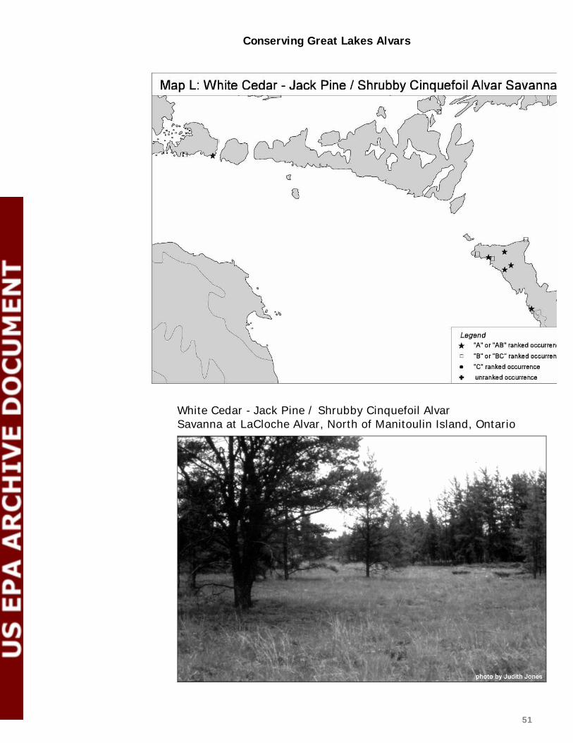
Conserving Great Lakes Alvars
51
White Cedar - Jack Pine / Shrubby Cinquefoil Alvar Savanna at LaCloche Alvar, North of Manitoulin Island, Ontario

Conserving Great Lakes Alvars
52
Diagnostic characteristics of white cedar - jack pine / shrubby cinquefoil alvar savanna:
→ partial canopy ranging from 10% to 25% cover of trees over 5 m tall
→ variable cover of shrubs (0.5 to 5 m tall)
→ variable cover of herbs (including grasses and sedges) forming a moist, grassy meadow between the trees and shrubs
→ soils are shallow loams (usually less than 30 cm deep) over dolostone bedrock
→ characteristic species include eastern white cedar, jack pine, shrubby cinquefoil, creeping juniper, northern singlespike sedge, limestone calamint, and ebony sedge.
12. Mixed conifer / common juniper alvar woodland
This rare community probably occurs scattered through the Great Lakes basin in Ontario, Michigan, and New York (Map M), but it has not been well documented during Alvar Initiative surveys. Nine occurrences of this community were documented, with a total of over 1334 acres (540 ha). It has a global rank of G2? (denoting some uncertainty about the ranking).
This is a woodland community: the trees form a partial canopy with 25% to 60% cover. The tree canopy consists of a variable mixture of white spruce (Picea glauca), eastern white cedar (Thuja occidentalis), jack pine (Pinus banksiana), balsam fir (Abies balsamea), and white pine (Pinus strobus). The understory of this woodland is a mosaic of shrubby patches, exposed pavement, and grassy patches. The most abundant shrub is common juniper (Juniperus communis); other characteristic shrubs include creeping juniper (J. horizontalis), buffaloberry (Shepherdia canadensis) and bearberry (Arctostaphylos uva-ursi).
Characteristic herbs include false pennyroyal (Trichostema brachiatum), Crawe's sedge (Carex crawei), balsam ragwort (Senecio pauperculus), ebony sedge (Carex eburnea), Richardson's sedge (C. richardsonii), and sheathed rush grass (Sporobolus vaginiflorus). Areas of exposed limestone or dolostone pavement are common, usually with a cover of mosses such as twisted moss (Tortella spp.) and common grimmia (Schistidium spp.), lichens such as reindeer 'moss' (Cladina rangiferina) and dog lichen (Peltigera canina), and rock surface algae (Gloeocapsa alpina).

Conserving Great Lakes Alvars
53
This community is closely related to juniper alvar shrubland and may represent a later successional stage of that community. The main difference between mixed conifer / common juniper alvar woodland and juniper alvar grassland is the cover of trees that are over 5 m tall.
Diagnostic characteristics of mixed conifer / common juniper alvar woodland are:
→ partial canopy ranging from 25% to 60% cover of trees over 5 m tall
→ variable cover of shrubs (0.5 to 5 m tall)
→ variable cover of herbs (including grasses and sedges) in a mosaic with exposed patches of limestone or dolostone bedrock pavement
→ soils are shallow loams (usually less than 30 cm deep)
→ characteristic species include white spruce, eastern white cedar, jack pine, white pine, common juniper, false pennyroyal, and ebony sedge.

Conserving Great Lakes Alvars
54
Red Cedar / Early Buttercup Alvar Woodland at Salmon River Alvar, Napanee Plains, Ontario

Conserving Great Lakes Alvars
55
13. Red cedar / early buttercup alvar woodland
This community occurs in Ontario, and possibly in New York (Map N), with three documented occurrences and a total area of over 110 acres (45 ha) currently mapped. This community was not well documented during Alvar Initiative surveys; surveys are needed to search for additional examples and to map the extent of these communities. It has a global rank of G3?, reflecting the impression that there are many more occurrences to document. This is a woodland community as the trees form a partial canopy with 25% to 60% cover. Red cedar (Juniperus virginiana) is usually the most abundant tree, but eastern white cedar (Thuja occidentalis) may also be present. There are very few shrubs.
The groundlayer is a mosaic of grassy patches and exposed limestone pavement. Characteristic herbs in the grassy patches include Canada bluegrass (Poa compressa), early buttercup (Ranunculus fascicularis), sheathed rush grass (Sporobolus vaginiflorus), Philadelphia panic grass (Panicum philadelphicum), wiry panic grass (P. flexile), and upland white aster (Solidago ptarmicoides). Patches of exposed pavement typically are covered with tufts of mosses such as twisted moss (Tortella spp.) and lichens.
Diagnostic characteristics of red cedar / early buttercup alvar woodland are:
→ partial canopy ranging from 25% to 60% cover of trees over 5 m tall
→ variable cover of shrubs (0.5 to 5 m tall)
→ variable cover of herbs (including grasses and sedges) in a mosaic with exposed patches of limestone or dolostone bedrock pavement
→ soils are shallow loams (usually less than 20 cm deep)
→ characteristic species include red cedar, poverty grass, and early buttercup.
2.3 Other Communities Studied
Four other communities similar to alvar communities were studied and evaluated to determine if they should be considered alvar types. These communities have species composition and physiognomy that are close to alvar communities. After careful review of the floristic composition and key ecological

Conserving Great Lakes Alvars
56
processes influencing these communities, collaborators agreed to recognize these types as related to, but distinct from, alvar communities.
Alvar communities sometimes occur as many small patches intermingled in a mosaic; for example, this is a mosaic of Little Bluestem Alvar Grassland and Alvar Non-Vascular Pavement at Misery Bay Alvar, Manitoulin Island, Ontario
14. River ledge limestone pavement
This pavement community is known from four sites: two in northern Michigan along the Escanaba River, one in Ontario along the Maitland River, and one in New York along the Black River, although a few other examples may occur elsewhere. Only preliminary surveys have been conducted at the Ontario and New York sites and their sizes are unknown; the Michigan sites have a total area of 45 acres (15 ha). The community has a global rank of G1.
River ledge limestone pavements occur as small patches. This community occurs on limestone ledges along a river's shore; these ledges are scoured by river water and ice during periods of peak water flow.
Typically a river ledge limestone pavement has an open canopy with less than 10% cover of trees, and few shrubs: less than 10% cover of shrubs.

Conserving Great Lakes Alvars
57
The groundlayer is dominated by grasses and sedges, or a mosaic of pavement patches and grassy patches. Cover of herbs (grasses, sedges, and forbs) is variable, with some areas having nearly 100% cover, and other areas having a lot of exposed rock pavement and as little as 15% cover of herbs confined to linear rock crevices. Characteristic species include prairie cordgrass (Spartina pectinata), mat muhly grass (Muhlenbergia richardsonis), prairie dropseed (Sporobolus heterolepis), upland white aster (Solidago ptarmicoides), and flat-topped goldenrod (Euthamia graminifolia).
This community is not considered alvar because the river shoreline processes (including annual flooding and ice-scouring) seem to be more important influences to plant community structure and composition than the processes characteristic of alvar communities (such as alternating wet and dry soil moisture regime, and infrequent fire). This community also seems distinct from alvar types because of the dominance of prairie cordgrass and mat muhly grass instead of typical alvar grassland species.
15. Great Lakes limestone bedrock lakeshore
These sparsely vegetated lakeshores are found along the Great Lakes shorelines of Wisconsin, Michigan, Ontario, Ohio, and New York (Comer et al. 1997, Albert et al. 1997; 1995;1994). Similar communities are found along the shores of Lake Champlain in New York and Vermont (Reschke 1990; Catling and Brownell 1995). These communities are found along Great Lakes shores where exposed flat limestone or dolostone bedrock slopes gently into the lake (average 1%
Great Lakes Limestone Bedrock Lakeshore at Huron Bay, Drummond Island, Michigan

Conserving Great Lakes Alvars
58

Conserving Great Lakes Alvars
59
slope). The surface of the bedrock has numerous cracks and crevices where most of the plants are rooted. Two vegetation zones may be present in this lakeshore community. The wave-washed and ice-scoured zone adjacent to the lake is very sparsely vegetated (average 2% cover); the most common plants are rush (Juncus balticus), silverweed (Potentilla anserina), and balsam poplar (Populus balsamifera). The next zone away from the lake typically has about 20% vegetative cover, including Arkansas mint (Calamintha arkansana), shrubby cinquefoil (Pentaphylloides floribunda), silverweed (Potentilla anserina), panic grass (Panicum lindheimeri), eastern white cedar (Thuja occidentalis), tufted hair grass (Deschampsia cespitosa), bog violet (Viola nephrophylla), birdseye primrose (Primula mistassinica), and Kalm's lobelia (Lobelia kalmii). Reports from Michigan described a third, wooded vegetation zone that occurs further inland (Albert et al. 1997, 1995, 1994) called a glade; this glade community is equivalent to the mixed conifer / common juniper alvar woodland described above.
This community is not considered alvar because the shoreline processes (including wave-wash and ice-scouring) and shoreline climate (frequent fog and exposure to winds) seem to be more important influences to plant community structure and composition than the processes characteristic of alvar communities (such as alternating wet and dry soil moisture regime and infrequent fire). This community also seems distinct from alvar types because of the dominance by forbs (broad-leaf herbs) instead of dominance by graminoids (grasses and sedges) or shrubs, which is characteristic of many alvar types.
16. Bur oak limestone savanna
This oak savanna community was studied in Sheguiandah Township on Manitoulin Island in an area that is known to have sustained a catastrophic fire in 1865. Similar savannas are reported from a few other sites in Ontario, such as Foxy Prairie on Manitoulin Island and the Squire Creek Headwater in the Lower Trent area. The Sheguiandah area has been grazed by cattle in the recent past, and almost all the currently known sites continue to be used as pasture. However, there does not seem to be a clear correlation between the structure or openness of the canopy and the intensity of current grazing.
This savanna community has from 10% to 25% cover of trees and an open, grassy groundlayer that gives the community a pleasant, park-like quality. The community occurs on shallow loam soils over limestone pavement. The dominant tree is bur oak (Quercus macrocarpa) and the ground flora includes many species characteristic of alvars, such as poverty grass (Danthonia spicata), upland white aster (Solidago ptarmicoides),

Conserving Great Lakes Alvars
60
Virginia saxifrage (Saxifraga virginiensis), chickweed (Cerastium arvense), prairie smoke (Geum triflorum), Canada bluegrass (Poa compressa), and early buttercup (Ranunculus fascicularis). Shrubs occur in rings around the trees; most common are downy arrow-wood (Viburnum rafinesquianum), snowberry (Symphoricarpos albus), and common

Conserving Great Lakes Alvars
61
Bur Oak Limestone Savanna in Sheguiandah Township, Manitoulin Island, Ontario
juniper (Juniperus communis). Most sites have a significant amount of exotic flora present, including weeds and typical pasture plants such as orange hawkweed (Hieracium aurantiacum), white clover (Trifolium repens), and cinquefoil (Potentilla recta).
A study of the land surveyor's records was undertaken in Sheguiandah Township because the area was initially surveyed the year before the fire (1864) and then resurveyed the year after the fire, because the fire destroyed the survey markers. This unique record allowed a comparison of conditions just before and after the fire with present day vegetation (Jones 1997). This comparison showed that 81% of the areas currently in bur oak savanna were hardwood forests before the fire. Since the fire regime, and possibly also grazing, seem to be key ecological processes influencing this community, it was not considered an alvar type.
17. Midwest wet-mesic dolomite prairie
This grassland community occurs on shallow, temporarily flooded or frequently saturated soils overlying dolomite bedrock. It is only known from northeastern Illinois. This grassland has a dense cover of herbaceous vegetation, while woody species are virtually absent. The

Conserving Great Lakes Alvars
62
most abundant species include bluejoint grass (Calamagrostis canadensis), sedges (Carex sartwellii, C. scoparia, C. sterilis), arnoglossum (Arnoglossum plantagineum), tufted hairgrass (Deschampsia cespitosa), Arkansas mint (Calamintha arkansana), little bluestem (Schizachyrium scoparium), Ohio goldenrod (Solidago ohioensis), and prairie cordgrass (Spartina pectinata).
Although this grassland has a soil moisture regime very similar to alvar grasslands, the soils are generally deeper and this community seems to be dependent upon frequent fires. The combination of the fire regime and the relative abundance of many characteristic prairie species are the main reasons this community is considered a prairie instead of an alvar.
2.4 Evaluating Alvar Occurrences and Sites for Conservation Planning
Element occurrence data from alvar sites in the Great Lakes have been compiled into a summary table (see Table 2 below). The table is sorted by state or province, and then by site name. For each site, the table lists the communities and target rare species that occur, along with the global rank of the species or community and the EO rank for that particular occurrence. In addition, Table 2 shows the approximate acreage of each community, the ecoregion unit where the site is located, and the type of landowner.
To identify priorities for conservation planning, each community occurrence was assigned a conservation priority rank based on a combination of its global rank, EO rank, and the relative quality of occurrences in each ecoregion subsection or site district:
Conservation priority rank "1" (high priority):
G1, G1G2, or G2 element occurrences with an EO rank of A, AB, or B;
G3 element occurrences with an EO rank of A or AB.
Conservation priority rank "2" (medium priority):
G1, G1G2, or G2 element occurrences with an EO rank of C;
G3 element occurrences with an EO rank of B or BC.

Conserving Great Lakes Alvars
63
Conservation priority rank "3" (low priority):
G1, G1G2, or G2 element occurrences with an EO rank of D;
G3 element occurrences with an EO rank of C or D.
If there were no community occurrences in the ecoregion unit with a priority rank of 1, then the largest or best example ranked 2 was upgraded to a priority rank of 1. Likewise, if there were no community occurrences in the ecoregion unit with a priority rank of 1 or 2, then the best one ranked 3 was upgraded to a priority rank of 2. This assured that the best examples of each community in each subsection/site district would be assigned a high conservation priority rank. In some cases where the viability of an occurrence was uncertain, the highest conservation priority rank given (even for the largest in the ecoregion unit) was a 2 for medium priority. If the community is known to be extant (EO rank of "e"), but the quality is unknown, it received a conservation priority rank of 3. The conservation priority ranks are shown in Table 2 below.
From the table, it is clear that several alvar communities with the high conservation priority often occur together at the same sites. A further analysis to target the most critical sites for conservation activities is presented in Chapter 5.

64
Table 2: 1998 SUMMARY OF GREAT LAKES ALVAR SITES -- International Alvar Conservation Initiative, December 15, 1998 State or Province
Survey Site ALVAR COMMUNITY TYPE Global Rank
size in acres
size rank
condition rank
landscape context
1998 EO RANK
Conserv. Priority Rank
ecoregion unit
owner type
MI Bass Cove white cedar - jack pine / shrubby cinquefoil alvar savanna
G1G2 ~30 C A A A 1 212Hj
alvar nonvascular pavement G2 ~10 A A A A 1 212Hj Great Lakes limestone bedrock lakeshore G3 ~20 A A A A 1 212Hj MI Big Knob Campground Road juniper alvar shrubland G3 8 C C C C 3 212Hj MI Big Shoal Cove tufted hairgrass wet alvar grassland G2 ? of 40 B B B B 1 212Hj Great Lakes limestone bedrock lakeshore G3 < 40 B B B B 2 212Hj MI Charboneau Lake scrub conifer / dwarf lake iris alvar shrubland G1G2 90 A C C B 1 212He MI East Lake Alvar juniper alvar shrubland G3 30 B B B B 2 212Hj MI Escanaba River North little bluestem alvar grassland G2 ? of 30 B B B B 1 212Hb river ledge limestone pavement G1 ? of 30 B B B B 1 212Hb MI Escanaba River South little bluestem alvar grassland G2 ? of 20 C B B B 1 212He river ledge limestone pavement G1 ? of 20 C B B B 1 212He MI Garden Southeast Glade scrub conifer / dwarf lake iris alvar shrubland G1G2 300 A B A A 1 212He state forest
& private MI Goudreau's Harbour alvar nonvascular pavement G2 15 B A A A 1 212Hj Great Lakes limestone bedrock lakeshore G3 12 A A A A 2 212Hj MI Grand Lake scrub conifer / dwarf lake iris alvar shrubland G1G2 80 B B B B 1 212Hl MI Huron Bay alvar nonvascular pavement G2 100 A A A A 1 212Hj white cedar - jack pine / shrubby cinquefoil alvar
savanna G1G2 5 D A A B 1 212Hj
Great Lakes limestone bedrock lakeshore G3 50 A A A A 1 212Hj MI Huron Bay Road juniper alvar shrubland G3 15 C B B C 3 212Hj MI Jones Lake - Drummond Island poverty grass dry alvar grassland G2? 40 B B B B 1 212Hj MI Kregg Bay Glade scrub conifer / dwarf lake iris alvar shrubland G1G2 75 B B B B 1 212He

65
State or Province
Survey Site ALVAR COMMUNITY TYPE Global Rank
size in acres
size rank
condition rank
landscape context
1998 EO RANK
Conserv. Priority Rank
ecoregion unit
owner type
MI Kregg Bay NE Alvar Great Lakes limestone bedrock lakeshore G3 18 A B B B 2 212He MI Maxton Plains little bluestem alvar grassland G2 ? of 2500 A B A A 1 212Hj TNC &
DNR creeping juniper - shrubby cinquefoil alvar
pavement G2 ? of 2500 A B A A 1 212Hj TNC &
DNR tufted hairgrass wet alvar grassland G2 100 A A A A 1 212Hj TNC &
DNR juniper alvar shrubland G3 20 C A A A 1 212Hj TNC &
DNR Great Lakes limestone bedrock lakeshore G3 18 A A A A 2 212Hj MI Point Detour Great Lakes limestone bedrock lakeshore G3 23 B A A A 1 212He creeping juniper - shrubby cinquefoil alvar
pavement G2 2 C A A B 1 212He
MI Poverty Island - East Shore Great Lakes limestone bedrock lakeshore G3 15 B A A A 2 212He MI Prentiss Bay Great Lakes limestone bedrock lakeshore G3 2 D B B C 3 212Hj MI Seaman's Point Great Lakes limestone bedrock lakeshore G3 50 A A A A 1 212Hj MI Stony Point Great Lakes limestone bedrock lakeshore G3 8.5 B B B B 2 212Hj MI Sucker Lake Alvar scrub conifer / dwarf lake iris alvar shrubland G1G2 140 A B A A 1 212He MI Summer Island East Shore creeping juniper - shrubby cinquefoil alvar
pavement G2 5 C B A B 1 212He
Great Lakes limestone bedrock lakeshore G3 25 B A A A 1 212He MI The Rock juniper alvar shrubland G3 60 B C B B 2 212Hj MI Thompsons Harbor scrub conifer / dwarf lake iris alvar shrubland G1G2 10 C C B C 2 212Hl MI Thompsons Harbor Observatory
Point scrub conifer / dwarf lake iris alvar shrubland G1G2 50 A B A A 1 212Hl
tufted hairgrass wet alvar grassland G2 50 B B A A 1 212Hl

66
State or Province
Survey Site ALVAR COMMUNITY TYPE Global Rank
size in acres
size rank
condition rank
landscape context
1998 EO RANK
Conserv. Priority Rank
ecoregion unit
owner type
MI Thunder Bay Island little bluestem alvar grassland G2 10 C A A A 1 212Hl alvar nonvascular pavement G2 10 B A A A 1 212Hl Great Lakes limestone bedrock lakeshore G3 30 B A A A 1 212Hl MI Warner's Cove Great Lakes limestone bedrock lakeshore G3 2 C B B C 3 212Hj NY Black River Gorge river ledge limestone pavement G1 ? e e e e 3 212Ee private NY Burnt Rock Barrens juniper alvar shrubland G3 47 B BC B BC 2 212Ee DEC &
private NY Chaumont Barrens tufted hairgrass wet alvar grassland G2 44 A A A A 1 212Ee TNC &
private annual alvar pavement-grassland G2 ~5 B A A A 1 212Ee TNC &
private alvar nonvascular pavement G2 ~15 B A A A 1 212Ee TNC &
private juniper alvar shrubland G3 ~805 A AB A A 1 212Ee TNC &
private poverty grass dry alvar grassland G2? ~5? e e e e 3 212Ee TNC &
private mixed conifer / common juniper alvar woodland G2? ? e e e e 3 212Ee TNC &
private NY El Dorado Beach juniper alvar shrubland G3 10? D C BC D 3 222Ie TNC Great Lakes limestone bedrock lakeshore G3 8 B CD C C 2 222Ie TNC NY Limerick Cedars juniper alvar shrubland G3 ~450 A AB AB AB 1 212Ee TNC &
private alvar nonvascular pavement G2 ~50 A A AB A 1 212Ee TNC &
private annual alvar pavement-grassland G2 <10 A B B B 1 212Ee TNC &
private tufted hairgrass wet alvar grassland G2 <2 D B B C 2 212Ee TNC &
private poverty grass dry alvar grassland G2? ~15 A C C C 3 212Ee TNC &
private mixed conifer / common juniper alvar woodland G2? ? e e e e 3 212Ee TNC &

67
State or Province
Survey Site ALVAR COMMUNITY TYPE Global Rank
size in acres
size rank
condition rank
landscape context
1998 EO RANK
Conserv. Priority Rank
ecoregion unit
owner type
private NY Limerick Game Farm Road juniper alvar shrubland G3 ~10 D B C BC 3 212Ee private alvar nonvascular pavement G2 <5 C C C C 3 212Ee private mixed conifer / common juniper alvar woodland G2? ? e e e e 3 212Ee private NY Lucky Star Alvar tufted hairgrass wet alvar grassland G2 ~42 B B AB B 1 212Ee private alvar nonvascular pavement G2 ~40 A AB AB AB 1 212Ee private juniper alvar shrubland G3 1620 A B AB AB 1 212Ee private annual alvar pavement-grassland G2 ~14 A AB A A 1 212Ee private poverty grass dry alvar grassland G2? ~5? e e e e 3 212Ee private mixed conifer / common juniper alvar woodland G2? ? e e e e 3 212Ee private
NY Sam Adams Road Woods juniper alvar shrubland G3 ~35 B C C C 3 212Ee private poverty grass dry alvar grassland G2? ~20 B C C C 2 212Ee private NY Stony Point Barrens juniper alvar shrubland G3 ~175 A C BC C 2 222Ie DEC &
private poverty grass dry alvar grassland G2? <2 D CD C CD 3 222Ie DEC &
private Great Lakes limestone bedrock lakeshore G3 25? B C AB BC 1 222Ie DEC &
private
NY Three Mile Creek Road Barrens tufted hairgrass wet alvar grassland G2 ~91 A A A A 1 212Ee corp. & private
annual alvar pavement-grassland G2 ~5 A A A A 1 212Ee corp. & private
alvar nonvascular pavement G2 ~30 B B A AB 1 212Ee corp. & private
juniper alvar shrubland G3 ~670 A B A AB 1 212Ee corp. & private
poverty grass dry alvar grassland G2? ~5? e e e e 3 212Ee corp. & private
mixed conifer / common juniper alvar woodland G2? ? e e e e 3 212Ee corp. & private
OH Kelley's Island Central Quarry alvar nonvascular pavement G2 ~200 A C C C 2 222If DNR state

68
State or Province
Survey Site ALVAR COMMUNITY TYPE Global Rank
size in acres
size rank
condition rank
landscape context
1998 EO RANK
Conserv. Priority Rank
ecoregion unit
owner type
parks OH Kelley's Island North Quarry juniper alvar shrubland G3 ~200 A BC B B 1 222If DNR state
parks OH Kelly's Island North Shore Great Lakes limestone bedrock lakeshore G3 ~1 D A A AB 1 222If DNR state
parks OH Marblehead Quarry alvar nonvascular pavement G2 750 A C C C 2 222If corporate &
DNR ON Asselstine Alvar annual alvar pavement-grassland G2 ~100 A C C C 2 6E15 private tufted hairgrass wet alvar grassland G2 30 to 50 A C BC C 2 6E15 private ON Baptist Harbour Alvar little bluestem alvar grassland G2 ~10 C A A A 1 6E14 private ON Barney Lake Alvar tufted hairgrass wet alvar grassland G2 ~2 D B A B 1 6E14 private creeping juniper - shrubby cinquefoil alvar
pavement G2 ~4 D A A B 1 6E14 private
white cedar - jack pine / shrubby cinquefoil alvar savanna
G1G2 > 2.5 D A A B 1 6E14 private
ON Barrie Island little bluestem alvar grassland G2 175 A CD BC C 2 5E2 private creeping juniper - shrubby cinquefoil alvar
pavement G2 25 B BC BC BC 2 5E2 private
ON Barrier Island tufted hairgrass wet alvar grassland G2 ~32 B AB A A 1 6E14 ?IR or
other ON Bear's Rump Island Alvar little bluestem alvar grassland G2 21 C A A A 1 6E14 Parks
Canada creeping juniper - shrubby cinquefoil alvar
pavement G2 11 C A A A 1 6E14 Parks
Canada ON Belanger Bay Alvar little bluestem alvar grassland G2 230 A A A A 1 5E2 corporate tufted hairgrass wet alvar grassland G2 10 B A A AB 1 5E2 corporate creeping juniper - shrubby cinquefoil alvar
pavement G2 50 B A A A 1 5E2 corporate

69
State or Province
Survey Site ALVAR COMMUNITY TYPE Global Rank
size in acres
size rank
condition rank
landscape context
1998 EO RANK
Conserv. Priority Rank
ecoregion unit
owner type
alvar nonvascular pavement G2 20 B A A A 1 5E2 corporate juniper alvar shrubland G3 300 A A A A 1 5E2 corporate scrub conifer / dwarf lake iris alvar shrubland G1G2 25 B A A A 1 5E2 corporate poverty grass dry alvar grassland G2? ~5 C A A B 1 5E2 corporate ON Bend Bay Valley annual alvar pavement-grassland G2 2.5 C C B B 1 6E9 private juniper alvar shrubland G3 ~60 B B B B 2 6E9 private
poverty grass dry alvar grassland G2? ~40 A B B B 1 6E9 private ON Burnt Lands juniper alvar shrubland G3 ~125 A B B A 1 6E11 Ontario
MNR, Canada DND, & private
annual alvar pavement-grassland G2 ~50 A A B A 1 6E11 Canada DND & private?
alvar nonvascular pavement G2 ~15 B A B A 1 6E11 Canada DND & private?
little bluestem alvar grassland G2 ~125 A A B A 1 6E11 Ontario MNR
poverty grass dry alvar grassland G2? ~100 A B B A 1 6E11 Ontario MNR
ON Cabot Head Alvar little bluestem alvar grassland G2 ~49 B A A A 1 6E14 priv. &
MNR white cedar - jack pine / shrubby cinquefoil alvar
savanna G1G2 ~7 D A A B 1 6E14 priv. &
MNR ON Camden East Alvar poverty grass dry alvar grassland G2? ? e e e e 3 6E9 private
annual alvar pavement-grassland G2 ? e e e e 3 6E9 private
ON Cameron Ranch Alvar tufted hairgrass wet alvar grassland G2 >20 A AB B A 1 6E9 private creeping juniper - shrubby cinquefoil alvar
pavement G2 25 to 125 B B B B 1 6E9 private
juniper alvar shrubland G3 25 to 125 B B B B 2 6E9 private

70
State or Province
Survey Site ALVAR COMMUNITY TYPE Global Rank
size in acres
size rank
condition rank
landscape context
1998 EO RANK
Conserv. Priority Rank
ecoregion unit
owner type
ON Cape Croker Alvar tufted hairgrass wet alvar grassland G2 >200 A AB A AB 1 6E14 IR, FN little bluestem alvar grassland G2 >125 A A A A 1 6E14 IR, FN juniper alvar shrubland G3 ~100 B A A A 1 6E14 IR, FN creeping juniper - shrubby cinquefoil alvar
pavement G2 >30 C A A A 1 6E14 IR, FN
ON Carden Alvar #1 (Morton prop.) tufted hairgrass wet alvar grassland G2 ~22 B B B B 1 6E9 private juniper alvar shrubland G3 ~62 B B B B 2 6E9 private little bluestem alvar grassland G2 5 to 25 C A B B 1 6E9 private poverty grass dry alvar grassland G2? ~10 B B? B B 1 6E9 private ON Carden Alvar #2 (Jesin prop.) tufted hairgrass wet alvar grassland G2 ~15 B B B B 1 6E9 private juniper alvar shrubland G3 ~6 C B B B 2 6E9 private ON Carden Alvar #3A tufted hairgrass wet alvar grassland G2 ~166 A A B A 1 6E9 private juniper alvar shrubland G3 ~38 B B B B 2 6E9 private mixed conifer / common juniper alvar woodland G2? ~3 to 42 A? A AB A 1 6E9 private ON Carden Alvar #4 tufted hairgrass wet alvar grassland G2 15 B B BC B 1 6E9 private ON Carden Alvar #5C (Lepone and
Stewart) poverty grass dry alvar grassland G2? 50 A B B A 1 6E9
tufted hairgrass wet alvar grassland G2 ~70 A B B A 1 6E9 private
creeping juniper - shrubby cinquefoil alvar pavement
G2 ~20 C A B B 1 6E9 private
juniper alvar shrubland G3 ~100 B B B B 1 6E9 private
ON Chief's Point Alvar little bluestem alvar grassland G2 >12 C A A A 1 6E14 IR, FN ON Christina Bay including Burnt
Island Harbour little bluestem alvar grassland G2 75 B BC BC BC 2 5E2 corporate
juniper alvar shrubland G3 75 B BC BC BC 3 5E2 corporate
ON Clapperton Island little bluestem alvar grassland G2 150 A A A A 1 5E2 FN
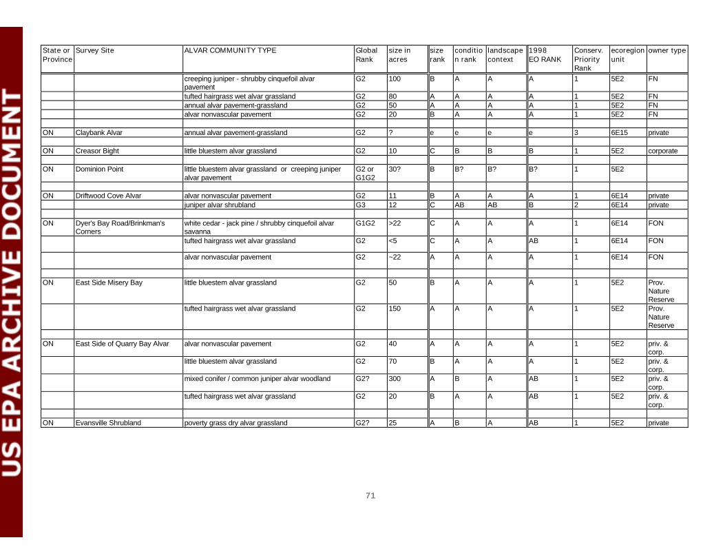
71
State or Province
Survey Site ALVAR COMMUNITY TYPE Global Rank
size in acres
size rank
condition rank
landscape context
1998 EO RANK
Conserv. Priority Rank
ecoregion unit
owner type
creeping juniper - shrubby cinquefoil alvar pavement
G2 100 B A A A 1 5E2 FN
tufted hairgrass wet alvar grassland G2 80 A A A A 1 5E2 FN annual alvar pavement-grassland G2 50 A A A A 1 5E2 FN alvar nonvascular pavement G2 20 B A A A 1 5E2 FN ON Claybank Alvar annual alvar pavement-grassland G2 ? e e e e 3 6E15 private ON Creasor Bight little bluestem alvar grassland G2 10 C B B B 1 5E2 corporate ON Dominion Point little bluestem alvar grassland or creeping juniper
alvar pavement G2 or G1G2
30? B B? B? B? 1 5E2
ON Driftwood Cove Alvar alvar nonvascular pavement G2 11 B A A A 1 6E14 private juniper alvar shrubland G3 12 C AB AB B 2 6E14 private ON Dyer's Bay Road/Brinkman's
Corners white cedar - jack pine / shrubby cinquefoil alvar savanna
G1G2 >22 C A A A 1 6E14 FON
tufted hairgrass wet alvar grassland G2 <5 C A A AB 1 6E14 FON
alvar nonvascular pavement G2 ~22 A A A A 1 6E14 FON
ON East Side Misery Bay little bluestem alvar grassland G2 50 B A A A 1 5E2 Prov.
Nature Reserve
tufted hairgrass wet alvar grassland G2 150 A A A A 1 5E2 Prov. Nature Reserve
ON East Side of Quarry Bay Alvar alvar nonvascular pavement G2 40 A A A A 1 5E2 priv. &
corp. little bluestem alvar grassland G2 70 B A A A 1 5E2 priv. &
corp. mixed conifer / common juniper alvar woodland G2? 300 A B A AB 1 5E2 priv. &
corp. tufted hairgrass wet alvar grassland G2 20 B A A AB 1 5E2 priv. &
corp. ON Evansville Shrubland poverty grass dry alvar grassland G2? 25 A B A AB 1 5E2 private

72
State or Province
Survey Site ALVAR COMMUNITY TYPE Global Rank
size in acres
size rank
condition rank
landscape context
1998 EO RANK
Conserv. Priority Rank
ecoregion unit
owner type
juniper alvar shrubland G3 1000 A B A AB 1 5E2 private ON Fishing Islands Alvar alvar nonvascular pavement G2 ~6 C A A A 1 6E14 IR, FN ON Fowler Aggregate Alvar tufted hairgrass wet alvar grassland G2 74 B B B B 1 6E9 corporate ON Foxy Prairie bur oak limestone savanna G1? 450 A BC BC BC 1 5E2 private &
municipal tufted hairgrass wet alvar grassland G2 80 A B B B 1 5E2 private &
municipal little bluestem alvar grassland G2 50 B A B AB 1 5E2 private &
municipal creeping juniper - shrubby cinquefoil alvar
pavement G2 150 A A B AB 1 5E2 private &
municipal annual alvar pavement-grassland G2 20 A AB B B 1 5E2 private &
municipal ON George Lake Alvar white cedar - jack pine / shrubby cinquefoil alvar
savanna G1G2 <50 C A A A 1 6E14 Parks Can.
ON Greene Island tufted hairgrass wet alvar grassland G2 >10 B AB A AB 1 5E2 private little bluestem alvar grassland G2 100 B A A A 1 5E2 private ON Gretna Alvar tufted hairgrass wet alvar grassland G2 ~56 A B C B 1 6E15 ? red cedar / early buttercup alvar woodland G3? ~99 A C C C 2 6E15 ? ON Hayesland Alvar (Flamborough
Plains) shagbark hickory / prickly ash alvar savanna (Flamborough Plains type)
G? 10 B C C C 2 6E1
ON Howe's Road Alvar annual alvar pavement-grassland G2 29 A B C B 1 6E15 ? ON LaCloche Area Alvar little bluestem alvar grassland G2 3200 A A AB A 1 5E3 priv. & FN creeping juniper - shrubby cinquefoil alvar
pavement G2 550 A A AB A 1 5E3 priv. & FN
annual alvar pavement-grassland G2 200 A A AB A 1 5E3 priv. & FN juniper alvar shrubland G3 800 A BC BC BC 1 5E3 priv. & FN tufted hairgrass wet alvar grassland G2 1700 A A AB A 1 5E3 priv. & FN little bluestem alvar grassland (disturbed) G2 250 A C BC BC 2 5E3 priv. & FN white cedar - jack pine / shrubby cinquefoil alvar
savanna G1G2 ~300 A C BC BC 1 5E3 priv. & FN

73
State or Province
Survey Site ALVAR COMMUNITY TYPE Global Rank
size in acres
size rank
condition rank
landscape context
1998 EO RANK
Conserv. Priority Rank
ecoregion unit
owner type
savanna
ON Maitland River river ledge limestone pavement G1 < 5 D C C C 2 6E2 Conservati
on Authority
ON Massassauga Point Alvar annual alvar pavement-grassland G2 5 A C B B 1 6E15 ? red cedar / early buttercup alvar woodland G3? 8 D C B C 2 6E15 ? ON Misery Bay Alvar poverty grass dry alvar grassland G2? 40 A? B B B 1 5E2 priv. &
Prov. Pk. tufted hairgrass wet alvar grassland G2 100 A A B AB 1 5E2 priv. &
Prov. Pk. little bluestem alvar grassland G2 500 A A B AB 1 5E2 priv. &
Prov. Pk. juniper alvar shrubland G3 10 C A A B 3 5E2 priv. &
Prov. Pk. alvar nonvascular pavement G2 60 A B B B 1 5E2 priv. &
Prov. Pk. creeping juniper - shrubby cinquefoil alvar
pavement G2 10 C A AB AB 1 5E2 priv. &
Prov. Pk. ON Niibin Alvar tufted hairgrass wet alvar grassland G2 ~25 A B A AB 1 6E14 IR, FN &
priv. little bluestem alvar grassland G2 <5 C C A B 1 6E14 IR, FN &
priv. ON Northwest & Big Burnt Islands little bluestem alvar grassland G2 ? of 250 A? A A A 1 5E2 FN tufted hairgrass wet alvar grassland G2 ? of 250 A? A A A 1 5E2 FN ON Ottawa River Cottnam Island little bluestem alvar grassland G2 < 1 D B A B 1 5E12 private ON Pendall Lake Alvar white cedar - jack pine / shrubby cinquefoil alvar
savanna G1G2 20 C A A A 1 6E14 Parks
Canada little bluestem alvar grassland G2 6 C A A A 1 6E14 Parks
Canada tufted hairgrass wet alvar grassland G2 <5 C A A AB 1 6E14 Parks
Canada

74
State or Province
Survey Site ALVAR COMMUNITY TYPE Global Rank
size in acres
size rank
condition rank
landscape context
1998 EO RANK
Conserv. Priority Rank
ecoregion unit
owner type
ON Pike Bay Alvar white cedar - jack pine / shrubby cinquefoil alvar savanna
G1G2 25 C A A A 1 6E4 private
creeping juniper - shrubby cinquefoil alvar pavement
G2 <5 C A A A 1 6E4 private
little bluestem alvar grassland G2 <5 D A A B 1 6E4 private ON Pine Tree Harbour mixed conifer / common juniper alvar woodland G2? >1000 A A A A 1 6E14 private white cedar - jack pine / shrubby cinquefoil alvar
savanna G1G2 <100 B A A A 1 6E14 private
creeping juniper - shrubby cinquefoil alvar pavement
G2 >125 A A A A 1 6E14 private
ON Point Anne Alvar tufted hairgrass wet alvar grassland G2 ? e e e e 3 6E15 corporate annual alvar pavement-grassland G2 ? e e e e 3 6E15 corporate ON Rozel's Bay tufted hairgrass wet alvar grassland G2 30 B A BC B 1 5E2 private little bluestem alvar grassland G2 20 C A B B 1 5E2 private ON Salmon River Alvar annual alvar pavement-grassland G2 ? A C C C 2 6E15 private? red cedar / early buttercup alvar woodland G3? ? A C C C 1 6E15 private? ON Scugog Lake Alvar little bluestem alvar grassland G2 <5 D A A B 1 6E14 MNR/Parks
Can. creeping juniper - shrubby cinquefoil alvar
pavement G2 <5 D A A B 1 6E14 MNR/Parks
Can. scrub conifer / dwarf lake iris alvar shrubland G1G2 <5 D A A B 1 6E14 MNR/Parks
Can. ON Sheguiandah Bur Oak poverty grass dry alvar grassland G2? 30 B? AB A AB 1 5E2 private &
FN bur oak limestone savanna G1? 600 A? B B B 1 5E2 private &
FN ON Shigley Bay to Dominion Point juniper alvar shrubland G3 500? A B? AB AB? 2 5E2 ON Sideroad Creek Alvar white cedar - jack pine / shrubby cinquefoil alvar
savanna G1G2 ~250 A C A B 1 6E14 MNR/Parks
Can. mixed conifer / common juniper alvar woodland G2? 10 to 20 C A AB B 1 6E14 MNR/Parks
Can.

75
State or Province
Survey Site ALVAR COMMUNITY TYPE Global Rank
size in acres
size rank
condition rank
landscape context
1998 EO RANK
Conserv. Priority Rank
ecoregion unit
owner type
ON Silverwater Radio Towers Alvar juniper alvar shrubland G3 120 B B B B 3 5E2 corp. ON South of Cameron Ranch Alvar juniper alvar shrubland G3 85 B BC C C 3 6E9 private tufted hairgrass wet alvar grassland G2 8.5 C B C C 2 6E9 private ON Squire Creek Headwater bur oak limestone savanna G1? ~62 C? C? C? C 2 6E9 private ON St. Jean's Point creeping juniper - shrubby cinquefoil alvar
pavement G2 10 C A B B 1 6E14
ON Stone Road Alvar (Pelee Island) Chinquapin oak - nodding onion alvar savanna
(Pelee Island type) G1? 30 A C C C 1 7E1 FON & ?
ON Strawberry Island tufted hairgrass wet alvar grassland G2 20 B A A AB 1 5E2 corporate creeping juniper - shrubby cinquefoil alvar
pavement G2 50 B A A A 1 5E2 corporate
little bluestem alvar grassland G2 60 B A A A 1 5E2 corporate ON Tamarack Harbour little bluestem alvar grassland G2 20 C A B AB 1 5E2 IR creeping juniper - shrubby cinquefoil alvar
pavement G2 80 B A A A 1 5E2 IR
ON Taskerville Alvar poverty grass dry alvar grassland G2? 75 A B B B 1 5E2 private juniper alvar shrubland G3 30 C B B B 3 5E2 private little bluestem alvar grassland G2 170 A B B B 1 5E2 private creeping juniper - shrubby cinquefoil alvar
pavement G2 15 C A A AB 1 5E2 private
ON Vidal Island little bluestem alvar grassland G2 100 B A A A 1 5E2 FN creeping juniper - shrubby cinquefoil alvar
pavement G2 50 B A A A 1 5E2 FN
ON West of Lynn Point little bluestem alvar grassland G2 90 A A A A 1 5E2 corporate tufted hairgrass wet alvar grassland G2 20 B A A A 1 5E2 corporate

76
State or Province
Survey Site ALVAR COMMUNITY TYPE Global Rank
size in acres
size rank
condition rank
landscape context
1998 EO RANK
Conserv. Priority Rank
ecoregion unit
owner type
creeping juniper - shrubby cinquefoil alvar pavement
G2 5 - 10 C A A AB 1 5E2 corporate
juniper alvar shrubland G3 100 B A B B 3 5E2 corporate ON West of South Baymouth creeping juniper - shrubby cinquefoil alvar
pavement G2 20 C B A B 1 5E2 private
scrub conifer / dwarf lake iris alvar shrubland G1G2 40 B A A A 1 5E2 private & municipal
Great Lakes limestone bedrock lakeshore G3 >15 A A A A 1 5E2 private & municipal
WI State Highway 57 expansion
project juniper alvar shrubland G3 15? C BC C BC 1 212Hd state hwy
ROW
IL Lower DesPlaines River Valley midwest wet-mesic dolomite prairie G2? 222Ki? ? IL Manito Prairie Nature Reserve midwest wet-mesic dolomite prairie G2? 222Ki? county

Conserving Great Lakes Alvars
77
3.0 Characteristic and Rare Species Associated with Great Lakes Alvars
3.1 Characteristic and Rare Plants
3.1.1 Rare Vascular Plants
The inventory of rare vascular plants in Great Lakes alvars was intended to document the occurrence and distribution of rare species, collect data to enable comparison and ranking of individual rare plant occurrences, and collect information needed to guide conservation design. While information on the distribution of characteristic alvar plants and the extent of confinement of vascular plants to alvar habitats was available for southern Ontario (Catling 1995), the status of rare alvar species across the Great Lakes basin was poorly known.
In 1995, the Alvar Working Group decided that the focus of rare plant data collection should be species of shared priority. This included the following:
• all G1 through G3 taxa, • taxa that are ranked S1 through S2 in Michigan, New York, Ohio, and
Ontario, • rare taxa that are restricted primarily to alvar habitats in the Great
Lakes basin, and • any potential new "finds".
Collaborators compared state and provincial rare species tracking lists and identified a group of 11 species that were either globally or regionally rare and that were systematically sought and documented during alvar field surveys in all jurisdictions. An additional 13 state or provincially rare species were documented in jurisdictions where they were being tracked by the state or provincial Natural Heritage Program.
The initial list of 11 target rare plant species included the following species: wild chives (Allium schoenoprasum var. sibiricum), Cooper's milk vetch (Astragalus neglectus), sideoats grama (Bouteloua curtipendula), juniper sedge (Carex juniperorum), Hill's thistle (Cirsium hillii), Pitcher's thistle (Cirsium pitcheri), ram's-head ladyslipper (Cypripedium arietinum), lakeside daisy (Hymenoxys herbacea), dwarf lake iris (Iris lacustris), Houghton's goldenrod (Solidago houghtonii), and northern dropseed (Sporobolus heterolepis).

Conserving Great Lakes Alvars
78
The primary inventory method used was simply to search alvar sites for target species, often in conjunction with community field surveys. Target plants observed at alvar sites were documented by completing rare plant survey forms, which included data on geographic extent, population size, threats, disturbances, and basic habitat features. As surveys were conducted, the list of target rare plants evolved. During 1995 field surveys in Ontario, a provincially rare chickweed (Cerastium brachypodum) was found at three alvar sites in the Napanee Plains. This species was added to the list of target rare plants, with the thought that it might be characteristic of alvar sites in the region. After field surveys were completed and inventory results compiled, it became apparent that not all of the target rare plant species are actually characteristic of alvar sites in the Great Lakes region. Although each of the initially targeted rare plants does occur in alvar habitats, some occur primarily in habitats that are not alvars, others are not globally rare, and the taxonomy of one (Allium schoenoprasum var. sibiricum) is questionable.
Therefore, the list of rare vascular plants characteristic of alvar habitats has been refined to include only globally rare species (ranked G1 through G3) that primarily occur in alvar habitats, or globally rare species that have large populations in at least three alvar sites. The resulting group of six rare vascular plants characteristic of Great Lakes alvars is presented in Table 3. The results of our field surveys for these species are briefly summarized below.
Table 3: Characteristic Rare Plants of Great Lakes Alvars
Scientific Name Common Name Global Rank
Carex juniperorum Juniper sedge G2
Hymenoxys herbacea Lakeside daisy G2
Cirsium hillii Hill's thistle G3
Cypripedium arietinum Ram's-head lady's slipper G3
Iris lacustris Dwarf lake iris G3
Solidago houghtonii Houghton's goldenrod G3
Juniper sedge (Carex juniperorum), G2
Juniper sedge is a small, grass-like plant in the sedge family that was recently described from a population found in an alvar site in the Napanee Plain in Ontario (Catling et al. 1993). It is found in red cedar / early buttercup alvar woodlands. Only one alvar site was documented with juniper sedge: Salmon River Alvar in Ontario.

Conserving Great Lakes Alvars
79
Lakeside daisy (Hymenoxys herbacea), G2
This showy, yellow composite has multiple common names. In Ohio and Illinois it is known as lakeside daisy, on the Bruce Peninsula it is called rubberweed, and it is locally known as Manitoulin gold on Manitoulin Island. This is an imperiled species that is endemic to alvar pavements, dolomite prairies, and grassy openings in cedar woodlands near the Great Lakes. Thirteen sites with lakeside daisy were documented in Ontario and Ohio. Lakeside daisy is primarily restricted to alvar sites in the Great Lakes region, although it does occur in a few other similar habitats (e.g., on moist calcareous tuffa in a white cedar woodland in northern Michigan).
Two sites on Kelley's Island in Ohio are abandoned quarries where the population was first established by transplanting plants that had been "rescued" from certain destruction in a quarry site on the Marblehead Peninsula. Seeds collected from Marblehead sites were also spread at the Kelley's Island sites, and the lakeside daisy population there is now reproducing and spreading. Because there are no historical records of lakeside daisy from Kelley's Island, those populations are not exactly a restoration; however, they are viable populations.
The 11 documented natural occurrences of lakeside daisy are at the following alvar sites: Marblehead Quarry/Lakeside Plains in Ohio, and in Ontario at Belanger Bay, Cabot Head, Dyer's Bay Road/Brinkman's Corners, East Side of Quarry Bay, Misery Bay, Taskerville, West of Lynn Point, Christina Bay/ Burnt Island Harbour, George Lake, and Silverwater Radio Towers. However, this species also is known to occur at other sites along the south shore of Manitoulin Island.
Hill's thistle (Cirsium hillii), G3
Hill's thistle is a showy thistle in the aster family with large, bright rose-purple flower heads. It is a biennial species (living two years, flowering in the second year). This rare species in the Great Lakes region occurs on sand plains, juniper alvar shrublands, and poverty grass alvar grasslands with sandy soils. Twenty-one sites with Hill's thistle were documented, mostly in the Bruce Peninsula, Manitoulin Island, and Drummond Island.
The Ontario alvar sites with Hill's thistle are LaCloche Area, Barney Lake, Chief's Point, East Side of Quarry Bay, Evansville
Conserving Great Lakes Alvars
80
Shrubland, Misery Bay, Taskerville, West of Lynn Point, Christina Bay/Burnt Island Harbour, Driftwood Cove, Pike Bay, Scugog Lake, Sideroad Creek, West of South Baymouth, and Belanger Bay. In Michigan, alvar sites with this species are Bass Cove, Huron Bay Road, Jones Lake-Drummond Island, Maxton Plains, Seaman's Point, and The Rock.
Ram's-head lady's slipper (Cypripedium arietinum), G3
Ram's-head lady's slipper is a small orchid with a petite, colorful flower. It is rare in the Great Lakes region and occurs in coniferous alvar woodlands. The Alvar Initiative documented nine alvar sites with ram's-head lady's slipper: Burnt Rock Barrens, Chaumont Barrens, and Limerick Cedars in New York state; Burnt Lands, LaCloche Area, and Belanger Bay alvars in Ontario; and Big Shoal Cove, Huron Bay, and Thunder Bay Island in Michigan.
Dwarf lake iris (Iris lacustris), G3
Dwarf lake iris is a diminutive plant that is usually less than 18 cm tall, with showy blue flowers. It is endemic to the Great Lakes, near the shores of Lake Huron, Lake Michigan, and Lake Superior. It is abundant in the ground layer of the scrub conifer / dwarf lake iris alvar shrubland community and is commonly found on the Great Lakes limestone bedrock shore. The species also occurs in openings in white cedar woodlands.
Dwarf lake iris was documented at 20 alvar sites in Ontario, Michigan, and Wisconsin: Baptist Harbour, Chief's Point, Dyer's Bay/Brinkman's Corners, Scugog Lake, West of South Baymouth, Pike Bay, Belanger Bay, and Pine Tree Harbour in Ontario; Charboneau Lake, Escanaba River South, Garden Southeast Glade, Goudreau's Harbour, Grand Lake, Kregg Bay Glade, Kregg Bay NE, Point Detour, Poverty Island-East Shore, Sucker Lake, and Thompson's Harbor in Michigan; and at the State Highway 57 expansion project in Wisconsin.
Houghton's goldenrod (Solidago houghtonii), G3
Houghton's goldenrod is a slender yellow composite. It is a rare species endemic to the Great Lakes region, usually occurring in wetlands, moist beaches, and moist swales behind dunes; it is also occasionally found in little bluestem alvar grasslands. Houghton's goldenrod was found in five alvar sites: Tamarack Harbour,

Conserving Great Lakes Alvars
81
Strawberry Island, LaCloche Area, and Cabot Head in Ontario; and Seaman's Point in Michigan.
3.1.2 Characteristic Nonvascular Plants: Lichens, Mosses, Algae
The Alvar Working Group recognized that alvars have a diverse array of lichens, mosses, and other nonvascular plants, and that some of these nonvascular species are rare. Little work had been done previously to document nonvascular plants in North American alvars; most of the known information was from intensive studies at a few sites (Gilman 1995; Schaefer 1996). Objectives for the inventory of nonvascular plants were mainly to assist the community classification process, to increase understanding of ecological diversity in alvars, and to identify globally and regionally significant species, building a picture of their rarity and their distribution in alvars.
Nonvascular plants were collected as part of alvar community field surveys if the surveyor estimated they had at least 5% cover in a community type. This was intended to obtain a representative sample of the diversity of nonvascular plants in alvars. In addition, a few sites were visited by experts in taxonomy of nonvascular plants, with a goal of finding rare species and compiling more complete species lists. Many collections of mosses, lichens, liverworts, and a few algae were made during Alvar Initiative surveys, but only a small portion of these have been identified. Mosses collected in Ontario are currently being identified, but most lichens collected in Ontario, and some of the lichens and mosses collected from New York and Michigan, are awaiting evaluation by experts.
The most abundant nonvascular plants of alvar communities are noted in the alvar community descriptions in Section 2.2 of this report, and briefly summarized here. Mosses such as Bryum pseudotriquetrum and Drepanocladus spp. often form a dense mat underneath the grasses in wet microhabitats of tufted hairgrass wet alvar grassland. Crustose lichens such as Placynthium nigrum, and the foliose lichen Dermatocarpon miniatum are common on limestone and dolostone surfaces in alvar nonvascular pavements. The lichens commonly known as reindeer moss (Cladina spp.), Iceland moss (Cetraria arenaria), and cup lichens (Cladonia spp.) are common in dry alvar habitats, such as juniper alvar shrublands. A very common alga in ephemeral pools in alvar grasslands is Nostoc commune; it looks like gelatinous blobs when wet and dries to a papery thin mat.
Several rare mosses and lichens have been identified from alvar habitats. A rare moss, Pseudocalliergon turgescens (also known as Scorpidium turgescens,ranked G3G5), is characteristic of moist depressions in tufted hairgrass wet alvar grasslands

Conserving Great Lakes Alvars
82
(Slack et al. 1988) and in little bluestem alvar grasslands. Other rare mosses that have been reported include Limprichtia cossonii (also known as Drepanocladus revolvens var. intermedius, ranked G?), Tortella inclinata (G4G5), Tortula muralis (G5), and Tortula cainii (G1?). The latter species is apparently restricted to karst habitats in alvar regions (Zander and Eckel 1980) and may be an alvar endemic (this is not yet confirmed); it was reported from localities in the Bruce Peninsula and Carden Plain.
Rare lichens that have been identified from alvar sites include Placynthium petersii (G?) and Psora decipiens (G?). Collections of lichens in the genus Dermatocarpon from Chaumont Barrens in New York have been tentatively identified as a new species that may be endemic to alvars (R. Harris, personal comment), but this is not yet confirmed.
Certain microscopic algae, in particular the alga Gloeocapsa alpina, were found to be abundant on dolomites in the Bruce Peninsula (Schaefer 1996) and may be common in many alvar sites. These tiny algae grow within the surface of the exposed rock, giving the naturally pale-colored rock a dark gray color when dry and nearly black when wet. Most people looking at these rocks would not guess they had any plants on them at all, but a specialist in algae would recognize these surface algae as one of the most common organisms in the alvar nonvascular pavement community.
Diverse communities of algae and bacteria are found in some wet depressions on alvar pavements; sometimes they form a slimy pink or white mat in shallow depressions. At least some of these organisms are "nitrogen-fixers" which have the ability to convert atmospheric nitrogen into organic compounds that make the nitrogen available to other plants. Therefore, these microbial communities may have a very important ecological role in alvars. These communities of little-known microscopic organisms may be very rare and certainly warrant further study. Schaefer (1996) noted that some of the microbial crust communities are very fragile and can be easily disturbed by trampling.
Detailed descriptions of the nonvascular flora have been recently completed for several alvar sites, including a study of Maxton Plains in Michigan (Marr 1997), seven sites on the Bruce Peninsula (Schaefer 1996), and Limerick Cedars in NewYork state (Gilman 1995).

Conserving Great Lakes Alvars
83
3.2 Characteristic Invertebrates, Birds, and Rare Animals
Given the unusual assemblage of plants associated with Great Lakes alvars, it could be expected that alvar animal life should also contain many rarities or unusual faunal assemblages. Based on information collected over the past four years, that expectation is well fulfilled, particularly among the invertebrate species which tend to colonize slowly. Many alvar invertebrate species are thought to be isolated remnants of a prairie-like community that covered a wide area of central North America during the Hypsithermal period of warmer and drier climate some 4,000 to 8,000 years ago.
These disjunct species act as important clues to the origins of ecological communities and are of great scientific value. For example, the Burnt Lands alvar has a thriving population of a wingless prairie leafhopper whose nearest other known population is on the Bruce Peninsula. Many species of terrestrial snails found on Great Lakes alvars are also disjunct populations, sometimes separated from their main range by thousands of kilometers. These isolated populations of species which disperse very slowly provide a vital glimpse into the ecological history of alvar sites as well as a scientific resource to study the processes by which new species emerge.
3.2.1 Inventory Methods for Invertebrate Surveys
Collaborators agreed to focus invertebrate surveys on a few select groups that were likely to have rare species in alvar habitats. These groups were selected because they are sufficiently well-known taxonomically, and they are groups with taxonomic expertise readily available to collaborators. The main groups of invertebrates surveyed were terrestrial molluscs, or land snails (Gastropods), and four groups of insects: sawflies (Hymenoptera), tiger beetles and ground beetles (Coleoptera), leafhoppers (Homoptera), and butterflies and noctuid moths (Lepidoptera).
The primary inventory technique for land snails was to search appropriate microhabitats in alvar sites, such as under rocks or in humus at the bottom of deep crevices or grikes. When land snails were found, surveyors collected live specimens and delivered them to F. Wayne Grimm, a Canadian expert in terrestrial molluscs, for taxonomic work. Mr. Grimm also surveyed a large number of alvar sites in person.
Insects were sampled in a variety of representative alvar habitats. For example, in New York state, three alvar sites with grassland and pavement habitats were

Conserving Great Lakes Alvars
84
selected. Sampling techniques included use of nocturnal blacklight traps for moths, and both netting and baiting by daylight. In Michigan and Ontario, collecting techniques also included use of malaise traps and pitfall traps. Details of the inventory methods varied among jurisdictions and are presented in the reports listed in Chapter 6.
The most comprehensive surveys of insect biodiversity in alvars were carried out by Patrice Bouchard, then of McGill University, who sampled alvar pavements, grasslands, and shrublands on Manitoulin Island, the Bruce Peninsula, Carden Plain, Napanee Plain, and Smiths Falls Plain. He collected over 25,000 specimens from five target insect groups, including over 600 species. His work is described in detail in his report Insect Diversity in Alvars of Southern Ontario, submitted to the Federation of Ontario Naturalists in 1998 (Bouchard 1998). Other insect collecting as part of the Alvar Initiative was carried out by Ed Stanton on New York alvars (Stanton 1997), Dave Cuthrell on Michigan sites, and Andy Hamilton on sites across the Great Lakes basin. A number of other researchers have independently sampled alvar sites.
3.2.2 Insects
The current state of knowledge of alvar fauna is much less complete than for its floral characteristics, given the number of species involved and the ability to sample only a few sites. Based on the few groups of insect species that were studied in more depth, for example, about 30% of Ontario’s insects could be expected to occur on alvars – about 12,000 species in all. Among the 600 species studied, roughly 5% to 8% are special to some degree in alvars. If the same proportion holds true for other insect groups, about 600 to 1,000 insect species would be peculiar to alvars – a significant number in terms of conserving biodiversity [Henri Goulet, personal communication].
This important contribution of insect life to the species diversity of alvar habitats has also been noted from European studies. Rosen (1995) observed that alvars (and especially dry grassland alvars) are thought to be among the most species-rich communities in the world on the small scale (10 to 100 cm2) and are of extraordinary protection value. However, the greatest possible diversity should not be the only criteria used in selecting sites for conservation (See Chapter 5). Bouchard’s work appears to agree with studies of Swedish alvars which show that insect diversity is highest in alvars with rich vegetation, but the most rare arthropod species are often found in sites with poor, low-growing vegetation (Coulianos and Sylven 1983). In addition, finding evidence of sustainable populations on a site is important, such as sites with dominant populations of significant species or sites where reproduction can be confirmed.

Conserving Great Lakes Alvars
85
Among the 600 species of insects collected from alvars, Bouchard identifies 54 as biologically significant, which include the following:
- species rarely collected outside alvars but common within them;
- species rarely collected but found in small numbers within alvars;
- species at or near the limit of their geographical range in alvars;
- species new to science; and
- species found nowhere else within the Great Lakes region but on alvars.
Ground beetles and tiger beetles
Ground beetles are commonly found in alvar habitats, with the largest numbers in some grassland alvars, and a high species diversity (but low numbers) on pavement alvars. Shrubland alvars seem less diverse for ground beetle species than other community types. Among the 143 species of ground beetles recorded in southern Ontario alvars in 1996 and 1997, four species are listed by Bouchard as very rarely collected in Ontario but occurring in dominant numbers in one or more alvar sites:
Agonum nutans occurred in all grassland alvars surveyed; prairie remnant associations.
Chlaenius p. purpuricollis was found in grassland alvars on Manitoulin, Burnt Lands, Carden, Camden East, and Maxton Plains; likely restricted to alvar habitats in the Great Lakes basin.
Pterostichus novus was present at all alvars surveyed by Bouchard as well as at alvars in Quebec and Maxton Plains. However, this species is also common on most non-wetland habitats on the upper Bruce Peninsula (Steve Marshall, pers. comm.).
Amara pennsylvanica was found at Burnt Lands and Camden East grassland alvars.
Several other species are very rarely collected outside alvars and are found either in small numbers in alvars (Carabus sylvosus) or in larger numbers (Cicindela denikei,, Cyclotrachelus sodalis, Harpalus faunus, H. fallax), or are at the extreme limit of their range in Ontario alvars (e.g. Pterostichus permundus, Cymindis americana, Carabus sylvosus).
Leafhoppers
Information on leafhoppers and their relatives was collected by Bouchard at 10 Ontario sites, but was supplemented with data on Michigan alvars

Conserving Great Lakes Alvars
86
provided by D. Cuthrell and from the extensive collections across the Great Lakes basin by K.G.A. Hamilton (Hamilton 1990, 1994, 1995). Alvar sites with dense vegetation such as alvar grassland and savanna grasslands in general support larger numbers of leafhoppers than pavement or shrubland alvars. Among the over 230 species reported in Great Lakes alvars, 17 species are thought to be North American prairie endemics, which are very restricted in distribution in this region:
Aflexia rubranura, found on Manitoulin grassland and pavement alvars only, disjunct from Manitoba to Illinois range.
Auridius sp. n., found on Manitoulin, Bruce Peninsula, Maxton Plains, and Bass Cove, otherwise known only from Alberta and Wisconsin.
Flexamia delongi, on Manitoulin, Bruce Peninsula, Maxton Plains, Huron Bay, and Warner’s Cove.
Flexamia inflata, on Camden East and other Napanee Plain alvars.
Graminella mohri, on Bruce Peninsula alvars, disjunct from Texas to Illinois range.
Limotettix urnura, on Manitoulin Island, Bruce Peninsula, Maxton Plains, and Marblehead.
Memnonia sp. n., on Manitoulin Island, Bruce Peninsula, Carden, Burnt Lands, disjunct from Manitoba to Illinois range.
Mocuellus americanus, on Manitoulin alvars.
Paraphlepsius lobatus, on Manitoulin and Bruce Peninsula alvars.
Pendarus punctiscriptus, on Manitoulin, Bruce Peninsula, and northern Michigan alvars.
Texananus marmor, on Manitoulin and Bruce Peninsula alvars, disjunct from Montana to Manitoba range.
Delphacodes nigriscutellata (a planthopper species), on Burnt Lands, Bruce Peninsula, and Manitoulin alvars, disjunct from Kansas to Wisconsin range.
Chlorotettix spatulatus, on the Marblehead alvar.
Laevicephalus minimus, on the Marblehead alvar.
Polyamia caperata, on the Marblehead and Camden East alvars.
Aceratagallia sp. n., on Chaumont Barrens and Three Mile Creek Barrens.
Manitoulin Island and the Bruce Peninsula are especially rich in western leafhoppers, while alvars on the Door and Garden peninsulas in Lake

Conserving Great Lakes Alvars
87
Michigan appear to be particularly depauperate. Hamilton (1996) speculates that this could be the result of these Michigan sites having been completely overgrown by cedar in prehistoric times.
Four other leafhopper species are at the extreme limits of their ranges in Great Lakes alvars:
Idiocerus productus, an arctic-alpine species found on Carden Alvar #3 only (new Ontario record).
Clastoptera arborina, near its northern limit at Camden East alvar.
Chlorotettix fallax, at its northern limit at Marblehead (new Ohio record).
Graminella aureovittata, at its northern limit at Marblehead (new Ohio record).
Leafhoppers could be usefully studied as an important indicator group for the quality of alvar habitats, since they have a great diversity of species occurring on alvars, and a high number of species that are monophagous (i.e. feed only on one plant species) on alvar-restricted plants. For example, several host-specific leafhoppers feed on Eleocharis elliptica, a plant species that is common in such alvar sites as Cape Croker [A. Hamilton, pers. comm.].
Butterflies, skippers, and moths
Documentation of butterflies and skippers is widespread, with considerable work having been done in the Burnt Lands alvars (Brunton 1986), in New York state alvars (Stanton 1997), in the Carden alvars by Bob Bowles (unpublished list), and in Maxton Plains by Steve Stephenson (unpublished list). Bouchard recorded a total of 44 species.
Seven species are noted for their rarity at the provincial level or at a regional scale. The garita skipper (Oarisma garita), which occurs on the LaCloche alvar, is a disjunct from a population 1,000 km to the west. The Napanee Plain alvars have the majority of the Ontario population of olive hairstreak (Mitoura gryneus), a very localized butterfly in Ontario. Two other butterflies with restricted occurrence in Ontario are also associated with alvars – the hoary elfin (Incizalia polios) and the mottled duskywing (Erynnis martialis) (Catling and Brownell 1995). Brunton (1986) identified a new species of owlet moth (Noctuidae family) from the Burnt Lands alvar near Ottawa.

Conserving Great Lakes Alvars
88
Other butterfly species noted by Bouchard as significant include two species at their northern range limit – columbine dusky wing (Erynnis lucilius) and olympia marblewing (Euchloe olympia); three species at their southern limits – chryxus arctic (Oneis chryxus), Laurentian skipper (Hesperia comma), and large marblewing (Euchloe ausonides); and one other widespread but local species, tawny crescent (Phyciodes batesii).
Survey work by Ed Stanton on New York state alvars (Stanton, 1997) identified 324 species of Lepidoptera, including Euchloe olympia at Chaumont Barrens, two new state records (Semiothisa denticulata and Othodes obscura), and one species previously thought extirpated from the state (Eacles imperialis imperialis).
Sawflies
Sawflies are another insect group with interesting alvar affinities. Dr. H. Goulet found two species of prairie sawflies (Blennogeneris spissipes and Zachizonyx montana) on the Almonte (Burnt Lands) alvars near Ottawa and a nearby site in Quebec. Bouchard recorded 144 species of sawflies in Ontario alvars, including the following:
Pseudodineura rileda, a species new to Canada, on Carden shrubland alvar.
Rhadinoceraea sp.n., thought to be a new species to science, found on white camass plants (Zigadenus elegans) on the Bruce Peninsula (both on alvar and non-alvar habitats).
Several rarely collected species, including Sterictiphora serotina, Periclista albicollis, P.diluta, and Tenthredo spp.
Two species near their range limits – Empria candidata and Eutomostethus luteiventris.
Zachizonyx montana, a western disjunct, was also found on Carden shrubland alvar.
Orthopteroids
A total of 54 species of orthopteroid insects (which includes grasshoppers, crickets, mantids, walkingsticks, and cockroaches) is known from Ontario and northern Michigan alvars, particularly from grassland alvars. Eight of these species are rare in Ontario:

Conserving Great Lakes Alvars
89
Melanoplus mancus, collected only from Carden alvar #1.
Melanoplus p. punctulatus, found in two eastern Ontario alvars, though not primarily an alvar species.
Melanoplus huroni, collected only from Manitoulin Island shrubland alvar.
Orphulella p. pelidna, a dominant species on Burnt Lands alvar; also found in Camden East alvar.
Scudderia septentrionalis, from alvar savanna grassland on Manitoulin Island.
Ceuthophilis meridionalis, restricted to Great Lakes region, found in most alvars surveyed.
Conocephalus saltans, a prairie associate found in most grassland alvars surveyed.
Conocephalus strictus, collected only from Camden East grassland alvar.
One other rare grasshopper, Stethophyma gracila, has been found on Maxton Plains alvar.
Two other species found are listed as highly dependent on native prairie remnants: Melanoplus dawsonii found on Carden Plains and Manitoulin alvars (also occurs commonly on peatlands), and Scudderia pistillata at two alvar grassland sites on Manitoulin. One grasshopper species that is especially common on alvars, although not restricted to these habitats, is Trimerotropis verraculata.
3.2.3 Terrestrial Molluscs
Other faunal work sponsored by the International Alvar Conservation Initiative includes the surveying of over 100 alvar sites for terrestrial molluscs by F. Wayne Grimm. Grimm found 132 land snail species and 23 amphibious Basommatophora species on alvars, roughly two-thirds of all the species known from the Great Lakes basin. The origins of this faunal assemblage appear to be widespread, but with Carolinian east, Ohio-Mississippi basin, periglacial relict, and holarctic associations particularly well represented. Twenty-five of these taxa are strictly confined to alvars within the Great Lakes basin, but are known from tundra, cliffs, seeps, and rockslides elsewhere. A total of 26 proposed new species are in the process of being described, named, and illustrated as a result of Grimm’s work.
Many of the small species of snails found on alvars are confined to very small sites within each alvar – single cracks, small rubble piles, or single rockflats.

Conserving Great Lakes Alvars
90
The observed extent of a given colony is likely to be less than 10 meters square, and colonies are often distributed sporadically in each alvar. Species and numbers of molluscs were most evident in well-drained cracks, under cover at the edges of rockflats, on open shores above the strandline, and at the edges of curtain forests.
Based on Grimm’s work, it appears that the presence of rare, endemic, or disjunct taxa of terrestrial molluscs can be expected in large alvars (greater than 200 ha) that are relatively free of anthropogenic disturbance and grazing by livestock. In the sampled sites, rare molluscs were absent from only those alvars that exhibited grazing pressure or large quantities of exotic grasses. The Bruce Peninsula, Carden Plain, and Napanee Plain were identified as locations with particular potential for new finds of rare species from future inventory work.
For conservation purposes, it was also noted that fire eliminates the molluscan fauna of alvars unless refugia are retained in deep cracks or seeps. In the Burnt Lands alvar, for example, which burned approximately 100 years ago, the unique molluscan fauna is retained only in scattered zones free from evidence of burning. All of the small molluscs noted in previously burned habitats are commonplace species known to be tolerant of disturbance.
While a more comprehensive analysis of significant terrestrial snails on individual alvar sites awaits further confirmation and reporting on specimen collections, the following taxa should be included on a preliminary list of significant alvar species:
Vertigo hannai (G1 rank, S1 in Ontario): Burnt Lands alvar
Vertigo morsei (G1G2 rank, S2 in Ontario): Misery Bay, Scugog Lake, West of Lynn Point, Belanger Bay, Murphy Point, Lonely Point, Drummond Island, Michigan Upper Peninsula alvars
Vertigo elatior (G2G3 rank, S2S3 in Ontario): Burnt Lands, Point Anne, Scugog Lake, West of Lynn Point alvars
Vertigo paradoxa (G2G3 rank, S2S3 in Ontario): Stony Swamp, Dyer’s Bay/Brinkman’s Corners alvars
Vertigo ventricosa (G3 rank, S2 in Ontario): Salmon River, Burnt Lands, Pendall Lake, West of South Baymouth, Christina Bay/Burnt Island Neck, Murphy Point alvars
Vertico cristata (provisional G2G3 rank, S1 in Ontario): Stony Swamp, Evansville alvars

Conserving Great Lakes Alvars
91
Vertigo arthuri n. subsp. (provisional G1 rank, S1 in Ontario): Burnt Lands, Seymour Conservation Area
Vertigo basidens (provisional G2 rank, S1 in Ontario): Burnt Lands alvar
Vertigo hubrichti (G2 rank): Goudreau’s Harbor
Catinella aprica (G3 rank, S2 in Ontario): Burnt Lands, Salmon River, Claybank, Scugog Lake, Evansville, Belanger Bay alvars
Catinella exile (G1G2 rank, S1 in Ontario): Garden Peninsula, Big Shoal Cove, Pendall Lake, West of South Baymouth, Lonely Point, East of Quarry Bay, Belanger Bay, Misery Bay, LaCloche Area alvars
Additional rare species can be anticipated as Wayne Grimm’s work is compiled and reviewed and as new species are confirmed. A more detailed treatment of the relationships between terrestrial molluscs and alvars or other habitats is provided in Terrestrial Molluscs of the Mixed Wood Plain Ecozone (in Smith 1996), Molluscs of the Alvar Arc and the Niagara Cuesta Uplands and Barren Zones (Grimm 1995), and in the upcoming report to TNC Great Lakes Program Rare pulmonate mollusca from alvars in the Great Lakes Basin (Grimm, in preparation).
3.2.4 Birds, Herptiles, and Other Fauna
Larger forms of wildlife, which are more mobile and tend to disperse fairly readily, do not show the same degree of confinement to alvars as some insects and molluscs. Nonetheless, alvar habitats do have characteristic species of birds and other wildlife associated with them.
While no specific studies of bird life were carried out as part of the Alvar Initiative, it is clear that alvar habitats support a rich diversity of bird life. Forest-field edge species are common, and in alvar woodlands many of the typical forest species also occur. However, less common bird species also breed within alvar areas, including some that are notable for their rarity.
Extensive grassland alvars provide suitable breeding habitat for a guild of grassland birds which as a group are declining in population more rapidly than any other group of songbirds (Dunn and Downes 1998). Alvars appear to be especially important to species that require short-grass conditions for nesting, such as upland sandpiper (Bartramia longicauda) and grasshopper sparrow (Ammodramus savannarum). On Manitoulin Island, alvar grasslands also provide habitat for prairie sharp-tailed grouse (Tympanuchus phasianellus campestris). Alvars are also at the core of remaining habitats for nesting loggerhead shrike (Lanius ludovicianus migrans), which is ranked as a G4G5T3, but with populations declining precipitously in northeastern North America. Within the last several years,

Conserving Great Lakes Alvars
92
shrike nesting has been documented on Asselstine alvar, Cameron Ranch, and Carden alvar 5c.
Alvar shrublands also have a characteristic set of associated birds, such as rufous-sided towhee (Pipilo erythrophthalmus), indigo bunting (Passerina cyanea), brown thrasher (Toxostoma rufum), and clay-colored sparrow (Spizella pallida).
No herptile (reptile and amphibian) species are known to be wholly dependent on alvar habitats, but several significant species do occur on alvars. The eastern yellowbelly racer snake (Coluber constrictor flaviventris), an endangered species in Ontario, occurs on the Stone Road alvar as well as other undeveloped parts of Pelee Island. On the Bruce Peninsula, eastern massasauga rattlesnakes (Sistrurus catenatus catenatus), a nationally threatened species in Canada and a candidate for Federal listing in the U.S (ranked G3G4T3T4), occur frequently in alvar areas, including recent records in these locations:
Cape Croker alvar
Dyer’s Bay/Brinkman’s Corners alvar
George Lake alvar
Pendall Lake alvar
Pike Bay alvar
Pine Tree Harbour alvar
Scugog Lake alvar
Sideroad Creek alvar
Similarly, no mammal species are known to be dependent on alvars, although the database on small mammals is weak. White-tail deer (Odocoileus virginianus) are certainly abundant around most alvar areas, as demonstrated by their browsing pressure on shrubs and other vascular plants. In some areas such as the Carden alvars, the open habitats provided by alvar grasslands lose their snow earlier than the adjacent conifer deer yard areas, and late winter sightings of large herds of deer on the alvars have been reported (Bob Bowles, pers. comm.).

Conserving Great Lakes Alvars
93
4. 0 Ecology of Great Lakes Alvars
4.1 Overview
Four key ecological processes that influence Great Lakes alvar communities needed to be studied in order to understand how best to manage and conserve alvar communities. The key processes identified by the Alvar Working Group were: 1) hydrology and soil moisture regime, 2) fire regime and land use history, 3) herbivory: browsing by deer and grazing by cattle, and 4) the invasion of exotic plant species. Initially the information that we had on these processes was spotty across the Great Lakes. Detailed data were available from one or two sites, and casual observations suggested these processes were active at other sites, but we had no idea how much these processes influenced alvar sites across the Great Lakes region.
We collected data on evidence of these four ecological processes as part of our initial community field surveys. Field workers looked for evidence of fire by searching for charred stumps, charred wood lying on the ground, or fire scars on trees. At many sites a few of the oldest-looking cedars were cored and aged. Evidence of hydrology and soil moisture regime were noted, such as standing pools of water, soil depth, soil texture, and bedrock structure. We looked for browse lines and nipped twigs for evidence of herbivory. We noted fence lines, farm machinery, cut stumps, or other evidence of land use history that might indicate past disturbance. And we noted any exotic species present.
These observations on ecological processes were used to refine several research hypotheses that would help us understand the role of the four key ecological processes. For each process, a team of collaborators was identified to refine research methods and evaluate work done to date. For the hydrology and soil moisture regime research, the team of collaborators included Tom Feeney, Ray Lougeay, Carol Reschke, Judith Jones, and Bruce Gilman. The fire and land use history team included Judith Jones, Claudia Schaefer, Bruce Gilman, Pat Comer, and Carol Reschke. The group working on herbivory included Dawn Bazely, Saewan Koh, Judith Jones, Don Cuddy, Janet Grand, Sandy Bonanno, Don Waller, and Carol Reschke. The group focusing on exotics included John Riley, Amy Samuels, and Judith Jones. Other collaborators in the Alvar Working Group provided suggestions and logistical support for research projects.

Conserving Great Lakes Alvars
94
Summaries of the results to date are provided in this chapter. Some of the research is complete, and some is ongoing. The conclusions section at the end of each summary provides recommendations for management of alvar sites and suggestions for further research.
4.2 The Role of Alvar Hydrology and Soil Moisture Regime
4.2.1 Introduction
Most hydrologic studies of alvars in the Great Lakes region have concentrated on Chaumont Barrens in New York state (Reschke 1995a; Lougeay 1994, 1996; Tatnall 1996; Bertrand 1996; Feeney 1996, 1997). Reschke (1995a) found strong correlations between soil moisture conditions and vegetation types, with “alvar grasslands” (equivalent to tufted hairgrass wet alvar grassland) located in the wettest, seasonally flooded areas, and “calcareous pavement barrens” (equivalent to juniper alvar shrubland) in the drier, never-flooded areas. At the Limerick Cedars alvar, also in New York state, Gilman (1995) observed that alvar community structure was influenced by rapidly changing environmental conditions and differential tolerances of plants, especially to periodic drought.
Each alvar community type undoubtedly has its own special rhythm of seasonal wetness and dryness, and studies to date have only begun to document these patterns. Based on the Chaumont Barrens work, the hydrology of alvar grasslands has a considerable seasonal variation ranging from near-flooded conditions to near desiccation. Flooded conditions occur during March, April, May, and into June, and again in late September through November until snows accumulate (Figure A). These alvar grasslands achieve a near-wetland condition based upon the characteristics of the principal grassland soils, vegetation, and the spring and fall hydrologic conditions.

Conserving Great Lakes Alvars
95
Wet spring and fall conditions are usually interrupted by a very dry period in July and August in which all ponding ends and vegetation can be stressed to near, or beyond, the wilting point. Soils are very shallow (average is about 6 cm), and hold limited supplies of water; this limited soil moisture reservoir appears to be quickly depleted in dry periods. Surface temperatures on exposed rock within alvars can reach very high levels, from 43o to 53o C during summer periods (Schaefer and Larson 1997, Gilman 1995). Because of these factors, soils approach total desiccation in August and September, even during cool wet years (Lougeay 1996).
The rate of drying varies among different alvar community types, as outlined later in this section for sites on LaCloche Alvar as well as Chaumont Barrens. Shrubland alvars (in this case juniper alvar shrubland) consistently appear to dry more rapidly than grasslands (including tufted hairgrass wet alvar grassland and little bluestem alvar grassland) or adjacent woods.
The extreme range in hydrologic conditions appears to be a principal factor in limiting the invasion of woody species and maintaining grassland and other open alvar communities (Reschke 1995; Stephenson and Herendeen 1986). A hard summer drought on the Maxton Plains alvars on Drummond Island resulted in a die-back of woody plants that did not have their roots in moist
Figure A : Seasona l flooding conditions in a lva r

Conserving Great Lakes Alvars
96
bedrock cracks, along with an increased diversity of annual alvar plants the following year (Stephenson and Herendeen 1986).
Threats to alvar hydrology can come from within their site boundaries as well as beyond. Alvars have often served as open areas for off-road vehicle enthusiasts, snowmobilers, and timber harvesters, whose vehicles have created long-lasting ruts in the shallow soils. Ruts interfere with the natural soil moisture/surface water flow system by channeling water flow, thus changing the natural hydrologic system. Changes to off-site land use adjacent to alvars can also pose a threat to alvar hydrology in two ways. If the waters that flood the alvars are derived from a deeper groundwater source with an off-site recharge area, a change in the amount and timing of water recharge can alter the natural moisture regime. Also, off-site land use changes may cause an increase in surface water flow into an alvar site during normally droughty periods (Lougeay 1996).
Recognizing these threats, two studies of alvar hydrology and soil moisture regime were established. The first study focused on the regional hydrology of Chaumont Barrens. The term “regional hydrology” refers to how the hydrology of a site is influenced by hydrologic conditions of the surrounding landscape. The second study focused on the soil moisture regime and the effects of ruts on alvar grassland hydrology. It was conducted at two sites: LaCloche Island (north of Manitoulin Island in Ontario) and at Chaumont Barrens.
These studies provide only two examples, and the complete hydrologic story learned from each site does not necessarily apply to all alvars. Alvars across the Great Lakes occur in a variety of different geological settings. These two sites were selected to represent regional variation; however, study sites were also chosen based on where access for research was permitted and where local collaborators were available to conduct monitoring.
4.2.2 The Effect of Regional Hydrology on Alvars
Defining the source of flood waters for grassland alvars has proven difficult because alvars exist on carbonate rocks (limestone or dolostone) and in turn overlie karst aquifers. Groundwater flow to the land surface is a potential source of flooding that must be considered in these areas as many fen-like forms of vegetation exist in the alvars, suggesting a possible groundwater source (Reschke 1995). Collaborators have reported two instances, once at Belanger Bay on Manitoulin Island and once on Drummond Island, when water has been observed bubbling up from narrow rock crevices like a small water fountain. Other potential mechanisms of flooding exist, namely that

Conserving Great Lakes Alvars
97
surface water has simply become perched on the land surface. Understanding the hydrologic systems of alvars – and whether land use in surrounding areas may affect those systems – is fundamental to understanding how alvar ecosystems work and how best to protect them.
Regional hydrologic studies conducted at the Chaumont Barrens concentrated on identifying the source of seasonal waters ponded in the alvar grasslands by examining two principal hypotheses:
1. Seasonal flooding of alvar grasslands stems from precipitation and snowmelt that becomes ponded on relatively impermeable bedrock.
2. Seasonal flooding of alvar grasslands stems from upwelling of deep groundwater derived from off-site recharge areas through the karst aquifer (modified from Reschke 1995a).
Two methods were used to test these hypotheses in an effort to determine the source of alvar grassland floodwaters (Feeney 1996). First, groundwater and surface water elevations in the area were measured in order to determine whether sufficient hydraulic head was present to “drive” groundwater into the grasslands. Second, water chemistry was used to trace water through the system. Though hydrologic and chemical data were available for several places within Chaumont Barrens, this study focused on the grassland area called “Geum Prairie” because of the greater level of detailed data available for that area.
Physical Hydrology
Groundwater flow occurs because of differences in hydraulic head. In this study hydraulic head basically equates to elevation, with groundwater flowing from high to low elevation just as it does on the surface. For groundwater to discharge to an alvar grassland there must be a recharge area located upgradient at a higher elevation. The Chaumont Barrens preserve is actually situated on an interfluve, bounded by incised river valleys to the west, northwest, east, and southeast. Because the general dip, or tilt, of the bedrock and because the regional trend of the landscape is to the southwest, the region northeast of the site was recognized as the potential recharge area.
One characteristic common to all alvars is the generally flat nature of the landscape. Survey points were used to measure ground surface topography and dry-season water level elevations in two domestic water wells, a shallow spring, two abandoned wells, and the Chaumont/Lowville limestone contact, a recognized bedrock water-bearing zone in the region. Observed water levels
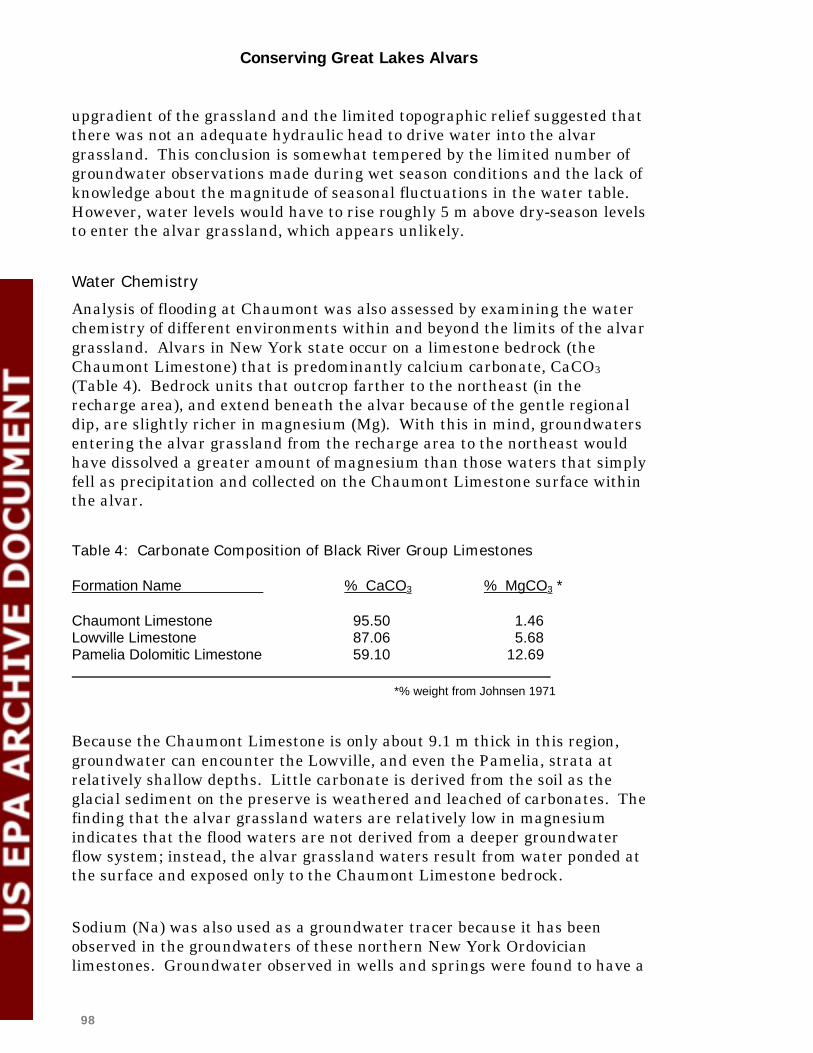
Conserving Great Lakes Alvars
98
upgradient of the grassland and the limited topographic relief suggested that there was not an adequate hydraulic head to drive water into the alvar grassland. This conclusion is somewhat tempered by the limited number of groundwater observations made during wet season conditions and the lack of knowledge about the magnitude of seasonal fluctuations in the water table. However, water levels would have to rise roughly 5 m above dry-season levels to enter the alvar grassland, which appears unlikely.
Water Chemistry
Analysis of flooding at Chaumont was also assessed by examining the water chemistry of different environments within and beyond the limits of the alvar grassland. Alvars in New York state occur on a limestone bedrock (the Chaumont Limestone) that is predominantly calcium carbonate, CaCO3 (Table 4). Bedrock units that outcrop farther to the northeast (in the recharge area), and extend beneath the alvar because of the gentle regional dip, are slightly richer in magnesium (Mg). With this in mind, groundwaters entering the alvar grassland from the recharge area to the northeast would have dissolved a greater amount of magnesium than those waters that simply fell as precipitation and collected on the Chaumont Limestone surface within the alvar.
Table 4: Carbonate Composition of Black River Group Limestones Formation Name % CaCO3 % MgCO3 * Chaumont Limestone 95.50 1.46 Lowville Limestone 87.06 5.68 Pamelia Dolomitic Limestone 59.10 12.69 *% weight from Johnsen 1971
Because the Chaumont Limestone is only about 9.1 m thick in this region, groundwater can encounter the Lowville, and even the Pamelia, strata at relatively shallow depths. Little carbonate is derived from the soil as the glacial sediment on the preserve is weathered and leached of carbonates. The finding that the alvar grassland waters are relatively low in magnesium indicates that the flood waters are not derived from a deeper groundwater flow system; instead, the alvar grassland waters result from water ponded at the surface and exposed only to the Chaumont Limestone bedrock.
Sodium (Na) was also used as a groundwater tracer because it has been observed in the groundwaters of these northern New York Ordovician limestones. Groundwater observed in wells and springs were found to have a

Conserving Great Lakes Alvars
99
greater concentration of sodium than water ponded at the alvar surface, proving sodium to be helpful in distinguishing groundwater from surface water and supporting the conclusion that deep waters had not risen to flood the alvar grasslands.
Findings
1. Alvar grassland flooding at Chaumont Barrens results from surface rainwater.
Analysis of groundwater elevations and water chemistry studied at the Chaumont Barrens alvar grassland indicates that flooding is the result of precipitation ponding at the surface on very thin soils over bedrock. Chemical analysis provided clear results: the lack of magnesium in the alvar grassland pools indicates that the waters did not circulate through the deeper Lowville and Pamelia Formations. This conclusion, however, does not rule out the presence of shallow groundwater flow through the upper 1 to 2 m of bedrock. Though this lateral flow through the near-surface bedrock (subcutaneous zone) has been observed at alvars, including the Chaumont Barrens, it would have limited areal extent and a source area relatively near the observed flow.
Bedrock fractures allowing water to rise to the surface are not readily visible at the locations where ponding appears; this is also true of many alvars across the Great Lakes. Large fractures have been observed along the periphery of the grasslands, but they appear filled with soils and organic matter. Bedrock pits and small solution conduits that once must have transmitted water now appear plugged after rains, supporting the idea that fractures at Chaumont Barrens are not as transmissive as they may have been in the geologic past.
4.2.3 Soil Moisture Regime and the Assessment of Grassland Ruts: On-Site Hydrology
Modification of the shallow soils is a potentially damaging threat to alvar hydrology. Trucks, tractors, off-road vehicles, and all-terrain vehicles traveling over an alvar grassland, particularly during wet periods, produce ruts that can remain for years (Figure B). Field observation has revealed water flow within the ruts, suggesting that the surface hydrology may be altered.
This study of alvar hydrology concentrated on the soil moisture regime, placing special emphasis on assessing ruts and their affect on alvar grassland
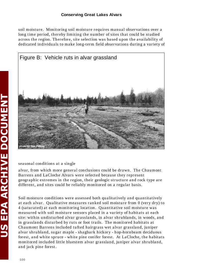
Conserving Great Lakes Alvars
100
soil moisture. Monitoring soil moisture requires manual observations over a long time period, thereby limiting the number of sites that could be studied across the region. Therefore, site selection was based upon the availability of dedicated individuals to make long-term field observations during a variety of
seasonal conditions at a single
alvar, from which more general conclusions could be drawn. The Chaumont Barrens and LaCloche Alvars were selected because they represent geographic extremes in the region, their geologic structure and rock type are different, and sites could be reliably monitored on a regular basis.
Soil moisture conditions were assessed both qualitatively and quantitatively at each alvar. Qualitative measures ranked soil moisture from 0 (very dry) to 4 (saturated) at each monitoring location. Quantitative soil moisture was measured with soil moisture sensors placed in a variety of habitats at each site: within undisturbed alvar grasslands, in alvar shrublands, in woods, and in grasslands disturbed by ruts or foot trails. The monitored habitats at Chaumont Barrens included tufted hairgrass wet alvar grassland, juniper alvar shrubland, sugar maple - shagbark hickory - hop-hornbeam deciduous forest, and white spruce - white pine conifer forest. At LaCloche, the habitats monitored included little bluestem alvar grassland, juniper alvar shrubland, and jack pine forest.
Figure B: Vehicle ruts in alvar grassland

Conserving Great Lakes Alvars
101
Soil moisture conditions were assessed at the Chaumont Barrens between 24 May and 15 August, 1996, involving 31 buried sensors. At LaCloche, soil moisture was monitored at 20 different stations over a 21-month period, from July 1996 to March 1998.
Findings
1. Alvar soils appeared to saturate almost completely after rainfall and then dry out more slowly to almost complete desiccation.
As shown in Figure C, soil moisture on alvar sites increased rapidly after summer rainfall events and then dried more slowly. Soil moisture is affected directly by summer weather patterns. During the summer of 1997 at LaCloche, there was a less pronounced wetting and drying cycle in soil moisture, stemming from a more consistent rainfall pattern.
2. Alvar soils remain saturated during the winter period and occasionally freeze.
From October onwards alvar soils are usually fully saturated, and they remain so until the following late spring. Reduced evaporation and transpiration and more consistent rainfall in the fall and winter months kept soils in a saturated state. At LaCloche Alvar, mean soil moisture conditions during the 1996/97 winter were generally wet and were considered much more representative of typical October-April conditions than the winter 1997/98, which was influenced by an El Nino event. The lack of snowpack caused by the mild winter conditions in 1997/98 allowed the ground to freeze. It is possible that ground freezing may also occur in extremely cold winters. Collaborators suspect that under typical winter conditions with a deep snowpack, the soil does not freeze and remains saturated.
On alvar pavement communities especially, the winter frost cycle may be an important disturbance factor. The development of frost crystals and needle ice in shallow alvar soils has been shown to disrupt moss mats, uproot emerging seedlings, and change vegetation patterns at a very small scale (Gilman 1995).
3. Different alvar community types show different patterns of soil moisture loss.
At both Chaumont Barrens and LaCloche, data from the soil moisture sensors were analyzed to trace desiccation rates over the entire summer period and for shorter periods without precipitation. In all cases, the alvar shrubland communities dried out more quickly than alvar grasslands, and

Conserving Great Lakes Alvars
102
usually more quickly than nearby woodlands. Desiccation rates over the entire summer period at Chaumont Barrens demonstrated that woodlands dried at the greatest rates, with alvar grasslands drying more slowly than other community types. However, over a shorter period without rain, the woodlands dried the slowest of all types measured (this result is less statistically reliable). At LaCloche, shrubland soils were found to desiccate more quickly and to a greater degree than either woods or grasslands.
This pattern was similar when the mean soil moisture for these communities (plus ruts) was derived for the summer and winter seasons. During the summer months of 1996 and 1997, the shrubland soils were, on average, the driest among the community types (see Figure D).

Conserving Great Lakes Alvars
103
Figure C

104
11 Jul 1996 - 15 Oct 1996
16 Apr 1997 - 15 Oct 1997
16 Oct 1996 - 15 Apr 1997
16 Oct 1997 - 30 Mar 1998

Conserving Great Lakes Alvars
105
4. The presence of ruts causes nearby alvar soils to dry more rapidly and to a greater degree.
Ruts across alvar grasslands consistently result in soils desiccating more quickly and to a greater degree than adjacent undisturbed grasslands (see Figure E). This finding suggests that ruts have modified the surface hydrology. Sensors placed in a foot trail at Chaumont Barrens suggested a moderate increase in desiccation rate compared to undisturbed grassland soils.
4.2.4 Conclusions
The study of regional hydrology conducted at the Chaumont Barrens revealed that water derived from beyond the boundaries of the alvar preserve was not responsible for flooding the grasslands. As a result, activities beyond the preserve boundaries do not appear to have an impact on the alvar grassland hydrology at that location. The regional hydrogeologic setting of New York alvars is fundamentally different than many alvars, including Carden, Smith Falls, the Bruce Peninsula, and Manitoulin and Drummond Islands. Field observation of waters bubbling to the surface at Belanger Bay on southern Manitoulin Island and on Drummond Island in Michigan attest to the need for site-specific studies.
Examination of water level data was helpful, and analysis of water chemistry proved to be a very useful tool in distinguishing surface water from groundwater. The success of water chemistry as a tool, however, was based largely on the variability of the bedrock geology at the Chaumont site. Because the geologic formations are relatively thin and differ in their chemical composition, the chemistry of water that circulated through different rocks was distinguishable. This chemical technique may be applicable at other alvar sites in the Great Lakes if the local bedrock geology has somewhat variable layers that can be chemically distinguished, like those at Chaumont Barrens.
Future study should anticipate the need to replace soil moisture sensors after roughly 18 months in the field. Other means of documenting soil moisture patterns, for example using remote sensing data such as radar imagery, may be useful tools for documenting soil moisture in a more continuous manner. Remote sensing techniques would also allow the study of more sites, since it would not be so dependent on the availability of someone willing to monitor sensors at alvar sites.
The study of alvar grassland soil moisture revealed that vehicle ruts do alter the soil moisture regime that is so important to alvar systems. Shallow alvar soils are most vulnerable to trampling and rut-formation when soils are saturated. Alvar grassland soils are also vulnerable when extremely dry because exposed dry soils, which often have a powdery texture, can easily be displaced from the bedrock. Management plans for alvar sites should prevent all vehicles from driving over

Conserving Great Lakes Alvars
106
alvars if at all possible, especially when the soils are saturated. Also, since the foot trail at Chaumont Barrens that follows the edge of a grassland showed a moderate increase in desiccation rate (compared to undisturbed grasslands), foot trails should be carefully located to avoid crossing areas with seasonally saturated soils.

107

Conserving Great Lakes Alvars
108
4.3 The Role of Fire Regime and Land Use History
4.3.1 Introduction
The history of Great Lakes alvars was examined from several angles to investigate three questions:
• Did alvars exist before European settlement times or are they the
product of recent anthropogenic disturbance? • Do alvars always remain open or do they grow in to some extent over an
observable period of time? • To what extent is fire involved in the origin and maintenance of alvars?
To address the first question, notes from the first surveys were used to reconstruct the presettlement vegetation of alvar areas on the Bruce Peninsula, Carden Plains, Manitoulin Island, and northern New York. Surveyors' comments such as "prairie," "plains," "rocky barrens," etc., were used to map the presence of alvars at the date of the survey. In addition, information about land use in alvar areas was collected from oral history interviews with older local residents. Topics of discussion dealt with logging activities, grazing practices, recollections of the alvars through the years, and memories and lore about local fire history.
To address the second question, a qualitative comparison was made of the size and openness of alvars on the Bruce Peninsula, Carden Plains, and Manitoulin Island in Ontario, and at Limerick Cedars in New York. The oldest available air photos were compared to the most recent ones available. In most cases, there were at least 45 years between sets of photos.
To address the third question, the presence or absence of burn evidence was recorded at each observation point made during alvar field work. Evidence included charcoal, burnt woody debris or stumps, and fire scars on trees. In addition, at each observation point a visual scan was made for eastern white cedar trees (Thuja occidentalis) that appeared to be exceptionally old. Some of these trees were cored and aged for further information on fire history. Also, local residents and old newspaper clippings were consulted to establish dates for burns. Finally, experts on fire history were escorted to several alvar sites, and they provided insights on fire history of alvars.
Work was done primarily by Claudia Schaefer on the Bruce Peninsula and the Carden Plain, Ontario with assistance in historical mapping by Helen

Conserving Great Lakes Alvars
109
Godschalk of NHIC; by Bruce Gilman, Sandy Bonanno and Carol Reschke in New York; and by Judith Jones on Manitoulin Island, Ontario. Unpublished reports used in preparing this summary are listed in the references.
4.3.2 General Findings
1. All regions had some areas that were very likely to have been alvar at the time of the first surveys. In New York, qualitative comments by the surveyors show that some alvar or substrate suitable for alvar did exist, in that there were some places described as "meadow," "rocky with limestone," or "poor land" in the survey of 1798. However, most of today's New York alvars had a cover of maple, beech and white pine in 1798. It is possible that pockets of alvar were under-represented because the surveyors were instructed to list timber species, and their comments were directed toward potential homesteaders who would be choosing parcels of land, sight unseen, for farms. Still, most New York alvars appear to have had more trees than they do today. Yet, on the whole the survey notes show that pockets of alvar did exist, even if the openings were small and scattered within the overall forest cover.
The story is very similar on the Flamborough Plain in Ontario (Goodban, 1995), with most of the current alvar areas listed as treed with maple, elm, basswood, etc. A few places were listed as having small trees or "broken land," and one area was listed as "meadow." However, while there are indications that there was suitable substrate for alvar, most of the land was forested.
Alvar was clearly described at Maxton Plains in Michigan in the survey of 1845. While the survey lines did not cross the majority of today's grasslands, several places were described by the surveyor as "naked rock with scattering of small trees growing in crevices" or some slight variation. At least two large areas of alvar existed (Comer et al. 1995).
On the Carden Plain, even a conservative estimate shows many patches of alvar existed at the time of the first survey in 1856. However, the patches, which were described as "plains," "prairie," "soil burnt off to rock," etc., appear to have been smaller than the alvar areas of today. Also, there appears to have been alvar in many places that are not now alvar. It is possible that some of these places have been altered by grazing or have grown up with trees.

Conserving Great Lakes Alvars
110
The Bruce Peninsula also supported many areas that most likely were alvar at the time of the first survey in 1855. Many areas were described as "barren," "scarcely any timber," or "scattered trees." Fairly extensive areas at Burnt Lands alvar are described in the land survey as “rock burnt spruce plain” or “rocky burnt land.”
On Manitoulin Island, almost the entire Lake Huron shore from Portage Point (Taskerville) to the western tip of the island, and inland from the shore for 2 to 4 concession lines, was described in various ways as burnt, barren flat rock, no soil, or stunted timber. Over the course of this huge area, only a few intervening wetlands and areas of young secondary growth or slash existed. The area that was open or not forested was much more extensive than the area of the alvars today.
While the surveyors’ comments do not identify presettlement alvars with 100% certainty, the coincidence of locations and descriptions with current conditions leaves little doubt that alvars existed as a natural community in the Great Lakes basin 150 years ago in many of the same locations as they do today.
2. Alvars can be created by fire.
A few alvar areas exist today which were not alvar at the time of the early surveys. On Manitoulin, the Silverwater Radio Towers site, today a juniper alvar shrubland, was listed as "good level land with mixed timber" and "sandy loam of average depth and some large cedar." Interviews with older local residents brought out memories of fighting a huge fire at this site in 1925.
In New York, an area at Limerick Cedars which was tree-covered in a 1948 air photo burned in an intense fire in 1953. Photos in newspaper articles of the time show the location of the fire at what is now the barren nonvascular pavement at the Perch River Barrens portion of Limerick Cedars. Local residents described the fire as intense, burning deeply into moss and cracks, and requiring several days to extinguish. While it is not clear if this area supported an alvar community prior to the fire (probably a pavement savanna from the description of burning moss and the forest cover on the air photo), it is evident that fire removed most of the vegetation to create the alvar that exists today.
In addition, other sites such as Driftwood Cove and Hopkins Bay on the Bruce Peninsula, Alvar #4 at Carden, and the alvar west of South Baymouth on Manitoulin were listed as forested at the time of the first surveys. Driftwood

Conserving Great Lakes Alvars
111
Cove, South Baymouth, and Carden #4 (no data is available for Hopkins Bay) have burn evidence present, making it likely that these alvars resulted from fires at or since settlement times.
3. Some alvars show no evidence of past fire.
The Bruce Peninsula alvars at Baptist Harbour, Bear's Rump Island, and parts of Pendall Lake, as well as part of the alvar on Great LaCloche Island, show no evidence of fire and support cedar trees several hundred years old. Even if fire occurred at these sites more than 500 years ago (and the evidence rotted away), the current sparse vegetation still testifies to an extremely slow growth rate at these sites. It is not inconceivable, therefore, that the past 3000-plus years that these sites have been exposed above Lake Huron would only have produced the growth we see today, and fire need not be a factor in explaining the barrenness of these alvars.
There are many other alvars which show no evidence of fire, although they lack the dramatic evidence of ancient cedar trees. These alvars occur throughout all regions, all alvar types, and in a range of conditions, such as along shores and inland.
4. Air photos show that shrublands and savannas appear to change or become wooded more quickly than grasslands or pavements.
This trend was noted independently by both Schaefer (1996a,c) and Jones (1996) and was observed at nearly every site where a comparison of historic air photos from the 1930s to the present was done (including a series of sites on Carden Plain, Flamborough Plain, Bruce Peninsula, and Manitoulin). At the very least, the comparisons show that some alvars or types of alvars do grow in over time, and it may happen in as little as 45 years. This also is supported anecdotally by interviews with older Manitoulin residents who pointed out wooded areas (limestone woodland) that had been open flat rock earlier in their lives.
Several hypotheses have been suggested to explain this trend, but none has been rigorously tested. Schaefer suggested that perhaps alvars grow in very slowly until some sort of threshold level of vegetation is reached and then they become wooded more quickly. Jones suggested that cracks and grikes in the bedrock, a common feature of shrublands, may favor growth of woody plants, allowing shrublands’ relatively rapid growth.
5. Air photos show that boundaries of most alvars changed little in 45 years, with some areas becoming more wooded.

Conserving Great Lakes Alvars
112
This pattern of stable boundaries was noted many times, and may indicate that there is some underlying factor such as bedrock surface or lack of soil which causes an abrupt difference between alvar and adjacent land. This agrees well with Schaefer and Larson's (1997) finding that there is little transition zone between alvars and the surrounding communities. This trend also appears to show that alvars generally don't grow in from their margins, but rather from expansion of woody areas already present within the alvar openings.
6. Some alvar community types show a strong correlation with presence of
burn evidence, while others do not.
Table 5 shows that some community types have an obvious correlation with past burning, for example bur oak limestone savanna and white cedar - jack pine / shrubby cinquefoil alvar savanna, where all observation points have burn evidence present. In addition, both the creeping juniper - shrubby cinquefoil alvar shrubland and the alvar nonvascular pavement types show a high percentage (71% and 75% of observation points, respectively) of burn evidence. This suggests that the sparseness of vegetation in these types may have something to do with past fires.
On the other hand, the tufted hairgrass wet alvar grassland and annual alvar pavement-grassland types show a lack of burn evidence, which makes sense since these types are usually on the wetter end of the moisture spectrum. Similarly, most of the observation points for the red cedar / early buttercup alvar woodland type had not burned, although the moisture regime here is unclear.
Burn evidence for other types show a fairly even split between presence and absence, perhaps indicating that fire occurs but is not necessarily a key maintaining process. However, since alvars can change very little over long periods of time, the occurrence of "alvar-maintaining fires" many centuries ago still cannot be ruled out. Little is known about how long burn evidence lasts before rotting away, and it is still possible that some alvars were created by fire centuries ago but that no evidence of burning remains.
Table 5. Observation points by community type showing presence/absence of burn evidence.
Points with only a fire scar are shown in the "present" column.
Alvar community type Number of samples
Burn evidence present
Burn evidence absent

Conserving Great Lakes Alvars
113
Tufted hairgrass wet alvar grassland
37 10 (+ 1 scar only)
26
Little bluestem alvar grassland 59 24 (+ 1 scar only)
35
Annual alvar pavement - grassland 15 2 13
Poverty grass dry alvar grassland 12 6 (+ 1 scar only)
5
Creeping juniper - shrubby cinquefoil alvar shrubland
21 15 6
Scrub conifer / dwarf lake iris alvar shrubland
7 3 4
Alvar nonvascular pavement 8 6 (+ 1 scar only)
1
Juniper alvar shrubland 42 25 16
Great Lakes limestone bedrock lakeshore
12 - 12
Chinquapin oak / nodding onion alvar savanna
3 3 - controlled burning
-
Bur oak limestone savanna 9 9 -
White cedar - jack pine / shrubby cinquefoil alvar savanna
16 16 -
Mixed conifer / common juniper alvar woodland
6 5 1
Red cedar / early buttercup alvar woodland
7 1 6
Another reason why a strong correlation with fire may not show up, at least in some grassland types, is that if fire occurred in a grassland, there would be very little evidence left behind, according to Tim Lynham, fire research officer with the Canadian Forest Service (personal communication, 1996). Reschke (1995) analyzed soil samples from Chaumont Barrens in New York to look for microscopic charcoal that would provide evidence of fires. She found no charcoal in alvar grassland soils, although charcoal was found in some areas of the adjacent juniper alvar shrubland.
Interestingly, Schaefer and Larson (1997) found little difference in composition and environmental variables between alvars with old trees showing no burn evidence and alvars which were known to have burned. Our data seems consistent with this conclusion. Our interpretation is that fire may be a necessary factor only in some types of alvars while it is merely an incidental occurrence in others.
Conserving Great Lakes Alvars
114
7. Bur oak limestone savanna can result from hardwoods burned in catastrophic fire.
This community type occurs in Sheguiandah Township, among other places, on Manitoulin Island. A study of the history of the township shows that the area was surveyed in 1863, and then a catastrophic fire raged through most of the township in 1864, destroying most of the survey posts. The entire township had to be resurveyed in 1865; as a result, surveyors' notes are available for immediately before and after the fire.
Maps of vegetation before and after fire were made based on the two sets of notes and compared to the current locations of bur oak limestone savanna (field surveyed in 1997). The comparison shows that most areas currently supporting bur oak limestone savanna were described as hardwoods before the fire (usually predominantly maple), and that while these areas burned, not all vegetation was removed.
This study only speaks to the creation of bur oak limestone savanna and not to its maintenance, but this community type also exists in some areas of Foxy Prairie, where local people say there have been several fires in the last century and where repeated fire may keep the canopy open. However, the Sheguiandah Township savannas have not burned since the fire of 1864. Both sites have been continuously grazed by cattle since settlement times, and it is possible that in the absence of fire, grazing maintains their open savanna characteristics.
8. Grazing by cattle may be keeping some alvars open.
While grazing history was not investigated in depth, casual observations of fencelines where one side is used as pasture and the other side is not show drastic differences in the amount of alvar vegetation present and in the cover of woody plants. At Foxy Prairie, the grazed side is still alvar, while the side that is no longer grazed has grown up with tall Eurasian grasses. In Sheguiandah Township, the ungrazed side is a dense bur oak woodland with almost no alvar ground flora.
Many alvars in Carden Township and eastern Ontario (community types other than bur oak limestone savanna) have also served as pasture since settlement times. On the whole, alvars where grazing occurs have a higher than usual incidence of exotic plant species. Therefore, while grazing may keep some alvars open, it also seems to slowly degrade the natural community. Exclosures set up to look at what happens when grazing is stopped may not show results for several years, but future attention to this topic is needed

Conserving Great Lakes Alvars
115
since the results have implications for alvar restoration efforts (see section 4.4 below for further discussion of herbivory research).
9. Controlled burning may be beneficial to some alvar types but could harm others.
At the Stone Road Alvar site on Pelee Island, controlled burning has been very beneficial. Two controlled burns (1993 and 1997) have resulted in a die-back of 75% to 80% of the shrub cover and a reduction in the cover of weeds. The burns have also caused a resurgence of native species such as nodding onion (Allium cernuum), gray-headed coneflower (Ratibida pinnata), and whorled milkweed (Asclepias verticillata) (Dan Lebedyk, Essex Region Conservation Authority, personal communication). However, the Pelee Island alvar has a very different constellation of species from other alvar types and also has contiguous areas that are considered true prairie and savanna. Therefore, conclusions about the benefits of controlled burning at Pelee may not be transferable to other alvar types.
An upcoming article by Catling and Brownell (1998) concludes that a section of the Burnt Lands alvar which was cut and burned 37 years earlier had an unusually high species diversity of native vascular plants, including rare and/or restricted species. They argue that successional alvar burns are an important part of the alvar ecosystem and that burning is an appropriate management consideration for alvars.
In New York, at Limerick Cedars, Gilman (1997b) has shown that there may be detrimental effects from burning alvars. The Perch River Barrens was a pavement savanna prior to a catastrophic fire in 1953. Today, 45 years later, it remains a very barren pavement with only a sparse vegetative cover of lichens and mosses. Whether this pavement may someday be more highly diverse because of burning remains to be seen, but, if so, it may be on time scales that are difficult to regulate (or even correlate) with controlled burns.
Some collaborators have also expressed concern about the effects of burns on terrestrial molluscs, particularly on small, less robust (and often rarer) species (Wayne Grimm, personal communication).
Careful further study certainly must be done before controlled burning can be recommended for alvars (other than the Pelee Island site and possibly the alvar-related bur oak limestone savanna type). Most likely, recommendations will need to be developed on a site-by-site basis rather than on the basis of alvar community types as a whole.

Conserving Great Lakes Alvars
116
4.3.3 Conclusions
From the alvars with old trees and no burn evidence, it is clear that not all alvars require fire to remain in an open state. If fire is at all required in some of these alvars, it could only be on the basis of a return cycle of many hundreds of years. Furthermore, at many other alvars, fire has probably been only an incidental occurrence, based on the fact that among many similar alvars some have burn evidence and some don't. Therefore, the use of fire as a management tool is not advised for all alvar community types, even though it may be beneficial for some sites such as Stone Road Alvar on Pelee Island.
Based on air photos, some alvars, especially shrublands and savannas, do grow in with trees. It is not known if low-intensity fire would maintain these more dynamic alvars in an open state, or if the only option is a larger fire which would reset the successional clock all the way to zero – to an extremely barren state. Clearly, some alvars have originated from large fires, so if low-intensity burning does not maintain these areas, management strategies might have to consider more intense burns at some future point.
Periodic fire may maintain bur oak limestone savannas and keep them from becoming woodlands, but grazing is probably obscuring this trend while degrading the ecosystem. Based on work in similar ecosystems with deeper soils (Tester, 1996), periodic burning should be studied as a management tool for this community type.
Certainly, given the long history of alvar communities from presettlement times, natural fires appear always to have been at least an incidental part of their history, and probably instrumental in maintaining some alvar types such as juniper alvar shrubland. This suggests that aggressive fire suppression is not needed on alvar habitats, although no alvar should be allowed to burn entirely in one fire event, to ensure the survival of invertebrate fauna. If fires do occur within alvars, researchers should use these occurrences as opportunities to gather much-needed data on subsequent ecological changes.
4.4 The Role of Browsing and Grazing
The effect of several kinds of herbivores on alvar plant communities was identified as a concern early in the Alvar Initiative, and information relating to browsing and grazing was collected from all field observation points. While

Conserving Great Lakes Alvars
117
information about browsing by rabbits and voles was gathered, their effects appear to be minor and a normal part of natural processes on alvar sites. The primary focus of research in this area has been browsing by white-tail deer (Odocoileus virginianus) and grazing by domestic cattle.
White-tail deer are a native species in the Great Lakes basin, but artificially high population levels across much of the basin, created and sustained by habitat modifications and management policies, are seriously impacting plant populations in many natural habitats (Waller and Rooney 1998). In some plant communities, such as Carolinian forests, intense deer grazing has significantly altered plant community composition and has resulted in the removal of a number of rare species (Bazely et al. 1997, Koh 1991, Pearl et al. 1995, Koh et al. 1994, Koh and Bazely 1994, Koh and Bazely 1992). There are concerns that excessive browsing by deer poses a threat to alvar communities by changing the composition and structure of shrub and herb layers. At the same time, some collaborators on the Alvar Working Group have questioned whether browsing by deer may benefit some alvar communities by limiting the growth of trees and shrubs (Alvar Working Group, 1996).
Alvars in the Great Lakes basin and elsewhere have long been influenced by grazing livestock. While this influence has been little studied in North America, the effects of grazing have been documented on alvar habitats of the Swedish island of Oland, where grazing by domestic animals has occurred since the first centuries A.D. (Titlyanova et al. 1988). In that location, grazing has been considered essential to prevent encroachment in closed grasslands occurring on silicious soils, where soil depth would potentially support woody vegetation (Rosen 1982, Bengtsson et al. 1988). A study of reproductive regeneration in grazed and ungrazed limestone grassland communities showed that the closed turf of ungrazed sites hindered the germination of perennial herbs, and that the short turf and gaps in grazed communities increased the abundance and persistence of some monocarpic plant species (Rusch 1988).
However, the intensity of grazing appears to be a critical factor. A comparison of ungrazed, moderately grazed, and overgrazed sites showed decreased biomass and floristic changes in the overgrazed area, with perennial and annual ruderal (quick-germinating, disturbed soil specialists) species replacing the dominant alvar grassland species. Alvar lichens had the highest biomass values in the moderately grazed community. (Titlyanova et al. 1988).
Brownell (1998) has noted that where grazing is intense on Great Lakes alvar grasslands, the grasses may be reduced and that species avoided by cattle

Conserving Great Lakes Alvars
118
such as flat-stemmed spike-rush (Eleocharis compressa) may increase in abundance. Rosette-forming species such as ciliolate aster (Aster ciliolatus) and goldenrod (Solidago) species also may increase. Early buttercup (Ranunculus fascicularis) is much more frequent on some alvars subject to grazing than on adjacent non-grazed sites. Nevertheless, even light grazing tends to result in elimination of certain species such as the disjunct clustered cancer-root (Orobanche fasiculata) (Catling and Brownell 1995).
As noted in the previous section, there is anecdotal evidence from several Great Lakes alvar sites that grazing by cattle may be keeping alvar areas open by preventing the invasion of trees or shrubs. This can be an important factor in maintaining suitable nesting habitat for rare alvar birds such as loggerhead shrike (Lanius ludovicianus migrans), which depend on open, short grasslands for their prey (Chabot 1994).
These factors led the Alvar Working Group to hypothesize that cattle grazing is generally detrimental to alvar communities, but some light grazing may help to keep alvar areas open. Also, as the intensity of grazing increases, diversity of native species decreases and the number of exotics increases (Alvar Working Group 1996).
To address these questions about the role of browsing and grazing, a long-term research study was established. This study, coordinated by Dawn Bazely and Saewan Koh of York University, has two overall objectives:
• Establish permanent deer and cattle exclosures at sites in alvars in
Ontario and in the United States. • Collect baseline plant community composition data in order to allow the
impact of mammalian herbivory to be assessed.
Permanent deer and cattle exclosures and adjacent control (grazed) plots were established in August and September 1997 in three Ontario locations (Misery Bay on Manitoulin Island; Burntlands, and Carden Plains) with varying grazing pressure. Exclosures were also built by TNC staff at Stony Point and Chaumont Barrens in New York state. Each exclosure (4.9 m x 4.9 m) consisted of four cattle panels.
Four paired plots (exclosure and grazed plot) were established in each of the Burntlands and Misery Bay locations and a total of eight paired plots at two sites in the Carden location. In New York, four exclosures were built at Stony

Conserving Great Lakes Alvars
119
Point and four at Chaumont Barrens. This provides a total of 24 exclosures and 24 grazed control plots for the study.
As a general guideline, all plots are located in alvar grasslands with alvar savanna communities in the vicinity, since these are the most likely areas to detect herbivory effects. In the Misery Bay Preserve, the availability of this habitat was restricted, so research there will focus more on grassland/pavement areas. An important difference between the Ontario and U.S. sites was the inclusion of large red cedar (Juniperus virginiana) trees within the New York exclosures. This may affect subsequent plant community changes.
Manitoulin Island has a high deer density, while Burntlands is expected to have a low to intermediate deer density. Carden has two types of alvar sites: (i) alvars actively grazed by cattle and (ii) alvars not grazed by cattle but with intermediate deer density. The New York state sites are not recently grazed but have high deer densities.
Baseline data on the plant community composition of paired plots was collected in July/August 1996 and spring 1997, using the TNC field protocols and community field forms (Sneddon 1994) adopted by the Alvar Initiative.
Data from all plots have been entered into an Excel 5 database and will be statistically analyzed to examine relationships to all available environmental variables. Initially, grazed and exclosed plots are expected to be similar but with large differences in plant species composition among sites. However, in future years, depending on ungulate herbivory, grazed plots are expected to become rapidly different from ungrazed plots.
Funding to support periodic data collection and analysis of these changes is being sought, since the most valuable results of this project are likely to emerge only after repeated monitoring.
4.5 The Role of Exotic Plants
4.5.1 Introduction
The Alvar Working Group identified several exotic species that were invasive and problematic in alvar communities, including St. John's-wort (Hypericum

Conserving Great Lakes Alvars
120
perforatum) in Michigan, Canada bluegrass (Poa compressa) in Ontario and New York, and buckthorn (Rhamnus cathartica) and honeysuckle (Lonicera tatarica, L. morrowii) in New York. Several other exotic species were known to be present in alvar sites, but with little information about their abundance, frequency, or distribution.
Alvar survey methods included documentation of exotic species observed during field reconnaissance surveys (observation point data) and in plant species lists compiled for the six alvar structural types (described in section 2.1 above). Because the field information format varied slightly from year to year (e.g. recording species by abundance classes in 1995 and by percent cover in 1996), several different data sets were used for analysis.
Most of the analysis of exotics used a small data set (111 observation points) consisting of the 1996 observation points plus a few 1995 observation points that represented single community types. In places where a pattern occurred in the analysis, the full data set (291 observation points) was consulted to see if the pattern appeared consistently throughout.
For each observation point in the small data set (111 observation points), data compiled included a full list of all exotic species present, the number of exotics, the percent cover of Poa compressa, and the percent cover of all exotic species (excluding P. compressa). The large data set (291 observation points) included only the number of exotics, percent cover of Poa compressa and percent cover of other exotics.
Sample size for each community type was variable. In the small data set, there were from 22 to 25 examples of type 3 (little bluestem alvar grassland) and type 8 (juniper alvar shrubland); from 9 to 14 examples of type 2 (tufted hairgrass wet alvar grassland), type 4 (annual alvar pavement-grassland), and type 5 (creeping juniper - shrubby cinquefoil alvar pavement); 6 examples of type 7 (alvar nonvascular pavement); and only 2 or 3 examples of type 6 (scrub conifer / dwarf lake iris alvar shrubland), type 11 (Chinquapin oak / nodding onion alvar savanna), type 13 (poverty grass dry alvar grassland), type 16 (mixed conifer / common juniper alvar woodland), and type 17 (red cedar / early buttercup alvar woodland).
4.5.2 Findings on Common Exotic Species
1. Different species of exotic plants vary considerably in their frequency of occurrence on alvar habitats.

Conserving Great Lakes Alvars
121
Overall, 109 exotic plant species (or taxa) were reported from all alvar observation points, and 64 exotic species were included in the small data set from 111 observation points. In this data set, there were 14 species that occurred in at least 9% of the observation points. These 14 taxa, in decreasing order of frequency are:
Canada bluegrass - Poa compressa (present at 62% of all observation points)
St. John’s-wort - Hypericum perforatum (49%)
Rough-fruited cinquefoil - Potentilla recta (25%)
Common mullein - Verbascum thapsus (24%)
Common timothy - Phleum pratense (22%)
Ox-eye daisy - Chrysanthemum leucanthemum (17%)
Glaucous king devil - Hieracium piloselloides (17%)
Curly-leaf dock - Rumex crispus (14%)
Hawkweed - Hieracium sp. (13%)
Wild carrot - Daucus carota (11%)
Blueweed - Echium vulgare (11%)
White sweet-clover - Melilotus alba (10%)
Kentucky bluegrass - Poa pratensis (9%)
Buckthorn - Rhamnus cathartica (9%)
2. Whether or not Canada bluegrass is a native species, its presence is highly correlated with the frequency of exotic species at an alvar site.
Debate continues among many workers as to whether Canada bluegrass (Poa compressa L.) is a native or an exotic species. It is a common pasture grass in Europe and could have been introduced to North America either accidentally (e.g. in straw used for packing) or intentionally as a pasture grass. Many taxonomists consider Poa compressa an introduced species (Voss 1972; Dore and McNeill 1980; Cronquist 1991).
In contrast, it may have been a native species in certain habitats. Morton and Venn (1984, 1990) consider it native. Morton and Venn may have been influenced by familiarity with a collection of this grass by Bell in 1860 from "cracks in flat beds of limestone" on Great LaCloche Island (Bell 1870). However, by 1860 there had already been at least 100 years of periodic visits by Europeans in the Manitoulin region, especially in the area of Little Current

Conserving Great Lakes Alvars
122
(just south of LaCloche), so the collection does not show conclusively that Poa compressa is native in the area.
In early meetings of the Alvar Working Group, collaborators questioned whether Poa compressa should be considered an indicator of past disturbance and how this should influence evaluations of alvar community condition.
In our analyses, data on Poa compressa have been treated separately from data on known exotic species. Still, our results show that there is a connection between high percent covers of P. compressa and high numbers of exotic species; this is a statistically significant correlation. Whether or not it is native, this implies that in alvar communities Poa compressa is often more abundant where there has been past disturbance. This relationship to disturbed soils is consistent with the observations of Stephenson (1995) on Maxton Plains alvar, who noted that the species did not appear to be a competitive threat to other grassland components on the alvar, but that it aggressively colonized disturbed areas and formed dense swards on the deeper soils of road and drain berms.
3. Canada bluegrass and other exotic species are much more abundant in some alvar community types than in others.
Poa compressa occurred with a greater frequency (at a greater number of observation points) than any other exotic species. This was true in all alvar community types, with P. compressa being present at 62% of observation points. The frequency may actually be somewhat higher than is represented in our data since the greatest part of our samples were type 8 (juniper alvar shrubland), which is not a predominantly herbaceous type.
Community types 17 (red cedar / early buttercup alvar woodland), 4 (annual alvar pavement-grassland), and 11 (Chinquapin oak / nodding onion alvar savanna) had the highest percent covers of Poa compressa (Figure F). Poa compressa appeared at all observation points in each of these types.
Community types 6 (scrub conifer / dwarf lake iris alvar shrubland) and 16 (mixed conifer / common juniper alvar woodland) each had small sample sizes, but few of the observation points had any Poa compressa present, and when it was present, it had less than 1% cover. Of the five observation points in type 16 (mixed conifer / common juniper alvar woodland), none had more than 5% cover of Poa compressa in the community. None of the observations of type 14-15 (white cedar - jack pine / shrubby

Conserving Great Lakes Alvars
123
Figure F Comparison of maximum and median values for percent cover of Poa compressa in different alvar community types, arranged in decreasing order of median values. The difference between median and maximum shows whether high numbers occur in most of the samples or in just a few samples with exceptionally high values.
0.0
10.0
20.0
30.0
40.0
50.0
60.0
70.0
80.0
11 C
hinq
uapi
noa
k sa
v
4 an
nual
pav
-gr
17 r
ed c
edar
wdl
2 tu
fted
hairg
r.
7 no
nvas
c pa
v
5 cr
eepi
ngju
nipe
r sh
8 ju
nipe
r sh
.
13 p
over
ty g
r
3 lit
ttle
blue
stem
gr
6 sc
rub
coni
fer/
iris
shr
16 m
ixed
coni
fer
wdl
alvar community type
per
cen
t co
ver
max % cover Poa
median % cover Poa
Figure G Comparison of maximum and median values of percent cover of exotic species in different alvar community types.
0.0
5.0
10.0
15.0
20.0
25.0
30.0
35.0
40.0
45.0
11 C
hinq
uapi
noa
k sa
v
17 r
ed c
edar
wdl
16 m
ixed
coni
fer
wdl
13 p
over
ty g
r
3 lit
ttle
blue
stem
gr
8 ju
nipe
r sh
.
7 no
nvas
c pa
v
2 tu
fted
hairg
r.
4 an
nual
pav
-gr
5 cr
eepi
ngju
nipe
r sh
6 sc
rub
coni
fer/
iris
shr
alvar com m unity type
per
cen
t co
ver
max % cover exotics
median % cover exotics

Conserving Great Lakes Alvars
124
cinquefoil alvar savanna) had Poa compressa present at 1% or more cover, and only a few had this species present at all.
Therefore, Poa compressa does not appear to be an important plant, invasive or not, in our samples of alvar types 6 (scrub conifer / dwarf lake iris alvar shrubland), 14-15 (white cedar - jack pine / shrubby cinquefoil alvar savanna) or 16 (mixed conifer / common juniper alvar woodland).
A slightly different pattern was found for other exotic plant species. Community types 11 (Chinquapin oak / nodding onion alvar savanna) and 17 (red cedar / early buttercup alvar woodland) have the highest cover of exotics (Figure G), suggesting that these types tend to be weedier than other alvar types. Type 6 (scrub conifer / dwarf lake iris alvar shrubland) consistently ends up with the lowest cover of exotics, suggesting that this type has the fewest weeds.
4. St. John’s-wort and a few other exotic herbs are also widespread in most alvar communities and are difficult to control. After Poa compressa, St. John's-wort (Hypericum perforatum) is the most frequent exotic species in most alvar community types (except in types 6 and 16, where it is the most frequent exotic species). Overall, it occurred at 49% of the observation points. Community types 5 (creeping juniper - shrubby cinquefoil alvar pavement) and 3 (little bluestem alvar grassland) had the least Hypericum perforatum present. Types 11 (Chinquapin oak / nodding onion alvar savanna), 16 (mixed conifer / common juniper alvar woodland), and 17 (red cedar / early buttercup woodland) had H. perforatum present at all observation points.
The next most frequent species overall was rough-fruited cinquefoil (Potentilla recta) which occurred at 25% of observation points and was the next most frequent exotic species in most community types. Another widespread exotic presence was the hawkweeds of the genus Hieracium, which collectively constitute a large presence.
Some experimental attempts have been made to control St. John’s-wort within alvar habitats on the Maxton Plains alvar on Drummond Island (Stephenson 1995). Preliminary results showed single removals by hand-pulling to be relatively ineffective since stored seeds in the soil replaced the removed plants. Multiple removals in a single season was more effective, especially within dense grass areas, but effectiveness was highly site-specific.

Conserving Great Lakes Alvars
125
Burning was not an effective means of removing or reducing Hypericum populations, since the species resprouted vigorously from root systems. Experimental treatments with herbicides are highly effective at killing individual treated plants, but the longer-term response of alvar communities to this technique is uncertain.
4.5.3 Study Results Specific to Buckthorn
Buckthorn (Rhamnus cathartica) was the most frequently noted exotic shrub within alvar habitats. It was recorded from 9% of observation points, all from sites in New York and eastern Ontario (Burnt Lands, Gretna Alvar, and Massassauga Point Alvar). It occurred in three community types: juniper alvar shrubland, alvar nonvascular pavement, and annual alvar pavement-grassland.
A study of buckthorn conducted by Amy Samuels at Chaumont Barrens Preserve in New York (Samuels 1998) set out to address three main questions:
1. How are community type, soil depth, and land-use history related to the abundance of buckthorn at Chaumont Barrens?
2. How are the abundances of buckthorn, grey dogwood (Cornus racemosa), and common juniper (Juniperus communis) related to alvar community composition and species diversity?
3. How does buckthorn compare to grey dogwood and common juniper in terms of the relationship of each shrub species to associated herbaceous vegetation?
The answer to the first question should provide insight into factors that affect the establishment, spread, and control of buckthorn, while answers to the second and third questions will help determine whether or not buckthorn is enough of a problem to require some control measures. Buckthorn would be considered a problem if it alters community composition and species diversity, or if it is relatively abundant compared to the native shrubs. A second exotic shrub, honeysuckle (Lonicera tatarica), is also a problem on some of the same alvar sites, but to a lesser extent. In addition, black swallow-wort (Vincetoxicum rossicum) is a very aggressive exotic plant which is a management problem on New York state alvars.
The primary communities studied by Samuels were juniper alvar shrubland, tufted hairgrass wet alvar grassland, and adjacent woodlands that ranged from deciduous and mixed types (not represented in Alvar Initiative types) to

Conserving Great Lakes Alvars
126
coniferous woodlands and forests somewhat similar to mixed conifer / common juniper alvar woodland. The study examined relationships between buckthorn abundance and community type, soil depth, disturbance history, community composition, and abundance of native shrub species. An analysis of the age structure of buckthorn was completed and the abundance of seeds in the soil in different communities was examined. Sample plots near roads (within 80 paces) were also compared to plots in less disturbed interior shrublands.
Findings
1. The abundance of buckthorn varied between community types.
The highest abundance of buckthorn was found in the roadside shrublands, then in the woods, then in interior shrublands, with the lowest abundance in the alvar grasslands. Overall differences in frequency, density and percent cover between communities were found to be statistically significant. The study also found that the frequency and density of all ages of buckthorn were higher in coniferous and mixed woods than in deciduous woods.
Soils depths varied between communities, with deeper soils associated with shrublands and woods, and shallower soils in grasslands. This variation in soil depth is correlated to buckthorn abundance, with more buckthorn found in communities where soils are deeper.
2. Buckthorn abundance and seed density are related to the degree of disturbance in natural communities.
Disturbance as represented by distance from roads was strongly correlated with buckthorn abundance. The highest frequencies of buckthorn were found within 80 paces of a road.
Analysis of size and age class distributions indicated there was an uneven distribution of age classes, with many buckthorn seedlings and saplings, and fewer adults. Analysis of the distribution of seeds in the soil showed that there were significantly higher numbers of seeds near the roadside (where buckthorn abundance was also higher). Both seeds and adult buckthorn plants were found in the roadside and interior shrubland communities. Buckthorn seeds (but no adult plants) were found in deciduous woods. No seeds or buckthorn adults were found in grasslands
3. At Chaumont Barrens alvar, buckthorn is more problematic in woodland settings than in interior shrublands.

Conserving Great Lakes Alvars
127
In shrublands, the comparison of buckthorn abundance to the abundance of native shrubs showed that buckthorn had a significantly lower abundance than the dominant shrubs: common juniper, grey dogwood, and downy arrowwood (Viburnum rafinesquianum). In contrast, the cover of buckthorn in woodlands was equivalent to the cover of the two most abundant native shrubs (grey dogwood and downy arrowwood), and significantly greater than any other native shrubs.
The overall trend that emerges across communities is that buckthorn and honeysuckle, the two exotic shrubs, have higher abundances in the woods and along the roadside than in the grasslands or interior shrublands. This tendency is much more pronounced for buckthorn than for honeysuckle.
4.5.4 Conclusions
The patterns presented here say something about the current state of weediness in different alvar community types but do little to explain the underlying causes. Most likely, the community types that are now the weediest were in the past the most desirable (or the most accessible) for human uses such as grazing. Land use history may have more to do with patterns of weediness than alvar community type. The majority of our data comparing exotics to alvar community types fail to show any strong pattern. This probably indicates that weediness of alvar communities is site specific and depends on local site disturbances rather than on some rangewide processes that consistently influence all occurrences of a community type.
More work needs to be done to determine appropriate management of exotic species and rehabilitation of weedy alvar sites. Developing techniques of applying herbicides without damaging native herbs is a challenge that still needs to be addressed. The effectiveness of manual removal of exotic plants, or of controlled burning as a restoration technique, also needs more study in a variety of alvar settings. Also, the role of Poa compressa in alvar communities should be studied in more detail to see whether this species is a threat.
One interesting question is whether the abundance of bird-dispersed seeds (such the seeds of buckthorn and honeysuckle) might be correlated with the abundance of perch sites for birds. Although that correlation was not specifically studied, it may have important management implications. For instance, if buckthorn or honeysuckle are cut as part of a management program and the cut brush left on site, this may be simply providing additional perch sites for birds that disperse the seeds. This could be an important question for future research.

Conserving Great Lakes Alvars
128

Conserving Great Lakes Alvars
129
5.0 Conservation Priorities and Techniques
5.1 Conservation Targets
The evaluation and conservation rankings of alvar communities described in Chapter 2, together with information on significant species, provide a wealth of information on which to base conservation priorities. Since most conservation work is carried out at the site level, and a single site often contains several communities and significant species, conservation priorities are most effectively identified as a series of specific sites. This section presents an approach to identifying alvar sites that are most important to protect first.
A key question was considered in identifying these sites: How many need to be protected, in order to capture the full range of alvar biodiversity within the Great Lakes ecoregion and to ensure its survival over the long term?
As part of an ecoregional planning process to identify high-priority conservation sites in ecoregions across the Great Lakes basin, TNC and Heritage Program science staff have identified the following conservation targets: • All natural communities within the ecoregion, regardless of rarity • All globally significant (global rank of G1-G3G4) plant and animal species • More common (global rank of G4-G5) species that are disjunct in the
ecoregion
Regional conservation objectives have been established for each of these targets to address the question of how many occurrences of each should be protected to ensure its long-term survival in the ecoregion. For natural communities, the following draft goals and objectives are relevant to Great Lakes alvar communities:
Global Rank
Distribution Relative to Ecoregion
Rangewide Goal Ecoregion Objective
G1-G2 endemic, limited, disjunct, or widespread
All viable occurrences (ideally, restore 30-60 occurrences, rangewide)
All viable occurrences (EO rank A-C)

Conserving Great Lakes Alvars
130
G3-G4 endemic, limited, disjunct
30-60 occurrences (depending on actual distribution across subsections)
Section-scaled replication (>3). Subsection-scaled representation
Since most alvar communities have global ranks of G1 or G2, these objectives emphasize the importance of maintaining essentially all of the existing viable occurrences, at least up to a goal of 30 to 60 examples of each community type.
Setting objectives for species occurrences is more difficult since only a few rare or disjunct species occur exclusively on alvars within the Great Lakes basin. However, where globally rare species (G1-G3G4) occurrences are known on alvars, they are included as a criterion for identifying significant sites for protection, with the objective of protecting all known occurrences of G1 and G2 species and most of the viable occurrences of G3 and G3G4 species. Most alvar occurrences of disjunct species are thought to be included through their associated communities, but a specific objective for disjunct species was not identified.
Applying these objectives results in most of the alvar sites listed in Table 2 being included as significant sites. But within this list of sites, there are some that are relatively small, with only one or two target communities or species present, and others with a rich mosaic of target elements. Some greater definition of priority sites seemed necessary.
In keeping with the collaborative nature of the Alvar Initiative, direction was sought from a range of people on how to establish these priorities. As part of the June 1998 alvar workshop in Tobermory, speakers and participants (who included agency and NGO staff, landowners, and scientists) were asked to focus on priorities for alvar conservation. In one exercise, participants were clustered into small groups and asked: How should we decide which sites to protect first, given limited conservation resources?
The results from these groups were summarized and distributed for further discussion, and subsequently used as a guide to develop criteria for identifying priority sites. The weights assigned by the workshop participants were as follows:
Very High Priority:
Capture full range of alvar communities

Conserving Great Lakes Alvars
131
Protect sites with largest concentrations of rare species and communities
Protect threatened sites first
Capture full diversity of rare alvar species
Protect sites with highest overall ecological diversity
High Priority:
Protect representative alvar communities/species in each ecoregion
Protect sites where there is funding or opportunity
Focus on sites with strong lead organization and good chance for success
Moderate Priority:
Capture range of alvar landforms and geologic types
Protect largest sites
Protect areas that are clustered or connected
Start with one to three sites in each jurisdiction
Other suggestions:
Protect alvar sites connected to other environmentally significant areas
Focus on sites where value can be communicated to the public and local community
Protect sites that offer conservation leverage
Based on this list of weightings from the workshop participants, four criteria were identified to help define the most important alvar sites for immediate conservation action:
Sites which include the largest diversity of high quality alvar community types.
Sites which, collectively, best represent each of the alvar community types across their entire range.
Sites which best represent the full diversity of alvar communities and associated species within each ecoregion.
Sites which have globally rare species associated with alvar habitats.
Sites which met two or more of these criteria were identified as “alvar sites with multiple values,” highlighting a suite of sites of the highest priority. This assessment was complemented by an evaluation of the urgency of protection or management actions needed for each priority site, thereby helping to determine where conservation actions may be needed first.

Conserving Great Lakes Alvars
132
Other factors may also be considered at a state/provincial or local level in assigning priorities, and factors such as changing threats or immediate opportunities may also have a major influence on where conservation activities take place first.
5.1.1 Applying Conservation Criteria
In the following sections, individual alvar sites which meet each of these four criteria are listed, along with a brief description of how each criterion was applied. The resulting multiple-value alvar sites are listed in Section 5.1.2 and other significant sites in Section 5.1.3.
Criterion 1: Diversity of alvar community types
This criterion records the number of alvar community types with occurrences identified as conservation “Priority 1" (Table 2) that occur within each site. Only sites with three or more of these community types are included (Map O).
Criterion 2: Representing alvar community types
This criterion highlights those sites which best represent each of the 13 alvar community types anywhere within their Great Lakes range. (The four associated community types were not included in this analysis since they were not adequately sampled in the field to provide a reliable basis for choosing representative sites.) Up to three sites were selected for each alvar community type. Since site quality is an important factor, only communities with a condition rank of A and a landscape context rating of A or B were considered, unless only lower-quality sites were available. [Condition rank is a measure of the degree of disturbance or maturity of each occurrence; landscape context ranks evaluate the degree of naturalness or conflict with the surrounding landscape.] The largest examples of these high-quality communities were then selected, with consideration to distribution across the range of each alvar community type where possible (Map P).
Table 6: Alvar sites with three or more priority 1 community occurrences. Site name Number of
community types
Site name Number of community
types Bass Cove MI 3 Clapperton Island ON 5
Huron Bay MI 3 Dyer’s Bay/Brinkmans Crn ON 3
Maxton Plains MI 4 East Side of Quarry Bay ON 4
Thunder Bay Island MI 3 Foxy Prairie ON 5

Conserving Great Lakes Alvars
133
Site name Number of community
types
Site name Number of community
types Chaumont Barrens NY 4 LaCloche Area ON 5
Limerick Cedars NY 3 Misery Bay ON 4
Lucky Star NY 4 Pendall Lake ON 3
Three Mile Barrens NY 4 Pike Bay ON 3
Barney Lake ON 3 Pine Tree Harbour ON 3
Belanger Bay ON 7 Strawberry Island ON 3
Burnt Lands ON 5 Taskerville ON 4
Cape Croker ON 4 West of Lynn Point ON 3
Carden #1 ON 3 West of South Baymouth ON 3 Carden #5c ON 4

Conserving Great Lakes Alvars
134
Table 7: Best representative sites for alvar community types
Tufted hairgrass wet alvar grassland LaCloche Area ON East Side Misery Bay ON Carden #3a ON
Little bluestem alvar grassland LaCloche Area ON Cape Croker ON Belanger Bay ON
Annual alvar pavement-grassland LaCloche Area ON Clapperton Island ON Burnt Lands ON
Alvar nonvascular pavement Limerick Cedars NY East Side of Quarry Bay ON Huron Bay MI
Poverty grass dry alvar grassland Sheguiandah Bur Oak ON Carden # 5c ON Burnt Lands ON
Creeping juniper - shrubby cinquefoil alvar pavement LaCloche Area ON Clapperton Island ON Pine Tree Harbour ON
Scrub conifer / dwarf lake iris alvar shrubland Belanger Bay ON Garden Southeast Glade MI West of South Baymouth ON
Juniper alvar shrubland Belanger Bay ON Cape Croker ON Maxton Plains MI
Shagbark hickory / prickly ash alvar savanna Hayesland - Flamborough Plain ON
Chinquapin oak / nodding onion alvar savanna Stone Road - Pelee ON

Conserving Great Lakes Alvars
135
White cedar - jack pine / shrubby cinquefoil alvar savanna Pine Tree Harbour ON George Lake ON Bass Cove MI
Mixed conifer / common juniper alvar woodland Carden # 3a ON Pine Tree Harbour ON East Side of Quarry Bay ON
Red cedar / early buttercup alvar woodland Salmon River ON Gretna ON Massassauga Point ON
Criterion 3: Representing diversity within ecoregions
Since the species composition and floristics of alvars vary considerably across their Great Lakes range (Catling and Brownell 1995), it is important to identify the best sites within each site district or ecoregional subsection to capture the full range of alvar diversity. This analysis was assisted by assigning biodiversity ranks to sites within each of these units, based on an approach developed by The Nature Conservancy.
Biodiversity ranks highlight outstanding or very significant sites within each site district or subsection. These sites were then examined to capture examples of all of the community types within that unit. Biodiversity rankings were assigned on the basis of all 17 alvar and associated community types, but not including species (which are

Conserving Great Lakes Alvars
136
considered separately in the next criterion). Sites meeting this criteria include all B1 sites, or otherwise sites of the best available quality within each eco-unit, to represent the range of alvar and associated community types occurring there. Where possible, two or three good-quality examples of each type are included to provide replication (Map Q).
Definition of Biodiversity Ranks
B1: Outstanding significance, such as the only known occurrence of any element, the best or an excellent (A-ranked) occurrence of a G1 element, or a concentration (4+) of high-ranked (A- or B-ranked) occurrences of G1 or G2 elements. Site should be viable and defensible for targeted elements and ecological processes contained.
B2: Very high significance, such as one of the most outstanding occurrences of any community element (regardless of its element rank). Also includes areas containing any other (B-, C-, or D-ranked) occurrence of a G1 element, a good (A- or B-ranked) occurrence of a G2 element, an excellent (A-ranked) occurrence of a G3 element, or a concentration (4+) of B-ranked G3 or C-ranked G2 elements.

Conserving Great Lakes Alvars
137
Table 8: Representative alvar sites within each site district/subsection Ecoregional Unit Alvar Community Types
Present (type #’s from Table 1)
Representative Sites and Their Biodiversity Ranks
Site District 5E2 ON North Shore: 2,3,4,5,7 South Shore: 2,3,4,5,6,7,8,9,12,13,16
Belanger Bay - B1 Clapperton Island - B1 East Side of Quarry Bay - B1 Foxy Prairie - B1 Misery Bay - B1 West of South Baymouth - B1
Site District 5E3 ON 2,3,4,5,8,14/15 LaCloche Area - B1
Site District 6E1 ON 10 Hayesland (Flamborough Plain) - B3
Site District 6E4 ON 3,5,14/15 Pike Bay - B1
Site District 6E9 ON Carden Plain: 2,3,5,8,13,16 Dummer Moraine: 4,8,13 Napanee Plain: 13
Bend Bay Valley - B2 Carden # 5c - B2 Carden # 3a - B2 Carden #1 - B2 Cameron Ranch - B2 Camden East - B2?
Site District 6E11 ON 2,4,7,8,13 Burnt Lands - B1
Site District 6E14 ON 2,3,5,6,7,8,14/15 Scugog Lake - B1 George Lake - B1 Dyer’s Bay/Brinkman’s Corners - B1 Pendall Lake - B1 Pine Tree Harbour - B1 Cape Croker - B2
Site District 6E15 ON 2,4,17 Gretna - B2 Howe’s Road - B2 Salmon River - B3
Site District 7E1 ON 11 Stone Road - B2
Subsection 212Ee NY
2,4,7,8,16 Chaumont Barrens - B2 Three Mile Creek Road Barrens - B2 Limerick Cedars - B2 Lucky Star - B2
Subsection 212Hb MI 1,3 Escanaba River North - B2
Subsection 212Hd WI 8 State Highway 57 Expansion Project - B4
Subsection 212He MI
1,3,5,6,9 Garden Southeast Glade - B1 Sucker Lake - B1 Summer Island East Shore - B2 Escanaba River South - B2
Subsection 212Hj MI
2,3,5,7,8,9,13,14/15 Bass Cove - B1 Huron Bay - B2 Maxton Plains - B2 Jones Lake - Drummond Island - B2
Subsection 212Hl MI
2,3,6,7,9 Thompsons Harbor Observatory Point - B1 Thunder Bay Island - B2
Subsection 221Ie NY 8,9,13 Stony Point Barrens - B3
Subsection 221If OH 7,8,9 Kelley’s Island North Quarry - B3 Kelley’s Island North Shore - B2 Marblehead Quarry - B3

Conserving Great Lakes Alvars
138
B3: High significance, such as any other (C- or D-ranked) occurrence of a G2 element, a B-ranked occurrence of a G3 element, an A-ranked occurrence of any community, or a concentration (4+) of A- or B-ranked occurrences of (G4 or G5) S1 elements.
B4: Moderate significance, such as a C-ranked occurrence of a G3 element, a B-ranked occurrence of any community, an A- or B-ranked or only state (but at least C-ranked) occurrence of a (G4 or G5) S1 element, an A-ranked occurrence of an S2 element, or a concentration (4+) of good (B-ranked) S2 or excellent (A-ranked) S3 elements.
Within two of the Ontario site districts, Brownell (1998) has suggested that variations in bedrock type and climate warrant a further subdivision for the purposes of providing full representation of alvar types. In selecting representative sites for site districts 5E2 and 6E9, Brownell’s subdivisions have been considered – northern and southern Manitoulin Island within 5E2, and Carden Plain, Dummer Moraine, and Napanee Plain within 6E9.
Criterion 4: Rare species associated with alvar habitats
Some alvar sites shelter globally rare species, which add to their conservation value. The listing of species is inevitably incomplete due to uneven field inventories and the lack of global rankings for many invertebrate species. Additional data on vertebrate and invertebrate species and nonvascular plants should be added to this analysis as data becomes available.
Known occurrences of plant or animal species are summarized for each site in the following table, including species with global rankings of G1,G2, G3, G3G4, G3G5, or T3 (for a rare subspecies or variety). To qualify under this criterion for the multiple-value table, sites could have one or more G1 or G2 species, or two or more species ranked G3 or below.
Species which are rare at the state or provincial level (S1-S3 ranked species) also add to the significance of individual alvar sites, and this aspect should be incorporated into evaluations at that level. In fact, some alvar sites have an exceptional roster of species that are rare within their jurisdictions - Stone Road alvar, for example, has at least 48 species that are rare in Ontario. However, S-ranks for individual species can vary widely across the Great Lakes basin, and it is difficult to incorporate a meaningful analysis of state/provincial rarity at this level. For that reason, only globally ranked rare species are considered under this criterion.

Conserving Great Lakes Alvars
139
Species diversity is another valid measure contributing to the significance of a site. However, given the disparity in degree of effort and expertise involved in surveying such a large set of alvar sites, the potential differences related to site location and type, and the difficulty in assembling comprehensive species lists for each site, this measure did not appear feasible at the Great Lakes basin scale. In future studies, especially at the state/provincial level, measures of total native plant or insect group diversity, or of diversity of species highly confined to alvars, could be useful indicators of site quality.
Table 9: Alvar sites with known occurrences of globally rare species
Site Number of Species with Global Rank
G1 G1G2 G2 G2G3 G3 G3G4/G3G5/T3
Big Shoal Cove MI 1 invert.
Bass Cove MI 1 plant
Charboneau Lake MI 1 plant
Escanaba River South MI 1 plant
Garden Southeast Glade MI 1 plant
Goudreau’s Harbor MI 1 invert. 1 plant
Grand Lake MI 1 plant
Huron Bay Road MI 1 plant
Jones Lake - Drummond Is. MI 1 plant
Kregg Bay Glade MI 1 plant
Kregg Bay N.E. MI 1 plant
Maxton Plains MI 1 plant
Point Detour MI 1 plant
Poverty Island E.S. MI 1 plant
Seaman’s Point MI 1 plant
Sucker Lake MI 1 plant
The Rock MI 1 plant
Thompson’s Harbor MI 1 plant
Burnt Rock Barrens NY 1 plant
Chaumont Barrens NY 1 plant 1 plant, 1 non-vasc
Limerick Cedars NY 2 plants 1 plant, 1 non-vasc, 1 bird

Conserving Great Lakes Alvars
140
Site Number of Species with Global Rank
G1 G1G2 G2 G2G3 G3 G3G4/G3G5/T3
Kelley’s Island Central Quarry OH 1 plant
Marblehead Quarry OH 1 plant
State Hwy 57 WI 1 plant
Asselstine ON 1 bird
Baptist Harbour ON 1 plant 1 non-vasc
Barney Lake ON 1 plant
Bear’s Rump Island ON 1 non-vasc
Belanger Bay ON 2 inverts. 1 plant 3 plants 1 invert
Burnt Lands ON 2 invert. 2 invert. 1 invert. 2 invert. 1 plant
Cabot Head ON 1 plant 1 non-vasc
Cameron Ranch ON 1 bird
Cape Croker ON 1 plant 1 plant, 1 reptile
Carden # 5c ON 1 bird
Chief’s Point ON 2 plants
Christina Bay/Burnt Island Hbr ON 1 plant 1 plant 1 invert.
Claybank ON 1 invert.
Driftwood Cove ON 1 plant
Dyer’s Bay Rd/Brinkman’s Cnr ON
1 plant 1 invert. 1 plant 1 non-vasc, 1 rept.
East Side of Quarry Bay ON 1 invert. 1 plant 1 plant
Evansville ON 1 invert. 1 plant 1 invert.
George Lake ON 1 plant 1 reptile
Greene Island ON 1 plant
LaCloche Area ON 1 invert. 3 plants 1 plant
Misery Bay ON 2 invert. 1 plant 2 plants 1 non-vasc
Niibin ON 1 non-vasc
Pendall Lake ON 1 invert. 1 invert. 1 reptile
Pike Bay ON 2 plants 1 reptile
Pine Tree Harbour ON 1 plant 1 reptile

Conserving Great Lakes Alvars
141
Site Number of Species with Global Rank
G1 G1G2 G2 G2G3 G3 G3G4/G3G5/T3
Point Anne ON 1 invert.
Salmon River ON 1 plant 2 invert.
Scugog Lake ON 1 invert. 1 invert. 1 plant 1 invert.
1 reptile
Sideroad Creek ON 1 plant 1 non-vasc, 1 rept.
Silverwater Radio Towers ON 1 plant
Stone Road ON 1 reptile 2 plants
Stony Swamp 2 invert.
Strawberry Island ON 1 plant
Tamarack Harbour ON 1 plant 1 non-vasc
Taskerville ON 1plant 1 plant 1 non-vasc
West of Lynn Point ON 1 invert. 1 plant 1 invert. 1 plant
West of South Baymouth ON 1 invert. 1 plant 1 plant 1 invert.
5.1.2 Great Lakes Alvar Sites with Multiple Values
Alvar sites which meet more than one of the four criteria are listed in the following table and shown on Map R. Only eight sites met all four of the criteria. Four sites – LaCloche Area Alvar, Belanger Bay Alvar, Burnt Lands Alvar, and East Side of Quarry Bay Alvar – can be considered outstanding priorities since they provide the best representation of several community types while also meeting the other criteria. All four of these sites have very high protection urgency ratings.
This summary chart also highlights the importance of Manitoulin Island as a whole as the epicenter of significant alvars within the Great Lakes basin. Over one-quarter of the alvar sites with multiple values occur on Manitoulin Island.
The fifth and sixth columns, dealing with protection urgency, provide an assessment of the degree of immediate threat to each of these multiple-value sites. This assessment is based on a threats analysis for each site carried out by a local collaborator familiar with the site. Protection urgency has been subdivided into two categories - securement and management.

Conserving Great Lakes Alvars
142
Securement urgency is the need for short-term actions to secure the land base within the alvar in some form of protective ownership. For example, a site which is currently for sale or has been zoned for aggregate operations would receive a VH (very high) securement urgency rating. On the other hand, sites such as Scugog Lake and Chaumont Barrens, where major parts of the alvars are in protective ownership, would be rated as M (moderate) or L (low). Sites in private ownership where major landowners are known to be sympathetic to conservation would also receive a relatively low ranking for securement urgency.
The management urgency rank relates to threats which are independent of land ownership, such as invasion of exotic species or changes in hydrology. Depending on the scope, severity, and immediacy of the threat, sites are ranked from very high to low management urgency.
In general, sites which are known to be at immediate risk because of impending development or ongoing stresses should be considered more urgent priorities as protection targets.
Table 10: Alvar sites with multiple values Site Name # of
community types (3 or more)
Best community representation
Best ecoregional representation
Globally rare species
Securement urgency
Management urgency
Michigan
Bass Cove 3 , , , VH M
Garden SE Glade , , H L
Huron Bay 3 , , VH M
Maxton Plains 4 , , H H
Thunder Bay Island 3 , L L
New York
Chaumont Barrens 4 , , L VH
Limerick Cedars 3 , , , H VH
Lucky Star 4 , VH VH
Three Mile Barrens 4 , VH VH
Ohio
Marblehead (Lakeside) , , VH M

Conserving Great Lakes Alvars
143
Site Name # of community types (3 or more)
Best community representation
Best ecoregional representation
Globally rare species
Securement urgency
Management urgency
Ontario
Belanger Bay 7 3 types , , VH H
Burnt Lands 5 2 types , , VH H
Cape Croker 4 , , , L H
Carden # 1 3 , H M
Carden # 3a 2 types , H H
Carden # 5c 4 , , VH M
Clapperton Island 5 2 types , L M
Dyers Bay/Brkmns Cnr 3 , , L H
East Side Quarry Bay 4 2 types , , VH L
Foxy Prairie 5 , M VH
George Lake , , , L M
Gretna , , L H
Hayesland - Flamb. , , M H
LaCloche Area 5 4 types , , VH VH
Misery Bay 4 , , VH H
Pendall Lake 3 , , L L
Pike Bay 3 , , M M
Pine Tree Harbour 3 3 types , , L L
Salmon River , , , VH H
Scugog Lake 3 , , L H
Stone Road , , , L H
Taskerville 3 , L L
West of Lynn Point 3 , H L
West of South Baymouth 3 , , , VH L
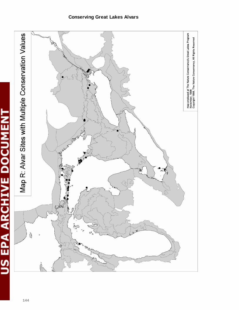
Conserving Great Lakes Alvars
144

Conserving Great Lakes Alvars
145
5.1.3 Other Significant Alvar Sites
In addition to the multiple-value sites listed above, other alvar sites across the Great Lakes basin are worthy of conservation. The following sites include one or more alvar communities with a conservation priority rank of 1 (see Table 2) or have good populations of significant species. These sites are considered viable and add significantly to the long-term conservation of biodiversity within the basin. Other significant Michigan sites:
Charboneau Lake Goudreau’s Harbor Escanaba River North Escanaba River South Grand Lake Jones Lake-Drummond Island
Kregg Bay Glade Point Detour Seaman’s Point Sucker Lake Summer Island East Shore Thompsons Harbor Observatory Point
Other significant New York sites:
Stony Point Barrens
Other significant Ohio sites:
Kelley’s Island North Shore Lakeside Daisy Nature Reserve
Other significant Wisconsin sites:
State Highway 57 Expansion Project Other significant Ontario sites:
Manitoulin: Creasor Blight Dominion Point East Side Misery Bay Evansville Shrubland Greene Island Northwest & Big Burnt Islands
Rozel’s Bay Sheguiandah Bur Oak Strawberry Island Tamarack Harbour Vidal Island
Bruce Peninsula: Baptist Harbour Barney Lake Barrier Island Bear’s Rump Island
Cabot Head Chief’s Point
Driftwood Cove Fishing Islands

Conserving Great Lakes Alvars
146
Niibin Sideroad Creek
St. Jean’s Point
Carden Plain:
Cameron Ranch Carden Alvar #2 Carden Alvar #4 Eastern Ontario: Bend Bay Valley Camden East Clay Bank
Howe’s Road
Massassauga Point Point Anne
5.1.4 Attainment of Ecoregional Goals
As outlined earlier in Section 5.1, goals and objectives for alvar communities in the Great Lakes basin call for all viable occurrences of most community types to be protected, and a total of 30 to 60 representative occurrences across the region for the G3 communities. The roster of multiple-value and other significant alvar sites identified through the Alvar Initiative contributes directly to meeting these objectives. The viability of each occurrence was evaluated through its EO ranking, and priority sites were selected partially on representation criteria. Figures H and I summarize the number and acreage of viable occurrences for each alvar community type. The contributions of these alvar sites to the globally significant and disjunct species objectives are more difficult to assess since few of these species are restricted totally to alvar habitats within the Great Lakes basin. Nearly all of the alvar sites with known occurrences of globally rare or disjunct species in the groups examined have been included on the list of significant alvar sites, with the exception of a few occurrences of G3 species on very small or degraded sites. For a few species, such as Lakeside Daisy (Hymenoxys herbacea) or the beetle Chlaenius p. purpuricollis, these alvar sites likely represent nearly all of their occurrences within the Great Lakes basin. However, most other species are not entirely confined to alvar habitats within the ecoregion, so a broader assessment of their occurrence would be needed to assess how best to meet regional conservation objectives.
5.2 Rangewide Analysis of Threats Across their Great Lakes range, alvar habitats face a daunting series of threats to their future survival and quality. The protection urgency rankings for multiple-value alvar sites, for example, place 56% of the sites with a high
Conserving Great Lakes Alvars
147
or very high securement urgency, and 53% with a high or very high management urgency (see Table 10). While the nature and extent of these threats tend to be site-specific and constantly changing, a number of common factors emerge.

Conserving Great Lakes Alvars
148
Alvar nonvascular pavement
Creeping juniper - shrubby cinquefoil alvar pavement
Annual alvar pavement-grassland
Poverty grass dry alvar grassland
Little bluestem alvar grassland
Tufted hairgrass wet alvar grassland
Scrub conifer / dwarf lake iris alvar shrubland
Juniper alvar shrubland
White cedar - jack pine / shrubby cinquefoil alvar savanna
Shagbark hickory / prickly ash alvar savanna
Chinquapin oak - nodding onion alvar savanna
Mixed conifer / common juniper alvar woodland
Red cedar / early buttercup alvar woodland
0 5 10 15 20 25
C-ranked B-ranked A-ranked
Figure H: Abundance of alvar communities in the G reat Lakes region
Alvar nonvascular pavement
Creeping juniper - shrubby cinquefoil alvar pavement
Annual alvar pavement-grassland
Poverty grass dry alvar grassland
Little bluestem alvar grassland
Tufted hairgrass wet alvar grassland
Scrub conifer / dwarf lake iris alvar shrubland
Juniper alvar shrubland
White cedar - jack pine / shrubby cinquefoil alvar savanna
Shagbark hickory / prickly ash alvar savanna
Chinquapin oak - nodding onion alvar savanna
Mixed conifer / common juniper alvar woodland
Red cedar / early buttercup alvar woodland
0 1000 2000 3000 4000 5000 6000 7000
C-ranked B-ranked A-ranked
Figure I: Acreage of alvar communities in the Great Lakes Region

Conserving Great Lakes Alvars
149
Quarrying
The loss of alvar habitats to quarries has taken place across the Great Lakes basin and continues to be a primary threat in many places. Since quarry companies seek areas of easily accessible limestone with little overburden for economic reasons, almost any alvar area within trucking distance of major urban markets is at risk. Past quarrying activities have removed alvar habitats in places such as the Marblehead Peninsula, Carden Plain, Flamborough Plain, Point Anne on the Napanee Plain, and parts of the LaCloche area. Belanger Bay on Manitoulin Island is licensed for future massive quarrying, although no extraction has occurred there yet. A variation of quarrying which has had very destructive effects is the commercial collection of glacial erratic boulders from the surface of the LaCloche Area alvar for sale to landscaping contractors. This activity, carried out over extensive areas during wet conditions with heavy machinery, has caused massive rutting and disturbance of the shallow alvar soil surface, and in many places, has completely destroyed the alvar. Similar collecting of limestone surface rubble and slabs for sale as flagstone has taken place at a few other alvar sites. Residential and related development
The construction of rural residences, cottages and second homes, trailer parks, and other forms of low-density rural development is an ongoing threat to many alvar habitats in such areas as the Bruce Peninsula, Burnt Lands and other eastern Ontario alvars, New York State alvars, Michigan’s Garden Peninsula, and some Manitoulin alvars including Strawberry Island and Misery Bay. Shoreline alvars are especially at risk. Cottage development has been proposed within several significant alvar sites along the south shore of Manitoulin Island, and scattered residential development continues in many other areas. As well as the habitat removed by the construction of a house itself, larger areas are lost under fill imported for septic beds, driveways, outbuildings, and lawns. Adjacent areas may also be damaged by rutting or disturbance during construction. A diverse mix of other rural developments can be located on alvar habitats. The Salmon River alvar has been impacted by a large commercial racetrack. Golf courses have been proposed or developed in some areas. Utility corridors also affect some alvar sites. All-terrain vehicle and off-road vehicle use
Recreational users of all-terrain vehicles, trail bikes, and off-road trucks are attracted to some alvar areas because of their flat open terrain and

Conserving Great Lakes Alvars
150
remoteness. The rutting caused by these vehicles disrupts local hydrological patterns, creates conditions suitable for the invasion by exotic species and visually scars the alvar surface. Because many people don’t recognize the special nature of alvar habitats and simply see them as easy places to drive over, these areas are often impacted negatively by hunters or other outdoor users. ATV use is a particular problem within the Burnt Lands alvar, other eastern Ontario sites, several Manitoulin Island sites including Belanger Bay, Misery Bay, and Tamarack Harbour, northern New York sites including Three Mile Creek Barrens and Lucky Star, and in parts of Maxton Plains in Michigan. However, uncontrolled off-road use can quickly develop into a management challenge on almost any alvar site. Snowmobiles are also used on many alvar sites, but their impact appears to be substantially less, or at least less documented. At several sites in New York state, impacts are noted from the creation and maintenance of fire control roads and trails, which often create rutting. In addition, nearby municipal roads create hydrological changes and corridors of deeper soil for the invasion of exotic plants both at these New York sites and at Maxton Plains. Grazing and browsing
Many grassland alvars, such as some of those on Manitoulin Island, Carden Plain, and in eastern Ontario, have been grazed by cattle for decades. In some areas, grazing has ceased in recent years, and the composition of alvar communities appears to be gradually changing as shrubs and trees recolonize. On other sites, cattle grazing is ongoing or being replaced by horse pasturing. The degree of threat posed by grazing to alvar quality is discussed in Chapter 4 and is the subject of ongoing research. While intensive grazing appears to be associated with the loss of some alvar species and an increased presence of exotic species, light grazing helps to maintain the open character of some alvars. For some alvar-related fauna such as loggerhead shrike (Lanius ludovicianus migrans), grazing to maintain short grass conditions appears to be an essential habitat requirement for nesting. Deer browsing is also an important factor in most Great Lakes alvar sites. High deer densities may be preventing successful regeneration of some alvar species, but the longer-term effects on community composition is uncertain at this stage. Ongoing research studies should help to clarify the nature and extent of this stress.

Conserving Great Lakes Alvars
151
Exotic species
Virtually all Great Lakes alvars include a diverse mix of exotic species in their flora and fauna, but the extent and trends of non-native species populations vary widely. As noted in the discussion of exotic species in Chapter 4, aggressive species which are problematic include buckthorn (Rhamnus cathartica), common St. John’s wort (Hypericum perforatum), rough-fruited cinquefoil (Potentilla recta), and many others. Canada blue grass (Poa compressa), which is considered by most experts to be an introduced species, is also well established on many alvar sites. These exotic species compete for space and nutrients with native species and, in some cases, become dominant, significantly reducing the ecological value of alvar communities. New York state alvars appear to have particularly serious problems with aggressive exotic species, but many other savanna, woodland, and grassland alvars are also noted as weedy. Plant collecting
The extent of plant collecting on alvars by hobbyists is unknown, but the removal of stunted old-growth cedars and other trees by bonsai collectors is a serious management problem on the Bruce Peninsula. Other showy wildflowers of alvars or associated limestone woodlands, such as dwarf lake iris (Iris lacustris) and several orchid species, are also at risk from collectors or from careless photographers who trample surrounding vegetation. On the Stone Road alvar on Pelee Island, commercial collection of hop trees (Humulus lupulus) and gray-headed coneflowers (Ratibida pinnata) also takes place and is difficult to control. Logging and forestry
Logging of mature trees from alvar savannas and adjacent woodlands can disrupt the landscape integrity of alvar sites. In some instances, the flat open areas provided by alvars have been used as log assembly areas or skidways, resulting in serious damage to shallow soils and vegetation communities from rutting and accumulation of bark and other debris. Very heavy uncontrolled logging has been a recent problem in parts of the Carden Plain alvars and is likely to be an issue periodically on most private land holdings that contain alvars. A related issue is the inappropriate planting of alvar sites with trees designed to provide a future commercial crop. The most striking example of this is a jack pine plantation on part of the Burnt Lands alvar. Whether these trees are removed as part of site restoration efforts, or left in place to avoid disturbing the resident populations of rare molluscs, is an issue that will have to be addressed through a site management plan.

Conserving Great Lakes Alvars
152
Waste dumping and vandalism
Many alvar sites are lightly settled, and remote roadsides provide access for dumping of household garbage, construction debris, or yard wastes. In addition to smothering small areas of alvar and being a visual eyesore, some of these materials may contain toxins that leach into local groundwater, such as lead from car batteries. At one alvar site, dust from adjacent coal piles is a problem, and quarry dust is often present at some other alvar sites. In a few places, landowners appear to have engaged in acts of ecological vandalism for no apparent reason. For example, at least one landowner has simply scraped clean an area of alvar with his bulldozer. The threat of this kind of random destruction may be partially countered by building better awareness of alvar values among landowners, but there will always likely be some residue of vandalism on both publicly and privately owned alvar sites.
5.3 Conservation Activities Underway
At least seven different types of conservation activities for alvar habitats are currently underway across the Great Lakes basin. 1. Protective public ownership
National, provincial, state, and regional government agencies all own some areas of high-quality alvar habitat in scattered sites across the basin. The Bruce Peninsula National Park incorporates several significant alvar sites, as do nearby provincial Nature Reserves. The Misery Bay Nature Reserve on Manitoulin Island incorporates a small but significant part of the Misery Bay alvar site, and parts of Burnt Lands alvar are currently proposed as a new Provincial Nature Reserve. Kelley’s Island includes alvar areas within an Ohio State park, and parts of Maxton Plain are within Michigan State Forest. The Essex Region Conservation Authority owns part of Stone Road alvar on Pelee Island. 2. Protective NGO ownership
In recent years, non-government organizations have been active in acquiring significant alvar areas as part of their nature reserve systems. The Nature Conservancy has been especially active, with large alvar holdings at Chaumont Barrens and Limerick Cedars in New York state and at Maxton Plains on Drummond Island in Michigan. The Federation of Ontario Naturalists (FON) has also acquired alvar habitats as nature reserves on Pelee Island and the Bruce Peninsula. 3. Private land stewardship

Conserving Great Lakes Alvars
153
Several non-profit organizations have worked cooperatively with private landowners to educate them about the values of alvar habitats and to encourage voluntary conservation. The Couchiching Conservancy has worked extensively with landowners on the Carden Plain and has enlisted the support and cooperation of the owners of several thousand acres of alvar. They are also negotiating a conservation easement and a future land donation. FON has sponsored similar landowner contact programs on parts of the Bruce Peninsula and Manitoulin Island. Landowner contact materials have also been prepared for alvars on the Napanee Plain, Bruce Peninsula, and Burnt Lands. TNC staff in New York state have initiated contact with private landowners in Three Mile Creek Barrens alvar site, and TNC has also been active in community-based work around alvars and other habitats in northern Michigan. In total, these projects have delivered direct contact and education to over 50 landowners, with total alvar landholdings of over 17,000 acres (7000 ha). In Ohio, a cooperative project with Lafarge, a major quarry company, has resulted in preservation of several acres of high-value alvar pavement and in colonization of former quarry areas by lakeside daisy (Hymenoxis herbacea) through experimental plantings. 4. Joint planning for protection
In several places, different groups have come together to jointly plan and undertake conservation programs for clusters of alvar sites. The most prominent example of this is a joint undertaking on Manitoulin Island among TNC, Nature Conservancy of Canada (NCC), FON, and the Ontario Ministry of Natural Resources (OMNR). These groups sponsored an evaluation of priority alvar habitats for acquisition, particularly within a large tract of corporate land currently for sale. If they are successful in persuading the company to accept their offer, a coordinated fundraising effort to secure the necessary support will ensue. Similar arrangements at a smaller scale are being discussed for a project area on the Carden Plain among the Couchiching Conservancy, NCC, and OMNR. Collectively, protection projects for alvar habitats now in the planning or implementation stages involve some 8700 acres (3580 ha) across the Great Lakes basin. At a broader scale, TNC is currently sponsoring ecoregional studies within ecoregions in the U.S. portion of the Great Lakes basin. This process, which

Conserving Great Lakes Alvars
154
involves multiple local partners in workshops to jointly evaluate conservation priorities and strategies, includes consideration of alvar habitats. Ecoregional planning will likely be undertaken for parts of the Canadian side of the basin as well in the near future. 5. Integration into the planning system
In Ontario, sites identified as Areas of Natural and Scientific Interest (ANSIs) receive a degree of protection through the municipal and provincial land use planning processes. Some alvar sites have previously been identified as provincially significant ANSI's, including parts of:
Burnt Lands Camden East Salmon River Bend Bay Valley Carden #1 Stone Road Cape Croker
Cabot Head Pine Tree Harbour Scugog Lake Dyer’s Bay/Brinkman’s Corners Fishing Islands Bear’s Rump Island
However, most other alvars have not yet been considered by the program. The FON has retained an experienced consultant to carry out an alvar theme study that will result in the identification of these ANSIs on a representative basis across southern Ontario. When this study has been reviewed and endorsed by the Ministry of Natural Resources, it should provide a basis for improved integration of selected sites into the land use planning system. In addition, private owners of ANSI areas qualify for an exemption of their property taxes under the Conservation Lands Tax Incentive Program as an incentive to retain the natural values of their lands. At a regional level, priority alvars identified by the Couchiching Conservancy are being incorporated into the Victoria County Official Plan with policies to discourage future development within these areas. The same process has taken place in some eastern Ontario municipalities and will be encouraged elsewhere as well. 6. Site management and restoration
Relatively little work has been carried out on alvar site management and restoration, but a few good examples do exist. TNC preserves at both Chaumont Barrens and Maxton Plains have been used as study sites for a range of research projects, including experimental treatments of non-native plants to evaluate control options. As well, interpretive trails and materials have been developed to increase the educational component of site management. Similarly, an interpretive boardwalk has been constructed on the FON’s North Bruce Alvar Reserve to provide visitor access with minimal habitat damage.

Conserving Great Lakes Alvars
155
FON and other conservation partners have also experimented with controlled burns as a habitat restoration technique at their Stone Road Alvar Reserve. On former quarry sites on Kelley’s Island and Marblehead Peninsula, the Ohio Department of Natural Resources has been experimenting successfully with the establishment of lakeside daisy (Hymenoxys herbacea)from transplanted seed. Site managers at Misery Bay on Manitoulin Island are looking at ways to control the invasive mossy stonecrop (Sedum acre). On the Wikwemikong Unceded First Nation, efforts are underway to deflect human use, including ATVs, from the Tamarack Harbour alvar site. 7. Raising awareness and understanding
An important part of the International Alvar Conservation Initiative has been raising awareness of the value and vulnerability of alvar habitats at various levels. This has included information oriented to the general public in magazines such as Seasons and Wildflower, and in television, radio, and print media. A general booklet and poster are also being produced to aid in promoting awareness among the general public and related audiences such as local governments (see Chapter 7). Another important audience, consisting of conservation practitioners in government, conservation groups, and academic institutions, is being addressed through this report, the Ontario alvar theme study, and state summary reports for New York, Ohio, and Michigan. In addition, a series of journal articles has been published, as listed in Chapter 7, and additional articles are anticipated from work sponsored through this Initiative or independently. Alvar-related presentations have been made at the Natural Areas 1998 Conference and other forums, and the Tobermory Alvar Workshop also served to significantly raise awareness of alvar issues.

Conserving Great Lakes Alvars
156
5.4 Priority Actions for Alvar Conservation
Alvar habitats across the Great Lakes basin are at risk. It is clear that the scope and extent of current conservation activities will not be sufficient to protect all, or even most, of the high-priority alvar sites from ongoing threats. To address this gap, four priority actions for the conservation of alvar habitats are proposed.
Priority Action 1: Continue conservation leadership
The International Alvar Conservation Initiative has been effective in creating major increases in awareness and support for protection of alvars, but only the beginning stages of on-the-ground progress towards their actual conservation have been achieved. Ongoing efforts are needed to build on the results of the past four years and to maintain momentum to secure key sites and manage them appropriately. Strong mechanisms must be in place to respond effectively when future opportunities arise or to help create opportunities at important alvar sites. The nature of this ongoing leadership can be informed by drawing on the most successful past aspects of the Alvar Initiative. Since learning more about alvar ecosystems and threats is so vital, keeping the learning network vibrant will be essential. The linking of disparate parties to jointly support protection projects is also vital, particularly to transcend agency or jurisdictional boundaries. The success of the Alvar Initiative in forging partnerships and joint projects without creating new institutions could be a good model. As well, in the face of limited resources and competing demands, continued innovation and flexibility in achieving conservation goals will be necessary. However, if further progress in conserving alvar habitats is to continue, there is a clear need for ongoing leadership – for one or two organizations who are committed to taking the central responsibility for making things happen. Fortunately, several organizations are well placed to undertake that role and to encourage others to develop or maintain their involvement in alvar conservation:
The Great Lakes Program of The Nature Conservancy should seek the necessary support to continue developing, implementing and assisting others with protection projects for high-priority alvar sites, and should incorporate alvar sites as an important component of its ecoregional protection efforts.

Conserving Great Lakes Alvars
157
The NCC, and TNC’s Canadian Conservation Partnership Program and Great Lakes Program, should consider alvar sites within the Great Lakes region as a priority for collaborative, cross-border conservation.
The Federation of Ontario Naturalists should continue its leadership role on alvar
conservation in Ontario through its nature reserves system, through encouragement of protection projects by the N CC, local land trusts, and nature clubs, and through advocacy of protective planning policies by the Province and municipalities.
A joint alvar conservation steering committee should be established involving TNC,
NCC, FON, and any other agencies or organizations directly involved in alvar conservation projects, with responsibility to achieve the following:
• jointly fund, select, and oversee a contracted part-time Alvar Specialist,
whose primary duties would include initiating, promoting, and coordinating alvar protection, planning, and research projects; raising awareness of alvar significance and threats; coordinating information exchanges about alvars among organizations and interested individuals; and producing a twice-annual electronic newsletter sent by email to members of the Alvar Working Group and any other interested subscribers to provide information about new research findings, conservation projects, and alvar management strategies.
• monitor conservation activities related to alvar habitats within the U.S. and
Canada, and periodically report on progress through presentations to appropriate conferences (such as SOLEC or the Latornell Symposium) or through brief biennial update reports.
Priority Action 2: Develop action plans for high- priority sites
A key next step will be to develop action plans for the protection of alvar sites with a high protection urgency. There are several examples of alvar site conservation plans that can be used as models. The site conservation plan for Chaumont Barrens, available from the Central and Northern New York (C/WNY) chapter of The Nature Conservancy, is one good example. On the Carden Plain, a conservation strategy for alvars and other habitats has been developed by the Couchiching Conservancy. A joint initiative on Manitoulin Island among TNC, FON, NCC, and OMNR is pursuing the acquisition and protection of a number of alvar sites on the Island. Even though many organizations and agencies may be involved with the development and implementation of action plans, a recognized lead organization for each site, or cluster of sites, is vital. For some areas, this is already well established – the Couchiching Conservancy has taken the lead for the Carden plain, the C/W NY chapter of TNC for the cluster of sites east
Conserving Great Lakes Alvars
158
of Lake Ontario, the Michigan TNC chapter for Maxton Plains and nearby alvars, the Ohio Department of Natural Resources for the Ohio cluster, and the FON for alvar sites on the Bruce Peninsula and Pelee Island. But for other alvar clusters such as Napanee Plains, local leadership is either uncertain or lacking at this point. It is important to recognize that action plans at this level involve more than ecological considerations – they must also consider social, community, and economic issues. Often, new ways must be found to integrate local concerns or traditional uses into protection strategies, so that local support will be developed and sustained. Similarly, protection does not always equate to outright ownership of alvar sites. Handshake agreements and education activities with private landowners, conservation easements, or a wide range of other techniques may be appropriate. Strengthening the protection of priority alvar sites on the ground through action plans can be achieved by the following actions:
TNC, FON, and NCC should work with state chapters, land trusts, and government agencies to identify a local lead conservation organization for each high-priority alvar site, with special emphasis on multiple-value sites with high protection urgency.
TNC, FON, and NCC should also look for opportunities to create major joint projects
at the international or regional scale, similar to the existing Manitoulin Island project. These joint projects could entail shared planning and fundraising activities.
Locally-based programs to carry out landowner contact with private owners of alvar
sites should be encouraged and supported wherever possible, both to assist in educating landowners about the ecological values of alvars and to identify properties at risk.
Members of the Alvar Working Group and other interested professionals should be
requested to make themselves available on a voluntary basis to provide advice and assistance to local lead organizations developing alvar conservation action plans.
The Province of Ontario and municipalities should be encouraged to establish regional
aggregate advisory committees where potential quarrying and alvar habitats conflict, involving aggregate producers and conservationists. In addition, the Province should designate Manitoulin Island under the Aggregate Resources Act without further delay to ensure that ecological concerns are considered in quarry applications.
The Ontario Ministry of Natural Resources should be urged to incorporate the results of
the Ontario Alvar Theme Study into their ANSI system and to participate strongly in strategic acquisition and restoration of alvar sites.
State and provincial Heritage Programs should establish S-ranks for the alvar
communities outlined in this report; encourage further inventory, analysis, and research
Conserving Great Lakes Alvars
159
related to alvar sites; and ensure that the resulting data are accessible for use as soon as possible.
TNC, NCC, and FON should increase the capacity of local partner organizations to
participate effectively in alvar conservation by providing training on site conservation planning methodology, using existing plans as models and implementing site conservation plans at specific high-priority sites in conjunction with local partners as pilot projects.
Priority Action 3: Broaden and strengthen support
An important part of the Alvar Initiative has been the creation of stronger links between the science of alvars and public education. These links not only relate to broader understanding of the ecology of alvars, but also they help to connect regional thinking with local activities by showing that locally common alvar types may be very rare at a broader scale. Building support involves more than a single strand of effort since there are several audiences to be considered and different channels to each. One key audience is private landowners, as noted above. Another is the Ontario native community, because significant alvar sites such as Cape Croker, Tamarack Harbour, and Fishing Islands are on First Nations lands, and others such as Clapperton Island are part of active native land claims. A third is conservation practitioners, both inside and outside government agencies, who can do much to aid alvar conservation if they are aware of their value. Finally, the general public is an important audience to build support for alvar conservation. The following steps will help to broaden and strengthen support for alvar conservation.
The glossy booklet and poster developed as part of the Alvar Initiative should be distributed broadly to naturalist and community groups, municipalities, and schools in areas around alvar sites.
Information on specific alvar sites and their significance should be provided to local
jurisdictions and public land management agencies that have alvars within their jurisdictions.
FON, TNC state chapters, nature clubs, and private operators should be encouraged to
conduct low-impact tours of alvar sites to increase public appreciation of their value and to demonstrate their potential as ecotourism assets to local communities.
Community-based conservation programs to develop local interest and support in alvar
and associated habitats should be continued and expanded wherever possible.

Conserving Great Lakes Alvars
160
Manitoulin Island and the Napanee Plain should be considered priorities for additional work in this important activity.
Ongoing efforts should be made to involve First Nation communities in alvar
conservation, particularly in the Bruce Peninsula and Manitoulin Island areas. TNC’s Great Lakes Program and FON should seek out opportunities to present a
synopsis of the International Alvar Conservation Initiative’s findings to key audiences within their organizations, within other conservation organizations, and within relevant government agencies.
Continued networking and collaboration among alvar researchers and conservation
practitioners should be encouraged, including site visits, periodic gatherings, and involvement in an electronic newsletter.
Priority Action 4: Fill knowledge and research gaps
The past four years of effort has enormously improved our understanding of alvar habitats and their distribution, but there is much more to learn. Ongoing research should be encouraged by conservation organizations and agencies, academic institutions, and interested individuals. Among the most important topics for further research are the following:
Additional information on what on-site activities are compatible with alvar conservation, particularly with respect to acceptable levels of cattle grazing and deer browsing
Experimentation with and research on the role of fire as a management tool for alvars Research on the effects of surrounding land use near alvars and how negative effects can
be mitigated More effective management techniques for the control of aggressive non-native species
within alvar habitats Experimentation with restoration of degraded alvar habitats, either through active
management or natural succession Improved methods to monitor and learn from management techniques as they are
applied Predictive modeling techniques to assess future threats and clarify the relative
vulnerability of alvar sites
Conserving Great Lakes Alvars
161
Documentation of the significance of alvar-associated habitats, especially including Great Lakes limestone bedrock shores, bur oak limestone savannas, and dolomite prairies, as well as the rich limestone woodlands often found adjacent to alvars
Determine the relationship between Great Lakes alvars and associated habitats to
similar community types outside the Great Lakes region Ongoing inventory and field investigation of alvar habitats, especially on known
historic sites, in shoreline and riverine settings, in the Province of Quebec, and involving lesser-known target groups such as invertebrates and nonvascular plants.
6.0 Evaluation of the Collaborative Process 6.1 Outline of the Process Steps Over a span of approximately four years, the Alvar Initiative involved a series of steps: "Conserving Great Lakes Alvars" Proposal Development
A group of about 20 people from U.S. and Canadian organizations came together under the leadership of TNC’s Great Lakes Program to identify priority threats and information gaps, reach consensus on an overall approach to address them, and guide the preparation of a proposal. Work Plan and Funding Submission
TNC’s Great Lakes Program developed a detailed proposal with review and input from the initial group, including a work plan and proposed schedule, and secured core funding through the Great Lakes Protection Fund (GLPF). Enlisting Collaborators
Potential collaborators were identified and contacted, with “word-of-mouth” and suggestions from involved organizations being used to identify interested individuals. Collaborators were asked to sign an agreement (as required by the GLPF) that they would participate through in-kind work or matching funding. First Annual Gathering
The first meeting of collaborators in April 1995 developed field forms for vegetation community and rare plant inventories, established research

Conserving Great Lakes Alvars
162
hypotheses and initial field projects on alvar ecology, set targets for rare animal groups and ecological processes to be studied, and allocated initial funding to specific projects. Considerable advance work and follow-up by TNC’s Great Lakes Program and other participants also took place. Second Annual Gathering
The second annual gathering in March 1996 featured reports on progress and findings to date, identification of priority sites for further inventory work, refinement of research hypotheses and projects, and initial discussions of the documentation needed to establish conservation priorities. Third Annual Gathering
The June 1997 gathering also provided updates on progress and findings, but divided into two sub-groups for most of its discussions. One group further reviewed and refined the alvar community classification system and discussed criteria and approaches for site prioritization. The other group developed communication strategies for target audiences and started planning for the Alvar Workshop, a task which was carried on over the next year by a small planning group. Alvar Workshop
The Tobermory Alvar Workshop, held in June 1998, was designed to communicate the Initiative’s findings on alvar distribution, community types, and ecology to a broader audience. This audience included key conservation organization and government agency staff, interested landowners, and other stakeholders. As well, conservation case studies and perspectives on alvar conservation issues were presented. Participants were also engaged in structured discussions on conservation priorities and emerging themes to help provide direction for the ongoing analysis and the final report. Reporting of Results
The last six months of the Alvar Initiative focused on finalizing and bringing together the results of a broad range of inventory and research work and ensuring that these results were communicated to the appropriate audiences. These include the conservation practitioner audience, to be addressed through this final technical report, state summaries and the Ontario alvar theme study, and published scientific articles. A broader audience of landowners and interested public are being addressed through a glossy alvar booklet, a poster, and various magazine and media articles.
6.2 Key Ingredients for Success

Conserving Great Lakes Alvars
163
Managing a project of such geographic scope and institutional complexity presents some very real challenges. Because of the number of organizations and individuals involved, decision-making can at times appear untidy, and there is a real risk of overlap or gaps in project activities. On the other hand, the opportunity for individual participants to learn from each other and feel they are an important part of something larger and international in scope is a major benefit. Because the International Alvar Conservation Initiative could serve as a model for those working towards coordination of other regional conservation efforts, we offer the following observations on the “lessons learned” from this experience, based on observations by project coordinators Sue Crispin and Ron Reid:
There appears to be tremendous potential for support of truly international, regional-scale work that has clear objectives and is well planned.
The establishment of a core project fund of significant size, as provided
for the Alvar Initiative by the Great Lakes Protection Fund and later the C.S. Mott Foundation, provides strong leverage for the commitment of additional matching funding from other sources, as well as “in-kind” commitment of staff time and resources from a wide range of agencies and organizations.
New money is essential to support new work at this scale. Many great
project ideas fail because the responsibility for carrying them forward rests with people who, though enthusiastic and capable, are already over-committed and have no additional resources to help meet new demands.
The diversity of people involved – scientists and non-scientists,
professionals and volunteers, government and non-government – adds enormously to the strength of the project. This diverse network offers flexibility in overcoming bureaucratic and jurisdictional challenges and helps make the project “real” to landowners and local agencies.
Coordination and support (financial, communications, meetings, etc.)
of large-scale, multi-partner efforts requires a major time investment – in the case of this project, 30-50% of two professional staff people’s time as well as some administrative support (10-20% of another staff person). Without dedicated coordination and support, too much responsibility for the critical details of project management and

Conserving Great Lakes Alvars
164
coordination falls back on participants, who need to be contributing expertise rather than administrative services.
The ease of group decision-making is inversely proportional to group
size. It is virtually impossible to achieve broad consensus on all of the many decisions that need to be made in a project such as this, due to both the challenge of communication among so many actors and the wide variety of individual perspectives and opinions. What works best is to achieve agreement at meetings on the key objectives and operating principles and then confer decision-making authority on various issues to identified lead actors who consult with group members when appropriate and feasible. For some specific tasks, such as planning the Alvar Workshop, small task groups worked effectively.
Despite the difficulty of decision-making in large groups, the annual
gatherings of collaborators were vital to the process, providing opportunities for progress updates, stimulating debates on contentious issues, and developing new approaches to problems. E-mail communication and occasional telephone conference calls supplement these gatherings, but cannot replace face-to-face contact.
Clear contracts or letters of agreement for individual project activities
are essential, setting out the products to be delivered, the time-frame, financial arrangements, and any other expectations. While the Alvar Initiative followed this practice for individual researchers and contractors, it did not always do so with other organizations, sometimes leading to confusion or misunderstandings later in the process.
While it is important to be crystal clear about project objectives and
stick to them, it is also essential to remain flexible about the means of achieving them. This allows room for creativity, different points of view, and opportunities for learning during the process. It also allows for flexibility in responding to new opportunities, such as additional resources provided during the course of the project.
There will be some disagreements (especially about methods and details) that are simply unresolvable and must be accepted, but everyone must feel they have at least had a chance to be heard.
As is always true in life, money complicates things. Access to new money will generate healthy competition among ideas and their proponents, but can also place collaborators who are independent researchers or contractors in an awkward position with respect to participating in group decisions on priorities and funding allocations.

Conserving Great Lakes Alvars
165
Disagreements in this area are the most difficult to manage (open and frank discussion can even be a challenge), and may ultimately fall to the project managers to resolve.
It is vital to start thinking early in the project about how results will be communicated effectively to key audiences. A strong communications strategy can help shape the analysis and reporting stages of the project in the most productive directions.
One of the benefits of a bi-national approach is the added credibility and stature it confers to local organizations who are involved as collaborators and to their local sites. Being part of such an international approach brings access to new information and ideas, contact with people working on similar challenges in other areas, and local recognition that you are part of something important. This can serve as a source of new energy and credibility for local groups in their advocacy and other protection efforts.
6.3 Adapting the Collaborative Process for Other Ecosystem Types The Alvar Initiative project manager was asked to present information on the collaborative process of a conference on Great Lakes islands as one potential ecosystem that might benefit from a similar approach. Within the Great Lakes region, other bi-national resources that might merit similar attention could include special ecosystem types often associated with Great Lakes shorelines, such as sand beaches and dune systems, bedrock and cobble beaches, unconsolidated shore bluffs, limestone cliffs and talus slopes, lakeplain prairies, sand barrens, and communities containing unusual species, such as arctic-alpine disjuncts and Atlantic coastal plain disjuncts (Reid and Holland, 1997). Specialized or sparsely distributed wetland types might also be of interest, such as fens or bogs south of the Canadian Shield or Great Lakes coastal marshes. Almost any ecosystem type could benefit from a collaborative approach if the following criteria are met:
• high biological significance • identified threats • inadequate current protection • core of knowledgeable and committed collaborators
Conserving Great Lakes Alvars
166
• clear information impediments to effective conservation action • identified conservation actors interested in using results • good potential for a willing lead funder
The initiation of a collaborative approach for any of these or other ecosystem types will be dependent on the presence of a sponsoring organization willing to take the lead in bringing together potential participants and coordinating the development and presentation of a proposal and work plan on their behalf. Our experience with the Alvar Initiative suggests that the benefits and satisfaction of working across borders to protect significant elements of biodiversity greatly outweighs the complexity of the challenge.
Conserving Great Lakes Alvars
167
7.0 Sources of More Detailed Information This report is intended to provide only an overview of the findings of the International Alvar Conservation Initiative. For those who want more detailed information, a series of sources are listed below. Detailed information on specific sites
A series of site summary documents have been prepared in various formats at the state/provincial level. These reports describe alvar characteristics and distribution for each jurisdiction and provide a summary description of individual sites and features of significance.
New York State: Alvar Conservation: Protecting Eastern North America’s Most Endangered Ecosystem: Site Summary Data for New York. By Bruce Gilman. Prepared for The Nature Conservancy C/W NY Chapter. 1998. Available from: The Nature Conservancy, Eastern Lake Ontario Project Office, 7 South Jefferson Street, Suite 3, Pulaski, NY 13142. Ohio: Alvar Landforms and Plant Communities in Ohio: Overview and Site Summaries. By Allison Cusick. Ohio Department of Natural Resources. 1998. Available from: Allison Cusick, Division of Natural Areas and Preserves, Ohio Department of Natural Resources, Fountain Square, Bldg F, Columbus, OH 43224. Michigan: Alvars of Michigan. By YuMan Lee and Lyn Scrimger. Michigan Natural Features Inventory. 1998. Available from: Michigan Natural Features Inventory, 8th Floor Mason Bldg, P.O. Box 30444, Lansing, MI 48909. Ontario: Significant Alvar Natural Heritage Areas in the Ontario Great Lakes Region. By Vivian R. Brownell Prepared for Federation of Ontario Naturalists. In press. Available from: Federation of Ontario Naturalists, 355 Lesmill Road, Don Mills, Ontario, M3B 2W8. Copies of the field data sheets on community composition for alvars studied during this project, including data for plots and species lists by structural types, are on file at TNC’s Great Lakes Program office in Chicago. As well, occurrence data on species and communities is compiled in the Biological and Conservation Database for each state/province, and can be requested through: New York Natural Heritage Program: Kathy Schneider Phone: 518-783-3937 E-mail: [email protected] Ohio Department of Natural Resources: Allison Cusick Phone 614-265-6471 E-mail: [email protected]

Conserving Great Lakes Alvars
168
Michigan Natural Features Inventory: Lyn Scrimger Phone: 517-373-1552 E-mail: [email protected] Wisconsin Natural Heritage Program: Eric Epstein Phone: 608-267-5038 E-mail: [email protected] Ontario Natural Heritage Information Centre: Jarmo Jalava Phone: 705-755-2167 E-mail: [email protected]
Information on research findings
A number of journal articles, theses, and unpublished papers can be consulted for detailed results from studies associated with or supported by the International Alvar Conservation Initiative: Bouchard, P., H. Goulet and T.A. Wheeler. 1998. Phenology and habitat preferences of three species of ground beetles (Coleoptera: Carabidae) associated with alvar habitats in southern Ontario. Proceedings of the Entomological Society of Ontario. (In press). Bouchard, Patrice. 1998. Insect diversity in alvars of southern Ontario. Prepared for Federation of Ontario Naturalists, Toronto. 87 pp. Bouchard, Patrice, 1997. Insect Diversity in Alvars Habitats, Manitoulin Island, Ontario. Prepared for Great Lakes Program, The Nature Conservancy and Ontario Natural Heritage Information Centre. 28 pp. and appendices. Catling, Paul M. and Vivian R. Brownell 1998. Importance of fire in the maintenance of distinctive, high diversity plant communities on alvars – evidence from the Burnt Lands, eastern Ontario. Canadian Field-Naturalist 112: in press. Feeney, T.P. 1997. The Geomorphic Evolution of Limestone Pavements and Alvar Grasslands in Northwestern New York State, USA. Unpublished Ph.D. dissertation, University of Georgia, Athens, GA. 311 pp. Feeney, Thomas P. 1996. The Role of Grikes in Limestone Pavement Formation in Northern New York State, USA. In Karren Landforms, eds. J.J. Fornos and A. Gines. Universitat de les Illes Balears: Palma de Mallorca, Spain. Aug. 1996. pp. 53-62. Gilman, Bruce A. 1995. Vegetation of Limerick Cedars: Pattern and Process in Alvar Communities. Unpublished dissertation, SUNY College of Environmental Science and Forestry, Syracuse, NY. 322 pp. Goodban, A.G. 1995. Alvar Vegetation on the Flamborough Plain: Ecological Features, Planning Considerations and Conservation Recommendations. Major Paper. Faculty of Environmental Studies, York University, North York, Ontario. 88 pp. + appendices. Grimm, F. Wayne. 1995. Molluscs of the Alvar Arc and the Niagara Cuesta Uplands and Barren Zones. Proceedings of the Leading Edge ‘95 Conference, Collingwood, Ontario. Ontario Ministry of Environment and Energy, Toronto.

Conserving Great Lakes Alvars
169
Reschke, Carol. 1995. Biological and hydrological monitoring at the Chaumont Barrens Preserve. Unpublished report for The Nature Conservancy’s Rodney Johnson Grants Program, Grant #R93NY01. 65 pp., + 4 appendices. Available from The Nature Conservancy, Arlington, VA. Schaefer, C.A. 1996. Plant community structure and environmental conditions of alvars on the Bruce Peninsula, Ontario, Canada. M.Sc. Thesis. University of Guelph, Ont. 156 pp. Schaefer, C.A. and D.W. Larson. 1997. Vegetation, environmental characteristics and ideas on the maintenance of alvars on the Bruce Peninsula, Canada. Journal of Vegetation Science 8:797-810. Stanton, E.J. 1998. Evaluating the completeness of a macrolepidoptera inventory using species abundance distribution: three case studies in New York State. M.S. thesis, SUNY Coll. Environ. Sci. and Forestry, Syracuse, NY. 67 pp + appendix. Stanton, Edward J. 1997. Inventory of the macrolepidoptera on alvars of Jefferson County, New York. Prepared for The Nature Conservancy C/W NY Chapter and New York Heritage Program. 19 pp. and appendices. Additional unpublished reports relating to Alvar Initiative results are included in the list of references cited. Information suitable for a general audience
A full-color booklet, titled Great Lakes Alvars, and an associated color poster are being produced by the Federation of Ontario Naturalists and are available from their Toronto office at the address listed above. Several alvar booklets oriented toward private landowners within local areas have been produced in association with the Alvar Initiative: Carden Plain Habitat Conservation, available from The Couchiching Conservancy, Carden Alvar Project, Box 330, Washago, Ontario, L0K 2B0. Manitoulin’s Flat Rock Country: A Landowners Guide to a Special Habitat, available from Federation of Ontario Naturalists, 355 Lesmill Road, Don Mills, Ontario, M3B 2W8. The Burnt Lands Alvar Habitat Conservation, The Napanee Plain Alvar Habitat Conservation, and Bruce Peninsula Alvar Habitat Conservation, all available from Ontario Natural Heritage Information Centre, Ministry of Natural Resources, Box 7000, Peterborough, Ontario, K9J 8M5. Several magazine articles oriented towards a general audience have also been published in association with the Alvar Initiative, including: The One Conservancy, newsletter, May 18, 1995 "Alvar Grasslands Protection Effort Underway" Cuesta, the Niagara Escapment Magazine, 1995 "Nature's Rock Gardens" by Claudia Schaefer
Mott Exchange, newsletter of the C.S. Mott Foundation, Summer-fall 1995
Conserving Great Lakes Alvars
170
"Why Should We Save an Alvar?" by Richards Newsletter, TNC - NYRO, Fall 1995 "Walking in a Glacier's Path" Katharine Ordway Associates UPDATE, TNC newsletter, 1995 "Diving into the Great Lakes" NHIC Newsletter, Fall 1995 "International Alvar Conservation Initiative" by Wasyl Bakowsky Ohio Division of Natural Areas and Preserves Newsletter, April-June 1996 "Alvars in Ohio" by Allison Cusick Seasons, Autumn 1996 “Habitat for the Hardy” by Ron Reid
Wildflower, magazine, Summer 1996 "The Survivors" by Claudia Schaefer "Grassland Communities on Manitoulin Island, Ontario" by John Morton "Stone Prairies" by Bruce Gilman North Coast Newsletter, Ohio Lake Erie Commission, August, 1996 "Kelleys Island North Pond, Alvar to be Dedicated as State Nature Preserve" Great Lakes Habitat Watch #36, Great Lakes United, October 21, 1996 "Alvar Conservation" Canadian Wildlife, August 1998 “When the going gets tough” by Patrice Bouchard Biosphere, Aout 1998 “Quand la vie est dure” by Patrice Bouchard The One Conservancy, TNC newsletter, August 1998 "International Workshop to Protect Globally Rare Great Lakes Alvar Ecosystems" The Nature Conservancy, Central & Western New York Chapter, newsletter, fall 1998 "Alvar: Mother Nature's Rock Garden"

Conserving Great Lakes Alvars
171
Acknowledgments Primary funding for this project came from the Great Lakes Protection Fund. Additional funds were provided by the U.S. Environmental Protection Agency’s Great Lakes National Program Office, the C.S. Mott Foundation, TNC’s Rodney Johnson grants program, and in-kind matches provided by many collaborators’ institutions and organizations. Thanks to TNC’s C/WNY chapter for access to Chaumont Barrens for research on hydrology, herbivory, fire history, and exotics, and access to Limerick Cedars Preserve for research on fire history. Thanks to Mr. Clifford Fielding and Wavy Farms for access to the LaCloche Area Alvar for research on hydrology. Mr. Josef Kercherink-Borg allowed access for study of the Lucky Star alvar, and Mr. Bernard Davies of NY DEC also provided assistance with research work in the Henderson Shores Unique Area. Thanks to Couchiching Conservancy for arranging access to Carden Township alvars for research on herbivory and invertebrates and to the following Carden landowners: Allan and Karen Popp, Elwood and Frank Stewart, and Garnet and Pat Morton. A particular thanks to the members of the Alvar Working Group (listed in Appendix 4) who contributed generously of their time, expertise, and enthusiasm to make this project a success. We also appreciate the work of Keith Monzingo who created the maps included in this report and handled the actual production of this document.

Conserving Great Lakes Alvars
172

Conserving Great Lakes Alvars
173
References Cited Albert, D.A., P.J. Comer, R.A. Corner, D.L. Cuthrell, M.R. Penskar and M.L. Rabe. 1997. Bedrock communities on Michigan’s Great Lakes shoreline. Report to Michigan Department of Environmental Quality. 215 pp. Albert, D.A., P.J. Comer, R.A. Corner, D.L. Cuthrell, M.R. Penskar and M.L. Rabe. 1995. Bedrock shoreline biological survey of the Niagaran Escarpment in Michigan’s Upper Peninsula: Mackinac County to Delta County. Report to Michgan Department of Environmental Quality, Land and Water Management Division. 51 pp. Albert, D.A., P. Comer, D. Cuthrell, M. Penskar, M. Rabe and C. Reschke. 1994. Bedrock shoreline suveys of the Keweenaw Peninsula and Drummond Island in Michigan’s Upper Peninsula. Michigan Natural Features Inventory. Lansing, MI 48909-7944. 94pp. Alvar Working Group. 1996. Preliminary research hypotheses: browsing and grazing. March 1996 unpublished meeting notes. Alvar Working Group. 1995. Definition of alvar for the purposes of the International Alvar Conservation Initiative. Unpublished. Anderson, M., P. Bourgeron, M. T. Bryer, R. Crawford, L. Engelking, D. Faber-Langendoen, M. Gallyoun, K. Goodin, D. H. Grossman, S. Landaal, K. Metzler, K. D. Patterson, M. Pyne, M. Reid, L. Sneddon, and A. S. Weakley. 1998. International classification of ecological communities: terrestrial vegetation of the United States. Volume II. The National Vegetation Classification System: list of types. The Nature Conservancy, Arlington, Virginia, USA. Baskin, J.M and C.C. Baskin 1985. Life cycle ecology of annual plant species of cedar glades of south-eastern United States. In: White, J. (editor). The population structure of vegetation. Junk Publishers. Dordrecht. Pp. 371-398. Bazely, D. R. et al. 1997. Interactions between deer and vegetation in southern Ontario, Canada: Monitoring and restoration of overgrazed plant communities in Pinery and Rondeau Provincial Park. Report 2 to the Southern Region Science & Technology Transfer Unit. Ontario Ministry of Natural Resources. Belcher, J. W. 1992. The ecology of alvar vegetation in Canada: description, patterns, competition. M.Sc. Thesis. University of Ottawa, Ontario. Belcher, J. W., Keddy, P. A., and Catling, P. A. 1992. Alvar vegetation in Canada: a multivariate description at two scales. Can. J. Bot. 70:1279-1291. Bell, J., 1870, List of plants of the Manitoulin Islands, Lake Huron. Geological Survey of Canada Report for 1867-1869. Bengtsson, K., H.C. Prentice, E. Rosen, R. Moberg and E. Sjogren 1988. The dry alvar grasslands of Oland: ecological amplitudes of plant species in relation to vegetation composition. Acta Phytogeographica Suecica 76:21-46. Bertrand, R. 1996. Hydrological Monitoring of the Chaumont Barrens: Summer 1996. Unpublished report to The Nature Conservancy.

Conserving Great Lakes Alvars
174
Beschel, R. E. 1965. Comments on the vegetation of the Kingston region. Bluebill 12: 32-36. Bouchard, Patrice. 1998. Insect Diversity in Alvars of Southern Ontario. Report presented to the Federation of Ontario Naturalists, Toronto. 87 pp. Bouchard, Patrice 1997. Insect Diversity in Alvars Habitats, Manitoulin Island, Ontario. Report presented to The Nature Conservancy Great Lakes Program and Ontario Natural Heritage Information Centre. 28 pp. + appendices. Brownell, Vivian R. 1998. Significant alvar natural heritage areas in the Ontario Great Lakes region: a preliminary discussion paper. Prepared for Federation of Ontario Naturalists, Toronto. 54 pp. Brunton, Daniel F. 1988. The Clay Bank Alvar: An Important Natural Area in the Ottawa Valley. Trail and Landscape. Vol. 22: No. 2: 53-65. Brunton, D.F. 1986. A life science inventory of the Burnt Lands. Ontario Ministry of Natural Resources. 118 pp. + maps. Catling, Paul M. 1995. The extent of confinement of vascular plants to alvars in southern Ontario. Canadian Field-Naturalist 109(2): 172-181. Catling, Paul M. and Vivian R. Brownell. 1998. Importance of fire in the maintenance of distinctive, high diversity plant communities on alvars – evidence from the Burnt Lands, eastern Ontario. Canadian Field-Naturalist 112: in press. Catling, Paul M. and Vivian R. Brownell. 1995. A review of the alvars of the Great Lakes region: distribution, floristic composition, biogeography and protection. Canadian Field-Naturalist 109(2): 143-171. Catling, P.M., A. A. Reznicek, and W. J. Crins. 1993. Carex juniperorum (Cyperaceae), a new species from northeastern North America, with a key to Carex sect. Phyllostachys. Systematic Botany 18(3): 496-501. Catling, P. M., J. E. Cruise, K. L. McIntosh, and S. M. McKay. 1975. Alvar vegetation in southern Ontario. Ontario Field Biologist 29(2): 1-25. Chabot, A. A. 1994. Habitat selection and reproductive biology of the Loggerhead Shrike in eastern Ontario and Quebec. Faculty of Science, Macdonald College, McGill University, Montreal, P.Q. Comer, P. J., D. L. Cuthrell, D. A. Albert, and M. R. Penskar. 1997. Natural community abstract for limestone/dolostone pavement lakeshore. Michigan Natural Features Inventory, Lansing, MI. 4 pp. Comer, P.J., D.A. Albert, H.A. Wells, B.L. Hart, J.B. Raab, D.L. Price, D.M. Kashian, R.A. Corner & D.W. Schuen (map interpretation); T.R. Leibfreid, M.B. Austin, C.J. DeLain, L. Prange-Gregory, L.J. Scrimger, K.M. Korroch, & J.G. Spitzley (digital map production). 1995. Michigan's presettlement vegetation, as interpreted from the General Land Office Surveys 1816-1856. Michigan Natural Features Inventory, Lansing, MI. digital map. Comer, P.J., D.A. Albert, H.A. Wells, B.L. Hart, J.B. Raab, D.L. Price, D.M. Kashian, R.A. Corner and D.W. Schuen. 1995. Michigan’s native landscape, as interpreted from the General Land Office Surveys 1816-1856. Report to the U.S.E.P.A. Water Division and the

Conserving Great Lakes Alvars
175
Wildlife Division, Michigan Department of Natural Resources. Michigan Natural Features Inventory, Lansing, MI. 78 pp. Coulianos, C.C. and E. Sylven. 1983. The distinctive character of the Great Alvar (Oland, Sweden) from an entomological point of view. Entomologisk Tidskrift. 104:213-234. Cronquist, A., 1991, Manual of Vascular Plants of Northeastern United States and Adjacent Canada 2nd ed., New York Botanical Garden, N.Y. Curtis, J.T. 1959. The vegetation of Wisconsin. Madison: The University of Wisconsin Press. D’Arcy, Gordon, and John Hayward 1997. The Natural History of The Burren. Immel Press, London, England. 168 pp. Dore, W.G. and McNeill, J., 1980, Grasses of Ontario, Monograph No. 26., Agriculture Canada, Ottawa. Dunn, Erica H. and C.M. Downes. 1998. Monitoring Canada’s songbirds: status and results. Bird Trends. No. 6, Spring 1998. Canadian Wildlife Service, Ottawa. Erickson, R.O., L.G. Brenner and J. Wraight. 1942. Dolomitic glades of east-central Missouri. Annals of the Missouri Botanical Garden 29:89-101. Feeney, T.P. 1997. The Geomorphic Evolution of Limestone Pavements and Alvar Grasslands in Northwestern New York State, USA. Unpublished Ph.D. dissertation, University of Georgia, Athens GA. 311 p. Feeney, T.P. 1996. The Source of Seasonal Flood Waters in Alvar Grasslands: Chaumont Barrens, New York State. Unpublished report to The Nature Conservancy. Gilman, Bruce. 1997a. An Addendum to Summary of Original Land Survey Data for Northern New York Alvar Sites. Unpublished report for The Nature Conservancy's Alvar Conservation Initiative. Gilman, Bruce. 1997b. Recent Fire History Data for the Perch River Barrens Alvar Site. Unpublished report for The Nature Conservancy's Alvar Conservation Initiative. Gilman, Bruce. 1996a. Summary of Original Land Survey Data for Northern New York Alvar Sites. Unpublished report for The Nature Conservancy's Alvar Conservation Initiative. Gilman, Bruce. 1996b. A Search for Potentially Ancient Conifer Trees in Northern New York Alvar Sites. Unpublished report for The Nature Conservancy's Alvar Conservation Initiative. Gilman, Bruce A. 1995. Vegetation of Limerick Cedars: Pattern and Process in Alvar Communities. Unpublished dissertation, SUNY College of Environmental Science and Forestry, Syracuse, NY. 322 pp. Goodban, Anthony G. 1995. Alvar vegetation on the Flamborough Plain: ecological features, planning issues and conservation recommendations. MS thesis, York University, North York, Ontario. Grimm, F. Wayne. 1995. Molluscs of the Alvar Arc and the Niagara Cuesta Uplands and Barren Zones. Proceedings of the Leading Edge ‘95 Conference, Collingwood, Ontario. Ontario Ministry of Environment and Energy.

Conserving Great Lakes Alvars
176
Grossman, D. H., D. Faber-Langendoen, A. S. Weakley, M. Anderson, P. Bourgeron, R. Crawford, K. Goodin, S. Landaal, K. Metzler, K. D. Patterson, M. Pyne, M. Reid, and L. Sneddon. 1998. International classification of ecological communities: terrestrial vegetation of the United States. Volume I. The National Vegetation Classification System: development, status, and applications. The Nature Conservancy, Arlington, Virginia, USA. Hamilton, K.G.A. 1996. Native leafhoppers at US alvar sites. Unpublished report submitted to The Nature Conservancy Great Lakes Program. 3 pp. Hamilton, K.G.A. 1995. Evaluation of leafhoppers and their relatives (Insecta: Homoptera: Auchenorrhycha) as indicators of prairie reserve quality. Proceedings of the 14th North American Prairie Conference. Preney Print and Litho Inc. Windsor. Pp. 211-226. Hamilton, K.G.A. 1994. Leafhopper evidence for origins of Northeastern relict prairies (Insecta: Homopterea: Cicadellidae). Proceedings of the 13th North American Prairie Conference. Preney Print and Litho Inc. Windsor. Pp. 61-70. Hamilton, K.G.A. 1990. Grasslands of Ontario and surrounding areas. Arthropods of Canadian Grasslands Newsletter. 5:2-10. Johnsen, J. H. 1971. The Limestones (Middle Ordovician) of Jefferson County, New York. Map and Chart Series # 13, New York State Museum and Science Service, Albany NY. Jones, Judith. 1997. Report on the Fire History of the Bur Oak Alvars, Sheguiandah Township, Manitoulin Island. Unpublished report prepared for The Nature Conservancy’s Alvar Conservation Initiative. December 1997. 10 pp + 4 maps. Jones, Judith. 1996. Report From Fieldwork on Manitoulin Island Area Alvars 1995 and 1996. Unpublished report for The Nature Conservancy's Alvar Conservation Initiative. Kirk, Donald A. 1992. Stone Road Alvar, Pelee Island: management of an unusual oak savannah community type in the western Lake Erie archipelago. pp 33 - 43 in: Spirit of the Land, Our Prairie Legacy. Proceedings of the Thirteenth North American Prairie Conference. R.G. Wickett, P.D. Lewis, A. Woodliffe, and P. Pratt, eds., Dept. of Parks and Recreation, Windsor, Ontario, Canada. Koh, S. and D.R. Bazely. 1994. Response of vegetation to grazing pressure by white-tailed deer Odocoileus virginianus. Point Pelee National Park, Internal Report. Koh, S and D.R. Bazely. 1992. Response of vegetation to grazing pressure by white-tailed deer Odocoileus virginianus. Point Pelee National Park, Internal Report. Koh, S. 1995. The effect of white-tailed deer Odocoileus virginianus on herbaceous plant species composition and cover in Rondeau Provincial Park. M.Sc. Thesis, York University, Toronto, Canada. Lee, H. T., W. D. Bakowsky, J. Riley, J. Bowles, M. Puddister, P. Uhlig, and S. McMurray. 1998. Ecological Land Classification for Southern Ontario: First Approximation and Its Application. Ontario Ministry of Natural Resources, Southcentral Science Section, Science Development and Transfer Branch. SCSS Field Guide FG-02. Lougeay, R. 1994. Hydroclimatic Reconnaissance of the Chaumont Barrens. Unpublished report to The Nature Conservancy.

Conserving Great Lakes Alvars
177
Lougeay, R. 1996. Rates of Desiccation: Chaumont Barrens, NY. Unpublished report to The Nature Conservancy. Marr, J. K. 1997. Cryptogams of an alvar on Drummond Island, Chippewa County, Michigan. Unpublished report submitted in partial fulfillment of the requirements for the Master of Science Degree. Department of Biological Sciences, Michigan Technological University, Houghton, MI McCune, B. and M. J. Mefford. 1997. PC-ORD. Multivariate Analysis of Ecological Data, Version 3.0. MjM Software Design, Gleneden Beach, Oregon, USA. McCune, B. and M. J. Mefford. 1995. PC-ORD. Multivariate Analysis of Ecological Data, Version 2.0. MjM Software Design, Gleneden Beach, Oregon, USA. Morton, J.K. and Venn, J. M., 1990, A Checklist of the flora of Ontario Vascular Plants, University of Waterloo, Biology Series No. 34, Waterloo, Ontario. Morton, J.K. and Venn, J.M., 1984, The Flora of Manitoulin Island, University of Waterloo, Biology Series, No. 28, Waterloo, Ontario. Pearl, D.L., S. Koh, D.R. Bazely, D.R. Voigt, M. Tang and W. Soo. 1995. Interactions between deer and vegetation in southern Ontario, Canada: Monitoring and restoration of overgrazed plant communities in Pinery and Rondeau Provincial Park. Southern Region Science & Technology Transfer Unit Technical Report. TR-010. 49 pg. Ontario. Ministry of Natural Resources. Reid, Ron and Karen Holland. 1997. The Land by the Lakes: Nearshore Terrestrial Ecosystems. State of the Lakes Ecosystem Conference 1996 Background Paper. U.S. Environmental Protection Agency, Chicago. Reschke, Carol. 1995a. Biological and hydrological monitoring at the Chaumont Barrens Preserve. Unpublished report for The Nature Conservancy’s Rodney Johnson Grants Program, Grant #R93NY01. 65 p., plus 4 appendices. Copies available from The Nature Conservancy, Arlington, VA. Reschke, C. 1995b. Development of Research Methodologies for the International Alvar Conservation Initiative. Report for The Nature Conservancy’s Rodney Johnson Grants program, Grant #R95MR01. Reschke, Carol. 1990a. Ecological Communities of New York State. New York Natural Heritage Program, New York State Department of Environmental Conservation, Latham, NY. 96 pp. Reschke, Carol. 1990b. Techniques used for the inventory of rare ecological communities in New York State. pages 102 - 105 in: Ecosystem Management: Rare Species and Significant Habitats. New York State Museum Bulletin 471, Albany, NY. Rosen, E. 1995. Periodic droughts and long-term dynamics of alvar grassland vegetation on Oland, Sweden. Folia Geobotanica et Phytotoxonomica, Praha. 30:131-140. Rosen, E. 1992. Vegetation development and sheep grazing in limestone grasslands of south Oland, Sweden. Acta Phytogeographica Suecica 72:1-104.

Conserving Great Lakes Alvars
178
Rusch, Graciela. 1996. Alvar landscapes in Europe. Unpublished paper. 3 pp. Rusch, Graciela 1988. Reproductive regeneration in grazed and ungrazed limestone grassland communities on Oland: preliminary results. Acta Phytogeographica Suecica 76:113-124. Samuels, A. 1998. Untitled report on results of research on buckthorn (Rhamnus cathartica) at Chaumont Barrens Preserve. 45 pp. The Nature Conservancy, Eastern Lake Ontario Program Office, Pulaski, NY. Schaefer, C.A. and D.W. Larson. 1997. Vegetation, environmental characteristics and ideas on the maintenance of alvars on the Bruce Peninsula, Canada. Journal of Vegetation Science 8:797-810. Schaefer, Claudia. 1996a. The Role of Fire in Carden Township Alvars. Unpublished report for The Nature Conservancy's Alvar Conservation Initiative. Schaefer, Claudia. 1996b. Map of Potential Alvar Habitat in Carden Township, Victoria County, Ontario, in the Mid-1800's. Unpublished report for the Couchiching Conservancy, Orillia, Ontario. Schaefer, Claudia. 1996c. Comments on the Role of Fire in Bruce Peninsula Alvars. Unpublished report for Federation of Ontario Naturalists, Don Mills, Ontario. Schaefer, Claudia. 1996d. Map of Potential Alvar Habitat in St. Edmund's Township, Bruce County, in the Year 1855. Unpublished report for Federation of Ontario Naturalists, Don Mills, Ontario. Schaefer, C.A,. and D.W. Larson. 1997. Vegetation, environmental characteristics and ideas on the maintenance of alvars on the Bruce Peninsula, Canada. Journal of Vegetation Science 8:797-810. Schaefer, C.A. 1996e. Plant community structure and environmental conditions of alvars on the Bruce Peninsula, Ontario, Canada. M.Sc. Thesis. University of Guelph, Ont. 156 pp. Slack, Nancy G., Carol Reschke, and Bruce Gilman. 1988. Scorpidium turgescens rediscovered in New York. The Bryologist 91(3):217-218. Smith, Ian (ed.) 1996. Assessment of species diversity in the mixed wood plain ecozone. Ecological Monitoring Assessment Project, Halifax and Ottawa. Web site www.cciw.ca/eman-temp/reports/publications/Mixedwood/intro.html Sneddon, Lesley (ed.) 1994. Field Form Instructions for the Description of Sites and Terrestrial, Palustrine, and Vegetated Estuarine Communities. Version 2. The Nature Conservancy, Eastern Heritage Task Force, Boston, MA. Stanton, E.J. 1997. Inventory of the macrolepidoptera on alvars of Jefferson County, New York. Report submitted to The Nature Conservancy and the New York Department of Environmental Conservation. Stephenson, S.N. 1995. Annual report to The Nature Conservancy on long-term monitoring activities on the Maxton Plains Preserve. 23 pp.

Conserving Great Lakes Alvars
179
Stephenson, S.N. and P.S. Herendeen. 1986. Short-term Drought Effects on The Alvar Communities of Drummond Island, Michigan. The Michigan Botanist 25: 16-27. Tatnall, C. 1996. Field Observations at Chaumont Barrens: Graphic Interpretations of Information Collected by Rebecca Bertrand During Summer 1996. Unpublished report to The Nature Conservancy. Tester, John R. 1996. Effects of fire frequency on plant species in oak savanna in east-central Minnesota. Bulletin Torry Botanical Club 123(4): 304-308. Titlyanova, A., G. Rusch and E. van der Maarel. 1988. Biomass structure of limestone grasslands on Oland in relation to grazing intensity. Acta phytogeographica suecica 76:125-134. Voss, E.G., 1972, The Michigan Flora Vol. I, Cranbrook Institute of Science, Bloomfield Hills, Michigan. Waller, Don, and Tom Rooney. 1998. How many deer are too many? Impacts on plant populations and the concept of carrying capacity. Presentation to 1998 Natural Areas Association Conference, Mackinac Island, MI. Program abstract. Zander, R. H. and P. M. Eckel. Tortula cainii: Additional Ontario Records and Behavior in a Common Garden. The Bryologist 83(2):209-211.

Conserving Great Lakes Alvars
180
Appendix 1: Detailed Community Inventory Methods Alvar working group collaborators who participated in community field surveys agreed to use consistent field methodologies across all jurisdictions, including the same field forms, for documenting communities at alvar sites. The methodology initially adopted in 1995 followed the guidelines provided by regional ecologists at The Nature Conservancy's Eastern Regional Office (Sneddon 1994). Essentially the same methodology, using similar field forms, has recently been described in detail in a new publication by The Nature Conservancy describing TNC's national vegetation classification (Grossman et al. 1998). Examples of the field forms we used are provided below. In addition to the standard field forms, Alvar Working Group collaborators designed two "Addendum" forms for field workers to record additional data specifically needed for the Alvar Initiative Project. The Addendum to Community Form 1 (Reconnaissance) was used to record observations of evidence of ecological processes (herbivory, fire, soil moisture regime, land use history) and alvar microhabitat features. The Addendum to Community Form 2 (Community Ranking and Description) was used to record a full species list of plants observed in each alvar structural type at a site; each species listed is assigned an abundance class. Specific instructions for completing the Addendum forms are provided below with the field forms. Definitions of the six alvar structural types are also included. At the 1996 meeting of the Alvar Working Group, a few collaborators who used the field forms suggested improvements for the field forms that would streamline the data collection process. The suggestions were used to redesign Community Form 1 so that one form (instead of two) could be used to describe the structure and composition of the vegetation, as well as to compile a fairly complete species list for plants observed within the structural type. Basically, the 1996 version of Community Form 1 combined the functions of the 1995 Field Form 1 with the species list in the 1995 Addendum to Community Form 2. One big benefit of the revised field form is that the field worker does not need to repeatedly write species names for each observation point. The following examples of field forms include the Site Survey Summary Form (used to summarize information on all the communities and rare species present at a site); the 1995 Community Forms 1, 2 and 3; the Addendum Forms; and the 1996 revised Community Form 1. Following the field forms are the definitions of the six structural types we used as our initial classification of alvar community types.

Conserving Great Lakes Alvars
181

Conserving Great Lakes Alvars
182

Conserving Great Lakes Alvars
183
Appendix 2: Detailed Community Analysis Methods Field data collected by collaborators in Michigan, Ontario, and New York were compiled by the Heritage program staff in each jurisdiction, and provided to Carol Reschke (inventory and research coordinator for the Alvar Initiative). With assistance from a contractor (Karen Dietz), field data on vegetation, environment, and evidence of ecological processes from alvar sites were entered into spreadsheets using Lotus 123 and Excel software. Spreadsheets were edited to combine a few ambiguous taxa (e.g. Sporobolus neglectus and S. vaginiflorus, which look similar and can only be positively distinguished when they are flowering in early fall), incorporate consistent nomenclature, delete duplicates, and delete species that occurred in only one or a few samples. Vegetation data were compiled from two sources: 10 x 10 m square releve plots (Community Form 3) and species lists compiled for each structural type (from the 1995 Addendum to Community Form 2, or 1996 Community Form 1). Corresponding data on the environment and evidence of ecological processes were compiled in two additional spreadsheets. The plot data set consisted of data from 85 sample plots; there were 240 taxa of vascular and nonvascular taxa included in the initial data set. The structural type data set consisted of 120 samples and 335 taxa of vascular and nonvascular plants. All data analyses were completed by Carol Reschke. Analysis of Releve Plot Data The plot data set included a great deal of structural detail. If a tree species was present in different vegetation layers, then it was recorded as a separate taxon for each layer in which it occurred; for example, Thuja occidentalis might be recorded as a tree (over 5 m tall), a tall shrub (2 to 5 m tall), and a short shrub (05 to 2 m tall). Initially, the full data set of 85 samples by 240 taxa was analyzed using PC-ORD software (McCune and Mefford 1995). Vegetation data on percent cover were relativized for each sample and then transformed with an arcsine - square root transformation. This standardization is recommended for percentage data (McCune and Mefford 1995). Two kinds of classification and two kinds of ordination procedures were run on the full data set. Classification procedures used were: 1) cluster analysis with group average (or UPGMA) group linkage method and Sorenson's distance measure, and 2) TWINSPAN with the default settings. The two ordination procedures used were 1) Bray-Curtis ordination with Sorenson's distance and variance-regression endpoint selection, and 2) non-metric multidimensional scaling (NMS) using Sorenson's distance and the coordinates from the Bray-Curtis ordination as a starting configuration.

Conserving Great Lakes Alvars
184
Environmental data recorded for each plot and data on evidence of ecological processes were used as overlays in ordination graphs to interpret ordination patterns and relationships between samples. The classification dendrograms and ordination graphs were presented to a core group of ecologists to discuss the results. Participants in the data analysis discussions were: Wasyl Bakowsky, Don Faber-Langendoen, Judith Jones, Pat Comer, Don Cuddy, Bruce Gilman, Dennis Albert, and Carol Reschke. The two classifications were compared to see how they grouped plots, and ordinations were consulted to check and confirm groupings of plots suggested by the classification program. At the end of the first meeting to discuss the data analysis, collaborating ecologists agreed on eight alvar community types, and suggested another four or five that had been observed in field surveys but were not represented in the plot data set. The group also recommended some refinements to the data analysis. Following the recommendations of the ecology group, the plot data were modified in two ways. For nonvascular plants, the first data set included data on individual species or genera, as well as taxa representing simple growth forms. Since only a few collaborators could identify nonvascular plants in the field, we had agreed to describe the nonvascular plants in plots by their growth form and collect a specimen if the species had at least 5% cover in the plot. If nonvascular species were identified by the surveyor, or from the collected specimen, the species were included in the data set. We decided this may have biased the results, because the plots sampled by folks who knew the nonvascular plants had a greater potential diversity than plots in which only a few growth forms were identified. So all data on nonvascular taxa were lumped into nine growth form categories: foliose algae (e.g. Nostoc), rock surface algae, microbial crusts, turf or cushion mosses, weft mosses, thalloid bryophytes, crustose lichens, foliose lichens, and fruticose lichens. The second modification involved lumping the different structural growth forms of woody taxa into a single taxon; for example, trees, tall shrubs and short shrubs forms of Thuja occidentalis were lumped into a single taxon. These modifications reduced the dimensions of the plot data set to 85 plots by 199 taxa with the nonvascular taxa lumped, and even fewer taxa with the woody growth forms lumped. The analyses were run again using the procedures described above with the modified data sets. It turned out that lumping the nonvascular plants improved the classification and ordination results (yielding more clearly defined groups), but lumping the growth forms of tree species was actually detrimental to the results. The final classification that we used was produced from an analysis of the data set with nonvascular plants lumped into nine growth forms, and multiple growth forms of tree species kept separated.

Conserving Great Lakes Alvars
185
Analysis of Structural Type Data Once the optimal procedure for classifying and ordinating the plot data was determined, the same procedures were applied to the structural type data set. The primary difference in the structural type data set was that abundance for each species was recorded in one of four broad cover classes so the abundance data entered were midpoints of the four cover classes. In other words, the data were less precise in terms of percent cover than the plot data. Our intent in analyzing the structural type data was to test the classification results from the analysis of the plot data. We wanted to know if the structural type data would be classified into the same community types as the plot data. The results from the analysis of the structural type data set were very ambiguous and very different from the results of the plot data. After reviewing and discussing the data with collaborators (mostly in conference calls), we realized that the ambiguous results were an artifact of our sampling procedure. For example, if a site has two types of grassland present (e.g. poverty grass dry alvar grassland and tufted hairgrass wet alvar grassland) and the structural type data were collected from the portion of the site with "grassland" structure, then the structural type data for that particular site actually includes species from two different community types. Some of the structural type data may have included only one community type, but it was difficult, and sometimes impossible, to tell from the field data. So we discarded the analysis of structural type data and used only the plot data for describing the community types. Once the classification results were finalized and agreed upon by collaborators, the community type numbers were entered into the vegetation spreadsheets, and the plot data were sorted into groups by community type. Within each community type, species composition was then summarized by calculating average percent cover for each species and then sorting the species in order of average percent cover across all the samples from the community type. The most abundant species in each vegetation layer were included in the community descriptions in Chapter 2. Vegetation data recorded at reconnaissance observation points (on Community Form 1) were reviewed, and each observation point was assigned to one of the 13 alvar or three other (non-alvar) community types recognized in data analyses. Although the vegetation data from observation points were not entered in spreadsheets, the data on environment and evidence of ecological processes (recorded on the Addendum to Community Form 1) were entered into spreadsheets. Once the final community types were assigned to

Conserving Great Lakes Alvars
186
each observation point, data on ecological processes were evaluated for each community type. Availability of Data Spreadsheet files with compiled vegetation data from plots and structural types will be available from TNC's Great Lakes Program Office or from the state or provincial Heritage Programs. Original field forms are already filed at state/provincial Heritage Programs.

Conserving Great Lakes Alvars
187

Conserving Great Lakes Alvars
188
Appendix 3: Alvar Community Technical Descriptions and Element Occurrence Ranking Specifications
Final Alvar Initiative Community Types Recognized: (community type numbers in parentheses) Open Grasslands and Pavements:
Tufted hairgrass wet alvar grassland (type # 2) Little bluestem alvar grassland (type # 3) Annual alvar pavement-grassland (type # 4) Alvar nonvascular pavement (type # 7) Poverty grass dry alvar grassland (type # 13) Shrublands:
Creeping juniper - shrubby cinquefoil alvar pavement (type # 5) Scrub conifer / dwarf lake iris alvar shrubland (type # 6) Juniper alvar shrubland (type # 8) Savannas and Woodlands:
Shagbark hickory / prickly ash alvar savanna (type # 10) Chinquapin oak - nodding onion alvar savanna (type # 11) White cedar - jack pine / shrubby cinquefoil alvar savanna (types # 14 & 15) Mixed conifer / common juniper alvar woodland (type # 16) Red cedar / early buttercup alvar woodland (type # 17) Communities similar to alvar communities (EO specifications not included):
River ledge limestone pavement (type # 1) Great Lakes limestone bedrock lakeshore (type # 9) Bur oak limestone savanna (type # 12) Midwest wet-mesic dolomite prairie (IL reports) Comparable names for these communities within the state or provincial jurisdictions that have previously recognized alvar communities are shown on Table 11.

189
Table 11: Comparison of Alvar Community Types with State / Provincial Heritage Classifications - December 15, 1998
orig. type number
Alvar Initiative Community Type (BCD Synonym)
Ontario NHIC classification equivalent New York HP classification equivalent Michigan NFI equivalent
2 tufted hairgrass wet alvar grassland Fresh - Moist Tufted Hairgrass Open Alvar Meadow Type
Alvar grassland Alvar - grassland, or Alvar - pavement
3 little bluestem alvar grassland Dry - Fresh Little Bluestem Open Alvar Meadow Type
(not known from NY) Alvar - grassland, or Limestone pavement lakeshore
4 annual alvar pavement-grassland Dry Annual Open Alvar Pavement Type patches within Alvar grassland (not known from Michigan)
7 alvar nonvascular pavement Dry Lichen - Moss Open Alvar Pavement Type patches within Calcareous pavement barrens
(not known from Michigan)
13 poverty grass dry alvar grassland Dry - Fresh Poverty Grass Open Alvar Meadow Type
patches within Calcareous pavement barrens
Alvar - grassland
5 creeping juniper - shrubby cinquefoil alvar pavement
Creeping Juniper - Shrubby Cinquefoil Dwarf Shrub Alvar Type
(not known from NY) Alvar - glade
6 scrub conifer / dwarf lake iris alvar shrubland
Scrub Conifer - Dwarf Lake Iris Shrub Alvar Type (not known from NY) Alvar - glade
8 juniper alvar shrubland Common Juniper Shrub Alvar Type Calcareous pavement barrens Alvar - pavement, or Alvar - grassland
10 shagbark hickory / prickly ash alvar savanna (Flamborough Pl. type)
Shagbark Hickory - Prickly Ash Treed Alvar Type (not known from NY) (not known from Michigan)
11 Chinquapin oak - nodding onion alvar savanna (Pelee Island type)
Chinquapin Oak - Nodding Onion Treed Alvar Type
(not known from NY) (not known from Michigan)
14 & 15 white cedar - jack pine / shrubby cinquefoil alvar savanna
White Cedar - Jack Pine Treed Alvar Type (not known from NY) glade zone of Limestone pavement lakeshore
16 mixed conifer / common juniper alvar woodland
Jack Pine - White Cedar - White Spruce Treed Alvar Type
some patches within Limestone woodland (coniferous type)
(not reported from Michigan)
17 red cedar / early buttercup alvar woodland
Red Cedar - Early Buttercup Treed Alvar Type ~ Calcareous pavement barrens, OR ~ Red cedar successional woodland
(not reported from Michigan)
OTHER COMMUNITIES STUDIED (alvar-related communities that occur on limestone or dolomite outcrops, but are not considered alvar types for this project; data were collected from a few examples of these types for the alvar initiative project.)
1 river ledge limestone pavement (not currently in ONHIC classification) (not currently in NYHP classification) Alvar - grassland
9 Great Lakes limestone bedrock lakeshore
Shrubby Cinquefoil Carbonate Open Bedrock Beach Type
Calcareous shoreline outcrop Limestone pavement lakeshore
12 bur oak limestone savanna Bur Oak Treed Alvar Type (not known from NY) ??
IL reports midwest wet-mesic dolomite prairie (not known from ON) (not known from NY) ??

Conserving Great Lakes Alvars
190
Tufted hairgrass wet alvar grassland (type # 2)
EO SPECS and EO RANK SPECS: Proposed GNAME: Deschampsia cespitosa - (Sporobolus heterolepis - Schizachyrium scoparium) - Carex
crawei - Senecio pauperculus herbaceous vegetation Proposed Common Name:
Tufted hair grass - (prairie dropseed - little bluestem) - Crawe's sedge - balsam ragwort herbaceous vegetation
Proposed Synonym: Tufted hairgrass wet alvar grassland GRank: G2 Sites where plots were sampled: Belanger Bay (ON), Carden Alvar (#1 - Morton) (ON), Carden Alvar (#2a - Jesin) (ON), Carden Alvar (#5c - Lepone), Gretna Alvar (ON), Lucky Star Alvar (NY), Chaumont Barrens (NY), Three Mile Creek Barrens (NY), Maxton Plains (MI) EOSPECS:
Occurrences of the community must have a minimum of 1.25 acres (0.5 ha) of grassland dominated by characteristic native species, such as Deschampsia cespitosa, Carex crawei, Sporobolus heterolepis, Senecio pauperculus, Sporobolus neglectus, S. vaginiflorus, Solidago ptarmicoides, Trichostema brachiatum, Eleocharis compressa, and Allium schoenoprasum. Typically there are several turf and weft mosses forming a patchy mat at the base of grasses and forbs; typical mosses are Bryum pseudo-triquetrum, Abietinella abietinum, Tortella tortuosa, and Drepanocladus spp. This community occurs in small to large patches. Soils are very shallow (usually less than 10 cm deep) and patchy over limestone bedrock. Sizes of currently known occurrences range from under 2 acres to about 100 acres (0.8 to 40 ha). The grassland may have been disturbed by grazing, as long as characteristic native species are still common. The characteristic soil moisture regime of seasonal flooding and saturation in early spring and late fall, combined with summer drought in most years (except unusually wet years) must be intact. The physiognomy of the vegetation meets the following criteria:
a) there is less than 10% cover of trees over 5 m tall; average cover of trees is less than 1% cover
b) there is usually less than 10% cover of shrubs; average cover of shrubs is less than 1% cover
c) there is at least 50% cover of graminoid plants; average cover of herbs (including graminoids) is over 80% cover
d) there is a variable cover of mosses, lichens, and algae; average cover of lichens, mosses, and algae is about 45% cover
e) less than 50% of the ground surface is exposed bedrock (including bedrock covered with nonvascular plants: lichens, mosses, algae); average amount of exposed bedrock is about 10% of the surface area.
Individual EOs are separated by one of the following: · a substantial barrier, such as a river or lake or manmade linear feature such as

Conserving Great Lakes Alvars
191
herbicide-treated roadsides of a paved, two-lane road; · an area of cultural vegetation (e.g. farm fields, pasture, plantation) greater than
0.3 mi (0.5 km) across; · a different, intervening, natural community type that is not typically part of an
alvar landscape matrix and is greater than 0.6 mi (1 km) across; · different, intervening, alvar community types that separate patches of alvar
grassland by more than 3.1 mi (5 km); · a different, intervening substrate that is not a limestone or dolostone pavement. Justification: Wet alvar grasslands usually occur as small to large patches within an alvar landscape. Sometimes there are small patches of an alvar pavement of a different alvar grassland community within a large patch of these wet alvar grasslands. The grassland patches within the same alvar landscape matrix may share hydrological processes, although the hydrology of these grasslands is not fully understood. RANK PROCEDURE: Ranking follows standard TNC ranking procedures described in the February 5, 1997 "Element Occurrence Data Standard" document. CONDITION SPECS: "A" - rated condition: grassland has minimal human disturbance evident: few or no ruts, no barbed wire fences, no artificial berms, and no structures that could alter drainage or hydrologic regime. The grassland has no more than trace amounts of exotic species other than Poa compressa and Hypericum perforatum. Diversity of the invertebrate fauna has not been reduced by pesticide spraying. "B" - rated condition: there may be some evidence of human disturbance, such as ruts, barbed wire fences, or some light grazing; but the disturbance has had little apparent impact on overall composition of the community: the grassland is predominantly native species. Characteristic invertebrate fauna are present. "C" - rated condition: there is substantial evidence of human disturbance, and the disturbance has resulted in the establishment of exotic plants, reduction in the abundance or diversity of characteristic native plants, or reduction in the diversity of characteristic invertebrate fauna. Exotics are widespread. Abundances of native species have been reduced, but native species are persistent. The hydrologic regime can be maintained or restored over a predominant portion of the occurrence. "D" - rated condition: Severely degraded by trampling, grazing, creation of berms, or soil removal; exotics are often abundant to dominant. The community is so severely disturbed that restoration would not be feasible. Justification for "A" - rated criteria: The alternating wet/dry hydrologic regime is a key ecological process that seems to maintain the grassland vegetation and may

Conserving Great Lakes Alvars
192
prevent the establishment of trees and most shrubs. Disturbances from trampling or moving the shallow soils may alter surface flow hydrology, altering the natural drainage regime. Justification for "C"/"D" threshold: Native herb composition is severely altered and unlikely to replace exotics, even with careful management. SIZE SPECS: "A" - rated size: over 20 acres (8 + ha) "B" - rated size: 5 to 20 acres (2 to 8 ha) "C" - rated size: 2 to 5 acres (0.8 to 2 ha) "D" - rated size: less than 2 acres (< 0.8 ha) Justification for "A" - rated criteria: Very few occurrences are larger than 20 acres (8 ha); the median size from sites sampled with plots is 50 acres (20 ha). Stands this size are likely to have intact natural processes. Justification for "C"/"D" threshold: Occurrences this small may have limited viability; they may succeed to a different alvar community type; small patches are best considered a habitat variation of the surrounding community type. LANDSCAPE CONTEXT SPECS: "A" - rated landscape context: The surrounding landscape is an intact natural landscape with natural ecological communities that may include a mosaic of forests, woodlands, sparse woodlands, shrublands, and sparsely vegetated pavements. The grassland EO is completely surrounded by other viable communities with at least a 500 m to 1000 m buffer of viable communities surrounding the grassland EO. "B" - rated landscape context: The surrounding landscape includes partially disturbed natural or semi-natural communities; some of the surrounding communities may be other viable communities, but at least some of the surrounding area does not have viable natural communities. "C" - rated landscape context: The surrounding landscape is fragmented; the surrounding landscape has a mix of agricultural, residential, and/or commercial land uses along with some patches of natural or semi-natural areas. "D" - rated landscape context: The surrounding landscape is primarily intensive agriculture, active commercial (e.g. quarrying operations), or residential development. Justification for "A" - rated criteria: Large landscapes can sustain natural disturbance regimes: fluctuating water levels and alternating saturation and drought conditions as well as natural fire regime in adjacent alvar communities. Large landscapes would reduce invasion of widespread exotic species that can become established in naturally disturbed soils (turned by needle-ice action) by

Conserving Great Lakes Alvars
193
providing a larger buffer from seed sources. Justification for "C"/"D" threshold: Intensive use of surrounding landscape would alter natural processes beyond a point where they could be restored. Author: Carol Reschke Office: Great Lakes Program, Guilderland, NY Date: 1998-03-05

Conserving Great Lakes Alvars
194
Little bluestem alvar grassland (type # 3)
EO SPECS and EO RANK SPECS: Proposed GNAME: Sporobolus heterolepis - Schizachyrium scoparium - (Carex scirpoidea / Juniperus
horizontalis) herbaceous vegetation Proposed Common Name:
Prairie dropseed - little bluestem - (sedge - creeping juniper) herbaceous vegetation
Proposed Synonym: Little bluestem alvar grassland GRank: G2 Sites where plots were sampled: Maxton Plains (MI), Thunder Bay Island (MI), Niibin Alvar (ON), Pendall Lake Alvar (ON), Barney Lake Alvar (ON), Carden Alvar (#5c - Lepone) (ON), Tamarack Harbour (ON), Foxy Prairie (ON), LaCloche Alvar (ON), Dyer's Bay (ON), Misery Bay (ON), Scugog Lake Alvar (ON) EOSPECS:
Occurrences of the community must have a minimum of 1.25 acre (0.5 ha) of grassland dominated by characteristic native species, such as Sporobolus heterolepis, Schizachyrium scoparium, Juniperus horizontalis, Carex scirpoidea, Deschampsia cespitosa, Senecio pauperculus, and Carex crawei. This community occurs in small to large patches, and as a matrix. Soils are very shallow (usually less than 20 cm deep, average is about 6 cm deep) and patchy over limestone or dolostone bedrock. Sizes of currently known occurrences range from under 5 acres to about 7000 acres (2 to 2800 ha). The grassland may have been disturbed by grazing, as long as characteristic native species are still common. The characteristic soil moisture regime of seasonal flooding and saturation in early spring and late fall, combined with summer drought in most years (except unusually wet years) must be intact. The physiognomy of the vegetation meets the following criteria:
a) there is less than 10% cover of trees over 5 m tall b) there is usually less than 10% cover of shrubs over 0.5 m tall; however
there may be as much as 50% cover of dwarf shrubs (under 0.5 m tall) especially Juniperus horizontalis. This dwarf shrub is shorter than the dominant grasses, so the physiognomic type is here considered a grassland (in spite of relatively high cover of dwarf shrubs).
c) there is at least 50% cover of graminoid plants d) less than 50% of the ground surface is exposed bedrock (including bedrock
covered with nonvascular plants: lichens, mosses, algae) Individual EOs are separated by one of the following: · a substantial barrier, such as a river or lake or manmade linear feature such as
herbicide-treated roadsides of a paved, two-lane road; · an area of cultural vegetation (e.g. farm fields, pasture, plantation) greater than
0.3 mi (0.5 km) across; · a different, intervening, natural community type that is not typically part of an
alvar landscape matrix and is greater than 0.6 mi (1 km) across;
Conserving Great Lakes Alvars
195
· different, intervening, alvar community types that separate patches of alvar grassland by more than 3.1 mi (5 km);
· a different, intervening substrate that is not a limestone or dolostone pavement. Justification: Alvar grasslands can occur as small to large patches within an alvar landscape, and in some cases they can form the matrix of an alvar landscape, with patches of other alvar or woodland community types occurring within the grassland matrix and in between patches of alvar grassland. The grassland patches within the same alvar landscape matrix may share hydrological processes, although the hydrology of these grasslands is not well understood. RANK PROCEDURE: Ranking follows standard TNC ranking procedures described in the February 5, 1997 "Element Occurrence Data Standard" document. CONDITION SPECS: "A" - rated condition: grassland has minimal human disturbance evident: few or no ruts, no barbed wire fences, no artificial berms, and no structures that could alter drainage or hydrologic regime. The grassland has no more than trace amounts of exotic species other than Poa compressa and Hypericum perforatum. Diversity of the invertebrate fauna has not been reduced by pesticide spraying. "B" - rated condition: there may be some evidence of human disturbance, such as ruts, barbed wire fences, or some light grazing; but the disturbance has had little apparent impact on overall composition of the community. The grassland is predominantly native species. Characteristic invertebrate fauna are present. "C" - rated condition: there is substantial evidence of human disturbance, and the disturbance has resulted in the establishment of exotic plants, reduction in the abundance or diversity of characteristic native plants, or reduction in the diversity of characteristic invertebrate fauna. Exotics are widespread. Abundances of native species have been reduced, but native species are persistent. The hydrologic regime can be maintained or restored over a predominant portion of the occurrence. "D" - rated condition: Severely degraded by trampling, grazing, creation of berms, or soil removal; exotics are often abundant to dominant. The community is so severely disturbed that restoration would not be feasible. Justification for "A" - rated criteria: The alternating wet/dry hydrologic regime is a key ecological process that seems to maintain the grassland vegetation and may prevent the establishment of trees and most shrubs. Disturbances from trampling or moving the shallow soils may alter surface flow hydrology, altering the natural drainage regime. Justification for "C"/"D" threshold: Native herb composition is severely altered and unlikely to replace exotics, even with careful management.

Conserving Great Lakes Alvars
196
SIZE SPECS: "A" - rated size: over 75 acres (30 + ha) "B" - rated size: 25 to 75 acres (10 to 30 ha) "C" - rated size: 5 to 25 acres (2 to 10 ha) "D" - rated size: less than 5 acres (< 2 ha) Justification for "A" - rated criteria: Few occurrences are larger than 75 acres (30 ha); the median size from our sites sampled with plots is 45 acres (18 ha). Stands this size are likely to have intact natural processes. Justification for "C"/"D" threshold: Occurrences this small may have limited viability; they may succeed to a different alvar community type; small patches are best considered a habitat variation of the surrounding community type. LANDSCAPE CONTEXT SPECS: "A" - rated landscape context: The surrounding landscape is an intact natural landscape with natural ecological communities that may include a mosaic of forests, woodlands, sparse woodlands, shrublands, and sparsely vegetated pavements. The grassland EO is completely surrounded by other viable communities with at least a 500 m to 1000 m buffer of viable communities surrounding the grassland EO. "B" - rated landscape context: The surrounding landscape includes partially disturbed natural or semi-natural communities; some of the surrounding communities may be other viable communities, but at least some of the surrounding area does not have viable natural communities. "C" - rated landscape context: The surrounding landscape is fragmented; the surrounding landscape has a mix of agricultural, residential, and/or commercial land uses along with some patches of natural or semi-natural areas. "D" - rated landscape context: The surrounding landscape is primarily intensive agriculture, active commercial (e.g. quarrying operations), or residential development. Justification for "A" - rated criteria: Large landscapes can sustain natural disturbance regimes: fluctuating water levels and alternating saturation and drought conditions as well as natural fire regime in adjacent alvar communities. Large landscapes would reduce invasion of widespread exotic species that can become established in naturally disturbed soils (turned by needle-ice action) by providing a larger buffer from seed sources. Justification for "C"/"D" threshold: Intensive use of surrounding landscape would alter natural processes beyond a point where they could be restored.
Conserving Great Lakes Alvars
197
Author: Carol Reschke Office: Great Lakes Program, Guilderland, NY Date: 1998-03-05

Conserving Great Lakes Alvars
198
Annual alvar pavement-grassland (type # 4)
EO SPECS and EO RANK SPECS: Proposed GNAME: Sporobolus neglectus - S. vaginiflorus - Trichostema brachiatum - Panicum
philadelphicum - (Poa compressa) herbaceous vegetation Proposed Common Name: Small rush grass - sheathed rush grass - false pennyroyal - panic grass -
(Canada bluegrass) herbaceous vegetation Proposed Synonym: Annual alvar pavement-grassland GRank: G2 Sites where plots were sampled: Foxy Prairie (ON), Burnt Lands (ON), Asselstine Alvar (ON), Salmon River Alvar (ON) EOSPECS:
Occurrences of the community must have a minimum of 1.25 acre (0.5 ha) of pavement - grassland mosaic dominated by characteristic native species, such as Sporobolus neglectus, S. vaginiflorus, Panicum philadelphicum, Poa compressa, Solidago ptarmicoides, Danthonia spicata, Trichostema brachiatum, Senecio pauperculus, Carex crawei, and Panicum flexile. Lichens and mosses are common on "pavement" rock outcrops that occur as patches within this mosaic. This community usually occurs in small to large patches. Soils are very shallow (usually less than 10 cm deep) over limestone or dolostone bedrock. Sizes of currently known occurrences range from under 2 acres to about 200 acres (0.8 to 81 ha). The grassland may have been disturbed by grazing, as long as characteristic native species are still common. The characteristic soil moisture regime of seasonal flooding and saturation in early spring and late fall, combined with summer drought in most years (except unusually wet years) must be intact. The physiognomy of the vegetation meets the following criteria:
a) there is less than 10% cover of trees over 5 m tall b) there is usually less than 10% cover of shrubs c) there is about 50% cover of herbaceous plants (including graminioids),
and about 50% cover of nonvascular plants (lichens, mosses, algae) d) usually about 50% of the ground surface is exposed bedrock (including
bedrock covered with nonvascular plants: lichens, mosses, algae) Individual EOs are separated by one of the following: · a substantial barrier, such as a river or lake or manmade linear feature such as
herbicide-treated roadsides of a paved, two-lane road; · an area of cultural vegetation (e.g. farm fields, pasture, plantation) greater than
0.3 mi (0.5 km) across; · a different, intervening, natural community type that is not typically part of an
alvar landscape matrix and is greater than 0.6 mi (1 km) across; · different, intervening, alvar community types that separate patches of alvar
grassland by more than 3.1 mi (5 km); · a different, intervening substrate that is not a limestone or dolostone pavement.

Conserving Great Lakes Alvars
199
Justification: Alvar grassland-pavement mosaics can occur as small to large patches within an alvar landscape, with patches of other alvar or woodland community types between patches of alvar grassland-pavement mosaic. The grassland-pavement mosaic patches within the same alvar landscape matrix may share hydrological processes, although the hydrology of these mosaics is not well understood. RANK PROCEDURE: Ranking follows standard TNC ranking procedures described in the February 5, 1997 "Element Occurrence Data Standard" document. CONDITION SPECS: "A" - rated condition: grassland has minimal human disturbance evident: few or no ruts, no barbed wire fences, no artificial berms and no structures that could alter drainage or hydrologic regime. The grassland has no more than trace amounts of exotic species other than Poa compressa and Hypericum perforatum. Diversity of the invertebrate fauna has not been reduced by pesticide spraying. "B" - rated condition: there may be some evidence of human disturbance, such as ruts, barbed wire fences, or some light grazing; but the disturbance has had little apparent impact on overall composition of the community: the grassland is predominantly native species. Characteristic invertebrate fauna are present. "C" - rated condition: there is substantial evidence of human disturbance, and the disturbance has resulted in the establishment of exotic plants, reduction in the abundance or diversity of characteristic native plants, or reduction in the diversity of characteristic invertebrate fauna. Exotics are widespread. Abundances of native species have been reduced, but native species are persistent. The hydrologic regime can be maintained or restored over a predominant portion of the occurrence. "D" - rated condition: Severely degraded by trampling, grazing, creation of berms, or soil removal; exotics are often abundant to dominant. The community is so severely disturbed that restoration would not be feasible. Justification for "A" - rated criteria: The alternating wet/dry hydrologic regime is a key ecological process that seems to maintain the grassland vegetation and may prevent the establishment of trees and most shrubs. Disturbances from trampling or moving the shallow soils may alter surface flow hydrology, altering the natural drainage regime. Justification for "C"/"D" threshold: Native herb composition is severely altered and unlikely to replace exotics, even with careful management.
Conserving Great Lakes Alvars
200
SIZE SPECS: "A" - rated size: over 5 acres (2 + ha) "B" - rated size: 3 to 5 acres (1.2 to 2 ha) "C" - rated size: 1 to 3 acres (0.5 to 1.2 ha) "D" - rated size: less than 1.25 acres (< 0.5 ha) Justification for "A" - rated criteria: Very few occurrences are larger than 5 acres (2 ha). Stands this size are likely to have intact natural processes. Justification for "C"/"D" threshold: Occurrences this small may have limited viability; they may succeed to a different alvar community type; small patches are best considered a habitat variation of the surrounding community type. LANDSCAPE CONTEXT SPECS: "A" - rated landscape context: The surrounding landscape is an intact natural landscape with natural ecological communities that may include a mosaic of forests, woodlands, shrublands, grasslands, and sparsely vegetated pavements. The grassland-pavement mosaic EO is completely surrounded by other viable communities with at least a 500 m to 1000 m buffer of viable communities surrounding the grassland-pavement EO. "B" - rated landscape context: The surrounding landscape includes partially disturbed natural or semi-natural communities; some of the surrounding communities may be other viable communities, but at least some of the surrounding area does not have viable natural communities. "C" - rated landscape context: The surrounding landscape is fragmented; the surrounding landscape has a mix of agricultural, residential, and/or commercial land uses along with some patches of natural or semi-natural areas. "D" - rated landscape context: The surrounding landscape is primarily intensive agriculture or forestry, active commercial (e.g. quarrying operations), or residential development. Justification for "A" - rated criteria: Large landscapes can sustain natural disturbance regimes: fluctuating water levels and alternating saturation and drought conditions as well as natural fire regime in adjacent alvar communities. Large landscapes would reduce invasion of widespread exotic species that can become established in naturally disturbed soils (turned by needle-ice action) by providing a larger buffer from seed sources. Justification for "C"/"D" threshold: Intensive use of surrounding landscape would alter natural processes beyond a point where they could be restored.
Author: Carol Reschke Office: Great Lakes Program, Guilderland, NY

Conserving Great Lakes Alvars
201
Date: 1998-03-06

Conserving Great Lakes Alvars
202
Alvar nonvascular pavement (type # 7)
EO SPECS and EO RANK SPECS:
Proposed GNAME: Tortella tortuosa - Cladonia pocillum - Placynthium spp. sparse vegetation Proposed Common Name: Twisted moss - cup lichen - crustose lichen sparse vegetation Proposed Synonym: Alvar nonvascular pavement GRank: G2 Sites where plots were sampled: Lucky Star Alvar (NY), Three Mile Creek Barrens (NY), Burnt Lands (ON) EOSPECS:
Occurrences of the community must have a minimum of 1.25 acre (0.5 ha) of pavement that is sparsely vegetated with characteristic native species, such as Cladonia pocillum, Tortella tortuosa, Saxifraga virginiensis, Penstemon hirsutus, Potentilla norvegica, Trichostema brachiatum, Fragaria virginiana, Solidago nemoralis, Symphoricarpos albus, Vitis riparia, Aquilegia canadensis, Arenaria stricta, Houstonia longifolia and Hieracium piloselloides. A few trees and shrubs are usually rooted in deep crevices of the pavement; characteristic trees and shrubs that occur sparsely include Thuja occidentalis, Juniperus communis, Betula papyrifera, Juniperus virginiana, Juglans cinerea, and Picea glauca. This community usually occurs in small patches. Soils are either lacking or very shallow (usually less than 10 cm deep in crevices) over limestone or dolostone bedrock. Sizes of currently known occurrences range from under 1.25 acres to about 25 acres (0.5 to 10 ha). The pavement may have been disturbed by trampling, as long as characteristic native species are still common. The characteristic soil moisture regime of severe summer drought must be intact. The physiognomy of the vegetation meets the following criteria:
a) there is less than 10% cover of trees b) there is usually less than 10% cover of shrubs c) there is usually less than 15% cover of herbaceous plants d) more than 50% of the ground surface is exposed bedrock (including
bedrock covered with nonvascular plants: lichens, mosses, algae); average is about 25% unvegetated, exposed bedrock, and about 55% bedrock covered with nonvascular plants.
Individual EOs are separated by one of the following: · a substantial barrier, such as a river or lake or manmade linear feature such as
herbicide-treated roadsides of a paved, two-lane road; · an area of cultural vegetation (e.g. farm fields, pasture, plantation) greater than
0.3 mi (0.5 km) across; · a different, intervening, natural community type that is not typically part of an
alvar landscape matrix and is greater than 0.6 mi (1 km) across; · different, intervening, alvar community types that separate patches of alvar

Conserving Great Lakes Alvars
203
pavement by more than 3.1 mi (5 km); · a different, intervening substrate that is not a limestone or dolostone pavement. Justification: Alvar pavements usually occur as small patches within an alvar landscape, with larger patches or a matrix of other alvar or woodland community types surrounding patches of alvar pavement. The pavement patches within the same alvar landscape matrix may share hydrological processes, although the hydrology of these pavements is not well understood. RANK PROCEDURE: Ranking follows standard TNC ranking procedures described in the February 5, 1997 "Element Occurrence Data Standard" document. CONDITION SPECS: "A" - rated condition: pavement has minimal human disturbance evident: few or no vehicle tracks, no barbed wire fences, no artificial berms, no garbage dumps, no structures, and no evidence of plant harvesting (e.g. digging up stunted trees, shrubs, or wildflowers for cultivation, or cutting trees for fence posts). The pavement has no more than trace amounts of exotic species and there is little or no evidence of deer browsing. Diversity of the invertebrate fauna has not been reduced by pesticide spraying. Fires may have occurred, but they are infrequent. There have been no alterations to soil cover or drainage that would ameliorate (e.g. contribute additional moisture to) the characteristic mid-summer drought conditions. "B" - rated condition: there may be some evidence of human disturbance, such as vehicle tracks, berms, cut stumps, garbage dumps, barbed wire fences, or some light trampling, or deer browsing; but the disturbance has had little apparent impact on overall composition of the community. The pavement is predominantly native species. Characteristic invertebrate fauna are present. There have been minimal alterations to soil cover or drainage that would ameliorate the characteristic mid-summer drought conditions. "C" - rated condition: there is substantial evidence of human disturbance, and the disturbance has resulted in the reduction in the abundance or diversity of characteristic native plants, establishment of exotic plants, or reduction in the diversity of characteristic invertebrate fauna. There may have been some alterations to soil cover or drainage that would ameliorate (e.g. contribute additional moisture to) the characteristic mid-summer drought conditions. There is substantial evidence of past trampling or heavy deer browsing; exotics may be common to widespread. Abundances of native species have been reduced, but native species are persistent, and restoration would be feasible with appropriate management techniques. "D" - rated condition: Severely degraded by trampling, clearing, plant harvesting, trampling, severe deer browsing, creation of berms, garbage dumping, or removal of

Conserving Great Lakes Alvars
204
rocks and/or soil; exotics may be abundant to dominant. The community is so severely disturbed that restoration would not be feasible. Justification for "A" - rated criteria: The soil moisture regime characterized by severe summer drought (usually in late July or August) is a key ecological process that seems to maintain the pavement vegetation and may prevent the establishment of most trees. Disturbances from trampling or moving the shallow soils may alter surface flow hydrology, altering the natural drainage and drought regime. Justification for "C"/"D" threshold: Native herb composition is severely altered and unlikely to replace exotics, even with careful management. SIZE SPECS: "A" - rated size: over 20 acres (8 + ha) "B" - rated size: 5 to 20 acres (2 to 8 ha) "C" - rated size: 2 to 5 acres (0.8 to 2 ha) "D" - rated size: less than 2 acres (< 0.8 ha) Justification for "A" - rated criteria: Very few occurrences are larger than 20 acres (8 ha). Stands this size are likely to have intact natural processes if they occur within a matrix with other alvar communities. Justification for "C"/"D" threshold: Occurrences this small may have limited viability; they may succeed to a different alvar community type; small patches are best considered a habitat variation of the surrounding community type. LANDSCAPE CONTEXT SPECS: "A" - rated landscape context: The surrounding landscape is an intact natural landscape with natural ecological communities that may include a mosaic of forests, woodlands, sparse woodlands, shrublands, and grasslands. The pavement EO is completely surrounded by other viable communities with at least a 500 m to 1000 m buffer of viable communities surrounding the pavement EO. "B" - rated landscape context: The surrounding landscape includes partially disturbed natural or semi-natural communities; some of the surrounding communities may be other viable communities, but at least some of the surrounding area does not have viable natural communities. "C" - rated landscape context: The surrounding landscape is fragmented; the surrounding landscape has a mix of agricultural, residential, and/or commercial land uses along with some patches of natural or semi-natural areas. "D" - rated landscape context: The surrounding landscape is primarily intensive agriculture, active commercial (e.g. quarrying operations), or residential
Conserving Great Lakes Alvars
205
development. Justification for "A" - rated criteria: Large landscapes can sustain natural disturbance regimes: droughty summer soil moisture regime, and infrequent natural fire regime. Large landscapes would reduce invasion of widespread exotic species that can become established in naturally disturbed soils (turned by needle-ice action) by providing a larger buffer from seed sources. Justification for "C"/"D" threshold: Intensive use of surrounding landscape would alter natural processes beyond a point where they could be restored. Author: Carol Reschke Office: Great Lakes Program, Guilderland, NY Date: 1998-04-03
Conserving Great Lakes Alvars
206
Poverty grass dry alvar grassland (type # 13)
Draft EO SPECS and EO RANK SPECS: Proposed GNAME: Danthonia spicata - Poa compressa - (Schizachyrium scoparium) herbaceous vegetation Proposed Common Name: Poverty grass - Canada bluegrass - (little bluestem) herbaceous vegetation Proposed Synonym: Poverty grass dry alvar grassland GRank: G2? Sites where plots were sampled: No plots sampled of this type; reconnaissance observation points were recorded at Burnt Lands, Carden Alvar #5c, Bend Bay Valley, Limerick Cedars, and elsewhere. EOSPECS:
Occurrences of the community must have a minimum of 1.25 acre (0.5 ha) of grassland dominated by characteristic species, such as Danthonia spicata and Poa compressa, sometimes with Schizachyrium scoparium. Lichens and mosses may occur on small "pavement" rock outcrops that occur as patches within this grassland. This community usually occurs in small to large patches. Soils are very shallow (usually less than 10 cm deep) over limestone or dolostone bedrock. Sizes of currently known occurrences range from under 2 acres to about 100 acres (0.8 to 40.5 ha). The grassland may have been disturbed by grazing, as long as characteristic native species are still common. The characteristic soil moisture regime of summer drought in most years must be intact. The physiognomy of the vegetation meets the following criteria:
a) there is less than 10% cover of trees over 5 m tall b) there is less than 25% cover of shrubs c) there is about 50% cover of herbaceous plants (including graminioids),
and about 50% cover of nonvascular plants (lichens, mosses, algae) d) usually about 50% of the ground surface is exposed bedrock (including
bedrock covered with nonvascular plants: lichens, mosses, algae) Individual EOs are separated by one of the following: · a substantial barrier, such as a river or lake or manmade linear feature such as
herbicide-treated roadsides of a paved, two-lane road; · an area of cultural vegetation (e.g. farm fields, pasture, plantation) greater than
0.3 mi (0.5 km) across; · a different, intervening, natural community type that is not typically part of an
alvar landscape matrix, and is greater than 0.6 mi (1 km) across; · different, intervening, alvar community types that separate patches of alvar
grassland by more than 3.1 mi (5 km); · a different, intervening substrate that is not a limestone or dolostone pavement.

Conserving Great Lakes Alvars
207
Justification: Dry alvar grasslands can occur as small to large patches within an alvar landscape, with patches of other alvar or woodland community types between patches of dry alvar grassland. The grassland patches within the same alvar landscape matrix may share hydrological processes, although the hydrology of these grasslands is not well understood. RANK PROCEDURE: Ranking follows standard TNC ranking procedures described in the February 5, 1997 "Element Occurrence Data Standard" document. CONDITION SPECS: "A" - rated condition: grassland has minimal human disturbance evident: few or no ruts, no barbed wire fences, no artificial berms, and no structures that could alter drainage or hydrologic regime. The grassland has no more than trace amounts of exotic species other than Poa compressa and Hypericum perforatum. Diversity of the invertebrate fauna has not been reduced by pesticide spraying. There have been no alterations to soil cover or drainage that would ameliorate (e.g. contribute additional moisture to) the characteristic mid-summer drought conditions. "B" - rated condition: there may be some evidence of human disturbance, such as ruts, barbed wire fences, or some light grazing; but the disturbance has had little apparent impact on overall composition of the community: the grassland is predominantly native species. Characteristic invertebrate fauna are present. "C" - rated condition: there is substantial evidence of human disturbance, and the disturbance has resulted in the establishment of exotic plants, reduction in the abundance or diversity of characteristic native plants, or reduction in the diversity of characteristic invertebrate fauna. Exotics are widespread. Abundances of native species have been reduced, but native species are persistent. "D" - rated condition: Severely degraded by trampling, grazing, creation of berms, or soil removal; exotics are often abundant to dominant. The community is so severely disturbed that restoration would not be feasible. Justification for "A" - rated criteria: The soil moisture regime characterized by severe summer drought (usually in late July or August) is a key ecological process that may be important to maintain the vegetation and may prevent the establishment of most trees. Disturbances from trampling or moving the shallow soils may alter surface flow hydrology, altering the natural drainage regime. Justification for "C"/"D" threshold: Native herb composition is severely altered and unlikely to replace exotics, even with careful management.

Conserving Great Lakes Alvars
208
SIZE SPECS: "A" - rated size: over 30 acres (12 + ha) "B" - rated size: 5 to 30 acres (2 to 12 ha) "C" - rated size: 2 to 5 acres (1 to 2 ha) "D" - rated size: less than 2 acres (< 1 ha) Justification for "A" - rated criteria: Few occurrences are larger than 30 acres (12 ha). Stands this size are likely to have intact natural processes. Justification for "C"/"D" threshold: Occurrences this small may have limited viability; they may succeed to a different alvar community type; small patches are best considered a habitat variation of the surrounding community type. LANDSCAPE CONTEXT SPECS: "A" - rated landscape context: The surrounding landscape is an intact natural landscape with natural ecological communities that may include a mosaic of forests, woodlands, shrublands, grasslands, and sparsely vegetated pavements. The grassland-pavement mosaic EO is completely surrounded by other viable communities with at least a 500 m to 1000 m buffer of viable communities surrounding the grassland-pavement EO. "B" - rated landscape context: The surrounding landscape includes partially disturbed natural or semi-natural communities; some of the surrounding communities may be other viable communities, but at least some of the surrounding area does not have viable natural communities. "C" - rated landscape context: The surrounding landscape is fragmented; the surrounding landscape has a mix of agricultural, residential, and/or commercial land uses along with some patches of natural or semi-natural areas. "D" - rated landscape context: The surrounding landscape is primarily intensive agriculture or forestry, active commercial (e.g. quarrying operations), or residential development. Justification for "A" - rated criteria: Large landscapes can sustain natural disturbance regimes: fluctuating water levels and alternating saturation and drought conditions as well as natural fire regime in adjacent alvar communities. Large landscapes would reduce invasion of widespread exotic species that can become established in naturally disturbed soils (turned by needle-ice action) by providing a larger buffer from seed sources. Justification for "C"/"D" threshold: Intensive use of surrounding landscape would alter natural processes beyond a point where they could be restored. Author: Carol Reschke Office: Great Lakes Program, Guilderland, NY Date: 1998-09-25

Conserving Great Lakes Alvars
209

Conserving Great Lakes Alvars
210
Creeping juniper - shrubby cinquefoil alvar pavement (type # 5) EO SPECS and EO RANK SPECS: Proposed GNAME: Juniperus horizontalis - Pentaphylloides floribunda / Schizachyrium
scoparium - Carex richardsonii dwarf-shrubland Proposed Common Name:
Creeping juniper - shrubby cinquefoil / little bluestem - Richardson's sedge dwarf-shrubland
Proposed Synonym: Creeping juniper - shrubby cinquefoil alvar pavement GRank: G2 Sites where plots were sampled: Pine Tree Harbour (ON), Scugog Lake Alvar (ON), Pendall Lake Alvar (ON) EOSPECS:
Occurrences of the community must have a minimum of 1.25 acre (0.5 ha) of dwarf shrubland on dolostone pavement dominated by characteristic native species, such as Juniperus horizontalis, Potentilla fruticosa, Schizachyrium scoparium, Carex richarsonii, C. scirpoidea, Pinus banksiana, Thuja occidentalis, Danthonia spicata, Solidago ptarmicoides, Senecio pauperculus, Calamintha arkansana, and Hymenoxys herbacea. Much of the exposed rock surface is covered with microscopic algae (e.g. Gloeocapsa alpina). Mosses and lichens are common, including the mosses Tortella tortuosa and Schistidium rivulare, and the lichens Placynthium nigrum and Cetraria arenaria. This community occurs in small to large patches, and as a matrix. Soils are very shallow (usually less than 10 cm deep) over dolostone bedrock. Sizes of currently known occurrences range from under 5 acres to about 1000 acres (2 to 405 ha). The shrubland may have been disturbed by off-road vehicles, as long as characteristic native species are still common. These pavements are typically very droughty in summer, except immediately after rainfall, when shallow pools can form on the bedrock. The physiognomy of the vegetation meets the following criteria:
a) there is less than 10% cover of trees over 5 m tall b) there is usually about 25% cover of shrubs, and the dominant shrubs are
less than 0.5 m tall; c) there is usually less than 50% cover of herbaceous plants (including
graminoids); average cover of herbs is 33% cover d) less than 50% of the ground surface is exposed bedrock (including bedrock
covered with nonvascular plants: lichens, mosses, algae); average cover of mosses, lichens, and algae is 47% cover
Individual EOs are separated by one of the following: · a substantial barrier, such as a river or lake or manmade linear feature such as
herbicide-treated roadsides of a paved, two-lane road; · an area of cultural vegetation (e.g. farm fields, pasture, plantation) greater than

Conserving Great Lakes Alvars
211
0.3 mi (0.5 km) across; · a different, intervening, natural community type that is not typically part of an
alvar landscape matrix and is greater than 0.6 mi (1 km) across; · different, intervening, alvar community types that separate patches of alvar
dwarf shrubland by more than 3.1 mi (5 km); · a different, intervening substrate that is not a limestone or dolostone pavement. Justification: Alvar dwarf shrublands can occur as small to large patches within an alvar landscape, and in some cases they can form the matrix of an alvar landscape, with patches of other alvar or woodland community types occurring within the dwarf shrubland matrix and in between patches of alvar dwarf shrubland. RANK PROCEDURE: Ranking follows standard TNC ranking procedures described in the February 5, 1997 "Element Occurrence Data Standard" document. CONDITION SPECS: "A" - rated condition: dwarf shrubland has minimal human disturbance evident: few or no ruts or vehicle tracks, no barbed wire fences, no artificial berms, no structures, and no evidence of plant harvesting (e.g. digging up stunted trees, dwarf shrubs, or wildflowers for cultivation, or cutting trees for fence posts). The dwarf shrubland has no more than trace amounts of exotic species. Diversity of the invertebrate fauna has not been reduced by pesticide spraying. Fires may have occurred, but they are infrequent. There have been no alterations to soil cover or drainage that would ameliorate (e.g. contribute additional moisture to) the characteristic mid-summer drought conditions. "B" - rated condition: there may be some evidence of human disturbance, such as ruts, berms, cut stumps, barbed wire fences, or some light trampling; but the disturbance has had little apparent impact on overall composition of the community. The dwarf shrubland is predominantly native species. Characteristic invertebrate fauna are present. There have been minimal alterations to soil cover or drainage that would ameliorate the characteristic mid-summer drought conditions. "C" - rated condition: there is substantial evidence of human disturbance, and the disturbance has resulted in the reduction in the abundance or diversity of characteristic native plants, establishment of exotic plants, or reduction in the diversity of characteristic invertebrate fauna. There may have been some alterations to soil cover or drainage that would ameliorate(e.g. contribute additional moisture) the characteristic mid-summer drought conditions. Exotics may be common to widespread. Abundances of native species have been reduced, but native species are persistent, and restoration would be feasible with appropriate management techniques. "D" - rated condition: Severely degraded by trampling, clearing, plant harvesting,

Conserving Great Lakes Alvars
212
creation of berms, or removal of rocks and/or soil; exotics may be abundant to dominant. The community is so severely disturbed that restoration would not be feasible. Justification for "A" - rated criteria: The soil moisture regime characterized by severe summer drought (usually in late July or August) is a key ecological process that seems to maintain the dwarf shrubland vegetation and may prevent the establishment of most trees. Disturbances from trampling or moving the shallow soils may alter surface flow hydrology, altering the natural drainage and drought regime. Justification for "C"/"D" threshold: Native herb composition is severely altered and unlikely to replace exotics, even with careful management. SIZE SPECS: "A" - rated size: over 125 acres (50 + ha) "B" - rated size: 25 to 125 acres (10 to 50 ha) "C" - rated size: 5 to 25 acres (2 to 10 ha) "D" - rated size: less than 5 acres (< 2 ha) Justification for "A" - rated criteria: Very few occurrences are larger than 125 acres (50 ha); the median size from our sites sampled with plots is 15 acres (6 ha). Stands this size are likely to have intact natural processes. Justification for "C"/"D" threshold: Occurrences this small may have limited viability; they may succeed to a different alvar community type; small patches are best considered a habitat variation of the surrounding community type. LANDSCAPE CONTEXT SPECS: "A" - rated landscape context: The surrounding landscape is an intact natural landscape with natural ecological communities that may include a mosaic of forests, woodlands, shrublands, grasslands, and sparsely vegetated pavements. The dwarf shrubland EO is completely surrounded by other viable communities with at least a 500 m to 1000 m buffer of viable communities surrounding the dwarf shrubland EO. "B" - rated landscape context: The surrounding landscape includes partially disturbed natural or semi-natural communities; some of the surrounding communities may be other viable communities, but at least some of the surrounding area does not have viable natural communities. "C" - rated landscape context: The surrounding landscape is fragmented; the surrounding landscape has a mix of agricultural, residential, and/or commercial land uses along with some patches of natural or semi-natural areas. "D" - rated landscape context: The surrounding landscape is primarily intensive

Conserving Great Lakes Alvars
213
agriculture, active commercial (e.g. quarrying operations), or residential development. Justification for "A" - rated criteria: Large landscapes can sustain natural disturbance regimes: droughty summer soil moisture regime, and infrequent natural fire regime. Large landscapes would reduce invasion of widespread exotic species that can become established in naturally disturbed soils (turned by needle-ice action) by providing a larger buffer from seed sources. Justification for "C"/"D" threshold: Intensive use of surrounding landscape would alter natural processes beyond a point where they could be restored. Author: Carol Reschke Office: Great Lakes Program, Guilderland, NY Date: 1998-03-06

Conserving Great Lakes Alvars
214
Scrub conifer / dwarf lake iris alvar shrubland (type # 6)
EO SPECS and EO RANK SPECS: Proposed GNAME: Picea glauca - Thuja occidentalis - Juniperus communis / Iris lacustris -
Carex eburnea shrubland Proposed Common Name: White spruce -northern white cedar - old field juniper / dwarf lake iris - sedge
shrubland Proposed Synonym: Scrub conifer / dwarf lake iris alvar shrubland GRank: G1G2 Sites where plots were sampled: Garden Southeast Glade - 8th Ave. (MI), Kregg Bay Glade (MI), Sucker Lake Alvar (MI) EOSPECS:
Occurrences of the community must have a minimum of 1.25 acre (0.5 ha) of shrubland dominated by characteristic native species, such as Iris lacustris, Carex eburnea,Picea glauca, Juniperus communis, Arctostaphylos uva-ursi, Thuja occidentalis, Carex richardsonii, Larix laricina, Danthonia spicata, Prunus virginiana, Diervilla lonicera, Shepherdia canadensis, Abies balsamea, Cornus stolonifera, and Rhamnus alnifolia. This community usually occurs in small patches (less than 50 acres). Soils are very shallow (usually less than 10 cm deep) over limestone or dolostone bedrock. Sizes of currently known occurrences range from under 30 acres to about 200 acres (12 to 80 ha). The shrubland may have been disturbed by trampling or logging, as long as characteristic native species are still common. The characteristic soil moisture regime of seasonal flooding or saturation in early spring and late fall, combined with summer dry periods in most years (except unusually wet years) must be intact. The physiognomy of the vegetation meets the following criteria:
a) there is less than 10% cover of trees over 5 m tall b) there is at least 25% cover of shrubs (including scrub forms of trees less
than 5 m tall) c) there is usually over 50% cover of herbaceous plants; average cover of
herbs is 82%, with Iris lacustris and Carex eburnea typically forming a dense "lawn"
d) less than 10% of the ground surface is exposed bedrock (including bedrock covered with nonvascular plants: lichens, mosses, algae); average area of exposed bedrock is less than 1% and average cover of mosses and lichens is 4%.
Individual EOs are separated by one of the following: · a substantial barrier, such as a river or lake or manmade linear feature such as
herbicide-treated roadsides of a paved, two-lane road; · an area of cultural vegetation (e.g. farm fields, pasture, plantation) greater than
0.3 mi (0.5 km) across; · a different, intervening, natural community type that is not typically part of an
Conserving Great Lakes Alvars
215
alvar landscape matrix and is greater than 0.6 mi (1 km) across; · different, intervening, alvar community types that separate patches of alvar
shrubland by more than 3.1 mi (5 km); · a different, intervening substrate that is not a limestone or dolostone pavement. Justification: Moist northern alvar shrublands occur as small patches within an alvar landscape, with a matrix of other alvar or forest community types occurring in between patches of moist alvar shrubland. RANK PROCEDURE: Ranking follows standard TNC ranking procedures described in the February 5, 1997 "Element Occurrence Data Standard" document. CONDITION SPECS: "A" - rated condition: shrubland has minimal human disturbance evident: few or no ruts or vehicle tracks, no barbed wire fences, no artificial berms, no structures, no evidence of plant harvesting (e.g. digging up stunted trees, shrubs, or wildflowers for cultivation, or cutting trees for fence posts or firewood), and little or no evidence of past grazing or deer browsing. The shrubland has no more than trace amounts of exotic species. Diversity of the invertebrate fauna has not been reduced by pesticide spraying. Fires may have occurred, but they are infrequent. There have been no alterations to soil cover or drainage that would ameliorate (e.g. contribute additional moisture to) the characteristic mid-summer drought conditions. "B" - rated condition: there may be some evidence of human disturbance, such as ruts, berms, cut stumps, barbed wire fences, some light trampling, or some evidence of past grazing or deer browsing; but the disturbance has had little apparent impact on overall composition of the community: the shrubland is predominantly native species. Characteristic invertebrate fauna are present. There have been minimal alterations to soil cover or drainage that would ameliorate the characteristic mid-summer drought conditions. "C" - rated condition: there is substantial evidence of human disturbance, past grazing, or heavy deer browsing, and the disturbance has resulted in the reduction in the abundance or diversity of characteristic native plants, establishment of exotic plants, or reduction in the diversity of characteristic invertebrate fauna. There may have been some alterations to soil cover or drainage that would ameliorate (e.g. contribute additional moisture to) the characteristic mid-summer drought conditions. Exotics may be common to widespread. Abundances of native species have been reduced, but native species are persistent, and restoration would be feasible with appropriate management techniques. "D" - rated condition: Severely degraded by trampling, clearing, plant harvesting, past grazing, creation of berms, or removal of rocks and/or soil; exotics may be abundant to dominant. The community is so severely disturbed that restoration

Conserving Great Lakes Alvars
216
would not be feasible. Justification for "A" - rated criteria: The alternating wet/dry hydrologic regime is a key ecological process that seems to maintain the shrubland vegetation and may prevent or slow the establishment of a full forest canopy. The moist shrubland patches may also be an artifact of infrequent blowdown or fire disturbances; and these sites may eventually succeed to forest types without such occasional disturbances. Disturbances from trampling or moving the shallow soils may alter surface flow hydrology, altering the natural drainage and drought regime. Justification for "C"/"D" threshold: Native herb composition is severely altered and unlikely to replace exotics, even with careful management. Our current understanding of disturbance regimes in this community is rudimentary; we don't know how to do effective restoration of this type, and we're uncertain of proper management techniques. SIZE SPECS: "A" - rated size: over 125 acres (50 + ha) "B" - rated size: 25 to 125 acres (10 to 50 ha) "C" - rated size: 5 to 25 acres (2 to 10 ha) "D" - rated size: less than 5 acres (< 2 ha) Justification for "A" - rated criteria: Very few occurrences are larger than 125 acres (50 ha); the median size from our sites sampled with plots is 140 acres (57 ha). Stands this size are likely to have intact natural processes. Justification for "C"/"D" threshold: Occurrences this small may have limited viability; they may succeed to a different alvar community type; small patches are best considered a habitat variation of the surrounding community type. LANDSCAPE CONTEXT SPECS: "A" - rated landscape context: The surrounding landscape is an intact natural landscape with natural ecological communities that are usually forests, but may include a mosaic of forests, woodlands, shrublands, grasslands, and sparsely vegetated pavements. The shrubland EO is completely surrounded by other viable communities with at least a 500 m to 1000 m buffer of viable communities surrounding the shrubland EO. "B" - rated landscape context: The surrounding landscape includes partially disturbed natural or semi-natural communities; some of the surrounding communities may be other viable communities, but at least some of the surrounding area does not have viable natural communities. "C" - rated landscape context: The surrounding landscape is fragmented; the surrounding landscape has a mix of agricultural, residential, and/or commercial land uses along with some patches of natural or semi-natural areas.
Conserving Great Lakes Alvars
217
"D" - rated landscape context: The surrounding landscape is primarily intensive agriculture, active commercial (e.g. quarrying operations), or residential development. Justification for "A" - rated criteria: Large landscapes can sustain natural disturbance regimes: droughty summer soil moisture regime, and infrequent natural fire regime. Large landscapes would reduce invasion of widespread exotic species that can become established in naturally disturbed soils (turned by needle-ice action) by providing a larger buffer from seed sources. Justification for "C"/"D" threshold: Intensive use of surrounding landscape would alter natural processes beyond a point where they could be restored.
Author: Carol Reschke Office: Great Lakes Program, Guilderland, NY Date: 1998-03-26 Juniper alvar shrubland (type # 8)
EO SPECS and EO RANK SPECS: Proposed GNAME: Juniperus communis - (J. virginiana) - Rhus aromatica - Viburnum rafinesquianum /
Solidago ptarmicoides shrubland Proposed Common Name: Old field juniper - (Eastern red cedar) - fragrant sumac - downy arrow-wood /
upland white aster shrubland Proposed Synonym: Juniper alvar shrubland GRank: G3 Sites where plots were sampled: Burnt Lands (ON), Carden Alvar (#1 - Morton) (ON), Carden Alvar (#5c - Lepone) (ON), Beautiful Bend Bay Alvar (ON), Evansville Shrubland (ON), Limerick Cedars (NY), Three Mile Creek Barrens (NY), Chaumont Barrens (NY), Big Knob Campground Road (MI), East Lake Alvar (MI), Grand Lake Alvar (MI), Huron Bay Road (MI), Jones Lake - Drummond Island (MI), The Rock (MI) EOSPECS:
Occurrences of the community must have a minimum of 1.25 acre (0.5 ha) of shrubland dominated by characteristic native species, such as Juniperus communis, Danthonia spicata, Arctostaphylos uva-ursi, Cornus foemina ssp. racemosa, Prunus virginiana, Juniperus virginiana, Solidago ptarmicoides, Toxicodendron radicans, Rhus aromatica, Thuja occidentalis, Carex umbellata, and Quercus macrocarpa. This community occurs in small to large patches, and as a matrix. Soils are very shallow (usually less than 0.3 m deep) over limestone bedrock. Sizes of currently known occurrences range from under 10 acres to about 500 acres (4 to 200 ha). The shrubland may

Conserving Great Lakes Alvars
218
have been disturbed by grazing, as long as characteristic native species are still common. The characteristic soil moisture regime of summer drought in most years (except unusually wet years) must be intact. The physiognomy of the vegetation meets the following criteria:
a) there is less than 10% cover of trees; average cover of trees is less than 5%
b) there is at least 25% cover of shrubs; average cover of shrubs is about 43%, mostly short shrubs, with less than 10% cover of tall shrubs
c) there is variable cover of herbaceous plants; average cover of herbs is about 23%
d) less than 50% of the ground surface is exposed bedrock (including bedrock covered with nonvascular plants: lichens, mosses, algae); average is about 14% of ground surface that is exposed bedrock, and about 22% cover of non-vascular plants.
Individual EOs are separated by one of the following: · a substantial barrier, such as a river or lake or manmade linear feature such as
herbicide-treated roadsides of a paved, two-lane road; · an area of cultural vegetation (e.g. farm fields, pasture, plantation) greater than
0.3 mi (0.5 km) across; · a different, intervening, natural community type that is not typically part of an
alvar landscape matrix and is greater than 0.6 mi (1 km) across; · different, intervening, alvar community types that separate patches of alvar
shrubland by more than 3.1 mi (5 km); · a different, intervening substrate that is not a limestone or dolostone pavement. Justification: Alvar shrublands can occur as small to large patches within an alvar landscape, and in some cases they can form the matrix of an alvar landscape, with patches of other alvar or woodland community types occurring within the shrubland matrix and in between patches of alvar shrubland. The shrubland patches within the same alvar landscape matrix may share hydrological processes, although the hydrology of these shrublands is not well understood. RANK PROCEDURE: Ranking follows standard TNC ranking procedures described in the February 5, 1997 "Element Occurrence Data Standard" document. CONDITION SPECS: "A" - rated condition: shrubland has minimal human disturbance evident: few or no ruts or vehicle tracks, no barbed wire fences, no artificial berms, no structures, and no evidence of plant harvesting (e.g. digging up stunted trees, shrubs, or wildflowers for cultivation, or cutting trees for fence posts). The shrubland has no more than trace amounts of exotic species; and there is little or no evidence of past grazing or deer browsing. Diversity of the invertebrate fauna has not been reduced by pesticide spraying. Fires may have occurred, but they are infrequent. There have been no

Conserving Great Lakes Alvars
219
alterations to soil cover or drainage that would ameliorate (e.g. contribute additional moisture to) the characteristic mid-summer drought conditions. "B" - rated condition: there may be some evidence of human disturbance, such as ruts, berms, cut stumps, barbed wire fences, or some light trampling, past grazing, or deer browsing; but the disturbance has had little apparent impact on overall composition of the community. The shrubland is predominantly native species. Characteristic invertebrate fauna are present. There have been minimal alterations to soil cover or drainage that would ameliorate the characteristic mid-summer drought conditions. "C" - rated condition: there is substantial evidence of human disturbance, and the disturbance has resulted in the reduction in the abundance or diversity of characteristic native plants, establishment of exotic plants, or reduction in the diversity of characteristic invertebrate fauna. There may have been some alterations to soil cover or drainage that would ameliorate (e.g. contribute additional moisture to) the characteristic mid-summer drought conditions. There is substantial evidence of past grazing or heavy deer browsing; exotics may be common to widespread. Abundances of native species have been reduced, but native species are persistent and restoration would be feasible with appropriate management techniques. "D" - rated condition: Severely degraded by trampling, clearing, plant harvesting, grazing, severe deer browsing, creation of berms, or removal of rocks and/or soil; exotics may be abundant to dominant. The community is so severely disturbed that restoration would not be feasible. Justification for "A" - rated criteria: The soil moisture regime characterized by severe summer drought (usually in late July or August) is a key ecological process that seems to maintain the shrubland vegetation and may prevent the establishment of most trees. Disturbances from trampling or moving the shallow soils may alter surface flow hydrology, altering the natural drainage and drought regime. Justification for "C"/"D" threshold: Native herb composition is severely altered and unlikely to replace exotics, even with careful management. SIZE SPECS: "A" - rated size: over 125 acres (50 + ha) "B" - rated size: 25 to 125 acres (10 to 50 ha) "C" - rated size: 5 to 25 acres (2 to 10 ha) "D" - rated size: less than 5 acres (< 2 ha) Justification for "A" - rated criteria: Few occurrences are larger than 125 acres (50 ha); the median size from our sites sampled with plots is 75 acres (30 ha). Stands over 125 acres are likely to have intact natural processes.

Conserving Great Lakes Alvars
220
Justification for "C"/"D" threshold: Occurrences this small may have limited viability; they may succeed to a different alvar community type; small patches are best considered a habitat variation of the surrounding community type. LANDSCAPE CONTEXT SPECS: "A" - rated landscape context: The surrounding landscape is an intact natural landscape with natural ecological communities that may include a mosaic of forests, woodlands, sparse woodlands, shrublands, grasslands, and sparsely vegetated pavements. The shrubland EO is completely surrounded by other viable communities with at least a 500 m to 1000 m buffer of viable communities surrounding the shrubland EO. "B" - rated landscape context: The surrounding landscape includes partially disturbed natural or semi-natural communities; some of the surrounding communities may be other viable communities, but at least some of the surrounding area does not have viable natural communities. "C" - rated landscape context: The surrounding landscape is fragmented; the surrounding landscape has a mix of agricultural, residential, and/or commercial land uses along with some patches of natural or semi-natural areas. "D" - rated landscape context: The surrounding landscape is primarily intensive agriculture, active commercial (e.g. quarrying operations), or residential development. Justification for "A" - rated criteria: Large landscapes can sustain natural disturbance regimes: droughty summer soil moisture regime, and infrequent natural fire regime. Large landscapes would reduce invasion of widespread exotic species that can become established in naturally disturbed soils (turned by needle-ice action) by providing a larger buffer from seed sources. Justification for "C"/"D" threshold: Intensive use of surrounding landscape would alter natural processes beyond a point where they could be restored. Author: Carol Reschke Office: Great Lakes Program, Guilderland, NY Date: 1998-03-24

Conserving Great Lakes Alvars
221
Shagbark hickory / prickly ash alvar savanna (type # 10)
Draft EO SPECS and EO RANK SPECS: Proposed GNAME: Carya ovata / Zanthoxylem americanum / Panicum philadelphicum - Carex
pensylvanica wooded herbaceous vegetation Proposed Common Name: Shagbark hickory / prickly ash / panic grass - Pennsylvania sedge wooded herbaceous vegetation Proposed Synonym: Shagbark hickory / prickly ash alvar savanna GRank: G? Sites where plots were sampled: Hayesland Alvar (Flamborough Plains, ON) EOSPECS: Occurrences of the community must have a minimum of 1.25 acre (0.5 ha) of savanna: partially wooded vegetation with 10% to 25% canopy cover, and a variable understory with shrubby patches and grassy patches. The dominant tree is shagbark hickory (Carya ovata); other characteristic trees include bur oak (Quercus macrocarpa), chinquapin oak (Quercus muehlenbergii), white ash (Fraxinus americana), and rock elm (Ulmus thomasii). The most abundant shrub is prickly ash (Zanthoxylem americanum); other characteristic shrubs are gray dogwood (Cornus foemina spp. racemosa), buckthorn (Rhamnus cathartica), chokecherry (Prunus virginiana), and snowberry (Symphoricarpos albus). Characteristic herbs of grassy patches in the groundlayer are poverty grass (Danthonia spicata), tall hawkweed (Hieracium piloselloides), Philadelphia panic grass (Panicum philadelphicum), Pennsylvania sedge (Carex pensylvanica), Canada bluegrass (Poa compressa), and gray goldenrod (Solidago nemoralis). Small outcrops of dolostone pavement are common; characteristic herbs on pavement patches include false pennyroyal (Trichostema brachiatum), Bicknell's cranebill (Geranium bicknellii), and panic grasses (Panicum spp.). Soils are shallow loams (usually 10 to 20 cm deep) over dolostone bedrock, they are well-drained, and usually very dry in mid-summer. The physiognomy of the vegetation meets the following criteria: a) there is a partial canopy with 10% to 25% cover of trees over 5 meters tall b) there is variable cover of shrubs 0.5 to 5 meters tall, ranging from 2% to
55% cover c) there is variable cover of herbs (including grasses and sedges) forming a
dry, grassy meadow between the trees and shrubs Individual EOs are separated by one of the following: · a substantial barrier, such as a river or lake or manmade linear feature such as
herbicide-treated roadsides of a paved, two-lane road; · an area of cultural vegetation (e.g. farm fields, pasture, plantation) greater than
0.3 mi (0.5 km) across; · a different, intervening, natural community type that is not typically part of an
alvar landscape matrix and is greater than 0.6 mi (1 km) across; · different, intervening, alvar community types that separate patches of alvar

Conserving Great Lakes Alvars
222
savanna by more than 3.1 mi (5 km); · a different, intervening substrate that is not a limestone or dolostone pavement. Justification: Alvar savannas can occur as small to large patches within an alvar landscape. The savanna patches within the same alvar landscape matrix may share ecological processes (e.g. fire regime), although the ecology of these savannas is not well understood. RANK PROCEDURE: Ranking follows standard TNC ranking procedures described in the February 5, 1997 "Element Occurrence Data Standard" document. CONDITION SPECS: "A" - rated condition: savanna has minimal human disturbance evident: few or no ruts or vehicle tracks, no barbed wire fences, no artificial berms, no structures, and no evidence of plant harvesting (e.g. digging up stunted trees, shrubs, or wildflowers for cultivation, or cutting trees for fence posts). The savanna has no more than trace amounts of exotic species; and there is little or no evidence of past grazing or deer browsing. Diversity of the invertebrate fauna has not been reduced by pesticide spraying. Fires may have occurred. There have been no alterations to soil cover or drainage that would ameliorate (e.g. contribute additional moisture to) the characteristic mid-summer drought conditions. "B" - rated condition: there may be some evidence of human disturbance, such as ruts, berms, cut stumps, barbed wire fences, or some light trampling, past grazing, or deer browsing; but the disturbance has had little apparent impact on overall composition of the community. The savanna is predominantly native species. Characteristic invertebrate fauna are present. There have been minimal alterations to soil cover or drainage that would ameliorate the characteristic mid-summer drought conditions. "C" - rated condition: there is substantial evidence of human disturbance, and the disturbance has resulted in the reduction in the abundance or diversity of characteristic native plants, establishment of exotic plants, or reduction in the diversity of characteristic invertebrate fauna. There may have been some alterations to soil cover or drainage that would ameliorate (e.g. contribute additional moisture to) the characteristic mid-summer drought conditions. There is substantial evidence of past grazing or heavy deer browsing; exotics may be common to widespread. Abundances of native species have been reduced, but native species are persistent, and restoration would be feasible with appropriate management techniques. "D" - rated condition: Severely degraded by trampling, clearing, plant harvesting, grazing, severe deer browsing, creation of berms, or removal of rocks and/or soil; exotics may be abundant to dominant. The community is so severely disturbed that

Conserving Great Lakes Alvars
223
restoration would not be feasible. Justification for "A" - rated criteria: The soil moisture regime characterized by severe summer drought (usually in late July or August) is a key ecological process that seems to maintain the savanna vegetation and may limit the establishment of trees. Disturbances from trampling or moving the shallow soils may alter surface flow hydrology, altering the natural drainage and drought regime. Justification for "C"/"D" threshold: Native herb and shrub composition is severely altered and unlikely to replace exotics, even with careful management. SIZE SPECS: "A" - rated size: over 10 acres (4 + ha) "B" - rated size: 5 to 10 acres (2 to 4 ha) "C" - rated size: to 5 acres (1 to 2 ha) "D" - rated size: less than 2 acres (< 1 ha) Justification for "A" - rated criteria: No occurrences are currently known to be larger than 10 acres (4 ha). Justification for "C"/"D" threshold: Occurrences this small may have limited viability; they may succeed to a different alvar community type; small patches are best considered a habitat variation of the surrounding community type. LANDSCAPE CONTEXT SPECS: "A" - rated landscape context: The surrounding landscape is an intact natural landscape with natural ecological communities that may include a mosaic of forests, woodlands, sparse woodlands, shrublands, grasslands, and sparsely vegetated pavements. The savanna EO is completely surrounded by other viable communities with at least a 500 m to 1000 m buffer of viable communities surrounding the savanna EO. "B" - rated landscape context: The surrounding landscape includes partially disturbed natural or semi-natural communities; some of the surrounding communities may be other viable communities, but at least some of the surrounding area does not have viable natural communities. "C" - rated landscape context: The surrounding landscape is fragmented; the surrounding landscape has a mix of agricultural, residential, and/or commercial land uses along with some patches of natural or semi-natural areas. "D" - rated landscape context: The surrounding landscape is primarily intensive agriculture, active commercial (e.g. quarrying operations), or residential development.

Conserving Great Lakes Alvars
224
Justification for "A" - rated criteria: Large landscapes can sustain natural disturbance regimes: droughty summer soil moisture regime and natural fire regime. Large landscapes would reduce invasion of widespread exotic species that can become established in naturally disturbed soils (turned by needle-ice action) by providing a larger buffer from seed sources. Justification for "C"/"D" threshold: Intensive use of surrounding landscape would alter natural processes beyond a point where they could be restored. Author: Carol Reschke Office: Great Lakes Program, Guilderland, NY Date: 1998-12-29
Chinquapin oak / nodding onion alvar savanna (type # 11) Draft EO SPECS and EO RANK SPECS: Proposed GNAME: Quercus muhlenbergii / Poa spp. - Allium cernuum - Eleocharis compressa /
Aulacomnium palustre - Bryum spp. wooded herbaceous vegetation Proposed Common Name:
Chinquapin oak / bluegrass - nodding onion - flat-stemmed spike-rush / aulacomnium moss - bryum moss wooded herbaceous vegetation
Proposed Synonym: Chinquapin oak / nodding onion alvar savanna GRank: G1? Sites where plots were sampled: Stone Road Alvar (Pelee Island, ON) EOSPECS: Occurrences of the community must have a minimum of 1.25 acre (0.5 ha) of savanna: partially wooded vegetation with 10% to 25% canopy cover, and a variable understory with shrubby patches and grassy patches. Chinquapin oak (Quercus muehlenbergii) is the most abundant tree, but swamp white oak (Q. bicolor), blue ash (Fraxinus quadrangulata), and eastern red cedar (Juniperus virginiana) are also characteristic trees. The most abundant shrubs in the shrubby patches are rough-leaved dogwood (Cornus drummondii), downy arrow-wood (Viburnum rafinesquianum), fragrant sumac (Rhus aromatica), prickly ash (Zanthoxylem americanum), staghorn sumac (Rhus typhina), and snowberry (Symphoricarpos albus). The dominant grass in the grassy patches is Canada bluegrass (Poa compressa); other characteristic herbs include nodding onion (Allium cernuum), troublesome sedge (Carex molesta), balsam ragwort (Senecio pauperculus), wiry

Conserving Great Lakes Alvars
225
panic grass (Panicum flexile), and false pennyroyal (Trichostema brachiatum). Most of the area within this community has been grazed, and several weedy exotic species are common, including Kentucky bluegrass (Poa pratensis) and St. John's-wort (Hypericum perforatum). Soils are shallow loams (usually about 10 cm deep) over limestone bedrock, seasonally flooded, and usually very dry in mid-summer. The physiognomy of the vegetation meets the following criteria: a) there is a partial canopy with 10% to 25% cover of trees over 5 meters tall b) there is variable cover of shrubs 0.5 to 5 meters tall c) there is variable cover of herbs (including grasses and sedges) forming a
grassy meadow between the trees and shrubs Individual EOs are separated by one of the following: · a substantial barrier, such as a river or lake or manmade linear feature such as
herbicide-treated roadsides of a paved, two-lane road; · an area of cultural vegetation (e.g. farm fields, pasture, plantation) greater than
0.3 mi (0.5 km) across; · a different, intervening, natural community type that is not typically part of an
alvar landscape matrix and is greater than 0.6 mi (1 km) across; · different, intervening, alvar community types that separate patches of alvar
savanna by more than 3.1 mi (5 km); · a different, intervening substrate that is not a limestone or dolostone pavement. Justification: Alvar savannas can occur as small to large patches within an alvar landscape. The savanna patches within the same alvar landscape matrix may share ecological processes (e.g. fire regime), although the ecology of these savannas is not well understood. RANK PROCEDURE: Ranking follows standard TNC ranking procedures described in the February 5, 1997 "Element Occurrence Data Standard" document. CONDITION SPECS: "A" - rated condition: savanna has minimal human disturbance evident: few or no ruts or vehicle tracks, no barbed wire fences, no artificial berms, no structures, and no evidence of plant harvesting (e.g. digging up stunted trees, shrubs, or wildflowers for cultivation, or cutting trees for fence posts). The savanna has no more than trace amounts of exotic species; and there is little or no evidence of past grazing or deer browsing. Diversity of the invertebrate fauna has not been reduced by pesticide spraying. Fires may have occurred. There have been no alterations to soil cover or drainage that would ameliorate (e.g. contribute additional moisture to) the characteristic mid-summer drought conditions. "B" - rated condition: there may be some evidence of human disturbance, such as ruts, berms, cut stumps, barbed wire fences, or some light trampling, past grazing, or deer browsing; but the disturbance has had little apparent impact on overall

Conserving Great Lakes Alvars
226
composition of the community. The savanna is predominantly native species. Characteristic invertebrate fauna are present. There have been minimal alterations to soil cover or drainage that would ameliorate the characteristic mid-summer drought conditions. "C" - rated condition: there is substantial evidence of human disturbance, and the disturbance has resulted in the reduction in the abundance or diversity of characteristic native plants, establishment of exotic plants, or reduction in the diversity of characteristic invertebrate fauna. There may have been some alterations to soil cover or drainage that would ameliorate (e.g. contribute additional moisture to) the characteristic mid-summer drought conditions. There is substantial evidence of past grazing or heavy deer browsing; exotics may be common to widespread. Abundances of native species have been reduced, but native species are persistent and restoration would be feasible with appropriate management techniques. "D" - rated condition: Severely degraded by trampling, clearing, plant harvesting, grazing, severe deer browsing, creation of berms, or removal of rocks and/or soil; exotics may be abundant to dominant. The community is so severely disturbed that restoration would not be feasible. Justification for "A" - rated criteria: The soil moisture regime characterized by severe summer drought (usually in late July or August) is a key ecological process that seems to maintain the savanna vegetation and may limit the establishment of trees. Disturbances from trampling or moving the shallow soils may alter surface flow hydrology, altering the natural drainage and drought regime. Justification for "C"/"D" threshold: Native herb and shrub composition is severely altered and unlikely to replace exotics, even with careful management. SIZE SPECS: "A" - rated size: over 10 acres (4 + ha) "B" - rated size: 5 to 10 acres (2 to 4 ha) "C" - rated size: to 5 acres (1 to 2 ha) "D" - rated size: less than 2 acres (< 1 ha) Justification for "A" - rated criteria: No occurrences are currently known to be larger than 30 acres (12 ha). Justification for "C"/"D" threshold: Occurrences this small may have limited viability; they may succeed to a different alvar community type; small patches are best considered a habitat variation of the surrounding community type. LANDSCAPE CONTEXT SPECS: "A" - rated landscape context: The surrounding landscape is an intact natural landscape with natural ecological communities that may include a mosaic of forests,

Conserving Great Lakes Alvars
227
woodlands, sparse woodlands, shrublands, grasslands, and sparsely vegetated pavements. The savanna EO is completely surrounded by other viable communities with at least a 500 m to 1000 m buffer of viable communities surrounding the savanna EO. "B" - rated landscape context: The surrounding landscape includes partially disturbed natural or semi-natural communities; some of the surrounding communities may be other viable communities, but at least some of the surrounding area does not have viable natural communities. "C" - rated landscape context: The surrounding landscape is fragmented; the surrounding landscape has a mix of agricultural, residential, and/or commercial land uses along with some patches of natural or semi-natural areas. "D" - rated landscape context: The surrounding landscape is primarily intensive agriculture, active commercial (e.g. quarrying operations), or residential development. Justification for "A" - rated criteria: Large landscapes can sustain natural disturbance regimes: droughty summer soil moisture regime, and natural fire regime. Large landscapes would reduce invasion of widespread exotic species that can become established in naturally disturbed soils (turned by needle-ice action) by providing a larger buffer from seed sources. Justification for "C"/"D" threshold: Intensive use of surrounding landscape would alter natural processes beyond a point where they could be restored. Author: Carol Reschke Office: Great Lakes Program, Guilderland, NY Date: 1998-12-29

Conserving Great Lakes Alvars
228
White cedar - jack pine / shrubby cinquefoil alvar savanna (types # 14 & 15)
Draft EO SPECS and EO RANK SPECS: Proposed GNAME: Thuja occidentalis - Pinus banksiana / Pentaphylloides floribunda /
Calamintha arkansana wooded herbaceous vegetation Proposed Common Name:
Northern white cedar - jack pine / shrubby cinquefoil / low calamint wooded herbaceous vegetation
Proposed Synonym: White cedar - jack pine / shrubby cinquefoil alvar savanna GRank: G1G2 Sites where plots were sampled: No plots sampled of this type; reconnaissance observation points were recorded at Pine Tree Harbour (ON), George Lake Alvar (ON), Dyer's Bay Road / Brinkman's Corners (ON), Pendall Lake Alvar (ON), Pike Bay Alvar (ON), Bass Cove (MI), Huron Bay (MI), Sideroad Creek Alvar (ON), Cabot Head Alvar (ON), Barney Lake Alvar (ON), and LaCloche Area Alvar (ON). EOSPECS: Occurrences of the community must have a minimum of 1.25 acre (0.5 ha) of savanna: partially wooded vegetation with 10% to 25% canopy cover, and a variable understory with shrubby patches and grassy patches. The most abundant trees are eastern white cedar (Thuja occidentalis) and jack pine (Pinus banksiana); tamarack (Larix laricina) is a common associate. This community has a fairly diverse shrub and herb layer. The most abundant shrubs are dwarf shrubs (under 0.5 meters tall), including shrubby cinquefoil (Pentaphylloides floribunda) and creeping juniper (Juniperus horizontalis). Characteristic herbs are similar to little bluestem alvar grassland, including little bluestem (Schizachyrium scoparium), prairie dropseed (Sporobolus heterolepis), northern singlespike sedge (Carex scirpoidea), Richardson's sedge (C. richardsonii), ebony sedge (C. eburnea), and limestone calamint (Calamintha arkansana). This is sometimes a near-shore alvar community, occurring along and near the south shore of Manitoulin Island and the west shore of the Bruce Peninsula. Soils are shallow loams (usually less than 30 cm deep) over dolostone bedrock. The physiognomy of the vegetation meets the following criteria: a) there is a partial canopy with 10% to 25% cover of trees over 5 meters tall b) there is variable cover of shrubs 0.5 to 5 meters tall c) there is variable cover of herbs (including grasses and sedges) forming a
moist, grassy meadow between the trees and shrubs Individual EOs are separated by one of the following: · a substantial barrier, such as a river or lake or manmade linear feature such as
herbicide-treated roadsides of a paved, two-lane road; · an area of cultural vegetation (e.g. farm fields, pasture, plantation) greater than
0.3 mi (0.5 km) across; · a different, intervening, natural community type that is not typically part of an
alvar landscape matrix and is greater than 0.6 mi (1 km) across;

Conserving Great Lakes Alvars
229
· different, intervening, alvar community types that separate patches of alvar savanna by more than 3.1 mi (5 km);
· a different, intervening substrate that is not a limestone or dolostone pavement. Justification: Alvar savannas can occur as small to large patches within an alvar landscape. The savanna patches within the same alvar landscape matrix may share ecological processes (e.g. fire regime), although the ecology of these savannas is not well understood. RANK PROCEDURE: Ranking follows standard TNC ranking procedures described in the February 5, 1997 "Element Occurrence Data Standard" document. CONDITION SPECS: "A" - rated condition: savanna has minimal human disturbance evident: few or no ruts or vehicle tracks, no barbed wire fences, no artificial berms, no structures, and no evidence of plant harvesting (e.g. digging up stunted trees, shrubs, or wildflowers for cultivation, or cutting trees for fence posts). The savanna has no more than trace amounts of exotic species; and there is little or no evidence of past grazing or deer browsing. Diversity of the invertebrate fauna has not been reduced by pesticide spraying. Fires may have occurred. There have been no alterations to soil cover or drainage that would ameliorate (e.g. contribute additional moisture to) the characteristic mid-summer drought conditions. "B" - rated condition: there may be some evidence of human disturbance, such as ruts, berms, cut stumps, barbed wire fences, or some light trampling, past grazing, or deer browsing; but the disturbance has had little apparent impact on overall composition of the community. The savanna is predominantly native species. Characteristic invertebrate fauna are present. There have been minimal alterations to soil cover or drainage that would ameliorate the characteristic mid-summer drought conditions. "C" - rated condition: there is substantial evidence of human disturbance, and the disturbance has resulted in the reduction in the abundance or diversity of characteristic native plants, establishment of exotic plants, or reduction in the diversity of characteristic invertebrate fauna. There may have been some alterations to soil cover or drainage that would ameliorate (e.g. contribute additional moisture to) the characteristic mid-summer drought conditions. There is substantial evidence of past grazing or heavy deer browsing; exotics may be common to widespread. Abundances of native species have been reduced, but native species are persistent and restoration would be feasible with appropriate management techniques. "D" - rated condition: Severely degraded by trampling, clearing, plant harvesting, grazing, severe deer browsing, creation of berms, or removal of rocks and/or soil;

Conserving Great Lakes Alvars
230
exotics may be abundant to dominant. The community is so severely disturbed that restoration would not be feasible. Justification for "A" - rated criteria: The soil moisture regime characterized by severe summer drought (usually in late July or August) is a key ecological process that seems to maintain the savanna vegetation and may limit the establishment of trees. Disturbances from trampling or moving the shallow soils may alter surface flow hydrology, altering the natural drainage and drought regime. Justification for "C"/"D" threshold: Native herb and shrub composition is severely altered and unlikely to replace exotics, even with careful management. SIZE SPECS: "A" - rated size: over 100 acres (40 + ha) "B" - rated size: 50 to 100 acres (20 to 40 ha) "C" - rated size: 10 to 50 acres (4 to 20 ha) "D" - rated size: less than 10 acres (< 4 ha) Justification for "A" - rated criteria: Few occurrences are larger than 100 acres (40 ha); the size of examples surveyed ranges from about 3 acres to 300 acres (1 to 121 ha). Stands over100 acres are likely to have intact natural processes. Justification for "C"/"D" threshold: Occurrences this small may have limited viability; they may succeed to a different alvar community type; small patches are best considered a habitat variation of the surrounding community type. LANDSCAPE CONTEXT SPECS: "A" - rated landscape context: The surrounding landscape is an intact natural landscape with natural ecological communities that may include a mosaic of forests, woodlands, sparse woodlands, shrublands, grasslands, and sparsely vegetated pavements. The savanna EO is completely surrounded by other viable communities with at least a 500 m to 1000 m buffer of viable communities surrounding the savanna EO. "B" - rated landscape context: The surrounding landscape includes partially disturbed natural or semi-natural communities; some of the surrounding communities may be other viable communities, but at least some of the surrounding area does not have viable natural communities. "C" - rated landscape context: The surrounding landscape is fragmented; the surrounding landscape has a mix of agricultural, residential, and/or commercial land uses along with some patches of natural or semi-natural areas. "D" - rated landscape context: The surrounding landscape is primarily intensive agriculture, active commercial (e.g. quarrying operations), or residential

Conserving Great Lakes Alvars
231
development. Justification for "A" - rated criteria: Large landscapes can sustain natural disturbance regimes: droughty summer soil moisture regime, and natural fire regime. Large landscapes would reduce invasion of widespread exotic species that can become established in naturally disturbed soils (turned by needle-ice action) by providing a larger buffer from seed sources. Justification for "C"/"D" threshold: Intensive use of surrounding landscape would alter natural processes beyond a point where they could be restored. Author: Carol Reschke Office: Great Lakes Program, Guilderland, NY Date: 1998-12-29
Mixed conifer / common juniper alvar woodland (type # 16)
Draft EO SPECS and EO RANK SPECS: Proposed GNAME: Pinus banksiana - Thuja occidentalis - Picea glauca / Juniperus communis
woodland Proposed Common Name: Jack pine - northern white cedar - white spruce / common juniper woodland Proposed Synonym: Mixed conifer / common juniper alvar woodland GRank: G2? Sites where plots were sampled: No plots sampled of this type; reconnaissance observation points were recorded at East side of Quarry Bay (ON), Pine Tree Harbour (ON), Carden Alvar (#3A) (ON), and Sideroad Creek Alvar (ON). EOSPECS: Occurrences of the community must have a minimum of 1.25 acre (0.5 ha) of woodland: wooded vegetation with 25% to 60% canopy cover. The tree canopy consists of a variable mixture of white spruce (Picea glauca), eastern white cedar (Thuja occidentalis), jack pine (Pinus banksiana), balsam fir (Abies balsamea), and white pine (Pinus strobus). The understory of this woodland is a mosaic of shrubby patches, exposed pavement, and grassy patches. The most abundant shrub is common juniper (Juniperus communis); other characteristic shrubs include creeping juniper (J. horizontalis), buffaloberry (Shepherdia canadensis) and bearberry (Arctostaphylos uva-ursi). Characteristic herbs include false pennyroyal

Conserving Great Lakes Alvars
232
(Trichostema brachiatum), Crawe's sedge (Carex crawei), balsam ragwort (Senecio pauperculus), ebony sedge (Carex eburnea), Richardson's sedge (C. richardsonii), and sheathed rush grass (Sporobolus vaginiflorus). Areas of exposed limestone or dolostone pavement are common, usually with a cover of mosses such as twisted moss (Tortella spp.) and common grimmia (Schistidium spp.), lichens such as reindeer 'moss' (Cladina rangiferina) and dog lichen (Peltigera canina), and rock surface algae (Gloeocapsa alpina). This community is closely related to juniper alvar shrubland, and may represent a later successional stage of that community. The main difference between mixed conifer / common juniper alvar woodland and juniper alvar grassland is the cover of trees that are over 5 meters tall. Soils are shallow loams (usually less than 30 cm deep). The physiognomy of the vegetation meets the following criteria: a) there is a partial canopy with 25% to 60% cover of trees over 5 meters tall b) there is variable cover of shrubs 0.5 to 5 meters tall c) there is a variable cover of herbs (including grasses and sedges) in a
mosaic with exposed patches of limestone or dolostone bedrock pavement Individual EOs are separated by one of the following: · a substantial barrier, such as a river or lake or manmade linear feature such as
herbicide-treated roadsides of a paved, two-lane road; · an area of cultural vegetation (e.g. farm fields, pasture, plantation) greater than
0.3 mi (0.5 km) across; · a different, intervening, natural community type that is not typically part of an
alvar landscape matrix and is greater than 0.6 mi (1 km) across; · different, intervening, alvar community types that separate patches of alvar
woodland by more than 3.1 mi (5 km); · a different, intervening substrate that is not a limestone or dolostone pavement. Justification: Alvar woodlands can occur as small to large patches within an alvar landscape. The woodland patches within the same alvar landscape matrix may share ecological processes (e.g. fire regime), although the ecology of these woodlands is not well understood. RANK PROCEDURE: Ranking follows standard TNC ranking procedures described in the February 5, 1997 "Element Occurrence Data Standard" document. CONDITION SPECS: "A" - rated condition: woodland has minimal human disturbance evident: few or no ruts or vehicle tracks, no barbed wire fences, no artificial berms, no structures, and no evidence of logging or plant harvesting (e.g. digging up stunted trees, shrubs, or wildflowers for cultivation, or cutting trees for fence posts). The woodland has no more than trace amounts of exotic species; and there is little or no evidence of past grazing or deer browsing. Diversity of the invertebrate fauna has not been reduced by pesticide spraying. Fires may have occurred. There have been no alterations to

Conserving Great Lakes Alvars
233
soil cover or drainage that would ameliorate (e.g. contribute additional moisture to) mid-summer drought conditions. "B" - rated condition: there may be some evidence of human disturbance, such as ruts, berms, cut stumps, barbed wire fences, or some light trampling, past grazing, or deer browsing; but the disturbance has had little apparent impact on overall composition of the community. The woodland is predominantly native species. Characteristic invertebrate fauna are present. There have been minimal alterations to soil cover or drainage that would ameliorate the characteristic mid-summer drought conditions. "C" - rated condition: there is substantial evidence of human disturbance, and the disturbance has resulted in the reduction in the abundance or diversity of characteristic native plants, establishment of exotic plants, or reduction in the diversity of characteristic invertebrate fauna. There may have been some alterations to soil cover or drainage that would ameliorate (e.g. contribute additional moisture to) the characteristic mid-summer drought conditions. There is substantial evidence of past grazing or heavy deer browsing; exotics may be common to widespread. Abundances of native species have been reduced, but native species are persistent, and restoration would be feasible with appropriate management techniques. "D" - rated condition: Severely degraded by trampling, clearing, plant harvesting, grazing, severe deer browsing, creation of berms, or removal of rocks and/or soil; exotics may be abundant to dominant. The community is so severely disturbed that restoration would not be feasible. Justification for "A" - rated criteria: Disturbances from trampling or moving the shallow soils may alter surface flow hydrology, altering the natural drainage and drought regime. Justification for "C"/"D" threshold: Native herb and shrub composition is severely altered and unlikely to replace exotics, even with careful management. SIZE SPECS: "A" - rated size: over 50 acres (20 + ha) "B" - rated size: 20 to 50 acres (8 to 20 ha) "C" - rated size: 10 to 20 acres (4 to 8 ha) "D" - rated size: less than 10 acres (< 4 ha) Justification for "A" - rated criteria: Few occurrences are larger than 50 acres (20 ha); the size of examples surveyed ranges from about 3 acres to over 1000 acres (1 to over 405 ha). Stands over 50 acres are likely to have intact natural processes. Justification for "C"/"D" threshold: Occurrences this small may have limited viability; they may succeed to a different alvar community type; small patches are best considered a habitat variation of the surrounding community type.

Conserving Great Lakes Alvars
234
LANDSCAPE CONTEXT SPECS: "A" - rated landscape context: The surrounding landscape is an intact natural landscape with natural ecological communities that may include a mosaic of forests, savannas, shrublands, grasslands, and sparsely vegetated pavements. The woodland EO is completely surrounded by other viable communities with at least a 500 m to 1000 m buffer of viable communities surrounding the woodland EO. "B" - rated landscape context: The surrounding landscape includes partially disturbed natural or semi-natural communities; some of the surrounding communities may be other viable communities, but at least some of the surrounding area does not have viable natural communities. "C" - rated landscape context: The surrounding landscape is fragmented; the surrounding landscape has a mix of agricultural, residential, and/or commercial land uses along with some patches of natural or semi-natural areas. "D" - rated landscape context: The surrounding landscape is primarily intensive agriculture, active commercial (e.g. quarrying operations), or residential development. Justification for "A" - rated criteria: Large landscapes can sustain natural disturbance regimes: droughty summer soil moisture regime, and natural fire regime. Large landscapes would reduce invasion of widespread exotic species that can become established in naturally disturbed soils (turned by needle-ice action) by providing a larger buffer from seed sources. Justification for "C"/"D" threshold: Intensive use of surrounding landscape would alter natural processes beyond a point where they could be restored. Author: Carol Reschke Office: Great Lakes Program, Guilderland, NY Date: 1998-12-29

Conserving Great Lakes Alvars
235
Red cedar / early buttercup alvar woodland (type # 17)
Draft EO SPECS and EO RANK SPECS: Proposed GNAME: Juniperus virginiana / Ranunculus fascicularis woodland Proposed Common Name: Eastern red cedar / early buttercup woodland Proposed Synonym: Red cedar / early buttercup alvar woodland GRank: G3? Sites where plots were sampled: No plots sampled of this type; reconnaissance observation points were recorded at Gretna Alvar (ON), Massassauga Point Alvar (ON), and Salmon River Alvar (ON). EOSPECS: Occurrences of the community must have a minimum of 1.25 acre (0.5 ha) of woodland: wooded vegetation with 25% to 60% canopy cover. Red cedar (Juniperus virginiana) is usually the most abundant tree, but eastern white cedar (Thuja occidentalis) may also be present. There are very few shrubs. The groundlayer is a mosaic of grassy patches and exposed limestone pavement. Characteristic herbs in the grassy patches include Canada bluegrass (Poa compressa), early buttercup (Ranunculus fascicularis), sheathed rush grass (Sporobolus vaginiflorus), Philadelphia panic grass (Panicum philadelphicum), wiry panic grass (P. flexile), and upland white aster (Solidago ptarmicoides). Patches of exposed pavement typically are covered with tufts of mosses such as twisted moss (Tortella spp.) and lichens. Soils are shallow loams (usually less than 20 cm deep). The physiognomy of the vegetation meets the following criteria: a) there is a partial canopy with 25% to 60% cover of trees over 5 meters tall b) there is a low cover of shrubs 0.5 to 5 meters tall (less than 10% cover) c) there is a variable cover of herbs (including grasses and sedges) in a
mosaic with exposed patches of limestone or dolostone bedrock pavement Individual EOs are separated by one of the following: · a substantial barrier, such as a river or lake or manmade linear feature such as
herbicide-treated roadsides of a paved, two-lane road; · an area of cultural vegetation (e.g. farm fields, pasture, plantation) greater than
0.3 mi (0.5 km) across; · a different, intervening, natural community type that is not typically part of an
alvar landscape matrix and is greater than 0.6 mi (1 km) across; · different, intervening, alvar community types that separate patches of alvar
woodland by more than 3.1 mi (5 km); · a different, intervening substrate that is not a limestone or dolostone pavement. Justification: Alvar woodlands can occur as small to large patches within an alvar landscape. The woodland patches within the same alvar landscape matrix may share ecological processes (e.g. fire regime), although the ecology of these woodlands is not well understood.

Conserving Great Lakes Alvars
236
RANK PROCEDURE: Ranking follows standard TNC ranking procedures described in the February 5, 1997 "Element Occurrence Data Standard" document. CONDITION SPECS: "A" - rated condition: woodland has minimal human disturbance evident: few or no ruts or vehicle tracks, no barbed wire fences, no artificial berms, no structures, and no evidence of logging or plant harvesting (e.g. digging up stunted trees, shrubs, or wildflowers for cultivation, or cutting trees for fence posts). The woodland has no more than trace amounts of exotic species; and there is little or no evidence of past grazing or deer browsing. Diversity of the invertebrate fauna has not been reduced by pesticide spraying. Fires may have occurred. There have been no alterations to soil cover or drainage that would ameliorate (e.g. contribute additional moisture to) mid-summer drought conditions. "B" - rated condition: there may be some evidence of human disturbance, such as ruts, berms, cut stumps, barbed wire fences, or some light trampling, past grazing, or deer browsing; but the disturbance has had little apparent impact on overall composition of the community. The woodland is predominantly native species. Characteristic invertebrate fauna are present. There have been minimal alterations to soil cover or drainage that would ameliorate the characteristic mid-summer drought conditions. "C" - rated condition: there is substantial evidence of human disturbance, and the disturbance has resulted in the reduction in the abundance or diversity of characteristic native plants, establishment of exotic plants, or reduction in the diversity of characteristic invertebrate fauna. There may have been some alterations to soil cover or drainage that would ameliorate (e.g. contribute additional moisture to) the characteristic mid-summer drought conditions. There is substantial evidence of past grazing or heavy deer browsing; exotics may be common to widespread. Abundances of native species have been reduced, but native species are persistent and restoration would be feasible with appropriate management techniques. "D" - rated condition: Severely degraded by trampling, clearing, plant harvesting, grazing, severe deer browsing, creation of berms, or removal of rocks and/or soil; exotics may be abundant to dominant. The community is so severely disturbed that restoration would not be feasible. Justification for "A" - rated criteria: Disturbances from trampling or moving the shallow soils may alter surface flow hydrology, altering the natural drainage and drought regime. Justification for "C"/"D" threshold: Native herb and shrub composition is severely

Conserving Great Lakes Alvars
237
altered and unlikely to replace exotics, even with careful management. SIZE SPECS: "A" - rated size: over 50 acres (20 + ha) "B" - rated size: 20 to 50 acres (8 to 20 ha) "C" - rated size: 10 to 20 acres (4 to 8 ha) "D" - rated size: less than 10 acres (< 4 ha) Justification for "A" - rated criteria: Few occurrences are larger than 50 acres (20 ha); the size of examples surveyed ranged from 8 acres to about 100 acres (3 to about 40 ha). Stands over 50 acres are likely to have intact natural processes. Justification for "C"/"D" threshold: Occurrences this small may have limited viability; they may succeed to a different alvar community type; small patches are best considered a habitat variation of the surrounding community type. LANDSCAPE CONTEXT SPECS: "A" - rated landscape context: The surrounding landscape is an intact natural landscape with natural ecological communities that may include a mosaic of forests, savannas, shrublands, grasslands, and sparsely vegetated pavements. The woodland EO is completely surrounded by other viable communities with at least a 500 m to 1000 m buffer of viable communities surrounding the woodland EO. "B" - rated landscape context: The surrounding landscape includes partially disturbed natural or semi-natural communities; some of the surrounding communities may be other viable communities, but at least some of the surrounding area does not have viable natural communities. "C" - rated landscape context: The surrounding landscape is fragmented; the surrounding landscape has a mix of agricultural, residential, and/or commercial land uses along with some patches of natural or semi-natural areas. "D" - rated landscape context: The surrounding landscape is primarily intensive agriculture, active commercial (e.g. quarrying operations), or residential development. Justification for "A" - rated criteria: Large landscapes can sustain natural disturbance regimes: droughty summer soil moisture regime, and natural fire regime. Large landscapes would reduce invasion of widespread exotic species that can become established in naturally disturbed soils (turned by needle-ice action) by providing a larger buffer from seed sources. Justification for "C"/"D" threshold: Intensive use of surrounding landscape would alter natural processes beyond a point where they could be restored.

Conserving Great Lakes Alvars
238
Author: Carol Reschke Office: Great Lakes Program, Guilderland, NY Date: 1998-12-29

Conserving Great Lakes Alvars
239

Conserving Great Lakes Alvars
240
Appendix 4: Alvar Working Group Members Denny Albert Michigan Natural Features Inventory Wasyl Bakowsky Ontario Natural Heritage Information Centre Ministry of Natural Resources Dawn Bazely York University, Toronto Tom Beechey Ontario Ministry of Natural Resources Sandy Bonanno The Nature Conservancy Eastern Lake Ontario Project Office Patrice Bouchard McGill University, Montreal Robert Bowles Bowles Environmental Consultants Vivian Brownell, Consultant Graham Bryan Federation of Ontario Naturalists Paul Catling Herbarium, Agriculture Canada Jacques Cayouette Eastern Cereal and Oilseed Research Centre Agriculture and Agri-Food Canada Christopher Clampitt The Nature Conservancy - Michigan Field Office Pat Comer Western Regional Office, The Nature Conservancy Sue Crispin The Nature Conservancy, Montana Natural Heritage Program (formerly Great Lakes Program) Don Cuddy Ontario Ministry of Natural Resources Allison Cusick Division of Natural Areas & Preserves Ohio Department of Natural Resources Dave Cuthrell Michigan Natural Features Inventory
Greg Edinger New York Natural Heritage Program Judy Eising Federation of Ontario Naturalists Eric Epstein Wisconsin Natural Heritage Program Dave Ewert The Nature Conservancy - Michigan Field Office Don Faber-Langendoen, Midwest Region The Nature Conservancy Tom Feeney Shippensburg University Bruce Gilman Finger Lakes Community College Anthony Goodban, Consultant Henri Goulet Agriculture Canada Janet Grand Couchiching Conservancy - Carden Alvar Project Mike Grimm The Nature Conservancy - Door County Office Wayne Grimm For The Biosphere Andy Hamilton Agriculture Canada Jarmo Jalava Ontario Natural Heritage Information Centre Ministry of Natural Resources Judith Jones, Consultant Saewan Koh York University John Lounds Nature Conservancy of Canada Doug Larson University of Guelph Ray Lougeay

Conserving Great Lakes Alvars
241
State University College - Geneseo
Mike Oldham
Ontario Natural Heritage Information Centre Ministry of Natural Resources Scott Parker Bruce Peninsula National Park Mike Penskar Michigan Natural Features Inventory Heather Potter The Nature Conservancy Great Lakes Program Kent Prior Carleton University Mary Rabe Michigan Natural Features Inventory Ron Reid Couchiching Conservancy Carol Reschke The Nature Conservancy John Riley Federation of Ontario Naturalists Amy Samuels State University of New York Claudia Schaefer University of Guelph Greg Schneider Ohio Dept. of Natural Resources Div. of Natural Areas & Preserves Kathy Schneider New York Natural Heritage Program Ed Stanton State University of New York Steve Stephenson Michigan State University Don Sutherland Ontario Natural Heritage Information Centre Ministry of Natural Resources