CONSERVATION AREA AUDIT - City of Westminster
28
CONSERVATION AREA AUDIT MOLYNEUX STREET 7
Transcript of CONSERVATION AREA AUDIT - City of Westminster

CO
NS
ER
VAT
ION
AR
EA
AU
DIT
MOLYNEUXSTREET
7

Document Title: Molyneux Street Conservation Area Audit Document Status: Adopted Supplementary Planning Guidance Date: 7 August 2002 Document Id No.: Department of Planning and City Development,Development Planning Services,City Hall, 64 Victoria Street London SW1E 6Q
www.westminster.gov.uk
PREFACE Since the designation of the first conservation areas in 1967 the City Council has undertaken a comprehensive programme of conservation area designation, extensions and policy development. There are now 52 conservation areas in Westminster, covering 76% of the City. These conservation areas are the subject of detailed policies in the Unitary Development Plan and in Supplementary Planning Guidance. In addition to the basic activity of designation and the formulation of general policy, the City Council is required to undertake conservation area appraisals and to devise local policies in order to protect the unique character of each area. Although this process was first undertaken with the various designation reports, more recent national guidance (as found in Planning Policy Guidance Note 15 and the English Heritage Conservation Area Practice and Conservation Area Appraisal documents) requires detailed appraisals of each conservation area in the form of formally approved and published documents. This enhanced process involves the review of original designation procedures and boundaries; analysis of historical development; identification of all listed buildings and those unlisted buildings making a positive contribution to an area; and the identification and description of key townscape features, including street patterns, trees, open spaces and building types. Given the number and complexity of Westminster’s conservation areas the appraisal process has been broken down into three stages, the first of which is complete. This first stage involved the publication of General Information Leaflets or mini-guides for each conservation area covering in brief a series of key categories including Designation, Historical Background, Listed Buildings and Key Features. The second stage involved the production of Conservation Area Directories for each Conservation Area. A Directory has now been adopted for 51 of the City’s conservation areas and includes copies of designation reports, a detailed evaluation of the historical development of the area and analysis of listed buildings and key townscape features. The City is now working on a programme to prepare Conservation Area Audits for each of its conservation areas. This will form the third and final stage of the appraisal process. As each audit is adopted as Supplementary Planning Guidance it will incorporate the Directory for that conservation area.
CONTENTS 1 INTRODUCTION 2 HISTORIC DEVELOPMENT 3 CHARACTER OF THE CONSERVATION AREA GENERAL HIERARCHY OF PLAN FORM ARCHITECTURAL AND HISTORIC CHARACTERISTICS OF BUILDINGS
overview unlisted buildings of merit landmark buildings roof extensions
METROPOLITAN AND LOCAL VIEWS CHARACTERISTIC LAND USES CHARACTERISTIC LOCAL TOWNSCAPE DETAILS
railings, boundary walls & enclosure Historic shopfronts Statues and Monuments Street Furniture historic floorscapes trees
NEGATIVE AREAS 4 DIRECTORY DESIGNATION AND EXTENSION LISTED BUILDINGS OTHER DESIGNATIONS
Adjacent conservation areas Strategic views Areas of archaeological priority Article 4 directions Regulation 7 direction
PUBLICATIONS
Design Briefs and Guidelines Further reading.
AUDIT DESIGNATION REPORT AND STATEMENT OF DECISION
1 INTRODUCTION 1.1 The City Council has a statutory duty to review the character and boundaries of its conservation areas. The Audit is the third, and final stage of the appraisal process. The overall appraisal strategy is based upon the English Heritage publication Conservation Area Practice. 1.2 The first stage (Mini-guide) and second stage (Directory) documents have already been adopted. The Mini-guide provides a brief description of the area and its characteristics. The Directory provided a detailed source of factual information. This has now been incorporated as part of the Audit providing an Appendix of factual information to the main body of the report. 1.3 The Audit describes both the historical development, and character and appearance of the conservation area. It is designed to identify and explain important local features such as unlisted buildings of merit, unbroken rooflines and local views. In addition the audit also seeks to apply relevant Unitary Development Plan policies to the local context in order to preserve and/or enhance the character and appearance of the area. 1.4 The Conservation Area Audit for Molyneux Street was adopted as Supplementary Planning Guidance by the Cabinet Member for City Development on 7th August 2002. The Molyneux Street Conservation Area was designated on 28 March 1974 and extended on 20 March 1990, 30 March 1993 and 14 April 1994. The designation reports can be found in the Directory, Section 1, at the back of this document.
2 HISTORIC DEVELOPMENT 2.1 The Molyneux Conservation Area falls within the ancient parish of St. Marylebone, which extended north from Oxford Street and north-east from Edgware Road. The area was generally held to derive its name from a small chapel dedicated to the Virgin Mary erected on the margin of the correspondingly diminutive brook, the Tyburn, which ran its downward course from Hampstead to the Thames. 2.2 By the eighteenth century, the area had become part of the newly fashionable West End of London, with small parcels of land being developed along the north-eastern side of Edgware Road. Horwood’s map of 1794 shows a newly laid road, Queen Street (now Harrowby Street) leading into open fields, yet in a version dated twenty years later the character of the area has become overwhelmingly urban (see Figure 1). 2.3 The streets comprising today’s conservation area were laid out and developed in the first decade of the nineteenth century in the typical Georgian grid-iron pattern, as an area of ‘fourth rate’ terraced housing – this referring to its cubic capacity and expense of construction as opposed to quality. The area appears to have been planned as a modest neighbour to the dignified squares and streets to the east that comprise the area now designated as the Portman Estate Conservation Area.
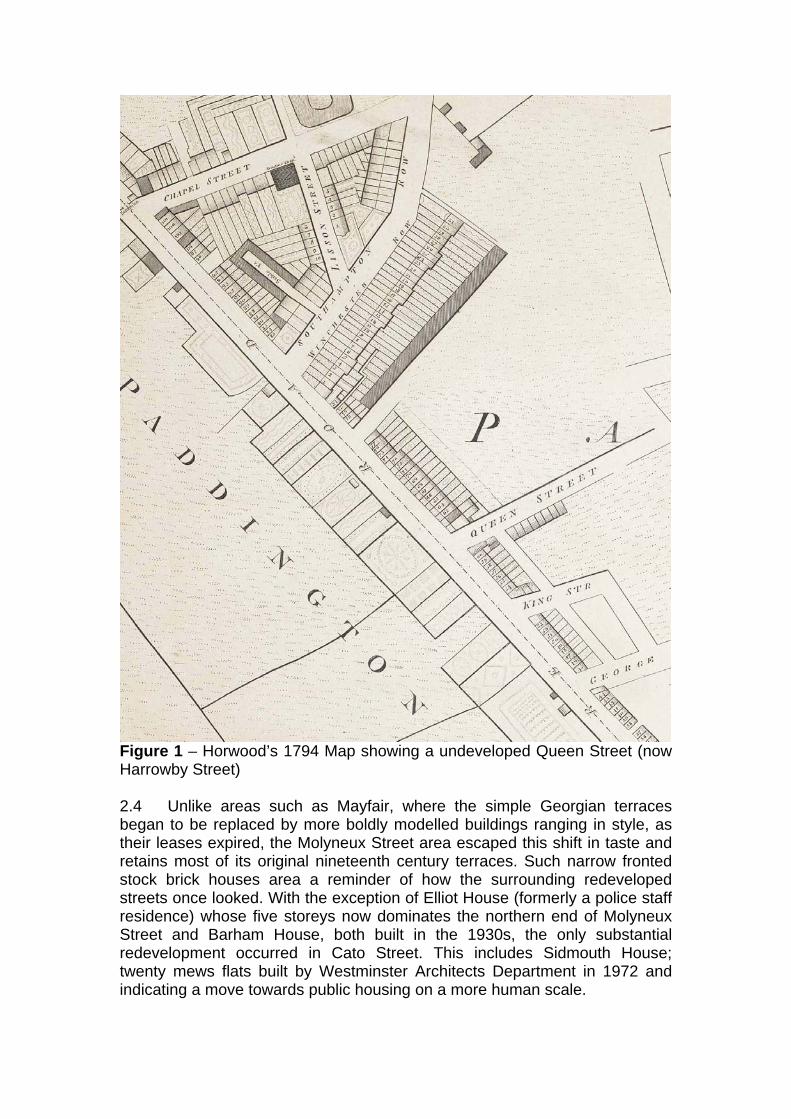
Figure 1 – Horwood’s 1794 Map showing a undeveloped Queen Street (now Harrowby Street) 2.4 Unlike areas such as Mayfair, where the simple Georgian terraces began to be replaced by more boldly modelled buildings ranging in style, as their leases expired, the Molyneux Street area escaped this shift in taste and retains most of its original nineteenth century terraces. Such narrow fronted stock brick houses area a reminder of how the surrounding redeveloped streets once looked. With the exception of Elliot House (formerly a police staff residence) whose five storeys now dominates the northern end of Molyneux Street and Barham House, both built in the 1930s, the only substantial redevelopment occurred in Cato Street. This includes Sidmouth House; twenty mews flats built by Westminster Architects Department in 1972 and indicating a move towards public housing on a more human scale.

Figure 2: Greenwood’s 1830 map, showing the emergence of the street pattern that remains to this day. 2.5 The area’s street names also reflect the social and intellectual aspirations of the original residents, with the names of military men and scholars scattered throughout the area, the most pertinent being Admiral Lord Molyneux Shuldham, (quite early on an ‘o’ was added to make it Shouldham). A cluster of classically named streets can also be seen, but a map dating from 1862 shows the essayist Cato replaced by the poet Horace. This stemmed from the notoriety that the street attracted in 1820 where due to the widespread misery that followed the Napoleonic wars, a plot to overthrow the Government by murdering Lord Castlereagh and his cabinet as they dined at the Grosvenor Square home of the Earl of Harrowby, was hatched. The plot was betrayed however and the conspirators were trapped above a stable in Cato Street. This building, 1A Cato Street, is listed Grade II and is the only surviving coach house in the mews. It was not until 1937 that it was decided that time had made the name famous rather than notorious and the original title restored.

Figure 3. 1870’s Ordnance Survey showing the arrival of the modern day street plan.

3 CHARACTER OF THE CONSERVATION AREA GENERAL 3.1 Molyneux street typifies the conservation area with its early 19th century terraced properties much of which remain unaltered within the original street plan. These provide a uniform townscape dominated by the narrow fronted stock brick houses. Later from the 19th century there are several public houses on corner sites. Redevelopment during the twentieth century includes the mews type development in Cato Street and Elliott House. See Figure 4. 3.2 It is necessary to look at specific components of the built fabric of the conservation area in order to gain a full understanding of the character and appearance of the area. This will range from an analysis of views of metropolitan or local importance to the identification of local townscape qualities such as notable shopfronts. Individually and collectively these factors will define the unique character of an area and should be considered fully in the determination of any application. 3.3 The Unitary Development Plan provides the policy basis for the determination of applications and the relevant policy or polices are referred to where appropriate.
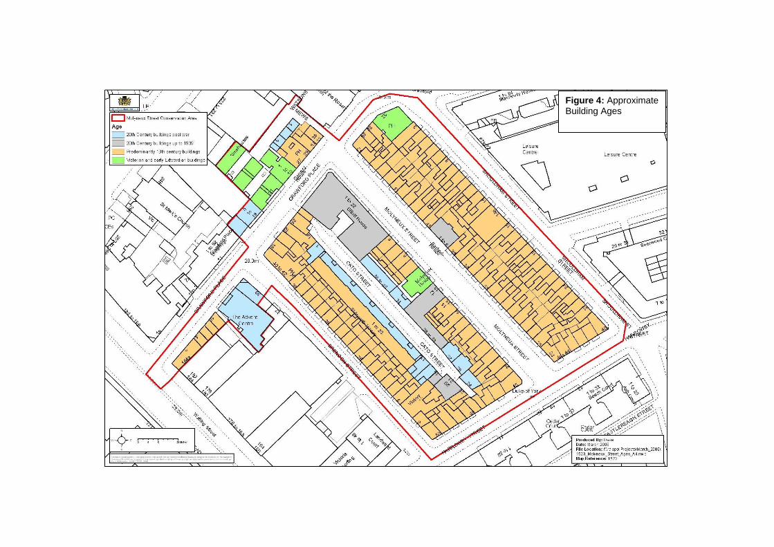
Figure 4: Approximate Building Ages

HIERARCHY OF PLAN FORM 3.4 The hierarchy of the street pattern and its interrelationship with the open space network will define the overall framework of an area. Within this the importance of the grain of development in terms of plot patterns and building lines will establish the pattern of the built form. All of these factors will affect the character of an area dictating the scale of development and the level of enclosure. 3.5 For the purposes of the conservation area audits the council has defined 3 categories of routes or spaces according to a combined analysis of their scale, level of enclosure and the function they perform within the area. These are: Primary routes and spaces Secondary routes and spaces Intimate routes or spaces See Figure 5 3.6 The grid plan is typical of development of the time providing a regularity to the overall form of the area and defining the views available within. This includes the regular building line which is continuous and forms a tight block pattern. Molyneux street is the focus of the conservation area with terraced properties on both sides, Shouldham Street and Brendon Street only retaining terraces on one side. The original narrow plot patterns give the conservation area its compact nature. The later infill development has respected this plan form generally continuing the building line and grain of the area though the plot size, most notably the frontage, of more recent scheme is larger. 3.7 This is a small area and the primary routes are located outside. The main one being Edgware Road at the western edge of the boundary. The majority of the streets in the area form secondary routes. The hierarchy remains intact with the streets running east/west at the boundaries of the conservation area being busier with a more varied built form which is more evident on the street frontage outside the conservation area. Cato Street has a subservient relationship within the street plan and together with Watson Mews provides intimate routes. Dominant patterns should be respected and where historic patterns remain these should be protected and reflected in any proposed schemes. Policies DES1 A 2, 5, 6, 7 and DES 12 should be consulted.

Figure 5: Streets and Spaces
ARCHITECTURAL AND HISTORIC CHARACTERISTICS OF BUILDINGS Overview 3.8 The conservation area townscape is defined by the architectural style of the late Georgian terraces found in Shouldham Street, Molyneux Street, Brendon Street and Harrowby Street. They are of a simple design and detailing providing modest neighbours to the grand Georgian examples in the neighbouring Portman Estate. 3.9 Within the conservation area the prevailing height is 3 storeys (with basement), however some buildings vary between 2 and 4 storeys and this variety at roof level is an important element of the townscape. Georgian terraces 3.10 The Georgian terraces, most of which are listed, are typical early nineteenth century terraced properties. They have a strong uniform character and are predominantly three storeys built of stock brick some with stucco detailing at ground floor level. (The uniform appearance of terraces being harmed where this is painted inappropriate colours). The basement lightwells retain their iron railings and many have small iron balconies to the elongated 1st floor windows. The roofs are concealed by parapets although a limited number have been extended with Welsh slate mansards. Butterfly roofs which remain intact are important features of the original buildings. 3.11 Timber sash windows set deep into reveals are generally found throughout the conservation area many with their original glazing bars. Some of those to the ground floor have arched heads. These are an important feature and should be refurbished rather than replaced wherever practicable. The introduction of various window styles and use of non-traditional materials severely disrupts this harmonious feature which is important to the character and appearance of the conservation area Infill and corner properties 3.12 Public Houses provide features of interest without detracting from the qualities of the terraced properties. These mid to late 19th century buildings are considerably more ornate in their elevational detailing than the surrounding terraces though complementary in their traditional pallet of materials. They provide richness, and stops to the terraces in some places. 3.13 Barham House, 1938, sits well within the terraces on the east side of Molyneux Street and 14a Shouldham Street, a former Baptist chapel, is from the same period as the terraced properties. 3.14 The built form is more varied on the east west routes which link directly to major routes outside the conservation area such as Edgware Road. This is particularly evident in Crawford Street though again brick is the dominant material and groups of terraced properties remain of a similar period to those listed in other streets. The almshouses have a well articulated façade with entrances set back beneath a central pediment. In keeping with the scale of
the terraced properties the red brick and level of detail providing an interesting contrast. Cato Street 3.15 The properties in Cato Street have simple more utilitarian detailing with brick remaining the dominant material though of more varied colour and style. Redevelopment schemes include a mixture of properties the scale and height of which tends to have increased though the area retains a subservient character to the surrounding streets and a strong sense of enclosure. Setting 3.16 The church of Our Lady of the Rosary and leisure centre evident in views to the east outside the conservation area contrast in terms of their scale, particularly their footprints, as do the mansions blocks to the south and north. These developments are however of sympathetic materials their brick construction contributing to the richness in the surrounding streets. Any proposal should take into account the character of its context. Policies , DES1 A 3 and 4 and DES3 should be consulted on the Principles of Development and DES5 A and B should be consulted on alterations and extensions. Policy DES4B should be consulted for scholarly replicas within terraces of unified townscape and DES4A in terms of respecting adjoining buildings in areas of varied townscape. Unlisted buildings of merit 3.17 The vast majority of the buildings are in keeping with the character of the conservation area or the respective sub-areas within, most contributing in a positive manner. Those properties or developments which are considered to harm the character of the conservation area are identified in the section ‘Negative Buildings’ below 3.18 There are numerous buildings or groups of buildings that are not listed but are considered to be of special merit. These are buildings which may be considered for listing at a future date and are of local significance. They are defined in the Audits as unlisted buildings of merit. 3.19 This may be due to their townscape or group value, their contribution to the overall character of the area, their inherent architectural qualities or historic association. By definition these properties are of particular value to the character and appearance of the conservation area and their demolition or unsympathetic alteration will be resisted. See Figure 6 Brendon Street No 6-38(even), P.H. No. 40 & 42 Crawford Place Nos. 4-10 & 28-30(even) P.H. No. 32, No 21, P.H. No. 27 & 29, No. 31 & 33
Harrowby Street No. 44, P.H. No. 45 Molyneux Street No 12-15 (consec.), Barham House (between Nos. 38 & 41) and Molyneux House (between Nos. 9 & 12). Shouldham Street No 14a Policy DES9 2 states that the City Council will seek the retention of buildings which in the opinion of the City Council make a significant contribution to the character or appearance of a conservation area and this would include unlisted buildings of merit. Landmark buildings 3.20 Within the conservation area there are no buildings which are considered to be landmarks. However there are numerous properties which are important features or points of interest and contribute to the character and townscape of the area as focal points in local views. See section on local views.

Figure 6
Roof extensions 3.21 Roof profiles are an important element which can influence the character and appearance of the conservation area. As a result roof extensions are not always acceptable as they can have a negative impact on this. Policy DES6 highlights instances where roof extensions would not be acceptable. This includes terraces where the existing roofline is largely unimpaired by any extensions or alterations; buildings that are significantly higher than their neighbours; buildings or terraces which are complete compositions or which have existing roof extensions; where there is an unbroken line of butterfly roofs; and where a roofline is visible in long views of public spaces. See Figure 7. 3.22 The east side of Molyneux Street has a consistent roofline, with the exception of Barham house, the row of prominent chimney stacks being a distinctive feature . The western side comprises of buildings dating from a mixture of eras and this is reflected in the diversity of roof profiles. At the northern end the five storey 1930s block has a mansard addition and obviously the further extension of this is inappropriate. The adjacent terrace is a surviving part of the original Georgian Street development. This group of four properties remain intact with the original butterfly roof. Alterations to the roof profile would therefore be resisted, as would any to the remaining terraced properties to the south. 3.23 Three properties in Harrowby Street (nos. 40-43)have mansard roof additions. The adjoining terraced properties are unimpaired and a story taller and therefore roof additions would be inappropriate. The rooflines remain intact in the remainder of Harrowby Street, Shouldham Street, Brendon Street and Crawford Place and whilst some roof extensions have been built in the past these have not been sufficient to affect the character of these streetscapes. 3.24 The policy acknowledges that there are some instances where additional storeys may be acceptable, notably when the extension would not harm the proportions or the architectural integrity of the building or terrace. Policy DES7 states that a roof extension should always compliment the appearance of the existing building and should not adversely affect the character and appearance of the conservation area. Further advice is given in the publication ‘Roofs. A Guide to Alterations and Extensions on Domestic Buildings (1995). ‘Mews, a Guide to Alterations’ explains how these policies apply in mews-streets. DES 6 is the relevant policy.
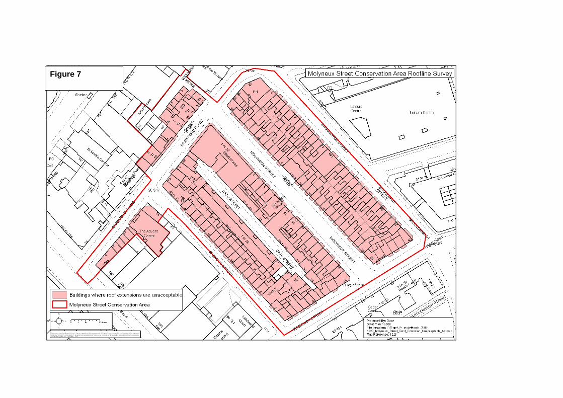
Figure 7

Rear extensions 3.25 An issue of particular local importance is the principle and design of rear extensions to the properties on the eastern side of Molyneux Street and the western side of Shouldham Street. The Council will continue to implement UDP POLICY DES 5 to ensure that any future proposals are in scale with the building and the space around it, designed to respect the period, style and detailing of the original building and use high quality materials to match the existing. Permission will not normally be granted for extensions which occupy a significant proportion of the original garden or yard area. 3.26 The Council will generally limit any rear extension where acceptable in principle to no more than 50% of the rear garden, at basement level and below the height of the boundary walls. The detailed design will have to be in keeping with the character of the rear of the terraces and any proposal for a roof terrace will be based on on-site analysis. METROPOLITAN AND LOCAL VIEWS 3.27 There are a number of important local views both within the conservation area and into and out of it. It is essential that full consideration be given to the impact of any development proposals on these. See Figure 8. 3.28 There are local views into the mews-like Cato Street through the archways at either end. That to the north from Crawford Street is through a replacement arch of 1939 which is part of the corner site development of Elliot House. This intimate glimpse reinforces the street plan hierarchy of the area. Also of note is the view of the Almshouses in Crawford Place from Cato Street. 3.28 There are views focusing on the public houses and the infill properties such as Barham House and 14a Shouldham Street with their gable ends, within the terraces of uniform properties. These add interest and the occasional feature in the predominantly uniform streets without compromising the integrity of the terraced properties. No 32 Crawford Place, the XX P.H. provides a feature tower in views into the area from the east and from the north and south along Shouldham Street. There are no strategic views affected by development in this conservation area. In the Unitary Development Plan DES15 seeks to protect metropolitan and local views.
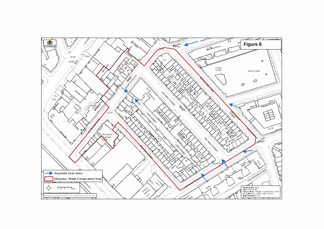
Figure 8
CHARACTERISTIC LOCAL TOWNSCAPE DETAILS 3.29 Local townscape details contribute to the sense of local distinctiveness and may be unique to a particular conservation area. They can range from specific building detailing, characteristic building elements, boundary treatments to the landscape qualities of the streetscape. Individually and collectively they contribute to the overall quality of Westminster as well as enhancing individual areas of character within the City. Railings and ironwork 3.30 Railings can contribute significantly to the character of a conservation area. The City Council considers that they should be protected and properly maintained. They add interest and richness and provide a sense of enclosure marking the boundaries between public and private spaces. 3.31 All the residential properties have black iron railings around narrow basement lightwells defining a consistent and attractive street frontage. The design of the railings are simple with undecorated railing heads and urn finials, except in Molyneux Street where the detailing is more ornate reflecting the grander nature of this street. Those original ones that remain are of considerable value to the character of the area. 3.32 Many properties have semi-circular balconies to first floor level and these add richness with their delicate profiles. Those original ones that remain are of considerable value to the character of the area. The relevant City Council policy in respect of these is DES7 G and further guidance can be found in the design guide Railings in Westminster A guide to their design, repair and maintenance. Historic shopfronts 3.33 Shopfronts, including non-original ones of an appropriate design, can be of great importance in contributing to the character and appearance of both individual buildings and the conservation area and can be of historic and architectural interest in their own right. 3.34 There are a number of traditional shopfronts situated along Harrowby Street, particularly adjacent to the entrance into Cato Street, and Crawford Street where traditional detailing remains to the frontages. These are of great importance to the character and appearance of the area. Others are of a traditional design and materials. Nos. 4 & 6 to the west end of Crawford Place are inappropriate modern replacements. The relevant City Council policies concerning historic shopfronts and the design of new ones are DES5 C. Reference should be made to the design guide 'Shopfronts, Blinds and Signs: A Guide to their Design' (1990).

Street Furniture 3.35 Westminster has an outstanding heritage of interesting and historic street furniture, many of them listed. The appropriate maintenance and protection of these is important as is the need to prevent modern street clutter from detracting from their setting. Though none of the street furniture is listed it is of an appropriate design for the conservation area and the streets are free at present of excessive clutter. Policy DES7 F 1 & 2 intends to protect these historic and characteristic features of the street scene. Historic floorscapes 3.36 Historic floorscapes are important elements in the townscape of an area and often an integral part of landscaping schemes in an urban environment. This can include major city squares or a mews development. Paving, if well-designed and maintained and in suitable quality materials, will contribute to the townscape qualities of an area, often by providing a backdrop to the surrounding built fabric. Trees 3.37 Trees provide significant amenity value in an urban environment in both visual and environmental terms. They are important elements in the character and appearance of a conservation area contributing to the townscape in many ways. This can range from a single specimen providing a focal point, a group of mature trees forming part of an historic planting scheme or street trees forming an integral part of an estate layout. 3.38 There are no street trees in the conservation area and due to the basement and closed block development there are no real views of garden planting to the front or rear. However there are several street trees in Shouldham Street, Harrowby Street and Brendon Street, outside the conservation area, which contribute positively to the street scene. UDP policy ENV 14 seeks to protect trees which make a significant contribution to the character and appearance of a conservation area. Advice on trees and their protection is given in the City Council design guide, Trees and Other Planting on Development Sites.

CHARACTERISTIC LAND USES 3.39 The contribution of land uses to the character and appearance of a conservation area is of importance. This will not only have a direct influence on the building typology or make-up of an area but also on the nature and use of the public spaces and streets. Particular uses may be of historic or national importance and will have dictated the evolution of an area. 3.40 The conservation area is predominantly residential in character, with a variety of commercial premises located in Cato Street. There are a number of Public Houses located strategically on street corners and small runs of shopfronts along Crawford Place and Harrowby Street. The land uses in the area are shown on the plan in Figure 9. The City Council will consider the contribution of existing and proposed uses to the character or appearance of the conservation area. DES9 D is the relevant UDP policy NEGATIVE FEATURES 3.41 Negative areas detract from the special character of an area and present the opportunity for change which will enhance the character and appearance of an area. It may be that simple maintenance works could remedy the situation or in some cases there may be the opportunity to redevelop a particular site. 3.42 Those buildings or features considered to have a negative impact on the character and appearance of the conservation area are: No 39 Brendon Street. Modern shop fronts to Nos. 4 & 6 and 1st floor blinds to Nos. 6 & 8 Crawford Place. Colour paint finishes to render on properties in Brendon Street and some on Harrow Street. Ground floor to No 53 Harrowby Street. And outside the conservation area: In the view west from Crawford Place the central tower of the Water Gardens development on the western side of Edgware Road sits uncomfortably in the backdrop to views of the predominantly 2 storey development. The development on the western side of Brendon Road facing the conservation area is poor with the service entrances and dead space of this modern development contributing little to the street scene and showing no respect to the traditional form of the terraced development opposite. The City Council will take appropriate steps to ensure the preservation and enhancement of its conservation areas. Schemes for the improvement and enhancement of conservation areas will be encouraged and initiated where possible. Any proposal will be judged against policies DES1 and DES9.

Figure 9
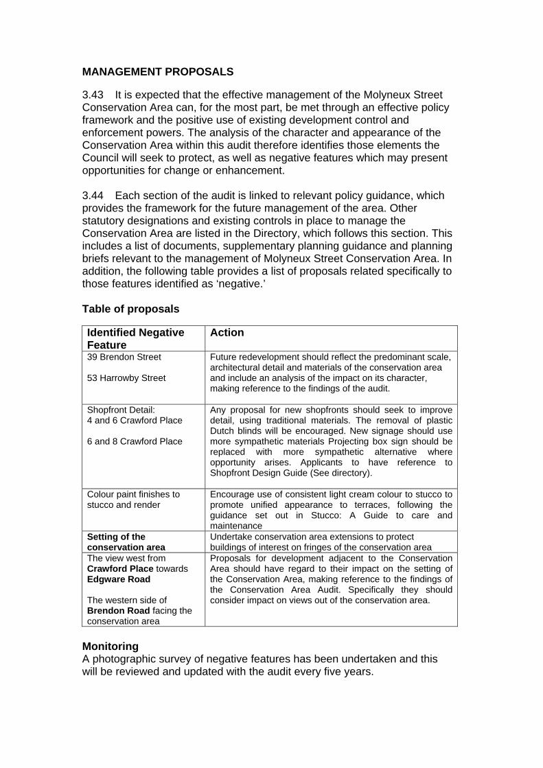
MANAGEMENT PROPOSALS 3.43 It is expected that the effective management of the Molyneux Street Conservation Area can, for the most part, be met through an effective policy framework and the positive use of existing development control and enforcement powers. The analysis of the character and appearance of the Conservation Area within this audit therefore identifies those elements the Council will seek to protect, as well as negative features which may present opportunities for change or enhancement. 3.44 Each section of the audit is linked to relevant policy guidance, which provides the framework for the future management of the area. Other statutory designations and existing controls in place to manage the Conservation Area are listed in the Directory, which follows this section. This includes a list of documents, supplementary planning guidance and planning briefs relevant to the management of Molyneux Street Conservation Area. In addition, the following table provides a list of proposals related specifically to those features identified as ‘negative.’ Table of proposals Identified Negative Feature
Action
39 Brendon Street 53 Harrowby Street
Future redevelopment should reflect the predominant scale, architectural detail and materials of the conservation area and include an analysis of the impact on its character, making reference to the findings of the audit.
Shopfront Detail: 4 and 6 Crawford Place 6 and 8 Crawford Place
Any proposal for new shopfronts should seek to improve detail, using traditional materials. The removal of plastic Dutch blinds will be encouraged. New signage should use more sympathetic materials Projecting box sign should be replaced with more sympathetic alternative where opportunity arises. Applicants to have reference to Shopfront Design Guide (See directory).
Colour paint finishes to stucco and render
Encourage use of consistent light cream colour to stucco to promote unified appearance to terraces, following the guidance set out in Stucco: A Guide to care and maintenance
Setting of the conservation area
Undertake conservation area extensions to protect buildings of interest on fringes of the conservation area
The view west from Crawford Place towards Edgware Road The western side of Brendon Road facing the conservation area
Proposals for development adjacent to the Conservation Area should have regard to their impact on the setting of the Conservation Area, making reference to the findings of the Conservation Area Audit. Specifically they should consider impact on views out of the conservation area.
Monitoring A photographic survey of negative features has been undertaken and this will be reviewed and updated with the audit every five years.

DIRECTORY

Conservation Area Audit
Department of Planning and City Development Westminster City Council
64 Victoria Street London SW1E 6QP
The City Council also makes available many documents in Braille, on tape and in large print. If you require any of the information contained in these documents in one of these alternative formats please contact: (020) 7641 8088.