Connecting Communities - Amazon Simple Storage … · AmeriGEOSS AmeriGEOSS ...
20
Jeff Peters - Esri Connecting Communities
Transcript of Connecting Communities - Amazon Simple Storage … · AmeriGEOSS AmeriGEOSS ...

Jeff Peters - Esri
Connecting
Communities

Public Safety and Security
Police Foundation
Officer Involved Shootings and Violent Crimes
Mail Theft
USPS
Infrastructure Protection
DHS
Live Incident Viewer
Philadelphia
Event Monitoring
Orland Park
Fairfax County
Operation Centers

Preparing for and Responding to Disasters
Nepal Earthquake Response
FEMA
Vulnerable Populations
Wildfire Damage Assessment
Oregon
Fire Alert System
Global Forest Watch
Red Cross
Optimizing Humanitarian Resources
Boston Storm Weather
MEMA
Snow Fall
Coastal Flood Analysis
New York City, New York
Power Outage
Idaho
Modeling Floods
Lake Champlain

Forestry, Agriculture and Land Management
Cooperative
Forestry Viewer
USFS
Forest
Restoration Planning
Tribes and USDA
Forest Service
Shared Stewardship
USDA Forest
Service Partners
USDA
Soil Conservation
Field Data Collection
BLM
Corn Production Crop Rotation
Wheat & SoybeanPlanting Frequency
US

National Mapping and Charting
Navigation
Cyprus
GDAS Malaysia
Production Workflows Aeronautical
FAA
Indonesia
National Mapping Portal
Topographic
USGS
Border Mapping
International Joint CommissionUS / Canada
NOAA
Nautical Charts

Story Maps
Wilderness Map Tour
Steens Mountain Wilderness, Oregon
Informing Citizens
Office of Senator Ron Wyden
Stakeholder Report
USFS
Native American History
US
White House Maps
US
History of the Capitol Christmas Tree
USFS
Urban Forestry
Washington, DC
Senate Foreign Relations
Congressional Policy Assessment

Homeland Infrastructure Foundation – Level Data (HIFLD) & GII
DHS – Organizing What is Important

AmeriGEOSS
AmeriGEOSS – Connecting Communities to What is Important

ArcGISServing Communities
GIS Innovation for Organizations
Mapping
Real-Time
Data Management
Imagery
Big Data
Mobile
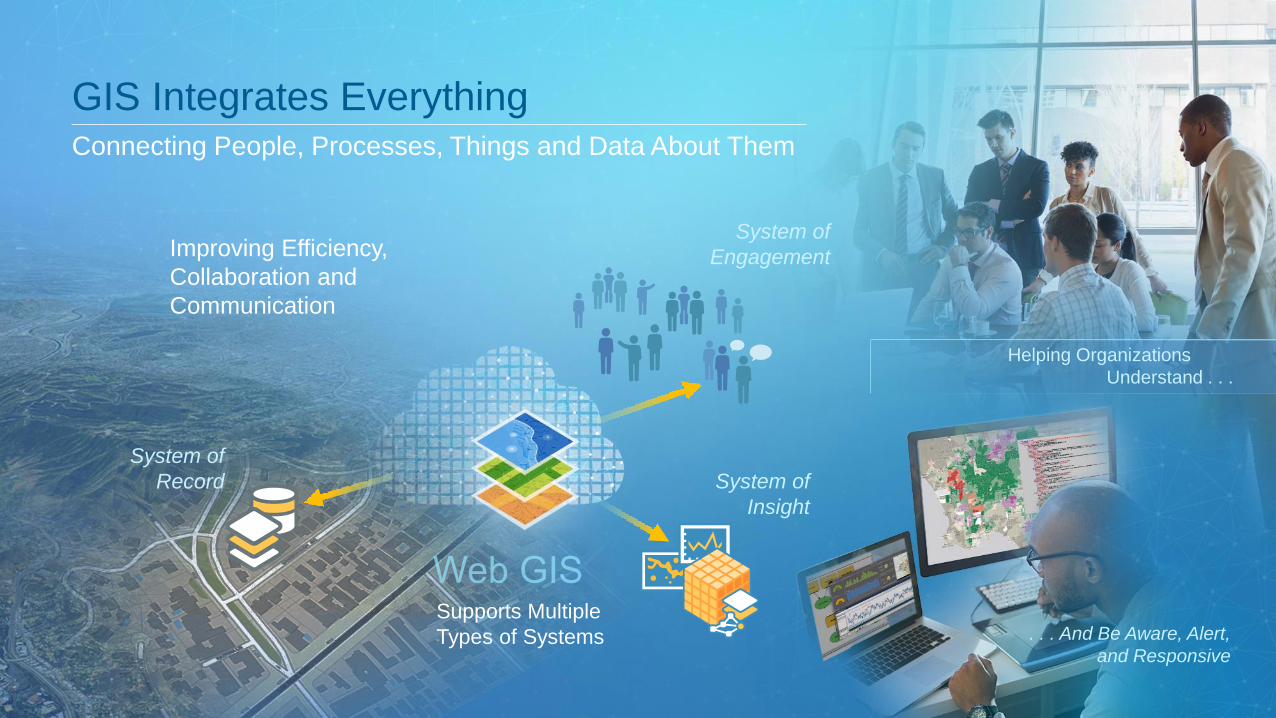
Improving Efficiency,
Collaboration and
Communication
GIS Integrates EverythingConnecting People, Processes, Things and Data About Them
System of
Insight
System of
Engagement
System of
Record
Supports Multiple
Types of Systems
Helping Organizations
Understand . . .
. . . And Be Aware, Alert,
and Responsive

Deployable On-Premises and Online
Desktop
Browser
Device
Server Online/
Cloud
Open
SystemsOnline/
ArcGIS An Integrated Web GIS Platform

. . . integrated into thousands of systems
Open Standards
and Formats
Product
Integration
Open Software
Engineered to be Open
AutoCAD
SAP HANA
IBM Cognos
Adobe Creative Cloud
AWS
Azure
MS Office
Oracle
SQL Server
Teradata
Netezza
REST
OPeNDAP
WMSWCS
CSW
GML
WFS
KML
WMTS
WPS
SLD
GeoPackage
SOAP
IFC
LASNetCDF
SQL
JSON
WaterML
CityGML
OneGeology
LERC
Shapefiles
Web Scene (I3S)
INSPIRE
Extensible
Architecture
Open-Source
Contributions (300+)
Embeddable
Components
Open
APIs &
SDKsOpen Data
Access
Open-Source
Integration
Ensuring Data and System Interoperability

Thousands of Maps and Layers
Ready-to-Use
Authoritative
Online Content A Living Atlas of the World
Millions of User Contributions . . . Billions of Views per Week
Basemaps | Imagery | Demographics | Landscape
Land Cover
Elevation
HIFLD Open
A16 Layers
NAIP
Federal Content
Landsat/GLDAS
NOAA
Statistics/Population
Basemaps
Images
Tens of Thousands of
Open Data Sets

ArcGIS Serves the Community

Focused Applications
BathymetryRoads and
Highways
(LRS)Business Analyst
GeoPlanner
Topo Map
Maritime Chart
GeoportalAeronautical
Chart
Pipelines
Community Analyst
(Open Source)
Airports
Serving Needs of Communities

ArcGIS Feeds Solutions
Geoplatform.gov Harvests Content from ArcGIS Online
Public Safety and
Emergency Management
Leveraging Community Work
UtilitiesGovernment
Military and
Security
500,000+ Downloads
Open
Solutions

ArcGISInnovation Continues
The Road Ahead
Mapping
Real-Time
Data Management
Imagery
Big Data
Mobile

Road Map Incremental and Groundbreaking Advancements
. . . Focused on Quality, User Needs, and Innovation
Pro 1.1
Crowdsourcing
Real-time
Utility networks
Federated System
Massive 3D
Vector tiles
Web raster analysis
Advanced navigation
Modeling
Big data GeoAnalytics
Insights10.3.1
Pro 1.210.4
Incremental Software Release
Mobile
UAV/Drone
Continuous Improvements
Distributed GIS
10.4.1
10.5
Analytic Engines
Raster Analytics
Pro 1.4
Pro 1.3
User Roles
2015
2016
2017

. . . Creating a Nervous System for Our Planet
Individuals Organizations
Smart GIS Enables New Types of CollaborationConnecting Individuals, Organizations and Communities
Network of
Organizations

Thank You
Jeff PetersDirector, National Government
Esri
Mapping
Real-Time
Data Management
Imagery
Big Data
Mobile