
Concordia Landscape Portfolio
23
Landscape Architecture Portfolio - 2010 University of Illinois Brian Concordia
-
Upload
brian-concordia -
Category
Documents
-
view
220 -
download
0
description
A portfolio from my undergraduate degree
Transcript of Concordia Landscape Portfolio

Landscape Architecture Portfolio - 2010
University of Illinois Brian Concordia

In a profession that is so closely att uned with the rhythms and cycles of nature, landscape architects require a unique eye for design. Much like the natural processes, the fi eld of landscape architecture is constantly changing. Over the course of years the boundaries and defi niti ons of what a landscape architect can do or produce has expanded and changed. From designing comfortable livable back yards, to creati ng community gathering spaces, even to regional issues, landscape architects have a very diverse profession. Along these same lines, other design professions have begun to encroach on the traditi onal territory of the landscape architect. It is important for landscape architects to fi nd and defi ne their profession. While working on my undergraduate studies in landscape architecture, I feel that I have also grown and expanded. Not only have I come to understand various aspects of successful design and representati on, but I have also gained signifi cant knowledge in the fi eld of landscape architecture. As my undergraduate ti me closes I look to take this knowledge and more thoroughly explore the world of landscape architecture.


AREA INVENTORY
An example of the small businesses that dot the trail
There is a lot more to the trail than just the hundred foot wide right of way. It will take more than just a well designed trail to make the Kickapoo Trail a sucess. The trail must reach out and gain support from the surrounding communities and encourage people to interact with the space. There are many opportunities between Urbana and Kickapoo State Park that could be included in the design. It is important to look beyond the right of way and look at the possible impacts the trail can have, not only environmentally, but socially and economically as well.
Each of the towns possess the opportunity for small business developments. By relating businesses to the trail, towns will be able to take advantage of the variety of trail users.
Kickapoo State Park is the eastern edge of the proposed trail. The park already has a variety of established trails and areas. It would be benefi cial for the trail to connect to Kickapoo State Park.
Along the trail there are a variety of unused structures. These places could become interesting attractions along the trail. These amenities could provide shelter and information on the trail.
Although much of the surrounding area is agriculture, there are sections off the trail that could developed into environmental areas. These environmental “fi ngers” could help develop a wider variety of users on the trail.
The lower wetlands of Kickapoo could connect to the trail
The Interurban Train Stop could be renovated into a trail stop
A small creek north of Fithian could be accessed
St. Joseph Ogden Fithian Muncie OakwoodUrbana
ECONOMIC DEVELOPMENT
The development of the Kickapoo Trail will do more than just provide a physical connection between towns. Each of the towns situated along the trail has the opportunity to promote and create economic opportunities for a variety of businesses. With the development of the trail, towns will understand that they are no longer isolated and separate, rather are linked by a shared experience. Residents and users of the trail can look at the trail not only as a great place to hike, bike and walk, but also as an economic resource. With the successful development of the trail, residents could see increased property values. Towns would also benefi t from the increased tax revenues from the trail, and an increase in tourism. At the very least, the trail creates a multitude of jobs in the construction of the 24.5 mile trail. With the development of many rails to trail projects, the term “Trail Town” has developed. These towns are typically located adjacent to the trail and off er amenities to users and visitors. “Trail Towns” consist of a variety of stores and locations including bike shops, ice cream parlors, and family restaurants.
The towns of the Kickapoo Trail are in great position for economic develop. For many of the towns, the section of trail cuts right in the middle of the towns. This is a benefi t since many of the buildings and businesses are located within walking distance of the trail. Many of the existing business include restaurants, bars, specialty shops, and antique stores. Since these businesses are located so near the trail, towns such as Fithian, Muncie and Ogden have the opportunity to really capitalize on welcoming trail users.
With the development of the trail, the area can expect a large increase in visitors, both local and tourists. Most likely tourists will travel from areas near the trail heads, specifi cally the Champaign-Urban area and Danville. These visitors will support the majority of local businesses since it is shown that outside visitors tend to spend more than four times as much as local residents. Though the types of proposed businesses can vary, it is common to see small restaurants, specialty stores, desert and snack shops, as well as bike shops. These bike shops have great potential since a majority of users are expected to be bikers. Bike shops could off er repairs, rentals and sales. While traveling through the towns it is easy to see that many of the buildings are vacant, although not good for the town, this does provide a great opportunity for new businesses.
Development Guidelines*
In order to create a sucessful business plan it is important to understand that each town will need to address their own situations. What works for one town may not work for all the towns. The following are ideas to take into consideration. 1: Understand the communities capacity and deisres2: Identify markets based on the trail3: Understand the relationship between the town and the trail4: Choose trailheads and stops based on markets and impacts5: Located stops within town lines in order to ensure economic impacts6: Build of esixting markets in each town7: Cultivate partnerships between towns, communities, and users
Bike rentals and repairs could be a big draw along the trail
Highlighted building adjacent to the trail provide great locations
for new businesses
*”Economic Development” by Alex Sammet
A small resturant located in Fithain. These types of resturants could benefi t from trail development
Small vacant buildings dot the trail and provide excellent oportunities for expanding businesses
BASE MAP
As users travel further east towards Kickapoo State Park the towns become smaller while agriculture seems to dominate the landscape. Along this stretch of trail it is important to emphisize the importance of native plants and provide engaging destinations for users. Between Ogden and Fithian is an old grain elevator. This structure provides a great location for a trail rest stop since it will provide shade, covering, as well as an aesthically diff erent experience. Fifthian and Muncie can both benefi t economically from the development of the trail as well.
LEGEND
Vegetation
Wetlands
Rail Road
Streams
I-74
Roads
Proposed Trail
Secondary Trail Stop
Trail Rest Stop
Parking Area
Trail Heads
TRAIL VISION AND GOALS
VISION
PROGRAM
GOALS
Th e Kickapoo Trail:A Prairie Foothold in the Farmlands
Surrounded by miles and miles of agriculture, the trail has to opportunity to really distinguish itself from its surroundings. The trail will be defi ned by the types of materials, plants, and experiences found specifi cally on the trail. By incorporating a native plant palette, specifi cally prairie plants, the trail will become a distinct destination within the area. The native planting plan will harken back to a time before agriculture, when tall grass prairies dominated Central Illinois. This vision is to develop the 100’ right of way into a prairie style habitat for plants, birds, insects, as well as other smaller mammals. Planting all the way up to the edge of the right of way incorporates and takes advantage of all the available space. The long sight lines provide a unique view of what will appear to be an extensive prairie, but will be contained by the 100’ right of way. As seen from above, the trail will appear as a long string of prairie tieing in Kickapoo State Park and the towns along the trail. By using native plants the aim is to install a design with minimal maintenance within the fi rst few years and after establishment the plants will be able to regulate themselves. The plants will also have the opportunity to regulate storm water runoff on and around the trail since most of the plants will be very deep rooted.
Along with environmental benefi ts for the area, the plants will develop distinct personalities is each season. A planting palette with a variety of plants off ers blooms at diff erent points during the growing season, encouraging return visits in the spring and summer. Many of the plants also take advantage of cooler fall temperatures and off er a change of color with the seasons, providing crisp air strolls to enjoy a variety of experiences. In the winter the adventurous user will appreciate the bare stalks and dried seed pods contrasting against the white snow on the trail. A native prairie planting within the trail provides residents and users an opportunity to view and enjoy a prairie experience close to home. For many users this will be one of the only areas of prairie within their areas. With successful implementation of these native plantings the goal is to encourage users and residents of the area to rethink ideas of native plantings. Hopefully in the future there will be the possibility for extensions of native plantings adjacent to the trail, creating a web of prairie-style experiences within the area.
The design for this trail accommodates a variety of users. The designed primary user would be hikers and walkers. Hikers will enjoy the detail to planting along the trail. Also hikers and walkers will most likely take advantage of rest stops, future businesses, and open park spaces. The trail is also designed to provide space for bikers. The trail is great for bikers since it is so long and straight, providing the opportunity for bikers to really get moving. Along with bikers and hikers, there is a possibility for equestrian use. Although not originally planned for, there are locations that in the future could be adapted if needed. As well as standard physical activities along the trail, users will also enjoy a range of shops, stores, and restaurants. These existing and new businesses are conveniently located near the trail. Within the trail there are three types of stops designed. The fi rst level, and largest are the trail heads. These bookend the trail at the east and west edges and provide parking, rest rooms, open spaces and other amenities. Located in each of the towns are the secondary trail stops. These are smaller than the trail heads and provide rest rooms, water, and connections to communities. Often found between secondary stops are the smaller rest stops. These stops simply provide places to sit, water, and shade. Overall the trail provides many things trail users are accustomed to, and other surprises as well.
A great prairie style trail showcasing fall color
google images
google images
A well develop series of stops provides oportunities for user interaction
1 - Develop a restorative native planting program for the entire length of the trail
2 - Provide open park spaces adjacent to the trail for community programs and festivals
3 - Develop management strategies for future development
4 - Make the trail accessible to a wide range of users including ADA accessibility along the length of the trail
5 - Connect to existing trails and parks along the corridor
6 - Provide space for community health and encourage residents and users to use the trail often
INVENTORY
The trail opens up in downtown Ogden
This grain tower lies between Fithian and
Ogden
An unused grain tower in Fithian
A bridge just east of Muncie
Here the trail, a live rail, and US-150 all meet
Here the trail a live rail
St. Joseph Ogden Fithian Muncie OakwoodUrbana
Creek crossing west of St. Joseph
There is a lot more to the trail than just the hundred foot wide right of way. It will take more than just a well designed trail to make the Kickapoo Trail a sucess. The trail must reach out and gain support from the surrounding communities and encourage people to interact with the space. There are many opportunities between Urbana and Kickapoo State Park that could be included in the design. It is important to look beyond the right of way and look at the possible impacts the trail can have, not only environmentally, but socially and economically as well.
Secondary Trail Stop
Trail Rest Stop
Unused for many years and running along US Route 150, the CSX rail corridor was the subject of our senior year regional design studio. This corridor, which is roughly 25 miles long, focuses on the very popular rails to trails projects. We started with a trail precedent project in order to gain our bearings on such a large scale project. Aft er this introducti on to similar projects, it was ti me to gain an understanding on our site. Working together as a studio, each team had a secti on of trail and topic to study and apply to the site. Using this collecti ve informati on, it was ti me to begin individual projects. It was important to have an overall design theme for the trail in order to give the site connecti vity. Also the project called for two smaller scale designs at chosen sites along the rail. The fi nal project was a booklet, collected from all the pieces of individual work.

One of the sites I chose for a detail design was the railroad crossing near the town of St. Joseph. This area is unique because it is where the trail corridor crosses an acti ve rail line. It was important to understand the danger of this while also creati ng a fun and acti ve park. Also following the theme of bringing prairie into the cornfi eld, the park is heavily planted with nati ve prairie plants.

The second detail design chosen for the trail project was the town of Ogden. The town is located near the midpoint of the 25 mile proposed trail and has the potenti al to develop into a jewel of the trail. Also Ogden has great exposure from US Route 150 and the prairie planti ng could be easily seen. The town has a small existi ng park, as seen from the top photo, and a great connecti on could be made to my proposed park system. The preliminary design is shown in the middle and the fi nal plan is shown below. Comprised of three diff erent secti ons, the park could easily be split up into phases, depending on funding and popularity. The core of the design is to follow the overall idea of bringing a more natural, prairie style planti ng, to the various towns and citi es along the trail, which is sandwiched between massive agricultural fi elds.
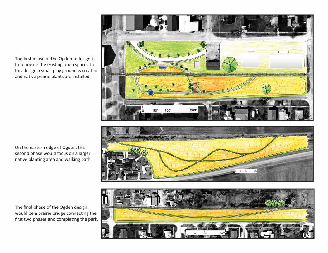
The fi rst phase of the Ogden redesign is to renovate the existi ng open space. In this design a small play ground is created and nati ve prairie plants are installed.
On the eastern edge of Ogden, this second phase would focus on a larger nati ve planti ng area and walking path.
The fi nal phase of the Ogden design would be a prairie bridge connecti ng the fi rst two phases and completi ng the park.

The topic of the Lohman Park redesign project was to understand how important parks are to the surrounding communiti es. Assigned midway through junior year, this project incorporated both group and individual work. Groups were assigned to do analysis of the site as well as the adjacent communiti es. The park lies near an elementary school, a series of apartment buildings, and a new golf course and community development border the eastern edge of the park. It was important to incorporate these three users into the overall design of the park. Aft er analysis was completed, the conceptual and overall redesigns were up to the individual. Below are three conceptual graphs and the fi nal conceptual plan. On the opposite page is the fi nal master plan, as well as supporti ng perspecti ve graphics.


The Virginia Park design was a piece of a larger design project in the East St. Louis area. As landscape architects, our junior studio was a part of the East St. Louis Acti on Research Project. This was a very unique project for me since we were able to visit the town and citi zens and get quality feedback from them immediately. The project started with inquiries into issues of environmental justi ce and quality of life. High crime rates, abandoned homes, and loss of jobs are just some of the problems facing this community. As landscape architects, we visited with members of the community to get a sense of what they wanted from their local parks. With this informati on we went back to our studio to develop preliminary master plans. With these in hand, we took a second trip to display our work to community members. Aft er our second trip our work was condensed into groups and a fi nal redesign booklet was produced for the community. The photos below are of the various meeti ngs and presentati ons during the project. The plan on the opposite page is my preliminary master plan along with supporti ng graphics.


To begin our junior year studio, our fi rst project was a local residenti al design. My selected house was located just off campus, near a large neighborhood park. The project required an initi al site visit, and a meeti ng with the resident. As required for the project, my three designs off er diff erent perspecti ves, while also providing opti ons for the resident. One occurring theme in my designs was the implementati on of a secluded, more private area, as requested by the client.

Plants and plant life should be a large part of the landscape architects understanding. Not only should landscape architects be able to identi fy and understand plants, but it is also important to be able to create engaging designs with them. The drawings here are examples of the designs created as part of the annuals and perennial plant courses here at the university. Along with identi fi cati on tests, these projects ensure students are able to successfully design with plant materials.

In many cases Photoshop has become a tool of the landscape architect. A carefully constructed image can really help support a project and easily get an idea across.

Our studio spaces are very generous; large windows, plenty of space, and great desks are all students can ask for. While spending ti me near one of the larger back windows, a few of us had a great idea to take advantage of some unused space. Aft er discussing community gardens and their health benefi ts in class, we decided to install one of our very own. It started off very slowly, with two propagati on units and a few packets of seeds. Before we knew it we had a fully fl edged garden, including tomato plants, morning glory vines, and even 3 foot tall sunfl owers!

Completi ng this project in the spring of sophomore studio, this project would prove to be a precursor to the 2008 Windsor Road Corridor charrett e. Split up into four secti ons, our studio was responsible for creati ng preliminary ideas for the campus development of Windsor Road. For my group it was important to focus on the large body of water located in the south west secti on of our quadrant. Also we needed to incorporate spaces for business as well as residenti al. The master plan includes trails, water remediati on, and “green” educati onal center.


The Orchard Downs design was the defi niti ve project for our community design studio. In order to produce the highest quality projects, our studio split up into various teams. The teams fi rst started with an extensive analysis of the site. Orchard Downs contains various housing types, primarily housing for graduate or married students. Located a short bike ride south east of campus town, Orchard Downs is accessible by bike and bus lines and the project looked to connect this area to the main campus. With this in mind, our group produced a variety of conceptual designs. It was important to include healthy living ideas such as walkable communiti es and open spaces. Taking these ideas and refi ning them, our group produced the master plan shown on the right. The plan contains a small centrally located business court, dormitories, single family homes, and reti rement housing located in the southern secti on. From there individuals were to choose specifi c secti ons to detail. Shown on the opposite page, my redesign of the central area shows the main entrance to the community as well as the styles of buildings included on the site.


The fi nal project for our Nati ve Planti ng Design Studio was to take one of the three projects completed earlier in the semester and go further with it. Working with a partner on both sides of this project, we chose to complete our design of the wetland area surrounding the newly built Business Instructi onal Facility (BIF). The BIF was one of the fi rst “green” buildings to be built on campus. With this in mind, we really wanted to contribute to that mentality. It was important to contain and allow run off to percolate on site. Following this idea, we designed a larger wetland area as well as deepening the long swaths in the center. Along with these land forms, we chose nati ve wetland plants that would thrive in heavy rains and water. Also since the court yard is primarily viewed from inside the massive atrium, we designed to plant large swaths of similar plants in order to provide an almost arti sti c quality when viewed from above.


The Skelton Park Redesign was a fi nal project for our constructi on drawing class. The site, located just north of campus town, has a secti on of the Boneyard Creek running along the eastern edge. This secti on of the creek posed a problem since it is prone to fl ooding. It was important to design a park that could mediate the excess water, while sti ll functi on as a successful park the rest of the ti me. Preliminary site visits showed very interesti ng aspects to the park and its high visibility. The design for this park came about in an interesti ng way because we were instructed to develop our ideas with clay models. This tacti le and visual development brought about the large earthen berms and landforms seen in the model below. From the small scale model the fi nal constructi on documents and a larger scale model were created, as seen on the opposite page.


