Comprehensive Study Report
152
Agence canadienne d’évaluation environnementale Canadian Environmental Assessment Agency Kitsault Mine Project Comprehensive Study Report August 2013
-
Upload
hoangthuan -
Category
Documents
-
view
213 -
download
0
Transcript of Comprehensive Study Report
Agence canadienned’évaluation environnementale
Canadian EnvironmentalAssessment Agency
Kitsault Mine ProjectComprehensive Study Report
August 2013

Cover photo credited to Avanti Staff.
© Her Majesty the Queen in Right of Canada (2013).
This publication may be reproduced for personal use without permission, provided the source is fully acknowledged. However, multiple copy reproduction of this publication in whole or in part for purposes of distribution requires the prior written permission of the Minister of Public Works and Government Services Canada, Ottawa, Ontario. To request permission, contact [email protected].
Catalogue No.: En106-120/2013E-PDF
ISBN: 978-1-100-22586-9
This document has been issued in French under the title Rapport d'étude approfondie – Projet minier Kitsault
Alternative formats may be requested by contacting [email protected]
CEAA—Comprehensive Study Report: Kitsault Mine Project III
Executive Summary
Avanti Kitsault Mine Ltd. proposes to construct, operate and decommision an open pit molybdenum mine with a production capacity of approximately 40 000 to 50 000 tonnes (t) per day. The proposed Kitsault Mine project (the Project) will be located 140 kilometres (km) north of Prince Rupert, British Columbia, within the Nass Area and Nass Wildlife Area defined by the Nisga’a Final Agreement. The Project consists of an open pit, an ore processing plant, ancillary mine infrastructure, tailings and waste rock management facilities, buildings, explosives manufacturing facility and storage magazines, water management facilities and a power substation. The Project involves redeveloping a previous mine which last operated in 1982.
An environmental assessment (EA) of the Project under the former Canadian Environmental Assessment Act (the former Act) is required because Fisheries and Oceans Canada and Natural Resources Canada may take regulatory decisions in relation to the Project. A comprehensive study EA is required under the Comprehensive Study List Regulations. The Project is considered a major resource project under the Cabinet Directive on Improving the Performance of the Regulatory System for Major Resource Projects.
A provincial EA was conducted under British Columbia’s Environmental Assessment Act with federal and provincial agencies working cooperatively to coordinate activities as guided by the principles of the Canada-British Columbia Agreement for Environmental Assessment Cooperation (2004). The Project is also subject to the EA requirements of the Nisga’a Final Agreement (NFA), a constitutionally-protected treaty, as the mine footprint will be situated in the Nass Wildlife Area and Nass Area of British Columbia and portions of the proposed transportation corridors overlap Nisga’a Lands.
The Canadian Environmental Assessment Agency (the Agency) prepared this comprehensive study report in consultation with Fisheries and Oceans Canada and Natural Resources Canada following a technical review of the proponent’s Environmental Impact Statement and an evaluation of the potential environmental effects of the Project. Environment Canada, Health Canada and Aboriginal Affairs and Northern Development Canada provided additional expert advice.
Valued components (VCs) are notable features of the natural and human environment that have the potential to be impacted by the Project. This report presents the assessment of the Project’s effects on the following key VCs: surface water and sediment quality, hydrology, groundwater, fish and fish habitat, marine aquatic resources, wildlife and wildlife habitat, vegetation and plant communities, and land and resource use.
The Agency assessed the potential for the Project to have significant adverse effects on the environment. In addition, the environmental effects on the Nisga’a Nation and the effects of the Project on the existing and future economic, social and cultural well-being of Nisga’a citizens as set out in the NFA were assessed as part of the EA. These evaluations were completed based on technical information provided by the proponent, advice from federal, provincial and Nisga’a Lisims Government (NLG) experts, and comments provided by Aboriginal groups and public stakeholders through various consultation opportunities.
Potential environmental, economic, social and cultural effects and concerns examined during the comprehensive study process include:
• changes to surface water and sediment quality • management of mine wastes to prevent metal leaching and acid rock drainage • protection of fish and fish habitat • effects on the marine environment

IV CEAA—Comprehensive Study Report: Kitsault Mine Project
• attainment of employment and training for Nisga’a citizens • social effects related to limited housing supply in Nisga’a Villages and increased income
Issues identified as a result of public and Aboriginal consultations include the protection of moose and surface water quality, site reclamation and the need for ongoing monitoring and environmental management.
Mitigation measures to prevent or reduce the adverse effects of the Project were incorporated into the project planning and design. These measures include:
• treatment of mine contact water prior to discharge into the receiving environment • subaqueous disposal of potentially acid generating tailings and low grade ore • discharge of mine water in a manner that mimics natural stream flow • fish habitat compensation plan
Management plans to address economic, social and cultural effects on the Nisga’a Nation include:
• educational support, skills training and closure transition support • programs and policies based on the results of a cultural and social needs assessment
A follow-up program is required under the former Act to verify the accuracy of the EA and to determine the effectiveness of the proposed mitigation measures. The follow-up program will focus on confirming predictions of effects for the following elements:
• water management • wildlife and wildlife habitat • wetlands and species-at-risk
The Agency concludes that with the implementation of mitigation measures, the
Project is not likely to cause significant adverse environmental effects.
With respect to potential effects on residents of Nisga’a Lands, Nisga’a Lands or Nisga’a interests, the Agency identified potential adverse but not significant environmental effects on Nisga’a Nation treaty interests in relation to fisheries, wildlife and migratory birds and forest resources. The Project is also likely to affect the social and cultural well-being of Nisga’a citizens as the potential inflow of people and income to Nisga’a communities may place additional demand on the existing housing supply and may reduce Nisga’a opportunities to pursue cultural activities. A modest benefit may occur to the economic well-being of Nisga’a citizens due to employment and contracting opportunities associated with the Project.
Following public consultation on this Report, the Minister of the Environment will decide whether, taking into account the implementation of mitigation measures, the Project is likely to cause significant adverse environmental effects. At the same time, the Minister will issue an NFA Project Recommendation. The Project will then be referred back to the responsible authorities for the appropriate course of action in accordance with Section 37 of the former Act.
CEAA—Comprehensive Study Report: Kitsault Mine Project V
Table of Contents
Executive Summary .................................................................................. iii
List of Figures .................................................................................................................... ixList of Tables ...................................................................................................................... ixList of Acronyms and Short Forms ..................................................................................x
1 Introduction .........................................................................................1
1.1 Project Overview ..........................................................................................................11.2 Environmental Assessment Context and Process ...................................................1
1.2.1 Purpose of the Comprehensive Study Report ..................................................... 11.2.2 Federal Environmental Assessment Process ......................................................21.2.3 Cooperative EA Process ......................................................................................21.2.4 Nisga’a Final Agreement ......................................................................................3
2 Project Description and Assessment of Alternatives ..............................4
2.1 Need for and Purpose of the Project .........................................................................42.2 Project Components ....................................................................................................4
2.2.1 Project Activities and Schedule............................................................................7
2.3 Assessment of Alternatives ........................................................................................7
2.3.1 Alternatives to the Project ....................................................................................72.3.2 Alternative Means of Carrying Out the Project ....................................................8
3 Scope of the Environmental Assessment ...............................................9
3.1 Factors to be Considered ...........................................................................................93.2 Scope of the Project ....................................................................................................93.3 Scope of Assessment .................................................................................................93.4 Temporal and Spatial Boundaries ............................................................................ 113.5 Information Distribution ............................................................................................13
3.5.1 Technical Working Group ...................................................................................13
4 Environmental Effects Assessment .....................................................14
4.1 Assessment Methodology ........................................................................................144.2 Surface Water and Sediment Quality .......................................................................15
4.2.1 Description of Baseline Environment .................................................................154.2.2 Potential Environmental Effects .........................................................................164.2.3 Mitigation Measures ...........................................................................................194.2.4 Government, Aboriginal and Public Comments .................................................224.2.5 Residual Effects .................................................................................................224.2.6 Agency Conclusions ..........................................................................................23

VI CEAA—Comprehensive Study Report: Kitsault Mine Project
4.3 Hydrology ...................................................................................................................23
4.3.1 Description of Baseline Environment .................................................................234.3.2 Potential Environmental Effects .........................................................................244.3.3 Mitigation Measures ...........................................................................................244.3.4 Government, Aboriginal and Public Comments .................................................254.3.5 Residual Effects .................................................................................................254.3.6 Agency Conclusions ..........................................................................................26
4.4 Groundwater ..............................................................................................................26
4.4.1 Description of Baseline Environment .................................................................264.4.2 Potential Environmental Effects .........................................................................264.4.3 Mitigation Measures ...........................................................................................274.4.4 Government, Aboriginal and Public Comments .................................................284.4.5 Residual Effects .................................................................................................284.4.6 Agency Conclusions ..........................................................................................29
4.5 Fish and Fish Habitat ................................................................................................29
4.5.1 Description of Baseline Environment .................................................................294.5.2 Potential Environmental Effects .........................................................................304.5.3 Mitigation Measures ...........................................................................................324.5.4 Government, Aboriginal and Public Comments .................................................334.5.5 Residual Effects .................................................................................................334.5.6 Agency Conclusions ..........................................................................................34
4.6 Marine Aquatic Resources ........................................................................................34
4.6.1 Description of Baseline Environment .................................................................344.6.2 Potential Environmental Effects .........................................................................354.6.3 Mitigation Measures ...........................................................................................354.6.4 Government, Aboriginal and Public Comments .................................................354.6.5 Residual Effects .................................................................................................364.6.6 Agency Conclusions ..........................................................................................36
4.7 Wildlife and Wildlife Habitat ......................................................................................36
4.7.1 Description of Baseline Environment .................................................................364.7.2 Potential Environmental Effects .........................................................................374.7.3 Mitigation Measures ...........................................................................................384.7.4 Government, Aboriginal and Public Comments .................................................404.7.5 Residual Effects .................................................................................................404.7.6 Agency Conclusions ..........................................................................................44
4.8 Vegetation and Plant Communities ..........................................................................44
4.8.1 Description of Baseline Environment .................................................................444.8.2 Potential Environmental Effects .........................................................................454.8.3 Mitigation Measures ...........................................................................................464.8.4 Government, Aboriginal and Public Comments .................................................474.8.5 Residual Effects .................................................................................................474.8.6 Agency Conclusions ..........................................................................................48

CEAA—Comprehensive Study Report: Kitsault Mine Project VII
4.9 Land and Resource Use ............................................................................................48
4.9.1 Description of Baseline Environment .................................................................484.9.2 Potential Environmental Effects .........................................................................494.9.3 Mitigation Measures ...........................................................................................504.9.4 Government, Aboriginal and Public Comments .................................................514.9.5 Residual Effects .................................................................................................514.9.6 Agency Conclusions ..........................................................................................52
4.10 Effects of Accidents and Malfunctions .................................................................52
4.10.1 Mitigation Measures ........................................................................................534.10.2 Government, Aboriginal and Public Comments ............................................... 534.10.3 Agency Conclusions ........................................................................................53
4.11 Effects of the Environment on the Project ............................................................53
4.11.1 Agency Conclusions ........................................................................................54
4.12 Capacity of Renewable Resources ........................................................................54
4.13 Cumulative Effects Assessment ............................................................................54
4.13.1 Approach .........................................................................................................544.13.2 Potential Cumulative Effects ...........................................................................554.13.3 Government, Aboriginal and Public Comments ............................................... 574.13.4 Summary of Cumulative Environmental Effects .............................................. 574.13.5 Agency Conclusions ........................................................................................59
5 Nisga’a Nation Effects Assessment ....................................................60
5.1 Assessment of Environmental Effects (8e of NFA Chapter 10) ............................. 60
5.1.1 Lands .................................................................................................................605.1.2 Access ...............................................................................................................615.1.3 Water .................................................................................................................625.1.4 Fisheries ............................................................................................................635.1.5 Wildlife and Migratory Birds ...............................................................................665.1.6 Forest Resources ..............................................................................................685.1.7 Cultural Artefacts and Heritage ..........................................................................695.1.8 Nisga'a Nation Comments .................................................................................70 5.1.9 Agency Conclusions on 8e Assessment ............................................................70
5.2 Assessment of Economic, Social, and Cultural Effects (8f of the NFA Chapter 10) ..70
5.2.1 Economic Well-being .........................................................................................725.2.2 Social Well-being ...............................................................................................775.2.3 Cultural Well-being ............................................................................................835.2.4 Nisga’a Nation Comments .................................................................................935.2.5 Agency Conclusions on 8f Assessment .............................................................93
VIII CEAA—Comprehensive Study Report: Kitsault Mine Project
6 Treaty and Aboriginal Consultation .....................................................94
6.1 Nisga’a Nation Consultation Activities ....................................................................946.2 Consultation Activities related to Potential Aboriginal Rights .............................. 95
6.2.1 Metlakatla First Nation .......................................................................................956.2.2 Gitanyow First Nation ........................................................................................956.2.3 Gitxsan Nation ...................................................................................................956.2.4 Kitsumkalum First Nation ...................................................................................966.2.5 Kitselas First Nation ...........................................................................................966.2.6 Métis Nation of British Columbia ........................................................................96
6.3 Proponent Engagement ............................................................................................96
6.4 Summary of Key Issues ............................................................................................97
6.4.1 Nisga’a Nation ...................................................................................................976.4.2 Metlakatla First Nation .......................................................................................986.4.3 Gitanyow First Nation and Gitanyow Huwilp Luuxhon ....................................... 996.4.4 Gitxsan Nation .................................................................................................1006.4.5 Kitsumkalum First Nation .................................................................................1006.4.6 Kitselas First Nation .........................................................................................1006.4.7 Métis Nation of British Columbia ......................................................................100
6.5 Mitigation and Accommodation .............................................................................101
6.6 Agency Conclusions Regarding Impacts to Aboriginal Rights........................... 101
7 Public Consultation ..........................................................................102
7.1 Public Comment Summary .....................................................................................102
8 Follow-up under the Canadian Environmental Assessment Act ...........103
8.1 Water Management ..................................................................................................103
8.2 Fish and Fish Habitat ..............................................................................................104
8.3 Wildlife and Wildlife Habitat ....................................................................................104
8.4 Wetlands and Species at Risk ................................................................................104
8.5 Other Valued Ecosystem Components ..................................................................104
9 Benefits to Canadians ......................................................................105
10 Conclusions of the Agency ...............................................................106
10.1 Canadian Environmental Assessment Act ..........................................................106
10.2 Nisga’a Final Agreement .......................................................................................106
CEAA—Comprehensive Study Report: Kitsault Mine Project IX
11. Appendix .........................................................................................108
Appendix A: Project Components and Activities ........................................................108Appendix B: Alternatives for Carrying out the Project ............................................... 113Appendix C: Summary of Mitigation Measures ........................................................... 117Appendix D: Environmental Effects from Accidents and Malfunctions and Summary of Prevention/Mitigation Measures ....................................... 120Appendix E: Summary of the Environmental Effects Assessment ........................... 124Appendix F: Comparison of Predicted and Current Water Quality Against Water Quality Guidelines .........................................................................135Appendix G: Monthly Flows in Lower Lime Creek (LC1) ............................................136Appendix H: Summary of Public Comments ...............................................................137Appendix I: Aboriginal Consultation: Further information ......................................... 138
List of Figures
Figure 1-1: Location of the Kitsault Mine Project ...................................................................................5Figure 2-1: Project Components and Layout ...........................................................................................6Figure 4-1: Patsy Creek, Lime Creek, and Clary Creek Watersheds .....................................................18Figure 4-2: Proposed Transportation Corridors from Highway 16 to the Mine Site .............................41
List of Tables
Table 1-1: Project Summary .....................................................................................................................1Table 2-1: Project Activities and Schedule ..............................................................................................7Table 3-1: Key Valued Components Included in the Environmental Assessment .................................10Table 3-2: Local and Regional Study Areas for Valued Components ....................................................12Table 4-1: Definitions for Significance Rating .......................................................................................14Table 4-2: Mitigation for Potentially Acid Generating Waste Rock and Tailings ..................................19Table 4-3: Management of Contact Water from Mine Infrastructure ....................................................21Table 4-4: Fish Bearing Habitat Displaced by Project ...........................................................................30Table 4-5: Wetland Classes in the Local Study Area .............................................................................45Table 4-6: Wetland Loss Associated with the Project ............................................................................46Table 4-7: Activities and Projects Included in the Cumulative Effects Assessment ..............................55Table 4-8: Cumulative Effects from Past, Present and Reasonably Foreseeable Projects and Activities ..........................................................................................................56Table 5-1: Projects Considered in Regional Development Scenarios ....................................................72Table 5-2: Frameworks for the Nisga’a Nation Economic, Social and Cultural Management Plans ....87

X CEAA—Comprehensive Study Report: Kitsault Mine Project
List of Acronyms and Short Forms
AANDC Aboriginal Affairs and Northern Development CanadaAEMP Aquatic Effects Monitoring ProgramAgency Canadian Environmental Assessment AgencyAP acid potentialARD acid rock drainage B.C. British ColumbiaBC EAO British Columbia Environmental Assessment OfficeBC WQG British Columbia Water Quality GuidelineBC MOE British Columbia Ministry of Environment BC MFLNRO British Columbia Ministry of Forests, Lands and Natural Resource OperationsBMI benthic macro-invertebratesCCME Canadian Council of Ministers of the EnvironmentCEA cumulative effects assessmentCEAA Canadian Environmental Assessment Act CEAR Canadian Environmental Assessment Registry CSR Comprehensive Study Report CWQG Canadian Water Quality GuidelinesDFO Fisheries and Oceans Canada, Department of Fisheries and Oceans EA environmental assessment EC Environment Canada EMP environmental management planEIS environmental impact statementESCIA economic, social, and cultural impact assessmentFHCP fish habitat compensation planFSR forest service roadGHCO Gitanyow Hereditary Chiefs’ Officeha hectare HC Health Canada km kilometre LGS Low Grade StockpileLSA local study area m3 cubic metres m metre mg/L milligrams per litre MEMP Marine Environment Monitoring ProgramML metal leaching
CEAA—Comprehensive Study Report: Kitsault Mine Project XI
ML/ARD metal leaching/acid rock drainageMMER Metal Mining Effluent RegulationsMNBC Métis Nation of BCMt million tonnes Mt/a million tonnes per annum NA Nass AreaNFA Nisga’a Final AgreementNLG Nisga’a Lisims GovernmentNPR neutralisation potential ratioNP/AP neutralisation potential/acid potentialNWA Nass Wildlife AreaNRCan Natural Resources Canada NSCP Northeast Seepage Collection PondPAG potentially acid generating Project Kitsault Mine ProjectRA responsible authority RSA regional study area SARA Species at Risk Act t tonne TRWG Transportation Working GroupTWG Technical Working GroupTMF tailings management facilityTSS total suspended solids VAP Village Advisory ProcessVC valued component WRMF waste rock management facility

CEAA—Comprehensive Study Report: Kitsault Mine Project 1
1. Introduction
1.1 Project Overview
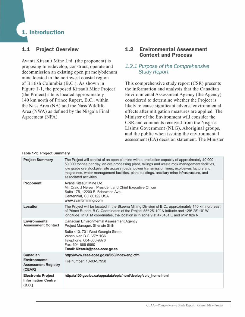
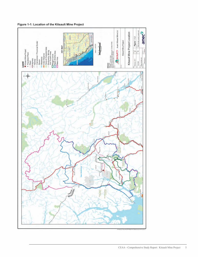
Avanti Kitsault Mine Ltd. (the proponent) is proposing to redevelop, construct, operate and decommission an existing open pit molybdenum mine located in the northwest coastal region of British Columbia (B.C.). As shown in Figure 1-1, the proposed Kitsault Mine Project (the Project) site is located approximately 140 km north of Prince Rupert, B.C., within the Nass Area (NA) and the Nass Wildlife Area (NWA) as defined by the Nisga’a Final Agreement (NFA).
1.2 Environmental Assessment Context and Process
1.2.1 Purpose of the Comprehensive Study Report
This comprehensive study report (CSR) presents the information and analysis that the Canadian Environmental Assessment Agency (the Agency) considered to determine whether the Project is likely to cause significant adverse environmental effects after mitigation measures are applied. The Minister of the Environment will consider the CSR and comments received from the Nisga’a Lisims Government (NLG), Aboriginal groups, and the public when issuing the environmental assessment (EA) decision statement. The Minister
Table 1-1: Project Summary
Project Summary The Project will consist of an open pit mine with a production capacity of approximately 40 000 - 50 000 tonnes per day, an ore processing plant, tailings and waste rock management facilities, low grade ore stockpile, site access roads, power transmission lines, explosives factory and magazines, water management facilities, plant buildings, ancillary mine infrastructure, and associated activities.
Proponent Avanti Kitsault Mine Ltd. Mr. Craig J Nelsen, President and Chief Executive Officer Suite 175, 12200 E. Briarwood Ave., Centennial, CO 80122 USA www.avantimining.com
Location The Project will be located in the Skeena Mining Division of B.C., approximately 140 km northeast of Prince Rupert, B.C. Coordinates of the Project 55º 25’ 19” N latitude and 129º 25’ 10” W longitude. In UTM coordinates, the location is in zone 9 at 473451 E and 6141826 N.
Environmental Canadian Environmental Assessment Agency Assessment Contact Project Manager, Sherwin Shih
Suite 410, 701 West Georgia Street Vancouver, B.C. V7Y 1C6 Telephone: 604-666-9876 Fax: 604-666-6990 Email: [email protected]
Canadian Environmental Assessment Registry (CEAR)
http://www.ceaa-acee.gc.ca/050/index-eng.cfm
File number: 10-03-57958
Electronic Project Information Centre (B.C.)
http://a100.gov.bc.ca/appsdata/epic/html/deploy/epic_home.html
2 CEAA—Comprehensive Study Report: Kitsault Mine Project
will issue a federal Nisga’a Final Agreement Project Recommendation at the same time as the EA decision.
The Minister may request additional information or require that public concerns be addressed further before issuing the EA decision statement. The Minister will refer the Project back to Fisheries and Oceans Canada (DFO) and Natural Resources Canada (NRCan) following the EA decision statement to allow them to take the appropriate course of action.
1.2.2 Federal Environmental Assessment Process
The Canadian Environmental Assessment Act1 (the former Act) applies when federal regulatory authorities contemplate certain actions or decisions about a project that would enable the project to proceed in whole or in part.
An EA is required under the former Act because DFO and NRCan may take regulatory decisions in relation to the Project, specifically, under the Fisheries Act and the Explosives Act respectively.
The Project is subject to a comprehensive study type EA because a component of the Project is described in Section 16(a) of the former Act’s Comprehensive Study List Regulations:
• The proposed construction, decommissioning or abandonment of a metal mine, other than a gold mine, with an ore production capacity of 3 000 tonnes per day or more.
The Agency is responsible for the conduct of the comprehensive study and prepared this CSR in consultation with DFO and NRCan. Environment
Canada (EC), Health Canada (HC) and Aboriginal Affairs and Northern Development Canada (AANDC) also provided advice in relation to their respective mandates and areas of expertise.
1.2.3 Cooperative EA Process
The Project was subject to an EA under the B.C. Environmental Assessment Act. The Governments of Canada and B.C. (through the B.C. Environmental Assessment Office (BC EAO)), conducted the EA cooperatively in accordance with the principles of the Canada-British Columbia Agreement for Environmental Assessment Cooperation (2004).
1 The Canadian Environmental Assessment Act, 2012 (CEAA 2012) came into force on July 6, 2012, replacing the former Canadian Environmental Assessment Act S.C. 1992, c. 37 (the former Act). In accordance with the transition provisions of CEAA 2012, the comprehensive study of the Kitsault Mine Project was completed under the former Act. All references to federal EA legislation in this report reflect the requirements of the former Canadian Environmental Assessment Act S.C. 1992, c. 37.
The Minister of the
Environment will consider
the CSR and comments
received from the Nisga’a
Lisims Government (NLG),
Aboriginal groups, and the
public when issuing the
environmental assessment
(EA) decision statement.
CEAA—Comprehensive Study Report: Kitsault Mine Project 3
1.2.4 Nisga’a Final Agreement
The NFA came into effect in May 2000 under the Constitution Act, 1982 and represents the first modern treaty in B.C. and the first treaty in Canada to incorporate both land claims and constitutionally protected self-government provisions. The NFA establishes the decision-making authority of the NLG and the lands over which the Nisga’a Nation has law-making power and jurisdiction. Chapter 10 of the NFA outlines specific provisions for EAs that are required under federal, provincial, and Nisga’a law.
The Project was subject to the NFA because the Project may reasonably be expected to have adverse environmental effects on residents of Nisga’a Lands, Nisga’a Lands or Nisga’a interests set out in this agreement. Requirements under Chapter 10, paragraph 8 were included in the EA in addition to the requirements of the former Act. The Government of Canada considered whether the Project could reasonably be expected to have: 1) adverse environmental effects on residents of Nisga’a Lands, Nisga’a Lands, or Nisga’a interests set out in the NFA (i.e., effects under paragraph 8(e)) and 2) effects on the existing and future economic, social, and cultural well-being of Nisga’a citizens (i.e., effects under paragraph 8(f)).
In February 2011, a federal approach was established to clarify how the Government of Canada would meet Chapter 10, paragraph 8 requirements in the EA, including the assessment of effects under paragraphs 8(e) and 8(f) and the issuance of a Ministerial NFA Project Recommendation.
The Government of Canada operated in a tripartite government approach with the NLG and the Government of British Columbia to facilitate the assessment of 8(e) and 8(f) effects as part of the comprehensive study.
The proponent conducted an Economic, Social, and Cultural Impact Assessment (ESCIA) on the well-being of Nisga’a citizens (i.e., 8(f) effects) based on a work plan that was a requirement of the federal Environmental Impact Statement (EIS) guidelines. Effects defined under 8(e) were described in the EIS as part of the proponent’s analysis of the Project’s effects on environmental valued components (VCs).
Chapter 5 of this report examines both 8(e) and 8(f) effects to Nisga’a citizens, lands and interests and provides the federal perspective regarding these effects. This chapter, together with comments received during the final public consultation opportunity on the CSR, will inform the Minister of the Environment’s NFA Project Recommendation of whether the Project should proceed. Any subsequent permitting or approval decisions by responsible authorities (RAs) must take the NFA Project Recommendation into account.

4 CEAA—Comprehensive Study Report: Kitsault Mine Project
2. Project Description and Assessment of Alternatives
2.1 Need for and Purpose of the Project
Under the former Act, the need for a project describes the problem or opportunity that a project is intended to solve or satisfy. The purpose of a project describes what is to be achieved by carrying out a project.
The need for the Project relates to supplying molybdenum concentrate to help meet the global demand for molybdenum. The proponent has stated that the purpose of the project is to redevelop, operate, close, and reclaim a former producing mine to extract molybdenum ore in a profitable and sustainable manner. The Project will bring training, employment opportunities and increased investment in services to residents within the region and to the province of B.C. as a whole. On a national level, the proponent suggests that development of the Project will contribute to Canada’s role as a producer of molybdenum in the world economy.
2.2 Project Components
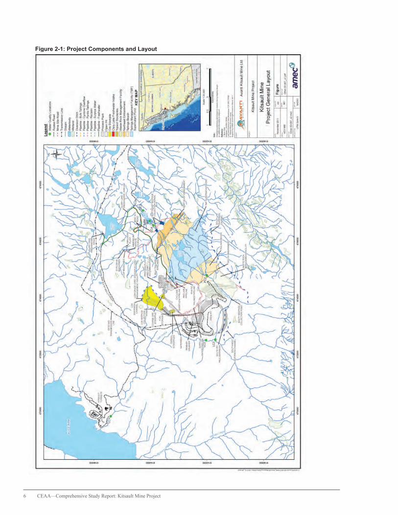
The Project includes the on-site and off-site components described below and shown in Figure 2-1. Further details of these components are provided in Appendix A.
On-site components
• 40 000 to 50 000 tonnes/day open pit mine and processing plant
• waste rock and tailings management facilities• ore stockpiles• water management facilities• site runoff, diversion and water collection system• sewage and waste water management facility• borrow pit, overburden and topsoil storage• construction camps and accommodation
building complex
• explosives manufacturing facility and magazines• infrastructure and facilities (e.g., truck shop, fuel
storage, administration office, assay laboratory)• use and maintenance of a network of existing
access roads including the Nass Forest Service Road, Nass-Kwinatahl Forest Service Road, Kinskuch Forest Service Road and Kitsault Forest Service Road
Off-site components
• new substation at the mine site serviced by an existing B.C. Hydro 138 kilovolt (kV) transmission line from the New Aiyansh substation
• transport of concentrate by truck from the mine site to Kitwanga
• Fisheries Act compensation works to offset the loss of fish habitat
CEAA—Comprehensive Study Report: Kitsault Mine Project 5
Figure 1-1: Location of the Kitsault Mine Project
6 CEAA—Comprehensive Study Report: Kitsault Mine Project
Figure 2-1: Project Components and Layout
CEAA—Comprehensive Study Report: Kitsault Mine Project 7
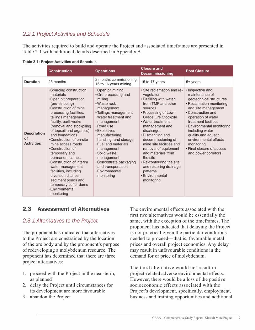
2.2.1 Project Activities and Schedule
The activities required to build and operate the Project and associated timeframes are presented in Table 2-1 with additional details described in Appendix A.
Table 2-1: Project Activities and Schedule
Construction OperationsClosure and Decommissioning
Post Closure
Duration 25 months2 months commissioning; 15 to 16 years mining
15 to 17 years 5+ years
Description of Activities
• Sourcing construction materials
• Open pit preparation (pre-stripping)
• Construction of mine processing facilities, tailings management facility, earthworks (removal and stockpiling of topsoil and organics) and foundations
• Construction of on-site mine access roads
• Construction of temporary and permanent camps
• Construction of interim water management facilities, including diversion ditches, sediment ponds and temporary coffer dams
• Environmental monitoring
• Open pit mining• Ore processing and milling
• Waste rock management
• Tailings management • Water treatment and management
• Road use• Explosives manufacturing, handling, and storage
• Fuel and materials management
• Solid waste management
• Concentrate packaging and transportation
• Environmental monitoring
• Site reclamation and re-vegetation
• Pit filling with water from TMF and other sources
• Processing of Low Grade Ore Stockpile
• Water treatment, management and discharge
• Dismantling and decommissioning of mine site facilities and removal of equipment and materials from the site
• Re-contouring the site and restoring drainage patterns
• Environmental monitoring
• Inspection and maintenance of geotechnical structures
• Reclamation monitoring and site management
• Construction and operation of water treatment facilities
• Environmental monitoring including water quality and aquatic environmental effects monitoring
• Final closure of access and power corridors
2.3 Assessment of Alternatives
2.3.1 Alternatives to the Project
The proponent has indicated that alternatives to the Project are constrained by the location of the ore body and by the proponent’s purpose of redeveloping a molybdenum resource. The proponent has determined that there are three project alternatives:
1. proceed with the Project in the near-term, as planned
2. delay the Project until circumstances for its development are more favourable
3. abandon the Project
The environmental effects associated with the first two alternatives would be essentially the same, with the exception of the timeframes. The proponent has indicated that delaying the Project is not practical given the particular conditions needed to proceed—that is, favourable metal prices and overall project economics. Any delay may result in unfavourable conditions in the demand for or price of molybdenum.
The third alternative would not result in project-related adverse environmental effects. However, there would be a loss of the positive socioeconomic effects associated with the Project’s development, specifically, employment, business and training opportunities and additional

8 CEAA—Comprehensive Study Report: Kitsault Mine Project
benefits through Aboriginal capacity building. Opportunities to compare the alternatives are limited, but abandoning the Project would not fulfill the proponent’s purpose.
In considering the above, the proponent has advised that proceeding with the Project in the near-term, as planned, is the preferred alternative, and is the only alternative that fulfills the project purpose.
2.3.2 Alternative Means of Carrying Out the Project
As presented in the EIS and supporting technical documents, the proponent considered alternative means of carrying out the Project in relation to the following components and activities:
• processing plant • Waste Rock Management Facility (WRMF) • truck shop and fuel storage compound • primary crusher • explosives manufacturing facility and storage magazines • Tailings Management Facility (TMF) • water management • transportation of construction materials • transportation of concentrate • decommissioning, closure and reclamation
The proponent used acceptability criteria and professional judgement to evaluate different alternatives, including cost-effectiveness, potential environmental effects, potential social and economic effects and amenability to reclamation. Appendix B presents a summary of the alternatives considered by the proponent.
The Agency carried out a review of the rationale and method for the selection of preferred alternative means. Based on this review, the Agency is satisfied that the proponent has identified the technically and economically viable approaches for carrying out the Project and the environmental effects of these alternatives have been adequately considered.

CEAA—Comprehensive Study Report: Kitsault Mine Project 9
3. Scope of the Environmental Assessment
Scoping establishes the boundaries of the EA with the purpose of focusing the assessment on relevant factors and concerns.
3.1 Factors to be Considered
Pursuant to subsections 16(1) and 16(2) of the former Act, the following factors were considered as part of the comprehensive study:
• purpose of the project• alternative means of carrying out the Project
that are technically and economically feasible, and the environmental effects of any such alternative means
• environmental effects of the Project, including the environmental effects of accidents and malfunctions that may occur in connection with the Project, and any cumulative environmental effects that are likely to result from the Project in combination with other projects or activities that have been or will be carried out
• capacity of any renewable resources to meet the needs of the present and those of the future
• significance of the effects• comments received from the public in accordance
with the former Act and the regulations• technically and economically feasible measures
that would mitigate any significant adverse environmental effects of the Project
• need for and requirements of any follow-up program in respect of the Project
The environmental effects of the Project on residents of Nisga’a Lands, Nisga’a Lands, or Nisga’a interests were included in the assessment of environmental effects defined in paragraph 2(1) (a) and (b) of the former Act, to meet the requirements of Chapter 10, paragraph 8(e) of the NFA.
The effects on the existing and future economic, social and cultural well-being of Nisga’a citizens as defined in Chapter 10, 8(f) of the NFA were considered as a “matter relevant to the comprehensive study” under subsection 16(1)(e) of the former Act. The Agency also determined that the EA, in accordance with paragraph 16(1)(e), would include a description of the need for the Project, an evaluation of the alternatives to the Project, and an examination of the benefits to Canadians as a result of the EA process.
3.2 Scope of the Project
The scope of the Project for the purposes of the comprehensive study includes all physical works and activities associated with the construction, operation and decommissioning of the Project as described in Chapter 2 of this report.
3.3 Scope of Assessment
For the purposes of identifying the potential for significant adverse environmental effects, the EA focused on aspects of the natural and human environment with particular value or importance
The scope of the Project
for the purposes of the
comprehensive study
includes all physical
works and activities
associated with the
construction, operation
and decommissioning of
the Project.

10 CEAA—Comprehensive Study Report: Kitsault Mine Project
that are likely to be impacted by the Project. These aspects are termed valued components (VCs).
The selection of VCs for the EA was based on issues raised during consultations, literature sources and professional judgement. The VCs considered most important, based on feedback
from the NLG, federal and provincial experts, and Aboriginal groups, and which are the focus of this report, are shown in Table 3-1. The Agency’s assessment of project-related effects on all VCs and the significance of those effects are summarized in Appendix E.
Table 3-1: Key Valued Components Included in the Environmental Assessment
Aspect of the Environment
Valued Components Rationale
Groundwater
• Groundwater flow• Groundwater quality• Recharge and Discharge
• Groundwater and Surface Water Interaction
• Importance to the health and well-being of humans, wildlife, vegetation and other biota
• Pathway for the transport of contaminants to the freshwater, marine, terrestrial and human environments
Hydrology
• Hydrology of Lime/Patsy Creek , Clary Creek and Illiance River watersheds
• Changes to surface water flow and quantity could affect water and sediment quality, habitat for aquatic resources, wildlife and other biota
Surface water and sediment quality
• Surface water quality• Sediment quality
• Pathway for the transport of contaminants to freshwater, terrestrial and human environments
• Important to hydrological processes
Fish and Fish Habitat
• Dolly Varden• Coho salmon• Rainbow trout• Benthic macro-invertebrates
• Ecological, aesthetic and recreational importance of the freshwater environment to the Nisga’a Nation and Aboriginal groups
• Direct interaction of the Project with freshwater streams, some of which support fish
• Potential for effects on the freshwater environment as a result of accidents and malfunctions
• Federal (Fisheries Act) regulations and federal and provincial policies that offer various levels of protection to fish and fish habitat
Marine Aquatic Resources
• Marine water quality• Marine biota
• Commercial, recreational and cultural importance• Potentially influenced by water quality effects associated with the Project
Vegetation and Plant Communities
• Ecosystem composition
• Wetland ecosystems• Old forests• Species at Risk• Ecological communities at risk
• Cultural plants
• Ecological, commercial, and recreational importance of wildlife resources to the Nisga’a Nation, Aboriginal groups and public
• Interaction of project-related activities with wildlife and wildlife habitat• Provincial (B.C. Wildlife Act) and federal (Species at Risk Act) legislation that offer protection to wildlife

CEAA—Comprehensive Study Report: Kitsault Mine Project 11
Table 3-1: Key Valued Components Included in the Environmental Assessment continued
Aspect of the Environment
Valued Components Rationale
Wildlife and Wildlife Habitat
• Western Toad• Olive-sided Flycatcher• Sooty Grouse• Northern Goshawk• American Marten• Mountain Goat• Moose• Grizzly Bear
• Contribution to landscape, community and species-level biodiversity• Function as an indicator of overall ecosystem health• Dependence of wildlife, plant communities and hydrological processes on the condition and characteristics of terrestrial vegetation
• Commercial and cultural values, recognized at a site-specific or regional scale
• Direct interaction of the Project with vegetation resources• Provincial and federal legislation and policies that offer protection to vegetation resources
Land and Resource Use
• Current use of lands and resources for traditional purposes by Aboriginal people
• Trapping and guide outfitting
• Country foods
• The project footprint is located within the asserted traditional territory of the Metlakatla First Nation. Portions of the proposed transportation corridors intersect the traditional territories of the Kitselas First Nation, Kitsumkalum First Nation, Gitxsan Nation, Gitanyow Nation and pass through the NA, NWA, and Nisga’a Lands as defined by the NFA
• Potential for project activities to affect resources that are used by local harvesters (e.g., hunters, gatherers, trappers or fishers)
3.4 Temporal and Spatial Boundaries
The VC selection process also considered the temporal and spatial scope of potential project-environment interactions. The definitions of temporal boundaries are based on the timing and duration of project activities that could adversely affect the environment and humans. Based on the proponent’s project schedule, the temporal boundaries for the EA are:
Construction: Estimated 25 months
Operations: Estimated two months of commissioning and 15 to 16 years of mining
Decommissioning and Closure:
Estimated 15 to 17 years
Post Closure: Estimated five years or more
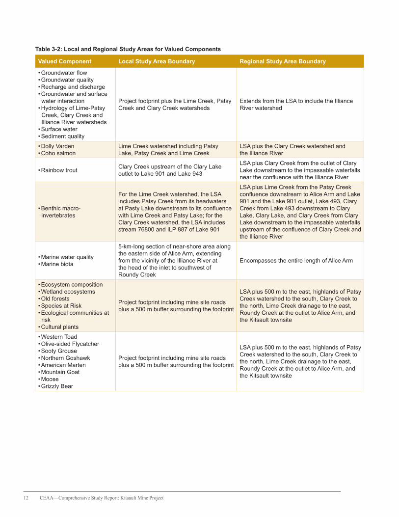
Spatial boundaries for each VC reflect the geographic extent over which the Project’s potential environmental effects are expected to be measurable. These include the local study area (LSA) for consideration of direct effects and the regional study area (RSA) for assessment of cumulative effects. Spatial boundaries for each VC are described in Table 3-2.
12 CEAA—Comprehensive Study Report: Kitsault Mine Project
Table 3-2: Local and Regional Study Areas for Valued Components
Valued Component Local Study Area Boundary Regional Study Area Boundary
• Groundwater flow• Groundwater quality• Recharge and discharge• Groundwater and surface
water interaction• Hydrology of Lime-Patsy
Creek, Clary Creek and Illiance River watersheds
• Surface water• Sediment quality
Project footprint plus the Lime Creek, Patsy Creek and Clary Creek watersheds
Extends from the LSA to include the Illiance River watershed
• Dolly Varden• Coho salmon
Lime Creek watershed including Patsy Lake, Patsy Creek and Lime Creek
LSA plus the Clary Creek watershed and the Illiance River
• Rainbow troutClary Creek upstream of the Clary Lake outlet to Lake 901 and Lake 943
LSA plus Clary Creek from the outlet of Clary Lake downstream to the impassable waterfalls near the confluence with the Illiance River
• Benthic macro-invertebrates
For the Lime Creek watershed, the LSA includes Patsy Creek from its headwaters at Pasty Lake downstream to its confluence with Lime Creek and Patsy Lake; for the Clary Creek watershed, the LSA includes stream 76800 and ILP 887 of Lake 901
LSA plus Lime Creek from the Patsy Creek confluence downstream to Alice Arm and Lake 901 and the Lake 901 outlet, Lake 493, Clary Creek from Lake 493 downstream to Clary Lake, Clary Lake, and Clary Creek from Clary Lake downstream to the impassable waterfalls upstream of the confluence of Clary Creek and the Illiance River
• Marine water quality• Marine biota
5-km-long section of near-shore area along the eastern side of Alice Arm, extending from the vicinity of the Illiance River at the head of the inlet to southwest of Roundy Creek
Encompasses the entire length of Alice Arm
• Ecosystem composition• Wetland ecosystems• Old forests• Species at Risk• Ecological communities at
risk• Cultural plants
Project footprint including mine site roads plus a 500 m buffer surrounding the footprint
LSA plus 500 m to the east, highlands of Patsy Creek watershed to the south, Clary Creek to the north, Lime Creek drainage to the east, Roundy Creek at the outlet to Alice Arm, and the Kitsault townsite
• Western Toad• Olive-sided Flycatcher• Sooty Grouse• Northern Goshawk• American Marten• Mountain Goat• Moose• Grizzly Bear
Project footprint including mine site roads plus a 500 m buffer surrounding the footprint
LSA plus 500 m to the east, highlands of Patsy Creek watershed to the south, Clary Creek to the north, Lime Creek drainage to the east, Roundy Creek at the outlet to Alice Arm, and the Kitsault townsite

CEAA—Comprehensive Study Report: Kitsault Mine Project 13
Table 3-2: Local and Regional Study Areas for Valued Components continued
Valued Component Local Study Area Boundary Regional Study Area Boundary
• Current use of lands and resources for traditional purposes by Aboriginal people
• Trapping and guide outfitting
Project footprint and access and haul roads plus a 500 m buffer surrounding this area
LSA plus Alice Arm, Bessie Lake, Patsy Lake, Shishilabet Lakes, the Kitsault and Illiance Rivers, a number of creeks including Roundy, Lime, Clary, Falls, Wilauks, Morley, Foxy, Hoan, Kelskiist and Theophilus, and the south side of Chaloner Ridge, Mount Theophilus, Ksi Gwinhatal and Dawson Ridge
• Country foodsProject footprint plus a 2 km buffer surrounding the footprint
LSA plus a 2.5 km buffer surrounding the LSA
3.5 Information Distribution
3.5.1 Technical Working Group
In October 2010, a Technical Working Group (TWG) that comprised provincial agencies, federal departments, the NLG, and Aboriginal groups was established by the BC EAO for the EA. The TWG provided the opportunities for parties to:
• review and comment on proposed baseline study programs; • review and comment on draft EIS guidelines and the EIS; • provide advice on issues raised during the course of the EA; and • comment on the EA findings to be reported to provincial ministers and the federal Minister of the Environment at the conclusion of the EA process.
Smaller working groups were also established during the EA to focus on specific issues related to metal leading and acid rock drainage, fisheries, wildlife and wildlife habitat, and transportation.
14 CEAA—Comprehensive Study Report: Kitsault Mine Project
4. Environmental Effects Assessment
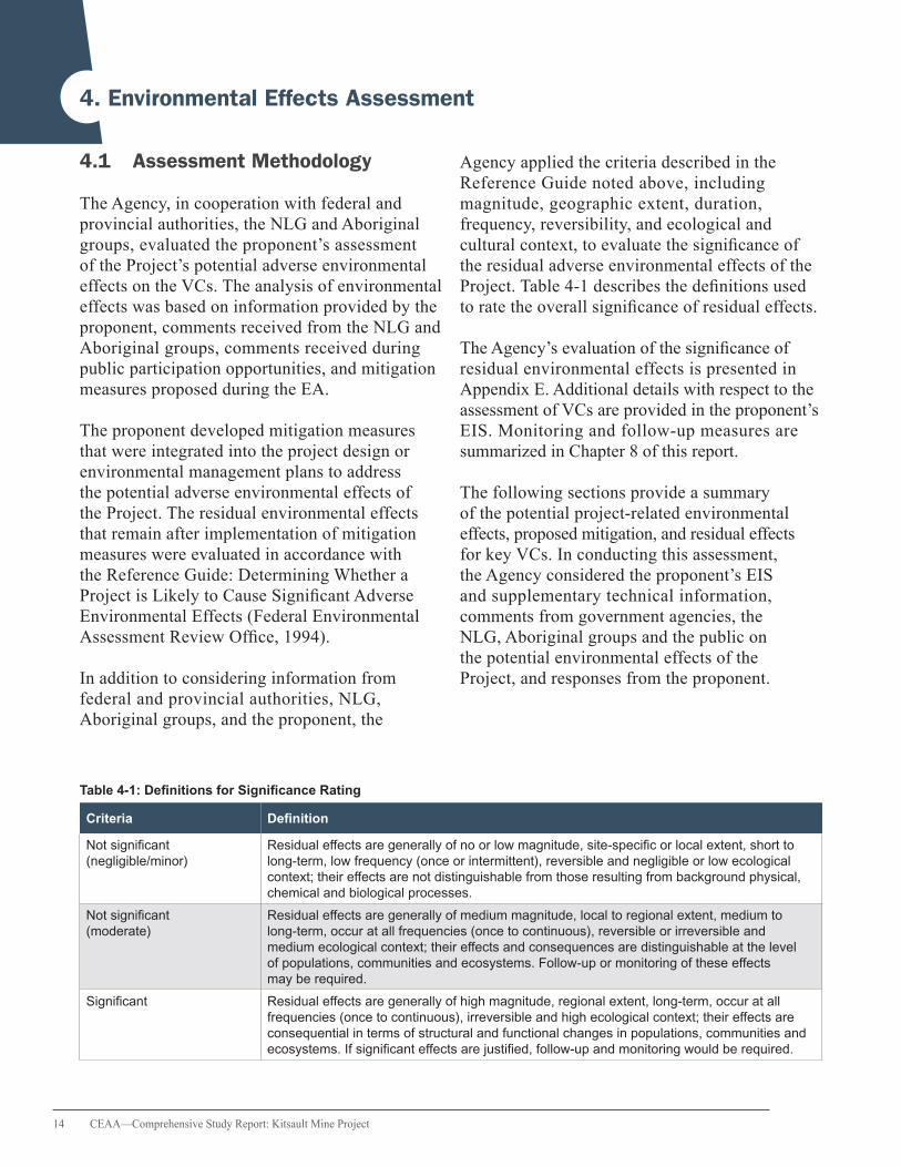
4.1 Assessment Methodology
The Agency, in cooperation with federal and provincial authorities, the NLG and Aboriginal groups, evaluated the proponent’s assessment of the Project’s potential adverse environmental effects on the VCs. The analysis of environmentaleffects was based on information provided by the proponent, comments received from the NLG and Aboriginal groups, comments received during public participation opportunities, and mitigation measures proposed during the EA.
The proponent developed mitigation measures that were integrated into the project design or environmental management plans to address the potential adverse environmental effects of the Project. The residual environmental effects that remain after implementation of mitigation measures were evaluated in accordance with the Reference Guide: Determining Whether a Project is Likely to Cause Significant Adverse Environmental Effects (Federal Environmental Assessment Review Office, 1994).
In addition to considering information from federal and provincial authorities, NLG, Aboriginal groups, and the proponent, the
Agency applied the criteria described in the Reference Guide noted above, including magnitude, geographic extent, duration, frequency, reversibility, and ecological and cultural context, to evaluate the significance of the residual adverse environmental effects of the
Project. Table 4-1 describes the definitions used to rate the overall significance of residual effects.
The Agency’s evaluation of the significance of residual environmental effects is presented in Appendix E. Additional details with respect to the assessment of VCs are provided in the proponent’s EIS. Monitoring and follow-up measures are summarized in Chapter 8 of this report.
The following sections provide a summary of the potential project-related environmental effects, proposed mitigation, and residual effects for key VCs. In conducting this assessment, the Agency considered the proponent’s EIS and supplementary technical information, comments from government agencies, the NLG, Aboriginal groups and the public on the potential environmental effects of the Project, and responses from the proponent.
Table 4-1: Definitions for Significance Rating
Criteria Definition
Not significant Residual effects are generally of no or low magnitude, site-specific or local extent, short to (negligible/minor) long-term, low frequency (once or intermittent), reversible and negligible or low ecological
context; their effects are not distinguishable from those resulting from background physical, chemical and biological processes.
Not significant Residual effects are generally of medium magnitude, local to regional extent, medium to (moderate) long-term, occur at all frequencies (once to continuous), reversible or irreversible and
medium ecological context; their effects and consequences are distinguishable at the level of populations, communities and ecosystems. Follow-up or monitoring of these effects may be required.
Significant Residual effects are generally of high magnitude, regional extent, long-term, occur at all frequencies (once to continuous), irreversible and high ecological context; their effects are consequential in terms of structural and functional changes in populations, communities and ecosystems. If significant effects are justified, follow-up and monitoring would be required.
CEAA—Comprehensive Study Report: Kitsault Mine Project 15
4.2 Surface Water and Sediment Quality
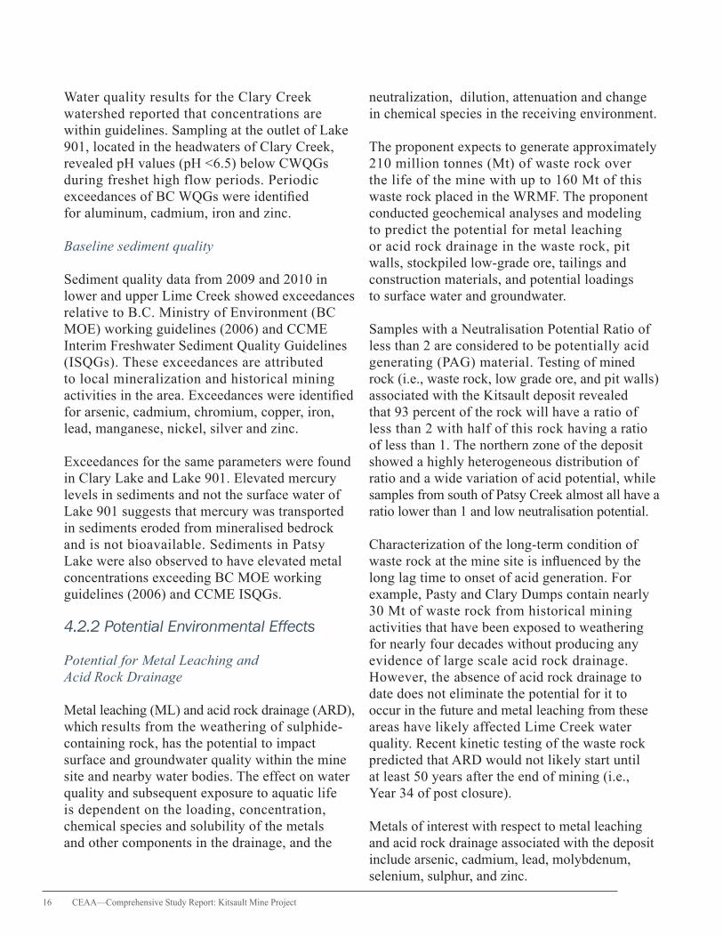
The quality of surface water and sediment has intrinsic importance to the health of the aquatic ecosystem and other VCs such as fish, wildlife and vegetation that depend upon it. The Agency analyzed the effects of project-related changes to surface water and sediment quality with a focus on the Patsy Creek, Lime Creek and Clary Creek watersheds, given their proximity to the mine site. Most of the mine site infrastructure, both historical and proposed, is located within the
Patsy Creek watershed as shown in Figure 4-1, with certain components, such as the Low Grade Ore Stockpile, situated in the Lime Creek watershed.
4.2.1 Description of Baseline Environment
Historical context
The surface water quality assessment focused on project activities that would affect surface water quality and the contribution of past mining activities to existing water quality conditions. Sampling locations used to determine water quality conditions are shown in Figure 2-1, and include LC1, LC2, LC3, and PC2.
To separate the effects of historical mining activities on water quality from those of the Project, the proponent differentiated between “current” baseline water quality conditions, which include disturbance from past mining, and “natural” water quality conditions, which exclude mining effects. “Natural” water quality was modeled for the proposed point of discharge upstream of LC2 using data collected from upper Lime Creek (LC3) and Patsy Creek (PC2).
Current baseline water quality
Concentrations of various parameters in Patsy Creek and Lime Creek exceed B.C. Water Quality Guidelines (BC WQGs) and/or Canadian Water Quality Guidelines (CWQGs) for the Protection of Aquatic Life (CWQGs were applied for parameters where BC WQGs did not exist). These parameters include fluoride, nitrite, sulphate, aluminum, cadmium, copper, iron, zinc and molybdenum. Exceedances in Patsy Creek water quality are attributed to runoff and seepage from the existing mine infrastructure, including the Patsy Dump and Kitsault Pit. With similar water quality in Patsy Creek and Lime Creek, water quality in Patsy Creek is likely contributing to the diminished downstream water quality in Lime Creek.
The analysis of
environmental
effects was based on
information provided
by the proponent,
comments received from
the NLG and Aboriginal
groups, comments
received during
public participation
opportunities, and
mitigation measures
proposed during the EA.
16 CEAA—Comprehensive Study Report: Kitsault Mine Project
Water quality results for the Clary Creek watershed reported that concentrations are within guidelines. Sampling at the outlet of Lake 901, located in the headwaters of Clary Creek, revealed pH values (pH <6.5) below CWQGs during freshet high flow periods. Periodic exceedances of BC WQGs were identified for aluminum, cadmium, iron and zinc.
Baseline sediment quality
Sediment quality data from 2009 and 2010 in lower and upper Lime Creek showed exceedances relative to B.C. Ministry of Environment (BC MOE) working guidelines (2006) and CCME Interim Freshwater Sediment Quality Guidelines (ISQGs). These exceedances are attributed to local mineralization and historical mining activities in the area. Exceedances were identified for arsenic, cadmium, chromium, copper, iron, lead, manganese, nickel, silver and zinc.
Exceedances for the same parameters were found in Clary Lake and Lake 901. Elevated mercury levels in sediments and not the surface water of Lake 901 suggests that mercury was transported in sediments eroded from mineralised bedrock and is not bioavailable. Sediments in Patsy Lake were also observed to have elevated metal concentrations exceeding BC MOE working guidelines (2006) and CCME ISQGs.
4.2.2 Potential Environmental Effects
Potential for Metal Leaching and Acid Rock Drainage
Metal leaching (ML) and acid rock drainage (ARD), which results from the weathering of sulphide-containing rock, has the potential to impact surface and groundwater quality within the mine site and nearby water bodies. The effect on water quality and subsequent exposure to aquatic life is dependent on the loading, concentration, chemical species and solubility of the metals and other components in the drainage, and the
neutralization, dilution, attenuation and change in chemical species in the receiving environment.
The proponent expects to generate approximately 210 million tonnes (Mt) of waste rock over the life of the mine with up to 160 Mt of this waste rock placed in the WRMF. The proponent conducted geochemical analyses and modeling to predict the potential for metal leaching or acid rock drainage in the waste rock, pit walls, stockpiled low-grade ore, tailings and construction materials, and potential loadings to surface water and groundwater.
Samples with a Neutralisation Potential Ratio of less than 2 are considered to be potentially acid generating (PAG) material. Testing of mined rock (i.e., waste rock, low grade ore, and pit walls) associated with the Kitsault deposit revealed that 93 percent of the rock will have a ratio of less than 2 with half of this rock having a ratio of less than 1. The northern zone of the deposit showed a highly heterogeneous distribution of ratio and a wide variation of acid potential, while samples from south of Patsy Creek almost all have a ratio lower than 1 and low neutralisation potential.
Characterization of the long-term condition of waste rock at the mine site is influenced by the long lag time to onset of acid generation. For example, Pasty and Clary Dumps contain nearly 30 Mt of waste rock from historical mining activities that have been exposed to weathering for nearly four decades without producing any evidence of large scale acid rock drainage. However, the absence of acid rock drainage to date does not eliminate the potential for it to occur in the future and metal leaching from these areas have likely affected Lime Creek water quality. Recent kinetic testing of the waste rock predicted that ARD would not likely start until at least 50 years after the end of mining (i.e., Year 34 of post closure).
Metals of interest with respect to metal leaching and acid rock drainage associated with the deposit include arsenic, cadmium, lead, molybdenum, selenium, sulphur, and zinc.

CEAA—Comprehensive Study Report: Kitsault Mine Project 17
The Project is expected to produce approximately 16 Mt of tailings per year, with the tailings management facility (TMF) designed for secure and permanent storage of approximately 270 Mt of tailings. Two main streams of tailings will exit the mill. Most of the tailings will be de-pyritised rougher tailings that will be non-potentially acid generating (i.e., less than 0.10 percent sulphur and a ratio above 15) and suitable for beach or TMF dam construction. Rougher tailings not used for construction will be deposited and partly flooded in the TMF. The second tailings stream will comprise a combination of cleaner scavenger tailings with pyrite concentrate. This waste stream is expected to be strongly potentially acid generating with anticipated sulphide concentrations above 30 percent and will be stored underwater in the center of the TMF to prevent the onset of metal leaching and acid rock drainage.
Surface Water Quality
Mine development and operation involve activities that have the potential to affect surface water quality. Without mitigation, changes in water quality could result from discharges of mine process water, seepage from the TMF embankments and Low Grade (ore) Stockpile (LGS), runoff from disturbed surfaces, topsoil and till, and metal leaching and acid rock drainage from exposed mine rock, tailings, and molybdenum concentrate storage. The proponent’s water quality modeling results before mitigation predicted potential water quality effects throughout all project phases, peaking towards the end of operations and then declining through closure and post closure. Predictions were compared against both the “natural” and current water quality conditions.
Without treatment, water quality predictions for Lime Creek showed exceedances of BC WQGs and CWQGs (30 day or maximum) for a number of metals including fluoride, aluminum, cadmium, copper, chromium, mercury and zinc.
Cadmium was identified as the main parameter of concern due to the persistent exceedances of BC WQGs and CWQGs and the elevated concentrations in waste rock.
Cadmium concentrations in lower Lime Creek were modeled as high as 18 times BC WQG and CWQG during operations and 14 times these guidelines during the post-closure period prior to treatment. Other parameters were also predicted to exceed water quality guidelines in lower Lime Creek including fluoride, sulphate, aluminum, chromium, copper, mercury, molybdenum, selenium and zinc.
For the Clary Creek watershed, cadmium and mercury were the key parameters of concern that were predicted to reach peak concentrations after closure when the Northeast Seepage Collection Ponds (NSCPs) are allowed to spill into Lake 901. Without mitigation, concentrations of these parameters are predicted to exceed BC WQGs and CWQGs due to seepage from the cyclone sand dam within the TMF embankments (cyclone sand is finely ground rock that is a by-product of tailings). Exceedances of guidelines were also predicted for arsenic, aluminum, sulphate, copper, lead, molybdenum, chromium, iron, selenium and zinc.
Water quality further downstream in Clary Lake, although predicted to exceed BC WQGs and CWQGs for various parameters including cadmium, would not cause further decline in water quality downstream in the Illiance River where baseline concentrations already exceed guideline limits.
Water Quality Effects on Fish and Fish Habitat
Changes in surface water quality resulting from mine water discharge and seepage over the course of the Project have the potential to affect fish and fish habitat. Without mitigation, exceedances of BC WQGs and CWQGs could potentially affect the health of Dolly Varden, coho salmon, and other freshwater biota.

18 CEAA—Comprehensive Study Report: Kitsault Mine Project
Figure 4-1: Patsy Creek, Lime Creek, and Clary Creek Watersheds
LIM
E
CR
EE
KW
AT
ER
SH
ED
CL
AR
Y
CR
EE
KW
AT
ER
SH
ED
Lim
e
Creek
Creek
Pats
y
Creek
Cla
ryCreek
Creek
Fal
ls
Roundy
Wila
uks
R i
v e
r
C r
e e
k
R i
v e
r
Cla
ry L
ake
Pats
y La
ke
Alic
e
Arm
I l l
i a n
c e
K w
i n
a t a
h l
470,000
470,000
475,000
475,000
480,000
480,000
485,000
485,000
490,000
490,000
6,14
0,00
06,
140,
000
6,14
5,00
06,
145,
000
RE
VD
ATE
DE
SC
RIP
TIO
ND
ES
IGN
ED
AP
P'D
CH
K'D
DR
AWN
CC
A19
OC
T'12
ISS
UE
D F
OR
INFO
RM
ATIO
NAM
DG
LSKJ
B
KITS
AU
LT P
RO
JEC
T
AVA
NTI
KIT
SA
ULT
MIN
E L
TD.
WAT
ERSH
ED M
OD
EL S
TREA
MFL
OW
NO
DES
P/A
NO
.
RE
VVA
101-
343/
13-
RE
F N
O.
FIG
UR
E 3
SAVED: M:\1\01\00343\13\A\GIS\Figs\_working\KITS_WatershModelNodes.mxd; Oct 22, 2012 5:01 PM; cczembor
A
10
12
30.
5km
SC
ALE
NO
TES:
1. B
AS
E M
AP
: NR
CA
N M
TS D
ATA
AN
D E
SR
I AC
RG
IS O
NLI
NE
IMA
GE
RY.
2. C
OO
RD
INAT
E G
RID
IS IN
ME
TRE
S.
CO
OR
DIN
ATE
SY
STE
M: N
AD
198
3 U
TM Z
ON
E 9
N.
3. T
HIS
FIG
UR
E IS
PR
OD
UC
ED
AT
A N
OM
INA
L S
CA
LE O
F 1:
61,9
90FO
R 1
1x17
(TA
BLO
ID) P
AP
ER
. AC
TUA
L S
CA
LE M
AY D
IFFE
R
AC
CO
RD
ING
TO
CH
AN
GE
S IN
PR
INTE
R S
ETT
ING
S O
RP
RIN
TED
PA
PE
R S
IZE
.
DR
AFT
GEN
ERA
LLE
GEN
D:
MA
JOR
WAT
ER
SH
ED
BO
UN
DA
RY
RIV
ER
LAK
E
MIN
E S
ITE
AR
EA
Nam
eW
ater
shed
Ar
ea (k
m2 )
Dist
urbe
d Ar
ea (k
m2 )
Clar
y Cr
eek
Wat
ersh
ed36
.71.
8Li
me
Cree
k W
ater
shed
39.7
8.7
Min
e Si
te F
ootp
rint
-10
.5

CEAA—Comprehensive Study Report: Kitsault Mine Project 19
Sediment Quality
Project-related activities, including land clearing, topsoil stripping and stockpiling, and road and infrastructure construction could affect sediment quality through sediment entrained in surface runoff and mobilization of metals that become adsorbed into sediments. The Patsy Creek discharge site (Lime Creek watershed) was identified as the greatest source of sediment metals as water would be discharged into Lime Creek directly. In the Clary Creek watershed, seepage from the LGS and the Northeast Embankment Water Management Ponds during operations could provide a pathway for metals to become adsorbed onto sediments.
4.2.3 Mitigation Measures
Metal Leaching and Acid Rock Drainage Management
A suite of mitigation measures will be applied to manage potentially acid generating waste rock and tailings and reduce the liability and costs associated
with future water treatment (see Table 4-2). These measures are expected to reduce contaminant discharge, but water treatment would still be required as metal leaching and acid rock drainage is predicted in the future.
The proponent also considered additional mitigation by waste rock segregation and undertook a geochemical modeling to get a conceptual picture of the NPR distribution in the Kitsault deposit. The proponent concluded that segregation of waste rock by ARD potential was at present not practical based on the predominance of potentially acid generating material, the variability of neutralisation potential ratio and the lack of detailed sampling and analysis.
However, the actual distribution of low NPR waste can be accurately determined once mining begins. As a result, and in response to comments from the TWG, the proponent is required as part of the B.C. EA Certificate, to complete an assessment of the technical feasibility to segregate and submerge waste rock based on its potential for acid rock drainage and measurable long-term water quality benefits. A plan to segregate
Table 4-2: Mitigation for Potentially Acid Generating Waste Rock and Tailings
Mitigation measures Activities
Use of non-PAGGeochemical characterization of construction material and use of non-PAG material for construction other than South Embankment
Footprint minimizationConstruction of the WRMF in an area of previous disturbance to minimize the environmental footprint of the mine
Water managementNon-contact water will be diverted around the WRMF and contact water will be diverted to the TMF or Kitsault open pit for discharge, depending on the project phase
Water treatmentThe Project will be designed to enable water treatment during operations, closure and post closure to meet BC WQGs or approved Site Specific Water Quality Objectives
PAG TailingsCleaner scavenger tailings and pyrite concentrate that are PAG will be stored below water in the TMF; rapid on-site NP and AP sample analyses will identify and assist management of PAG materials (NPR < 2)
Low Grade Ore stockpile
A technical evaluation will be undertaken prior to construction to determine feasibility of relocating the LGS to a location adjacent to the open pit. At mine closure, the stockpiled low grade ore will be milled or moved to the open pit for permanent subaqueous storage
Financial AssuranceProvision of a financial security for construction, inspection, monitoring, maintenance and repair of drainage collection and ML/ARD mitigation structures
SegregationAssessment of the technical feasibility of segregating and submerging waste rock and segregate waste rock, if feasible, based on potential for ARD and benefits to water quality
20 CEAA—Comprehensive Study Report: Kitsault Mine Project
and submerge waste rock will be developed and implemented if provincial ministries determine that segregating and submerging waste rock is feasible and beneficial to long-term predicted water quality.
Water Quality Management
The proponent’s Mine Site Water Management Plan includes the following measures to address project-related effects to surface water quality:
• Separation of contact and non-contact water and storing contact water in the TMF • Seepage collection ponds and vertical sumps to collect surface runoff and seepage from mine infrastructure, including the TMF embankments and LGS • Water treatment during operations, closure and post closure, including the construction of a water treatment plant if there is elevated metal leaching or acidic drainage from the WMRF • Reuse of water to the extent practicable through the collection and management of site runoff from disturbed areas, recycling of process water and storage of surplus water within the TMF until discharge is required • Ongoing research to support the development of site-specific water quality objectives during permitting for parameters exceeding BC WQG limits (i.e., cadmium, sulphate, and aluminum)
Additional mitigation measures were developed during the review of the EIS in response to concerns raised by the TWG. Water quality in Lime Creek (LC1 and LC2) and Lake 901 will meet BC WQGs unless site-specific water quality objectives have been approved by the BC MOE for specific parameters of concern. The project design will also provide for water treatment during operations, closure, and post closure and include the capacity to collect runoff and seepage from all project infrastructure and direct it to the TMF. Viable water treatment technologies were assessed during the EA, including in-mill water treatment (operations and closure), in-pit water
treatment (closure) and active water treatment (post closure).
For in-mill treatment, lime and sulphide reagents would be added to the tailings slurry within the mill circuit to cause the precipitation of dissolved metals in the tailings supernatant. The precipitate would be entrained with the tailings solids and directed to the TMF, which would be designed to provide filtration by dividing the pond into two sections containing filtered and unfiltered water. Microfilters would draw water from the unfiltered section of the TMF into the filtered section, which would then be discharged into the receiving environment. Applying the lime-sulphide treatment to the mill circuit, combined with filtration, would improve the quality of the water that would be released from the TMF into Lime Creek.
As the Kitsault Pit fills during the closure phase, the addition of lime to raise the pH and precipitate metals would be used to reduce elevated concentrations of dissolved metals in the pit lake. Lime would be applied to the pit lake water, either by batch treatment or continuous application, prior to discharge into Lime Creek at the start of post closure. During post closure, adding lime to a water treatment plant, such as a High Density Sludge facility, can be effective in improving water quality affected by ARD.
During the winter, snow that accumulates within the mine site will be deposited at the western edge of the WRMF instead of on top of the waste rock so that the water from the melted snow does not drain through the rock placed with the WRMF.
Table 4-3 describes the proposed approaches to managing contact water as part of the Mine Site Water Management Plan. A summary of mitigation measures is described in Appendix C.
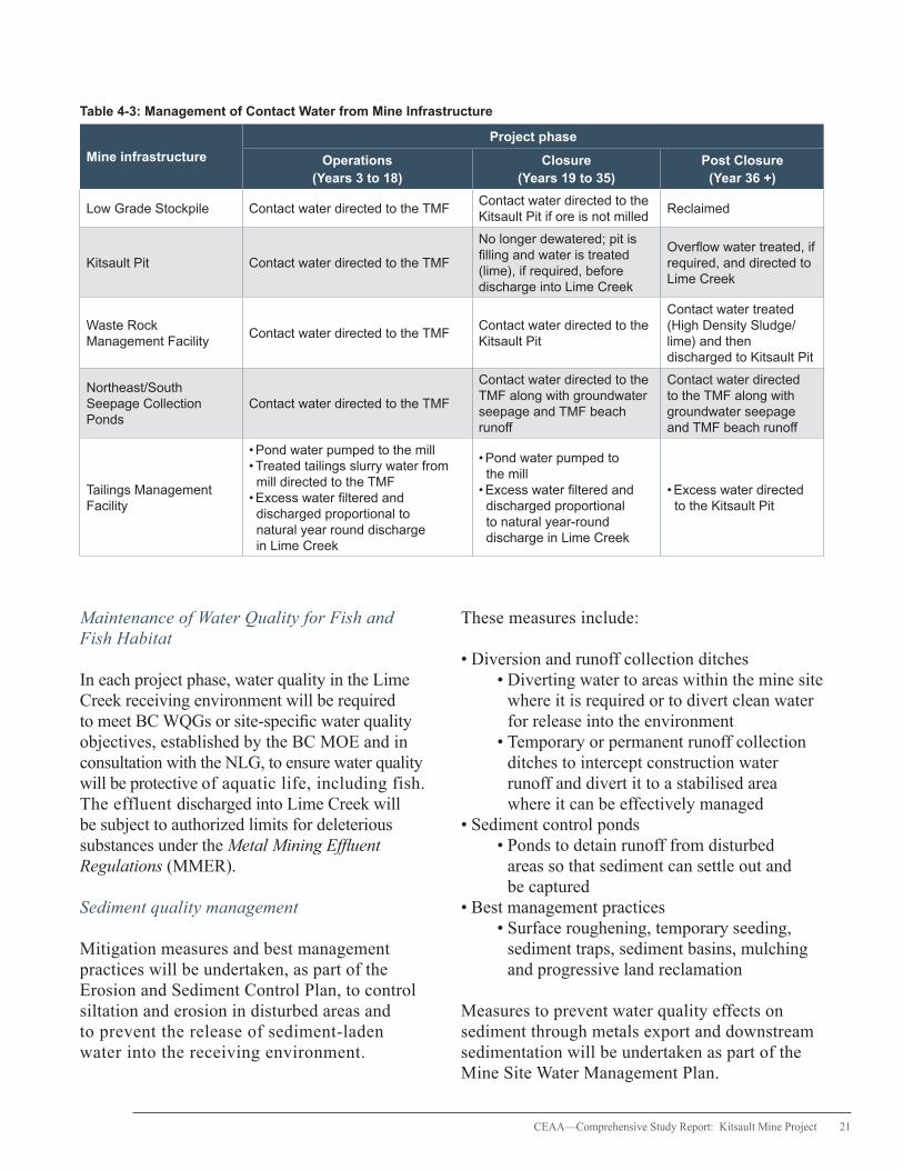
CEAA—Comprehensive Study Report: Kitsault Mine Project 21
Table 4-3: Management of Contact Water from Mine Infrastructure
Mine infrastructure
Project phase
Operations (Years 3 to 18)
Closure (Years 19 to 35)
Post Closure (Year 36 +)
Low Grade Stockpile Contact water directed to the TMFContact water directed to the Kitsault Pit if ore is not milled
Reclaimed
Kitsault Pit Contact water directed to the TMF
No longer dewatered; pit is filling and water is treated (lime), if required, before discharge into Lime Creek
Overflow water treated, if required, and directed to Lime Creek
Waste Rock Management Facility
Contact water directed to the TMFContact water directed to the Kitsault Pit
Contact water treated (High Density Sludge/lime) and then discharged to Kitsault Pit
Northeast/South Seepage Collection Ponds
Contact water directed to the TMF
Contact water directed to the TMF along with groundwater seepage and TMF beach runoff
Contact water directed to the TMF along with groundwater seepage and TMF beach runoff
Tailings Management Facility
• Pond water pumped to the mill• Treated tailings slurry water from mill directed to the TMF
• Excess water filtered and discharged proportional to natural year round discharge in Lime Creek
• Pond water pumped to the mill
• Excess water filtered and discharged proportional to natural year-round discharge in Lime Creek
• Excess water directed to the Kitsault Pit
Maintenance of Water Quality for Fish and Fish Habitat
In each project phase, water quality in the Lime Creek receiving environment will be required to meet BC WQGs or site-specific water quality objectives, established by the BC MOE and in consultation with the NLG, to ensure water quality will be protective of aquatic life, including fish. The effluent discharged into Lime Creek will be subject to authorized limits for deleterious substances under the Metal Mining Effluent Regulations (MMER).
Sediment quality management
Mitigation measures and best management practices will be undertaken, as part of the Erosion and Sediment Control Plan, to control siltation and erosion in disturbed areas and to prevent the release of sediment-laden water into the receiving environment.
These measures include:
• Diversion and runoff collection ditches • Diverting water to areas within the mine site where it is required or to divert clean water for release into the environment • Temporary or permanent runoff collection ditches to intercept construction water runoff and divert it to a stabilised area where it can be effectively managed
• Sediment control ponds • Ponds to detain runoff from disturbed areas so that sediment can settle out and be captured
• Best management practices • Surface roughening, temporary seeding, sediment traps, sediment basins, mulching and progressive land reclamation
Measures to prevent water quality effects on sediment through metals export and downstream sedimentation will be undertaken as part of the Mine Site Water Management Plan.

22 CEAA—Comprehensive Study Report: Kitsault Mine Project
4.2.4 Government, Aboriginal and Public Comments
Key concerns associated with surface water and sediment quality pertained to the host of parameters that exceeded BC WQGs and CWQGs in Lime Creek and Clary Creek watersheds and the consideration of both “natural” (pre-mine) and current water quality in the definition of “baseline” water quality for Lime Creek. Comments were provided about the elevated concentrations of certain parameters without mitigation during times of low flow in Lime Creek and the effects of these concentrations in the receiving environment on marine life, including the seafood consumed by Nisga’a citizens. There was also discussion regarding the appropriate location for compliance monitoring (i.e., LC1 vs. LC2) and the range and frequency of exceedances above guidelines currently occurring at LC1 and in modeled predictions during the mine life. The LGS garnered attention with regard to its contribution to metal loadings on freshwater creeks during the life of the Project. Questions were raised regarding the potential to mill versus stockpile the low grade ore. Reviewers discussed the possibility of segregating PAG from non-PAG waste rock as a cost-effective measure that could avoid the need for long-term treatment if PAG waste rock were stored in a sub-aqueous manner. Other comments focused on the proponent’s approach to developing site-specific water quality management targets at the permitting phase of the Project and the scope of the proponent’s Aquatic Effects Monitoring Program (AEMP). This led to further analysis of potential water quality effects during the EA.
4.2.5 Residual Effects
Residual Water Quality Effects
Residual effects of ML/ARD on water quality will be mitigated by water management measures and activities specified in the ML/ARD Monitoring
and Management plan for all phases of the Project. The effluent to be discharged into Lime Creek will be subject to and is predicted to meet water quality limits prescribed in the MMER. Environmental Effects Monitoring pursuant to the MMER will help to evaluate the adequacy of the regulatory limits in protecting fish, fish habitats, and the use of fisheries resources.
With the application of the proponent’s Mine Site Water Management Plan, that includes measures for water treatment and seepage control, the Project is designed to meet BC WQGs or site-specific water quality objectives approved by the BC MOE in Lime Creek.
Comparisons were made between predicted water quality (annual average), water quality guidelines and current concentrations for cadmium, aluminum and sulphate at monitoring station LC1 in lower Lime Creek during operations, closure and post closure (see Appendix F). LC1 was used to represent the receiving environment since the monitoring station is near to where fish habitat is found in lower Lime Creek. The data indicates that while predicted cadmium values may still remain above guideline limits during the life of the Project, water quality is expected to improve over current (baseline) conditions, which already exceed the BC WQGs and CWQGs. While annual values are provided in Appendix F for comparison purposes, these numbers are higher or lower during certain times of the year.
Aluminum concentrations are also predicted to be below water quality guidelines, except during operations when values are highest due to TMF discharge. Unlike other parameters, sulphate concentrations are not projected to improve through the course of the Project. The highest concentrations are projected to occur and exceed guidelines in early post closure following the discharge from the Kitsault Pit into Lime Creek. These exceedances are likely during high precipitation periods of the year (e.g., winter and spring freshet) because in-pit lime water

CEAA—Comprehensive Study Report: Kitsault Mine Project 23
treatment is not effective in reducing sulphate concentrations. Initial post-closure concentrations in the Kitsault Pit will be elevated, but are expected to improve over time.
With the implementation of the proposed mitgation measures, future water quality in Lime Creek is predicted to improve over current water quality conditions. However, residual water quality effects related to cadmium and sulphate in Lime Creek are expected to be of low to medium magnitude, localized, long-term (beyond post closure), continuous and irreversible.
Residual effects to water quality are not predicted in Lake 901, Clary Lake or further downstream in the Clary Creek and Illiance River watershed with the implementation of the proposed seepage collection measures.
Residual Sediment Quality Effects
Water management and sediment and erosion control measures outlined in the Erosion and Sediment Control Plan are expected to prevent sedimentation and erosion from affecting sediment quality in the Lime Creek and Clary Creek watersheds at all phases of the Project. As prescribed in the MMER, the effluent discharge cannot exceed a monthly mean concentration of 15 mg/L for total suspended solids. Due to past mining activities, current sediment quality in the Lime Creek and Clary Creek watersheds exceeds both BC MOE and CCME ISQGs for a host of parameters.
Effluent discharges from the mine are not predicted to exacerbate metal loading on downstream sediments with the proposed water treatment measures in place. As such, the residual effects to sediment quality are considered local in geographic extent, low magnitude, long-term, continuous, and irreversible.
4.2.6 Agency Conclusions
Based on the information in this report and with the implementation of the mitigation measures as described in this report and summarized in Appendix C, the Project is not likely to result in significant adverse environmental effects on surface water and sediment quality.
4.3 Hydrology
The Agency assessed the effects of the Project on hydrology (surface water quantity) in the Lime Creek, Clary Creek and Illiance River watersheds given its influence on water and sediment quality and in turn, aquatic and wildlife habitat. Key issues relating to hydrology included changes to annual and seasonal flows in these watersheds.
4.3.1 Description of Baseline Environment
The LSA included the project footprint and associated activities that could cause surface water quantity and flow effects. The RSA covered the Lime Creek (including Patsy Creek), Clary Creek and Illiance River (lower portion downstream of Clary Creek) watersheds. Annual hydrographs of these creeks show the highest peak flow occurring in the spring freshet period and a secondary peak occurring in the late fall or early winter period.
Lime Creek/Patsy Creek Watershed
The Patsy Creek watershed is a sub-watershed of the Lime Creek watershed with Patsy Creek draining into Lime Creek and then into Alice Arm. The downstream end of Lime Creek was identified to be of hydrological importance given the presence of various species of fish and its proximity to the intertidal zone of Alice Arm.
A bedrock cascade located approximately 1800 meters up Lime Creek acts as a barrier to fish passage, making parts of Lime Creek and all of Patsy Creek non-fish bearing.

24 CEAA—Comprehensive Study Report: Kitsault Mine Project
Clary Creek Watershed
The Clary Creek watershed is situated to the north and east of the Project. Several lakes and ponds, including Clary Lake and Lake 901, are located in the headwaters of Clary Creek, which flows in a north-westerly direction and discharges into the lower Illiance River.
Illiance River Watershed
The Illiance River watershed upstream of the Clary Creek and Illiance River confluence does not interact with mining activities, and as a result, was not considered in the hydrological assessment. Conversely, the Illiance River below the confluence of Clary Creek and the Illiance River could be affected by flow and water quantity changes in the Clary Creek watershed and was included in the assessment.
4.3.2 Potential Environmental Effects
All three watersheds are situated within or adjacent to the project footprint, with the greatest disturbance situated in Patsy Creek. Water diversion, obstruction and withdrawal activities have the potential to affect annual flows, seasonal flow distributions (high and low flows) and lake levels during all phases.
Runoff volumes in affected watersheds are anticipated to change due to the construction of mining infrastructure (e.g., waste rock and LGS) and water diversions, increased evaporation and seepage due to the large surface water area of the TMF, greater impermeable areas where mine facilities are constructed, and alteration of groundwater flows as a result of Kitsault Pit. Aspects of the Mine Site Water Management Plan, including pit de-watering and flooding, seepage collection, surface water retention and diversions, also have the potential to affect hydrology.
Lime Creek-Patsy Creek Watershed
The TMF will be constructed over Patsy Lake and is expected to alter the flow pattern of the Patsy Creek drainage area. The WRMF and Kitsault Pit will affect a portion of Patsy Creek. Annual flow volumes, peak flows, and low flows will be affected during each phase of the Project with the greatest hydrological effects anticipated in the area of the proposed TMF. The filling of the Kitsault Pit during closure will affect flows in Lime Creek.
Clary Creek Watershed
Changes in the hydrology of Clary Lake and Lake 901 are expected because of TMF development and water withdrawal from Clary Lake for mill processing and potable water needs. Approximately 1.9 km2 of the Lake 901 drainage area will be covered by the TMF and not contribute to flows in the Clary Creek watershed. With Lake 901 flowing to Clary Lake, water levels in Clary Lake are predicted to decline by up to 5 percent.
Illiance River Watershed
The proponent’s modeling estimated minor effects (i.e., -2 percent to 0 percent change from baseline) to average annual, peak, and seven-day low flows in the lower Illiance River. These effects reflect the small loss of drainage due the TMF in the Clary Creek watershed (1.9 km2) compared to the overall drainage area of the lower Illiance River (127.1 km2).
4.3.3 Mitigation Measures
As part of the Mine Site Water Management Plan, mitigation measures to minimize project effects on surface water flows include maximising water recycling, regulating discharges to mimic baseline conditions, and compensating for flow losses during low-flow periods. Contact water from the TMF embankments, WRMF, Kitsault Pit and LGS will be collected and pumped back

CEAA—Comprehensive Study Report: Kitsault Mine Project 25
to the TMF for reuse in the milling process or discharged into Lime Creek following treatment.
The TMF is expected to have sufficient capacity to store water for most of the year without requiring discharge; however, excess water from the TMF will be discharged into Lime Creek throughout the year in a manner that mimics the natural hydrograph of Lime Creek. Therefore, more water will be discharged during periods of high natural flow (i.e., May – July, October) and less water will be discharged during winter and late summer low-flow periods. Based on this approach, the seasonal distribution of high and low flows is maintained until post closure, when water is no longer stored on the mine site. In some cases, excess water may be retained in the TMF to meet regulatory requirements.
Flow reduction in Lake 901 will be mitigated by diverting water from neighbouring Lake 493. With this diversion, no effects in Lake 901 and Clary Lake are anticipated during construction and operations phases; however, lake levels are expected to increase during closure and post closure due to continued flow diversion from Lake 493 and runoff from the TMF.
4.3.4 Government, Aboriginal and Public Comments
Key concerns regarding hydrology included the potential impacts of reduced flows on fish and fish habitat in lower Lime Creek and the Clary Creek watershed, the accuracy of the water balance model in representing baseline flows and the potential for unregulated discharges to disrupt the natural hydrology in Lime Creek. Government agencies, the NLG and Aboriginal groups expressed the importance of addressing water flows and reclamation during closure and post closure. Comments were also provided regarding the calibration of the TMF water balance model to reflect the changes to water management in and around the mine site. In response to comments raised, the proponent
proposed to install monitoring and pump-back wells downstream of the NSCPs and upstream of Lake 901 prior to construction. This seepage management infrastructure would remain over the life of the Project to prevent effects to Lake 901 and Clary Lake.
4.3.5 Residual Effects
Following mitigation, reductions in annual low flows and peak flows in the Lime Creek and Patsy Creek watershed are expected during all project phases prior to post closure, despite the measures to mimic the natural hydrological conditions of Lime Creek.
Water storage from the mine site catchment during operations and closure is expected to reduce the annual water volume in Lime Creek up to 11 percent relative to baseline conditions. This reduction amounts to a 13 percent reduction in average peak flow and an 11 percent reduction during the period of low flow. Similar flow reductions are expected during filling of the Kitsault Pit at closure, but the natural hydrographic pattern (cycle of peak and low flows) will be maintained. At post closure, a slight increase of 7 percent in annual volume and 10 percent in peak flow are expected when water is no longer stored on site (see Figure G-1 in Appendix G).
Residual effects to Lime Creek flows will be continuous throughout all project phases including post closure and are expected to be long-term. The magnitude is expected to be low to medium since the changes are within the range of natural variation. The altered flow conditions will be limited to the watershed and irreversible.
In the Clary Creek watershed, diversion from Lake 493 to Lake 901 is expected to mitigate the loss of flow in Lake 901 caused by the TMF. The seepage collection and pump-back system in place at the north end of the Project are predicted to reduce the effects on Lake 901 and on flow contributions to Clary Creek.
26 CEAA—Comprehensive Study Report: Kitsault Mine Project
However, after mitigation, overall decreases in Clary Creek flows as a result of the Project are still anticipated– maximum reductions of 8 percent, 7 percent, and 17 percent in average annual, peak (10-year and 200-year) flows, and 10-year 7-day low flows, respectively. The 100-year 7-day low flows will be unaffected. Maximum predicted changes in average annual, peak and 7-day low flows are within 2 percent of baseline flows in the Illiance River below Clary Creek.
Based on these considerations, residual effects to the Clary Creek watershed are expected to be low to medium in magnitude, continuous, long-term, and irreversible.
4.3.6 Agency Conclusions
Based on the information in this report and with the implementation of the mitigation measures as described in this report and summarized in Appendix C, the Project is not likely to result in significant adverse environmental effects on hydrology.
4.4 Groundwater
The Agency assessed groundwater as an aquatic environment VC because changes to groundwater flow and quality can affect water and sediment quality which, in turn, influence fish and wildlife habitat.
4.4.1 Description of Baseline Environment
Groundwater flow
The proponent’s field studies and groundwater modeling show that average groundwater flow rates constitute a small portion of the total average surface water flow rates within the modeled area. Groundwater flow beneath the RSA is influenced by local climatic and hydraulic conditions within the Patsy Creek, Lime Creek, Clary Creek and Illiance River
(lower reach) watersheds. Groundwater recharges from precipitation that flows down-slope, over exposed bedrock or through thin overburden, to stream valleys or topographically low areas. Groundwater discharges to surface water bodies that intersect the water table at the watershed boundary’s lowest elevation.
Groundwater quality
Analyses of local groundwater samples revealed elevated concentrations of sulphate, ammonia, and dissolved metals relative to BC WQGs, B.C. Contaminated Sites Regulations, B.C. Hazardous Waste Regulations, and CWQGs. Sources of potential groundwater contamination from the Project include:
• blasting residue • construction, use and reclamation of the LGS stockpile, WRMF and TMF • surface and waste water management works and facilities and operational failure of these works • infiltration of pit lake water, containing blasting residue and metal concentrations into bedrock groundwater
The proponent continues to conduct quarterly groundwater quality monitoring to validate baseline data.
4.4.2 Potential Environmental Effects
Groundwater flow
Potential groundwater flow effects could occur as a result of dewatering the Kitsault Pit, construction and operation of the TMF and construction of water diversion structures.
Development of the Kitsault Pit below the existing water table is expected to direct groundwater flow from Patsy Creek and Lime Creek toward the open pit and lower the water table near the pit. With the pit located near the confluence of Patsy Creek with Lime Creek, pit
CEAA—Comprehensive Study Report: Kitsault Mine Project 27
dewatering is predicted to result in loss of both groundwater and surface water flows to Lime Creek. However, low bedrock permeability and the high potential for groundwater recharge are expected to limit the flow loss to a relatively small area of influence around the pit.
During operations, surface water diversion channels will divert surface water within the Patsy and Lime Creek watersheds around the Kitsault Pit. These diversion channels are not anticipated to affect groundwater flow, since the extent of the diverted flow would be small compared to that of the watershed and the discharge would occur at or near locations where the diverted surface water would have discharged naturally.
Baseline groundwater flow near the Kitsault Pit and diversion channels is expected to re-establish during mine decommissioning and closure, but the TMF is predicted to continually alter groundwater flow in the Lime Creek watershed as a new reclaimed landscape feature.
Any pit water in the TMF supernatant pond that infiltrates the Patsy Creek watershed is not likely to affect groundwater flow within the Patsy Creek and Lime Creek watersheds since the extracted groundwater originated within these watersheds. In addition, a small volume of pit water is expected to infiltrate the Clary Creek watershed, but is not likely to result in groundwater effects at the watershed scale.
With no project development proposed for the Illiance River watershed, groundwater flow effects are not anticipated in this watershed.
Groundwater quality
Groundwater quality could be affected by infiltration of seepage from the TMF, LGS, WRMF, and Kitsault Pit.
The TMF will be constructed over lava flows that could potentially provide a pathway for seepage.
Sources of seepage include the supernatant pond and precipitation onto the tailings beach. Seepage is also expected to flow through the Northeast and South embankments and embankment foundation materials. Potential for seepage via lava flows is low given the absence of seeps along the perimeter of the lava flows, the estimated hydraulic conductivities, and the limited exposure of the lava flows along the TMF.
Precipitation entering the LGS and the WRMF will interact with mineralized rock and explosives residue, and the resulting seepage could affect groundwater quality.
When the Kitsault Pit floods with water during post closure, there is a possibility that surface water could interact with mineralized rock in the upper pit walls. With the onset of ML/ARD, this interaction could alter the quality of groundwater in bedrock surrounding the pit over the long-term.
4.4.3 Mitigation Measures
Groundwater flow
Measures to mitigate potential groundwater flow effects include:
• Discharge of water drawn from the Patsy Creek and Lime Creek watersheds at hydraulically upgradient locations in the headwaters of these watersheds to compensate for groundwater effects associated with pit dewatering. • Monitoring of bedrock groundwater wells near and hydraulically downgradient from the Kitsault Pit during all phases of the Project to assess bedrock groundwater hydraulic head and chemical quality and implementation of additional measures should adverse effects be detected.
A summary of mitigation measures is provided in Appendix C.
28 CEAA—Comprehensive Study Report: Kitsault Mine Project
Groundwater quality
The proponent designed and located project components to mitigate local groundwater effects. The WRMF has been strategically sited between the TMF and the Kitsault Pit to keep potential effects in an area where groundwater has already been impacted by historical mining activity.
Runoff and seepage from all project infrastructure will be collected and diverted to the TMF. This infrastructure will be maintained indefinitely (into post closure).
For the TMF, surface runoff and seepage from the Northeast Embankment will be collected by the NSCPs located at the downstream toe and pumped back to the TMF to protect Lake 901 and the Clary Creek watershed. Groundwater that potentially bypasses the collection ponds (i.e., 10 percent of total seepage under the Northeast Embankment) will be monitored, captured and pumped back to the TMF via monitoring and pump-back wells located between the NSCPs and Lake 901. The South Seepage Collection Pond downstream of the South Embankment and WRMF will collect and pump runoff and seepage from these structures back to the TMF. Any seepage that bypasses the South Seepage Collection Pond will discharge into the Kitsault Pit. Monitoring wells located downgradient of the TMF embankments will be sampled to identify any effects on groundwater quality.
Seepage water and runoff from the LGS will be collected in a vertical sump downstream of the LGS and pumped back to the TMF. The proponent will either mill the low grade ore or move it to the Kitsault Pit for permanent subaqueous storage at mine closure to minimize long-term effects.
For the potential effects of the Kitsault Pit on groundwater quality, the proponent has proposed a suite of mitigation options to prevent a decline in groundwater quality in the pit area, including
lime treatment of the pit lake, active water treatment in post closure, and diversion of all contact water and seepage back to the TMF.
The proponent will conduct seep mapping and develop a Groundwater Monitoring and Mitigation Plan designed to assess groundwater seepage and assess chemical quality downgradient of key mine infrastructure and in the receiving environment. This plan will specify monitoring methods, locations and parameters, thresholds for management action and reporting protocols. Additional measures will be implemented (e.g., additional monitoring wells, seepage collection trenches and groundwater interception wells) should monitoring results detect adverse effects on groundwater quantity or quality.
4.4.4 Government, Aboriginal and Public Comments
Government agencies, the NLG, and Aboriginal groups raised issues regarding the influence of the Project on local groundwater and potential regional groundwater effects. Reviewers commented on the cumulative effects associated with the impacts of different project components on groundwater. Other comments focused on the potential effects of Kitsault Pit groundwater seepage on Lime Creek water quality during closure when the pit is filling. Monitoring of the pit lake water quality and the receptors downgradient throughout the closure period was considered important to confirm that no effects on Lime Creek would occur. There was also discussion about the decline in water quality in Lake 901 and Clary Lake from the decommissioning at closure of seepage management infrastructure for Lake 901 and the Clary Creek watershed.
4.4.5 Residual Effects
After mitigation, residual effects to groundwater flow will persist as a result of dewatering of the Kitsault Pit, construction of the TMF, and
CEAA—Comprehensive Study Report: Kitsault Mine Project 29
seepage from the TMF, LGS and WRMF. Groundwater flow rates in overburden and bedrock near the Kitsault Pit and the TMF will be affected during construction and operations. These changes would be local and not expected to affect groundwater flow at the broader watershed level. The Kitsault Pit would be allowed to flood, diversion channels would be removed, and the baseline flow regime would be re-established during closure and decommissioning. These measures are expected to minimize local groundwater flow effects associated with the Kitsault Pit except for the potential effects associated with altered pit water infiltration rates caused by mining activity. Residual effects are considered medium in magnitude, local in geographic extent, continuous, long-term, irreversible given the permanency of the TMF and Kitsault Pit on the landscape.
Residual effects to groundwater quality will occur as a result of seepage from the Kitsault Pit, WRMF and TMF. The least predictable and potentially most important residual effect is the potential for mobilization of metals from acid generating waste rock that could be entrained in groundwater recharge. Any effects following mitigation would be localized to Lime Creek and to a lesser extent Clary Creek. With effective mitigation, any decline in groundwater quality will be medium in magnitude, long-term, continuous and irreversible.
4.4.6 Agency Conclusions
Based on the information in this report and with the implementation of the mitigation measures as described in this report and summarized in Appendix C, the Project is not likely to result in significant adverse environmental effects on groundwater.
4.5 Fish and Fish Habitat
The Agency assessed the project effects on fish and fish habitat including the alteration, disruption and loss of fish and fish habitat and hydrological effects on fish habitat in the Lime Creek and Clary Creek watersheds. The effect of mine water discharge and seepage on water quality as a component of fish habitat is addressed in Section 4.2.
4.5.1 Description of Baseline Environment
Dolly Varden, coho salmon, prickly sculpin, and coastrange sculpin are found in Lime Creek, but an eight metre (m) high waterfall restricts fish passage to the lower 1.8 km of Lime Creek. Dolly Varden have been found up to the waterfall. Juvenile coho salmon have not been captured or observed upstream of a bedrock cascade approximately 400 m upstream of the mouth of Lime Creek. While adult coho salmon were not captured or observed within Lime Creek, coho salmon parr were found in lower Lime Creek. Coho salmon are also known to be present in the Illiance River and in the lower reach of Clary Creek. Prickly sculpin and coastrange sculpin inhabit the lower section of Lime Creek.
Rainbow trout was the only fish species identified in the Clary Creek watershed. These rainbow trout are descendants from provincial stocking in Killam Lake in the late 1980s. Fish bearing lakes in the Clary Creek watershed include Lake 901, Lake 493, Killam Lake, Clary Lake, and three unnamed lakes north of Clary Lake. These lakes cover an area of 1 013 943 m2.
Benthic macro-invertebrates (BMI) function as an important food source for fish. Sampling results showed higher density, richness, and diversity of benthic macro-invertebrates in Patsy Creek compared to other locations in the Lime Creek watershed. These characteristics were higher in the Clary Creek watershed than in the Lime Creek watershed.
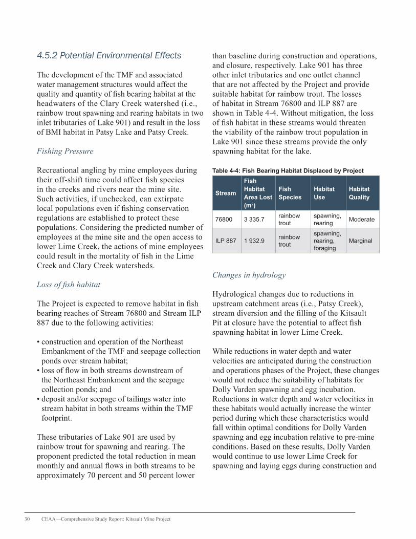
30 CEAA—Comprehensive Study Report: Kitsault Mine Project
4.5.2 Potential Environmental Effects
The development of the TMF and associated water management structures would affect the quality and quantity of fish bearing habitat at the headwaters of the Clary Creek watershed (i.e., rainbow trout spawning and rearing habitats in two inlet tributaries of Lake 901) and result in the loss of BMI habitat in Patsy Lake and Patsy Creek.
Fishing Pressure
Recreational angling by mine employees during their off-shift time could affect fish species in the creeks and rivers near the mine site. Such activities, if unchecked, can extirpate local populations even if fishing conservation regulations are established to protect these populations. Considering the predicted number of employees at the mine site and the open access to lower Lime Creek, the actions of mine employees could result in the mortality of fish in the Lime Creek and Clary Creek watersheds.
Loss of fish habitat
The Project is expected to remove habitat in fish bearing reaches of Stream 76800 and Stream ILP 887 due to the following activities:
• construction and operation of the Northeast Embankment of the TMF and seepage collection ponds over stream habitat; • loss of flow in both streams downstream of the Northeast Embankment and the seepage collection ponds; and • deposit and/or seepage of tailings water into stream habitat in both streams within the TMF footprint.
These tributaries of Lake 901 are used by rainbow trout for spawning and rearing. The proponent predicted the total reduction in mean monthly and annual flows in both streams to be approximately 70 percent and 50 percent lower
than baseline during construction and operations, and closure, respectively. Lake 901 has three other inlet tributaries and one outlet channel that are not affected by the Project and provide suitable habitat for rainbow trout. The losses of habitat in Stream 76800 and ILP 887 are shown in Table 4-4. Without mitigation, the loss of fish habitat in these streams would threaten the viability of the rainbow trout population in Lake 901 since these streams provide the only spawning habitat for the lake.
Table 4-4: Fish Bearing Habitat Displaced by Project
Stream
Fish Habitat Area Lost (m2)
Fish Species
Habitat Use
Habitat Quality
76800 3 335.7rainbow trout
spawning, rearing
Moderate
ILP 887 1 932.9rainbow trout
spawning, rearing, foraging
Marginal
Changes in hydrology
Hydrological changes due to reductions in upstream catchment areas (i.e., Patsy Creek), stream diversion and the filling of the Kitsault Pit at closure have the potential to affect fish spawning habitat in lower Lime Creek.
While reductions in water depth and water velocities are anticipated during the construction and operations phases of the Project, these changes would not reduce the suitability of habitats for Dolly Varden spawning and egg incubation. Reductions in water depth and water velocities in these habitats would actually increase the winter period during which these characteristics would fall within optimal conditions for Dolly Varden spawning and egg incubation relative to pre-mine conditions. Based on these results, Dolly Varden would continue to use lower Lime Creek for spawning and laying eggs during construction and
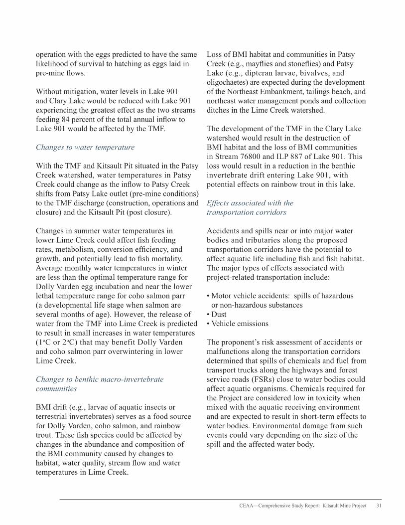
CEAA—Comprehensive Study Report: Kitsault Mine Project 31
operation with the eggs predicted to have the same likelihood of survival to hatching as eggs laid in pre-mine flows.
Without mitigation, water levels in Lake 901 and Clary Lake would be reduced with Lake 901 experiencing the greatest effect as the two streams feeding 84 percent of the total annual inflow to Lake 901 would be affected by the TMF.
Changes to water temperature
With the TMF and Kitsault Pit situated in the Patsy Creek watershed, water temperatures in Patsy Creek could change as the inflow to Patsy Creek shifts from Patsy Lake outlet (pre-mine conditions) to the TMF discharge (construction, operations and closure) and the Kitsault Pit (post closure).
Changes in summer water temperatures in lower Lime Creek could affect fish feeding rates, metabolism, conversion efficiency, and growth, and potentially lead to fish mortality. Average monthly water temperatures in winter are less than the optimal temperature range for Dolly Varden egg incubation and near the lower lethal temperature range for coho salmon parr (a developmental life stage when salmon are several months of age). However, the release of water from the TMF into Lime Creek is predicted to result in small increases in water temperatures (1oC or 2oC) that may benefit Dolly Varden and coho salmon parr overwintering in lower Lime Creek.
Changes to benthic macro-invertebrate communities
BMI drift (e.g., larvae of aquatic insects or terrestrial invertebrates) serves as a food source for Dolly Varden, coho salmon, and rainbow trout. These fish species could be affected by changes in the abundance and composition of the BMI community caused by changes to habitat, water quality, stream flow and water temperatures in Lime Creek.
Loss of BMI habitat and communities in Patsy Creek (e.g., mayflies and stoneflies) and Patsy Lake (e.g., dipteran larvae, bivalves, and oligochaetes) are expected during the development of the Northeast Embankment, tailings beach, and northeast water management ponds and collection ditches in the Lime Creek watershed.
The development of the TMF in the Clary Lake watershed would result in the destruction of BMI habitat and the loss of BMI communities in Stream 76800 and ILP 887 of Lake 901. This loss would result in a reduction in the benthic invertebrate drift entering Lake 901, with potential effects on rainbow trout in this lake.
Effects associated with the transportation corridors
Accidents and spills near or into major water bodies and tributaries along the proposed transportation corridors have the potential to affect aquatic life including fish and fish habitat. The major types of effects associated with project-related transportation include:
• Motor vehicle accidents: spills of hazardous or non-hazardous substances • Dust • Vehicle emissions
The proponent’s risk assessment of accidents or malfunctions along the transportation corridors determined that spills of chemicals and fuel from transport trucks along the highways and forest service roads (FSRs) close to water bodies could affect aquatic organisms. Chemicals required for the Project are considered low in toxicity when mixed with the aquatic receiving environment and are expected to result in short-term effects to water bodies. Environmental damage from such events could vary depending on the size of the spill and the affected water body.
32 CEAA—Comprehensive Study Report: Kitsault Mine Project
4.5.3 Mitigation Measures
To address fishing pressures on local fish populations, the proponent will implement a no-fishing policy that would apply to all mine personnel at the mine site and during transportation between the mine site and residential communities. The policy will be communicated to all employees during employee orientation and to contractors as part of their contractual agreements with the proponent.
Mitigation measures to reduce the potential effects of, and changes in, hydrology on fish and fish habitat, include:
• The design and installation of the gravity fed diversion between Lake 493 and Lake 901 to mitigate potential lake level changes in Lake 901 and Clary Lake caused by flow reductions from development of the TMF. • The installation of new structures in fish bearing streams along the Alice Arm road and new mine site access roads to allow for fish passage that would be beneficial to rainbow trout in the Clary Creek watershed. • The construction of structures in fish bearing streams following DFO guidelines to minimize the potential for entrainment and impingement of fish.
While no mitigation measures are specifically targeted to reduce the potential changes in water temperatures in Lime Creek, the proponent predicts that these changes would be attenuated by the continued thermal loading provided by runoff from the unaffected upper Lime Creek watershed, the diverted upper Patsy Creek watershed, and the unaffected Lime Creek tributaries downstream of the Patsy Creek confluence.
Fish Habitat Compensation Plan
The proponent has developed a conceptual Fish Habitat Compensation Plan (FHCP) to offset the loss of rainbow trout habitat in a portion of the Clary Creek watershed. The primary objective
of this plan is to offset unavoidable impacts to fish habitat with habitat creation or improvement. Developed in consultation with the NLG, the FHCP follows DFO policies and preferences for habitat compensation, including the habitat to be created, compensation ratio, technical feasibility and commitments for environmental monitoring. The FHCP is based on a 2.4:1 habitat impact ratio to compensate for the loss of spawning and rearing habitat in Stream 76800 and Stream ILP 887.
The proposed FHCP contains a list of 15 considerations for on-site and off-site habitat compensation and is expected to create 17 412 m2 of new fish bearing stream habitat with spawning habitat features. For on-site compensation, the diversion from Lake 493 would supplement flows in Lake 901 to maintain lake water levels and provide opportunities to create spawning and rearing habitat within the existing lake outlet. This would create nearly 343 m2 of new spawning, rearing, and overwintering habitat for rainbow trout in the Clary Creek watershed. Off-site habitat compensation would include side channel enhancement and ponds to improve spawning and rearing habitat for chum and coho salmon in the Kitsault River. Both chum and coho salmon are species of high concern for the NLG. Compensation activities in the Kitsault River would provide approximately 5 660 m2 and 11 409 m2 of spawning and rearing habitat for chum and coho salmon, respectively.
Although the proposed FHCP has not been finalized and aspects of the plan may be modified, the final plan is required to be technically, economically and biologically feasible. DFO will continue to consult with the NLG on the design and implementation of the FHCP; however, the plan is part of the federal permitting process and is, therefore, not considered part of the follow-up program under the former Act.
A Geographic Response Plan will be developed prior to construction to manage the potential effects to fish and wildlife from spills that affect water bodies and environmentally sensitive areas

CEAA—Comprehensive Study Report: Kitsault Mine Project 33
along the proposed transportation corridors. More information on this plan is provided in Section 4.10. Where important aquatic values along areas of the transportation corridors could be at risk from spills of hazardous materials, the proponent will identify appropriate forms of barrier protection (e.g., concrete or wire barriers). These measures will be subject to provincial approval and include consultation with the NLG and Aboriginal groups.
Benthic macro-invertebrate communities
Measures to mitigate the effects of habitat loss on BMI include minimizing the project footprint, locating project components in the headwaters of the Lime Creek and Clary Creek watersheds and compensating for lost habitat. Potential water temperature changes associated with the release of TMF surplus water into Lime Creek are anticipated to persist over the life of the Project; however, water temperature effects on Lake 901 would be attenuated by the diversion of water from Lake 493 to Lake 901. Water quality at LC1, LC2 and in Lake 901 will meet BC WQGs or Site Specific Water Quality Objectives that protect aquatic life. A summary of mitigation measures is described in Appendix C.
4.5.4 Government, Aboriginal and Public Comments
Key issues raised included the potential for water quality changes and stream flow reduction to affect Dolly Varden and coho salmon parr in lower Lime Creek and the loss of BMI habitat in the Patsy Creek watershed. Government agencies, the NLG, Aboriginal groups and the public commented on the potential effects of flow changes on fish bearing habitats in lower Lime Creek and the predicted loss of rainbow trout spawning and rearing habitat in Stream 76800 and ILP 883. Reviewers also discussed the encroachment of the TMF Northeast Embankment on the Clary Creek drainage and the resulting effects on water levels in Lake 901 and Clary Lake. The NLG submitted that they are
not in agreement with DFO’s determination that streams at the location of the northeast seepage collection ponds are not frequented by fish and that therefore the proposed tailings impoundment area does not need to be added to Schedule 2 of the Metal Mining Effluent Regulations pursuant to the Fisheries Act.
4.5.5 Residual Effects
The loss of fish habitat in Stream 76800 and ILP 887 will affect rainbow trout. The geographic extent of this residual effect will be limited to the Clary Creek watershed. This disturbance will be short-term, reversible and fixed to a discrete period of time as fish habitat compensation will be carried out. The Clary Creek watershed, including Lake 901 and Clary Lake, has medium ecological importance that results in the need to compensate for losses of fish habitat. Monitoring and reporting activities by the proponent, as prescribed in a Section 35(2) Fisheries Act authorization, will demonstrate compliance and evaluate the effectiveness of the habitat compensation program.
In reaching a conclusion on the significance of the potential environmental effects on fish and fish habitat, the Agency has taken into account the following:
• Fish habitat in Stream 76800 and ILP 887 represents a small fraction of the available habitat in the Clary Creek watershed. • While the predicted effects on rainbow trout that use Stream 76800 and ILP 883 are highly probable, the magnitude of the predicted effects is low. • The creation of compensation habitats will ensure that the productive capacity of the aquatic environment is not diminished. • Throughout all phases of the Project, best management practices will be employed to reduce or eliminate adverse effects on fish habitat.

34 CEAA—Comprehensive Study Report: Kitsault Mine Project
Losses of BMI habitat and communities in Patsy Creek and Patsy Lake are anticipated, however these effects are not expected to affect Dolly Varden and coho salmon parr in lower Lime Creek given the drift distance (~6 km) and different local conditions (deeply incised with average gradient of ~7 percent) between the Patsy sub-basin and the fish bearing reaches of lower Lime Creek. Such losses in the Patsy Creek watershed are considered low magnitude, continuous, long-term and reversible. As for the Clary Creek watershed, the loss of habitat in Stream 76800 and ILP 887 for BMI communities is expected to be negligible because: 1) these streams represent a small fraction of the total habitat area of the Clary Creek watershed; and 2) the enhancement or creation of new habitat would compensate for the lost habitat and BMI production.
4.5.6 Agency Conclusions
Based on the information in this report and with the implementation of the mitigation measures as described in this report and summarized in Appendix C, the Project is not likely to result in significant adverse environmental effects on fish and fish habitat.
4.6 Marine Aquatic Resources
The Agency examined the potential effects of mine site surface drainage on both marine estuarine water quality and select marine biota in Alice Arm. Marine water quality is important to the diversity and health of the biota, including plankton, benthic invertebrates, marine fishes, mammals and birds, that use marine waters near the Project.
4.6.1 Description of Baseline Environment
Alice Arm, the closest body of seawater to the Project, is located approximately 7 km northwest of the proposed project site and represents one of the terminal branches of Observatory Inlet and Hastings Arm. Two major rivers, the Kitsault and Illiance,
and several smaller creeks, including Lime Creek, flow into the head and sides of the inlet.
The physical and chemical characteristics of seawater in Alice Arm are typical of glacially-fed inlets along the west coast of B.C. Total suspended solids (TSS) concentrations were lowest in surficial water and higher in deeper water. Surface water TSS decreased with distance from the Kitsault River, as the lowest surface water turbidity was recorded at the mouth of Lime Creek.
Higher concentrations of certain metals (i.e., total aluminum, iron, manganese, copper, lead and zinc) were reported in surface waters than at depth, which suggests that these metals are entering Alice Arm through riverine inputs. Other dissolved metals showed higher concentrations in deeper waters signifying a more marine origin. The only element found to exceed B.C. Marine Water Quality Guidelines was boron.
For marine biota in Alice Arm, the EIS identified five types of habitat including intertidal gravel beach, shallow sub tidal mud and sand areas, deep sub tidal mud areas, rocky outcrops and an estuarine mud flat. Twenty species were found with the most abundant consisting of Dolly Varden char, Chinook and coho salmon, shiner perch, sculpins and dungeness crab. The greatest species abundance was found in the intertidal environment adjacent to the outflows of Lime and Roundy Creeks.
Marine mammal surveys in Alice Arm and Observatory Inlet identified the presence of harbour seals, harbour porpoises, Dall’s porpoises and humpback whales. Other marine mammals were also incidentally observed, including a sea lion species, an unidentified whale species and river otters. Harbour seals were the most commonly observed species in Alice Arm. The harbour porpoise is designated as a species of special concern while the humpback whale is designated as a threatened species under the Species at Risk Act (SARA). The humpback
CEAA—Comprehensive Study Report: Kitsault Mine Project 35
whale is also protected under the Marine Mammal Regulations under the Fisheries Act.
Recent baseline studies in Alice Arm showed elevated metals concentrations in sediment, which can be attributed to past mining activities at the Kitsault mine, including mine tailings deposition directly into Lime Creek and Alice Arm. Past sediment quality data collected in Alice Arm identified a historically impacted area spanning 14 km2 from the head of Alice Arm close to the Kitsault River.
4.6.2 Potential Environmental Effects
Project-related effects to freshwater quality and quantity in Lime Creek have the potential to affect the downstream marine environment near the mouth of Lime Creek during operations and post closure. Direct project effects to the marine environment are not anticipated since no project-related activities would occur in marine waters or along the shoreline of Alice Arm.
Potential effects to marine aquatic resources include the degradation of marine water quality near the mouth of Lime Creek, affecting marine biota, and the deposit of chemical contaminants adsorbed by waterborne particulates that could alter sediment quality in marine BMI habitat. Contaminants, whether in dissolved form or particle-bound, could affect marine biota by direct uptake or bioaccumulation through the food chain. Changes in marine water quality could alter the species composition of benthic invertebrates near the creek’s mouth and, in turn, influence other marine biota.
Beyond the potential project-related effects on the health of the marine environment, the potential effects of water quality on human health from fish and shellfish harvesting in Alice Arm were also discussed. Outcomes from these discussions formed the basis of the proponent’s MEMP, which is designed to determine whether the Project would change metal concentrations in shellfish relative to current conditions in Alice Arm.
4.6.3 Mitigation Measures
The proponent predicts that the Project is not expected to result in direct effects on the marine environment in Alice Arm and that any potential effects on Lime Creek water quality would be addressed through the implementation of the Mine Site Water Management Plan described in Section 4.2 of this report.
A conceptual framework for the MEMP was developed to determine whether the Project would result in “statistically significant change in project-related metal concentrations in shellfish from current reference conditions in Alice Arm.” The framework specifies monitoring objectives and locations, species selection, statistical design and other technical details, which will be completed prior to construction of the mine and in compliance with provincial permit requirements. Actions related to the MEMP include:
• use of monitoring results to determine mitigation effectiveness in the marine environment and to determine if additional actions are warranted to address potential effects; • collaboration with government agencies, the NLG, and the Metlakatla Nation during all stages of the MEMP and sharing data with these parties; and • completion of two years of baseline studies for the MEMP prior to the start of mine operations.
A summary of mitigation measures is provided in Appendix C.
4.6.4 Government, Aboriginal and Public Comments
With regard to potential effects to marine aquatic resources, a key issue raised by the NLG was the interest to ensure a thorough characterization of the existing baseline conditions in Alice Arm, particularly the current sediment quality that has been impacted by historical mining tailings disposal. This issue arose in response to a report
36 CEAA—Comprehensive Study Report: Kitsault Mine Project
titled “Environmental Impact Assessment of Alice Arm” (2012) prepared for the BC MOE that was provided to the TWG during the EIS review. The report provided information to guide future studies of metal content in shellfish tissue in proximity to the mine site. Other comments sought information to indicate whether shellfish in Alice Arm were safe to consume, and in particular, the appropriate quantity that could be consumed safely. In light of the effects of historical mining activities and the potential cumulative effects of the Project on the marine environment in Alice Arm, comments were made about the need to implement a robust marine effects monitoring program that would set protocols for monitoring and detecting potential effects, communicating outcomes to appropriate parties and mitigating any identified adverse effects.
4.6.5 Residual Effects
Project-related activities effects on surface water and sediment in Lime Creek have the potential to affect marine water quality and sediment that have already been affected by past mining at the former Kitsault site. However, the freshwater contribution of Lime Creek to Alice Arm is relatively small (5 percent) compared to the Kitsault River (57 percent), Illiance River (17 percent), and the combination of other smaller creeks (21 percent) that discharge into Alice Arm. Discharge from the Kitsault River, which is unaffected by the Project, heavily influences the marine water and sediment quality in Alice Arm and, in turn, the local marine biota including shellfish.
The proponent will ensure the water quality in the Lime Creek receiving environment will meet BC WQGs or site-specific water quality objectives for the protection of aquatic life. For parameters with residual exceedances, site-specific water quality objectives will be developed for water users in Lime Creek (e.g., fish, aquatic biota, etc.). Although there may still be exceedances of BC WQGs, the predicted water quality in Lime Creek is expected to improve over current water quality conditions.
Discharges into Lime Creek are not likely to affect the water quality of the marine environment, provided the proponent successfully implements the Mine Site Water Management Plan and considering the dilution zone in Lime Creek between the mine site and Alice Arm and the relatively small contribution of Lime Creek to Alice Arm compared to the other riverine inputs. Implementation of the MEMP is expected to detect project-related effects in Alice Arm. The MEMP will specify early warning thresholds for triggering management actions and processes for determining critical effect thresholds on marine biota.
Mine water releases into Lime Creek are therefore not expected to adversely affect primary productivity, reduce fish survival, or affect Nisga’a Nation, Aboriginal or recreational fisheries in the marine aquatic resources in Alice Arm. Residual effects resulting from changes to water and sediment quality are anticipated to be of low magnitude, occurring at the local scale, long-term, continuous and irreversible.
4.6.6 Agency Conclusions
Based on the information in this report and with the implementation of the mitigation measures as described in this report and summarized in Appendix C, the Project is not likely to result in significant adverse environmental effects on marine aquatic resources.
4.7 Wildlife and Wildlife Habitat
The Agency examined the potential effects of the Project on wildlife and their habitat, which are important to the biodiversity of the region and could be sensitive to mining and other activities in the region.
4.7.1 Description of Baseline Environment
Baseline field studies were undertaken by the proponent in 2009 and 2010 to characterize the
CEAA—Comprehensive Study Report: Kitsault Mine Project 37
terrestrial wildlife communities and identify important wildlife habitats in and around the mine site area. In addition to direct field observations, the proponent conducted literature reviews to compile existing information and held discussions with knowledgeable experts, including representatives of the NLG and the Gitanyow Hereditary Chiefs Office (GHCO).
Wildlife studies focused on reptiles and amphibians, birds and mammals, including species listed on Schedule 1 of SARA. Under Section 79(2) of SARA, the Agency must identify the adverse effects of the Project on listed wildlife species and their critical habitats. If the Project is undertaken, measures must be taken to avoid or lessen those adverse effects and to monitor them in a way that is consistent with any applicable recovery strategy.
Migratory birds, including Marbled Murrelet and Olive-sided Flycatcher, and the Northern Goshawk (A. g. laingi subspecies), are listed as threatened species on Schedule 1 of SARA, while the Western Toad is listed under SARA as a species of special concern. The grizzly bear is designated as a species of special concern by the federal Committee on the Status of Endangered Wildlife in Canada (COSEWIC). Species on the provincial blue list include the Olive-sided Flycatcher, sooty grouse, and grizzly bear while Northern Goshawk subspecies A. g. laingi is on the provincial red list.
Important wildlife habitats in the project area were identified through habitat suitability mapping and wetland habitat assessments. Portions of the LSA provide suitable habitat for Olive-sided Flycatcher (33 percent), sooty grouse (71 percent), Northern Goshawk (6 percent), American Marten (43 percent), and moose (11 percent), respectively. Baseline bird surveys detected Olive-sided flycatchers beyond the footprint area and sooty grouse throughout the LSA and RSA, which indicates that the RSA provides suitable breeding habitat
for both species. The assessment of old forest also indicated potential nesting habitat for Marbled Murrelet.
Moose were observed at lower elevations along Alice Arm and the Kitsault River and found to use the stretch of road from the Nass FSR (also known as the Cranberry Connector) to the mine as a travel corridor. The moose population in the NWA (5 000 km2) area has been in gradual decline, with recent provincial moose survey results showing a 70 percent reduction in the population since 1997. Harvest reductions and other conservation measures have been initiated by provincial agencies, the NLG and Aboriginal groups to respond to this population decline. Wildlife studies did not identify grizzly bear aside from an incidental sighting near Clary Lake. However, salmon runs in both the Illiance River and the Kitsault River provide potential feeding sites for grizzly bears. Mountain goats were observed in lower elevation forested areas outside the RSA.
Baseline surveys indicated that American marten are commonly found in the region where there is mixed canopy conifer forest supporting high structural diversity associated with mature and old growth stands. Wetland surveys revealed limited breeding habitat for Western Toad within the existing wetland complexes.
4.7.2 Potential Environmental Effects
The potential environmental effects of mine activities and components on wildlife and their habitats were examined during all project phases and included habitat loss or alteration, physical barriers, sensory disturbance and wildlife mortality.
Habitat loss or alteration
Development of the Project will result in the loss, disturbance and degradation of wildlife habitat. Removal of upland and wetland areas
38 CEAA—Comprehensive Study Report: Kitsault Mine Project
and alteration of aquatic breeding habitat within the area of the mine footprint could impact amphibian populations including the Western Toad. Clearing of forested area has the potential to remove forage and wintering habitat for moose and American Marten and breeding habitat for Olive-sided Flycatcher, Northern Goshawk and sooty grouse. Edge effects resulting from habitat loss or fragmentation can affect wildlife breeding, nesting and foraging activities as competition, predation and parasitism along the habitat interface increases.
Physical barriers
Physical barriers may affect wildlife or disrupt wildlife movement. Mine infrastructure, such as the TMF and WRMF, has the potential to block or alter seasonal toad migration between terrestrial and wetlands habitat. Some species may use cleared right-of-ways as travel corridors leading to altered wildlife movement patterns.
Sensory disturbance
Noise and vibration from mine-related activities (e.g., blasting, machinery) and human presence have the potential to affect wildlife behaviour and habitat use. Visual disturbance is related to lights, structures, and human presence while salt used as a road de-icing agent and odours from garbage, sewage, machine oils and food are considered wildlife attractants. These attractants could entice wildlife to the mine site area and along the proposed transportation corridors, increasing the potential for human-wildlife interactions. The effects of sensory disturbance will vary by species and life stage, but could include increased stress levels, avoidance of or displacement from important foraging, denning and nesting habitats, distractions from feeding or breeding and decreased productivity.
Vehicle traffic noise can also disturb and potentially displace wildlife (e.g., moose) from
their winter range, particularly in areas where noise disturbance is currently limited. The Nass FSR and the Nass-Kinskuch FSR bisect wildlife winter range habitat and are not ploughed in the winter. Ploughing of these roads to allow vehicle traffic during the winter could disturb wildlife in adjacent habitats and potentially hinder their movement between habitats.
Wildlife mortality
Traffic along the proposed transportation corridors could increase the risk of wildlife mortality. Winter ploughing of the network of Forest Service Roads from the mine site to Cranberry Junction off Highway 37 has the potential to increase moose-vehicle collisions since these roads are currently inaccessible in the winter and experience relatively low levels of traffic during the remaining months. Ploughed roads that provide year-round access to the project area could also lead to an increase in hunting pressure or poaching of moose. Increased mortality could yield adverse changes to the already depressed moose population in the Nass Wildlife Area.
Increased traffic levels associated with the Project may also increase vehicular collisions with other wildlife species including bears, American Marten, sooty grouse, and Northern Goshawks. The clearing of active nesting areas and the potential for bird collisions with mine-related vehicles and power lines have the potential to increase bird mortality.
4.7.3 Mitigation Measures
A broad range of mitigation measures will reduce the potential effects on wildlife and wildlife habitat resulting from the mine site or transportation corridors. Details of these measures are provided below with a summary of mitigation measures found in Appendix C.
CEAA—Comprehensive Study Report: Kitsault Mine Project 39
Habitat loss or alteration
• Maximize the use of previously cleared areas to minimise encroachment into undisturbed wildlife habitat. • Conduct surveys of Western Toad (e.g., in wetlands and ponds) prior to clearing and salvage toads that are found. • Conduct vegetation and tree clearing outside the bird breeding window (1 April to 31 July) to minimise nest mortality. • Identify and avoid sensitive habitats adjacent to worksites.
Physical barriers
• Install signs along access roads (forest service roads) and mine site roads (for all mine-related vehicles) to yield the right of way to wildlife.
Sensory disturbance
• Train employees and contractors in handling wildlife interactions and minimising or avoiding bear-human conflicts (Bear Interaction Management Plan, Solid Waste Management Plan). • Minimize visual and noise disturbance by preserving vegetation buffers around construction and operations areas, and reducing noise emanating from operating facilities, equipment and vehicles (Noise Management Plan). • Use refuse control during construction and operations to prevent the attraction of wildlife to work areas. • Use non-palatable de-icing products and re-vegetation species at the road’s edge to reduce the attraction of moose to the access road. • Install signage at known wildlife crossing points.
Wildlife mortality
• Restrict mine site access to only individuals who are employed with the Project, using gated entry points. • Enforce a no hunting policy for all mine personnel.
• Provide transportation for employees working at the mine to reduce traffic volumes and reduce the risk of motor vehicle-wildlife collisions. • Monitor road conditions during all project phases and minimize dust generation by applying dust suppression materials.
During the EIS review, the proponent proposed further investigation into the potential project-related effects on bats and Marbled Murrelet by identifying 1) the potential presence of hibernacula (shelter of a hibernating species) or roosting sites for bats in and around the mine site and 2) potential breeding habitat for Marbled Murrelet.
The proponent also prepared a Road Use Effects Assessment to identify and address the potential effects associated with the following two proposed transportation corridors from Highway 16 to the mine site, as shown in Figure 4-2:
1. From the Highway 16 turn-off west of Terrace, north on Highway 113 past New Aiyansh onto the Nass FSR to kilometre 31 and then following the Nass-Kinskuch FSR, Nass-Kwinatahl FSR, Kitsault FSR, and Alice Arm Road to the mine site.
2. From the Highway 16 turn-off at Kitwanga, north on Highway 37 to the Nass FSR (i.e., Cranberry Connector), west along the Nass FSR to kilometre 31 and then following the Nass-Kinskuch FSR, Nass-Kwinatahl FSR, Kitsault FSR, and Alice Arm Road to the mine site.
Issues related to road use were discussed amongst members of the Transportation Working Group (TRWG), resulting in the development of additional mitigation measures beyond those described in the EIS to manage road use effects on wildlife. As part of the B.C. EA Certificate, the proponent will be required to:
• Support Nass moose population recovery efforts, including education and communication,
40 CEAA—Comprehensive Study Report: Kitsault Mine Project
inventory, monitoring, collection of harvest data, signage and programs to increase knowledge of human interactions with moose. • Provide the option to Conservation officers or other provincial enforcement staff conducting enforcement activities along the proposed transportation corridors to use accommodations at the mine during enforcement activities. • Develop a Wildlife Corridor Management Plan before the start of construction. The Plan will include measures to reduce the risk of vehicle-wildlife interactions. See Appendix I for more details. • Develop a Transportation Safety Plan, prior to construction, to enhance driver safety and protect the public and environment through measures to reduce the likelihood of vehicle accidents. See Appendix I for more details. • Participate in cross-industry, government strategies or planning exercises or studies that address road use adjacent to or intersecting moose habitat along the proposed transportation corridors, including funding to support a coordinated approach to managing and mitigating the potential cumulative effects to aquatic and wildlife populations along Highway 37. • Regularly share traffic schedules and data on accidents and wildlife collisions with other project proponents who are undergoing an EA or will during the life of the Project, and who will be using Highway 37, Highway 113 and the Nass FSR.
4.7.4 Government, Aboriginal and Public Comments
Comments were provided about the identification and avoidance of western toad migration routes and seasonal habitats. Other comments focused on undertaking further work to identify wildlife habitat areas in the mine area, including potential bat hibernacula or roosting sites and old forest breeding habitat for Marbled Murrelet, and developing appropriate strategies to mitigate any potential disturbances to individuals found in these areas. Given the conservation status and
important cultural value of moose to the NLG and local Aboriginal communities, concerns were raised regarding the potential mortality of moose from vehicle collisions along the transportation corridors and increased illegal or unregulated hunting along the Nass FSR. Reviewers recommended managing human-bear interactions and separating wildlife from areas of waste or contaminants on-site during all phases of the Project and monitoring to ensure wildlife exclusion measures are effective. It was also suggested that carrion along the FSRs to the mine site be removed to reduce grizzly bear attraction to roads and interactions with mine-related vehicles.
4.7.5 Residual Effects
Habitat loss or alteration
Western Toads are known to move between terrestrial and aquatic habitats for breeding and survival. After mitigation, 35 percent and 24 percent of terrestrial and wetland habitats, respectively, in the LSA will be lost during construction and operations. Most of the habitat in the LSA is not suitable for Western Toad breeding and baseline surveys did not identify any potential breeding sites in the areas of the proposed TMF or WRMF. Although potential breeding habitat was found in Lake 493, northeast of the TMF, mine-related activities are not expected to affect these habitats. Pre-clearing surveys, salvage and reporting of Western Toad breeding or mass dispersal movements will be undertaken to prevent further effects to Western Toad individuals. After reclamation, the landscape, although different from baseline conditions, may provide suitable habitat for Western Toad breeding.
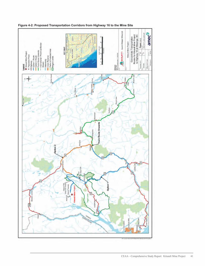
CEAA—Comprehensive Study Report: Kitsault Mine Project 41
Figure 4-2: Proposed Transportation Corridors from Highway 16 to the Mine Site
42 CEAA—Comprehensive Study Report: Kitsault Mine Project
The removal of Patsy Lake and the surrounding forested area for the construction of the TMF is expected to remove 228 hectares (ha) (35 percent) and 502 ha (36 percent) of the total Olive-sided Flycatcher and sooty grouse potential breeding habitat (649 ha and 1 409 ha) respectively, in the LSA. While the predicted losses would affect nesting opportunities on a local scale (i.e., within the mine footprint), they are not predicted to cause population-scale effects given the remaining potential breeding habitat in the LSA (65 percent for Olive-sided Flycatcher and 64 percent for sooty grouse). These species can also use a broader range of habitat in the RSA. The predicted Olive-sided Flycatcher and sooty grouse habitat losses will be long-term, as it is uncertain whether both species would return to a potentially different landscape following reclamation (i.e., denser forest environments replaced with open habitats).
Residual effects to Northern goshawk are not anticipated, considering the mitigation proposed, the high elevation of the Project (i.e., ≥ 900 m) relative to the optimal elevation for breeding habitat, and the limited value of potential breeding in the mine footprint as a result of past disturbances.
Of the 856 ha of potential wintering habitat for American marten in the LSA, 312 ha (36 percent) will be removed due to mine construction and operations. The quality of the habitat lost is considered low because of the snow depths associated with higher elevations (>800 m) at the mine site that would restrict marten movement and hunting activities in the LSA. Lower elevation areas beyond the LSA with reduced snow packs may provide more suitable winter habitat for marten. Effects to the regional marten population are not anticipated given the relative abundance of potential wintering habitat in the RSA and the highly mobile nature of marten to find suitable habitat. Marten are likely to reoccupy the area once the mine site has been reclaimed and revegetated.
Of the 209 ha (or 11 percent) of potential moose winter habitat, 31 ha (15 percent) would be removed. Use of this habitat by moose will be affected over the life of the Project. However, moose are known to winter in the lower elevation riparian areas near the Kitsault River estuary and surrounding low elevation areas of Alice Arm. This part of the Kitsault area has been identified as moose winter range and will not be affected by the Project.
Residual effects related to lost and altered habitats are anticipated to be low to medium in magnitude, local, long-term, continuous and irreversible.
Physical barriers
The development of TMF, WRMF and other mine infrastructure is expected to disrupt the movement of Western Toads. Western Toads, however, can use different types of terrestrial habitats and have the ability to move over long distances to find suitable habitat. Baseline surveys of the existing landscape in the project footprint did not identify Western Toad or breeding habitat. The localized residual effect is expected to be intermittent, long-term, and reversible, based on these considerations, assuming Western Toad re-inhabit the landscape after reclamation.
Project infrastructure and activities would likely displace grizzly bears from the mine site area and alter any movements through the site into adjacent habitats. Considering the moderate suitability of bear habitat in the LSA, the temporary use by bears of the LSA during the fall season, and the amount of habitat that will be removed by the Project (553 ha) relative to the sizeable home ranges of grizzly bears, residual effects associated with direct habitat alteration and the displacement of bears are not expected.

CEAA—Comprehensive Study Report: Kitsault Mine Project 43
Sensory disturbance
Displacement of moose from the mine site area is likely to occur as a result of noise and human disturbances during construction and operations. The degree of displacement is considered minimal because of the limited moose winter habitat available in the LSA (209 ha or 10.6 percent of the LSA) and because moose use lower elevation areas along Alice Arm and the Kitsault River estuary.
Mitigation measures to prevent the disturbance or displacement of moose along the proposed transport corridors will help manage the disturbance by vehicle traffic of roadside winter moose habitat.
Development and implementation of a Bear Interaction Management Plan will reduce the potential attraction of grizzly bears to the mine site and, in turn, minimize the risks associated with bear-human conflicts.
Vegetation clearing activities may cause sensory disturbance to Olive-sided Flycatchers and sooty grouse during the breeding season and near active nests. These effects are confined to a point source of disturbance that would continue to occur until vegetation clearing activities are complete.
Residual effects related to sensory disturbance are anticipated to be low to medium in magnitude, local to regional in geographic extent, intermittent to continuous, medium-term or longer, medium level of ecological importance and reversible.
Direct mortality
Mortality of Western Toads at the mine site and along the mine access roads could occur during mass tadpole dispersal, which in turn, could affect the local population. Pre-clearing surveys and salvage to be conducted during the amphibian breeding and dispersal periods are anticipated to minimize the potential mortality
risk to Western Toads. Any residual effects would occur intermittently and at the local scale of the mine footprint.
For moose, mortality is not anticipated within the mine site area or along road sections since these are not adjacent to high quality habitat. Moose winter range habitat has, however, been identified along sections of the Nass FSR (Cranberry Connector) and the Nass-Kinskuch FSR, both of which are not accessible in the winter. Potential moose mortality could increase as a result of greater vehicle traffic and access along these areas during winter when moose might concentrate in winter habitat ranges. By congregating, moose in these areas would be susceptible to increased hunting pressure (i.e., illegal or unregulated hunting). The moose population in the Nass Wildlife Area has been in decline and is considered at risk by provincial government agencies, the NLG and Aboriginal groups. Therefore, the cultural and ecological importance of the moose population in the region is considered high.
The expected increase in project traffic in combination with the winter snow ploughing of roads is likely to increase grizzly bear mortality risk as a result of vehicle collisions. The grizzly bear mortality risk is expected to vary depending on the suitability of habitat adjacent to the roads, speed limits (e.g., higher along highways), areas with blind turns or time of season. The potential mortality of female grizzly bears could affect the productivity of the local population since grizzly bears generally have lower reproductive rates. The ecological importance of the grizzly bear population is considered medium as a result of its designation as a species of special concern.
Avoidance of vegetation clearing activities during breeding periods is expected to limit the direct mortality of Olive-sided Flycatchers. Considering the conservation status of the Olive-sided Flycatcher under SARA, the

44 CEAA—Comprehensive Study Report: Kitsault Mine Project
ecological importance of any loss of nesting individuals and the productivity of the local population would be high. Sooty grouse, a species of special concern and American marten may be affected by clearing activities and by vehicle strikes. The potential mortality of hens and chicks could affect the productivity of the local population.
Residual effects related to direct mortality are anticipated to be low to medium in magnitude, local to regional in geographic extent, intermittent, long-term, medium to high ecological importance and irreversible.
4.7.6 Agency Conclusions
Based on the information in this report and with the implementation of the mitigation measures as described in this report and summarized in Appendix C, the Project is not likely to result in significant adverse environmental effects on wildlife and wildlife habitat.
4.8 Vegetation and Plant Communities
The Agency evaluated the potential effects of the Project on vegetation and plant communities because these communities provide chemical, biological and physical functions that contribute to the maintenance of healthy ecosystems and are important to the cultural and commercial interests of the Nisga’a Nation and Aboriginal groups.
4.8.1 Description of Baseline Environment
The NLG noted that the Project is located within the Meziadin Mountains Ecosection of the Nass Ranges Ecoregion. The LSA comprises three biogeoclimatic ecosystem classifications: coastal western hemlock (CWHws2) at lower elevations and mountain hemlock amabilis fir (MHmm2) and mountain hemlock subalpine parkland, heath and meadow (MHmmp) at higher elevations.
Vegetation is shaped by elevation (600-1 600 m) and the transition between coastal and interior climates that are characterised by long, moist, cold winters and short, cool, moist summers. Forests are dominated by mountain hemlock and amabilis fir with subalpine fir less commonly found. Wetland fen and narrow-leaved cotton-grass – peat-moss fen are also widespread in the area. The understorey vegetation comprises Alaskan blueberry, black huckleberry, oval-leaved blueberry, five-leaved bramble, pipecleaner moss and red-stemmed feathermoss.
Riparian ecosystems were identified within the project footprint. Other sensitive vegetation communities include old forests, sparsely vegetated areas, and wetlands (i.e., fens, treed swamps and marshes), which play an important role in regulating surface and groundwater flow and providing habitat for amphibians, birds, plants and insects.
One rare ecological community, Sitka-sedge – peat-moss fen, is on the provincial red list for ecological communities designated for conservation. Two provincially blue-listed ecological communities at risk, WH-lodgepole pine-Feathermoss and amabilis fir-western red cedar-oak fern, were also identified. These communities covered approximately 15 ha or less than 1 percent of the LSA.
Although field surveys did not identify invasive species or species at risk listed under provincial legislation, Cryptic Paw Lichen (Nehroma occultum), a species designated as a species of special concern by COSEWIC and listed on Schedule 1 of SARA, could potentially occur in the LSA. Ecosystems with medium to high potential to support species at risk covered approximately 256 ha or 13 percent of the LSA.
Wetlands
Wetlands provide habitat for wildlife, birds and amphibians and support ecological and biological
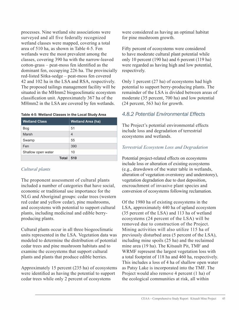
CEAA—Comprehensive Study Report: Kitsault Mine Project 45
processes. Nine wetland site associations were surveyed and all five federally recognized wetland classes were mapped, covering a total area of 510 ha, as shown in Table 4-5. Fen wetlands were the most prevalent among the classes, covering 390 ha with the narrow-leaved cotton-grass – peat-moss fen identified as the dominant fen, occupying 226 ha. The provincially red-listed Sitka-sedge – peat-moss fen covered 42 and 102 ha in the LSA and RSA, respectively. The proposed tailings management facility will be situated in the MHmm2 biogeoclimatic ecosystem classification unit. Approximately 367 ha of the MHmm2 in the LSA are covered by fen wetlands.
Table 4-5: Wetland Classes in the Local Study Area
Wetland Class Wetland Area (ha)
Bog 51
Marsh 4
Swamp 55
Fen 390
Shallow open water 10
Total 510
Cultural plants
The proponent assessment of cultural plants included a number of categories that have social, economic or traditional use importance for the NLG and Aboriginal groups: cedar trees (western red cedar and yellow cedar), pine mushrooms, and ecosystems with potential to support cultural plants, including medicinal and edible berry-producing plants.
Cultural plants occur in all three biogeoclimatic units represented in the LSA. Vegetation data was modeled to determine the distribution of potential cedar trees and pine mushroom habitats and to examine the ecosystems that support cultural plants and plants that produce edible berries.
Approximately 15 percent (235 ha) of ecosystems were identified as having the potential to support cedar trees while only 2 percent of ecosystems
were considered as having an optimal habitat for pine mushroom growth.
Fifty percent of ecosystems were considered to have moderate cultural plant potential while only 10 percent (190 ha) and 6 percent (119 ha) were regarded as having high and low potential, respectively.
Only 1 percent (27 ha) of ecosystems had high potential to support berry-producing plants. The remainder of the LSA is divided between areas of moderate (35 percent, 700 ha) and low potential (24 percent, 563 ha) for growth.
4.8.2 Potential Environmental Effects
The Project’s potential environmental effects include loss and degradation of terrestrial ecosystems and wetlands.
Terrestrial Ecosystem Loss and Degradation
Potential project-related effects on ecosystems include loss or alteration of existing ecosystems (e.g., drawdown of the water table in wetlands, alteration of vegetation overstorey and understorey), vegetation degradation due to dust deposition, encroachment of invasive plant species and conversion of ecosystems following reclamation.
Of the 1980 ha of existing ecosystems in the LSA, approximately 440 ha of upland ecosystem (35 percent of the LSA) and 113 ha of wetland ecosystems (24 percent of the LSA) will be removed due to construction of the Project. Mining activities will also utilize 115 ha of previously disturbed area (5 percent of the LSA), including mine spoils (25 ha) and the reclaimed mine area (19 ha). The Kitsault Pit, TMF and WRMF represent the largest vegetation loss with a total footprint of 118 ha and 460 ha, respectively. This includes a loss of 4 ha of shallow open water as Patsy Lake is incorporated into the TMF. The Project would also remove 4 percent (1 ha) of the ecological communities at risk, all within
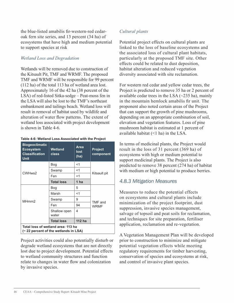
46 CEAA—Comprehensive Study Report: Kitsault Mine Project
the blue-listed amabilis fir-western-red cedar-oak fern site series, and 13 percent (34 ha) of ecosystems that have high and medium potential to support species at risk
Wetland Loss and Degradation
Wetlands will be removed due to construction of the Kitsault Pit, TMF and WRMF. The proposed TMF and WRMF will be responsible for 99 percent (112 ha) of the total 113 ha of wetland area lost. Approximately 16 of the 42 ha (38 percent of the LSA) of red-listed Sitka-sedge – Peat-moss fen in the LSA will also be lost to the TMF’s northeast embankment and tailings beach. Wetland loss will result in removal of habitat used by wildlife and alteration of water flow patterns. The extent of wetland loss associated with project development is shown in Table 4-6.
Table 4-6: Wetland Loss Associated with the Project
Biogeoclimatic Ecosystem Classification Unit
Wetland class
Area lost (ha)
Project component
CWHws2
Bog <1
Kitsault pitSwamp <1
Fen <1
Total loss 1 ha
MHmm2
Bog 5
TMF and WRMF
Marsh <1
Swamp 9
Fen 94
Shallow open water
4
Total loss 112 ha
Total loss of wetland area: 113 ha (~ 22 percent of the wetlands in LSA)
Project activities could also potentially disturb or degrade wetland ecosystems that are not directly lost due to project development. Potential effects to wetland community structures and function relate to changes in water flow and colonization by invasive species.
Cultural plants
Potential project effects on cultural plants are linked to the loss of baseline ecosystems and the associated loss of cultural plant habitats, particularly at the proposed TMF site. Other effects could be related to dust deposition, habitat alteration and reduced vegetation diversity associated with site reclamation.
For western red cedar and yellow cedar trees, the Project is predicted to remove 35 ha or 2 percent of available cedar trees in the LSA (~235 ha), mainly in the mountain hemlock amabilis fir unit. The proponent also noted certain areas of the Project that can support the growth of pine mushrooms, depending on an appropriate combination of soil, elevation and vegetation features. Loss of pine mushroom habitat is estimated at 1 percent of available habitat (<1 ha) in the LSA.
In terms of medicinal plants, the Project would result in the loss of 31 percent (369 ha) of ecosystems with high or medium potential to support medicinal plants. The Project is also predicted to remove 38 percent (274 ha) of habitat with medium or high potential to produce berries.
4.8.3 Mitigation Measures
Measures to reduce the potential effects on ecosystems and cultural plants include minimization of the project footprint, dust suppression, invasive species management, salvage of topsoil and peat soils for reclamation, and techniques for site preparation, fertiliser application, reclamation and re-vegetation.
A Vegetation Management Plan will be developed prior to construction to minimize and mitigate potential vegetation effects while meeting regulatory requirements for timber harvesting, conservation of species and ecosystems at risk, and control of invasive plant species.

CEAA—Comprehensive Study Report: Kitsault Mine Project 47
The Reclamation and Closure Plan specifies the process for reclaiming wetlands, ecosystems that support species at risk and cultural plants, old forests and sparsely vegetated ecosystems in areas of the decommissioned mine infrastructure. In particular, the processing plant and associated mine infrastructure will be reclaimed and reforested with native deciduous tree and shrub species. The downstream slope of the WRMF will be re-sloped, capped with reclamation material, and seeded. The TMF has been designed to maintain a lake over a portion of the tailings sand beaches in perpetuity. The downstream slope of the Northeast Embankment and areas of the south and north tailings beaches that are not inundated with water will be reclaimed to an upland community. For other facilities, surface material will be replaced once a facility has been decommissioned.
Before construction, Terrestrial Ecosystem Mapping will be used to identify wetlands and other environmental features for consideration during final footprint alignment and identification of construction laydown areas. A Wetland Habitat Compensation Plan will be finalized to replace the 16 ha of blue- and red-listed wetlands lost to the TMF through the implementation of compensation wetland sites that provide ecological functions equivalent to those of the removed wetlands. The plan will follow Environment Canada’s mitigation hierarchy framework to achieve no-net-loss to wetlands to the extent practical and will be based on a site survey and characterization of listed wetland communities and their function as habitats for migratory birds and species at risk. Further delineation of wetland compensation will be undertaken through cooperation between the proponent and Environment Canada. Prior to the submission and implementation of the plan, the proponent will make reasonable efforts to consult with the NLG and the Metlakatla First Nation.
A site assessment survey will be undertaken within and near the mine footprint to determine the presence of Cryptic Paw Lichen and will
inform the development and implementation of protocols for managing potential effects to the lichen species that are identified. This assessment will be conducted by a lichen specialist and reporting activities will be completed in consultation with Environment Canada.
4.8.4 Government, Aboriginal and Public Comments
Terrestrial ecosystem loss, including the loss of wetlands in the project area, was of key concern to government agencies, the NLG and Aboriginal groups. Concerns were raised about the proponent’s approach to avoiding and mitigating the potential effects on species at risk, including the residual effects associated with the loss of the red-listed Sitka-sedge – peat-moss fen community. Reviewers expressed concern that a conceptual wetland habitat compensation plan ought to be developed that includes further characterization of the function of potentially lost wetlands to wildlife and migratory birds, including those provincially listed that occupy these areas. Other comments referred to a need to examine the potential presence of Cryptic Paw Lichen in the project area.
4.8.5 Residual Effects
The loss and disturbance of vegetation communities, wetlands and cultural plants of terrestrial ecosystems will result in a change from baseline conditions with the permanent addition of the TMF, WRMF and Kitsault Pit lake on the landscape. Complete restoration of baseline conditions after project closure is not possible although the surrounding areas are expected to function in a similar manner prior to the Project.
Losses in the LSA after reclamation activities include 15 percent (35 ha) of large cedar trees, 1 percent (< 1 ha) of pine mushroom habitat, 16 percent (193 ha) of ecosystems supporting medicinal plants, 13 percent (96 ha) of habitat supporting berry-producing plants, less than 1 ha
48 CEAA—Comprehensive Study Report: Kitsault Mine Project
of ecological communities at risk and 6 percent (16 ha) of ecosystems considered as exhibiting medium and high potential to support species at risk. The TMF supernatant pond is expected to remain as an open water body resulting in the permanent loss of 11 percent (195 ha) of baseline vegetation in the LSA. The Reclamation and Closure Plan will incorporate measures to integrate the new post closure WRMF, TMF and Kitsault Pit lake features with adjacent landscape that is expected to function under pre-project conditions, however, neither the losses in cedar trees or pine mushroom habitat will be lessened by reclamation.
These localized residual effects occur once and are considered low to medium in magnitude, long-term and reversible over many years. They have medium ecological importance since changes in the baseline landscape and drainage directly influence the development and viability of ecosystems.
The probability of wetland loss is high in the TMF and WRMF area because the construction of these structures requires the clearing of vegetation and the draining and infilling of wetlands, including Patsy Lake. Following reclamation activities, 77 ha (16 percent) of wetlands will still be lost in the LSA (i.e., 36 ha reclaimed of 113 ha predicted loss). The specific loss of Sitka-sedge – peat-moss fen would be subject to wetland compensation activities as guided by Environment Canada. Given uncertainties associated with the potential loss of wetland function to birds and wildlife, the residual effect is considered medium in both magnitude and ecological importance. The long-term effect will be irreversible, localized to the mine site, and occur within a discrete timeframe during construction of the mine.
4.8.6 Agency Conclusions
Based on the information in this report and with the implementation of the mitigation measures as described in this report and summarized in
Appendix C, the Project is not likely to result in significant adverse environmental effects on vegetation and plant communities.
4.9 Land and Resource Use
The effects assessment related to land and resource use focused on the current use of lands and resources for traditional purposes, trapping and guide outfitting, cultural foods, and how the environment effects of the Project might affect these uses. The potential project-related effects on land and resource use of the Nisga’a Nation are described and assessed in Chapter 7.
4.9.1 Description of Baseline Environment
Current Use of Lands and Resources for Traditional Purposes
The Metlakatla First Nation’s asserted territory overlaps with the proposed project footprint and with the proposed transportation corridor from Highway 16 to the mine site. During consultations with the Agency, the Metlakatla First Nation did not articulate any specific land uses in the area of the mine and along the transportation corridors. However, existing information indicates that the Metlakatla First Nation engages in hunting, trapping, fishing, and gathering activities within their asserted territory in and around the mine site.
Segments of the proposed transportation routes pass through the asserted traditional territories of the Kitsumkalum First Nation, Gitxsan Nation, Gitanyow Wilp Luuxhon, and the Gitanyow First Nation and through the Nass Area, NWA and Nisga’a Lands as defined by the NFA. The asserted territory of the Kitselas First Nation lies outside the area of the Project; however, it was determined that project-related traffic along Highway 113 through Terrace and along parts of Highway 16 could affect the First Nation’s current use of lands and resources.

CEAA—Comprehensive Study Report: Kitsault Mine Project 49
The Kitselas First Nation, Kitsumkalum First Nation, Gitxsan Nation, Gitanyow Wilp Luuxhon, and the Gitanyow continue to use areas along the transportation corridors for practicing the following traditional activities:
• Hunting (moose, deer, grizzly bears, black bears, mountain goats, snowshoe hares, red squirrels, and game birds) • Fishing (sockeye, pink, coho, chum, and Chinook salmon, steelhead, rainbow trout, Dolly Varden, and cutthroat trout) • Trapping • Berry picking, medicinal plant gathering and bark collecting
Trapping and Guide Outfitting
The project footprint overlaps with one registered trapline (TR0614T088) that has been held since 1994. Trapping activity is concentrated in the winter months and includes harvesting marten, mink, red squirrels, wolverines, black bears, wolves, and beavers. The trapper also holds permits for trapline cabins near Clary Lake and Roundy Creek to harvest black bears, trout, and berries. Eleven other trapline tenure areas were identified as overlapping with the RSA.
The project footprint intersects a portion of the guiding tenure held by Coast Mountain Outfitters (also known as Milligan’s Outfitting), a non-resident outfitting company that offers excursions to observe and hunt different wildlife species and fish in the Alice Arm area.
Country Foods
Marine resources are used by the Metlakatla First Nation for food, social, ceremonial and commercial purposes. Community members locally harvest fish, shellfish, herring eggs, oolichan, seal grease, berries and seaweed. Oolichan and salmon are of particular importance to the Metlakatla First Nation’s economy, history, culture and seasonal activities. Considering these
interests, marine water quality is important for the continued Metlakatla First Nation marine harvest.
The NFA specifies Nisga’a Nation rights to harvest marine resources, including fish, shellfish and intertidal bivalves. The maintenance of marine water quality is important to these harvesting activities. The potential effects of the Project on Nisga’a Nation treaty rights of harvesting are assessed and discussed in Chapter 5 of this report.
4.9.2 Potential Environmental Effects
In addition to the information contained in the proponent’s EIS, the potential environmental effects of the Project on land and resource use were also discussed by the TWG and through correspondence.
The Agency’s assessment of potential effects specific to land and resource uses of the Nisga’a Nation is provided in Chapter 5.
Current Use of Lands and Resources for Traditional Purposes
Restricted access to the mine site is not expected to block land-based access to Alice Arm for traditional use activities. However, access to the portion of the Metlakatla First Nation’s asserted territory that overlaps with the project footprint will be prohibited for purposes of public safety. Restricted access to this area may affect potential hunting, trapping and gathering activities of the Metlakatla First Nation.
The proposed transportation corridors from the mine to Highway 16 (via Highway 113 or Highway 37) could increase non-Aboriginal access and cause year-round land and resource use, particularly in winter where opportunities exist for steelhead fishing, snowmobiling, trapping, and hunting. Aboriginal groups expressed concern about potential effects to the declining moose

50 CEAA—Comprehensive Study Report: Kitsault Mine Project
population in the Nass Wildlife Area as a result of greater unregulated hunting and poaching that would come with winter access to areas of winter moose habitat along the Nass FSR.
Trapping and Guide Outfitting
The trapper holding the registered trapline has expressed concerns about the potential effects to the trapline from increased access of a year-round open road, fur theft, increased harvesting of moose in the Clary Lake area, and the maintenance of access to the trapline taking into account safety issues.
Local access restrictions around the Project could affect access to the Coast Mountain Outfitter’s guiding territory in the RSA. Noise, vibration and reduced aesthetics could disrupt the ambience and quality of the guiding and hunting experience near the mine.
Country Foods
The human health risk from exposure to metals in cultural foods was a key concern examined during the comprehensive study. A screening-level human health risk assessment was undertaken to estimate the maximum potential environmental exposure of project-related contaminants to permanent Aboriginal residents in the LSA and RSA. No permanent residents were identified in the LSA and RSA; however, the proponent noted seasonal and temporary use of the areas.
The potential exposure risks were modeled for individuals (babies and adults) who theoretically spend all of their time in the region and could potentially be exposed through direct contact with soil, dust, and surface water, and the consumption of cultural foods. The assessment identified a potential for exposure to arsenic and molybdenum through human consumption of untreated surface water and terrestrial plants. However, human health effects were not
anticipated considering the unlikelihood of life-long, daily exposure to these contaminants.
4.9.3 Mitigation Measures
Current Use of Lands and Resources for Traditional Purposes
Environmental management plans (EMPs) will guide actions to mitigate effects on water and sediment quality, transportation and access, fish and fish habitat, vegetation, wildlife and their habitat, and dust. Potential project-related effects on the marine environment in Alice Arm will be managed and monitored as part of the MEMP, Groundwater Monitoring and Mitigation Plan and Mine Site Water Management Plans. These mitigation measures, which will be developed in consultation with the NLG and Aboriginal groups, will help minimize the adverse effects of the Project on the current use of lands and resources for traditional purposes.
Trapping and Guide Outfitting
An access management strategy for the mine site will be developed in consultation with the local trapper, Coast Mountain Outfitter Company, NLG, Aboriginal groups, and any other affected stakeholders, to manage public access to the mine area, prohibit hunting at the mine site, reduce possible wildlife-human conflicts and protect the interests of wildlife-dependent land users.
Country Foods
Mitigation measures have been developed to address a variety of effects relevant to cultural foods, including the potential contamination of streams and fish, habitat loss, and the direct mortality or physical removal of animal and plant species. The MEMP will be designed to detect potential effects on ecosystem and human health based on analyses of different marine components including water chemistry, sediment chemistry and toxicity, and tissue chemistry
CEAA—Comprehensive Study Report: Kitsault Mine Project 51
(e.g., benthic invertebrates, intertidal fish, and shellfish). Human health issues and risks will be analyzed and managed as part of the MEMP in accordance with the proponent’s human health risk framework. Results from the MEMP will be used to examine the effectiveness of mine mitigation and to determine whether additional mitigation or changes to the marine monitoring program would be required.
The proponent will also develop a communications procedure to inform concerned parties (e.g., Local Health Authority, Kitsault townsite) about any health effect resulting from the Project. Measures would be developed in collaboration with the appropriate parties to identify and manage the source of any potential exposure.
A Transportation Safety Plan will be implemented that includes watering for dust suppression and identifying areas of high risk along the transportation corridors that require additional barrier protection to minimize the potential effects on cultural foods resulting from road dust and accidental spills.
4.9.4 Government, Aboriginal and Public Comments
Key issues related to land and resource use were associated with the potential effects of the Project on the marine environment and along the proposed transportation corridors. These issues include the potential effects on country food sources, land uses downstream of the mine site, and the regional moose population along the proposed transportation corridors. Reviewers commented about the potential human health risk related to Nisga’a consumption of harvested country foods exposed to concentrations of metals through soil and surface water. It was recommended that the proponent conduct a more detailed Nisga’a dietary survey (i.e., consumption rates, frequencies and portion sizes of cultural foods for different age and gender groups) and collect information on tissues from each type of
cultural food consumed. Other comments focused on including speciation analysis of seafood and other cultural foods (e.g., speciate inorganic arsenic in shellfish tissue) in monitoring programs and monitoring potential increases of cadmium and other contaminants in cultural foods. These recommendations will be incorporated in the design of the proponent’s AEMP and MEMP.
4.9.5 Residual Effects
The footprint of the mine site and associated facilities will be inaccessible to any traditional activities, trapping and guide outfitting during all phases of the Project. Land uses will cease in the area of the Metlakatla First Nation’s asserted traditional territory that overlaps with the proposed mine footprint. The area lost compared to the overall Metlakatla First Nation asserted traditional territory is expected to be small and inadequate for land use purposes since it has already been disturbed by past mining activities (i.e., brownfield). Loss of this area is not expected to hinder the opportunity for Metlakatla First Nation members to use and access adjacent areas for their land use activities. Any further clearing activities are anticipated to occur in areas directly associated with construction and operations of the Project.
Better road access due to winter snow ploughing and regular maintenance along the Forest Service Roads is predicted to increase vehicle-moose collisions and opportunities for unregulated hunting along these roads. Although implementation of mitigation measures will reduce the effects of project-related traffic on moose, the risk of moose mortality from the cumulative effects of vehicular collisions and unregulated hunting along Highway 37 and the Nass Forest Service Road still remains. Efforts to address these effects cannot be effectively managed by the proponent alone, but require a coordinated multi-stakeholder approach that includes other proponents who are currently using or are expected to use the same roads for
52 CEAA—Comprehensive Study Report: Kitsault Mine Project
transportation. The proponent will participate in any cross-industry or government strategies related to road use adjacent to or intersecting moose habitat along the proposed transportation corridors.
The loss of 701 ha of area to the Project will result in a 0.03 and 3.3 percent reduction in the Coast Mountain Outfitter’s total guiding territory (2 680 823 ha) and the registered trapline holder’s total trap line (21 327 ha), respectively. Although most of the area lost overlaps the existing brownfield area where hunting and trapping is limited, undisturbed areas adjacent to the mine site are considered more suitable for these land uses. The disturbed area will be reclaimed after mine closure when hunting and trapping activities are expected to resume.
The potential remains for human exposure to certain contaminants following mitigation, including arsenic and molybdenum, through the consumption of country foods in Lime Creek and Alice Arm. As discussed in Sections 4.2 and 4.6, historical mining activities may have contributed to the existing elevated levels of these contaminants in water and sediments, which could affect freshwater and marine resources, including fish and shellfish. Actual exposures to potentially contaminated cultural foods are considered unlikely as there are no permanent residents and low numbers of temporary or seasonal users in the LSA. As such, the risk of health effects from direct exposure to affected soil, dust, surface water and country foods is minimal.
Based on these considerations and the environmental effects assessments for freshwater water quality, fish and fish habitat, and other valued components, the residual effects to land and resource use are expected to be low in magnitude, local to regional in extent, long-term, continuous and reversible except in the case of potential exposures to contaminated country foods. The effects would be localized to the harvest of resources in Lime Creek and nearby sediment
deposition and transport zones in Alice Arm resulting from discharges from project-affected watersheds (i.e., Lime Creek and Patsy Creek).
4.9.6 Agency Conclusions
Based on the information in this report and with the implementation of the mitigation measures as described in this report and summarized in Appendix C, the Project is not likely to result in significant adverse environmental effects on land and resource use.
4.10 Effects of Accidents and Malfunctions
Under the former Act, an EA must consider the possible effects of accidents and malfunctions that could adversely affect the environment at any stage of the Project from construction to post closure. Accidents and malfunctions have the potential to occur throughout the life of the Project from mine site construction through to post closure.
The proponent will include consideration of accidents and malfunctions in its Mine Emergency and Spill Response Plan, which is a component of their Environmental Management System.
The following potential malfunctions and accidents were identified:
• fuel releases during truck transport • fuel releases from storage facilities and dispensing areas • motor vehicle accidents (non-hazardous and hazardous materials) • chemical spills within contained facilities • release of sewage effluent • seepage containment pond failure • explosives accidents • power outages • failure of the TMF dam • pipeline leakage (water and tailings lines) • failure of waste rock or overburden stockpile

CEAA—Comprehensive Study Report: Kitsault Mine Project 53
• release of metal leaching and acid rock drainage • fires associated with the Project • chronic emissions (vehicle and incinerator)
Appendix D summarizes data on potential malfunctions and accidents, the likelihood of their occurrence, their possible environmental effects, preventative mitigation measures, and contingency and emergency response procedures.
4.10.1 Mitigation Measures
Measures specified in the Mine Emergency and Spill Response Plan and Geographic Response Plan are expected to deliver the necessary training and hazardous material spill response strategies that will address concerns raised by government agencies, the NLG and Aboriginal groups regarding accidents and malfunctions along the transportation corridors. These measures will also include the identification of appropriate forms of barrier protection along areas of the proposed transportation corridors with high aquatic values (e.g., fish) that could be at risk from spills of hazardous materials. The proponent will make reasonable efforts to consult with the NLG and Aboriginal groups about these areas before approval by provincial ministries.
4.10.2 Government, Aboriginal and Public Comments
Aboriginal groups expressed concerns about the potential effects of accidents and malfunctions along the proposed transportation corridors, particularly spills of chemicals and fuel into important water bodies and environmentally sensitive areas.
Aboriginal groups also stated the need for more coordination for training and operation of spill response stations located along the transportation corridors. In response, the proponent will develop the Geographic Response Plan to coordinate training and spill response approaches between the BC MOE and community members responsible for spill response activities.
4.10.3 Agency Conclusions
Based on the proposed operating, contingency and emergency response procedures, the measures in the Geographic Response Plan and the implementation of the mitigation as described in this report and summarized in Appendix C, the Project is not likely to result in significant adverse environmental effects as a result of accidents and malfunctions.
4.11 Effects of the Environment on the Project
Under the former Act, and as part of the evaluation of effects, an EA must consider the potential effects the environment may have on the Project. The Agency considered the following environmental conditions that are the most likely to impact the Project:
• forest fires • geo-hazards • seismic events • weather events
Increased industrial activity in the area could lead to a higher risk of fire. The proponent will delay project activities during periods of high fire risk, administer a fire training program for employees and implement a fire response plan that includes working with the B.C. Ministry of Forests, Lands and Natural Resource Operations (BC MFLNRO) on an ongoing basis. All actions to manage the risk of forest fires are expected to comply with the provincial Forest Fire Prevention and Suppression Regulation.
There is evidence of landslide activity near the project area, with the highest risk of landslides predicted along the steep, gullied terrain located next to Patsy Creek and Lime Creek. No project infrastructure is expected to be situated in these areas. The Coarse Ore Stockpile is situated close to the edge of the lava flow plateau with a conveyor (1.4 km) spanning up the cliff face of the lava flow (290 m elevation change)
54 CEAA—Comprehensive Study Report: Kitsault Mine Project
that traverses unstable areas on the cliff face escarpment. Any weakening of the toe of the slope could lead to a higher risk of landslides; however, the project design incorporates appropriate setbacks to minimize any potential damage to project infrastructure. The proponent will also secure all potentially unstable slopes prior to the start of construction activities and will monitor road use to identify, remove or stabilize any possible snow hazards. No major snow avalanche paths have been identified as slope steepness in the area (i.e., 4° to 26° slope angles) is not conducive to avalanche formation (i.e., 25° to 45°).
All building and structure designs, such as the TMF, will meet anticipated flood and seismic requirements to withstand any future potential seismic events. The TMF has been designed to meet all current Canadian Dam Association Dam Safety Guidelines and specifications to withstand extreme events, including a 10 000-year return period earthquake event.
Variations in weather trends, such as precipitation, wind, temperature, atmospheric pressure and humidity could potentially affect the Project. Uncertainties in long-term weather patterns will be addressed through appropriate project design and adaptive response measures. For example, supply and mine haul roads are expected to be maintained during heavy snowfalls to allow for passable access while hot and dry conditions may require road watering and measures to guard against fires caused by lightning strikes or by construction activities.
4.11.1 Agency Conclusions
Based on the proposed mitigation strategies, design criteria and adaptive response plans and the mitigation measures as described in this report and summarized in Appendix C, significant adverse effects of the environment on the Project are not likely.
4.12 Capacity of Renewable Resources
Under subsection 16(2) of the former Act, a comprehensive study shall address the capacity of renewable resources that are likely to be significantly affected by the project to meet present and future needs. Renewable resources within the project area include wildlife, aquatic resources, and vegetation and plant communities, which were assessed in detail as part of the EA. Significant adverse effects to these resources are not anticipated.
Mineral resources are defined by such factors as commodity pricing and mineral access. Under certain circumstances, the development of a given deposit could lead to future developments associated with that same deposit, or it could provide infrastructure that would improve the economic feasibility for other developments in the area.
4.13 Cumulative Effects Assessment
Cumulative environmental effects are defined as the effects of a project that are likely to result when a residual effect acts in combination with the effects of other projects or activities that have been or will be carried out.
4.13.1 Approach
The approach used by the Agency to assess the cumulative environmental effects of the Project was guided by the Agency’s Operational Policy Statement (2007) and Cumulative Effects Assessment Practitioner’s Guide (1999).
The cumulative effects assessment (CEA) considered the effects of past, present, and future activities and projects that will overlap spatially and temporally with the residual environmental effects of the Project. Emphasis was placed on cumulative environmental effects arising from activities or projects that are certain or reasonably foreseeable.
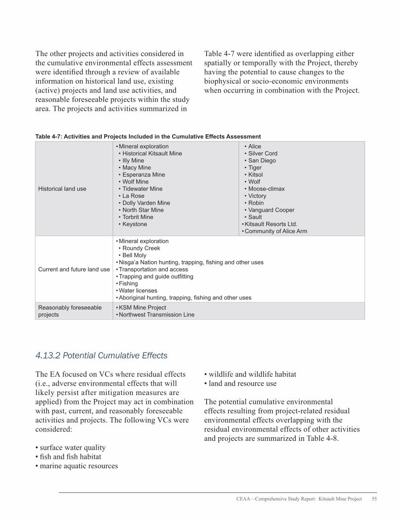
CEAA—Comprehensive Study Report: Kitsault Mine Project 55
The other projects and activities considered in the cumulative environmental effects assessment were identified through a review of available information on historical land use, existing (active) projects and land use activities, and reasonable foreseeable projects within the study area. The projects and activities summarized in
Table 4-7 were identified as overlapping either spatially or temporally with the Project, thereby having the potential to cause changes to the biophysical or socio-economic environments when occurring in combination with the Project.
Table 4-7: Activities and Projects Included in the Cumulative Effects Assessment
Historical land use
• Mineral exploration • Historical Kitsault Mine • Illy Mine • Macy Mine • Esperanza Mine • Wolf Mine • Tidewater Mine • La Rose • Dolly Varden Mine • North Star Mine • Torbrit Mine • Keystone
• Alice • Silver Cord • San Diego • Tiger • Kitsol • Wolf • Moose-climax • Victory • Robin • Vanguard Cooper • Sault
• Kitsault Resorts Ltd. • Community of Alice Arm
Current and future land use
• Mineral exploration • Roundy Creek • Bell Moly
• Nisga’a Nation hunting, trapping, fishing and other uses• Transportation and access• Trapping and guide outfitting• Fishing• Water licenses • Aboriginal hunting, trapping, fishing and other uses
Reasonably foreseeable projects
• KSM Mine Project• Northwest Transmission Line
4.13.2 Potential Cumulative Effects
The EA focused on VCs where residual effects (i.e., adverse environmental effects that will likely persist after mitigation measures are applied) from the Project may act in combination with past, current, and reasonably foreseeable activities and projects. The following VCs were considered:
• surface water quality • fish and fish habitat • marine aquatic resources
• wildlife and wildlife habitat • land and resource use
The potential cumulative environmental effects resulting from project-related residual environmental effects overlapping with the residual environmental effects of other activities and projects are summarized in Table 4-8.
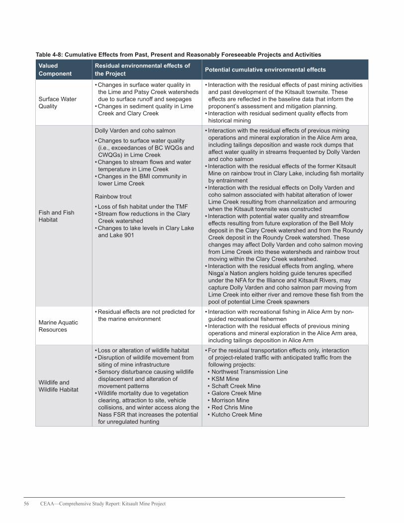
56 CEAA—Comprehensive Study Report: Kitsault Mine Project
Table 4-8: Cumulative Effects from Past, Present and Reasonably Foreseeable Projects and Activities
Valued Component
Residual environmental effects of the Project
Potential cumulative environmental effects
Surface Water Quality
• Changes in surface water quality in the Lime and Patsy Creek watersheds due to surface runoff and seepages
• Changes in sediment quality in Lime Creek and Clary Creek
• Interaction with the residual effects of past mining activities and past development of the Kitsault townsite. These effects are reflected in the baseline data that inform the proponent’s assessment and mitigation planning.
• Interaction with residual sediment quality effects from historical mining
Fish and Fish Habitat
Dolly Varden and coho salmon
• Changes to surface water quality (i.e., exceedances of BC WQGs and CWQGs) in Lime Creek
• Changes to stream flows and water temperature in Lime Creek
• Changes in the BMI community in lower Lime Creek
Rainbow trout
• Loss of fish habitat under the TMF• Stream flow reductions in the Clary Creek watershed
• Changes to lake levels in Clary Lake and Lake 901
• Interaction with the residual effects of previous mining operations and mineral exploration in the Alice Arm area, including tailings deposition and waste rock dumps that affect water quality in streams frequented by Dolly Varden and coho salmon
• Interaction with the residual effects of the former Kitsault Mine on rainbow trout in Clary Lake, including fish mortality by entrainment
• Interaction with the residual effects on Dolly Varden and coho salmon associated with habitat alteration of lower Lime Creek resulting from channelization and armouring when the Kitsault townsite was constructed
• Interaction with potential water quality and streamflow effects resulting from future exploration of the Bell Moly deposit in the Clary Creek watershed and from the Roundy Creek deposit in the Roundy Creek watershed. These changes may affect Dolly Varden and coho salmon moving from Lime Creek into these watersheds and rainbow trout moving within the Clary Creek watershed.
• Interaction with the residual effects from angling, where Nisga’a Nation anglers holding guide tenures specified under the NFA for the Illiance and Kitsault Rivers, may capture Dolly Varden and coho salmon parr moving from Lime Creek into either river and remove these fish from the pool of potential Lime Creek spawners
Marine Aquatic Resources
• Residual effects are not predicted for the marine environment
• Interaction with recreational fishing in Alice Arm by non-guided recreational fishermen
• Interaction with the residual effects of previous mining operations and mineral exploration in the Alice Arm area, including tailings deposition in Alice Arm
Wildlife and Wildlife Habitat
• Loss or alteration of wildlife habitat• Disruption of wildlife movement from siting of mine infrastructure
• Sensory disturbance causing wildlife displacement and alteration of movement patterns
• Wildlife mortality due to vegetation clearing, attraction to site, vehicle collisions, and winter access along the Nass FSR that increases the potential for unregulated hunting
• For the residual transportation effects only, interaction of project-related traffic with anticipated traffic from the following projects: • Northwest Transmission Line • KSM Mine • Schaft Creek Mine • Galore Creek Mine • Morrison Mine • Red Chris Mine • Kutcho Creek Mine
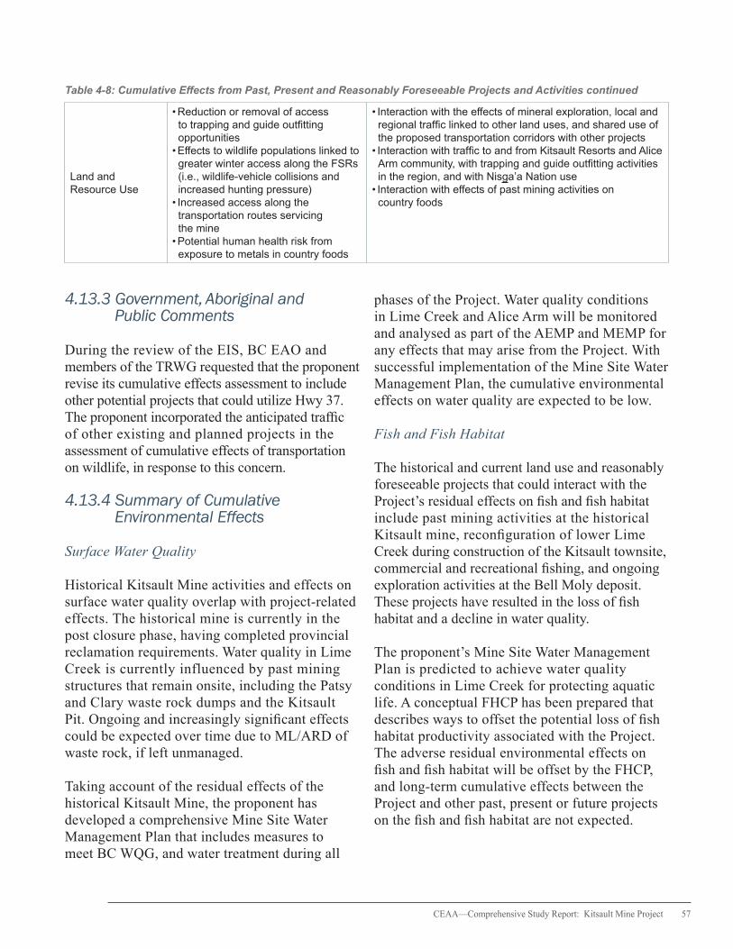
CEAA—Comprehensive Study Report: Kitsault Mine Project 57
Table 4-8: Cumulative Effects from Past, Present and Reasonably Foreseeable Projects and Activities continued
Land and Resource Use
• Reduction or removal of access to trapping and guide outfitting opportunities
• Effects to wildlife populations linked to greater winter access along the FSRs (i.e., wildlife-vehicle collisions and increased hunting pressure)
• Increased access along the transportation routes servicing the mine
• Potential human health risk from exposure to metals in country foods
• Interaction with the effects of mineral exploration, local and regional traffic linked to other land uses, and shared use of the proposed transportation corridors with other projects
• Interaction with traffic to and from Kitsault Resorts and Alice Arm community, with trapping and guide outfitting activities in the region, and with Nisga’a Nation use
• Interaction with effects of past mining activities on country foods
4.13.3 Government, Aboriginal and Public Comments
During the review of the EIS, BC EAO and members of the TRWG requested that the proponent revise its cumulative effects assessment to include other potential projects that could utilize Hwy 37. The proponent incorporated the anticipated traffic of other existing and planned projects in the assessment of cumulative effects of transportation on wildlife, in response to this concern.
4.13.4 Summary of Cumulative Environmental Effects
Surface Water Quality
Historical Kitsault Mine activities and effects on surface water quality overlap with project-related effects. The historical mine is currently in the post closure phase, having completed provincial reclamation requirements. Water quality in Lime Creek is currently influenced by past mining structures that remain onsite, including the Patsy and Clary waste rock dumps and the Kitsault Pit. Ongoing and increasingly significant effects could be expected over time due to ML/ARD of waste rock, if left unmanaged.
Taking account of the residual effects of the historical Kitsault Mine, the proponent has developed a comprehensive Mine Site Water Management Plan that includes measures to meet BC WQG, and water treatment during all
phases of the Project. Water quality conditions in Lime Creek and Alice Arm will be monitored and analysed as part of the AEMP and MEMP for any effects that may arise from the Project. With successful implementation of the Mine Site Water Management Plan, the cumulative environmental effects on water quality are expected to be low.
Fish and Fish Habitat
The historical and current land use and reasonably foreseeable projects that could interact with the Project’s residual effects on fish and fish habitat include past mining activities at the historical Kitsault mine, reconfiguration of lower Lime Creek during construction of the Kitsault townsite, commercial and recreational fishing, and ongoing exploration activities at the Bell Moly deposit. These projects have resulted in the loss of fish habitat and a decline in water quality.
The proponent’s Mine Site Water Management Plan is predicted to achieve water quality conditions in Lime Creek for protecting aquatic life. A conceptual FHCP has been prepared that describes ways to offset the potential loss of fish habitat productivity associated with the Project. The adverse residual environmental effects on fish and fish habitat will be offset by the FHCP, and long-term cumulative effects between the Project and other past, present or future projects on the fish and fish habitat are not expected.
58 CEAA—Comprehensive Study Report: Kitsault Mine Project
Wildlife and Wildlife Habitat
Cumulative environmental effects related to increased vehicular traffic of the Project has the potential to interact in combination with the potential transportation effects from past, present and reasonably foreseeable projects.
Moose and grizzly bear mortality from vehicle collisions associated with year-round access to the network of FSRs will act cumulatively with the residual road use effects of other projects and activities along the Nass FSR (Cranberry Connector) and Highway 37. An increase in winter road traffic along these roads resulting from cumulative road use in the region is expected to increase the risk of mortality to moose and grizzly bears. The mortality risk to moose is further complicated and compounded by ongoing illegal and unregulated moose harvesting by Aboriginal communities.
A suite of transportation safety measures has been developed to minimize the effects of project-related road use on wildlife and human safety. However, reducing the cumulative effects to the regional moose and grizzly bear populations would require a coordinated regional planning approach involving all applicable road users. Government examination of feasible solutions to address other underlying causes of moose mortality (i.e., increased enforcement against illegal and unregulated hunting) is ongoing and local conservation initiatives for moose have been integrated into regional resource management plans. In supporting these initiatives, the proponent will: 1) participate in cross-industry, government strategies or planning exercises to address road use effects on moose habitat along the proposed transportation corridors; 2) exchange traffic and wildlife and human accident data with other proponents; and, 3) participate in regional cumulative effects assessments related to traffic along Highway 37 and Highway 113. Proponents of planned and future projects are expected to also
make similar efforts to managing the cumulative road use effects on wildlife and human safety in the region.
Lands and Resource Use
The spatial boundary for the cumulative effects assessment of Current Lands and Resources Use for Traditional Purposes is defined by the approximate boundaries of the asserted traditional territories of each Aboriginal group. The potential cumulative effect on land and resource use is a change to current traditional use patterns.
Residual effects on current land and resource use from the activities and projects identified in Table 4-8 have the potential to overlap with the residual effects of the Project. Ongoing exploration projects (e.g., Keystone, Alice) near Alice Arm and two prospective developments, Bell Moly and Roundy Creek, could further disturb resources (e.g., wildlife, vegetation, and aquatic resources) and limit areas for traditional harvesting activities, while traffic from the Project, regional exploration activities and local road use could increase access into and affect existing traditional land use areas. Mitigation measures have been developed for the Project that will reduce any cumulative effects with respect to these uses. Other planned and future projects and activities within the RSA that could potentially affect traditional lands and resources will be required to develop similar mitigation measures, which would further minimize the cumulative effects on these lands and resources.
The potential residual effects of the Project on country foods will overlap with the residual effects of past mining activities at the historical Kitsault Mine and in Alice Arm, including tailings deposition in Lime Creek. The significance of the cumulative risk of human exposure to metals in country foods is low considering the absence of any permanent residents in the LSA that could be subject to daily, life-long consumption of country foods and

CEAA—Comprehensive Study Report: Kitsault Mine Project 59
the availability of the country foods in the RSA. In addition, the proposed mitigation measures are expected to minimize any residual water quality effects in Lime Creek and Alice Arm.
4.13.5 Agency Conclusions
Based on the information in this report and with the implementation of the mitigation measures as described in this report and summarized in Appendix C, the Project is not likely to result in significant adverse cumulative environmental effects.
60 CEAA—Comprehensive Study Report: Kitsault Mine Project
5. Nisga’a Nation Effects Assessment
The Project is subject to the NFA because of the potential effects of the Project on residents of Nisga’a Lands, Nisga’a Lands or Nisga’a Nation interests. In accordance with Chapter 10 of the NFA, the Agency assessed 1) whether the Project can reasonably be expected to have adverse environmental effects on residents of Nisga’a Lands, Nisga’a Lands, or Nisga’a interests set out in the NFA (paragraph 8(e) of Chapter 10) and 2) the effects of the Project on the existing and future economic, social, and cultural well-being of Nisga’a citizens (paragraph 8(f) of Chapter 10).
To meet the obligations under the NFA, Canada incorporated the NFA factors (i.e., 8(e) and 8(f)) into the federal comprehensive study of the Project. The 8(e) effects were examined using information and analyses generated by the EA process. The approach used to assess the effects to the economic, social and cultural well-being of Nisga’a citizens was developed in close cooperation with the NLG and B.C. It was informed by the proponent’s ESCIA and related documents, as well as issues raised by the NLG, B.C., Canada and the proponent throughout the EA.
The approach to assessing NFA factors and the subsequent analysis of effects involved several federal departments with expertise in pertinent areas. These include Fisheries and Oceans Canada, Natural Resources Canada, Environment Canada, Health Canada, Canadian Heritage and Aboriginal Affairs and Northern Development Canada. The expert advice from these departments contributed to the Agency’s assessment of NFA factors.
The following sections describe the outcomes of the assessment of NFA factors examined during the EA, including comments from the NLG, and the Agency’s conclusions on the potential effects of the Project on Nisga’a Nation interests defined in the NFA.
In addition to the EA decision statement, the Minister of the Environment will issue a NFA Project Recommendation as to whether the project should proceed in light of NFA considerations. Any subsequent permitting or approval decisions by responsible authorities must take both the EA decision and the NFA Project recommendation into account.
5.1 Assessment of Environmental Effects (8e of NFA Chapter 10)
5.1.1 Lands
Among other things, Chapter 3 of the NFA describes Nisga’a Lands and sets out the nature of Nisga’a Nation ownership of Nisga’a Lands, and Nisga’a Fee Simple Lands (Category A Lands and Category B Lands), which are situated outside of Nisga’a Lands. The Nisga’a Lands comprise approximately 2 000 km2 around the lower Nass Valley. The NFA also sets out that the Nisga’a Nation owns the mineral resources on and under Nisga’a Lands.
The Project is situated within the Nass Area and the NWA defined by the NFA, but falls outside of Nisga’a Lands, which are located 25 km east of the mine site. Ten kilometres of the Kitsault FSR overlap with the Nisga’a Lands while the transportation corridor proposed along the Nisga’a Highway to Terrace intersects 25 km of Nisga’a Lands and 25 km of the NWA. The other proposed transportation corridor along the Nass FSR and south on Highway 37 to Kitwanga is expected to encompass 75 km of the NWA.
Chapter 3 of the NFA also sets out the Nisga’a Nation’s commercial recreation tenure, provincial heritage sites and key geographic features, the Nisga’a Memorial Lava Bed Park, and the Gingietl Creek Ecological Reserve. The Project is located 5 km southeast of Gits’oohl that are Fee Simple Category A lands under the NFA.

CEAA—Comprehensive Study Report: Kitsault Mine Project 61
Adjacent to these lands is a parcel of land that is Nisga’a Nation commercial recreation tenure.
Potential Effects of the Project
To ensure public safety, the proponent will maintain a 500 m buffer around the mine site that will be restricted to only mine-related activities during the life of the Project. Non-project land use activities, including activities that would otherwise be carried out pursuant to Nisga’a interests as set out in the NFA, would be prohibited within the buffer area. With the mine footprint and buffer covering a total area of 1 980 ha and the NWA and the NA spanning 1 610 100 ha and 2 700 000 ha, respectively, the proponent expects that 0.07 percent of the NA and 0.12 percent of the NWA will not be available for use by Nisga’a citizens or other users.
Mitigation Measures
No measures are proposed to mitigate the loss of use of those portions of the NA and the NWA restricted for active mining during the life of the Project. The proponent will work with the NLG to accommodate the inability of Nisga’a citizens to carry out activities specified in the NFA in these areas through the Social and Cultural Management Plan. More details on this plan are found in Table 5-2.
Agency Conclusions
The Project will be constructed and operated on lands that will not be publicly accessible for Nisga’a citizens to undertake activities pursuant to their treaty rights under the NFA. The mine footprint will remove the potential value of a portion of the NA and NWA as a location to carry out such activities in the future. Land-based and aquatic resources such as wetlands, lakes and forests will be either removed or made inaccessible in the immediate mine site area. However, the general availability of such resources in the areas adjacent to the Project footprint is not expected to diminish and alternative locations to exercise Nisga’a Nation rights under the NFA may exist in close proximity. While the locations of land use practices will be restricted to areas outside the project footprint, it is expected that Nisga’a citizens will be able to continue to exercise their treaty rights as defined by the NFA. Residual effects on land use will, as appropriate, be addressed through the development and implementation of the Social and Cultural Management Plan.
5.1.2 Access
Chapter 6 of the NFA includes provisions for access onto and through Nisga’a Lands for public, private and federal and provincial government land and resource use. The Chapter also describes public access to Nisga’a Public Lands for temporary non-commercial and recreational purposes and for hunting and fishing. Provisions in the Chapter also cover Nisga’a citizens’ access to Crown lands outside Nisga’a Lands.
Chapter 7 of the NFA describes the ownership, administration and control of roads, their corridors (if applicable) and rights-of-way within Nisga’a Lands. These provisions affect the Nisga’a Highway, Nass FSR and Alice Arm FSR. The Chapter includes a section that sets out that B.C. will consider extension of Highway 37 in line with
In addition to the EA
decision statement, the
Minister of the Environment
will issue a NFA Project
Recommendation
62 CEAA—Comprehensive Study Report: Kitsault Mine Project
provincial priorities and B.C.’s long-term goal of completing that extension. It also includes a section that sets out that the Nisga’a Nation will grant a right of way to B.C. or a public utility for secondary provincial roads. Chapter 7 also sets out that B.C. may have access to areas outside of the Nisga’a Highway corridor and secondary road right of ways on Nisga’a Lands subject to requirements set out in the Chapter.
Potential Effects of the Project
The proponent predicts that year-round maintenance activities associated with the proposed transportation corridors, particularly the network of FSRs will create land use effects related to access. As the holder of a provincial Special Use Permit for the roads from the mine site to the Nass FSR at Highway 113, the proponent is responsible for maintaining these roads during the winter and spring.
Greater access along the transportation corridors is expected to enhance Nisga’a citizen access to areas for pine mushroom picking, hunting, snowmobiling, fishing and trapping. The location of the mine site is predicted to not hinder land-based access to Alice Arm. Access to and use of different land use sites along the Nass FSR and Hwy 113, however, could be impeded due to vehicular accidents and spills during the Project.
Mitigation Measures
The ploughing of otherwise inaccessible roads in the winter and the grading and management of vegetation along the road right of ways in the spring are expected to provide Nisga’a citizens with improved access for land use and to cultural sites in the NA and NWA. Where normal public access is restricted, the proponent is expected to provide reasonable alternative access that enables Nisga’a citizens to exercise their treaty rights as per the NFA.
Agency Conclusions
The proponent’s proposed use of the existing network of FSRs and provincial highways, including the upgrade of the Nass FSR to Highway 37, is not expected to result in adverse environmental effects on Nisga’a Nation’s treaty rights to access Nisga’a Lands and other lands as set out in Chapter 6 of the NFA. Improved access may benefit the Nisga’a Nation as Nisga’a citizens are able to pursue land use and cultural activities on a year-round basis.
5.1.3 Water
Chapter 3 of the NFA establishes the Nisga’a Nation’s water reservation of 300 000 decametres per year from the Nass River and other streams wholly or partially within Nisga’a Lands, for domestic, industrial and agricultural purposes. The Nisga’a Nation was issued an angling guide license for 15 rivers outside Nisga’a Lands, including the Illiance River and the Kitsault River, both of which are close to the mine site.
Maintaining the hydrology of local water bodies, particularly the Illiance River and Kitsault River, is essential to protect fish stocks, marine ecosystems and aquatic plants that are important to the Nisga’a Nation. Changes to flow volumes can also affect surface water quality, which, in turn, can have implications for human health and the health of fish and wildlife that the Nisga’a Nation harvests for subsistence.
Potential Effects of the Project
Three rivers located partially within Nisga’a Lands–Kwinatahl, Tchitin, and Kshadin Rivers–are close to either the mine site or the access road. The Kwinatahl River is the closest, flowing 2 km from the mine site. The Project is not predicted to affect water bodies outside the LSA and RSA, including the Kwinatahl, Tchitin, and Kshadin Rivers. The proponent is required to implement measures to mitigate water quality effects and effects associated with accidents or spills.

CEAA—Comprehensive Study Report: Kitsault Mine Project 63
Water management measures and structures will control and contain water-related effects within the local mine site footprint. Potential effects are confined to the Lime, Patsy, and Clary Creek watersheds and Illiance River watershed, all of which drain into Alice Arm and are located within the Nass Area, but not Nisga’a Lands. As these watersheds drain directly into Alice Arm, they are not expected to influence water quality or stream flow in the Nass River or Kitsault River.
Accidents or spills may occur along the proposed transportation corridors transecting the NA and NWA, which could affect nearby water bodies.
Mitigation Measures
Since project-related activities are not expected to extend to the Nass River and other water bodies referenced in Chapter 3 of the NFA, no mitigation measures have been proposed by the proponent for these particular rivers. However, the proponent has developed the Mine Emergency and Spill Response Plan and the Geographic Spill Response Plan to address the potential risks of accidents or spills associated with road use.
Agency Conclusions
While mine-related activities are expected to affect water resources in the Lime, Patsy and Clary Creek watersheds, these effects do not extend to or affect the water bodies specified in Chapter 3 of the NFA. The EA identified and evaluated the potential for water-related effects resulting from accidents or spills along the proposed transport corridors. Following the implementation of mitigation measures related to spill response, speed limits and road side barrier protection, adverse environmental effects to local water bodies from accidents or spills are not expected.
5.1.4 Fisheries
Chapter 8 sets out the Nisga’a Nation right to fish and fisheries allocation entitlements. Nisga’a citizens have the right to harvest fish and aquatic
plants for domestic use (i.e., food, ceremonial and social), and barter or trade fish and aquatic plants harvested in Nisga’a fisheries, subject to conservation and laws for public health and safety. Nisga’a citizens are also entitled to harvest wildlife fish pursuant to their right to harvest wildlife as defined in Chapter 9 of the NFA.
The Nisga’a Nation, B.C. or Canada may propose the establishment of Nisga’a fish allocations for non-salmon species or aquatic plants. According to paragraphs 11 and 12 of the Nisga’a Annual Fish Plan, fishing, other than for intertidal bivalves and oolichans, is restricted to the NA. Under the Harvest Agreement, additional pink and sockeye salmon allocations are set out and Nisga’a citizen may sell salmon harvested under this agreement.
Under Chapter 8, paragraph 64, Nisga’a citizens have the right to harvest intertidal bivalves for domestic purposes within those portions of the NA set out in Appendix I of the NFA. Intertidal bivalves are defined in Chapter 1 as littleneck clams, butter clams, horse clams, cockles, mussels and manila clams.
The closest boundary of the intertidal bivalve harvest area identified in Appendix I of the NFA is located approximately 15 km southwest of the Project, near the entrance to Alice Arm in Observatory Inlet. Nisga’a citizens harvest intertidal bivalves in Alice Arm even though Appendix I of the NFA does not identify intertidal bivalve harvest areas near the Project’s marine receiving environment in Alice Arm at Lime Creek estuary, or near the Kitsault and Illiance River estuaries at the head of Alice Arm.
Potential Effects of the Project
Sections 4.5 and 4.6 of this report assessed VCs for fish and fish habitat in both freshwater and marine aquatic environments. Findings from these assessments indicate that the Project has the potential to affect fish and fish habitat as a result of changes in water quality and quantity, physical

64 CEAA—Comprehensive Study Report: Kitsault Mine Project
habitat loss and effects caused by accidents and malfunctions along the proposed transportation corridors. More details on the project-related effects to water quality, water quantity, and fish and fish habitat are provided in Sections 4.2, 4.3, 4.5, and 4.6, respectively.
The lower section of Lime Creek, extending 1.8 km upstream from the estuary in Alice Arm to an 8 m high waterfall (barrier to fish migration), which is 6 km downstream of the mine site effluent discharge into Lime Creek, provides marginal fish habitat for Dolly Varden char and coho salmon parr. No fish were found above the barrier. Potential changes to surface water quality have the potential to affect Dolly Varden and coho salmon including mortality of fish and eggs. Details on the assessment of project-related effects on Dolly Varden and coho salmon are provided in Section 4.5 of this report.
Killam Lake, which is confluent with the Clary Creek watershed, was stocked with rainbow trout fry and yearlings by provincial agencies between 1988 and 2003. Rainbow trout are the only fish species in the Clary Creek watershed and the potential effects of the Project on this fish species are limited to the reach of Clary Creek upstream of a large impassable waterfall (>30 m in height) located near the confluence of Clary Creek and the Illiance River. Development of the Project would result in the harmful alteration, disruption or destruction of rainbow trout spawning habitat in a portion of the Clary Creek watershed that affects two inlet tributary streams to Lake 901: Streams 76800 and ILP 887. The lower section of Clary Creek downstream of the Clary Creek and Illiance River confluence provides habitat for steelhead (anadromous rainbow trout), coho salmon, Dolly Varden and other fish species of interest to the Nisga’a Nation. No effects on areas downstream of Clary Lake are expected.
Water quality changes in Lime Creek during operations have the potential to affect marine water and sediment quality and aquatic life
(e.g. shellfish, sculpins and other marine fish species) in the Lime Creek estuary that in turn could affect other marine biota through ecosystem trophic interactions with marine biota in Alice Arm.
In Alice Arm, potential marine environmental effects include increased concentrations of metals in sediment, benthic organisms and fish tissue. Marine sediment and shellfish tissue in Alice Arm currently exhibit elevated metal concentrations, likely due to historical tailings deposition from previous mining operations in the area.
A risk assessment based on the potential for accidents or malfunctions along the transportation corridors concluded that spills of chemicals or fuel near water bodies could affect aquatic organisms, including fish. While the assessment predicted a low likelihood of spills from transportation accidents, the environmental damage may be moderate to high depending on the size of the spill and the water body affected.
Mitigation Measures
A complete discussion of the water quality and quantity mitigation measures is provided in Sections 4.2 and 4.3.
Water quality in lower Lime Creek is expected to be protective of aquatic life over the life of the Project, following implementation of water management measures and water treatment. The Mine Site Water Management Plan will include strategies for water treatment, erosion and seepage control, water recycling, monitoring, and water diversion. Surplus water from the TMF will be treated prior to discharge into Lime Creek, with the purpose of maintaining water quality and flows that will protect aquatic life.
The proponent will design the Project to enable water treatment and ensure water quality at LC1, LC2 and Lake 901 meet BC WQGs or Site Specific Water Quality Objectives approved by BC MOE.
CEAA—Comprehensive Study Report: Kitsault Mine Project 65
Residual effects to fish habitat in the inlet tributaries of Lake 901 will require the development and implementation of a FHCP to offset losses of fish bearing habitat. The plan, to be finalized in consultation with the NLG, is required by DFO to provide no net loss or a net gain of the productive capacity of fish habitat affected by the Project prior to the issuance of an authorization under the Fisheries Act. More information can be found in Section 4.5.
The monitoring programs related to aquatic effects and to the marine environment (AEMP and MEMP) will be implemented, based on a conceptual framework that has been developed in collaboration with the NLG, Metlakatla First Nation, and federal and provincial authorities. These monitoring programs are designed to detect potential project-related effects, and include adaptive management responses to ensure impacts to the freshwater and marine environment are mitigated. Analysis and management of human health issues and risks will be undertaken as part of the AEMP and MEMP as per the framework developed by the proponent.
Strategies in the Transportation Safety Plan and Geographic Response Plan are expected to address the potential effects on fish from accidents and malfunctions along the transportation corridors (e.g., spills of process chemicals and fuel into waterways), while coordinating the delivery of training and spill response among provincial authorities and community members responsible for spill response activities.
Agency Conclusions
With the implementation of the Mine Site Water Management Plan that includes measures for water management and water treatment for each phase of the Project, the resulting water quality for all parameters is expected to meet BC WQGs except for cadmium, sulphate and aluminum. As shown in Appendix F, although these exceedances are expected to persist after mitigation, their
predicted levels show an improvement over current water quality conditions (i.e., reduced concentrations) in lower Lime Creek where cadmium greatly exceeds BC WQGs along with exceedances of other parameters.
The proponent will ensure that water quality in Lime Creek will meet BC WQGs or site-specific water quality objectives approved by the BC MOE. Potential residual effects to the marine environment in Alice Arm are not predicted given the mitigation of project-related effects to water quality, stream flows and aquatic life in lower Lime Creek.
Future monitoring of the marine environment in accordance with the MEMP will identify and determine the extent of any unforeseen residual project effects on marine resources, including fish and shellfish. Both the AEMP and MEMP will be centred on baseline information from which future effects can be appropriately assessed, including water chemistry and toxicity and fish tissue analysis. The final details of these monitoring programs will be undertaken during the permitting phase with government agencies, the NLG and Aboriginal groups.
As for potential road use effects on fish, the proposed transportation corridors pass through areas of sensitive fish habitat and along riparian areas including the Nass River, which is an important fish bearing river to Nisga’a Nation and local communities. Transportation safety and emergency and spill response measures will be established to manage, with the cooperation of the NLG and Aboriginal groups, the potential effects of a spill on nearby fish populations along the transportation corridors.
Residual adverse environmental effects to fish and aquatic life in Lime Creek and Clary Creek watersheds may occur following implementation of mitigation measures. As noted in Section 4.5.5, these effects are not expected to be significant, however, they have the potential to adversely affect Nisga’a Nation treaty rights and fisheries
66 CEAA—Comprehensive Study Report: Kitsault Mine Project
interests as set out in Chapter 8 of the NFA. Residual effects will be addressed through the implementation of the AEMP, MEMP and FHCP.
5.1.5 Wildlife and Migratory Birds
Under Chapter 9 of the NFA, Nisga’a citizens have the right to harvest, for domestic purposes, wildlife in the NWA and migratory birds within the Nass Area, subject to measures necessary for conservation, public health and safety legislation. Nisga’a citizens’ harvesting of wildlife and migratory birds must align with the communal nature of the Nisga’a Nation domestic (i.e., food, social and ceremonial) harvest and traditional harvest seasons. No wildlife harvesting can interfere with other authorized uses of Crown land.
Nisga’a citizens have treaty rights to harvest wildlife, including moose, grizzly bears, mountain goats, and migratory birds for domestic purposes and to trade or barter wildlife or migratory birds with other Aboriginal groups and/or amongst themselves. Nisga’a Nation wildlife harvesting rights have the same priority as recreational and commercial harvesting interests.
The NFA lists Nisga’a Nation trap lines held by Nisga’a citizens that are outside of Nisga’a Lands and subject to provincial law. Four trap lines fall within the Project’s land and resource use study area, but do not overlap with any mine infrastructure. Nisga’a citizens have identified Nisga’a Nation hunting and fishing cabins close to the Project. The issuance of hunting licenses by the NLG in the NWA varies each year.
Potential Effects of the Project
Habitat loss or alterationHabitat loss or alteration causing moose and grizzly bear displacement is expected to occur during construction and operations. The Project is expected to remove 113 ha of forage wetland habitat and 31 ha of potentially suitable winter habitat for moose in the NWA. Considering the
remote location of the Project, displacement of moose further away from Nisga’a Lands could pose access issues for Nisga’a harvesting of moose. The Project will also displace grizzly bears from the immediate area and disrupt their movement to habitat areas near the mine site.
Clearing of forested area has the potential to remove forage and wintering habitat for American marten and migratory bird breeding habitat for Olive-sided Flycatcher, Northern goshawk and sooty grouse. The clearing of old growth forest during American marten birthing periods (i.e., late March) could cause some incidental mortality of females and offspring.
Wildlife MortalityThe Project is expected to result in mortality of moose, grizzly bears, American marten and mountain goats from collisions with vehicles.
Moose and grizzly bear winter range habitat is known to overlap with the network of FSRs, Highway 113 and Highway 37. Higher risks of moose and grizzly bear mortality are expected to occur as traffic volumes increase near or adjacent to winter ranges. Bear accidents with mine-related traffic are likely to be concentrated in the active bear season between the months of April and October. Mortality risk will be a function of the habitat suitability adjacent to the road, the speed limit on the road (e.g., higher for highways) and visibility (e.g., blind turns, whiteout conditions). The existing network of FSRs from the mine site to Highway 37 has not been accessible during recent winters, and has experienced limited traffic relative to Highway 37 and Highway 113 over the remaining months of the year. Snow ploughing along these FSRs to allow vehicle traffic is expected to increase the risk of moose and grizzly bear mortality and result in greater use of the area for illegal and unregulated hunting.
Aerial surveys did not identify mountain goats close to the mine site. Suitable terrain to support

CEAA—Comprehensive Study Report: Kitsault Mine Project 67
mountain goats was not identified in the RSA and the existing access roads do not cross suitable mountain goat habitat, including low elevation canyons that are used by mountain goats during the summer. Mountain goats were found to use lower elevation conifer forest habitat further away from the project (i.e., >5 km), but there is potential for mountain goats to cross existing access roads and collide with Project-related traffic. Mountain goats could also be subject to illegal and unregulated hunting along the existing network of FSRs.
American marten could be attracted to carrion along access roads (e.g., hares) leading to increased mortality risk from vehicle collisions.
Sensory disturbanceEncounters with grizzly bears could also contribute to bear morality and pose safety risks to humans. Grizzly bears could be attracted to waste and garbage at the mine site and may need to be destroyed to protect human safety or relocated elsewhere either with other bears or with relatively less suitable habitat. Salt used along the access roads could also attract mountain goats to congregate near roadways, leading to potential collisions.
Mitigation Measures
The following management plans will address the adverse effects of the Project, including the effects of road use, on wildlife and wildlife habitat:
• Wildlife Corridor Management Plan • Transportation Safety Plan • Wildlife Management Plan • Bear Interaction Management Plan • Reclamation and Closure Plan
The Wildlife Management Plan will include Nisga’a Nation participation in additional enforcement when access along the Nass FSR increases during the winter. The proponent will also support recovery efforts of the Nass moose
population. With regard to regional road use, the proponent will participate in any industry or government initiatives around use of the Nass FSR and the Highway 37 corridor, which are important winter range habitat areas for moose. A summary of mitigation measures is provided in Appendix C.
Agency Conclusions
Mitigation measures were developed during the EA in collaboration with the NLG and the TWG to minimize project-related effects on wildlife and wildlife habitat. Residual effects are considered minor for most wildlife species, given the low quality habitat within the LSA and the availability of suitable habitat in the surrounding RSA.
Year-round project-related road use of the network of FSRs, particularly the Nass FSR, is likely to result in mortality of individual moose. These losses could affect the regional Nass Valley moose population that has been in decline since 2001. While the proposed mitigation measures are anticipated to reduce the potential for moose collisions with project-related vehicles, the risk of moose mortality from cumulative vehicular collisions and other causal factors, including illegal and unregulated hunting, still remains. Efforts to minimize this mortality risk in concert with complex recovery planning for the regional moose population cannot be effectively managed by the proponent alone, but requires a coordinated planning approach involving relevant government agencies, the NLG, Aboriginal groups, the proponent and other industrial companies who use or are planning to use the same roads for transport. As such, the proponent will participate in any future regional CEAs, and management and planning efforts related to traffic along the proposed transportation corridors.
Residual adverse environmental effects to wildlife and wildlife habitat, including migratory birds, may occur following implementation of mitigation measures. As noted in Section 4.7.5,
68 CEAA—Comprehensive Study Report: Kitsault Mine Project
these effects are not expected to be significant, however, they have the potential to adversely affect Nisga’a Nation treaty rights and wildlife interests as set out in Chapter 9 of the NFA. Residual effects will be addressed through the development and implementation of the management plans.
5.1.6 Forest Resources
Chapter 5 of the NFA sets out that the Nisga’a Nation owns all forest resources and non-timber forest resources on Nisga’a Lands. Provisions in Chapter 5 establish timber harvesting rights and rates on Nisga’a Lands. The NFA also sets out the process for the NLG to apply and acquire Tree Farm Licenses. One Tree Farm License owned and operated by Coast Tsimshian Ltd, intersects the northern part of Nisga’a Lands, 25 km east of the mine site.
The Department of Forest Resources of the NLG manages and regulates the harvest of botanical forest products, including pine mushrooms, 10 other mushroom species and fiddleheads within Nisga’a Lands. All Nisga’a Nation and non-Nisga’a Nation harvesters and buyers must apply for permits for the harvest of pine mushroom.
Potential Effects of the Project
A summary of the potential effects of the Project to cultural plants is described below with more information related to the vegetation effects assessment provided in Section 4.8.
Cultural plants that were assessed include large cedar trees, pine mushroom, medicinal plants and edible berry-producing plants. Loss of cultural plants is anticipated throughout the project footprint as a result of vegetation clearing and surface disturbance.
The Project is expected to remove 35 ha (2 percent) of the 235 ha of ecosystems in the LSA that could potentially support large cedar trees. This loss would not be reduced by reclamation.
Pine mushrooms were evaluated for their importance as a food source and economic value in the region. The coastal western hemlock-lodgepole pine-feathermoss unit was determined to have the greatest potential for producing pine mushroom with pine mushroom habitat covering 2 percent of the unit. Project activity is expected to clear <1 ha of this mushroom habitat, representing a 1 percent loss of the available habitat in the LSA. Reclamation would not reduce this habitat lost.
The Project is estimated to affect 369 ha (31 percent) and 274 ha (38 percent) of ecosystems with high or medium potential to support medicinal and edible-berry producing plants, respectively. Reclamation would reduce these losses by 193 ha (16 percent) and 96 ha or (13 percent) for medicinal plant and edible berry-producing habitats, respectively.
The Project is expected to result in the loss of 113 ha of wetland, with 99 percent (112 ha) of this loss attributed to the construction of the TMF and WRMF. Approximately 16 of the 42 ha (38 percent of the LSA) of red-listed Sitka-sedge – Peat-moss fen in the LSA will be lost to the TMF. One hectare (4 percent in LSA) of the blue-listed amabilis fir-western-red cedar-oak fern in the LSA would also be removed by project-related construction.
Mitigation Measures
As an existing brownfield site, the use of previous disturbed areas would be maximized wherever possible to help maintain a compact Project footprint. Specific mitigation measures include:
• Preserving the existing on-site hydrological regime to the extent possible; • Preventing the introduction of invasive species by vehicle washing and use of native species for site reclamation; • Salvaging and stockpiling topsoil and peat soils for use in reclamation; • Plant transplanting and seed collection; and,
CEAA—Comprehensive Study Report: Kitsault Mine Project 69
• Site reclamation and re-vegetation (with native species, including species used by members of Nisga’a Nation, when operations cease).
The proponent will develop a detailed Wetland Habitat Compensation Plan to address residual effects resulting from the development of the TMF to red- and blue-listed ecological wetland communities and their functions.
Agency Conclusions
Reclamation and other mitigation measures are expected to minimize the loss of ecosystems that support large cedar trees and medicinal and berry-producing plants, but existing ecosystems will not be completely restored at project closure (i.e., loss of wetland habitat). Residual losses of cultural plants may affect the availability of such plants for harvest and use by Nisga’a citizens. The plant ecosystems affected by the Project also occur in surrounding areas that are not subject to any project-related disturbance and therefore alternative locations for harvesting cultural plants may exist nearby.
Residual adverse environmental effects to vegetation and plant communities may occur following implementation of mitigation measures. As noted in Section 4.8.5, these effects are not expected to be significant, however, they have the potential to adversely affect Nisga’a Nation treaty rights and forest resource interests as set out in Chapter 5 of the NFA.
5.1.7 Cultural Artefacts and Heritage
Chapter 17 of the NFA specifies provisions for the return of certain Nisga’a artefacts that are in the Royal British Columbia Museum and the Canadian Museum of Civilization, and sets out that the
Nisga’a Nation can negotiate and attempt to reach custodial agreements for certain other artefacts. Future artefact discoveries in British Columbia or in Canada, but outside lands owned by the Nisga’a Nation can either be lent to the Nisga’a Nation or transferred to the Nisga’a Nation. The Chapter also has provisions that allow for processes to be developed by B.C. or the Nisga’a Nation for the protection of heritage sites.
The NFA Appendix F-1 identifies five Nisga’a heritage sites, one of which (the Grease Trail at the Cranberry River) is located two kilometres from a transportation corridor. Other sites of Nisga’a interest, including old village sites, trails, grave sites, house sites, oral history landmarks and culturally-modified trees, have not been identified in the LSA.
Potential Effects of the Project
The proponent did not identify archaeological or heritage sites within the LSA during archaeological surveys, but recorded seven historical features linked to early mineral exploration–blazed trees as trail markers, a partially buried wooden board, nails, wire of a drill pad and a section of telegraph line. Since these features post-date 1846, they are not protected under the B.C. Heritage Conservation Act.
The nearest archaeological site is located northwest of the Project at the mouth of the Kitsault River. Most archaeological sites are found along the Nass River Valley. It is predicted that these sites may date as early as 10 000 Before Present2, placing them within the North Coast Microblade Tradition. A historical fishing camp at Gitzault, approximately 15 km north of the mine site at the head of Alice Arm, was identified as the closest heritage site.
2 Before Present years is a time scale used in archaeology, geology, and other scientific disciplines to specify when events in the past occurred. Because the “present” time changes, standard practice is to use 1 January 1950 as the origin of the age scale, reflecting the fact that radiocarbon dating became practicable in the 1950s.
70 CEAA—Comprehensive Study Report: Kitsault Mine Project
Land clearing and excavation activities, including revegetation and remediation of lands, during all phases of the Project have the potential to uncover unidentified archaeological and cultural heritage sites. While direct effects to archaeological and heritage sites identified beyond the LSA are not anticipated, unidentified sites potentially could be discovered as the Project is constructed.
Mitigation Measures
The proponent will implement an Archaeological and Cultural Heritage Resource Management Plan in collaboration with the NLG. This plan will establish protocols to protect any archaeological and cultural heritage resources that are discovered within the project footprint during construction and operations and to identify, record, communicate about, and manage these resources. Consultation with the NLG will inform and guide the options for mitigating potential effects to archaeological and heritage sites.
Agency Conclusions
The Project is not expected to affect Nisga’a interests as defined in Chapter 17 of the NFA as no archaeological and heritage resources were identified within the mine footprint area. The anticipated increase in the level of activity in the LSA during construction, however, has the potential to uncover unrecorded archaeological or heritage resources. The management of such resources would be guided by the proponent’s Archaeological and Cultural Heritage Resource Management Plan and through consultations with the NLG and the Archaeology Branch of the BC MFLNRO.
5.1.8 Nisga'a Nation Comments
Comments received from the Nisga’a Nation regarding the environmental effects of the Project can be found in Chapter 4, within the discussion of Government, Aboriginal and Public Comments
for each VC, and in Section 6.4.1 on the summary of key issues raised by the Nisga’a Nation.
5.1.9 Agency Conclusions on 8e Assessment
Chapter 10, paragraph 8(e) of the NFA sets out that for all EAs covered by the NFA, B.C. and Canada are required to “assess whether the project can reasonably be expected to have adverse environmental effects on residents of Nisga’a Lands, Nisga’a Lands or Nisga’a interests set out in this Agreement and, where appropriate, make recommendations to prevent or mitigate those effects.”
During the EA, the potential environmental effects of the Project were evaluated and mitigation measures were revised or developed in collaboration with government agencies, the NLG and Aboriginal groups. Additional measures were developed by the proponent in response to specific issues raised by the NLG and Aboriginal groups. The Agency considers the mitigation measures described in this report and summarized in Appendix C appropriate to prevent or minimize the adverse environmental effects associated with the Project.
Based on the information in this report, the Project is likely to result in adverse, but not significant, environmental effects on residents of Nisga’a Lands, Nisga'a Lands and Nisga'a interests related to fisheries, wildlife and migratory birds and forest resources. No adverse effects are predicted to water and to cultural artefacts and heritage as described in the NFA.
5.2 Assessment of Economic, Social, and Cultural Effects (8f of the NFA Chapter 10)
Chapter 10, paragraph 8(f) of the NFA requires that all EA processes, as defined in the NFA, “assess the effects of the project on the existing and future economic, social and cultural well-
CEAA—Comprehensive Study Report: Kitsault Mine Project 71
being of Nisga’a citizens who may be affected by the project.”
In November of 2010, the NLG circulated its draft ESCIA Guidelines to the Agency and the BC EAO to guide how the 8(f) requirement under the NFA should be addressed for the EAs of the Project and the proposed KSM Project. The draft ESCIA Guidelines establish a comprehensive approach to evaluating specific economic, social and cultural effects of a project on the well-being of Nisga’a citizens, including those residing in the four Nisga’a Villages (i.e., Gingolx, Laxgalts’ap, Gitwinksihlkw, and Gitlaxt’aamiks), Terrace, Prince Rupert and other parts of B.C.
The potential economic, social and cultural effects identified in the ESCIA Guidelines include:
1. Economic Effects • Nisga’a employment and income • Nisga’a business activity, earnings and investment activity • Nisga’a natural resource activity and related earnings or values • Nisga’a Government revenues and expenditures • Future Nisga’a Nation economic opportunities and economic development
2. Social Effects • Migration and population effects • Impacts on infrastructure and services • Occupational and non-occupational health risks • Occupational and non-occupational accident risks • Family and community well-being
3. Cultural Effects • Effects on cultural activities and practices including:
• changing work patterns and incomes • Nisga’a language
The ESCIA Guidelines also include consideration of cumulative and incremental impacts of the Project in the context of projects that have already taken place or are expected to take place over the same timeframe as the Project.
To assess cumulative and incremental impacts as part of the 8(f) assessment, the proponent formulated several scenarios that assume varying levels of economic development in the region and provide a basis for comparison of the net effects of the Project in relation to other potential projects.
The federal EIS guidelines required the proponent to develop and submit a work plan that outlined how it would collect and analyse the necessary information to address the draft ESCIA Guidelines. With guidance from the NLG, Agency and BC EAO, the proponent developed a study methodology for data collection and analysis that included a combination of surveys, formal interviews, focus groups, informal discussions with Nisga’a citizens and representatives, Nisga’a literature research and reviews, and information from relevant sections of the proponent’s EIS. The study focused on Nisga’a citizens residing in the four Nisga’a Villages, the NA, and other areas outside Nisga’a Lands including Terrace, Prince Rupert and other communities in B.C.
Results of the data analyses, which were based on an estimated mine life of 16 to 17 years, were incorporated in the proponent’s Nisga’a ESCIA report that assisted the federal and provincial governments in completing their 8(f) assessments under the NFA.
This section provides an overview of the assessment of project-related effects on the economic, social and cultural well-being of Nisga’a citizens as defined in the NFA, based on the information contained in the proponent’s ESCIA report.

72 CEAA—Comprehensive Study Report: Kitsault Mine Project
5.2.1 Economic Well-being
The proponent’s work plan acknowledged that other unrelated developments that may take place in the region will affect economic issues such as employment, migration and business opportunities. Therefore, project-related effects were evaluated within the broader context of regional change and development.
The proponent, with advice from the NLG, the Agency, federal departments and the BC EAO, created low, medium and high scenarios to estimate potential employment and business activities relative to the level of development (i.e., number and types of projects) predicted to occur in the region. The proponent used data from other proposed or planned projects in the region to derive the different scenarios. Details of the scenarios are summarized in Table 5-1.Table 5-1: Projects Considered in Regional Development Scenarios
Scenario Projects
Low regional development
[KMP], Northwest Transmission Line (NTL), Forrest Kerr Hydro, and McLymont Creek Hydro
Medium regional development
[KMP], NTL, Forrest Kerr Hydro, McLymont Creek Hydro, and KSM
High regional development
[KMP], NTL, Forrest Kerr Hydro, McLymont Creek Hydro, KSM, Galore Creek, Red Chris, and Schaft Creek
Description of Baseline Information
Nisga’a Employment and IncomeTo examine the potential effects of the Project on Nisga’a employment and income, the proponent analyzed the potential demand for workers in the
region and compared that demand against the Nisga’a employable labour supply3 to meet this potential demand.
The total number of jobs in the region, based on estimates of labour demand projections, is expected to grow within the next decade as projects, both existing and planned, are constructed and operated.
Labour demand was estimated for the three scenarios. For the low development scenario, the number of available jobs of all projects peaked at 1 145 person years in 2012 (construction of the Project) before dropping to 308 for the next 16 years and then further declining to 11 person years by 2052 when most projects have ceased operations. Under the high development scenario, the total available jobs would peak at 3 275 person years in 2016 and would continue at these numbers during the life of the Project and the proposed KSM Project.
The Project is expected to contribute to this regional labour demand with up to 720 jobs during construction, 300 jobs during operations and 51 positions during decommissioning and closure. No direct employment is expected during post closure.
The current employable Nisga’a labour supply was estimated at approximately 1 140 Nisga’a citizens with 370 residing on Nisga’a Lands and 775 living off Nisga’a Lands. This labour force will reach near 1 480 Nisga’a members by 2051.
The ESCIA noted that the median incomes earned by Nisga’a citizens range from $17 200 to $43 700 annually. For some Nisga’a citizens,
3 The potential employable labour supply was defined as Nisga’a citizens who:• are employed (part-time or full-time) or unemployed and looking for a job, and are 15 years of age or older,• have expressed an interested in working at the mine or are willing to work under mine conditions, and• have the minimum required skills to work at the mine (defined as high school education or higher).
CEAA—Comprehensive Study Report: Kitsault Mine Project 73
some or all of their income is derived from government assistance.
Nisga’a Nation Business, Earnings, and Investment ActivityThe proponent conducted a survey of existing Nisga’a businesses as part of the ESCIA to understand the sectors that they serve, the goods and services they provide, and the potential business opportunities and effects associated with the Project. The ESCIA noted that Nisga’a businesses provide goods and services to a wide range of sectors such as tourism and food services, retail and wholesale sales, culture and recreation, business and other support services. The majority of these businesses are small, having five employees or less, while only one business comprises more than 100 employees. Key clients for most Nisga’a businesses include the NLG or Nisga’a Village governments, social or education agencies, and provincial and federal governments. Approximately one in five Nisga’a businesses have worked in the mining sector, with the same number of businesses working in construction and forestry, all of which are relevant sectors that could support the Project.
Nisga’a Natural Resource ActivityNisga’a citizens depend on the natural resources within the NA to practice and pursue their traditional, cultural, and commercial activities. They use the land for hunting, trapping, gathering, fishing, country foods, medicines, material, and other culturally-important resources.
Nisga’a businesses also depend on certain natural resources for commercial activities, including, but not limited to, fishing, hunting and trapping.
The annual Nisga’a Nation harvest of salmon for individual sale, domestic and commercial purposes, since the year 2000, has ranged between 22 000 and 128 000 fish and generated over a total of $6.6 million. Thirty full-time employees were working in Nisga’a fisheries management in 2000–2001, with an increase to
85 employees at the height of the harvest season. In 2002, a total of a 100 people were employed.
The Nisga’a Nation traps animals for pelts that are used to make traditional apparel and ceremonial gifts. Marmots, fisher, American marten, mink and weasel are all trapped for their pelts, with American marten offering the most value. In 2006, marten accounted for 69 percent of the total value of wildlife pelts trapped in B.C. ($1.6 million of total value) and approximately 58 percent of the furbearers harvested in the Skeena Region. To maintain an active trapline, trappers are required to harvest 50 pelts or earn $200 from pelt sales per year.
Nisga’a Nation hunters on Nisga’a Lands and the NWA are regulated by annual allocations established by a joint management committee comprising the NLG and provincial and federal authorities. The NLG is responsible for monitoring and enforcing wildlife harvesting allocations under the Nisga’a Fisheries and Wildlife Act. Moose and bear (grizzly and black bears) were the species primarily hunted based on harvest data of resident hunters from 1996 and 2005.
Pine mushrooms are an important resource found in Nisga’a Nation forests. Harvesting is prevalent in areas such as the Kitsumkalum valley, Cranberry Junction and the Nass Valley, and is regulated through the sale of permits to Nisga’a and non-Nisga’a harvesters. From 2000 to 2008, the annual pine mushroom harvest ranged between 1 500 and 45 000 kilograms and generated a total of $4.2 million. Despite the highly variable economics of pine mushrooms, the annual harvest added approximately $1 million to the local economy while permit and surcharges provided nearly $80 000 towards management of the program.
NLG Revenues ExpenditureThe ESCIA indicated that the NLG collects approximately $73 million in revenue annually with $6 million excess revenue (i.e., adjusted

74 CEAA—Comprehensive Study Report: Kitsault Mine Project
for expenses) in 2011. Most NLG finances are channelled towards supporting the operations and administration of NLG including transfers to the Nisga’a Village Governments, Nisga’a Valley Health Authority and the Nisga’a School Board. Operating surpluses from commercial entities, such as Nisga’a Fisheries, Lisims Forest Resources and enTel Communications, also contribute to the NLG revenue stream.
Potential Effects of the Project
Nisga’a Employment and IncomeThe proponent’s original estimate of potential jobs for Nisga’a Nation (i.e., 60 jobs during construction, 36 jobs annually during operations and 24 jobs during closure) in the EIS was based on calculations of available jobs relative to Nisga’a citizens who expressed interest in working at the Project. As these numbers did not take into account any employment strategies to improve job readiness Nisga’a citizens, they represent the low end of the potential employment spectrum.
The ESCIA provided a different set of labour supply and demand estimates that were specific to Nisga’a communities in the context of labour demand from other development projects occurring in the region. Considering the implementation of intensive training, local hiring strategies and career awareness measures, the proponent estimated a maximum of 144 jobs occupied by Nisga’a citizens during construction, 90 jobs per year during operations, 21 jobs during decommissioning and 3 during closure and post closure. These numbers are considered at the high end of potential employment spectrum.
In terms of incremental income, the average annual earnings at the mine for all positions were predicted to be approximately $62 600 per year, inclusive of wages and benefits. The median income in the region for Aboriginal workers was estimated at $17 200 for all workers and $43 700 for those working full-time. Considering these
income estimates, the incremental net income for Nisga’a workers that may be employed at the mine was calculated at $36 000 per year, which would result in an overall Nisga’a Nation net income effect of $5.2 million a year during construction and $3.2 million a year during operations, assuming maximum employment is achieved.
Nisga’a Nation Business, Earnings and Investment ActivityPotential revenue to Nisga’a businesses is expected to vary depending on the extent of industrial development in the region and the involvement of these businesses in providing goods and services to the mining industry. Under low regional development, peak business revenue is predicted to be $7.9 million in 2013, while under the high regional development scenario, Nisga’a businesses can expect peak revenues of $16 million by 2014. For all scenarios, the incremental net income from the Project for the first two years of construction is forecasted to reach $500 000 in year one and $700 000 in year two, after which net income would decline and remain at $200 000.
Nisga’a businesses expect their operations to grow over the next 10 years (irrespective of the Project) and over 90 percent of Nisga’a business respondents expressed an interest in becoming suppliers to the Project.
The largest barriers to benefits to local Nisga’a businesses include access to capital and financing, and the costs of running and maintaining infrastructure and equipment. Implementing business policies (e.g., health and safety plans) could be a challenge, as many Nisga’a businesses did not have these measures in place at the time of the survey.
Opportunities during operations are expected to be of most benefit for Nisga’a businesses as local suppliers may find it difficult to competitively respond to procurement requests within a

CEAA—Comprehensive Study Report: Kitsault Mine Project 75
short period of time for specialized supply requirements that are needed for construction. Local businesses will have more time during operations to better understand the supply needs and requirements of the Project and foster meaningful working relationships with the proponent. Some of the potential goods and services needed for operations include road maintenance, bus services, camp catering, concentrate haulage and winter gravel.
Data from other projects in Canada indicated that project expenditures for Aboriginal businesses ranged from 14 percent to 50 percent, although many factors influenced those success rates.
Nisga’a Natural Resource ActivityThe Project has the potential to affect the Nisga’a Nation’s traditional, cultural and commercial natural resource activities. These activities are an important part of Nisga’a Nation culture and contribute to the economic welfare of individuals, households and communities. Changes in the ability to participate in these activities could result from adverse environmental effects of the mine and alterations in employment patterns. Survey results described in the ESCIA did not identify trends related to the effect of project employment on the harvesting activities of Nisga’a citizens. Those citizens who believed employment would affect harvesting attributed this primarily to having less time to harvest and noted that the effects would be seasonal.
The assessment of adverse environmental effects on residents of Nisga’a Lands, Nisga’a Lands and Nisga’a interests set out in the NFA is discussed in Section 5.1 of this report with additional information on effects on key environmental VCs provided in Chapter 4.
NLG Revenues ExpenditureThe ESCIA identified different components of revenue to the NLG, but the quantification of effects, either positive or adverse, on revenues to the NLG could not be reasonably estimated
as most of the necessary financial information is appropriately collected and disseminated by the NLG. As a result, it was not possible to determine project-related effects on NLG revenues, particularly from changes in revenue of Nisga’a businesses where the NLG has invested or has a business interest.
With respect to NLG revenues and expenditures, the NLG does not have sufficient information to estimate the costs of participating in the regulatory phase of the Project, including costs for monitoring, project-related education and training and other economic development strategies during construction and operations. However, the proponent has provided funding, pursuant to funding agreements, for the NLG’s participation in the EA.
In terms of the costs related to community services and infrastructure, the proponent will cover the costs for local road upgrades and maintenance. Incremental migration of citizens to Nisga’a communities may incur a cost to the NLG for the provision of additional services associated with housing, education, recreation and water and sewer. Aside from housing and recreation facilities, most of the existing community infrastructure, facilities and services are expected to absorb any additional demands caused by increased migration. Under each of the three development scenarios, in-migration is expected to result in additional housing needs. For the low regional development scenario, three houses a year for a total cost of $700 000 was estimated while six to eight houses per year at a cost of $1.5–$1.8 million a year was estimated under the high regional development scenario. Alternatively, Nisga’a citizens may choose to live outside the Nisga’a Villages (e.g., Terrace) in which case additional housing would not be required.
76 CEAA—Comprehensive Study Report: Kitsault Mine Project
Management Plans
ESCIA-related frameworks (see Table 5-2) have been developed with input from the NLG, the BC EAO, the Agency and federal authorities to maximize employment and income opportunities for Nisga’a citizens and to enhance the retention of Nisga’a workers. These frameworks provide the basis for the following management plans that must be completed and approved by appropriate regulatory authorities as part of the B.C. EA Certificate:
• Social and Cultural Management Plan • Recruitment, Training, and Employment Plan • Business Capacity Plan • Economic Closure Plan • Communication Plan
Further refinement and implementation of these plans will involve close collaboration with the NLG and Nisga’a Villages and is expected to build capacity and augment the skills base of the Nisga’a Nation. The proponent will consult with the NLG prior to submitting these plans to the regulatory authorities and implement the plans upon receipt of approval.
Agency Findings
The Project will provide employment and business opportunities for Nisga’a citizens and businesses during all phases and, in turn, offer prospects for increasing income and revenue. Construction of the Project is estimated to provide a maximum of 144 jobs, while operations and closure are expected to create 90 and 24 jobs, respectively. In view of the incremental increase in wages (taking into account the opportunity cost of existing positions), the overall net income that the Project is expected to generate could reach as high as $5.2 million during construction to $3.2 million during operations, and if all proposed projects in the region are realized (i.e., high regional development), as low as $1.6 million a year.
Once implemented, the management plans are expected to identify and reduce barriers to employment opportunities by facilitating educational support and skills training, increasing awareness of career and business opportunities among Nisga’a citizens and exposing prospective workers to industry networks and contacts. However, the nature and number of jobs taken up by Nisga’a citizens will depend on various factors, including the uptake and quality of training, job opportunities elsewhere in the Nass Valley and in the province, the range of salaries and working conditions at the mine site, provincial economic conditions and an individual’s own priorities and commitments.
The Project is also expected to provide some contracting and business opportunities for the Nisga’a Nation, the benefits of which will not likely occur until operations get underway and key goods and services are needed, including road maintenance, business services, camp catering and concentrate hauling. The proponent will support Nisga’a Nation involvement in construction-related procurement requests; however, any benefits from these opportunities would depend on the success of Nisga’a businesses in competitive bidding, based on the temporary nature of the proposed business opportunities. Successful implementation of the Business Capacity Plan is expected to address some of the barriers facing Nisga’a businesses looking to secure contracts for the Project. Full and cooperative support of the NLG in developing and implementing the management plans will be essential to addressing these economic well-being effects. Potential business opportunities may also be negotiated through an agreement between the proponent and the NLG concerning the effects of the Project. It is anticipated that any such agreement would benefit the Nisga’a Nation; however, details regarding an agreement are not presently available.
Potential project-related effects to traditional or commercial natural resources activities are
CEAA—Comprehensive Study Report: Kitsault Mine Project 77
not anticipated provided the mitigation measures to address the effects on environmental VCs are successfully implemented and monitored for effectiveness (see Chapter 4). While the location of such activities will shift as a result of the mine footprint, the economic value or costs of undertaking these activities are not expected to change.
In terms of revenue expenditures, the NLG will incur residual costs related to environmental and community well-being monitoring over the life of the Project, and expenditures for upgrading community facilities, including additional housing units.
5.2.2 Social Well-being
Description of Baseline Information
Migration and PopulationThe ESCIA assessed the potential for migration to Nisga’a Villages and the NA and the growth in these communities. The assessment, based on provincial statistics, was used to predict population growth of the Nisga’a Nation. Between 2006 and 2026, the population is predicted to grow before a decline from 2026–2036. This growth is expected to result in a 1.8 percent net increase of population (35 individuals) to a population of 2 080, which represents marginal or no in-migration.
Community Infrastructure and ServicesThe ESCIA noted that in 2006, based on census information, there were 531 occupied private homes in the Nisga’a Villages of which 25.3 percent were rented and 74.7 percent were owned. Many of the dwellings (40 percent) were identified as needing major repairs and on average there were about three persons per household.
More recent information in the ESCIA estimated approximately 473 homes in three Nisga’a
Villages with nearly 70 people on waitlists for new homes. Depending on the community, different approaches have been used to manage the housing demand including building new houses on available lots, redeveloping existing housing lots, and acquiring funding for home renovations. Temporary accommodations in New Aiyansh and Gitwinksihlkw (i.e., hotels, motels, bed and breakfasts and RV campgrounds) have a capacity of 272 units.
Community utilities within Nisga’a Lands such as water, sewer, garbage collection and landfill services are operated by the NLG and the Nisga’a Village governments. The community landfill, which is funded by the Regional District of Kitimat-Stikine, is located near Gitlaxt’aamiks and services the Nisga’a communities and surrounding area. The ESCIA noted that all of the water systems in Nisga’a Villages have been or are in the process of being upgraded. The majority of the community sewer systems are in good working order with only one system needing a recent upgrade in 2011. High-speed internet services are provided to all Nisga’a Villages by enTel, a company that is part of the Nisga’a Commercial Group.
Each Nisga’a Village operates a recreation centre that houses community-based recreation programs funded by Nisga’a Child and Family Services. In addition, the Nisga’a Memorial Lava Bed Provincial Park provides the setting and facilities for a variety of recreational activities.
The Nisga’a Nation School District No. 92 administers education services to the Nisga’a Villages and employs a staff of 32 teachers as of 2011–2012. The district is considering new proposals that focus on reorganization of the school system in the Nass Valley and development of a trades program. The Wilp Wilxo’oskwhl Nisga’a Institute also provides post-secondary education opportunities in different academic and vocational sectors.

78 CEAA—Comprehensive Study Report: Kitsault Mine Project
The Gitlaxt’aamiks Volunteer Fire department and RCMP Lisims-Nass Valley police detachment provide emergency services in Nisga’a communities with ambulance services provided by the B.C. Ambulance Service for the northern region. Healthcare services (e.g., physician services, public health, dental and mental health) in the Nisga’a Villages are delivered and managed by the Nisga’a Valley Health Authority. Each Nisga’a Village government provides social services in its community while the Nisga’a Child and Family Services coordinates services to ensure the protection and well-being of Nisga’a children and youth in all Nisga’a communities.
Social Risks to Family and Community Well-beingThe ESCIA reported on different socio-economic indicators to examine the current well-being in Nisga’a communities. For most indicators, including children at risk, youth at risk, human economic hardship, crime, health and education, the rates in Nisga’a communities were found to be double or triple the relevant provincial average. The assessment recognized the importance of the local context and the perceptions of well-being in the community despite the higher results compared to provincial averages.
Potential Effects of the Project
Migration and PopulationThe ESCIA identified different scenarios of migration of Nisga’a citizens in and out of the NA that could be expected to occur. Under the High Net Migration scenario, the ESCIA predicted a net in-migration of 52 people to the Nass Area within the first several years of the Project being constructed. This in-migration scenario was based on 65 people moving to the Nass Area with their families, totalling 113 people, minus those individuals who choose to live in Terrace or Prince Rupert. With the predicted out-migration of 26 people from the
NA due to the Project, the result is a net increase of 26 people. Annual in-migration would decline by one person per year over the life the Project, leaving a steady in-migration in the NA population that would result in an increase of about 1 800 people by 2022. At the end of the Project’s life in 2030, the population would have increased by one-third to 2 025, an annual increase of 3.4 percent.
Under the Low Net Migration Scenario, in-migration is expected to be the same as in the High Net Migration scenario, but out-migration rates would be higher. The result over the life the Project is a population increase of 1 676 people by 2022, an 11 percent increase. By the end of the Project in 2030, the population could reach 1 800 people, representing an annual increase of 1.06 percent, about double the natural annual population growth rate.
These predicted population changes described in the ESCIA have the potential to positively and adversely affect Nisga’a communities. Although the predictions reflect linear growth rates, both in-migration and out-migration will fluctuate depending on the stage of the Project, the influence of other development expected to occur in the region and broader socio-economic drivers.
The reasons why individuals might decide to move away or move to (or move back to) the NA were also explored. Mining experiences in B.C. have shown that people moving into the northwest region are more likely to move to larger centres such as Terrace or Smithers because of the diversity of services that are not found in smaller communities like the Nisga’a Villages. Those who do decide to move to the Nisga’a Villages from outside the region or from the large regional centres are likely to have social connections in those villages and actively seek available employment opportunities.
CEAA—Comprehensive Study Report: Kitsault Mine Project 79
Other Nisga’a citizens, however, have expressed the intention to move away from the NA if the Project was to proceed. The ESCIA revealed that some citizens were likely to leave because of environmental concerns associated with the Project.
Compared to the Project’s operations phase, the construction phase is likely to have less influence on people’s decisions to (or not to) move to (or back to) the NA because of the temporary nature of construction work. The ESCIA noted that there could be exceptions to this trend particularly for those individuals who have some other reason to move to (or back to) the NA or who seek the opportunity to make a first impression with the proponent to secure future work during operations (e.g., young, single workers). With Nisga’a citizens showing a moderate interest in working at the Project, it is expected that the long-term employment associated with the operations phase and the close proximity of the Project to Nisga’a communities will influence decisions to permanently move to (or back to) the NA.
Community Infrastructure and ServicesThe net impact of potential mine-related migration on housing and infrastructure within the Nisga’a Villages is a function of the quality and quantity of existing housing, current occupancy and the degree to which expected migration might exceed the combined stock of housing and infrastructure, including consideration of any upgrades or additions that may be proposed.
The ESCIA indicated that overcrowded residences continue to be an issue in Nisga’a communities as housing is close to or at capacity. For Nisga’a citizens living outside of the Nisga’a Villages, the lack of adequate housing represents a key deterrent to moving back to the NA. In the case of the High Net Migration scenario (i.e., 26 people per year), the following effects could occur:
• If more people come to the Nisga’a Villages, there is likely to be an increase in over-crowded households.
• Additional overcrowded housing will deter those deciding whether to move to (back to) the NA for jobs.
• Employment, businesses, and revenues generated by the Project may prompt investment to upgrade and augment local housing in some or all of the Nisga’a Villages.
It is predicted that until additional housing becomes available, Nisga’a Villages are likely to face adverse social impacts due to a shortage of housing and overcrowding of existing housing.
The potential influx of people to the Nisga’a Villages is also expected to increase usage and demand on community infrastructure. For most necessities, such as electricity and communications, the existing community infrastructure would be able to absorb the additional demand. Similarly, water and sewer facilities in each Nisga’a Village either have ample capacity to service a larger population or are in the process of being upgraded.
Recreation facilities; however, have been identified by Nisga’a citizens as an element of community infrastructure that would require upgrades to accommodate more people. Improving these facilities is considered necessary to not only attract people to (back to) the Nisga’a Villages, but also to provide an incentive to keep people from moving away. Local schools have the classroom space to take in more students, but would likely need to hire additional teachers.
An increase in the number of people in the Nisga’a Villages and to a lesser extent, individual behaviour and choices (e.g., higher income leading to substance abuse, domestic disturbance) have the potential to affect the delivery of services (e.g., education, emergency response and transportation). An increase in students is not likely to strain education services as schools
80 CEAA—Comprehensive Study Report: Kitsault Mine Project
are facing the challenges of managing declining school enrolment. The ESCIA noted that a review of the education system and services in Nisga’a communities is ongoing to address issues such as teacher staffing levels and facility conditions.
With an anticipated increase in project-related traffic on the Nisga’a highway and roads (i.e., 6 206 vehicle trips during construction; 6 724 per year during operations), an increase in the number of accidents is expected, and depending on where these accidents occur, a greater demand on existing police and ambulance services will result. Responding to these additional incidents will draw Nisga’a emergency resources – Nisga’a Lisims RCMP and Nisga’a volunteer fire department – away from other emergency needs in the community for periods of time. Road blockage caused by accidents could inconvenience travellers by preventing or delaying Nisga’a citizens from reaching their destination.
Nisga’a emergency services may also have to contend with a potential increase in public and domestic disturbances that are associated with higher disposable incomes in communities. It has been noted that, to some extent, mine-related employment and incomes will lead to increased incidents of alcohol and drug abuse and necessitate the need for more community policing.
Potential effects related to transportation services and infrastructure include pollution and other environmental impacts resulting from vehicle accidents and spills and risks to wildlife and humans from higher levels of industrial traffic. Improved access caused by snow ploughing and regular maintenance along the Forest Service Roads could attract non-resident parties to the area and lead to increased land use activities by outsiders. These activities and those that are deemed illegal (i.e., illegal and unregulated hunting) could impose additional pressure on Nisga’a resources and elevate the risk of accidents. Unintended access can also increase
the risk of damage to culturally important sites due to more traffic or vandalism.
Occupational and non-occupational health risksThe potential risks of environmental exposures on Nisga’a citizens are generally expected to be localized to the mine site. The proponent conducted a human health risk assessment, which identified arsenic and molybdenum as chemicals of potential concern that could affect humans consuming untreated mine contact water, soil and plants at the mine site. The assessment noted that the likelihood of health effects from these chemicals is low, based on conservative exposure scenarios. Surface drinking water sources for the Project are limited to the Clary Creek watershed, with no potential pathways of exposure to Nisga’a communities.
Occupational and non-occupational accident risksThe proponent conducted an assessment as part of the EIS to identify the different occupations associated with the Project that would be considered high-risk. The potential risk of injury or death caused by job site accidents was estimated using Worksafe B.C. statistics. The results forecasted 35 injuries per year during construction and six per year during operations. For decommissioning and post closure, 0.1 injuries per year are expected. These numbers provide a general indication of the level of accident risk that could occur for Nisga’a citizens working at the mine, which is no greater or lesser risk of job site injury or death than for the broader employee population.
In terms of non-occupational accident risk, mine-related traffic, including buses, heavy trucks and equipment, and other industrial transport vehicles on Nisga’a roadways is expected to pose some risk to Nisga’a citizens whether as drivers, passengers or bystanders. However, measures will be implemented to manage this potential risk, as described in Section 4.7 of this report.
CEAA—Comprehensive Study Report: Kitsault Mine Project 81
Social Risks to Family and Community Well-beingThe inflow of transient workers into Nisga’a communities not only has the potential to change people’s behaviours, social conditions and community dynamics, but can also increase demand on existing community services, infrastructure, housing and traditional culture. Workers that engage in disruptive or illegal activities could also cause other adverse effects in the community including crime, alcohol abuse and family dysfunction.
Increased income associated with project employment can have both positive and negative effects on communities. It can improve the standard of living in which individual and family decisions can be made to improve housing, seek higher education, practice cultural activities or invest and save for the future. The ESCIA indicated that Nisga’a citizens with increased income, although working away from their families for periods of time, would feel better knowing that they could provide a better life for their children. Higher incomes have also been noted to improve people’s health, self-esteem and choices, particularly for young children.
Conversely, increased incomes can also exacerbate negative behaviours such as alcohol and substance abuse, in communities that are already fraught with social issues. These behaviours can, in turn, lead to other family-related problems including child neglect and domestic violence. Substance and alcohol abuse can contribute to suicides, overdoses and death. Poor spending decisions can dually reduce the well-being of the individual and the wider community that is affected by the negative behaviour.
As mentioned in previous sections, Nisga’a Villages are already experiencing overcrowded residences and a shortage of housing such that trying to accommodate new families would be difficult. To
partially address these issues, two of the Nisga’a communities have developed portions of land for new housing. During Project decommissioning and closure phases, there will be a loss of jobs and income, which could lead to an outward migration and negative effects on the community.
Schedules related to shift work can strain family and community dynamics as workers are separated from their families for periods of time. The potential effects on the worker include feelings of loneliness and separation and the temptation to engage in substance and alcohol abuse. For the spouse at home, an absent partner can mean managing a busier household workload, making more independent decisions and feeling more anxiety for the partner. The ESCIA noted that the stress caused by a rotational schedule can increase family fragmentation, family break-ups and violence, and altered behaviour in children. In addition, time away from the community can reduce a worker’s community involvement and ability to fully participate in subsistence and traditional activities. Removal of workers from the community has the potential to remove the most skilled and employable workers from the community (i.e., brain drain) and redirect spending away from local businesses to larger centres such as Terrace.
The ESCIA reported that resource harvesting and activities are strongly internalized for most Nisga’a citizens. Workers living away from the community might have less time or lose the opportunity to participate in resource harvesting, whether for subsistence or community cultural purposes. Instead of harvesting country foods, workers on shift work may rely more on store bought foods, which have been linked to health problems in northern communities. At the same time, with higher incomes, workers are able to purchase the necessary equipment to efficiently partake in resource harvesting activities.
82 CEAA—Comprehensive Study Report: Kitsault Mine Project
Management Plans
The proponent will implement policies that guide the movement of workers and contractors to and from the mine site, including:
• housing external contractors and their workers in camp at the site; • prohibiting private vehicles from driving to and from the site from regional communities and other parts of B.C.; • transporting workers and contractors by bus to and from the mine site from Terrace; and, • prescribing work rotation schedules and providing on-site accommodation camps.
These policies are intended to reduce the need for people outside the Nass Valley to move to (back to) the region to work at the mine. They have the potential to lessen in-migration to Nisga’a communities and temper any additional demand on existing community infrastructure and services.
Beyond these policies, the proponent will implement the management plans described in Table 5-2 to manage the potential social effects associated with in-migration on infrastructure and services, new work patterns and income levels, and road accidents due to increased traffic. Effects will be addressed and monitored through a suite of activities, including:
• monitoring of social and cultural indicators in Nisga’a Villages and the mine site; • implementation of a cultural and social needs assessment survey to solicit input from Nisga’a employees about their employment and work conditions at the mine site; • implementation of human resources policies that are culturally-sensitive to the needs of Nisga’a employees and fair to other employees at the mine site; and, • implementation of a communications plan to facilitate regular communication with the NLG and Nisga’a Villages during all phases of the Project.
Monitoring indicators and triggers will be developed in collaboration with the NLG and will, at a minimum, track changes related to population and housing, school enrolment, individual and family dysfunction (e.g., children in care, serious crime rates), participation rates in harvesting and cultural activities, and mine-related traffic volumes and accidents along the Nass FSR. Where monitoring results exceed specified triggers, the proponent and the NLG will investigate the underlying issues, develop appropriate action plans and take action to address the issues.
Human resources policies will prohibit drug and alcohol use at the mine, before and during shift work, and will provide leave with pay for those workers willing to address substance abuse issues. The proponent will also provide Nisga’a workers with scheduling options that suit their needs for participating in cultural and harvesting activities.
Potential accidents associated with the Project will be managed through the Occupational Health and Safety Plan, which will be developed prior to mining and processing operations. The plan is expected to protect the health, safety and well-being of all workers and will include inspections and measures to address unsafe work places, accidents and worker health.
Agency Findings
The social effects of the Project will depend on the number of Nisga’a citizens who gain employment at the Project, where they decide to live and how they decide to spend their disposable income. As more people move to or return to Nisga’a communities to obtain employment, the greater the effects, both positive and negative, on social-well-being, local infrastructure and services, and personal and community well-being. Migration of Nisga’a citizens into or out of Nisga’a communities is predicted to result in a net increase in village populations. The influx would increase demand
CEAA—Comprehensive Study Report: Kitsault Mine Project 83
on housing, which is currently at or close to capacity, and on recreational facilities and policing services. The adverse effects on housing are expected to persist over the short term and could be alleviated by augmenting the housing inventory as higher incomes and revenues are brought to the communities. The provision of transportation options that allow Nisga’a employees to commute back to Nisga’a Villages and the development of flexible schedules to accommodate this arrangement are expected to reduce the effects of in- and out- migration.
The effects of increased income on well-being can be beneficial or adverse. Increased income can lead to the purchase of amenities that enable more comfortable living and more efficient resource harvesting. Under these conditions, the quality of life and effective resource harvesting might both improve, and demands on family and community services might lessen. These positive influences tend to increase as work and income stabilizes, and families learn to manage their increased income. Conversely, greater income can increase the potential for gambling or spending on alcohol that jeopardizes the purchase of necessities. Substance abuse can have serious adverse effects on family and community relationships and well-being. Incompatible expectations between workers, who have endured lengthy work-related separations, and their spouses, who want to share family responsibilities at home, can lead to serious family conflicts.
Predicting the effects to social well-being as a result of increased income is therefore complex and contingent on many factors. The proposed management plans are expected to address, manage and monitor the adverse social effects associated with increased family incomes while enhancing the benefits to families. As part of the Social and Cultural Management Plan, the proponent will develop social and cultural well-being monitoring programs in collaboration with the NLG, establish a Village Advisory Process
(VAP) for engaging communities about issues as they arise, conduct a social and cultural needs assessment to ensure camp life is “Nisga’a friendly” and implement human resource policies which include drug and alcohol programs, equal opportunity and anti-discrimination programs, flexible work schedule options and policies around bereavement leave. Full and cooperative support of the NLG will be required for plans to be developed and successfully implemented to address project-related effects on social well-being.
5.2.3 Cultural Well-being
Description of Baseline Information
Culture practices and activitiesChapter 2 of the NFA states that “Nisga’a citizens have the right to practice the Nisga’a culture and to use the Nisga’a language, in a manner consistent with this Agreement.”
The ESCIA identified that knowledge of the treaty right and ability to use the land is just as important, if not more important than the actual pursuit of cultural practices and activities, based on results from surveys with Nisga’a citizens. Nisga’a Nation cultural practices and activities are connected to the land and aquatic resources. These include hunting, trapping, fishing, mushroom picking, and the harvest of country foods and medicinal plants.
The ESCIA reported that cultural practices and activities go beyond the boundaries of traditional resource harvesting practices whereby the integrity of the environment is not only essential to the Nisga’a Nation culture, but also the Nisga’a economy. Examples of Nisga’a businesses offering eco-tourism and wilderness activities show the close relationship between the NA environment and Nisga’a cultural values.
In terms of cultural activities, the ESCIA revealed that most Nisga’a citizens, both on and off
84 CEAA—Comprehensive Study Report: Kitsault Mine Project
Nisga’a Land, consume wild fish on a weekly basis, while some Nisga’a citizens consume wild meat, berries and plants on a weekly basis. It was noted that wild food consumption among Nisga’a citizens who live on Nisga’a Lands is consistently higher for all types of foods compared to those citizens who live off Nisga’a Lands.
Work Patterns and IncomesThe ESCIA noted that Nisga’a citizens have had some previous experience with shift work and the potential interruptions to their land use activities. While they understand that mine employment can affect resource harvesting and community activities, Nisga’a citizens also recognize that people are already moving away from Nisga’a Villages for seasonal work or other employment, which is not any different from the work patterns for mine employment.
The potential implications of increased income on Nisga’a Nation culture will depend on the individual, the family, the community and any measures implemented by the proponent.
Nisga’a LanguageCensus data from 2006 shows that Nisga’a citizens use and are more fluent in the Nisga’a language compared to the provincial average for language fluency among other Aboriginal groups. More recent information in the ESCIA, however, showed that the comprehension of and the ability to read and write the Nisga’a language are limited to a small portion of Nisga’a citizens. In a survey of 405 Nisga’a citizens living in Nisga’a Villages, Terrace, Prince Rupert and Vancouver, 72 (17.8 percent) understood the Nisga’a language while 42 (10.4 percent) could speak the language, and 28 (6.9 percent) could read and write the language.
The survey results coincide with the general recognition among Nisga’a citizens that most people in Nisga’a communities no longer speak the Nisga’a language regularly. Teaching the Nisga’a language is often challenging because
youth are not interested in learning and because of limited opportunities for citizens to learn the Nisga’a language in urban centres.
Currently, efforts are being made to revitalize the Nisga’a language through immersion classes in schools and through increased awareness of the significance of the language to the Nisga’a Nation’s culture. Part of the revitalization includes using new ways to connect with youth (e.g., mobile application) about the Nisga’a language.
Potential Effects of the Project
Direct Project-related Environmental Impacts on CultureThe Project has the potential to result in residual effects on harvesting activities such as fishing, hunting, trapping and gathering that are at the core of Nisga’a Nation culture and cultural practices. More information is provided in Section 5.1 of this report.
Impacts of Changing Work Patterns and IncomeMine employment schedules can affect the cultural pursuits of Nisga’a citizens by making it difficult for them to maintain their cultural lifestyle, altering family dynamics and changing the traditional diet at the mine site.
The ESCIA described concerns with respect to the limited time that those employed at the mine will have to participate in cultural activities, including resource harvesting. For young, working-aged men, less time on the land practicing culturally-related activities may diminish their opportunities to learn traditional skills and knowledge from their family and Elders. This situation is considered essential to facilitating the transfer of cultural knowledge between generations. Missing the opportunity to process fish was identified as another consequence of shift work associated with the Project.

CEAA—Comprehensive Study Report: Kitsault Mine Project 85
Mine-related work schedules may also hinder Nisga’a workers from attending cultural family and community events such as weddings, ceremonies, funerals and feasts. Being able to participate in these events is important for the Nisga’a Nation because of the value and significance of certain ceremonies and the specific roles of key community members. The ESCIA noted that Nisga’a citizens expressed the need to allow employees to return to the community for cultural and family events, especially for Nisga’a funeral ceremonies.
Shift work can strain family dynamics if one or both parents work at the mine. The potential adverse effects of the Project’s work patterns on these dynamics are discussed in Section 5.2.2. It is noted that family and community cohesion can be strengthened when workers have extended time to bond with family and friends, and to participate in cultural and community events that foster community cultural well-being.
While working at the mine site, Nisga’a workers will have less opportunity to consume traditional foods such as wild meat, fish, plants and berries because of the Western diet accommodated in camp. The difference between the diet in camp and Nisga’a consumption of culturally-relevant food is likely to affect the cultural values and lifestyle of Nisga’a workers at the mine site.
Higher disposable incomes that benefit certain individuals over others have the potential to weaken cultural cohesion and resilience in communities. The disparity in income can lead to an increase in individual spending, a greater interest in generating wealth and a diminished interest in partaking in cultural activities together with family and friends. These effects tend to be more prominent for certain groups in the community, based on experiences from other northern mines. For example, young single males lacking money management skills and responsibilities for supporting a family are more likely to spend their income on alcohol or
substances for themselves and others. However, it is also recognized that generating more wealth can have positive results, such as improving self-worth through increased responsibility, creating more opportunities to participate in resource harvesting activities and contributing to community well-being. The prospect of having Nisga’a women work at the mine and earn a good income would also have an overall positive impact at the family and community levels.
Effects on Nisga’a LanguageThe Project is expected to affect the use of Nisga’a language because:
• The working environment is predominantly English. • Nisga’a workers do not use Nisga’a language during their shift at the site (i.e. for weeks. • English-only policies will be enforced to ensure clarity and consistency among employees. • An influx of non-Nisga’a workers to the Nass Valley necessitates the use of English at the mine site and in communities. • English will continue to be used at home and in the community.
It is recognized that the use of English at the mine could hamper the Nisga’a Nation’s ongoing efforts to revive the traditional language. However, providing Nisga’a workers with the ability to spend more time participating in cultural activities with family members during off shifts may help reverse language loss and the effects to Nisga’a culture. Teaching non-Nisga’a people the Nisga’a language has been identified as another measure to strengthen the culture and increase language use.
Management Plans
Measures to address the potential effects of the Project on the terrestrial and aquatic resources that Nisga’a citizens have the right to harvest as defined in the NFA are provided in Chapter 4 and in Section 5.1.

86 CEAA—Comprehensive Study Report: Kitsault Mine Project
The five ESCIA-related management plans comprise actions that will minimize adverse project-related effects on social and cultural well-being. In particular, the Social and Cultural Management Plan specifies a set of strategies to identify, monitor and manage cultural effects on Nisga’a citizens working at the mine site and living in Nisga’a communities. For example, the establishment and monitoring of cultural indicators are expected to help the proponent and the NLG characterize the extent of effects on Nisga’a citizens, determine the thresholds for initiating action and evaluate the effectiveness of mitigation strategies.
Human resource policies and programs would provide options for Nisga’a workers that align best with their cultural pursuits and commitments, including Nisga’a language courses, food services, bereavement leave and work schedules. The proponent’s refinement of all of these strategies will be achieved through ongoing collaboration with the NLG.
Cultural effects associated with higher incomes in Nisga’a communities are difficult to manage, as spending decisions are based on individual preferences. A VAP will be established to identify, discuss and develop strategies to address community-based effects when they arise.
Agency Findings
The Project has the potential to positively or adversely affect the cultural well-being of Nisga’a citizens, either strengthening or weakening culture preservation and language. Cultural effects could arise from the nature of shift work and changes to resource harvesting activities, and could include loss of language.
Shift work patterns could cause Nisga’a workers to potentially miss traditional harvesting opportunities and important family and
community events. Such absences can affect the intergenerational transmission of cultural knowledge and practices and their relationships with the community, particularly if individuals play an important role in the community or have unique obligations at cultural events. The extent of these effects will depend on the balance between work and cultural obligations, the adaptability of families to shift work and the availability of family and community support.
As for Nisga’a language, the increase in employment of Nisga’a citizens will lead to an increase in their communication and interaction with non-Nisga’a workers. These influences could reduce the time that workers speak the Nisga’a language and spend in the Nisga’a communities with their families, and in turn, alter the influence of families and communities on workers. Collectively, these influences, plus the effects on harvesting and cultural practices, could affect Nisga’a language use and cultural retention.
The proposed management plans are expected to effectively address the adverse cultural effects associated with shift work and language retention. Implementation of the social and cultural well-being monitoring program and the VAP will provide the means to identify ongoing community effects as they arise, discuss these effects collectively with NLG and Nisga’a representatives and develop appropriate solutions to manage the effects.
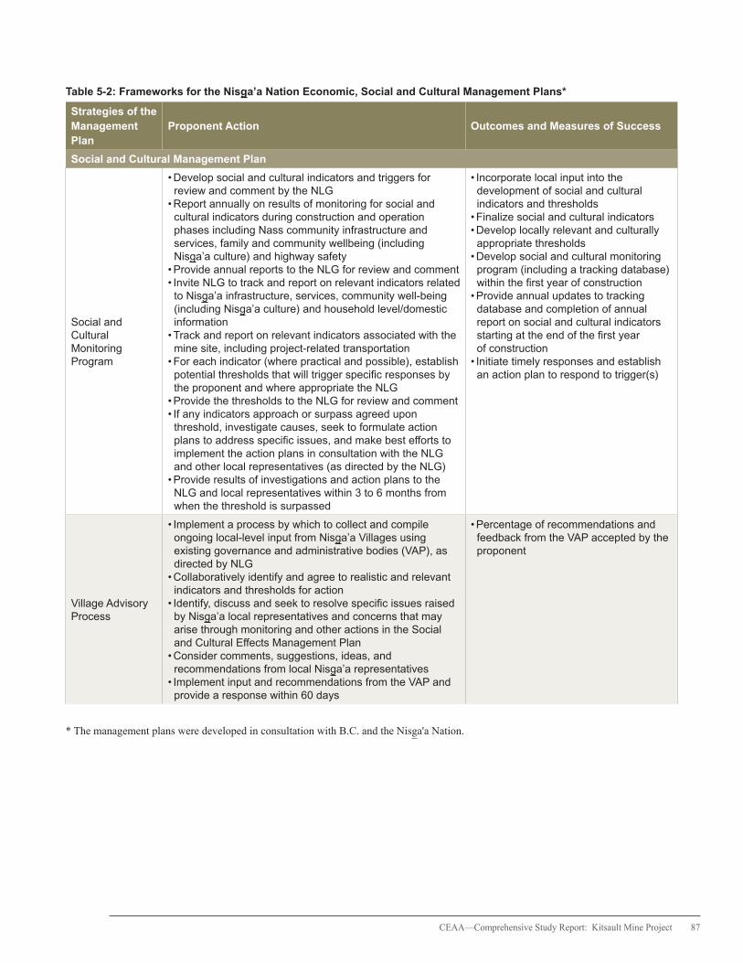
CEAA—Comprehensive Study Report: Kitsault Mine Project 87
Table 5-2: Frameworks for the Nisga’a Nation Economic, Social and Cultural Management Plans*
Strategies of the Management Plan
Proponent Action Outcomes and Measures of Success
Social and Cultural Management Plan
Social and Cultural Monitoring Program
• Develop social and cultural indicators and triggers for review and comment by the NLG
• Report annually on results of monitoring for social and cultural indicators during construction and operation phases including Nass community infrastructure and services, family and community wellbeing (including Nisga’a culture) and highway safety
• Provide annual reports to the NLG for review and comment• Invite NLG to track and report on relevant indicators related to Nisga’a infrastructure, services, community well-being (including Nisga’a culture) and household level/domestic information
• Track and report on relevant indicators associated with the mine site, including project-related transportation
• For each indicator (where practical and possible), establish potential thresholds that will trigger specific responses by the proponent and where appropriate the NLG
• Provide the thresholds to the NLG for review and comment• If any indicators approach or surpass agreed upon threshold, investigate causes, seek to formulate action plans to address specific issues, and make best efforts to implement the action plans in consultation with the NLG and other local representatives (as directed by the NLG)
• Provide results of investigations and action plans to the NLG and local representatives within 3 to 6 months from when the threshold is surpassed
• Incorporate local input into the development of social and cultural indicators and thresholds
• Finalize social and cultural indicators• Develop locally relevant and culturally appropriate thresholds
• Develop social and cultural monitoring program (including a tracking database) within the first year of construction
• Provide annual updates to tracking database and completion of annual report on social and cultural indicators starting at the end of the first year of construction
• Initiate timely responses and establish an action plan to respond to trigger(s)
Village Advisory Process
• Implement a process by which to collect and compile ongoing local-level input from Nisga’a Villages using existing governance and administrative bodies (VAP), as directed by NLG
• Collaboratively identify and agree to realistic and relevant indicators and thresholds for action
• Identify, discuss and seek to resolve specific issues raised by Nisga’a local representatives and concerns that may arise through monitoring and other actions in the Social and Cultural Effects Management Plan
• Consider comments, suggestions, ideas, and recommendations from local Nisga’a representatives
• Implement input and recommendations from the VAP and provide a response within 60 days
• Percentage of recommendations and feedback from the VAP accepted by the proponent
* The management plans were developed in consultation with B.C. and the Nisga'a Nation.

88 CEAA—Comprehensive Study Report: Kitsault Mine Project
Table 5-2: Frameworks for the Nisga’a Nation Economic, Social and Cultural Management Plans continued
Strategies of the Management Plan
Proponent Action Outcomes and Measures of Success
Cultural and Social Needs Assessment
• Carry out a Cultural and Social Needs Assessment Survey with the Nisga’a workforce at the mine site
• Provide the NLG the opportunity to review and comment prior to finalizing the survey
• Solicit input from Nisga’a employees at the mine site about work schedule options, camp food services, Nisga’a language options, counselling, family communication options, the bereavement policy, mentorship and shift scheduling for participation in traditional harvesting activities and cultural events
• Develop and make reasonable efforts to implement programs and policies that are based on the results of the Cultural and Social Needs Assessment
• Complete a Cultural and Social Needs Assessment among Nisga’a employees at the mine site within the first year of operations
Measure of Success:
• Achieve a participation rate of at least 50 percent of Nisga’a employees in the Cultural and Social Needs Assessment Survey
• Submit results of the Cultural and Social Needs Assessment to the NLG
• Implement human resources policies and procedures that are based on the results of the Cultural and Social Needs Assessment within two years of operations
Measure of Success:
• Ratio of policies, initiatives, and programs recommended compared to those implemented based on the results of the Cultural and Social Needs Assessment
Human Resources Policies
• Define and develop culturally-sensitive and locally-relevant Human Resource Policies (e.g., bereavement, drug and alcohol, equal opportunity and anti-discrimination, work schedule options, Social and Cultural Programs and employment packages) informed by the Cultural and Social Needs Assessment Survey
• Provide the NLG the opportunity to review and comment on the policies
• Work to establish and implement such policies and programs
• Develop and implement human resource policies and procedures within two years of operations.
Measures of Success:
• Nisga’a worker absenteeism at or below industry norms
• Nisga’a worker absenteeism declining over time
• Nisga’a worker retention rates at or above industry norms
• Nisga’a worker retention rates increasing over time
Recruitment, Training, and Employment Plan
Career Awareness
• Develop and make reasonable efforts to implement a career awareness program, including annual mine site visits with the Nisga’a graduating class, financially support pre-training courses at local educational institutions, hold career fairs and workshops
• Complete scoping of potential pre-training courses in local schools and vocational or technical training before the start of construction
• Host an annual mine site visit with Nisga’a graduates starting in the first year of construction
• Host or participate in career fairs and workshops starting prior to construction
Measures of Success:
• Percentage of Nisga’a citizens attending career fairs and workshops
• Percentage of Nisga’a graduates attending the mine site visits
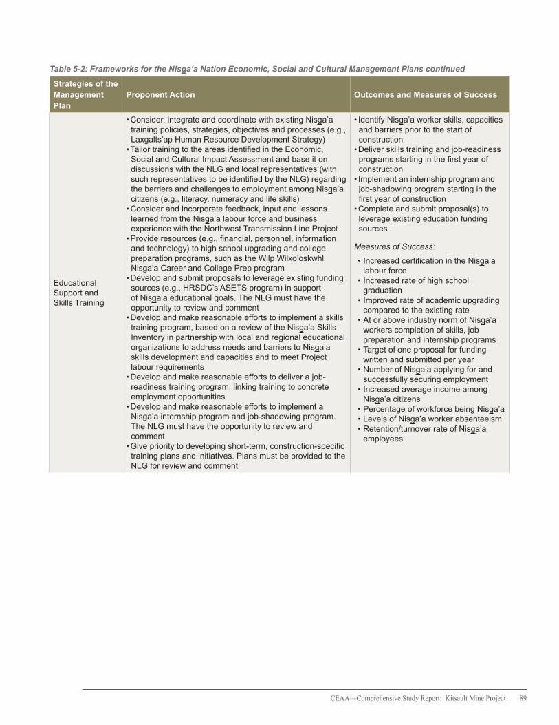
CEAA—Comprehensive Study Report: Kitsault Mine Project 89
Table 5-2: Frameworks for the Nisga’a Nation Economic, Social and Cultural Management Plans continued
Strategies of the Management Plan
Proponent Action Outcomes and Measures of Success
Educational Support and Skills Training
• Consider, integrate and coordinate with existing Nisga’a training policies, strategies, objectives and processes (e.g., Laxgalts’ap Human Resource Development Strategy)
• Tailor training to the areas identified in the Economic, Social and Cultural Impact Assessment and base it on discussions with the NLG and local representatives (with such representatives to be identified by the NLG) regarding the barriers and challenges to employment among Nisga’a citizens (e.g., literacy, numeracy and life skills)
• Consider and incorporate feedback, input and lessons learned from the Nisga’a labour force and business experience with the Northwest Transmission Line Project
• Provide resources (e.g., financial, personnel, information and technology) to high school upgrading and college preparation programs, such as the Wilp Wilxo’oskwhl Nisga’a Career and College Prep program
• Develop and submit proposals to leverage existing funding sources (e.g., HRSDC’s ASETS program) in support of Nisga’a educational goals. The NLG must have the opportunity to review and comment
• Develop and make reasonable efforts to implement a skills training program, based on a review of the Nisga’a Skills Inventory in partnership with local and regional educational organizations to address needs and barriers to Nisga’a skills development and capacities and to meet Project labour requirements
• Develop and make reasonable efforts to deliver a job-readiness training program, linking training to concrete employment opportunities
• Develop and make reasonable efforts to implement a Nisga’a internship program and job-shadowing program. The NLG must have the opportunity to review and comment
• Give priority to developing short-term, construction-specific training plans and initiatives. Plans must be provided to the NLG for review and comment
• Identify Nisga’a worker skills, capacities and barriers prior to the start of construction
• Deliver skills training and job-readiness programs starting in the first year of construction
• Implement an internship program and job-shadowing program starting in the first year of construction
• Complete and submit proposal(s) to leverage existing education funding sources
Measures of Success:
• Increased certification in the Nisga’a labour force
• Increased rate of high school graduation
• Improved rate of academic upgrading compared to the existing rate
• At or above industry norm of Nisga’a workers completion of skills, job preparation and internship programs
• Target of one proposal for funding written and submitted per year
• Number of Nisga’a applying for and successfully securing employment
• Increased average income among Nisga’a citizens
• Percentage of workforce being Nisga’a • Levels of Nisga’a worker absenteeism • Retention/turnover rate of Nisga’a employees
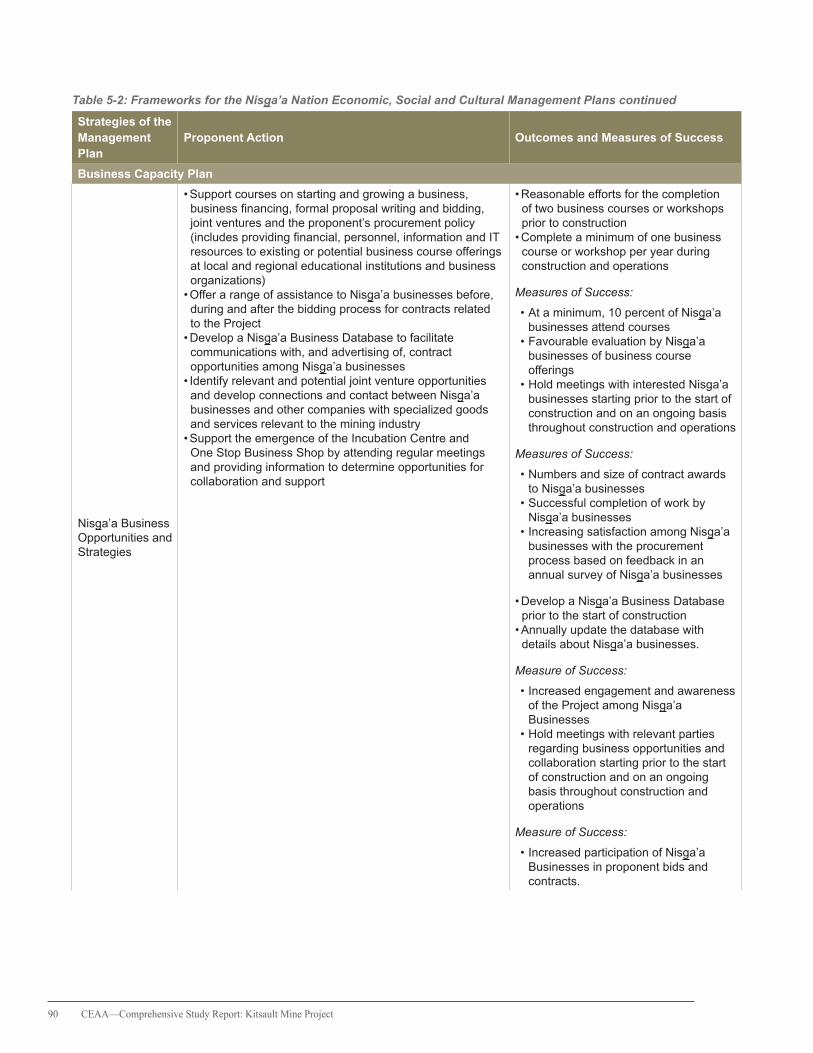
90 CEAA—Comprehensive Study Report: Kitsault Mine Project
Table 5-2: Frameworks for the Nisga’a Nation Economic, Social and Cultural Management Plans continued
Strategies of the Management Plan
Proponent Action Outcomes and Measures of Success
Business Capacity Plan
Nisga’a Business Opportunities and Strategies
• Support courses on starting and growing a business, business financing, formal proposal writing and bidding, joint ventures and the proponent’s procurement policy (includes providing financial, personnel, information and IT resources to existing or potential business course offerings at local and regional educational institutions and business organizations)
• Offer a range of assistance to Nisga’a businesses before, during and after the bidding process for contracts related to the Project
• Develop a Nisga’a Business Database to facilitate communications with, and advertising of, contract opportunities among Nisga’a businesses
• Identify relevant and potential joint venture opportunities and develop connections and contact between Nisga’a businesses and other companies with specialized goods and services relevant to the mining industry
• Support the emergence of the Incubation Centre and One Stop Business Shop by attending regular meetings and providing information to determine opportunities for collaboration and support
• Reasonable efforts for the completion of two business courses or workshops prior to construction
• Complete a minimum of one business course or workshop per year during construction and operations
Measures of Success:
• At a minimum, 10 percent of Nisga’a businesses attend courses
• Favourable evaluation by Nisga’a businesses of business course offerings
• Hold meetings with interested Nisga’a businesses starting prior to the start of construction and on an ongoing basis throughout construction and operations
Measures of Success:
• Numbers and size of contract awards to Nisga’a businesses
• Successful completion of work by Nisga’a businesses
• Increasing satisfaction among Nisga’a businesses with the procurement process based on feedback in an annual survey of Nisga’a businesses
• Develop a Nisga’a Business Database prior to the start of construction
• Annually update the database with details about Nisga’a businesses.
Measure of Success:
• Increased engagement and awareness of the Project among Nisga’a Businesses
• Hold meetings with relevant parties regarding business opportunities and collaboration starting prior to the start of construction and on an ongoing basis throughout construction and operations
Measure of Success:
• Increased participation of Nisga’a Businesses in proponent bids and contracts.

CEAA—Comprehensive Study Report: Kitsault Mine Project 91
Table 5-2: Frameworks for the Nisga’a Nation Economic, Social and Cultural Management Plans continued
Strategies of the Management Plan
Proponent Action Outcomes and Measures of Success
Economic Closure Plan
Closure Transition Support
• Provide résumé preparation, job search skill assistance and business management and career coaching services to Nisga’a employees at the mine site
• Develop a workforce skills and experience inventory and distribute it among potential external employers
• Communicate with human resource personnel of other major projects in the region and elsewhere to ensure there is knowledge of the available workforce
• Work with NLG and Nisga’a Villages and regional employment assistance agencies to facilitate connections between workers and other potential employers
• Implement the Human Resource Closure Plan one year in advance of closure
• Distribute the Kitsault skills and experience inventory to potential external employers one year in advance of closure
• Hold meetings with human resource personnel of other major projects in the region one year in advance of closure
• Hold meetings and establish relationships with regional employment assistance agencies one year in advance of closure
Measures of Success:
• Percentage of Nisga’a workers that utilize internal transition assistance services
• Percentage of Nisga’a workers that utilize external transition assistance services
• Frequency of access by external parties to workforce skill and experience inventory
• Number and percentage of Nisga’a workers that secure alternative employment
• Number and percentage of Nisga’a workers that move from their home community
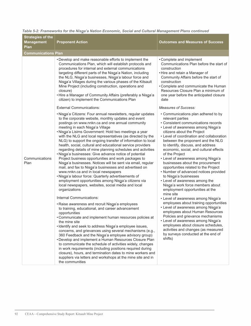
92 CEAA—Comprehensive Study Report: Kitsault Mine Project
Table 5-2: Frameworks for the Nisga’a Nation Economic, Social and Cultural Management Plans continued
Strategies of the Management Plan
Proponent Action Outcomes and Measures of Success
Communications Plan
Communications Plan
• Develop and make reasonable efforts to implement the Communications Plan, which will establish protocols and procedures for internal and external communications targeting different parts of the Nisga’a Nation, including the NLG, Nisga’a businesses, Nisga’a labour force and Nisga’a Villages during the various phases of the Kitsault Mine Project (including construction, operations and closure)
• Hire a Manager of Community Affairs (preferably a Nisga’a citizen) to implement the Communications Plan
External Communications:
• Nisga’a Citizens: Four annual newsletters, regular updates to the corporate website, monthly updates and event postings on www.nnkn.ca and one annual community meeting in each Nisga’a Village
• Nisga’a Lisims Government: Hold two meetings a year with the NLG and local representatives (as directed by the NLG) to support the ongoing transfer of information to local health, social, cultural and educational service providers regarding details of mine planning schedules and activities
• Nisga’a businesses: Give advance notice of potential Project business opportunities and work packages to Nisga’a businesses. Notices will be sent via email, regular mail, and fax to Nisga’a businesses and advertised on www.nnkn.ca and in local newspapers
• Nisga’a labour force: Quarterly advertisements of employment opportunities among Nisga’a citizens via local newspapers, websites, social media and local organizations
Internal Communications:
• Raise awareness and recruit Nisga’a employees to training, educational, and career advancement opportunities
• Communicate and implement human resources policies at the mine site
• Identify and seek to address Nisga’a employee issues, concerns, and grievances using several mechanisms (e.g., 360 Feedback and the Nisga’a employee advisory group)
• Develop and implement a Human Resources Closure Plan to communicate the schedule of activities widely, changes in work requirements (including positions required during closure), hours, and termination dates to mine workers and suppliers via letters and workshops at the mine site and in the communities
• Complete and implement Communications Plan before the start of construction
• Hire and retain a Manager of Community Affairs before the start of construction
• Complete and communicate the Human Resources Closure Plan a minimum of one year before the anticipated closure date
Measures of Success:
• Communications plan adhered to by relevant parties
• Consistent communications records • Level of awareness among Nisga’a citizens about the Project
• Level of coordination and collaboration between the proponent and the NLG to identify, discuss, and address economic, social, and cultural effects of the Project
• Level of awareness among Nisga’a businesses about the procurement opportunities related to the Project
• Number of advanced notices provided to Nisga’a businesses
• Level of awareness among the Nisga’a work force members about employment opportunities at the mine site
• Level of awareness among Nisga’a employees about training opportunities
• Level of awareness among Nisga’a employees about Human Resources Policies and grievance mechanisms
• Level of awareness among Nisga’a employees about closure schedules, activities and changes (as measured by surveys conducted at the end of shifts)

CEAA—Comprehensive Study Report: Kitsault Mine Project 93
5.2.4 Nisga’a Nation Comments
The Nisga’a Nation expressed concerns about the lack of specificity of the proposed management plans and the resulting underestimation of the Project’s adverse economic, social and cultural effects on Nisga’a citizens. Concerns focused on the omission of a process for: 1) defining specific targets, indicators or commitments; 2) determining thresholds beyond which remedial action is required; and, 3) monitoring progress. The Nisga’a Nation also noted its limited capacity to participate in the development and implementation of management plans and emphasized that the responsibility for any residual project-related costs rests with the proponent.
To address economic effects, the Nisga’a Nation suggested that specific training initiatives and employment and business contract targets be established in order to evaluate, on an ongoing basis, the extent to which Nisga’a citizens and businesses realize the economic benefits associated with the Project. Other comments included the need for more details on the range of possible economic impacts, including details on employment and business effects, effects on NLG revenues and expenditures, and opportunity costs of predicted employment. However, in the absence of these details, the Nisga’a Nation questioned the basis for predicting net economic benefits of the Project to Nisga’a citizens.
With respect to social and cultural effects, the Nisga’a Nation noted the uncertainty regarding project-related effects on Nisga’a migration and community population levels and the associated demands on Nisga’a families, communities and community infrastructure and services. The comments indicated that the extent of effects on family and community well-being and on cultural activities will largely depend on the implementation and effectiveness of proposed policies and programs, and the identification of and response to social and cultural issues as they arise. The Nisga’a Nation emphasized
the need for the proponent to develop specific commitments for monitoring family and community well-being that include triggers for remedial action if unanticipated effects emerge.
The Nisga’a Nation submitted that, in the absence of specific commitments to monitoring and management actions by the proponent, predictions regarding the economic, social and cultural impacts of the Project on Nisga’a citizens are unsupported.
5.2.5 Agency Conclusions on 8f Assessment
Chapter 10, paragraph 8(f) of the NFA sets out that for all EAs covered by the NFA, B.C. and Canada are required to “assess the effects of the project on the existing and future economic, social and cultural well-being of Nisga’a citizens who may be affected by the project.”
The potential economic, social and cultural effects of the Project on the well-being of Nisga’a citizens were evaluated during the EA. The Agency took into consideration plans proposed by the proponent to manage potential adverse economic, social and cultural effects. Based on the information in this report, the Project may result in both adverse and positive effects on the social and cultural well-being of Nisga’a citizens and contribute to modest improvements in their economic well-being.

94 CEAA—Comprehensive Study Report: Kitsault Mine Project
6. Treaty and Aboriginal Consultation
The federal government has a duty to consult and, where appropriate, to accommodate, when it has knowledge that its proposed conduct might adversely impact an established or potential Aboriginal or Treaty right. Consultation is also undertaken more broadly as an important part of good governance, meaningful policy developmentand informed decision-making.
In addition to the federal government’s broader obligations, the former Act requires that all federal EAs consider the effect of any environmental change caused by the Project and also the effect of that change on current use of lands and resources for traditional purposes by Aboriginal peoples. The former Act also requires consideration of the effect of any project-related environmental change on physical and cultural heritage, and “any structure, site, or thing that is of historical or archaeological significance.”
The Agency served as the Crown consultation coordinator and, together with the relevant federal departments, integrated consultation with the EA process to the extent possible. In this role, the Agency ensured that Aboriginal groups were provided with opportunities to (a) learn about the project, (b) evaluate the project, and (c) communicate their concerns to the Crown.
Through the federal government’s Participant Funding Program, funding was made available to reimburse eligible expenses incurred by Aboriginal groups during their participation in the EA. The Nisga’a Nation, GHCO (on behalf of Gitanyow Huwilp Wiitaxhayetwx-Sidok, Huwilp Gwass Hlaam, Huwilp Gwinuu, and Huwilp Gamlaxyeltxw), Gitanyow Huwilp Luuxhon, Gitxsan Nation, Kitselas First Nation, Kitsumkalum First Nation and the Métis Nation of B.C. (MNBC) were provided with funding under the Participant Funding Program.
6.1 Nisga’a Nation Consultation Activities
Provisions under Chapter 10 of the Nisga’a Final Agreement specify the requirements for consultation with the Nisga’a Nation in relation to an EA of a project. The Government of Canada worked collaboratively with the NLG and the Government of B.C. as part of a tripartite government approach to: 1) ensure that the Nisga’a Nation was informed about the Project; 2) understand the potential impacts of the Project on Nisga’a Nation treaty rights under the NFA; and, 3) elicit Nisga’a Nation feedback on how the NFA applies to different phases of the EA process.
The federal government
has a duty to consult
and, where appropriate,
to accommodate, when
it has knowledge that its
proposed conduct might
adversely impact an
established or potential
Aboriginal or Treaty right.

CEAA—Comprehensive Study Report: Kitsault Mine Project 95
The Agency invited the NLG to review and provide comments on key documents relating to the EA, including the federal EIS guidelines, the EIS and corresponding reports, this comprehensive study report and all of the products associated with the proponent’s ESCIA. Additional information was received from the NLG through working groups (EA and transportation), technical subgroup meetings, bilateral and trilateral government meetings, correspondence, open houses in Nisga’a villages and supplementary information documents. The NLG also provided its draft ESCIA Guidelines to the Agency and the BC EAO to guide the scope and contents of the proponent’s ESCIA. Meetings held between the NLG, Agency and BC EAO provided opportunities to collectively discuss issues related to the ESCIA and to inform the proponent of information gaps that needed to be addressed. Funding was allocated to assist the NLG to participate in the activities related to the federal EA.
6.2 Consultation Activities related to Potential Aboriginal Rights
Aboriginal groups that were contacted and invited to participate in the consultation activities had been identified as potentially having asserted Aboriginal rights that could be adversely impacted by the Project. These groups included Metlakatla First Nation, GHCO, Gitanyow Huwilp Luuxhon, Gitxsan Nation, Kitselas First Nation, Kitsumkalum First Nation, and MNBC.
6.2.1 Metlakatla First Nation
Based on the available information gathered during the EA, the Agency identified that the mine footprint and six kilometres along one of the proposed transportation corridors (i.e., mine site along the Nass FSR to Highway 113 south to Highway 16) overlap with the asserted territory of the Metlakatla First Nation. Correspondence received from the Metlakatla First Nation confirmed that the Project, situated within the
boundaries of its asserted traditional territory, has the potential to infringe Metlakatla First Nation’s potential rights and affect Metlakatla First Nation’s interests.
Representatives of the Metlakatla First Nation were invited to participate in the TWG to discuss different aspects of the proponent’s EIS and the draft of this report. The Agency also received feedback and information from the Metlakatla First Nation through face-to-face meetings and correspondence.
6.2.2 Gitanyow First Nation
Although the project footprint is situated outside of the asserted territory of the Gitanyow First Nation, the proposed transportation corridors intersect portions of the asserted territories of five Gitanyow Huwilp, including the Gitanyow Huwilp Luuxhon. The GHCO represented the interests of the Gitanyow Huwilp Watakheyetsxw, Huwilp Gamlaxyeltxw, Huwilp Gwass Hlaam and Huwilp Gwinuu while the Gitanyow Huwilp Luuxhon participated in the EA as a separate entity.
The GHCO and the Gitanyow Huwilp Luuxhon were invited to participate to the TRWG to exchange information on the potential effects of road use, and provide input into the proponent’s measures for spill response. Important information was also received through one-on-one meetings, direct correspondence, public open houses and comment periods on the EIS and other documents, including the draft of this report. Both the GHCO and Gitanyow Huwilp Luuxhon were provided with funding to participate in these activities related to the transportation aspects of the Project.
6.2.3 Gitxsan Nation
The project footprint is situated outside the asserted territory of the Gitxsan Nation; however, the proposed transportation corridor from Highway 16 along Highway 37 to the mine site intersects the territories of three

96 CEAA—Comprehensive Study Report: Kitsault Mine Project
Gitxsan wilp, including Tenim Gyet (for 13.8 km), Gaxsbgabaxs (for 3.7 km), and Sakxam Higookxw (for 9.0 km). The Agency’s consultation activities with the Gitxsan Nation were related to the proponent’s intended use of Highway 37 and the potential for transportation-related effects such as wildlife mortality and spills. Funding was provided for Gitxsan Nation participation in the EA, including involvement in the TRWG.
6.2.4 Kitsumkalum First Nation
The asserted territory of the Kitsumkalum First Nation covers the extent of the Kitsumkalum valley from Terrace to Sand Lake and therefore overlaps with the proposed transportation corridor that travels from the mine site to Terrace via Highway 113. Funding was provided to the Kitsumkalum First Nation to participate in the TRWG and to provide input during public comment periods and open houses.
6.2.5 Kitselas First Nation
Neither the mine footprint nor the proposed transportation corridors intersect the asserted territory of the Kitselas First Nation; however, it was determined that the close proximity of project-related traffic along Highway 113 through Terrace could affect the Kitselas First Nation’s current use of lands and resources in the area. In consideration of these potential effects, funding was made available to the Kitselas First Nation to participate in the federal EA. The Kitselas First Nation was also invited to the TRWG to provide input into project-related road use issues and proposed mitigation measures.
6.2.6 Métis Nation of British Columbia
The Métis Nation of British Columbia (MNBC), a consultative body representing chartered Métis communities in B.C., notified the Agency of its interest in the Project and was therefore invited
to participate in the consultation process for the EA. Preliminary information provided to the Agency in 2010 suggested that MNBC citizens from adjacent chartered communities could be exercising their potential Aboriginal rights to harvest near the Project. MNBC was provided funding to participate in the EA, kept informed of EA milestones and was invited to comment on key documents.
6.3 Proponent Engagement
The legal responsibility to consult and accommodate rests with the Crown. However, the efforts of the proponent can assist in the overall consultation process and inform not only the assessment of potential adverse impacts of the Project on asserted Aboriginal rights but also appropriate mitigation or accommodation measures that may be required to address the potential impacts.
The following are examples of consultation activities the proponent led during the EA process:
• sharing of project information • participation in working group meetings • organization of site visits, community meetings and open houses • provision of capacity funding to participate in the review process and for community engagement • financial support and coordination of field activities, including a survey of areas along the transportation corridors where barrier protection could be warranted to protect ecologically sensitive areas from future spills or accidents
Information collected by the proponent during its Aboriginal consultation program was considered in the Agency’s determination of any potential adverse impacts of the Project on potential or established Aboriginal and treaty rights.
CEAA—Comprehensive Study Report: Kitsault Mine Project 97
6.4 Summary of Key Issues
Project effects that could potentially affect Aboriginal rights were considered during the review of the proponent’s EIS through the participation of Aboriginal groups on the TWG and TRWG, and through direct consultation meetings with the Metlakatla First Nation, Gitanyow First Nation, Gitxsan Nation and MNBC. The potential effects of the Project on the treaty rights of the Nisga’a Nation, as defined by the NFA, are discussed in Chapter 5 of this comprehensive study report.
The Agency maintained an issues tracking table to follow and respond to all information related to potential or established Aboriginal rights, potential adverse impacts on those rights and proposed mitigation or accommodation measures. This table was shared with Aboriginal groups contacted during the EA process, for review and comment. A summary of the substantive issues raised by Aboriginal groups follows.
6.4.1 Nisga’a Nation
During the EA, the NLG raised a range of issues regarding the Project through written correspondence to the Agency, comments on proponent documents and concerns expressed at the TWG and other working groups.
Comments were provided about the predicted effects of the Project on water quality in the Lime Creek and Clary Creek freshwater environments and the mitigation measures proposed to address these effects, including mine site water management and water treatment. The NLG raised concerns regarding mine site discharge into Lime Creek and the ecological implications of such discharge on downstream water quality, sediment quality and marine biota in Alice Arm. Comments were focused on both ecosystem and human health risks associated with increased metal loading in marine sediment and shell fish that are important to Nisga’a Nation harvest food diet. Furthermore,
the NLG stated the need for a better understanding of the cumulative effects of the Project and historical tailings disposal in Alice Arm from previous Kitsault Mine operations.
The NLG advocated for water treatment during all mine phases to address predicted exceedances of BC WQGs and recommended changes to the AEMP and MEMP, including the evaluation of ecosystem health effects and the monitoring of clams. Questions were raised regarding the proponent’s water quality predictions. The NLG requested the opportunity to review the proponent’s baseline water quality data, water quality model predictions and associated modeling assumptions. Specific comments on the derivation and output of the proponent’s water quality predictions were provided.
The NLG sought assurances that BC WQGs or Site Specific Water Quality Objectives be used to evaluate the protection of aquatic life in Lime Creek. The proponent’s use of water quality management targets was not considered appropriate to replace the guidelines and protocols developed by the BC MOE to manage water quality in the province. The NLG asserted that any approach other than following the approved provincial process for protecting aquatic life was not acceptable to the Nisga’a Nation.
The NLG requested more information on the proposed closure plan for water management, in particular a conceptual model of the water flows and contaminant loads for closure and post closure, the approach for sludge management post closure, and the basis for long-term mitigation strategies such as cover design. With respect to ML/ARD, concerns were raised about the management of waste rock and PAG rock, the feasibility of segregating PAG from non-PAG, the location of the LGS and long-term water treatment during post closure. Further clarification was sought regarding the proponent’s PAG waste rock management strategy, including the consideration of submerging PAG waste
98 CEAA—Comprehensive Study Report: Kitsault Mine Project
rock and the possibility of moving the LGS closer to the Kitsault Pit to manage long-term water quality effects. The NLG questioned the accountability, enforcement and net present value for water treatment with the onset of ARD after closure, indicating that the responsibility for the legacy of the mine should fall to the proponent.
Concerns were raised about moose mortality, specifically from the increase in winter access along the Nass FSR, the corresponding increase in illegal and unregulated hunting pressure, and the cumulative increase in regional traffic. The NLG stated that the proposed Wildlife Management Plan must include requirements to support Nisga’a Nation participation in additional enforcement when access along the Nass FSR increases during the winter. Monitoring wildlife mortality along the proposed transportation corridors was also discussed as an important element in identifying and mapping sensitive areas where moose are most vulnerable.
The NLG strongly opposed the notion to close the Nass FSR by stating that the closure of this road during the winter months is “not an effective strategy for mitigating potential impacts to moose and moose habitat.” Through written correspondence to the BC MFLNRO, the NLG outlined various reasons behind its position and requested that the proponent open the Nass FSR during the winter months and participate in any coordinated regional strategy on access management and moose conservation.
Concerns were raised about the effects of the TMF on wetlands and fish and fish habitat and the need to capture these impacts in appropriate management plans (i.e., Wetlands Habitat Compensation Plan and FHCP). The NLG provided feedback on the contents of these conceptual management plans and requested ongoing meaningful engagement and consultation to incorporate Nisga’a interests as the management plans are finalized after the conclusion of the EA.
NLG comments regarding the Nisga’a effects assessment in the EIS focused on clarifications of intent, content, terminology or interpretation of the NFA and the applicability of the socio-economic data sources and information. As for the ESCIA, the NLG raised concerns about the lack of detail with regard to the mitigation measures to address economic, social and cultural effects. The NLG requested that the proponent conduct additional site-specific land use analyses to assess effects to marine harvesting in Alice Arm and wildlife and vegetation harvesting in the Kitsault mine site area.
6.4.2 Metlakatla First Nation
The Metlakatla First Nation asserts an Aboriginal right to access and harvest marine resources from their traditional territory. Potential project-related effects on these rights relate to changes to surface water quality in Lime Creek and Clary Creek and the resulting downstream implications on marine water quality and organisms in Alice Arm.
Concerns were noted regarding the extent of existing water quality and sediment contamination in Alice Arm from historical mining activity and the need to characterize the extent and severity of this contamination through monitoring that would, in turn, determine outcomes for local harvesters. Cumulative effects arising from the combination of elevated metal concentrations in the freshwater environment and the residual marine concentrations from historical mining were also identified as important to the Metlakatla First Nation. It was recommended that the MEMP include sampling of marine species that are harvested and consumed by First Nations and specify the actions to be taken when elevated levels of contaminants are detected in the freshwater or marine environments. The Metlakatla First Nation advocated that the proponent develop a communications plan with them to establish Metlakatla involvement in the development, implementation and reporting

CEAA—Comprehensive Study Report: Kitsault Mine Project 99
activities of environmental management plans, wetland and fish habitat compensation plans and monitoring programs.
The Metlakatla First Nation also raised issues related to the project-related effects on socio-economic interests and other issues that were not directly related to Metlakatla First Nation’s potential Aboriginal rights. These issues were instructive in guiding the federal EA process and related consultation activities.
6.4.3 Gitanyow First Nation and Gitanyow Huwilp Luuxhon
The issues raised by the GHCO focused on the potential effects of increased road use along the proposed transportation corridors on wildlife, notably moose. The GHCO stated in correspondence to the Crown that the proposed transportation corridors overlap with the asserted territories of the Gitanyow Wilp Watakheyetsxw (44.8 km), Wilp Gamlaxyeltxw (16.9 km), Wilp Gwaas Hlaam (49.1 km), and Wilp Gwinuu (7.8 km) and that the Nass FSR provides important wintering habitat for moose, a species which Gitanyow communities depend on for food and for cultural and ceremonial purposes. The GHCO expressed that they have constitutionally protected Aboriginal rights to harvest moose and other traditional foods from their territory.
The GHCO, as members of the TRWG, provided detailed and insightful information and feedback related to the potential effects of the transportation corridors on Gitanyow First Nation’s Aboriginal rights. The majority of the concerns were focused on the potential direct and cumulative effects of increased road use along the Nass FSR on the regional moose population. The GHCO clarified, through written correspondence to the Agency, that any further decrease to the declining moose population, either because of the Project or because of the cumulative increase in traffic along Highway 37, would reduce the
moose available for the Gitanyow First Nation to exercise their right to hunt or harvest moose.
The GHCO provided the Agency with information related to the moose population in the Nass Valley and mitigation measures used in other jurisdictions to reduce vehicular moose mortality. This information indicated that the moose population in the Nass Valley had declined from 638 in 2007 to 517 in 2011 and that the majority of moose migrated along the Nass FSR to the Cranberry River during the winter. Concerns were raised about the effects on moose in their critical winter habitat of year-round vehicular access to the Nass FSR.
The documentation provided by GHCO throughout the EA contributed to the Crown’s understanding of the cultural importance of moose to the way of life of the Gitanyow First Nation and the importance of moose as a fundamental food source. Meetings with GHCO have also helped the Crown understand the GHCO’s position on mitigation measures to slow the decline of the current moose population, including the prospect of temporarily closing the Nass FSR during certain months of the winter. Comments focused on identifying and protecting habitat areas for moose, using historical vehicle-moose collision data, enforcing unregulated harvesting of moose, and funding for additional monitoring of and education about moose conservation.
In addition to concerns about moose, the Agency also received comments regarding the vulnerability of local water bodies (e.g., Cranberry River) to potential spills and accidents along the Nass FSR and the downstream effects of such events. The GHCO advocated that the proponent and government agencies involve Gitanyow First Nation members in any emergency response measures or initiatives developed for the transportation corridors. Comments were also made regarding the effects of increased traffic on human safety
100 CEAA—Comprehensive Study Report: Kitsault Mine Project
in communities along the transportation corridors, access to fishing sites, and other wildlife including grizzly bears and furbearers.
Participation of the Gitanyow Huwilp Luuxhon was limited during the EA. Comments received by the Agency were in opposition to the notion of closing the Nass FSR during the winter, in view of the economic opportunities for the Huwilp associated with the use of the proposed transportation corridor along Highway 37.
6.4.4 Gitxsan Nation
The Gitxsan Nation raised concerns regarding the potential effects of the Project on the Nass River and the watersheds in Gitxsan territory, including the Nass, Lower Skeena, Kitseguecla and Saskwa. These watersheds are important to the Gitxsan Nation as they provide fish and wildlife for sustenance and resources for cultural practices. As a member of the TRWG, concerns were expressed about the increase in vehicle traffic moving through Gitxsan territories and the cumulative effect of more traffic interacting with wildlife (e.g., deer, grizzly bears, moose and other wildlife). The Gitxsan Nation also commented on the implications of ploughed snow affecting steelhead in the Cranberry River and the effects of invasive species on medicinal plants along the transportation corridors.
6.4.5 Kitsumkalum First Nation
As a participant on the TRWG, the Kitsumkalum First Nation expressed the importance of Kitsumkalum River and Lake as traditional areas for hunting and fishing. Concerns were raised about the potential for vehicular accidents with moose, bears, and furbearers, and for spills and downstream effects on Kitsumkalum Lake, which provides habitat for Chinook salmon and spawning channels for sockeye salmon along the roadside. It was noted that the downstream effects
of any spill would be difficult to clean up during winter when the lake is frozen and when recovery of materials and equipment would be challenging. The Kitsumkalum First Nation requested to be involved in the development of the proponent’s Mine Emergency and Spill Response Plan that includes establishing a response team located in the Kitsumkalum community.
Comments were also noted regarding the potential effects of project-related traffic on the moose population, the need for roadside barrier protection, and the increase in traffic along the Nisga’a Highway (Highway 113) and through the Kitsumkalum asserted traditional territory should the use of the Nass FSR be restricted. The Kitsumkalum First Nation requested to be involved in reporting moose kills and in timely consultation on the development of a communications protocol with the proponent.
6.4.6 Kitselas First Nation
The Kitselas First Nation did not raise any concerns or provide any written feedback regarding the Project during the EA process.
6.4.7 Métis Nation of British Columbia
Issues raised by MNBC during the review of the Project include the assertion of Aboriginal rights in the project area and a desire to be included in the scope of Crown consultation related to the EA process. MNBC identified that the construction and operation of the Project could put local Métis Aboriginal rights and traditional land uses at risk by adversely affecting harvesters who rely on the area for sustenance, social and ceremonial purposes. Concerns centred on the contingency measures that will be undertaken by the proponent should the Project affect surface and groundwater quality and on the monitoring of such effects on fish in the lake environment.

CEAA—Comprehensive Study Report: Kitsault Mine Project 101
6.5 Mitigation and Accommodation
The potential impacts on potential Aboriginal rights and related interests, and the appropriate mitigation and accommodation measures, were considered throughout the EA process, particularly through consultation during the review of the EIS. Mitigation measures developed in response to issues raised by Aboriginal groups that participated in the EA process are described in Appendix I. The proponent will also make reasonable efforts to ensure that the Metlakatla First Nation, Gitanyow First Nation, Gitxsan Nation and Kitsumkalum First Nation continue to be involved in environmental studies or monitoring programs during the regulatory phase of this project. Appendix I describes key mitigation and monitoring measures that address potential impacts on potential Aboriginal rights to hunting, fishing, trapping, harvesting and other land uses.
6.6 Agency Conclusions Regarding Impacts to Aboriginal Rights
As a result of Crown consultation with the Metlakatla First Nation, Gitanyow First Nation, Gitanyow Huwilp Luuxhon, Gitxsan Nation and the MNBC, throughout the EA process, the Crown better understands the importance of certain areas near the mine site and along the transportation corridors to these groups’ potential Aboriginal rights related to food, cultural practices and other traditional uses.
The Agency has considered the mitigation measures to address the potential effects to water quality, fish and fish habitat (including the removal of non-fish bearing habitat), wildlife and wildlife habitat, wetlands and other VCs. As a result, the Agency is satisfied that adverse impacts of the mine on the continued exercise of potential Aboriginal rights in the area of the Lime Creek and Clary Creek watersheds and along the proposed transportation corridors
will be appropriately avoided, mitigated or accommodated.
The Agency is satisfied that the consultation and accommodation obligations, including the implementation of mitigation measures, are commensurate with the Crown’s assessment of the potential Aboriginal rights in the project area and the potential adverse effects of the Project on these potential rights. Additional consultation and accommodation measures may be considered as part of the post-EA permitting phase should new information arise (post-consultation on this document) that require changes to the Crown’s assessment.
After the EA concludes, the RAs will continue Crown consultation with Aboriginal groups as appropriate on matters associated with any federal regulatory approvals required for the Project to proceed.

102 CEAA—Comprehensive Study Report: Kitsault Mine Project
7. Public Consultation
The former Act requires that the public be provided with a minimum of three formal participation opportunities: one at the outset of the EA process, one during the comprehensive study process, and a final opportunity to review and comment on this report.
The federal and provincial government agencies worked cooperatively throughout the EA process and collaborated wherever possible on public consultation activities, including participation in open houses and proponent-led public consultation activities.
For this project, formal public consultation periods were held to receive comments on
a) the Project and the conduct of the comprehensive study (November– December 2010), and
b) the proponent’s EIS (May–June 2012; held jointly with BC EAO)
During the final public consultation opportunity, the Agency invites the public to comment on the content, conclusions and recommendations of this comprehensive study report.
Notices of these opportunities for public participation were posted on the Canadian Environmental Assessment Registry (CEAR) website. Notices were also provided in local media sources, and individuals and groups who had indicated an interest in the Project were notified directly. The Agency provided funding to support the public’s participation in the comprehensive study process through its Participant Funding Program.
7.1 Public Comment Summary
All comments received were shared with federal and provincial members of the TWG. The key environmental issues raised related to the potential impacts on existing freshwater and marine water quality, fish and fish habitat, and groundwater-surface water interactions. Other issues included opportunities for local training and employment and the ability of the TMF to withstand natural seismic events. Appendix H provides a summary of the key issues raised during the public comment periods conducted prior to this report.

CEAA—Comprehensive Study Report: Kitsault Mine Project 103
8. Follow-up under the Canadian Environmental Assessment Act
The purpose of a follow-up program required under the former Act is to verify the accuracy of the EA of a project and determine the effectiveness of measures taken to mitigate the adverse environmental effects of the Project. The results of a follow-up program may also support, where appropriate, the implementation of adaptive management measures to address unanticipated adverse environmental effects and environmental management systems to manage the environmental effects of projects.
The proponent has proposed a follow-up program to verify the accuracy of effects predictions or the effectiveness of mitigation for certain VCs. The detailed design and implementation of these programs will be completed following the Minister’s EA decision statement and NFA Project Recommendation.
8.1 Water Management
A follow-up program is required to monitor and verify water quality predictions in Lime Creek and the effectiveness of mitigation measures in protecting aquatic life.
The proponent will develop the AEMP prior to construction of the Project to detect adverse changes (e.g., cadmium, aluminum) that may affect freshwater receptors (e.g., fish, aquatic plants) in Lime Creek and examine the effectiveness of water management measures. The proponent will develop and implement additional management actions where monitoring results exceed water quality guidelines. Potential effects will be monitored in surface and groundwater chemistry, hydrology, sediment chemistry, primary and secondary producers, and fish. The AEMP will include protocols for field sampling and analysis, triggers for management actions and reporting. The proponent will provide copies of monitoring reports to EC upon request for review and follow up.
The proponent will also develop a Mine Site Water Monitoring Plan to quantify and characterize mine site water and inform the development of additional management measures based data trends in water quality and quantity over time. This plan will be provided to the NLG and Metlakatla First Nation and will complement the objectives and measures in the proponent’s Environmental Management System and AEMP.
Monitoring of ML/ARD will be undertaken in accordance with the proponent’s ML/ARD Monitoring and Management Plan that will be developed prior to the start of construction. The plan will confirm geochemical characterisations and adapt management approaches for different ML/ARD sources, if necessary. Components include:
• Data collection and ongoing characterization of waste rock, low-grade ore, tailings and construction material;
The purpose of a follow-up
program required under the
former Act is to verify the
accuracy of the EA of a
project and determine the
effectiveness of measures
taken to mitigate the
adverse environmental
effects of the Project.
104 CEAA—Comprehensive Study Report: Kitsault Mine Project
• An inventory of waste and low grade ore production and placement for future assessments of facility performance; • Monitoring of water chemistry (i.e., seeps, pit wall runoff, supernatant); and • Updates to water and metal loading to verify and refine water quality predictions for the Project.
The MEMP will be developed to detect potential effects of the Project on defined water users (e.g. marine life, human health, wildlife) prior to effects occurring. Two years of marine environment monitoring data will be collected and analysed to establish a baseline for the identification of potential effects before the start of operations. The MEMP will involve monitoring of water quality, sediment chemistry and toxicity, and tissue chemistry of important marine resources including shellfish, intertidal fish and BMI. Any effects identified through monitoring over time will inform and adapt the proponent’s management measures. The proponent will consult EC, the NLG, the Metlakatla First Nation on the design and development of the MEMP and, where required, will request HC’s expert advice on human health issues related to the harvesting and consumption of marine resources by local communities.
8.2 Fish and Fish Habitat
The proponent will submit a FHCP to DFO before an authorization under subsection 35(2) of the Fisheries Act may be issued. DFO will continue to consult with the NLG on the design and implementation of the FHCP following conclusion of the EA if the EA decision enables the Project to proceed. The primary objective of this plan is to offset unavoidable impacts to fish habitat through the creation of new habitat or improvement of existing habitat. Since the FHCP is part of the regulatory process following the conclusion of the EA, it is not considered part of the follow-up program under the former Act.
The proponent will develop the AEMP in accordance with the requirements of the B.C. Environmental Management Act permit that includes provisions for additional management measures should effects to fish and fish habitat arise.
8.3 Wildlife and Wildlife Habitat
The proponent will submit a Wildlife Management Plan to EC prior to construction that includes specific requirements for the protection of migratory birds and active bird nests as defined by the Migratory Birds Convention Act.
8.4 Wetlands and Species at Risk
The proponent will, prior to construction, submit a detailed Wetland Habitat Compensation Plan to EC that will identify options to offset effects of loss of wetland communities for migratory birds and species at risk within the mine footprint. The plan will take into account wetland functions to migratory birds and species at risk and EC’s no-net-loss policy for wetland habitat compensation.
The proponent will also conduct a site assessment survey for Cryptic Paw Lichen within and near the immediate mine footprint prior to the commencement of construction. Reporting of survey results and ongoing management measures will be completed in consultation with EC.
8.5 Other Valued Ecosystem Components
The Agency identified minor residual effects to vegetation, cultural foods and current use of lands and resources for traditional purposes by Aboriginal people. The assessment of effects relies on measures that will be further defined and implemented through environmental management plans for air quality, vegetation and soils. These plans and their adaptive management measures may be amended or updated during the life of the Project to address changes in environmental conditions or observed environmental effects.

CEAA—Comprehensive Study Report: Kitsault Mine Project 105
9. Benefits to Canadians
The EA as a planning process can substantially influence a project’s design or alternatives. The Agency, assisted by RAs, federal authorities, provincial agencies, the NLG and Aboriginal groups, evaluated the Project. Through this process, changes were made to the Project, and associated activities – mitigation, monitoring and follow-up program – to avoid or minimize potentially adverse effects as much as possible. For example, the proponent’s water management approach was revised to incorporate in-mill, lime addition and active water treatment that is expected to reduce metal concentrations in water discharged into the natural receiving environment. The Project design has also been changed to allow continuous discharge of water from the TMF that reflects the natural hydrograph of Lime Creek and to collect and direct seepage and runoff from the LGS and the existing Clary and Patsy waste dumps to the TMF during all project phases.
The NLG and Aboriginal groups identified that the current decline of the moose population in the Nass Area could potentially be affected by the Project. Because moose are of high value ecologically, culturally and economically, the proponent, with input from the NLG and Aboriginal groups, developed mitigation measures to address the potential effects on moose along the Nass FSR. These measures include: implementing a speed limit for mine-related vehicles along a stretch of the Nass FSR, making improvements to the intersection of the Nass FSR and Highway 37, providing accommodation at the mine site for Conservation Officers or other enforcement personnel during enforcement activities, supporting recovery of the Nass moose population and participating in any cross industry or government initiatives related to road use, including a coordinated approach to manage cumulative effects to aquatic and wildlife populations along Highway 37.
Through this process,
changes were made to the
Project, and associated
activities – mitigation,
monitoring and follow-
up program – to avoid or
minimize potentially
adverse effects as much
as possible.
106 CEAA—Comprehensive Study Report: Kitsault Mine Project
10. Conclusions of the Agency
10.1 Canadian Environmental Assessment Act
The Agency has taken into account the following elements in reaching a conclusion on whether the Project is likely to cause significant adverse environmental effects:
• documentation submitted by the proponent, including the EIS, technical memoranda and responses to information requests
• analysis and findings in this comprehensive study report
• opinions and comments of the public, government agencies, the NLG and Aboriginal groups
• the proponent’s obligations as documented in this report and summarized in Appendix C
• the regulatory authorizations and permits the proponent will be required to obtain, namely:
• a Fisheries Act authorization and the associated FHCP
• a licence under subsection 7(1)(a) of the Explosives Act for the manufacture and storage of explosives
The environmental effects of the Project have been determined using assessment methods that reflect the current best practices of impact assessment practitioners. The Agency concludes that with the implementation of mitigation measures, the Project is not likely to cause significant adverse environmental effects.
Following a public consultation on this report, the Minister of the Environment will decide whether, taking into account the implementation of mitigation measures, the Project is likely to cause significant adverse environmental effects. Should the EA decision allow the Project to proceed, the Project will then be referred back to
DFO and NRCan for appropriate course of action in accordance with Section 37 of the former Act.
10.2 Nisga’a Final Agreement
In addition to the requirements of the former Act, the Agency assessed the effects of the Project on the Nisga’a Nation in accordance with Chapter 10, paragraphs 8(e) and 8(f) of the NFA, as part of the environmental assessment process.
In assessing the adverse environmental effects on residents of Nisga’a Lands, Nisga’a Lands, or Nisga’a interests as required under paragraph 8(e), the Agency considered the analysis of environmental effects under the former Act as applicable. The Agency concludes that the Project is likely to result in adverse, but not significant, environmental effects on Nisga’a Nation treaty interests related to fisheries, wildlife and migratory birds, and forest resources. No adverse effects are predicted to water and to cultural artefacts and heritage as described in the NFA. The Agency considers the mitigation measures as described in this report and summarized in Appendix C appropriate to prevent or minimize the adverse environmental effects identified under paragraph 8(e).
The 8(f) assessment of economic, social and cultural effects was considered as a matter relevant to the assessment under section 16(1)(e) of the former Act. Although not specified in paragraph 8(f), the Agency took into consideration plans proposed by the proponent to manage potential adverse economic, social and cultural effects. The Agency concludes that the Project may have both adverse and positive effects on the social and cultural well-being of Nisga’a citizens and contribute modest improvements in their economic well-being.

CEAA—Comprehensive Study Report: Kitsault Mine Project 107
In accordance with Chapter 10, paragraph 8(h), the Minister of the Environment will issue an NFA Project Recommendation in respect of whether the Project should proceed, alongside the EA decision statement. Any regulatory decisions that may be taken by the responsible authorities – DFO and NRCan – will take into account the NFA Project Recommendation issued by the Minister.
The Agency concludes that
with the implementation
of mitigation measures,
the Project is not likely to
cause significant adverse
environmental effects.
108 CEAA—Comprehensive Study Report: Kitsault Mine Project
11. Appendix
Appendix A Project Components and Activities
This appendix provides further details on major project components and activities.
Project Components
Waste Rock Management FacilityThe WRMF is the area where waste rock mined from the Kitsault Pit will be deposited and includes a channel to divert non-contact water around the WRMF. Snow will be deposited at the western edge of the WRMF each winter, which is adjacent rather than on top of the waste rock.
Explosives Manufacturing Facility and Storage MagazinesExplosives manufacturing and storage facilities include a factory, magazine facilities, silos, garage, fuel storage, and power supply. As required, explosives components will be mixed on site in a purpose-built explosives mixing facility and transported to the mine site in purpose-built mixing trucks. The explosives manufacturing facility and magazine areas are located up a side road from the mine site road, about 500 m to the northeast of the TMF. The following components will be stored on site:
• Ammonium nitrate• Emulsifier• Fuel Oil• Primers• Detonators
The manufacturing of explosives and storage of ammonium nitrate and explosives will be in conformance with the Explosives Act which is administered by NRCan.
Ore StockpilesA short-term stockpile will be used to store small quantities of ore (up to 340 000 t) before it is sent
for processing. A long-term stockpile will store up to 36 Mt of low grade ore mined early in the life of the Project and mined during operations. A coarse ore stockpile will store crushed ore during processing, with a live load of up to 60 000 tonnes.
Tailings Management FacilityThe TMF will manage tailings, which include bulk rougher tailings and pyritic or cleaner/scavenger tailings. The TMF has been designed for secure and permanent storage of approximately 270 Mt of tailings.
The tailings impoundment and supernatant pond will be created by two embankments constructed with a combination of local borrow materials, the cyclone sand fraction of the tailings, and waste rock from the mining operation. The TMF includes a south (rockfill) embankment, a northeast (cyclone sand) embankment, cyclone sand towers, bulk and cleaner tailings delivery and distribution pipeworks, freshwater channel diversions, a seepage collection system, a reclaim system to recycle water to the process plant and a surplus water system to release water to Lime Creek.
Tailings Distribution SystemThe tailings distribution system will deliver and distribute tailings from the processing facilities to the tailings impoundment and supernatant pond. Both the final cleaner tailings and the final bulk tailings leave the plant by pipelines for transport to the TMF. Bulk tailings will be split in a distribution box in the process plant and then directed either to the cyclones or to the TMF embankments. They will be discharged away from the embankment faces to provide addition seepage control and keep the surface pond remote from the embankments. The coarse fraction from the cyclones will be used for embankment construction, while the fine fraction must be placed within the TMF. The cleaner and pyritic tailings stream will be deposited into a separate, permanently submerged area of the TMF, away from the tailings beaches and embankments to prevent oxidation that may lead to ML/ARD.

CEAA—Comprehensive Study Report: Kitsault Mine Project 109
Water Management FacilitiesContact water (i.e., water, seepage or runoff that has been in contact with historical mining features and new mine facilities) will be collected and directed to the TMF. This process will be maintained until closure.
Processing FacilitiesProcessing facilities will process ore mined from the Kitsault Pit into a concentrate. The crushed ore must be conveyed over a horizontal distance of up to 1500 m to the course ore stockpile. The process plant will include the mills, flotation cells, capacity for water treatment, and process systems.
Infrastructure and Ancillary FacilitiesInfrastructure facilities will include all buildings, shops, utilities, and services necessary to support mining and ore processing activities. A truckshop is required for equipment and vehicle maintenance. Fuel will be stored in a manner consistent with regulations at other locations within the mill site. Liquid propane will be stored in mobile tanks. Accommodations will be constructed for a peak of 700 workers. An administration and change room facility will be constructed. Human waste from the campsite will be treated with a sewage treatment plant. Non-hazardous waste will be segregated into two streams that will either be burned in on-site incinerators or collected and disposed of within an on-site landfill. An explosive manufacturing facility and related explosives magazines will be constructed for blasting purposes at the Kitsault Pit.
Power Supply and DistributionPower will be provided by diesel generators during construction until power from the grid becomes available on site. Power for operations will come from an existing B.C. Hydro 138-kV transmission line from the New Aiyansh substation, approximately 70 km away. The incoming transmission line will terminate at a new main substation at the project site.
Mine Site RoadsThe mine site will have a network of general vehicle roads around the facilities, service roads to remote structures, and haul roads.
Road Access Road access to the mine site will be either:
1. From the Highway 16 turn-off west of Terrace:
• North along Highway 113 (Nisga’a Highway) to Nass Camp, east along the Nass FSR (i.e., Cranberry Connector) to the junction of the Nass-Kinskuch FSR. From this junction, southwest along the Nass-Kwinatahl FSR, then northwest along the Kitsault FSR to the existing mine site road.
2. From the Highway 16 turn-off at Kitwanga: • North along Highway 37 to the Nass FSR and west along the Nass FSR to the junction of the Nass-Kinskuch FSR. From this junction, southwest along the Nass-Kwinatahl FSR, then northwest along the Kitsault FSR to the existing mine site road.
The proponent will undertake any necessary road and bridge modifications, vegetation brushing, dust suppression and snow removal along the Nass, Nass-Kwinatahl, Nass-Kinskuch, Kitsault FSRs and the Alice Arm Road to the mine site as per provincial permit requirements.
Project Activities
ConstructionThe construction period includes pre-production mining (i.e., mining of waste rock and stockpiling of ore) that will supply materials for the construction of mine infrastructure. Pre-production mining will also include developing mine access roads suitable for large mining equipment. Construction will occur between year zero and year two and may overlap with some components of operations.

110 CEAA—Comprehensive Study Report: Kitsault Mine Project
Sourcing Construction MaterialsConstruction materials and large-scale mining and construction equipment will be delivered via Highway 113 or Highway 37, while aggregates will be sourced at the mine site.
Interim FacilitiesWater management structures (e.g., diversion ditches, sediment control ponds, and temporary coffer dams for construction, seepage collection ponds) will be constructed prior to the start of earthworks (including removal and stockpiling of topsoil and organics). Temporary erosion and control features will be implemented to control sediment and erosion during construction. These features will be reclaimed after achieving soil and sediment stability. Explosives will be brought to the mine site as-needed by a certified supplier until the explosives manufacturing facility is constructed and operational.
Road AccessThe existing roads along the proposed transportation corridors will be used for mine site access during all phases of the Project. During construction, there will be short-term, intensive use of FSRs, Highway 37, and Highway 113 to transport construction materials and supplies, large-scale mining and construction equipment, and construction personnel. Bridges and culverts along the FSRs that access the mine site will require minor maintenance and repair. The maximum daily number of trips is estimated at 108 total trips (54 round trips).
Facility ConstructionConstruction of the ore processing facilities will commence early in the construction phase, following initial on-site road construction and land clearing. Topsoil from the area of the processing facilities and from under the truckshop will be excavated and stockpiled. The two TMF embankments will be constructed before start-up with the use of quarry material near the TMF for construction of the northeast embankment. A ML/ARD monitoring program will be implemented to ensure the appropriate use of construction material.
Open Pit PreparationThe initial open pit access and pre-stripping was largely completed during the historical development of the open pit. Waste rock from pre-stripping will be used as fill in areas except the starter South Embankment, if non-PAG. More than 2 Mm3 of PAG waste rock will be placed in un-flooded downstream side of south embankment of TMF prior to the second year of operations. The initially stripped materials will be stockpiled for construction and reclamation purposes. Ore that has been mined during the construction period will be stockpiled and re-handled to the mill during operations.
Operations
Open Pit Mining Mining will deepen the existing historical open pit. Once commercial-scale mining commences, production drilling will be performed. Blasting is expected to occur daily. Shovels will be used to load the ore and waste trucks. High-grade ore will be sent to the process plant while low grade ore will be stockpiled for processing or submerged in the Kitsault Pit at closure.
Ore ProcessingOre will be crushed and transported by a conveyor system to a concentrator in preparation for flotation. Flotation processes will separate the ore into a purified molybdenum concentrate and waste streams (tailings). The concentrate will be stored and bagged in an enclosed building onsite and transported by truck-trailer combination. Two main waste streams will exit the mill. The first will consist of tailings that are expected to be non PAG and suitable for TMF construction. The second waste stream will comprise a blend of tailings and sulphide concentrates predicted to be PAG, and will be deposited in a permanently submerged area of the TMF.
Road Use During operations, there will be continuous, long-term flow of mine-related traffic between the mine

CEAA—Comprehensive Study Report: Kitsault Mine Project 111
site and regional hubs for transporting materials, equipment and supplies (including personnel bus transportation and concentrate transport). Project personnel on rotation will be transported to and from the mine site by bus from Terrace, with provisions made for intermediate pickups for those who live locally in New Aiyansh. Private vehicle access to the mine site must be limited to personnel with issued visitor passes or personnel vehicle passes. Hazardous materials (e.g. petroleum products, explosives, mill reagents) will be transported along the existing provincial highways and FSRs in accordance with provincial guidelines and regulations.
Premature ClosurePremature closure involves permanent closure of the mine before completion of mining. The closure and reclamation activities, as outlined in the following section will be implemented should any temporary shutdown extend beyond two years with the exception that the LGS being hauled to the Kitsault Pit and submerged.
Decommissioning and ClosureThe closure phase commences with the cessation of molybdenum production (i.e. milling of ore) and lasts until the Kitsault Pit floods to its discharge elevation. Closure and reclamation activities will be undertaken consistent with provincial permit requirements. The post closure phase begins when the open pit begins passively discharging into Lime Creek.
During the closure phase, all equipment and infrastructure not required for closure and post-closure activities will be removed and/or reclaimed. Soil stockpiles generated during the construction will be used to provide reclamation media across the site. Revegetation activities must include fertilization, seeding using certified weed-free mixes approved by permitting agencies, and must reflect native species (without legumes).
Kitsault PitAt the end of the mine’s life, the Kitsault Pit will be filled with water from the South Seepage
Collection Pond, groundwater inflows and natural precipitation in the pit area. Discharge from the TMF will be diverted around the pit until the post closure phase. Pit walls above the final water level will remain as exposed bedrock.
Tailings Management FacilityAt closure, the TMF will have a lake to maintain permanent water cover over sulphidic tailings. Sand beaches will keep water away from the northeast and south embankments and will be reclaimed to allow for seasonal fluctuations in lake levels. At closure, reclamation material will be placed over the non-inundated tailings beaches (north and south) and the downstream slope of the Northeast Embankment. Revegetation will encourage development of wetland habitat around the edges of the TMF lake and upland habitat in the drier areas away from the lake. TMF reclamation will be consistent with the Wetland Habitat Compensation Plan.
WRMF and Low Grade Ore StockpileThe downstream slope of the WRMF will be resloped to approximately 2:1. Soils salvaged for reclamation will be placed prior to revegetation, which will be completed using native species and seed mixes according to the final Reclamation and Closure Plan. At the commencement of the closure phase, the LGS will have been milled or must be in the process of being moved to the Kitsault Pit. The LGS area will be reclaimed using salvaged soil to provide a growth medium and planted or seeded with native species.
Infrastructure, Processing and Ancillary FacilitiesInfrastructure, processing and ancillary facilities will be dismantled and removed, demolished, and/or reclaimed at closure. Decommissioning of the explosives manufacturing facility and storage magazines will be undertaken in accordance NRCan requirements. Salvageable items and materials will be removed from the site and sold. Non-hazardous materials with no salvage value will be disposed of on-site while hazardous wastes will be removed from the site and
112 CEAA—Comprehensive Study Report: Kitsault Mine Project
delivered to an approved facility. All salvaging, dismantling and demolition will be completed within three years of cessation of commercial production. These areas of the mine site will be reclaimed according to the Reclamation and Closure Plan, which includes placement of reclamation medium and revegetation or seeding using native species.
Access and Haul RoadsOn-site roads that provide access to key closure and post-closure infrastructure (i.e., water quality monitoring stations, the TMF, treatment facilities, etc.) will be maintained for ongoing site maintenance and monitoring. Roads that are no longer required will be re-graded and scarified to encourage vegetation growth.
Borrow AreasBorrow sites will be reclaimed through progressive reclamation and during the closure phase where progressive reclamation is not possible. Borrow reclamation will involve re-contouring the site to establish drainage patterns and topography consistent with the surrounding landscape. Reclamation material, salvaged prior to site development, will be replaced directly on the re-contoured area.
Water ManagementDuring the closure phase, the south TMF diversion channel, the south diversion ditch (above the south side of the Kitsault Pit) and the in-pit diversion channel will be maintained until the pit has flooded to the closure elevation. During this phase, excess water from the TMF will be released into Lime Creek via a single point of discharge.
Once the Pit is full and begins to spill to Lime Creek (at post closure), the south TMF diversion channel upstream of the TMF will be decommissioned, allowing the diverted catchment to flow into the TMF. The portion of the south
TMF diversion channel that is immediately upstream of the WRMF will be maintained in the long term to divert flows around the waste rock and into the pit. The south diversion ditch (above the pit) and the in-pit diversion channel will be decommissioned, allowing flows to enter the pit. A closure spillway for the TMF will be constructed during the final year of operations to meet the latest closure criteria and specifications as defined by the Canadian Dam Association.
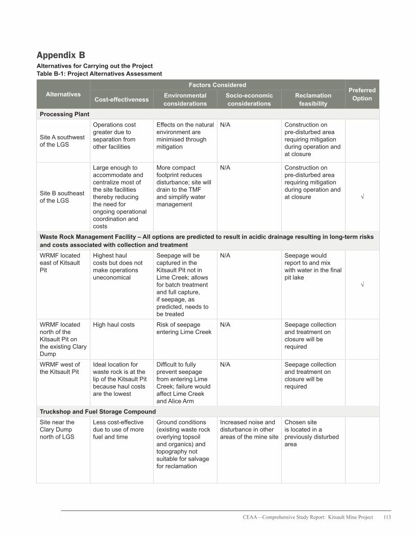
CEAA—Comprehensive Study Report: Kitsault Mine Project 113
Appendix B Alternatives for Carrying out the ProjectTable B-1: Project Alternatives Assessment
Alternatives
Factors ConsideredPreferred
OptionCost-effectivenessEnvironmental considerations
Socio-economic considerations
Reclamation feasibility
Processing Plant
Site A southwest of the LGS
Operations cost greater due to separation from other facilities
Effects on the natural environment are minimised through mitigation
N/A Construction on pre-disturbed area requiring mitigation during operation and at closure
Site B southeast of the LGS
Large enough to accommodate and centralize most of the site facilities thereby reducing the need for ongoing operational coordination and costs
More compact footprint reduces disturbance; site will drain to the TMF and simplify water management
N/A Construction on pre-disturbed area requiring mitigation during operation and at closure √
Waste Rock Management Facility – All options are predicted to result in acidic drainage resulting in long-term risks and costs associated with collection and treatment
WRMF located east of Kitsault Pit
Highest haul costs but does not make operations uneconomical
Seepage will be captured in the Kitsault Pit not in Lime Creek; allows for batch treatment and full capture, if seepage, as predicted, needs to be treated
N/A Seepage would report to and mix with water in the final pit lake
√
WRMF located north of the Kitsault Pit on the existing Clary Dump
High haul costs Risk of seepage entering Lime Creek
N/A Seepage collection and treatment on closure will be required
WRMF west of the Kitsault Pit
Ideal location for waste rock is at the lip of the Kitsault Pit because haul costs are the lowest
Difficult to fully prevent seepage from entering Lime Creek; failure would affect Lime Creek and Alice Arm
N/A Seepage collection and treatment on closure will be required
Truckshop and Fuel Storage Compound
Site near the Clary Dump north of LGS
Less cost-effective due to use of more fuel and time
Ground conditions (existing waste rock overlying topsoil and organics) and topography not suitable for salvage for reclamation
Increased noise and disturbance in other areas of the mine site
Chosen site is located in a previously disturbed area

114 CEAA—Comprehensive Study Report: Kitsault Mine Project
Table B-1: Project Alternatives Assessment continued
Alternatives
Factors ConsideredPreferred
OptionCost-effectivenessEnvironmental considerations
Socio-economic considerations
Reclamation feasibility
Site south of the LGS
Less distance to travel for mine trucks and therefore less fuel and time lost
Truckshop site will allow salvage of topsoil for reclamation
Closer to other facilities and infrastructure and keeps most of the noise away from the camps and mill site
Chosen site is located in a previously disturbed area
√
Primary Crusher
North of the Kitsault Pit
Most cost-effective due to proximity to Kitsault Pit and crusher configuration
Orientation will minimise dust from prevailing winds
Reduction in dust will mitigate health effects on workers
Chosen site is located in a previously disturbed area
√
Other locations near the Kitsault Pit
Less cost-effective the further away it is from the Kitsault Pit
Increase in dust because of the prevailing winds
Potential health risk to employees working near the area of the crusher
Chosen site is located in a previously disturbed area
Explosives Manufacturing Facility and Storage Magazines
500 m northeast of the TMF
Location not driven by cost effectiveness
Away from water bodies that could be affected by leachate
Main issues are safety and compliance with regulations
Results in new disturbance but legally required for safety reasons
√
Other locations around the mine site
Locations not driven by cost effectiveness
Leachate may reach nearby water bodies
Not compliant with regulations
May or may not result in new disturbance
Tailings Management Facility
Site 1 – Upper Lime Creek
High capital and operating costs
Catastrophic failure of embankment could destroy fish habitat
Embankment failure could affect use of the fish resource and nearby property
Post-closure treatment could be required
Site 2 – Clary Lake
Lowest construction and operations cost
Overlying a fish bearing lake
Potentially high social and economic effects due to loss of fish resource
Post-closure lake and wetland could replace fish habitat lost
Site 3 – Bell Moly deposit
Overlying another potential deposit - Bell Moly
Environmental control at the site manageable and fish bearing waters not directly affected
Loss of the Bell Moly deposit, potential revenues and employment
Seepage control and treatment could be required post closure to prevent contamination of adjacent lakes
Site 4 – Patsy Lake East
Relatively high construction and operating costs
Need to capture seepage from the embankment to prevent effects to Killam Lake
Seepage into Killam Lake, if not controlled, could affect fish
Seepage control and treatment could be required post closure
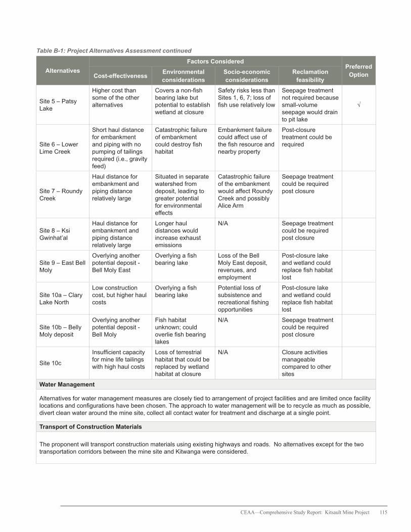
CEAA—Comprehensive Study Report: Kitsault Mine Project 115
Table B-1: Project Alternatives Assessment continued
Alternatives
Factors ConsideredPreferred
OptionCost-effectivenessEnvironmental considerations
Socio-economic considerations
Reclamation feasibility
Site 5 – Patsy Lake
Higher cost than some of the other alternatives
Covers a non-fish bearing lake but potential to establish wetland at closure
Safety risks less than Sites 1, 6, 7; loss of fish use relatively low
Seepage treatment not required because small-volume seepage would drain to pit lake
√
Site 6 – Lower Lime Creek
Short haul distance for embankment and piping with no pumping of tailings required (i.e., gravity feed)
Catastrophic failure of embankment could destroy fish habitat
Embankment failure could affect use of the fish resource and nearby property
Post-closure treatment could be required
Site 7 – Roundy Creek
Haul distance for embankment and piping distance relatively large
Situated in separate watershed from deposit, leading to greater potential for environmental effects
Catastrophic failure of the embankment would affect Roundy Creek and possibly Alice Arm
Seepage treatment could be required post closure
Site 8 – Ksi Gwinhat’al
Haul distance for embankment and piping distance relatively large
Longer haul distances would increase exhaust emissions
N/A Seepage treatment could be required post closure
Site 9 – East Bell Moly
Overlying another potential deposit - Bell Moly East
Overlying a fish bearing lake
Loss of the Bell Moly East deposit, revenues, and employment
Post-closure lake and wetland could replace fish habitat lost
Site 10a – Clary Lake North
Low construction cost, but higher haul costs
Overlying a fish bearing lake
Potential loss of subsistence and recreational fishing opportunities
Post-closure lake and wetland could replace fish habitat lost
Site 10b – Belly Moly deposit
Overlying another potential deposit - Bell Moly
Fish habitat unknown; could overlie fish bearing lakes
N/A Seepage treatment could be required post closure
Site 10c
Insufficient capacity for mine life tailings with high haul costs
Loss of terrestrial habitat that could be replaced by wetland habitat at closure
N/A Closure activities manageable compared to other sites
Water Management
Alternatives for water management measures are closely tied to arrangement of project facilities and are limited once facility locations and configurations have been chosen. The approach to water management will be to recycle as much as possible, divert clean water around the mine site, collect all contact water for treatment and discharge at a single point.
Transport of Construction Materials
The proponent will transport construction materials using existing highways and roads. No alternatives except for the two transportation corridors between the mine site and Kitwanga were considered.
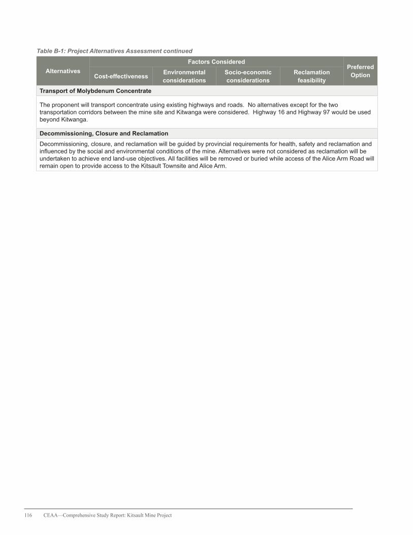
116 CEAA—Comprehensive Study Report: Kitsault Mine Project
Table B-1: Project Alternatives Assessment continued
Alternatives
Factors ConsideredPreferred
OptionCost-effectivenessEnvironmental considerations
Socio-economic considerations
Reclamation feasibility
Transport of Molybdenum Concentrate
The proponent will transport concentrate using existing highways and roads. No alternatives except for the two transportation corridors between the mine site and Kitwanga were considered. Highway 16 and Highway 97 would be used beyond Kitwanga.
Decommissioning, Closure and Reclamation
Decommissioning, closure, and reclamation will be guided by provincial requirements for health, safety and reclamation and influenced by the social and environmental conditions of the mine. Alternatives were not considered as reclamation will be undertaken to achieve end land-use objectives. All facilities will be removed or buried while access of the Alice Arm Road will remain open to provide access to the Kitsault Townsite and Alice Arm.
CEAA—Comprehensive Study Report: Kitsault Mine Project 117
Appendix CSummary of Mitigation Measures
The following list includes measures that the Canadian Environmental Assessment Agency considers necessary to mitigate the environmental effects of the Project. Mitigation measures in relation to accidents and malfunctions are listed separately in Appendix D.
Additional mitigation is specified in the British Columbia EA Certificate documentation, and may be further described in additional authorizations that may be issued by the federal and provincial governments.
Acid Rock Drainage Prevention and Mitigation
• Construct and operate a de-pyritization circuit as part of the processing facilities. Combine pyritic tailings with the cleaner tailings stream and deposit via one pipeline for immediate and permanent subaqueous storage within the TMF. • At mine closure, either mill the stockpiled LGS or move it to the open pit for permanent subaqueous storage. • Ensure that the chosen method for deposit of waste rock supports the long term predicted water quality identified in the EA process.
Water Management and Treatment
• Ensure that, during the all phases of the Project, water quality at LC1, LC2 and Lake 901 meets water quality guidelines or objectives set by the appropriate regulatory authorities. • Collect and direct runoff and seepage from all Project infrastructure, including the LGS, Kitsault Pit, South and Northeast Embankments, WRMF, historic waste rock, conveyor system cut and roads, to the TMF. • Divert freshwater runoff from upstream areas not affected by the mining operation to reduce the amount of water in contact with disturbed area. • Ensure that mine water discharge during all phases of the Project meets the flow requirements
to mimic the natural hydrograph of Lime Creek throughout the year. • Construct sediment control ponds to detain runoff from disturbed areas and enable sediments to settle out and be captured. • Store cleaner scavenger tailings and pyrite concentrate that are PAG below water in the TMF. • Ensure that the starter embankment and TMF are designed and constructed such that the final TMF surface water or tailings pore water is not hydraulically connected with the contact between the Bowser Group and Tertiary basalt.
Wildlife and Wildlife Habitat
• Implement actions in a Bear Interaction Management Plan approved by appropriate regulatory authorities to avoid and reduce risks of potential bear-human conflicts. • Prior to the start of construction, develop a map of sensitive wildlife areas within the LSA. Develop and implement site-specific mitigation measures, to the satisfaction of appropriate regulatory authorities including Environment Canada, to reduce the likelihood of impacting sensitive wildlife habitats or wildlife within those habitats during all Project phases. • If pre-construction site assessments identify a bat hibernacula site or sites, develop and implement protocols for minimizing adverse effects to bats at all Project phases, to the satisfaction of appropriate regulatory authorities including Environment Canada. • If pre-construction assessments confirm the presence of breeding habitat for marbled murrelet, develop and implement protocols for minimizing adverse effects to marbled murrelets and their breeding habitat at all Project phases, to the satisfaction of appropriate regulatory authorities including Environment Canada. • Prior to clearing or construction activities, examine wetlands and ponds within and immediately adjacent to work zones during western toad breeding and dispersal periods. If one or more western toad breeding areas or dispersal areas are identified through field
118 CEAA—Comprehensive Study Report: Kitsault Mine Project
work, develop and implement protocols for minimizing adverse effects to western toads, to the satisfaction of appropriate government authorities including Environment Canada and the Nisga’a Lisims Government.
Vegetation and Plant Communities
• Prior to clearing or construction of mine components that will impact wetlands, undertake a site survey and characterization of blue- and red-listed wetland communities within the Kitsault Mine site, including an assessment of blue-and red-listed wetland function as it relates to habitat for migratory birds and species at risk, for use in the development of a Wetland Habitat Compensation Plan. • Prior to construction, complete a detailed Wetlands Habitat Compensation Plan that addresses effects on red- and blue-listed wetland communities and their functions, to the satisfaction of Environment Canada and other appropriate regulatory authorities. Consult with the Nisga’a Lisims Government and the Metlakatla First Nation prior to submission and implementation of the Plan. • Prior to construction, conduct a site assessment survey for Cryptic Paw Lichen within and near the immediate Kitsault Mine footprint, by a lichen specialist. If Cryptic Paw Lichen is identified at the site, develop and implement protocols to minimize adverse effects on Cryptic Paw Lichen to the satisfaction of appropriate regulatory authorities including Environment Canada.
Transportation and Road Use
• Implement a speed limit for mine-related vehicles of 50 km/hr along kilometre 0 to 51 of the Nass Forest Service Road (Cranberry Connector). • Develop a Wildlife Corridor Management Plan prior to construction that includes a Large Mammal Reporting and Monitoring Program to identify high potential areas (i.e., location, time of day, season) for large mammal-vehicle collisions.
• Support Nass moose population recovery efforts, for example, education and communication, inventory, monitoring, collection of harvest data, signage and programs to reduce the risk of moose mortality in the Nass Valley.
• Actively participate in any cross industry or government initiatives that address road use adjacent to or intersecting moose habitat along the transportation corridors, including funding to support a coordinated approach to managing and mitigating the potential cumulative effects to aquatic and wildlife populations along Highway 37.
• Prior to the commencement of construction, develop a Geographic Response Plan articulating training and hazardous material spill response activities for the transportation route to the approval of regulatory authorities responsible for hazardous material spill response. Spill response measures will include the establishment of five separate equipment caches along the transportation corridor which will enable timely and effective response to spills in high environmental sensitivity areas, including areas downstream of water-crossings. Consult the Nisga’a Lisims Government, Gitanyow Nation, Gitxsan Nation and the Kitsumkalum First Nation on the development of the Geographic Response Plan.
• Develop and implement a plan describing appropriate forms of barrier protection along areas of the proposed transportation corridors with high aquatic values that could be at risk from spills of hazardous materials. Prior to identifying high risk areas, consult with: the Nisga’a Lisims Government within the Nass Area; and the Gitanyow Nation, Gitxsan Nation and Kitsumkalum First Nation within their asserted traditional territories.
Fish and Fish Habitat
• Complete a Fish Habitat Compensation Plan to the approval of Fisheries and Oceans Canada before a Fisheries Act subsection 35(2) authorization is issued. Consult with the Nisga’a Lisims Government prior to submitting the Plan.

CEAA—Comprehensive Study Report: Kitsault Mine Project 119
• Design and install a diversion between Lake 493 and Lake 901 to mitigate potential lake level changes in Lake 901 and Clary Lake.
Marine Aquatic Resources
• Prior to construction, complete and submit a plan for review by the appropriate parties, including Health Canada, the Nisga’a Lisims Government and the Metlakatla First Nation, describing how human health risks will be analyzed and managed as part of the AEMP and MEMP. Implement the actions in the plan.

120 CEAA—Comprehensive Study Report: Kitsault Mine Project
Appendix DEnvironmental Effects from Accidents and Malfunctions and Summary of Prevention/Mitigation Measures
Issue FacilityEffects Prevention /
MitigationConstruction Operations Closure
Petroleum spills
Equipment
Routine drips and spills, major adverse effects to land or water body
Routine drips and spills, major adverse effects to land or water body
Routine drips and spills, major adverse effects to land or water body
Drip trays, regular maintenance service, employee training, spill response and clean up (i.e., Mine Emergency and Spill Response Plan)
StorageRoutine drips and spills, major loss to land or water body
Routine drips and spills, major loss to land or water body
Routine drips and spills, major loss to land or water body
Drip trays, containment ponds, follow standard operating procedures (SOP), employee training, and spill response and clean up
Hazardous substances spills
Mill, explosives manufacturing facility, magazines, and explosives process trucks, truckshop, warehouse, cold storage building
N/A
Health hazard, injury, contaminated soil and water, impacts on aquatic organisms
N/A
Design, containment ponds, follow SOPs, training, explosives management plan, and spill response and clean up
Containment pond failure
Sedimentation ponds
Loss of sediment to water bodies, impacts on aquatic organisms
N/A N/ARegular inspection, monitoring and clean-up
Seepage collection ponds
N/A
Loss of potentially contaminated water and sediment to water bodies, impacts to aquatic organisms
N/A
Engineered design and construction control, regular inspection, monitoring, and spill response and clean-up
Stockpile failure LGS, WRMF N/A
Small slump: loss of material to a lower bench or surroundings
Large failure: injury or loss of life, covering of surrounding area
Small slump: loss of material to a lower bench or surroundings
Large failure: injury or loss of life, covering of surrounding area
Engineered design and construction control, use of trained equipment operators, monitoring, regular inspections, spill response and clean-up, and medical response
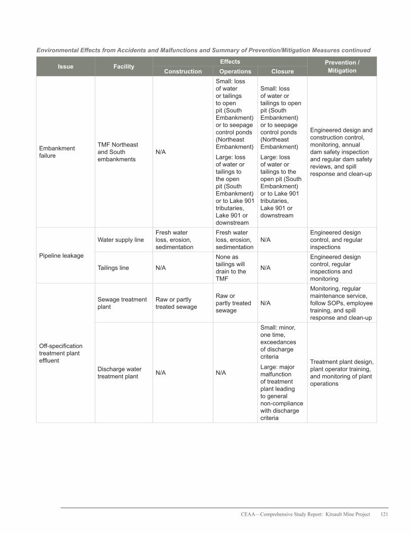
CEAA—Comprehensive Study Report: Kitsault Mine Project 121
Environmental Effects from Accidents and Malfunctions and Summary of Prevention/Mitigation Measures continued
Issue FacilityEffects Prevention /
MitigationConstruction Operations Closure
Embankment failure
TMF Northeast and South embankments
N/A
Small: loss of water or tailings to open pit (South Embankment) or to seepage control ponds (Northeast Embankment)
Large: loss of water or tailings to the open pit (South Embankment) or to Lake 901 tributaries, Lake 901 or downstream
Small: loss of water or tailings to open pit (South Embankment) or to seepage control ponds (Northeast Embankment)
Large: loss of water or tailings to the open pit (South Embankment) or to Lake 901 tributaries, Lake 901 or downstream
Engineered design and construction control, monitoring, annual dam safety inspection and regular dam safety reviews, and spill response and clean-up
Pipeline leakage
Water supply lineFresh water loss, erosion, sedimentation
Fresh water loss, erosion, sedimentation
N/AEngineered design control, and regular inspections
Tailings line N/A
None as tailings will drain to the TMF
N/A
Engineered design control, regular inspections and monitoring
Off-specification treatment plant effluent
Sewage treatment plant
Raw or partly treated sewage
Raw or partly treated sewage
N/A
Monitoring, regular maintenance service, follow SOPs, employee training, and spill response and clean-up
Discharge water treatment plant
N/A N/A
Small: minor, one time, exceedances of discharge criteria
Large: major malfunction of treatment plant leading to general non-compliance with discharge criteria
Treatment plant design, plant operator training, and monitoring of plant operations

122 CEAA—Comprehensive Study Report: Kitsault Mine Project
Environmental Effects from Accidents and Malfunctions and Summary of Prevention/Mitigation Measures continued
Issue FacilityEffects Prevention /
MitigationConstruction Operations Closure
Power outagesAll facilities requiring electricity
Shutdown of electric equipment, loss of lighting and heat
Shutdown of electric equipment, loss of lighting and heat, stoppage of water management structures (e.g., treatment plant and pumping of seepage to TMF)
Shutdown of electric equipment, loss of lighting and heat, stoppage of water management structures (e.g., treatment plant and pumping of seepage to TMF)
Backup generators, regular maintenance and inspections
FireSlash, forest wildfire, buildings, mobile equipment
Damage/destruction of facilities or surroundings, power outages, increased erosion and runoff, injury or loss of life
Damage/destruction of facilities or surroundings, power outages, stoppage of water management structures, increased erosion and runoff, injury or loss of life
Damage/destruction of facilities or surroundings, power outages, stoppage of water management structures, increased erosion and runoff, injury or loss of life
Engineered design control, monitoring, suppression equipment, training and medical response
Accidental explosion
Buildings, explosives storage, propane tanks, vehicles
Injury or loss of life, damage or destruction of facilities or surroundings
Injury or loss of life, damage or destruction of facilities or surroundings
N/A
Engineered design control maintenance, monitoring, follow SOPs, training and medical response
Fly rock from blasting
Open pit N/A
Injury, rock project beyond the open pit
N/A
Safe placement of facilities, equipment and people, signage, training, blast warnings and medical response
Motor vehicle accidents
Mobile equipment at mine, personnel and materials transport vehicles
Injury or loss of life, spills of hazardous or non-hazardous substances on land or water, fires
Injury or loss of life, spills of hazardous or non-hazardous substances on land or water, fires
Injury or loss of life, spills of hazardous or non-hazardous substances on land or water, fires
Maintenance, employee training, re-enforcement of safety procedures, clean-up and medical response
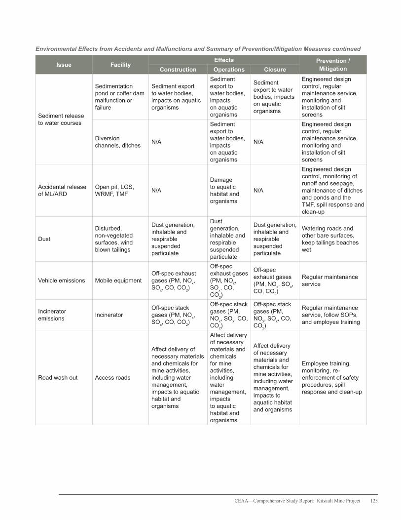
CEAA—Comprehensive Study Report: Kitsault Mine Project 123
Environmental Effects from Accidents and Malfunctions and Summary of Prevention/Mitigation Measures continued
Issue FacilityEffects Prevention /
MitigationConstruction Operations Closure
Sediment release to water courses
Sedimentation pond or coffer dam malfunction or failure
Sediment export to water bodies, impacts on aquatic organisms
Sediment export to water bodies, impacts on aquatic organisms
Sediment export to water bodies, impacts on aquatic organisms
Engineered design control, regular maintenance service, monitoring and installation of silt screens
Diversion channels, ditches
N/A
Sediment export to water bodies, impacts on aquatic organisms
N/A
Engineered design control, regular maintenance service, monitoring and installation of silt screens
Accidental release of ML/ARD
Open pit, LGS, WRMF, TMF
N/A
Damage to aquatic habitat and organisms
N/A
Engineered design control, monitoring of runoff and seepage, maintenance of ditches and ponds and the TMF, spill response and clean-up
Dust
Disturbed, non-vegetated surfaces, wind blown tailings
Dust generation, inhalable and respirable suspended particulate
Dust generation, inhalable and respirable suspended particulate
Dust generation, inhalable and respirable suspended particulate
Watering roads and other bare surfaces, keep tailings beaches wet
Vehicle emissions Mobile equipmentOff-spec exhaust gases (PM, NO
x,
SOx, CO, CO
2)
Off-spec exhaust gases (PM, NO
x,
SOx, CO,
CO2)
Off-spec exhaust gases (PM, NO
x, SO
x,
CO, CO2)
Regular maintenance service
Incinerator emissions
IncineratorOff-spec stack gases (PM, NO
x,
SOx, CO, CO
2)
Off-spec stack gases (PM, NO
x, SO
x, CO,
CO2)
Off-spec stack gases (PM, NO
x, SO
x, CO,
CO2)
Regular maintenance service, follow SOPs, and employee training
Road wash out Access roads
Affect delivery of necessary materials and chemicals for mine activities, including water management, impacts to aquatic habitat and organisms
Affect delivery of necessary materials and chemicals for mine activities, including water management, impacts to aquatic habitat and organisms
Affect delivery of necessary materials and chemicals for mine activities, including water management, impacts to aquatic habitat and organisms
Employee training, monitoring, re-enforcement of safety procedures, spill response and clean-up

124 CEAA—Comprehensive Study Report: Kitsault Mine Project
Appendix E Summary of the Environmental Effects Assessment
Table E-1: Analysis of the Significance of Residual Environmental Effects on VCs
Predicted Degree of Effect After Mitigation
Magnitude (negligible, low, medium, high)
Extent (local, watershed, regional,
provincial scale)
Duration (short-term, medium-term,
long-term)
Frequency (once, intermittent, continuous)
Reversibility (reversible or irreversible)
Ecological, socioeconomic, or cultural importance
(negligible, low, medium, high)
Significance of Effect After Mitigation
(minor, moderate, major)
Negligible. There is no detectable change from baseline conditions.
Local. The effect is limited to the project footprint.
Short-term. The effect lasts less than one day to two years (duration of construction phase).
Once. The effect is confined to one discrete period during the life of the project.
Reversible. The effect can be reversed within the short to long term.
Negligible. The effect is not considered to be important or valuable by people living in potentially affected communities in the region.
Not Significant (negligible/minor). Residual effects of no or low magnitude, site-specific or local extent, short to long-term, low frequency (once or intermittent) and reversible with negligible or low ecological context; their effects are not distinguishable from those resulting from background physical, chemical and biological processes.
Low. The magnitude of effect differs from the average value for baseline conditions, but is within the range of natural variation and well below a guideline or threshold value.
Watershed. The effect extends beyond project footprint to within an area a few kilometres of the project footprint.
Medium-term. The effect lasts throughout mine operations, decommissioning and closure.
Intermittent. The effect occurs at sporadic, intermittent, intervals and potentially beyond the life of the project.
Irreversible. The effect cannot be reversed.
Low. The effect is considered to be somewhat important or valuable by people living in potentially affected communities in the region.
Not Significant (moderate). Residual effects of medium magnitude, local to regional extent, medium to long-term, occur at all frequencies (once to continuous), and reversible or irreversible with medium ecological context; their effects and consequences are distinguishable at the level of populations, communities and ecosystems. Follow-up or monitoring of these effects may be required.
Medium. The magnitude of effect differs from the average value for baseline conditions and approaches the limits of natural variation, but below or equal to a guideline or threshold value.
Regional. The effect extends throughout the regional assessment area.
Long-term. The effect is likely to persist beyond the life of the project.
Continuous. The effect occurs constantly during and potentially beyond the life of the project.
Medium. The effect is considered to be valuable by people living in potentially affected communities in the region.
Significant (major). Residual effects of high magnitude, regional extent, long-term occur at all frequencies (once to continuous), and irreversible with high ecological context; their effects are consequential in terms of structural and functional changes in populations, communities and ecosystems. If significant effects are justified, follow-up and monitoring would be required.
High. The magnitude of effect is predicted to differ from baseline conditions, guideline or threshold value so that there will be a detectable change beyond the range of natural variation (i.e., change of state from baseline conditions).
Provincial: effect extends across or beyond the province
High. The effect is highly valued by people living in potentially affected communities or the region.

125 CEAA—Comprehensive Study Report: Kitsault Mine Project
Table E-2: Environmental Effects Analysis for Atmospheric Environment
VEC Affected Potential Effect Proposed Mitigation
Residual Effect
(yes/ no)
Predicted Degree of Effect After Mitigation Significance of Effect After
Mitigation (minor,
moderate, major)
Agency Conclusion
Follow-up Requirement
Magnitude (negligible, low, medium, high)
Extent (local, watershed, regional, provincial
scale)
Duration (short-term,
medium-term, long-term)
Frequency (once, intermittent,
continuous)
Reversibility (reversible or irreversible)
Ecological, socioeconomic,
cultural importance (negligible, low, medium, high)
Atmospheric Environment
Air quality Decline in air quality due to increased emissions, fugitive dust, and aggregate ore and waste handling activities
• Use of mining equipment that meet emission standards
• Vehicle and equipment maintenance and management
• Minimize land disturbance
• Establish speed limits on unpaved surfaces
• Minimise clearing / grubbing areas
• Dust suppression on access and haul roads
Yes Low Local Medium-term Intermittent Reversible Low Minor The residual environmental effects are not likely to be significant (minor).
Climate change Greenhouse gas emissions due to mining vehicles and deforestation
• See mitigation for air quality
• Reclamation of the mine footprint
No
Noise and Vibration
Increased noise and vibration from road traffic, blasting and construction equipment
• Use of noise abatement equipment and accessories.
• Restricted use of sirens and alarms
No

126 CEAA—Comprehensive Study Report: Kitsault Mine Project
Table E-3: Environmental Effects Analysis for Groundwater
VEC Affected Potential Effect Proposed Mitigation Residual Effect
(yes/no)
Predicted Degree of Effect After Mitigation Significance of Effect After
Mitigation (minor,
moderate, major)
Agency Conclusion Follow-up Requirement
Magnitude (negligible,
low, medium, high)
Extent (local,
watershed, regional, provincial
scale)
Duration (short-term,
medium-term, long-
term)
Frequency (once,
intermittent, continuous)
Reversibility (reversible or irreversible)
Ecological, socioeconomic,
cultural importance
(negligible, low, medium, high)
Groundwater
Groundwater flow
Effects to groundwater flow in Patsy, Lime Creek watershed due to the Kitsault Pit, TMF and diversion channels
• Discharge of water drawn from the Patsy Creek and Lime Creek watersheds (at hydraulically up-gradient locations within the headwaters) back into these watersheds
• Monitor bedrock groundwater monitoring wells near and hydraulically down-gradient from the Kitsault Pit
Yes Medium Local Long-term Continuous Irreversible Low Moderate The residual environmental effects are not likely to be significant.
The proponent will develop a groundwater monitoring and mitigation plan that will include the installation of groundwater monitoring wells between Lake 901 and the seepage collection ponds at the Northeast Embankment.
Groundwater quality
Effects of seepage, runoff, ML/ARD, blasting residue, and contaminants to groundwater quality and nearby surface water bodies
• Seepage collection ponds downstream of TMF embankments (i.e., South and Northeast Seepage Collections Ponds) to collect seepage and runoff and pump back to TMF
• Install monitoring and pump back wells between the NSCPs and Lake 901 to meet BC WQGs or Site Specific Water Objectives
• Seep mapping in the area of the TMF to identify and mitigate potential seepage pathways
• Vertical sump downstream of the LGS to collect and pump seepage and runoff back to the TMF and monitoring
• Mapping and hydraulic characterization of permeable bedrock features
• Install additional monitoring wells or seepage collection trenches in the event of a spill and if further effects are identified
Yes Medium Local Long-term Continuous Irreversible Low Moderate The residual environmental effects are not likely to be significant.
Groundwater Recharge and Discharge
Changes to groundwater and surface water flow and quality
• See mitigation for groundwater quality Yes Medium Local Long term Continuous Irreversible Low Moderate The residual environmental effects are not likely to be significant.
Groundwater and Surface Water Interaction
Changes in groundwater flow and quality on surface water
• See mitigation for groundwater quality Yes Medium Local Long term Continuous Irreversible Low Moderate The residual environmental effects are not likely to be significant.
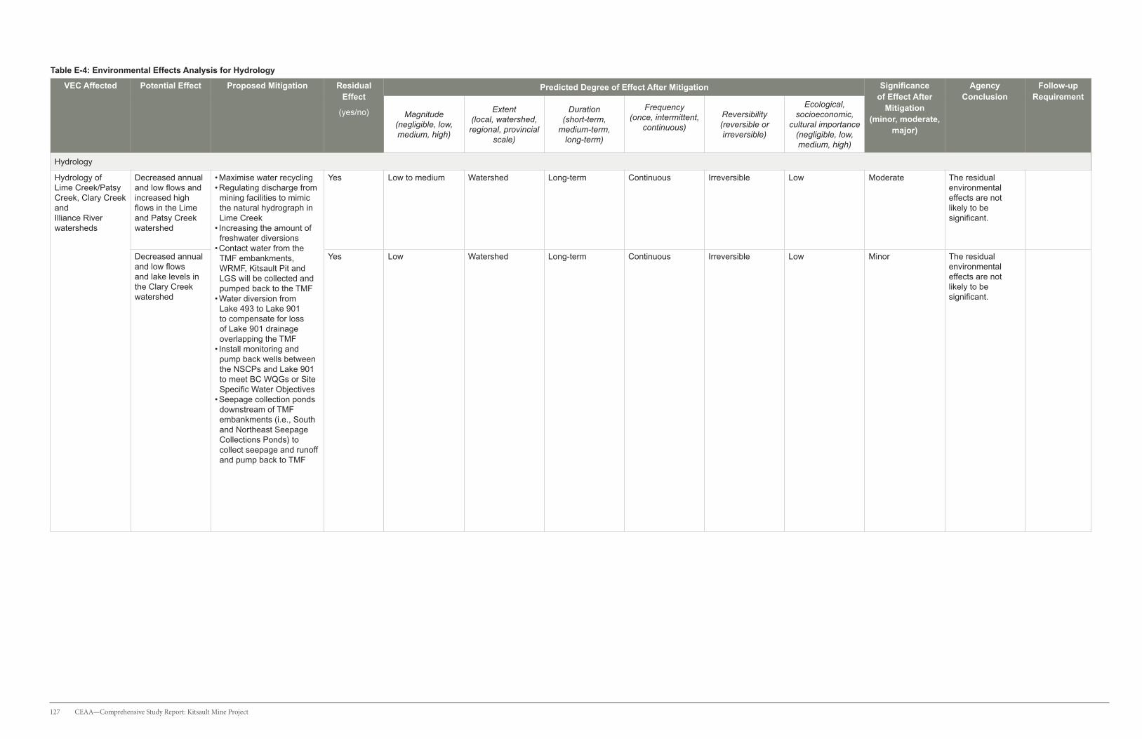
127 CEAA—Comprehensive Study Report: Kitsault Mine Project
Table E-4: Environmental Effects Analysis for Hydrology
VEC Affected Potential Effect Proposed Mitigation Residual Effect
(yes/no)
Predicted Degree of Effect After Mitigation Significance of Effect After
Mitigation (minor, moderate,
major)
Agency Conclusion
Follow-up Requirement
Magnitude (negligible, low, medium, high)
Extent (local, watershed, regional, provincial
scale)
Duration (short-term,
medium-term, long-term)
Frequency (once, intermittent,
continuous)
Reversibility (reversible or irreversible)
Ecological, socioeconomic,
cultural importance (negligible, low, medium, high)
Hydrology
Hydrology of Lime Creek/Patsy Creek, Clary Creek and Illiance River watersheds
Decreased annual and low flows and increased high flows in the Lime and Patsy Creek watershed
• Maximise water recycling• Regulating discharge from mining facilities to mimic the natural hydrograph in Lime Creek
• Increasing the amount of freshwater diversions
• Contact water from the TMF embankments, WRMF, Kitsault Pit and LGS will be collected and pumped back to the TMF
• Water diversion from Lake 493 to Lake 901 to compensate for loss of Lake 901 drainage overlapping the TMF
• Install monitoring and pump back wells between the NSCPs and Lake 901 to meet BC WQGs or Site Specific Water Objectives
• Seepage collection ponds downstream of TMF embankments (i.e., South and Northeast Seepage Collections Ponds) to collect seepage and runoff and pump back to TMF
Yes Low to medium Watershed Long-term Continuous Irreversible Low Moderate The residual environmental effects are not likely to be significant.
Decreased annual and low flows and lake levels in the Clary Creek watershed
Yes Low Watershed Long-term Continuous Irreversible Low Minor The residual environmental effects are not likely to be significant.
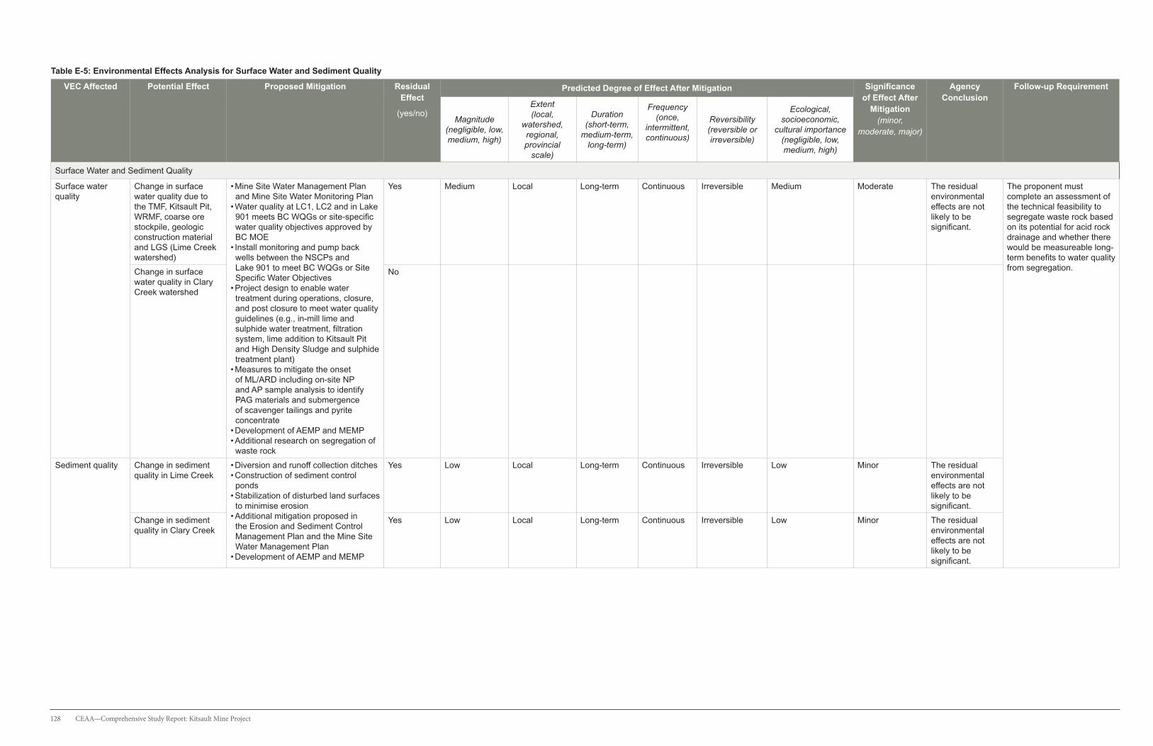
128 CEAA—Comprehensive Study Report: Kitsault Mine Project
Table E-5: Environmental Effects Analysis for Surface Water and Sediment Quality
VEC Affected Potential Effect Proposed Mitigation Residual Effect
(yes/no)
Predicted Degree of Effect After Mitigation Significance of Effect After
Mitigation (minor,
moderate, major)
Agency Conclusion
Follow-up Requirement
Magnitude (negligible, low, medium, high)
Extent (local,
watershed, regional, provincial
scale)
Duration (short-term,
medium-term, long-term)
Frequency (once,
intermittent, continuous)
Reversibility (reversible or irreversible)
Ecological, socioeconomic,
cultural importance (negligible, low, medium, high)
Surface Water and Sediment Quality
Surface water quality
Change in surface water quality due to the TMF, Kitsault Pit, WRMF, coarse ore stockpile, geologic construction material and LGS (Lime Creek watershed)
• Mine Site Water Management Plan and Mine Site Water Monitoring Plan
• Water quality at LC1, LC2 and in Lake 901 meets BC WQGs or site-specific water quality objectives approved by BC MOE
• Install monitoring and pump back wells between the NSCPs and Lake 901 to meet BC WQGs or Site Specific Water Objectives
• Project design to enable water treatment during operations, closure, and post closure to meet water quality guidelines (e.g., in-mill lime and sulphide water treatment, filtration system, lime addition to Kitsault Pit and High Density Sludge and sulphide treatment plant)
• Measures to mitigate the onset of ML/ARD including on-site NP and AP sample analysis to identify PAG materials and submergence of scavenger tailings and pyrite concentrate
• Development of AEMP and MEMP • Additional research on segregation of waste rock
Yes Medium Local Long-term Continuous Irreversible Medium Moderate The residual environmental effects are not likely to be significant.
The proponent must complete an assessment of the technical feasibility to segregate waste rock based on its potential for acid rock drainage and whether there would be measureable long-term benefits to water quality from segregation.Change in surface
water quality in Clary Creek watershed
No
Sediment quality Change in sediment quality in Lime Creek
• Diversion and runoff collection ditches• Construction of sediment control ponds
• Stabilization of disturbed land surfaces to minimise erosion
• Additional mitigation proposed in the Erosion and Sediment Control Management Plan and the Mine Site Water Management Plan
• Development of AEMP and MEMP
Yes Low Local Long-term Continuous Irreversible Low Minor The residual environmental effects are not likely to be significant.
Change in sediment quality in Clary Creek
Yes Low Local Long-term Continuous Irreversible Low Minor The residual environmental effects are not likely to be significant.

129 CEAA—Comprehensive Study Report: Kitsault Mine Project
Table E-6: Environmental Effects Analysis for Fish and Fish Habitat
VEC Affected Potential Effect Proposed Mitigation Residual Effect
(yes/no)
Predicted Degree of Effect After Mitigation Significance of Effect After
Mitigation (minor,
moderate, major)
Agency Conclusion
Follow-up Requirement
Magnitude (negligible, low, medium, high)
Extent (local,
watershed, regional,
provincial scale)
Duration (short-term,
medium-term, long-term)
Frequency (once, intermittent,
continuous)
Reversibility (reversible or irreversible)
Ecological, socioeconomic,
cultural importance (negligible, low, medium, high)
Fish and Fish Habitat
Dolly Varden Increased fishing pressure and changes in surface water quality, hydrology, water temperature and BMI community in Lime Creek
• No fishing policy for employees and contractors onsite
• Water quality at LC1, LC2 and in Lake 901 meets BC WQGs or site-specific water quality objectives approved by BC MOE
• Mine Site Water Management Plan • Usage of low sulphur diesel fuels and maintenance of the mine fleet to reduce air emissions
• Control dust generation by using a dust collection system
• Development of AEMP and MEMP
Yes Low Local Long-term Continuous Irreversible High Minor The residual environmental effects are not likely to be significant.
coho salmon Changes in surface water quality, hydrology, water temperature and BMI community in Lime Creek
Yes Low Local Long-term Continuous Irreversible High Minor The residual environmental effects are not likely to be significant.
rainbow trout • Increased fishing pressure, impingement or entrainment of fish in pumps and pipeline
• Change in fish passage at stream crossings
• Loss of fish and fish habitat due to the TMF
• Changes in surface water quality, lake levels, stream flows and BMI community in Clary Creek watershed
• Fish Habitat Compensation Plan• Mine Site Water Management Plan • No fishing policy for employees and contractors
• Water quality at LC1, LC2 and in Lake 901 meets BC WQGs or site-specific water quality objectives approved by BC MOE
• Collect seepage and runoff in the NSCPs and pump back to the TMF
• Install monitoring and pump back wells between the NSCPs and Lake 901 to meet BC WQGs or Site Specific Water Objectives
• Design and install gravity fed diversion between Lake 493 and Lake 901
• Install intake pipes with mesh screens • Install new structures in fish bearing streams along Kitsault FSR and new access roads to allow fish passage
Yes Low Watershed Short-term Once Reversible Medium Minor Additional information is required to demonstrate that the FHCP is technically, economically, and biologically feasible.
Benthic Macro- Invertebrates
Change to abundance and composition in the Lime and Clary Creek watersheds
• Fish Habitat Compensation Plan • Water quality at LC1, LC2 and in Lake 901 meets BC WQGs or site-specific water quality objectives approved by BC MOE
• Mitigation proposed in the Mine Site Water Management Plan
• Development of AEMP and MEMP
Yes Low to medium Watershed Long-term Continuous Reversible Low Minor The residual environmental effects are not likely to be significant.

130 CEAA—Comprehensive Study Report: Kitsault Mine Project
Table E-7: Environmental Effects Analysis for Marine Aquatic Resources
VEC Affected Potential Effect Proposed Mitigation Residual Effect
(yes/no)
Predicted Degree of Effect After Mitigation Significance of Effect After
Mitigation (minor, moderate,
major)
Agency Conclusion
Follow-up Requirement
Magnitude (negligible, low, medium, high)
Extent (local,
watershed, regional, provincial
scale)
Duration (short-term,
medium-term, long-term)
Frequency (once,
intermittent, continuous)
Reversibility (reversible or irreversible)
Ecological, socioeconomic,
cultural importance (negligible, low, medium, high)
Marine Aquatic Resources
Marine water quality
• Potential effects of freshwater quality and quantity in Lime Creek on marine waters near the mouth of Lime Creek
• Development of MEMP• Water quality at LC1, LC2 and in Lake 901 meets BC WQGs or site-specific water quality objectives approved by BC MOE
• Mine Site Water Management Plan and Mine Site Monitoring Plan
• No
Yes Low Local Long-term Continuous Irreversible High Moderate The residual environmental effects are not likely to be significant.
Information collected through the AEMP will be shared with Environment Canada to inform the proponent’s EEM program.
Marine Biota No
Table E-8: Environmental Effects Analysis for Terrain, Surficial Geology, and Soils
VEC Affected Potential Effect Proposed Mitigation Residual Effect
(yes/no)
Predicted Degree of Effect After Mitigation Significance of Effect After
Mitigation (minor,
moderate, major)
Agency Conclusion
Follow-up Requirement
Magnitude (negligible, low, medium, high)
Extent (local, watershed, regional, provincial
scale)
Duration (short-term,
medium-term, long-term)
Frequency (once,
intermittent, continuous)
Reversibility (reversible or irreversible)
Ecological, socioeconomic,
cultural importance
(negligible, low, medium, high)
Terrestrial Environment: Terrain, Surficial Geology, and Soils
Physiography and Topography
Alteration of existing landscape, accelerated erosion and changes to terrain stability
• Maximizing previously disturbed areas to maintain a compact project footprint
• Erosion and Sediment Control Plan• Reclamation and Closure Plan
Yes Medium Local Long-term Continuous Reversible Low Moderate The residual environmental effects are not likely to be significant.
Surficial Geology Removal of overburden material, re-contouring land surface, accelerated erosion and changes to terrain stability
• Maximizing previously disturbed areas to maintain a compact project footprint
• Salvage and store suitable reclamation materials• Erosion and Sediment Control Plan• Reclamation and Closure Plan
No
Soil Cover Soil disturbance and redistribution
• Maximizing previously disturbed areas to maintain a compact project footprint
• Closure and Reclamation plan• Reclamation material replacement• Monitoring of soil erosion and vegetation
No
Soil Quality • Accelerated erosion and changes to terrain stability
• Dust deposition • Changes to the quality of reclamation material
• Soil disturbance contamination, and redistribution
• Maximizing previously disturbed areas to maintain a compact project footprint
• Soil salvage and stockpile• Vegetation monitoring • Dust management Plan• Emergency and Spill response plan• Reclamation and Closure Plan
No

131 CEAA—Comprehensive Study Report: Kitsault Mine Project
Table E-9: Environmental Effects Analysis for Vegetation and Plant Communities
VEC Affected Potential Effect
Proposed Mitigation Residual Effect
(yes/no)
Predicted Degree of Effect After Mitigation Significance of Effect After
Mitigation (minor,
moderate, major)
Agency Conclusion
Follow-up Requirement
Magnitude (negligible, low, medium, high)
Extent (local,
watershed, regional, provincial
scale)
Duration (short-term,
medium-term, long-term)
Frequency (once,
intermittent, continuous)
Reversibility (reversible or irreversible)
Ecological, socioeconomic, or cultural importance
(negligible, low, medium, high)
Vegetation and Plant Communities
Ecosystem Composition
Loss of baseline ecosystems
• Vegetation Management Plan• Maximize use of previously disturbed areas to maintain a compact project footprint
• Dust suppression in line with the Dust Management Plan
• Maintain soil salvage for reclamation• Reclamation and Closure Plan
Yes Medium Local Long-term Once Reversible Medium Moderate The residual environmental effects are not likely to be significant.
Wetland Ecosystems
Loss of listed wetlands
• Wetland compensation plan• Site survey and characterization of blue- and red-listed wetland communities, including wetland function to migratory birds and SAR
• Terrestrial Ecosystem Mapping to identify wetlands before establishment of footprint and construction laydown areas
• Maintaining soil salvage for reclamation• Maximize use of previously disturbed areas to maintain a compact project footprint
• Reclamation and Closure Plan
Yes Medium Local Long-term Once Irreversible Medium Moderate The residual environmental effects are not likely to be significant.
Additional information will be incorporated into the draft Wetlands Compensation Plan in consultation with Environment Canada.
Old Forests Loss of baseline old forests
• Site map of old forest stands within the project footprint area
• Timber Salvage as part of the Vegetation Management Plan
• Maximize use of previously disturbed areas to maintain a compact project footprint
• Reclamation and Closure Plan
Yes Low Local Long-term Once Irreversible Medium Minor The residual environmental effects are not likely to be significant.
Species at Risk
Loss of baseline ecosystems for species at risk
• Species at risk avoidance during construction clearing
• Invasive Species management• Maximize use of previously disturbed areas to maintain a compact project footprint
• Maintain soil salvage for reclamation.• Reclamation and Closure Plan
Yes Low Local Long-term Once Reversible High Minor The residual environmental effects are not likely to be significant.
Prior to the commencement of construction, the proponent must conduct a site assessment survey of Cryptic Paw Lichen within and near the immediate Kitsault Mine footprint in areas that include Cryptic Paw Lichen habitat. The assessment will be undertaken by a lichen specialist and inform the development of guidance and protocols that will be implemented in the event Cryptic Paw Lichen is identified.
Ecological Communities at Risk
Loss of baseline ecological communities at risk
Introduction and spread of invasive plants
• Site map of ecological communities at risk within the project footprint area.
• Maximize use of previously disturbed areas to maintain a compact project footprint
• Invasive Species management• Maintain soil salvage for reclamation• Reclamation and Closure Plan
Yes Low Local Long-term Once Reversible High Minor The residual environmental effects are not likely to be significant.
Cultural Plants Loss of cultural plants and habitat for cultural plants
• Maximize use of previously disturbed areas to maintain a compact project footprint
• Timber Salvage as part of the Vegetation Management Plan
• Invasive Species management• Maintain soil salvage for reclamation• Reclamation and Closure Plan
Yes Medium Local Long term Once Reversible Medium Moderate The residual environmental effects are not likely to be significant.

132 CEAA—Comprehensive Study Report: Kitsault Mine Project
Table E-10: Environmental Effects Analysis for Wildlife and Wildlife Habitat
VEC Affected Potential Effect Proposed Mitigation Residual Effect
(yes/no)
Predicted Degree of Effect After Mitigation Significance of Effect After
Mitigation (minor,
moderate, major)
Agency Conclusion
Follow-up Requirement
Magnitude (negligible, low, medium, high)
Extent (local,
watershed, regional, provincial
scale)
Duration (short-term,
medium-term, long-
term)
Frequency (once,
intermittent, continuous)
Reversibility (reversible or irreversible)
Ecological, socioeconomic, or cultural importance
(negligible, low, medium, high)
Wildlife and Wildlife Habitat
Western Toad Habitat loss, disruption of movement, mortality
• Surveys (e.g., wetlands, ponds and along access roads) and salvage prior to clearing activities during breeding and dispersal periods and protocols to minimize risks
• Maximizing previously disturbed areas to maintain a compact project footprint
• Wildlife Management Plan
Yes Low to Medium Local
Long-term Intermittent to continuous
Reversible Low Minor The residual environmental effects are not likely to be significant.
• Prior to construction, a sensitive wildlife habitat map and site-specific mitigation measures will be developed and provided to federal and provincial authorities prior to implementation.
• Protocols for minimizing risks to western toads will be provided to federal and provincial authorities prior to implementation.
• A desk-based assessment to characterize and identify potential bat hibernacula sites in the LSA. If the assessment identifies areas of high potential bat hibernacula, a site assessment will be conducted in those areas. The results of the desk-based and field assessment will be provided to federal and provincial authorities.
Olive-sided Flycatcher
Habitat loss, disruption of movement, mortality
• Avoid activity during the sensitive bird breeding period (1 April to 31 July).
• Maximizing previously disturbed areas to maintain a compact project footprint
• Noise Management Plan • Transportation and Access Management Plan• Reclamation and Closure Plan
Yes Low Local Long-term Intermittent Reversible Medium Minor The residual environmental effects are not likely to be significant.
Sooty Grouse Habitat loss, sensory disturbance (noise), mortality
• Avoid activity during the sensitive bird breeding period (1 April to 31 July).
• Maximizing previously disturbed areas to maintain a compact project footprint
• Noise Management Plan • Wildlife Corridor Management Plan• Reclamation and Closure Plan• Wildlife Management Plan
Yes Low Local Long-term Intermittent Reversible Low Minor The residual environmental effects are not likely to be significant.
Northern Goshawk
Mortality, sensory disturbance, and habitat loss
• See mitigation for Sooty Grouse No
American Marten
Habitat loss, mortality
• Maximizing previously disturbed areas to maintain a compact project footprint
• Identify and avoid sensitive habitats adjacent to worksites
• Removal of carrion along the road.• Wildlife Corridor Management Plan • Solid Waste Management Plan• Reclamation and Closure Plan
Yes Low Local Medium-term Intermittent Reversible Low Minor The residual environmental effects are not likely to be significant.
Mountain Goat Mortality and sensory disturbance
• Road management strategies including improving lines-of-sight, creating escape corridors along roadside snow banks during winter
• Transportation and Access Management Plan • Wildlife Management Plan • Noise Management Plan
No
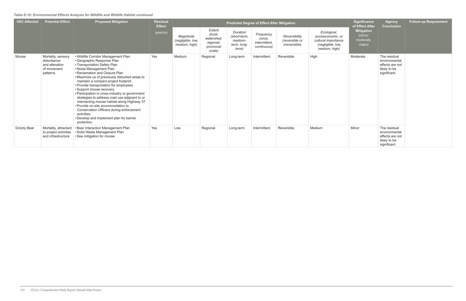
133 CEAA—Comprehensive Study Report: Kitsault Mine Project
Table E-10: Environmental Effects Analysis for Wildlife and Wildlife Habitat continued
VEC Affected Potential Effect Proposed Mitigation Residual Effect
(yes/no)
Predicted Degree of Effect After Mitigation Significance of Effect After
Mitigation (minor,
moderate, major)
Agency Conclusion
Follow-up Requirement
Magnitude (negligible, low, medium, high)
Extent (local,
watershed, regional, provincial
scale)
Duration (short-term,
medium-term, long-
term)
Frequency (once,
intermittent, continuous)
Reversibility (reversible or irreversible)
Ecological, socioeconomic, or cultural importance
(negligible, low, medium, high)
Moose Mortality, sensory disturbance and alteration of movement patterns
• Wildlife Corridor Management Plan• Geographic Response Plan• Transportation Safety Plan• Noise Management Plan • Reclamation and Closure Plan• Maximize us of previously disturbed areas to maintain a compact project footprint
• Provide transportation for employees• Support moose recovery • Participation in cross industry or government strategies to address road use adjacent to or intersecting moose habitat along Highway 37
• Provide on-site accommodation to Conservation Officers during enforcement activities
• Develop and implement plan for barrier protection
Yes Medium Regional Long-term Intermittent Reversible High Moderate The residual environmental effects are not likely to be significant.
Grizzly Bear Mortality, attractant to project activities and infrastructure
• Bear Interaction Management Plan • Solid Waste Management Plan• See mitigation for moose
Yes Low Regional Long-term Intermittent Reversible Medium Minor The residual environmental effects are not likely to be significant.

134 CEAA—Comprehensive Study Report: Kitsault Mine Project
Table E-11: Environmental Effects Analysis for Land and Resource Use
VEC Affected Potential Effect Proposed Mitigation Residual Effect
(yes/no)
Predicted Degree of Effect After Mitigation Significance of Effect After
Mitigation (minor, moderate,
major)
Agency Conclusion
Follow-up Requirement
Magnitude (negligible,
low, medium, high)
Extent (local,
watershed, regional,
provincial scale)
Duration (short-term,
medium-term, long-term)
Frequency (once,
intermittent, continuous)
Reversibility (reversible or irreversible)
Ecological, socioeconomic, or cultural importance
(negligible, low, medium, high)
Land and Resource Use
Current uses of lands and resources for traditional purposes by Aboriginal people
Project footprint reduces or removes access to areas for traditional uses
• Environmental Management Plans
• Marine Environment Monitoring Program
• Wildlife Corridor Management Plan
Yes Low Regional Long-term Continuous Reversible Medium Minor The residual environmental effects are not likely to be significant.
Trapping and guide outfitting
Project footprint reduces or removes access to trapping and guide outfitting opportunities
• Access management strategy Yes Low Local Long-term Continuous Reversible Negligible Minor The residual environmental effects are not likely to be significant.
Country foods Potential human health risk from exposure to metals in country foods
• Marine Environment Monitoring Program
• Communications procedure with local stakeholders
• Transportation Safety Plan
Yes Low Local Long-term Intermittent to continuous
Irreversible High Minor The residual environmental effects are not likely to be significant.
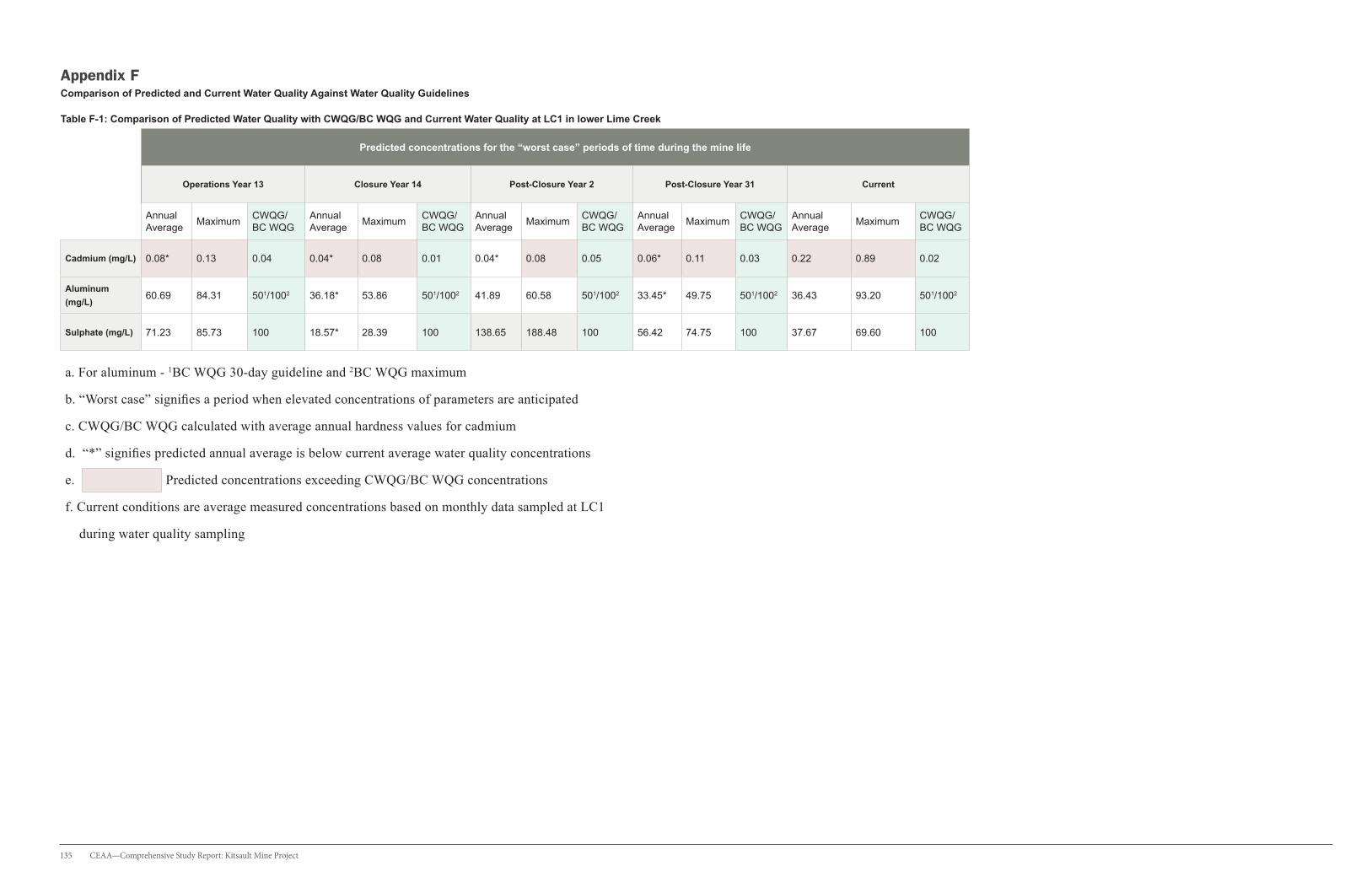
135 CEAA—Comprehensive Study Report: Kitsault Mine Project
Appendix F Comparison of Predicted and Current Water Quality Against Water Quality Guidelines
Table F-1: Comparison of Predicted Water Quality with CWQG/BC WQG and Current Water Quality at LC1 in lower Lime Creek
Predicted concentrations for the “worst case” periods of time during the mine life
Operations Year 13 Closure Year 14 Post-Closure Year 2 Post-Closure Year 31 Current
Annual Average
MaximumCWQG/ BC WQG
Annual Average
MaximumCWQG/ BC WQG
Annual Average
MaximumCWQG/ BC WQG
Annual Average
MaximumCWQG/ BC WQG
Annual Average
MaximumCWQG/ BC WQG
Cadmium (mg/L) 0.08* 0.13 0.04 0.04* 0.08 0.01 0.04* 0.08 0.05 0.06* 0.11 0.03 0.22 0.89 0.02
Aluminum
(mg/L)60.69 84.31 501/1002 36.18* 53.86 501/1002 41.89 60.58 501/1002 33.45* 49.75 501/1002 36.43 93.20 501/1002
Sulphate (mg/L) 71.23 85.73 100 18.57* 28.39 100 138.65 188.48 100 56.42 74.75 100 37.67 69.60 100
a. For aluminum - 1BC WQG 30-day guideline and 2BC WQG maximum
b. “Worst case” signifies a period when elevated concentrations of parameters are anticipated
c. CWQG/BC WQG calculated with average annual hardness values for cadmium
d. “*” signifies predicted annual average is below current average water quality concentrations
e. Predicted concentrations exceeding CWQG/BC WQG concentrations
f. Current conditions are average measured concentrations based on monthly data sampled at LC1
during water quality sampling

136 CEAA—Comprehensive Study Report: Kitsault Mine Project
Appendix GMonthly Flows in Lower Lime Creek (LC1)
Figure G-1: Comparison of Average Monthly Flows in Lower Lime Creek (LC1) Relative to the Natural Hydrograph
0
2,000,000
4,000,000
6,000,000
8,000,000
10,000,000
12,000,000
14,000,000
16,000,000
January February March April May June July August September October November December
m3 /mon
th
LC1 Current ‐ Average
LC1 Operations Yr 13 Scenario 1
LC1 Operations Yr 13 Base Case
LC1 Closure Yr 14
LC1 Post‐Closure Yr 2
LC1 Post Closure Yr 31
NOTE:1. "CURRENT" FLOW CONDITIONS WERE EXTRACTED FROM THE LIME CREEK PRE‐MINE WATERSHED MODEL.2. FLOW VOLUMES FOR THE VARIOUS MINE PHASES WERE EXTRACTED FROM THE FLOW BALANCE IN THE WATER QUALITY MODEL.3. THE BASE CASE SCENARIO FLOWS FOR OPERATIONS YR 13 (DOTTED LINE) WERE REFERENCED FROM KNIGHT PIESOLD LTD
LETTER VA11‐00964.
Average Monthly Flows in Lower Lime Creek (Sourced from KPL Letter VA12-01685)

CEAA—Comprehensive Study Report: Kitsault Mine Project 137
Appendix HSummary of Public Comments
Consultation Document
Consultation Period
Summary of Comments
Conduct of the Comprehensive Study
November 8– December 10, 2010
• Risks to human safety and the potential effects to groundwater sources and marine ecology in Alice Arm in the event of failure of the TMF
• Potential risks to the geotechnical stability of the TMF during seismic events• Ecological implications of removing Patsy Lake• Financial bonding for potential ecological effects to Alice Arm• Economic costs of moving forward with the Project• Project will provide an economic boost to nearby communities
Environmental Impact Statement (EIS)
May 11–June 11, 2012
• Project will generate new investment and employment in Terrace and Northwest BC• Potential effects of seismic and volcanic activity on the Project, particularly in terms of the proposed TMF and soil storage areas
• Potential decline in Lime Creek water quality• Potential effects on Kitsault Resorts, including groundwater and surface water quality effects, increased road use and traffic, health and safety on residents and visitors, and the economics implications of mine development

138 CEAA—Comprehensive Study Report: Kitsault Mine Project
Appendix IAboriginal Consultation: Further information
Mitigation and Monitoring
Key mitigation measures and monitoring requirements that address potential effects to asserted Aboriginal rights to hunting, trapping, fishing and other land uses are summarized below.
Metlakatla First NationDuring the EA, the following measures were developed to mitigate the potential effects of the Project on the asserted marine harvesting rights of the Metlakatla First Nation.
• Implement new water treatment, including an in-mill treatment and filtration system and conventional HDS treatment with sulphide addition in post closure, to improve water quality in the Lime Creek and Clary Creek watersheds. • Meet B.C. Water Quality Guidelines or Site Specific Water Quality Objectives. • Develop the MEMP in consultation with the Metlakatla First Nation. The monitoring results will be used to determine the effectiveness of measures taken to mitigate effects on marine water uses and to determine if additional management actions are warranted to prevent or address unforeseen impacts. • Share the monitoring results from the MEMP with the Metlakatla First Nation. • Consult with the Metlakatla First Nation the development of management and monitoring plans.
Gitanyow First Nation During the EA, the following mitigation measures were developed to mitigate the potential effects of transportation and FSR use on the asserted wildlife harvesting rights of the Gitanyow First Nation.
• Develop a Wildlife Corridor Management Plan prior to construction, which will include the following mitigation measures:
• Remove snow to create pullouts for wildlife escape routes at key locations along the
FSRs. Develop the design and location of the pullouts through discussions with the Gitanyow First Nation and consider the best available scientific research. • Inspect the FSRs and brush vegetation to improve wildlife visibility in areas where the lines-of-sight are poor. Develop brushing widths, frequency, and riparian set-backs through discussions with the Gitanyow First Nation and consider the best available scientific research. • Create a map of the transportation corridors that identify important environmental features and sensitive moose habitats and identify measures to reduce disturbance to these areas (e.g., reduced speed limits, increased signage, increased vegetation brushing widths, snow escape routes). Distribute the map to all mine-related vehicle drivers. • Place wildlife signage along the FSRs in areas of potential wildlife collisions with emphasis on high moose population areas. Establish the design and placement of signage through discussions with the Gitanyow First Nation. • Develop protocols for reduced vehicle movement during dawn and dusk periods, and for convoys (a component of the Traffic Control Plan). • Establish procedures for immediately reporting moose kills to provincial authorities and Aboriginal groups, including the Gitanyow First Nation. • Implement a no hunting and fishing policy for all employees and contractors while working directly or indirectly for the Project. • Develop a Wildlife Observe/Record/Report Program in consultation with regional Conservation Officers. • Establish an Employee Education and Environmental Awareness Program. • Support recovery of the Nass moose population.

CEAA—Comprehensive Study Report: Kitsault Mine Project 139
• Develop a Large Mammal Monitoring and Reporting Program (i.e., moose, bears, and goats) that includes:
• Procedures for contractor initiation and training; • Protocols with contractor companies, independent drivers, and mine employee drivers that includes successive levels of penalties or consequences for non-compliance; • GPS wildlife recording devices installed in mine-related vehicles; • Recording and reporting of large mammal-vehicle near miss, injury or mortality, and observations of dead large mammals; • Data reporting and radio communication protocols for distributing information on large mammal observations and incidents; • Evaluation and reporting of results to identify high potential areas (i.e., location, time of day, season) for large mammal-vehicle collisions; and • Compliance monitoring, including periodic audits for conformance and to assess the effectiveness of the program and identify opportunities for improvements.
• Develop and implement a Geographic Response Plan prior to construction to provide training and hazardous material spill response approaches along the transportation corridors. The Plan includes the following elements:
• Identify all hazardous and bulk materials that pose a risk to the environment or public safety • Conduct a fate and effects assessment for each identified material • Produce maps identifying areas of high environmental sensitivity along the transportation corridors • Develop site specific spill response tactics and training and resources to implement these tactics
• Develop requirements and procedures for spill reporting and notification to government agencies, the NLG, and Aboriginal groups • Establish five separate equipment caches along the transportation corridors for timely response to spills • Identify and train spill responders to respond and implement spill response tactics • Conduct regular spill response drills and exercises • Pursue opportunities to harmonize spill response kits and plans with other industrial operators in the region
• Develop and implement a plan describing appropriate forms of barrier protection along areas of the proposed transportation corridors with high aquatic values that could be at risk from spills of hazardous materials.
Gitxsan NationDuring the EA, the following mitigation measures were developed to mitigate the potential effects of the transportation corridors on the asserted wildlife harvesting rights of the Gitxsan Nation.
• Develop and implement the measures set out in the Wildlife Corridor Management Plan to minimize potential mine-related vehicle collisions with wildlife. • Develop and implement the Transportation Safety Plan to prevent and address spills and other potential impacts on water bodies along the Cranberry Connector, including the installation of barriers in environmentally sensitive areas. • Consult on barrier protection along the transportation corridors. • Participate in future regional cumulative effects assessments, management, and planning efforts related to traffic along the Highway 37 and Highway 113 transportation corridors. • Develop and implement the Vegetation Management Plan, which will include invasive species management to reduce the potential

140 CEAA—Comprehensive Study Report: Kitsault Mine Project
spread of invasive species from the mine site to the transportation corridors.
Kitsumkalum First NationDuring the EA, the following mitigation measures were developed to mitigate the potential effects of the Project on the asserted fishing and wildlife harvesting rights of the Kitsumkalum First Nation.
• Develop a communications protocol as part of the Wildlife Corridor Management Plan. • Develop and implement a Geographic Response Plan prior to construction to provide training and hazardous material spill response approaches along the transportation corridors. The Plan includes the following elements:
• Identify all hazardous and bulk materials that pose a risk to the environment or public safety • Conduct a fate and effects assessment for each identified material • Produce maps identifying areas of high environmental sensitivity along the transportation corridors • Develop site-specific spill response tactics and training and resources to implement these tactics • Develop requirements and procedures for spill reporting and notification to government agencies, the NLG, and Aboriginal groups • Establish five separate equipment caches along the transportation corridors for timely response to spills • Identify and train spill responders and implement spill response tactics • Conduct regular spill response drills and exercises • Pursue opportunities to harmonize spill response kits and plans with other industrial operators in the region
• Develop and implement a plan describing appropriate forms of barrier protection along
areas of the proposed transportation corridors with high aquatic values that could be at risk from spills of hazardous materials.
Kitselas First NationThe Kitselas First Nation did not submit any comments or identify any issues or potential effects in relation to the Project. No specific mitigation or accommodations were developed during EA Application Review specifically for the Kitselas First Nation. The proposed transportation mitigation measures should address the potential effects to any potential Kitselas First Nation Aboriginal rights.
Métis Nation of British ColumbiaThe mitigation measures identified in the EA process are expected to address the potential effects of the Project on surface water and groundwater quality (Sections 4.2.3 and 4.4.3), and fish and fish habitat (Section 4.5.3), which were of interest to MNBC.