COMPREHENSIVE PLAN PDF - Abilene, TX
107
CITY OF ABILENE
Transcript of COMPREHENSIVE PLAN PDF - Abilene, TX
CITY OF ABILENE

City Council
Mayor Grady Barr
Norm Archibald, Place 1 John Hill, Place 4 Kris Southward, Place 2 Jimmy McNeil, Place 5 Anthony Williams, Place 3 Kay Alexander, Place 6
Planning and Zoning Commission
Jack Harkins
Floyd Miller Neomia M. Banks Eddie Boykin Ovelia Campos Jeff Luther Tim Rice McClarty
City Staff
Larry D. Gilley, City ManagerRichard G. Gertson, AICP, Director of Planning and Development Services
Elizabeth Grindstaff, AICP, Assistant Director of Planning and Development Services
Larry Abrigg, AICP JoAnn Sczech, CPS Robert Allen, AICP Ben Finley Jeff Armstrong Dustin Luensmann Sandy Bowen Shannon Meinhold Greg Brown Virginia Owens, AICP Helen Clanahan
Steering Committee Woody Gilliland, Chairman Airport Board Nancy Jones, Social Services Norm Archibald, Abilene City Council Alesha Mitchell, Youth Advisory Council Neomia Banks, Planning & Zoning Commission John Morbach, College Students Ovelia Campos, Neighborhoods Andrew Penns, Neighborhoods Victor Carrillo, Taylor County Gary Pullin, Architects Jim Compton, West Central Texas Dale Scoggins, Development Council of Governments Scott Senter, Real Estate Charlie Dromgoole, Business Mike Schweikhard, Utilities John Hill, Neighborhoods Dwayne Wadlington, Dyess Air Force Base Roger Huber, Education Mike Young, Tax Increment Finance District
A C K N O W L E D G E M E N T S

Introduction.............................................................................................
Land Use and Development....................................................................
Community Appearance..........................................................................
Neighborhoods........................................................................................
Community Services and Facilities..........................................................
Natural Environment and Resources.......................................................
Economic Base.........................................................................................
Appendix A .............................................................................................
Appendix B..............................................................................................
Page 4
Page 8
Page 42
Page 56
Page 66
Page 78
Page 88
Page 96
Page 106
TA B L E O F C O N T E N T S

4 - Abilene Comprehensive Plan
I N T R O D U C T I O N Purpose of the Comprehensive PlanThe Comprehensive Plan establishes a coordinated set of policies to guide Abilene’s physical development over the next ten to fi fteen years. As a decision-making guide, the Plan ensures that future public and private investment decisions are consistent with the long-range vision of what citizens want Abilene to become. The Plan also outlines implementation strategies for reaching stated objectives and is meant to be a dynamic document that should evolve and respond to changing conditions.
The Abilene Comprehensive Plan is the community’s blueprint for future development. As such, it serves as a valuable resource for both the public and private sector. In the seminal work, The Urban General Plan, planner and council member T.J. Kent, Jr., described a comprehensive plan as a policy-control instrument.
I believe that the city council should be the principal client of the general plan, and that the plan should be prepared for active use by the council. This belief follows from my belief that city planning is primarily a policy-making activity of the city council…. In reality, every city-planning decision of signifi cance must sooner or later be made in the council chamber….
In keeping with that philosophy, this Plan is fashioned as a guide for decision-makers as they are faced with land use questions regarding annexations, rezonings, urban design, and the expansion of public infrastructure. The Plan speaks to current and future city councils alike. It attempts to do so in a direct, assertive style that is meant to convey the depth of commitment to its major tenets. This Plan is also a reference document for the general public, property owners and developers. By communicating a clear and consistent direction for the City’s future physical form, there is more certainty in the development process and greater congruence between private development and public goals.
Elements of the PlanAbilene’s Comprehensive Plan includes the following six elements:
· Land Use and Development· Neighborhoods · Community Appearance· Community Facilities and Services · Natural Environment and Resources · Economic Base
Each element begins with an introductory overview that summarizes existing conditions and issues. The element is then organized by a statement of Plan “goals,” followed by “objectives” and “strategies” related to the goals. Several “discussion” items are also included throughout the Plan to provide a context for related policies. Each of these components are defi ned as described below:
Goals state the results citizens of Abilene hope to achieve over the next ten to fi fteen years. They refl ect the community’s values and aspirations for the physical growth, enhancement, and development of the City. Each goal, at a general level, provides the foundation for the policies and strategies that guide the decision- making process.
1 T.J. Kent, Jr., The Urban General Plan, (San Francisco; Chandler Publishing Company, 1964) page 23.
1

Abilene Comprehensive Plan - 5
Objectives identify, in more specifi c terms, ways in which each goal can be achieved. They express what the City intends to do so that land use and development activities are directed toward attaining desired goals. Each objective provides a general direction for the development of strategies.
Strategies describe the actions the City and its partners can take to accomplish its overall vision. Each strategy is linked to a specifi c objective and sets forth actions the City should take in pursuit of the objective. For instance, a strategy may recommend that the City update development regulations, create incentive programs, or undertake public projects and services.
Discussions explain the context or rationale by which policies have been developed and often explain the intent of goals and objectives. Unlike goals, objectives, and strategies, discussions do not establish policy. Rather, they offer valuable planning theory or reasoning as an aid to the interpretation of policies.
The Planning ProcessIn August 2001, the Abilene Community Excellence (ACE) Task Force developed a set of strategies for improving the City’s community and economic development quality of life. Recognizing that much has changed since 1973 when the last comprehensive plan was written, the Task Force members decided it was time to construct a new plan with a cohesive vision for the community’s future. The new plan, according to the ACE Report, should provide a basis for future zoning and land use decisions, refl ect more progressive planning thought, and complement other economic development efforts. From among more than thirty strategies, the Task Force ranked the need for a new Comprehensive Plan as the community’s second highest priority.
In the eighteen months that followed, the City engaged a diverse group of citizens from throughout the community in a collaborative planning process. Neighborhood representatives, interest groups, business and development interests, City staff, members of the Planning and Zoning Commission and City Council, and the general public were all involved at various levels in developing the Plan. The process allowed participants an opportunity to ask -- What do we want for Abilene? And how will we achieve it?
Throughout the process, a twenty-three member Steering Committee helped shape the Future Land Use and Development Plan and its supporting policies. The Steering Committee was composed of a broad
6 - Abilene Comprehensive Plan
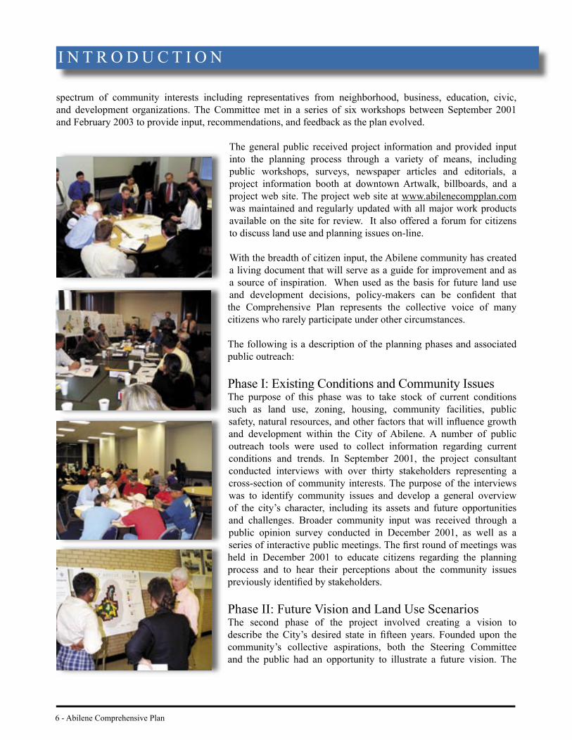
spectrum of community interests including representatives from neighborhood, business, education, civic, and development organizations. The Committee met in a series of six workshops between September 2001 and February 2003 to provide input, recommendations, and feedback as the plan evolved.
The general public received project information and provided input into the planning process through a variety of means, including public workshops, surveys, newspaper articles and editorials, a project information booth at downtown Artwalk, billboards, and a project web site. The project web site at www.abilenecompplan.comwas maintained and regularly updated with all major work products available on the site for review. It also offered a forum for citizens to discuss land use and planning issues on-line.
With the breadth of citizen input, the Abilene community has created a living document that will serve as a guide for improvement and as a source of inspiration. When used as the basis for future land use and development decisions, policy-makers can be confi dent that the Comprehensive Plan represents the collective voice of many citizens who rarely participate under other circumstances.
The following is a description of the planning phases and associated public outreach:
Phase I: Existing Conditions and Community IssuesThe purpose of this phase was to take stock of current conditions such as land use, zoning, housing, community facilities, public safety, natural resources, and other factors that will infl uence growth and development within the City of Abilene. A number of public outreach tools were used to collect information regarding current conditions and trends. In September 2001, the project consultant conducted interviews with over thirty stakeholders representing a cross-section of community interests. The purpose of the interviews was to identify community issues and develop a general overview of the city’s character, including its assets and future opportunities and challenges. Broader community input was received through a public opinion survey conducted in December 2001, as well as a series of interactive public meetings. The fi rst round of meetings was held in December 2001 to educate citizens regarding the planning process and to hear their perceptions about the community issues previously identifi ed by stakeholders.
Phase II: Future Vision and Land Use ScenariosThe second phase of the project involved creating a vision to describe the City’s desired state in fi fteen years. Founded upon the community’s collective aspirations, both the Steering Committee and the public had an opportunity to illustrate a future vision. The
I N T R O D U C T I O N

Abilene Comprehensive Plan - 7
Vision Map, as shown on page eight, forms a composite view of how Abilene’s development patterns, neighborhoods, and community systems can be enhanced. Armed with the ideas generated in these brainstorming sessions and the input received in Phase I, the Planning staff and consultant created a range of land use scenarios to achieve the vision.
As described in the Land Use and Development element and Appendix A, the land use scenarios and draft goals were presented at a public workshop and displayed in the Abilene Reporter-News. The public was asked to evaluate and indicate the characteristics from each scenario that they would like to see included in the Final Land Use and Development Plan. Extensive citizen input was also obtained through a scenario preference questionnaire published in both the newspaper and the project web site. The web site was the primary vehicle for obtaining participation from residents of Dyess Air Force Base.
Phase III: Final Land Use Plan, Goals, and Objectives The third phase of the planning process focused on refi ning a physical image and related policies. With a synthesis of the preferences obtained in the second phase, the Steering Committee and general public crafted a preferred scenario that would eventually become the Future Land Use and Development map. As a guide to future development, the preferred scenario was translated into a set of demonstrative goals and objectives. The general public had an opportunity to review and provide feedback on the proposed policies at an interactive public workshop. A similar session was held with the Steering Committee. Reactions from Committee members provided an important test as to the general validity of the issues raised and the prospects for public acceptance of the policies.
Phase IV: Implementation StrategiesThe fi nal phase involved developing a range of implementation strategies to realize the future goals and objectives of the Plan. To that end, the project consultant conducted an implementation workshop at a general public meeting and a joint meeting of the Steering Committee and Planning and Zoning Commission. These workshops provided a forum for citizens, City offi cials, and policy makers to discuss what actions are needed to bring the Plan to fruition. A key component of the workshops related to those private and public actions needed to promote infi ll and redevelopment, a central theme of the Comprehensive Plan. Specifi c implementation tools such as the zoning ordinance, subdivision regulations, and annexation plan will be modifi ed at a later date and will embody these strategies. See Appendix B for further discussion of the implementation actions to be taken in the interim.
When adopted by the City Council, the Comprehensive Plan will serve as a guide for decision-making on the future development of the City of Abilene. In establishing goals for the physical development of the City, the Plan provides the framework to which the zoning ordinances must conform in order to implement those goals. Until new ordinances are adopted, the Plan’s policies and existing ordinances will be used to guide development review. The City Council, working with the Planning and Zoning Commission and City staff, will consider amendment or adoption of the zoning ordinances. Careful consideration will be given to each recommendation in the Plan, and public input will be received before any new zoning ordinances are adopted that alter planning processes or development rules.

8 - Abilene Comprehensive Plan
L A N D U S E A N D D E V E L O P M E N T

Abilene Comprehensive Plan - 9
Introduction
In developing the Comprehensive Plan, Abilene citizens debated several fundamental issues regarding Abilene’s future such as how, where, and to what extent the City should grow, as well as how new development should be managed to improve the quality of life for residents. What emerged from the discussion of these questions was a clear set of guiding principles by which the City should proactively direct and shape new development. These guiding principles set new standards for future growth, redevelopment, and public infrastructure investments. The principles are based on the core values voiced by citizens - including a desire to create stable and unique neighborhoods, attractive and conveniently located shopping areas; diversifi ed centers of employment; welcoming gateways; and, effi cient public facilities.
The guiding principles form the key components of the Land Use and Development Plan and policies that, along with other elements of the Comprehensive Plan, outline a vision for the physical development of the City. The cornerstone of this vision is a land use pattern that confronts the trend toward growth on the fringes of the city and a disinvestment in the central city. Instead, the City will seek to actively guide new growth, infi ll, and redevelopment to areas characterized by both a requisite population density and within the logical scope of existing service areas. A more compact city will ensure the effi cient use of public infrastructure, capitalize on previous investments in the central city, and promote more attractive and stable conditions within existing neighborhoods. New growth will be accommodated primarily through compatible infi ll development, commercial and civic activity centers, and community enhancement corridors, rather than development on the periphery of the City’s boundaries. This approach to future development will create a more livable, vibrant and cost-effective city.
Guiding Principles
· While development may occur in all areas of the city, promote infi ll and
redevelopment projects that are targeted to underutilized or vacant areas of the city.
Prioritize the redevelopment of older facilities that might
not otherwise have an economically viable use, such as distressed retail shopping centers, industrial sites, and
vacant schools.
· Target the development and redevelopment of activity
centers that are linked with attractive street corridors
coupled with a community-wide pedestrian network.
· Maximize the effi cient use of limited resources, such as water, roads, and public services, by targeting new development in areas with
existing services.
· Use water and sewer infrastructure more effi ciently
to promote development in the urbanized area rather than extending infrastructure to the
urban fringe.
· Promote the development of gateway districts that
provide strong visual impacts at entrances to the community,
promoting a positive image with interesting and welcoming
elements that portray a sense of community.
· Preserve fl ood-sensitive areas for environmentally compatible development
and passive recreation, such as trails, wildlife habitat, and
natural green spaces.

Final Comprehensive Plan Maps
are available as separate PDF files
www.abilenetx.com
Existing Land Use: City Limits Map (pg. 10-11)
Existing Land Use: City Center Map (pg. 12-13)
Future Land Use Development Plan (pg 16-17)
Vacant and Undeveloped Land (pg 24-25)
ETJ and County Boundaries (pg 40-41)
Super Neighborhood Boundaries (pg 58-59)
Existing Community Facilities (pg 68-69)
Sensitive Development Areas (pg 80-81)


14 - Abilene Comprehensive Plan
Preparation of the Future Land Use and Development Plan
The key components of the Future Land Use and Development Plan Element were developed through an extensive public process during which citizens were asked to evaluate four distinct Land Use and Development scenarios.
· Mixed Use Districts · Strategic Infi ll · Resource Management · Continuing Trends
The scenarios provided a focal point for discussion and enabled the community to examine a range of physical forms and the implications associated with each. The scenarios were used as tools to help discuss the values and trade-offs of planning decisions. The fi nal result of the planning process, as depicted in the Future Land Use and Development Plan, include some features of each scenario, as well as new features that evolved during the scenario evaluation process. Appendix A describes the four land use scenarios in greater detail.
Land Use and Development Plan
Objective: Plan for land use patterns that make the most effi cient use of existing land and community resources. Encourage new development that is a logical extension of existing infrastructure and development and avoid “leapfrog” patterns of development. (See Figure 1)
Discussion: The City of Abilene’s Future Land Use and Development Plan is a hybrid born of the scenario characteristics favored by residents. The Plan illustrates the general land use distribution and development patterns the City desires over the next twenty years. Activity Centers, Community Enhancement Corridors, and Gateway Districts provide a future framework for infi ll and redevelopment throughout the city. As described in more detail below, Activity Centers feature a mix of commercial, employment, institutional, and residential land uses. The map symbols for these centers, however, are conceptual and do not specify precise parcel boundaries on which development should occur. The symbols provide fl exibility for landowners, developers, and the City to determine in greater detail how and where Activity Centers should develop. In conjunction with the map, the policies of the Land Use and Development Element provide direction for development of a variety of land uses in the vicinity of each legend symbol.
Throughout the planning process, participants recognized that while the city is not growing fast, it is experiencing a gradual trend of dispersed development spreading south along the city’s periphery. Because this land use pattern can exert inordinate pressure on the City’s fi nite fi nancial resources and system capacities, it contributes to disinvestment within established areas of the central city and an ineffi cient use of public facilities and services. An alternative approach to this dispersed development trend is a more focused pattern of development.
L A N D U S E A N D D E V E L O P M E N T
G O A L : P R O M O T E L A N D U S E T H AT B U I L D S O N T H E C H A R A C T E R A N D F U T U R E N E E D S O F T H E C O M M U N I T Y.

Abilene Comprehensive Plan - 15
Drawing new development back into the central city offers several advantages. First, it preserves the unique character of Abilene by accentuating those elements of the community that residents prefer: the small town atmosphere of close-knit neighborhoods, the downtown, and the convenience of shopping and recreational choices. Focused development also promotes more effective delivery of public facilities and services by using existing infrastructure rather than spending public dollars to extend and maintain infrastructure and services where it produces only marginal benefi ts. The higher densities associated with the focused development pattern will support a greater range of transportation choices and the creation of vibrant activity centers. Reversing the trend of unplanned growth and the social, environmental, and fi scal costs associated with it, is an incremental process but one that will lead to a more sustainable, livable community for Abilene.
Figure 1: “Leapfrog” development occurs when developments are separated by large tracts of vacant land. The City should minimize “leapfrog” development by promoting infi ll and redevelopment opportunities. Scattered site development increases the immediate and long term costs of providing services and impacts all tax payers by perpetuating a development pattern that is diffi cult and expensive to sustain.
Contiguous Leapfrog

Final Comprehensive Plan Maps
are available as separate PDF files
www.abilenetx.com
Existing Land Use: City Limits Map (pg. 10-11)
Existing Land Use: City Center Map (pg. 12-13)
Future Land Use Development Plan (pg 16-17)
Vacant and Undeveloped Land (pg 24-25)
ETJ and County Boundaries (pg 40-41)
Super Neighborhood Boundaries (pg 58-59)
Existing Community Facilities (pg 68-69)
Sensitive Development Areas (pg 80-81)

18 - Abilene Comprehensive Plan
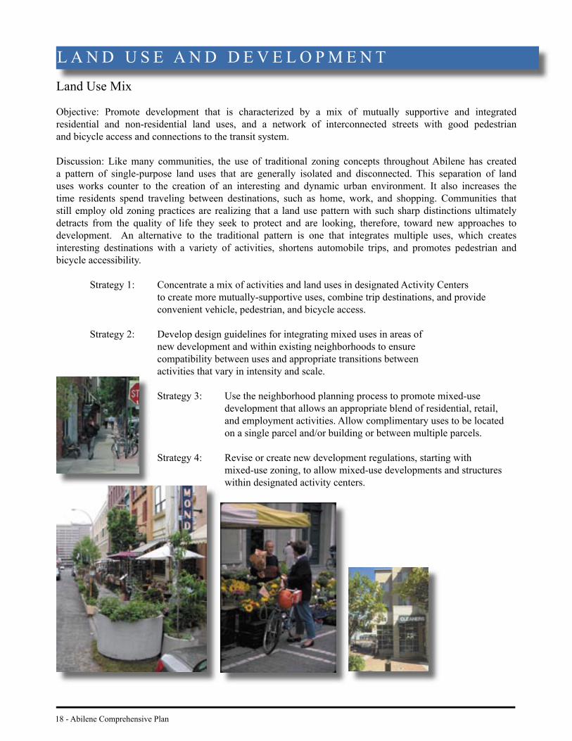
Land Use Mix
Objective: Promote development that is characterized by a mix of mutually supportive and integrated residential and non-residential land uses, and a network of interconnected streets with good pedestrian and bicycle access and connections to the transit system.
Discussion: Like many communities, the use of traditional zoning concepts throughout Abilene has created a pattern of single-purpose land uses that are generally isolated and disconnected. This separation of land uses works counter to the creation of an interesting and dynamic urban environment. It also increases the time residents spend traveling between destinations, such as home, work, and shopping. Communities that still employ old zoning practices are realizing that a land use pattern with such sharp distinctions ultimately detracts from the quality of life they seek to protect and are looking, therefore, toward new approaches to development. An alternative to the traditional pattern is one that integrates multiple uses, which creates interesting destinations with a variety of activities, shortens automobile trips, and promotes pedestrian and bicycle accessibility.
Strategy 1: Concentrate a mix of activities and land uses in designated Activity Centers to create more mutually-supportive uses, combine trip destinations, and provide convenient vehicle, pedestrian, and bicycle access.
Strategy 2: Develop design guidelines for integrating mixed uses in areas of new development and within existing neighborhoods to ensure compatibility between uses and appropriate transitions between
activities that vary in intensity and scale.
Strategy 3: Use the neighborhood planning process to promote mixed-use development that allows an appropriate blend of residential, retail, and employment activities. Allow complimentary uses to be located on a single parcel and/or building or between multiple parcels.
Strategy 4: Revise or create new development regulations, starting with mixed-use zoning, to allow mixed-use developments and structures
within designated activity centers.
L A N D U S E A N D D E V E L O P M E N T
within designated activity centers.
Strategy 3: Use the neighborhood planning process to promote mixed-use development that allows an appropriate blend of residential, retail, and employment activities. Allow complimentary uses to be located on a single parcel and/or building or between multiple parcels.
Strategy 4: Revise or create new development regulations, starting with mixed-use zoning, to allow mixed-use developments and structures

Abilene Comprehensive Plan - 19
Commercial Uses
Discussion: Abilene contains numerous commercial areas that provide goods and services for city residents as well as the surrounding region. While residents are generally satisfi ed with the number and variety of commercial services, only half are satisfi ed with the distribution of those services throughout the city.2
Because older areas have lost much of their consumer base, several neighborhoods within the central city lack convenient access to commercial areas. The location and design of commercial areas not only affects the fi nancial success of a business and the resulting tax base, but also the quality of life for residents. Regardless of the scale of commercial development, the location and design of commercial uses should support and enhance surrounding areas, rather than alter the character of the neighborhoods they serve. Integrating commercial development into a mix of uses will also increase the vitality of businesses.
Strategy 5: Target the development of new commercial uses to designated activity centers according to their function, size, and intensity.
Strategy 6: Support the redevelopment of aging or distressed commercial centers as mixed- use activity centers.
Strategy 7: Encourage the development of commercial areas in non-linear confi gurations along roadways. Figures 2a and 2b illustrate different approaches to commercial development. One which does not facilitate safe and convenienct automobile or pedestrian access (left); and one which fosters both while providing a sense of place for the user.
Strategy 8: Revise regulations to allow neighborhood commercial retail and service uses, including residential conversions, provided that buildings are residentially scaled, site design is pedestrian oriented, and the use depends primarily upon the neighborhood for its market area.
Strategy 9: Plan and design commercial land uses with safe automobile access and transit service from the adjoining streets to an internal street and parking system. Also provide a strong pedestrian orientation and direct pedestrian accessibility from surrounding residential areas.
Figure 2a, left: As shown here, commercial development in familiar “strip” patterns, is characterized by individual buildings with rigid setbacks on shallow parcels, each with their own ingress and egress and parking lot. This development pattern creates traffi c hazards and forecloses options for better site
design. The commercial development on the right, Figure 2b, brings buildings to the streetfront which serves as the framework for creating a comfortable and inviting public space along the street. The City should encourage unifi ed developments in non-linear confi gurations along roadways to maximize the economic potential of commercial land.
2 Results of the public preference survey, completed 2/28/02.

20 - Abilene Comprehensive Plan
Residential Uses
Discussion: Neighborhoods are the fundamental building block of the city. Residents provide those neighborhoods with the essential synergy to support and benefi t schools, local activity centers, community parks, recreation centers, employment centers, open space networks, and the City’s transportation system. Residential areas of the city should be developed, redeveloped, and revitalized as cohesive sets of neighborhoods, sharing an interconnected network of streets, schools, parks, activity centers, and public facilities and services.
Strategy 10: Integrate new residential areas into the citywide pattern of activity centers, community enhancement corridors, parks and school locations, and other public facilities and services.
Strategy 11: Adapt neighborhood development to conform with signifi cant natural features and to ensure compatibility with environmental constraints.
Strategy 12: Employ higher density housing as a supporting residential use for activity centers and transition the density to the surrounding residential areas.
Strategy 13: In new development areas, promote a modifi ed grid system of streets that provides multiple routes to better diffuse traffi c, shorten walking distances, and improve emergency responsiveness.
L A N D U S E A N D D E V E L O P M E N T
Strategy 10: Integrate new residential areas into the citywide pattern of activity centers, community enhancement corridors, parks and school locations, and other public facilities and services.
Strategy 11: Adapt neighborhood development to conform with signifi cant natural features and to ensure compatibility with environmental constraints.
Strategy 12: Employ higher density housing as a supporting residential use for activity centers and transition the density to the surrounding residential areas.
Strategy 13: In new development areas, promote a modifi ed grid system of streets that provides multiple routes to better diffuse traffi c, multiple routes to better diffuse traffi c, shorten walking distances, and improve emergency responsiveness.

Abilene Comprehensive Plan - 21
Figure 3: Residential streets should promote connectivity. Cul-de-sacs and curvilinear developments discourage walking and create long travel distances, and often create bottlenecks for emergency vehicles. Abilene should promote a modifi ed grid system of streets that provides multiple routes to better diffuse traffi c and shorten walking distances.
Traditional Residential(Grid Pattern)
Contemporary Residential(Cul-de-Sacs)

22 - Abilene Comprehensive Plan
Infi ll and Redevelopment
Objective: Encourage infi ll and redevelopment projects that enhance surrounding areas, are contextual, and in character with existing surrounding development. Promote new growth in well-defi ned contiguous areas in order to avoid leapfrog development.
Discussion: The concepts of infi ll and redevelopment are critical elements of the Comprehensive Plan. The term “infi ll” refers to the development of vacant land generally within the interior regions of the City, while “redevelopment” refers to the reuse of existing development. Rather than promoting growth that spreads out across the landscape and consumes vast amounts of land, infi ll and redevelopment focuses on keeping the City’s overall development pattern more compact.
Infi ll and redevelopment projects that are compatible with and enhance surrounding development provide signifi cant benefi ts to the community. They stabilize and revitalize existing neighborhoods, make effi cient use of existing infrastructure, minimize long-term costs of system maintenance, and support quality, mixed-use activity centers. By creating a more dynamic central city, infi ll and redevelopment can also act as a magnet to attract more residents and businesses into the interior of the city. This revitalization will support neighborhood businesses, schools, and public facilities.
While infi ll and redevelopment are key components to the Plan, these concepts do not preclude growth outside the central city. The Land Use and Development Plan facilitates development throughout the entire city. However, it uses a combination of supportive regulations and fi nancial or infrastructure incentives to lure growth to locations that are more desirable from a public interest standpoint. Leveraging public investments targeted to infi ll and redevelopment areas is one way in which the city can promote sustainable private development. The City can also scale development fees based on a project’s proximity to existing infrastructure and services.
Strategy 14: Encourage infi ll and redevelopment activity within the urbanized area of the city through the use of fi nancial and infrastructure incentives, which create a positive cost advantage for development in the central city. (See Figure 4)
Strategy 15: Engage property owners and businesses in neighborhood planning to determine appropriate intensities, uses, and development criteria for redevelopment and infi ll projects at designated Activity Centers.
Strategy 16: Develop infi ll and redevelopment design guidelines and standards to ensure that the scale, massing, height, and site design of projects are compatible with and enhance surrounding neighborhoods (See Community Appearance Element). Review and revise regulations to create fl exible development standards that facilitate infi ll and redevelopment projects.
Strategy 17: Adopt appropriate building sub-codes to facilitate the reuse and redevelopment of older, and often, obsolete structures in a manner that protects public health, safety, and welfare.
Strategy 18: Target City infrastructure investments and improvements to preferred infi ll development and redevelopment areas, such as designated Activity Centers.
L A N D U S E A N D D E V E L O P M E N T

Abilene Comprehensive Plan - 23
Strategy 19: Reduce development fees at designated Activity Centers and areas where infi ll and redevelopment projects are desired.
Strategy 20: Set priorities for short and long-term public investments at designated Activity Center projects in the Capital Improvement Program. Consider improvements to make infi ll and redevelopment projects fi nancially feasible to developers, including the following:
· develop area-wide stormwater drainage systems;
· assemble land;
· upgrade utilities; and,
· improve roadways.
Figure 4: Smaller infi ll development can occur on vacant lots or on parcels of land with dilapidated buildings. Infi ll should be compatible with, and in some cases, enhance the established character of the existing neighborhood in terms of house size and scale, building placement, and architectural character.

Final Comprehensive Plan Maps
are available as separate PDF files
www.abilenetx.com
Existing Land Use: City Limits Map (pg. 10-11)
Existing Land Use: City Center Map (pg. 12-13)
Future Land Use Development Plan (pg 16-17)
Vacant and Undeveloped Land (pg 24-25)
ETJ and County Boundaries (pg 40-41)
Super Neighborhood Boundaries (pg 58-59)
Existing Community Facilities (pg 68-69)
Sensitive Development Areas (pg 80-81)

26 - Abilene Comprehensive Plan
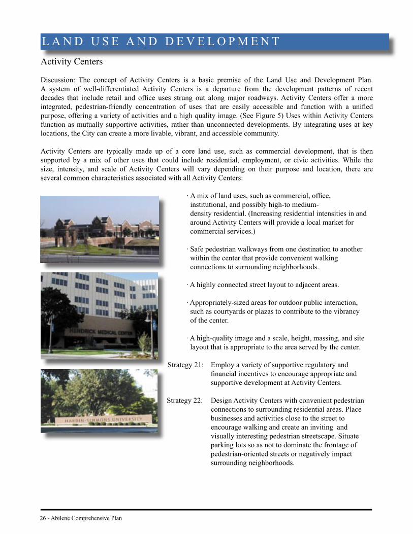
Activity Centers
Discussion: The concept of Activity Centers is a basic premise of the Land Use and Development Plan. A system of well-differentiated Activity Centers is a departure from the development patterns of recent decades that include retail and offi ce uses strung out along major roadways. Activity Centers offer a more integrated, pedestrian-friendly concentration of uses that are easily accessible and function with a unifi ed purpose, offering a variety of activities and a high quality image. (See Figure 5) Uses within Activity Centers function as mutually supportive activities, rather than unconnected developments. By integrating uses at key locations, the City can create a more livable, vibrant, and accessible community.
Activity Centers are typically made up of a core land use, such as commercial development, that is then supported by a mix of other uses that could include residential, employment, or civic activities. While the size, intensity, and scale of Activity Centers will vary depending on their purpose and location, there are several common characteristics associated with all Activity Centers:
· A mix of land uses, such as commercial, offi ce, institutional, and possibly high-to medium- density residential. (Increasing residential intensities in and around Activity Centers will provide a local market for commercial services.)
· Safe pedestrian walkways from one destination to another within the center that provide convenient walking connections to surrounding neighborhoods.
· A highly connected street layout to adjacent areas.
· Appropriately-sized areas for outdoor public interaction, such as courtyards or plazas to contribute to the vibrancy of the center.
· A high-quality image and a scale, height, massing, and site layout that is appropriate to the area served by the center.
Strategy 21: Employ a variety of supportive regulatory and fi nancial incentives to encourage appropriate and supportive development at Activity Centers.
Strategy 22: Design Activity Centers with convenient pedestrian connections to surrounding residential areas. Place businesses and activities close to the street to encourage walking and create an inviting and visually interesting pedestrian streetscape. Situate parking lots so as not to dominate the frontage of
pedestrian-oriented streets or negatively impact surrounding neighborhoods.
L A N D U S E A N D D E V E L O P M E N T

Abilene Comprehensive Plan - 27
Strategy 23: Incorporate transit-oriented design within all Activity Centers.
Strategy 24: Develop architectural and site design standards that promote compatibility with adjoining neighborhoods.
The Land Use and Development Plan designates three types of Activity Centers: Local Activity Centers; Major Commercial/Business Activity Centers; and, Special Activity Centers. The summaries below address the function of each center. Smaller, neighborhood-oriented activity centers should be designated during the Super Neighborhood planning process, designed according to the principles of the Neighborhood element, and harmonized with the Activity Center strategies herein. Because the number and location of neighborhood-oriented centers must be determined during the highly participatory Super Neighborhood planning process, the Land Use and Development Plan does not map their specifi c locations. While all three types of Activity Centers are similar in function and share several common characteristics, they vary in terms of their scale and intensity.
Figure 5: All activity centers contain a mix of uses designed to provide safe and convenient access for pedestrians and vehicles. Special paving and marked crosswalks connect various uses.

28 - Abilene Comprehensive Plan
Local Activity Center
Discussion: Local Activity Centers contain a mix of shopping, employment, entertainment, and civic uses for a number of surrounding neighborhoods. They are created around neighborhood planning concepts, but the size and scale of uses, such as schools, parks, and shopping facilities have evolved to larger forms because they serve more than one neighborhood. A Local Activity Center could contain a large supermarket, chain retail/discount store, specialty shops, service stations, large churches, a community park, mid-size offi ces, and a middle school. Local Activity Centers should be surrounded by higher-density housing, with residential intensities decreasing closer to single-family areas. Because Local Activity Centers serve multiple neighborhoods, they should be designed to balance automobile access with pedestrian access and circulation, as well as good transit connections to and from the surrounding neighborhoods. The intent of a Local Activity Center is for residents to be able to park once and walk between several destinations within the Center. (See Figure 6)
All of the Local Activity Centers identifi ed on the Land Use and Development Plan are designated within the urbanized area to help shape the city’s form. The network of Local Activity Centers, linked by Enhancement Corridors, will help strengthen the identity of the central city, reduce service costs, and ultimately bring more jobs closer to residences. In addition, many of the Local Activity Centers are signifi cant redevelopment opportunities. New development in these areas will require that the City remove regulatory barriers that may exist and target public investments to create developer interest at these sites.
Strategy 25: Use the following planning guidelines to develop Local Activity Centers:
Purpose: Provide a higher concentration and greater variety of activity for several neighborhoods, including a mix of commercial, employment, entertainment, housing, and civic services.
Market Radius: 3 - 4 miles driving distance
Market Population: 10,000 - 20,000
L a n d U s e a n d D e v e l o p m e n t
L A N D U S E A N D D E V E L O P M E N T

Abilene Comprehensive Plan - 29
Site Area: Approximately 10 - 30 acres
Access: Usually located at the intersection of arterial streets, easily accessible by automobile, transit, and a community-wide pedestrian network, off- street parking, pedestrian-friendly circulation.
Land Use Examples: Full-service grocery, bank, restaurant, hotel, low-rise offi ce/ professional, medium density residential.
Scale: 2 - 3 story, mix of larger and smaller fl oor area buildings, connections between buildings, parking lots, and surrounding developments, public plaza and/or open space.
L a n d U s e a n d D e v e l o p m e n t
Figure 6: Local Activity Centers should be designed to provide a higher concentration and greater variety of activity for several neighborhoods, including a mix of commercial and employment, entertainment, housing, and civic services. A public plaza or open space and buildings designed to a pedestrian scale will enhance the Local Activity Center as a vibrant destination for residents.

Major Commercial/Business Activity Center
Discussion: Major Commercial/Business Activity Centers have a similar mix of uses and features as Local Activity Centers but at higher concentrations since its market area is the entire Abilene region. The business component should include primarily non-service related jobs. By combining commercial and employment uses, residents and employees can access mutually supportive activities in a single, integrated regional destination. Business services, hotels, convenience retail, daycare, restaurants, and multifamily housing will all provide convenient services for employees. Major Commercial/Business Activity Centers should include a range of mixed uses from major shopping centers, like the Mall of Abilene, to a corporate headquarters. The centers should have good external access from the Interstate and/or highways that connect to an internal circulation system of local streets, pedestrian walkways, and parking areas. (See Figure 7)
Strategy 26: Use the following planning guidelines to develop Major Commercial/Business Centers:
Purpose: Provide the highest level of commercial, service, and employment concentration outside of the downtown.
Market Radius: Community-wide
Market Population: 30,000 +
Site Area: Approximately 60 acres +
30 - Abilene Comprehensive Plan
L A N D U S E A N D D E V E L O P M E N T

Access: Located on major arterial streets, often at a major intersection or freeway interchange, fully accessible by all modes of transportation, including vehicles, transit, bicycles, or pedestrians. Served by on-street and off-street parking, often with structured parking facilities.
Land Use Examples: Big-box retail or enclosed shopping mall, mid-rise offi ce, major hotel, technology/light manufacturing, major cultural or entertainment venues, medium to high density residential.
Scale: Three story or higher, large building footprints, connections between buildings and parking, large public plazas and open spaces.
Abilene Comprehensive Plan - 31
Figure 7: Major Commercial/Business Centers should be designed to provide a place of work and/or shopping for residents throughout the city and region. Ideally, it should also include supporting uses such as higher density housing.
32 - Abilene Comprehensive Plan
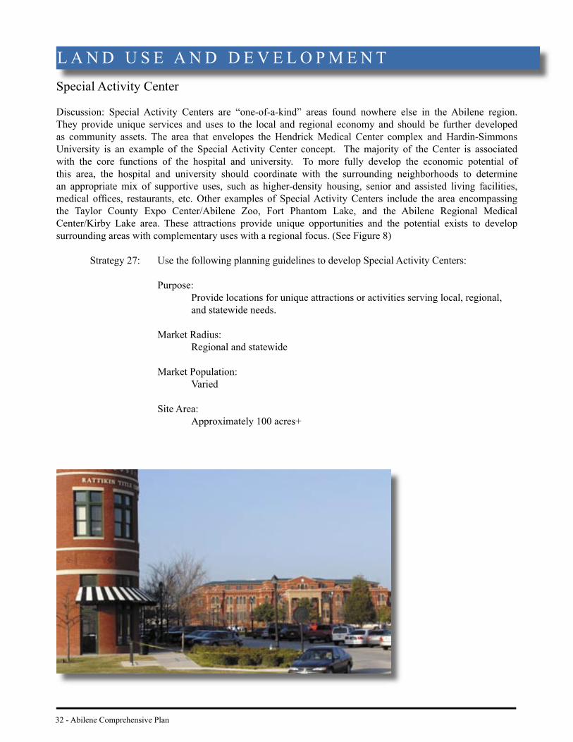
Special Activity Center
Discussion: Special Activity Centers are “one-of-a-kind” areas found nowhere else in the Abilene region. They provide unique services and uses to the local and regional economy and should be further developed as community assets. The area that envelopes the Hendrick Medical Center complex and Hardin-Simmons University is an example of the Special Activity Center concept. The majority of the Center is associated with the core functions of the hospital and university. To more fully develop the economic potential of this area, the hospital and university should coordinate with the surrounding neighborhoods to determine an appropriate mix of supportive uses, such as higher-density housing, senior and assisted living facilities, medical offi ces, restaurants, etc. Other examples of Special Activity Centers include the area encompassing the Taylor County Expo Center/Abilene Zoo, Fort Phantom Lake, and the Abilene Regional Medical Center/Kirby Lake area. These attractions provide unique opportunities and the potential exists to develop surrounding areas with complementary uses with a regional focus. (See Figure 8)
Strategy 27: Use the following planning guidelines to develop Special Activity Centers:
Purpose: Provide locations for unique attractions or activities serving local, regional, and statewide needs. Market Radius: Regional and statewide
Market Population: Varied
Site Area: Approximately 100 acres+
L A N D U S E A N D D E V E L O P M E N T

Abilene Comprehensive Plan - 33
Access: Located on major arterial streets, fully accessible by all modes of transportation. Served by on-street and off-street parking.
Land Use Examples: Educational and medical campuses, regional recreation attractions, including supporting retail and service businesses.
Scale: Buildings of various sizes and heights, depending on nature of use, with well-connected pedestrian walkways, public plazas and/or open spaces, cohesive design environment.
Figure 8: Special Activity Centers are “one-of-a-kind” places that provide regional activities, services, or attractions, such as medical and educational campuses. The City should promote a variety of supportive uses that complement the area’s variety and interest.

34 - Abilene Comprehensive Plan
Downtown
Discussion: As the heart of Abilene, the Downtown is the primary center of fi nance, culture, and government. Over the past ten years, there have been signifi cant changes and improvements in the downtown business area. This has occurred, in part, as a result of investment from both the public and private sectors. The City has adopted the Toal Plan for the continued development of downtown Abilene (see the Economic Base Element). The Comprehensive Plan supports that plan and is intended to work in concert with it. The following strategies focus on strengthening the downtown as the social and economic hub of Abilene.
Strategy 28: Implement the policies and strategies contained in the Downtown Streetscape Master Plan and the Toal Plan.
Strategy 29: Provide regulatory and fi nancial incentives to induce residential development in the downtown area. Locate such development and/or redevelopment at appropriate locations and densities to support existing and future downtown services, employment, and retail uses.
Strategy 30: Upgrade downtown infrastructure, such as sidewalks, street lighting, and landscaping in a manner that is compatible with the area’s historic character.
Strategy 31: Promote land use, transportation, and urban design improvements that will link the Downtown activity center with the Butternut Street corridor and the Hendrick Medical Center/Hardin-Simmons University Activity Center. Work with the property owners, private developers, and neighborhood groups to enhance these linkages.
L A N D U S E A N D D E V E L O P M E N T

Abilene Comprehensive Plan - 35
Community Enhancement Corridors
Discussion: Community Enhancement Corridors identifi ed on the Land Use and Development Plan are key arterials that will unify the city, establish a sense of place, and provide enhanced physical and visual links between Activity Centers. Major connections between Activity Centers should be unique and memorable. They should accommodate vehicles, buses, pedestrians, and bicyclists in a safe and attractive street environment. Currently, many major corridors lack a cohesive and appealing streetscape impression to foster quality development. There are local examples of vibrant streetscapes that can serve as the foundation for future street improvements. For instance, the planted median along Sayles Boulevard, the railroad right-of-way between North and South and 1st Streets, and the street trees, lighting, and special paving found downtown are elements that make these corridors unique. The intent of designating Community Enhancement Corridors is to apply these and other urban design elements that make a few corridors unique today to a citywide system of enhanced corridors in the future.
Many of the policies included in the Community Appearance Element of the Plan address guidelines for creating both functional and attractive corridors. For instance, the street environment for pedestrians can be improved by placing buildings closer to the street with detached sidewalks and attractive landscaping. Using the Community Appearance policies as a starting point, the City should establish criteria for each corridor that will create a distinctive visual character, while at the same time refl ecting a cohesive citywide image.
Strategy 32: Develop Community Enhancement Corridor plans to address the opportunities, constraints, and priorities for each corridor. Plans should include appropriate land use mixes, streetscape improvements, design guidelines, economic development strategies, and a corridor improvements program for capital expenditures.
Strategy 33: Work with the business community along Community Enhancement Corridors to establish public/private partnerships and appropriate regulatory and/or fi nancial incentives to revitalize private properties and make site improvements.
Strategy 34: Use overlay zoning or other appropriate ordinances to apply consistent landscaping and signage standards to each corridor.
Strategy 35: Designate additional Community Enhancement Corridors in appropriate locations through the Super Neighborhood planning process.

36 - Abilene Comprehensive Plan
Gateways
Discussion: Gateways are key entrances into the community. Citizens have pinpointed the poor image of the gateways as a major weakness of the community. Their perceptions have been confi rmed by the recommendations of the ACE Report, the Wadley-Donovan Economic Development Study, and the Chamber’s Cultural Tourism Report. Gateways are the areas where visitors will form their fi rst impression of the city and as such, should refl ect the highest quality and provide a glimpse of Abilene’s local identity. Improvements within designated Gateway Districts will give strong defi nition to I-20 and SH. 83/84 and at Abilene’s major entry points. More than simply signs that demarcate entry into the city, Gateway Districts will include designated land uses, site planning, architectural standards, historical context, and landscaping requirements to help shape the character and image of these key areas. Each of the Gateway Districts identifi ed on the Land Use and Development Plan was selected because of its importance as an entrance to Abilene. The function, shape, and character of each gateway will vary depending on its location, development history, and market development potential. (See Figure 9)
Strategy 36: Establish Gateway Districts at the following locations:
· I-20 East and I-20 West: These areas currently contain older industrial facilities and convenience stores serving interstate travelers. The visual deterioration of these areas creates a ragged impression for travelers entering Abilene from both the east and west. Transforming the character of these districts will require a combination of aesthetic improvements (such as streetscape landscaping, signage, and lighting), coupled with a concentrated effort by the City to work with property owners to improve the appearance of their properties.
· US 83/277 North: The existing character of this area is lower-intensity residential and business uses with large areas of undeveloped land, much of which is within the fl oodplain. Unlike the more developed gateways located along the interstate, this gateway has the potential to project a more rural image.
· US 83/84 South: This area has experienced a surge of new development over the past several years. The gateway coincides with the Special Activity Center found around Abilene Regional Medical Center on the west and Kirby Lake on the east. The character of the area will build on the supporting land uses of the activity center and the degree to which Kirby Lake can be transformed into an inviting natural asset.
• State Hwy. 36 and FM 18 East: This area is dominated by the contrast of open agricultural land and the city’s airport. Future land uses must respond to the City’s Airport Master Plan, and appeal to and support the needs of the business traveler. Special care must be given to the transition from this gateway to the Expo Center/Abilene Zoo Special Activity Center, which has a recreation/tourism core.
L A N D U S E A N D D E V E L O P M E N T

Abilene Comprehensive Plan - 37
Strategy 37: Conduct a gateway planning study to delineate the exact geographic boundaries and land uses for each Gateway District. In addition to the action steps of the Entryway Improvements strategy of the ACE Report, the study should include a market component to determine the appropriate economic niche of each area. Share results with property owners and interested developers.
Strategy 38: Coordinate gateway planning with the Texas Department of Transportation’s Landscape and Aesthetic Master Plan.
Strategy 39: Develop and implement overlay zoning and supporting regulations specifi c to the desired character of each gateway.
Strategy 40: Make funding for gateway improvements a priority in the City’s Capital Improvements Program.
Figure 9: Through thoughtful design and articulation of Abilene’s unique history and location, gateways can become important points of identifi cation for the community’s residents and visitors.
38 - Abilene Comprehensive Plan
Regional Growth and Annexations
Objective: Use annexation as a tool to achieve the objectives of the Comprehensive Plan.
Discussion: Annexation is one of the most powerful tools at the City’s disposal. By annexing new areas, the City extends its municipal services, regulations, voting privileges, and taxing authority to new territory. Historically, the City has annexed new land for a number of reasons, ranging from the need to control critical public facilities, such as the city’s water supply at Fort Phantom Lake in 1956, to realizing opportunities for economic diversifi cation with the annexation of a state prison facility in 1990. Since 1999 the City has maintained a policy that all annexations will be voluntary or fall under an exemption to the rigorous three-year planning requirements of Senate Bill 89.
The annexation strategies contained in the Comprehensive Plan are intended to guide the revision of a complete three-year Annexation Plan that advances the City’s new infi ll and redevelopment policies within the urbanized area. The Plan should be used as a tool to guide and manage future growth, ensure fi scal responsibility, and plan for the cost-effective expansion of infrastructure systems.
Strategy 41: In accordance with State law: • Prepare and maintain a three-year Annexation Plan to guide the
City’s annexation decisions and to identify targeted areas for City- initiated annexation; and,
• Prepare plans for the provision of municipal services and facilities, as necessary, for each annexation area.
Strategy 42: Annex areas to the south and west of Dyess Air Force Base and to the south and east of Abilene Regional Airport, all as shown on the Future Land Use and Development Plan, as a means for controlling incompatible encroachment.
Strategy 43: Annex the existing area of the Town of Impact should it unincorporate, based on a plan that addresses costs associated with the
need for potential infrastructure and service upgrades to meet City standards.
Strategy 44: Evaluate the benefi t of annexation proposals to the City based upon the following criteria:
• A fi scal impact analysis of the area to be annexed; • The negative impacts a development area may impose upon the
city if it is not annexed; • Any necessary capital improvements and anticipated revenues
generated by the proposed development; • Employment opportunities and diversifi cation of the economic
base; • The effi ciencies of adding the annexation to the city; • The ability to protect future development by enforcing land use
regulations, development standards, and environmental regulations; • A need to close gaps or enclaves within current city limits.
L A N D U S E A N D D E V E L O P M E N T

Abilene Comprehensive Plan - 39
Intergovernmental Cooperation
Objective: Establish and maintain mechanisms for regional cooperation to address important land use, transportation, and other planning issues that transcend the current boundaries of the City of Abilene.
Discussion: The impact of land use and development on the Abilene community is not strictly a local issue - it is a regional issue as well. Without improved coordination with surrounding government entities, Abilene runs the risk of haphazard and scattered development patterns at its fringe, fi scal inequalities as the City is burdened with providing services to those who reside outside city boundaries, and uncoordinated standards for infrastructure and facilities. Throughout the planning process, residents stressed the importance of making land use and development decisions that will protect and support the continued success of Dyess Air Force Base. Because Dyess is surrounded by the City of Abilene, the City of Tye, and Taylor County, protecting this community asset will require close intergovernmental cooperation to ensure that decisions made by one entity do not compromise the goals of another.
Strategy 45: Proactively pursue regional land use and resource planning with Taylor, Callahan, Jones, and Shackelford Counties, the City of Tye, and other regional governments, local federal installations such as Dyess AFB, special service districts, local school districts, and affected state and federal agencies.
Strategy 46: Jointly plan and pursue intergovernmental agreements related to the City’s extra-territorial jurisdiction (ETJ) with Taylor, Callahan, Jones and
Shackelford Counties to: • Direct the development of urban-intense uses within the city
where a full range of existing services are available. • Revise infrastructure requirements for development within the ETJ
that are consistent with City standards.
Strategy 47: Continue to expand and utilize a common planning database collecting and sharing regional information in a common format among the various organizations in the region.
Strategy 48: Explore and pursue opportunities with surrounding jurisdictions and government entities for joint funding of regional multi-use facilities such as parks, open space, stormwater master plans, and joint school/community facilities.
Final Comprehensive Plan Maps
are available as separate PDF files
www.abilenetx.com
Existing Land Use: City Limits Map (pg. 10-11)
Existing Land Use: City Center Map (pg. 12-13)
Future Land Use Development Plan (pg 16-17)
Vacant and Undeveloped Land (pg 24-25)
ETJ and County Boundaries (pg 40-41)
Super Neighborhood Boundaries (pg 58-59)
Existing Community Facilities (pg 68-69)
Sensitive Development Areas (pg 80-81)


42 - Abilene Comprehensive Plan
C O M M U N I T Y A P P E A R A N C E
Introduction
The City of Abilene is made up of unique elements that contribute to the overall character and identity of the city. Abilene’s natural setting, characterized by gently rolling plains at the confl uence of several creeks, is a key element of the community’s appearance. The man-made counterpart to the city’s natural setting is its strong western heritage and historic legacy as a cattle, railroad, and oil town. However, this legacy is not static. Instead, it has evolved as the city has grown outward from the historic neighborhoods of downtown. Abilene’s heritage is embodied by several distinct periods of growth and is refl ected in the diversity found throughout the community. Each period is a unique aspect of the city’s physical character and identity that should be respected and enhanced as Abilene continues to grow and redevelop.
The community’s future appearance will depend largely on the design of new development as well as the character of infi ll and redevelopment projects, such as the re-use of older commercial and employment centers. One of the greatest challenges facing the community is to improve the image of existing areas to enhance the city’s overall character and appearance and reinforce its unique identity. Enhancing the community’s public and private places, residential neighborhoods, gateways, and streets will strengthen the community’s identity and convey a positive visual image. Future design considerations should address how new neighborhoods and activity centers can fi t into an established urban context as well as how different uses and activities are integrated and relate to one another.
The Land Use and Development Plan provides guidance regarding the use of land at a broad, community-wide scale. The Community Appearance element of the Comprehensive Plan takes a more fi ne-grained approach to guide the design of individual developments. While any individual development proposal will be based on its own function and design objectives, it should contribute to the overall public image and identity of the city. Community Appearance policies address a variety of issues - the way in which land uses are integrated; transitions between land uses; and where land uses and buildings are located with respect to roads, trails, open space, and other types of land uses. Ultimately, how well individual sites are designed and developed will determine how the community looks and functions.
G O A L : E N H A N C E T H E C O M M U N I T Y ’ S O V E R A L L I D E N T I T Y A N D I M A G E .

Abilene Comprehensive Plan - 43
Gateways
Discussion: How people perceive Abilene is largely infl uenced by the impressions residents and visitors gain while driving into the city along Interstate 20 and State Highway 83/84, its major entrance corridors. The importance of these corridors has led the city to examine how these entryways, or “gateways,” can best be protected and enhanced so that they refl ect citizens’ aspirations for improving the design, appearance, and image of Abilene. While these entryways have shifted over time as new annexations and development have expanded the city’s boundaries, today Abilene’s gateways provide opportunities to establish a welcoming image to both residents and visitors.
Objective: Establish an inviting entry along major corridors into the city.
Strategy 1: Develop and utilize planning and design guidelines appropriate for each gateway to improve the aesthetic quality of entryways and related impact areas and to encourage higher levels of investment in these areas. See Land Use and Development element.
Strategy 2: Utilize a combination of landscaping, lighting, building materials, color, and/or materials to reinforce and enhance the desired identity within each gateway.
Strategy 3: Develop gateway streetscape plans that establish a unique visual character along each entryway corridor. Include guidelines for public and private landscaping and the elimination of sign clutter.
44 - Abilene Comprehensive Plan
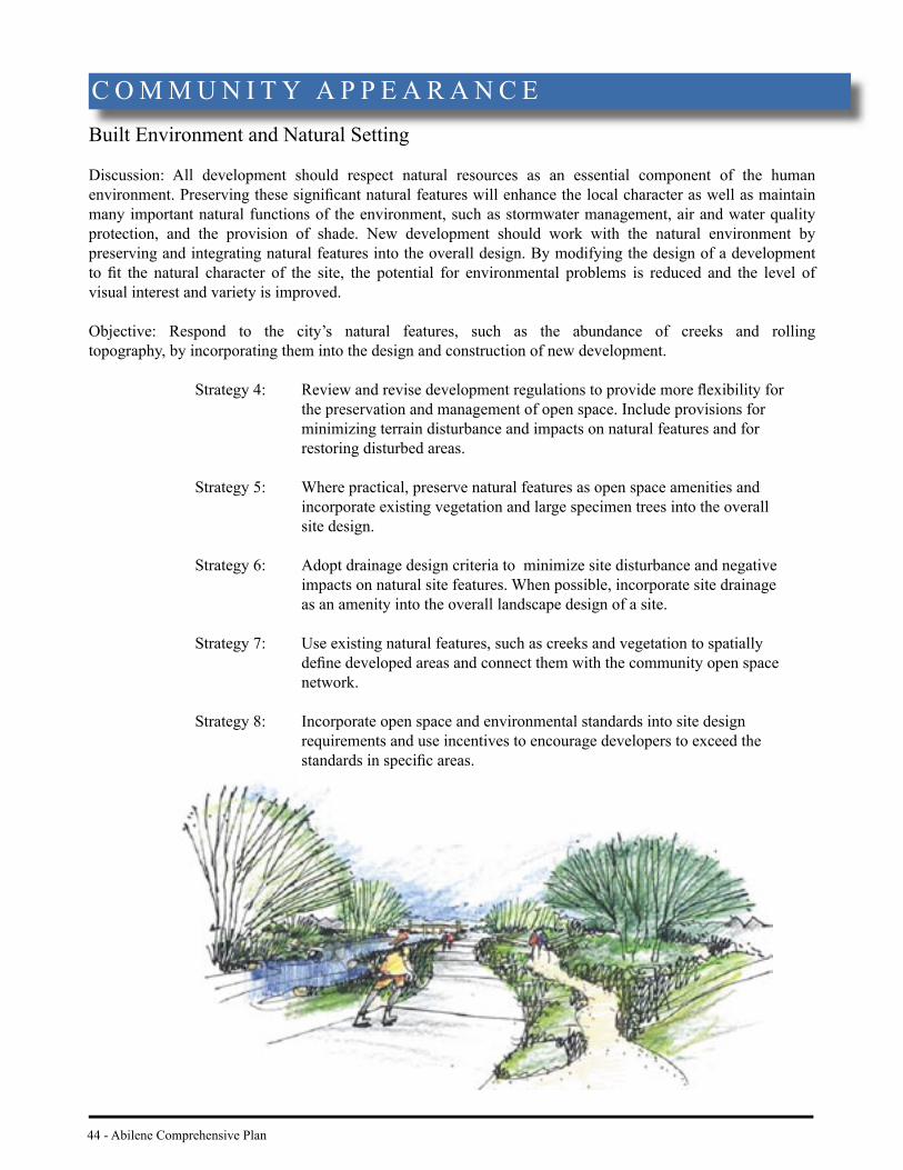
Built Environment and Natural Setting
Discussion: All development should respect natural resources as an essential component of the human environment. Preserving these signifi cant natural features will enhance the local character as well as maintain many important natural functions of the environment, such as stormwater management, air and water quality protection, and the provision of shade. New development should work with the natural environment by preserving and integrating natural features into the overall design. By modifying the design of a development to fi t the natural character of the site, the potential for environmental problems is reduced and the level of visual interest and variety is improved.
Objective: Respond to the city’s natural features, such as the abundance of creeks and rolling topography, by incorporating them into the design and construction of new development.
Strategy 4: Review and revise development regulations to provide more fl exibility for the preservation and management of open space. Include provisions for minimizing terrain disturbance and impacts on natural features and for restoring disturbed areas.
Strategy 5: Where practical, preserve natural features as open space amenities and incorporate existing vegetation and large specimen trees into the overall site design.
Strategy 6: Adopt drainage design criteria to minimize site disturbance and negative impacts on natural site features. When possible, incorporate site drainage as an amenity into the overall landscape design of a site.
Strategy 7: Use existing natural features, such as creeks and vegetation to spatially defi ne developed areas and connect them with the community open space network.
Strategy 8: Incorporate open space and environmental standards into site design requirements and use incentives to encourage developers to exceed the standards in specifi c areas.
C O M M U N I T Y A P P E A R A N C E

Abilene Comprehensive Plan - 45
Streets and Street Design
Discussion: City streets account for a signifi cant portion of the public environment, and their design and appearance are major contributors to the character of Abilene. As the major public spaces by which most residents experience the city, they should be designed in a manner that is visually appealing, functional, and safe. Streetscapes that include shade trees, medians, a variety of landscape materials, and other amenities that are appropriate to arterial, collector, and residential street classifi cations will signifi cantly contribute to the community image.
Objective: Design public streets that are both functional and visually appealing.
Strategy 9: Develop Streetscape Design Standards that create more visually aesthetic and pedestrian-oriented streets. Ensure standards accommodate the range of transportation modes and required street utilities.
Strategy 10: Provide assistance to neighborhood organizations to develop streetscape improvements, such as traffi c calming devices, tree plantings, sidewalk improvements, and lighting.
Strategy 11: Promote street maintenance to preserve and enhance existing streets and streetscapes as a means of retaining the value of past investments and improving that of future capital investments.
Vertical Feature
Landscaped Median/Lighting
Landscaped Curb Extension
Crosswalk
Parallel Parking
46 - Abilene Comprehensive Plan
Landscape
Discussion: Abilene’s landscape includes a variety of trees, shrubs, and grasses, some of which are native to the area and others which have been introduced to the region. From the trees and plantings residents use around homes to the lush tree stands found along many of the city’s creeks, vegetation plays an important role for the city. Not only does vegetation provide shade and beauty, softening the appearance of paved and built areas, but it also plays an important ecological role by keeping the air clean and the climate temperate. The appropriate use of drought-resistant vegetation also helps to foster a unifi ed design for development and helps to blend the built environment with the natural landscape. In order to realize these aesthetic and ecological benefi ts of landscaping, the City should continue to promote the planting and maintenance of appropriate plant materials and xeriscape principles throughout the city.
Objective: Establish and promote community-wide xeriscape landscaping that compliments the surrounding community and environment.
Strategy 12: Update landscape regulations and site plan standards to require the use of xeriscape principles, including the use of a low water use drought-tolerant plant list.
Strategy 13: Promote native vegetation as per the City of Abilene’s Recommended Planting List as the preferred landscaping in order to restore wildlife habitat, conserve water, provide shade and visual relief, and enhance Abilene’s regional identity.
Strategy 14: Expand educational programs and activities that raise community awareness of the benefi ts of urban landscapes and xeriscape principles.
Strategy 15: The City should set the standard for xeriscape landscape principles by continuing to incorporate water-conserving plantings in the City’s capital improvement and maintenance projects.
Strategy 16: Investigate private incentives and public-private cost sharing programs to promote the planting and maintenance of drought-tolerant street trees.
Strategy 17: Expand the role of Keep Abilene Beautiful and other community groups to help defi ne aesthetic standards and create incentives to enhance the urban landscape.
Strategy 18: For new development and redevelopment projects, distinguish the corners of street intersections, particularly gateways and site entries from streets and sidewalks using special landscape treatments.
C O M M U N I T Y A P P E A R A N C E

Abilene Comprehensive Plan - 47
Signage
Discussion: Throughout the planning process, concern was expressed relative to the proliferation of signage within Abilene. Planning participants also expressed concern that many signs, particularly those along major corridors, do not portray an image that is consistent with an aesthetically appealing community. Although signs are necessary to advertise and communicate the location of destinations, they can overpower and dominate an area if not controlled. In addition to adopting a new Sign Ordinance, the City should explore voluntary incentives to encourage property owners and businesses to improve signs that will become non-conforming. When sign owners have little incentive to replace or upgrade nonconforming signs, the City can step in by providing design assistance and possibly cost-sharing programs to stimulate the private sector to upgrade signs with new sign regulations. A mix of regulatory and incentive programs can successfully ensure quality signage that is adequate but not excessive, while still serving its valuable role as an aid to attracting consumer traffi c.
Objective: Improve the effectiveness and quality of business signage.
Strategy 19: Adopt new sign regulations to be incorporated into the City’s development regulations. The objectives of the ordinance should be to:
· Improve the regulation of the size, location, height, appearance, and construction of all permanent and temporary signs;
· Protect property values by creating an attractive and inviting community; and,
· Further the community appearance and economic development objectives of the city.
Strategy 20: Adopt new sign regulations and guidelines that promote signs that are:
· Compatible with and/or improve the physical and architectural character of their surroundings; · Legible and appropriate to the activity to which they pertain;
· Not distracting to motorists;
· Not contributing to visual clutter;
· Constructed and maintained in a structurally sound and attractive condition;
· Limited to the specifi c use or business that is in operation on the premises; and,
· An enhancement to the appearance of the city’s transportation corridors, residential neighborhoods, and business areas.

48 - Abilene Comprehensive Plan
Strategy 21: Develop incentive programs to remove or upgrade nonconforming signs, particularly in locations where the City undertakes roadway and public infrastructure improvements. (See Figure 10)
Strategy 22: Revise development regulations to require that nonconforming signs be removed or upgraded to conform with new sign regulations as a condition of site plan approval.
Strategy 23: Provide more support and resources to enforce sign regulations through the monitoring, investigating, and removal of illegal signs.
C O M M U N I T Y A P P E A R A N C E
Figure 10: Although signs serve a useful purpose, the proliferation of signs in commercial areas can quickly overpower and dominate an area. To reduce visual clutter, the City should work with property owners to improve the appearance of signage.

Abilene Comprehensive Plan - 49
Sidewalks and Pedestrian Links
Discussion: Sidewalks serve a variety of functions in the community. By separating pedestrians from vehicular traffi c, sidewalks improve traffi c fl ow effi ciency for automobiles and provide safety for pedestrians. Sidewalks allow for convenient circulation within residential areas and provide safe pedestrian access to schools, recreational areas, commercial areas, the downtown, universities, and other cultural and community facilities.
Pedestrian and bicycle trips in Abilene are taken primarily for recreation and are generally not used as a primary transportation mode. The sidewalk system in Abilene is discontinuous and parts of it are in need of repair. Walking or bicycling within the city would increase with improved and connected pedestrian and bicycle routes and with the implementation of the Land Use and Development Plan, which designates a range of Activity Centers within reasonable distance to each other and to surrounding neighborhoods.
Objective: Develop a safe pedestrian and bicycle environment that connects residential with commercial and employment areas and community facilities.
Strategy 24: Adopt development regulations to require sidewalks between buildings and through parking lots in Activity Centers to provide more convenience for pedestrians. Also require direct pedestrian walkways when development is adjacent to local bus stops. Wherever walkways cross internal drives and curb cuts, provide a highly-visible, handicapped accessible crosswalk.
Strategy 25: Prioritize and develop pedestrian walkways, sidewalks, crosswalks, handicap accessible ramps, and curb cuts along city streets in areas with signifi cant pedestrian traffi c, such as around schools, parks, retail districts, and other activity areas.
Strategy 26: Use signage, striping, and/or special paving to facilitate convenient and safe bicycle and pedestrian crossings at traffi c signals.
Strategy 27: Explore funding opportunities, such as grant programs, to develop pedestrian paths along drainageways, such as Cedar Creek. Require new development to provide pedestrian connections to the Council approved pathway system.
Strategy 28: Require new development and redevelopment at designated Activity Centers, such as shopping areas and employment centers, to provide bicycle racks at convenient locations for bicyclists.
Strategy 29: Prohibit the building of walls, fences, or berms that would create barriers to pedestrians. Where feasible, create breaks in existing barriers to provide cross-access for pedestrians.

50 - Abilene Comprehensive Plan
Preservation
Discussion: Adopted in 1999, the City of Abilene’s Historic Preservation Plan is a preservation guide to encourage the recognition and preservation of signifi cant historical, architectural, and cultural sites and structures. It is the goal of the Plan to promote and safeguard the city’s heritage, encourage the uniqueness of neighborhood character by conservation, and foster civic pride in the accomplishments of the past.
Objective: Preserve and promote the area’s historic and cultural resources.
Strategy 30: Identify and protect buildings, districts, and sites of historical, cultural, archaeological, paleontological, or architectural importance.
Strategy 31: Use incentives to encourage private sector preservation and rehabilitation of historic and cultural resources. Provide staff support to assist property owners in preparing applications to designate their properties as historic landmarks.
Strategy 32: Use planning regulations, such as demolition control and preservation standards, to formally recognize and protect historic and cultural resources.
Strategy 33: Work with neighborhood organizations to designate neighborhoods as historic or conservation districts and apply the appropriate preservation standards.
C O M M U N I T Y A P P E A R A N C E
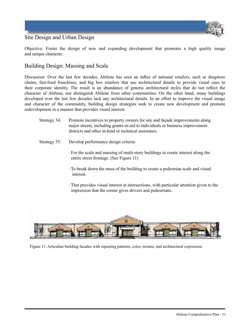
Abilene Comprehensive Plan - 51
Site Design and Urban Design
Objective: Foster the design of new and expanding development that promotes a high quality image and unique character.
Building Design: Massing and Scale
Discussion: Over the last few decades, Abilene has seen an infl ux of national retailers, such as drugstore chains, fast-food franchises, and big box retailers that use architectural details to provide visual cues to their corporate identity. The result is an abundance of generic architectural styles that do not refl ect the character of Abilene, nor distinguish Abilene from other communities. On the other hand, many buildings developed over the last few decades lack any architectural details. In an effort to improve the visual image and character of the community, building design strategies seek to create new development and promote redevelopment in a manner that provides visual interest.
Strategy 34: Promote incentives to property owners for site and façade improvements along major streets, including grants-in-aid to individuals or business improvement districts and other in-kind or technical assistance.
Strategy 35: Develop performance design criteria:
· For the scale and massing of multi-story buildings to create interest along the entire street frontage. (See Figure 11)
· To break down the mass of the building to create a pedestrian scale and visual interest.
· That provides visual interest at intersections, with particular attention given to the impression that the corner gives drivers and pedestrians.
Figure 11: Articulate building facades with repeating patterns, color, texture, and architectural expression.

52 - Abilene Comprehensive Plan
Building Placement
Discussion: An important element of all architecture and site design is the physical defi nition of streets and public spaces as places of shared use. Many portions of the city’s commercial corridors are composed of deteriorating and obsolete development characteristic of the commercial “strip” with recessed buildings and seas of parking. Streets lined by buildings rather than parking lots are more visually interesting to move along, and provide a safer environment for pedestrians.
Strategy 36: Revise setback ordinances to allow the location of buildings close to streets, with off-street parking provided behind and/or beside buildings.
Strategy 37: In conjunction with other performance criteria for intersections, use the placement of buildings rather than parking, loading, or services to achieve visual interest at the corner.
C O M M U N I T Y A P P E A R A N C E

Abilene Comprehensive Plan - 53
Parking
Discussion: Cars play a primary role in the everyday life of Abilene residents, so it is important to provide adequate and convenient space for them. The typical suburban pattern of predominant and highly-visible parking lots, however, contributes to a formless and often bleak image or “sea of parking.” Placing large amounts of parking between the front door of buildings and the adjacent street creates a negative visual impact for drivers and pedestrian alike. The following strategies are intended to make parking lots less obtrusive by reducing the scale of parking areas and thereby reducing their overall visual impact.
Strategy 38: To the maximum extent practical, locate parking lots behind buildings, in the interior of a block, or create buffers to ensure parking lots do not dominate the street frontage.
Strategy 39: Revise development regulations to accommodate shared parking between adjacent or mixed uses whose peak demand is off-set from each other, such as offi ces and housing.
Strategy 40: Develop design criteria to:
· Ensure that large surface parking lots are visually and functionally segmented into several smaller lots. (See Figure 12)
· Provide visual buffers, to the maximum extent practical, between parking lots and adjacent streets and sidewalks where they adjoin.
Figure 12: The addition of landscaping improves the overall look and feel of parking areas by providing an attractive environment along the street and minimizing the expansive appearance of a parking lot. Landscaping should include native or well-adapted drought tolerant vegetation, often referred to as xeriscaping.

Internal Vehicular Circulation and Access
Discussion: Given that the automobile is the primary mode of transportation for Abilene residents, it is critical that safe, effi cient, and convenient vehicular access and circulation patterns exist within and between developments. Internal vehicle circulation patterns should provide a clear and direct path from entry drives to building entrances and parking areas.
Strategy 41: Where feasible, locate internal access drives to connect existing public streets and/ or connect to adjacent private drives. By joining access points, the internal circulation pattern functions as an integral part of the surrounding transportation network.
Strategy 42: Where possible, join adjacent parking lots and record cross-access easements to provide vehicular links to abutting properties.
Strategy 43: Minimize driveway access along arterial streets by sharing vehicular access with adjacent properties and/or utilizing alleys for access.
Strategy 44: Adopt access management regulations for ingress and egress.
C O M M U N I T Y A P P E A R A N C E
54 - Abilene Comprehensive Plan

Abilene Comprehensive Plan - 55
Lighting
Discussion: Lighting is an important element in providing safe and visible pedestrian and vehicular access to and within a development. Attractive lighting fi xtures and layout patterns can also contribute to a more positive architectural image or character for developed areas.
Strategy 45: Use lighting that will provide uniform visibility while avoiding light pollution and spillover onto adjacent properties and streets.
Strategy 46: Use lighting fi xtures to enhance visual interest.
Strategy 47: Design lighting standards to illuminate sidewalks and walkways using low intensity fi xtures that provide an even distribution of light.
56 - Abilene Comprehensive Plan
N E I G H B O R H O O D SIntroduction
Neighborhoods are the basic building blocks that make up the larger community of Abilene. They are the places where we live, shop, play, and sometimes work. We often use the characteristics of our individual neighborhoods - from the quality of our schools to the conditions of our houses - to describe our quality of life. Accordingly, preserving and enhancing the quality of neighborhoods was a primary value espoused by participants in the planning process.
Abilene has a diverse collection of neighborhoods. Since neighborhoods in the northern and central part of the city are older, these areas face distinctly different challenges than their counterparts in newer areas in southern parts of the city. Plan policies refl ect this diversity of needs by (1) defi ning types of existing neighborhoods and, on the basis of that defi nition, providing direction to protect, enhance, and/or revitalize them; and, (2) supporting the development of new residential areas as well-functioning neighborhoods.
Neighborhood policies also build on a growing momentum within the community to create positive change at the neighborhood level. Increasingly, Abilene residents are enabling themselves to address community needs by focusing on improvements to individual neighborhoods and establishing strong communication links with City government. Over the past several years, residents of both the Carver and the Sears neighborhoods have successfully partnered with the City to develop neighborhood revitalization plans.
G O A L : P R E S E RV E A N D E N H A N C E T H E Q U A L I T Y O F E X I S T I N G A N D N E W N E I G H B O R H O O D S A S P L A C E S T O L I V E , W O R K , S H O P, A N D R E C R E AT E .

Abilene Comprehensive Plan - 57
Neighborhood Organization
Discussion: In response to the growing need of residents to cooperatively address neighborhood issues, the City has created an Offi ce of Neighborhood Services (ONS) to provide planning services for existing and future neighborhoods. The ONS is founded on fi ve principles to: (1) build and support neighborhood leadership; (2) change the community mindset to advocate neighborhoods; (3) secure a resource commitment for neighborhoods; (4) focus service efforts on achieving neighborhood stability; and, (5) respect neighborhood identity. The technical assistance available through the ONS supports neighborhood self-determination, customized solutions for meeting local needs, and gives neighborhoods a voice in how City resources are utilized for infrastructure and other physical improvements.
Objective: Promote neighborhoods as the central organizing element of the city.
Strategy 1: Train and engage residents, property owners, churches, and neighborhood-based organizations in the planning and prioritization of land development, infrastructure, and services.
Strategy 2: Establish community partnerships with public and private non-profi t entities, such as schools, churches, universities, and service clubs to build neighborhood support systems.
Strategy 3: Incorporate the network of neighborhood-based organizations into the City’s decision-making processes that affect planning and revitalization at the neighborhood level.
Strategy 4: Construct the City’s development review systems so as to give preferences for fi nancial and process incentives to developments that advance neighborhood objectives.

Final Comprehensive Plan Maps
are available as separate PDF files
www.abilenetx.com
Existing Land Use: City Limits Map (pg. 10-11)
Existing Land Use: City Center Map (pg. 12-13)
Future Land Use Development Plan (pg 16-17)
Vacant and Undeveloped Land (pg 24-25)
ETJ and County Boundaries (pg 40-41)
Super Neighborhood Boundaries (pg 58-59)
Existing Community Facilities (pg 68-69)
Sensitive Development Areas (pg 80-81)


60 - Abilene Comprehensive Plan
N E I G H B O R H O O D S
Figu
re 1
3: E
xam
ple
of a
mor
e de
taile
d Su
per N
eigh
borh
ood
Are
a pl
an.

Abilene Comprehensive Plan - 61
Neighborhood Planning
Discussion: Vibrant neighborhoods contain a variety of housing opportunities as well as neighborhood-oriented activity centers with the essential uses and services that meet the daily needs of local residents. These may consist of such diverse facilities as a small grocery store, drug store, elementary school, day care, church, and smaller offi ce spaces. By focusing commercial activities at a single location, neighborhood residents can access many of their daily shopping and service needs in a single trip.
Neighborhoods should have a strong pedestrian orientation. A lattice of sidewalks, walking and bicycle trails, attractive public venues, and transit stops should accommodate the shopping, employment, school and recreational needs of residents. A pedestrian focus also serves the important socio-interactive purpose of bringing people to street level where neighborhood bonds are created and a sense of safety and security develops.
During the neighborhood planning process, the City should direct medium to high-density residential development, such as apartments, duplexes, and townhomes, to areas immediately surrounding the more intense activity centers. A proximate residential base will help sustain neighborhood businesses and promote the walkability of the neighborhood.
Objective: Create Super Neighborhood Areas (SNAs) that are manageable units for land use, transportation, facility, demographic, and growth analysis and planning.
Strategy 5: Use Super Neighborhood Areas, as identifi ed in the Super Neighborhood Boundary Map and illustrated in Figure 13, for neighborhood planning and neighborhood assistance programs, and to provide a context for the evaluation of development proposals. Super Neighborhood Areas should be contiguous sections of the city that are composed of one or more residential neighborhoods with relatively consistent development characteristics and sensitivity to impacts from external sources, and of a size that allows for effective governance.
Strategy 6: Through the Super Neighborhood planning process, identify or designate the activity center(s) serving the daily needs of residents for each component neighborhood. Harmonize the design of the center(s) with the Activity Center strategies established in the Land Use and Development element.
Strategy 7: Distinguish the resource needs of the Super Neighborhood Areas (SNAs) by classifying them into three defi ning categories: Established Stable; Established Redeveloping; and, New and Developing.
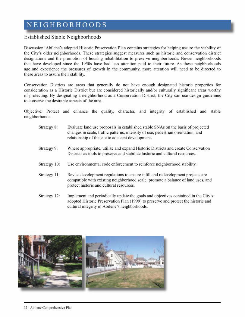
62 - Abilene Comprehensive Plan
N E I G H B O R H O O D SEstablished Stable Neighborhoods
Discussion: Abilene’s adopted Historic Preservation Plan contains strategies for helping assure the viability of the City’s older neighborhoods. These strategies suggest measures such as historic and conservation district designations and the promotion of housing rehabilitation to preserve neighborhoods. Newer neighborhoods that have developed since the 1950s have had less attention paid to their future. As these neighborhoods age and experience the pressures of growth in the community, more attention will need to be directed to these areas to assure their stability.
Conservation Districts are areas that generally do not have enough designated historic properties for consideration as a Historic District but are considered historically and/or culturally signifi cant areas worthy of protecting. By designating a neighborhood as a Conservation District, the City can use design guidelines to conserve the desirable aspects of the area.
Objective: Protect and enhance the quality, character, and integrity of established and stable neighborhoods.
Strategy 8: Evaluate land use proposals in established stable SNAs on the basis of projected changes in scale, traffi c patterns, intensity of use, pedestrian orientation, and relationship of the site to adjacent development.
Strategy 9: Where appropriate, utilize and expand Historic Districts and create Conservation Districts as tools to preserve and stabilize historic and cultural resources.
Strategy 10: Use environmental code enforcement to reinforce neighborhood stability.
Strategy 11: Revise development regulations to ensure infi ll and redevelopment projects are compatible with existing neighborhood scale, promote a balance of land uses, and protect historic and cultural resources.
Strategy 12: Implement and periodically update the goals and objectives contained in the City’s adopted Historic Preservation Plan (1999) to preserve and protect the historic and cultural integrity of Abilene’s neighborhoods.
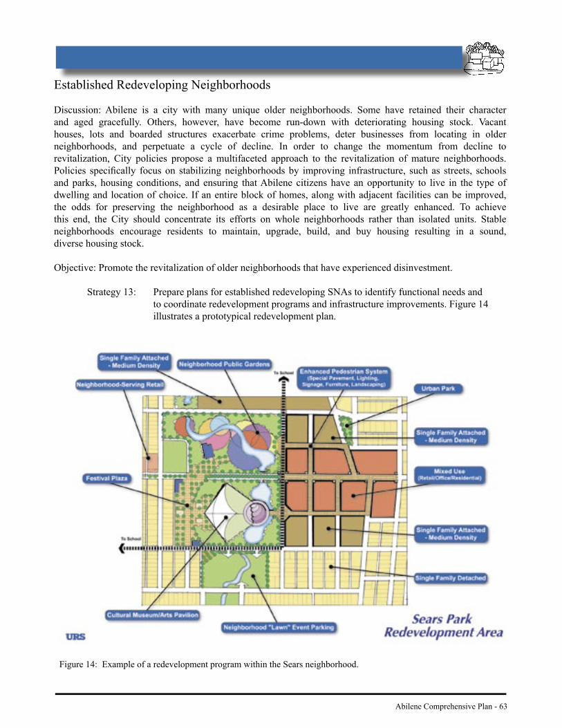
Abilene Comprehensive Plan - 63
Established Redeveloping Neighborhoods
Discussion: Abilene is a city with many unique older neighborhoods. Some have retained their character and aged gracefully. Others, however, have become run-down with deteriorating housing stock. Vacant houses, lots and boarded structures exacerbate crime problems, deter businesses from locating in older neighborhoods, and perpetuate a cycle of decline. In order to change the momentum from decline to revitalization, City policies propose a multifaceted approach to the revitalization of mature neighborhoods. Policies specifi cally focus on stabilizing neighborhoods by improving infrastructure, such as streets, schools and parks, housing conditions, and ensuring that Abilene citizens have an opportunity to live in the type of dwelling and location of choice. If an entire block of homes, along with adjacent facilities can be improved, the odds for preserving the neighborhood as a desirable place to live are greatly enhanced. To achieve this end, the City should concentrate its efforts on whole neighborhoods rather than isolated units. Stable neighborhoods encourage residents to maintain, upgrade, build, and buy housing resulting in a sound, diverse housing stock.
Objective: Promote the revitalization of older neighborhoods that have experienced disinvestment.
Strategy 13: Prepare plans for established redeveloping SNAs to identify functional needs and to coordinate redevelopment programs and infrastructure improvements. Figure 14 illustrates a prototypical redevelopment plan.
Figure 14: Example of a redevelopment program within the Sears neighborhood.
64 - Abilene Comprehensive Plan
Strategy 14: Establish performance standards for infi ll development that respect the scale and character of the neighborhood.
Strategy 15: Provide incentives to encourage infi ll and redevelopment in distressed neighborhoods. Use the following regulatory and fi nancial tools to leverage additional investment in established redeveloping SNAs and promote homeownership:
· Locally funded exterior rehabilitation programs to improve the structural and aesthetic condition of existing housing.
· Areawide zoning reclassifi cations when consistent with neighborhood redevelopment plans.
· Financial incentives, such as rehabilitation loans/grants, offsets of development fees, and tax-advantaged project fi nancing. · Federal, state, and local funds to rehabilitate dilapidated residential structures occupied by lower income residents.
Strategy 16: Revise development regulations to include incentives designed to encourage rehabilitation over demolition.
Strategy 17: Apply environmental code enforcement measures in conjunction with the City’s community policing program to arrest patterns of decline.
Strategy 18: Where appropriate, use the siting of public facilities in neighborhoods as a catalyst for increased public investment.
Objective: Maintain and support local schools as community assets that are central to the stability of neighborhoods.
Strategy 19: In consultation with the Abilene Independent School District and Wylie Independent School District, devise small-area plans that strengthen the neighborhood-school link with methods designed to:
· Improve walkability.
· Enhance housing location and transportation choices for low-income and minority populations.
· Arrest and stabilize land use transition.
· Increase residential density in proximity to the school.
· Create opportunities for the school to serve the neighborhood in multiple ways.
Strategy 20: Develop small-area plans for neighborhoods with vacant school facilities that will open up new opportunities for compatible productive reuse of the facility and that forge new links between residents and the former school site.
N E I G H B O R H O O D S

Abilene Comprehensive Plan - 65
New and Developing Neighborhoods
Discussion: A mix of housing types within a neighborhood provides residential opportunities for a wide variety of people, including singles, young families, elderly persons, large families, childless couples, owners, and renters. Healthy vibrant neighborhoods include housing for individuals and families throughout the various stages of life. Rather than moving to a different neighborhood as household needs change, residents should be afforded the opportunity to choose from a variety of housing types within a Super Neighborhood Area. The stability of a neighborhood is enhanced when a single area can meet the needs of diverse and changing households - rather than households moving to fi nd better schools or different housing types. Planning for diverse housing opportunities requires the distribution of a variety of housing types and densities throughout the city.
Objective: Develop new neighborhoods that achieve a balanced mix of land uses and reinforce a sense of place.
Strategy 21: Provide fi nancial and process incentives to development in new and developing SNAs that conform to the infi ll and resource management policies of the Comprehensive Plan.
Strategy 22: Through negotiations, reserve land for future development in new neighborhoods if appropriate to achieve a balanced mix of land uses over time.
Strategy 23: Revise development regulations and design standards to encourage a variety of housing types, styles, and densities in new and developing SNAs to accommodate the needs of a wider socioeconomic cross section of the community.
Strategy 24: Update development regulations to improve street, bicycle and pedestrian connectivity between new and developing SNAs and their attendant commercial centers, public spaces, and parks.

66 - Abilene Comprehensive Plan
Introduction
Community facilities and services affect the quality of life in Abilene. The City of Abilene has endeavored to provide the highest level of services for city residents with the least cost. Survey responses received during the Comprehensive Planning effort reveal that residents generally have a high regard for the way the City delivers public services. Roadways, transportation, infrastructure, parks and recreation, schools, police and fi re, and libraries, along with other services and facilities, work together to maintain a healthy and stable living environment for all members of the community. The map on page 68 illustrates existing community facilities and services.
Anticipated future growth and changing community needs could affect the overall quality of these facilities and services. One of the greatest challenges facing the City in the future will be how to maintain or replace existing infrastructure and fund expansion of capital facilities required to serve development, without reducing the levels of service provided to residents. Only through on-going strategic planning can the City proactively address demands for new infrastructure and services, as well as improvements to the existing systems, as prompted by changing expectations of the community.
C O M M U N I T Y S E RV I C E S A N D F A C I L I T I E S
G O A L : P R O V I D E C O M M U N I T Y F A C I L I T I E S A N D S E RV I C E S ( F I R E , P O L I C E , H E A LT H A N D S A F E T Y, S C H O O L S , E T C . ) T H AT E F F I C I E N T LY A N D F A I R LY S E RV E T H E C O M M U N I T Y.

Abilene Comprehensive Plan - 67
Roadways
Discussion: The roadway network is the cornerstone of the city’s transportation system. Because the private automobile will remain the primary mode of transportation for residents into the future, it is important that the roadway network continue to meet the demands of Abilene residents and businesses in a safe and effi cient manner, while accommodating other modes of transportation, such as buses and bicycles. At the same time, the land use patterns identifi ed in the Land Use and Development Plan require a shift in thinking about how and where the roadway network expands. Redirecting new development and redevelopment activities to strategic Activity Centers may mean a shift in resource investments in order to support the City’s desired future land use pattern. The City should consider balancing demand for construction at the urban fringe and improving existing roadway infrastructure within the central city.
Objective: Provide a safe and effi cient roadway system for the movement of persons, goods and services.
Strategy 1: Re-evaluate and update the Thoroughfare Plan to refl ect current and future needs for the roadway network, including identifying all freeways, arterials, collectors, and local streets.
Strategy 2: Facilitate the formation of special improvement districts to fi nance the construction of needed roadway and easement improvements in established and developing areas.
Strategy 3: Require roadway improvements prior to, or concurrent with, the construction of new residential, commercial, or industrial development.
Strategy 4: Design roadways to create safe, attractive, driving and walking environments. Retrofi t selected arterials and collectors as boulevards, parkways, or enhancement corridors. Provide landscaping in medians or along the sides of the road. Utilize traffi c calming devices on local streets to achieve desired effect.
Strategy 5: Encourage alternative transportation options including reserved parking for car pooling, van pooling, or bicycle usage during site review.
Strategy 6: Support public awareness campaigns, focusing attention on the social, environmental, and economic impacts and costs of travel choices.

Final Comprehensive Plan Maps
are available as separate PDF files
www.abilenetx.com
Existing Land Use: City Limits Map (pg. 10-11)
Existing Land Use: City Center Map (pg. 12-13)
Future Land Use Development Plan (pg 16-17)
Vacant and Undeveloped Land (pg 24-25)
ETJ and County Boundaries (pg 40-41)
Super Neighborhood Boundaries (pg 58-59)
Existing Community Facilities (pg 68-69)
Sensitive Development Areas (pg 80-81)


70 - Abilene Comprehensive Plan
Mobility
Discussion: Land use and transportation are fundamentally interrelated. Low-density development spreads the city over a greater area, causing the need to construct more miles of roads. As more roads are developed, new areas along the urban fringe are opened up for development. This pattern of sprawling development results in an expensive transportation network that is increasingly diffi cult to sustain. While the City recognizes that auto access will continue to be a key element in accommodating new growth, the development of pedestrian-oriented Activity Centers, linked by Community Enhancement Corridors, a grid street pattern, and off-street pedestrian and bicycle trails can facilitate a greater range of mobility choices and temper the long term costs of maintaining a street system.
Objective: Accommodate alternative means of transportation such as public transit, bicycling, and walking.
Strategy 7: Assess and plan for the transit needs of Abilene residents and provide improved bus services and facilities that adequately serve the travel needs of commuters and transit-dependent groups.
Strategy 8: Revise regulations to accommodate mixed-use and higher density developments that provide employment opportunities in proximity to residential areas in order to reduce commuting times, improve air quality, and to increase travel by foot, bicycle, and bus.
Strategy 9: Designate key pedestrian streets within the highest-density portions of activity and neighborhood centers. Design and operate these streets to be safe and attractive for pedestrians, improve access to transit, encourage street-level activity, and facilitate social interaction. Integrate pedestrian facilities into future improvements on these streets.
Strategy 10: Develop and improve new pedestrian facilities throughout the city. Provide recommended school walking routes, access to buses, access for people with disabilities, and access to and within Activity Centers and neighborhood environments.
Strategy 11: Incorporate the Abilene Pedestrian Trails Plan into a new Parks Master Plan. Maintain direct, continuous bicycle routes, and make all appropriate streets bicycle-friendly. Accelerate development of bicycle facilities in, around, and between mixed-use Activity Centers, residential neighborhoods, and other key locations. Facilitate bicycling, where appropriate, with separate trails or bicycle lanes.
Strategy 12: All new development should provide an integrated system of walkways consistent with and linked to existing and planned city sidewalks and trails shown in the Parks Master Plan. All development submittals should delineate and dedicate connections to the city’s existing pedestrian system or Council approved pedestrian plan.
Strategy 13: Provide well-designed pedestrian crossings of major arterial roadways.
C O M M U N I T Y S E RV I C E S A N D F A C I L I T I E S

Abilene Comprehensive Plan - 71
Airport
The Abilene Regional Airport is a community asset for local businesses and residents alike. Maintaining and enhancing this facility is an important impetus for economic development. Therefore, land use decisions should support the continued growth of the Airport and airport related businesses.
Objective: Develop the Abilene Regional airport and its environs to support the aviation needs of businesses and residents.
Strategy 14: Capitalize on the airport as a catalyst for new compatible development, such as industrial and employment uses in appropriate areas adjacent to the airport.
Strategy 15: Ensure that development regulations and plans are consistent with the policies and short- and long-term development strategies contained in the Airport Master Plan. Strategy 16: Coordinate with Taylor County to strictly limit and manage new development to uses and densities that are appropriate for and compatible with the Airport’s protection zones.

72 - Abilene Comprehensive Plan
Expansion of Infrastructure Services
Discussion: The City of Abilene has made tremendous progress in meeting the challenges of the West Texas climate. Construction of the Ivie pipeline and a new treatment plant guarantees that the city will have an adequate supply of water to meet demand in the next quarter century. But such large-scale infrastructure comes at a cost. It affects the ability to respond to normal pressures for expansion and maintenance on other parts of the system. Prudent management requires using both the resource and the system in the most effi cient manner possible.
A similar case can be made for other infrastructure systems. The high marginal cost of an expanded system is the driving factor in the creation of the Land Use and Development Plan, which emphasizes concentrated development and support for maintaining resources in the urbanized sections of the city. Objective: Coordinate the effi cient planning and provision of infrastructure services that balance the City’s costs, achieving desired growth, and effects upon the development market.
Strategy 17: Support efforts for procurement of water rights, usage, and infrastructure upkeep as set forth by the City of Abilene Water Department and the strategies of the ACE Report in a manner consistent with the Comprehensive Plan.
Strategy 18: Distribute the costs of new infrastructure improvements in a manner that furthers the goals of the Comprehensive Plan, using methods and incentives that:
· Improve the economic viability of infi ll and redevelopment projects by providing fi nancial, infrastructure, regulatory an other incentives for such projects. · Provide for the equitable distribution of costs for the extension of water, sewer, and street systems.
C O M M U N I T Y S E RV I C E S A N D F A C I L I T I E S

Abilene Comprehensive Plan - 73
Parks, Recreation, and Open Space
Discussion: An important factor in the quality of life of any city is the availability and variety of parks and recreation facilities. The City of Abilene maintains a system of twenty-nine parks including the award-winning Union Pacifi c right-of-way— 40 acres of open space running adjacent to downtown. Residents of Abilene are the benefi ciaries of this park system which provides diverse recreation opportunities for the entire community. Not only does open space improve the quality of life of the city’s neighborhoods, but it also serves a valuable role in enhancing the image of the entire community. As the City moves closer to realizing desired future land use patterns, it is important that the distribution of open space, parks and recreational opportunities are equitably dispersed throughout the community.
Objective: Provide a balanced system of parkland and recreational facilities.
Strategy 19: Review and update the City’s Parks Master Plan to ensure that parks, open space, and recreation facilities are equitably distributed throughout the community to meet the needs of current and future residents. Ensure that the Plan update achieves the following objectives:
· Creates Park Classifi cation and Park Standards that designates the size and service area of city parks, along with the typical development in these parks.
· Identifi es land and easements the City should obtain to establish a community-wide network of trails.
· Identifi es suitable historical, cultural, and environmentally sensitive lands to preserve for passive recreation.
Strategy 20: Integrate short and long-term projects identifi ed in the Parks Master Plan into the capital improvement program.
Strategy 21: Acquire and develop parks in conjunction with other public facilities projects such as stormwater improvements, libraries and schools.

74 - Abilene Comprehensive Plan
Schools
Discussion: The Abilene Independent School District and the entire community of Abilene is grappling with a crisis faced nationwide - the consolidation of neighborhood school campuses based on programmatic and funding constraints and declining enrollments. From a neighborhood standpoint, school closings have a two-fold impact: they impact the stability of older neighborhoods and they disconnect students and families from the basic building block of the community - the neighborhood. If possible, this scenario should be avoided. For developing areas of the Wylie Independent School district, proactive application of neighborhood-oriented land use and development now can ward off similar problems for that district in the future.
Objective: Emphasize the role of schools in determining land use and as an organizing element for neighborhood stability and revitalization.
Strategy 22: Plan for the location of new schools that further the policies of the Comprehensive Plan.
Strategy 23: Maximize resources by joint utilization of City and school district facilities.
Strategy 24: Increase the value of schools to their respective neighborhoods through public investment in street improvements, sidewalk construction, and similar infrastructure.
Strategy 25: Prioritize and preserve historic school structures and maintain these facilities where possible for continued use as a school or other appropriate use. Strategy 26: When necessary, adapt the re-use of schools to comply with adopted neighborhood plans and/or the Neighborhood element of the Comprehensive Plan.
C O M M U N I T Y S E RV I C E S A N D F A C I L I T I E S

Abilene Comprehensive Plan - 75
Police and Fire Service
Discussion: According to a majority of residents surveyed, the City of Abilene provides high quality police and fi re protection services throughout the community. However, resources are increasingly being stretched further from the central city, as police and fi re personnel are called upon to serve growing areas on the urban fringe. A more focused land use pattern can reverse this trend by concentrating new development and the attendant demand for, safety and security resources, to highly urbanized areas of the city. A more sustainable land use pattern will assure the continued provision of police and fi re services that meet desired performance standards.
Objective: Provide for current and future police and fi re services needs in accordance with optimum levels of performance that balance the City’s costs, achieving desired growth, and effects upon the development market.
Strategy 27: Include the Fire and Police Departments in the development review process.
Strategy 28: Submit requests for annexation to the Fire and Police Departments to assess the impact upon performance and the need for future fi re/police station sites. Where needed, include contributions of land or capital for community facilities in site development review.
Strategy 29: Ensure the new development in the extraterritorial jurisdiction that may be annexed into the City complies with current City building and fi re codes and subdivision regulations.
Strategy 30: Include community policing, public education, crime prevention, and neighborhood watch programs as essential resources in the Offi ce of Neighborhood Services.
76 - Abilene Comprehensive Plan
Libraries
Discussion: Like many communities, Abilene’s libraries offer a variety of community-oriented activities and services. These facilities are community assets that are enjoyed by both the young and old and undoubtedly add to the quality of life enjoyed by Abilene residents. Libraries can serve as focal points and public gathering places for neighborhoods. Based on existing and future land use patterns, the City should consider opportunities to locate library facilities or services in neighborhoods and in Activity Centers where they are conveniently located and easily accessible.
Objective: Provide for current and future library services in accordance with identifi ed needs of the community.
Strategy 31: Work closely with the Abilene Public Library and the Big Country Library System in the future planning and development of library facilities.
Strategy 32: Locate adjunct library facilities in designated Neighborhood and Local Activity Centers that support the core acitivities of those areas.
Strategy 33: Work with the Abilene Public Library to plan for and develop joint library/school facilities.
C O M M U N I T Y S E RV I C E S A N D F A C I L I T I E S

Abilene Comprehensive Plan - 77
78 - Abilene Comprehensive Plan
Introduction
The citizens of Abilene place a high priority on the city’s natural environment - a resource that encompasses a host of resource management issues including: water quality, stormwater and water conservation; open space; natural drainageways, environmental and fl ooding hazards and constraints. While individually, the policies contained in this element of the Comprehensive Plan can yield signifi cant environmental improvements, a synergistic approach that combines a number of policies and strategies can deliver even greater environmental benefi ts. For instance, the Community Appearance element of the Plan contains policies that seek to lessen the environmental impacts of individual development projects through such means as incorporating natural features into new development.
On a larger scale, development patterns and practices also indirectly affect environmental quality. Policies of the Land Use and Development element support infi ll and redevelopment over the historic trend of dispersed growth along Abilene’s southern boundary. As development becomes more dispersed, larger areas of impervious surfaces such as concrete or asphalt reduce the city’s natural ground cover. This in turn increases stormwater runoff that leads incrementally to the pollution of water supplies. Proper infi ll development accommodates new growth with signifi cantly less impervious surface per unit of development than typical development at the urban periphery. A land use pattern that promotes infi ll and redevelopment will use land more effi ciently and decrease the need for new roads and parking lots. Conventional patterns of development, characterized by very low densities and single land uses, without the benefi t of effi cient public transportation not only consume more land, but also foster a greater reliance on automobiles. As development disperses, people must drive farther to reach their destinations. Societal costs increase with longer commuting times, greater fuel consumption, and air pollution.
Public awareness and actions regarding conservation, preservation, and stewardship of these resources will enhance the community’s quality of life and foster the economic well being of the region. Natural resource concerns reach beyond the city limits. Addressing these issues successfully requires citizens and government agencies to determine the value such resources hold for the local and regional community. The goals, policies, and implementation strategies contained in this Plan element seek to identify, plan for, and manage Abilene’s limited but valued natural resources. The Sensitive Development Areas map on page 80 illustrates a number of environmental constraints within Abilene.
N AT U R A L E N V I R O N M E N T A N D R E S O U R C E S
G O A L : P R E S E RV E A N D S U S TA I N L I M I T E D N AT U R A L R E S O U R C E S .

Abilene Comprehensive Plan - 79
Water Conservation
Discussion: Water is a vital resource for human life and a healthy environment and economy. Nowhere is the issue of natural resource management more evident in Abilene than in the discussion of the region’s long-range water supply, a prized and essential resource in west Texas. The protection and careful use and planning of the water supply was of paramount concern to citizens throughout the planning process. This requires a delicate balance of values, interests, opportunities, and constraints. Water conservation practices will be promoted and required through restrictions on water intensive land uses, expanding the use of reclaimed water; and, the use of drought-tolerant landscaping. The residents and government of Abilene must recognize and emphasize the importance of education about water conservation, water quality, water management, and re-use as well as efforts to acquire new water sources. Objective: Conserve and protect water resources in both the public and private sector.
Strategy 1: Strengthen and expand the City’s Water Conservation Plan by updating and amending site plan development regulations to require the use of water conservation practices and use of xeriscape standards for landscaping and irrigation systems.
Strategy 2: Expand citywide programs for the re-use of water:
· Where applicable, include self-designed water reuse systems in development plans for consumers of large quantities of water; and,
· Expand the use of reclaimed water for large non-residential consumptive uses that do not require potable water.
Strategy 3: Continue to develop and implement programs for new sources of water.
Figure 15: The City should pursue the development of park facilities and multi-use trails within the open space network, as well as other recreational amenities such as campsites.

Final Comprehensive Plan Maps
are available as separate PDF files
www.abilenetx.com
Existing Land Use: City Limits Map (pg. 10-11)
Existing Land Use: City Center Map (pg. 12-13)
Future Land Use Development Plan (pg 16-17)
Vacant and Undeveloped Land (pg 24-25)
ETJ and County Boundaries (pg 40-41)
Super Neighborhood Boundaries (pg 58-59)
Existing Community Facilities (pg 68-69)
Sensitive Development Areas (pg 80-81)


82 - Abilene Comprehensive Plan
Open Space
Discussion: Open spaces, natural areas, and greenways are places to play, to relax, to enjoy the natural environment and to connect socially with others in the community. They can defi ne a neighborhood; provide a cultural or historical focal point; provide recreational opportunities or alternative transportation routes; and serve as buffers between urban and rural areas. In addition, open spaces serve to protect environmentally sensitive lands from potentially harmful effects of urban development and enhance the overall quality of life valued by residents of Abilene. Open space can also provide habitat for the wide range of animals and plants found in the region.
Objective: Provide a balanced system of connected open lands, natural areas, and greenway corridors.
Strategy 4: Establish an accessible interconnected open space network throughout the region in order to permanently connect Fort Phantom Lake, Kirby Lake, and other signifi cant resource areas. Evaluate the use of Fort Phantom Lake and Lake Kirby special activity centers as anchors for the network by maximizing their recreation and tourism potential including the feasibility of compatible residential and commercial development. Strategy 5: Use natural drainageways as the backbone of the interconnected open space network.
Strategy 6: Coordinate the open space network with the City’s Parks Master Plan and implement it through cooperative public and private efforts.
· Initiate plans and actions for an ongoing, orderly open space acquisition process and maintenance program based on long-range plans with continued review and evaluation. Identify and establish sources of funding for acquisition and management programs, including state and federal assistance.
· Implement subdivision practices to further acquisitions of the open space network, and provide incentives to property owners who voluntarily contribute land to the network.
Strategy 7: Preserve open space areas to maximize their use for habitat protection, recreational opportunities, and development as visual corridors.
N AT U R A L E N V I R O N M E N T A N D R E S O U R C E S
Strategy 7: Preserve open space areas to maximize their use for habitat protection, recreational opportunities, and development as visual corridors.
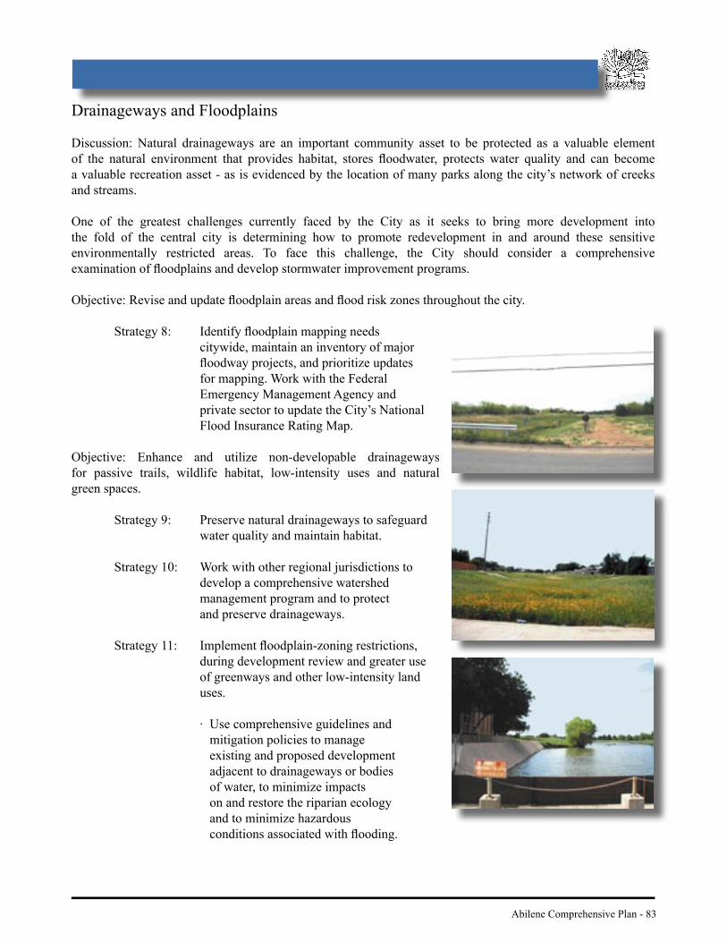
Abilene Comprehensive Plan - 83
Drainageways and Floodplains
Discussion: Natural drainageways are an important community asset to be protected as a valuable element of the natural environment that provides habitat, stores fl oodwater, protects water quality and can become a valuable recreation asset - as is evidenced by the location of many parks along the city’s network of creeks and streams.
One of the greatest challenges currently faced by the City as it seeks to bring more development into the fold of the central city is determining how to promote redevelopment in and around these sensitive environmentally restricted areas. To face this challenge, the City should consider a comprehensive examination of fl oodplains and develop stormwater improvement programs.
Objective: Revise and update fl oodplain areas and fl ood risk zones throughout the city.
Strategy 8: Identify fl oodplain mapping needs citywide, maintain an inventory of major fl oodway projects, and prioritize updates for mapping. Work with the Federal Emergency Management Agency and private sector to update the City’s National Flood Insurance Rating Map.
Objective: Enhance and utilize non-developable drainageways for passive trails, wildlife habitat, low-intensity uses and natural green spaces.
Strategy 9: Preserve natural drainageways to safeguard water quality and maintain habitat.
Strategy 10: Work with other regional jurisdictions to develop a comprehensive watershed management program and to protect and preserve drainageways.
Strategy 11: Implement fl oodplain-zoning restrictions, during development review and greater use of greenways and other low-intensity land uses.
· Use comprehensive guidelines and mitigation policies to manage existing and proposed development adjacent to drainageways or bodies of water, to minimize impacts on and restore the riparian ecology and to minimize hazardous conditions associated with fl ooding.

84 - Abilene Comprehensive Plan
· Ensure that new developments preserve and improve existing drainage corridors to accommodate increased runoff and expanded trail, recreation, and open space uses.
· Increase setback requirements or the provision of open space tracts adjacent to drainageways to facilitate trail development.
Strategy 12: Maximize the use of drainageways in the Abilene Bicycle and Pedestrian Trails Plan.
N AT U R A L E N V I R O N M E N T A N D R E S O U R C E S
Figure 16: Abilene drainageways could be used as major trail corridors to connect various parts of the community, such as neighborhoods and parks along creeks.

Abilene Comprehensive Plan - 85
Stormwater
Discussion: The city is situated on a gradual slope with fi ve creeks converging into Lake Fort Phantom, the city’s major water source. Abilene has long recognized the signifi cance of its location within the watershed of its primary water supply. Given that water washes through the streets, alleys, and rights-of-way into one of the primary drinking water supplies, the City has a strong program of water monitoring and water pollution abatement to ensure a clean and safe water supply.
Objective: Protect and maintain the quality of stormwater discharged to streams, drainage facilities, and other water bodies in the region.
Strategy 13: Control and monitor the discharge of pollutants associated with stormwater through improved land use confi gurations and stormwater facilities.
Strategy 14: Require a soil erosion control plan for all development sites including areas under construction as well as land contiguous to the development site that may be subject to erosion.
Strategy 15: Ensure all new development effectively protects groundwater and surface water from contamination.
Strategy 16: Revise site design regulations to minimize stormwater runoff by limiting the amount of impervious surface areas in new development.
86 - Abilene Comprehensive Plan
Environmental Hazards and Constraints
Discussion: The Hazard Mitigation Grant Program (HMGP) is one way federal funds can be used to help local communities recover from a disaster and alleviate future risk of disaster. The HMGP can be used to purchase fl ood-damaged Abilene properties at pre-fl ood, fair market values. Property purchased through this program would become public property that must forever remain open space land. The community could use the land to create such things as public parks, but it could not be sold to private individuals or developed.
Objective: Minimize and mitigate impacts from natural and man-made hazards to health and property.
Strategy 17: Reduce the total economic, environmental, and social costs associated with natural hazards by the following measures, listed in order of priority:
· Avoid potential hazard situations/areas, including areas delineated in the Sensitive Development Areas Map on page 80-81.
· Apply environmentally appropriate mitigation in areas that cannot be avoided.
· Use prevention measures accompanied with education and incentives for mitigation.
Strategy 18: Examine and utilize appropriate public and public/private alternatives for acquiring and/or relocating existing structures prone to fl ooding.
Strategy 19: Delineate and avoid geologic hazard and constrained areas in the placement of infrastructure.
Strategy 20: Continually maintain and update the Abilene/Taylor County Emergency Operations Plan (EOP), ensure jurisdictional EOP readiness, and coordinate its functional applications.
N AT U R A L E N V I R O N M E N T A N D R E S O U R C E S

Abilene Comprehensive Plan - 87

88 - Abilene Comprehensive Plan
E C O N O M I C B A S E
Introduction
In the 1980’s oil prices and consequently oil production fell substantially throughout Texas and other parts of the United States. This downturn in the oil industry had a strong, negative impact on the economy in and around the City of Abilene.
In response to the downturn in the economy, the community now understands the necessity to establish a workforce that will be able to withstand future economic diffi culties. Diversifi cation of the local economy is the key to attaining a safeguard against negative economic impacts, and the City of Abilene has evolved to support an array of economic activities. This effort has paid off in numerous ways. For example, the city has succeeded in attracting a larger variety of manufacturing-related jobs to the area.
Abilene has also established itself as a regional center for high quality health care. Hendrick Health System and Abilene Regional Medical Center are not only top employers in the area, but also are well-respected institutions. With Dyess Air Force Base, the city has a strong tie to Federal employment opportunities. A strong, positive relationship exists between the base and the city and this has provided additional economic stability to the area. With jobs provided by local and state government agencies, along with employment and activity created by Hardin-Simmons University, McMurry University, and Abilene Christian University, the City of Abilene fi nds itself today in a better economic situation than many cities in West Texas.
G O A L : G U I D E T H E C O M M U N I T Y T O B R O A D E N I T S B A L A N C E D E C O N O M I C G R O W T H .

Abilene Comprehensive Plan - 89
Business Retention
Discussion: Abilene strives to be a community that connects its citizens with business and employment opportunities. A need exists for citizens, local government, and business leaders to achieve a level of ingenuity, guided by ethics, foresight, and planning, to retain a strong economic base. With such practices in place, business retention will be an easier goal to achieve.
Objective: Build an environment that encourages existing businesses to prosper and expand.
Strategy 1: Coordinate land use development decisions and the activities of the City Economic Development Department to meet the community’s economic development needs, plan for those needs, coordinate economic development efforts, and support activities to maximize the public’s return on invested dollars.
Strategy 2: Strengthen programs that promote the redevelopment of existing structures and properties.
· Identify, classify, and categorize available structures and properties within the city that have industrial, commercial, and offi ce redevelopment potential.
· Work with the Chamber of Commerce and other development interests to promote and market these structures and properties.
Strategy 3: Implement the appearance and image policies of the Comprehensive Plan to positively impact the value of business properties.
90 - Abilene Comprehensive Plan
E C O N O M I C B A S EBusiness Diversifi cation
Discussion: Abilene has endeavored to diversify its local job market to better refl ect both the economic realities of business in the 21st Century, and to pay tribute to the strong workforce available in the area. These actions, in conjunction with a “participatory” attitude from local government, have helped to further expand job opportunities in Abilene. Citizens should continue to support such endeavors, especially as exemplifi ed by the Development Corporation of Abilene, in order to further capitalize on overcoming perceived weaknesses in the local economy, seizing new opportunities, and working with area communities to create a stronger overall regional economy. Abilene has much to offer, and if such a campaign was promoted and organized in an effective manner, the city would continue to attract new business and industry in the coming years.
Objective: Attract appropriate new business and industry to Abilene in conformance with the “Workforce Assessment, Curriculum Needs, Technology Infrastructure Assessment and Targeted Industry Study.”
Strategy 4: Direct land use planning as it relates to economic development on strengthening commercial and industrial sectors that:
· Diversify local and regional share economies.
· Increase sales and property tax base, as well as expand the employment base of Abilene.
· Energize the downtown area to consist of numerous businesses, both large and small.
· Support the activities of the Abilene Convention & Visitors Bureau.
Strategy 5: Coordinate with local employers and Texas State Technical College, Cisco Junior College, and other training agencies to identify the needs in the work force and to develop training programs suffi cient to produce workers highly qualifi ed for current and future jobs.
Strategy 6: Initiate a cooperative effort between the Abilene ISD, Wylie ISD, and regional public and private institutions, to create and ensure the continuation of quality educational opportunities, such as on the job training and training in advanced technology. Include other institutions in this effort, such as local universities, technical and junior colleges whenever possible.
Strategy 7: Design and offer incentives to attract new business to the City of Abilene. Strategies could include expediting all aspects of a move to Abilene, (relocation of machinery, equipment and personnel) assisting in grant acquisition, facilitating coordination between the private and public sector, and design fees. Base the incentives offered to potential businesses upon meeting criteria such as job creation and capital expenditures.
Strategy 8: Promote Abilene as a regional center for trade, distribution, industry, higher education, entertainment and recreation. Highlight the business opportunities and advantages associated with the Abilene Regional Airport.

Abilene Comprehensive Plan - 91
Business Infrastructure
Objective: Improve public infrastructure to serve as a catalyst for economic development.
Strategy 9: Delineate areas for future infrastructure improvements in order to promote new business and industrial growth in areas best suited for new growth. Maintain and support existing services and infrastructure to best serve existing business resources.
Strategy 10: Base investments in infrastructure upon the community’s projected demand for commercial and industrial space. Redevelopment of underutilized resources in areas where utilities and other infrastructure exists should take priority over new development that requires extension of or construction of new infrastructure.
Strategy 11: Provide transportation planning and site development criteria that will create desirable commercial and industrial zones that are compatible with surrounding area land uses. Require new development to incorporate landscaping and integrate architectural performance standards as established in City plans.

92 - Abilene Comprehensive Plan
E C O N O M I C B A S E
Tourism
Discussion: Abilene should offer “something for everyone” in the realm of leisure time. These types of opportunities will enhance the sense of community and enjoyment felt by local residents, as well as encourage visitors to come and partake in the city’s numerous diversions. By extending the potential market of tourists who know about Abilene, the city could see more visitors from not only the region, but also from other parts of the State of Texas, and the rest of the country. Tourism in the Abilene area remains an untapped resource. Given the right exposure and marketing, this portion of the local economy could expand greatly, resulting in a further diversifi cation.
Objective: Capitalize on visitor activities that support local economic development efforts.
Strategy 12: Develop small-area plans that elevate the role of tourism attractions as focal points for Activity Centers and Gateway Districts.
Strategy 13: Using the Texas Forts Trail Association and the Texas Midwest Community Network as models, create and expand networks and information sharing that reaches out to travel agencies and tourist bureaus.
Strategy 14: Devise and implement guidelines for signage, urban art, and other visual media that will reinforce Abilene’s cultural and historic image, the sights and sounds of downtown and other tourism attractions.
Strategy 15: Expand the capacity and resources of economic development organizations to expedite implementation of the Toal Plan for downtown.

Abilene Comprehensive Plan - 93
Regional Medical Facilities
Discussion: Citizens of Abilene should have access to all aspects of healthcare. Education of the community to its own healthcare needs should be increasing. Not only should these needs be illuminated, but the community should also take the initiative to fi nd solutions to having these needs met. In addition, the signifi cant resources offered by Abilene Regional Medical Center and Hendrick Hospital should be promoted regionally as well as locally. Communication among these institutions, the City, and the neighborhoods in which they are located should be strengthened and improved.
Objective: Enhance the provision of advanced medical services as a regional medical center.
Strategy 16: Recruit medical services that are not being offered in other areas of West Texas. Ensure that high quality, advanced services are promoted in the media.
Strategy 17: Integrate the expansion of the hospitals and other medical services into long-term development plans for Activity Centers where those facilities serve as anchors for such centers.

94 - Abilene Comprehensive Plan
E C O N O M I C B A S EDyess Air Force Base
Discussion: Dyess Air Force Base is a remarkable asset for a city the size of Abilene. Employing nearly 6,000 people, the base infuses millions of dollars into the local economy every year. It is essential for the City to promote policies that will enable Dyess to meet current and future mission requirements. An open line of communication between Dyess and the City of Abilene should be a priority at all times.
Objective: Support and promote Dyess Air Force Base as a long term community asset.
Strategy 18: Prohibit urban expansion into areas that encroach upon the operation of the base. The City should ensure compliance with this effort by controlling development in and around the installation, and annexing areas on the south and west side of the installation.
Strategy 19: Coordinate with Dyess AFB on transportation and land use planning in the
base environs to strengthen new programs and new missions at the installation.
Strategy 20: Expand education campaigns directed to local residents that explain the impact the base has on Abilene and the positive effects the military has on the local economy.
Strategy 18: Prohibit urban expansion into areas that encroach upon the operation of the base. The City should ensure compliance with this effort by controlling development in and around the installation, and annexing areas on the south and west side of the installation.
Strategy 19: Coordinate with Dyess AFB on transportation and land use planning in the

Abilene Comprehensive Plan - 95
Higher Education
Discussion: The City should capitalize on the universities, junior, and technical colleges as resources. The interaction between these institutions and the city is crucial to the future health and welfare of the region. The City should take every opportunity to promote the existence of these institutions of higher learning to the region, state, and country, as well as seek ways in which to improve overall communication with the universities.
Objective: Improve dialogue, connections, and interaction among institutions of higher learning with the City of Abilene and its neighborhoods.
Strategy 21: Establish new programs and build on existing programs that work to develop and support the local economy, such as medical, nursing, and teaching programs, according to the identifi ed needs of the business community.
Strategy 22: Create partnerships between the City of Abilene and the universities to establish and defi ne the needs of the City and its neighborhoods, especially those neighborhoods that surround these institutions.
Strategy 23: Plan for the expansion of universities as their enrollment and programs increase.
Strategy 24: Promote the community and its many offerings to students in a more effective manner to increase student involvement in economic activity.

96 - Abilene Comprehensive Plan
During the public visioning process, citizens were invited to comment on features of four future land use scenarios. One scenario assumed a continuation of the prevailing land use development patterns and trends that have occurred over the last two decades. Three other scenarios were created by the City’s Planning staff and Consultant based upon alternative “themes.” The themes were derived from strategies and concepts that have surfaced as dominant community-wide concerns in other community/economic development efforts.
Each scenario is defi ned by a set of six characteristics. The public was asked to state their preferences among the characteristics in three ways. First they selected their favorite characteristics for each scenario. The top two characteristics for the four scenarios included (in rank order) A4 and A6 for the Mixed-Use scenario, B2 and B1 for Strategic Infi ll, C6 and C1 for Resource Management, and D4 and D6 for the Continuing Trends scenario. All but one of these (D6) was selected by at least 50% of the survey respondents. Then citizens were asked to select the fi ve most important characteristics that they would like to see included in a preferred scenario and the fi ve least important characteristics that should defi nitely not be included in the preferred scenario. The most preferred characteristics, each receiving positive votes from at least 75% of the respondents, were (in rank order) B1, C6, B4, B2, A4, A2 and C1. The public’s preferences for the characteristics that they did not want to see become part of the fi nal plan were equally as clear. Features receiving negative votes from at least 75% of the respondents included (in descending order) D5, B5, D2, D1, B6 and D3. Finally, respondents were asked to select the one scenario that best described their desired vision for the future of Abilene. The Resource Management scenario garnered the most votes, followed by Mixed-Use, Strategic Infi ll, and Continuing Trends.
The results of the preference survey demonstrate that the public was thoughtful and consistent in their answers. This provided the Planning staff, Consultant and Steering Committee with suffi cient confi dence to use the most highly ranked characteristics as the skeleton of the Comprehensive Plan.
A p p e n d i x A - L a n d U s e S c e n a r i o s

Abilene Comprehensive Plan - 97

98 - Abilene Comprehensive Plan
Scenario A – Mixed Use Districts. Under this scenario, the City chooses to concentrate new development into mixed-use activity centers. These centers may contain a mix of employment and housing, and would capitalize on opportunities to redevelop older facilities that might not otherwise have an economically viable use, such as antiquated retail shopping centers, industrial sites, and underutilized commercial areas. Characteristics of the scenario include the following:
A1. The City chooses to concentrate new development around core activity centers, such as hospitals, universities, and regional shopping areas.
A2. Specifi c types of development are targeted to districts and are integrated into a land use mix of employment, housing, retail, and services to support core activities.
A3. Neighborhood districts mimic the mixed-use concept on a local scale with a variety of convenient living, retail, and service uses located around identifi ed residential
neighborhoods.
A4. Gateway districts provide strong visually impactive development at entrances to the community, promoting a positive image with interesting and welcoming elements that
portray a sense of place.
A5. Reinvestment is encouraged in and around activity centers.
A5. Activity centers are linked with attractive street corridors coupled with pedestrian and non-auto oriented types of transportation.
A p p e n d i x A
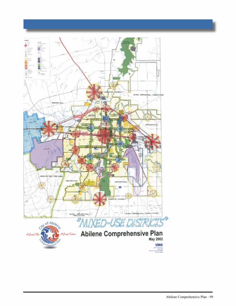
Abilene Comprehensive Plan - 99
100 - Abilene Comprehensive Plan
Scenario B – Strategic Infi ll. Under this scenario, the City chooses to promote redevelopment and mixed land uses, potentially with higher densities and a greater emphasis on alternative modes of transportation. The implications of this scenario may mean that the City chooses to modify, or tighten, its current planning area boundaries and limit investments in new infrastructure expansion, with a greater reliance on maximizing infrastructure investments already made. The primary policy objective of this scenario is to aggressively maximize development within the Loop, thereby minimizing development at the periphery of the city. Characteristics of the scenario include the following:
B1. The City promotes infi ll and redevelopment projects that are targeted to underutilized or vacant areas of the city.
B2. Priority is given to redevelopment of older facilities that might not otherwise have an economically viable use, such as distressed retail shopping centers, industrial sites, and vacated schools.
B3. Select areas are designated for future annexation to prevent residential development around Dyess Air Force Base and Abilene Regional Airport.
B4. The city uses water and sewer infrastructure more effi ciently, rather than extending infrastructure to the urban fringe (edge of the city).
B5. Mixed income housing developments are encouraged.
B6. Residential development promotes a variety of housing types with higher densities (more units per acre).
A p p e n d i x A

Abilene Comprehensive Plan - 101

102 - Abilene Comprehensive Plan
Scenario C – Resource Management. Under this scenario, the City’s primary aim in directing and managing new development is to ensure the effi cient use of both natural and physical resources. As in Scenario B, the City aggressively restricts new development outside the Loop. Characteristics of the scenario include the following:
C1. The City seeks to maximize the effi cient use of limited resources, such as water, roads, and public services, by directing new development to areas with existing services.
C2. Development is confi ned primarily to within “the Loop” (Winters Freeway/Loop 322/ Interstate 20).
C3. A system of connected open lands, natural areas, and greenway corridors are protected from development outside the Loop.
C4. Floodplain areas are preserved for passive trails, wildlife habitat, and natural green spaces.
C5. Residential densities are increased over time to produce less stormwater run-off and protect water quality.
C6. The City’s effl uent i.e., treated wastewater, system is expanded to reduce the use of potable
water for yards and landscaping.
A p p e n d i x A
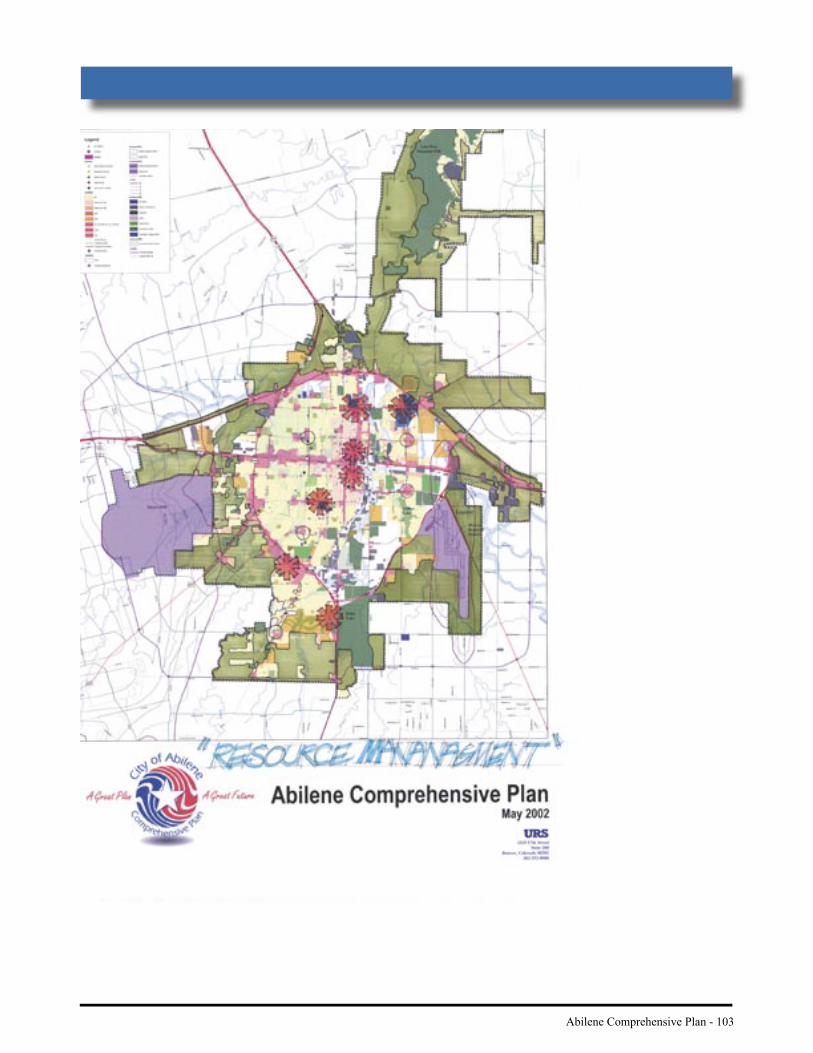
Abilene Comprehensive Plan - 103
104 - Abilene Comprehensive Plan
Scenario D – Continuing Trends. Under this scenario, current development trends continue into the future and the City responds to market demands and private sector growth trends. This market driven scenario provided a baseline from which to compare the other three scenarios. By exploring the implications of a laissez-faire approach, citizens were better able to understand the implications of maintaining current land uses and infrastructure plans. Characteristics of the scenario include the following:
D1. New development continues to be concentrated primarily in southern areas of the city and along the urban fringe.
D2. Commercial development continues to “strip out” along highways and streets.
D3. City resources are directed to new development and away from older areas, except for isolated pockets of infi ll and redevelopment.
D4. The downtown area continues to redevelop with targeted city investments.
D5. Infrastructure is expanded according to the demands for development at the urban fringe.
D6. A major transportation loop begins developing at FM 707 on the south edge of the city, with the creation of new commercial nodes at intersecting roads.
A p p e n d i x A

Abilene Comprehensive Plan - 105

106 - Abilene Comprehensive Plan
Adoption of a Comprehensive Plan ushers in a new period for the City of Abilene. The 1973 plan lapsed into obsolescence years ago, and since that time, local policy-makers have weighed the development issues before them without the benefi t of a coherent physical blueprint for the community. The current zoning ordinance has served the utilitarian purpose of providing for the separation of incompatible land uses. In administering the terms of the ordinance, the City has fulfi lled that basic goal, but it has done so without a contextual vision for how the ordinances are intended to accomplish some larger purpose. Used in that way, a zoning ordinance is no longer a means to an end, it becomes the ends unto itself. A new Comprehensive Plan will supply the vision by which all of the City’s development ordinances and regulations must be measured.
The strategies of the Plan that express the vision are not self-executing. Within a short time following adoption of the Plan, the City must revise its existing development codes in order to formally breathe life into the strategies. The City may choose to deal with separable parts of a particular code, rather than waiting on the overhaul of an entire code, depending upon its implementation priorities. The greatest single task will be revision of the zoning ordinances. As mentioned throughout the Plan, the infi ll, redevelopment, and mixed-use concepts will require a departure from the traditional Euclidean zoning approach. An examination of the other development-oriented policies, such as the subdivision code and annexation plan, is essential to realizing the full vision.
In the interim, until new ordinances are adopted, the City must implement the policies of the Comprehensive Plan using the tools and processes currently at its disposal.
I. PUBLIC AWARENESSThe public participation phase was successful in raising citizen awareness of Abilene’s Comprehensive Plan and planning in general. Staff and City leaders have had the opportunity to present the Plan to civic groups and organizations concerned with the development, growth, appearance, and image of the community. This effort should continue after adoption. The more the public and development interests know about the Plan, its goals and policies, the more they will expect by way of results. Increased expectations coupled with tangible progress in implementing physical improvements can help sustain the momentum for executing the Plan.
II. PROACTIVE SITE DEVELOPMENT REVIEWExisting ordinances provide for the use of Planned Development Districts (PDDs) as an alternative approach to zoning and site review. Unlike the reactive analysis that takes place when a landowner fi les a rezoning application, the PDD approach calls for reviewing site design and associated platting issues concurrent with the usual land use concerns. Historically, the City has viewed PDDs as a vehicle for giving the applicant fl exibility from setbacks and density. That is just half of the value of using PDDs. They are also intended to help the City engage the applicant in advance consultation and a more proactive site development review, resulting in improved design and the incorporation of features that “one size fi ts all” zoning ordinances are unable to accomplish. The City should use the latitude of its wide-ranging PDD ordinances, in appropriate cases, to apply the principles and policies of the Comprehensive Plan to site development.
III. EXEMPTIONS TO THE ANNEXATION PLANAbilene’s current annexation plan, adopted in 1999, states that the City will not annex land in its extra-territorial jurisdiction unless it is pursuant to one of the statutory exemptions to involuntary annexation. One exemption relieves cities of the service plan requirement when the area to be annexed has fewer than one hundred dwellings. The City should determine whether any of the areas designated on the Future Land Use map for annexation, primarily the land south and west of Dyess Air Force Base, meet the criteria for an exemption. If so, it should undertake the steps necessary for annexation of those areas as soon as possible.
A p p e n d i x B - I n t e r i m I m p l e m e n t a t i o n

Abilene Comprehensive Plan - 107