Comparisons between L-band and C-band InSAR for large …
19
Comparisons between L-band and C-band InSAR for large 2007-2008 earthquakes in Asia: Implications for future SAR missions and earthquake studies Zhenhong Li (1) , John Elliott (2) , Eric J. Fielding (3) , Barry Parsons (2) and Richard Walters (2) (1): COMET, University of Glasgow, Glasgow, UK (2): COMET, University of Oxford, Oxford, UK (3): Jet Propulsion Laboratory, Caltech, USA 06 Nov 2008
Transcript of Comparisons between L-band and C-band InSAR for large …

Comparisons between L-band and C-band InSAR for large 2007-2008 earthquakes in Asia: Implications for future SAR missions and
earthquake studies
Zhenhong Li(1), John Elliott(2), Eric J. Fielding(3), Barry Parsons(2) and Richard Walters(2)
(1): COMET, University of Glasgow, Glasgow, UK(2): COMET, University of Oxford, Oxford, UK(3): Jet Propulsion Laboratory, Caltech, USA
06 Nov 2008
Large earthquakes in Asia in 2007 and 2008
Comparisons between C-band & L-band InSAR
Coherence
Phase gradients
Ionospheric effects
Conclusions
Contents

Large earthquakes in Asia (2007-2008)
Sep 2007 Sumatran
earthquakes(Mw 8.4 & 7.9)
May 2008Wenchuan(Mw 7.9)
March 2008Yutian
(Mw 7.2)
Jan 2008Gaize
(Mw 6.4 & 5.9)

The 2007 Sumatran earthquakes:
Coherence+
Temporary Resolution
(Konca et al, Nature, in press, 2008)
The 2007 Sumatran earthquake

The 2007 Sumatran earthquake
Mw 8.4: 12 Sep 2007
11:10:26 UTC
Mw 7.9: 12 Sep 2007
23:49:01 UTC
12 hours interval
4 tracks of ALOS PALSAR L-band interferograms
Note:
(1) All interferograms include signals
from both events!
(2) CGPS data available to distinguish
coseismic signals.

L-band Interferogram
The 2007 Sumatran earthquake
Google image
Note: NO coherence for C-band Data!!!
Implication: L-band has advantages over C-band in terms of coherence…

The 2008 Gaize earthquake:
Temporal Resolution of InSAR data
The 2008 Gaize earthquake

The 2008 Gaize earthquake
Mw 6.4: 09 Jan 2008
Mw 5.9: 16 Jan 2008
7 days interval
2 tracks of Envisat C-band interferograms+1 track of ALOS L-band image
(Feng et al., 2008, on preparation for CGJ)
Note:
All interferograms cover both events &
NO other data available to distinguish
coseismic signals
A BIG Challenge for modeling

The 2008 Gaize earthquake
Main fault: NW-dipping
Secondary fault:
Option 1: NW-dipping
Option 2:SE-dipping
Implication: Temporal resolution is a limitation …
(Feng et al., 2008, on preparation for CGJ)
The 2008 Yutian earthquake:
Phase gradients and wavelengths
The 2008 Yutian earthquake

The 2008 Yutian earthquakeFringes lost due to
large phase gradients

The 2008 Yutian earthquake
(L-band)(C-band)
Implication: Longer wavelength can be used to resolve deformation with greater phase gradients
The 2008 Wenchuan earthquake:
Ionospheric effects
&
Coherence
The 2008 Wenchuan earthquake

The 2008 Sichuan earthquake
Fault traces from SAR Range offset Maps
471
472
473
474
475
476 Track numbers: 471 - 476
Magnitude of c. 1 m within a distance of 200km
Magnitude of c. 0.5 m within a distance of 500km
Magnitude of c. 0.8 m within a distance of 400km
Implication: Ionospheric effects on L-band interferograms
cannot be neglected…

Coherence: ALOS vs Envisat
ALOS Envisat
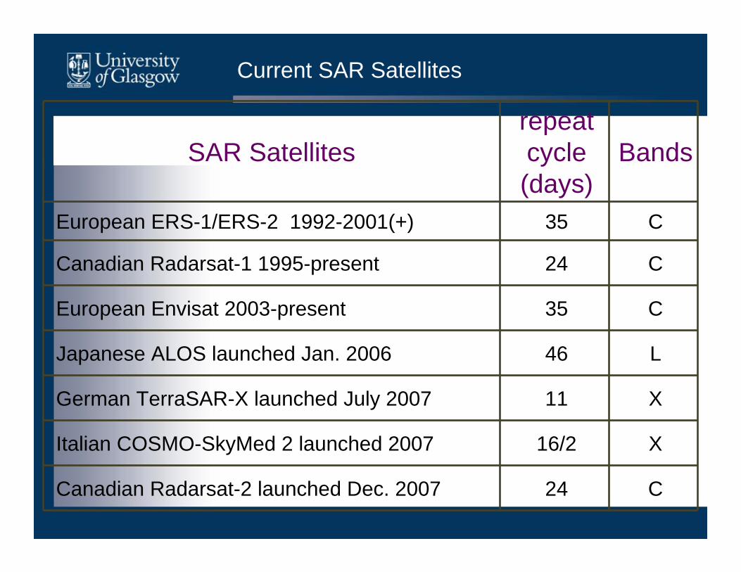
Current SAR Satellites
SAR Satellitesrepeatcycle(days)
Bands
European ERS-1/ERS-2 1992-2001(+) 35 C
Canadian Radarsat-1 1995-present 24 C
European Envisat 2003-present 35 C
Japanese ALOS launched Jan. 2006 46 L
German TerraSAR-X launched July 2007 11 X
Italian COSMO-SkyMed 2 launched 2007 16/2 X
Canadian Radarsat-2 launched Dec. 2007 24 C

Future SAR Satellites (incomplete)
SAR Satellitesrepeatcycle(days)
Bands
European Sentinel-1 (2011) 12 CCanadian Radarsat Constellation Mission (RCM) (2012) 4 C
Indian RISAT (2009) 13 C
Chinese HJ-1-C (2008) -- SArgentinean SAOCOM-1 (2012) 16 L Brazilian + German Multi-Application
PurposeSAR (MapSAR) (2012)
37 L

Temporal resolution of current SAR systems is still a limitation for earthquake studies:
Combination of different data sets (e.g. X-, C- and L-bands)
More SAR satellites…
Conclusions
C-band L-band Notes
Coherence - +Tropospheric effects = = Identical
Ionospheric effects + - ~17 times greater at L-band than C-band
Phase gradients /Greater deformation - +
Measurement accuracy + - ~1.6 times (Sandwell et al., 2008)

Acknowledgements
JAXA ALOS AO project (ID: P0610001; PI: I. Dowman)ESA ALOS ADEN AO project (ID: 3577; PI: B. Parsons)
ESA AOE-621(PI: B. Parsons)ESA AOE-668 (PI: E. Fielding) DRAGON 2558 (PI: Q. Zeng)


![L-Band InSAR Penetration Depth Experiment, North Slope … · strial Reference Frame with vertical accuracy and precision ... 5 m vertical accuracy [10]. The ALOS PALSAR operated](https://static.fdocuments.us/doc/165x107/5b34fbd47f8b9a3a6d8ca720/l-band-insar-penetration-depth-experiment-north-slope-strial-reference-frame.jpg)