Comparison of ATSR and NOAA AVHRR hotspot data...
7
1 Comparison of ATSR and NOAA AVHRR hotspot data acquired during an exceptional fire event in Kalimantan (Indonesia) F. SIEGERT, A. HOFFMANN * & S. KUNTZ + Ludwig-Maximilians-Universität, Dept. Biology, Luisenstr. 14, 80333 München, Germany e-mail: [email protected] *Integrated Forest Fire Management Project IFFM / GTZ, Jln. Harmonika, Samarinda, 75001,Kalimantan Timur, Indonesia, & Fire Ecology Research Group, Max Planck Institute for Chemistry, c/o Freiburg University, P.O. Box 79085 Freiburg, Germany + Remote Sensing Services GmbH, Wörthstr. 49, 81667 München In 1997 and 1998 uncontrolled fires devastated huge tracts of tropical rainforests in Kalimantan on the island of Borneo in Indonesia. Here we report on results of a comparative study of ERS-2 ATSR hotspot and NOAA-AVHRR hotspot data used to analyse the extent of this disaster. A burned scar map derived from a Landsat TM image acquired after the fires and extensive ground data were used to assess the accuracy of both systems in fire detection and burned scar mapping. With both it was possible to detect most burned scars. Complete mapping was probably impeded by thick haze which covered the area during active burning. Significantly more hotspots were detected by the NOAA AVHRR 14 system, which covers the area of Indonesia 2 times a day and acquires images at day and night. ATSR derived hotspots showed a slightly higher spatial accuracy than NOAA. By calculating the burned area from the hotspot data and its comparison to the Landsat TM derived burned scar map it was found that ATSR strongly underestimates the fire affected area using the presently applied algorithms, while NOAA AVHRR with day and night acquisitions slightly overestimates the burned area. INTRODUCTION In 1997/98 Indonesia experienced one of the worst fire disasters ever observed on earth. Fires started by men and driven by the exceptional El- Niño event evolved into uncontrolled wildfires which destroyed large areas of lowland dipterocarp forest, peat swamp forest, heath forest and grassland. The use of remote sensing data is an efficient way to analyze the ecological and economic impacts of such large scale disasters. Several approaches were undertaken to determine the extent of the 1997 forest fires in Indonesia using both optical and microwave sensors. Studies were based either on visual interpretation of multitemporal Spot quick-look mosaics, the evaluation of NOAA-AVHRR or ATSR hot spot data or the combined use of ERS-2 SAR coherence data and ATSR data (FULLER & FULK, 1998; WOOSTER ET AL., 1998; FANG & HUANG, 1998; LIEW ET AL., 1998; ANTIKIDIS et al., 1998; BUONGIORNO et al., 1997). Through the combined use of multitemporal ERS-2 SAR and the NOAA- AVHRR data it was possible to calculate precise figures on the extent of the fires and their impacts on the vegetation (SIEGERT & HOFFMANN, 1999). The European ERS-2 satellite is of particular interest for fire monitoring and burned scar mapping since it has complementary instruments like the optical ATSR and the microwave SAR sensors onboard. The low resolution ATSR-2 instrument allows for the detection of active fires during night acquisition using its thermal infrared channel centered at 3,7 μm. The ERS-2 SAR sensor provides a much higher spatial resolution of 25 m and is able to deliver images also when haze and clouds cover the area. The AVHRR sensor detects the presence of active fires at a similar wavelength and
-
Upload
trinhthuan -
Category
Documents
-
view
216 -
download
0
Transcript of Comparison of ATSR and NOAA AVHRR hotspot data...

1
Comparison of ATSR and NOAA AVHRR hotspot dataacquired during an exceptional fire event in Kalimantan
(Indonesia)
F. SIEGERT, A. HOFFMANN* & S. KUNTZ+
Ludwig-Maximilians-Universität, Dept. Biology, Luisenstr. 14, 80333 München, Germanye-mail: [email protected]
*Integrated Forest Fire Management Project IFFM / GTZ, Jln. Harmonika, Samarinda,75001,Kalimantan Timur, Indonesia, & Fire Ecology Research Group, Max Planck Institute for
Chemistry, c/o Freiburg University, P.O. Box 79085 Freiburg, Germany+Remote Sensing Services GmbH, Wörthstr. 49, 81667 München
In 1997 and 1998 uncontrolled fires devastated huge tracts of tropical rainforests inKalimantan on the island of Borneo in Indonesia. Here we report on results of acomparative study of ERS-2 ATSR hotspot and NOAA-AVHRR hotspot data used toanalyse the extent of this disaster. A burned scar map derived from a Landsat TM imageacquired after the fires and extensive ground data were used to assess the accuracy ofboth systems in fire detection and burned scar mapping. With both it was possible todetect most burned scars. Complete mapping was probably impeded by thick haze whichcovered the area during active burning. Significantly more hotspots were detected by theNOAA AVHRR 14 system, which covers the area of Indonesia 2 times a day and acquiresimages at day and night. ATSR derived hotspots showed a slightly higher spatialaccuracy than NOAA. By calculating the burned area from the hotspot data and itscomparison to the Landsat TM derived burned scar map it was found that ATSR stronglyunderestimates the fire affected area using the presently applied algorithms, while NOAAAVHRR with day and night acquisitions slightly overestimates the burned area.
INTRODUCTIONIn 1997/98 Indonesia experienced one of theworst fire disasters ever observed on earth.Fires started by men and driven by theexceptional El- Niño event evolved intouncontrolled wildfires which destroyed largeareas of lowland dipterocarp forest, peatswamp forest, heath forest and grassland.The use of remote sensing data is anefficient way to analyze the ecological andeconomic impacts of such large scaledisasters. Several approaches wereundertaken to determine the extent of the1997 forest fires in Indonesia using bothoptical and microwave sensors. Studieswere based either on visual interpretation ofmultitemporal Spot quick-look mosaics, theevaluation of NOAA-AVHRR or ATSR hotspot data or the combined use of ERS-2SAR coherence data and ATSR data(FULLER & FULK, 1998; WOOSTER ET AL.,1998; FANG & HUANG, 1998; LIEW ET AL.,
1998; ANTIKIDIS et al., 1998; BUONGIORNO etal., 1997). Through the combined use ofmultitemporal ERS-2 SAR and the NOAA-AVHRR data it was possible to calculateprecise figures on the extent of the fires andtheir impacts on the vegetation (SIEGERT &HOFFMANN, 1999).
The European ERS-2 satellite is of particularinterest for fire monitoring and burned scarmapping since it has complementaryinstruments like the optical ATSR and themicrowave SAR sensors onboard. The lowresolution ATSR-2 instrument allows for thedetection of active fires during nightacquisition using its thermal infrared channelcentered at 3,7 µm. The ERS-2 SAR sensorprovides a much higher spatial resolution of25 m and is able to deliver images also whenhaze and clouds cover the area. TheAVHRR sensor detects the presence ofactive fires at a similar wavelength and
2
resolution as the ATSR instrument (channel3, 3,8 µm, ~1.1 km2), however both on nightand day time. A major advantage of theNOAA satellites is the high temporalresolution they can provide. The objective ofthis study was to compare the capabilities ofthe ERS-2 ATSR and NOAA-AVHRRinstruments for fire detection and burnedscar mapping.
THE STUDY AREAThe project study area covers the provincesEast Kalimantan and Central Kalimantan onthe island of Borneo in Indonesia. LowlandDipterocarp forest, (peat) swamp forest,secondary forests, bushland and grass- andfarmland dominate the vegetation of thisarea. Most forests have already beensubjected to selective logging, ,often withextensive overexploitation. Shiftingcultivation prevails close to the rivers.Several large pulp wood and oil palmplantations have been established in thepast decade. In Central Kalimantan a largedevelopment project was initiated in 1996.Within 2 years more than 3200 km of canalswere built in an area of peat swamp forestarea in order to prepare land for ricecultivation (1 Mio hectare rice project). Toverify burned scar mapping in Central EastKalimantan we conducted two ground and 4aerial surveys in 1998 and 1999 andrecorded all travels using a GPS incontinuous track mode. In CentralKalimantan we conducted a ground and anaerial surveys in November 1998. Again alltravels were recorded by GPS.
MATERIAL AND METHODSThe Integrated Forest Fire Managementproject (IFFM/GTZ, German TechnicalCooperation) based in Samarinda, EastKalimantan is a Indonesian-Germancooperation project and provides amongother activities information on fire risk andfire occurrences in East Kalimantan withimages from several NOAA AVHRRsatellites. The fire detection process usingNOAA AVHRR images is based on surfacetemperature measurements taken by
channel 3. A pixel is classified as a hotspotwhen channel 3 is saturated by a specifictemperature much below that of burningvegetation (MALINGREAU 1990, KAUFMANN etal. 1990a, 1990b, KENNEDY et al. 1994). Toavoid false detection due to high backgroundtemperature (soil), highly reflective clouds orsun reflection of water, the image processingprogram applied by IFFM uses the MultipleThreshold algorithm (ARINO & MELINOTTE,1995). Threshold temperatures are setmanually for each image and usually have arange between 322° and 317° Kelvin for day-time images and between 303° and 308°Kelvin for night-time images. A single firepixel or hotspot has an area of 1.1 km2 andmay be saturated by a single fire or morethan one fire event of unknown size.Providing that the surrounding backgroundtemperature is low, like during night imageacquisition when a low thresholdtemperature can be set, the detected fire canbe as small as a gas flame from an oilplatform. In general it is difficult to preciselyregister a time series of approx. 200successive NOAA AVHRR images. Thespatial error mainly depends on the imagequality, i.e. the cloud cover and the visibilityof image to image registration points.Additionally the accuracy of the AVHRRscanner deteriorates at wide viewing angles.We found a spatial registration error of theNOAA AVHRR hotspots of up to 3 pixels (3.3km) (SIEGERT & HOFFMANN, 1999). Due tothese facts a single long lasting fire sourcemay be represented by several or too fewhotspots in a time series of NOAA AVHRRimages. Furthermore the geographical dataset which is used to georeference theAVHRR images has a slight shift of a fewpixels. A major advantage of the NOAAAVHRR system is the high temporalresolution. 3 NOAA satellites (NOAA-12,-14,-15) can be received two times a dayresulting in a coverage of 6 times perday/nigh over the test site in Borneo.
The ATSR instrument has a swath of 512 kmwith a spatial resolution of 1 km and arepetitive coverage over the same area ofabout 3 days in equatorial regions like
3
Indonesia. As with NOAA AVHRR the firedetection process with ATSR images isbased on surface temperaturemeasurements taken by an thermal infraredchannel centered at 3,7 µm. The ATSR datawas provided in the framework of the ATSRFire Atlas Validation study by ESRIN/ESAand was downloaded via Internet as adatabase containing the data and the lat/longcoordinates of each hotspot. ESRINprocessed the ATSR images with twodifferent algorithms, i.e. a threshold of 312Kelvin (algorithm 1) or a threshold of 308Kelvin (algorithm 2). All ATSR and AVHRRhotspots acquired between April 1997 andSeptember 1998 were imported intoMicrosoft Access and geographic andtemporal subsets were created. Then bothdata sets were compared quantitatively bydata base queries. Furthermore both datasets were imported into an ARCVIEW GISproject in order to compare the spatio-temporal pattern of hotspots detected byboth optical systems and the burned scarsmapped by ERS SAR or Landsat TM. ALandsat TM image acquired after the fireevent (118-62, 29.3.1998) was provided bythe EU funded INCO Project NaturalResource Functions, Biodiversity AndSustainable Management Of TropicalPeatlands (Proposal No: ERB 3514 PL 972440).
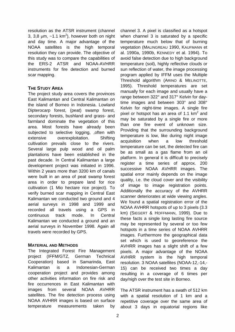
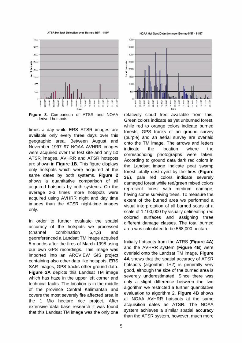
RESULTSBetween August and November 1997 both,the NOAA AVHRR and ATSR system,acquired images regularly. Therefore weused this period for our investigation. Figure1A shows the island of Borneo and allhotspots detected by the ATSR (purple) andAVHRR (yellow) instruments in that period.Most hotspots are concentrated in thesouthern province of Central Kalimantan.During the fire season of 1997/98 theprocessing window of the NOAA-AVHRRimages used by IFFM ends at the westernedge of Borneo and also did not cover thenorthern Malaysian province of Sabah.Furthermore there were technical difficultieswith the sea mask, which normally preventsfalse alarm detection over the sea. Therefore
a small stripe along the whole coast ofBorneo was excluded from the fire detection
Figure 1: A. ATSR and NOAA hotspots inBorneo 1997. B ATSR and NOAAhotspots acquired at same dates in1997.
(note the sharp line in Figure 1A beyondwhich no yellow spots are visible). Lesshotspots were found by both systems in thecentral mountainous region of Borneo andthe Malaysian Provinces Sarawak andSabah. Many more hotspots have beendetected by IFFM using the NOAA 14satellite night and day time overpasses.Detected fires can be considered as highlylikely, however some fires can be missedbecause of high threshold temperatures.Making the algorithm more resilient tomisinterpretation results in greater firedetection "losses". Furthermore NOAAAVHRR 14 images can be received two
4
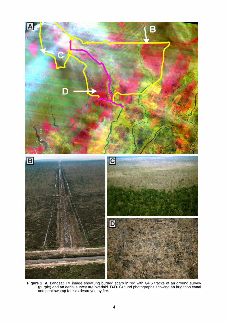
Figure 2. A. Landsat TM image showiung burned scars in red with GPS tracks of an ground survey(purple) and an aerial survey are overlaid. B-D. Ground photographs showing an irrigation canaland peat swamp forests destroyed by fire.
5
Figure 3. Comparison of ATSR and NOAAderived hotspots
times a day while ERS ATSR images areavailable only every three days over thisgeographic area. Between August andNovember 1997 97 NOAA AVHRR imageswere acquired over the test site and only 50ATSR images. AVHRR and ATSR hotspotsare shown in Figure 1B. This figure displaysonly hotspots which were acquired at thesame dates by both systems. Figure 2shows a quantitative comparison of allacquired hotspots by both systems. On theaverage 2-3 times more hotspots wereacquired using AVHRR night and day timeimages than the ATSR night-time imagesonly.
In order to further evaluate the spatialaccuracy of the hotspots we processed(channel combination 5,4,3) andgeoreferenced a Landsat TM image acquired5 months after the fires of March 1998 usingour own GPS recordings. This image wasimported into an ARCVIEW GIS projectcontaining also other data like hotspots, ERSSAR images, GPS tracks other ground data.Figure 3A depicts this Landsat TM imagewhich has haze in the upper left corner andtechnical faults. The location is in the middleof the province Central Kalimantan andcovers the most severely fire affected area inthe 1 Mio hectare rice project. Afterextensive data base research it was foundthat this Landsat TM image was the only one
relatively cloud free available from this.Green colors indicate as yet unburned forest,while red to orange colors indicate burnedforests. GPS tracks of an ground survey(purple) and an aerial survey are overlaidonto the TM image. The arrows and lettersindicate the location where thecorresponding photographs were taken.According to ground data dark red colors inthe Landsat image indicate peat swampforest totally destroyed by the fires (Figure3E), pale red colors indicate severelydamaged forest while red/green mixed colorsrepresent forest with medium damage,having some surviving trees. To measure theextent of the burned area we performed avisual interpretation of all burned scars at ascale of 1:100,000 by visually delineating redcolored surfaces and assigning threedifferent damage classes. The total burnedarea was calculated to be 568,000 hectare.
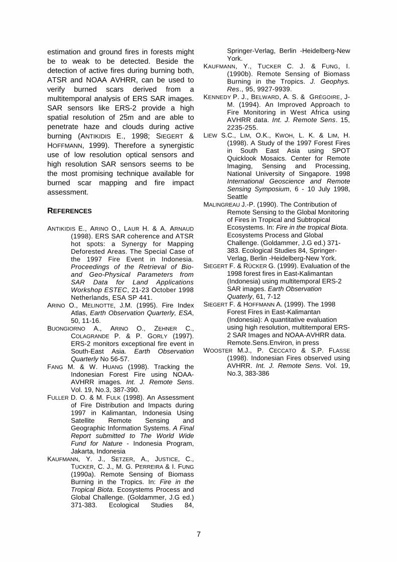
Initially hotspots from the ATRS (Figure 4A)and the AVHRR system (Figure 4B) wereoverlaid onto the Landsat TM image. Figure4A shows that the spatial accuracy of ATSRhotspots (algorithm 1+2) is generally verygood, although the size of the burned area isseverely underestimated. Since there wasonly a slight difference between the twoalgorithm we restricted a further quantitativeevaluation to algorithm 2. Figure 4B showsall NOAA AVHRR hotspots at the sameacquisition dates as ATSR. The NOAAsystem achieves a similar spatial accuracythan the ATSR system, however, much more
6
hotspots were detected. If day and night timeacquisitions were discriminated a very goodagreement between ATSR and AVHRR nighttime hotspots was found (not shown). Toassess if ATSR and AVHRR hotspot datacan be used to estimate the fire affectedarea in a tropical forest environment wecompared the area detected by hotspots tothat of the burned scar map derived fromLandsat TM. In the calculation it wasassumed that if a hotspot was detected thefull area of the hotspot (approx. 1 km2 ATSRand 1.1 km2 NOAA) was affected by the fire.It was found that ATSR using the presentdetection algorithms strongly underestimatesthe burned area (31.2% of the total areawere detected). A similar result was obtainedwith NOAA 14 night time acquisitions (30.7%of the total area were detected). Thesefigures shows the very good agreementbetween the two sensors. If NOAA 14 daytime acquisitions were included in thecalculation we found that the burned areawas slightly overestimated (29.4% more thanthe actual area).
CONCLUSIONIn order to be able to prevent such huge firedisasters in the future, the extent and thecauses of the recent forest fires have to beanalyzed carefully. Due to the large size ofthe area affected by fire and theinaccessibility of the region the analysis hasto rely on spaceborne remote sensing data.However, within more than one year after thefires it was not possible to acquire asufficiently cloud free mosaic from the fireaffected area in East Kalimantan by opticalsatellites. Cloud free Landsat TM, IRS orSPOT images would be ideal for burned scarmapping, however in the course of time itbecomes harder to reliably map burnedscars from optical images due to the fastregrowth of underbrush and vines.
In this situation, low resolution opticalspaceborne sensors with a high temporalresolution like ATSR and NOAA AVHRRprovide important data on the location andsize of the fire affected area. Night timeimagery, although more reliable in the fire
detection, may give only a biasedinformation since the fire activity often peakout in the afternoon. Therefore to get adetailed monitoring result about the firesituation like it was in 1997/98 it seems moreprecise to use also day time images. For thedetection of active burning fires bothsystems seem to be sufficiently precise if anairplane was then used for identification ofsingle hotspots. If travelling overland inforested
Figure 4. Comparison of ATSR and NOAAderived hotspots overlay on Landsat TMimage.
areas it might be difficult to find a specifichotspot due to an averageregistration/system error of 2-3 km.Furthermore care must be taken if burnedareas will be calculated from hotspot data.First not all fires might be detected due tofrequent haze during burning. The resolutionis to coarse for an exact burned area
7
estimation and ground fires in forests mightbe to weak to be detected. Beside thedetection of active fires during burning both,ATSR and NOAA AVHRR, can be used toverify burned scars derived from amultitemporal analysis of ERS SAR images.SAR sensors like ERS-2 provide a highspatial resolution of 25m and are able topenetrate haze and clouds during activeburning (ANTIKIDIS E., 1998; SIEGERT &HOFFMANN, 1999). Therefore a synergisticuse of low resolution optical sensors andhigh resolution SAR sensors seems to bethe most promising technique available forburned scar mapping and fire impactassessment.
REFERENCES
ANTIKIDIS E., ARINO O., LAUR H. & A. ARNAUD(1998). ERS SAR coherence and ATSRhot spots: a Synergy for MappingDeforested Areas. The Special Case ofthe 1997 Fire Event in Indonesia.Proceedings of the Retrieval of Bio-and Geo-Physical Parameters fromSAR Data for Land ApplicationsWorkshop ESTEC, 21-23 October 1998Netherlands, ESA SP 441.
ARINO O., MELINOTTE, J.M. (1995). Fire IndexAtlas, Earth Observation Quarterly, ESA,50, 11-16.
BUONGIORNO A., ARINO O., ZEHNER C.,COLAGRANDE P. & P. GORLY (1997).ERS-2 monitors exceptional fire event inSouth-East Asia. Earth ObservationQuarterly No 56-57.
FANG M. & W. HUANG (1998). Tracking theIndonesian Forest Fire using NOAA-AVHRR images. Int. J. Remote Sens.Vol. 19, No.3, 387-390.
FULLER D. O. & M. FULK (1998). An Assessmentof Fire Distribution and Impacts during1997 in Kalimantan, Indonesia UsingSatellite Remote Sensing andGeographic Information Systems. A FinalReport submitted to The World WideFund for Nature - Indonesia Program,Jakarta, Indonesia
KAUFMANN, Y. J., SETZER, A., JUSTICE, C.,TUCKER, C. J., M. G. PERREIRA & I. FUNG(1990a). Remote Sensing of BiomassBurning in the Tropics. In: Fire in theTropical Biota. Ecosystems Process andGlobal Challenge. (Goldammer, J.G ed.)371-383. Ecological Studies 84,
Springer-Verlag, Berlin -Heidelberg-NewYork.
KAUFMANN, Y., TUCKER C. J. & FUNG, I.(1990b). Remote Sensing of BiomassBurning in the Tropics. J. Geophys.Res., 95, 9927-9939.
KENNEDY P. J., BELWARD, A. S. & GRÉGOIRE, J-M. (1994). An Improved Approach toFire Monitoring in West Africa usingAVHRR data. Int. J. Remote Sens. 15,2235-255.
LIEW S.C., LIM, O.K., KWOH, L. K. & LIM, H.(1998). A Study of the 1997 Forest Firesin South East Asia using SPOTQuicklook Mosaics. Center for RemoteImaging, Sensing and Processing,National University of Singapore. 1998International Geoscience and RemoteSensing Symposium, 6 - 10 July 1998,Seattle
MALINGREAU J.-P. (1990). The Contribution ofRemote Sensing to the Global Monitoringof Fires in Tropical and SubtropicalEcosystems. In: Fire in the tropical Biota.Ecosystems Process and GlobalChallenge. (Goldammer, J.G ed.) 371-383. Ecological Studies 84, Springer-Verlag, Berlin -Heidelberg-New York.
SIEGERT F. & RÜCKER G. (1999). Evaluation of the1998 forest fires in East-Kalimantan(Indonesia) using multitemporal ERS-2SAR images. Earth ObservationQuaterly, 61, 7-12
SIEGERT F. & HOFFMANN A. (1999). The 1998Forest Fires in East-Kalimantan(Indonesia): A quantitative evaluationusing high resolution, multitemporal ERS-2 SAR Images and NOAA-AVHRR data.Remote.Sens.Environ, in press
WOOSTER M.J., P. CECCATO & S.P. FLASSE(1998). Indonesian Fires observed usingAVHRR. Int. J. Remote Sens. Vol. 19,No.3, 383-386