COMMONS AND RIGHTS OF WAY COMMITTEE 23 SEPTEMBER 2004 AGENDA ITEM
48
COMMONS AND RIGHTS OF WAY COMMITTEE 23 SEPTEMBER 2004 AGENDA ITEM: 5 APPLICATION FOR A MODIFICATION ORDER FOR AN ADDITIONAL BRIDLEWAY AT ROWDEN, PARISHES OF ULEY AND DURSLEY JOINT REPORT OF THE EXECUTIVE DIRECTOR: ENVIRONMENT AND THE HEAD OF LEGAL AND DEMOCRATIC SERVICES 1. PURPOSE OF REPORT To consider the following application: Nature of Application: Additional Bridleway Parishes: Uley and Dursley Name of Applicant: Mr David Sykes Date of Application: 20 th November 2003 2. RECOMMENDATION (1) That no Modification Order should be made to add a length of bridleway to the Definitive Map and Statement (2) That a Modification Order be made to add a length of Byway Open to All Traffic to the Definitive Map and Statement. 3. RESOURCE IMPLICATIONS Average staff cost in taking an application to the Committee- £2,000. Cost of advertising Order in the local press, which has to be done twice, varies between £75 - £300 per notice. In addition, the County Council is responsible for meeting the costs of any Public Inquiry associated with the application. If the application were successful, the path would become maintainable at the public expense. 4. SUSTAINABILITY IMPLICATIONS No sustainability implications have been identified. 5. STATUTORY AUTHORITY Section 53 of the Wildlife and Countryside Act 1981 imposes a duty on the County Council, as surveying authority, to keep the Definitive Map and Statement under continuous review and to modify it in consequence of the occurrence of an `event' specified in sub section [3]. Any person may make an application to the 1
Transcript of COMMONS AND RIGHTS OF WAY COMMITTEE 23 SEPTEMBER 2004 AGENDA ITEM

COMMONS AND RIGHTS OF WAY COMMITTEE 23 SEPTEMBER 2004
AGENDA ITEM: 5
APPLICATION FOR A MODIFICATION ORDER FOR AN ADDITIONAL BRIDLEWAY AT ROWDEN, PARISHES OF ULEY AND DURSLEY
JOINT REPORT OF THE EXECUTIVE DIRECTOR: ENVIRONMENT AND THE
HEAD OF LEGAL AND DEMOCRATIC SERVICES 1. PURPOSE OF REPORT To consider the following application: Nature of Application: Additional Bridleway Parishes: Uley and Dursley Name of Applicant: Mr David Sykes Date of Application: 20th November 2003 2. RECOMMENDATION (1) That no Modification Order should be made to add a length of
bridleway to the Definitive Map and Statement (2) That a Modification Order be made to add a length of Byway Open to
All Traffic to the Definitive Map and Statement. 3. RESOURCE IMPLICATIONS Average staff cost in taking an application to the Committee- £2,000. Cost of advertising Order in the local press, which has to be done twice, varies
between £75 - £300 per notice. In addition, the County Council is responsible for meeting the costs of any Public
Inquiry associated with the application. If the application were successful, the path would become maintainable at the
public expense. 4. SUSTAINABILITY IMPLICATIONS No sustainability implications have been identified. 5. STATUTORY AUTHORITY Section 53 of the Wildlife and Countryside Act 1981 imposes a duty on the
County Council, as surveying authority, to keep the Definitive Map and Statement under continuous review and to modify it in consequence of the occurrence of an `event' specified in sub section [3]. Any person may make an application to the
1

authority for a Definitive Map Modification Order on the occurrence of an `event' under section 53 [3] [b] or [c]. The County Council is obliged to determine any such application that satisfies the required submission criteria in accordance with schedule 14 of the Act.
6. DEPARTMENTAL CONTACTS Mr Andrew Houldey, Modification Orders Officer, Public Rights of Way and . Definitive Map Team. Environment Department. Telephone Gloucester (01452)
425522 E-mail: and [email protected] Janet Smith, Senior Lawyer, County Legal Services. Telephone Gloucester
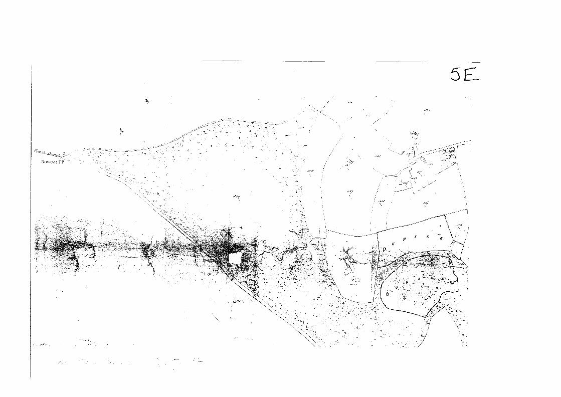
(01452) 425095 E-mail: [email protected] REPORT 7. DESCRIPTION OF PATH 7.1 A location map at scale 1: 10,000 is attached (numbered 5A) showing the position
of the claimed path at Rowden. The path in question lies partially in the parish of Uley and partially in the parish of Dursley. The boundary runs up the middle of the claimed route. Rowden is approximately 1 %miles east south-east of Dursley town centre.
7.2 The claimed path runs from the unclassified road 41473 in a generally south-
westerly direction to connect with public bridleways CDU 54, CUL 30 and CDU 57. The area of interest lies within Ordnance Survey Grid Square ST 7797.
7.3 A large scale map of the Rowden area at scale 1: 2500 is attached (numbered
5..B). This map shows the claimed path by a dotted line between points A and B. The claimed route is some 210 metres in length, and varies in width between approximately 3 and 6 metres. The track is enclosed between two hedges at the northern end, and as it climbs up through Rowden Wood to point B it becomes a sunken track, enclosed by high banks and is badly eroded in the southern section as the path approaches point B.
7.4 The track is open at both ends, although a temporary string barrier had been put
across the track at point A to prevent cattle from straying when the path was inspected in November 2003. The path is now partly obstructed at point A by two small conifers that were planted between November 2003 and January 2004. A County Council finger post at point A signposts the route as "Public Footpath".
7.5 Point A is at Ordnance Survey Grid Reference ST 7793 9726. Point B is at
Ordnance Survey Grid Reference ST 7776 9715. 8. BACKGROUND
2

8.1 On 16 July 2003 David Sykes, Footpaths Officer for Uley Parish Council drew the attention of the Public Rights of Way Department to what he considered to be an anomaly on the Definitive Map, with reference to the claimed path. He notes "The section of track in question is a very old, sunken track (with a badly eroded surface- wholly impassable to a wheeled vehicle), and is historically the continuation of the lane (i.e. 41473) that comes up from Uley; many years ago it was the route from Uley to Wotton. The Dursley/Uley parish boundary also runs along it. However, on the copy of the network map that I have... it is not shown as either a bridleway or a footpath... Nonetheless, there is a footpath sign pointing up it, it is commonly used as a footpath and a bridleway, and the OS Explorer Map 167 does show it as a bridleway..."
8.2 Mr Sykes was informed by letter dated 7 August 2003 that the path was on neither
the Definitive Map of Public Rights of Way nor on the Road Records. He was informed of the process by which rights of way could be added to the Definitive Map by Modification Order and sent the appropriate forms.
9. APPLICATION 9.1 On 14 November 2003, David Sykes, Footpaths Officer for Uley Parish Council,
submitted a completed application for an additional bridleway at Rowden, running from the junction of public bridleway CDU 54 with public bridleways CDU 57 and CUL 30 to the junction of public footpath CDU 53 with County Road 41473. Notice was served on the landowners affected by the application, namely John Rymer of Elcombe Farm, Elcombe, Uley, Jonathan Dembrey of Sheephouse Farm, Dursley, Uley Woodlands Estate Office, Oriel House, Tabram's Pitch, Nailsworth and Steven Price of 31 Rowden, Uley. The applicant noted that Mr Rymer owns the fields and some of the woodland to the west of the track, Mr Dembrey owns Coopers Wood, and Uley Woodlands own Rowden Wood. Mr Price owns the house and garden adjacent to the track.
9.2 The application was supported by a written statement of supporting evidence for
the application. Mr Sykes states that "it appears to be an anomaly that this was not designated when the local rights of way were recorded back in the last century: this section has clearly been part of a regular public route out of Uley for several years."
9.3 He goes on to describe the line and appearance: "The bridleway in question is a
length of sunken track leading up into the woods, just to the west of the three houses at Rowden; it follows the line of the Uley/Dursley parish boundary. Its deeply sunken appearance suggests that the track itself is of great age, and that it has been a well used right of way for many years. Examination of any contemporary map shows that this length of track is the natural extension of bridleway CDU 57 down to the metalled lane (41473) at Rowden, and indeed the historical evidence that follows bears this out."
9.4 Evidence from maps: "If you look into the local history, it is clear that the main
road from Uley to Nibley and Wotton under Edge was historically the lane (41473), now metalled, that still runs from Uley to Elcombe and Rowden, and which then continued up the track in question to join (what is now) bridleway
3

CDU 57 on up to the top of the hill, where it joined the Kingscote/Dursley road along the ridge. Historical evidence for this comes from old maps. Inspection of any of the tithe maps for Uley shows the track clearly marked as the main route out of Uley in a south-westerly direction. It is also shown on other period maps such as the early 19th century "Donne's Map of the country 21 miles round the City of Bristol" and the Victorian Ordnance Survey maps. Interestingly, OS maps published in the last few decades (viz Pathfinder 1132, 1; 50,000 sheet 162, Explorer 167) all show the track as a public bridleway."
9.5 Books: "The evidence of these maps is supported by the text in the book "The
Story of Uley" by M Lloyd Baker (early 20th century) - see page 34 "...The other old road out of Uley in that direction was that which went by Elcombe, and up through the wood to Bowcote. This was known as the 'coach road'...". This book includes a sketch map (not however to scale) showing the line of the lane through Elcomb (sic) and Rowden, and on up the hill to the road along the top. Mr Lloyd Baker had copied this from his great-grandfather's pocket book, which he reckoned to date around 1800."
9.6 Local people: "In the present day, there are plenty of local residents who can
vouch for the continuing, and unchallenged, use of this track as a right of way in recent decades. Public Path Evidence Forms have been collected from several of these, and are attached. All of the adjoining landowners are also supportive of the designation. It should be noted that there is a regular Gloucestershire County Council footpath sign pointing along the track from its northern end; this has been there for a number of years."
9.7 The application was further supported by four public path evidence forms. These
are summarised at 5...C. 9.8 The application was acknowledged as duly made on 24 November 2003. 10. LANDOWNERS' COMMENTS Consultations were undertaken with landowners on 29th December 2003. Those
landowners affected were Mr V Beeching of Uley Woodlands Estate Office, Mr H M A Lloyd- Baker of Hardwicke Court, Mr and Mrs S Price of 31 Rowden, Uley, John Rymer of Elcombe Farm, Elcombe, Uley and Mr J Dembrey of Sheephouse Farm, Dursley. Uley Woodlands Estate manage the land owned by Mr Lloyd-Baker. They were all given the opportunity to comment on the user evidence supplied in support of the application.
A summary of the documentary evidence was sent to all of the affected
landowners on 12th May 2004. The landowners were given an opportunity to comment upon the documentary evidence. V L Beeching of P D Carter Land Agents replied on behalf of Mr Lloyd Baker.
10.1 Uley Woodlands Estate Uley Woodlands Estate Office returned a map showing the extent of their
landownership on 17th December 2003. They made no further comment. The
4

Estate Office commented upon the documentary evidence by letter dated 9th June 2004:
"I refer to your letter and enclosures of 12th May and wish to point out that part of the bridleway to be added between points A and B is partly in Uley Parish and partly in Dursley Parish. The claimed track has the parish boundary running up the middle as shown on the Ordnance Survey sheet scale 1: 2,500 with OS 38 being in Dursley Parish and OS 24 being in Uley Parish. In the final paragraph of your Summary of Documentary Evidence you refer only to parcel OS 38 being the northern half of the track (in Dursley Parish) but there is no reference to the southern half being parcel OS 24 (in Uley Parish). There could be confusion if parcel OS 24 is not referred to in that only half of the claimed track has been dedicated."
10.2 Mr and Mrs S D Price Replied by letter dated 2nd December 2003: "....Reference additional bridleway at
Rowden in the Parish of Uley. We think that the opening of this bridleway is a great idea. But on closer inspection of what you are about to open up to us horse riding folk, is dangerous, unless the council are going to spend some money and make this lane accessible to horse riding people. As it is at present the top of the path, the banks are so steep where they have been eroded away, it is going to endanger horse and rider if any one attempted to ride up there. We hope that something will be done to make this bridle path worth opening and not just, another line on some paperwork."
10.3 John Rymer of Elcombe Farm, Uley Mr Rymer submitted a Public Path Evidence Form in support of the application.
He states that he has known and used the path since the 1950s, and he has used the path on a tractor (sometimes) and walking (mostly). He comments that "All local people believe this track to be a public right of way." In response to the question as to believed status of path he replied "Byway".
11. DOCUMENTARY EVIDENCE The County Archivist has examined sources in the Gloucestershire County Record
Office to see if this path is marked in any way and has identified other sources which might be useful in establishing the existence of a path along this route. These sources have then been checked by the Modification Orders Records Officer.
For ease of reference, the junction with County Road 41473 at Rowden is referred
to as point A, the junction with public bridleways CDU 54 and CDU 57 as point B. 11.1 Inclosure Award Not known for either Uley or Dursley 11.2 Uley Tithe Map, 1842 (GDRIT11187) Map of whole parish with apportionment. Roads are coloured brown, watercourses
in blue, parish boundaries in pink, and detached parts of Dursley and Cam parishes in pale blue. Footpaths are shown by a single dashed line, unenclosed tracks by a pair of dashed lines. Claimed route is shown between
5

points A and B as part of a through route connecting Elcombe to the Dursley- Tetbury road at Bowcot TP [turnpike], coloured brown as are other known roads.
Route is shown open at each end. At the base of the map is written the following: 'We the Undersigned Tithe
Commissioners for England and Wales do hereby certify this to be a Correct Copy of the Map or Plan referred to in the Apportionment of the Rent Charge in lieu of Tithes in the Parish of Uley in the County of Gloucester. In testimony whereof we have hereunto subscribed our respective names and caused our Official Seal to be affixed this twenty seventh day of June in the Year of our Lord one thousand eight hundred and forty two". The map is signed Wm Blamire and Tho Buller; the seal of the Tithe Commissioners is embossed on the map. The Tithe Commutation Act o f 1836 was amended in 1837 to establish two classes of tithe maps: first class and second class. The presence of the Tithe Commissioners' official seal identifies the Uley map as first class. First-class maps are legal evidence of all matters which they portray, whereas the Tithe Commission sanctioned second-class maps as evidence of only those facts of direct relevance to tithe commutation. Those tithe maps sealed as first class are compiled from new surveys.
11.3 Dursley Tithe Map, 1846 (GDR/T1/71) (5 F) Map of whole parish showing claimed route continuing beyond point B to
connect with the "Turnpike Road" from Dursley to Tetbury at Bowcott where a building is shown and the main road is crossed by a boundary feature, presumably the turnpike gate. Watercourses are shown coloured blue, buildings in pink or black, roads are uncoloured. Claimed route shown by two continuous lines between points A and B. The route continues south from point B to Bowcott; this section is depicted by double pecked lines. Parish boundary shown running down the middle of the way. The map bears the Tithe Commissioners' seal and is certified as a correct copy by W Buller and Richard Jones, 1 May 1847. This identifies the map as First Class.
11.4 Ordnance Survey 25" to 1 mile, 1883 edition, sheet Glos 56.4 (.5H) Route shown marked by two full lines, open at A and with a boundary feature at
B. Claimed route is given the Plot Number 38, and is described as 0.108 acres in area; this measurement of area would appear to relate only to that part of the path that was in Dursley parish. The notation "C.R." which is short for Centre of Road indicates that the parish boundary ran down the centre of the road. The notation "C.R." is also used on the section of path leading up to Bowcott.
11.5 Ordnance Survey 25" to 1 mile, 1903 edition, sheet Glos 56.4 (5.I) Route shown by two full lines, open at A and with a boundary feature at B.
Claimed route is given the plot Number 38 for the Dursley part of the road, and forms part of plot number 24 (with Elcombe Lane) on the Uley side of the boundary. The boundary mereing "C.R." is marked on the map between points A and B and also beside the continuation of the route to Bowcott.
11.6 Ordnance Survey 25" to 1 mile, 1921 edition, sheet Glos 56.4 (.5J) The 3rd edition map of 1921 shows the claimed route by two full lines, open at A
and by a dashed line at point B. Claimed route is given the plot Number 38 for the
6

Dursley part of the road, and forms part of plot number 24 (with Elcombe Lane) on the Uley side of the boundary. The boundary mereing "C.R." is marked on the map between points A and B and also beside the continuation of the route to Bowcott.
11.7 Ordnance Survey 1" to 1 mile map, surveyed 1817 Route is shown as part of a through route to Bowcott by a pair of dashed lines. 11.8 Bryant Map of Gloucestershire, 1824 A route is shown continuing from Elcombe to the main Dursley to Tetbury road at
Bowcott, but the exact route is not clear owing to the scale of the map. 11.9 Inland Revenue: maps compiled under the Finance Act, 1910 (.5.G) Based on Ordnance Survey 25" to 1 mile c.1902 edition, marked up by Inland
Revenue c.1915 and reference books or files (D2428) Route is shown uncoloured and outside property boundaries between points A
and B. The continuation of the route to Bowcott is shown coloured, and forms part of hereditament 627.
11.10 Maps deposited with County Planning Officer under Rights of Way Act, 1932
S1,3 (CPID) Nothing appears relevant for Uley. No items relevant to the act have been
deposited by Dursley Parish Council 11.11 Parish Council File, Rights of Way Act 1932 Uley Parish Council minutes (P345aPC1/1-7), 1894-1975 (7 vols). Not checked
Dursley Parish Council minutes 1894-1949. Not checked 11.12 Duplicate copies of tithe or inclosure awards D3549/39/3/9- Copy Uley tithe
map MF 1128/207 Microfilm copy of Uley tithe map 11.13 Private estate maps and title deeds Map of Uley, 9840 (D1388 155 Uley) 1840 map in outline, unfinished, otherwise features shown are as tithe map.
Possibly a draft version of the tithe map. Title deeds relating to a cottage and land at Rowden in Uley 17281868
(D3549 39/1/52) Searched, not relevant Survey of Uley with sketch plans and data on the population, in the writing of
Thomas John Lloyd Baker c.1795-1807 (D3549 3913/4) The sketch plan of houses at Uley in The Story of Uley by M Lloyd Baker [not
dated, c.1935] is based on this original sketch (5 .D). Shows houses at Rowden, numbered 3, 4 and 5. An accompanying schedule lists the occupiers. A road is depicted, labelled Marsh Lane and then The Alley, continuing from Uley through Elcombe to what appears to be the main Dursley to Tetbury road at Bowcott where the houses numbered 1 and 2 are indicated.
7

11.14 Footpath or highway diversion orders deposited with Clerk of the Peace (Q/SRh)
Uley: 1775D; 1786D/2; 180213; 1805A/4; 1818D/3,4; 1832D/3; 183513/2; 1876T, M; 1879E; Q/SR 1819A; 1835C; 1876D; 1879C}
Checked; 1805A/4 relates to the widening of a highway between Bowcott and Uley and the diversion of several footpaths (includes plan) (.... ; other orders not relevant. The plan shows the highway to be widened, coloured in grey, with the sections to be added to allow widening in a paler grey. The two ends of the highway are marked "To Uley and "To Bowcott". The Order includes the following wording: "We whose names are hereunto subscribed being two of his Majesty's Justices of the Peace for the said county... having upon view found that certain parts of the highway between the village of Uley and a place called Bolcott otherwise Bowcott in the Parish of Uley..."
Dursley: 1781M; 1784T; 1839Ea; 1867T; 1907Ea; 1930Ea; 1937Ea; 1946Tr;
Q/SR 1839D; 1867D; 1900A} Checked, not relevant 11.15 Plans of public schemes deposited with Clerk of Peace (QIRUm) Not checked 11.16 District Council Clerk's correspondence Nothing appears relevant 11.17 County Council Solicitor's correspondence (K596/25) Checked, nothing appears relevant 11.18 County Surveyor: papers relating to survey of footpaths under National Parks
and Access to Countryside Act, 1949 (K687) K6871114110 Original Submission Map for Uley There are a series of three maps accompanying the original parish submission.
On the first map (Map 1)(.5.N) the parish boundary is coloured yellow, and footpaths are for the most part marked in purple, bridleways in red ink. However, some paths are marked "BR" or "FP" and this is not always consistent with the red / purple colouring. The claimed route and its continuation southwards to the main road at Bowcott are coloured green and both sections are separately numbered 57. The only other route on the map that is coloured green runs from Hydegate to Ashmead Green in Cam parish. Presumably the green colouring has been used to denote paths that a re outside the parish of Uley.
A second map (Map 2), (.5..0) marks the claimed route, its southern extension to Bowcott and also the path which it crosses, all in green. The claimed route is labelled 36, its continuation to the south is unnumbered. On the cover of the map is written "See New Map"
A third map (Map 3) shows paths in red ink, some of which are numbered in pencil. County roads are marked in brown and numbered. The parish boundary is marked in orange. The route in question is not marked.
K687121312 Objections File, Uley Letter from Uley Parish Council Clerk to County Council, 15 January 1954 notes:
"...FP CUL 30 should continue along the marked track to the main road at a point 800 ft west of Ridge Farm. At its western extremity it should extend from Rowden
8

to Round House". In pencil the following comment is added "it does so as BR CDU 57". In reply, the County Surveyor wrote to Uley Parish Council on 14 May 1958: "...in addition, it was claimed that footpath CUL 30 should be extended along the track marked on the OS Map to the main road at a point 800 feet west of Ridge Farm and at its western extremity it should extend from Rowden to Round House ... With regard to these last three claims, the paths do in fact extend to the points claimed by the objectors, but since these extensions come within the adjoining Parish they would not of course have been marked on the Draft map which was issued to Uley Parish..."
K6871316 Provisional Map Route to the south of the claimed bridleway is numbered 57 on the provisional
map. It is unclear whether this number should also refer to the claimed route. K68713128 Statement annexed to the Provisional Map BR [bridleroad] CDU 54 runs from BR CDU 60 East of Caswell Farm in a SE then
NE direction to county road 41473 SE of Sheephouse Farm via OS Parcel numbers 56, 31 and 38. Particulars state "Submitted by Parish Council, not shown as BR on Glos OS no.56 1924 Edition"
BR CDU 57 runs from County Road A4135 Round House in a NE direction to BR CDU 54 NE of Round House via OS Parcel Nos. 30 and 31. Particulars state "Submitted by Parish Council, not on Glos OS No. 56 1924 Edition"
K687111413 Original Submission Map and Schedule for Dursley Original parish submission map (.5.K) shows footpaths in purple, bridleways in
green and carriageways by a green and white dashed line. Claimed route shown between A and B (and continuing south-westerly to the Round House) by a green line. The route between A and B is labelled "48" in pencil as is its south-westerly continuation. A second map (.5M) uses the 6" to 1 mile sheet Glos 56 NE as a base map, and shows paths in parts of Uley, Dursley, North Nibley, Cam and Wotton under Edge parishes. Footpaths are marked in purple, bridleways in green and carriage roads used as public paths by a green and white dashed line. Paths are numbered in red ink. Amendments have been made to the map in pencil. The claimed route is marked in green and numbered 54. The south west continuation to the Round House is coloured green and numbered 57. The westerly continuation at point B [the present bridleway CDU 54] is labelled 54 and coloured green. A third map, which incorporates the amendments suggested on the second map shows the claimed route, its westerly continuation at point B and its south-westerly continuation to the Round House in green, with similar labelling to the second map.
The handwritten submission schedule (51) describes CDU 57 as a bridleway running from the A4135 at the Round House in a north-easterly direction to connect with bridleway CDU 54 north-east of Round House via OS Parcel Numbers 30 and 31. In the particulars column the following note is made: "Submitted by Parish Council, not on Glos OS No.56 1924 edition".
The schedule describes CDU 54 as a bridleway running from CRB [Carriage Road Used as a Bridleway] CDU 60 East of Caswell Farm in a south east, north east direction to connect with County Road 41473 SE of Sheephouse Farm via Ordnance Survey Parcel Numbers 56, 31, 38. In the particulars column it is
9

described as "Submitted by Parish Council, not shown as BR [bridleroad] on Glos OS No.56 1924 edition"
K687/2/3/1 Objections File, Dursley Not relevant to this route Draft and Modified Draft Maps Claimed route marked on the Draft Map in green as are other bridleways, and
numbered 54. Modified Draft Map shows claimed route coloured green but not numbered. On both maps the parish boundary between Dursley and Uley is marked in yellow in the same position as the claimed route, making the green colouring used to denote a bridleway indistinct.
Provisional Map (K687/3/6) and Schedule (K687/3/28) The Provisional Map (.5.P) shows CDU 57 from the Round House to the junction
with CDU 54 at point B. CDU 54 is marked as the route running west from point B. The actual claimed route is neither depicted nor numbered.
In the schedule, bridleroad CDU 54 is described as running from BR CDU 60
East of Caswell Farm in a south-easterly then north-easterly direction to county road 41473 South East of Sheephouse Farm via OS Parcel Nos. 56, 31, 38. The particulars state "Submitted by Parish Council, not shown as BR on Glos OS No.56 1924 Edition".
BR CDU 57 is described as running from County Road A4135 at the Round House in a NE direction to BR CDU 54 North East of Round House via OS Parcel Nos. 30 and 31. The particulars state "Submitted by Parish Council, not on Glos OS No.56 1924 Edition".
Summary of Papers relating to the National Parks and Access to the Countryside
Act 1949 The claimed route is depicted on the Uley Parish Submission. The Uley Parish
Council Clerk wrote to the County Surveyor on 15 January 1954 to state that CUL 30 should extend at its western end from Rowden to the Round House [i.e. including the claimed route]. The County Surveyor replied that the path did in fact extend to the points claimed by the Parish Council but in an adjoining parish.
The claimed route is shown on the Dursley parish submission maps, the draft
map and the modified draft map as an eastward extension of bridleway CDU 54. It is not depicted on the Provisional Map or on the final Definitive Map. The Statements annexed to both the Parish Submission and Provisional Map and also to the Definitive Statement describe bridleway CDU 54 as connecting with County Road 41473 via OS Parcel Numbers 56, 31 and 38. Parcel 38 is the length of lane that forms the claimed route. The description of the route within the Definitive Statement indicates that the claimed route was considered to be part of bridleway CDU 54.
11.19 M Lloyd Baker The Story of Uley (n.d. [1935?]) (.5.D) On page 34: "The other old road out of Uley in that direction was that which went
by Elcombe, and up through the wood to Bowcote. This was known as the "coach road", and the wood was called the "coach wood". My ancestor used it when he
10

first came to Stoutshill, when going to Petty Sessions at Wotton; he was very fond of driving four in hand. Perhaps it was rather easier than the Owlpen lane. There were many more houses along the Elcombe road 150 years ago than there are now, probably because it was one of the principal highways of Uley. In 1800 it was known as `the Alley'."
On page 49: "The following sketch maps are taken from my great-grandfather's estate pocket book. The date us unfortunately not given, but it is likely to have been about 1800, or perhaps a few years earlier." This map is annotated with numbers that correspond to individual houses of which the occupants are listed.
The original sketch plan and survey referred to on page 49 are in the
Gloucestershire Record Office (D3549 39/3/4), see section 11.13 of this report. 12. OTHER OBSERVATIONS 12.1 Ramblers' Association Mr Michael Poole, Group Footpath Secretary for South Cotswolds replied by email
on 12 December 2003: "We naturally support this application for a new bridleway, which we have used on foot on many occasions as it appears on the OS Explorer Map as a bridleway at the present time. I notice, however that it is not so shown on the County's Network Map of Rights of Way. Does this mean that the purpose of the proposed order is merely to correct a collection of administrative errors in the past? We naturally support all such orders, especially in the case of a long established and well used path such as this one."
12.2 British Horse Society Mr W Reddaway County Bridleways and Access Officer for the British Horse
Society replied by e-mail dated 26 January 2004 "....I am naturally in favour of more bridleways but looking at the Plan and comparing it with the Ordnance Survey map, it seems there is already a bridleway running along this section..."
12.3 Cyclists' Touring Club Mr C Palmer, local representative for CTC Offroad, the Access and Rights of Way
Section of the Cyclists' Touring Club, replied by letter received 19 December 2003 that his organisation supported this application but commented "Am a little mystified as the link is shown as a bridleway on my Landranger".
12.4 Uley Parish Council Mr David Sykes, the applicant, made the application in his capacity as Footpaths
Officer for Uley Parish Council. 12.6 Dursley Parish Council Mrs A Leaney, Clerk to Dursley Town Council, replied by letter dated 8th January
2004: "Thank you for your letter of 8th December, regarding the above proposal, which was put before Council at its last meeting on 6 th January 2004. It was agreed that Dursley Town Council have no objection to the intended modification."
12.7 Stroud District Council
11

James Rachel, Legal Executive at Stroud District Council replied by e-mail dated 26 January 2004: "I refer to your consultation letter dated 8 th December 2003 ... and confirm this council has no comments to make in respect of any of the applications."
12.8 County Councillor Councillor Geoff Wheeler replied by e-mail dated 3'd February 2004: "...On enquiry
of the parish and town councils and users of the existing footpaths and bridleways in the vicinity, I have no evidence to suggest that there has been no intention to dedicate the proposed bridleway. One person, Mr John Penley of Uley, would be prepared, if necessary, to provide a witness statement that the path has been used for a considerable time as a bridle path."
13. APPLICANT The applicant Mr David Sykes made no further comment on the user or
documentary evidence. 14. LEGAL COMMENTS AND CONCLUSION 14.1 Section 53 (3) (c) (i) of the Wildlife and Countryside Act, 1981, relates to the
discovery by the Authority of evidence that shows that a right of way that is not shown on the map and statement subsists, or is reasonably alleged to subsist, over land in the area to which the map relates.
14.2 Section 31(1) of the Highways Act 1980 states that where a way over any land,
other than a way of such character that use of it by the public could not give rise at Common Law to any presumption of dedication, has been actually enjoyed by the public as of right and without interruption for a full period of 20 years, the way is deemed to have been dedicated as a highway unless there is sufficient evidence that there was no intention during that period to dedicate it. The period of 20 years in sub-section (1) is calculated retrospectively from the date when the right of the public is brought into question whether by a notice or otherwise.
14.3 Section 31 (9) of the Highways Act 1980 says that nothing in this section
operates to prevent the dedication of a way as a highway being presumed on proof of user for any less period than 20 years. Paragraph 12 of Annex B of the Department of Environment Circular 2/93 states that before making an order, the surveying authority must be satisfied that the evidence shows on the balance of probability that a right of way of a particular description exists.
14.4 Section 66 (1) of the Wildlife and Countryside Act 1981, states that a `byway
open to all traffic' means a highway over which the public have a right of way for vehicular and all other kinds of traffic, but which is used by the public mainly for the purpose for which footpaths and bridleways are so used.
14.5 The conditions for classification of a byway open to all traffic have been clarified
by the Court of Appeal's judgement [Masters v the Secretary of State for the Environment, Transport and the Regions (2001)]. The Court stated that it is not a precondition for a carriageway to be a BOAT for there to be equestrian or
12

pedestrian use or that such use is greater than vehicular use. The test for a carriageway to be a BOAT relates to its character or type and in particular whether it is more suitable for use by walkers and horse riders than vehicles. In summary, a byway open to all traffic is a carriageway and thus a right of way for vehicular traffic, but one that is used mainly for the purposes for which footpaths and bridleways are used, i.e. by walkers and horse riders.
14.6 In the Masters case (2000) it was further concluded that a byway should not be
removed from the Definitive Map because the use made of the way by the public had ceased or the balance between the various uses made by the public of the way had changed. Parliament intended that `full highways or cart ways' which might not be listed as highways maintainable at the public expense under the Highways Act 1980, should be included in the Definitive Map and Statement so that rights of way over such highways should not be lost. If a highway was more suited to horse riders or pedestrians, then, as in the Masters case, it was made obligatory by parliament that they continue to be shown on the maps and statements.
14.7 The issue is whether the evidence discovered by the Council, when considered
with all other relevant evidence available, shows that, on the balance of probabilities, the Definitive Map and Statement require modification because a right of way which is not shown on the map and Statement subsists, or is reasonably alleged to subsist.
14.8 The case for the Order rests on user and documentary evidence. In order to
apply the requirements of the 1981 Act, we need to consider whether there is a presumption of dedication under Section 31(1) of the Highways Act. This requires:
1) determination of the date on which the right of the public to use the claimed footpath was called into question; that is there has to be some overt act on the part of the landowner to bring it home to users that their right is being challenged
2) whether the claimed path was actually enjoyed by the public as of right, and without interruption, for a full period of 20 years ending on the date on which their right to do so was brought into question; and
3) whether there is sufficient evidence that there was, during this 20 year period, no intention on the part of the landowners concerned to dedicate the claimed footpath
14.9 If there is no presumption of dedication under Section 31 of the 1980 Act, we will
also consider whether the evidence is such as to establish, again on a balance of probabilities, dedication at Common Law.
14.10 We have first to ascertain the date of challenge. There is no fixed method by
which the public's right may be brought into question, though one (the erection of a notice) is expressly referred to in Section 31. The words "or otherwise" in Section 31(2) leave the matter at large. The methods can range from a notice on site denying the public the existence of a right of way, the locking of a gate or seeking a declaration that there is no highway over the land in question. Whatever means are employed, it should be sufficient "to make it likely that some
13

of the users are made aware that the owner has challenged their right to use the way as a highway... The persons to whom the challenge has to be brought home are the users of the way."
14.11 The Dorset case [R v Secretary of State for the Environment, Transport and the
Regions, ex parte Dorset County Council, 19991 makes it clear that there was a need to "bring into question" the public's right to use a way in order to trigger the provisions of Section 31 of the 1980 Highways Act. If this does not happen, there can be no deemed dedication under that Section. Not every user need be told by the owner of the challenge, nor is there any particular method of bringing it home to users. In terms of a Modification Order application, if the owner objects to the application, this will be a date of challenge. If he does nothing until the Order is made, this is insufficient and there will be no challenge that will meet the requirements of Section 31. If the owner does nothing at all, then this would not preclude a claim based on common law under Section 31 (9) of the Highways Act [see section 14.3].
14.12 The owners have not opposed this application and none of the witnesses make
reference to ever having been prevented from using the path or having their right to use the path brought into question in any way. As there does not appear to have been an event that brought the public's right to use the path into question, the case would need to be considered under common law rather than under Section 31 of the Highways Act.
14.13 At common law, the burden of proof is upon the person claiming the right to
show both that the owner of the land intended to dedicate over it a public right of way and that the public accepted the right of way. The latter is more often than not implied from use of the way by the public. In the absence of some overt act on the part of the landowner, it may be that use by the public has gone on openly for so long that dedication can reasonably be inferred from it. Mere use does not create a highway, but use is the evidence to prove dedication.
14.14 Four public path evidence forms were submitted in support of the application.
John Fisher (witness 3) has used the path on foot between the 1940s and 1980s and John Rymer (witness 2) from the 1950s to 2003. C F Ash (witness 4) used the path between 1980 and 2000. Two of the witnesses believe the path to be a bridleway, one a byway and one a footpath, but apart from Mr Rymer who has driven a tractor along the path, the other three have only used the path on foot.
14.15 There is no statutory minimum level of user required for the purpose, and the
matter does not seem to have been tested in the courts. However it is clear that there has to be a sufficient level of use for the landowner to have been aware of it, and have had the opportunity to resist it if he chose. In Hollins v Verney (1884) it was said that: No user can be sufficient which does not raise a reasonable inference of such a continuous enjoyment and that no actual use can be sufficient to satisfy the statute ... unless the user is enough to carry to the mind of a reasonable person (owner, etc) the fact that a continuous right of enjoyment is being asserted and ought to be resisted ... It follows that use of a way is less cogent evidence of dedication if the landowner is non-resident- at
14

any rate, if the owner had no agent on the spot- than if he is resident. If the landowner did not know that the way was being used, no inference can be drawn from his non-interference.
14.16 Use of the way should also have been by a sufficient number of people to show
that it was use by the public, that is the people as a whole, or the community in general, and this may well vary from case to case. Very often the quantity of valid user evidence is less important in meeting these sufficiency tests than the quality (i.e. its cogency, honesty, accuracy, credibility and . consistency with other evidence).
14.17 It was held in Mann v Brodie (1885) that the number of users must be as might
reasonably have been expected, if the way had been unquestionably a public highway. Watson J said: If twenty witnesses had merely repeated the statements made by the six old men who gave evidence, that would not have strengthened the respondents' case. On the other hand the testimony of a smaller number of witnesses each speaking to persons using and occasions of use other than those observed by these six witnesses, might have been a very material addition to the evidence. Arguably therefore, the evidence contained in a few forms may be as cogent- or more cogent- evidence than that in many. However, Dyson J in Dorset 1999 did not question that the Inspector had found the evidence contained in five user statements insufficient to satisfy the statutory test, even though the truth of what was contained in them had been accepted.
14.18 Under Section 32 of the Highways Act 1980, when determining whether a way
has or has not been dedicated as a highway, or the date on which such dedication, if any, took place, shall take into consideration any map, plan or history of the locality or other relevant document which is tendered in evidence, and shall give weight thereto as the court or tribunal considers justified in the circumstances, including the antiquity of the tendered document, the status of the person by whom and the purpose for which it was made or compiled, and the custody in which it has been kept and from which it is produced. The Panel's attention is drawn to the report on documentary evidence at section 11.
14.19 If it can be established that a public right of way existed at any past date, that
right continues today. The right cannot be lost by disuse. It can only cease to exist if the public right to use the route was lawfully removed: until recently that required an order from the justices of the peace. Lack of modern user evidence does not obstruct such claims.
14.20 On the 1817 Ordnance Survey 1 inch to 1 mile map the route is shown by two
pecked lines, running from point A to point B and then continuing to Bowcott. This indicates that it was a road or track, but gives no indication as to its status. Ordnance Survey maps carry a disclaimer that any representation of a road, track or path is no evidence of the existence of a right of way over it. However, they do provide evidence of the physical existence and extent of a way, suggesting (but not proving) that the path had been in use for a longer period than that for which user evidence is available.
15

14.21 The 1st, 2nd and 3rd edition Ordnance Survey 25" to 1 mile maps are consistent in their depiction of the claimed route. On all three maps the boundary mereing "C.R." meaning Centre of Road is used both for the claimed route and the continuation to Bowcott, indicating that the Ordnance Survey considered that its physical characteristics suggested that it looked like a road, although no indication is given as to status.
14.22 Tithe maps provide important evidence as to the existence of a public right of
way. The maps were drawn up under statutory authority by the Tithe Commissioners under the provisions contained in the Tithe Commutation Act of 1836 to show all cultivated land, arable and pasture, as tithe was payable on land producing crops. They also had to show wasteland and roads, because tithe was not payable on these. Thus a distinction is made between tithable and untithable land, with roads clearly marked as untithable. Several features of the Tithe Commutation process lend weight to the evidential value of the documents: the public and statutory nature of the process, the external and internal checks carried out at the time, the impartiality of the process, and the official custody in which the records have been kept.
14.23 Tithe Maps were concerned solely with identifying tithable lands, and not with
roads and their status, so cannot be used as definitive evidence regarding public roads. However, Tithe Maps do mark roads quite accurately and, taken in conjunction with the schedules, provide useful supporting evidence. As tithes were not payable on public highways, these are often shown in a special colouring on the plans.
14.24 I n the case of Maltbridge Island Management Company v Secretary of State for
the Environment, 31 St July 1998, Sullivan considered that: "The Tithe Map and apportionment evidence is undoubtedly relevant as to both
the existence, and physical extent, of a way at the relevant time. Both public and private roads were not tithable, the mere fact that a road is shown on, or mentioned in a Tithe Map or Apportionment, is no indication as to whether it is public or private."
Sullivan went on to consider whether a tithe map and apportionment could be
evidence of the status of a road: "But if detailed analysis shows that even though he was not required to do so, the
cartographer or the compiler of this particular map and apportionment did in fact treat public and private roads differently, whether by the use of different colours, the use or non-use of plot numbers, or other symbols, or in schedules or listings, I do not see why evidence based on such analysis should not be admissible as to the existence or non-existence of public rights of way. ... Since it was not one of the purposes of the 1836 Act to distinguish between public and private roads, such information as can be derived for the Tithe Map and Apportionment cannot be conclusive, and must by its very nature be tentative..."
14.25 The Tithe Commutation Act of 1836 was amended in 1837 to establish two
classes of tithe maps: first class and second class. The presence of the Tithe
16

Commissioners' official seal identifies both the Uley and the Dursley maps as first class. First-class maps are legal evidence of all matters which they portray, whereas the Tithe Commission sanctioned second-class maps as evidence of only those facts of direct relevance to tithe commutation. Those tithe maps sealed as first class are compiled from new surveys.
14.26 The Tithe Map for Uley shows an enclosed route running from A-B. The route A
to B and its continuation to Bowcott is coloured on the map in a manner consistent with other known roads. No plot number is allotted to the parcel of land over which the route runs and no obstruction or boundary feature is depicted across the claimed route. The Tithe Map for Dursley is consistent with the Uley map. Although uncoloured, the claimed route A to B is shown by two continuous lines, with the continuation to Bowcott depicted by two dashed lines. No plot number is allotted to the claimed route (or its continuation) indicating that it was untithable. Both maps depict the route in a manner consistent with other known roads.
14.27 The Footpath or Highway diversion order deposited with the Clerk of the Peace
1805A/4 relates to the widening of the highway between. Bowcott and Uley. Bowcott is beyond Elcombe on the Dursley to Tetbury Road. Although this widening does not relate directly to the claimed route, the Order and plan make it clear that there was a through route between Uley, Elcombe and Bowcott and that this route was a carriageway.
14.28 The location of this carriageway between Uley and Bowcott is provided by the
Survey of Uley with sketch plans and data on the population, in the writing of Thomas John Lloyd Baker c.1795-1807 (D3549 39/3/4). This sketch shows houses at Rowden, numbered 3, 4 and 5. An accompanying schedule lists the occupiers. A road is depicted, labelled Marsh Lane and then The Alley, continuing from Uley through Elcombe to what appears to be the main Dursley to Tetbury road at Bowcott where the houses numbered 1 and 2 are indicated. The sketch map is referred to in The Story of Uley by M Lloyd Baker [not dated, c.1935]. On page 49 he states: "The following sketch maps are taken from my great-grandfather's estate pocket book. The date us unfortunately not given, but it is likely to have been about 1800, or perhaps a few years earlier."
14.29 The Story of Uley by M Lloyd Baker also states (on page 34): "The other old
road out of Uley in that direction was that which went by Elcombe, and up through the wood to Bowcooe. This was known as the "coach road", and the wood was called the "coach wood". My ancestor used it when he first came to Stoutshill, when going to Petty Sessions at Wotton; he was very fond of driving four in hand. Perhaps it was rather easier than the Owlpen lane. There were many more houses along the Elcombe road 150 years ago than there are now, probably because it was one of the principal highways of Uley. In 1800 it was known as 'the Alley'."
14.30 Considering the highway widening order of 1805, the sketch maps of Uley
c.1800 and the two Tithe Maps together it is clear that a through road continued from Elcombe Lane to Rowden, along the claimed route and then through the
17

wood to Bowcott. The comments made by Lloyd Baker in The Story of Uley confirm this.
14.31 The Finance Act of 1910 imposed a tax on the incremental value of land when it
changed hands. In order to levy the tax, the Board of Inland Revenue was required to ascertain the site value of all land in the United Kingdom, which meant plotting and recording every piece of land, and resulted in the most' comprehensive record of land ever prepared. All private land including private roads was assigned an assessment number. Valuers would have been extremely reluctant to show any land as a public road if it could be assessed for duty. Indeed they would have been negligent to do so.
14.32 In view of the financial implications, many landowners and occupiers would
have been anxious to ensure that public highways were correctly recorded on the plans and all rights of way were properly recorded in the Field Book. It was an offence to knowingly make any false statement of representation, punishable by up to six months imprisonment. The threat of criminal sanction and the fact that the survey was carried out by a public body under statutory powers are relevant in giving the survey documents weight.
14.33 The Finance Act Map shows the whole of the claimed route from point A to point
B as uncoloured. The continuation to Bowcott is shown within property boundaries. The absence of colouring indicates that there is no claimed owner of this section of the claimed way. The fact that the road is uncoloured points strongly to the conclusion that this section of road was recognised as a highway at the time but, viewed in isolation, the fact that the road is uncoloured leaves open the question of whether it was recognised as a public carriage road or as a lesser highway. The Finance Act map does provide good corroborative evidence, but this evidence is not conclusive.
14.34 The claimed route is depicted on the Parish Submission map drawn up by Uley
Parish Council under the National Parks and Access to the Countryside Act 1949. The Uley Parish Council Clerk wrote to the County Surveyor on 15 January 1954 objecting to the Original Draft Map for Uley. One of the objections was that the claimed route at Rowden was omitted. The Parish Clerk stated that bridleway CUL 30 should extend at its western end from Rowden to the Round House [i.e. to include the claimed route]. In pencil the following comment is added (presumably by the County Surveyor) "It does so as BR CDU 57". The County Surveyor responded to this objection formally on 14 May 1958 "...With regard to these last three claims [including the claim to extend CUL 30], the paths do in fact extend to the points claimed by the objectors, but since these extensions come within the adjoining parish they would not of course have been marked on the Draft map which was issued to Uley parish..."
14.35 The claimed route is shown on the three Dursley parish submission maps, then
the Draft map and then also the Modified Draft Map as an eastward extension of bridleway CDU 54 and is consistently depicted as a bridleway. The claimed route is not shown on the Provisional Map or on the final Definitive Map. The Statements annexed to both the Dursley Parish Submission and
18

Provisional Map and the final Definitive Statement describe bridleway CDU 54 as connecting with County Road 41473 via OS Parcel Numbers 56, 31 and 38. Parcel 38 corresponds to the strip of land which forms the claimed route. The description of the route within the Definitive Statement makes it clear that the claimed route was considered to be part of bridleway CDU 54.
14.36 The claimed bridleway is not shown on the Definitive Map but the Definitive
Statement makes it clear that the route A to B forms part of bridleway CDU 54. It would thus appear that an anomaly exists between the Definitive Map and the Definitive Statement concerning the claimed path: it is recorded on the Definitive Statement but not on the Definitive Map.
14.37 The Wildlife and Countryside Act 1981 does not state whether the definitive
map or the definitive statement has precedence. Section 56(1)(e) of the Act indicates, however, that the purpose of the two documents is different. It provides: "A definitive map and statement shall be conclusive evidence as to the particulars contained therein to the following extent ... the map is conclusive evidence, as at any date, as to a highway shown thereon, any particulars contained in the statement as to the position or width thereof shall be conclusive evidence as to the position and width thereof at that date, and any particulars so contained as to the limitations or conditions affecting the public right of way shall be conclusive evidence that at the said date the said right was subject to those limitations or conditions..."
14.38 The Planning Inspectorate Right of Way Section Advice Note No 5 summarises
this as follows: the map is conclusive evidence as to the existence and status of any right of way shown, whilst the statement is conclusive evidence as to the position and width, and limitations or conditions. It seems reasonable to conclude, therefore, that the respective documents have precedence on the particulars to which the Act provides they are conclusive evidence.
14.39 The Department of the Environment advised in 1997 that "Information recorded
in the definitive statement about the position or width or as limitations or conditions affecting a public right of way is conclusive evidence of position, width, limitations or conditions. Information may be recorded in the definitive statement which, in practice, restricts the use of the way by those whose rights to use it are recorded on the definitive map. Where such information is not about position or width or is not recorded as a limitation or condition, highway authorities should examine the evidence in each case in order to resolve the inconsistencies."
14.40 The intention of both parishes was for the path to be included on the Definitive
Map as a bridleway. This is clear from its depiction as a bridleway on the submission maps for both parishes and also the Draft and Modified Draft Maps. Uley Parish Council queried its absence as a bridleway from the Uley draft map to which the County Surveyor replied that this was because it formed part of bridleway CDU 54 in Dursley Parish. The Definitive Statement makes it clear that CDU 54 joins the Elcombe Lane and thus includes the whole of the claimed route. It can only be assumed that the path was omitted from the Provisional
19

and hence final Definitive Map through a drafting error, presumably resulting from it being overlooked owing to its position coinciding with the parish boundary.
14.41 The historical evidence strongly suggests that the claimed route carries higher
status than bridleway. The Tithe Maps and Finance Act map show the route falling outside property boundaries, indicating that the claimed route was highway. On both the Dursley and Uley Tithe Maps the route (and its continuation to Bowcott) is depicted in a manner consistent with other known roads. The 1805 highway widening order and the 1800 sketch showing roads and houses in Uley show that a carriageway ran from Uley through Rowden to Bowcott.
14.42 If a public highway was in existence on 31 August 1835, it is publicly maintain-
able by virtue of section 23 of the Highways Act 1835. Although there is some evidence of the route being a carriageway in 1805, the evidence is more compelling from 1843 and 1846 when the route was depicted on the Uley and Dursley Tithe Maps.
14.43 The Masters judgement establishes that the test for a carriageway to be a
Byway Open to All Traffic relates to its character or type and in particular whether it is more suitable for use by walkers and horse riders than vehicles. A byway open to all traffic is a carriageway and thus a right of way for vehicular traffic, but one that is used mainly for the purposes for which footpaths and bridleways are used, i.e. by walkers and horse riders.
14.44 The documentary evidence suggests that the claimed way carries vehicular
rights but the user evidence suggests that the route is used mainly for the purpose for which footpaths and bridleways are so used, i.e. by walkers and pedestrians. Considering the physical characteristics of the way, the claimed route between A and B (and its continuation to Bowcott) has a roughly stoned surface, much eroded in places, and is a leafy often muddy track through the woods. Elcombe Lane is tarmaced from Uley to point A, from whence it continues as a rough track through Rowden Wood (the claimed route). Thus, the tests under Masters for suitability and character are met and the way should be recorded on the Definitive Map and Statement as a Byway Open to All Traffic. It is further concluded that the historical evidence (namely the Tithe Maps, the 1805 Highway Widening Order and the c.1800 Sketch map) indicates that the continuation of the route to Bowcott should be similarly re-classified as a Byway Open to All Traffic.
15. ENCLOSURES A. Location map, scale 1:10,000 B. Detailed map of area, scale 1:2,500 C. Summary of Public Path Evidence Forms D. Sketch map showing houses and roads in Uley c.1800 (modern copy, made
c.1935) E. Uley Tithe Map, 1842 F. Dursley Tithe Map, 1846
20

G. Finance Act Maps, c.1915, Glos 56.4 and 56.8 H. Ordnance Survey 25" to 1 mile County Series map, Glos 56.4 and 56.8 First
Edition, 1883 I. Ordnance Survey 25" to 1 mile County Series map, Glos 56.4 and 56.8 Second
Edition, 1903 J. Ordnance Survey 25" to 1 mile County Series map, Glos 56.4 and 56.8 Third
Edition, 1921 K. Original Parish Submission Map for Dursley L. Schedule accompanying Dursley Parish Submission M. Submission / Draft Map for Dursley (Map 2), K687/1/4/3 N. Parish Submission Map for Uley, Map 1 O. Parish Submission Map for Uley, Map 2 P. Provisional Map Q. Definitive Map R. Definitive Statement S. Highway Widening Order for Uley to Bowcott road, plan, 1805
21