COMMON GROUND M SEA 3. A VISION FOR THE...
31
COMMON GROUND FROM THE MOUNTAINS TO THE SEA OR THE FUTURE 3. A. B. ! A VISION FOR THE FUTURE VISION The watersheds were first transformed from wild- lands to farmlands. The second transformation converted farmlands to urban lands. The third transformation will create a network of livable, sus- tainable communities, connected by open spaces. The goal is to: Restore balance between natural and human systems in the watersheds. This requires that government and the public re- think the use of land and water, to better integrate human-made and natural systems. Planning must embrace multiple objectives. Economic and envi- ronmental benefits can be realized from sustainable development. Southern California can grow greener with more open space. Open spaces can be connected with a network of trails and bike paths improving access for all residents. Habitat for wildlife can be pre- served in the foothills and mountains, and restored along rivers and tributaries in urban areas. The rivers can be enhanced, surface and ground waters cleansed, local water supply improved, and depend- ence on imported water reduced. Flood protection can be maintained and improved. By planning across jurisdictions and boundaries, this vision can become a reality. This vision is achiev- able, but not overnight. This vision is affordable, but not by business as usual methods. There can be a consensus for this vision, but only if citizens are educated, involved, and allowed to choose the quality of life they prefer. With science as a basis, this plan can be used as a framework for future planning at the subwatershed and local level. This plan is intended as a living document that will evolve over time, as priorities evolve and needs dictate, based on periodic assess- ment of progress. This plan is a tool to create a healthier environment, build consensus, to reach common ground. GUIDING PRINCIPLES To restore the watersheds, create an open space network, enhance waters and waterways, and im- prove coordination of planning throughout the region, plans and projects need consistent goals. The Guiding Principles represent an over-arching set of goals that can be used to guide future projects and enhance current open space planning in the watersheds. The Guiding Principles are intended to serve as a reference or a touchstone for all con- cerned with watershed planning. They set forth general directions without attempting to define re- sponsibilities for implementation. They are guides, not directives. They imply a wide perspective and a long view. The Principles were developed through a consensus-building process involving state and county agencies, cities, environmental groups, local councils of government, and individuals having a stake in the evolution of the watersheds. The Guiding Principles are intended to allow juris- dictions, communities, and groups to advance, promote, and enable the concepts below. LAND: Grow a Greener Southern California Create, Expand, and Improve Public Open Space Throughout the Region ▪ Establish priorities for land acquisition ▪ Coordinate targeted land acquisition with regional and local land use planning ▪ Establish a long-term land acquisition process, including protection for current uses ▪ Recycle brownfields with cooperation of EPA, DTSC, and other agencies ▪ Coordinate public lands management policies and procedures among jurisdictions State of California Resources Agency 47 A VISION F Improve Access to Open Space and Recreation for All Communities ▪ Accommodate active and passive recreational uses ▪ Incorporate passive and low-impact recreational facilities in habitat areas ▪ Accumulate and record the needs for active recreation facilities
Transcript of COMMON GROUND M SEA 3. A VISION FOR THE...

COMMON GROUND FROM THE MOUNTAINS TO THE SEA
OR
TH
E FU
TUR
E
3. A.
B.
!
A VISION FOR THE FUTURE VISION
The watersheds were first transformed from wild-lands to farmlands. The second transformation converted farmlands to urban lands. The third transformation will create a network of livable, sus-tainable communities, connected by open spaces. The goal is to:
Restore balance between natural and human systems in the watersheds.
This requires that government and the public re-think the use of land and water, to better integrate human-made and natural systems. Planning must embrace multiple objectives. Economic and envi-ronmental benefits can be realized from sustainable development.
Southern California can grow greener with more open space. Open spaces can be connected with a network of trails and bike paths improving access for all residents. Habitat for wildlife can be pre-served in the foothills and mountains, and restored along rivers and tributaries in urban areas. The rivers can be enhanced, surface and ground waters cleansed, local water supply improved, and depend-ence on imported water reduced. Flood protection can be maintained and improved.
By planning across jurisdictions and boundaries, this vision can become a reality. This vision is achiev-able, but not overnight. This vision is affordable, but not by �business as usual� methods. There can be a consensus for this vision, but only if citizens
are educated, involved, and allowed to choose the quality of life they prefer.
With science as a basis, this plan can be used as a framework for future planning at the subwatershed and local level. This plan is intended as a living document that will evolve over time, as priorities evolve and needs dictate, based on periodic assess-ment of progress. This plan is a tool to create a healthier environment, build consensus, to reach common ground.
GUIDING PRINCIPLES
To restore the watersheds, create an open space network, enhance waters and waterways, and im-prove coordination of planning throughout the region, plans and projects need consistent goals. The Guiding Principles represent an over-arching set of goals that can be used to guide future projects and enhance current open space planning in the watersheds. The Guiding Principles are intended to serve as a reference or a touchstone for all con-cerned with watershed planning. They set forth general directions without attempting to define re-sponsibilities for implementation. They are guides, not directives. They imply a wide perspective and a long view. The Principles were developed through a consensus-building process involving state and county agencies, cities, environmental groups, local councils of government, and individuals having a stake in the evolution of the watersheds.
The Guiding Principles are intended to allow juris-dictions, communities, and groups to advance, promote, and enable the concepts below.
LAND: Grow a Greener Southern California Create, Expand, and Improve Public Open Space Throughout the Region ▪ Establish priorities for land acquisition ▪ Coordinate targeted land acquisition with regional and local land use planning ▪ Establish a long-term land acquisition process, including protection for current uses ▪ Recycle brownfields with cooperation of EPA, DTSC, and other agencies ▪ Coordinate public lands management policies and procedures among jurisdictions
State of California Resources Agency
47
A V
ISIO
N FImprove Access to Open Space and Recreation for All Communities ▪ Accommodate active and passive recreational uses ▪ Incorporate passive and low-impact recreational facilities in habitat areas ▪ Accumulate and record the needs for active recreation facilities

COMMON GROUND FROM THE MOUNTAINS TO THE SEA
▪ Evaluate access by population density, distance and time for different types of open space
▪ Open school sites for after-hours recreational use Improve Habitat Quality, Quantity, and Connectivity ▪ Protect existing high-quality habitat and ecologically significant areas ▪ Restore and enhance aquatic and terrestrial riparian and upland habitat ▪ Coordinate regional efforts to remove invasive species ▪ Maintain and enhance wildlife corridors as continuous linkages ▪ Identify indicator species, develop standards and monitoring programs
Connect Open Space with a Network of Trails ▪ Develop continuous bike trail, equestrian, and public access systems along riverfronts
and within the watershed ▪ Connect river trails to mountain trails, urban trails, local parks, open spaces, and beaches ▪ Connect open spaces to transit access points ▪ Provide for public safety and security along waterways and trails
Promote Stewardship of the Landscape ▪ Use drought-tolerant, native, and regionally-adapted plant materials ▪ Identify, preserve, and restore historic sites and cultural landscapes
Encourage Sustainable Growth to Balance Environmental, Social, and Economic Benefits ▪ Preserve major open spaces and limit urban sprawl ▪ Recycle urban riverfronts as frontage for new development ▪ Provide incentives and streamline regulations to promote watershed sustainability ▪ Encourage local government actions as examples of watershed sustainability ▪ Provide individuals and organizations with incentives to promote natural habitat
! WATER: Enhance Waters and Waterways Maintain and Improve Flood Protection ▪ Maintain or enhance existing flood protection at all phases of implementation ▪ Utilize nonstructural methods for flood management where feasible ▪ Reduce the volume and velocity of stormwater runoff where feasible ▪ Develop regional and subregional networks of stormwater detention areas where feasible ▪ Encourage new developments to detain stormwater onsite to mitigate runoff where fea-
sible Establish Riverfront Greenways to Cleanse Water, Hold Floodwaters, and Extend Open Space ▪ Acquire land for flood management, wetlands, cleansing of water, and compatible uses ▪ Create a continuous network of parks along the waterways
OR
TH
E FU
TUR
E
▪ Develop recreational opportunities along waterways ▪ Connect communities to the waterways by extended greenways
Improve Quality of Surface Water and Groundwater ▪ Reduce dry weather urban runoff discharge into waterways and the ocean
San Gabriel and Los Angeles Rivers Watershed and Open Space Plan
48
A V
ISIO
N F
▪ Coordinate local planning and opportunities for water quality improvements with the re-gional basin plan for water quality
▪ Support public/volunteer water quality monitoring programs ▪ Assist cities in implementing water quality regulatory requirements

COMMON GROUND FROM THE MOUNTAINS TO THE SEA
OR
TH
E FU
TUR
E
!
Improve Flood Safety Through Restoration of River and Creek Ecosystems ▪ Restore the natural hydrologic functioning of subwatershed areas where feasible ▪ Naturalize low-flow streambeds/develop floodways for storm events where feasible ▪ Restore local streams to replace storm drains where feasible ▪ Maintain sufficient flow conditions to support riparian/riverine habitats ▪ Develop sediment management strategy
Optimize Water Resources to Reduce Dependence on Imported Water ▪ Expand groundwater recharge facilities to increase local water supplies ▪ Encourage onsite collection of stormwater for irrigation and percolation, where consis-
tent with water quality goals and existing water rights ▪ Extend the distribution and range of uses for reclaimed water ▪ Expand water conservation programs ▪ Publish a subwatershed-level water budget and periodically monitor performance
PLANNING: Plan Together to Make it Happen Coordinate Watershed Planning Across Jurisdictions and Boundaries ▪ Partner with all relevant agency officials, staff, and elected officials throughout the proc-
ess ▪ Develop a coordinated regional approach to obtain federal, state, and local funding ▪ Plan at the subwatershed level; coordinate at the watershed level ▪ Encourage and facilitate public and private partnerships to implement projects ▪ Involve the residential, business, and professional communities in all aspects of planning
Encourage Multi-Objective Planning and Projects ▪ Integrate land use planning with flood management principles, water quality improve-
ment objectives, and open space uses ▪ Develop demonstration open space projects with multiple watershed objectives ▪ Provide incentives in funding and public approvals for multiple-objective projects ▪ Employ comprehensive cost-benefit analysis to evaluate multiple-objective projects ▪ Analyze interdependence of land, water, materials, energy, economics, and ecosystems
Use Science as a Basis for Planning ▪ Base plans and projects on scientifically derived principles, practices, and priorities ▪ Incorporate review of key issues by an interdisciplinary science panel ▪ Develop benchmarks to assess watershed status by a regular monitoring process ▪ Utilize applied scientific research to guide public policy
Involve the Public Through Education and Outreach Programs ▪ Conduct public educational and outreach programs to promote watershed restoration ▪ Establish a process for project participation by stakeholder representatives and the pub-
lic ▪ Present plans and programs in reader-friendly print and electronic versions ▪ Involve stakeholders and the public in project implementation and maintenance ▪ Recognize the significance and uniqueness of individual properties for watershed plan-
ning Utilize the Plan in an On-going Management Process
State of California Resources Agency
49
A V
ISIO
N F▪ Secure approval of the plan by partner jurisdictions ▪ Assure CEQA compliance in approval of proposed projects ▪ Establish and periodically assess measurable objectives for all plan elements ▪ Establish a procedure and schedule for periodic plan review and updates

COMMON GROUND FROM THE MOUNTAINS TO THE SEA O
R T
HE
FUTU
RE
C. STRATEGIES
1. Education
!
To grow greener, enhance waters and waterways, and plan together, the State Conservancies must develop and implement a range of strategies that translate the Guiding Principles into plans, from which individual projects can be identified, pro-posed, and developed.
A high priority must be placed upon public educa-tion and outreach. Community leaders, property owners, industries, businesses, and individuals make day-to-day decisions that impact the watersheds. Restoration of the watershed will require changes in behavior, shifts in resource priorities, and decisions on how to balance environmental and economic needs. This requires local understanding of the key issues to allow the public to make informed choices.
State Conservancies and agencies will facilitate the exchange of information concerning the conditions of the watersheds, options for restoration and en-hancement of natural resources, and encourage the broadest-based participation in the management and protection of the watershed. This will include de-velopment and implementation of a strategy for a watershed-wide public outreach, education, and interpretive programs.
Public Outreach
Because water drains from the mountains to the sea, trash thrown into a storm drain anywhere in the watersheds will end up at the beach. Discarded trash and careless hu-man activities in the canyons and along the rivers also negatively impact our drinking water supply.
Storm Drain Stencil
Yet many residents do not understand these simple truths. Public education will make clear the linkages between the condition of the watershed and the health and well being of the population, wildlife, and the ocean.
Cleaning stormwater runoff improves water quality and could help to optimize water resources. Public service campaigns address non-point source pollu-tion, and the reduction of trash, animal waste, organic matter, and other pollutants that wash into storm drains and then into the rivers and the ocean. Public involvement programs should also encourage residents to become involved in the cleanup of the rivers, and build upon existing programs, such as the use of volunteers in monitoring river water qual-ity.
In addition to those issues most directly related to the condition of the watershed, outreach programs should also address broader environmental issues, including sustainability. At the simplest level, sus-tainability is the ability to meet current needs without compromising the ability of future genera-tions to meet their own needs. This goal encompasses a range of concepts, such as recycling, energy, and water conservation, use of appropriate building materials, minimizing use of hazardous materials, appropriate transportation practices (such as carpooling and public transit); and the purchase of environmentally friendly products and packaging. If individuals, neighborhoods, cities, communities, and agencies reduce their impact on the environ-ment, the benefits to the watersheds will be significant. Outreach efforts will recognize existing programs, such as the T.R.E.E.S. project, developed by Tree People and other examples of city policies and programs (e.g., the City of Santa Monica�s Sus-tainable City Program, Cool Schools).
Outreach programs will inform the public about the connection between individual open spaces, such as community gardens and backyards, and the health and condition of the watersheds. Wildlife need more than just nature preserves to thrive. Back-yards can provide essential resources for different kinds of wildlife, such as birds, butterflies, small mammals and other creatures. This could entail planting a few host plants for butterflies or creating a place that provides food, water, summer shade, winter refuge, perches, nesting sites, and hiding places for all kinds of wildlife. The public needs to understand which native plants provide the best habitat for wildlife species. The conservancies will work to publicize existing programs, such as the Backyard Wildlife Habitat program developed by the National Wildlife Foundation, Master Gardeners by University of California Cooperative Extension,
San Gabriel and Los Angeles Rivers Watershed and Open Space Plan
50
A V
ISIO
N F

COMMON GROUND FROM THE MOUNTAINS TO THE SEA
OR
TH
E FU
TUR
E
!
and work with such organizations to advance the potential to provide amenities for wildlife in back-yards where appropriate.
Educational Programs
Continuing education to adults is important, but educating children who currently live in the water-sheds is equally important, given that decades may be required to achieve the vision articulated in this plan. Today�s children are the future stewards of the watersheds, and need to understand the impor-tance of restoring balance.
Educating the Next Generation
Scientists, educators, groups, and interested indi-viduals can create effective educational programs and products. These activities will focus on: meet-ing the needs of educators; forging long-term partnerships with education institutions and profes-sionals; encouraging a wide range of educational activities; fostering full participation of groups cur-rently underrepresented in natural resources education; and incorporating the latest communica-tions, dissemination and display technologies into education programs.
Education programs for children will build upon the extensive network of existing resources, such as the California Plan for Environmental Education, the California Regional Environmental Educational Center�Los Angeles (CREEC-LA), Global Learn-ing and Observations to Benefit the Environment (GLOBE), the Global Rivers Environmental Edu-
cation Network (GREEN), the EcoAcademy (of the Los Angeles Conservation Corps), the North American Association of Environmental Educators (NAAEE), the US EPA�s Water Office Kid�s Page, the Water Education for Teachers project.
Education programs for adults could include provi-sion of amenities for wildlife, gardening techniques that minimize pesticide and herbicide use, natural methods of pest control, composting, organic gar-dening, or the planning and construction of stormwater drainage systems that promote ground-water infiltration.
The State Conservancies will encourage higher edu-cation institutions to conduct research and teaching related to the condition of the watersheds. Given the interrelationships between the physical and natural environment, this could include a variety of fields, including hydrology, biology, urban planning, civil engineering, transportation planning, atmos-pheric sciences, geography, education, sociology, chemical engineering, and public health. The State Conservancies will work with others such as the Los Angeles and San Gabriel Rivers Watershed Council towards establishing a clearinghouse of information that catalogs research on the watersheds, to facilitate the exchange of information and ideas.
! Interpretive Opportunities
When people visit open space, parks, community gardens, historic sites, cultural resources, riverfront walks, bike paths, wetlands, or habitat preserves, opportunities to learn about what they see and ex-perience should be available. This requires interpretive programs that translate information for a variety of audiences. The information presented could be scientific, environmental, cultural, or even artistic in nature. Within the watersheds, interpre-
State of California Resources Agency
51
A V
ISIO
N F
Interpretive Signage

COMMON GROUND FROM THE MOUNTAINS TO THE SEA
tive programs could include hands-on programs at nature centers and museums, docent-led nature walks, summer day-camps for families, tours of water resources or flood management facilities, bird-watching or wildlife viewing events, living his-tory exhibits at cultural sites, or signage and informational materials at accessible locations in parks, along trails, or at wetlands or habitat pre-serves. These could be patterned after the El Dorado Nature Center, the Eaton Canyon Nature Center, and the Los Angeles River Visitor Center, among others.
The State Conservancies will assist existing nature centers to enhance and expand the existing pro-grams and facilities and will work with partners in the creation of new interpretative facilities where appropriate and where needed.
OR
TH
E FU
TUR
E
2. Partnerships
Partnerships provide opportunities for agencies, cities, communities, and groups to work together for common goals. Cities can, and sometimes do, coordinate planning with adjacent jurisdictions. Agencies can work with cities and other agencies to coordinate studies and implement projects. Interest groups may band together to work on issues of common interest. Neighborhoods and associations can strive to identify consensus on broad goals. These all represent forms of partnerships, which increase the strength of individual voices, expand the influence of groups, and extend benefits beyond individual cities or jurisdictions.
Instead of a focus on single-purpose public projects, a consistent approach for multiple-objective plan-ning is required. Just as the San Gabriel and Los Angeles Rivers are linked (via the engineered con-nection at the Rio Hondo) and therefore function as partners, restoration of the watersheds will require that agencies, cities, communities, neighborhoods, interest groups, and individuals work together and form partnerships to achieve a common purpose. For example, the Los Angeles and San Gabriel Riv-ers Watershed Council has been meeting monthly since 1996 to facilitate the formation of partner-ships. The State Conservancies will support and expand such efforts.
Given the large number of agencies and cities with jurisdiction in the watersheds, and the diversity of
neighborhoods and interest groups, the range of interests and issues is very diverse. Instead of dif-ferences, it is possible to focus on common themes on which virtually everyone will concur: protect the environment, protect water quality, and provide more parks and open space. It is possible to work together to plan and develop multi-purpose projects that meet both local needs and agency mandates while also helping to restore balance to the water-sheds.
Strength in Partnerships
A wide variety of agencies, individuals, groups, and entities have an opportunity to participate in part-nerships and play a role in restoration of the watersheds. The following list is illustrative, and is not intended to be all-inclusive.
!
!
Federal Elected Officials�Senators and Representatives Agencies�Army Corps of Engineers, Bureau of
Land Management, Bureau of Reclamation, Environmental Protection Agency, Fish and Wildlife Service, Geological Survey, Forest Service, National Park Service, Natural Re-sources Conservation Service
State Elected Officials�Governor, Senators, and As-
sembly members
San Gabriel and Los Angeles Rivers Watershed and Open Space Plan
52
A V
ISIO
N F
Departments and Agencies�Agriculture, Cal-trans, Environmental Protection Agency, Fish and Game, Forestry and Fire Protection, Health Services, Integrated Waste Manage-ment Board, Parks and Recreation, Resources Agency, State Water Resources Control Board, Toxic Substances Control, University
COMMON GROUND FROM THE MOUNTAINS TO THE SEA
OR
TH
E FU
TUR
E
!
!
!
!
!
3. Funding
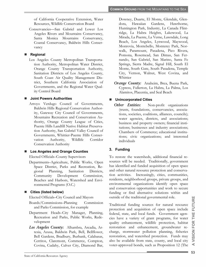
of California Cooperative Extension, Water Resources, Wildlife Conservation Board
Conservancies�San Gabriel and Lower Los Angeles Rivers and Mountains Conservancy, Santa Monica Mountains Conservancy, Coastal Conservancy, Baldwin Hills Conser-vancy
Regional Los Angeles County Metropolitan Transporta-
tion Authority, Metropolitan Water District, Orange County Transportation Authority, Sanitation Districts of Los Angeles County, South Coast Air Quality Management Dis-trict, Southern California Association of Governments, and the Regional Water Qual-ity Control Board
Joint Powers Authorities Arroyo Verdugo Council of Governments,
Baldwin Hills Regional Conservation Author-ity, Gateway City Council of Governments, Mountains Recreation and Conservation Au-thority, Orange County League of Cities, Puente Hills Landfill Native Habitat Preserva-tion Authority, San Gabriel Valley Council of Governments, Whittier-Puente Hills Conser-vation Authority, Wildlife Corridor Conservation Authority
Los Angeles and Orange Counties Elected Officials�County Supervisors Departments�Agriculture, Public Works, Open
Space District, Parks and Recreation, Re-gional Planning, Sanitation Districts, Community Development Commission, Beaches and Harbors, Watershed and Envi-ronmental Programs (O.C.)
Cities (listed below) Elected Officials�City Council and Mayors Boards/Commissions�Planning Commission
and Parks Commission, for example Department Heads�City Manager, Planning,
Recreation and Parks, Public Works, Rede-velopment
Los Angeles County: Alhambra, Arcadia, Ar-tesia, Azusa, Baldwin Park, Bell, Bellflower, Bell Gardens, Bradbury, Burbank, Calabasas, Cerritos, Claremont, Commerce, Compton, Covina, Cudahy, Culver City, Diamond Bar,
Downey, Duarte, El Monte, Glendale, Glen-dora, Hawaiian Gardens, Hawthorne, Huntington Park, Industry, La Canada Flint-ridge, La Habra Heights, Lakewood, La Mirada, La Puente, La Verne, Lawndale, Long Beach, Los Angeles, Lynwood, Maywood, Monrovia, Montebello, Monterey Park, Nor-walk, Paramount, Pasadena, Pico Rivera, Pomona, Rosemead, San Dimas, San Fer-nando, San Gabriel, San Marino, Santa Fe Springs, Sierra Madre, Signal Hill, South El Monte, South Gate, South Pasadena, Temple City, Vernon, Walnut, West Covina, and Whittier
Orange County: Anaheim, Brea, Buena Park, Cypress, Fullerton, La Habra, La Palma, Los Alamitos, Placentia, and Seal Beach
Unincorporated Cities Other Entities: Non-profit organizations
(trusts, foundations, conservancies, associa-tions, societies, coalitions, alliances, councils); water agencies, districts, and associations; business and property owners; financial insti-tutions; businesses and industry associations; Chambers of Commerce; educational institu-tions; civic organizations; and interested individuals
To restore the watersheds, additional financial re-sources will be needed. Traditionally, government has identified and funded acquisition of open space and other natural resource protection and conserva-tion activities. Increasingly, cities, communities, residents, neighborhood groups, private groups, and environmental organizations identify open space and conservation opportunities and work to secure funding or find alternative solutions within and outside of the traditional governmental role.
State of California Resources Agency
53
A V
ISIO
N F
Traditional funding sources for natural resource protection and acquisition of open space include federal, state, and local funds. Government agen-cies have a variety of grant programs, for water quality enhancement, wildlife protection, habitat restoration and enhancement, groundwater re-charge, stormwater pollution planning, fisheries restoration, and watershed protection. Funds may also be available from state, county, and local city voter-approved bonds, such as Proposition 12 (The

COMMON GROUND FROM THE MOUNTAINS TO THE SEA
Safe Neighborhood Parks, Clean Water, Clean Air, and Coastal Protection Bond Act) and Proposition 13 (the Safe Drinking Water, Clean Water, Water-shed Protection, and Flood Protection Bond Act) or assessment districts. The Los Angeles County Safe Neighborhood Parks Acts (Proposition A) of 1992 and 1996 have been responsible for most of the Los Angeles River greening and riverfront parks. These sources will likely be the primary source of funds for acquisition of lands and individual projects.
Additional Parks Will Require Additional Funds
In addition to securing funds from traditional sources, the State Conservancies will work to iden-tify and create funding opportunities from private trusts. Trusts acquire land for transfer to a third party, when financing is organized. Private founda-tions should be a source of additional funding.
Funding for planning, management, and mainte-nance of open space, including historic and cultural sites, must also be addressed. Wherever feasible, plans for acquisition of open space should include a plan for securing the necessary funds for long-term maintenance of those spaces. Many existing facili-ties have suffered from inadequate maintenance and require funding to restore those facilities to accept-able conditions. To help with on-going maintenance and public services, expanded funding opportunities should be created.
OR
TH
E FU
TUR
E
Existing funding sources will not be overlooked. Currently, federal, state, and local agencies, and individual cities expend considerable resources to maintain existing parks, open space, trails, bike paths, and flood protection facilities. For example, optimization of existing water resources through improved water conservation and increased
groundwater recharge could reduce the need for imported water and result in cost savings that could be used to meet other water resource needs.
Compliance with current legislative mandates, such as those related to stormwater runoff quality, will require counties, cities, local agencies, and private landowners to expend resources to develop, imple-ment, maintain, and monitor Standard Urban Storm Water Mitigation Plans. Additional resources will be needed to implement the recently adopted re-quirements to eliminate trash and other contaminants from the San Gabriel and Los Angeles Rivers. Caltrans plans to expend considerable sums to mitigate stormwater pollution from State high-ways. The State Conservancies will encourage discussion of how best to optimize the expenditure of resources to mitigate non-point stormwater run-off pollution to accomplish multiple objectives where feasible.
The State Conservancies will encourage and support efforts to secure additional funding from traditional sources, as well as private foundations and trusts. The State Conservancies will work to identify op-portunities to optimize use of existing resources, such as sharing of information and knowledge, and work towards lowering the costs of maintenance (e.g., through joint purchasing cooperatives), educa-tion and interpretive programs for existing facilities (e.g., through sharing of information and materials). State Conservancies will work to assure that avail-able funds are allocated equitably, to address upstream and downstream, urban, and suburban needs.
4. Multiple-Objective Planning
In recent years, while maintaining focus on their primary responsibilities and missions, a number of agencies in the watersheds have been engaged in the process of discussion and have contributed to the emerging vision of integrated watershed planning, and have incorporated multiple objectives into plan-ning.
San Gabriel and Los Angeles Rivers Watershed and Open Space Plan
54
A V
ISIO
N F
Several cities have also incorporated these concepts into planning, and worked with other cities, some-times through their Council of Governments, to achieve goals that extend beyond the border of in-dividual cities.

COMMON GROUND FROM THE MOUNTAINS TO THE SEA
OR
TH
E FU
TUR
E
To restore the watersheds, a consistent approach to multiple objective planning is required, in which science-based planning and several socially desirable objectives are considered together. Where feasible, parks will provide habitat and flood protection fea-tures. Passive recreation in habitat areas may be compatible with resources protection when properly managed. Flood protection features will incorpo-rate recreation features, such as bike paths, where public safety can be assured. By integrating multiple objectives into a single project, it may also be possi-ble to combine several funding sources into a single project, and thereby optimize resources.
Pan Pacific Park
The various concepts that could be combined to achieve multiple objectives are reflected in the Guiding Principles. The State Conservancies will encourage the use of the Principles in the develop-ment of plans and projects, and work to fund demonstration projects that illustrate that multi-purpose projects are practical and functional. The State Conservancies will encourage cities to consider incorporation the relevant Guiding Principles into their next General Plan update, so that future pro-jects within individual cities reflect the goals embodied in the Guiding Principles.
To assist agencies, cities, communities, and groups to understand priorities for the award of funds for open space projects, the RMC and SMMC have each developed criteria to rank projects that are eligible for funding administered by those agencies. These criteria have been reviewed and discussed with state and county agencies to ensure that they are in concurrence with agency missions and fund-ing criteria. Basin ranking categories include:
▪ Urban Resource Value ▪ Watershed Resource Value ▪ Partner Resource Value ▪ Economic Value ▪ Access Value ▪ Scenic Resource Value ▪ Wildlife Resource Value ▪ Floristic Resource Value ▪ Archaeological or Historic Resource
Value ▪ Trails Resource Value ▪ Recreational Resource Value
In addition to the above criteria, the RMC adds an additional criterion for Open Space Plan Value. The SMMC also adopted criteria for improvement projects. The criteria, and weighting factors within each category are included in Appendix G. The State Conservancies will work with funding agencies to encourage the use of the Guiding Principles, above the criteria, and cost-benefit models (that consider economic, social and environmental costs) to prioritize funding applications for projects. The State Conservancies will encourage cities, communi-ties, agencies, and groups to begin to incorporate these concepts into project plans, and thereby meet the goal of multiple objective planning.
5. Management of Public Lands
Public lands will be managed for the benefit of the people and to preserve, protect, and enhance natural resource values, and where appropriate, provide for multiple objectives. Acquisition of open space should include a plan to identify responsibility for future management of the space and, where feasible, identify funds for that management.
State of California Resources Agency
55
A V
ISIO
N F
Surplus LADWP Property Along San Gabriel River

COMMON GROUND FROM THE MOUNTAINS TO THE SEA
This plan recognizes the importance and the need for both active and passive recreation. Active rec-reation generally is within the purview of local and county jurisdictions. These jurisdictions maintain departments that address recreation needs on a local level. Low impact recreation refers to uses that have relatively low impact on the land and include such uses as hiking, strolling, picnicking, sitting, and bird watching. These uses avoid impacts to the land by designating specific routes of travel or areas of usage that allows the surrounding open space to be preserved. A management program may incorpo-rate areas of low impact activities to enhance the sense of place and preserve what makes a particular site important. These activities allow for self-education, exercise, and contemplation to be under-taken at a user�s own pace.
In developing and managing an open space, it is critical that numerous issues be addressed. These issues include: access, circulation, security, mainte-nance, visitor amenities such as restrooms, water, trash pick-up, along with habitat protection and enhancement and interpretive education.
Legg Lake in Whittler Narrows
The State Conservancies will work with partners to identify potential mitigation banking sites (to restore or create off-site wetlands as compensation for de-struction of wetlands) and assist in funding and acquisition of these lands and sites.
OR
TH
E FU
TUR
E
6.
D.
1.
!
Monitoring and Assessment
This Plan sets forth a long-term vision for restora-tion of the watersheds, suggests strategies to achieve that vision, and identifies plans and opportunities to implement those strategies. Since restoration of the watersheds will require decades, periodic review and assessment of progress will be required, to deter-
mine whether strategies need to be revised, alternative plans pursued, or new concepts and ob-jectives incorporated.
The State Conservancies will work to develop a joint assessment process for restoration of the wa-tershed, and monitor progress towards meeting the goals described herein. Critical to this process will be maintenance and updating of the Geographic Information Systems database developed by RMC. At a minimum, the periodic assessment process shall occur at ten-year intervals, or more often if deemed practical. This process shall utilize quantifi-able, science-based methods wherever feasible, and shall include stakeholder involvement in the design, implementation, and review of the assessments. The RMC has received comments and guidance to create a new park system. The State Conservancies recognizes the need to coordinate its responsibilities for maintenance and security and will work with other public park and open space managers in the region.
OPPORTUNITIES
To achieve the vision of the future for the water-sheds, to encourage use of the Guiding Principles, and to implement the strategies described above, the State Conservancies will work with agencies, cities, communities, and groups to identify opportunities and encourage development of project-specific plans that take advantage of those opportunities. The following discussion highlights some important opportunities.
Land Acquisition, Connectivity, and Open Space
River Parkways
River parkways along the banks of the Los Angeles, San Gabriel, and Rio Hondo Rivers will provide the most visible and accessible element of the proposed open space network. As illustrated in Figure 3-1, the parkways will extend green ribbons of open space across the urbanized length of the watersheds, from the foothills and the San Gabriel Mountains to the Pacific Ocean.
San Gabriel and Los Angeles Rivers Watershed and Open Space Plan
56
A V
ISIO
N F
Landscaped open spaces on both sides of the rivers would provide pocket parks, passive recreation, and natural areas for wildlife habitat. These landscaped spaces could cleanse runoff, promote groundwater

COMMON GROUND FROM THE MOUNTAINS TO THE SEA
OR
TH
E FU
TUR
E
Figure 3-1. Proposed River Parkways
infiltration, and enhance flood protection by serving as buffers between the rivers and adjacent land uses. They could also galvanize a sense of community, provide a unifying theme throughout our diverse region, and enhance the economic value of adjacent land.
In various forms, river parkways were first sug-gested more than a century ago and reiterated in the Olmsted-Bartholomew plan in 1930. A number of existing plans address the enhancement of the edges of the rivers, including the Los Angeles River Master Plan, the San Gabriel River Master Plan (in progress) and the Reconnecting the San Gabriel Valley: A Planning Approach for the Creation of Interconnected Urban Wildlife Corridor Networks, which addressed habitat restora-tion.
State of California Resources Agency
57
A V
ISIO
N FElements of the riverfront parkway system already
exist: bike and pedestrian trails line the length of the Rio Hondo and San Gabriel Rivers and parts of the Los Angeles River. Several major parks already
front the rivers: Santa Fe Dam Recreation Area, Whittier Narrows Recreation Area, Cerritos Re-gional Park, Debs Regional Park, Elysian Park, Griffith Park, Sepulveda Dam Recreation Area, and El Dorado Regional Park. Various cities have exist-ing parks along one of the river main channels, including Bell Gardens, Bellflower, Burbank, Cerritos, City of Commerce, Downey, Duarte, El Monte, Lakewood, Los Angeles, Long Beach, Montebello, Paramount, Pico Rivera, Rosemead, Santa Fe Springs, Seal Beach, and South Gate. Many schools and recreational facilities currently front the river. These individual open spaces will be connected by parkways along the entire length of the rivers, creating valuable urban amenities.
Several of the �river� cities and communities are already embracing the river as an amenity for their residents. Azusa calls itself the �Canyon City� re-flecting the watercourse of the San Gabriel River as it flows from the mountains. Duarte�s residents use the Puente Largo pedestrian bridge as a way to ac-

COMMON GROUND FROM THE MOUNTAINS TO THE SEA
cess the native environment along the river. The Whittier Narrows Recreation Area provides natural open space and a river beach for the surrounding cities. Long Beach uses the San Gabriel River parks as a connective armature for the city�s extensive bicycle network. The City of Maywood is creating a park on five former industrial sites along the Los Angeles River. The riverfront parks in the Elysian Valley and as proposed along the Arroyo Seco con-stitute small natural parks. By adding to this impressive network, a continuous parkway can be created.
OR
TH
E FU
TUR
E
Los Angeles River at Sepulveda Basin
Goal: A continuous ribbon of trails, open space, active and passive recreation areas, and wildlife habitat along the San Gabriel, Los Angeles, and Rio Hondo Rivers. The specific treatment of each seg-ment of the greenway should be determined by the existing conditions of the parcel, the needs and de-sires of the local community and the opportunities for connection and linkages presented at that loca-tion.
Actions: The State Conservancies will work with each riverfront city, community, and relevant agen-cies to identify potential River Parkway projects, tailored to the needs and desires of each city. This will include a list of projects, identification of poten-tial funding and partners and a work program to accomplish the acquisition and development of each project.
The State conservancies will work with Los Angeles County Department of Public Works and local gov-ernments to implement projects identified in the Los Angeles River Master Plan and will assist in
identification of projects for the in-progress San Gabriel River Master Plan.
The State Conservancies, in conjunction with the Resources Agency, will work individually and collec-tively with the cities, communities, local groups, and the appropriate Council of Governments along the rivers to identify individual projects that will qualify for Proposition 12 funding (by July 2002) and future fund sources.
! Urban Lands
In the urbanized portions of the watersheds, com-petition for parcels of land is intense. Within the San Gabriel Valley, the San Fernando Valley, and the Los Angeles Basin, most parcels of land that become available were previously used for industrial or commercial purposes, or have been deemed sur-plus by public agencies. The size of parcels in urbanized areas will vary from individual lots in residential areas to large, former industrial sites or military facilities. When such parcels become avail-able, they should be reviewed for their potential to serve as contributing elements in the developing network of open spaces.
The potential for individual parcels to be acquired and adapted as public open space that can provide recreation, wildlife habitat, mitigate flood hazard or allow infiltration of groundwater will depend upon the site of the parcel, the location of the parcel (e.g., proximity to rivers, tributaries, or other open space), and the costs of site clean-up (e.g., clearance of ex-isting structures and/or remediation of any site contamination). The opportunity costs of acquisi-tion must be considered in the review of any parcels, and be balanced against the value of the parcel as part of the evolving open space network.
San Gabriel and Los Angeles Rivers Watershed and Open Space Plan
58
A V
ISIO
N F
Much of the frontage along the Los Angeles and San Gabriel Rivers has been developed as industrial property. At some locations, properties are aban-doned, idled, or underused because of known or perceived environmental contamination from previ-ous uses. Those properties, termed brownfields, pose a major challenge to the expansion of public open space along the rivers, because of their poten-tial value as component of a river parkway, and the potentially high cost of the complete remediation of the site contamination that is required to accommo-date public use.

COMMON GROUND FROM THE MOUNTAINS TO THE SEA
OR
TH
E FU
TUR
E
For properties where acquisition and clean-up costs are prohibitive, those sites may be adapted for a variety of uses, including commercial, industrial, or retail. The potential future use will depend upon a variety of factors, including cost of acquisition, the extent of contamination, the zoning and general plan designation of the site, and the objectives of the cities and communities in which the site is lo-cated. To the extent feasible, the Guiding Principles should be used to guide future site planning (e.g., to maximize open space).
Existing Quarry in Irwindale
Large parcels of land that may become available over time include the gravel pits located in the up-per San Gabriel River watershed, under-utilized or vacant industrial properties along both rivers, hill-side properties that, due to geological or other natural conditions, preclude normal types of devel-opment, and flood plain lands. Powerline easements belonging to the City of Los Angeles Department of Water and Power and Southern California Edison may provide opportunities for open space uses. Throughout much of the length of the Los Angeles and Rio Hondo Rivers, power-line easements follow the river course. With the continuing evolution of rail operations, additional rail yards and linear rail rights-of-way may become available.
Examples of large parcels that have been converted to public use include the Whittier Narrows Nature Center, the Industry Hills Recreation complex (for-mer landfill), Los Angeles River Center and Gardens (former corporate headquarters), and a park in Maywood (former industrial site). The China-town/Cornfield Yard area (a former rail yard) and
Taylor Yard (another former rail yard) may become state parks.
Public agencies, including cities, counties, special districts, state government and institutions, and the federal government own a significant amount of land throughout the watershed, for use as mainte-nance yards, storage sites, and sites of office and other facilities. Some parcels of land may no longer be needed for their original purpose, may be de-clared surplus, and disposed of in the manner prescribed by law for each agency or jurisdiction. One example of public land that has been converted to public use is the Augustus F. Hawkins Natural Park, a former pipe storage yard for the Los Angeles Department of Water and Power.
A variety of lands may, over time, be considered �surplus� including major military facilities, such as the Seal Beach Naval Weapons Depot or local re-serve training facilities. State agencies such as Caltrans own the lands under and around freeway interchanges and under river bridges. Cities and agencies own and maintain corporate or work yards, some of which have frontage along the rivers and tributaries.
Goal: Consider acquisition of parcels in urbanized areas to provide open space, passive recreation, habitat, water quality, and flood mitigation uses. Balance acquisition costs, including site clean up if necessary, with the value of providing additional open space at that location.
Maywood Riverfront Park
State of California Resources Agency
59
A V
ISIO
N F
Actions: The State conservancies will work with individual cities to identify and evaluate parcels that may become available in the next 10 years. If deemed appropriate, the cities and the conservan-cies will work together to develop a purchase,

COMMON GROUND FROM THE MOUNTAINS TO THE SEA
development, operation, and maintenance strategy for each identified parcel. Where appropriate, the conservancies will work with the State Department of Toxic Substances Control and other relevant agencies to identify opportunities and incentives to expedite and streamline remediation of brownfields. The conservancies will work with local, county, regional, state, and federal agencies and institutions to identify potential surplus government lands and develop a strategy and program for acquiring, oper-ating, and managing those lands. The State Conservancies will work with willing municipalities and public agencies to develop a program that grants and defines the State Conservancies the right of first refusal for surplus governmental lands. The State Conservancies will work with local power distributors, railroads, legislators, agencies, and communities to gain ground access to the linear rights-of-way that crisscross the watersheds and would contribute to the goals of the plan.
OR
TH
E FU
TUR
E
! Mountains, Foothills, and Hills
Development of the flatlands within the watershed began more than two centuries ago, and continues. Because of the limited remaining land, development has pushed into the foothills, and in some locations, into the San Gabriel, Santa Monica, and Santa Su-sana Mountains. Because large areas of the foothills and mountains remain undeveloped, preservation of special places must be pursued before critical op-portunities are lost.
San Gabriel Mountains
The preservation of the ridge tops and hillsides ringing the Los Angeles basin was also a goal of the 1930 Olmsted-Bartholomew Plan. That plan spe-
cifically called for the creation of parkways along the rivers and large parks in the San Gabriel and Santa Monica Mountains, the Puente Hills, and the Whit-tier Narrows.
Much progress has been made towards the preser-vation of the area�s hillside habitat and open space. For instance, the majority of the San Gabriel Moun-tains are within the Angeles National Forest, under the jurisdiction of the U.S. Forest Service.
Several non-profit, community-based land conserv-ancies have been created along the south-facing foothill slopes of the San Gabriel Mountains to preserve undeveloped hillside lands. These con-servancies utilize time-honored, locally based fundraising techniques and local support to acquire and protect important parcels of land so they may continue to be open space and habitat.
Significant portions of the Santa Monica Mountains, the Simi Hills, Verdugo Mountains and the Santa Susana Mountains have been preserved as park and open space by the Santa Monica Mountains Conser-vancy and the Mountains Recreation Conservation Authority, in coordination with the California De-partment of Parks and Recreation, the County of Los Angeles, the City of Los Angeles, and the Na-tional Park Service.
The Puente and Whittier Hills, Chino Hills, San Jose Hills, Verdugo Mountains, and the San Rafael Hills all have existing preserved open space. There are nature centers in the Puente Hills (Whittier Narrows Nature Center), the Verdugo Mountains, Eaton Canyon, Monrovia, and San Dimas Canyon Park in the San Gabriel Mountains. The Audubon Society is planning a nature center on the slopes of Debs Park along the Arroyo Seco.
San Gabriel and Los Angeles Rivers Watershed and Open Space Plan
60
A V
ISIO
N F
The State Conservancies are working with and through the U.S. Forest Service, National Park Ser-vice, California Department of Parks and Recreation, the California Department of Fish and Game, Wildlife Conservation Board, Caltrans, Whit-tier/Puente Hills Conservation Authority, Wildlife Corridor Conservation Authority, Puente Hills Landfill Native Habitat Preservation Authority, and several land trusts on research studies and land ac-quisition and preservation programs.
Several major public open spaces are located in the hills and mountains. Besides the Angeles National

COMMON GROUND FROM THE MOUNTAINS TO THE SEA
OActions: The State Conservancies will work with the foothill communities of the San Gabriel Moun-tains, agencies, local land trusts, and the Councils of Government to establish a common strategy and comprehensive plan for the preservation of foothill open space. Figure 3-2 illustrates the areas of op-portunity for the continued preservation of mountains, hills, and foothills.
Forest in the San Gabriel Mountains, there are the Chino Hills State Park, Debs Regional Park, Deuk-mejian Regional Park, Elysian Park, Griffith Park, Industry Hills Recreation Center, Schabarum Re-gional Park, Frank G. Bonelli Regional County Park, Claremont Hills Regional Park, Glendora Wilder-ness Park, and Marshall Canyon County Park.
The potential for lands in the mountains, foothills, or hills to be acquired and adapted as public open space will depend upon the size of the parcel, the location of the parcel (e.g., proximity to rivers or other open space), and the potential costs of provid-ing public access if appropriate.
Acquisition of land has been the traditional means of protecting land resources, but securing public funding for acquisition may be a lengthy process. Because the window of opportunity to acquire lands may be short, other options may need to be consid-ered.
The most common form of open space acquisition is through the outright purchase of property. The standard purchase is a fee simple transaction where money is exchanged for property. Other alterna-tives include a lease with a future option to purchase or an installment purchase. Both options may allow for immediate occupancy and transfer of final pay-ment(s) in the future. This may be an important consideration when available resources are low but can be secured in the future. Funding for outright purchases typically comes from local, state and fed-eral grants and bonds and from grants or donations from private individuals and foundations.
R T
HE
FUTU
RE
The State Conservancies, in conjunction with agen-cies, cities, communities, and private groups, may be able to identify critical parcels of land that have value for open space, habitat, or water resources. If the owner is willing, it may be possible to secure a right of first refusal that can be exercised when the property is put on the market. It may also be possi-ble to negotiate with the property owner to secure an agreement to donate or dedicate the property in the future. Property owners may have a valid rea-son (usually tax-related) to donate the property or sell it at a reduced rate, and may be willing if they know it will be used and maintained for the public good. Occasionally, land can be traded among owners, if multiple needs can be met simultaneously by trading parcels.
For some parcels, the owner may be unwilling to sell the property but may be willing to grant the right of use to another party. A conservation ease-ment is a voluntary agreement that allows a landowner to limit the type or amount of develop-ment on their property (in exchange for a fee or other considerations) while retaining private owner-ship of the land. In California, agricultural lands are often protected by the use of a conservation ease-ment. Lands with conservation easements may have limited public access and serve as visual open space. Funding for easements typically comes from state and federal grants and from grants and bonds and donations from private individuals and foundations.
Arroyo Seco
Goal: Acquisition of mountain and hillside open spaces that provide important wildlife habitat and open space values. The hillside open space net-work, in conjunction with the river network, should connect the San Gabriel Mountains with the Santa Ana Mountains, the Angeles National Forest with the Cleveland National Forest, and the Santa Monica Mountains with the Santa Susana Moun-tains.
State of California Resources Agency
61
A V
ISIO
N F
The State Conservancies will work with the com-munities, local conservancies and groups, and the

COMMON GROUND FROM THE MOUNTAINS TO THE SEA
Figure 3-2. Preservation Opportunities in the Mountains, Foothills, and Hills
Councils of Government surrounding and within the Whittier/Puente/Chino/San Jose Hills complex to establish a common strategy and comprehensive plan for the preservation of open space in this area.
The State Conservancies will also work with the communities surrounding the San Rafael Hills, the hills surrounding the Glendale Narrows, and the Verdugo Mountains to establish a common strategy and comprehensive plan for the preservation of open space in this area.
OR
TH
E FU
TUR
E
! Tributaries
There are nearly 2,000 stream miles in the water-sheds, and one-quarter of those streams flow year-round.
Similar to river parkways, open spaces along tribu-taries provide an opportunity to extend further green ribbons throughout the watersheds, connect-ing those communities not located directly on the
rivers, and expanding the network of trails and bike paths.
As discussed in Chapter 2 and illustrated in Figure 2-4, there are eleven major sub-watersheds that create the San Gabriel and Los Angeles Rivers. The major tributaries of the San Gabriel River include the East and West Forks of the San Gabriel, Walnut Creek, San Jose Creek, and Coyote Creek. For the Los Angeles River, major tributaries include the Tujunga, Pacoima and Verdugo Washes, Arroyo Seco, Rio Hondo, and Compton Creek.
San Gabriel and Los Angeles Rivers Watershed and Open Space Plan
62
A V
ISIO
N F
River tributaries can provide access to and from the river from all areas of the watersheds. From a circu-lation perspective, bike and pedestrian paths along the tributaries provide access to alternative transpor-tation modes. From a natural systems perspective, tributary greenways allow for the reestablishment and protection of continuous natural corridors from hill and mountainous environments to coastal envi-ronments. From a flood protection perspective, the

COMMON GROUND FROM THE MOUNTAINS TO THE SEA
OR
TH
E FU
TUR
E
Figure 3-3. Open Space Opportunities Along Tributaries
tributary parkways could create opportunities for development of smaller detention facilities that in-crementally reduce the threat of flooding downstream. From a recreation perspective, they create local recreation and educational opportuni-ties.
The idea that parks and open space are located along tributaries is prevalent throughout Southern California. Various cities already have public parks and public open space along tributaries, including Alhambra, Anaheim, Arcadia, Azusa, Baldwin Park, Brea, Calabasas, Cerritos, Claremont, Compton, Covina, Diamond Bar, Fullerton, Glendale, Glen-dora, Hawaiian Gardens, La Habra, La Mirada, La Verne, Lakewood, Long Beach, Los Angeles, Pasa-dena, Pomona, San Dimas, San Gabriel, Seal Beach, South Pasadena, Walnut, and West Covina.
The challenge is not only to create a continuous open space ribbon along the tributaries but also to increase regional access and create a closer relation-
ship among the existing parks and open spaces within these linear greenways. Large existing parks and open spaces along these tributaries include: Hahamonga Watershed Park, Lower Arroyo Seco Park, Debs Regional Park, Bosque del Rio Hondo, and Eaton Canyon Park.
Goal: All tributaries in urbanized areas of the wa-tersheds are envisioned as open space ribbons that allow for pedestrian and bike paths, restoration of habitat, and provide opportunities for water quality improvement and flood protection. See Figure 3-3.
State of California Resources Agency
63
A V
ISIO
N F
Actions: The State Conservancies will work indi-vidually and collectively within the communities, local groups, and the appropriate Councils of Gov-ernment along each of the major tributaries to develop sub-watershed plans that will identify indi-vidual projects within each city.

COMMON GROUND FROM THE MOUNTAINS TO THE SEA O
R T
HE
FUTU
RE
! Trails and Bike Paths
The linearity and length of the rivers make them perfect conduits for connecting the northern moun-tainous areas, the populous interior plains, and the coastal margins of the watersheds. The tributaries provide opportunities to create an extensive net-work of additional corridors that would extend throughout the urbanized areas of the watersheds. With connections to existing trails and bike paths along those natural corridors, a vast network of alternative transportation corridors will become a reality, creating inter- and intra-city commuter routes and providing connections to a range of rec-reational opportunities from mountain trails to beachfront promenades. The Rim-of-the-Valley Trail is an example of an opportunity to create re-gional connections to local trails.
San Gabriel River Trail
Large segments of riverfront bike paths are already in place. The LARIO trail currently follows the Los Angeles River from Long Beach to Maywood and the Rio Hondo from the Los Angeles River to the Santa Fe Dam. A San Gabriel River trail system runs from the mountains to the sea. A trail program for the entire Los Angeles River is depicted in the Los Angeles River Master Plan.
The dozen or so major tributaries create perpen-dicular linkages to the major spines and allow for a region-wide network of alternative transportation modes. Currently, trail segments are in place along the Coyote Creek, Thompson Creek, La Mirada Creek, and the Arroyo Seco. Existing power line rights-of-way may also provide opportunities to create and extend bike paths and trails along linear corridors.
Beyond the rivers and tributaries, bike paths exist in various locations throughout the watersheds. Cal-trans has made development of additional bike paths a priority, and the Metropolitan Transit Au-thority�s long-range transportation plan proposes to extend and expand the network with an additional 1,800 miles of bike paths. The Orange County Transportation Authority is currently updating the County�s Strategic Bicycle Plan. Various cities have proposals to extend existing paths, or create new paths.
Goal: A comprehensive network of pedestrian, bike, and equestrian trails that uses existing corri-dors (such as rivers, tributaries, and power line rights-of-way) where available and new connections where needed.
Actions: The State Conservancies will work with the California Department of Transportation, re-gional transportation agencies, Councils of Government, cities and local agencies, communities, state legislators, and community groups such as the Los Angeles (and Orange County) Bicycle Coalition, to identify local and regional connections and de-velop funding strategies for acquisition or development of regional bike, pedestrian, and equestrian trail linkages.
! Community Gardens
In the urban portions of the watersheds, community gardens provide gardening opportunities, in a com-munal setting, for those who do not otherwise have space for gardening. The patchwork of urban community gardens provides opportunities for pas-sive recreation and attraction of wildlife (such as birds and butterflies), demonstrates the value of using open space, landscaping, and mulch-covered spaces to contain runoff and reduce water waste, provides opportunities to learn about how compost-ing can reduce the volume of green waste deposited in landfills and how native plants can be incorpo-rated into urban settings.
San Gabriel and Los Angeles Rivers Watershed and Open Space Plan
64
A V
ISIO
N F
Many communities throughout Southern California have established community gardens for their resi-dents, and including native plant demonstration gardens. A number of organizations assist commu-nities in the development, organization, and operations of community gardens. The University of California Cooperative Extension has established

COMMON GROUND FROM THE MOUNTAINS TO THE SEA
OR
TH
E FU
TUR
E
2.
!
the Common Ground (no relation to this project) Gardening Program that makes gardening possible for residents of all ages. Common Ground is com-prised of Master Gardeners (who present seasonal workshops), Master Food Preservers (to show how to store and preserve a garden�s bounty) and the Gardening Angels school garden program (which works with teachers to provide hands-on gardening activities to complement curricula and create gar-dens on school grounds).
Tree Planting Along Los Angeles River
The Los Angeles Community Garden Council is an umbrella organization providing assistance to com-munity gardens in Southern California. Together with the Los Angeles Conservation Corps, they established the Green Bank to provide opportuni-ties for residents to participate in community gardens. Long Beach Organic helps turn vacant lots into beneficial green zones, maintained by local residents. This gives families interested in gardening an opportunity to work together, and to link their urban experience with the natural environment.
Goal: In the urbanized portions of the watersheds, create a network of community native plant gardens to provide opportunities for residents that do not have access to private land.
Actions: The State Conservancies will work with cities, educational organizations, and non-profit groups to increase funding opportunities to main-tain, expand, and develop additional community gardens that incorporate native plant materials.
Public Access
Improve and Expand Existing Facilities
As the initial phase of this Plan, the RMC engaged the LJS Group to conduct a survey in the San Gabriel and Lower Los Angeles River watershed in which residents were asked to suggest priorities for RMC activities. One of the highest priorities was improvement of existing parks. Enhanced recrea-tional facilities and increased security were specifically mentioned.
Over the years, for a variety of reasons, many parks in Southern California have not been adequately maintained. Local, state, and federal budgets have not kept pace with the need. Beyond addressing deferred maintenance needs, existing parks and open space could be redesigned to accommodate multiple uses serving a wider variety of users. Parks and open spaces located along river or tributary margins may provide opportunities for low-impact recreation, habitat, flood protection, education and interpretation, trails and connections, water quality and ground water recharge, as well as for active recreational uses.
Goal: Upgraded open space and other facilities that provide amenities commensurate with use and meet applicable standards.
El Dorado Park in Long Beach
State of California Resources Agency
65
A V
ISIO
N F
Actions: The State Conservancies will work with cities, communities, counties, regional park districts, and local non-profit groups to identify opportunities for the enhancement of existing open spaces, cul-tural resources, and historic sites within their jurisdictions. The Conservancies will assist the cities

COMMON GROUND FROM THE MOUNTAINS TO THE SEA
in identifying sources of funding, including park and open space bonds, and will advise cities, communi-ties, counties, and park districts on how to best meet application requirements.
!
3.
!
Create New Facilities
Some existing open space resources, cultural re-sources, and historic sites in the watershed may lack appropriate amenities that allow for maximum pub-lic benefit and use. This may include the need for adequate access and parking, interpretive facilities, maintenance and security features, or trails or bike path connections.
Goal: Open space facilities that provide an appro-priate range of amenities to maximize public enjoyment of those facilities.
Actions: The State Conservancies will work with cities, communities, counties, and local non-profit groups to identify opportunities for the creation of new facilities, cultural resources, and historic sites within their jurisdictions.
Native Plants and Wildlife
Habitat and Linkages
Habitats that support rare or sensitive species of plants and animals occur throughout the water-sheds. Los Angeles County has identified Significant Ecological Areas for various habitats within Los Angeles County. The US Fish and Wild-life Service has designated critical habitat for two animals, the threatened California gnatcatcher (Po-lioptila californica), and the endangered arroyo toad (Bufo microscaphus californicus). The State of California has delineated a Natural Community Conservation Planning area for the Southern California coastal sage scrub habitat that includes the southeastern corner of Los Angeles county and large areas of Orange County. As urban and suburban develop-ment continues to reduce and fragment open space throughout the watersheds, identification of habitat that warrants protection will become increasingly important.
OR
TH
E FU
TUR
E
Habitat fragmentation can reduce plant and animal populations and species diversity. Therefore, main-taining or establishing linkages between patches of habitat is important to maintain biodiversity and ecological integrity. Linkages and corridors must be
defined in terms of functional connectivity: daily and seasonal movements; dispersal, and gene flow; range shifts; and maintenance of ecological proc-esses. To gauge the success of habitat linkages, specific animal and plant species can serve as sensi-tive indicators of functional connectivity. A list of potential indicator species for the watersheds is provided in Appendix H.
San Gabriel Mountains
A number of important wildlife corridors were iden-tified in Missing Linkages: Restoring Connectivity to the California Landscape (2001). These linkages were subsequently evaluated (Noss 2001) in terms of how well the proposed corridors correspond to actual habitat conditions and patterns in the landscape, based on review of aerial photography and a flyover of the region.
San Gabriel and Los Angeles Rivers Watershed and Open Space Plan
66
A V
ISIO
N F
Figure 3-4 indicates potential linkages in the water-sheds, mostly as revised from the seven linkages identified by the numbers used in the Missing Link-ages report (Nos. 21, 24, 27, 28, 29, 30, and 31), but with some possible new linkage zones also indi-cated. The linkages on the map are shown as broad zones within which connectivity might be achieved through linear wildlife corridors; through specific enhancement features, such as bridges or tunnels; through �stepping stone� habitat patches within the linkage zone (e.g., disconnected patches that pro-vide mobility for birds and some animals); or through some combination of these approaches. Each linkage is designated as High, Moderate, or Low Priority based on existing data; although these preliminary rankings may change as more informa-tion becomes available. Additional study is necessary to delineate the specific habitat protec-

COMMON GROUND FROM THE MOUNTAINS TO THE SEA
OR
TH
E FU
TUR
E
! !
y
!
Figure 3-4. Habitat Linkages Source: Dr. Reed Noss, California Dept. of Fish and Game
tion, restoration, and enhancement needs within these zones.
Linkage #21: Santa Susana Pass�High Priority
This proposed linkage is the easternmost of a series of linkages proposed by Missing Linkages, which would connect the Santa Susana Mountains with the Simi Hills (which, together, constitute a proposed Significant Ecological Area). The Simi Hills would, in turn, be connected by other linkages (outside the study region) to the Santa Monica Mountains, an-other proposed Significant Ecological Area. This locations was designated by Missing Linkages as a Landscape Linkage and Connectivity Choke-Point. The south end of this proposed linkage, in the Simi Hills, is high-quality oak woodland that is being reduced by development. Maintaining a connection to the west of the south end of the linkage will be important. To the north, the Porter Ranch devel-opment is spreading westward and could soon
jeopardize the viability of this linkage. Wildlife use of this linkage should be documented as soon as possible.
Linkage #24: I-5�Newhall Pass�High Priorit
Missing Linkages identifies this as a Landscape Linkage and Connectivity Choke-Point. This link-age would connect the Santa Susana Mountains with the San Gabriel Mountains, specifically linking two proposed Significant Ecological Areas: Santa Susana Mountains/Simi Hills and Santa Clara River. Two roads, SR 14 and I-5 both pass through this area, with interchanges. A highway tunnel or high bridge would be necessary to make this a secure linkage.
State of California Resources Agency
67
A V
ISIO
N F
Linkage #27: Angeles�Verdugo Moun-tains�Moderate Priority
This linkage would connect the Verdugo Mountains to the San Gabriel Mountains in Angeles National Forest. Missing Linkages describes this as a Missing

COMMON GROUND FROM THE MOUNTAINS TO THE SEA
Link, because the existing connection is tenuous at best. There is some undeveloped private land and islands of public land. Highway 210 crosses the Big Tujunga Wash here, but an underpass is needed for wildlife movement, accompanied by a secure corri-dor south to the Verdugo Hills.
!
!
!
!
!
Linkage #28: Griffith Park�Verdugo Hills�Low to Moderate Priority
This linkage is correctly identified as a Missing Link. Furthermore, as drawn in Missing Linkages, the proposed linkage passes through a wide (2-3 mile) swath of highly developed land. Verdugo Wash, upon which the linkage appears to be centered, is a possible path, but needs revegetation. �Develop-ment removal,� as recommended on the Linkage Description Log, is probably not likely. Judging from aerial photographs, and as indicated on the map overlay, connections to the east and west of the previously identified linkage might be more viable, but are still tenuous at present. To the east of this linkage zone, the Arroyo Seco may offer a superior alternative.
Linkage #28/29: Verdugo�San Gabriel Stepping Stones�Low Priority
Although not identified by Missing Linkages, aerial photography shows a patchwork of potential step-ping stone habitats between the San Gabriel River (in the vicinity of the Puente Hills) northwest to the Arroyo Seco and, tenuously, to the Verdugo Wash. These stepping stones, largely occupying hills, might be used for travel by birds, and some of the more mobile terrestrial mammals (e.g., coyote) and could also be the basis for a trail system.
Linkage #29: San Gabriel River�Moderate to High Priority
OR
TH
E FU
TUR
E
The San Gabriel River, identified as a Missing Link by Missing Linkages, nevertheless has considerable potential for restoration, as noted on the Linkage Description Form. Habitat for the least Bell�s vireo and other focal species still exists in several areas. Restoration of native riparian vegetation along the river would greatly enhance habitat availability for the vireo and other native species. Gravel mines along the river are ending their leases and provide good opportunities for restoration. The San Gabriel River in this area, if adequately restored, would
functionally link two proposed Significant Ecologi-cal Areas: Puente Hills and San Gabriel Canyon.
Linkage #30: Puente Chino Hills�Moderate to High Priority
Although identified as a Connectivity Choke-Point by Missing Linkages, this could also be a Landscape Linkage. Considerable undeveloped habitat remains in the Puente Hills, which are proposed as a Signifi-cant Ecological Area. The Puente Hills could be linked to the San Gabriel Mountains (including the San Gabriel Canyon Significant Ecological Area) through the San Gabriel River corridor. Although this connection may currently be tenuous, it could be a very important linkage.
Linkage #31: Puente�San Jose�San Gabri-els�Moderate Priority
As drawn in Missing Linkages, this linkage crosses widely developed areas. An alternative linkage zone may be more feasible to the east, because of a higher density of stepping stone habitats, which might be used by birds, and mobile mammals (e.g., coyote). Importantly, it would link three proposed Significant Ecological Areas: Puente Hills, East San Gabriel Valley, and San Dimas Canyon/San Anto-nio Wash.
In addition to the linkages shown on Figure 3-4, the Los Angeles River has considerable potential for restoration along much of its course, and if pursued aggressively, the river and its riparian zone could someday constitute a viable linkage and important habitat.
Goal: Preserve important terrestrial, avian, and aquatic habitats, and protect native plants and wild-life in the watersheds.
Preserve or establish habitat linkages and/or corri-dors in the Santa Susana Pass, Newhall Pass, Angeles National Forest to the Verdugo Mountains, Griffith Park to the Verdugo Mountains, the Ver-dugo Mountains and San Gabriel �Stepping Stones,� the San Gabriel River, the Puente & Chino Hills, the Puente Hills to San Jose Hills and the San Gabriel Mountains, and the Los Angeles River.
San Gabriel and Los Angeles Rivers Watershed and Open Space Plan
68
A V
ISIO
N F Actions: The State Conservancies will work with
federal, state, and local agencies and private groups to pursue: 1) detailed study and monitoring of po-tential habitat linkages in the watersheds; 2)

COMMON GROUND FROM THE MOUNTAINS TO THE SEA
OR
TH
E FU
TUR
E
!
comprehensive mapping of potential conservation sites; 3) ranking of potential sites according to their conservation value and vulnerability; 4) analyses of aquatic and wetland habitats and species, which have generally received less study than terrestrial habitats and species.
Wetlands
Before the arrival of settlers in the 1700s, the rivers and tributaries, combined with abundant groundwa-ter, created an extensive network of wetlands throughout the watersheds. The vast majority of these wetlands were lost, but some wetlands do still exist. In its Wetlands of the Los Angeles River Water-shed, the California Coastal Conservancy documented current wetland resources in the water-shed and identified 10 sites that have potential for near-term restoration. These sites were chosen because they �represent a range of wetland and riparian habitats that historically occurred in the watershed and are distributed with the overall objec-tive of improving the geographic balance of such habitat types and promoting greater regional biodi-versity.�
Riparian Habitat Along Los Angeles River
These sites are located at De Forest Park (Long Beach), Victoria Park (Torrance), Harbor Park (San Pedro), Dominguez Gap (Long Beach), Hazard Park (Los Angeles), Taylor Yard (Los Angeles), Lower Arroyo Park (Pasadena), Cahuenga Spreading Grounds (Glendale), Sepulveda Basin (Van Nuys), and Upper Bull Creek (San Fernando).
For the upper San Gabriel River in the San Gabriel Valley, Reconnecting the San Gabriel Valley has pro-posed a series of actions to create a wildlife corridor along the San Gabriel River. This network includes wetland creation throughout the wildlife corridor.
Although not as detailed as the Coastal Conservancy work on the Los Angeles River, this study presents a long term, multi-objective, and accomplishable vi-sion for this reach of the river.
For the Los Angeles River, the authors of Wetlands of the Los Angeles River Watershed state that �many other�in most cases more extensive�restoration opportunities exist or could be created�through such landscape-scale efforts as restoring former hydrologic regimes, more effective stormwater management practices, and non-structural solutions to flood control�. Examples of long-term restora-tion opportunities include the creation of large-scale, off-channel wetlands and riparian habitats in auxiliary flood ways and utility corridors adjacent to the major tributaries and mainstem channel of the Los Angeles River. These long-term restoration opportunities are also applicable for the San Gabriel River. These opportunities can capitalize on the potential for wetlands to serve as natural filters that trap sediments and contaminants and improve water quality.
Goal: Restore and expand wetlands wherever fea-sible in the watersheds, and incorporate those wetlands as elements of natural systems, to treat urban run-off, improve water quality, and provide wildlife habitat.
State of California Resources Agency
69
A V
ISIO
N F
Actions: The State Conservancies will work with appropriate agencies to create a mitigation bank for the restoration and establishment of wetlands within the watersheds. This mitigation bank will provide mitigation for the loss of jurisdictional wetlands and other waters of the United States, as defined by Section 404 of the federal Clean Water Act. The Wildlife Conservation Board and the California Coastal Conservancy are currently working to ac-quire and restore the Los Cerritos wetlands in Long Beach and Seal Beach. The Resources Agency, the SMMC, and the RMC will utilize available funds (including Propositions 12 and 13) to fund projects that restore riparian and wetland habitats along the rivers and tributaries. The State Conservancies will develop partnerships with agencies and land groups to enhance, create, rehabilitate, manage, and moni-tor these wetlands.
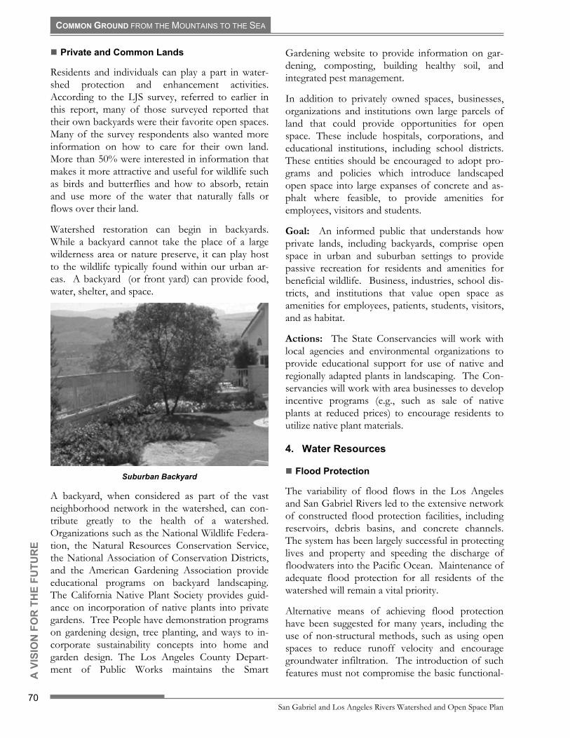
COMMON GROUND FROM THE MOUNTAINS TO THE SEA O
R T
HE
FUTU
RE
! Private and Common Lands
Residents and individuals can play a part in water-shed protection and enhancement activities. According to the LJS survey, referred to earlier in this report, many of those surveyed reported that their own backyards were their favorite open spaces. Many of the survey respondents also wanted more information on how to care for their own land. More than 50% were interested in information that makes it more attractive and useful for wildlife such as birds and butterflies and how to absorb, retain and use more of the water that naturally falls or flows over their land.
Watershed restoration can begin in backyards. While a backyard cannot take the place of a large wilderness area or nature preserve, it can play host to the wildlife typically found within our urban ar-eas. A backyard (or front yard) can provide food, water, shelter, and space.
Suburban Backyard
A backyard, when considered as part of the vast neighborhood network in the watershed, can con-tribute greatly to the health of a watershed. Organizations such as the National Wildlife Federa-tion, the Natural Resources Conservation Service, the National Association of Conservation Districts, and the American Gardening Association provide educational programs on backyard landscaping. The California Native Plant Society provides guid-ance on incorporation of native plants into private gardens. Tree People have demonstration programs on gardening design, tree planting, and ways to in-corporate sustainability concepts into home and garden design. The Los Angeles County Depart-ment of Public Works maintains the Smart
Gardening website to provide information on gar-dening, composting, building healthy soil, and integrated pest management.
In addition to privately owned spaces, businesses, organizations and institutions own large parcels of land that could provide opportunities for open space. These include hospitals, corporations, and educational institutions, including school districts. These entities should be encouraged to adopt pro-grams and policies which introduce landscaped open space into large expanses of concrete and as-phalt where feasible, to provide amenities for employees, visitors and students.
Goal: An informed public that understands how private lands, including backyards, comprise open space in urban and suburban settings to provide passive recreation for residents and amenities for beneficial wildlife. Business, industries, school dis-tricts, and institutions that value open space as amenities for employees, patients, students, visitors, and as habitat.
Actions: The State Conservancies will work with local agencies and environmental organizations to provide educational support for use of native and regionally adapted plants in landscaping. The Con-servancies will work with area businesses to develop incentive programs (e.g., such as sale of native plants at reduced prices) to encourage residents to utilize native plant materials.
4.
!
Water Resources
Flood Protection
The variability of flood flows in the Los Angeles and San Gabriel Rivers led to the extensive network of constructed flood protection facilities, including reservoirs, debris basins, and concrete channels. The system has been largely successful in protecting lives and property and speeding the discharge of floodwaters into the Pacific Ocean. Maintenance of adequate flood protection for all residents of the watershed will remain a vital priority.
San Gabriel and Los Angeles Rivers Watershed and Open Space Plan
70
A V
ISIO
N F
Alternative means of achieving flood protection have been suggested for many years, including the use of non-structural methods, such as using open spaces to reduce runoff velocity and encourage groundwater infiltration. The introduction of such features must not compromise the basic functional-

COMMON GROUND FROM THE MOUNTAINS TO THE SEA
OR
TH
E FU
TUR
E
ity of the system, and therefore may have limited application at some locations. The Los Angeles Regional Water Quality Control Board recently adopted requirements for development, implemen-tation and monitoring of Standard Urban Stormwater Mitigation Programs for certain types of new developments and redevelopments, which will require treatment or retention of stormwater. As model programs for retention and treatment of portions of stormwater runoff are developed, retro-fit of existing facilities may become practical and feasible.
!
Cogswell Dam
In the upper watershed, open space projects may have the opportunity to retain runoff so as to actu-ally decrease the amount of water in the rivers during peak flows. If stormwater is retained on site, there is an opportunity to use the retention facility as a recreation and or open space amenity during the dry months. Centralized retention facilities serv-ing several parcels provide larger facilities that accommodate more uses.
Goal: Utilize a range of flood protection methods, including non-structural; maintain and enhance flood protection, while utilizing open spaces and landscaped areas to filter, cleanse and retain storm-water and enhance groundwater infiltration.
Actions: The State Conservancies will participate in flood protection planning activities with the De-partments of Public Works in Los Angeles and Orange County, and the U.S. Army Corps of Engi-neers and encourage incorporation of non-structural flood protection measures as part of comprehensive flood protection programs.
Surface Water
Since adoption of the federal Clean Water Act, wa-ter quality in the rivers and tributaries has improved significantly, although many reaches of the rivers are still identified as having impaired water quality. A variety of problems remain to be addressed to as-sure that surface water quality meets applicable standards. The most notable of these problems is urban runoff, including stormwater runoff.
Los Angeles and Orange Counties have been granted permits for municipal separate storm drain systems, which cover the discharge of floodwaters into the regional drainage network, and then into the Pacific Ocean. The Los Angeles permittees have filed a Report of Waste Discharge (dated Feb-ruary 1, 2001), and applied for renewal of the waste discharge requirements and a NPDES permit. The LARWQCB is expected to adopt a new permit for those discharges later this year. As a result, most storm drain systems in the urbanized areas of the watersheds are covered by NPDES requirements, which requires development, implementation, and monitoring of Stormwater Pollution Prevention Programs. A major component of those programs is the use of Best Management Practices (BMPs) during planning, construction, operation and main-tenance of facilities.
Los Angeles River
State of California Resources Agency
71
A V
ISIO
N F
In addition, the Los Angeles Regional Water Quality Control Board recently adopted requirements for implementation and monitoring of Standard Urban Stormwater Mitigation Plans for certain types of new developments. Model programs for retention and treatment of stormwater runoff will be devel-oped as a result of these requirements, and those model programs are to be adopted by cities, which

COMMON GROUND FROM THE MOUNTAINS TO THE SEA
will review plans for new development and deter-mine compliance with the model programs.
Beyond BMPs applicable to existing and future de-velopment, public education and outreach will be critical to reducing urban stormwater pollution. Cities and both counties have existing outreach programs, to eliminate the misuse of storm drains as trash receptacles, create an understanding of the connection between animal and yard waste and the quality of water in the rivers and at the beaches, and underscore the need for personal commitment to improve the quality of stormwater runoff. For ex-ample, the City of Los Angeles has an exemplary stormwater program, has trained thousands of city employees for BMPs, and maintains a website for public outreach and education.
Goal: Improve stormwater runoff quality to assure protection of surface and ground water. Encourage infiltration of urban runoff into groundwater where feasible and without having a negative impact on groundwater quality, to extend the water supply, thereby reducing reliance on imported water.
Actions: The State Conservancies will work with the LARWQCB, the counties, and relevant local agencies to encourage development of model pro-grams related to urban stormwater runoff mitigation and encourage agencies and cities to adopt and im-plement those programs. The State Conservancies will encourage expansions of existing urban storm-water runoff education and outreach programs.
OR
TH
E FU
TUR
E
! Groundwater
In the early stages of development of the water-sheds, groundwater played an important role as the source of the majority of water for farms, homes, and businesses. Regionally, over-pumping of groundwater aquifers declined as imported water became available. Today, the continued and even increased infiltration of surface water into our un-derground aquifers is essential to the water supply. Poor quality of groundwater, or contamination from prior land uses, limits or precludes use of groundwa-ter for domestic purposes. Enhancing groundwater infiltration could expand the availability of this valu-able resource, and reduce reliance on imported water.
Los Angeles County Department of Public Works (LACDPW) undertakes substantial groundwater
recharge throughout Los Angeles County. LACDPW operates 27 water-spreading areas where water infiltrates to replenish the County�s under-ground water supply (LACDA Study, 1994). Over 250,000 acre-feet of water runoff was conserved in the 1999-2000 water year. The conserved water percolates into the ground water and is pumped for use by the residents of the watersheds.
Tujunga Wash
The Los Angeles County Department of Public Works is undertaking a demonstration project along the San Gabriel and Rio Hondo Rivers in the City of Pico Rivera. The project is a multi-purpose, multi-phase plan to allow public access to the open space provided by the spreading grounds. Planned elements include perimeter landscaping, wildlife habitat, and public access to the spreading grounds. This partnership between Public Works and the City of Pico Rivera is model of cooperation and enlight-ened multi-use policies.
The City of Los Angeles Department of Water and Power is planning a spreading ground/ habi-tat/education/passive recreation area at the Headworks Spreading Grounds along the Los Angeles River, north of Griffith Park.
San Gabriel and Los Angeles Rivers Watershed and Open Space Plan
72
A V
ISIO
N F
The City of Long Beach, with other stakeholders such as County Public Works and the Water Re-plenishment District of Southern California are working to develop a multi-use approach to expan-sion and improvement to the Dominguez Gap Spreading Grounds in the northern part of Long Beach.
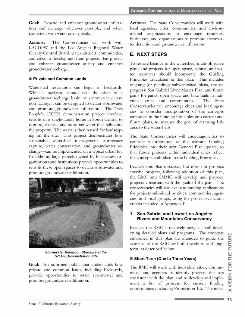
COMMON GROUND FROM THE MOUNTAINS TO THE SEA
A V
ISIO
N F
The RMC will work with individual cities, commu-nities, and agencies to identify projects that are consistent with the plan, and to develop and imple-ment a list of projects for current funding opportunities (including Proposition 12). The initial
Goal: Expand and enhance groundwater infiltra-tion and recharge wherever possible, and when consistent with water quality goals.
Actions: The Conservancies will work with LACDPW and the Los Angeles Regional Water Quality Control Board, water districts, communities, and cities to develop and fund projects that protect and enhance groundwater quality and enhance groundwater recharge.
OR
TH
E FU
TUR
E
! Private and Common Lands
Watershed restoration can begin in backyards. While a backyard cannot take the place of a groundwater recharge basin or stormwater deten-tion facility, it can be designed to detain stormwater and promote groundwater infiltration. The Tree People�s TREES demonstration project involved retrofit of a single-family home in South Central to capture, cleanse, and store rainwater that falls onto the property. The water is then reused for landscap-ing on the site. This project demonstrates how sustainable watershed management�stormwater capture, water conservation, and groundwater re-charge�can be implemented on a typical urban lot. In addition, large parcels owned by businesses, or-ganizations and institutions provide opportunities to retrofit these open spaces to detain stormwater and promote groundwater infiltration.
Stormwater Retention Structure at the
TREES Demonstration Site
Goal: An informed public that understands how private and common lands, including backyards, provide opportunities to retain stormwater and promote groundwater infiltration.
Actions: The State Conservancies will work with local agencies, cities, communities, and environ-mental organizations to encourage residents, businesses, and organizations to promote stormwa-ter detention and groundwater infiltration.
E.
1.
!
NEXT STEPS
To restore balance to the watershed, multi-objective plans and projects for open space, habitat, and wa-ter resources should incorporate the Guiding Principles articulated in this plan. This includes ongoing (or pending) subwatershed plans, the (in progress) San Gabriel River Master Plan, and future plans for parks, open space, and bike trails in indi-vidual cities and communities. The State Conservancies will encourage cities and local agen-cies to consider incorporation of the concepts embodied in the Guiding Principles into current and future plans, to advance the goal of restoring bal-ance to the watersheds.
The State Conservancies will encourage cities to consider incorporation of the relevant Guiding Principles into their next General Plan update, so that future projects within individual cities reflect the concepts embodied in the Guiding Principles.
Because this plan discusses, but does not propose specific projects, following adoption of this plan, the RMC and SMMC will develop and propose projects consistent with the goals of the plan. The conservancies will also evaluate funding applications for projects submitted by cities, communities, agen-cies, and local groups, using the project evaluation criteria included in Appendix F.
San Gabriel and Lower Los Angeles Rivers and Mountains Conservancy
Because the RMC is relatively new, it is still devel-oping detailed plans and programs. The concepts embodied in this plan are intended to guide the activities of the RMC for both the short- and long-term, as described below
Short-Term (One to Three Years)
State of California Resources Agency
73

COMMON GROUND FROM THE MOUNTAINS TO THE SEA
focus will be on projects that are located along the rivers and tributaries, including: (1) acquisition of individual parcels; (2) installation of trails, bike paths and passive recreation space, (3) creation of parks; (4) development of community gardens (with the assistance of the UC Cooperative Extension Com-munity Gardens Program), and (5) improvement or expansion of existing facilities.
The RMC will also develop a master list of projects that will be reviewed as future funding sources are identified or become available (including future bond issues). The project evaluation criteria used by the RMC may be adjusted for individual funding sources to better match projects with funding sources.
The RMC will develop project evaluation software, which will allow individual projects to be quickly and easily ranked (using the project evaluation crite-ria in Appendix E), and linked to available information in the RMC GIS database.
The RMC will work with the Tree People, the County of Los Angeles, CALFED, the Los Angeles and San Gabriel Rivers Watershed Council, and others to support and implement watershed-related educational programs.
The RMC will seek funds to develop a restoration strategy for quarry pits along the San Gabriel River to restore native vegetation, protect and enhance groundwater, and incorporate recreation where fea-sible and consistent with water quality goals.
OR
TH
E FU
TUR
E
Upper San Gabriel River
Additionally, to fully develop some of the concepts described in this plan, the RMC will undertake a second phase of this open space plan process, to
develop, within three years of the adoption of this plan, the following subsequent plans:.
Rivers Parkway Plan: To create a continuous ribbon of open space along the San Gabriel River, the lower Los Angeles River and the Rio Hondo, a Rivers Parkway Plan should be developed. A pro-posed study by the National Park Service to create a National Recreation Area along the rivers could inform this process. Partners in the development of the Rivers Parkway Plan may include the National Park Service, the U.S. Forest Service, the California State Parks and Recreation Department, the Los Angles County Department of Public Works, the Los Angeles County Parks and Recreation Depart-ment, and each riverfront city. The Rivers Parkway Plan shall outline a prioritized list of projects, iden-tify potential funding, and include a work program to accomplish the acquisition and development of each project. This will include projects designated in the Los Angeles River Master Plan and the in-progress San Gabriel River Master Plan.
Tributary Plans: To extend the network of open space, trails and bike paths along tributaries, the RMC will encourage the relevant agencies engaged in subwatershed plans to address open space, habi-tat and passive recreation along the major tributaries of the rivers, including the Compton Creek, Coyote Creek, Rio Hondo, and the Upper San Gabriel River (including Walnut and San Jose Creeks). Potential partners in this process include the Los Angeles Regional Water Quality Control Board, the Los Angeles County Department of Public Works, the Los Angeles County Parks and Recreation Depart-ment, Orange County Watershed and Environmental Programs, the U.S. Army Corps of Engineers, the San Gabriel Regional Mountains Conservancy the Los Angeles and San Gabriel Riv-ers Watershed Council, the San Gabriel Valley Council of Governments, the tributary-fronting cities and stakeholders involved in subwatershed plans.
San Gabriel and Los Angeles Rivers Watershed and Open Space Plan
74
A V
ISIO
N F
Trails and Bike Paths Plan: To establish a com-prehensive network of trails and bike paths, existing plans need to be reviewed to determine whether those plans should be revised to incorporate trails and paths along the river tributaries. Gaps in exist-ing trails and bike paths must be identified and addressed. Potential partners in this effort include: Caltrans, the Metropolitan Transit Authority, the

COMMON GROUND FROM THE MOUNTAINS TO THE SEA
OR
TH
E FU
TUR
E
!
Orange County Transportation Authority, the Cali-fornia Department of Parks and Recreation, the Los Angeles County Parks and Recreation Department, individual cities and communities, and advocacy groups such as the Los Angeles (and Orange County) Bicycle Coalitions.
The State Conservancies will work with the State Department of Transportation, regional transporta-tion agencies, Councils of Government, cities and local agencies, communities, state and legislators, and community groups, to identify local and re-gional connections and develop funding strategies for acquisition or development of pedestrian and equestrian trail linkages.
Mountains, Foothills and Hills Plan(s): To identify parcels and areas of land within the moun-tains, foothills, hills that should be preserved and protected, comprehensive plan(s) are needed to identify priorities, funding and implementation strategies. Potential partners include: the foothill communities of the San Gabriel Mountains, and the San Gabriel Valley Council of Governments; the communities; local conservancies, agencies, and groups; and the Councils of Government surround-ing and encompassing the Whittier/Puente/Chino/ San Jose Hills complex; and the communities sur-rounding the Glendale Narrows and the Verdugo Mountains.
Habitat Conservation Plan: To preserve critical habitat, preserve, and establish habitat linkages and/or corridors, and to preserve, restore, and cre-ate wetlands, a comprehensive habitat plan for the watersheds is needed. This would include (1) de-tailed study and monitoring of potential habitat linkages in the watersheds; (2) comprehensive map-ping of potential conservation sites; (3) ranking of potential sites according to their conservation value and vulnerability; and (4) analyses of aquatic and wetland habitats and species, which have generally received less study than terrestrial habitats and spe-cies. Potential partners in these efforts include the U.S. Forest Service, U.S. Fish and Wildlife Service, the California Department of Fish and Game, the Wildlife Conservation Board, the California Coastal Conservancy, the Puente Hills Landfill Native Habi-tat Preservation Authority, the Wildlife Corridor Conservation Authority, counties, cities, and habitat and resource conservation organizations.
The RMC will also retain a conservation resource biologist to conduct a second phase of analysis and research of habitat linkages and corridors in the watersheds, to identify problems and opportunities related to species conservation in urban settings and provide for input from local experts.
The RMC will also look for partners to fund vegeta-tion mapping for the watersheds. Vegetation mapping would improve understanding existing habitats and the extent of fragmentation, inform planning, and development of strategies for protec-tion of habitats and the establishment and preservation of habitat linkages and corridors.
Historic and Cultural Landscape Survey: In order to preserve our rich cultural and agricultural heritage, the RMC, in conjunction with university, professional, civic, and community organizations, State Parks, the National Park Service, and local agencies, will work to create a comprehensive sur-vey of historic and cultural landscapes throughout the watersheds.
Monitoring and Assessment Plan: The RMC, with partners, will work to develop an assessment process for restoration of the watersheds, and moni-tor progress towards meeting the goals described herein. Critical to this process will be maintenance and updating of the Geographic Information Sys-tems database developed by the RMC. At a minimum, the periodic assessment process shall occur at ten-year intervals, or more often if deemed practical. This process shall utilize quantifiable methods wherever feasible and input from a techni-cal advisory committee, and shall include stakeholder involvement in the design, implementa-tion, and review of the assessments.
A timeline reflecting the development of these plans is included as Figure 3-5.
Long-Term (Twenty to Fifty Years)
The following are the long-term goals of the RMC:
State of California Resources Agency
75
A V
ISIO
N F
▪ To create, expand, and improve public open space, the RMC will work with the federal gov-ernment, the state legislature, the counties, cities, and non-profit groups to identify funding to pro-vide five acres of park space per 1,000 residents. This will include a strategy for land acquisition

COMMON GROUND FROM THE MOUNTAINS TO THE SEA
Watershed PlanVisionPrinciplesStrategiesOpportunities
AcquisitionPublic AccessWaterWilldlife
Plans
Watershed PlanVisionPrinciplesStrategiesOpportunities
AcquisitionPublic AccessWaterWilldlife
PlansPlans & Work Programs
Rivers ParkwayTributaries (Subwatersheds)
Trails & Bike PathsMountains, Hills & Foothills
Habitat ConservationCultural and Historic Resources
Monitoring & Assessment
Plans & Work ProgramsRivers Parkway
Tributaries (Subwatersheds)Trails & Bike Paths
Mountains, Hills & FoothillsHabitat Conservation
Cultural and Historic ResourcesMonitoring & Assessment
Projects
Projects
Rive
rs &
Mou
ntai
nsCo
nser
vanc
yRM
C &
Partn
ers
2001 2002 2003 2004
SMM
C, C
ities
& Ag
enci
es Ongoing Plans and Projects
Open Space Planning Timeline
SocialResearch
GISDatabase
PHASE ONE PHASE TWO
Figure 3-5. Open Space Planning Timeline
and preservation to create parkways along the riv-ers and tributaries.
▪ To improve habitat quality, quantity, and connec-tivity, the RMC will work with resource conservation agencies and other appropriate part-ners to plan and implement a hierarchy of habitat networks that will connect small habitat patches and narrow corridors within the densest urban areas, larger habitat patches and wider corridors in suburban and rural areas, and extensive open spaces in the mountains and the national forests.
OR
TH
E FU
TUR
E
▪ To build a regional systems of trails, bike paths, equestrian trails, and public access systems the RMC will work with federal, state, regional and local agencies, the counties, cities, and advocacy groups to develop a comprehensive network that
will connect river trails to mountain trails, urban trails to centers of commerce, and parks and sig-nificant open spaces to the beaches.
2.
3.
Santa Monica Mountains Conservancy
Because the SMMC has been established for more than 20 years, it already has a variety of plans and programs related to acquisition and preservation of open space, establishment of parks, installation of trails, restoration of habitat, and other resource conservation activities. The SMMC will use the concepts in this plan to develop and implement a Watershed Work Program.
San Gabriel and Los Angeles Rivers Watershed and Open Space Plan
76
A V
ISIO
N F
Other Agencies and Cities
California Resources Agency: Implement devel-opment of the California Continuing Resource
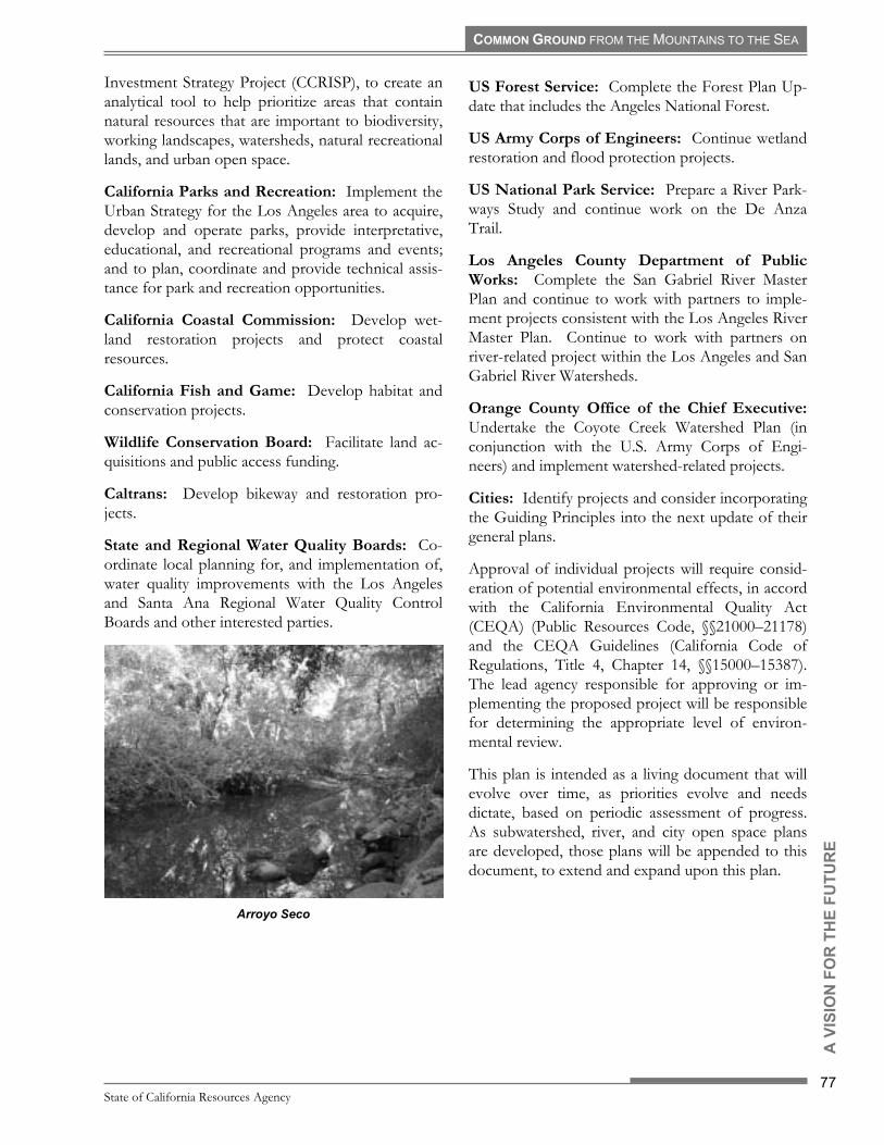
COMMON GROUND FROM THE MOUNTAINS TO THE SEA
OR
TH
E FU
TUR
E
Investment Strategy Project (CCRISP), to create an analytical tool to help prioritize areas that contain natural resources that are important to biodiversity, working landscapes, watersheds, natural recreational lands, and urban open space.
California Parks and Recreation: Implement the Urban Strategy for the Los Angeles area to acquire, develop and operate parks, provide interpretative, educational, and recreational programs and events; and to plan, coordinate and provide technical assis-tance for park and recreation opportunities.
California Coastal Commission: Develop wet-land restoration projects and protect coastal resources.
California Fish and Game: Develop habitat and conservation projects.
Wildlife Conservation Board: Facilitate land ac-quisitions and public access funding.
Caltrans: Develop bikeway and restoration pro-jects.
State and Regional Water Quality Boards: Co-ordinate local planning for, and implementation of, water quality improvements with the Los Angeles and Santa Ana Regional Water Quality Control Boards and other interested parties.
Arroyo Seco
US Forest Service: Complete the Forest Plan Up-date that includes the Angeles National Forest.
US Army Corps of Engineers: Continue wetland restoration and flood protection projects.
US National Park Service: Prepare a River Park-ways Study and continue work on the De Anza Trail.
Los Angeles County Department of Public Works: Complete the San Gabriel River Master Plan and continue to work with partners to imple-ment projects consistent with the Los Angeles River Master Plan. Continue to work with partners on river-related project within the Los Angeles and San Gabriel River Watersheds.
Orange County Office of the Chief Executive: Undertake the Coyote Creek Watershed Plan (in conjunction with the U.S. Army Corps of Engi-neers) and implement watershed-related projects.
Cities: Identify projects and consider incorporating the Guiding Principles into the next update of their general plans.
Approval of individual projects will require consid-eration of potential environmental effects, in accord with the California Environmental Quality Act (CEQA) (Public Resources Code, §§21000�21178) and the CEQA Guidelines (California Code of Regulations, Title 4, Chapter 14, §§15000�15387). The lead agency responsible for approving or im-plementing the proposed project will be responsible for determining the appropriate level of environ-mental review.
This plan is intended as a living document that will evolve over time, as priorities evolve and needs dictate, based on periodic assessment of progress. As subwatershed, river, and city open space plans are developed, those plans will be appended to this document, to extend and expand upon this plan.
State of California Resources Agency
77
A V
ISIO
N F