COMMERCIAL EYES IN SPACE: IMPLICATIONS FOR U.S. …
43
COMMERCIAL EYES IN SPACE: IMPLICATIONS FOR U.S. MILITARY OPERATIONS IN 2030 William Scott Bell, Major, USAF March 2008 Blue Horizons Paper Center for Strategy and Technology Air War College
Transcript of COMMERCIAL EYES IN SPACE: IMPLICATIONS FOR U.S. …

COMMERCIAL EYES IN SPACE: IMPLICATIONS FOR U.S. MILITARY OPERATIONS IN 2030
William Scott Bell, Major, USAF March 2008
Blue Horizons Paper Center for Strategy and Technology Air War College

Report Documentation Page Form ApprovedOMB No. 0704-0188
Public reporting burden for the collection of information is estimated to average 1 hour per response, including the time for reviewing instructions, searching existing data sources, gathering andmaintaining the data needed, and completing and reviewing the collection of information. Send comments regarding this burden estimate or any other aspect of this collection of information,including suggestions for reducing this burden, to Washington Headquarters Services, Directorate for Information Operations and Reports, 1215 Jefferson Davis Highway, Suite 1204, ArlingtonVA 22202-4302. Respondents should be aware that notwithstanding any other provision of law, no person shall be subject to a penalty for failing to comply with a collection of information if itdoes not display a currently valid OMB control number.
1. REPORT DATE MAR 2008 2. REPORT TYPE
3. DATES COVERED 00-00-2008 to 00-00-2008
4. TITLE AND SUBTITLE Commercial Eyes in Space: Implications for U.S. Military Operations in 2030
5a. CONTRACT NUMBER
5b. GRANT NUMBER
5c. PROGRAM ELEMENT NUMBER
6. AUTHOR(S) 5d. PROJECT NUMBER
5e. TASK NUMBER
5f. WORK UNIT NUMBER
7. PERFORMING ORGANIZATION NAME(S) AND ADDRESS(ES) Air University,Air War College,Center for Strategy andTechnology,Maxwell AFB,AL,36112
8. PERFORMING ORGANIZATIONREPORT NUMBER
9. SPONSORING/MONITORING AGENCY NAME(S) AND ADDRESS(ES) 10. SPONSOR/MONITOR’S ACRONYM(S)
11. SPONSOR/MONITOR’S REPORT NUMBER(S)
12. DISTRIBUTION/AVAILABILITY STATEMENT Approved for public release; distribution unlimited
13. SUPPLEMENTARY NOTES
14. ABSTRACT see report
15. SUBJECT TERMS
16. SECURITY CLASSIFICATION OF: 17. LIMITATION OF ABSTRACT Same as
Report (SAR)
18. NUMBEROF PAGES
42
19a. NAME OFRESPONSIBLE PERSON
a. REPORT unclassified
b. ABSTRACT unclassified
c. THIS PAGE unclassified
Standard Form 298 (Rev. 8-98) Prescribed by ANSI Std Z39-18

ii
Disclaimer
The views expressed in this academic research paper are those of the author and do not reflect the official policy or position of the US government or the Department of Defense. In accordance with Air Force Instruction 51-303, it is not copyrighted, but is the property of the United States government.

iii
Preface This paper summarizes the research results for one topic in the Blue Horizons Space
Seminar, a CSAF-commissioned research project devoted to providing a 20-30 year estimate of strategic and technology trends. The Blue Horizons Space research seminar examined accelerating scientific and technological advances in areas that could impact space policy, operations, and support. The results of this study are an executive summary, underpinned by student-prepared white papers, targeted at key decision makers and planners that is intended to provide a framework for Air Force strategic planning, investment and capability decisions.
This research paper would not be possible without the contributions of many experts from the commercial remote sensing industry. I would like to thank these experts for their outstanding support and invaluable information, which formed the basis for this report. Additionally, I would like to thank my advisor, Lt Col Richard Hughes, as well as the entire Blue Horizons Research Seminar staff for their guidance and wisdom on conducting futures research for this project.

iv
Abstract
Commercial remote sensing from satellites provides tremendous information about objects on the Earth’s surface for a variety of business, civil, and recreational needs. Using two case studies, this research paper investigates how commercial satellite remote sensing capabilities in 2030 could impact U.S. military operations and analyzes what investments should be made today to protect U.S. interests from adversaries using these capabilities. Interviews with multiple experts from the commercial remote sensing community combined with research of open-source documentation provide unique insights into possible futures. The research shows that by 2030, the commercial remote sensing industry will be able to provide dynamic and vertically-integrated multi-source information in near-real-time. The implications for the U.S. military include a wealth of information to supplement national intelligence collection as well as a need to develop capabilities to deny its use by adversaries. To preserve information superiority in 2030, the U.S. must advocate international policies to prevent sales of commercial information products and invest today in technology development efforts such as counter-communications, synthetic aperture radar jamming and spoofing, computer network attack, and mobile laser technologies as part of a comprehensive counter-ISR fielding program.
v
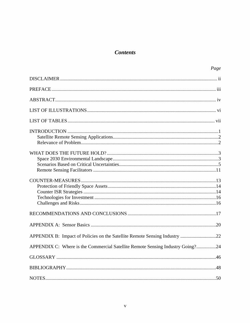
Contents
Page
DISCLAIMER ................................................................................................................................ ii
PREFACE ...................................................................................................................................... iii
ABSTRACT ................................................................................................................................... iv
LIST OF ILLUSTRATIONS ......................................................................................................... vi
LIST OF TABLES ........................................................................................................................ vii
INTRODUCTION ...........................................................................................................................1 Satellite Remote Sensing Applications ......................................................................................2 Relevance of Problem ................................................................................................................2
WHAT DOES THE FUTURE HOLD? ...........................................................................................3 Space 2030 Environmental Landscape ......................................................................................3 Scenarios Based on Critical Uncertainties .................................................................................5
Remote Sensing Facilitators ....................................................................................................11
COUNTER-MEASURES ..............................................................................................................13 Protection of Friendly Space Assets ........................................................................................14 Counter ISR Strategies ............................................................................................................14 Technologies for Investment ...................................................................................................16 Challenges and Risks ...............................................................................................................16
RECOMMENDATIONS AND CONCLUSIONS ........................................................................17 APPENDIX A: Sensor Basics ......................................................................................................20 APPENDIX B: Impact of Policies on the Satellite Remote Sensing Industry .............................22
APPENDIX C: Where is the Commercial Satellite Remote Sensing Industry Going? ................24
GLOSSARY ..................................................................................................................................46
BIBLIOGRAPHY ..........................................................................................................................48
NOTES ...........................................................................................................................................50

vi
List of Illustrations Page
Figure 1: Scenarios for Future of Commercial Satellite Remote Sensing ......................................9
Figure 2: Notional Satellite Remote Sensing Flow and Potential Counter-ISR Strategies ..........25
Figure 3: Spectral Characteristics of energy sources, atmospheric effects, and sensing systems ..................................................................................................................................34
Figure 4: Electromagnetic Spectrum ............................................................................................35

vii
List of Tables
Page
Table 1: Space 2030 Scenario Summary ........................................................................................6
Table 2: Summary of Military Implications .................................................................................22
Table 3: Summary of Counter-ISR Capabilties Required in 2030 ...............................................27
Table 4: Summary of Recommendations ......................................................................................31
Table 5: Advantages and Disadvantages of Common Sensor Types ...........................................35
Table 6: Summary of Near-Term Commercial Satellite Capabilties ............................................40

1
Part 1 - Introduction
Today, commercial satellite imagery is available on the Internet free within several
mouse clicks. Companies like Google Earth provide the common citizen searchable global satellite imagery paired with maps and travel facts within seconds. However, this wealth of information may be used for more than just recreational and business purposes. In late 2006, the British military found Google Earth printouts during raids of insurgents’ homes in Iraq. According to a British military intelligence officer, the insurgents apparently used this information to identify vulnerabilities and plan attacks on British bases in Basra, Iraq.1 In March 2002, the Director of Central Intelligence testified that foreign military, intelligence, and terrorist organizations are exploiting commercial high-resolution imagery to enhance the conduct of their operations.2 Commercial satellite remote sensors paired with easily accessible websites on the Internet not only provide a growing resource for numerous business, personal, and recreational needs, but also potential targeting information for U.S. adversaries. If this information is readily available today, what types of commercial satellite imagery and information will be available in the future and how will this impact military operations?
Twenty five years from now, an unprecedented amount of multi-source commercial imagery, and militarily relevant information, may be available in near-real-time to anyone willing to pay for it. The potential implications to military operations are numerous and will be explored throughout this paper. This research project investigates two related questions: First, how will commercial satellite remote sensing capabilities in 2030 impact U.S. military operations? Second, what investments should be made to protect U.S. interests from adversaries using these capabilities?
This paper will show that commercial satellite remote sensing capabilities in 2030 will be capable of providing militarily-relevant data to paying customers in near-real-time. The U.S. should utilize commercial sources of imagery to supplement existing sources and develop capabilities to prevent adversaries from obtaining the commercially available, militarily-relevant satellite imagery of 2030. Prevention strategies should be policy related, such as “shutter control” over geographic areas, and technology-based, such as denial, deception, and concealment, or denial and disruption of the imagery transmission via information operations (IO). This research paper will address the benefits of using commercial imagery for military operations as well as policy decisions and technical capabilities required to cope with a commercial remote sensing threat in 2030.
To explore the research questions, the paper will first provide a background on applications for commercial remote sensing and further describe the significance of the problem. A discussion of the 2030 environment will analyze potential scenarios and critical uncertainties, followed by a scenario-driven case analysis of potential futures. The paper will next describe the required capabilities for systems to protect U.S. interests from a commercial remote sensing threat and then discuss several technologies requiring further research and development to provide those capabilities. Upcoming challenges and risks will then be explored and followed by recommendations and conclusions.

2
Satellite Remote Sensing Applications
Information from commercial satellite remote sensing permeates much of our lives, and provides crucial decision-making capabilities to governments, businesses, and civil agencies. Remote sensing from space provides a unique global perspective of the Earth not available to airborne or ground-based sensors. The satellite orbits for most remote sensing platforms allow for global coverage at all latitudes, with the ability to revisit areas of interest over periods of time. The government and military rely on space-based sensors for intelligence collection. Satellite remote sensors collect imagery intelligence as well signals intelligence to monitor hostile forces or adversaries. Satellite sensors also provide indications and warnings of missile and rocket launches around the world. Weather and climate monitoring are another application for space-based sensors. Numerous weather and scientific agencies use satellites not only to observe global weather patterns, but also to monitor global environmental conditions.
A satellite’s global perspective also provides an excellent view of the world’s natural resources, metropolitan areas, and farms. The U.S. Forest Service uses commercial satellite imagery to examine the impacts of fires on the nation’s forests and assess fire risk.3 Satellite imagery provides a capability to track movement of ice formations and locate specific geological formations or resources. National Oceanic and Atmospheric Administration (NOAA) analyzes drought conditions using satellite-based imagery to provide decision-making information to water managers controlling the flow of water through reservoirs.4 The agricultural industry uses satellite imagery to manage crops and urban planners use satellite imagery to determine the location of future buildings, parks, and utilities.
Satellite imagery is a critical aspect of natural disaster preparation, mitigation, and follow-up. Imagery can be a critical component of disaster preparedness plans, indicating susceptible areas and safe evacuation locations. Before Hurricane Katrina hit the Gulf coast, integrated observations from space, aircraft, and ocean buoys provided information for state officials to issue warnings for evacuation.5 Numerous news and weather agencies featured satellite imagery of Hurricane Katrina approaching the Gulf Coast. Additionally, insurance companies use imagery to estimate the costs associated with natural disasters and government officials use imagery to assess overall damage. In many cases, the satellite sensors serve a dual-use purpose, where both industry and governments benefit from the same satellite platform.
Relevance of Problem
Today’s commercial satellite remote sensing yields considerable amounts of useful information; however adversaries could use this information against the U.S., its forces, or its allies. Adversary purchase of commercially-produced satellite remote sensing data today is a serious national security threat. The capabilities of 2030 could yield considerably more actionable information in near-real time to U.S. adversaries. For example, adversaries without their own intelligence satellites could purchase what imagery they need, when they need it, without developing and launching capabilities of their own. This would provide military intelligence capabilities at a tremendous cost savings to less wealthy countries that traditionally do not have access to global intelligence collection. Additionally, non-state actors like terrorists could buy imagery to plan and conduct acts of terrorism in the U.S. or against U.S. forces. For commercial satellite imagery to be useful for U.S. adversaries, it must be detailed enough for planning and targeting.

3
What level of detail for commercial satellite imagery constitutes militarily-relevant? Ten-meter resolution is sufficient for detecting bridges, buildings, and even concentrations of tanks. Two-meter resolution is sufficient to generally identify aircraft, vehicles, roads and bridges while one-meter resolution is sufficient to precisely identify types of aircraft, tanks, airport and harbor facilities, cars in railroad yards, vehicles on roads and bridges, and troop units.6
Imagery resulting from electro-optical (EO) imaging systems that is less than 0.8 meter and infrared (IR) or synthetic aperture radar (SAR) imagery in the multiple meter range would be useful for targeting.7 Today’s space-based commercial EO systems are led by U.S. companies and are capable of sub-one-meter resolution. However, today’s commercial SAR and IR systems do not yet possess multiple meter resolutions.8
U.S. and foreign commercial remote sensing industries will continue to grow and provide increasingly detailed information to customers. U.S. policies developed in the 1990s and further modified in 2003 fostered growth of the U.S. satellite remote sensing industry, while providing a level of protection for national security (see Appendix B for a more detailed discussion). However, these security measures are only effective for U.S. imaging satellites. Numerous countries plan to launch remote sensing satellites in the near future with capabilities approaching and even closing the gap with U.S. companies. According to a recent market forecast (see Appendix C), the next decade appears to be bright for commercial satellite remote sensing, but what will the industry look like in 2030? The next section analyzes scenarios for potential futures and discusses the implications for global military operations.
Part 2 - What Does the Future Hold? Today’s decision makers face a complex and uncertain world in which assessment of the trends shaping our long-term future is a major challenge. —Michael Osborne
Director of OECD International Futures Programme, 2004
The future is impossible to predict accurately. One method for analyzing what may
happen in the future is to develop scenarios to describe potential futures and then analyze the applications of a specific technology within each of the scenarios. This paper utilizes two case studies to analyze the potential for commercial satellite remote sensing and the implications for military operations in 2030. The first case study is based on a two-year futures project conducted by the international Organisation for Economic Cooperation and Development (OECD) on the commercialization of space and development of space applications in the upcoming decades. The second case study is based on critical uncertainties identified during research for this paper. Together these case studies provide a thorough examination of possibilities for commercial satellite remote sensing in the next 20 to 30 years.
Space 2030 Environmental Landscape
4
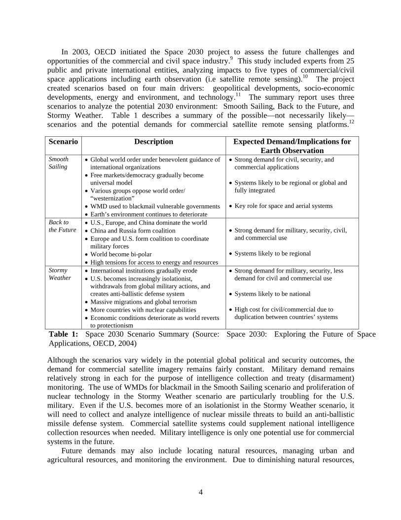
Scenario Description Expected Demand/Implications for Earth Observation
Smooth Sailing
• Global world order under benevolent guidance of international organizations
• Free markets/democracy gradually become universal model
• Various groups oppose world order/ “westernization”
• WMD used to blackmail vulnerable governments • Earth’s environment continues to deteriorate
• Strong demand for civil, security, and commercial applications
• Systems likely to be regional or global and
fully integrated • Key role for space and aerial systems
Back to the Future
• U.S., Europe, and China dominate the world • China and Russia form coalition • Europe and U.S. form coalition to coordinate
military forces • World become bi-polar • High tensions for access to energy and resources
• Strong demand for military, security, civil,
and commercial use • Systems likely to be regional
Stormy Weather
• International institutions gradually erode • U.S. becomes increasingly isolationist,
withdrawals from global military actions, and creates anti-ballistic defense system
• Massive migrations and global terrorism • More countries with nuclear capabilities • Economic conditions deteriorate as world reverts
to protectionism
• Strong demand for military, security, less demand for civil and commercial use
• Systems likely to be national • High cost for civil/commercial due to
duplication between countries’ systems
Table 1: Space 2030 Scenario Summary (Source: Space 2030: Exploring the Future of Space Applications, OECD, 2004)
In 2003, OECD initiated the Space 2030 project to assess the future challenges and opportunities of the commercial and civil space industry.9 This study included experts from 25 public and private international entities, analyzing impacts to five types of commercial/civil space applications including earth observation (i.e satellite remote sensing).10 The project created scenarios based on four main drivers: geopolitical developments, socio-economic developments, energy and environment, and technology.11 The summary report uses three scenarios to analyze the potential 2030 environment: Smooth Sailing, Back to the Future, and Stormy Weather. Table 1 describes a summary of the possible—not necessarily likely—scenarios and the potential demands for commercial satellite remote sensing platforms.12
Although the scenarios vary widely in the potential global political and security outcomes, the demand for commercial satellite imagery remains fairly constant. Military demand remains relatively strong in each for the purpose of intelligence collection and treaty (disarmament) monitoring. The use of WMDs for blackmail in the Smooth Sailing scenario and proliferation of nuclear technology in the Stormy Weather scenario are particularly troubling for the U.S. military. Even if the U.S. becomes more of an isolationist in the Stormy Weather scenario, it will need to collect and analyze intelligence of nuclear missile threats to build an anti-ballistic missile defense system. Commercial satellite systems could supplement national intelligence collection resources when needed. Military intelligence is only one potential use for commercial systems in the future.
Future demands may also include locating natural resources, managing urban and agricultural resources, and monitoring the environment. Due to diminishing natural resources,

5
Foreign Commercial Space Leads
Foreign Airborne Sensors Dominate
US Airborne SensorsLead the Way
US Commercial Space Sensors Rule
Space-BasedSensors
Aircraft-BasedSensors
Potential Futures for Commercial Remote Sensing
Foreign DominatedMarket
US Dominated Market
12
43Foreign Commercial
Space LeadsForeign Airborne Sensors Dominate
US Airborne SensorsLead the Way
US Commercial Space Sensors Rule
Space-BasedSensors
Aircraft-BasedSensors
Potential Futures for Commercial Remote Sensing
Foreign DominatedMarket
US Dominated Market
12
43
Figure 1: Scenarios for Future of Commercial Satellite Remote Sensing
there will also be a high demand to locate naturally-occurring oil and gas stores. Hyperspectral sensors, which collect reflected energy in very small bands, could be particularly useful in this application, as well as active sensors such as SAR and Light Detection and Ranging (LIDAR). Other trends include a demand for imagery for the monitoring and management of land resources and urban planning, precision farming, and natural disaster prevention and management. Commercial satellite sensors will also be needed for global environmental monitoring, meteorology, and oceanography.
The Space 2030 project showed continued demands for commercial satellite remote sensing, despite the varied geopolitical potential futures. Today’s satellite sensor applications would basically continue through 2030. If these varied geopolitical scenarios do not substantially alter the applications, what are the primary drivers for the industry? The next section will identify several of these drivers and analyze four potential scenarios for 2030.
Scenarios Based on Critical Uncertainties
The future of commercial satellite remote sensing may be impossible to predict, however an understanding of key drivers provides a starting point for analysis. Key drivers are comprised of known elements as well as uncertainties. Uncertainties are the most critical component of a future scenario, since they are by definition unknown. One method for creating scenarios is to illustrate the two most significant critical uncertainties on axes for possible futures.13 Two critical uncertainties for commercial satellite remote sensing in 2030 include what counties dominate the market and the platform on which the sensor resides.14 U.S. and foreign approaches to commercial satellite remote sensing appear to differ today (see Appendix C), with the U.S. focus on high-resolution EO systems, and other countries developing and integrating EO and SAR sensors. In the future, this difference may become further pronounced, or countries may pursue similar approaches. Additionally, sensors can be either airborne or space-based. An aircraft-based and dominated market may have large impacts on the space-based market or vice versa. On the other hand, both aircraft and satellite based sensors may supplement each other rather than compete. Plotting the two uncertainties on a two-dimensional graph creates four potential scenarios, shown in Figure 1. These scenarios provide a framework for analysis. The four scenarios created for this analysis are: 1) U.S. Commercial Space Sensors Rule, 2) U.S. Airborne Sensors Lead the Way, 3) Foreign Airborne Sensors Dominate, and 4) Foreign
Commercial Space Leads. In reality, no single one of these scenarios would occur in isolation from the others. However, the scenarios provide a structure for analyzing the potential state of technology and the possible implications for military operations in 2030. The impacts to military operations must be understood for the creation of protection strategies and measures. Scenario 1: U.S. Commercial Space Sensors Rule

6
In Scenario 1, U.S. space-based commercial sensors lead the global commercial remote sensing industry in 2030. The U.S. may continue to dominate the EO market alone or develop other sensor technology to supplement EO data. With an EO-only focus, industry would most likely further develop sensors to improve spatial resolution, increase the refresh rate of the data available to customers, and improve the geolocation accuracy of the imagery. Improving spatial resolution entails balancing the size of the optics package with the overall satellite size and mass, which impact the manufacturing and launch costs. Nanotechnology, or the manipulation of materials on an atomic or molecular scale, could provide a means for improving optics by building from the ground up instead of the current technique of polishing and purifying.15 Industry could improve the currency of imagery by placing more satellites in orbit or further developing satellite/sensor pointing methods for collecting imagery. If nanotechnology could reduce the overall size and cost of imaging satellites, more satellites could be placed into orbit to increase re-visit times. Additionally, placing high-resolution satellite in geosynchronous orbit would allow the satellite to constantly view approximately one-third of the Earth. However, this satellite would have to be extremely large. To obtain a one meter resolution would require an optical sensor with a diameter of 29.6 meters.16 The geolocation accuracy of imagery today is based on the availability of U.S. Air Force Global Positioning System (GPS) timing and positing services. Future improvements would mostly depend on the capabilities of GPS (or its follow-on system) and methods for processing the GPS signals. A U.S.-dominated market may also develop other sensor technologies to complement EO imagery.
In 2030, U.S.-led industry may pursue other remote sensing techniques such as SAR, hyperspectral, IR, and LIDAR to supplement traditional EO imagery products. SAR uses motion of the sensor to its advantage to increase the effective size of its collection aperture while transmitting and receiving energy. SAR systems are active imagers, which can be specifically “tuned” and resulting data processed to collect information about specific objects on the ground or slightly below the surface. Commercial SAR imagery could be useful for cartography, geology, agriculture, forestry, as well as ice and ocean current monitoring. Although several non-U.S. commercial SAR systems exist today, relatively new SAR techniques could yield even more information to customers. Use of energy polarization—vertical and horizontal—would provide more capability for discerning objects of interest.17 Combining transmit and receive polarizations in different combinations such as cross polarization, dual polarization, or quad polarization provides numerous ways to analyze the signatures of objects. Another SAR capability is the detection of moving targets or moving target indicators (MTI).18 This technique uses Doppler shift to discern moving objects from background clutter, and would be specifically useful for locating moving vehicles or trains. Law enforcement or insurance companies could use MTI to locate specific vehicles. In general, commercial SAR imagery would provide useful information to commercial, civil, and military customers. Military applications for commercial SAR imagery include locating concealed or camouflaged targets, analyzing building or road structures, locating moving targets, and 3-D terrain mapping.
Hyperspectral sensors could also become more commonplace in a U.S.-dominated satellite remote sensing market. Hyperspectral techniques utilize sensors that collect energy in very small bands of the electromagnetic spectrum, possibly as many as hundreds or thousands of bands. The benefit of hyperspectral sensing is locating and or mapping objects of interest that emit or reflect energy at very specific wavelengths. This technique yields enormous amounts of data; however, it must be intelligently processed and interpreted to be useful to the commercial market. Hyperspectral imaging is not a new technique. The capability has existed for over 10

7
years, but did not catch on in the commercial world due to the expertise required to analyze the data.19 Twenty to thirty years from now, advancements in computer processing power both on-board the satellite and on the ground could automatically analyze the data for presentation in a user-friendly 3D or holographic displays.
A problem with today’s hyperspectral sensors is that the sensor slices the energy into very small bands resulting in little energy reaching the actual sensor.20 In the future, technologies such as active pixel sensors could help alleviate this issue. Active pixel sensors (APS) “contain the electronics such as amplifiers, conditioning circuits as part of the sensor substrate itself rather than conductors carrying raw data to functional blocks off the sensor array.”21 The advantage for hyperspectral sensors is that APS could be more efficient with energy collection, thus providing a more sensitive system.22 Also, individual active pixel sensors can automatically adjust gain to prevent saturation from reflections and glint, where conventional sensors would lose an entire row of data due to saturation.23 APS could be applied to any type of visual sensor systems, and will reduce the overall size of the sensor payload.24
Commercial companies could also use hyperspectral imagery to “sharpen” panchromatic EO imagery to highlight specific objects or areas.25 For example, hyperspectral data from specific mineral deposits could be combined with EO imagery of the same area to produce a detailed map of mineral deposit locations.26 A specific military application is the differentiation between real objects or decoys on a high resolution EO image. With advancements in processing, analysis techniques, and sensor technology, hyperspectral remote sensing could play a significant role in a U.S. led marketplace to supplement traditional EO imagery. Hyperspectral technology could benefit commercial as well as civil and military users by providing access to new types of information about specific geographic areas or objects of interest.
Another technology the U.S. commercial remote sensing market may further develop is IR sensors. Today’s sensors use power consuming cooling devices to provide a temperature gradient for collecting IR energy. A relatively new technology in use today for non-space applications is “uncooled” thermal sensors. L-3 Communications developed uncooled thermal IR detectors for imaging cameras and binoculars to be used for search and rescue, perimeter surveillance, vehicle night vision, and industrial process monitoring.27 These sensors use a patented Indium Antimonide IR focal plane array.28 Uncooled thermal sensors could be further developed for satellite use so that arrays of thermal detectors with small pixels replace the large mechanical IR scanners of the past.29 Smaller IR sensor payloads reduce the overall satellite size as well as launch cost and could potentially lead to many more commercial IR systems in orbit.
One last sensor technology where the U.S.-led market may further develop for commercial use to supplement EO capabilities is LIDAR. LIDAR is an active EO technique that transmits and then collects returns from pulsed laser energy. This form of remote sensing is relatively new for satellites. Today, NASA and several other organizations use space-based LIDAR to analyze cloud formations and atmospheric aerosols.30 In the future, new LIDAR techniques could provide valuable sources of information. Differential LIDAR is a technique used by airborne systems today where multiple laser wavelengths are fine-tuned to reflect specific particles.31 ITT uses differential LIDAR on an aircraft to detect leaks from natural gas pipelines.32 With the proper tuning, this technique could also be used to map wind patterns around airports in 3-D, locate and track chemical and biological gasses in 3-D, and perform topographic analysis of the shape of the Earth and under the ocean.33 One of the greatest challenges for LIDAR is developing laser technology that minimizes the amount of energy lost to the atmosphere.34 The atmosphere absorbs a large percentage of laser light from today’s systems, which reduces the
8
energy received at the sensor. This issue would be exasperated further for a space-based sensor imaging through the atmosphere. Laser systems must be smaller and more energy efficient to provide additional utility operating from a satellite. Efficient and powerful laser technologies will be required effectively implement commercial space-based LIDAR for specific niche markets. If the challenges can be overcome, LIDAR imaging from a satellite could provide a wealth of information about weather, poisonous gasses, and topography for commercial and military customers.
In Scenario 1, the U.S. led commercial satellite remote sensing market further developed EO systems, as well as SAR, hyperspectral, IR, and LIDAR to supplement EO imagery for use by commercial, civil, and military customers. What does this mean for U.S. military operations? First, the U.S. Government can continue to purchase commercial imagery to supplement military and national intelligence collection systems. Second, improvements in sensor design will reduce the size and therefore cost to manufacture and launch the systems. With a reduction in individual satellite cost, industry will most likely launch more systems for redundancy and to improve re-visit capability. More commercial satellites in orbit provide a more timely set of data for customers to select and the ability to request and receive new imagery in less time. Third, improvements to SAR, hyperspectral IR, and LIDAR imaging techniques will make new sources of data available for decision makers. Individually or when combined with EO imagery, SAR, hyperspectral, IR, and LIDAR data will provide unique decision making information.
Scenario 2: U.S. Airborne Sensors Lead the Way
In Scenario 2, U.S. airborne sensors lead the global commercial remote sensing marketplace in 2030.35 In an U.S.-dominated airborne-sensor scenario, airborne sensors would be used for both domestic and foreign data collection. What would drive such a scenario to occur? Airborne sensors offer several advantages over space-based sensors. First, airborne systems possess better spatial resolutions than their space-based counterparts. This is because the air-based sensor is much closer to the object of interest than a satellite sensor. Second, airborne systems tend to be cheaper than space sensors since there are no associated space launch costs. Airborne systems only require the operations and sustainment costs of the aerial platform and the sensors themselves. Third, airborne systems are also cheaper because they do not require the level of automation and redundancy of space systems with operational lifetimes of years without physical maintenance and sustainment. Fourth, aerial sensor systems can be adjusted and further developed after becoming operational.36 After returning to the ground, air-based sensors can be altered, updated, or modified based on the lessons learned from the previous operations. Lastly, airborne sensors are not as vulnerable to adversary counter-Intelligence, Surveillance, and Reconnaissance (ISR) techniques if the aircraft does not fly over potential hostile sites. In January 2007, China conducted an anti-satellite test, destroying a seven-year-old Chinese weather satellite.37 Additionally, China allegedly lased U.S. military satellites in 2006.38 Today’s low earth orbiting satellites do not possess the amount of fuel required to avoid passing over hostile areas. If these types of threats persist in the next few decades, industry may choose to focus on aircraft-based remote sensing to avoid potentially costly damage to space sensors. Air-based sensors can avoid threat areas if necessary, but at the cost of obtaining images of the target threat area. Additionally, air sensors cannot operate indefinitely in all airspace worldwide.
Air-based sensors have several key disadvantages. First, aircraft do not inherently have global coverage and cannot fly unrestricted over foreign countries. Due to the limitations in range and speed, air-based sensors do not have timely and persistent coverage over global areas

9
of interest. Second, most commercial aircraft can be easily tracked via ground radar, and are therefore not useful in covert data collection (unless collecting covertly while flying an overt mission). Industry has no impetus to apply costly stealth technology to purely commercial missions. Commercial air-based sensors, therefore are well suited for operations over friendly areas or areas where the U.S. maintains air superiority. Given these advantages and disadvantages, what capabilities will commercial airborne sensors possess in this scenario?
Commercial airborne sensors in 2030 will take advantage of improvements in sensor technologies as well as automated command and control. Sensor technologies, such as EO, SAR, hyperspectral, IR, and LIDAR will all be utilized by aerial platforms in 2030. The potential advances in sensor technology discussed above for space platforms also apply to air-based commercial sensors. The flexibility in air-based sensors will allow for development and refinement of both active and passive sensor systems to further improve resolution and provide meaningful new data. Additionally, air systems will begin to approach space systems in their level of automation. Automated commercial unmanned aerial systems (UAS), much like the military’s capabilities today, will provide persistent vision over areas of interest.39 In the future, if Federal Aviation Administration (FAA) policies keep pace with technology, unmanned commercial sensing systems will fly over cities, rural areas, and coastlines to provide information for traffic monitoring, law enforcement, and a myriad of commercial and civil functions. U.S. commercial aerial systems will most likely be focused on collecting information over U.S. territory, unless specific contracts and agreements are in place for U.S. aircraft to provide commercial services to non-U.S. countries. Aerial systems will therefore not have much military utility while operating in a purely commercial role, since the military is not permitted to collect intelligence information over the U.S. Commercially-obtained aerial data of foreign areas could provide useful intelligence information for mapping.
A U.S.-led airborne commercial remote sensing market will take advantage of the cost, flexibility, and technical capabilities developed over the next two decades. Commercial aerial systems cannot fly unrestricted over foreign areas and therefore have limited military utility. However, the U.S. Government could purchase commercial aerial data over non-US countries to supplement other intelligence sources. Military intelligence collections systems—both air and satellite-based—will benefit from the research and development conducted for commercial airborne sensors. Advancements in commercial EO, SAR, IR, and LIDAR technologies could be applied to military ISR systems. Air-based remote sensing could serve as a test-bed for future satellite sensors. This scenario discussed possible implications for a U.S. led aircraft-centric commercial remote sensing market. What would be the military implications of a non-U.S. dominated airborne remote sensing market?
Scenario 3: Foreign Airborne Sensors Dominate
In Scenario 3, foreign airborne sensors lead the global commercial remote sensing marketplace in 2030. The advantages and disadvantages for aerial remote sensing discussed in the previous scenario apply, except for who operates the systems and where. Foreign aircraft sensor capabilities will most likely improve similarly to U.S. systems, providing a wealth of information to commercial, and potentially government decision makers. There are two potential situations where foreign airborne sensors could impact U.S. security. Domestically, the U.S. Government must approve and track foreign sensor systems operating in U.S. territory to protect U.S. interests. The U.S. may be observed by other countries legally as part of the Open Skies Treaty. The Open Skies Treaty allows for limited aerial observation using commercially-

10
obtained sensors over the territory of the 30 participating countries.40 Overseas, the U.S. monitors and controls airspace in the vicinity of military operations. Therefore, foreign aerial systems would most likely not be able to collect information about U.S. force locations, movements, and actions. During peacetime operations in forward operating locations, the U.S. military should obtain as much information as possible about aircraft that could be carrying sensors to prevent foreign intelligence collection opportunities. If the U.S. maintains air superiority over areas of military operations and U.S. territory, foreign commercial systems will not pose a threat in 2030, regardless of the sensor’s capabilities. As with foreign airborne systems, the U.S. military should also maintain situational awareness of foreign satellite remote sensing platforms.
Scenario 4: Foreign Commercial Space Leads
In Scenario 4, the foreign commercial space industry leads the remote sensing market in 2030. The foreign satellite remote sensing industry could further develop EO, IR and SAR systems, but also could pursue other types of collection capabilities. Additionally, foreign companies will most likely develop space-based LIDAR sensors. Development of EO, IR, SAR and LIDAR systems will most likely lead to a greater number of small, high-resolution systems on orbit. One approach may entail the development and operations of commercial micro-satellite constellations. This approach could further mature systems in development today like the French Pleiades and German RapidEye EO constellations. Micro-satellites would be cheaper to launch into orbit, and manufacturing could be made more cost efficient by using nanotechnology to build micro-optics, propulsion, and power systems. Due to the smaller size and cheaper cost, more satellites could be launched by a single launch vehicle. Micro-satellites could carry small EO or IR payloads as well as Electronics Intelligence (ELINT) packages. A constellation of micro-satellites could provide a “synthetic” aperture that approaches the dimension of the satellite spacing, which could yield extremely small ground resolutions.41 A second area for the 2030 foreign-dominated commercial market to pursue is integration of multi-intelligence (multi-INT) collection systems.
In 2030, the foreign commercial remote sensing industry may operate constellations of EO, IR, SAR, and ELINT systems with integrated command and control and data processing facilities. These systems could be multi-national, as with the German SAR-Lupe and French Helios II systems today.42 Integration of multi-source capabilities would allow for synergy between the ground segment and users segments, which would facilitate a cross-flow of information. This situation could have numerous commercial applications, especially if policies allow for collection of private citizen’s information. One example involves use of near-real-time multi-source information for law enforcement. A phone conversation could be intercepted via ELINT that indicates a crime will soon occur. Geolocation coordinates of the suspects could be passed to imagery systems, which obtain up-to-date imagery of the area that is processed and routed to law enforcement officials’ hand-held displays. With numerous systems on-orbit and automated processing, this information could be provided in near-real-time. The satellite imagery could also be combined with video from ground-based sensors to provide additional situational awareness. These synergistic capabilities would be useful not only for law enforcement, but also intelligence gathering. Commercial multi-INT collection in 2030 has significant implications for military operations.
A non-U.S. dominated commercial satellite remote sensing market in 2030 has several important implications for military operations. First, improvements in sensor design, satellite
11
manufacturing, launch systems, and data processing will yield more EO, IR, LIDAR, and SAR systems that provide extremely accurate and timely information to customers. Micro-satellites with remote sensing packages will be increasing more difficult to track by ground and space systems. Second, shared command and control and processing centers will give an ability to quickly collect data, task sensors with a variety of collection capabilities, and distribute multi-source information. A wealth of processed decision-making information could be available in near-real-time to consumers. Information could be obtained by U.S. adversaries directly or through third party buyers. Policies to prevent these sales could help, but it may be near impossible to prevent sales to unauthorized users. The U.S. must be able to identify and track the location of foreign satellite systems carrying sensors and have knowledge of what information the systems can collect. Third, it may be difficult for forces on the ground to determine if satellites are collecting while passing overhead. Sensors could be built to detect the emissions of active collectors, like SAR and LIDAR. However, passive sensors, like EO, IR, and ELINT systems do not provide any indication whether they are collecting while overhead. U.S. strategies in 2030 to protect critical information about forces and sites must consider each of these implications to be successful. Foreign commercial satellite systems will pose a serious security threat to U.S. military operations if policies are unsuccessful in preventing the flow of information to adversaries.
The four scenarios show a variety of potential futures for the commercial satellite remote sensing industry. Taken individually, these scenarios illustrate a state of technology in 2030. In reality, none of these scenarios will occur in isolation from the others. The aerial and satellite commercial remote sensing industry will most likely complement each other rather than compete. The U.S. and foreign industry could both grow or one may dominate the market. Each will seek to develop, build, and operate systems to provide information services they think customers need for decision making. The commercial satellite-based remote sensing industry must also consider several facilitators in the next several decades.
Remote Sensing Facilitators
There are three key remote sensing facilitators that will impact the future of commercial remote sensing: the level of data integration, tools for processing and interpretation, and accessibility of data. These facilitators provide additional considerations for future military operations. By 2030, it is likely that the Earth’s surface will be under constant watch by orbiting, aerial, and static sensors on buildings and street corners. These sensors will provide near-real time relevant and dynamic data sources that are constantly updated.43 Data from these sensors provide additional value if seamlessly integrated into actionable information. Industry’s focus could move from single or dual-source approaches to broad vertical integration of multiple sensors with high refresh rates.44 With a myriad of sensors constantly monitoring the Earth, potentially all observable actions of military forces will be for sale to paying customers. Warfare would fundamentally change if the element of surprise is completely removed.45 However, this multitude of sensor data must be processed and presented in a manner for customers to easily comprehend and interpret.
Remotely sensed data must be processed to create actionable information to paying customers. In the 2030 timeframe, systems must “smartly” process volumes of raw sensor data from potentially thousands of sources to create practical end-user products. New types of processing power will be required to replace today’s CMOS silicon-based devices. Innovative processor designs may exploit advances in nanotechnology and biotechnology to self-organize

12
and self-assemble.46 Artificial intelligence and quantum computing may further advance processing autonomy and speed. Coherent change detection (CCD) processing techniques could benefit tremendously from processor advances. CCD compares images of like coordinates to determine what changed over the time between images. CCD processing of hyperspectral, SAR or LIDAR imagery from a number of vertically integrated data sources with persistent coverage will provide a capability to monitor changes to virtually anything detectable on, beneath, and above the Earth’s surface. Advanced processing can boil the most complicated data sets into easily understandable bites, but data ease of use and accessibility are crucial for consumer sales.
The commercial remote sensing industry of 2030 will focus on providing information that is complete, accessible, and understandable. With the numerous sources of data available, consumers will want one-stop-shopping to fulfill their information needs. Completeness of offering will be the key to a particular company’s success.47 Information must be easily accessible and organized so that users can find what they need via the most convenient means. The Institute for the Future predicts the creation of a “GeoWeb” as the next evolution of the Internet that will integrate cell phones, PDAs, WiFi, GPS positional information, and the Internet into one dynamic medium.48 The GeoWeb would be accessible through portable devices that are natural extensions of the human body, like contact lenses, glasses, or watches and make accessible “a rich spectrum of digital information in real time and real place.”49 Information from commercial remote sensors could be placed on the GeoWeb and accessed via these devices. New visualization techniques, such as 3-D holographic displays could further improve the understanding of complex information. These advances in technology will yield a knowledge-base of near-real-time, easily understandable information to consumers. An extremely dangerous situation will occur if adversaries access this information to plan and execute attacks against the U.S. or its allies.

13
# Implications for Global Military Operations in 2030 1 U.S. Government will continue to purchase commercial satellite imagery to supplement military and national
intelligence collection systems. 2 Size and launch cost of commercial satellite systems reduced—more systems on orbit—more timely data—
more responsive imagery tasking. 3 Improvements in EO, SAR, hyperspectral IR, and LIDAR imaging techniques will make new sources of data
available for decision makers. 4 U.S. Government could purchase commercial aerial data over non-US countries to supplement other
intelligence sources. 5 Air and satellite-based military intelligence collections systems will benefit from the research and
development conducted for commercial airborne sensors. 6 U.S. must maintain air superiority over U.S. territory and over areas to protect against foreign air-based
sensors. 7 U.S. must maintain situational awareness of foreign sensor locations, capabilities, and operator/owners.
8 Micro-satellites with remote sensing packages will be increasing more difficult to track by ground and space systems.
9 Improvements in sensor design, satellite manufacturing, launch systems, and data processing will yield more EO, IR, LIDAR, and SAR systems that provide extremely accurate and timely information to customers.
10 Shared satellite command and control and processing centers will give an ability to quickly collect data, task sensors with a variety of collection capabilities, and distribute multi-source information.
11 Forces on the ground may not be able to determine if satellites are collecting while passing overhead.
12 A myriad of sensors constantly monitoring the Earth will potentially make all observable actions of military forces for sale to paying customers.
13 CCD processing of hyperspectral, SAR or LIDAR imagery from a number of vertically integrated data sources with persistent coverage will provide a capability to monitor changes to virtually anything detectable on, beneath, and above the Earth’s surface.
14 Advances in technology will yield a knowledge-base of near-real-time, easily understandable information to consumers accessible via wearable, portable devices.
Table 2: Summary of Military Implications
The four scenarios for potential commercial remote sensing futures and the facilitating technologies generate multiple implications for military operations in 2030. Table 2 summarizes the implications previously discussed above. In general, commercial satellite remote sensing in 2030 will provide tremendous amounts of actionable information to commercial, civil, military,
and private consumers in near-real-time. The U.S. must maintain knowledge of the capabilities of U.S. and foreign satellite and aerial sensors and precisely track their operating locations. Although some policies are in place today to prevent timely and relevant commercial remote sensing products from reaching U.S. adversaries, there are no guarantees. The U.S. must pursue technologies to protect critical resources from observation by commercial sensors. The next section discusses requirements for protection, and recommends several promising technologies for investment to meet the challenges of a 2030 threat.
Part 3 – Counter-Measures In 2030, commercial space-based sensors built and operated by many nations will be
capable of capturing highly-detailed information about objects above, on, or under the Earth’s surface in near real time. This information will be made available almost instantaneously to consumers for a variety of commercial, private, and government needs. The U.S. Government will most likely continue to rely on commercial sensors to supplement national intelligence

14
Adv
ersa
ryU
ser
Com
mer
cial
Imag
ery
Com
pany
Subj
ect
Potential Counter ISR Strategies for 2030
Image Request
Tasking Recv’d
SatelliteTasked
Image Processed &
Stored
TaskingBuilt
Image Prepped & Sent to
Requestor
Image Recv’dby Requestor
Geo comm/relay satellite Geo comm/relay satellite
Near-real Time?
ELINT SAR
IRLIDAR
Electro-optical
Potential vulnerabilityor attack point
sensor
ObscurantsDecoys
Corner reflectorsDeception
Spoofing/MaskingJamming
Jam/spoof Jam/spoof
Jam/spoof
CNACNA
Figure 2: Notional Satellite Remote Sensing Flow and Potential Counter ISR Strategies
collection systems and therefore must protect this resource. On the other hand, commercial remote sensing satellites could also pose a national security threat if U.S. adversaries are able to obtain sensitive information from these systems. Some laws and policies are in effect today limiting this possibility. However, as commercial and government agencies from around the globe pursue remote sensing capabilities, security protection laws may not be in place or they could be circumvented. The U.S. must develop capabilities to both protect these systems for legitimate means as well as deny use by adversaries. Air Force Space Command recognizes the emerging issue, listing commercial imagers as a threat to military operations in the FY08 Counterspace Strategic Master Plan.50 Both Defensive Counterspace (DCS) and Offensive Counterspace (OCS) capabilities will be needed to ensure mission survivability from attack as well as negate adversaries’ access to space services.51
Protection of Friendly Space Assets
Several DCS methods could be implemented by U.S. commercial remote sensing satellites to ensure survivability and mitigate the impacts of attacks. A detailed discussion of space threats is beyond the scope of this research paper, however expected adversary techniques could include lasing, jamming, or co-orbital anti-satellite weapons. One of the simplest protection methods relies on the principle of “safety in numbers”.52 A constellation of numerous satellites would suffer fewer impacts to overall collection efforts if only several are degraded or destroyed. The pursuit of low-cost microsatellites could be one method of minimizing threats. Another method is to incorporate protection methods into the sensors themselves. Optical switches, rugate filters, and variable index of refraction devices could prevent damage to optical imagers by harmlessly diverting the energy from adversary lasers.53 Protection of systems the U.S. relies on for critical information will be paramount in the next two decades. Industry should develop techniques to counter potential threats that could interfere with their ability to collect and sell remote sensing products. Conversely, the U.S. government should consider how to prevent adversaries from using satellite-based remote sensing for planning and targeting activities.
Counter-ISR Strategies Given the commercial remote sensing possibilities of 2030 and their implications to military
operations from the previous section, what can be done to protect U.S. interests? The U.S. must pursue development of systems to protect both mobile forces and static facilities from space observation anywhere on the Earth. One must first understand the entire satellite remote sensing system before determining how to address a threat in 2030. Figure 2 illustrates a possible flow of information starting with the adversary’s request for information and ending with receipt of this information. This entire process could occur in near-real-time, which complicates implementation timeline for counter-ISR strategies. The notional flow of remote sensing information shown in Figure 2 contains several potential vulnerabilities. The first vulnerability is with the exchange of information with the requestor of remote sensing data products. For an adversary to request information, he or she must be connected via some type of communications or data infrastructure. This connection could be potentially vulnerable to computer network attack (CNA) methods that deny, degrade, disrupt the flow of information or deceive the requestor by altering the information. For example, an image could be altered to remove or add objects or an imagery report could be altered to change the information it conveys. By manipulating this information, the U.S. could affect the decision-making capability of an adversary. Computer network attacks of this nature would require detailed “mapping”

15
Tactically mobile (air, ground or space-based)
Situational awareness of threat satellites Situational awareness of friendly satellites and aircraft
Capable of active pointing and tracking of satellites
Capable of providing reversible effects: deny, disrupt, deceive capability to collect and
disseminate raw or processed information Capable of providing irreversible effects:
Degrade or destroy collection or dissemination capability Provide protection from space-based EO, SAR,
LIDAR, IR, ELINT sensors Table 3: Summary of Counter-ISR Capabilities Required in 2030
information of the adversary’s network or the commercial communications network used to transmit and receive information and have substantial legal implications.
The radio frequency (RF) communications links between the ground segment and the space segment, as well as within the space segment, are potentially vulnerable to OCS techniques. These links are critical for the remote sensing satellite to receive and relay tasking instructions as well as health and maintenance activities. An OCS technique that jams the tasking uplink, manipulates what areas the sensors collect over, or changes satellite pointing could prevent collection of sensitive U.S. assets. Jamming of the satellite uplinks, downlinks, or crosslinks would be relatively simple given the operating frequencies and bandwidths. Manipulation of the sensor tasking or satellite would require extensive information to be effective in covertly commanding the sensor or satellite. Exploiting both of these vulnerabilities could have substantial legal implications. Another method to prevent imaging by a remote sensing system is to affect the sensor package.
The sensor residing on the commercial remote sensing satellite could be vulnerable to passive and active denial and deception techniques. Passive methods of denial and deception include employing obscurants, concealment, or use of decoys.54 These methods could work initially, however future observations by IR, SAR, or LIDAR could penetrate the obscurants or distinguish between decoys and real objects. Other passive methods of denial and deception could include the use of corner reflectors to “confuse radar sensors and obscure real targets.”55 Active denial and deception methods include spoofing or masking to emit “false signals that are similar to real signals to cover the real signals” or jamming to emit “noise or some other signal for the purpose of preventing the sensor from collecting the real signals”.56 A method of jamming an optical sensor would be to temporarily “blind” the satellite with a laser by emitting radiation in the sensor pass band.57 The laser energy would overwhelm the sensors and could prevent collection of data for a finite period of time. A high power laser could deliver enough energy to permanently damage the sensor focal plane. Both the passive and active techniques take advantage of a sensor’s limitations and vulnerabilities to effect data collection. These techniques must be exploited by a comprehensive counter-ISR system.
The counter-ISR system needed to protect U.S. interests from space-based commercial sensors in 2030 requires several key performance parameters. The system must be tactically mobile to protect U.S. forces moving on the ground and be capable of protecting static areas. It must have continuous situational awareness of threat satellites to find, fix, track, target and engage when necessary. The system must also have situational awareness of friendly satellites and aircraft to deconflict engagements and prevent fratricide. The counter-ISR system must be capable of providing reversible or temporary effects to deny, disrupt, or deceive the flow of raw or processed sensor information. Exploitation of the commercial remote sensing vulnerabilities will be key to achieving this capability. The counter-ISR system also must have a capability to inflict
16
irreversible effects, although this would only be required in extreme circumstances. Finally, to be effective it must be capable of affecting all potential sensor techniques such as EO, IR, SAR, LIDAR, and ELINT collection. Significant R&D will be required to field a counter-ISR system with these capabilities.
Technologies for Investment
A counter-ISR system will have to rely on the development of several key technologies to be implemented in the future. First, land, air, and satellite-based counter-communications techniques must be developed to conduct jamming and deception of ELINT as well as uplink, downlink, and crosslink segments. Second, jamming and spoofing capabilities against space-based SAR must be developed. Third, methods to map commercial networks will be required for CNA to deny, degrade, disrupt the flow of remote sensing data products to/from the requestor or alter the products to remove or add information. Lastly, techniques to affect EO, IR, and LIDAR sensors must be developed. Since EO, IR, and LIDAR each have a focal planes sensitive to energy, mobile, high power laser systems could be used to create temporary or permanent effects. One type of laser system in development today could satisfy counter-ISR system requirements.
A future counter-ISR system could use Free-Electron Lasers (FELs) to degrade and disrupt sensor focal planes. A FEL creates continuous wave laser light by wiggling an electronic beam back and forth through a series of alternating magnets.58 FELs have several properties that make them attractive for counter-ISR. FELs do not use chemicals or crystals to generate beams and can produce any wavelength from extreme ultraviolet to microwaves.59 The adjustability of FEL wavelengths would allow for tuning to best propagate through the varying atmospheric conditions. Also, an electronically adjustable laser could be tuned for a specific satellite sensor to temporarily overwhelm the focal plane with energy and prevent imaging of a target. Since FELs only require magnets and energy to operate, replenishable chemicals and crystals would not be required, reducing the logistics footprint. However, FELs currently have several drawbacks that must be overcome for implementation in a counter-ISR system. Today’s FELs are tens of meters long and only produce about 10 kilowatts of power.60 R&D will be essential to increase the available power and reduce the FEL size for integration on mobile platforms. A combination of mature technologies will be essential to field a counter-ISR capability in the next two decades. Counter-communications, SAR spoofing and jamming, network mapping and CNA techniques, and FEL technology development must be implemented today to build a system capable of meeting future commercial ISR threats.
Challenges and Risks
Development of counter-ISR capabilities presents numerous challenges and risks. One of the largest challenges to overcome is the legality of the U.S. attacking a commercial satellite. U.S. and international law must be analyzed to determine if commercial remote sensing systems become legitimate targets when they supply adversaries with militarily relevant intelligence.61 A closely related challenge is attribution of attacks on commercial systems. Would the commercial company know the U.S. conducted an attack, or would the attack appear to be a system anomaly? Counter-ISR capabilities could be acknowledged to the world where a U.S. policy states that attempts to collect commercial imagery over U.S. military formations or sensitive U.S.

17
facilities will be dealt with using offensive action62. This type of policy could potentially provide deterrence factor. Or conversely, counter-ISR capabilities could be unacknowledged if the U.S. does not wish to openly admit to possessing the ability to impact commercial imagery processes. A policy that openly acknowledges the U.S. has counter-ISR capabilities, but that does not give specific techniques available is the recommended approach.
Another challenge of counter-ISR capabilities is the development of technology that reliably meets the requirements. Lasers, counter-communications, and counter SAR systems must be packaged small enough to fit into tactically mobile vehicles or aircraft to provide protection measures. Additionally, they must deliver enough power to be effective. Significant R&D will be required to advance these technologies for fielding in the next two decades.
A final challenge to overcome is developing a Concept of Operations (CONOPS) that details the what, when, and who for employing counter-ISR techniques. For example, will CNA, jamming, or lasing techniques be used in parallel or individually? How do we know if U.S. formations or objects are being imaged from a passive sensor (EO or IR) and when is it proper to respond? Should an assumption be made that any overhead sensor is active, and should therefore be denied the ability to collect when in view? Which satellites are “friendly”, which are “hostile”, and who determines the difference? What organizations are responsible for conducting counter-ISR activities and what approval authority is required to pull the trigger? Each of these questions must be thoroughly examined and answered by operations planners to effectively employ a counter-ISR system.
By 2030, significant amounts of commercially-produced imagery and intelligence information could be available to U.S. adversaries. A counter-ISR system is needed to prevent the collection and/or distribution of these products. Additionally, the U.S. should develop methods to prevent others from using these same counter-ISR strategies against the U.S. or its allies. The counter-ISR system should be tactically mobile and be able to protect both mobile and static friendly positions using a combination of reversible and irreversible effects. Although the state of technology today is not sufficient to fulfill these requirements, a focused R&D program could produce the necessary capabilities. Additionally, CONOPS for employing the counter-ISR system must be developed and coordinated with relevant U.S. Government stakeholders. The U.S. must be able to prevent adversaries from obtaining sensitive information about its forces and assets.
Part 4 - Recommendations and Conclusions Victory smiles upon those who anticipate the changes in the character of war, not upon those who wait to adapt themselves after the changes occur. — General Guilio Douhet
Command of the Air, 1921

18
# Recommendations 1 The U.S. should maintain awareness of foreign satellite remote sensing capabilities to analyze potential threats. 2 The U.S. should diplomatically work with other nations to build policies preventing the collection and sales of
commercial imagery information harmful to nation-state security.
3 Counter-ISR system requirements should be documented/coordinated and funding approved to develop and field capabilities preventing the imaging or distribution of imagery products to potential adversaries. (Table 3 summarizes the capabilities required). Specific areas requiring development include: counter-communications, SAR jamming/spoofing, mapping of networks for CNA, and development of FEL or other laser technologies to blind sensors.
4 CONOPS for employing counter-ISR systems should be developed in conjunction with system capabilities. 5 The U.S. should develop and approve a presidential policy that acknowledges development of counter-ISR
capabilities without divulging the details of the capabilities. 6 Techniques should be jointly developed with industry to protect satellite sensor packages from laser blinding
and communications jamming. (optical switches, filters, variable index of refraction devices) 7 Commercial SAR sensors should be further developed to incorporate MTI detection & polarization techniques. 8 Differential LIDAR should be developed and implemented on R&D satellites to map wind patterns and locate
and track chemical gasses. 9 Active pixel sensor and uncooled thermal sensor technologies should be further developed and tested from air
and space based platforms to reduce EO and IR sensor package sizes. 10 Nanotechnology development efforts should be funded and explored to reduce satellite size and improve sensor
optics. Table 4: Summary of Recommendations
In the next two decades the U.S. should anticipate a commercial satellite remote sensing industry capable of collecting sensitive information about U.S. formations, facilities, and actions anywhere on the Earth. Waiting too long to develop and field counter-ISR systems would be
extremely detrimental to U.S. national security. The U.S. must continue R&D of sensor technologies to be the leader in commercial remote sensing and conduct R&D of capabilities to prevent imaging of sensitive objects or areas. Table 4 summarizes the recommendations, listed in priority order, resulting from this research effort. Recommendations 1 through 6 must be implemented in the near term for the U.S. to be prepared to deal with future commercial remote sensing threats. Recommendations 7 through 10 should be implemented through satellite R&D efforts with Air Force Research Labs, NASA, and Air Force Space Command.
By the year 2030, commercial satellite remote sensing capabilities will be capable of providing militarily-relevant data to paying customers in near-real-time. Today’s U.S. policies intend to prevent U.S. industry from selling remote sensing products to potential adversaries. However, these policies may not be 100% successful and non-U.S. remote sensing companies may not have similar restrictions. By 2030, commercial remote sensing systems will have improved spatial resolutions, increased data products available to consumers, and constantly-updated vertically integrated dynamic information sources. Reductions in spacecraft size and launch costs will yield greater numbers of remote sensing satellites, which will allow for near-real-time imagery products. Advances in sensor technology such as hyperspectral, IR, LIDAR, and SAR techniques and the associated processing will provide a wealth of new information sources. Commercial multi-source intelligence collection systems will integrate command, control, and data processing of numerous types of sensors to facilitate cross-flow and synergy between diverse sensor data. Improvements to processing power and methods such as CCD will provide a capability to automate imagery analyses and dynamically monitor changes over time.
19
Dissemination of commercial imagery products and information will be facilitated by a vastly interconnected GeoWeb, 3-D holographic displays, and portable personal computers.
The commercial remote sensing industry of 2030 will have phenomenal capabilities compared to those of today. These advances will provide a wealth of digital information in near-real time to worldwide consumers. These capabilities may also benefit adversaries who purchase the information to target U.S. interests. If left unchecked, this would present a serious national security threat. The U.S must act today to develop the policies and capabilities necessary for protecting our future interests. Creation of international policies preventing collection and sales of commercial imagery information harmful to nation-state security is only the first step to reducing the threat. The U.S. must also invest today in technology development efforts for counter-communications, SAR jamming/spoofing, CNA, and mobile laser technologies as part of a comprehensive counter-ISR fielding program. A counter-ISR system will be essential for the U.S. to maintain the space and information superiority critical to fighting and winning future wars.
20
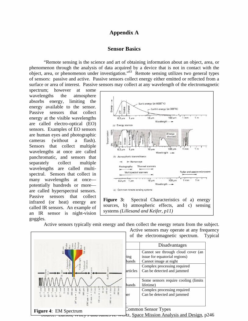
Figure 3: Spectral Characteristics of a) energy sources, b) atmospheric effects, and c) sensing systems (Lillesand and Keifer, p11)
Sensor Type Advantages Disadvantages Electro-Optical Typically best spatial resolution
What human eyes are used to seeing Can use multi- or hyper-spectral bands
Cannot see through cloud cover (an issue for equatorial regions) Cannot image at night
LIDAR Can image any time of day Can be tuned to image specific particles Capable of penetrating surfaces
Complex processing required Can be detected and jammed
IR Can image any time of day Can use multi- or hyper-spectral bands
Some sensors require cooling (limits lifetime)
SAR Can image any time of day Penetrates cloud cover and weather Capable of penetrating surfaces Can detect motion using Doppler
Complex processing required Can be detected and jammed
Table 5: Advantages vs Disadvantages of Common Sensor Types Source: Larson, Wiley J and James R. Wertz, Space Mission Analysis and Design, p246
Figure 4: EM Spectrum
Appendix A
Sensor Basics
“Remote sensing is the science and art of obtaining information about an object, area, or phenomenon through the analysis of data acquired by a device that is not in contact with the object, area, or phenomenon under investigation.”63 Remote sensing utilizes two general types of sensors: passive and active. Passive sensors collect energy either emitted or reflected from a surface or area of interest. Passive sensors may collect at any wavelength of the electromagnetic spectrum; however at some wavelengths the atmosphere absorbs energy, limiting the energy available to the sensor. Passive sensors that collect energy at the visible wavelengths are called electro-optical (EO) sensors. Examples of EO sensors are human eyes and photographic cameras (without a flash). Sensors that collect multiple wavelengths at once are called panchromatic, and sensors that separately collect multiple wavelengths are called multi-spectral. Sensors that collect in many wavelengths at once—potentially hundreds or more—are called hyperspectral sensors. Passive sensors that collect infrared (or heat) energy are called IR sensors. An example of an IR sensor is night-vision goggles. Active sensors typically emit energy and then collect the energy return from the subject.
Active sensors may operate at any frequency of the electromagnetic spectrum. Typical

21
active sensors are cameras with a flash, radio detection and ranging (radar), and light detection and ranging (LIDAR). Synthetic aperture radar (SAR) is a specific type of radar that takes advantage of the sensor’s movement to create a more detailed image. LIDAR emits light or lasers of specific wavelengths, and collects the returning energy. Processing of both SAR and LIDAR can be complex, but provides an inordinate amount of information about the subject matter. Two key measures of effectiveness for remotely sensed data are the spatial resolution and temporal resolution. Spatial “resolution is an indication of how well a sensor can record spatial detail”64. The greater the resolution, the more detailed the imagery will be in showing the subject matter. Resolution is a function of the sensor’s distance from the subject, the radius of the sensor detector or focal plane, the operating wavelength, and the sensor pointing angle.65 Temporal resolution, or timeliness, is a measure of how current the imagery is. For satellites, temporal resolution is a function of the orbit altitude, the number and spacing of satellite sensors, and the pointing capability of the satellite.

22
Appendix B
Impact of Policies on the Satellite Remote Sensing Industry
The U.S. commercial satellite remote sensing market changed in the 1990s as a result of new policies encouraging industry growth. In the early 1990s, very few commercial or civil satellite remote sensing satellites existed due to government restrictions on sales of imagery. The Land Remote Sensing Policy Act of 1992 changed the marketplace by removing unnecessary restrictions on imagery collection and streamlining the government licensing process run by the Department of Commerce, while also protecting national security interests.66 To further stimulate growth, the Clinton administration issued Presidential Decision Directive 23, U.S. Policy on Foreign Access to Remote Sensing Space Capabilities, in 1994 which expanded the capacity for industry to sell commercial imagery on the international market. This directive also created a policy of “shutter control”, where the U.S. Government could limit data collection and/or distribution of imagery as necessitated by national security.67 The collective impact of these two policies resulted in growth of the satellite remote sensing industry, the development of new technologies, and a capability to protect U.S. security interests when necessary. By 2000, U.S. companies developed the capability to collect satellite imagery with ground resolutions less than one meter.68
A recent policy decision by the Bush Administration in 2003 continues to impact the U.S. satellite commercial remote sensing industry. The 2003 U.S. Commercial Remote Sensing Policy’s goals are to maintain the nation’s leadership in remote sensing activities and protect U.S. national security interests.69 This new policy built upon previous policies, while also creating an environment for the U.S. Government to competitively outsource imagery needs to the commercial sector where feasible. The policy states:
A robust U.S. commercial remote sensing space industry can augment and potentially replace some United States Government capabilities and can contribute to U.S. military, intelligence, foreign policy, homeland security, and civil objectives, as well as U.S. economic competitiveness.70
This policy provides a relatively stable government “pull” for commercial imagery and supplements national intelligence collections systems which are continuously in high demand.
As the lead for acquiring and disseminating commercial satellite imagery, the National Geospatial Intelligence Agency (NGA) maintains a working relationship with U.S. remote sensing companies through government contracts. In the NextView contracts, NGA cost shares 50% of the research and development (up to a cap) for two remote sensing companies71. Once the satellites become operational, NGA can purchase all imagery over certain geographic areas, pay to change satellite tasking priorities, or pay to keep the imagery out of the public imagery archive72. This provides some level of security and effectively gives “checkbook control” of U.S. imaging satellites—but at a price. Additionally, restrictions are in place for the sale of high-resolution imagery to non-U.S. Government entities.
NOAA administers the licensing process for the Department of Commerce and imposes restrictions for the sale of commercial satellite imagery to non-U.S. Government agencies. Industry can only sell panchromatic imagery (multiple colors in one image) less than 0.5 meters and SAR imagery less then 3.0 meters to U.S. Government and associated agencies73.

23
Panchromatic imagery between 0.5 and 0.82 meters may be sold to non-U.S. Government customers after a 24 hour waiting period.74 Additionally, although never implemented, the U.S. Government can enact the “shutter control” policy to prevent imaging and imagery sales of sensitive areas. NOAA establishes strict term and conditions for the sale of imagery to non-US agencies that commercial companies must abide by or risk losing their license.75
The U.S. policies developed in the 1990s and further modified in 2003 fostered growth of the U.S. satellite remote sensing industry, while providing a level of protection for national security. However, these security measures are only effective for U.S. imaging satellites. What happens when the U.S. does not have a relationship with commercial remote sensing companies? As the next appendix will show, multiple foreign companies have plans to develop and launch remote sensing satellites in the near future with capabilities rivaling that of U.S. companies. The U.S. will need capabilities to prevent adversaries from obtaining intelligence information from foreign remote sensing systems. Both policy decisions and technical capabilities will be required to cope with a commercial remote sensing threat of the near future as well as 20 to 30 years in the future.

24
Country System Launch Date
Sensor Type
Best Resolution (by sensor type
in meters)
Canada RadarSat 2 2007 SAR 3/28/100 China/Brazil CBERS-2B 2007 EO/IR 20 / 1.64
France Helios 2A 2004 EO/IR 0.5 / ? France Pleiades-1 & 2 2008/2009 EO/IR 0.7 / 20 France ESSAIM 2004 ELINT N/A
Germany RapidEye 2007 EO/IR 6.5 / 4 Germany TerraSAR X/L 2007/2008 SAR 1.0 Germany SAR-Lupe 2006 SAR 0.5
India IRS Cartosat 2005 EO/IR 1.0 / 20 India RISAT 2007 SAR 10/50 Iran Unknown 2007? Unknown Unknown
Israel EROS C 2008 EO/IR 0.7 / 40 Italy COSMO-Skymed
1-4 2006-2008 SAR 1.0
Japan ALOS 2006 SAR 10/20/100 Korea KOMPSAT-2 2006 EO/IR 1.0 / 10 Korea Arirang-3A 2012 EO 0.7 Russia Resoure-DK-1 2006 EO/IR 1.0 / 2.8 U.S. GeoEye-1 2007 EO 0.4 U.S. WorldView 1
WorldView 2 2007 2008
EO/IR EO
0.5 / 32 0.5
Table 6: Summary of Near-Term Commercial Satellite Capabilities Sources: NOAA Licensing Spreadsheet and multiple websites (Appendix A provides a discussion of sensor types, advantages/disadvantages)
Appendix C
Where is the Commercial Satellite Remote Sensing Industry Going?
Foreign Satellite Remote Sensing Capabilities
Numerous countries plan to launch remote sensing satellites in the near future with capabilities approaching and even closing the gap with U.S. companies. According to one estimate, in the next decade over 100 remote sensing satellites may be launched by both private and government entities, with as many as eleven companies providing satellites with one-meter resolution.76 Table 6 shows a comparison of sensor types and predicted ground resolutions for the near future77. Countries that recently launched or with plans to launch one-meter or better optical sensors in the next several years include Israel, France, Russia, India, and South Korea.78 Several countries, such as Germany and a cooperative effort between China and Brazil are developing IR sensors with resolutions less than five meters.79 Russia’s Resource-DK-1, launched in 2006, already has a 2.8m IR resolution. Several foreign companies will differentiate themselves from
25
the traditionally U.S.-led EO market by operating radar satellites. Radar is capable of penetrating clouds as well as operating at night. Canada continues to operate one of the first commercial SAR satellites and plans to launch a follow-on capability in 2007 with up to a 3 meter resolution. Both Italy and Germany plan to launch SAR satellites in 2007 and 2008, with capabilities of 1 meter resolution. Germany’s SAR-Lupe satellite, launched in December 2006, may have a capability for up to half-meter imagery while in spot mode.80 A recent report indicated that Iran may soon launch a surveillance satellite on a converted ballistic missile system, according to the chairman of the Iranian National Security and Foreign Policy Commission.81 The foreign EO, IR, and SAR imagery capabilities of today and the near future provide valuable information for legitimate business purposes, but pose a potential national security threat if utilized to target U.S. interests. In the future, foreign companies may continually improve sensors or combine efforts to operate satellites with multiple intelligence collection capabilities.
Another potential trend for foreign commercial remote sensing is collaboration between multiple counties to share ground segments and data products. Today’s German SAR-Lupe and French Helios II systems are inter-connected, allowing both countries to task, operate, and use imagery products from both systems.82 This arrangement allows for synergy between organizations, where analysis of EO imagery leads to further collection via SAR sensors or vice versa. The intelligence collection capacity improves further if satellites such as France’s ESSAIM micro-satellite constellation, capable of collecting ELINT, become connected as part of a multiple source data and intelligence collection system83. Multi-source information from commercial satellites could be sold to U.S. adversaries, creating a serious security threat. This situation becomes more significant if the government owns and operates the remote sensing satellites with very little commercial industry involvement.
An important distinction exists between the U.S. satellite commercial imagery industry and that of other countries. In the U.S., commercial satellite companies operate entirely independent from the U.S. Government, except where the U.S. Government enters into contracts with industry to cost share R&D or to purchase imagery as a customer. France, Israel, Russia, India, and Canada provide satellites to private companies for commercial use while China, South Korea, Brazil governments own and operate the satellites exclusively.84 This difference in relationships between industry and the governments is significant when determining how to deal with satellite remote sensors as a potential threat. A protection or prevention strategy using diplomacy, military, or information instruments of national power must first address both the government’s and industry’s involvement in the collection, processing, and distribution of data products.
The last decade showed considerable growth in the number and type of U.S. and foreign commercial satellite remote sensing platforms. The U.S. commercial market focus has been the development of high-resolution EO sensors, and foreign industries developed both EO and SAR systems. What will the next two decades hold for the remote sensing market? The next section explores a recent commercial market forecast for the industry.
Commercial Market Forecast
Commercial satellite remote sensing is one segment of a much larger remote sensing industry that includes airborne sensors, satellite sensors, geographic information systems (GIS),

26
software applications, and a myriad of commercial firms, government agencies, not-for-profit organizations, and academic institutions that collect, process, and distribute remotely-sensed geospatial data and information.85 The global information industry drives this large and growing market. The American Society for Photogrammetry and Remote Sensing (ASPRS) recently completed a 10-year market forecast for the remote sensing industry, incorporating inputs from industry, government, and university data users and producers. Surprisingly, the group concluded “the introduction to the market of high-resolution imagery enhanced, rather than undercut the sales of data”, and both air-based as well as satellite-based imagery markets continue to grow and augment each other.86 The forecast predicted a combined industry growth of 9% to 14% per year through 2012, with increasing needs in national defense and global security, homeland security, environmental assessment, and infrastructure applications.87
Additionally, the forecast shows potential areas for improvement. “In particular, many data customers require levels of spatial data resolution, and geolocational and vertical accuracy of 0.5 to 3.0 feet, but do not use them because of barriers to cost or availability.”88 Not only is spatial resolution important to the surveyed users, the positional and altitude accuracies as well as imagery cost play in important role in the market. Another factor influencing the use of imagery data is timeliness. The forecast indicated that the U.S. Government has the largest interest in ‘real-time” imagery less than 24 hours old, and that nearly 60% of the commercial sector is interested in data between 1 to 3 days and 1 to 3 weeks old.89 The delivery of timely, accurate, and affordable products will be a common need for imagery users over the next decade.
The commercial satellite remote sensing industry must identify and mitigate risk to continue successful growth. A 2001 RAND Corporation report lists several key success factors and risks for the U.S. industry. For long-term success, companies “need a combination of reliable technologies, government policies that encourage U.S. industry competitiveness, a strong international presence, and sound business plans to ensure their competitiveness in both the domestic and international market places.”90 The report describes the largest risk as the ability of companies to transform themselves from imagery data providers to competitors in the information age.91 Other risks include developing, manufacturing, and launching sophisticated systems and “operating efficiently in a complex international business environment”.92 Purely collecting and disseminating imagery will not be enough to maintain a competitive edge in an information age. Creating an accessible and easy-to-use environment will be a key to building and maintaining paying customers.93 One company that continues to succeed in providing easily accessible data is Google Earth.
The Google Earth Phenomenon
The public’s awareness of commercial remote sensing imagery continues to increase due to companies like Google Earth that make imagery available to millions of Internet users. According to Mark Brender from GeoEye’s Marketing Communications and Government Affairs Office, Google Earth is a great source of advertising and provides a “sonic boom of awareness” for the industry.94 Google Earth is successful due the availability of GPS for image geolocation, advancement in remote sensing technology, favorable changes in Government policies, and the availability of imagery via the Internet.95 Competitors to Google Earth also increase public awareness. The Microsoft Corporation appears to have realized the potential for the remote sensing market, purchasing the Vexcel Corporation in May 2006 to take advantage of its experience in 2-D and 3-D imagery and remote sensing technologies.96 This acquisition

27
enables Microsoft to further develop its Virtual Earth software, touted as an “immersive online mapping and visualization experience”.97 Google’s widely-recognized and easily-accessible imagery and Microsoft’s innovative and dynamic tools should drive a public thirst for more imagery and global information systems in the future.
The commercial remote sensing industry established firm roots and looks to have a promising future. The recent ASPRS marketing forecast shows projected growth, with users wanting higher resolutions, better accuracy, and timely data. Commercial satellite imagery is one aspect of a much larger global information industry, which supplements and co-exists with aerial sources. Big name companies like Microsoft see the potential for the commercial remote sensing market. Industry risks exist, but are manageable with adequate planning and diversification within the information market.

28
Glossary
ACSC Air Command and Staff College APS Active Pixel Sensor CCD Coherent Change Detection CNA Computer Network Attack CONOPS Concept of Operations CMOS Complementary Metal-Oxide Semiconductor DCS Defensive Counterspace ELINT Electronics Intelligence EO Electro-Optical FAA Federal Aviation Administration FEL Free-Electron Laser GPS Global Position System IO Information Operations IR Infrared ISR Intelligence, Surveillance, and Reconnaissance LIDAR Light Detection and Ranging MTI Moving Target Indicator NASA National Aeronautics and Space Administration NGA National Geospatial Intelligence Agency NOAA National Oceanic and Atmospheric Administration OCS Offensive Counterspace OECD Organisation for Economic Cooperation and Development PDA Personal Data Assistant R&D Research and Development RF Radio Frequency

29
SAR Synthetic Aperture Radar WMD Weapons of Mass Destruction
30
Bibliography
Alcatel Alenia Space Press Release. “The First German SAR-Lupe Reconnaissance Satellite is Equipped with Alcatel Alenia Space’s SAR Sensor Electronics, 29 Dec 06. http://www.spaceRef.com/news/viewpr.html?pid=2155 (accessed 13 Feb 2007).
Beason, Doug. The E-Bomb, Cambridge, MA: DeCapo Press, 2005. Canadian Space Agency Website, “Resolution, Polarization, and Imaging”,
http://www.space.gc.ca/asc/eng/satellites/radarsat2/inf_data.asp?printer=1 (accessed 13 Feb 07).
Colleton, Nancy, “The Rest of the Story”, Imaging Notes, Fall 2006. Coyle, Philip E. “The Chinese Satellite Destruction: What’s Next?” National Security Space
Institute, Space News, 16 Feb 07. Hall, J Storrs. Nanofuture: What’s Next for Nanotechnology, Amherst, NY: Prometheus Books,
2005. Harris, Francis. “Bejing Secretly Fires Lasers to Disable Satellites”, Telegraph.co.uk. 27 Sep
06, http://www.telegraph.co.uk/news/main.jhtml?xml=/news/2006/09/26/wchina226.xml (accessed 8 Mar 2007).
Institute for the Future, “Infrastructure for the New Geography”, Technology Horizons Program, August 2004, http://www.iftf.org/docs/SR-869_Infra_New_Geog_Intro.pdf.
Kaspar, Beth M. Military Competitiveness in the Age of Transparency, Center for Strategy and Technology, Air War College, Aug 2001.
L-3 Communications Summary Annual Report, 2004, http://www.l-3com.com (accessed 12 Feb 07).
Larson, Wiley J. and James R. Wertz. Space Mission Analysis and Design, Torrance, CA: Microcosm and Kluwer Academic Publishers, 1992.
Latchford, Stephen. Strategies for Defeating Commercial Imagery Systems. Occasional Paper 39, Center for Strategy and Technology, Air War College, Dec 2005.
Lillesand Thomas M. and Ralph W. Kiefer, Remote Sensing and Image Interpretation. New York, NY: John Wiley and Sons, Inc, 1994.
Lombardo P., D. Pastina, F. Colone, et al. “A Study for Cosmo-Skymed SAR Multi-Beam of Second Generation”, http://earth.esa.int/cgi-bin/confpol.pl?abstract=156, (date unknown).
Mondello Charles, Dr. George F. Hepner, and Dr. Ray A. Williamson. The American Society for Photogrammetry and Remote Sensing (ASPRS) 10-Year Industry Forecast, Jan 2004, 11.
Microsoft Press Pass Website. “Microsoft Acquires Vexcel Corp, a Worldwide Leader in Imagery and Remote Sensing Technology, 4 May 2006, http://www.mircosoft.com/presspass/press/2006/may06/05-04VexcelPR.mspx (accessed 21 Feb 2007)
Microsoft Virtual Earth Homepage, http://www.microsoft.com/virtualearth/default.mspx (accessed 21 Feb 2007).
NASA CALIPSO Webpage, http://www-calipso.larc.nasa.gov/ (accessed 9 Mar 2007). Neowin.net, “Google, British Military Discuss Google Earth Use in Attacks”, 17 Jan
07http://www.neowin.net/index.php?act=view&id=37248 (accessed Feb 2007). NOAA Licensing Database, www.licensing.NOAA.gov (accessed Feb 2007).

31
O’Connell, Kevin M, John C. Baker, Beth E. Lachman, Steven Berner, David R. Frelinger, and Kim E. Gavin. U.S. Commercial Remote Sensing Satellite Industry: An Analysis of Risks, RAND, http://www.rand.org/pubs/monograph_reports/MR1469/, 2001.
Open Skies Treaty Factsheet, Bureau of Arms Control, U.S. Department of State, 4 June 2004, http://www.state.gov/t/ac/rls/fs/2004/33147.htm
Organisation for Economic Cooperation and Development. Space 2030: Exploring the Future of Space Applications, Paris, France: OECD Publishing, 2004.
Organisation for Economic Cooperation and Development. Space 2030: Tackling Society’s Challenges. Paris, France: OECD Publishing, 2005
Pocock, Chris. “Space Radar: Germany’s SAR-Lupe Constellation Puts Europe Ahead.” C4ISR Journal, 6 Nov 2006, http://www.c4isrjournal.com/story.php?F=2107972 (accessed 13 Feb 2007).
Prober, Raphael, "Shutter Control: Confronting Tomorrow's Technology with Yesterday's Regulations." Journal of Law and Politics. Vol. 19 (Spring 2003).
Scearce Diana, Katherine Fulton and the Global Business Network Community. Scenario Thinking in Practice. Available in Air Command and Staff College AY07 Leadership and the Staff Environment II LB Coursebook.
Sieff, Martin. “Iran May Launch Its Own Spy Satellite”, National Security Space Institute, Space News, 9 Feb 07.
Space Daily. “ESSAIM, Micro-satellites in Formation, 3 Jul 2005”, www.spacedaily.com/news/microsat-05h.html (accessed 14 Feb 2007).
Stillman, Dan, “Urgency of Drought Beginning to Sink In”, Imaging Notes, Fall 2006. U.S. Commercial Remote Sensing Policy Factsheet, Office of the Press Secretary, 13 May 2003. U.S. Senate. Worldwide Threat--Converging Dangers in a Post 9-11 World, Testimony of
Director if Central Intelligence George J. Tenent, Before the Senate Armed Services Committee, http://www.armed-services.senate.gov/statemnt/2002/march/tenent.pdf, 19 March 2002.
Wilson, Tom. Threats to United States Space Capabilities. Commission to Assess United States National Security Space Management and Organization, http://www.fas.org/spp/eprint/article05.html#9, Jan 2001.
32
Notes
1 Neowin.net, “Google, British Military Discuss Google Earth Use in Attacks”, http://www.neowin.net/index.php?act=view&id=37248, 17 Jan 07.
2 Worldwide Threat--Converging Dangers in a Post 9-11 World, Testimony of Director if Central Intelligence George J. Tenent, Before the Senate Armed Services Committee, http://www.armed-services.senate.gov/statemnt/2002/march/tenent.pdf, 19 March 2002 (Accessed on 25 Feb 07).
3 Organisation for Economic Cooperation and Development. Space 2030: Tackling Society’s Challenges. OECD Publishing, Paris, France, 2005, 86.
4 Dan Stillman, “Urgency of Drought Beginning to Sink In”, Imaging Notes, Fall 2006, 18. 5 Nancy Colleton, “The Rest of the Story”, Imaging Notes, Fall 2006, 37 6 Beth M. Kaspar, Military Competitiveness in the Age of Transparency (Center for Strategy
and Technology, Air War College, Aug 2001), 7. 7 Maj Jeff Reiman (Major, USAF Intelligence Officer), interview by the author, 25 Jan 07. 8 For a list of commercial remote sensing satellites, please refer to the NOAA Licensing
spreadsheet at Appendix C. 9 Organisation for Economic Cooperation and Development. Space 2030: Exploring the
Future of Space Applications (OECD Publishing, Paris, France 2004), 3, 6. 10 Ibid. 11 Ibid, 17. 12 Space 2030: Exploring the Future of Space Applications, 118. 13 Diana Scearce, Katherine Fulton and the Global Business Network Community. Scenario
Thinking in Practice. Available in Air Command and Staff College AY07 Leadership and the Staff Environment II LB Coursebook, 35. 14 Numerous uncertainties exist for the future of satellite commercial remote sensing. However, for the purpose of this research, only two were chosen to simply the discussion. Other uncertainties include: market needs and “pull”, development of sensor technology, U.S. and international policies and laws, and development of supporting technologies such as launch vehicle cost, manufacturing, graphical displays and computer processing. 15 J. Storrs Hall, Nanofuture: What’s Next for Nanotechnology, (Prometheus Books, Amherst, New York, 2005), 15 and Ed Walser (MITRE, Principle Information Engineer supporting NGA), interview by author on 15 Feb 07. (Personal opinion, not necessarily the views of MITRE or NGA).
16 Calculated for a diffraction limited resolution of 1 m and a satellite altitude of 35,887km. Calculation based on equation from Larson, Space Mission Analysis and Design, 252. hθr = 1.22 hλ/D, where hθr = ground resolution = 1.0m
h = sensor altitude = 35,887 km λ = the center wavelength = 0.675 μm D = the optical diameter Solved: D = 29.6m
17 Canadian Space Agency Website, “Resolution, Polarization, and Imaging”, http://www.space.gc.ca/asc/eng/satellites/radarsat2/inf_data.asp?printer=1 (accessed 13 Feb 07).

33
Notes
18 P. Lombardo, D. Pastina, F. Colone, et al. “A Study for Cosmo-Skymed SAR Multi-Beam of Second Generation”, paragraph 3.1.
19 Walser, 15 Feb 07 interview. 20 E-mail from Jim Torley (Remote Sensing Professor at Webster University and University
of Colorado at Colorado Springs), 6 Feb 07. 21 Ibid. 22 Walser, 15 Feb 07 interview. 23 Torley, 6 Feb 07 e-mail. 24 Ibid. 25 Walser, 15 Feb 07 interview. 26 Dr. Steve Stearns (Senior Scientist, ITT Corporation Space Systems), interview by the
author on 21 Feb 07. 27 L-3 Communications Summary Annual Report, 2004, http://www.l-3com.com (accessed
12 Feb 07). 28 Ibid. 29 Torley, 6 Feb 07 e-mail. 30 NASA CALIPSO Webpage, http://www-calipso.larc.nasa.gov/ (accessed on 9 Mar 07). 31 Stearns, 21 Feb 07 interview. 32 Ibid. 33 Ibid. 34 Ibid. 35 Today, the airborne remote sensing industry outpaces space-based industry 3 to 1, so this
scenario could be likely in 2030. Interview by author with Ed Walser, 15 Feb 07. (Personal opinion, not necessarily the views of MITRE or NGA).
36 Stearns, 21 Feb 07 interview. 37 Philip E Coyle, “The Chinese Satellite Destruction: What’s Next?” National Security
Space Institute, Space News, 16 Feb 07, 12. 38 Francis Harris, “Bejing Secretly Fires Lasers to Disable Satellites”, Telegraph.co.uk. 27
Sep 06, http://www.telegraph.co.uk/news/main.jhtml?xml=/news/2006/09/26/wchina226.xml. 39 Stearns, 21 Feb 07 interview. 40 Open Skies Treaty Factsheet, Bureau of Arms Control, U.S. Department of State, 4 June
2004, http://www.state.gov/t/ac/rls/fs/2004/33147.htm. 41 Torley, 6 Feb 07 e-mail. 42 See Appendix C for a discussion of foreign satellite capabilities. 43 Mark Brender (GeoEye Vice President of Communications and Marketing), interview by
author on 14 Feb 07. 44 Walser, 15 Feb 07 interview. 45 Brender, 14 Feb 07 interview. 46 Space 2030: Exploring the Future of Space Applications, 136, 137. 47 Walter Scott (Digital Globe Chief Technology Officer and Company Founder), interview
by author on 1 Feb 07. 48 Institute for the Future, “Infrastructure for the New Geography”, Technology Horizons
Program, August 2004, http://www.iftf.org/docs/SR-869_Infra_New_Geog_Intro.pdf. 49 Institute for the Future, 2.

34
Notes
50 Rahn Butler (Lt Col (s), USAF, AF Space Command A8XY), interview by author Jan 2007 and 4 Apr 2007, FY08 Counterspace Strategic Master Plan written in approximately Oct 2006.
51 Butler, Jan 2007 interview. 52 Torley, 6 Feb 07 e-mail. 53 Ibid. 54 Tom Wilson, Threats to United States Space Capabilities. Commission to Assess United
States National Security Space Management and Organization, http://www.fas.org/spp/eprint/article05.html#9, Jan 2001.
55 Ibid. 56 Ibid. 57 Ibid. 58 Doug Beason, The E-Bomb, (DeCapo Press, Cambridge, MA, 2005), 190. 59 Ibid, 188. 60 Ibid, 194. 61 Latchford, Stephen. Strategies for Defeating Commercial Imagery Systems, Occasional
Paper 39 (Center for Strategy and Technology, Air War College, Dec 2005), 8. 62 Ibid, 28. 63 Thomas M. Lillesand and Ralph W. Kiefer, Remote Sensing and Image Interpretation
(John Wiley and Sons, Inc, New York, 1994), 1. 64 Ibid, 33. 65 Wiley J. Larson and James R. Wertz, Space Mission Analysis and Design (Microcosm and
Kluwer Academic Publishers, 1992), 251 66 Raphael Prober, "Shutter Control: Confronting Tomorrow's Technology with Yesterday's
Regulations." Journal of Law and Politics. Vol. 19 (Spring 2003), 208. 67 Ibid, 207. 68 The IKONOS satellite was able to collect sub-one meter panchromatic imagery in 1999. 69 U.S. Commercial Remote Sensing Policy Factsheet, Office of the Press Secretary, 13 May
2003, 1. 70 U.S. Commercial Remote Sensing Policy Factsheet, 3. 71 Dennis Bretheuer (NGA/ASK), interview by the author on 7 Nov 06. 72 Bretheuer, 7 Nov 06 interview. Cost is $1.06/sq km standard tasking, 5X ($1.06/sq km)
for pre-emptive tasking, and 5X ($1.06/sq km) + ($4/sq km) to keep imagery out of archive. 73 Tahara Moreno (NOAA Senior Licensing Official), interview 5 Mar 07. 74 Moreno, 5 Mar 07 interview. The 24 hour delay policy is under review by DOC and
NOAA and may be removed in the near future. 75 Ibid. 76 Kaspar, Military Competitiveness in the Age of Transparency, 9. 77 Resolutions are only one aspect of many factors influencing the effectiveness of
commercial remote sensing. Other factors that impact the usefulness of commercial imagery include the sensor swath width, processing capabilities, number of satellites in orbit and revisit time, currency of the imagery, geolocation accuracy, and an accessible and searchable archive.
78 NOAA Licensing Database, www.licensing.NOAA.gov. 79 Ibid.

35
Notes
80 Chris Pocock, “Space Radar: Germany’s SAR-Lupe Constellation Puts Europe Ahead.” C4ISR Journal, 6 Nov 2006.
81 Martin Sieff, “Iran May Launch Its Own Spy Satellite”, National Security Space Institute, Space News, 9 Feb 07.
82 Alcatel Alenia Space Press Release. “The First German SAR-Lupe Reconnaissance Satellite is Equipped with Alcatel Alenia Space’s SAR Sensor Electronics, 29 Dec 06. SpaceRef.com.
83 Space Daily. “ESSAIM, Micro-satellites in Formation, 3 Jul 2005”, www.spacedaily.com.
84 Prober, "Shutter Control”, 210. 85 Charles Mondello, Dr. George F. Hepner, and Dr. Ray A. Williamson. The American
Society for Photogrammetry and Remote Sensing (ASPRS) 10-Year Industry Forecast, Jan 2004, 11.
86 Ibid, 12. 87 Ibid, 11, 44. 88 Ibid, 44. 89 Ibid, 42. 90 Kevin M. O’Connell, John C. Baker, Beth E. Lachman, Steven Berner, David R.
Frelinger, and Kim E. Gavin. U.S. Commercial Remote Sensing Satellite Industry: An Analysis of Risks, RAND, http://www.rand.org/pubs/monograph_reports/MR1469/, 2001.
91 Ibid. 92 Ibid. 93 Scott, 1 Feb 07 interview. 94 Brender, 14 Feb 07 interview. 95 Ibid. 96 Microsoft Press Pass Website. “Microsoft Acquires Vexcel Corp, a Worldwide Leader in
Imagery and Remote Sensing Technology, http://www.mircosoft.com/presspass/press/2006/may06/05-04VexcelPR.mspx, 4 May 2006.
97 Microsoft Virtual Earth Homepage, http://www.microsoft.com/virtualearth/default.mspx.