Combined Sewer Systems - Form 30, Part E · 2019-03-19 · FORM 30 - PART E 03/2019 cmc Form 30,...
2
FORM 30 - PART E 03/2019 cmc Form 30, Part E - Page 1 DNR Form 542-3220E IOWA DEPARTMENT OF NATURAL RESOURCES - NPDES PERMIT APPLICATION FORM 30, PART E - COMBINED SEWER SYSTEMS If the treatment works has a combined sewer system, complete Part E. Facility Name Permit Number 1. System Map - Provide a map indicating the following: (may be included with Part A, question 13) a. All Combined Sewer Overflow (CSO) discharge points. b. Sensitive use areas potentially affected by CSOs. c. Waters that support threatened or endangered species potentially affected by CSOs. 2. System Diagram - Provide a diagram of the combined sewer collection system that includes the following locations: major sewer trunk lines, both combined and separate sanitary; points where separate sanitary sewers feed into the combined sewer system; in-line and off-line storage structures; and flow-regulating devices and pump stations. Complete questions 3 through 6 once for each CSO discharge point. 3. Description of Outfall a. Outfall Number: b. Location City/Town State Zip County Section Township Range Latitude Degree Minute Second Longitude Degree Minute Second c. Distance from shore (if applicable) ft d. Depth below surface (if applicable) ft e. Which of the following were monitored during the last year for this CSO? Rainfall pollutant concentrations frequency flow volumes Receiving water quality f. How many storm events were monitored during the last year? 4. CSO Event a. Give the number of CSO events in the last year Events Actual Or Approximate b. Give the average duration per CSO event Hours Actual Or Approximate c. Give the average volume per CSO event Million Gallons Actual Or Approximate d. Give the minimum rainfall that caused a CSO event in the last year Inches of rainfall 5. Description of Receiving Waters a. Name of receiving waters: b. Name of watershed/river/stream system: c. Name of State Management/River Basin: 6. CSO Operations - Describe any known water quality impacts on the receiving water caused by this CSO (e.g., permanent or intermittent beach closings, permanent or intermittent shell fish bed closings, fish kills, other recreational loss, or violation of any applicable State water quality standard).
Transcript of Combined Sewer Systems - Form 30, Part E · 2019-03-19 · FORM 30 - PART E 03/2019 cmc Form 30,...

FORM 30 - PART E
03/2019 cmc Form 30, Part E - Page 1 DNR Form 542-3220E
IOWA DEPARTMENT OF NATURAL RESOURCES - NPDES PERMIT APPLICATION FORM 30, PART E - COMBINED SEWER SYSTEMS
If the treatment works has a combined sewer system, complete Part E.
Facility Name Permit Number
1. System Map - Provide a map indicating the following: (may be included with Part A, question 13) a. All Combined Sewer Overflow (CSO) discharge points. b. Sensitive use areas potentially affected by CSOs. c. Waters that support threatened or endangered species potentially affected by CSOs.
2. System Diagram - Provide a diagram of the combined sewer collection system that includes the following locations: major sewer trunk lines, both combined and separate sanitary; points where separate sanitary sewers feed into the combined sewer system; in-line and off-line storage structures; and flow-regulating devices and pump stations.
Complete questions 3 through 6 once for each CSO discharge point. 3. Description of Outfall
a. Outfall Number:
b. Location
City/Town State Zip
County Section Township Range
Latitude Degree Minute Second
Longitude Degree Minute Second
c. Distance from shore (if applicable) ft
d. Depth below surface (if applicable) ft
e. Which of the following were monitored during the last year for this CSO?
Rainfall pollutant concentrations frequency flow volumes Receiving water quality
f. How many storm events were monitored during the last year?
4. CSO Event
a. Give the number of CSO events in the last year Events Actual Or Approximate
b. Give the average duration per CSO event Hours Actual Or Approximate
c. Give the average volume per CSO event Million Gallons Actual Or Approximate
d. Give the minimum rainfall that caused a CSO event in the last year Inches of rainfall
5. Description of Receiving Waters
a. Name of receiving waters:
b. Name of watershed/river/stream system:
c. Name of State Management/River Basin:
6. CSO Operations - Describe any known water quality impacts on the receiving water caused by this CSO (e.g., permanent or intermittent beach closings, permanent or intermittent shell fish bed closings, fish kills, other recreational loss, or violation of any applicable State water quality standard).
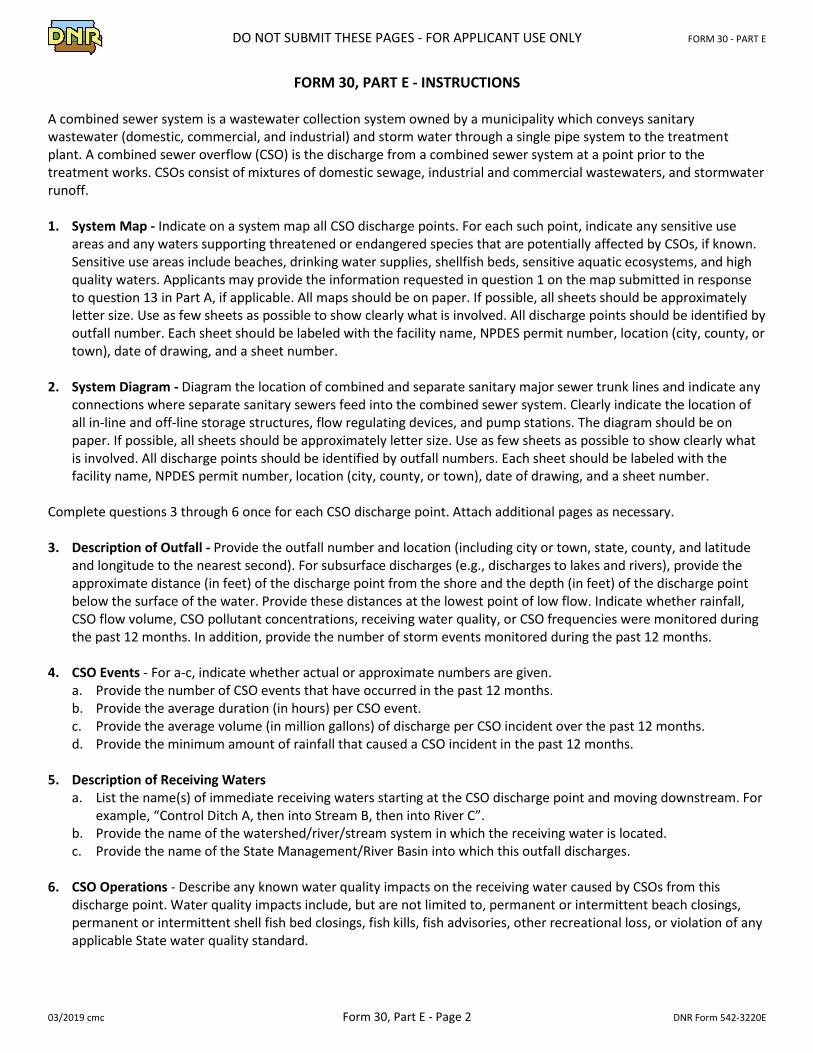
DO NOT SUBMIT THESE PAGES - FOR APPLICANT USE ONLY FORM 30 - PART E
03/2019 cmc Form 30, Part E - Page 2 DNR Form 542-3220E
FORM 30, PART E - INSTRUCTIONS
A combined sewer system is a wastewater collection system owned by a municipality which conveys sanitary wastewater (domestic, commercial, and industrial) and storm water through a single pipe system to the treatment plant. A combined sewer overflow (CSO) is the discharge from a combined sewer system at a point prior to the treatment works. CSOs consist of mixtures of domestic sewage, industrial and commercial wastewaters, and stormwater runoff. 1. System Map - Indicate on a system map all CSO discharge points. For each such point, indicate any sensitive use
areas and any waters supporting threatened or endangered species that are potentially affected by CSOs, if known. Sensitive use areas include beaches, drinking water supplies, shellfish beds, sensitive aquatic ecosystems, and high quality waters. Applicants may provide the information requested in question 1 on the map submitted in response to question 13 in Part A, if applicable. All maps should be on paper. If possible, all sheets should be approximately letter size. Use as few sheets as possible to show clearly what is involved. All discharge points should be identified by outfall number. Each sheet should be labeled with the facility name, NPDES permit number, location (city, county, or town), date of drawing, and a sheet number.
2. System Diagram - Diagram the location of combined and separate sanitary major sewer trunk lines and indicate any
connections where separate sanitary sewers feed into the combined sewer system. Clearly indicate the location of all in-line and off-line storage structures, flow regulating devices, and pump stations. The diagram should be on paper. If possible, all sheets should be approximately letter size. Use as few sheets as possible to show clearly what is involved. All discharge points should be identified by outfall numbers. Each sheet should be labeled with the facility name, NPDES permit number, location (city, county, or town), date of drawing, and a sheet number.
Complete questions 3 through 6 once for each CSO discharge point. Attach additional pages as necessary. 3. Description of Outfall - Provide the outfall number and location (including city or town, state, county, and latitude
and longitude to the nearest second). For subsurface discharges (e.g., discharges to lakes and rivers), provide the approximate distance (in feet) of the discharge point from the shore and the depth (in feet) of the discharge point below the surface of the water. Provide these distances at the lowest point of low flow. Indicate whether rainfall, CSO flow volume, CSO pollutant concentrations, receiving water quality, or CSO frequencies were monitored during the past 12 months. In addition, provide the number of storm events monitored during the past 12 months.
4. CSO Events - For a-c, indicate whether actual or approximate numbers are given.
a. Provide the number of CSO events that have occurred in the past 12 months. b. Provide the average duration (in hours) per CSO event. c. Provide the average volume (in million gallons) of discharge per CSO incident over the past 12 months. d. Provide the minimum amount of rainfall that caused a CSO incident in the past 12 months.
5. Description of Receiving Waters
a. List the name(s) of immediate receiving waters starting at the CSO discharge point and moving downstream. For example, “Control Ditch A, then into Stream B, then into River C”.
b. Provide the name of the watershed/river/stream system in which the receiving water is located. c. Provide the name of the State Management/River Basin into which this outfall discharges.
6. CSO Operations - Describe any known water quality impacts on the receiving water caused by CSOs from this
discharge point. Water quality impacts include, but are not limited to, permanent or intermittent beach closings, permanent or intermittent shell fish bed closings, fish kills, fish advisories, other recreational loss, or violation of any applicable State water quality standard.