Combined Coastal Management Program and Final ... · Combined Coastal Management Program and Final...
467
United States Department of Commerce Combined Coastal Management Program and Final Environmental Impact Statement for the State of Minnesota May 1999 Prepared by: Office of Ocean and Coastal Resource Management National Ocean Service National Oceanic and Atmospheric Administration U.S. Department of Commerce 1305 East-West Highway, N/ORM3 Silver Spring, Maryland 20910 and Minnesota Department of Natural Resources - Waters Minnesota’s Lake Superior Coastal Program 1568 Highway 2 Two Harbors, MN 55616 The preparation of this publication was financed by the Office of Ocean and Coastal Resource Management, National Oceanic and Atmospheric Administration through award #NA77OZ0407 under the Coastal Zone Management Act of 1972, as amended.
Transcript of Combined Coastal Management Program and Final ... · Combined Coastal Management Program and Final...

United States Department of Commerce
Combined Coastal Management Program and Final Environmental Impact Statement for
the State of Minnesota
May 1999
Prepared by:
Office of Ocean and Coastal Resource ManagementNational Ocean Service
National Oceanic and Atmospheric AdministrationU.S. Department of Commerce
1305 East-West Highway, N/ORM3Silver Spring, Maryland 20910
and
Minnesota Department of Natural Resources - WatersMinnesota’s Lake Superior Coastal Program
1568 Highway 2Two Harbors, MN 55616
The preparation of this publication was financed by the Office of Ocean and Coastal Resource Management, National Oceanic and Atmospheric Administrationthrough award #NA77OZ0407 under the Coastal Zone Management Act of 1972, as amended.

ABSTRACT
DESIGNATION: Final Environmental Impact Statement
TITLE: Proposed Federal Approval of the Minnesota Coastal Management Program
ABSTRACT: The State of Minnesota has submitted its Coastal Management Program asMinnesota’s Lake Superior Coastal Program (MLSCP) to the Office of Oceanand Coastal Resource Management for approval pursuant to Section 306 ofthe Federal Coastal Zone Management Act of 1972 as amended (CZMA), 16U.S.C. 1451 et seq. Approval would allow program administrative grants tobe awarded to the state and would require that federal actions be consistentwith the program. This document includes a copy of the program, which isa comprehensive management program for coastal land and water useactivities. It consists of numerous policies on diverse management issueswhich are administered under Minnesota laws and is the culmination of severalyears of program development. Minnesota’s Lake Superior Coastal Programpromotes the beneficial use of coastal resources, prevents their impairment,and manages major activities that substantially affect numerous resources.The program will enhance decision-making processes used for determining theappropriateness of actions in the coastal area.
Approval and implementation of the program will enhance governance ofMinnesota's coastal land and water uses according to the coastal policies andstandards contained in Minnesota’s statutes, authorities and rules. Federalalternatives to program approval include delaying or denying approval, ifcertain requirements of the Coastal Zone Management Act have not been met.The state could modify parts of the program or withdraw its application forfederal approval if either of the above federal alternatives results fromcirculation of this document. This document includes responses to commentsreceived on the Draft Environmental Impact Statement (DEIS) published inJune 1998.
APPLICANT: State of Minnesota, Department of Natural Resources
LEAD AGENCY: U.S. DEPARTMENT OF COMMERCENational Oceanic and Atmospheric AdministrationNational Ocean ServiceOffice of Ocean and Coastal Resource Management
FEDERAL CONTACT: Neil K. Christerson
Office of Ocean and Coastal Resource ManagementNOAA - U.S. Department of Commerce1305 East-West Highway, N/ORM3Silver Spring, Maryland 20910(301) 713-3113, ext. 167E-mail: [email protected]

STATECONTACT: Tricia Ryan
Minnesota Department of Natural Resources1568 Highway 2Two Harbors, MN 55616(218) 834-6625E-mail: [email protected]

NOTE TO READERS
The National Environmental Policy Act (NEPA) of 1969 requires that an environmental impactstatement be prepared as part of the review and approval process by federal government agencies ofmajor actions which significantly affect the quality of the human environment. The federal actioncontemplated is approval of Minnesota’s Lake Superior Coastal Program (MLSCP) under Section306 of the Federal Coastal Zone Management Act of 1972, as amended (CZMA). It is the generalpolicy of the Federal Office of Ocean and Coastal Resource Management (OCRM) to issue combinedenvironmental impact statements and program documents.
Part I and Part II of this Final Environmental Impact Statement (FEIS) were prepared jointly by theState of Minnesota and the Office of Ocean and Coastal Resource Management, and providesummary information concerning Minnesota’s Lake Superior Coastal Program, including how thestate has addressed the requirements of the CZMA. Part V and Part VI of this FEIS are a descriptionof Minnesota’s Lake Superior Coastal Program that were prepared by the state. It has been reviewedby the OCRM and is relied upon as a description of the proposed action for purposes of NEPA. PartIII and Part IV fulfill the remaining NEPA requirements for a FEIS and were prepared by the Officeof Ocean and Coastal Resource Management with assistance from the State of Minnesota. Part VIIcontains public comments on the DEIS and NOAA’s response to those comments.
An immediate effect of federal approval of the Minnesota program is the qualification of the state forfederal matching of funds for use in administering the program. In addition, the CZMA provides aprocedure for the state to review federal actions for consistency with its approved coastalmanagement program.
For purposes of reviewing this proposed action, the key questions are:
-- whether the Minnesota program is consistent with the objectives and policies of thenational legislation;
-- whether the award of federal funds under Section 306 of the federal act will helpMinnesota to meet those objectives;
-- whether Minnesota management policies and authorities are adequate to implementthe program;
-- whether there will be a net environmental gain as a result of program approval andimplementation.
OCRM has made a preliminary determination that the answers to these questions are affirmative.

MINNESOTA’SLAKE SUPERIOR COASTAL PROGRAM
Table of Contents - May 1999
Part I. Program OverviewA. Overview . . . . . . . . . . . . . . . . . . . . . . . . . . . . . . . . . . . . . . . . . . . . . . . . . . . . . . . . . . . . . I-1
1. Benefits of a Federally Approved Coastal Management Program . . . . . . . . . . . . . . . . I-22. Minnesota’s Lake Superior Coastal Program . . . . . . . . . . . . . . . . . . . . . . . . . . . . . . . I-2
B. Major Components of Minnesota’s Lake Superior Coastal Program . . . . . . . . . . . . . . . . . I-31. Public Participation . . . . . . . . . . . . . . . . . . . . . . . . . . . . . . . . . . . . . . . . . . . . . . . . . . I-32. The State’s Lead Agency. . . . . . . . . . . . . . . . . . . . . . . . . . . . . . . . . . . . . . . . . . . . . . . . I-33. A Coastal Council Will be Established . . . . . . . . . . . . . . . . . . . . . . . . . . . . . . . . . . . . I-34. Coastal Boundary . . . . . . . . . . . . . . . . . . . . . . . . . . . . . . . . . . . . . . . . . . . . . . . . . . . . I-45. Networked Program . . . . . . . . . . . . . . . . . . . . . . . . . . . . . . . . . . . . . . . . . . . . . . . . . . I-46. Based on Existing Policies and Authorities . . . . . . . . . . . . . . . . . . . . . . . . . . . . . . . . . I-57. State Agencies Must be Consistent With the Coastal Program . . . . . . . . . . . . . . . . . . I-58. Actions of Federal Agencies Must be Consistent With the Coastal Program . . . . . . . . I-5
C. Summary. . . . . . . . . . . . . . . . . . . . . . . . . . . . . . . . . . . . . . . . . . . . . . . . . . . . . . . . . . . . . . I-6
Part II. Coastal Zone Management Act . . . . . . . . . . . . . . . . . . . . . . . . . . . . . . . . . . . . . II-1A. The Coastal Zone Management Act . . . . . . . . . . . . . . . . . . . . . . . . . . . . . . . . . . . . . . . . . II-1B. Cross Reference to Program Requirements . . . . . . . . . . . . . . . . . . . . . . . . . . . . . . . . . . . II-4
Part III. Minnesota’s Lake Superior CoastGubernatorial LetterA. Setting . . . . . . . . . . . . . . . . . . . . . . . . . . . . . . . . . . . . . . . . . . . . . . . . . . . . . . . . . . . . . . III-1
1. Physical Environment . . . . . . . . . . . . . . . . . . . . . . . . . . . . . . . . . . . . . . . . . . . . . . . . III-1a. Area Geography . . . . . . . . . . . . . . . . . . . . . . . . . . . . . . . . . . . . . . . . . . . . . . . . III-1b. Climate . . . . . . . . . . . . . . . . . . . . . . . . . . . . . . . . . . . . . . . . . . . . . . . . . . . . . . . III-4c. Geology . . . . . . . . . . . . . . . . . . . . . . . . . . . . . . . . . . . . . . . . . . . . . . . . . . . . . . . III-4d. Soils . . . . . . . . . . . . . . . . . . . . . . . . . . . . . . . . . . . . . . . . . . . . . . . . . . . . . . . . . . III-5e. Physical Shoreline . . . . . . . . . . . . . . . . . . . . . . . . . . . . . . . . . . . . . . . . . . . . . . . III-6f. Forestry . . . . . . . . . . . . . . . . . . . . . . . . . . . . . . . . . . . . . . . . . . . . . . . . . . . . . . . III-8g. Wetlands . . . . . . . . . . . . . . . . . . . . . . . . . . . . . . . . . . . . . . . . . . . . . . . . . . . . . . III-9h. Water Quality . . . . . . . . . . . . . . . . . . . . . . . . . . . . . . . . . . . . . . . . . . . . . . . . . . III-10i. Fish and Wildlife Habitat . . . . . . . . . . . . . . . . . . . . . . . . . . . . . . . . . . . . . . . . . III-12j. Aquatic Nuisance Species . . . . . . . . . . . . . . . . . . . . . . . . . . . . . . . . . . . . . . . . . III-13k. Land Use . . . . . . . . . . . . . . . . . . . . . . . . . . . . . . . . . . . . . . . . . . . . . . . . . . . . . III-13l. Minerals . . . . . . . . . . . . . . . . . . . . . . . . . . . . . . . . . . . . . . . . . . . . . . . . . . . . . . III-14m. Submerged Lands . . . . . . . . . . . . . . . . . . . . . . . . . . . . . . . . . . . . . . . . . . . . . . . III-14
2. Socioeconomic Characteristics . . . . . . . . . . . . . . . . . . . . . . . . . . . . . . . . . . . . . . . . III-15a. Demographics . . . . . . . . . . . . . . . . . . . . . . . . . . . . . . . . . . . . . . . . . . . . . . . . . III-15b. Population . . . . . . . . . . . . . . . . . . . . . . . . . . . . . . . . . . . . . . . . . . . . . . . . . . . . III-15c. Commerce and Industry . . . . . . . . . . . . . . . . . . . . . . . . . . . . . . . . . . . . . . . . . . III-16d. Recreation and Tourism . . . . . . . . . . . . . . . . . . . . . . . . . . . . . . . . . . . . . . . . . . III-18
B. Coastal Resource and Development Issues . . . . . . . . . . . . . . . . . . . . . . . . . . . . . . . . . . III-24

Part IV. Requirements of the National Environmental Policy Act (NEPA) . . . . . . . . . IV-1A. NEPA Requirements . . . . . . . . . . . . . . . . . . . . . . . . . . . . . . . . . . . . . . . . . . . . . . . . . . . IV-1B. Purpose and Need for Action . . . . . . . . . . . . . . . . . . . . . . . . . . . . . . . . . . . . . . . . . . . . . IV-2C. Alternatives Including the Proposed Action . . . . . . . . . . . . . . . . . . . . . . . . . . . . . . . . . . IV-4
1. Introduction . . . . . . . . . . . . . . . . . . . . . . . . . . . . . . . . . . . . . . . . . . . . . . . . . . . . . . . IV-42. Federal Alternatives . . . . . . . . . . . . . . . . . . . . . . . . . . . . . . . . . . . . . . . . . . . . . . . . . IV-4
a. Alternative 1 . . . . . . . . . . . . . . . . . . . . . . . . . . . . . . . . . . . . . . . . . . . . . . . . . . . IV-4b. Alternative 2 . . . . . . . . . . . . . . . . . . . . . . . . . . . . . . . . . . . . . . . . . . . . . . . . . . . IV-4c. Alternative 3 . . . . . . . . . . . . . . . . . . . . . . . . . . . . . . . . . . . . . . . . . . . . . . . . . . . IV-5
3. State Alternatives Considered During Program Development . . . . . . . . . . . . . . . . . . IV-54. Consultation and Coordination . . . . . . . . . . . . . . . . . . . . . . . . . . . . . . . . . . . . . . . . . IV-6
D. Environmental and Socio-Economic Consequences . . . . . . . . . . . . . . . . . . . . . . . . . . . . IV-71. Positive Impacts Directly Resulting From Federal Approval . . . . . . . . . . . . . . . . . . . IV-72. Impacts (of Approval) Attributable to Minnesota’s Lake Superior Coastal Program . IV-93. Impacts Resulting From Denying Federal Approval . . . . . . . . . . . . . . . . . . . . . . . . IV-114. Impacts Resulting From Delaying Federal Approval . . . . . . . . . . . . . . . . . . . . . . . . IV-11
E. Unavoidable Adverse Environmental Effects . . . . . . . . . . . . . . . . . . . . . . . . . . . . . . . . IV-12F. Relationship Between Short-Term Uses of the Environment and the Maintenance and
Enhancement of Long-Term Productivity . . . . . . . . . . . . . . . . . . . . . . . . . . . . . . . . . . . IV-13G. Irreversible and Irretrievable Commitment of Resources . . . . . . . . . . . . . . . . . . . . . . . . IV-14
Part V. Minnesota’s Lake Superior Coastal ProgramChapter 1. Program Boundary . . . . . . . . . . . . . . . . . . . . . . . . . . . . . . . . . . . . . . . . . . V, 1-1A. Introduction . . . . . . . . . . . . . . . . . . . . . . . . . . . . . . . . . . . . . . . . . . . . . . . . . . . . . . . . . V, 1-1B. Boundary Establishment . . . . . . . . . . . . . . . . . . . . . . . . . . . . . . . . . . . . . . . . . . . . . . . . V, 1-2
1. Seaward Boundary and Interstate Boundary . . . . . . . . . . . . . . . . . . . . . . . . . . . . . . V, 1-22. Excluded Lands . . . . . . . . . . . . . . . . . . . . . . . . . . . . . . . . . . . . . . . . . . . . . . . . . . . V, 1-23. Nonpoint Source Pollution Control Program Boundary . . . . . . . . . . . . . . . . . . . . . V, 1-34. Inland Boundary . . . . . . . . . . . . . . . . . . . . . . . . . . . . . . . . . . . . . . . . . . . . . . . . . . V, 1-3
a. St. Louis River Watershed . . . . . . . . . . . . . . . . . . . . . . . . . . . . . . . . . . . . . . . . V, 1-5b. Duluth and Surrounding Urban Areas . . . . . . . . . . . . . . . . . . . . . . . . . . . . . . . . V, 1-5c. St. Louis County - North Shore . . . . . . . . . . . . . . . . . . . . . . . . . . . . . . . . . . . . V, 1-6d. Lake County - North Shore . . . . . . . . . . . . . . . . . . . . . . . . . . . . . . . . . . . . . . . V, 1-6g. Cook County - North Shore . . . . . . . . . . . . . . . . . . . . . . . . . . . . . . . . . . . . . . . V, 1-6
Chapter 2. Program Implementation . . . . . . . . . . . . . . . . . . . . . . . . . . . . . . . . . . . . . V, 2-1A. Organizational Structure . . . . . . . . . . . . . . . . . . . . . . . . . . . . . . . . . . . . . . . . . . . . . . . V, 2-1
1. Role of the Lead State Agency . . . . . . . . . . . . . . . . . . . . . . . . . . . . . . . . . . . . . . . . V, 2-12. Role and Responsibilities of the Coastal Council . . . . . . . . . . . . . . . . . . . . . . . . . . . V, 2-3
a. Relationship Between the Coastal Council and Coastal Program Staff . . . . . . . V, 2-5b. Relationship Between the Coastal Council and the Technical Advisors . . . . . . . V, 2-5
3. Local Units of Government . . . . . . . . . . . . . . . . . . . . . . . . . . . . . . . . . . . . . . . . . . V, 2-74. Roles of State Agencies . . . . . . . . . . . . . . . . . . . . . . . . . . . . . . . . . . . . . . . . . . . . . V, 2-85. Cooperation with Other Programs . . . . . . . . . . . . . . . . . . . . . . . . . . . . . . . . . . . . V, 2-12
B. Program Implementation . . . . . . . . . . . . . . . . . . . . . . . . . . . . . . . . . . . . . . . . . . . . . . V, 2-141. Implementation of Policies and Authorities From Networked Program . . . . . . . . . V, 2-14
a. Implementation Mechanisms . . . . . . . . . . . . . . . . . . . . . . . . . . . . . . . . . . . . . . V, 2-14b. Monitoring and Enforcement Mechanisms . . . . . . . . . . . . . . . . . . . . . . . . . . . V, 2-14
2. Consistency . . . . . . . . . . . . . . . . . . . . . . . . . . . . . . . . . . . . . . . . . . . . . . . . . . . . . V, 2-14

a State Consistency . . . . . . . . . . . . . . . . . . . . . . . . . . . . . . . . . . . . . . . . . . . . . . V, 2-14b. Mechanisms to Ensure State Consistency . . . . . . . . . . . . . . . . . . . . . . . . . . . . V, 2-15c. Federal Consistency . . . . . . . . . . . . . . . . . . . . . . . . . . . . . . . . . . . . . . . . . . . . V, 2-16
3. Implementation of Grant Program . . . . . . . . . . . . . . . . . . . . . . . . . . . . . . . . . . . . V, 2-16C. Review and Evaluation of Program . . . . . . . . . . . . . . . . . . . . . . . . . . . . . . . . . . . . . . V, 2-17
1. Program Priorities . . . . . . . . . . . . . . . . . . . . . . . . . . . . . . . . . . . . . . . . . . . . . . . . V, 2-172. Review of Performance . . . . . . . . . . . . . . . . . . . . . . . . . . . . . . . . . . . . . . . . . . . . V, 2-17
D. Termination Recommendation Process . . . . . . . . . . . . . . . . . . . . . . . . . . . . . . . . . . . . V, 2-18
Chapter 3. Management Policies and Authorities . . . . . . . . . . . . . . . . . . . . . . . . . . . V, 3-1A. Coastal Land Management . . . . . . . . . . . . . . . . . . . . . . . . . . . . . . . . . . . . . . . . . . . . . . V, 3-3
1. Shoreland Development . . . . . . . . . . . . . . . . . . . . . . . . . . . . . . . . . . . . . . . . . . . . . V, 3-4a. Shoreland Management Act . . . . . . . . . . . . . . . . . . . . . . . . . . . . . . . . . . . . . . . V, 3-4b. North Shore Management Plan (NSMP) . . . . . . . . . . . . . . . . . . . . . . . . . . . . . . V, 3-9
2. Floodplain Management . . . . . . . . . . . . . . . . . . . . . . . . . . . . . . . . . . . . . . . . . . . . V, 3-173. Coastal Shoreline Erosion . . . . . . . . . . . . . . . . . . . . . . . . . . . . . . . . . . . . . . . . . . V, 3-204. County, Municipal and Township Planning and Development . . . . . . . . . . . . . . . . V, 3-23
B. Coastal Water Management Standards . . . . . . . . . . . . . . . . . . . . . . . . . . . . . . . . . . . . V, 3-291. Protected Waters Program . . . . . . . . . . . . . . . . . . . . . . . . . . . . . . . . . . . . . . . . . . V, 3-31
a. Work in the Bed Permits . . . . . . . . . . . . . . . . . . . . . . . . . . . . . . . . . . . . . . . . V, 3-32b. Water Appropriation Permits . . . . . . . . . . . . . . . . . . . . . . . . . . . . . . . . . . . . . V, 3-36c. Dam Safety . . . . . . . . . . . . . . . . . . . . . . . . . . . . . . . . . . . . . . . . . . . . . . . . . . V, 3-38
2. Wetlands Programs . . . . . . . . . . . . . . . . . . . . . . . . . . . . . . . . . . . . . . . . . . . . . . . V, 3-40C. Air and Water Quality . . . . . . . . . . . . . . . . . . . . . . . . . . . . . . . . . . . . . . . . . . . . . . . . V, 3-56
1. Air Quality . . . . . . . . . . . . . . . . . . . . . . . . . . . . . . . . . . . . . . . . . . . . . . . . . . . . . V, 3-562. Water Quality . . . . . . . . . . . . . . . . . . . . . . . . . . . . . . . . . . . . . . . . . . . . . . . . . . . V, 3-613. Ground Water Protection . . . . . . . . . . . . . . . . . . . . . . . . . . . . . . . . . . . . . . . . . . . V, 3-664. Water Supply . . . . . . . . . . . . . . . . . . . . . . . . . . . . . . . . . . . . . . . . . . . . . . . . . . . . V, 3-695. Waste Management . . . . . . . . . . . . . . . . . . . . . . . . . . . . . . . . . . . . . . . . . . . . . . . V, 3-71
a. Solid Waste . . . . . . . . . . . . . . . . . . . . . . . . . . . . . . . . . . . . . . . . . . . . . . . . . . V, 3-71b. Hazardous Waste Management . . . . . . . . . . . . . . . . . . . . . . . . . . . . . . . . . . . V, 3-71c. Industrial Waste . . . . . . . . . . . . . . . . . . . . . . . . . . . . . . . . . . . . . . . . . . . . . . . V, 3-72
D. Fish and Wildlife Management . . . . . . . . . . . . . . . . . . . . . . . . . . . . . . . . . . . . . . . . . . V, 3-88E. Forest Management . . . . . . . . . . . . . . . . . . . . . . . . . . . . . . . . . . . . . . . . . . . . . . . . . . V, 3-97F. Mineral Resources . . . . . . . . . . . . . . . . . . . . . . . . . . . . . . . . . . . . . . . . . . . . . . . . . . V, 3-110G. Energy . . . . . . . . . . . . . . . . . . . . . . . . . . . . . . . . . . . . . . . . . . . . . . . . . . . . . . . . . . . V, 3-115
1. Energy Facility Siting . . . . . . . . . . . . . . . . . . . . . . . . . . . . . . . . . . . . . . . . . . . . . V, 3-115a. Minnesota Power Plant Siting Act . . . . . . . . . . . . . . . . . . . . . . . . . . . . . . . . V, 3-115b. Pipelines . . . . . . . . . . . . . . . . . . . . . . . . . . . . . . . . . . . . . . . . . . . . . . . . . . . . V, 3-116
2. Utility Crossings of Public Lands and Waters . . . . . . . . . . . . . . . . . . . . . . . . . . . V, 3-118H. Environmental Review . . . . . . . . . . . . . . . . . . . . . . . . . . . . . . . . . . . . . . . . . . . . . . . V, 3-121
1. Minnesota Environmental Rights Act . . . . . . . . . . . . . . . . . . . . . . . . . . . . . . . . . V, 3-1212. Minnesota Environmental Policy Act . . . . . . . . . . . . . . . . . . . . . . . . . . . . . . . . . V, 3-1223. Environmental Review Program . . . . . . . . . . . . . . . . . . . . . . . . . . . . . . . . . . . . . V, 3-123
Chapter 4. Special Programs and Management Areas . . . . . . . . . . . . . . . . . . . . . . . . V, 4-1A. Development/Economic Revitalization Plans . . . . . . . . . . . . . . . . . . . . . . . . . . . . . . . . V, 4-3
1. Highway Transportation . . . . . . . . . . . . . . . . . . . . . . . . . . . . . . . . . . . . . . . . . . . . . V, 4-3a. The North Shore Corridor Management Plan . . . . . . . . . . . . . . . . . . . . . . . . . . V, 4-4

b. MN DOT Rest Area Program . . . . . . . . . . . . . . . . . . . . . . . . . . . . . . . . . . . . . . V, 4-4 2. Port Development Plans . . . . . . . . . . . . . . . . . . . . . . . . . . . . . . . . . . . . . . . . . . . . . V, 4-6 3. The Duluth Downtown Waterfront Plan . . . . . . . . . . . . . . . . . . . . . . . . . . . . . . . . V, 4-10 4. Endion Waterfront Plan and Development Strategy . . . . . . . . . . . . . . . . . . . . . . . V, 4-10 5. The West Duluth Plan . . . . . . . . . . . . . . . . . . . . . . . . . . . . . . . . . . . . . . . . . . . . . V, 4-10 6. Two Harbors Waterfront Development Plan, 1991 . . . . . . . . . . . . . . . . . . . . . . . . V, 4-11 7. Grand Marais Comprehensive Plan . . . . . . . . . . . . . . . . . . . . . . . . . . . . . . . . . . . . V, 4-11
B. Natural Resource Protection and Management . . . . . . . . . . . . . . . . . . . . . . . . . . . . . . V, 4-12 1. Scientific and Natural Area Programs . . . . . . . . . . . . . . . . . . . . . . . . . . . . . . . . . . V, 4-12 2. State Wildife Management Areas. . . . . . . . . . . . . . . . . . . . . . . . . . . . . . . . . . . . . . . . . . . . . V, 4-13 3. Sensitivity of Coastal Environments and Wildlife to Spilled Oil, Lake Superior,
Volume 1 . . . . . . . . . . . . . . . . . . . . . . . . . . . . . . . . . . . . . . . . . . . . . . . . . . . . . . . V, 4-14 4. Important Habitat Data in the Minnesota Portion of the Lake Superior, 1995 . . . . V, 4-14 5. County Biological Survey . . . . . . . . . . . . . . . . . . . . . . . . . . . . . . . . . . . . . . . . . . . V, 4-15 6. Minnesota Natural Area Register . . . . . . . . . . . . . . . . . . . . . . . . . . . . . . . . . . . . . V, 4-16 7. St. Louis River Management Plan . . . . . . . . . . . . . . . . . . . . . . . . . . . . . . . . . . . . V, 4-17 8. St. Louis River System Remedial Action Plan . . . . . . . . . . . . . . . . . . . . . . . . . . . . V, 4-17 9. The Natural Conservancy . . . . . . . . . . . . . . . . . . . . . . . . . . . . . . . . . . . . . . . . . . . V, 4-19
a. Efforts in the Lake Superior Highlands . . . . . . . . . . . . . . . . . . . . . . . . . . . . . . V, 4-19b. Susie Island Francis Lee Jaques Memorial Preserve . . . . . . . . . . . . . . . . . . . . V, 4-20
10. The Trust for Public Land - Midwest Region . . . . . . . . . . . . . . . . . . . . . . . . . . . . V, 4-2011. Minnesota Land Trust . . . . . . . . . . . . . . . . . . . . . . . . . . . . . . . . . . . . . . . . . . . . . V, 4-20
a. Completed Projects . . . . . . . . . . . . . . . . . . . . . . . . . . . . . . . . . . . . . . . . . . . . V, 4-20b. In Process (All Conservation Easements) . . . . . . . . . . . . . . . . . . . . . . . . . . . . V, 4-21
C. Recreation and Water Access . . . . . . . . . . . . . . . . . . . . . . . . . . . . . . . . . . . . . . . . . . . V, 4-22 1. Shorefront Access and Protection Planning . . . . . . . . . . . . . . . . . . . . . . . . . . . . . V, 4-22 2. Harbors/Marinas and Water Access . . . . . . . . . . . . . . . . . . . . . . . . . . . . . . . . . . . V, 4-24 3. State Parks . . . . . . . . . . . . . . . . . . . . . . . . . . . . . . . . . . . . . . . . . . . . . . . . . . . . . . V, 4-28 4. Trail Systems . . . . . . . . . . . . . . . . . . . . . . . . . . . . . . . . . . . . . . . . . . . . . . . . . . . . V, 4-29
D. Cultural Resource Protection and Management . . . . . . . . . . . . . . . . . . . . . . . . . . . . . V, 4-34 1. Historical Works . . . . . . . . . . . . . . . . . . . . . . . . . . . . . . . . . . . . . . . . . . . . . . . . . V, 4-34 2. Organizations and Programs for Resources of State and/or National Significance . V, 4-34
a. Minnesota Historical Society . . . . . . . . . . . . . . . . . . . . . . . . . . . . . . . . . . . . . V, 4-34b. Minnesota State Historic Preservation Office . . . . . . . . . . . . . . . . . . . . . . . . . V, 4-35c. Submerged Cultural Resource Management Program . . . . . . . . . . . . . . . . . . . V, 4-35d. Office of the State Archaelogist . . . . . . . . . . . . . . . . . . . . . . . . . . . . . . . . . . . V, 4-36e. County and Local Historical Societies . . . . . . . . . . . . . . . . . . . . . . . . . . . . . . V, 4-36
Chapter 5. Land and Water Uses of Regional Benefit . . . . . . . . . . . . . . . . . . . . . . . V, 5-1
Chapter 6. Federal Coordination and National Interest . . . . . . . . . . . . . . . . . . . . . . V, 6-1A. Federal-State Consultation . . . . . . . . . . . . . . . . . . . . . . . . . . . . . . . . . . . . . . . . . . . . . . V, 6-1
1. During Program Development . . . . . . . . . . . . . . . . . . . . . . . . . . . . . . . . . . . . . . . . V, 6-1 2. During Program Implementation . . . . . . . . . . . . . . . . . . . . . . . . . . . . . . . . . . . . . . V, 6-2
B. Consideration of the National Interest . . . . . . . . . . . . . . . . . . . . . . . . . . . . . . . . . . . . . V, 6-3 1. Identification of Facilities and Resources of National Interest . . . . . . . . . . . . . . . . . V, 6-4 2. Management for Facilities and Resources in the National Interest . . . . . . . . . . . . . . V, 6-4
C. Federal Consistency Procedures . . . . . . . . . . . . . . . . . . . . . . . . . . . . . . . . . . . . . . . . . . V, 6-7 1. Definition . . . . . . . . . . . . . . . . . . . . . . . . . . . . . . . . . . . . . . . . . . . . . . . . . . . . . . . . V, 6-7

2. Process . . . . . . . . . . . . . . . . . . . . . . . . . . . . . . . . . . . . . . . . . . . . . . . . . . . . . . . . . V, 6-7a. Consistency for Federal Activities and Development Projects . . . . . . . . . . . . . . V, 6-7b. Consistency for Activities Requiring a Federal License or Permit . . . . . . . . . . V, 6-12c. Consistency for Federal Assistance to State and Local Governments . . . . . . . V, 6-15
3. Mediation . . . . . . . . . . . . . . . . . . . . . . . . . . . . . . . . . . . . . . . . . . . . . . . . . . . . . . V, 6-164. Minnesota’s Environmental Review Program and Minnesota’s Lake Superior Coastal
Program . . . . . . . . . . . . . . . . . . . . . . . . . . . . . . . . . . . . . . . . . . . . . . . . . . . . . . . . V, 6-18
Part VI. Coastal Nonpoint Pollution Control Program . . . . . . . . . . . . . . . . . . . . . . . . VI-1A. Summary of Development and Status of State NPS Programs . . . . . . . . . . . . . . . . . . . . VI-1
1. Background . . . . . . . . . . . . . . . . . . . . . . . . . . . . . . . . . . . . . . . . . . . . . . . . . . . . . . . VI-12. What is Nonpoint Source Pollution . . . . . . . . . . . . . . . . . . . . . . . . . . . . . . . . . . . . . VI-13. Recent Efforts in Minnesota . . . . . . . . . . . . . . . . . . . . . . . . . . . . . . . . . . . . . . . . . . . VI-2
B. Minnesota’s Approach to Nonpoint Source Pollution . . . . . . . . . . . . . . . . . . . . . . . . . . . VI-3C. Development of a Coastal Nonpoint Program . . . . . . . . . . . . . . . . . . . . . . . . . . . . . . . . VI-6
1. State of Minnesota Nonpoint Source Pollution: Existing Control and Programs, LakeSuperior Watershed Report - May 1995 . . . . . . . . . . . . . . . . . . . . . . . . . . . . . . . . . . VI-6
2. General Comments from NOAA and EPA . . . . . . . . . . . . . . . . . . . . . . . . . . . . . . . . VI-73. Next Steps . . . . . . . . . . . . . . . . . . . . . . . . . . . . . . . . . . . . . . . . . . . . . . . . . . . . . . . . VI-7
Part VII. AppendicesA. List of Acronyms . . . . . . . . . . . . . . . . . . . . . . . . . . . . . . . . . . . . . . . . . . . . . . . . . . . VII, A-1
Glossary . . . . . . . . . . . . . . . . . . . . . . . . . . . . . . . . . . . . . . . . . . . . . . . . . . . . . . . . . VII, A-6B. List of Preparers . . . . . . . . . . . . . . . . . . . . . . . . . . . . . . . . . . . . . . . . . . . . . . . . . . . VII, B-1C. List of Agencies, Organizations and Individuals Receiving Copies of the FEIS . . . . . VII, C-1D. Comments on DEIS and Response to Comments . . . . . . . . . . . . . . . . . . . . . . . . . . . VII, D-1E. Federal Agencies Consulted During Program Development . . . . . . . . . . . . . . . . . . . VII, E-1
National Interest Statements Related to Federal Consistency . . . . . . . . . . . . . . . . . . VII, E-3Model Federal Consistency Determination for Federal Agencies . . . . . . . . . . . . . . . . VII, E-6Coastal Management Consistency Form . . . . . . . . . . . . . . . . . . . . . . . . . . . . . . . . . . VII, E-7
F. Executive Order . . . . . . . . . . . . . . . . . . . . . . . . . . . . . . . . . . . . . . . . . . . . . . . . . . . . VII, F-1G. Agreements Between Federal and State Agencies . . . . . . . . . . . . . . . . . . . . . . . . . . . VII, G-1
Agreements Between State Agencies . . . . . . . . . . . . . . . . . . . . . . . . . . . . . . . . . . . . VII, G-3Agreements Between State and Local Agencies . . . . . . . . . . . . . . . . . . . . . . . . . . . . VII, G-4
H. Authorities . . . . . . . . . . . . . . . . . . . . . . . . . . . . . . . . . . . . . . . . . . . . . . . . . . . . . . . . VII, H-1

LIST OF FIGURES
Figure 1. Great Lakes Map, Adjacent States and Provinces . . . . . . . . . . . . . . . . . . . . . . . . III-1Figure 2. Minnesota’s Arrowhead Region . . . . . . . . . . . . . . . . . . . . . . . . . . . . . . . . . . . . . III-2Figure 3. Subwatersheds of Minnesota’s Lake Superior Basin . . . . . . . . . . . . . . . . . . . . . . III-3Figure 4. Recreation and Historical Sites Within the Coastal Area . . . . . . . . . . . . . . . . . . III-22Figure 5. Lake Superior Watershed Coastal Program Boundary . . . . . . . . . . . . . . . . . . . V, 1-7Figure 6. St. Louis and Carlton Counties Coastal Program Boundary . . . . . . . . . . . . . . . V, 1-8Figure 7. Lake County map of Coastal Boundary . . . . . . . . . . . . . . . . . . . . . . . . . . . . . . V, 1-9Figure 8. Cook County map of Coastal Boundary . . . . . . . . . . . . . . . . . . . . . . . . . . . . . V, 1-10Figure 9. Program Implementation Flowchart . . . . . . . . . . . . . . . . . . . . . . . . . . . . . . . . . V. 2-6Figure 10. North Shore Management Plan Boundary . . . . . . . . . . . . . . . . . . . . . . . . . . . . V, 3-11Figure 11. Port Plan Implementation Mechanism . . . . . . . . . . . . . . . . . . . . . . . . . . . . . . . . V, 4-9Figure 12. Map of the St. Louis River Area of Concern . . . . . . . . . . . . . . . . . . . . . . . . . . V, 4-18

LIST OF TABLES
Table 1. Wetland Coverage in the Lake Superior Major Watersheds . . . . . . . . . . . . . . . III-10Table 2. Critical Pollutants in Lake Superior . . . . . . . . . . . . . . . . . . . . . . . . . . . . . . . . . III-11Table 3. Change in Population in the Lake Superior Basin Counties, 1990-1996 . . . . . . III-15Table 4. Job Growth in Lake Superior Basin Counties, 1988-1993 . . . . . . . . . . . . . . . . . III-16Table 5. Agricultural Land Areas in Lake Superior Basin Counties, 1992 . . . . . . . . . . . . III-17Table 6. Summary of Agricultural Data From the Lake Superior Basin, 1992 . . . . . . . . . III-17Table 7. Goals for the North Shore - 1994 Survey Results . . . . . . . . . . . . . . . . . . . . . . . III-23Table 8. NEPA Requirements . . . . . . . . . . . . . . . . . . . . . . . . . . . . . . . . . . . . . . . . . . . . . IV-1Table 9. Excluded Federal Lands . . . . . . . . . . . . . . . . . . . . . . . . . . . . . . . . . . . . . . . . . . V, 1-3Table 10. Enforceable Polices - Coastal Land Management Standards . . . . . . . . . . . . . . V, 3-26Table 11. Other Non-regulatory Programs - Coastal Land Management . . . . . . . . . . . . . V, 3-27Table 12. Enforceable Polices - Coastal Water Management . . . . . . . . . . . . . . . . . . . . . V, 3-48Table 13. Other Non-regulatory Programs - Coastal Water Management . . . . . . . . . . . . V, 3-50Table 14. Enforceable Policies - Air and Water Quality . . . . . . . . . . . . . . . . . . . . . . . . . V, 3-76Table 15. Other Non-regulatory Programs - Air and Water Quality . . . . . . . . . . . . . . . . V, 3-84Table 16. Enforceable Policies - Fish and Wildlife Management . . . . . . . . . . . . . . . . . . . V, 3-91Table 17. Other Non-regulatory Programs - Fish and Wildlife Management . . . . . . . . . . V, 3-93Table 18. Enforceable Policies - Forest Management . . . . . . . . . . . . . . . . . . . . . . . . . . V, 3-105Table 19. Other Non-regulatory Programs - Forest Management . . . . . . . . . . . . . . . . . V, 3-106Table 20. Enforceable Policies - Mineral Resource Standards . . . . . . . . . . . . . . . . . . . . V, 3-113Table 21. Enforceable Policies - Energy Standards . . . . . . . . . . . . . . . . . . . . . . . . . . . . V, 3-120Table 22. Enforceable Policies - Environmental Review . . . . . . . . . . . . . . . . . . . . . . . . V, 3-125Table 23. Other Non-regulatory Programs - Environmental Review . . . . . . . . . . . . . . . V, 3-126Table 24. Boat Access on Lake Superior in Minnesota . . . . . . . . . . . . . . . . . . . . . . . . . . V, 4-27Table 25. Shorefront Access Program . . . . . . . . . . . . . . . . . . . . . . . . . . . . . . . . . . . . . . V, 4-32Table 26. Nuclear Fuels and Nuclear Waste . . . . . . . . . . . . . . . . . . . . . . . . . . . . . . . . . . V, 6-19Table 27. Electric Generating Facilities . . . . . . . . . . . . . . . . . . . . . . . . . . . . . . . . . . . . . V, 6-19Table 28. Petroleum Refineries . . . . . . . . . . . . . . . . . . . . . . . . . . . . . . . . . . . . . . . . . . . V, 6-20Table 29. Fuel Conversion Facilities . . . . . . . . . . . . . . . . . . . . . . . . . . . . . . . . . . . . . . . . V, 6-20Table 30. Transmission Lines . . . . . . . . . . . . . . . . . . . . . . . . . . . . . . . . . . . . . . . . . . . . . V, 6-20Table 31. Pipelines . . . . . . . . . . . . . . . . . . . . . . . . . . . . . . . . . . . . . . . . . . . . . . . . . . . . . V, 6-21Table 32. Transfer Facilities . . . . . . . . . . . . . . . . . . . . . . . . . . . . . . . . . . . . . . . . . . . . . . V, 6-22Table 33. Underground Storage . . . . . . . . . . . . . . . . . . . . . . . . . . . . . . . . . . . . . . . . . . . V, 6-22Table 34. Storage Facilities . . . . . . . . . . . . . . . . . . . . . . . . . . . . . . . . . . . . . . . . . . . . . . V, 6-23Table 35. Metallic Mineral Mining and Processing . . . . . . . . . . . . . . . . . . . . . . . . . . . . . V, 6-23Table 36. Nonmetallic Mineral Mining . . . . . . . . . . . . . . . . . . . . . . . . . . . . . . . . . . . . . . V, 6-24Table 37. Paper or Pulp Processing Mills . . . . . . . . . . . . . . . . . . . . . . . . . . . . . . . . . . . . V, 6-24Table 38. Industrial, Commercial, and Institutional Facilities . . . . . . . . . . . . . . . . . . . . . V, 6-25Table 39. Air Pollution . . . . . . . . . . . . . . . . . . . . . . . . . . . . . . . . . . . . . . . . . . . . . . . . . V, 6-26Table 40. Hazardous Waste . . . . . . . . . . . . . . . . . . . . . . . . . . . . . . . . . . . . . . . . . . . . . . V, 6-26Table 41. Solid Waste . . . . . . . . . . . . . . . . . . . . . . . . . . . . . . . . . . . . . . . . . . . . . . . . . . V, 6-27Table 42. Wastewater Systems . . . . . . . . . . . . . . . . . . . . . . . . . . . . . . . . . . . . . . . . . . . . V, 6-28Table 43. Residential Development . . . . . . . . . . . . . . . . . . . . . . . . . . . . . . . . . . . . . . . . V, 6-29Table 44. Campgrounds and RV Parks . . . . . . . . . . . . . . . . . . . . . . . . . . . . . . . . . . . . . . V, 6-30Table 45. Airport Projects . . . . . . . . . . . . . . . . . . . . . . . . . . . . . . . . . . . . . . . . . . . . . . . V, 6-30Table 46. Highway Projects . . . . . . . . . . . . . . . . . . . . . . . . . . . . . . . . . . . . . . . . . . . . . . V, 6-31Table 47. Barge Fleeting . . . . . . . . . . . . . . . . . . . . . . . . . . . . . . . . . . . . . . . . . . . . . . . . V, 6-31

Table 48. Water Appropriation and Impoundments . . . . . . . . . . . . . . . . . . . . . . . . . . . . V, 6-32Table 49. Marinas . . . . . . . . . . . . . . . . . . . . . . . . . . . . . . . . . . . . . . . . . . . . . . . . . . . . . V, 6-32Table 50. Streams and Ditches . . . . . . . . . . . . . . . . . . . . . . . . . . . . . . . . . . . . . . . . . . . . V, 6-32Table 51. Wetlands and Protected Waters . . . . . . . . . . . . . . . . . . . . . . . . . . . . . . . . . . . V, 6-33Table 52. Forestry . . . . . . . . . . . . . . . . . . . . . . . . . . . . . . . . . . . . . . . . . . . . . . . . . . . . . V, 6-33Table 53. Animal Feedlots . . . . . . . . . . . . . . . . . . . . . . . . . . . . . . . . . . . . . . . . . . . . . . . V, 6-34Table 54. Natural Areas . . . . . . . . . . . . . . . . . . . . . . . . . . . . . . . . . . . . . . . . . . . . . . . . . V, 6-34Table 55. Historical Places . . . . . . . . . . . . . . . . . . . . . . . . . . . . . . . . . . . . . . . . . . . . . . . V, 6-34Table 56. Mixed Residential and Industrial-Commercial Projects . . . . . . . . . . . . . . . . . . V, 6-35Table 57. Communication Towers . . . . . . . . . . . . . . . . . . . . . . . . . . . . . . . . . . . . . . . . . V, 6-35Table 58. Sports and Entertainment Facilities . . . . . . . . . . . . . . . . . . . . . . . . . . . . . . . . . V, 6-35Table 59. Release of Genetically Engineered Organisms . . . . . . . . . . . . . . . . . . . . . . . . . V, 6-36Table 60. Land Use Conversion, Including Golf Courses . . . . . . . . . . . . . . . . . . . . . . . . V, 6-36Table 61. Summary of Federal Consistency Provisions. . . . . . . . . . . . . . . . . . . . . . . . . . . . V, 6-46Table 62. Existing Tools for Addressing Nonpoint Source Pollution . . . . . . . . . . . . . . . . . VI-4Table 63. Existing Programs . . . . . . . . . . . . . . . . . . . . . . . . . . . . . . . . . . . . . . . . . . . . . . . VI-5

Part I - 1Minnesota’s Lake Superior Coastal Program and Final EIS - May 1999
The goal of the Coastal Zone Management Program is to preserve, protect,develop, and where possible, restore and enhance coastal resources forpresent and future generations.
PART IPROGRAM OVERVIEW
This document is the Final Environmental Impact Statement (FEIS) for Minnesota’s LakeSuperior Coastal Program. It is the third printed version of the program manual. It was precededby the draft Minnesota’s Lake Superior Coastal Program (MLSCP) document and the DraftEnvironmental Impact Statement (DEIS). Written comments and oral testimony received fromtwo public hearings on the DEIS are addressed in this document. Other comments andsuggestions for changes from review of the DEIS were considered and where appropriate,incorporated into this FEIS. This document essentially contains a description of the federalprogram and how Minnesota’s program will be implemented. It includes a description of theboundary, setting and socioeconomic characteristics of the coastal area. It also contains a listingof the existing management policies and authorities and special programs and management areasthat are currently in place to protect the coastal resources.
A. OVERVIEW
Established by the Congress in 1972, the Coastal Zone Management Act (CZMA) makes statesand territories along the coasts of the Atlantic and Pacific Oceans, the Gulf of Mexico, and theGreat Lakes eligible to participate in the Coastal Zone Management Program. The CZMA affirmsa national commitment to the effective protection and rational development of coastal areasby providing assistance and encouragement to coastal states to voluntarily develop and implementmanagement programs for their coastal areas. Responsibility for administering the nationalprogram rests with the Office of Ocean and Coastal Resource Management (OCRM), NationalOcean Service (NOS), National Oceanic and Atmospheric Administration (NOAA), U.S.Department of Commerce.
Through a partnership of state, local, and federal agencies and units of government, the nationalprogram seeks to sustain coastal communities, sustain coastal ecosystems, and improvegovernment efficiency. The management aspect of the program will be administered through thealready existing authorities within state and federal rules and regulations. The Coastal Programwill not in effect perform any management duties, other than to administer the Coastal Programgrants program and consistency reviews.

PART I
Minnesota’s Lake Superior Coastal Program and Final EIS - May 1999Part I - 2
1. Benefits of a Federally Approved Coastal Management Program (CMP)
Benefits to states that participate in the program include:
C Financial Assistance - Approximately $600,000 per year to implement Minnesota’s LakeSuperior Coastal Program.
C Technical Assistance - Workshops and training coordinated with other state, federal, andlocal agencies and organizations to address common coastal issues and data and researchinformation through NOAA’s National Ocean Service.
C Federal Consistency - This component requires that actions of federal agencies beconsistent with approved state coastal management programs.
Indirect benefits include participation in a program that provides a network of resource andbusiness professionals nationwide that together work to solve problems common to coastal areas.Shoreline, streambank and bluffland erosion, aquatic nuisance species, harbor development anddredging issues, permit simplification processes, data sharing, public participation processes anduse of technology are issues and strategies where states have shared their expertise through thisprogram.
2. Minnesota’s Lake Superior Coastal Program
Beginning in 1993, Minnesota has worked to develop a coastal management program for the LakeSuperior area. Citizen participation was a key component in the development of the programbeginning with an issues forum in January 1994, continuing with the formation of work groups todevelop the program boundary and implementation process for the program, the participation bylocal units of government and local stakeholders through presentations, joint meetings, and openhouse presentations. This process is concluding with review and comment on various drafts of theprogram document.
Minnesota is recognized nationally for its leadership in resource protection programs. The CoastalManagement Program that developed is one based on the strength of the existing policies andauthorities that address land and water uses and resource protection in the area. Further, theNorth Shore of Lake Superior is on the leading edge of local “grassroots” shoreland managementplanning as exemplified by the North Shore Management Plan. Using the combined resources,organization, and implementation abilities of federal, state, and local governments that manageland and water resources in the state, Minnesota developed a program that together wouldaddress the balance between resource protection, development, and sustainability for both theresources and the local economy.
Throughout this document, Minnesota’s Lake Superior Coastal Program maybe called theMLSCP or Coastal Program.

PROGRAM OVERVIEW
Part I - 3Minnesota’s Lake Superior Coastal Program and Final EIS - May 1999
B. MAJOR COMPONENTS OF MINNESOTA’S LAKE SUPERIOR COASTALPROGRAM
1. Public Participation
Throughout program development, public participation has been fundamental. Public forums,open house public meetings, presentations to organizations and local units of government, anewsletter published almost monthly and local work groups have all been components of programdevelopment. During implementation, a “Governor’s Council on Minnesota’s Coastal Program”will initially be established through an executive order, consisting of 15 individuals. In the secondphase, legislation will establish this council as the “Coastal Council” with a membership of 15 to17 individuals. These individuals will represent the geographic and ideological diversity of theNorth Shore and will seek public input through regular needs assessment to assist in developingprogram priorities.
2. The State’s Lead Agency
The Department of Natural Resources (DNR) has been designated as the lead agency forMinnesota’s Lake Superior Coastal Program. A coalition of state resource agencies including thePollution Control Agency, the Board of Water and Soil Resources, the Department of Health andthe Department of Agriculture will, however, work with the DNR to coordinate administrativeand implementation functions of the program.
The role of the lead agency is to administer Minnesota’s Lake Superior Coastal Program.Administrative responsibilities include serving as the fiscal agent for the program, as staff to theCoastal Council, as liaison between NOAA and state and local agencies and units of government,and the overall coordinator for components including state and federal consistency. A programcoordinator will facilitate the program from an office within the coastal area as defined in theprogram document. This office will be located in Two Harbors, Minnesota.
3. A Coastal Council Will be Established
Initially a “Governor’s Council on Minnesota’s Coastal Program” will be established through anexecutive order. This council will be made up of 15 people who will make recommendations tothe Commissioner of the DNR on Minnesota’s Lake Superior Coastal Program. As soon aspossible, the Coastal Council will be established through legislation. This council will be made upof 15-17 individuals as the primary decision making body for the grant component of Minnesota’sLake Superior Coastal Program.
Twelve of the positions (three from each of the four coastal counties) and three to five positions(from an at-large pool) for a total of 15-17 will be selected from nominees chosen from withineach county and submitted by local units of government. Appointments will be made by theGovernor with each member serving up to two consecutive four-year terms. The council willassist in determining grant program priorities, as well as review and select programs and projectsfor grant funding. It will also assist and recommend overall program direction to the programcoordinator.

PART I
Minnesota’s Lake Superior Coastal Program and Final EIS - May 1999Part I - 4
Minnesota has developed a networked program that uses existing statepolicies and authorities that are implemented by a number of different stateagencies and local units of government.
4. Coastal Boundary
The “coastal area” as defined by the program’s coastal boundary follows the nearest legal coastaltownship along the shore, or approximately six miles inland. In the metropolitan area aroundDuluth it includes all of the cities of Duluth, Hermantown, Proctor, Carlton, Wrenshall andCloquet and all or parts of the adjacent townships. This area was determined to have the mostsignificant impact on Lake Superior and its tributaries.
5. Networked Program
Each state develops a program that best fits its organizational structure and addresses the issues inthe coastal area. Three types of program organization are recognized through the nationalprogram:
C Direct Permitting - where the lead state agency directly implements law(s) which regulateor manage coastal development;
C Networked - where the lead state agency coordinates with other state and local agencieswhich together manage land and water uses and protect coastal resources; and
C Local Coastal Programs - where the lead state agency works with local units ofgovernment to develop state approved local coastal programs.
Local Governments create comprehensive land use plans and establish zoning ordinances toimplement these plans. Local governments are also active in economic development issues in theircommunities. Through the state’s Coastal Program, local units of government have anopportunity to obtain financial and technical assistance to develop and implement inventories,plans, and projects basic to the community environment and infrastructure.
State Agencies implement a wide range of programs managing coastal resources anddevelopment. Air and water quality standards, protected water permits, and shoreland andfloodplain managements are just a few activities administered at the state level. The number ofagencies, regulations, and permits is often confusing to the public and to other agencies. Throughthis program an effort to coordinate, simplify and streamline planning, processes, and permittingwill be encouraged.
Federal Agencies conduct many projects and activities in the coastal area. Federal agencies ownland such as military bases, national forests, and national monuments; administer federal laws andprograms such as national defense, endangered species protection, and the dredging of

PROGRAM OVERVIEW
Part I - 5Minnesota’s Lake Superior Coastal Program and Final EIS - May 1999
navigational channels; and provide financial assistance for projects including our transportationsystems. Federal actions are usually exempt from state laws and regulations. Once a state’scoastal management plan has been approved however, federal actions which are likely to affectany coastal use or resource must be conducted consistently to the maximum extent practicablewith the enforceable policies of the state’s coastal management program. Review of these actionswill be coordinated by the Department of Natural Resources and an effort for early coordinationwith federal agencies on projects will be a priority during program implementation.
6. Based on Existing Policies and Authorities
The national Coastal Zone Management Program, established through the enactment of theCoastal Zone Management Act (CZMA) of 1972, does not create any federal regulatoryauthority, nor mandate the adoption of any additional state regulations. Instead, Minnesota’s LakeSuperior Coastal Program will be based on existing state policies and authorities governing landand water use and resource protection. In other words, the development and implementation of Minnesota’s Lake Superior Coastal Program does not create any new permits and does notrequire any new regulations, zoning ordinances or enforceable mechanisms. The state legislature,state agencies, and local government units can adopt new laws or new rules according to existingprocesses and mechanisms. The state maintains the position that existing regulatory and voluntarymechanisms exist in Minnesota to adequately meet the intent of the Coastal Nonpoint Program(Section 6217 of CZARA, 1990).
Further, the public will have the opportunity to provide input on the effectiveness of the state’spolicies, authorities, and programs that are included in Minnesota’s Lake Superior CoastalProgram document during program reviews conducted by OCRM every two to three years.
7. State Agencies Must be Consistent With the Coastal Program
By participating in the national program, state agencies agree to be consistent with theenforceable policies of Minnesota’s Lake Superior Coastal Program. State agencies continue toexercise existing authorities. The consistency requirement is not intended to provide new criteriafor any agency’s permit decisions. Program consistency for state agencies means that stateagencies must comply with the enforceable policies, laws, and regulations of the state. Anexecutive order and memorandums of agreement will be developed to ensure understanding andcompliance with this program component. A method of reporting actions of state agencies relativeto the state’s Coastal Program will be developed to document compliance if necessary.
8. Actions of Federal Agencies Must be Consistent With the Coastal Program
Actions of federal agencies, including direct activities; federal licenses, permits or other requiredfederal approvals to non-federal applicants; and financial assistance programs to state agenciesand local governments, also must be consistent with the state enforceable policies of Minnesota’sLake Superior Coastal Program. The process developed encourages early coordination andreview and comment on certain federal actions that affect the coastal area.

PART I
Minnesota’s Lake Superior Coastal Program and Final EIS - May 1999Part I - 6
C. SUMMARY
Participation in the national Coastal Zone Management Program provides a number ofopportunities for Minnesota to address issues of development, resource protection, and publicaccess along the North Shore that go beyond political boundaries. Opportunities for additionalfinancial and technical resources certainly provide motivation to participate, but benefits alsoinclude incentives to review and revise redundant or complex permitting or regulatory processes,opportunities to share information, technology, training and staff, and through the network ofcoastal states and related organizations, and the potential to effect change on a national scale.
Minnesota’s Lake Superior Coastal Program is not another plan toimplement. It is instead, a new tool to implement existing programs and toprovide funding for unique or under-funded opportunities.

Minnesota’s Lake Superior Coastal Program and Final EIS - May 1999 Part II - 1
PART IITHE COASTAL ZONE MANAGEMENT ACT
A. THE COASTAL ZONE MANAGEMENT ACT
In response to intense pressure on coastal resources, and because of the importance of coastal areasof the United States, Congress passed the Coastal Zone Management Act of 1972 (CZMA), (16USC 1451-1464). The CZMA authorizes a state-federal program to encourage coastal states andterritories to develop comprehensive coastal management programs. The CZMA has beenreauthorized on several occasions, most recently with the enactment of the Coastal Zone ProtectionAct of 1996 (P.L. 104-150). The program is administered by the Secretary of Commerce, who inturn has delegated this responsibility to the National Oceanic and Atmospheric Administration(NOAA), Office of Ocean and Coastal Resource Management (OCRM). In addition to Minnesota,32 states and territories have coastal programs approved by the Department of Commerce - anetwork representing 99 percent of the United States coastline.
The CZMA affirms the national interest in the effective protection and careful development of thecoastal zone by providing assistance and encouragement to coastal states to voluntarily develop andimplement management programs for their coastal areas. The CZMA authorizes financial assistancegrants under Section 305 for program development and Section 306 for program implementation toprovide coastal states and territories with the means for achieving these objectives. The Section 305program development section was re-authorized by Congress in the 1990 amendments to theCZMA (P.L. 101-508, November 5, 1990) and in the 1996 amendments to the CZMA (P.L. 104-150, June 3, 1996).
Sections 305 and 306 of the CZMA and implementing regulations, 15 C.F.R. Part 923, provide therequirements and procedures for state management program development and federal approval. Insummary, the requirements for program approval are that a state develop a management programthat among other things:
1. Identifies and evaluates those coastal resources recognized in the act that requiremanagement or protection by the state or territorial government;
2. Re-examine existing policies or develops new policies to manage these resources. Thesepolicies must be specific, comprehensive, and enforceable, and must provide an adequatedegree of predictability as to how coastal resources will be managed.
3. Determines specific uses and special geographic areas that are to be subject to themanagement program, based on the nature of identified coastal concerns. Uses and areassubject to management should be based on resource capability and suitability analyses andsocioeconomic considerations;
4. Identifies the inland and seaward areas subject to the management program;
5. Provides for consideration of the national interest in planning for the siting of facilities; and

PART II
Minnesota’s Lake Superior Coastal Program and Final EIS - May 1999Part II - 2
6. Includes sufficient legal authorities and organizational structure to implement the programand to ensure conformance to it.
In arriving at these substantive aspects of the management program, states are obligated to followan open process which involves providing information to and considering the interests of thegeneral public, interest groups, local governments, and regional, state, interstate, and federalagencies.
Section 303 of the CZMA provides guidance on specific national objectives that warrant fullconsideration during the development and implementation of approved state coastal managementprograms.
Section 305 of the CZMA authorized four annual grants to states desiring to develop a coastalmanagement program. After its management program receives federal approval, the state is theneligible for annual grants under Section 306 to implement the program. Section 306A of the CZMAalso provides that states may use a portion of their Section 306 awards for, among other things,low cost construction projects that result in the preservation of important natural areas, improvedpublic access, or renewal of urban waterfronts.
Section 307 contains the federal consistency provisions of the CZMA to ensure that federal actionsare consistent with the state’s federally approved management program. Paragraphs (1) and (2) ofSection 307(c) require federal activities and development projects in or outside the coastal zone affecting the coastal zone be consistent to the maximum extent practicable with a federallyapproved state management program. Subparagraphs (A) and (B) of Section 307(c) require thatfederal license and permit activities affecting the coastal zone also are consistent with federallyapproved state management programs. Section 307(d) requires federal assistance to state and localgovernments for projects affecting the coastal zone to be consistent with federally approved statemanagement programs. Federal regulations implementing Section 307 are found in 15 C.F.R. Part930.
Section 309 establishes a coastal enhancement grant program. This section provides that a portionof Section 306 funds is available to states to develop program changes which strengthen their CZMprogram’s ability to address particular coastal issues. State efforts to seek such improvements aremeant to focus on priorities based on self-assessment of the nine objectives listed in Section 309.These objectives include, among others, stronger wetland protection, improved management ofcoastal hazards and additional public access.
Section 312 directs the secretary to evaluate the performance of the state coastal programs on acontinuing basis. OCRM formally reviews the implementation of each state program on a three-year cycle.
Section 315 establishes a national estuarine research reserve system to preserve representativeestuarine areas for long-term scientific and educational purposes. There are currently no estuarineresearch reserve sites designated in Minnesota.

THE COASTAL MANAGEMENT ACT
Minnesota’s Lake Superior Coastal Program and Final EIS - May 1999 Part II - 3
The Coastal Zone Act Reauthorization Amendments of 1990 (CZARA) established a CoastalNonpoint Pollution Control Program (CNPC), in addition to updating the CZMA. The State ofMinnesota will submit a nonpoint source management program for the Lake Superior watershed asthe basis for an approvable CNPC to NOAA and U.S. EPA (see Part VI). NOAA and EPA willmake a final determination regarding its compliance with Section 6217.

PART II
Minnesota’s Lake Superior Coastal Program and Final EIS - May 1999Part II - 4
B. CROSS REFERENCE TO PROGRAM REQUIREMENTS
CZMA Section
Requirement CZMA ApprovalRegulations
Program Document
306(d)(1) Minnesota’s Lake Superior Coastal Program(MLSCP) contains policies to adequatelymanage all uses with direct and significantimpacts on coastal waters and ensureprotection of those resources and areas thatmake the Minnesota coast a unique,vulnerable or valuable area.
15 C.F.R.§923.3 Part V,Chapter 3 and 4
306(d)(1) Minnesota’s Lake Superior Coastal Program(MLSCP) was developed after notice andwith the opportunity for full participation byfederal agencies, state agencies, localgovernments, regional organizations, portauthorities, and other interested parties andindividuals, public and private.
15 C.F.R.§923.3 Part VChapter 2, Section AChapter 6, Section A
Part I, pages 2, 3Part VII, Appendices B-E
306(d)(2)(A) Minnesota’s Lake Superior Coastal Program(MLSCP) includes sufficient inland, seaward,and interstate boundaries.
15 C.F.R. §923.31-34 Part VChapter 1, Section B
306(d)(2)(B) Minnesota’s Lake Superior Coastal Program(MLSCP) identifies the land and water usessubject to the management program.
15 C.F.R. §923.11 Part VChapter 3
306(d)(2)(C) Minnesota’s Lake Superior Coastal Program(MLSCP) designates Areas of ParticularConcern.
15 C.F.R. §923.21-23 Part VChapters 3 and 4
306(d)(2)(D) Minnesota’s Lake Superior Coastal Program(MLSCP) identifies the means by which thestate will exert control over the defined landand water uses.
15 C.F.R. §923.40-43 Part VChapters 3 and 4
306(d)(2)(E) Minnesota’s Lake Superior Coastal Program(MLSCP) contains broad guidelines onpriorities of uses in particular areas,including those uses of lowest priority.
15 C.F.R. §923.3 (923.21) Part VChapters 3 and 4
306(d)(2)(F) Minnesota’s Lake Superior Coastal Program(MLSCP) includes a description of theorganizational structure proposed toimplement the Minnesota’s Lake SuperiorCoastal Program (MLSCP), including theresponsibilities and interrelationships oflocal, area wide, state, regional, andinterstate agencies in the managementprocess.
15 C.F.R. §923.46 Part VChapter 2, Section A, B

THE COASTAL MANAGEMENT ACT
CZMA Section
Requirement CZMA ApprovalRegulations
Program Document
Minnesota’s Lake Superior Coastal Program and Final EIS - May 1999 Part II - 5
306(d)(2)(G) Minnesota’s Lake Superior Coastal Program(MLSCP) includes a definition of the termbeach, and a planning process for theprotection of, and provision of access to,public beaches and other public coastal areas.
15 C.F.R. §923.24 Part VChapter 4, Section C
306(d)(2)(H) Minnesota’s Lake Superior Coastal Program(MLSCP) includes a planning process forenergy facilities likely to be located in, orwhich may significantly affect, the coastalzone, including a process for anticipating themanagement of the impacts from suchfacilities.
15 C.F.R. § 923.13 Part VChapter 3, Section G
306(d)(2)(I) Minnesota’s Lake Superior Coastal Program(MLSCP) includes a planning process forassessing the effects of, and studying andevaluating ways to manage the impacts of,shoreline erosion and for restoring areasadversely affected by such erosion.
15 C.F.R. §923.25 Part VChapter 3, Section A (3)
306(d)(3)(A) The state has coordinated Minnesota’s LakeSuperior Coastal Program (MLSCP) withlocal, area wide, and interstate plansapplicable to areas within the coastal zoneexisting before 1/1/95.
15 C.F.R. §923.56 Part VChapter 2, 3, 4
306(d)(3)(B) The state has established an effectivemechanism for continuing consultation andcoordination between the lead agency andlocal governments, interstate agencies,regional agencies, and area wide agencieswithin the coastal boundary.
15 C.F.R. §923.57 Part VChapter 2, Section A, BChapter 6
307 Minnesota’s Lake Superior Coastal Program(MLSCP) contains adequate federalconsistency procedures.
15 C.F.R. §923.53 and§930 Subparts C-F
Part VChapter 6, Section C
306(d)(4) The state has held adequate public hearingsduring the development of Minnesota’s LakeSuperior Coastal Program (MLSCP).
15 C.F.R. §923.58 Part VIIAppendix D
Part I, Section B
306(d)(5) The Governor has reviewed and approved themanagement program and certifies that itcontains adequate authorities.
15 C.F.R. §923.48 Letter at beginning of Part III
306(d)(6) The Governor has designated a lead coastalagency.
15 C.F.R. §923.47 Letter at beginning of Part III
Part I, Section B (2)

PART II
CZMA Section
Requirement CZMA ApprovalRegulations
Program Document
Minnesota’s Lake Superior Coastal Program and Final EIS - May 1999Part II - 6
306(d)(7) The state is organized to implement Minnesota’s Lake Superior Coastal Program(MLSCP).
15 C.F.R. §923.46 Part VChapter 2, A (I)
306(d)(8) Minnesota’s Lake Superior Coastal Program(MLSCP) provides for adequate considerationof the national interest.
15 C.F.R. §923.52 Part VChapter 6, Section B
306(d)(9) Minnesota’s Lake Superior Coastal Program(MLSCP) includes a program by whichspecific areas may be designated for thepurpose of preserving or restoring them fortheir conservation, recreational, ecological,historical, or aesthetic values.
15 C.F.R. §923.22 Part VChapter 4
306(d)(10)(A)and (B)
The state has authority for the managementof the coastal zone in accordance with Minnesota’s Lake Superior Coastal Program(MLSCP), including the power to: a)administer land use and water use regulationsto control development to ensure compliancewith Minnesota’s Lake Superior CoastalProgram (MLSCP); b) resolve conflictsamong competing uses; and c) acquire feesimple and less than fee simple interests inland, waters, and other property throughcondemnation or other means, if necessary.
15 C.F.R. §923.41 Part VChapters 3 and 4
306(d)(10)(B) The state has the authority to acquireinterests in real property when necessary toachieve conformance with the managementprogram.
15 C.F.R. §923.41 Part VChapter 3 and 4
306(d)(11) Minnesota’s Lake Superior Coastal Program(MLSCP) uses any or a combination of thefollowing techniques for control of land usesand water uses within the coastal zone: a)state establishment of criteria and standardsfor local implementation, b) direct state landand water use planning and regulation;and/or c) state administrative review ofdevelopment plans, projects, or land andwater use regulations.
15 C.F.R. §923.41-44 Part VChapter 3
306(d)(12) Minnesota’s Lake Superior Coastal Program(MLSCP) ensures that local land use andwater use regulations within the coastalboundary do not unreasonably restrict orexclude land uses and water uses of regionalbenefit.
15 C.F.R. §923.12 Part VChapter 3 and 5

THE COASTAL MANAGEMENT ACT
CZMA Section
Requirement CZMA ApprovalRegulations
Program Document
Minnesota’s Lake Superior Coastal Program and Final EIS - May 1999 Part II - 7
306(d)(13) Minnesota’s Lake Superior Coastal Program(MLSCP) provides for an inventory anddesignation of areas that contain one or morecoastal resources of national significance andspecific and enforceable standard to protectsuch resources.
No Regulations Part VChapter 3, 4, 6
306(d)(14) Minnesota’s Lake Superior Coastal Program(MLSCP) provides for public participation inpermitting processes, consistencydeterminations, and other similar decisions.
No Regulations Part VChapter 2, Section CChapter 6, Section C
306(d)(15) Minnesota’s Lake Superior Coastal Program(MLSCP) ensures that all state agencies willadhere to the program.
No Regulations Part VChapter 2, Section B
306(d)(16) Minnesota’s Lake Superior Coastal Program(MLSCP) contains enforceable policies andmechanisms to implement applicablerequirements of the §6217(g).
Guidance on CoastalNonpoint Source Programissued January 1993.
Part VI

PART II
Minnesota’s Lake Superior Coastal Program and Final EIS - May 1999Part II - 8
THE FRAMEWORK FOR NATIONWIDEPROGRAM IMPLEMENTATION
Federal RoleSet national policy and advocate program goalsReview, approve, and evaluate state coastal management programsDevelop CZMA regulations and legislative proposalsReview/approve legal changes to federally-approved CZM programsCoordinate national interagency policies & activitiesEnsure adequate consideration of national interestsProvide “federal consistency” technical assistance & mediation servicesEnsure public participation in national CZM activitiesProvide technical assistance and information transferProvide federal funding
State, Territorial, and Commonwealth RoleRepresent state interest in the coast and shape national agendaDevelop and implement comprehensive coastal management programsPrepare state regulations and statutory change proposals for CZM issuesUpdate/improve resource management capabilitiesCoordinate state interagency policies and activitiesProvide state funding, and manage federal fundsEnsure state and federal consistency with state enforceable policiesProvide technical assistance to local governmentsEnsure public participation Advocate program goals
Local RoleInfluence state and national agenda and goalsDevelop and implement delegated authorities, including permittingDevelop local ordinances and regulations for land and water usesUpdate/improve delegated local coastal authoritiesCoordinate local interagency policies and activitiesProvide local fundingRepresent local interests in the coastProvide a forum for citizen participationEncourage public education and outreachDevelop and implement local coastal land and water use plans
From: Sustaining America’s Coastal Communities and Resources, A Strategic Framework for theCoastal Zone Management Program, September 1997

Minnesota’s Lake Superior Coastal Program and Final EIS - May 1999 Part III - 1
O n t a r i o
M in n e s o t a
W is c o n s in
I l l in o isI n d i a n a
M ic h i g a n
M ic h i g a n
O h io
P e n n s y l v a n i a
N e w Y o r k
S u p e r io r
H u r o nO n t a r i o
E r ie
Mic
higa
n
PART IIIMINNESOTA’S LAKE SUPERIOR COAST
A. SETTING
1. Physical Environment
a. Area Geography
Lake Superior is the largest of the Great Lakes and has the greatest surface area of any freshwaterlake in the world. It contains almost 3,000 cubic miles of water, an amount that could fill all theother Great Lakes plus three additional Lake Eries. This is about 10 percent of the world’s freshwater. With an average depth approaching 500 feet, Lake Superior also is the coldest and deepest(1,332 feet) of the Laurentian Great Lakes. The lake stretches approximately 350 miles from thewest to east, and 160 miles north to south, with a shoreline almost 2,800 miles long. The drainagebasin, totaling 49,300 square miles, 89 percent of which is forested, encompasses parts ofMichigan, Minnesota, Wisconsin, and Ontario (Lydecker 1976).
Figure 1. The Great Lakes and adjacent states and provinces.
Minnesota’s lowest (602 feet above sea level) and highest (2,301 feet) elevations are found in theLake Superior watershed. Within the immediate vicinity of the lake, elevations vary from 602 feetabove sea level at Lake Superior to 1,770 feet near Grand Marais. A pattern emerges in elevation

PART III
Part III - 2
#
####
##
###
# ##
#
##### ##
#### ##
##
##
#
## ### ### ##
# ###
## #####
# ##
##
###
#
#
#
###
#
#
#
#
#
#
#
#
#
#
##
#
#
#
#
#
#
#
#
()61()1
()23
,-2
()169
,-53
()65()73
()210
Co okLak e
St. L ou is
Ca r lt on
It asca
Aitk in
Ely
Babbitt
V irginia
HibbingGrand R apids
Aitkin
Moose Lake
Cloquet
Tw o H arbors
S ilv er Bay
Grand M arais
Duluth
P ine Ci ty
Pin e
*+35
4
© M N DNR - Div is ion of W ater s Lak e Super ior Coastal Pr ogramTwo Harbors Area O ffic e Decem ber , 1999
as one goes north along the shoreline. St. Louis County has, at most, an 800-foot change inelevation adjacent to the lake, while Cook County has more than a 1,100 foot change in elevation(Lydecker 1976).
Within the coastal area are 12 cities, 15 state parks, a national monument, portions of a nationalforest, two Indian reservations and an international seaport. Numerous unincorporatedsettlements are scattered through the area, most of them hugging the coast. The Minnesotacoastal area is divided into four political units: St. Louis, Carlton, Lake and Cook Counties. St.Louis County comprises 80 percent of the population of the four county area, while CarltonCounty has 12 percent of the population. Cook and Lake Counties comprise 2 and 5 percentrespectively. Just under 70 percent of the coastal area’s inhabitants live in Duluth.
St. Louis, one of the largest counties in the nation, touches the Lake Superior coast in a smallarea comprising the city of Duluth and to the east, Lakewood and Duluth Townships. Of the 206miles of coastline, 32 are within the city of Duluth. The southern portions of both Lake and CookCounties border on Lake Superior. Southwest of Lake Superior is Carlton County. The St. LouisRiver (the largest tributary to Lake Superior in Minnesota and the United States) flows throughthe northeast corner of Carlton County.
Figure 2. Minnesota’s Arrowhead Region.

MINNESOTA’S LAKE SUPERIOR COAST
Minnesota’s Lake Superior Coastal Program and Final EIS - May 1999 Part III - 3
Minnesota is known for its wealth of lakes, but the gem may be the North Shore of LakeSuperior. The North Shore is located in northeastern Minnesota, representing approximately 206miles of shoreline extending from the St. Louis River on the south to the Pigeon River on theUnited States/Canadian Border. Minnesota’s portion of Lake Superior is flanked by Cook, Lake,and St. Louis Counties.
The North Shore has a significant amount of scenically attractive relief, even when compared tothe rest of Minnesota’s Arrowhead Region. Very rugged relief occupies 5 percent of thewatershed sub-basin and is concentrated along the shoreline of Cook County. Rugged areas aremainly in the northern portion of the watershed with an extension along the west border of LakeCounty down to the shore near Silver Bay. Rolling relief is concentrated primarily in St. LouisCounty along the shore, while flat and other classes are scattered throughout the watershed sub-basin. Relief in Carlton County varies from 50 feet in the south, to 550 feet in the northeasternpart of the county.
Figure 3. Subwatersheds of Minnesota’s Lake Superior basin.
Minnesota Point, also called Park Point, is a six-mile bay mouth sand bar that averages two tothree blocks wide. Formed by wave action of Lake Superior and from silt and sand deposits of theSt. Louis and Nemadji Rivers, this strip of land protects the Duluth-Superior Harbor from thestrong northeast winds which blow across Lake Superior.

PART III
Minnesota’s Lake Superior Coastal Program and Final EIS - May 1999Part III - 4
b. Climate
The Lake Superior region in Minnesota has a continental climate regime characterized by widevariations in temperature. Temperatures can range from more than 100 degrees in the summer to50 degrees below zero in the winter. The climate of the areas located along the North Shore, aregreatly influenced by Lake Superior. The moderating effect of the lake results in cooler summerand warmer winter temperatures. The winter warming effect lessens if the western portion ofLake Superior freezes over (St. Louis County 1991).
Average annual precipitation varies from 26 inches inland, to 28 inches along the North Shore.Though spring and fall precipitation patterns follow the rest of Minnesota, summer and winterprecipitation differs as it is influenced by Lake Superior. Before the western part of Lake Superiorfreezes, snowfall increases near the lake. This is due to southerly and easterly winds absorbinglarge amounts of moisture as they cross over the open lake. When the moister air reaches land it iscooled and condenses as snow. An area of heavy snowfall generally occurs five to seven milesinland from Lake Superior. In the summer, land quickly becomes warmer than the water in LakeSuperior. Air passing over the lake is ordinarily cooled and stabilized, occasionally to the point ofcondensation. For this reason fog is not an uncommon feature on the lake and nearby shorelineduring the summer. The least amount of rain is found in the very northeast part of the state, aneffect of Lake Superior and prevailing winds.
Normal summer precipitation (June, July, August) averages 10 inches. Precipitation during thegrowing season (May - September) averages 15-17 inches inland. Average annual runoff isbetween 12 and 15 inches.
The median snowfall is 70 inches. The number of days when the snow cover is greater than 12inches varies from 65 days along Lake Superior to 100 days inland. The average date of the lastfrost in the spring is May 22 with the first frost occurring September 21.
c. Geology
The Lake Superior region has been affected by several major periods of volcanism, mountain-building, deformation, erosion and sedimentation throughout geologic time. Billions of years ago,intense deformation metamorphosed many of the volcanic and sedimentary rocks producing amountainous landscape. However, by about 1.2 billion years ago, erosion had reduced the area toa low, rolling plain.
The Midcontinent Rift System is a feature that extends from the east end of Lake Superior toDuluth, then south along the Minnesota-Wisconsin border to Iowa and on into Kansas. Riftingoccurred around 1.1 billion years ago as a result of the North American continent splitting apart.As the earth’s crust thinned, a depression formed and fractures allowed magma to work its way tothe surface to be erupted as lava flows. The lava flows are well exposed along the North Shore ofLake Superior, and their well-preserved flow features are much the same as those in modern

MINNESOTA’S LAKE SUPERIOR COAST
Minnesota’s Lake Superior Coastal Program and Final EIS - May 1999 Part III - 5
day volcanic rocks such as those found in Iceland and Hawaii. The Lake Superior agate, for whichMinnesota is famous, originally formed as fillings in the vesicles of these volcanic basalts.The last major volcanic sequence can now be seen as the “backbone” of Isle Royale and ofKeweenaw Point, far across the lake in Michigan. The rift continued to sink for a while, however,and streams washed sand, pebbles, and mud into the slowly subsiding basin. Finally, over a periodof 100 million years, the crust stabilized, and the buried sediments gradually hardened into rock(Lydecker 1976).
Within the past two million years (most recently about 14,000 years ago) the Great Ice Agebrought new forces shaping the landscape. Great continental glaciers, up to one or two milesthick, built up and flowed from Canada. The ice streams eroded the underlying rock, some ofwhich had become deeply weathered. The Superior Lobe (moving southwestward) carried debris(including volcanic rocks, agates, and sandstone) from the North Shore area as far as the TwinCities, the Minnesota River and even to Iowa. The ice eroded the sedimentary rock in the middleof the old Midcontinental Rift System relatively easily, and it excavated what was to be the LakeSuperior basin well below sea level. As the glacier receded about 11,000 years ago, it uncoveredthis scoured out depression which filled with water. Currently, the principal geologic processesoccurring in this area are:
1. Slow weathering of the surface rocks and soils.
2. Stream erosion of surface materials (mainly glacial and glacial-lake deposits, which carrythe sediments downstream and into Lake Superior).
3. Erosion, transportation, deposition by wave activity of rocks and surface materials, andthe building and maintaining of sand beaches. Resuspension of fine offshore sediment isalso common during large storms with high waves.
4. Hydrogeological processes involving precipitation, runoff in streams, and infiltration in thesubsurface as ground water. This water eventually moves downhill toward Lake Superior.
Geologic processes are constantly reworking Lake Superior and its shore. While the processesgenerally act very slowly to yield almost imperceivable changes, the combination of beach andbluff erosion associated with rising water levels of Lake Superior have, and will continue to cause,considerable changes along the shoreline of Lake Superior.
d. Soils
The soils within the Lake Superior watershed formed as a result of the weathering ofunconsolidated materials derived from very deep to shallow glacial and organic deposits. Thismaterial has been subjected to climate and organisms as conditioned by relief over the last 14,000years.
The relative proportions of soil types vary dramatically within the Lake Superior watershedmostly due to the depth to bedrock, slope gradient, geologic parent material and landscape

PART III
Minnesota’s Lake Superior Coastal Program and Final EIS - May 1999Part III - 6
position. The following narrative is based on major soil groupings within the subwatersheds.
The major soils within the St. Louis River watershed are very deep, nearly level to sloping, onloamy glacial till moraines and nearly level silty glacial lake plains and nearly level muck and peatin bogs. They are well and moderately well drained on summits and sideslopes, somewhat poorlyand poorly drained on flat areas and very poorly drained in depressions and bogs. Natural fertilityis moderately high to high. The potential for surface erosion on steeper areas is high. Minor soilsare on sandy glacial outwash plains.
The major soils within the Cloquet River watershed are very deep, nearly level to sloping, onsandy glacial outwash plains. They are somewhat excessively to moderately well drained onsummits and sideslopes, somewhat poorly drained on flat areas and poorly or very poorly drainedin depressions. Natural fertility is low to moderate. The potential for surface erosion on steeperareas is moderately high. Minor soils are on dense-loamy glacial till moraines and drumlins on theborders of the outwash plains. Other minor soils are muck and peat in bogs.
The major soils within the Lake Superior (south) and (north) watersheds above 1,000 feetelevation, are very deep to shallow over bedrock, nearly level to extremely steep, on gravelly-loamy glacial till moraines. They are well to moderately well drained on summits and sideslopes,somewhat poorly and poorly drained on flat areas and poorly or very poorly drained indepressions. Natural fertility is low to moderately high. The potential for surface erosion onsteeper areas is high. Below 1,000 feet elevation, the major soils are very deep to shallow overbedrock, nearly level to steep, on clayey glacial till moraines. They are well to moderately welldrained on summits and sideslopes, somewhat poorly and poorly drained on flat areas and poorlyor very poorly drained in depressions. Natural fertility is high. The potential for surface erosionand soil slumping on steeper areas is high. Minor soils are on sandy glacial outwash terracesadjacent to major streams. Other minor soils are mucks and peat in bogs.
e. Physical Shoreline
The Duluth-Superior Harbor, protected by Minnesota Point, a six mile long bay mouth sand bar,covers 19 square miles of land and water that includes 17 miles of dredged channels, most with adepth of 27 feet. The Duluth-Superior Harbor receives more than 1,000 visits by lake carriers andoceangoing ships, which load or deliver some 35 million tons of bulk and packaged generalcargoes annually.
Lester River is the first major stream entering Lake Superior at the eastern limits of Duluth.Nearly all agriculturally suitable land in the coastal area, with the exception of Carlton County, isbetween Duluth and Two Harbors. Along this twenty-five mile stretch, the land rises gentlynorthwestward in a ten-mile wide swath composed of woods, a few lakes and little developmentother than rural homes and small farms.
State Highway 61 becomes a four-lane expressway between Duluth and Two Harbors, while theold Route 61 provides a scenic drive along the shore. Most of the development here is confined toprivate residences or tourist accommodations. At French River, the Minnesota Department of

MINNESOTA’S LAKE SUPERIOR COAST
Minnesota’s Lake Superior Coastal Program and Final EIS - May 1999 Part III - 7
Natural Resources operates a modern fish hatchery for sport and commercial species. Six miles
beyond, at Knife River, is a modern marina which can accommodate nearly 100 boats. The KnifeRiver is one of the North Shore’s most popular trout streams.
Two Harbors, population 3,650, is primarily an ore shipping and railroad center with an excellentnatural harbor, Agate Bay. To the east is the second harbor, Burlington Bay, which is notcommercially developed. Two Harbors is the terminus of a mining railroad from the Iron Rangeand of a rail spur to Duluth. The city also has several small manufacturing plants.
East of Two Harbors, the coastal highway mounts the cliffs and tunnels through the bluffs thathave made the North Shore such a popular tourist attraction. The bluffs found at Silver CreekCliff, Split Rock, Beaver Bay, Palisade Head, and Shovel Point are composed of very hardvolcanic and intrusive rock that resisted the erosion that cut down surrounding formations.Between these headlands the North Shore rivers have cut their way through the softer rock ontheir brief but tumultuous journeys from the upland to Lake Superior. The gorges of most of thesestreams cut through still more volcanic flows of varying hardness accounting for the spectacularwaterfalls found along the shore on such rivers as the Gooseberry, Baptism, Manitou, Brule, andCascade.
Gooseberry Falls State Park is one of nine state parks located in the coastal boundary. Atop ahigh bluff several miles to the east is Split Rock Lighthouse. Built in 1909, it is no longer used fornavigation and is now a popular state park and historic site. Beyond Split Rock is Beaver Bay, theoldest town on the shore.
In sharp contrast to Beaver Bay is Silver Bay, a planned community built during the 1950s toprovide housing when Reserve Mining Company began its taconite operations there. ReserveMining Company closed in 1986. Cyprus Northshore reopened operations in 1990. After thecompany was acquired by Cleveland-Cliffs, the facility was renamed Northshore Mining Companyin 1994. The economy of southern Lake County centers on the mining firm that mines the ore 45miles northwest in Babbitt.
At Silver Bay and eastward to Taconite Harbor, the Lake Superior watershed widens. BeyondShovel Point the extremely rugged character of the shore ends for quite a distance. Here theunderlying lava flows were more easily eroded resulting in a plain sloping up to the highlandridge.
About two miles east of Taconite Harbor the Superior National Forest begins, and comprises theentire coastal area for 40 miles. Within the national forest are the coastal towns of Schroeder,Tofte and Lutsen. Originally commercial fishing and logging settlements, they now depend largelyupon tourism.
The generally-level slope of the coast breaks at Tofte, where Carlton Peak, an outcropping ofvery hard rock called anorthosite, stands more than 900 feet above lake level. Beyond Tofte thecoast levels out again until it rises over the basalt cliff several miles southwest of Grand Marais.

PART III
Minnesota’s Lake Superior Coastal Program and Final EIS - May 1999Part III - 8
This lava flow overlies the largest of the occasional sandstone deposits found between lava flowson the North Shore.
Closely paralleling the coast in this area, the North Shore ridge becomes a jagged range called theSawtooth Mountains. Three state parks are spread along this section of the coast. Grand Marais,the only city in Cook County, was founded as a trading post and commercial fishing center. Itnow hosts tourist and logging industries. The city has a population of 1,200 and is the foot of theGunflint Trail which runs northwestward into the Boundary Waters Canoe Area. Grand Maraisowes its excellent harbor to the existence of a volcanic flow of diabase rock.
The Cook County section of the coastal watershed is by far the largest along the North Shore,stretching more than 20 miles inland in some areas. The shoreland is fairly level east of GrandMarais, sloping up away from the lake to the north. However, at Hovland, the ridge formed bythe eastern end of the Duluth Gabbro Complex cuts back, down to the shore.
Beyond Hovland, the shore is relatively level again until the vicinity of Grand Portage IndianReservation. Here, dramatic results of unequal erosion and glacial action are evident in some ofthe shore’s most spectacular scenery. Intrusive rock formations come down to the lake shore asmountains, ridges and points. These rock masses trend generally northeastward but oneparticularly large formation runs at almost a right angle to the ridge, jutting out into LakeSuperior. This forms 700-foot Mt. Josephine and tapers down to Hat Point, dividing GrandPortage and Wauswaugoning Bays.
Grand Portage Bay is the result of erosion of a relatively soft shale and sandstone formation.From the head of the bay the historic Grand Portage Trail ascends the North Shore ridge. It isnine rugged miles to the Pigeon River and the site of Fort Charlotte, the upper staging area of the17th and 18th century fur traders.
The U.S. National Park Service operates the Grand Portage National Monument, a replica furcompany stockade. This restoration provides direct employment plus a craft outlet for theAmerican Indians on the 45,000 acre reservation. From May to October passenger ferry service isoperated from Grand Portage to Isle Royale National Park in Michigan, 18 miles offshore. Thisextremely rugged and scenic wilderness island is noted as a natural laboratory of the indigenouswolf packs and moose herd. Beyond Grand Portage is the Pigeon River and the internationalborder. From the border it is 40 miles to the port city of Thunder Bay, Ontario. Thus, the NorthShore highway serves not only local and tourist traffic but provides the only land route betweentwo major commercial centers: the Twin Ports and the Canadian Lakehead.
f. Forestry
The forest cover in Minnesota, while contributing to the character of the area, also has a greatimpact on the economy and the environment. The timber is used for providing structure to variousnatural ecosystems. It is also used for lumber, pulp and as a scenic resource that adds to therecreational attraction of the area. Approximately 79 percent of the forest land in these counties isclassified as timberland. Nearly two-thirds (2.9 million acres) of the timberland is publicly owned.

MINNESOTA’S LAKE SUPERIOR COAST
Minnesota’s Lake Superior Coastal Program and Final EIS - May 1999 Part III - 9
Of the 1.6 million acres that is privately owned, about 260 thousand is held by the forest industry,the remainder of private ownership is held by American Indians tribes, farmers who owntimberland, and other individuals.
Northeastern Minnesota is the most heavily forested region of the state. Cook, Lake, St. Louisand Carlton Counties contain 6.7 million acres of land of which 5.6 million acres, or 84 percent,are forested. This area originally comprised many coniferous stands of eastern white pine, jackpine, red pine, white spruce, black spruce, northern white cedar, tamarack, and balsam fir.Disturbances from logging activities and fire have altered the composition of the forest, producingforests dominated by hardwoods and aspen. While 37 percent of Minnesota’s total land area isforested, the Lake Superior watershed is 95 percent forested. The land adjacent to Lake Superiorhas a forest mix of aspen-birch, spruce-fir, maple-yellow birch, and white-red-jack pine. Theaspen-birch extends the entire length of the North Shore. Spruce-fir forests are concentrated inCook County, and maple-yellow birches are concentrated in Lake County. The intermixing of theyellow aspens with the bright red maples and green conifers enhances the recreational attractionof the North Shore in the fall (Minnesota DNR 1997).
g. Wetlands
In the Lake Superior watershed, greater than 90 percent of the presettlement wetlands remain.Wetland management in Minnesota, including the coastal area, strives to achieve a “no net loss”of wetland values. The preservation of wetlands is necessary to preserve the multitude of publicbenefits they provide: floodwater and storm water retention, including reducing the potential forflooding in the watershed; water quality benefits, including filtering of pollutants out of surfacewater and ground water, using nutrients that would otherwise pollute public waters, trappingsediments, protecting shoreline, and recharging ground water supplies; public recreation andeducation benefits, including hunting and fishing areas, wildlife viewing areas, and nature areas;commercial benefits, including wild rice and cranberry growing areas and aquaculture areas; fishand wildlife habitat; low-flow augmentation benefits during times of drought; and other publicuses. Because of the large amount of wetland losses statewide, Minnesota has placed a highpriority on the need to preserve, restore, and enhance wetlands. Wetland protection at the statelevel is accomplished primarily through the Wetland Conservation Act. Approximately 90 percentof the total wetland acreage in the coastal area is affected under the auspices of the act(Minnesota DNR 1997).
The St. Louis River, Cloquet River, Nemadji River, and the various North Shore river watershedsare rich in wetlands and water bodies. Table 1 summarizes the information on wetland and lakecoverage using the National Wetland Inventory.

PART III
Minnesota’s Lake Superior Coastal Program and Final EIS - May 1999Part III - 10
Table 1. Wetland Coverage in Lake Superior’s Major Minnesota Watersheds.
Coverage (acres) North Shore St. Louis Cloquet Nemadji Total
Wetlands 256,752 752,035 170,346 41,653 1,220,786
Deepwater habitat 61,499 34,350 22,682 1,451 119,982
Total watershed 1,424,091 1,825,257 507,844 177,767 3,934,959
Percent wetlands 18% 41.2% 33.5% 23.4% 31%
Percent lake area 4.3% 1.9% 4.5% 0.8% 3%
h. Water Quality
Minnesota’s wealth of high quality surface and ground water offer immense benefits to the state’soverall economy. The state boasts some 25,000 miles of fishable streams, 15,000 lakes (more than10 acres in size), 10 million acres of wetlands, and vast quantities of ground water that support amultitude of uses, including shipping, recreation, industry, domestic water supply, irrigation, andhydropower generation. As abundant as these waters may seem, they are not evenly distributedthroughout the state, therefore competition for available supplies can impact both the quantity andquality of available water.
By virtue of the geologic makeup of the coastal area, sewage disposal is a very real problem and athreat to water quality. Because of the impermeability of the predominantly clay soils, and in somecases, the lack of soils, the typical residential septic system is regarded as unsuitable for themajority of installations.
In 1979 the Western Lake Superior Sanitary District (WLSSD) began operations of treating 43million gallons of wastewater per day. The plan was the first total-concept facility in the nation.The processing facility currently converts solid waste to refuse-derived fuel to incinerate sewagesludge, thereby conserving energy and fossil fuel resources. This $125 million advanced co-disposal system serves a 500 square mile area, encompassing Carlton and southern St. LouisCounties. Future plans for WLSSD include converting from incineration to a system of landapplication of bio-solids.
Water quality investigations of many northeastern Minnesota lakes have revealed the presence ofheavy metal and chemical contamination. The levels of such contaminants as mercury, copper,lead, DDT, and PCBs (polychlorinated biphenyls) in Lake Superior appear to be the lowest in theGreat Lakes. In an attempt to ensure the health of Minnesota anglers the Department of NaturalResources and the Minnesota Pollution Control Agency collaborate annually to test the waterquality of lakes in Minnesota (MPCA 1997). The Minnesota Department of Health then publishesthe Minnesota Fish Consumption Advisory booklet to illustrate guidelines for how often fish canbe eaten safely. The advisory is not intended to discourage anglers from eating fish, but is used as

MINNESOTA’S LAKE SUPERIOR COAST
Minnesota’s Lake Superior Coastal Program and Final EIS - May 1999 Part III - 11
a guideline for choosing fish which are low in contaminants. There are fish consumptionadvisories for Lake Superior, the St. Louis River, and about 145 lakes in the drainage basin.
In 1991 various governments, including the State of Minnesota, accepted “zero discharge” intoLake Superior, under the Lake Superior Binational Program. This concept was designated toachieve zero discharge and zero emission of certain designated persistent, bioaccumulative toxicsubstances which may degrade the ecosystem of the Lake Superior basin. These toxic substanceshave long-term health implications making it important to work toward zero discharge from everysource.
The Duluth-Superior Harbor and the lower St. Louis River have a history of water qualityproblems resulting primarily from municipal and industrial discharges. The lower St. Louis River,including the Duluth-Superior Harbor, has been classified by the International Joint Commissionas an Area of Concern owing to impaired water resources. Water quality has improved markedlyin recent years with improved wastewater treatment at and upstream from Duluth (MPCA 1997).
Table 2. Critical Pollutants in Lake Superior (Minnesota Pollution Control Agency).
Management Approach Chemicals
Virtual Elimination chlordane mercuryDDT and metabolites ochtachlorostyrenedieldrin/aldrin PCBsdioxin toxaphene
Lakewide Remediation PAHsalpha-BHCcadmiumheptachlor/heptachlor epoxide
Local Remediation metals (including aluminum, arsenic,chromium, copper, iron, lead, manganese,nickel and zinc
Bottom sediments in the harbor, which consist of silts, sands, and clays, have contaminantconcentrations that reflect past conditions in the harbor. Periodic maintenance dredging hasremoved some of the historic contamination. Analytical results from comprehensive sampling ofthe federal navigation channels in 1994 and 1995 show that the contaminant character of thechannel sediments throughout the harbor is moderate and comparable to background levels in theharbor vicinity. In an effort to characterize the nature of sediment contamination in the lower St.Louis River, the U.S. Environmental Protection Agency and the MPCA have undertaken a seriesof investigations. These investigations identified a number of sites where sediments are pollutedwith oil and grease, polynuclear hydrocarbons (PAHs), trace metals, and cyanide. These sitesinclude Slip C and Minnesota Slip in Superior Bay. The sediment studies are summarized reportssuch as the Sediment Assessment of Hotspot Areas in the Duluth/Superior Harbors (1997).

PART III
Minnesota’s Lake Superior Coastal Program and Final EIS - May 1999Part III - 12
In Carlton County, the Nemadji River contributes the highest sediment load per drainage area ofthe tributaries to Lake Superior averaging 131,000 tons per year.
i. Fish and Wildlife Habitat
Fisheries: The Lake Superior fish community has undergone dramatic changes since the mid-1900s due to over-fishing, introduction of nonnative species, pollution and land use changes in thewatershed. Before 1950, the community was a relatively simple one with lake trout, siscowet, lakewhitefish, brook trout, lake sturgeon and walleye as the top native predators. Rainbow trout wasintentionally introduced in the late 1800's and quickly established self-reproducing populationsthroughout the lake. The major species of prey fish were lake herring, chubs and sculpins.
Since the 1950s, the Lake Superior fish community has become much more complex, and is nowcomposed of both native and nonnative species. Introductions of nonnative species were bothintentional and unintentional. Introduced game fish species include chinook salmon, coho salmon,pink salmon, Atlantic salmon, brown trout, and a variety of rainbow trout strains. The introducednonnative rainbow smelt population increased dramatically in importance for commercial use andas a prey species by most game fish. Populations have since fallen in Lake Superior and are lessimportant today commercially or as a forage species. The most devastating introduction to theLake Superior community has been the sea lamprey, which virtually eliminated the lake trout in allbut a few isolated areas of Lake Superior. More recently there has been a flurry of unwantedintroductions from Europe that include ruffe, zebra mussel, and the spiny water flea. Since the1960s, rehabilitation efforts, including sea lamprey control, harvest regulations and stockingprograms, along with stricter pollution standards and best management practices for land use haveled to partial restoration of healthy fish stocks.
Wildlife: The ecology of this area, while heavily forested, has been vastly altered due to loggingand forest fires during presettlement. Present logging will keep a great deal of the forest in a earlysuccessional phase and there is a concern for animal species that require large blocks of olderforests. Habitat loss or alteration and changes in biological communitites are important factorsthreatening the survival of threatened and endangered species. A significant portion of the LakeSuperior Watershed is habitat for the following federally listed threatened species: gray wolf, baldeagle, and the endangered peregrine falcon. Other large mammals species include white-taileddeer, black bear and moose. The main furbearers are bobcat, coyote, red fox, fisher, pine marten,beaver, otter, mink, muskrat, and raccoon. Small mammals of the forest include porcupine,snowshoe hare, striped skunk, red squirrel, chipmunk and several kinds of mice, shrews and bats.Common birds of this forest include: ruffed grouse, spruce grouse, woodcock, common raven,American crow, several species of hawks and owls and many species of songbirds, common loon,red-winged blackbird, mallard, blue-winged teal, and wood duck. Reptiles and amphibians foundin the coastal area include many frogs and salamanders that breed in the wetlands. The bluespotted salamander, red-backed salamander, spring peeper, green frog, leopard frog, chorus frog,wood frog, common garter snake, snapping turtle, red bellied snake and painted turtle may befound in the coastal watershed.

MINNESOTA’S LAKE SUPERIOR COAST
Minnesota’s Lake Superior Coastal Program and Final EIS - May 1999 Part III - 13
No discussion of the environmental quality of Lake Superior would be complete withoutconsidering the impact of zebra mussels and other exotic species.
j. Aquatic Nuisance Species
Zebra mussels are small, fingernail-sized mollusks native to the Caspian Sea region of Asia. Theywere discovered in Lake St. Clair near Detroit in 1988. Tolerant of a wide range of environmentalconditions, zebra mussels have now spread to parts of all the Great Lakes and the MississippiRiver and are also showing up in inland lakes. Zebra mussels clog water intake systems of powerplants and water treatment facilities, and the cooling systems of boat engines. They have severelyreduced, and may eliminate native mussel species. Zebra mussels are believed to have entered thelower Great Lakes basin in 1986 through the discharge of ship ballast water.
The Ruffe, a native of the perch family, is also an invader species. The Ruffe is a small butaggressive fish species native to Eurasia. It was also introduced into Lake Superior in the mid-1980s in the ballast water of an ocean-going vessel. Because the Ruffe grows very fast, has a highreproductive capacity, and adapts to a wide variety of environments, it is considered a seriousthreat to commercial and sport fishing. It also has the potential to seriously disrupt the delicatepredator/prey balance vital to sustaining a healthy fishery.
The Spiny Tailed Bythotrephes is an invertebrate that will also pose a threat to the ecosystem ofthe Great Lakes. A native of Great Britain and northern Europe east to the Caspian Sea, theanimal was first found in Lake Huron in 1984, likely from ballast water of an ocean-going vessel.The water flea is a predator on other macro invertebrates and can produce up to 10 offspringevery two weeks. It competes directly with young perch and other small fish for food.
The Sea Lamprey is an aggressive parasite equipped with a tooth-filled mouth that flares at theend of its eel-like body. The lamprey is an ocean fish that has adapted to the Great Lakes andspawns in fresh water streams. It poses a threat mostly to lake trout and salmon by attaching itselfto their bodies.
Purple Loosestrife is a wetland plant from Europe and Asia. It was introduced on the east coastof North America in the 1800s. First spreading along roads, canals and drainage ditches, thenlater, it was distributed as an ornamental. This plant is in 40 states and all of the Canadian borderprovinces. The plant can form dense, impenetrable stands that are unsuitable as cover, food, ornesting sites for a wide range of native wetland animals including ducks, geese, rails, bitterns,muskrats, frogs, toads and turtles. One plant can disperse 2 million seeds annually.
k. Land Use
Major industrial and manufacturing uses of the coastal area occur primarily in the Duluth-Superiormetropolitan area, Wrenshall, Two Harbors, Silver Bay, Taconite Harbor, and along the St. LouisRiver in Cloquet. Other minor industrial activities occur in scattered locations throughout thecoastal area and include sawmills and logging operations, salvage yards, gravel pits, andequipment storage areas.

PART III
Minnesota’s Lake Superior Coastal Program and Final EIS - May 1999Part III - 14
Commercial development in the coastal area is confined mainly to the Highway 61 corridor. Mostcommercial development that is located in the rural area is highway-orientated,service/commercial uses that cater to the traveling public and resort industry. More conventionaltypes of commercial activity are found in the major urban communities, particularly Duluth and toa lesser degree, Cloquet, Two Harbors, Silver Bay, and Grand Marais. Such uses consist ofdepartment stores, food outlets, offices, etc.
The majority of the North Shore residents reside within the corporate boundaries of existingcommunities, however, there is scattered residential development in a narrow band immediatelyadjacent to the shore and Highway 61. The development outside municipal boundaries hasrequired numerous points of access to Highway 61 be constructed, thus decreasing the carryingcapacity and safety of the roadway. In addition, this residential development is almost impossibleto serve with public sewer and water because of its linear development and the rocky nature of thesubstratum in the area.
Land use in Carlton County consists mainly of agricultural and forestry activities. Table 5 showsagriculture data from all counties in the Lake Superior watershed.
l. Minerals
The mineral resources of the coastal counties include iron ore, copper, nickel, other base metals,platinum group elements, clay, peat, sand, and gravel. The most important mineral is iron orewhich provided the original basis for the area’s growth and has been a mainstay of the economysince the late nineteenth century. As a result of a variety of economic reasons, the mining industryhas switched to the concentration of lower grade taconite ore. Estimates of the untapped depositsof the ore resources accessible by open pit mining run as high as 27 billion tons, excludingpotential for underground mining.
The major potential for an expanded mineral extractive industry exists in the Duluth GabbroComplex, which lies north of Duluth. The U.S. Bureau of Mines considers the Duluth GabbroComplex, which contains copper and nickel, and platinum group elements, as the largest knownnickel sulfide resource in the country (Minnesota DNR 1997). m. Submerged Lands
The State of Minnesota owns all submerged lands in the Minnesota portion of Lake Superiorincluding the Minnesota portion of the Duluth-Superior Harbor below the ordinary low watermark. The state owns beds of navigable water beyond the low water mark in trust for people forpublic uses.

MINNESOTA’S LAKE SUPERIOR COAST
Minnesota’s Lake Superior Coastal Program and Final EIS - May 1999 Part III - 15
2. Socioeconomic Characteristics
a. Demographics
One reason that the water quality in the Lake Superior basin, and in the coastal area, is goodoverall is that the area is not densely populated. Population is clustered in three areas.
Ç The lower St. Louis River area, which is the Area of Concern described by the St. Louis RiverSystem Remedial Action Plan, includes the cities of Cloquet and Duluth, as well as a numberof smaller communities in St. Louis and Carlton Counties.
Ç The Iron Range in St. Louis County is another population center, although some Rangecommunities straddle the watershed divides between Lake Superior, the Rainy River and theMississippi River.
Ç Although the North Shore of Lake Superior has long stretches of undeveloped shoreline, thereare a number of small communities and some cities near the shore. Most of the population ofLake and Cook Counties live along the North Shore.
b. Population
In the 1980s, St. Louis County went through a downturn in the taconite and shipping industriesthat led to a decrease in population and jobs (McMurry et al., 1993). Lake County experienced asimilar downturn. More recently, however, the population in Carlton, Cook, and Lake Countieshas increased, particularly in Cook County, which has the sixth highest growth rate in Minnesota(Skog and Lincoln, 1997). Table 3 shows the difference between the 1990 census figures and the1996 population estimates. The increases are due to a solid economy and the job market, buttourism, lower crime rates and wilderness appeal are also part of the reason for the upswing.
Table 3. Change in Population in the Lake Superior Basin Counties, 1990-1996.
County 1990 Census 1996 Estimate Percent change1990-1996
Carlton 29,259 30,426 4.0%
Cook 3,868 4,688 24.2%
Lake 10,415 10,707 2.8%
St. Louis 198,213 196,414 -0.9%

PART III
Minnesota’s Lake Superior Coastal Program and Final EIS - May 1999Part III - 16
c. Commerce and Industry
Job growth between 1988 and 1993 (illustrated in Table 4) shows an increase in the four majorcounties. Casinos in Carlton and Cook Counties have contributed to job growth in those countiesand job growth in Lake County is linked to the partial recovery of the taconite industry. Anotherfactor in job growth in Cook County is the popularity of the region with retirees and tourists.
During a peak tourist season, this county can expect an average of 15,000 visitors per day(Buchta 1995). Within the next 10 years, more than 3,400 jobs in the taconite industry areexpected to open up as the work force approaches retirement (Bloomquist 1997). In addition,Iron Range cities are expanding their economic base to include a variety of other employers. Inthe last 20 years, employment in the Iron Range taconite mines has been reduced from 13,500 to6,000, while overall employment has increased from 113,000 to 127,500 (Phillips 1997).
Table 4. Job Growth in Lake Superior Basin Counties, 1988-1993.
County 1988 1993 Percent change1990-2020
Carlton 12,833 14,913 16.2%
Cook 2,281 3071 34.6%
Lake 4,095 5,303 29.5%
St. Louis 96,154 105,167 9.4%
Data from McMurry, 1996.
Mineral Extraction: The DNR Division of Minerals is responsible for managing more than 12million acres of state-owned mineral rights, three million acres of peat lands, and surface rights forindustrial and construction materials on three million acres of state land.
Minnesota’s iron ore and taconite industry has had significant impact on the region and state. Ironore and taconite pellets are currently shipped from ports in Duluth, Two Harbors (Agate Bay),Silver Bay (Beaver Bay), and Schroeder (Taconite Harbor). Total tonnage is approximately 8million net tons. Although the iron ore and taconite industry is the major mineral industry in thewatershed, there are other nonferrous metallic minerals with potential for development, includingthe base metals such as copper, nickel, platinum group elements, lead, zinc, gold, chromium,cobalt, and titanium. While no minable deposits have been developed, mining activity contributesmillions of dollars each year to Minnesota’s economy.
Current iron ore/taconite mining activities in the near coastal area include the unloading/loadingfacilities at ports in Duluth, Two Harbors, Silver Bay, and Schroeder. Northshore Miningoperates a power plant at Silver Bay, and LTV Steel Mining Company owns and operates a 225-megawatt power plant at Schroeder producing power primarily for its own use in its Hoyt Lakes

MINNESOTA’S LAKE SUPERIOR COAST
Minnesota’s Lake Superior Coastal Program and Final EIS - May 1999 Part III - 17
mining/beneficiating facility. Taconite (crude ore) and/or pellets are shipped by rail from miningoperations on the “Iron Range” and loaded on ships with destination points being the steelproducing plants in the lower Great Lakes states of Ohio, Indiana, and Pennsylvania (Lydecker1976).
Agriculture: Only a small portion of the land in the four major Lake Superior basin counties isoccupied by farms. Table 5 illustrates the amount of land used in different farming practices.Carlton County, with 26.9 percent of its area occupied by agricultural lands, is obviously moreagriculturally orientated than Cook, Lake, and St. Louis, where the percent of agricultural landranges from 0.2 to 4.9 percent. St. Louis County, however, has more total agricultural land area,due to the large size of the county. Table 6 summarizes some additional data from the agriculturalcensus.
Despite its smaller size, Carlton County is similar in the number of farms and size of farms to St.Louis County (Lake County Soil and Water 1997).
Table 5. Agricultural Land Areas in Lake Superior Basin Counties, 1992.
Coverage (acres) Carlton Cook Lake St. Louis Total
Total Area 552,800 903,800 1,313,700 3,919,900 6,690,200
Total Cropland 61,392 715 1,530 80,397 144,034
Pastureland 14,453 181 432 16,523 31,589
Total AgriculturalLand
148,976 1,591 6,573 193,526 350,666
% Agricultural Land 26.9% 0.2% 0.5% 4.9% 5.2%
Table 6. Summary of Agricultural Data From the Lake Superior Basin, 1992.
Item Carlton Cook Lake St. Louis
Number of Farms 509 7 35 677
Average Size 223 178 150 226
Market Value of Agricultural Goods Sold $9.4M $44,000 $114,000 $13.3M

PART III
Minnesota’s Lake Superior Coastal Program and Final EIS - May 1999Part III - 18
d. Recreation and Tourism
The coastal area of Duluth and the North Shore are key to Minnesota’s tourism and recreationindustry and contribute $110 million in revenue and provide more than 11,200 jobs to the area(Kreag and Moe 1995). The combination of significant areas of diverse, undeveloped wilderness,much of which is publicly accessible, and moderate climate, is attractive to residents and visitorsalike. Opportunities and facilities, both public and private, abound and provide for a multitude ofstyles to enjoy the area’s resources. Many of the state’s programs that provide for thedevelopment, use and conservation of natural and cultural resources of the coastal area aredescribed in Part V, Chapter 4. Coastal resources are, however, protected, interpreted, accessed,and developed through a number of programs managed by federal, state and local agencies,private individuals and organizations. Following, are natural and cultural resources of statewide ornationwide significance in the coastal area.
State Parks and State Wayside Parks: Preserving natural and cultural resources for present andfuture generations, yet providing access and recreational opportunities; nine state parks and sixstate wayside parks are located within the coastal area. They include:
State ParksC Cascade RiverC George Crosby ManitouC Gooseberry FallsC Grand PortageC Jay CookeC Judge C. R. MagneyC Split Rock LighthouseC Temperance RiverC Tettegouche
State Wayside ParksC Caribou FallsC Cross RiverC Devil TrackC Flood BayC KadunceC Ray Berglund
National Forests - Superior National ForestThe Superior National Forest was designated in 1909 by proclamation (848) by TheodoreRoosevelt. Spanning 150 miles of the United States/Canadian border from Grand Portage toRainy Lake, the Superior National Forest contains some of the most beautiful land in the GreatLakes region. Dotted with hundreds of lakes surrounded by majestic forest, the area is a magnetfor campers, canoeists, hunters, backpackers, and anglers. To preserve the pristine nature of someof the forest’s most attractive areas, the Superior Roadless Primitive Area was established in1938. It was essentially this area within Superior National Forest that was to become theBoundary Waters Canoe Area (BWCA). The Wilderness Act of 1964 designated the BWCA as aunit of the National Wilderness Preservation System and recognized the unique history andcharacter and provided for special management considerations. The BWCA Wilderness Act of1978 added the “W” and created the BWCAW. The BWCAW is not within the boundary ofMinnesota’s Lake Superior Coastal Program, therefore, the program will not affect the currentBWCAW management, except in the case of federal activities that may have indirect impacts onthe coastal area (See Chapter 6, Federal Coordination and the National Interest).

MINNESOTA’S LAKE SUPERIOR COAST
Minnesota’s Lake Superior Coastal Program and Final EIS - May 1999 Part III - 19
The Forest Service is committed to multiple use management approach balancing forest resourcesand recreational use of the forest. The Superior National Forest also provides about 2.4 millionrecreation visitor days on its lands outside the wilderness. The Superior National Forest also playsa major role in maintaining wildlife habitat, hosting about 155 breeding species of birds with manymore migrants, 52 species of mammals and 18 species of Herpetofauna. The Superior NationalForest annually produces wood for Minnesota’s forest-based industries on more than 1.2 millionacres available for timber harvesting.
Regional Trail Systems: There are many opportunities for trail use along the North Shore ofLake Superior. Even so, there is growing competition from the multiple users and efforts arecoordinated in order to create additional linkages with existing trail systems and provide otheruses through the establishment of new systems. Regional trail systems are described in more detailin Part V, Chapter 4.
Lake Superior Water Trail: The trail will be created along the Lake Superior shoreline from theSt. Louis River in Duluth to the border with Canada and primarily developed for sea kayakers,using existing public lands for designated rest areas. The trail, when completed, will be part of theLake Superior Water Trail encircling all of Lake Superior.
North Shore State Trail (NSST): The NSST is used primarily by snowmobilers and hikers, butalso by backpackers, horseback riders, hunters, dog sledders, skiers and mountain bikers. The trailextends from Duluth to Grand Marais along the North Shore of Lake Superior, a distance ofapproximately 235 miles.
Superior Hiking Trail: The Superior Hiking Trail, now a national recreation trail, will extendfrom Duluth to the Canadian border, a trail distance of nearly 300 miles, when complete. The trailis narrow and rugged, and is designed for hiking only.
Willard Munger State Trail/Carlton-West Duluth Segment: This 14.5 mile segment of the WillardMunger State Trail runs along a ridge from the town of Carlton, along the border of Jay CookeState Park, through a forest of aspen, birch, maple and pine, to the west end of Duluth. NearCarlton, it passes over an old railroad bridge across the cascades of the St. Louis River. From itsheight, the trail provides great views of miles of rolling forest and the Duluth Harbor, with itsdistinctive aerial lift bridge. Although the trail is relatively level, there is a light (one percent)grade uphill for nine miles from the Duluth end.
Other Hiking Trails:C Border Route TrailC Eagle Mountain TrailC Grand Portage TrailC Mount Rose
C Lake Superior Vista TrailC Oberg and Leveaux Mountains National
Recreation Trails
Other Ski Trails:C Deer Yard LakeC North Shore Mountain Ski TrailsC North Shore Mountains Ski Beartrack
C Northwoods Ski Touring TrailsC Korkki Nordic Ski TrailsC Two Harbors Ski Trail

PART III
Minnesota’s Lake Superior Coastal Program and Final EIS - May 1999Part III - 20
C Lookout Mountain X/C Ski TrailC City of Duluth
C Pincushion Mountain
Other Snowmobile Trails:C Moose RunC LutsenC TofteC Finland (Sawtooth)C City of Duluth
C Silver Bay (Red Dot)C TomahawkC Two HarborsC Hermantown
Biking Trails:C North Shore Touring Trail
Historical Sites and Structures: Minnesota’s Lake Superior area is steeped in history, reflectingtimes past when the Chippewa tribe inhabited the North Shore, when the first white man saw theLake Superior region, when voyagers capitalized on the European craze for fashionable fur hats,and finally when settlers arrived to make the area their permanent home. History continued toenrich the North Shore area with the emergence of commercial fishing, timber, mining, and athriving shipping industry on Lake Superior. This history is revealed by the abundance of historicand archaeological sites within the coastal area.
National Register of Historic PlacesCurrently, there are 66 sites within the coastal area which are on the National Register of HistoricPlaces. They are:
C Aerial Lift BridgeC Amboy and George Spencer ShipwrecksC Bally Blacksmith ShopC Bridge No. L-6007C Carlton County CourthouseC Chester TerraceC Church of St. Francis Xavier (Catholic)C Cloquet City HallC Cloquet-Northern Office BuildingC Congdon, Chester and Clara, Estate
(Glensheen)C Cook County CourthouseC DeWitt-Seitz BuildingC District No. 4 SchoolC Duluth Central High SchoolC Duluth Civic Center Historic DistrictC Duluth and Iron Range DepotC Duluth Missabe and Iron Range Depot
(Endion)C Duluth Public Library
C Duluth South Breakwater InnerLighthouse
C Duluth State Normal School HistoricDistrict
C Duluth Union DepotC Dwan, John, Office BuildingC Endion SchoolC Fire House No. 1C Fitger’s Brewing CompanyC Gooseberry Falls State Park CCC
Structures/Rustic Style HistoricResources
C Grand Portage of the St. Louis RiverC Grand National Portage Monument C Hartley BuildingC Hesper ShipwreckC Irving SchoolC Jay Cooke State Park CCC/WPA/Rustic
Style Historic DistrictC Jay Cooke State Park CCC/WPA/Rustic
Style Picnic Grounds

MINNESOTA’S LAKE SUPERIOR COAST
Minnesota’s Lake Superior Coastal Program and Final EIS - May 1999 Part III - 21
C Jay Cooke State Park CCC/WPA RusticStyle Service Yard
C Kitchi Gammi ClubC Lake County Courthouse and Sheriff’s
ResidenceC Lindholm Oil Company Service StationC Madeira ShipwreckC Mattson, Edward and Lisa, House and
Fish HouseC Minnesota Point LighthouseC Moe, Bergetta, Bakery C Munger TerraceC Naniboujou LodgeC Niagara ShipwreckC Northeastern HotelC North Superior Lifeboat Station
Lightkeeper’s HouseC Onoko ShipwreckC Park Place Historic DistrictC Sacred Heart Cathedral and Cathedral
School
C St. Mark’s African Methodist EpiscopalChurch
C Samuel P. Ely ShipwreckC Schroeder Lumber Company BunkhouseC Scott, Jim, FishhouseC Shaw Memorial LibraryC Split Rock LighthouseC Tettegouche CampC Thomas Wilson ShipwreckC Traphagen, Oliver G., HouseC Tugboat Edna G.C Two Harbors Carnegie LibraryC Two Harbors Light StationC U.S. Army Corps of Engineers Duluth
Vessel YardC U.S. Fisheries Station-DuluthC U.S.S. Essex ShipwreckC William A. Irvin (Freighter)C Wirth Building
State Historic Sites RegistryThere are six sites within the coastal area which are on the State Historic Sites Registry. They are:
C Duluth Ship CanalC Duluth Union DepotC Grand Portage National Monument
C Minnesota Point LighthouseC Split Rock Light StationC Witch Tree
Minnesota Inventory of Prehistoric and Historic Places Twenty-four historic resources located on the Minnesota Inventory of Prehistoric and HistoricPlaces include:
C Brewer HouseC Cotton HouseC Crosby HouseC Cutter HouseC Duluth Board of Trade BuildingC First Presbyterian ChurchC Fish Lake DamC Fond du Lac Historic DistrictC Glen Avon StationC Holy Rosary Church & CemeteryC House, F. E., ResidenceC Hunter House
C Jefferson SchoolC Mallet LocomotiveC Meyers HouseC Morgan Park Historic DistrictC Olcutt HouseC Ordean HouseC Parkerville Ghost TownC Patrick HouseC Sellwood HallC Thomsonsite BeachC Three Spot Locomotive & CarsC William Crooks Locomotive

PART III
Minnesota’s Lake Superior Coastal Program and Final EIS - May 1999Part III - 22
© M N D NR - D iv is ion o f W ater s Lak e S uper io r Coasta l Pr ogramTwo Harbors A rea O ffic e Decem ber , 1999
Recreation and Histor ical areasin the Lake Superior Basin o f M innesota
#
#######
#
# #
()61
()61
()61
()23
*+35
,-2()194
,-169
()37,-53
()73
()1
Te mperan ce R ive rSta te Park
Cas cad e Ri verSta te Park
Judge C .R . Ma gn eySta te Park
Gra nd P ortag eSta te Park
Ge orge Cro sby M ani to uSta te Park
Te ttego uch eSta te Park
Spli t R ock L ig htho useSta te Park
Go osebe rry Fa ll sSta te Park
Jay CookeSta te Par k
Sava nn a Porta geSta te Park ()33
Hoyt Lak es
Babb it t
Hib bi ng
Chi sho lm
Moun tain Ir onVirg ini a Biwa bi k
Gilb ert
Dul uth
Clo qu et
Her m an to wn
W ren sha ll
Th omso n
Proctor
Car lton
Tw o Ha rbo rs
Silv er Bay
Beav er Bay
Grand M ara is
Meadow lands
Fl oo dwo od
Fo nd D u La cRes erva ti on
Gra nd Por t ageRe serva t ion
()61
Buhl
()135
,-53
Lake Superior
Clo
quet
Ri ve
r
St .
Lou i
s R i v
er
N e ma dji Riv er
e
./2
./2
./4
./12
./16
Duluth F ire Ho use # 1Gi tc hi G am mi Cl ubEndi on Passe ng er De po tDuluth U nio n D epo tFo rm er D ul uth Ce ntra l Hi gh Sch oo l Bui ld in g
Aeri al L if t Br idg e#
Duluth Sh ip C an al
M inn eso ta Poi nt Li ghth ous e
#
#
Tu g Boa t " Edn a G "
#
W itch T re e#
Gra nd P ortag e Na t ion al M onum en t
4
Citie sEx clud ed Fed era l L and sSta te P arksCoasta l Bo unda ryRive rsSup erio r Hiking Tra ilNorth S hore S ta te TrailCounty Ro adsMN DO T Roads
# Hist orical A rea
Grand Portage National Monument: Grand Portage National Monument is located in the heartof the Grand Portage Reservation and was authorized by legislation enacted by Congress in 1958.The 710 acre site was established for the purpose of “preserving an area containing uniquehistorical value”. The dominant American history theme, for which Grand Portage Monument issignificant, is associated with the fur trade in the Old Northwest, 1731-1822. The monumentincludes the stockade site on Grand Portage Bay, the 8.5 mile Grand Portage, and the site of FortCharlotte on the Pigeon River.
Figure 4. Partial Listing of the Recreation and Historic Sites Within the Coastal Area.
Hunting and Fishing: Hunting and fishing in Minnesota has been a source of life and livelihoodon the Minnesota coast throughout recorded history. The first commercial fishing operations,conducted by the American Fur Company, ceased in 1840 (NOAA 1976). The commercial catchon Lake Superior is mostly lake herring, roughly 85 percent, and smelt about 15 percent, theybring an estimated $230,000 annually to the North Shore economy (Geving 1997). MinnesotaSea Grant estimates that the Lake Superior sport fishery is worth about $9.4 million annually(Sea Grant). Hunters, both resident and nonresident totaled 458,000, and contributed $290million to the Minnesota economy in 1990 (Minnesota DNR 1991).
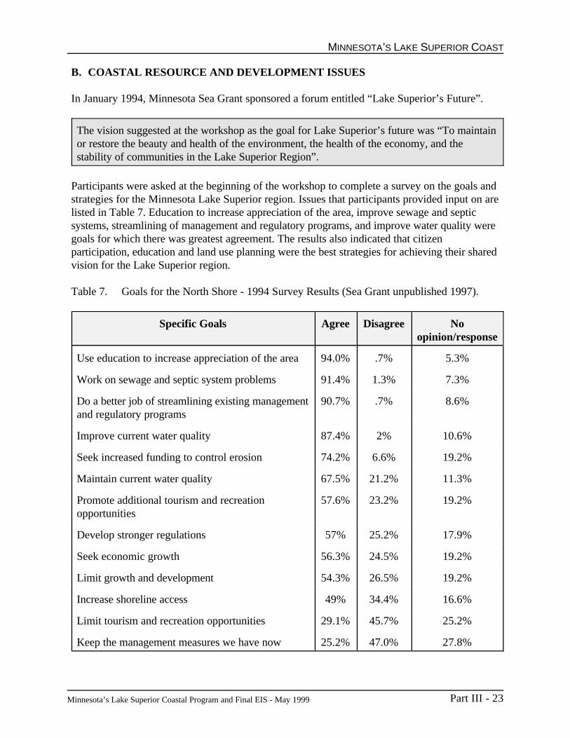
MINNESOTA’S LAKE SUPERIOR COAST
Minnesota’s Lake Superior Coastal Program and Final EIS - May 1999 Part III - 23
B. COASTAL RESOURCE AND DEVELOPMENT ISSUES
In January 1994, Minnesota Sea Grant sponsored a forum entitled “Lake Superior’s Future”.
The vision suggested at the workshop as the goal for Lake Superior’s future was “To maintainor restore the beauty and health of the environment, the health of the economy, and thestability of communities in the Lake Superior Region”.
Participants were asked at the beginning of the workshop to complete a survey on the goals andstrategies for the Minnesota Lake Superior region. Issues that participants provided input on arelisted in Table 7. Education to increase appreciation of the area, improve sewage and septicsystems, streamlining of management and regulatory programs, and improve water quality weregoals for which there was greatest agreement. The results also indicated that citizenparticipation, education and land use planning were the best strategies for achieving their sharedvision for the Lake Superior region.
Table 7. Goals for the North Shore - 1994 Survey Results (Sea Grant unpublished 1997).
Specific Goals Agree Disagree Noopinion/response
Use education to increase appreciation of the area 94.0% .7% 5.3%
Work on sewage and septic system problems 91.4% 1.3% 7.3%
Do a better job of streamlining existing managementand regulatory programs
90.7% .7% 8.6%
Improve current water quality 87.4% 2% 10.6%
Seek increased funding to control erosion 74.2% 6.6% 19.2%
Maintain current water quality 67.5% 21.2% 11.3%
Promote additional tourism and recreation opportunities
57.6% 23.2% 19.2%
Develop stronger regulations 57% 25.2% 17.9%
Seek economic growth 56.3% 24.5% 19.2%
Limit growth and development 54.3% 26.5% 19.2%
Increase shoreline access 49% 34.4% 16.6%
Limit tourism and recreation opportunities 29.1% 45.7% 25.2%
Keep the management measures we have now 25.2% 47.0% 27.8%

PART III
Minnesota’s Lake Superior Coastal Program and Final EIS - May 1999Part III - 24
Recent efforts to revise county comprehensive land use plans have included surveys of and publicmeetings with residents and seasonal land owners regarding their issues and concerns and theirvision for the future. Cook County conducted a survey of residents and land owners in late 1995.Lake County conducted public visioning meetings during the spring of 1996.
Significant in the results of the Cook County survey was that physical characteristics, mostnotably Lake Superior, define the positive quality of the county. Degradation of natural featuresand the loss of quiet were seen as negative forces. With respect to economic conditions,increasing property taxes, lack of affordable housing and rising property values were of greatestconcern. The large amount of public land was generally seen as positively contributing to thecharacter of the county and to its economic base, though this issue was also seen as a potentialconstraint to economic development. Survey responses confirmed continued support for theconcept of nodal development along the shore with the majority supporting a slow populationgrowth rate (Cook County Comprehensive Land Use Plan 1997).
Another survey conducted in 1996 by The Nature Conservancy, also asked residents to rankissues that were important to them. The issues listed were broad in nature and includedeconomic, social, and resource related issues. The top two issues within Lake Superior’s NorthShore, were “protecting Minnesota’s environment” (18 percent) and “the quality and cost ofpublic elementary and high school education” (17 percent). Of the environmental issues, “waterquality” ranked of greatest importance, with “clean air” ranking second (The NatureConservancy unpublished 1996).
An interest in addressing water quality issues has resulted in a variety of plans including:initiation of a Lake Superior basin plan by the Minnesota Pollution Control Agency, countywater plans, watershed and sub-watershed plans. Water plans developed by each of the fourLake Superior counties (Cook County Water Plan, Lake County Water Plan, St. Louis CountyWater Plan, and Carlton County Water Plan) have identified a number of common issuesincluding:
C Protecting water qualityC Protection of ground water recharge areasC Improper use and disposal of pesticides, fertilizers and hazardous wasteC Air pollutionC Failing septic systems and inadequate municipal waste water treatmentC Conserving soil from erosionC Fish contamination
Additional issues were identified in a survey conducted in 1997 for the Minnesota PollutionControl Agency (MPCA 1997). Respondents rated the following nine issues on a scale between1 and 5, with 5 being very serious and 1, not serious.
Dumping garbage/hazardous wastes 4.49Mercury Contamination 4.13Sewage overflows 4.11Air pollution 3.38

MINNESOTA’S LAKE SUPERIOR COAST
Minnesota’s Lake Superior Coastal Program and Final EIS - May 1999 Part III - 25
Florescent disposal 3.63Water contamination 3.59Failing septics 3.54Odors 3.47Development 3.28
Issues such as those listed by surveys and water plans go beyond political boundaries. They arerelated to the geology, climate, and economics of the area. Identifying and addressing the issuesrequires a regional approach to be most effective. As developed, Minnesota’s Lake SuperiorCoastal Program, at the lead of the Coastal Council, will work with agencies, governmentbodies, and local citizenry to evaluate the major issues and prioritize needs approximately everythree to five years. Funds through this program will be directed at addressing these needs.

PART III
Minnesota’s Lake Superior Coastal Program and Final EIS - May 1999Part III - 26
REFERENCES
Anderson, H.A., J. F. Amrhein, P. Shubat and J. Hesse. Protocol for a Uniform Great LakesSport Fish Consumption Advisory. Great Lakes Sport Fishery Advisory Task Force, 1993.
Beeton, Alfread M. Great Lakes Environmental Research Laboratory Yearly Report FY93. 1994.
Beeton, Alfread M. Great Lakes Environmental Research Laboratory Yearly Report FY94. 1995.
Beeton, Alfread M. Great Lakes Environmental Research Laboratory Yearly Report FY95. 1996.
Bloomquist, L. Rich Vein of Mining Jobs Near Duluth. Duluth News-Tribune. February 9, 1997.
Buchta. Spotlight on Cook County. Minneapolis Star Tribune. July 1, 1995.
Carlton County. Carlton County Water Management Plan. Carlton County, 1990.
Cook County. Cook County Water Management Plan. Cook County, 1995.
Geving, Steve. Commerical Fishing Summary, Minnesota Waters of Lake Superior. MinnesotaDepartment of Natural Resources, 1997.
Hunst, Michael, and Howse, George. Minnesota Agriculture Statistics. 1997.
International Joint Commission. Great Lakes Diversions and Consumptives Uses. 1985.
International Joint Commission. Pollution in the Great Lakes Basin From Land Use Activities. 1980.
Klaers, Powers and Associates. Port of Duluth Superior Economic Impact for the 1994 ShippingSeason. Seaway Port Authority, 1994.
Kreag, Glenn and Jennifer Moe. Trends in Tourism Visitation, Duluth Minnesota 1980-1994. 1995.
Lake County. Lake County Comprehensive Water Management Plan. Lake County, 1992.
Lydecker, Ryck. The Edge of the Arrowhead. Minnesota Marine Advisory Service, 1976.
McMurry, M. Population Notes. Minnesota Planning, 1996
McMurry, M. Population Notes (June 1996 Volume). OSD 96-79. Minnesota Planning, St.Paul, Minnesota pp. 108.

MINNESOTA’S LAKE SUPERIOR COAST
Minnesota’s Lake Superior Coastal Program and Final EIS - May 1999 Part III - 27
Minnesota Department of Agriculture. County Data. 1992.
Minnesota Department of Health. Minnesota Fish Consumption Advisory. 1996.
Minnesota Department of Natural Resources. Exotic Species Field Guide. 1997.
Minnesota Department of Natural Resources. Wetland Types and Definitions in Minnesota.1992.
Minnesota Department of Natural Resources. Hunting and Fishing Expenditures. 1991.
Minnesota Department of Transportation. Ports and Waterways Environmental Impacts of a Model Shift. 1997.
Minnesota State Planning Agency. North Shore Data Atlas, Minnesota Coastal Zone.
National Oceanic and Atmospheric Administration. Minnesota Coastal Zone ManagementProgram, Public Hearing, Draft. 1978.
North Shore Management Board. North Shore Management Plan. 1988.
Minnesota Pollution Control Agency. Remedial Action Plan. Lake Superior Basin InformationDocument. 1997.
Minnesota Pollution Control Agency. Lake Superior Basin Information Document. 1997.
Phillips, M. M. Renewal on the Range. Duluth News-Tribune. January 26, 1997.
St. Louis County. St. Louis County Comprehensive Water Management Plan. St. Louis County,1991.
Seaway Port Authority. North America’s Interior Seaport. Seaway Port Authority, 1994.
Skog, J and C. Lincoln. Most of Region’s Counties Grow. Duluth News Tribune, March 23,1997.
Superior Hiking Trail Association. Guide to the Superior Hiking Trail. Ridgeline Press, 1993.
U.S. Department of Agriculture. Ecoregions and Subregions of the United States. 1994.
U.S. Army Corps of Engineers. Duluth Superior Harbor, Minnesota and Wisconsin. 1996.
Van Dusen, Larry. Worlds Largest Inland Port. 1977.
Western Lake Superior Sanitary District. Clean Water. 1995.

Minnesota’s Lake Superior Coastal Program and Final EIS - May 1999 Part IV - 1
PART IVREQUIREMENTS OF THE NATIONAL ENVIRONMENTAL
POLICY ACT (NEPA)
A. NEPA REQUIREMENTS
This document is both a Final Environmental Impact Statement (FEIS) and Minnesota’s LakeSuperior Coastal Plan. Some of the section headings, and the order in which they are presented,are different from those frequently found in other environmental impact statements. To assistNEPA reviewers, the following table has been developed. Topics normally addressed in an EISdocument are listed under the heading “NEPA Requirement.” The corresponding section of thisdocument and the page numbers are provided in the other two columns.
Table 8. NEPA Requirements.
NEPA Requirement Draft EIS/Mgmt Plan Page
Purpose and Need for Action Part IV Part IV - 2
Alternatives Part IV Part IV - 4
Affected Environment Part III Part III - 1
Environmental and Socio-economic Part IV Part IV - 7Consequences
Unavoidable Adverse Environmental Part IV Part IV - 12Effects
Relationship Between Short-term Part IV Part IV - 13Uses of the Environment and theMaintenance and Enhancement of Long-term Productivity
Irreversible and Irretrievable Part IV Part IV - 14Commitment of Resources
List of Preparers Part VII Appendix B
List of Agencies, Organizations, & Part VII Appendix CPersons Receiving Copies of the FEIS/Program Document

PART IV
Minnesota’s Lake Superior Coastal Program and Final EIS - May 1999Part IV - 2
B. PURPOSE AND NEED FOR ACTION
NOAA has prepared this Final Environmental Impact Statement (FEIS) pursuant to the NationalEnvironmental Policy Act (NEPA), 42 U.S.C. 4321 et seq. to assess the environmental impactsassociated with the approval and implementation of the coastal management program submittedto NOAA by the State of Minnesota. The State of Minnesota has submitted its coastalmanagement program to the Office of Ocean and Coastal Resource Management (OCRM) forapproval pursuant to Section 306 of the federal Coastal Zone Management Act (CZMA) of 1972as amended, 16 U.S.C. 1451.
The proposed action on the FEIS is approval of Minnesota’s Lake Superior Coastal Program(MLSCP). The OCRM has made an initial determination that the program meets the requirementsof the CZMA. Federal approval of Minnesota’s program will enable the State of Minnesota toreceive federal grant assistance for program implementation and will require that federal actions inor affecting the Minnesota coast be consistent with the Minnesota program. The MinnesotaCoastal Management Program is described in Part V of this document. A table cross-referencingCZMA requirements with sections from this document may be found in Part II.
Approval and implementation of the MLSCP will improve management of Minnesota's coastalland and water uses according to the coastal policies and standards contained in the existingstatutes, authorities and rules. Federal alternatives to program approval include delaying ordenying approval, if certain requirements of the Coastal Zone Management Act have not beenmet. The state could modify parts of the program or withdraw its application for federal approvalif either of the above federal alternatives results from circulation of this document.
The Coastal Zone Management Act (CZMA)
In response to the intense pressures upon coastal areas of the United States, Congress passed theCoastal Zone Management Act (16 U.S.C. § 1451 et seq.). The CZMA was signed into law onOctober 27, 1972. The CZMA authorizes a federal grant program to be administered by theSecretary of Commerce, who in turn delegated this responsibility to the National Oceanic andAtmospheric Administration's (NOAA) Office of Ocean and Coastal Resource Management(OCRM). The CZMA affirms a national interest in the effective protection and development ofcoastal areas by providing assistance and encouragement to coastal states to develop andimplement rational programs for managing their coastal areas.
Broad guidelines and the basic requirements of the CZMA provide the necessary direction fordeveloping these state programs. These guidelines and requirements for program developmentand approval are contained in 15 C.F.R. Part 923.

REQUIREMENTS OF THE NEPA
Minnesota’s Lake Superior Coastal Program and Final EIS - May 1999 Part IV - 3
In summary, the requirements for program approval are that a state develops amanagement program that:
• Identifies and evaluates those coastal resources recognized in the act that requiremanagement or protection by the state;
• Re-examines existing policies or develops new policies to manage these resources. Thesepolicies must be specific, comprehensive and enforceable, and must provide an adequatedegree of predictability as to how coastal resources will be managed;
• Determines specific uses and special geographic areas that are to be subject to themanagement program, based on the nature of identified coastal concerns. The basis formanaging uses, or their impacts, and areas, should be based on resource capability andsuitability analyses, socio-economic considerations and public preferences;
• Identifies the inland and seaward areas subject to the management program;
• Provides for the consideration of the national interest in the planning for the siting offacilities that meet more than local requirements; and
• Includes sufficient legal authorities and organizational structure to implement the programand to ensure conformance to it.

PART IV
Minnesota’s Lake Superior Coastal Program and Final EIS - May 1999Part IV - 4
C. ALTERNATIVES INCLUDING THE PROPOSED ACTION
1. Introduction
Given the nature of the proposed federal action, approval, delay and denial of Minnesota’s LakeSuperior Coastal Program, are all alternatives available to OCRM. In approving a coastalmanagement program (the preferred alternative), the assistant administrator for Ocean Servicesand Coastal Zone Management must find that a state has met the federal approval requirements ofthe CZMA at 15 C.F.R. Part 923. Delay or denial of program approval could be based on failureof Minnesota’s Lake Superior Coastal Program to meet any of the requirements of the CZMA, asamended.
In an effort to elicit public and agency comment and to assure that the assistant administrator'sdetermination will be appropriate, this section identifies possible programmatic reasons fordelaying or denying approval of the MLSCP identified through the public review process to date.
2. Federal Alternatives
Three alternatives to the proposed action are available to the assistant administrator: approve,delay, or take no action/deny. The assistant administrator's approval must be based uponaffirmative findings for all of the requirements of the CZMA.
a. Alternative 1: The assistant administrator could approve the MLSCP. This is the preferredalternative.
Approval of the MLSCP would be based on an affirmative finding that the program meets allrequirements of the CZMA and its regulations. The benefits of the MLSCP implementation wouldinclude improved regulation and enforcement through intergovernmental coordination; balancedcoastal community development; improved economic development for water dependent uses;better natural resource and hazardous areas management; and improved public awareness.Additional benefits are reviewed by Minnesota of federal and federally permitted and fundedprojects for consistency with its Coastal Management Program and consideration of the nationalinterest in state decision making.
b. Alternative 2: The assistant administrator could deny approval (take no action) on theMLSCP.
OCRM could deny approval if the program is found to not meet all requirements. With respect tothe "no action" alternative, the Office of Ocean and Coastal Resource Management considersfederal denial or state withdrawal from the program and "no action" as synonymous. Stateparticipation under the CZMA is voluntary. When a state participates in program development, itdetermines whether or not program approval and implementation is in its best interest. Theimpacts of "no action" are described below:

REQUIREMENTS OF THE NEPA
Minnesota’s Lake Superior Coastal Program and Final EIS - May 1999 Part IV - 5
Ç Loss of federal funds to administer the program: Under Section 306 of the CZMA,Minnesota would receive about $600,000 annually to administer its Coastal ManagementProgram.
Ç Loss of consistency review of federal actions: This will mean that federal actions wouldnot be reviewed by Minnesota for consistency with the MLSCP as required by Section307 of the CZMA.
Ç Loss of adequate consideration of the national interest in the siting of facilities which areother than local in nature as required by Section 306(d)(8) of the CZMA. By delaying ordenying approval, the State of Minnesota and local governments would be under noobligation under Section 306(d)(8) to give adequate consideration to coastal facilities thatare of national interest. This could result in loss of public benefit that the use of suchfacilities provide.
c. Alternative 3: The assistant administrator could delay approval of the MLSCP.
OCRM could delay if any element of the MLSCP necessary for program approval does not meetapproval requirements and requires some modification. The MLSCP is a “networked” programconsisting of several Minnesota natural resource protection programs. The MLSCP requires thatall state agency actions affecting the coast be consistent with the existing state laws embodiedwithin the MLSCP. Responsibility in Minnesota for implementing the relevant statutes andcoordinating the overall program falls to the Department of Natural Resources. Other stateagencies need to act consistently with the MLSCP. The assistant administrator could delayprogram approval if the coordination and consistency provisions of the MLSCP are insufficient toeffectively network state agencies and divisions into an overall coastal management program.
Before taking final action approving the MLSCP, OCRM will review the complete record ofcomments and responses on this document.
3. State Alternatives Considered During Program Development
Throughout the effort to develop a program in Minnesota, preference was always given to using anetworked approach based on existing authorities rather than creation of new laws or regulations.Minnesota’s program establishes a networked program, with the DNR as lead agency assuringconsistency in implementation of existing authorities.
In the process of developing an inland boundary through the use of a citizen’s work group,several alternatives were considered. The largest boundary considered was the extent of thenatural watersheds adjacent to Lake Superior. While this boundary made sense from an ecologicalstandpoint, it was determined that it encompassed areas that did not have a direct or significantimpact on the coastal area and did not lend itself to the most efficient management. The smallestboundary considered was the boundary created under the North Shore Management Plan,consisting of the 40 acre subdivision lines of the rectangular coordinate system established in the

PART IV
Minnesota’s Lake Superior Coastal Program and Final EIS - May 1999Part IV - 6
U.S. Public Land Survey, nearest to the landward side of a line 1,000 feet from the shoreline ofLake Superior or 300 feet landward from the center line of U.S. Highway 61, whichever isgreater. This narrow boundary did not cover the entire Minnesota Lake Superior shoreline andwas deemed insufficient to encompass the resources intended to be protected under the CoastalZone Management Act. The selected boundary which is primarily the coastal townships covers anarea sufficient to address coastal resources, including most of the population and towns that are inthe watershed.
Similar to the boundary development process, a work group of citizens was established to discussand propose the organization of the program and the implementation process. The organizationsof numerous existing state coastal management programs were examined as alternatives beforethe unique organization and implementation process was selected that is described in thisdocument.
4. Consultation and Coordination
All local, state and federal agencies referenced in Appendix C of this document were consultedduring initial phases of program development and during development of the 1997 public reviewdraft document. The Minnesota DNR consulted each agency again in 1998 with the review of theDEIS in order to incorporate necessary revisions prior to publication of the FEIS.

REQUIREMENTS OF THE NEPA
Minnesota’s Lake Superior Coastal Program and Final EIS - May 1999 Part IV - 7
D. ENVIRONMENTAL AND SOCIO-ECONOMIC CONSEQUENCES
In enacting the CZMA, Congress declared that "it is national policy to preserve, protect, develop,and where possible, restore or enhance the resources of the nation's coastal zone for this andsucceeding generations." States are to achieve these potentially conflicting goals by improvinggovernmental coordination, incorporating consideration of long term implications of developmentdecisions, and instituting a more rational decision-making process which conforms to CZMApolicies. Such actions have the potential to substantially affect future coastal area activity andhave a significant positive environmental impact. The CZMA mandates giving full considerationto ecological, cultural, historic and aesthetic values as well as to needs for economic developmentwhen considering various development proposals.
Thus many factors and diverse, often conflicting values, between resource protection anddevelopment must be weighed. The CZMA requires that a balance must be achieved which allowsor encourages development, while still protecting unique and critical resources.
It is the intent of the MLSCP to carry out these legislative mandates of the CZMA. Therefore, theenvironmental, institutional and socio-economic effects are expected to be primarily beneficial.The MLSCP will provide more coordinated decision-making with a greater focus on criticalcoastal issues.
There are four impacts associated with approval of the MLSCP: (1) impacts resulting fromfederal approval and (2) impacts resulting from implementation of Minnesota’s coastal protectionstatutes embodied within the program. In contrast to approving the MLSCP, the assistantadministrator could decide to (3) deny, or (4) delay approval of the program. In general, suchimpacts are discussed with respect to direction of change (positive or beneficial, negative orneutral) and with respect to duration (long-term or short-term). Because the proposed action isapproval of a broad ranging program, quantification of net effects is not possible.
1. Positive Impacts Directly Resulting from Federal Approval
Section 306 Funding: Federal approval will enhance the State of Minnesota’s financial ability tocarry out its various coastal management efforts in accordance with Minnesota policies in theMLSCP. The state will rely to a considerable degree on the program funding made available inannual grants under Section 306 of the CZMA, both for program administration and for local andregional coastal management assistance grants. Program administration funding will support staff,contracts, and other resources to provide assistance to local governments and other entities aswell as enhancement of implementation of laws included in MLSCP. Section 306 funding for localand regional assistance grants will be used for environmentally and socio-economically beneficialefforts, such as the following:
C Feasibility studies and engineering reports for projects at the local level that are consistentwith the policies in the coastal management program document;

PART IV
Minnesota’s Lake Superior Coastal Program and Final EIS - May 1999Part IV - 8
C The protection and preservation of wetlands, beaches, fish and wildlife habitats, mineral,natural areas, endangered plant and animal species, or other significant natural coastalresources;
C Development and adoption of procedures to assess, consider, and control cumulative andsecondary impacts of coastal growth and development, including the collective effect onvarious individual uses or activities on coastal resources, such as coastal wetlands and fisheryresources;
C The management of shoreline development to prevent loss of life and property in coastal floodhazard areas and coastal erosion areas, to set priorities for water-dependent energy,commercial, industrial, and recreational uses, or to identify environmentally acceptable sitesfor dredge spoil disposal;
C Increasing public access to Lake Superior and other public places in the coastal area;
C The protection and preservation of historical, cultural, or aesthetic coastal resources;
C Improving the predictability and efficiency of governmental decision making related to coastalarea management;
C The redevelopment of deteriorating and underutilized waterfronts and ports; and
C Other purposes approved by the Coastal Council and the Department of Natural Resources.
Funding for such efforts is expected to have direct beneficial impacts on the natural andsocio-economic environment of the coastal region, through protection of natural areas and othersensitive resources, waterfront revitalization, comprehensive planning, streamlining of permits andthe monitoring of their effects, and conflict resolution. The integrated management approach of acoordinated cooperative MLSCP is expected to result in direct benefits to the environmentthrough a heightened proactive focus on coastal resource management. The MLSCP provides theframework for a partnership among state and local agencies and other entities, public and private,to cooperate to preserve, protect, develop and restore the region's unique values.
Federal Consistency Review: Federal approval and implementation of the MLSCP will haveeffects upon federal agency actions. Approval will activate the federal consistency reviewprovisions of Section 307 of the CZMA. The MLSCP federal consistency process and relevantprovisions of 15 C.F.R Part 930 are described in Part V, Chapter 6. Because federal consistencyentails early coordination and closer cooperation in planning as well as review of projectproposals, it is presumed that federal consistency will provide another means to minimize thepotential for adverse environmental impacts. This is considered to be a desirable impact and oneof the main purposes of the CZMA.
The MLSCP has been developed with the assistance and input of numerous federal agencieshaving responsibility for activities in or affecting the coastal area. Therefore, conflicts betweenMinnesota’s enforceable policies included in the MLSCP and federally permitted or conducted

REQUIREMENTS OF THE NEPA
Minnesota’s Lake Superior Coastal Program and Final EIS - May 1999 Part IV - 9
activities should be minimal. Federal activities will not be excluded but rather will be required tobe consistent with the policies in the MLSCP.
National Interest: Part V, Chapter 5 and Chapter 6 of the MLSCP describes how the siting ofland and water uses of regional benefit, coordination with federal agencies, and consideration ofnational interest are integrated in the program. In general, the activities identified for being ofregional benefit are under direct state and/or federal management, which preclude theunreasonable restriction or exclusion of the use of regional benefit by local regulation. This doesnot mean, however that local concerns are not sought and addressed. Each state agencyadministers a review process or other mechanism to assure consideration of all interests in theexercise of its authorities related to the regional use.
As MLSCP includes procedures for considering national and regional interests in comprehensiveplanning and decision making for the coastal area, the potential for conflicts between state,regional and national goals is reduced. Consideration of national interest during programimplementation will be achieved by the review, certification, and permitting process described inthe federal consistency section of this document (Part V, Chapter 6, page 7) or through processesoutlined in Memorandums of Understanding (list of agreements in Appendix G) that addressalternative review processes.
2. Impacts (of Approval) Attributable to Minnesota’s Lake Superior Coastal Program
The Minnesota Department of Natural Resources (DNR) is designated by executive order as thelead agency for development and implementation of the MLSCP. The functions and authorities ofthe DNR with respect to MLSCP administration, described in detail in Part V, Chapter 2, providea cohesive framework for improved and integrated decision making regarding coastal issues.Memoranda of Understanding between the DNR and other agencies as well as state consistencyreview coordinated by the DNR further foster unified coordination. Decisions and activities offederal, state and local agencies as well as those within the DNR will be monitored, coordinatedand mediated by one office within the DNR Waters to assure compliance with the MLSCP.Greater consistency, a central focus and streamlining of the decision-making process is expectedto improve the predictability of that process and bring about beneficial environmental andinstitutional impacts.
Assuring state agency consistency with the Coastal Program will help maintain program strength.As with federal consistency provisions and mechanisms, the impacts are expected to be positive.Improved coordination and cooperation throughout project planning and review will serve tominimize adverse impacts and to enhance predictability of decision making regarding stateprojects which may affect coastal resources. The MLSCP structure is described in Part V,Chapter 2, and the means to assure state consistency is described in Part V, Chapter 6.
The Coastal Council is the decision-making mechanism through which Minnesota’s Lake SuperiorCoastal Program implements the grant program. The responsibilities of the Council includedevelopment of program priorities, review and selection of grant proposals, review of the annualbudget, and periodic review of the program. The Council will provide direction for the CoastalProgram to the program coordinator and informally serve as liaison to outside organizations.

PART IV
Minnesota’s Lake Superior Coastal Program and Final EIS - May 1999Part IV - 10
These functions help to assure that public concerns regarding the environment are emphasized inthe state's decision making.
Public Participation: There is a shared value of the Lake Superior resource base by those whowork, live, or visit the area and there is a strong interest in public participation in the decisionmaking and policy making process to protect this area. A coastal program will provide anotheravenue for public participation and additional funding to conduct these citizen based planningprocesses. The Coastal Council will provide additional means of providing public participation inthe MLSCP including representation of the large geographical area of the North Shore as well asthe diversity of issues and perspectives.
Shoreline, Stream Bank and Bluff Erosion: Erosion and sedimentation problems exist alongthe Lake Superior shoreline. Although the potential exists that erosion management may result indecreased property values for some individuals who own shorefront property with extremely higherosion rates, the costs of protective actions are expected to be short term with property valuesgenerally increasing over the long term due to improved protection and decreased risk. TheCoastal Program can provide resources for planning, engineering or other tools to assist in solvingerosion problems.
Counties or municipal corporations with land in the designated coastal flood hazard area arerequired to participate in the National Flood Insurance Program (NFIP) or adopt resolutions orordinances meeting or exceeding NFIP requirements. Although they participate in the NFIP, noflood hazard areas have been identified in Cook and Lake Counties. Carlton and St. LouisCounties have identified flood hazard areas and participate in the NFIP. For the long term, thiswill assure that the state standards and the minimum federal standards are always in effect in theLake Superior coastal flood hazard areas.
Harbor Development and Dredging Issues: All the ports and harbors in the Minnesota coastalarea are important to local and regional economies. The Duluth-Superior Harbor is the mostsignificant shipping port in the region as well as the leading bulk cargo port on the Great Lakesand one of the busiest in the nation. The Duluth Comprehensive Port Development Plan addressespreservation and restoration of natural areas, placement of dredged material, and revitalization ofcommercial/industrial land adjacent to the harbor. The Port Plan is implemented through theexisting framework of the Duluth-Superior Metropolitan Interstate Committee. The committeewas formed to address issues related to the Duluth-Superior Harbor among which the placementof dredged material is a very high priority. Representatives on the committee include local andstate agencies from Wisconsin and Minnesota. This interstate relationship will be enhancedthrough the communication of the Coastal Programs in Wisconsin and Minnesota. Implementationof the Port Plan will also be improved through better communication with state and federalagencies and new linkages formed at the state and national level. These linkages will also providea means to exchange technical assistance at the local, state, and national levels.
Public Access: Through the implementation of the MLSCP, technical assistance to andcoordination with local communities will improve the recreational potential of the lakeshore.There is strong interest in enhancing the waterfront and increasing public access to Lake Superior.Public access programs will benefit from increased resources and funding through MLSCP

REQUIREMENTS OF THE NEPA
Minnesota’s Lake Superior Coastal Program and Final EIS - May 1999 Part IV - 11
implementation. The Coastal Program can help fund planning as well as low-cost constructionprojects and waterfront improvements. The Coastal Program will promote improved coordinationof public access projects, facilities, and plans along the entire shoreline and across all levels ofgovernment and organizations.
Environmental Justice: Approval of Minnesota’s Lake Superior Coastal Program will lessen thelikelihood of environmental inequities and may promote greater environmental justice. MLSCPpolicies provide for the protection of resources, such as fish and wildlife and their critical habitats,that are the mainstays of traditional coastal economies. MLSCP project grants will provide fundsto local communities to increase and enhance access to Minnesota’s waters and shore areas for allresidents and will provide additional means to address development pressures in small-townwaterfront areas and rehabilitate degraded urban waterfront areas. Approval of the MLSCP mayprovide additional resources to organizations such as the North Shore Management Board toaddress development issues such as wastewater treatment which will reduce impacts togroundwater and water bodies and improve public health generally. The MLSCP has includedeconomic development areas, cultural resource protection areas, and natural resource protectionareas as Areas of Particular Concern. This provides special management attention to these areasand makes them eligible for construction and acquisition projects under Section 306A of thefederal Coastal Zone Management Act.
3. Impacts Resulting from Denying Federal Approval
Several environmental, economic and social impacts could result if OCRM decided to denyapproval of the MLSCP. An obvious economic impact is the loss of federal funds to administerand implement the program. Under Section 306 of the CZMA, Minnesota would receive about$600,000 annually to implement its Coastal Management Program. Consistency of federal actions,as required by Section 307, CZMA, would be lost to Minnesota. Adequate consideration of thenational interest in siting facilities of national interest, as required by CZMA section 306(d)(8),would be lost and could result in loss of public benefit from use of those facilities. The technicalassistance available to Minnesota from OCRM would be lost without federal approval of theprogram as well as the benefit from information exchange and coordination with other states bothin the Great Lakes region and nationally.
4. Impacts Resulting from Delaying Federal Approval
The environmental, economic and social impacts listed above, that result from denial of federalapproval of the MLSCP, also apply to delaying approval of the program. Further, continued delayat this juncture may make it impossible, due to limits in funding, for Minnesota to enter the federalprogram in the future.

PART IV
Minnesota’s Lake Superior Coastal Program and Final EIS - May 1999Part IV - 12
E. UNAVOIDABLE ADVERSE ENVIRONMENTAL EFFECTS
The probable effects of Minnesota’s Lake Superior Coastal Program implementation will, on thewhole, be environmentally beneficial. However with or without the program, adverse impactsassociated with the siting of major facilities for purposes of defense, transportation, and energyrequirements in which both the state and federal governments have interest, will continue. It isimportant to note, however, that under the Coastal Program and related federal laws (e.g.,National Environmental Policy Act), such projects will be evaluated as to the impacts on thenatural coastal environment. That is, investigations will be made, alternatives considered, etcetera. The program also makes provisions for consideration of the national interest in the sitingof these facilities.
No new energy generation facilities are planned in Minnesota’s coastal area, and it is anticipatedthat existing facilities will remain largely unchanged.

REQUIREMENTS OF THE NEPA
Minnesota’s Lake Superior Coastal Program and Final EIS - May 1999 Part IV - 13
F. RELATIONSHIP BETWEEN SHORT-TERM USES OF THE ENVIRONMENT ANDTHE MAINTENANCE AND ENHANCEMENT OF LONG-TERM PRODUCTIVITY
Minnesota’s Lake Superior Coastal Program will provide long-term assurance that the naturalresources and benefits provided by the Minnesota Lake Superior coast will be available for futureuse and enjoyment, by more effectively administering existing resource protection laws.
Minnesota’s Lake Superior Coastal Program recognizes in the short-term that somecoastal-dependent developments have adverse environmental consequences, but that they may stillbe located in the coastal zone to protect the inland environment as well as help provide for orderlyeconomic development, and meet national interest.
Regarding the long-term use of the environment, the MLSCP recognizes the coastal area as adelicately balanced ecosystem; establishes a process of balanced management of coastal resources;allows growth to continue while protecting key resources; and provides a framework which canprotect regional, state and national interests by assuring the maintenance of the long-termproductivity and economic vitality of coastal resources necessary for the well-being of the public.Beneficial changes will likely promote avoidance of long-term costs to the public and a diminishedquality of life resulting from the misuse of coastal resources.

PART IV
Minnesota’s Lake Superior Coastal Program and Final EIS - May 1999Part IV - 14
G. IRREVERSIBLE AND IRRETRIEVABLE COMMITMENT OF RESOURCES
The only irretrievable or irreversible commitment of resources that will result directly from theapproval of Minnesota’s Lake Superior Coastal Program is the commitment of state and federalfunds and personnel for the purpose of achieving the goals and objectives of the MLSCP. It ispresumed that irretrievable and irreversible commitments of economic and environmentalresources will occur during the implementation of the MLSCP. This MLSCP is designed tobalance the need for development with the need for the protection and enhancement of coastalenvironmental resources by avoiding, minimizing and mitigating the consequences of coastaldevelopment on resources such as wetlands and shallow water Lake Superior habitats.
The MLSCP ensures, through enhanced local and regional participation and awareness, that anysuch proposed activities which commit coastal resources are provided a more comprehensivereview as individual actions and as an action contributing to the cumulative impacts taking placeon coastal resources. Such review will ensure that those irretrievable and irreversiblecommitments of resources which are undertaken under MLSCP are made with full awareness ofthe consequences of those commitments.

PART V
MINNESOTA’SLAKE SUPERIOR COASTAL PROGRAM

Minnesota’s Lake Superior Coastal Program and Final EIS - May 1999 Part V 1-1
CHAPTER 1PROGRAM BOUNDARY
A. INTRODUCTION
The term “coastal waters” in the Great Lakes area means “the waters within the territorialjurisdiction of the United States consisting of the Great Lakes, their connecting waters, harbors,roadsteads, and estuary-type areas such as bays, shallows, and marshes.” The coastal waters inMinnesota, therefore, consist of those waters of Lake Superior within the territorial jurisdiction ofMinnesota.
Section 304(1) of the Coastal Zone Management Act identifies the “coastal zone” as thecoastal waters (including lands therein and thereunder) and the adjacent shorelands(including the waters therein and thereunder), strongly influenced by each other and inproximity to the shorelines of the several coastal states, and includes islands, transitionaland intertidal areas, salt marshes, wetlands, and beaches. The zone extends, in GreatLakes waters, to the international boundary between the United States and Canada, inother areas, seaward to the outer limit of the United States territorial sea.
By definition, the zone “extends inland from the shorelines only to the extent necessary to controlshorelands and the uses which have a direct and significant impact on the coastal waters.Excluded from the coastal zone are lands, the use of which is by law subject solely to thediscretion of or which is held in trust by the federal government, its officers or agents” (CZMA,Section 304(l)).
The following boundaries have been developed for the Minnesota program: the seaward orwaterward boundary, interstate boundary, excluded lands, and the inland boundary. Definitions ofeach boundary and a summary of the issues analyzed to develop the boundary are discussed. Adetailed description for the inland boundary follows the discussion.
The program boundary chapter is broken down into two sections, Introduction and BoundaryEstablishment. The boundary establishment is divided into the following parts: 1. SeawardBoundary and Interstate Boundary, 2. Excluded Lands, 3. Nonpoint Source PollutionControl Program Boundary and finally, 4. Inland Boundary. Also included in this chapter isthe Justification for the Selected Boundary. The legal description for the boundary is described in: a. St. Louis River Watershed, b. Duluth and Surrounding Urban Areas, c. St. Louis County -North Shore, d. Lake County - North Shore and e. Cook County - North Shore.

CHAPTER ONE
Minnesota’s Lake Superior Coastal Program and Final EIS - May 1999Part V 1-2
B. BOUNDARY ESTABLISHMENT
There are five elements to Minnesota’s Lake Superior Coastal Program boundary: the inlandboundary, the lakeward (seaward) boundary, the interstate boundary, the excluded federal lands,and the coastal nonpoint source program boundary. A boundary work group was established anddeveloped recommendations for the boundary in Minnesota. The work group consisted of 14local citizens representing the geographic area from Carlton to Cook County. Therecommendations of the work group were presented at a series of open house meetings to obtainpublic input. Input was also solicited through state and local government participation, and a finalwork group recommendation was developed. The establishment of a final boundary is the result ofthoughtful consideration and a decision which is acceptable to those impacted by the program.
1. Seaward Boundary and Interstate Boundary
Minnesota adjoins Lake Superior, one of the Great Lakes. The seaward boundary for Minnesota’sLake Superior Coastal Program is the international boundary with Canada and the boundarieswith the adjacent states of Wisconsin and Michigan. Minnesota has consulted and coordinatedwith its coastal neighboring states of Wisconsin and Michigan.
Both adjoining coastal states provided input into the development and delineation of adjacentinland and lateral seaward boundaries. Based on the input received, it was determined that thelakeward coastal boundary as described is consistent with both states. Minnesota shares an inlandstate boundary with Wisconsin. The boundary in Wisconsin includes the entire county of Douglasadjacent to Minnesota. The Minnesota inland boundary does not extend inland as far as theadjoining Wisconsin coastal boundary. Through boundary work group consultation, it wasdetermined that the interstate relationship would not be compromised, part of Douglas Countydoes not drain into Lake Superior.
2. Excluded lands
States must exclude those federal lands as described in the chapter introduction. To meet thisrequirement, Minnesota will map and describe lands owned, leased, held in trust or otherwiseused solely by federal agencies. The exclusion of federal lands from the coastal area does notremove federal agencies from the obligation of complying with Section 307 of the act (federalconsistency review) when federal actions on these excluded lands have spillover effects on anyland or water use or natural resource of Minnesota’s Lake Superior Coastal Program. Table 9lists and describes excluded federal lands for Minnesota’s Lake Superior Coastal Program.Excluded federal lands are mapped if they are large scale holdings (more than 100 acre parcels) ornear special management areas (Figures 5 - 8). Grand Portage and Fond du Lac Reservations arethe only two federally excluded lands greater than 100 acres in the coastal boundary.

PROGRAM BOUNDARY
Minnesota’s Lake Superior Coastal Program and Final EIS - May 1999 Part V 1-3
Table 9. Excluded Federal Lands.
These are sites that contain large land areas more than 50 acres in size or are located adjacent tospecial management areas. Not included in this table, but likewise excluded from Minnesota’sLake Superior Coastal Program, are individual federal buildings and sites such as post offices andsmall Coast Guard or Army Corps of Engineers installations.
SITE AGENCY COUNTY
Fond du Lac Indian Reservation Bureau of Indian Affairs Carlton
Duluth International Airport Air National Guard St. Louis
Duluth International Airport U.S. Air Force St. Louis
Minnesota Point U.S. Army Corps of Engineers St. Louis
Superior National Forest U.S. Forest Service Cook
Grand Portage Indian Reservation Bureau of Indian Affairs Cook
Grand Portage National Monument National Park Service Cook
3. Nonpoint Source Pollution Control Program Boundary
The Nonpoint Program of the CZMA, also known as Section 6217, serves as an update andexpansion of the state Nonpoint Source Management Program developed under the federal WaterPollution Control Act, as the program under that section relates to land and water uses that affectcoastal waters. The Nonpoint Program will be a stand alone program and the boundary for theprogram will be developed through a separate process. In general, the nonpoint programboundary should be large enough to address the land uses that individually or cumulatively maycause or contribute significantly to degradation of the quality of coastal waters. See Part VI,Coastal Nonpoint Pollution Control Program, for information on Minnesota’s Nonpoint SourceProgram development efforts.
4. Inland Boundary
Federal regulations require that the inland boundary of Minnesota’s coastal area include thoseareas for which management is necessary to control uses that have direct and significant impactson coastal waters; special management areas; wetland areas subject to regular inundation by LakeSuperior that contain flora typical of the region; sandy beaches, dunes, and rocky areas to thepoint of upland vegetation; and islands in their entirety, except when uses of interior portions donot cause direct and significant impacts.
The inland boundaries extend landward to cover all coastal resource areas, all major coastal issueareas, and all lands which could have a direct and significant impact on coastal waters as a resultof their use.

CHAPTER ONE
Minnesota’s Lake Superior Coastal Program and Final EIS - May 1999Part V 1-4
Justification for Selected Boundary
In selecting boundaries for Minnesota’s Lake Superior Coastal Program, a detailed analysis wasmade of those potential areas (including sensitive or fragile ecosystems and various physicalconsiderations relative to development in these areas) which might have a direct and significantimpact upon coastal waters. Another important consideration in developing boundaries for theprogram is funding and the limitations on funding for program implementation. A thirdconsideration is the ease in which the boundary can be mapped, managed, and understood.
The Minnesota coastal area of Lake Superior can be divided into three parts for purposes ofdiscussion. One part includes the area of the St. Louis River in Carlton County, south of Duluth.Another part is the city of Duluth and surrounding areas of urban growth and expansion to thenorth and west. The third part is the region between the Duluth city limits north to the Canadianborder, also known as the “North Shore.”
There are variations in the natural and cultural features in the coastal area. The St. Louis River,which flows south of Duluth before it enters Lake Superior, is a major source for hydropowergeneration and recreation in Carlton County. The major issues identified include erosion,contaminant/sediment problems, exotic species, and hydropower operations. The city of Duluthand surrounding urban area is the location of a major shipping port and is also the largestpopulation center in the watershed. The major issues included in this part of the coastal area are:urban runoff, sewage treatment, erosion along waterways, harbor and port planning, and openspace planning. The North Shore is unique in the fact that the area is not as densely populated;the majority of land adjacent to Lake Superior is in private ownership, and the majority of landinland from the coast is in public ownership. This part of the coastal area is valued for its naturalcharacter and beauty. Maintaining the character of the area while providing a sustainable way oflife is important. The most important issues included in this part of the coastal area are waterquality, sewage treatment, shoreline erosion, recreation, tourism, stream corridors, and uniquemanagement areas. Common concerns throughout the coastal area include water quality anderosion, sewage treatment, and the cumulative impacts from growth. Because of the unique character of the North Shore, an inland boundary based on coastaltownships was developed. Coastal townships include those areas that are described by thesubdivision lines of the rectangular coordinate system established in the U.S. Public Land Survey.The U.S. Public Land System or the Rectangular Survey System is a method of land descriptionused to describe more than 50 percent of the land in the United States. The land is divided intoapproximate squares called “townships” which have sides approximately 6 miles in length.Townships are further subdivided into 36 sections each approximately one square mile. Thetownships are described by a township (north or south) number and a range (east or west)number. The coastal township boundary is a convenient means to identify a coastal programboundary since the boundary is defined by a legal description shown in local land surveys and istypically an existing government subdivision boundary.

PROGRAM BOUNDARY
Minnesota’s Lake Superior Coastal Program and Final EIS - May 1999 Part V 1-5
The coastal township boundary is defined as close to a 6- by 6-mile township as possible. In areaswhere the coastal township inland boundary was less than three or four miles from Lake Superior,the next inland 6-mile township was chosen as the coastal township boundary. In one instance,where the coastal boundary was less than 6 miles from Lake Superior and the next townshipboundary was 10 miles inland, the boundary of the Pat Bayle State Forest was used (CookCounty). The forest border makes use of an existing known geographic boundary, thus avoidingconfusion. In addition, a number of inland water resources, namely, Devil Track Lake, CaribouLake, Christine Lake, White Pine Lake, and Mistletoe Creek are within the boundary. Using therationale above, the inland coastal township boundary stays approximately six miles from the LakeSuperior shore.
Based upon the analysis, considerations, and relying upon the assumption that “the closer a use isto the coast the greater the impact on coastal waters,” it was decided that the area within whichactivities would be eligible for program implementation funds and subject to programmanagement policies would extend inland as described below (see Figure 5).
a. St. Louis River Watershed
The inland boundary affecting Carlton County, the Duluth-Superior Harbor and parts of St. LouisCounty: at the St. Louis River confluence with Lake Superior, going upstream along theMinnesota/Wisconsin border, within the county of St. Louis to the Carlton County line, thencesouth along the Jay Cooke State Park border, thence westerly along the park border and includingthe city limits of the city of Wrenshall, thence, northwesterly along the border of Jay Cooke StatePark and including the city limits of Carlton to the intersection of Highway 210, thence westerlyalong Highway 210 to the western border of Section 6, T48N, R17W, thence north along theR17W line following the western border of the city of Cloquet to the St. Louis County border,thence easterly along the Carlton/St. Louis County line to the western border of MidwayTownship and the city of Hermantown (see Figure 6).
b. Duluth and Surrounding Urban Areas
The inland boundary for Minnesota’s Lake Superior Coastal Program affecting the Duluthmetropolitan area, including the cities of Hermantown and Proctor within St. Louis County: fromthe point where Carlton County, Hermantown, Midway Township, and Solway Townships meet,north along Solway Road (County Road 889, the western border of Hermantown), to theintersection of Highway 53, thence northwesterly along Highway 53 to Munger Shaw Road(County Road 15), thence north on Munger Shaw Road to Abrahamson Road, thence east alongthe section line to the NE corner of Section 18, thence south on Midway Road to Martin Road(County Road 9), thence west on Martin Road to Rice Lake Road (County Road 4), thence northon Rice Lake Road, to West Beyer Road (County Road 259), thence east on West Beyer Road toJean Duluth Road (County Road 37), the western border of Lakewood Township (see Figure 6).

CHAPTER ONE
Minnesota’s Lake Superior Coastal Program and Final EIS - May 1999Part V 1-6
c. St. Louis County - North Shore
From the intersection of Jean Duluth Road and West Beyer Road, north on Jean Duluth Road(County 37) to the north border of Lakewood Township, thence east to the west border of DuluthTownship, thence north to the north border of Duluth Township, thence east to the Lake Countyborder (see Figure 6).
d. Lake County - North Shore
From Unorganized Territory Number Two west border, north along the R11W line to the T53N,R11W north corner, thence east along the T53N line to county-state aid Highway 2, thence northalong Highway 2 to the T54N line, thence east to the R9W west line, thence north to the T55Nline, thence east to the R8W line, thence north along the R8W west line to the T56N line, thenceeast to the R7W line, thence north along the R7W west line to the T57N north line, thence east tothe R6W line, thence north along the R6W west line to the T58N north line, thence east to theCook County line (see Figure 7).
e. Cook County - North Shore
From the Cook County line (NW corner Section 6, T58N, R11W) north along the R5W west lineto T59N north line, thence east to the R4W line, thence north along the R4W west line to T60Nnorth line, thence east to the R3W line, thence north along the R3W west line 3 miles to the PatBayle State Forest border, thence east to the R2W line, thence north 3 miles along the R2W lineto the Pat Bayle State Forest border, thence east to the R1W line, thence north along the R1Wwest line 2 miles to the Pat Bayle State Forest border, thence east to the R2E line, thence northalong the R2E west line 4 miles to the T62N line, thence east along the T62N line 12 miles to theR4E line, thence north along the R4E west line to the T63N line, thence east along the T63Nnorth line to the Grand Portage Indian Reservation, thence northerly along the west border of theGrand Portage Indian Reservation to the USA/Canada border, thence easterly along theMinnesota side of the USA/Canada border to Lake Superior (see Figure 8).
Maps which show the coastal boundaries in greater detail are on file at the Minnesota Departmentof Natural Resources office in Two Harbors.

()61
()61
()61
()23
*+35
,-2()194
,-169
()37,-53
()73
()1
Temperance RiverState Park
Cascade RiverState Park
Judge C.R. MagneyState Park
Grand PortageState Park
George Crosby ManitouState Park
TettegoucheState Park
Split Rock LighthouseState Park
Gooseberry FallsState Park
Jay CookeState Park
Savanna PortageState Park ()33
Hoyt Lakes
Babbitt
Hibbing
Chisholm
Mountain IronVirginia Biwabik
Gilbert
DuluthCloquet
Hermantown
Wrenshall
Thomson
Proctor
Carlton
Two Harbors
Silver BayBeaver Bay
Grand Marais
Meadowlands
Floodwood
Fond Du LacReservation
Grand PortageReservation
()61
Buhl
()135
,-53
Lake Superior
Cloque
t Rive
r
St. Lo
uis Ri
ver
Nemadji River
e
./2
./2./4
./12 ./16
N
EW
S
10 0 10 20 Miles
Minnesota
WisconsinMichigan
Michigan
Manitoba
Ontario
Figure 5.The Coastal Boundaryin Minnesota
Interstate',Federal Trunk(/State TrunkÆ"County Roads
State Parks
Excluded Federal Lands
Coastal Boundary
© MN DNR - Division of Waters Lake Superior Coastal ProgramTwo Harbors Area Office November, 1999

()61
()23
()33
,-2
,-53
,-53
()135,-169
()37
()210
()73
()194
*+35
Duluth
Hibbing
Buhl
Mountain Iron
Hoyt Lakes
Babbitt
Biwabik
GilbertEveleth
Virginia
CloquetProctor
Hermantown
Chisholm
Itasca CountyAitkin County
St. Louis County
Carlton County
LakeSupe
riorWater
shed
St. L
ouis
Rive
r
St. Loui
s Rive
r
Cloquet
River
N. Fork Nemadji River
S. Fork Nemadji River
Meadowlands
Floodwood
Brookston
Fond Du LacReservation
Jay CookeState Park
,-2
Wild Rice
Fish Res.
Island
Boulder
Whiteface Res.
Grand
North Shore State
Trail
Figure 6.The Coastal Boundary inSt. Louis and Carlton Counties, Minnesota
Minnesota
WisconsinMichigan
Michigan
Manitoba
Ontario
N
EW
S
6 0 6 12 Miles
North Shore State Trail
County Boundary
Lake Superior Watershed
Interstate Highways*+Federal Trunk Highways,-State Trunk Highways() Coastal Boundary
Rivers & Streams
Ditches
Lakes
Northshore Management Plan Boundary
State Parks
Excluded Federal Land
Cities
© MN DNR - Division of Waters Lake Superior Coastal ProgramTwo Harbors Area Office November, 1999

#
#
#
#
#
#
#
#
#
#
#
#
Little Marais
Illgen City
East Beaver Bay
Beaver Bay
Silver Bay
Two Harbors
Castle Danger
Knife River
Larsmont
Split Rock Lighthouse State Park
Gooseberry Falls State Park
Tettegouche State Park
George H. Crosby Manitou State Park
Wilson Lake
Lax Lake
Ninemile Lake
Stewart Lake
Balsam Lake
Cloquet Lake
Thomas Lake
Marble Lake
Lost Lake
Cramer Lake
Sullivan Lake
Organ Lake
Sonju Lake
Soup Lake
()1
()1
()61
()61
()61
./2
./2
./3
./15
./15
./9
./12
R6W
R7W
T57N
T57N
R8W
T56N
R9W
T56N
R10W
T55N
R11W
Silver Creek Township
Beaver Bay Township
Unorganized Territory #2
Crystal Bay Township
North
Shore
State
Trail
./14
./7
Unorganized Territory #1
Superior
Hiking
Trail
Minnesota
WisconsinMichigan
Michigan
Manitoba
Ontario
N
EW
S
Figure 7.The Coastal Boundary in Lake County, Minnesota
6 0 6 Miles© MN DNR - Division of Waters Lake Superior Coastal Program. Two Harbors Area Office / November, 1999
Northshore Management Plan Boundary
North Shore State Trail
Coastal Boundary
Rivers & Streams
Lakes
Cities
State Park
Superior Hiking Trail
State Trunk()County Roads./

#
#
#
#
#
#
#
#
#
Taconite HarborSchroeder
Tofte
Lutsen
Grand MaraisCroftville
Hovland
Grand Portage
Cascade River State Park
Judge C.R. Magney State Park
Grand Portage State Park
Brule
Deviltrack
Greenwood
PineClearwater
Crescent
Two Island
Pike
DeeryardCaribou
Four Mile
Alton
()61
()61
./2
./4
./12
./12
./16
./17
./14
./6
./7
./1
Grand PortageReservation
R5W
R4W
T60N
T61N
R3W
T61N
R2W T63N
R1W
T62N
R2E
R1E
T63N
R4E
R3E
Shroeder Township
Tofte Township
Lutsen Township
Sawbill
Trail
Caribou Tra
il
Gunflint
Trail
Arrowhead
Trail
North
Shore
State Trail
Superior
Hiking
Trail
Susie Islands arepart of the Reservation andexcluded land
Temperance River State Park
Figure 8.The Coastal Boundary in Cook County, Minnesota
© MN DNR - Waters Lake Superior Coastal Program. Two Harbors Area Office / November 1999
Minnesota
WisconsinMichigan
Michigan
Manitoba
Ontario
N
EW
S
6 0 6 12 Miles
State Trunk Highways()County Roads./
North Shore State TrailCoastal Boundary
Superior Hiking Trail
Cities
State Parks
Excluded Federal Land
Lakes
North Shore Management Plan Boundary

Minnesota’s Lake Superior Coastal Program and Final EIS - May 1999 Part V 2-1
CHAPTER 2PROGRAM IMPLEMENTATION
A. ORGANIZATIONAL STRUCTURE
Collectively, state, local and federal agencies and units of government, through a variety ofmechanisms, both policy and law, manage the natural and cultural resources of the Lake Superiorwatershed in Minnesota. Currently, the umbrella for all state and local management is the bodyof policy and law provided by the Minnesota Statutes. The statutes provide guidance and assignimplementation authority to a variety of state agencies and local units of government as outlinedin Chapter 3 - Management Policies and Authorities. Agencies and units of government worktogether with their stakeholders to address resource issues. It is through this network thatMinnesota accomplishes resource management in the Lake Superior watershed. The managementaspect of the program will be administered through the already existing authorities within stateand federal rules and regulations. The Coastal Program will not in effect perform anymanagement duties, other than to administer the Coastal Program grants program andconsistency reviews.
Minnesota’s Lake Superior Coastal Program was developed to encouragegreater cooperation, to encourage simplification of governmental processes,and to provide tools to implement existing policies, authorities andprograms within the area defined by the program boundary.
1. Role of the Lead State Agency
The Coastal Zone Management Act (CZMA) requires states to designate a single state agency toreceive and administer the grants for implementing the state’s Coastal Management Program.The agency must have the fiscal and legal capacity to accept and administer grant funds and havethe administrative capability to monitor and evaluate the management of the state’s coastalresources by the various agencies and/or local governments.
Tasks generally assigned to the lead agency include general program administration, federalconsistency review, grant administration, program review and evaluation, monitoring andevaluation of compliance with the coastal program’s policies and authorities, state agencyconsistency review, networking with state and local agencies, and outreach and education. Aslead fiscal agent for the program, the agency will prepare and submit the grant application, asdirected by the Coastal Council, administer funds, including pass-through grants and contracts,and monitor and summarize project performance as required by NOAA’s Office of Ocean andCoastal Resource Management.
The Governor, with input from the organization and implementation work group and from theCommissioners of the various state agencies, has designated the Department of Natural

CHAPTER TWO
Minnesota’s Lake Superior Coastal Program and Final EIS - May 1999Part V 2-2
Resources (DNR) as the lead agency for Minnesota’s Lake Superior Coastal Program. Thisagency, working in partnership with other state resource agencies including the Board of Waterand Soil Resources, the Pollution Control Agency, and the Departments of Health andAgriculture, will be responsible for program implementation and program related administrativeactivities. The office of the Coastal Program coordinator will be located within the coastal area asdefined by Minnesota’s Lake Superior Coastal Program boundary. As a networked program,functions including accounting, federal consistency, and implementation of many of thestatewide and regional programs and authorities included within the program may take place orbe directed from offices outside the coastal area.
This chapter is divided into four sections. Section A. Organizational Structure describes theroles of the lead agency, coastal council, local units of government, state agencies and thecooperation of other programs. Section B. Program Implementation describes theimplementation of polices and authorities from the networked program, consistency, and theimplementation of the grant program. Section C. Review and Evaluation of Program describesprogram priorities and review of performance, and Section D. describes the TerminationRecommendation Process.

PROGRAM IMPLEMENTATION
Minnesota’s Lake Superior Coastal Program and Final EIS - May 1999 Part V 2-3
Governor’s Council onMinnesota’s Coastal Program
15 Member Board Created through Executive Order
Governor Appointed
12 members: 3 persons per county selected frompool submitted by each of the cities, townships,and counties within the coastal boundary
3 members selected from At-Large pool
Functions:Advise on grant program funding prioritiesAdvise on pass-through grant decisionsParticipate in local program evaluationAssist and recommend changes at annualreview of grant program operations.
2. Role and Responsibilities of the Coastal Council
In the development of Minnesota’s Lake Superior Coastal Program a work group made up ofindividuals from within the Lake Superior watershed (Carlton, St. Louis, Lake and Cookcounties) representing a variety of perspectives, met to address several components of how acoastal management program might work in Minnesota. The Organization and ImplementationWork Group recommended the establishment of an administrative board by the legislature whosemembers would be nominated by local units of government as well as selected from at-largenominations and be appointed by the Governor. It is designed to include representation from thelarge geographical area of the North Shore as well as the diversity of issues and perspectives.
This will be a two phased approach.Initially this board will be establishedthrough an Executive Order, whichspecifies that the role of the board isto make recommendations to theCommissioner of the DNR onprogram priorities, funding decisions,program evaluation and proceduralreview. This board will be limited tono more than fifteen members duringthis first phase. The board, under theExecutive Order will be called the“Governor’s Council on Minnesota’sCoastal Program.” In the secondphase, the board will seek to beestablished through legislation, whichspecifies the role of the board, as onewith decision making powers withregards to the use of the federal funds.The board will remain advisory andmake recommendations to theCommissioner on the conduct anddirection of the Coastal Program.Under this legislation, the board willbe called the “Coastal Council.”
The Coastal Council will initially be composed of 15 members, three from each of the fourcounties represented in the state’s Coastal Management Program boundary (Carlton, St. Louis,Lake, and Cook) and three at-large members. After legislation, two more at-large members maybe added. A minimum three and a maximum of five Council members will represent any onecounty, and no more than one elected official ((includes all state and local elected officials exceptsoil and watershed conservation district (SWCD) supervisors)) from each county may berepresented on the Council. No requirement exists to select an elected official. Policies governing

CHAPTER TWO
Minnesota’s Lake Superior Coastal Program and Final EIS - May 1999Part V 2-4
administrative boards established through legislation are defined in Minn. Stat. §15.0575 andMinn. Stat. §15.0597.
As openings on the Coastal Council occur, each local government unit (LGU, defined to includeall counties, cities/municipalities, and townships) within the county where the opening occurs,will be asked to submit two namesfor a pool of potential candidates.The Governor will choose Councilmembers to fill the open positionsfrom this pool of names. As at-largeopenings occur a pool of names willbe solicited from the public andprivate sector statewide. Selectionby the Governor will be made fromthis pool of candidates.
As outlined in Minnesota Statutes,terms of Coastal Council membersare for four years each withapproximately one-fourth of theterms expiring each year. Nomember may serve more than twoconsecutive terms. Replacements foropen, unexpired terms will be filledin the same manner as explainedabove with the replacement servingout the remainder of the unexpiredterm. The Coastal Council will establish recommended membership criteria and details of theapplication process not covered by statute. Applicants will complete the required State OpenAppointment Application and Supplemental Application developed for this program. All termswill end on the first Monday of January.
The role of the coastal program staff in this process is to announce council openings, solicitapplications, sort applications, and submit the list of nominations to the Governor’s OpenAppointment Office for selection. Filings for open terms are due to the program coordinator ofMinnesota’s Lake Superior Coastal Program by October 1. The list will be submitted to theGovernor by October 31. Term length during the first four years of the Coastal Council’sexistence will vary to create staggered terms during subsequent years. Development of bylawsand working procedures and policies will be developed by the Coastal Council. The chair of theCouncil will be elected by the Council members.
The responsibilities of the Coastal Council include:
Development of grant program funding priorities: This process will be conducted with theassistance of program staff. Priorities will reflect a balance between preservation, protection,
Coastal Council
15-17 Member BoardCreated through Legislation
Governor Appointed
12 members: 3 persons per county selected frompool submitted by each of the cities, townships, andcounties within the coastal boundary
3-5 members selected from At-Large pool
Functions:Determine grant program prioritiesMake funding decisions on pass-through grantsParticipate in local program evaluationDetermine and annually review procedures for

PROGRAM IMPLEMENTATION
Minnesota’s Lake Superior Coastal Program and Final EIS - May 1999 Part V 2-5
development and where possible the restoration and enhancement of the coast for present andfuture generations, as defined by the CZMA. Opportunities for input by stakeholders will be animportant component of the development of program priorities.
Review and selection of grant proposals: The process for solicitation, review, and selection hasbeen developed by the organization and implementation work group and is detailed in “ProposalGuidance for Minnesota’s Lake Superior Coastal Program” which will be published anddistributed annually.
Review of annual budget: The Coastal Council will work together with the DNR to establish anannual administrative (nonproject administration) budget for the program. During the first year ofthe program administrative funds will be approximately 20 percent. During successive years staffwill draft an administrative budget for review and agreement jointly by the Council and the DNR. It is expected that the administrative budget be approximately 20 percent annually.
Periodic review of program: A program evaluation will be held every two to three years.Review may coincide with NOAA’s Office of Ocean and Coastal Resource Management(OCRM) review as described in Section 312 of the Coastal Zone Management Act (CZMA).This review will evaluate the programs efforts to ensure a balance between preservation,protection, development, restoration and enhancement of the coastal resources as specified in theCZM Act. Input from stakeholders, state and federal agencies and local units of government willbe sought during this review. (See Part V 2-17).
a. Relationship Between the Coastal Council and Coastal Program Staff
The Coastal Council is the decision making mechanism through which Minnesota’s LakeSuperiorCoastal Program implements the grant program. The Coastal Program staff will work togetherwith and as staff for the Coastal Council on responsibilities related to the grant program as listedin the previous section. Other functions, such as federal consistency and monitoring andevaluating coastal policies and authorities are accomplished by state agencies as outlined bystatute or as coordinated by the program coordinator. The Coastal Council will assist andrecommend direction for the Coastal Program to the program coordinator.
b. Relationship Between the Coastal Council and Technical Advisors
Technical advisors include professional staff (private or public) in fields such as resourcemanagement, engineering, planning, recreation and public works. The role of technical advisorswill be determined specifically by the Coastal Council, but generally professionals will be askedto provide technical review of project proposals and to assist the Coastal Council in theirdecision making role, as requested.

PROGRAM IMPLEMENTATION
Minnesota’s Lake Superior Coastal Program and Final EIS - May 1999 Part V 2-7
Figure 9.
FEDERAL PROGRAM
NOAA NOSIOCRM
Functions· National Program Administrat,oo
Technical assistance to states Monitor &. re'IAew state program & grants
---- - . _ .. ---------....... ~TE, LOCAL AGENCIES,
LGUs Implementation of
Policies and Authorities Implement existing po.iCies. aIlIhOliHes. and programs
PROGRAM IMPLEMENTATION
(LEAD STATE AGENCY Functions:
Pt"Ogf'SlT'adrrinistration ConSistency
Grant: adnWnIstratbn Outread'l and e:iJcation
Approx. 20% funding cap for administration
, FEDERAL AND STATE AGENCIES Consistency
Most be corsisterl wr.h state oothortties outlined in Coastal Program
STATE PROGRAM
~OVERN~R'S COUNCIL ONMN COASTAL PROGRAM
[created through Executive Order) Functions:
Advise Qr1 grant program priorities Ad'o'ise on pass-through grants
Participate in local program ewluator Adllise & annually review procedures
for grant prog1CIm operatiOns
! ----(GRANT PROGRAM ~~~~I~~~-
ADVISORS
COASTAL COUNCIL (created through legislation)
Functions: Determine gra'll progrnm prioritIeS
Make grant furJdillQ deosions Par1iCipate IrIlocai program e-.aiuatloo
Oelefmine & annually review procedures for grant program operations
TERMINATION PROCESS
Open to CoastallGUs, agencieS, nonprofils
Apply Annually T-..,prooess
LGU revieW for local consistency on constructioo projeds
Project Morlltoring & evaluation AssisI Coastal Council with decisions
\ Technical re\'lew of project proposals
Any LGU may initiate Iem"inatiOn procedure
Criteria for termination: State or federal consistency vdatlons
Changes to program wlo focaf coordinatioo \ ..... ------... ~
2J3lGUs required fa investigaton Majorityvote ofCounci required for
recormnendation to Governor T emmaton would begin at end of
(U"l"ent grant cycle

PROGRAM IMPLEMENTATION
Minnesota’s Lake Superior Coastal Program and Final EIS - May 1999 Part V 2-7
3. Local Units of Government
Counties, Cities, TownshipsThe following local units of government are included within the coastal area. Each unit managesland use within its political boundary through comprehensive land use plans and supportingordinances and zoning as authorized by state statute. A variety of relationships occur betweenstate and local agencies and between local agencies regarding implementation of state statutes andimplementation and enforcement of local comprehensive land use plans and zoning ordinances.
Cook County Lake County St. Louis County Carlton CountyGrand Marais Beaver Bay Canosia Township CloquetLutsen Township Beaver Bay Township Duluth CarltonSchroeder Township Crystal Bay Township Duluth Township ScanlonTofte Township Silver Bay Hermantown Silver Brook TownshipCook County Silver Creek Township Grand Lake Township Thomson
Two Harbors Lakewood Township Thomson TownshipLake County Midway Township Twin Lakes Township
Proctor Wrenshall. . Rice Lake Township Carlton County
St. Louis County
County Soil and Water Conservation DistrictsThough Soil and Water Conservation Districts (SWCD) are local units of government thatmanage and direct conservation programs, they are not eligible to submit nominations to theCoastal Council. The district’s function is to assist land occupiers in both rural and urban settingsto protect soil and water resources. Board of Water and Soil Resources (BWSR) is the stateadministrative agency for the SWCDs and channels state funds to the districts for manyconservation programs.

CHAPTER TWO
Minnesota’s Lake Superior Coastal Program and Final EIS - May 1999Part V 2-8
4. Roles of State Agencies
Mechanism for Networking
To address simplification of governmental processes and encourage cooperation, the state hasdeveloped numerous agreements (Memoranda of Understanding (MOU), Memoranda ofAgreement (MOA), and Memoranda of Direction (MOD)) within agencies, between agencies andbetween units of government to address specific responsibilities related to resource protection andland use. Existing agreements which are applicable to Minnesota’s Lake Superior CoastalProgram are listed in Appendix G. In addition, communication and cooperation between localunits of government and between state and local agencies and/or units of government also occurthrough numerous formal and informal means including the North Shore Management Board(NSMB), the Arrowhead Regional Development Commission (ARDC), the MetropolitanInterstate Committee (MIC), and the Harbor Technical Advisory Committee (HTAC). Forums,such as those facilitated by Minnesota Sea Grant, the University of Minnesota Extension Office,and others, offer additional opportunities for individuals, agencies and government representativesto learn and share information.
Minnesota’s Lake Superior Coastal Program will assist in enhancing communication and insimplifying governmental processes through the encouragement of additional MOUs and MOAs,through implementation grants that address these issues, and by collecting input andrecommending solutions through its public participation process during program review (seesection on Program Review, Part V 2-17). The effectiveness of current strategies for networking -between federal and state agencies, between state agencies, and between state and local agenciesand local units of government will also be considered during program review.
Organized below are the state agencies that have a role in managing land and water resources inthe State of Minnesota. Listed for each is the agency mission statement followed by the policies,authorities, and programs included in Minnesota’s Lake Superior Coastal Program andadministered by the agency. It is proposed that each of the agencies has signed a Memorandum ofUnderstanding (MOU) that confirms its role in implementation of Minnesota’s Lake SuperiorCoastal Program, its understanding of and agreement to be consistent with the state’s CoastalManagement Program, and its support for collaborative management of our coastal resource -Lake Superior.
The role of the DNR and other regulatory agencies will remain unchanged. Permits will begranted or denied with respect to each agency’s existing statutes and regulations, and there is nonew requirement to be consistent with or comply with local ordinances or approvals.
State permitting agencies will only administer and apply their existing statutes and regulations,they will not be applying authorities of other agencies or programs.

PROGRAM IMPLEMENTATION
Minnesota’s Lake Superior Coastal Program and Final EIS - May 1999 Part V 2-9
BOARD OF WATER AND SOIL RESOURCES (BWSR): The mission of the Board of Waterand Soil Resources is to provide leadership enabling local governments to properly manage waterand soil resources and to help all citizens be stewards of our irreplaceable natural resources. It isunique in its purpose of working with local units of government - particularly soil and waterconservation districts (SWCDs), watershed districts and water management organizations, andcounties - to assist in effective resource management at the local level. The BWSR has an officein Duluth. The Board also has a role in the question of water policy with the process under Minn.Stat. ch. 103A Water Policy and Information that contain procedures for conflict resolution, if oneshould occur.
Authorities, policies, or programs this agency administers which are part of Minnesota’s LakeSuperior Coastal Program and are detailed in the following two chapters include:
C Wetland Conservation Act (Administration)C County Water Plans
DEPARTMENT OF AGRICULTURE (MDA): The Minnesota Department of Agriculture isresponsible for ensuring that the food we eat is safe and wholesome all the way from the farmuntil it reaches the consumer. Its mission is to work toward a diverse agricultural industry that isprofitable as well as environmentally sound; to protect the public health and safety regarding foodand agricultural products; and to assure orderly commerce in agricultural and food products. TheDepartment of Agriculture has an office in Duluth.
Authorities, policies, or programs this agency administers which are part of Minnesota’s LakeSuperior Coastal Program and are detailed in the following two chapters include:
C Groundwater Protection Act
DEPARTMENT OF HEALTH (MDH): The mission of the Minnesota Department of Health isto protect, maintain and improve the health of the citizens of Minnesota. The Department ofHealth has offices in Duluth and a district office in Virginia, Minnesota.
Authorities, policies, or programs this agency administers which are part of Minnesota’s LakeSuperior Coastal Program and are detailed in the following two chapters include:
C Safe Drinking Water ActC Wells, Borings, and Underground UsesC Well Water Construction Code
DEPARTMENT OF NATURAL RESOURCES (DNR): The mission statement of theDepartment of Natural Resources is to preserve, protect and enhance Minnesota’s natural resourceheritage in order to benefit the environment, economy, and quality of life of all Minnesotans,present and future. The DNR has a number of offices along the North Shore including those inCloquet, Two Harbors, Duluth, Duluth Township, Finland and Grand Marais.

CHAPTER TWO
Minnesota’s Lake Superior Coastal Program and Final EIS - May 1999Part V 2-10
Authorities, policies, or programs this agency administers which are part of Minnesota’s LakeSuperior Coastal Program and are detailed in the following two chapters include:
C Shoreland Management ActC Floodplain Management ActC DNR Protected Waters ProgramC Water Appropriation PermitsC Dam SafetyC Wetland Conservation Act (enforcement of Act)C Groundwater Protection, Degradation Prevention GoalC Fish and Wildlife ManagementC State Water Access Site ProgramC Minnesota State Parks, Monuments, Recreation Reserves, WaysidesC State Trail SystemC Utility Crossings of Public Lands and WatersC Scientific and Natural Areas ProgramC County Biological SurveyC Mineland ReclamationC Forest Resource Management Act (1982)C Sustainable Forest Resources Act (1995)
DEPARTMENT OF TRANSPORTATION (MNDOT): The Minnesota Department ofTransportation fundamental purposes are: to develop a coordinated transportation network byleading and acting to preserve, manage, and improve the state’s highway system; to promote and support the transit, air, rail, waterways, bicycle and pedestrian systems; to promote nontravelalternatives; and to promote and support connections among transportation systems.
Authorities, policies, or programs this agency administers which are part of Minnesota’s LakeSuperior Coastal Program and are detailed in the following two chapters include:
C MN DOT Rest Area ProgramC MN DOT Highway Program
ENVIRONMENTAL QUALITY BOARD (EQB): The Environmental Quality Board is thestate’s principle forum for discussing environmental issues. The current 15-member board iscomposed of a chairperson and five citizen members appointed by the Governor, theCommissioners of the State Department of Agriculture, Health, Natural Resources, PublicServices, Transportation, and Pollution Control Agency, and the Directors of the Office ofStrategic and Long Range Planning and the Office of Environmental Assistance. It provides thepublic with an accessible forum for debating and discussing the environmental policies anddecisions of state government; it provides the mechanism for coordinating the actions of majorstate agencies and the impact of their decisions on the environment; and it provides the Governorand the legislature with a tool for working on those environmental issues and problems that do notfit in one of the state’s other environmental agencies. The EQB does not currently have an office

PROGRAM IMPLEMENTATION
Minnesota’s Lake Superior Coastal Program and Final EIS - May 1999 Part V 2-11
along the North Shore. Staff and consultant support for Board activities is provided by the Officeof Strategic and Long-Range Planning (MN Planning).
Authorities, policies, or programs this agency administers which are part of Minnesota’s LakeSuperior Coastal Program and are detailed in the following two chapters include:
C Minnesota Environmental Rights LawC Environmental Review ProgramC Minnesota Power Plant Siting Act
MINNESOTA HISTORICAL SOCIETY (MHS): The mission of the Minnesota HistoricalSociety is to foster an awareness of Minnesota history among people so that they may drawstrength and perspective from the past and find purposes for the future. Authorities, policies, or programs this agency administers which are part of Minnesota’s LakeSuperior Coastal Program and are detailed in the following two chapters include:
C State Historic Sites and MonumentsC Submerged Cultural Resource Management Program
OFFICE OF ENVIRONMENTAL ASSISTANCE (OEA): The Office of EnvironmentalAssistance (OEA) protects Minnesota’s environment and assures a sustainable economy throughwaste prevention and resource conservation. Types of programs included under the umbrella ofO.E.A. include environmental education, business assistance, solid waste assistance, sustainable communities, and financial assistance (for waste management projects). The Office ofEnvironmental Assistance has no office in Duluth.
POLLUTION CONTROL AGENCY (MPCA): The Minnesota Pollution Control Agency is thestate agency responsible for protecting Minnesota’s air, water and land resources from the effectsof pollution. The MN Pollution Control Agency has an office in Duluth.
Authorities, policies, or programs this agency administers which are part of Minnesota’s LakeSuperior Coastal Program and are detailed in the following two chapters include:
C Clean Water Act Section 401 Water Quality CertificationC Air EmissionsC Acid DepositionC Lead-based paintsC Water Pollution Control ActC Water Quality StandardsC National Pollutant Discharge Elimination SystemC Animal FeedlotsC Waste Water Treatment FacilitiesC Onsite Septic Systems

CHAPTER TWO
Minnesota’s Lake Superior Coastal Program and Final EIS - May 1999Part V 2-12
C Groundwater Protection ActC Solid Waste Management, Policy and AuthorizationC Sewage Sludge ManagementC Waste Treatment FacilitiesC Hazardous and Radioactive Waste; State Potable Water Protection PolicyC St. Louis River RAP
The Environmental Cluster, established by Governor Carlson and reorganized on July 8, 1997 iscomposed of the heads of the following departments or boards: DNR, Health, Board of Water andSoil Resources, Transportation, Office of Environmental Assistance, MN Planning, PCA,Environmental Quality Board, Public Utilities Commission, Public Service and Agriculture. Thefunction of this group is to share information on agency activity and to discuss issues of regionalor statewide importance. Changes in administration may change the composition, organization,and function of this group. To ensure support for a collaborative approach to resource protectionand development along the North Shore, it is recommended that agency heads or their designatesfor each of the state resource agencies meet at least annually to discuss Minnesota’s Lake SuperiorCoastal Program and issues related to resource protection and development that impact or havethe potential to impact Lake Superior and the Lake Superior watershed.
North Shore State Agency MeetingsTo facilitate communication and coordination between agencies, it is recommended that area staffrepresenting each of the state resource agencies (BWSR, DNR, and PCA) with field offices on theNorth Shore, meet quarterly to share information and coordinate efforts within the Lake Superiorwatershed. Efforts to encourage networking between federal, state, and local agencies, localorganizations and businesses should be considered as well as mechanisms for reducingredundancy and simplifying permitting procedures.
5. Cooperation with Other Programs
Arrowhead Regional Development Commission (ARDC) One of several regional development commissions located throughout Minnesota, ARDC servesseven counties in northeastern Minnesota. Through its mission to provide local leadership, it isinvolved in many issues related to the environment in the Lake Superior basin including servingas staff for the North Shore Management Board (NSMB). It is anticipated that ARDC may worktogether with local units of government, and the NSMB to prepare grant proposals and assist inimplementing projects through this program.
North Shore Management Board (NSMB)The North Shore Management Board was created in July 1987 to develop a North ShoreManagement Plan. The Board consists of county, city and township elected officials and isassisted by two 16-member advisory committees, the Citizens Advisory Committee and theTechnical Advisory Committee. Through a Joint Powers Agreement, the Board monitors howeach local unit of government carries out the plan and sees that the plan’s policies are applied and

PROGRAM IMPLEMENTATION
Minnesota’s Lake Superior Coastal Program and Final EIS - May 1999 Part V 2-13
enforced. As administrator of the North Shore Management Plan, the NSMB and the localgovernments it represents, plays a valuable role in the vision and implementation of planning,development, and resource protection along the North Shore. It is anticipated that funding throughthis program will assist the Board and its individual members in implementing its goals.
Sea GrantA unique partnership of public and private sectors that combines research, education andtechnology transfer for public service - is a NOAA-sponsored national network of universitiesmeeting the changing environmental and economic needs of Americans in coastal ocean and GreatLakes regions. The Minnesota Sea Grant office is located on the lower campus of the Universityof Minnesota - Duluth. Opportunities to collaborate on projects, especially those related toproviding opportunities to gather public input and to disseminate information on coastal resourcesand resource issues, have occurred throughout program development and should continue duringprogram implementation.

CHAPTER TWO
Minnesota’s Lake Superior Coastal Program and Final EIS - May 1999Part V 2-14
B. PROGRAM IMPLEMENTATION
1. Implementation of Policies and Authorities Through Networked Program
a. Implementation Mechanisms
Minnesota will implement its Coastal Program through existing mechanisms. Primary amongthese mechanisms are Minnesota statutes and rules, many which are implemented by local units ofgovernment, and state, and local programs and plans. Within the state’s Coastal ManagementProgram the CZMA requires the state to identify enforceable mechanisms to control land andwater uses. In addition, Minnesota has chosen to include those nonregulatory measures it uses tomanage its resources and the impacts of development upon those resources.
The specifics of these authorities and programs are reviewed in subsequent chapters.
b. Monitoring and Enforcement Mechanisms
Monitoring and enforcement of the authorities listed in this document are generally outlined bylaw. In an effort to evaluate the success or value of these programs relative to Lake Superior’scoastal resources, the program coordinator will compile, for periodic program reviews (see sectionon 312 reviews), documentation on the following: NSMB annual reports to the DNR, informationon changes in local planning and zoning, a summary of federal consistency actions, annual stateagency consistency reports, and summaries of the accomplishments of grant funding over thereview period. Additional monitoring strategies and enforcement mechanisms may berecommended during program review by local, state, or federal agencies or by stake holders. Newregulations (state statutes or rules) however will not be created directly by the creation orimplementation of this program. Recommendations to local or state agencies regarding additionalenforcement needs may be made to the pertinent agencies for consideration. Changes made toMinnesota statutes however which directly impact Minnesota’s Lake Superior Coastal Programwill be reviewed by stakeholders and this may impact continued participation in the nationwideCoastal Program (see termination process).
2. Consistency
a. State Consistency
CZMA regulations require that the state “bind each party which exercises statutory authority thatis part of the management program to conformance with relevant enforceable policies andmanagement techniques.” This component requires state agencies to be consistent with statepolicies and authorities included within this document. The Governor’s Executive Order willreaffirm the state’s commitment to this component of the Coastal Zone Management Act.
State agencies are encouraged to be proactive. It is recommended that input be sought from localunits of government and interest groups which may be impacted by agency decisions, particularly

PROGRAM IMPLEMENTATION
Minnesota’s Lake Superior Coastal Program and Final EIS - May 1999 Part V 2-15
regarding land acquisition and development within the coastal program boundary. If it isdetermined that an action will not be consistent with the state’s program, the agency should notifyMinnesota’s Lake Superior Coastal Program coordinator as early as possible in the planningprocess. Further, it is recommended that the agency document the rationale for its decision andprovide information to the public regarding the uniqueness of the situation.
State consistency does not require state agencies to implement new monitoring or reportingrequirements. State agencies will continue to implement existing policies and authorities pursuantto rules, authorities, executive orders and policies. Where there is conflict between state agencyprograms and state and local programs, the coastal program will assist in attempting to resolve theconflict, if so requested by each party.
b. Mechanisms to Ensure State Consistency
Each state agency which conducts activities or issues permits or licenses within the area includedin the boundary of Minnesota’s Lake Superior Coastal Program will receive a copy of the programdocument and subsequent revisions. Workshops to inform agencies on the Coastal Program andthe requirement of state consistency will be conducted by coastal program staff.
This program and the requirement of state consistency do not impose any new requirements onany state agency, local government, or person. Furthermore, this program and the requirement ofstate consistency do not give any state agency or local government any new regulatory authority orcriteria to apply.
The program document will assist state agencies in understanding the role of other governmentalunits and programs. No new criteria have been introduced, therefore, the program documentserves to remind state agency managers of the various authorities of existing state programs.
Agencies listed previously as “networked agencies” administer one or more of the policies,authorities, or programs included within this document. It is proposed that Memorandums ofUnderstanding (MOU) will be developed between these agencies and the DNR whichacknowledge the agency’s understanding of state consistency with Minnesota’s Lake SuperiorCoastal Program and an agreement to be consistent to the maximum extent practicable with thestate’s Coastal Program. The DNR will review these MOUs with other agencies that sharejurisdiction of issues in these documents.
Conflicts between Divisions within the DNR regarding state consistency with Minnesota’s LakeSuperior Coastal Program will be addressed by the Commissioner of the DNR at the request ofCoastal Program staff. Conflicts between state agencies regarding consistency with Minnesota’sLake Superior Coastal Program will be addressed through the Commissioners of each agencyusing the appropriate and existing mechanisms for conflict resolution. Parties to the conflict willresolve the issues at the appropriate level.

CHAPTER TWO
Minnesota’s Lake Superior Coastal Program and Final EIS - May 1999Part V 2-16
c. Federal Consistency
Considered by states as one of the key benefits of the national Coastal Management Program,federal consistency, the component of the Coastal Zone Management Act that requires actions offederal agencies to be consistent with the state’s Coastal Management Program, will encourage federal agencies to seek input early in the planning of activities and gives the state additionalleverage in and assurance that federal actions will be conducted in accordance with state law.
The Coastal Program staff within the DNR will take the lead for the state in reviewing proposedfederal actions to determine if they will be consistent with the state’s Coastal ManagementProgram. An annual summary of consistency reviews will be prepared by Minnesota’s LakeSuperior Coastal Program coordinator. At the federal level, NOAA oversees the state’s use ofconsistency, mediates consistency disputes and processes appeals to the Secretary of Commerce.
Specific processes for applying consistency in Minnesota have been developed following theguidance from NOAA’s Office of Ocean and Coastal Resource Management for the review offederal activities and development projects, permits and licenses, and federal assistance programsthat may impact the coastal area. Where Memoranda of Understanding have been developed andreceived public input, alternative processes for reviewing consistency may be used. Wheneverpossible, efforts will be made to consolidate and simplify the review process into existingprocedures. Detailed consistency procedures and time lines are discussed in Part V 6-7.
3. Implementation of the Grant Program
The DNR is responsible for the disbursement of funds received through the national CoastalManagement Program. Together with the Coastal Council an annual budget will be drafted andsubmitted to OCRM for approval. The budget will include administrative costs which shouldapproximate 20 percent as well as specific project proposals. The Coastal Council will annuallydraft, and direct staff to publish and distribute a “Proposal Guidance for Minnesota’s LakeSuperior Coastal Program” which will describe the process for solicitation, review, and selectionof projects and programs to be funded through this program. During the phase in which theCoastal Council is established under Executive Order, their role will be as an advisory council tothe DNR. After being established through legislation, the role of the Coastal Council will becomeone of decision making with regards to the expenditure of federal 306 and 306A funds for pass-through grants. The DNR will administer funding, including coordination of pass-through grants.Staff will monitor project progress and complete semiannual reports on program implementationto OCRM. OCRM remains the final decision maker on all applications for federal funds.

PROGRAM IMPLEMENTATION
Minnesota’s Lake Superior Coastal Program and Final EIS - May 1999 Part V 2-17
C. REVIEW AND EVALUATION OF PROGRAM
1. Program Priorities
Program priorities will be determined by the Governor’s Council on Minnesota’s Coastal Program(during the Executive Order term) in an advisory capacity until the Coastal Council is establishedthrough legislation and priorities will be determined with decision making authority.
2. Review of Performance
A continuing review of the performance of states with respect to coastal management as outlinedby the CZMA (Section 312) is conducted by NOAA’s Office of Ocean and Coastal ResourceManagement (OCRM). OCRM monitors state performance through ongoing review of financialassistance awards and performance reports, and through a periodic (usually every three years)evaluation of the state’s Coastal Program. Evaluation of the state’s Coastal Program means thestate must effectively implement and enforce the policies and standards it has developed to guidepublic and private uses of its coastal area. The state must also show compliance to the terms offederal financial assistance awards.

CHAPTER TWO
Minnesota’s Lake Superior Coastal Program and Final EIS - May 1999Part V 2-18
D. TERMINATION RECOMMENDATION PROCESS
The work group developed the following termination process to address concerns regardingadditional regulation by state or federal agencies that would cause undue hardship throughparticipation in the Coastal Program and regarding violations of the program by state or federalagencies. For the purpose of this document, termination is defined as withdrawal by the state fromthe national Coastal Zone Management Program.
Any local unit of government may initiate program termination procedure based on the followingreason(s):
a) Noncompliance of consistency component of program by state or federal agencies.(According to the CZMA, federal and state agencies must comply with policies and Authorities within the state’s Coastal Program to the maximum practicable extent - See Part V 6-7 of the program document).
b) Changes are made in federal or state policies or authorities which have a significant effecton Minnesota’s Lake Superior Coastal Program and which are made withoutcoordination with local program participants.
The local unit of government initiating program termination will provide a statement clearlyoutlining their complaints. The statement should include as many specifics as possible includingdates, explanations of events, impact on the local unit of government, impact on Minnesota’sLake Superior Coastal Program, action taken by the local unit of government, and a recommendedaction(s). The program termination request should be received by the Coastal Council in the formof a resolution as approved by the local unit of government.
The local unit of government initiating the termination becomes the process leader and has theresponsibility to circulate a petition to all LGUs within the Coastal Program boundary. Two-thirdsof the LGUs must sign the petition and submit official actions or resolutions supportingtermination of the program for the resolution to be considered by the Coastal Council.
The Coastal Council will appoint a team to investigate the facts stated in the petition.Discrepancies will be discussed with the initiating LGU. The Coastal Council will review theinvestigating team’s findings and recommendations. The Coastal Council will also review andconsider evaluation of the impacts and ramifications of termination of the program.
If the Coastal Council, by a majority vote, supports the advisory recommendation, therecommendation will be forwarded to the Governor and information copied to the DNR. Advisoryrecommendations short of termination may also be forwarded at this point. Upon receipt of theCoastal Council’s recommendation to terminate the program, the Governor will review theadvisory recommendation and notify in writing, his/her decision whether or not the state shouldwithdraw as a participant in the national Coastal Zone Management Program. Termination

PROGRAM IMPLEMENTATION
Minnesota’s Lake Superior Coastal Program and Final EIS - May 1999 Part V 2-19
becomes effective at the end of the current funding cycle to allow time to complete projects forwhich funding has been received.
If the Coastal Council does not support the recommendation, they will return the statement andpetition to the initiating local unit of government, stating their reasons for nonsupport. Theinitiating LGU may request a meeting with the Coastal Council to try to resolve the differences orthey may resubmit a petition which responds to the comments of the Coastal Council.

Minnesota’s Lake Superior Coastal Program and Final EIS - May 1999 Part V 3-1
Minnesota’s Lake Superior Coastal Programwill be based on existing policies andauthorities governing land and water use andresource protection. No new policies orauthorities will be created by implementationof the state’s Coastal Program. In addition,there will be no new applications of existinglaws or new requirements for conformancewith existing laws created by theimplementation of the state’s CoastalProgram. The state legislature, stateagencies, and local government units canadopt new laws or new rules according toexisting processes and mechanisms.
CHAPTER 3MANAGEMENT POLICIES AND AUTHORITIES
The Coastal Zone Management Act (CZMA), Section 306 (d) (B), requires Minnesota to definewhat constitutes permissible land and water uses within the Minnesota coastal boundary whichhave a direct and significant impact on the coastal waters. Those land and water uses are definedin this chapter.
This chapter also identifies the methods by which Minnesota addresses land and water usesthrough measures such as state laws andregulations. In addition, the chapter lists theagencies (including local governments, areawide agencies, regional agencies, or interstateagencies) that have the authority for themanagement of the coastal area in accordancewith the program. These authorities includethe administration of land and water useregulation. General techniques include theestablishment of criteria and standards forlocal implementation, such as the ShorelandManagement Act administered through localzoning ordinances and the North ShoreManagement Plan (NSMP). Othertechniques include direct state land and wateruse planning and regulation, such as theProtected Waters and Wetlands Program orother comprehensive legislation andnetworked programs. The program alsocontains a method of assuring that land useand water use regulations do not unreasonably restrict or exclude uses of regional benefit.
The Minnesota’s Lake Superior Coastal Program is based on the policies presented in thischapter. These policies are drawn from existing state laws. In the Minnesota coastal area, the statepolicies and authorities are the minimum standards by which activities on land or in water aremanaged. Local plans either countywide or at the municipality and township level can bedeveloped that are more restrictive than the state standards.
For the purposes of the Minnesota Coastal Program, the state statutes and rules are the authorities for state and federal agency consistency.
Matrices have been developed identifying state and local programs. The matrices include non-enforceable programs which contribute toward effective management of Minnesota’s coastalresources but, as nonregulatory enabling legislation, they do not constitute enforceable policies ofthe program and are not subject to federal consistency reviews. The matrix of respective programsfollows each section.

CHAPTER THREE
Minnesota’s Lake Superior Coastal Program and Final EIS - May 1999Part V 3-2
The Minnesota Statutes referenced in this document as well as other state statutes can be found inoffices of state and local agencies, most public libraries, local courthouses, and numerous otherpublic offices including the State Office of Revisor of Statutes, Seventh Floor, State OfficeBuilding, St. Paul, MN, 55155. Minnesota Statutes can also be found on the World Wide Web athttp://www.leg.state.mn.us/leg/statutes.html. Minnesota Rules can be found athttp:www.revisor.leg.state.mn.us/forms/getrulechap.html.
This chapter is a general introduction to the relevant laws, but the applicable statutes, rules, andcase law decisions must be consulted for an authoritative statement of the applicablerequirements. The summary of the laws in this chapter is not binding on any person or agency.Readers should obtain specific legal advice from their own lawyers to the extent necessary. Thesummary is not intended to be an exhaustive statement of all relevant requirements of any of thereference laws or programs. Furthermore, the summary is not a complete listing of all the lawsapplicable to the coastal zone, only the laws that are identified as part of Minnesota’s CoastalProgram.
This chapter is broken down into sections by topic, starting with the land management programsin Minnesota, then describing other Minnesota programs which fulfill the national coastalmanagement program requirements. Section A of this chapter, Coastal Land Management,describes the programs most directly applicable to the Coastal Program in Minnesota such as theShoreland Management Act and the North Shore Management Plan. Section B describes CoastalWater Management programs, Section C describes Air and Water Quality programs, SectionD describes Fish and Wildlife Management, Section E describes Forest ManagementPrograms, Section F describes Mineral Resources, Section G describes Energy programs, andSection H describes Environmental Review.
Each program described within these sections contains the following elements:
C Legislative PolicyC Activities ManagedC ImplementationC Standards and CriteriaC Authorities

MANAGEMENT POLICIES AND AUTHORITIES
Minnesota’s Lake Superior Coastal Program and Final EIS - May 1999 Part V 3-3
A. COASTAL LAND MANAGEMENT
Since activities which occur on land can profoundly impact the quality of nearby surface waters,the State of Minnesota has recognized the importance of managing development and use of landsabutting surface waters within the coastal area. Improper land management can contributenutrient, sediment, and chemical loading to surface waters reducing the water’s ability to supporta diversity of fish and wildlife species, limiting its use for water supply and recreational purposes,and decreasing its aesthetic and economic values.
Lake Superior offers a multitude of opportunities for recreational pursuit and its North Shoreprovides scenic vistas that are unequaled anywhere else in the state. Such amenities draw anestimated three million visitors to the region annually, placing considerable pressure on theregion’s natural resources. The bulk of this activity is concentrated along the Trunk Highway 61corridor which follows the shore of Lake Superior and provides the only major landtransportation route between Duluth and Thunder Bay, Ontario. Development within this corridorhas been intense, with townhouse and condominium developments and conversions, commercialservice-related uses, and traditional recreational developments representing the greatest pressures.Yet, the very nature of the North Shore that attracts these types of land uses also places it at greatrisk: a landscape generally characterized by rock outcroppings having steep slopes and limited soilcover. Each new development proposal on this fragile landscape poses unique challenges withrespect to sewage treatment, water supply, and soil erosion potential.
Since the remainder of the Lake Superior watershed beyond the Trunk Highway 61 corridor istraversed by numerous rivers and streams which drain to the lake, this area also plays a role in theoverall management of the coastal area. While development activities within this area are lessintense than in the corridor, they nonetheless have the potential to impact resources within thecoastal area. Therefore any efforts to identify and manage activities that could threaten the coastalarea must include consideration of the Lake Superior watershed as a whole.
In order to guide development in a manner that protects these fragile resources, Minnesota has inplace a combination of state policies and laws and local authorities that apply controls to thesubdivision and use of land. Within the coastal area, these controls are specifically administeredthrough the Shoreland Management Act, the North Shore Management Plan, County Planningand Zoning, Municipal and Township Planning and Zoning, the Floodplain Management Act, andthe Wetland Conservation Act. Although each of these programs is guided by state standards orenabling laws, their administration and enforcement are accomplished at the local level, i.e., by thecounties, municipalities, and townships.

CHAPTER THREE
Minnesota’s Lake Superior Coastal Program and Final EIS - May 1999Part V 3-4
1. Shoreland Development
Within the coastal area, control over the use of lands adjacent to lakes and rivers is primarilyaccomplished through the Shoreland Management Act and the North Shore Management Plan.These programs guide activities on shorelands for the primary purpose of minimizing the potentialimpacts of land development on the area’s surface water and ground water features. While theprovisions of the Shoreland Management Act apply to lakes and rivers in general, those of theNorth Shore Management Plan more specifically apply to land located along the North Shore ofLake Superior.
a. Shoreland Management Act
Legislative Policy: It is in the interest of the public health, safety, and welfare to: (1) Provideguidance for the wise development of shorelands of public waters and thus preserve and enhancethe quality of surface waters; (2) Preserve the economic and natural environmental values ofshorelands; and (3) Provide for the wise use of water and related land resources of the state.
Activities Managed: The Shoreland Management Act controls the following activities within thecoastal area:
C Residential lot sizesC Placement and height of structuresC Placement and design of roads, driveways and parking areas C Shoreland alterationsC Agricultural activitiesC Forest management activitiesC Extractive use/Mining of metallic minerals and peatC Commercial, industrial, public, and semi-public usesC Storm water managementC Sanitary systemsC Subdivisions and planned unit developmentsC Administrative review
Implementation: Under the act, the Commissioner of Natural Resources is mandated topromulgate minimum standards for the subdivision, use, and development of shorelands of “public waters” in both unincorporated areas of counties and within municipalities. Shorelandsinclude lands within 300 feet of streams and rivers and within 1,000 feet of lakes and flowages.“Public waters” for the purposes of shoreland management means any waters as defined in Minn.Stat. §103G.005, Subdivision 15. No lake, pond, or flowage of less than ten acres in size inmunicipalities and 25 acres in size in unincorporated areas need be regulated for the purposes ofthese rules.
Standards for counties were developed in 1970, and separate standards were developed formunicipalities in 1976. In 1989, these standards were amended and combined into a singledocument under Minn. Rules 6120.2500 - 6120.3900. The act requires counties and
MANAGEMENT POLICIES AND AUTHORITIES
Minnesota’s Lake Superior Coastal Program and Final EIS - May 1999 Part V 3-5
municipalities to adopt and administer these state standards as part of their official land usecontrols. A local government may adopt and enforce controls that are more restrictive, and may,under special circumstances and with the Commissioner’s approval, adopt shoreland managementcontrols that are not in strict conformity with these minimum standards and criteria throughalternative management standards. Local governments are required to adopt land use ordinanceswhen they are notified by the Commissioner in writing according to Minn. Rules 6120.2800.Failure to adopt means the community has not submitted a draft or adopted ordinance to theCommissioner. The Shoreland Management Act obligates the Commissioner to adopt anordinance for a community when the community refuses to do so.
Activities such as grading, filling, tree and shrub removal, onsite sewage treatment systemplacement, types of development allowed, and subdivisions and planned unit developments areguided by a system of building permits, conditional use permits, variances, and shorelandalteration permits. Permits for activities having minimal impact and meeting the performancestandards of the local controls are generally issued by the local government’s zoning staff, whilethe more complicated permits may be reviewed and approved by a zoning commission, board ofadjustment, or the governing body. If a planned shoreland activity proposes excavation where theintended purpose is connection to a public water, local government approval to excavate may begiven only after the Commissioner of Natural Resources has approved the proposed connection topublic waters pursuant to Minn. Stat. §103G.245. Any aggrieved person can appeal a permitdecision of a local governmental unit. Such appeals may be heard by the governing body of thelocal government or ultimately be decided by an appropriate state court of law.
Local governments are required to provide the Commissioner with copies of all notices of anypublic hearings to consider variances, amendments, or conditional uses under their shorelandcontrols at least 10 days before the hearings. Also, copies of approved amendments andsubdivision plats, and notices of final decisions granting variances or conditional uses must beprovided to the Commissioner within 10 days of final action. This notification process allows theDNR to provide advisory information to local governments on shoreland development proposalsand enables the Department to monitor local decision making to assure consistency with thestatewide minimum standards. The Department works with the local government to insure that ithas fulfilled all statutory procedural requirements in the granting of plats, variances, andconditional use permits. The Department has no prior approval authority over the issuance of avariance or conditional use permit. However, the Department does have legal standing to appealthese decisions within 30 days to the district court.
Within the coastal area, compliant shoreland controls have been adopted by all of the coastalcounties, cities, and townships with shoreland area that have been notified by the DNR.
Standards and Criteria:Residential lot sizes: All newly created lots must meet the minimum size requirements that areprescribed in the statewide standards (Minn. Rules 6120.3300, Subparts 2a and 2b). Minimum lotsizes on lakes range from 15,000 square feet in area to 80,000 square feet, and from 75 feet inwidth to 200 feet. Minimum lot widths on rivers range from 75 feet to 300 feet. Generally, the lotsize standards are more restrictive in areas not served by a municipal sewer system than in those

CHAPTER THREE
Minnesota’s Lake Superior Coastal Program and Final EIS - May 1999Part V 3-6
areas that are served by a municipal system. The reason for this is that in areas without amunicipal sewer system, all residential structures must instead utilize an onsite sewage treatmentsystem constructed in accordance with Minnesota Pollution Control Agency standards (Minn.Rules ch. 7080). These onsite systems may occupy several hundred square feet of land area.Therefore, lots sizes must be sufficient to accommodate these onsite systems along with the othercustomary improvements that might occur, such as residences, garages, and driveways.
Placement and height of structures: Structures must meet minimum setbacks from public watersthat range from 50 feet to 200 feet. Here too, the greater structure setbacks are generally requiredon properties that utilize onsite sewage treatment, the reason being that onsite systems generallypose fewer maintenance problems where gravity feed from the residence to the system can bemaintained. Shorelands nearly always slope downward toward a lake or stream, placement of a sewage system at a safe distance from the waterbody would then place theresidence even further back from the waterbody.
Another key setback requirement that applies to structures is the setback from a bluff. A “bluff” island that slopes toward a waterbody and rises at least 25 feet above the waterbody at an averageslope of 30 percent or greater. Since development on bluffs can threaten soil stability and result inhigh structure visibility as viewed from a waterbody, a minimum setback of 30 feet fromthe top of a bluff applies to all buildings. Only stairways, lifts and landings are allowed to beconstructed on a bluff.
The height of structures is also limited to a 25-foot maximum within residential districts inmunicipalities in order to minimize the visibility of these structures from a waterbody. This heightlimit would generally keep structures below the height of the surrounding trees thereby preservingthe natural screening of the structures.
Placement and design of roads, driveways and parking areas: Roads, driveways and parking areasmust meet structure setbacks from water bodies, unless such locations are infeasible orunreasonable, in which case they may be located within the structure setback limits if they aredesigned to minimize adverse impacts on the land and adjacent waters.
Shoreland Alterations: Shoreland alterations are controlled in order to minimize adverse impactsto the natural resources of shoreland areas that can result from alterations to vegetation and thetopography. The complete removal of trees and shrubs from a contiguous patch, strip or block(termed “intensive vegetation clearing”) is prohibited within shorelands. Instead, thinning of suchvegetation is allowed if necessary to provide a view of the waterbody from a residential structure.Any movement of more than 10 cubic yards of earth by excavating or filling must first beauthorized by a grading and filling permit from the local governmental unit if such activity is in ashore impact zone (i.e., land extending from the shore to a distance equal to one-half the requiredstructure setback), or is within a bluff impact zone or a steep slope area (land having a slopegreater than 12 percent as measured over horizontal distances of 50 feet or greater).
Agricultural use and forest management standards: Agricultural practices must maintainpermanent vegetation in shore and bluff impact zones and on steep slopes under a conservation

MANAGEMENT POLICIES AND AUTHORITIES
Minnesota’s Lake Superior Coastal Program and Final EIS - May 1999 Part V 3-7
plan that is consistent with the field office technical guides of the local Soil and WaterConservation District or the USDA Natural Resources Conservation Service. Animal feedlots arenot allowed within 300 feet of public waters or within bluff impact zones. Forest management,including timber harvesting, must meet a set of best management practices prescribed byProtecting Water Quality and Wetlands in Forest Management “Best Management Practices inMinnesota.”
Extractive uses standards/mining of metallic minerals and peat: Extractive uses (i.e., sand andgravel pits) must follow a site development and restoration plan that is approved by the localgovernmental unit. Any processing machinery associated with an extractive use operation mustmeet the minimum shoreline setbacks applicable to structures if such use abuts a waterbody.Mining of metallic minerals and peat may be allowed in shoreland areas, however, such mining ismore specifically regulated under separate laws (Minn. Stat. §93.44 - 93.51) that mandate an in-depth analysis and environmental review of each mining proposal, and requires a state level permitto mine, and compliance with state prescribed site reclamation standards.
Standards for commercial, industrial, public, and semi-public uses: Any commercial, industrial orsemi-public uses which do not have surface water-oriented needs must be located on lots orparcels without water frontage, or, if located on lots or parcels with water frontage, must either be setback double the shoreline setback or be substantially screened from view from thewaterbody by vegetation or topography.
Storm water management: All shoreland developments must give consideration to the properhandling of storm water runoff. Natural features such as existing drainage ways, wetlands, andvegetated soil surfaces must be used to convey, store, filter, and retain storm water runoff beforedischarge to water bodies. Where such natural features do not exist, constructed facilitiesincluding diversions, settling basins, skimming devices, dikes, waterways, and ponds may berequired. For all shoreland lots, impervious surface coverage is limited to a maximum of 25percent.
Sanitary systems: All public and private supplies of water for domestic purposes must meet orexceed water quality standards of the Minnesota Department of Health and the MinnesotaPollution Control Agency. The location, construction, maintenance and abandonment of wells arecontrolled by the Water Well Construction Code of the Minnesota Department of Health (Minn.Rules 4725.0100 - 4725.7600). As mentioned previously, all onsite sewage treatment systemsmust meet design standards of the Minnesota Pollution Control Agency (Minn. Rules ch. 7080).
Subdivisions and planned unit developments: Under the shoreland standards, all localgovernmental units are required to perform a land suitability evaluation for each lot createdthrough subdivision. The suitability analysis must consider susceptibility to flooding, existence ofwetlands, soil and rock formations with severe limitations for development, severe erosionpotential, steep topography, inadequate water supply or sewage treatment capabilities, near shoreaquatic conditions unsuitable for water based recreation, important fish and wildlife habitats,presence of significant historic sites, or any other feature of the natural land likely to be harmful tothe health, safety, or welfare of future residents of the proposed subdivision or of the community.

CHAPTER THREE
Minnesota’s Lake Superior Coastal Program and Final EIS - May 1999Part V 3-8
The guidance provided in this part of the standards is that each newly created lot must be suitablein its natural state for the intended use with minimal alteration (Minn. Rules 6120.3500, Subpart 1).
In addition, all subdivisions that create five or more parcels or lots that are less than two and one-half acres in size must be processed by local governmental units as plats in accordance with Minn.Stat. ch. 505. This processing procedure includes a formal review by the local governmental unitswhich often involves a public hearing before the planning and zoning commission appointed by thelocal governing body.
Provisions of the shoreland standards allow local governmental units to permit planned unitdevelopments (PUDs) as an alternative to the more conventional subdivision process for dividingand developing land. PUD standards seek to group or cluster dwelling units or sites within areasof suitable soils and slopes that have vegetative screening. These standards also designate themore sensitive resource areas within a development including wetlands, steep slopes, and the nearshore areas along lakes and streams into open space preservation areas. Services such as sewerand water and water oriented recreational facilities are also centralized within suitable areas of thePUD. This type of land development is encouraged in areas having a mixture of land types thatare both suitable and unsuitable for development.
Administrative review: The shoreland standards contain administrative procedures that seek tomanage and eliminate nonconformities. This is a key component of the shoreland program since itdirects local governmental units to require the upgrading or replacement of any existingnonconforming onsite sewage treatment system. Nonconforming sewage systems are oftenconsidered to be the most significant sources of contamination that threatens the surface andground water resources within the coastal area. Such systems may be identified through either oftwo mechanisms: 1) through an evaluation of a property’s existing system at the time alandowner applies for any type of local land use permit, or 2) through a general systematic reviewof existing records or a systematic onsite inspection program conducted by the local governmentalunit. Any nonconforming systems that are identified are upgraded to meet the Minn. Rules ch.7080 standards.
The shoreland standards require local governmental units to notify the Commissioner of NaturalResources of any proposed hearings to consider variances, conditional uses, subdivisions andPUDs, and proposed shoreland ordinance amendments. Following these hearings, they arerequired to provide the Commissioner with copies of approved amendments and subdivision plats,as well as final decisions granting variances or conditional uses. The purpose of these notificationprocedures is to afford the Commissioner an opportunity to review and comment to the localgovernmental unit on individual development proposals, and to monitor a unit’s performance inadministering the standards of the shoreland management program.
Authorities:C Shoreland Management Act, Minn. Stat. §103F.201 - 103F.221C Statewide Standards for “Management of Shoreland Areas,” Minn. Rules 6120.2500
- 6120.3900

MANAGEMENT POLICIES AND AUTHORITIES
Minnesota’s Lake Superior Coastal Program and Final EIS - May 1999 Part V 3-9
b. North Shore Management Plan
The North Shore of Lake Superior is a high amenity area with abundant natural resources andoutstanding recreational opportunities. Lake Superior has long been recognized by federal, stateand local officials, as well as private interests, as a unique body of water with distinctive shorelandcharacteristics. Lake Superior is no longer seen as just a products shipping waterway. Asdemonstrated by the recent increase in fishing, pleasure boating, marina proposals, condominiumand townhouse developments and the expansion of land oriented recreational facilities, the NorthShore has developed into an area of multiple uses.
The North Shore will continue to experience significant development pressure over the nextseveral decades. Tourism will play an increasing role in the economy of the area. Townhouses andcondominium development, resort/condominium conversions, traditional recreationaldevelopments and greater demand for land and especially water based recreational facilities allpresent economic development opportunities and resource management challenges. Several issuesconcerning Highway 61, the critical transportation link through the North Shore area, need to beaddressed in concert with land and water resources policies.
Minnesota’s Statewide Shoreland Management Program was conceived by the Legislature in1969 as a cooperative effort of the Minnesota Department of Natural Resources (MDNR) andlocal units of government. In 1981, the Legislative Commission on Minnesota Resources funded aprogram evaluation which identified Lake Superior as a distinctive management unit, notadequately addressed by the existing statewide Shoreland Management Program.
Recommendation for this evaluation called for the initiation and support of a local governmenteffort to develop a shoreland management plan for the North Shore of Lake Superior.
During the fall of 1986, the MDNR proposed new shoreland management regulations. These draftregulations were presented by MDNR staff at a public information meeting to concerned citizensand government officials on the North Shore. During that meeting, it became evident that therewas a large amount of opposition to the proposed management regulations. The oppositionmainly centered around the rules not being applicable to the North Shore, the difficulty and addedadministrative costs for enforcement of the rules, and the further erosion of local control.
From October 1986 to July 1987, a task force consisting of representatives from the North Shore,local units of government, MDNR and the Arrowhead Regional Development Commission(ARDC), discussed the possibility of jointly organizing the government units along the NorthShore for the purpose of developing and implementing a management plan for the shorelandcorridor or Lake Superior. The establishment of a Joint Powers Board was recommended. In July of 1987 the North Shore Management Board (NSMB), consisting of county, city and townshipgovernments, was established.
The purpose of the NSMB is to direct the development of a North Shore Management Plan withstrategies for environmental protection and orderly growth of the North Shore of Lake Superior.The management responsibility is jointly shared by the counties, cities and townships exercising

CHAPTER THREE
Minnesota’s Lake Superior Coastal Program and Final EIS - May 1999Part V 3-10
land use control and jurisdiction over certain public and private lands within this corridor.Management responsibility accomplished through adoption of a comprehensive North ShoreManagement Plan which provides the foundation for strong local official controls and policydecisions within the boundaries of the member units of government.
A Memorandum of Understanding between the NSMB and the MDNR pertaining to thecoordination, cooperation and responsibilities in developing the Shoreland Management Plan wasdeveloped in October of 1987. The goals of the Memorandum of Understanding were to definethe responsibilities of the MDNR and NSMB in support of common objectives, interests andstatutory requirements; to ensure timely identification and resolution of differences; and, toenhance communication and coordination.
Two sixteen member advisory committees, the Citizens Advisory Committee and the TechnicalAdvisory Committee, were appointed by the NSMB in October of 1987 to provide assistance indefining issues to be addressed during the planning process. Services were purchased from ARDCto provide technical assistance during the planning process.
The North Shore Management Board adopted the plan on November 29, 1988 after an extensiveprocess of local participation through which all major interests were fully represented.
When the North Shore Management Board adopted the plan it requested the Department ofNatural Resources to adopt the plan as a state rule through the non-controversial rule makingprocess. As outlined in the Memorandum of Understanding between the Board and the DNR, ithas, from the initiation of the process, been the intent of the DNR to adopt the Management Planas a state rule to replace the statewide Shoreland Management Rules for the North Shore fromand including Duluth Township in St. Louis County to the Canadian Border at the Pigeon River inCook County.
The North Shore Management Plan (NSMP - Minn. Rules 6121.2800 subp. 1.a.) incorporatesstandards for shoreland management that are consistent with the statewide minimum standardscontained in Minn. Rules 6120.2500 - 6120.3900, Statewide Standards for “Management ofShoreland Areas.” The minimum standards and criteria for the subdivision, use, and developmentof the shoreland of Lake Superior, other than for the city of Duluth, are those specified in theNorth Shore Management Plan, A Shoreland Management Plan for Lake Superior’s North Shore,December 1988. Local governments shall adopt shoreland management controls conforming tothe North Shore Management Plan and comply with Minn. Rules 6120.3900, subpart 6, inadministration of their shoreland management controls. (Minn. Rules 6120.2800, ShorelandManagement Plan for Lake Superior’s North Shore.)
The NSMP planning area is approximately 150 miles long, extending from and includingLakewood Township east of Duluth, to the Pigeon River on the USA/CANADA border. Theinland boundary includes the 1,000 feet shoreland jurisdiction along Lake Superior as establishedin Minn. Stat. §103F.205, but also extends to include the Trunk Highway 61 corridor. As statedin the North Shore Management Plan, A Shoreland Management Plan for Lake Superior’s NorthShore, December 1988, “The NSMP area boundary is defined along the 40 acre subdivision lines

MANAGEMENT POLICIES AND AUTHORITIES
Minnesota’s Lake Superior Coastal Program and Final EIS - May 1999 Part V 3-11
of the rectangular coordinate system established in the U.S. Public Land Survey, nearest to thelandward side of a line 1,000 feet from the shoreline of Lake Superior or 300 feet landward fromthe center line of U.S. Highway 61, whichever is greater. However, the boundary betweenLakewood Township and the western corporate limits of Two Harbors is the center line of the U.S. Highway 61 Expressway” (see Figure 10).
Figure 10. North Shore Management Plan Boundary.
Policies: The policies and goals of the NSMP are identified in the planning document titled:North Shore Management Plan. A Shoreland Management Plan for Lake Superior’s North Shore,December 1988. Within the NSMP, there are 16 policy fundamentals identified which provide thefoundation for the shoreland management standards and criteria of this plan. These policies areintended to serve as general guidelines of the NSMP and characterize more specific shorelandmanagement policies and implementation strategies which are detailed in the NSMP. Theyprovide a range of options and address anticipated development and shoreland managementprotection problems and issues. They provide the policy guidance to be followed by local units ofgovernment in revising their existing ordinances to be consistent with the plan, as well as assist inmaking specific land use decisions during the implementation (administration and enforcement)phases of the plan. They are intended to address a variety of possible situations, issues andproblems and therefore are necessarily broad. They can, however, serve as a policy reference forlocal zoning officials, planning commissions, boards of adjustment, or county boards in deciding specific shoreland use questions. The policy fundamentals are self-evident and are intended to beused in conjunction with the specific management area policies which follow. The specificmanagement area policies should be consulted and the policy fundamentals used as a furtherguide. Proposed developments that are inconsistent with the specific management area policiesand/or the policy fundamentals should not be permitted.

CHAPTER THREE
Minnesota’s Lake Superior Coastal Program and Final EIS - May 1999Part V 3-12
The North Shore Management Plan Policy Fundamentals
1. Shoreland use should first satisfy the economic, social, and environmental needs of the NorthShore region and its people.
2. Shoreland areas particularly suited for specific and appropriate use should be designated andreserved for such use through shoreland use districts.
3. Shoreland areas unsuitable for development because of public health or physical limitationsshould be designated and managed to encourage appropriate use.
4. Where feasible, shoreland use should restore, enhance, or maintain the land and waterenvironments.
5. Shoreland use should not negatively affect the economic base of the area.
6. Shoreland development should be encouraged in areas where public services and facilitiesessential to such development are adequate.
7. Like or compatible shoreland use should be located in an orderly manner rather thandeveloped at random.
8. All shoreland use should be located, designed, constructed and operated in a manner thatassures minimal impact on surrounding lands and waters and their use.
9. All shoreland use should be aesthetically compatible with the natural environment.
10. Scenic, aesthetic, geologic and ecological qualities of natural and developed shoreland shouldbe recognized and where possible preserved as valuable resources.
11. Fish and wildlife habitats should be protected, preserved, and where practical restored orenhanced so as to maintain their viability as habitats.
12. Structures, sites or areas that are of significance in the history, architecture, archeology orculture of the North Shore should be identified and protected, enhanced or restored.
13. All proposed governmental agency management decisions and plans within the NSMP areashould be consistent with the policies, standards and criteria of this plan and be coordinatedthrough the North Shore Management Board.
14. All North Shore Management actions shall protect and enhance the public health and safety ofresidents and visitors.
15. Existing public access areas should be protected and maintained. Additional public accessopportunities should be pursued.
16. Lake Superior’s land and water resources should be locally managed and protectedrecognizing their statewide and national significance.

MANAGEMENT POLICIES AND AUTHORITIES
Minnesota’s Lake Superior Coastal Program and Final EIS - May 1999 Part V 3-13
Shoreland Management Areas: The shoreland use guide plan defines six types of managementareas within the North Shore planning area to guide local plan implementation and shorelanddecision making. Management areas are defined and goals and policies established for each.
When necessary, local ordinances and/or performance standards will be revised to be consistentwith the management area policies. The goals and policies are intended to be used by local unitsof government in carrying out their specific planning and zoning responsibilities. The goals andpolicies provide a uniform decision-making framework for the North Shore. They addressshorewide issues and treat the North Shore as a single resource unit. Local units of governmenthave the responsibility of carrying out their specific planning and zoning responsibilities, includingbut not limited to the issuance of permits, conditional uses, variances and land use zoning districtdesignations or zoning changes. To ensure that the goals and objectives of the plan are achieved,these local decisions should be made after consulting these policies and in compliance with them.
The management area policies together with the maps provide the framework for futureprotection and development of the shore. The management area concept is designed to separateincompatible uses, provide for shoreland development and protection consistent with the carryingcapacity of the shoreland (provide development policies that will ensure stable, long term growthand protection of environmentally sensitive areas) and foster the “node” concept of development.The “node” concept seeks to centralize like or compatible uses. Sensitive environmental areas orareas that are of exception scenic or historical value should be protected from the more intensetypes of land uses.
Within each management area, specifically designed land use policies provide development and/orperformance standards which protect existing uses and land values. Incompatible uses are stronglydiscouraged. Policies also ensure to the extent possible compatibility with adjacent managementareas. For example, uses immediately adjacent to sensitive protected resource areas should bepermitted only if such uses don’t adversely affect the protected resource area. Low impact usescould be allowed.
The management area policies and maps are a general guide for local shoreland zoning decisionmaking, including zoning district delineation, permits, conditional uses and prohibited uses. Inmost cases the management area policies are founded on common sense principles and areintended to bracket the range of options available to local decision makers in each managementarea and provide a degree of consistency along the entire corridor. The ultimate decision forshoreland use is to left to the responsible local unit of government, but the plan provides thecommon policies and parameters for those local decisions. The criteria used to determine themanagement areas were existing development patterns, existing zoning, shoreland resourcecharacteristics, location of scenic and historical areas, and desired location for new uses. Themanagement areas are broadly mapped and do not replace existing zoning maps of the counties,cities or townships. They are intended to reflect existing development patterns and are to be usedto further the “node” concept of development and resource protection.
Industrial areas were limited to existing industrialized areas, or where existing industrial parks arelocated. Only water dependent industrial uses are allowed in shoreland areas (and only in

CHAPTER THREE
Minnesota’s Lake Superior Coastal Program and Final EIS - May 1999Part V 3-14
industrial management areas). A water dependent use is one that must be located near the lake forits successful existence and/or operation, that is, water is required either for the transportation oruse of finished product or raw materials or water is needed for the industrial process, or water isotherwise needed to support or sustain the economic viability of the industry. If an industry doesnot require a waterfront location to exist, then it is not a water dependent use.
The planning area is divided into six management areas which are identified in the plan: ProtectedResource Areas, Residential Areas, Commercial/Rural Areas, Commercial/Urban Areas,Resort/Commercial Areas, and Industrial Areas. For each of these management areas, the NSMPelaborates management goals and policies. The plan contains a set of maps showing theboundaries for these management areas.
Protected Resource Areas (PR) - Protected resource areas are outstanding or unique natural orscenic areas, existing relatively free from human influence, significant archeological or historic areas, state parks and other public lands managed for resource conservation or recreationpurposes.
Residential Areas (R) - Areas presently zoned or developed primarily for residential uses, capableof supporting low to medium density residential uses and compatible uses such as small resorts. Areas where residentially planned unit developments (PUDs) could be allowed under specialconditions to ensure compatibility with surrounding land use.
Commercial/Rural Areas (CR) - Unincorporated areas presently zoned or developed forcommercial use. Existing commercial nodes with low to medium intensity commercial use such asgrocery stores, shops, gas stations or other traditional retail, wholesale or service orientedactivities. Areas developed or capable of supporting commercial PUDs. Major highway corridorintersections where commercial development should locate to provide needed services andfacilities.
Commercial/Urban Areas (CU) - Sewered areas which are zoned for or developed for commercialuse, and areas within incorporated areas which are zoned for or developed for commercial use.
Industrial Areas (I) - Areas where industrial activities have already located along the shore such asin Two Harbors, Silver Bay and Taconite Harbor. Areas where water dependent, light industrialuse can be found to be compatible with the shoreland environment.
Activities Managed:C ZoningC Sanitary systemsC Shoreland alterationsC Erosion hazard areasC Planned unit developments
Implementation: The NSMP was developed by the North Shore Management Board (NSMB), ajoint power’s board created under the authority of a joint powers agreement (Minn. Stat. §471.59). The NSMB comprises the counties of Cook, Lake, and St. Louis, the cities of Beaver

MANAGEMENT POLICIES AND AUTHORITIES
Minnesota’s Lake Superior Coastal Program and Final EIS - May 1999 Part V 3-15
Bay, Grand Marais, Silver Bay, and Two Harbors, and the townships of Duluth and Lakewood.Under the joint powers agreement, the NSMB is empowered to:
C Contract for services, in the manner prescribed by law, that are required and necessary toprepare a comprehensive plan for management of the North Shore of Lake Superior withinthe boundaries of the members units of government from the western boundary ofLakewood Township to the Pigeon River in Cook County.
C Accept and disburse funds. To apply for state and federal funds necessary to prepare andimplement its plan.
C Develop and recommend a schedule for plan implementation by member units ofgovernment and to provide assistance in those instances where common administration ofplan elements is appropriate and approved by member units of government. This couldinclude general technical assistance, certain zoning oversight responsibilities, issuesinvestigation, operation of the Citizens and Technical Advisory Committees, etc.
C Initiate and maintain a liaison with governmental agencies necessary to complete acomprehensive plan for the North Shore of Lake Superior within the members governmentjurisdictions.
C Appoint advisory committees and conduct such public meetings and hearings as arenecessary to provide full public review and participation of the management plan for theNorth Shore of Lake Superior.
C Arrange for the independent audit of its expenditures and disbursements, consistent withstate law.
Exercise of these powers and duties will require a majority of the North Shore ManagementBoard voting members.
To assure consistency of governmental decisions with the Plan, the NSMB has retained theauthority to review certain zoning decisions of the members local governmental units. The typesof decisions subject to the board’s review include ordinance amendments, variances, conditionaluses, subdivision plats, and planned unit developments. The DNR, through the Area Hydrologist,provides ongoing technical assistance to the NSMB units of government in the administration andenforcement of their ordinances. In addition, all major federal and state agency permit decisionsand plan approvals within the planning area are first reviewed by the NSMB for the purposes ofevaluating plan consistency. Formal appeals of decisions made by local governments within theNSMP planning area are heard by the governing body of the local government or by a court oflaw of the state. The NSMP is the statewide standards and criteria for both municipalities andcounties (local governments). As indicated on Part V, page 3-5, local governments failure toadopt an ordinance obligates the Commissioner of the DNR to adopt for them.

CHAPTER THREE
Minnesota’s Lake Superior Coastal Program and Final EIS - May 1999Part V 3-16
Standards and Criteria: The North Shore Management Plan contains specific standards to guidethe management of the Lake Superior shoreland area. Lake Superior offers challenges for land usemanagers that go far beyond those normally associated with inland lakes and streams. Naturalforces that play upon Lake Superior’s shoreline pose formidable problems for development.Hence, it is necessary to tailor development standards specifically for the lake, the purpose of theNSMP. The NSMP contains specific standards for zoning, sanitary systems, shoreline alterations,erosion hazard areas, and planned unit developments. Additional components of the plan describeadministrative review procedures that apply within the NSMP planning area. As mentioned above,the details of these standards can be found in the NSMP.
Authorities:C North Shore Management Plan, Minn. Rules 6120.2800C Joint Exercise of Powers, Minn. Stat. §471.59C Shoreland Development Model Standards and Criteria, Minn. Stat. §103F.211C Planning, Development, Zoning (County), Minn. Stat. ch. 394C Municipal Planning and Development, Minn. Stat. ch. 462

MANAGEMENT POLICIES AND AUTHORITIES
Minnesota’s Lake Superior Coastal Program and Final EIS - May 1999 Part V 3-17
2. Floodplain Management
Minnesota has more than 14,000 lakes and 95,000 miles of streams and rivers. These lakes andwatercourses are confined within their banks throughout most years, however, periodically thesewater bodies reclaim the low-lying surrounding lands, resulting in flooding. This flooding isnormally the result of heavy summer thunderstorms, or a combination of snowmelt and springrains.
The state Floodplain Management Act enacted in 1969 (Minn. Stat. §103F.101 - 103F.165),stresses the need for a comprehensive approach for solving flood problems by emphasizingnonstructural measures, such as floodplain zoning regulations, flood insurance, flood proofing,and flood warning and response planning.
Flood considerations along the Lake Superior shoreline require special attention. Here, flooding isinfluenced by two factors: lake level fluctuation and storm induced wave runup. The mostsensitive flood hazard area is along Minnesota Point (Park Point), the beach/bar interface betweenLake Superior and the St. Louis River. During fall storm events, wind generated waves, primarilyfrom the northeast can result in property and infrastructure damage along the point. The city ofDuluth is working with the Park Point Community Club and state and federal agencies to developboth short term and long term strategies to protect property from damages due to wave action.Included in this strategy is a proposal to coordinate with the U.S. Army Corps of Engineers toplace clean dredge material along the beach for nourishment. Other proposals that are beingimplemented include revegetation of beach dunes, improved signage to minimize impacts fromrecreational users, and cost share assistance to land owners from federal, state, and local sourcesfor shore protection structures.
In addition, the National Flood Insurance Program in cooperation with the U.S. Fish and WildlifeService has identified a coastal barrier resources system for the undeveloped area along the end ofMinnesota Point. This area is particularly susceptible to wave damage and has significant value forfish and wildlife habitat. As a result of this designation, flood insurance is not available forstructural development in this area. The designation has been incorporated into the city ofDuluth’s floodplain management standards.
Legislative Policy: It is the policy of this state to reduce flood damages through floodplainmanagement, stressing nonstructural measures such as floodplain zoning and flood proofing,and flood warning practices. It is the policy of this state: (1) not to prohibit but to guidedevelopment of the flood plains consistent with legislative findings; (2) to provide statecoordination and assistance to local governmental units in floodplain management; (3) toencourage local governmental units to adopt, enforce and administer sound floodplainmanagement ordinances; and (4) to provide the Commissioner of Natural Resources withauthority necessary to carry out a floodplain management program for the state and tocoordinate federal, state, and local floodplain management activities in this state. (Minn. Stat. §103F.105)

CHAPTER THREE
Minnesota’s Lake Superior Coastal Program and Final EIS - May 1999Part V 3-18
Activities Managed: C Delineation of floodplains and floodwaysC Regulation and use of land in the floodplainC Structure alterations and hazardous usesC Flood protection measuresC Administrative review
Implementation: By law, flood prone communities in Minnesota are required to:1. Adopt floodplain management regulations when adequate technical information is
available to identify floodplain areas; and
2. Enroll and maintain eligibility in the National Flood Insurance Program (NFIP) so that thecommunity residents may insure themselves from future losses through the purchase offlood insurance. A state cost-sharing grant program to help local government units planfor and implement flood hazard mitigation measures were enacted in 1987.
Pursuant to the Floodplain Management Act, DNR developed statewide minimum standards forthe management of floodplain areas (Minn. Rules 6120.5000 - 6120.6200). Where sufficienttechnical information is available for the delineation of floodplains and floodways on watercourseswithin a local governmental unit and the governmental unit is advised by the Commissioner ofNatural Resources of the availability of this information, the local government must prepare oramend its floodplain management ordinances in conformance with these standards within sixmonths after receiving the Commissioner’s notice (Minn. Stat. §103F.121, Subdivision. 2). If alocal governmental unit fails to adopt a floodplain management ordinance as prescribed above,then the Commissioner shall adopt an ordinance meeting the state minimum standards for thatgovernmental unit. (Minn. Stat. §103F.121, Subdivision. 3). Permit decisions madepursuant to a local government’s floodplain management ordinance may be appealed either to thelocal government’s Board of Adjustment or, if necessary, to a state court of law.
No flood hazard areas have been identified in Cook and Lake Counties, therefore, even thoughthey participate in the NFIP, these counties and the communities within each county are notrequired to develop flood plain controls pursuant to Minn. Stat. ch. 103F. The local governmentunits with identified areas susceptible to flooding and their associated controls include:
Carlton CountyC Carlton County, Floodplain Management Ordinance, #15.C City of Cloquet, Ordinance No. 185A.
St. Louis CountyC St. Louis County, Floodplain Management Ordinance #43.C City of Hermantown, Ordinance #92-08.C City of Duluth, Water Resource Management Ordinance, Chapter 51.C City of Proctor, Municipal Floodplain Ordinance.C Rice Lake Township, Floodplain Management Ordinance #20.C Midway Township, Midway Zoning Ordinance #76-6.

MANAGEMENT POLICIES AND AUTHORITIES
Minnesota’s Lake Superior Coastal Program and Final EIS - May 1999 Part V 3-19
C Lakewood Township, Lakewood Township Ordinance #93-7-1.C Canosia Township, Floodplain Ordinance #92-1.C Gnesen Township, Town of Gnesen General Floodplain Ordinance.
Standards and Criteria: Minnesota Rules define the technical standards and requirements fordetermining floodplain delineations and mandate that the limits of the floodway shall bedesignated so that permissible encroachments on the floodplain will not cause an increase in thestage of the regional flood of more than 0.5 feet in any reach or for the cumulative effect ofseveral reaches of a watercourse.
Minnesota’s floodplain management rules prohibit the storage of any potentially hazardousmaterials within the floodway, and require proper elevation, floodproofing, or containment ofthese materials within flood fringe areas. Any proposed construction of solid or liquid wastetreatment and disposal facilities in floodplain areas requires preparation of emergency plans andprocedures for action to be taken in the event of flooding.
State standards place limits on improvements to any existing nonconforming uses located withinthe floodplain. Additions and modifications to nonconforming uses must be protected to theregional flood elevation and must not increase the flood damage potential or increase the degreeof obstruction to flood flows. Local governmental units may provide for the gradual elimination ofall nonconforming uses located within the floodway. In administering their floodplain ordinances,local governmental units are required to submit to the Commissioner of Natural Resources noticesof all hearings to consider any variance or special use permit under the provisions of theirordinances.
Authorities: C Floodplain Management Act, Minn. Stat. ch. 103FC Floodplain Management, Minn. Rules 6120.5000 - 6120.6200

CHAPTER THREE
Minnesota’s Lake Superior Coastal Program and Final EIS - May 1999Part V 3-20
3. Coastal Shoreline Erosion
The North Shore Management Plan (Minn. Rules 6120.2800, subp. 1a) establishes developmentstandards for “Erosion Hazard Areas”(EHA). EHAs are defined as those areas of Lake Superior’sNorth Shore where the long term average annual rate of recession is one foot or greater per year.
The Erosion Hazard Subcommittee of the North Shore Management Planning Process used thefollowing process to identify EHAs. First, a detailed soil map from the 1978 Coastal ZoneManagement study was transferred onto a Minnesota Department of Transportation strip map ofthe North Shore. Then, 199 surveys from a 1986 shoreline erosion survey were transferred to themap. Surveys indicating high erosion rates were tagged for further analysis. Fifty sites wererevisited and measurements were made to see how far the erosion had progressed since 1986.From this information, it was determined that many of the erosion problems reported in 1986were attributed to the extremely high water level and severe storms of the period. Losses ofcobble beaches, collapse of sea caves and the erosion of rocky shorelines were identified asoutside EHAs. However, areas of high clay banks continued to show signs of failure despite thetwo intervening years of relatively low, calm water. These are the areas identified as ErosionHazard Areas on the maps in the NSMP.
The more critical areas of clay banks were examined from the water. The area from French Riverto Split Rock River was covered by boat and pictures were taken of potential EHAs. Field notes,photos, and the 1986 and 1988 videotapes of the shoreline were then used to set the approximateboundaries.
The EHAs accurately represent the more severe problems of erosion on the shore. Further studiessuch as the Natural Resources Research Institute (NRRI) study on recession rates and detailedmapping by local zoning officials have improved the data used to identify and manage erodibleareas along the shore.
Policy: The goal of these special management standards is, “To Protect public and privateproperty and protect public interest and safety by guiding development in areas prone toexcessive shoreline erosion including promoting awareness and understanding of shorelineerosion, defining and identifying Erosion Hazard Areas, and designating special provisions forErosion Hazard Areas” (North Shore Management Plan).
Activities Managed:C Vegetation removal including proposed landscapingC Proposed sewage treatment systemsC Structure and driveway locationC Bluff toe protectionC Slope alterations
Implementation: Structural measures to control erosion along Lake Superior are regulated bythe Minnesota Department of Natural Resources, pursuant to Minn. Stat. ch. 103G, and Minn.Rules ch. 6115. Any activity to control erosion that occurs at or below the Ordinary High Water

MANAGEMENT POLICIES AND AUTHORITIES
Minnesota’s Lake Superior Coastal Program and Final EIS - May 1999 Part V 3-21
Level (OHWL) requires a permit. (On Lake Superior, the OHWL is the wave run up line orvegetation line). See Protected Waters Program in Part V, Section B, 1. The North ShoreManagement Plan, which stands as the state Shoreland Rule (pursuant to the State of MinnesotaShoreland Act, Minn. Stat. ch. 103F) establishes development standards for EHAs.
Technical Assistance: Technical assistance is provided primarily through the local Soil and WaterConservation Districts. At the regional level, technical assistance is provided through the MPCA,DNR, but primarily comes from the Board of Water and Soil Resources, North Shore engineerstationed in Duluth. Other regional providers of technical assistance include the Joint PowersBoard #3 (Duluth) and the Natural Resources Conservation Service (NRCS) districtconservationists, also in Duluth.
There are many brochures, guidebooks, and handouts that provide information to land owners onhow to protect and develop their property in order to minimize the effects of erosion. Informationis available from the BWSR, DNR, and local SWCDs. In addition, Minnesota developed a set ofShoreland Best Management Practices (BMP). This series of eighteen fact sheets containstechnical assistance to help shoreland property owners protect their investment. Number 7 in theseries, “Stabilizing your Shoreland to Prevent Erosion”, is specifically aimed at reducing erosionhazards along the shoreline. Financial Assistance Programs: It is estimated that the cost for installation of natural rock rip rapalong the Lake Superior shoreline is approximately $100-175 or more per foot of protection.Because the cost is quite high, financial assistance is available to property owners to reduce andeliminate the hazard of living in and near EHAs.
C SWCD Cost-Share Funds - Local SWCDs receive annual allotments of funds that areused to fund erosion control and water quality improvement projects. Cost-share ratesvary from 50 to 75 percent and are available on a year-round basis.
C Special Project Funds - The State of Minnesota makes additional funds available forerosion control and water quality improvement through the Board of Water & SoilResources. These funds are applied for on a competitive basis by Soil and WaterConservation Districts across Minnesota. Cost share rates vary from 50 to 75 percent.Application time periods are December and April.
C State Revolving Loan Fund - Low interest loans are available to individuals forqualifying projects. Eligible projects may include erosion control projects and sewagetreatment systems. Included in this is the Lake Superior Shoreline Protection Project lowinterest loans.
Standards and Criteria: The policies, authorities, and design standards of the NSMP and localgovernment ordinances control and mitigate the effects of erosion caused by Lake Superior’sstorm-generated waves. The North Shore Management Plan contains maps which serve asguidelines for designation of Erosion Hazard Areas (EHA).

CHAPTER THREE
Minnesota’s Lake Superior Coastal Program and Final EIS - May 1999Part V 3-22
The standards and criteria of the NSMP require at the time of permitting and/or sale of a propertywithin an erosion hazard area (EHA) that a covenant be recorded against the property stating thatit is in an EHA. Prior to all new construction in an EHA, a site development plan shall be requiredand approved by the local land use authority. Structures and sewage treatment systems shall beset back the annual erosion rate times 50 plus 25 feet from the top edge of the eroding bluff. Inthe absence of an established long term erosion rate, the setback shall be 125 feet. The setbackcan be modified by variance if the landowner provides technical data proving a different recessionrate or that the erosion hazard, although correctly estimated, can be mitigated by structuralprotection.
Authorities:C Shoreland Management Act, Minn. Stat. ch. 103FC Protected Waters Program, Minnesota Rules ch. 6115, Minn. Stat. ch. 103GC North Shore Management Plan, Minn. Rules 6120.2800

MANAGEMENT POLICIES AND AUTHORITIES
Minnesota’s Lake Superior Coastal Program and Final EIS - May 1999 Part V 3-23
4. County, Municipal and Township Planning and Development
Legislation in Minnesota empowers local governmental units (counties, townships, andmunicipalities) with the authority to plan for and manage the use of lands located within theirboundaries. In contrast to the Shoreland Management Act and the NSMB Plan which manage theuse of lands within specifically defined areas that are associated with surface water features suchas lakes, streams and the North Shore of Lake Superior, local planning and development authorityenables local governments to manage land use activities throughout their entire jurisdiction.
In granting local governments this authority, Minnesota has recognized that certain activities,regardless of their location, can have impacts that are of more than local significance. Localcontrols provide a means for managing such activities, thereby minimizing the impacts associatedwith them.
The planning and zoning authority of local government units in Minnesota are the cornerstones bywhich a great deal of state policies and programs are implemented. Shoreland, floodplain,wetlands, hazard areas, and other management programs are administered and enforced by thetownship, municipality, city, or county, whichever is the responsible local government unit withplanning and zoning authority.
Legislative Policy: The legislature finds that municipalities are faced with mounting problemsin providing means of guiding future development of land so as to insure a safer, more pleasantand more economical environment for residential, commercial, industrial and public activitiesand to promote the public health, safety, morals and general welfare. Municipalities can preparefor anticipated changes and by such preparations bring about significant savings in both privateand public expenditures. Municipal planning, by providing public guides to future municipalaction, enables other public and private agencies to plan their activities in harmony with themunicipality’s plans. Municipal planning will assist in developing lands more wisely to servecitizens more effectively, will make the provision of public services less costly, and will achieve amore secure tax base. It is the purpose of Sections 462.351 to 462.364 to provide municipalities,in a single body of law, with the necessary powers and a uniform procedure for adequatelyconducting and implementing municipal planning (Minn. Stat. §462.351, Municipal, Planningand Development; Statement of Policy).
For the purpose of promoting the health, safety, morals, and general welfare of the communityany county in the state having less than 300,000 population according to the 1950 federal censusis authorized to carry on county planning and zoning activities. (Minn. Stat. §394.21, Planning,Development, Zoning; Authority to Carry on County Planning and Zoning Activities)
Activities Managed: C Zoning activitiesC Subdivision platsC NonconformitiesC Administrative procedures

CHAPTER THREE
Minnesota’s Lake Superior Coastal Program and Final EIS - May 1999Part V 3-24
Implementation and Organization: Local governmental units develop comprehensive land useplans and local zoning ordinances. The local ordinances manage subdivisions, and controldevelopment so that it is done in an orderly manner consistent with established localcustoms/traditions and state and regional policies. In general, it is the policy and intent of localgovernment to promote the health, safety, and welfare of citizens by dividing the localgovernmental unit into zones and regulating the uses of land and the placement of all structureswith a view to encouraging the most appropriate use of the land, and to recognize and preservethe economic and natural environmental values of all lands within the governmental unit.
Official controls adopted by the local government apply to the use of land for both private andpublic purposes, except that no land owned or leased by the federal or state government shall besubject to official controls of the local government.
Counties, cities, and townships may adopt land use controls that are more restrictive thanminimum state standards and criteria. State standards that are implemented through local controlsor ordinances apply to state and federal agencies and are only enforceable to the extent of thestate standard.
Local governmental units apply their land use controls throughout their jurisdictions. This has theeffect of establishing procedures for the review of building placement, land division, andevaluating the appropriateness of proposed uses in locations not covered by the aforementionedShoreland Management Act, North Shore Management Plan, or Floodplain Management Act.Appeals of local decisions are made to the governing body or to a court of law of the state. Localland use plans and controls include:
Carlton CountyC Carlton County Shoreland Management Ordinance #19.C Carlton County Subdivision Ordinance #8.C Carlton County Zoning Ordinance #6.
Cook CountyC Cook County Zoning Ordinance #37.C City of Grand Marais Zoning Ordinance, Sec. 19.
Lake CountyC Lake County Comprehensive Plan and Land Use Ordinance #12.C Lake County Sewage Treatment Ordinance #11.C Lake County Solid Waste Ordinance #4.C Subdivision Regulations of Lake County, Ordinance #9.C City of Two Harbors, Zoning Ordinance #317.C Beaver Bay Zoning Ordinance.C City of Silver Bay, Ordinance No. 73 “N.”

MANAGEMENT POLICIES AND AUTHORITIES
Minnesota’s Lake Superior Coastal Program and Final EIS - May 1999 Part V 3-25
St. Louis CountyC Subdivision Regulations of St. Louis County, Minnesota, Ordinance #33.C Zoning Ordinance of St. Louis County, Minnesota, Ordinance #46.C St. Louis, Cloquet, Whiteface Corridor Management Plan.C Duluth Zoning Regulations, Chapter 50.C Duluth Water Resources Management Ordinance, Chapter 51. C Zoning Ordinance for the City of Proctor.C Zoning Ordinance for the City of Hermantown.C Town of Lakewood Zoning Ordinance #15.C Zoning Ordinance for the Town of Duluth.C Zoning Ordinance for Canosia Township, Ordinance #98-1.C Canosia Township Comprehensive Plan, February 1996.
Standards and Criteria: Within each local governmental unit, official controls may be adoptedby ordinance to establish districts within which the use of land may be regulated. The specificstandards that are developed will vary for each local governmental unit, however, the standardstypically control the placement, height, and size of structures, the specific uses for whichstructures might be utilized, minimum lot sizes, structure setbacks from roads and highways,controls relating to appearance including signs, lighting, and hours of operation, off street loadingand parking facilities, and special standards near airports.
Local governmental units may, under the authorities granted by Minn. Stat. ch. 394 and 462, adopt standards to guide the subdivision of land, however, standardized procedures for thepreparation and review of subdivision plats is specifically contained in Minn. Stat. ch. 505.
The planning and development authority given to local governmental units under Minn. Stat. ch.394 and 462 allow these units to manage nonconformities. Local planning and zoning legislationprovides local governmental units with the authority to establish a planning commission and aboard of adjustment for the purposes of developing the local unit’s land use controls andreviewing and approving development proposals that are regulated by those controls.
Authorities:C Planning, Development, Zoning, Minn. Stat. ch. 394C Municipal Planning and Development, Minn. Stat. ch. 462

CHAPTER THREE
Minnesota’s Lake Superior Coastal Program and Final EIS - May 1999Part V 3-26
Table 10. Enforceable Policies/Programs Subject to Federal ConsistencySection A. Coastal Land Management Programs
Agency Name Program Authority Funding Program DeliveryDNR
Area Hydrologist or ShorelandManagement Program:(612) 296-4800
Shoreland ManagementProgram: establishes standardsfor development of shorelandareas (land within 300 feet of astream or 1,000 feet of a lake orwetland, or within the floodplain).Standards address subdivision ofland, structure setbacks,vegetative management, landalterations, agricultural activities,and sewage treatment
Minn. Stat. §103F.201 to103F.221Minn. Rules 6120.2500 to6120.3900
General Fund State sets standards that are incorporatedinto local government zoning ordinances.DNR reviews and comments on certainzoning actions. DNR provides technicalsupport and grants to local governments tohelp implement programs.
DNR
Division of Waters FloodplainManagement Program:(612) 296-4800
Flood Plain Management:provides standards for identifyingfloodplains, floodways and floodfringe areas; describes floodprotection measures for newconstruction in the flood fringe.
Minn. Stat. §103F.101 to103F.165
Minn. Rules 6120.5000 to6120.6200
FEMA-CAP funds and stateGeneral Fund
State has set standards that areincorporated into local government zoningordinances. DNR reviews and commentson certain zoning actions, providestechnical support to local governments,and reviews and conducts flood studies.
North Shore ManagementBoard(NSMB)
North Shore Management Plan:establishes standards within theNorth Shore Management Planboundary (land adjacent to LakeSuperior). NSMP standards areused in place of the ShorelandManagement Program standards.
Minn. Stat. §103F.201 to103F.221
Minn. Rules 6120.2500 to6120.3900
Minn. Rules 6120.2800
General Fund NSMB has set NSMP standards that areincorporated into local government landuse ordinances. ARDC provides staffassistance to NSMB. Citizens AdvisoryCommittee (CAC) and Technical AdvisoryCommittee (TAC) assist NSMB. DNRprovides technical and financialassistance, reviews and approves annualwork plan.

MANAGEMENT POLICIES AND AUTHORITIES
Minnesota’s Lake Superior Coastal Program and Final EIS - May 1999 Part V 3-27
Table 11. Other Non-Regulatory Programs Not Subject to Federal Consistency ReviewsSection A. Coastal Land Management Programs
Agency Name Program Authority Funding Program Delivery
BWSR
Grants Coordinator:(612) 297-7361
Local Water ResourcesProtection and ManagementProgram: provides grants tocounties to assist inadministration andimplementation of approved andadopted local water plans.Wetlands inventory, monitoringand data collections are eligibleuses of these grant funds.
Minn. Stat. §103B.3369;Minn. Rules ch. 9400
State funds are provided asbase grants to counties,combined with special locallevy for water planimplementation to provide$37,500 in revenue for eachparticipating county.
Administered at the state level by BWSR;administered locally by counties and waterplanning task forces. Counties must havea state approved and locally adopted plan.
BWSR
Water Planning Coordinator:(612) 297-5617
Local Water ResourcesProtection and ManagementProgram: providesnoncompetitive base grants andcompetitive challenge grants tocounties for administration andimplementation of approved andlocally adopted local water plans.Lakes restoration andenhancement projects are aneligible action.
Minn. Stat. §103B.3369,Minn. Rules ch. 8405
$2.5 million annually.Funding is provided annuallyas base grants to counties.Base grant amounts arevariable but when combinedwith the special levy forwater plan implementationresults in $37,500 percounty. Challenge grants areavailable when fundingpermits.
Administered at the state level by BWSR;administered locally by counties and waterplanning task forces. Counties preparework plans and budgets during Octoberthrough December of each year. Countiesmust have a state approved and locallyadopted plan to receive funding.
BWSR
Grants Coordinator:(612) 297-7361
Streambank, Lakeshore, andRoadside (SLR) Program:provides financial assistance tolocal units of government andprivate landowners to solveerosion and sediment controlproblems on streams, lakes androadsides. Priority is given toprojects eligible for federalmatching funds.
Minn. Stat. §103C.501,Minn. Rules ch. 8400
$150,000 annually; cost-share rates cannot exceed50%, or 50% of the localshare if federally funded.
Administered by the BWSR at the statelevel; administered locally through soil andwater conservation districts. Applicationsare taken once each year; applicationdeadline is April 1.

CHAPTER THREE
Agency Name Program Authority Funding Program Delivery
Minnesota’s Lake Superior Coastal Program and Final EIS - May 1999Part V 3-28
DNR
Shoreland Hydrologist:(218) 828-2605
Lake Advocate Program: trainprivate citizens living on lakes as“lake advocates” regardingshoreland regulations, statepermitting processes and surfaceand ground water issues. Answerquestions from other lakeresidents or refer to governmentalunits.
Agency authorities Federal grant to PCA andlocal governments.
A partnership among the DNR, PCA, localunits of government and coalition of LakeAssociations. They provide training andmaterials to advocates and coordinate thisnetwork.
DNR
Local Area Hydrologist orFloodplain ManagementProgram:(612) 296-4800
Flood Damage ReductionProgram: provides matchinggrants to local governments toimplement flood damagereduction projects.
Minn. Stat. §103F.161 State General Fund andBonding
Local Area Hydrologists provideassistance. If funds are available, DNRcan make grants up to $75,000. For largerprojects, the legislature acts on bondingrequests.

MANAGEMENT POLICIES AND AUTHORITIES
Minnesota’s Lake Superior Coastal Program and Final EIS - May 1999 Part V 3-29
B. COASTAL WATER MANAGEMENT
Minnesota’s wealth of high quality surface and ground water offer immense benefits to the state’soverall economy. The state boasts some 25,000 miles of fishable streams, 15,000 lakes (more than10 acres in size), 10 million acres of wetlands, and vast quantities of ground water that support amultitude of uses including shipping, recreation, industry, domestic water supply, irrigation, andhydropower generation. As abundant as these waters may seem, they are not evenly distributedthroughout the state, therefore competition for available supplies can impact both the quantitiesand qualities of available water.
Lake Superior and the adjacent coastal waters in the watershed have long been recognized for theirvalue as a source for transportation, economic opportunities, and recreational pursuits. LakeSuperior is the largest fresh water lake in the world, and its tributaries are coldwater streams andcreeks that support native and non-native populations of trout. The lake and tributaries are a focusfor hunting, fishing, camping, hiking, boating, skiing and other recreational pursuits. The corridorareas around the lake and tributary streams are also valued for commercial and residentialdevelopment as well as some industrial uses. Since there is a public need to utilize the coastalwaters of Lake Superior in many different ways, there are often conflicts between competing uses. To manage Minnesota’s water resources, the state has promulgated a body of laws that guide thealteration and use of water in order to assure its continued high quality and availability for futureusers.
The primary state agencies involved in the protection and regulation of Minnesota’s water andwetland resources are the Department of Natural Resources (DNR), the Board of Water and SoilResources (BWSR) and the Minnesota Pollution Control Agency (MPCA). The U.S. Army Corpsof Engineers (USCOE) is the primary federal agency involved with water and wetland regulation.The USCOE regulates various activities in virtually all of Minnesota’s waters (lakes, rivers and allwetland types). All four of these agencies are working to simplify and coordinate the regulatoryprocess.
The DNR administers the Protected Waters Permits Program for activities at or below the ordinaryhigh water level which alter the course, current or cross-section of Minnesota’s public waters andpublic waters wetlands (Protected Waters). A DNR Water Appropriation Permit is required fortaking in excess of 10,000 gallons of water per day and/or one million gallons per year.
The Board of Water and Soil Resources (BWSR) and Soil and Water Conservation Districtsoversee local governmental unit (LGU) regulation of wetland areas (Types 1 through 8 withcertain exemptions) not under the jurisdiction of the DNR. There are no minimum basin size limitand the jurisdictional boundaries of regulated wetland areas generally corresponds to the boundarythat would be used by the U.S. Army Corps of Engineers (1987 Federal Delineation Manual).Applicants must replace altered/degraded wetlands under a locally approved mitigation plan.
The MPCA issues certification for activities which will result in the discharge of dredge or fillmaterials into waters of the state. The MPCA’s rules are applicable to both state and federal permits. When applicable, regulatory agencies may send a copy of application materials to theMPCA.

CHAPTER THREE
Part V 3-30 Minnesota’s Lake Superior Coastal Program and Final EIS - May 1999
At the local level, Soil and Water Conservation Districts (SWCD) assist landowners in theimplementation of plans to conserve and protect soil and water resources. Many counties andmunicipalities have implemented shoreland, floodplain and wetland ordinances, in addition to theirown building and zoning codes, to control development and protect the environment.
Depending on the size and the type of wetland or water basin affected by a proposed action, apermit applicant could be faced with working with a number of possible combinations ofregulatory agencies. To address this issue, the DNR and the Board of Water and Soil Resources, incooperation with the U.S. Army Corps of Engineers, have developed the “Combined JointNotification” form. This form allows a potential applicant to notify all regulatory agencies of aproject. The applicant is responsible for sending a copy of the form, with required attachmentsincluding plans and drawings to each agency listed on the back of the form. The form enablesregulatory agencies to determine jurisdictional authority over a proposed project. The agenciesthen notify the applicant of their jurisdictional interest, and the need for any additional applicationforms, project information and fees. The forms are available from all the agencies.

MANAGEMENT POLICIES AND AUTHORITIES
Minnesota’s Lake Superior Coastal Program and Final EIS - May 1999 Part V 3-31
1. Protected Waters Program
Introduction
The Department of Natural Resources administers the state’s Protected Waters Permit Program onsurface water features that meet certain criteria. Public waters are those waters as defined in Minn. Stat. §103G.005, subd. 15. For the purposes of administration of the DNR program,protected waters are defined per Minn. Rules 6115.0170, subp. 31. This program has been in placein its present form since the late 1970s.
Lake Superior is a protected water. The waters regulated as protectedwaters include all watercourses, lakes, and wetlands that have beeninventoried on the DNR’s protected waters inventory maps.
Protected waters and wetlands inventory maps are developed for each county and are on file in thecounty auditor’s office. The Protected Waters Permit Program applies to physical changes such asexcavation, fill, and construction of permanent structures that extend below the ordinary highwater level (OHWL) of a protected water. The OHWL means the boundary of water basins,watercourses, public waters, and wetlands, and is defined in Minn. Stat. §103G.005, Subdivision14.
The Protected Waters Program is broken down into three categories in this section: work in thebeds permits; water appropriations; and dam safety. The legislative policy and implementation arethe same for each of the three categories except where additional information is provided in acategory.
Legislative Policy: To conserve and use water resources of the state in the best interests of itspeople, and to promote the public health, safety, and welfare. It is the policy of the state that:
1. Subject to existing rights, public waters are subject to the control of the state;
2. The state, to the extent provided by law, shall control the appropriation and use of watersof the state; and
3. The state shall control and supervise activity that changes or will change the course,current, or cross section of public waters, including the construction, reconstruction,repair, removal, abandonment, alteration, or the transfer of ownership of dams,reservoirs, control structures, and waterway obstructions in public waters. (Minn. Stat. §103A.201 Regulatory Policy)
Implementation: Protecting water resources and managing usage is the responsibility of the DNRWaters. Through the Protected Waters and Water Appropriation Permits, the DNR manages waterresources. A DNR Protected Waters Permit is required for activities that will alter the course,

CHAPTER THREE
Part V 3-32 Minnesota’s Lake Superior Coastal Program and Final EIS - May 1999
current or cross-section of a protected water or wetland; or a DNR Water Appropriation Permit isrequired for activities that result in appropriation of large volumes of water (see item (b.) WaterAppropriation Permits).
Applications for Protected Waters Permits are submitted to and reviewed by DNR Waters anddecisions on individual applications are guided by a set of state rules that are identified as Minn.Rules 6115.0150 - 6115.0520. The standards prescribed in these rules were developed upon thefollowing legal premise contained in state statutes. If plans are reasonable, practical, and willadequately protect public safety and promote the public welfare, the permit may be granted.Generally, the rules seek to balance one’s lawful right to reasonable use of and access to protectedwaters with the need to maintain the quantity and quality of these waters for the benefit of thepublic as a whole. The evaluation of activities that result in physical changes to protected waters isnecessary to assure that private/public projects will minimize impacts to the public values ofwaters, which include fish and wildlife habitat, water supply, flood damage reduction, recreationaluse, and aesthetic amenities. While the program primarily manages physical alterations to waterssuch as excavations and placement of structures or fill, it also establishes a link with water qualityissues. Issuance of a Protected Waters Permit may be conditioned upon certain specific waterquality parameters. Where such parameters are managed under other programs more specificallyrelated to water quality, those programs are identified and addressed more fully in Section C, “Airand Water Quality.”
Administration of this program at the area level is handled by the DNR Waters Area and RegionalHydrologist. Permit applications are reviewed within the DNR by Area Fisheries and WildlifeManagers, Regional Nongame Wildlife Specialist, and the Regional Environmental AssessmentEcologist. Applications are also reviewed by the local soil and water conservation district, thecounty and the affected municipality. The DNR typically makes decisions on permit applicationswithin 60 days of receiving a completed application. The DNR notifies the local governmental unit,the local SWCD, and the U.S. Army Corps of Engineers of the DNR application. The agencies aregiven 30 days to review and comment. Based on comments and input received during the reviewperiod, the application is either issued, denied, or modified. The applicant can request a publichearing to seek reversal of a permit decision. The applicant may not proceed with the project untila permit is issued. Violations occur when an activity is conducted without a permit or if conditionsof a permit are not met. Violations are prosecuted by criminal and civil proceedings, andrestoration can be ordered, if necessary. A permit issued from the DNR applies only to activitiesregulated by the DNR. A DNR permit does not give authorization for work outside of theDepartment’s jurisdiction.
a. Work in the Beds Permits
Activities Managed:C Placement of fillC ExcavationC Placement of structuresC Water level controlsC Bridges, culverts, intakes and outfalls

MANAGEMENT POLICIES AND AUTHORITIES
Minnesota’s Lake Superior Coastal Program and Final EIS - May 1999 Part V 3-33
C MiningC DrainageC Diversions of waterC Dredging and port development
Standards and Criteria: In the protected waters of the state, Minnesota Rules regulate placementof fill, excavation, placement of structures, water level controls, bridges, culverts, intakes, andoutfalls, mining, drainage, and diversions of water. Minnesota Rules lay out comprehensive goalsfor each of these activities and criteria for specific types of activities.
Filling: Placement of fill is not permitted for:C Vegetation control, creating upland areas;C Stabilizing the beds of protected waters in areas that cannot support the fill;C Stabilizing or impounding active springs;C Disposing of rock, sand, or any other solid material resulting from activities carried out
above the ordinary high water level;C Constructing roadways or pathways to islands;C Filling posted fish spawning areas.
Filling necessary for port development or improvement shall be allowed only on those waterswhich are under the jurisdiction of established port authorities subject to the following:
C No filling shall be allowed to extend beyond the limits of federally established harbor lines,or where no harbor line has been established, beyond the maximum distance waterwardwhich could be attained without obstructing navigational use of waters;
C The proposed development must be part of a comprehensive port development plan whichhas been approved by the Commissioner;
C Adverse effects of the proposed filling on the physical and biological character of the areashall be subject to mitigation measures approved by the Commissioner.
The Duluth Comprehensive Port Plan details the goals and procedures for compliance with theport development and improvement standards. The Port Plan is described in Chapter 4, SpecialPrograms and Management Areas, Part V 4-6.
Water Level Controls: It is the goal of the Department to manage protected waters in order to:C Maintain natural flow and natural water level conditions to the maximum feasible extent;
C Encourage the construction of small upstream retarding structures for the conservation ofwater in natural waterbasins and watercourses;
C Limit the artificial manipulation of water levels except where the balance of affected publicinterests clearly warrants the establishment of appropriate controls and it is not proposedsolely to satisfy private interests.

CHAPTER THREE
Part V 3-34 Minnesota’s Lake Superior Coastal Program and Final EIS - May 1999
Excavation: The goals of the program relating to excavation are:C To limit excavation from the beds of protected waters in order to preserve the natural
character of protected waters and their shoreland;
C Regulate the nature, degree, and purpose of excavations so that excavations will becompatible with the capability of the waters to assimilate the excavation; and
C Control the deposition of materials excavated from protected waters and protect andpreserve the waters and adjacent lands from sedimentation and other adverse physical andbiological effects.
Placement of structures: Structures are not permitted in protected waters where it:C Will obstruct navigation or create a water safety hazard; C Will be detrimental to significant fish and wildlife habitat or protected vegetation; C Is designed or intended to be used for human habitation or as a boathouse; orC Is designed or intended to include walls, a roof, or sewage facilities.
Bridges, Culverts, Intakes, Outfalls: Bridge and culvert crossings may be permitted for a variety ofpurposes provided they are properly designed. They are not permitted where they will:
C Obstruct navigation or create a water safety hazard;C Cause or contribute to significant increases in flood elevations and flood damages either
upstream or downstream;C Involve extensive channelization of a stream channel;C Be detrimental to water quality, protected vegetation, or significant fish and wildlife
habitat;C Provide private access to an island.
Water intake and sewer outfall structures may be permitted in protected waters if they are designedto:
C Minimize detrimental impacts on fish and wildlife habitat, navigation, water supply, waterquality, and storm water retention;
C Incorporate erosion control measures.
Mining: It is the goal of the DNR to protect and preserve protected water basins and wetlandsfrom damage or destruction by drainage. Minnesota has also adopted specific legislation relating tothe drainage of water to facilitate mining activities.
To control mining impacts, the DNR has set the goal to ensure that alterations of protected watersfor mining or reclamation of mining areas will:
C Minimize adverse environmental effects, C Preserve water resources to the maximum extent feasible and practical, and C Encourage the planning of future land and water utilization while at the same time
promoting the orderly development of mining and the use of sound mining practices.

MANAGEMENT POLICIES AND AUTHORITIES
Minnesota’s Lake Superior Coastal Program and Final EIS - May 1999 Part V 3-35
Mineral development within the coastal area is discussed in greater detail in Section F of thischapter.
Minnesota discourages any diversions of water from the state for use in other states or regions ofthe United States or Canada. Diversions that are related to the mining of iron ore, taconite, copper,copper-nickel, or nickel in Minnesota are subject to the same review standards that are establishedfor drainage activities pursuant to Minn. Stat. §103G.297, Subdivision 3. Those standards aredescribed more fully in Section 2, a, (3), g, above and will not be repeated here.
Authorities:C Protected Waters Permit Program, Minn. Stat. §103G.201 - 103G.315 C Water Permits, Minn. Rules 6115.0010 - 6115.0810

CHAPTER THREE
Part V 3-36 Minnesota’s Lake Superior Coastal Program and Final EIS - May 1999
b. Water Appropriation Permits
In the Minnesota coastal area, permitted water appropriation is generally limited to surface waterwithdrawals. Because of the great depth to water bearing formations and low yields, ground wateris used sparingly for domestic supply (mostly to single residences). Surface water appropriation ofLake Superior is used for municipal supply for the cities along the coast, including the cities ofDuluth, Cloquet, Two Harbors, Silver Bay, and Grand Marais. Other large appropriators includethe paper and mining industry. Appropriation of ground and surface water for agricultural use isinsignificant. In terms of conflicts, the coastal area in Minnesota has very few competing users.Generally, the precipitation exceeds evapotranspiration, requiring very little surface or groundwater appropriation to meet needs.
In Minnesota, surface and ground water is managed to avoid interference among users and toensure an available supply of water for priority uses. Permits are required for large water users(>10,000 gallons per day and/or one million gallons per year). Annual water use fees, based on theamount of water used, are collected from water users to recover program costs. This program isclosely coordinated with the surface water and ground water monitoring programs to identify andresolve water use conflicts. A priority system allocates water when a water source is limited.Protected flows for streams, protected elevations for basins, and safe yields for aquifers are beingidentified to protect instream needs and higher priority users and to ensure that long-termwithdrawals do not exceed the available supply.
Activities Managed: C IrrigationC Public water suppliesC Mining and processing of metallic minerals and peatC Thermal heat pumpsC Hydropower
Implementation: Applications for Water Appropriation Permits are submitted to and reviewed byDNR Waters and decisions on individual applications are guided by a set of state rules that areidentified as Minn. Rules 6115.0600 - 6115.0810. The standards prescribed in these rules weredeveloped upon the legal premise contained in state statute. If plans are reasonable, practical, andwill adequately protect public safety and promote the public welfare the permit may be granted(Minn. Stat. §103G.315). Generally, the rules seek to balance one’s lawful right to appropriationsand use of waters of the state with the need to conserve and utilize the water resources of the statein the public interest.
Standards and Criteria: Permit issue for water appropriation is based on the standards and criteriain Minnesota Rules. These rules regulate activities including irrigation, public water supply, miningand processing of minerals and peat, thermal heat pumps, and hydropower. The rules lay outcomprehensive goals for each of these activities and criteria for specific types of activities.Irrigation under these standards includes agricultural, wild rice, golf courses, sod, nurseries,horticultural crops, and landscaping. Decisions to issue permits for irrigation are based

MANAGEMENT POLICIES AND AUTHORITIES
Minnesota’s Lake Superior Coastal Program and Final EIS - May 1999 Part V 3-37
on climatic characteristics of the area involved, soil types and major crops to be irrigated, bestavailable technology and crop-water use requirements of the Irrigation Guide for Minnesota.
The approval of amendments and expansions to public water supplies is based on the impact of theproposal to the water resource and conflict or well interference of neighboring wells. WaterAppropriation Permit approval requires a drought contingency plan and is also based on thenumber of domestic users, reasonable projection of population growth, type of industrial andcommercial users, and other users such as golf courses, and wastewater treatment systems. Activities managed under mining include makeup water, dewatering, water level control in tailingbasins or treatment ponds, and reclamation. Permits are approved based on the impacts to thewater resources involved and interference to other users, the applicant’s utilization of availablesurplus water from pre-existing mining operations or facilities, legal requirements for water quality,disposal of excess water, and the utilization of water from runoff and other related miningoperations.
Minnesota Stat. ch. 156A, Water Wells and Exploratory Boring define Minn. Stat. ch. 103Grequirements regarding appropriation of water for thermal conductance. A water appropriationpermit is required if actual flow exceeds 20 gallons per minute.
Permits for hydropower activities include raising or lowering of spillway level; changes in waterlevel fluctuation and discharge; dam modification/reconstruction; dredging and disposal of dredgematerial; shore protection, riprap, shoreline excavation; partial or complete drainage; water levelcontrol structure; stream or channel enlargement or relocation; and diversion of water out of theriver channel.
Authorities:C Work in Public Waters, Minn. Stat. §103G.245C Appropriation and Use of Water/Denial and Issuance of Permits, Minn. Stat.
§103G.271 - 103G.315C Water Resources, Minn. Rules 6115.0600 - 6115.0810

CHAPTER THREE
Part V 3-38 Minnesota’s Lake Superior Coastal Program and Final EIS - May 1999
c. Dam Safety
The purpose of the Dam Safety Program is to ensure that dams are designed, constructed,operated and maintained to protect public safety and welfare. DNR Waters reviews designs orplans and issues permits for dam construction, inspects dams to detect unsafe conditions, andprovides grants to local governmental units (LGUs) to make repairs or remove structures whenthey become safety hazards or are too expensive to repair. The Dam Safety Program is alsoresponsible for coordinating state review of federal hydropower license applications and damoperating plans to establish minimum stream flow levels necessary to protect instream uses such asfish and wildlife habitat, and recreation.
Activities Managed: Minnesota Dam Safety Rules have been in effect since March 1980. Therules regulate the construction and alteration of dams, as well as the enlargement, repair,maintenance, operation, transfer of ownership and abandonment of such structures. A protectedwaters permit is required to construct, alter, enlarge, operate, conduct major repair or maintenancework, transfer the ownership, or abandon any dam as defined in the Dam Safety Rules or theProtected Water Permits Rules (Minn. Rules 6115.0320). A dam is any artificial barrier, togetherwith appurtenant works, which does or may impound water and/or waste materials containingwater except:
1. Dams which are less than 25 feet in height and have a storage capacity at maximum storageelevation of less than 50 acre/feet shall be exempt from Dam Safety Permit requirements ifthey do not have potential for loss of life resulting from failure or misoperation;
2. Any artificial barrier which is not in excess of six feet in height regardless of storagecapacity or which has a storage capacity not in excess of 15 acre/feet regardless of height;
3. Underground or elevated tanks to store water and/or waste;
4. Any artificial barrier constructed solely for the purpose of containment of sewage orbiological treatment of wastewater which is under the jurisdiction of the MPCA;
5. Dams owned by the United States;
6. Dikes and levees constructed for flood control purposes to divert water flood waters andwhich are not intended to act as impoundment structures.
Implementation: Minnesota Rules governing dam safety are intended to be consistent with thegoals and objectives of applicable federal and state environmental quality programs and policies.Where the dam safety rules conflict with other appropriate rules and requirements, the mostrestrictive provision shall apply.
The DNR is required to make an initial detailed systematic technical inspection and evaluations ofevery Class I, II, or III dam in order to assess the general safety conditions including a review and

MANAGEMENT POLICIES AND AUTHORITIES
Minnesota’s Lake Superior Coastal Program and Final EIS - May 1999 Part V 3-39
analysis of available data on the design, construction, and operation, and for the adequacy andquality of maintenance and operating equipment and procedures.
The permit applicant must submit a final design report, together with plans and specifications tothe DNR for approval. Approval of a dam safety permit is based on the potential hazards to thehealth, safety and welfare of the public and the environment including probable future developmentof the area downstream or upstream. The applicant may be required to take measures to reducerisks, and the DNR shall furnish information and recommendations to local governments forpresent and future land use controls to minimize risks to downstream areas. Compliance withprudent, current environmental practices throughout the structure’s existence is required.
For water level control structures 25 feet or more in structural height or having a maximumstorage capacity of 50 acre/feet or more, permits will be issued only to governmental agencies,public utilities, or corporations having authority to construct and maintain such projects, exceptthat a title-registration type permit may be issued to the owner or owners of the private propertyupon which the proposed water level control structure will be located where the provisions of theprogram are met.
Standards and Criteria: Dam owners are required to keep records and report on maintenance,operation, staffing, and engineering and geologic investigations and any other data necessary toprotect the public health, safety, and welfare.
Unless the dam is removed, the dam owner is required to perpetually maintain the dam andappurtenances so as to ensure the integrity of the structure. For dams utilized for waste disposal,the owner must prepare and submit to the Commissioner of Natural Resources plans fortermination of operations and perpetual maintenance which will address the owner's plans for bothan unanticipated or premature termination of operations and for the ultimate intended terminationof operations.
All construction must be carried out in accordance with the approved design, plans, andspecifications. No alteration, modification, or addition to the approved designs, plans, andspecifications that could adversely affect the safety or environmental impact of the dam may bemade by the permittee without prior permission of the DNR. The DNR makes inspections for thepurpose of securing conformity with approved designs, plans, and specifications and shall requirethe owner to perform, at the permittee's expense, work or tests as found necessary to disclosesufficient information to determine if there is conformity.
Authorities: C Waters of the State, Minn. Stat. ch. 103GC Dams, Minn. Rules 6115.0300

CHAPTER THREE
Part V 3-40 Minnesota’s Lake Superior Coastal Program and Final EIS - May 1999
2. Wetlands Programs
Statewide, more than 80 percent of the state's original prairie pothole wetlands have been drainedand more than 60 percent of the state's total original wetland base have been drained, filled orotherwise diminished. Before passage of the Wetlands Conservation Act (WCA) it was estimatedthat the loss of wetlands in the state, both rural and urban, was in excess of 5,000 acres per year.According to the National Wetland Inventory (NWI), there are approximately 1.2 million acres or90 percent of wetlands in the Minnesota Lake Superior watershed.
The University of Minnesota has calculated that 4.3 million acres of wet mineral and peat soilsexist in the seven northeastern counties of Minnesota. Approximately 3.75 million acres are inpublic ownership. The majority of the wetlands are Type 6, 7, and 8. In the Lake Superiorwatershed, greater than 90 percent of the presettlement wetlands remain. Wetland management inMinnesota, including the coastal area, strives to achieve a “no net loss” of wetland values. Thepreservation of wetlands is necessary in order to preserve the multitude of public benefits theyprovide flood water and storm water retention, including reducing the potential for flooding in thewatershed; water quality benefits, including filtering of pollutants out of surface water and groundwater, using nutrients that would otherwise pollute public waters, trapping sediments, protectingshoreline, and recharging ground water supplies; public recreation and education benefits,including hunting and fishing areas, wildlife viewing areas, and nature areas; commercial benefits,including wild rice and cranberry growing areas and aquaculture areas; fish and wildlife habitat;low flow augmentation benefits during times of drought; and other public uses. Because of thelarge amount of wetland losses statewide, Minnesota has placed a high priority on the need topreserve, restore, and enhance wetlands. Wetland protection at the state level is accomplishedprimarily through the Wetland Conservation Act of 1991 (Minn. Stat. §103G.222-.2373) and itsamendments. Other wetland protection is accomplished through Clean Water Act Section 401Water Quality Certification, the DNR Protected Waters Program, and state Executive Order 91-3,No Net Loss of Wetlands. Approximately 90 percent of the total wetland acreage in the coastalarea is affected under the auspices of the Wetland Conservation Act. Minnesota has developed a state wetland management plan. The plan, Minnesota WetlandsConservation Plan, Version 1.01, 1997 refines the public policy goals for wetlands, establishesspecific management objectives to achieve those goals, and identifies how to improve the system. State Executive Order 93-1: Issued by the Governor of Minnesota in 1991, it directs stateagencies to protect, enhance, and restore wetlands to the fullest extent of their authority, and tofollow a strict policy of “no-net-loss” of wetlands for any projects which are their responsibility.The order requires state agencies to survey and categorize all wetlands on lands being acquired byor donated to the state, and wetlands on state lands that may be threatened by developments. Thehead of each state agency is required to report to the Commissioner of Natural Resources eachyear summarizing the extent of wetland activities resulting from an agency’s activities. All stateagencies are required to monitor and record all wetland impacts, wetland mitigation, wetlandsrestored or created other than for mitigation, and the acreage of wetlands acquired or removedfrom state ownership or administration. The DNR and BWSR report to the Governor and thelegislature on the status of the implementation of wetland regulations.

MANAGEMENT POLICIES AND AUTHORITIES
Minnesota’s Lake Superior Coastal Program and Final EIS - May 1999 Part V 3-41
Clean Water Act Section 404 Program: The Section 404 Program is a component of the federalClean Water Act and is administered by the U.S. Army Corps of Engineers (Corps) with oversightfrom the U.S. EPA. The program regulates the placement of fill, ditching, channelization, andmechanized land clearing in all waters of the United States, which includes all wetlands. Section404 jurisdiction at the federal level is equal to the WCA and Protected Waters Program at the statelevel. Activities covered by the Section 404 program must be authorized by a permit issued by theSt. Paul District of the Corps. Various types of permits are issued, depending on the situationsdescribed below. The Minnesota Pollution Control Agency (MPCA) has the Clean Water ActSection 401 water quality certification responsibility. A Section 401 Water Quality Certification isrequired for all activities which require a 404 Permit from the U.S. Army Corps of Engineers(discharges of fill into surface waters, including wetlands). Under the Section 401 provision, theMPCA reviews Corps permits for compliance with state water quality standards (Minn. Rules ch.7050). Water quality certification may be approved, waived, or denied. The Corps cannot issue apermit for which water quality certification has been denied by the MPCA. Approval for dischargesto wetlands is usually dependent on satisfactory mitigation sequencing and wetland replacement.The MPCA has issued blanket water quality certifications for the Section 404 nationwide permits,with regional conditions, and for the General Permit (MN-001-GP) for the State of Minnesota. SeePart V, Chapter 3(C) for air and water quality standards, policies, and authorities.
Nationwide Permits: A variety of activities having minor impacts are covered by nationwidepermits which essentially constitute authorizations. They are subject to regional conditions tailoredto Minnesota. Certain nationwide permits require notification of the Corps prior to the activity;others may proceed without prior notification. Activities covered by certain of the nationwidepermits are exempt from the Wetland Conservation Act.
General Permit (MN-001-GP): This is a blanket authorization for certain activities that areregulated by the DNR under the Protected Waters Program. The intent is to eliminate regulatoryduplication. If an applicant receives a DNR permit for any of the activities covered by the generalpermit, authorization from the Corps is automatic. Procedurally, the DNR Regional Hydrologistsends the Corps a copy of the Protected Waters Permit Application. If the activity qualifies, theCorps will send a letter to the applicant notifying them that they may proceed upon receipt of theDNR permit.
Individual Permit: All activities regulated by the Corps that do not qualify for a nationwide permitor the general permit must be authorized by an individual permit. An individual permit is subject toa public interest review conducted by the Corps. A public notice is prepared and circulated tosolicit comments from the public and other agencies.
Legislative Policy: The legislature finds that it is in the public interest to preserve the wetlandsof the state, to conserve surface waters, maintain and improve water quality, preserve wildlifehabitat, reduce runoff, provide for floodwater retention, reduce stream sedimentation, contributeto improved subsurface moisture, enhance the natural beauty of the landscape, and promotecomprehensive and total water management planning (Minn. Stat. §103A.202 Wetland Policy).

CHAPTER THREE
Part V 3-42 Minnesota’s Lake Superior Coastal Program and Final EIS - May 1999
DNR Protected Waters Program: Types of 3, 4, and 5 wetlands, as defined in U.S.F.W.S.Circular No. 39, are 10 or more acres in size in unincorporated areas or 2.5 acres in size inincorporated areas, are inventoried and mapped as “public waters” pursuant to Minn. Stat. ch.103G, Waters of the State. These wetlands were inventoried during the 1980s. The total acreageof protected waters wetlands in the coastal area is about 5 percent of the total acreage of allwetlands and deep water habitats. Projects affecting the "course, current, or cross-section" of thesewetlands are regulated by the Minnesota Department of Natural Resources through Minn. Rules,ch. 6115. See Part V, pages 3-31 to 3-39 for more information on the Protected Waters Program.
Minnesota Wetlands Conservation Act of 1991: The Wetland Conservation Act (WCA) of1991, along with subsequent amendments, extended protection to wetlands not covered under the"public waters" statute (Minn. Stat. ch. 103G), and established a "no net loss" policy. The purposeof the act is to: achieve no net loss in the quantity, quality, and biological diversity ofMinnesota’s existing wetlands; increase the quantity, quality, and biological diversity ofMinnesota’s existing wetlands; avoid direct or indirect impacts from activities that destroy ordiminish the quantity, quality, and biological diversity of wetlands; and replace wetland valueswhere avoidance of activity is not feasible and prudent. The central tenet of the WCA is thatwetlands may not be drained or filled without replacement by wetlands of equal public value, eitherthrough restoration or creation. In the coastal area, it regulates draining and filling of wetlands thatare greater than 400 square feet within shoreland areas and wetlands Type 1, 2, 6 or 7 (except forwhite cedar and tamarack wetlands) that are greater than 10,000 square feet and outside ofshoreland areas. The deminimis exemption of 10,000 square feet only applies to those counties thathave greater than 80 percent of their presettlement wetlands (Minn. Rules ch. 8420). All of thecoastal counties in Minnesota have greater than 90 percent of their wetlands still remaining. InLake and Cook Counties, the estimate for wetland areas remaining from presettlement is close to100 percent. Under WCA, Wetlands are defined according to the Federal Manual for Identifyingand Delineating Jurisdictional Wetlands (January 1987).
Amendments to WCA in 1996 (Laws 1996, Chapter 462) provided additional local control,regionalization, and flexibility by allowing local units of government to develop a comprehensivewetland protection and management plan with modifications to certain provisions of the state rule. To accomplish this, the amendment provides for the integration of wetland protection measureswith the local water planning process and local zoning ordinances. In addition, the amendmentsstreamline the approval process for landowners by enabling local governments to act in areasonable time frame, and allowing onsite determinations for small projects.
Additional features of WCA include:
C A dedicated state fund for restoring wetlands impacted by local road authorities.
C Additional incentives to include vegetative buffers and water quality treatment systems inareas adjacent to wetlands, thereby enhancing the water quality and wildlife benefits of thewetlands.

MANAGEMENT POLICIES AND AUTHORITIES
Minnesota’s Lake Superior Coastal Program and Final EIS - May 1999 Part V 3-43
C A strong state participation and oversight role in the development, implementation, andenforcement of local government comprehensive wetland protection and managementplans. This state presence is intended to ensure that the law is consistently and fairlyadministered.
C Enhancement of the notification and administrative appeals process, by providing an avenuefor concerned citizens to participate in the environmental review process to helpensure that the public maintains an active voice in the management of their resources, whileallowing project sponsors to get timely decisions on their proposals.
C A tax exemption program and an easement program to protect high priority wetlands.Landowners who maintain wetlands (rather than draining or filling them) will have accessto some financial compensation for the value of their land.
C The commitment to protecting calcareous fens.
C Incentives to retain restored wetlands that are eligible for drainage.
C Local government liability prevention, whereby the state will pay claims against and assistin the defense of the local government if they are properly implementing the law and acourt awards a taking or damage claim against the local government.
Activities Managed:C ExemptionsC Calcareous fensC MiningC High priority regions/areas and wetland preservation areasC Sequencing, wetland replacement plans and monitoringC Local comprehensive wetland protection and management plansC Wetland banking
Implementation: A key feature of the Wetland Conservation Act is that it gives to localgovernment units (counties, cities, townships, watershed districts, or soil and water conservationdistricts) the primary responsibility for implementing the WCA, including review and approval ofwetland replacement plans. The Minnesota Board of Water and Soil Resources providesadministrative and technical assistance, coordinates wetland mitigation banking, and hearsadministrative appeals. The DNR provides enforcement (along with local government units),regulation of calcareous fens, and wetlands impacted by metallic and peat mining, and review ofproposed replacement plans.
A joint notification form allows all relevant agencies to view proposed wetland impacts. TheUSCOE, DNR, BWSR, SWCD, MPCA (401 Water Quality Certification) and the LGU all reviewthe same application. This technique is efficient for both the landowner and government agencies.

CHAPTER THREE
Part V 3-44 Minnesota’s Lake Superior Coastal Program and Final EIS - May 1999
A person or entity proposing to fill or drain a wetland, unless the activity is exempt, must apply tothe appropriate local government unit for a sequencing determination and approval of a wetlandreplacement plan to compensate for all unavoidable wetland losses. LGUs are the counties, cities,or their delegate, in some instances the soil and water conservation district. The replacement plancontains a description of the proposed impact and a proposal for replacing the lost wetland valuesthrough restoration or creation of another wetland, which may involve the use of a wetland bank.The LGU must determine that impacts have been fully avoided and minimized and if the proposedrestoration or creation will adequately replace the lost wetland values. State agencies act as theLGU for their own projects and are therefore not required to obtain local government approvalsfor their projects. However, they must comply with the sequencing and replacement provisions ofthe WCA and are required to consult with local government units having jurisdiction in the projectarea. The notice includes both the proposed impact and the mitigation required (replacement plan).
All the agencies that administer wetland laws have consistent mitigation requirements so that onemitigation plan is usually accepted by all the agencies if various permits are required.
The decision of a local government unit can be appealed to the Board of Water and SoilResources. Enforcement of the act is performed by the Commissioner of Natural Resources,conservation officers, and other peace officers through Cease and Desist Orders and Restorationand Replacement Orders. Violation of any of these orders is a misdemeanor offense in Minnesota.
Funding for wetlands is provided for the Board of Water and Soil Resources to establish wetlandbanking credits, for easement and acquisition on Reinvest in Minnesota (RIM) land, and somemoney may be used by the Board on waterbank conversion acres and enrollment in the wetlandpreserve program.
If the Board of Water and Soil Resources has information that a local government unit is notfollowing Minn. Rules ch. 8420 (Wetland Conservation Act Rules) or the WCA in makingexemption, no-loss, replacement plan, or banking determinations, the Board shall notify the localgovernment unit of its concerns. If necessary the Board can take appropriate legal action to ensurecompliance.
Technical assistance is available to local governmental units (LGUs) through a three membertechnical evaluation panel. The panel is composed of technical professionals from the LGU, theSWCD, and the Board of Water and Soil Resources. The panel makes determinations on matterssuch as wetland function and value, location, type and size for wetland replacement plans,exemptions, sequencing, and other responsibilities as appointed by the county board. Forlandowners, LGUs throughout the coastal area have been trained in wetland delineation. Usuallyfor a fee, the LGU can ascertain the wetland limits and offer advice on proper land development.Contact LGU for advice on wetland delineations.
Standards and Criteria: The standards and criteria described below are an overview found inMinn. Rules, ch. 8420, Implementation of the Wetland Conservation Act (WCA).

MANAGEMENT POLICIES AND AUTHORITIES
Minnesota’s Lake Superior Coastal Program and Final EIS - May 1999 Part V 3-45
Exemptions: An activity is exempt if it qualifies for any one of the activities listed in the MinnesotaRules. These exemptions do not apply to calcareous fens as identified by the Commissioner ofNatural Resources or to wetlands that have been previously restored or created as a result of anapproved replacement plan. Activities initiated under one of the exemptions must be performedwith appropriate erosion control to prevent sedimentation of the water and cannot block fishactivity in a watercourse. The activity must also be conducted in compliance with all otherapplicable federal, state, and local requirements.
Calcareous Fens: Calcareous fens may not be drained or filled or otherwise altered or degradedexcept as provided for in a management plan approved by the Commissioner of Natural Resources.
Mining: Wetlands may not be drained or filled as part of a project for which a permit to mine isrequired by Minnesota statutes, except as approved by the Commissioner of Natural Resources.
High Priority Regions, Areas, and Wetland Preservation Areas: The high priority regions andareas are those places in Minnesota that are priority regions and areas for replacement,enhancement, restoration, and preservation of wetlands. High priority regions include thosecounties that have lost 50 percent or more of their presettlement wetlands. In the coastal area, allcounties have greater than 90 percent of their presettlement wetlands, therefore, there are no highpriority regions, and high priority areas are those approved, as such, by a county board. Wetlandpreservation areas are wetlands located in areas that are both high priority regions and areas. Highpriority regions are identified in the county water plan updates.
Enrollment as a wetland preservation area results in the wetland becoming exempt from propertytax. The state reimburses the county for the lost tax revenue. Wetland preservation areas areoptional to LGUs. Currently, no coastal county is offering this program.
Sequencing, Wetland Replacement Plans, and Monitoring: A landowner intending to drain or fill awetland who does not qualify for an exemption under Minn. Rules 8420.0122 is required to obtainapproval from the local governmental unit (LGU) for a replacement plan before beginning anydraining or filling. Minnesota rules specify the procedures and criteria for avoiding and minimizing(sequencing) impacts to wetlands and for ensuring adequate replacement of lost public values forunavoidable wetland impacts. Sequencing involves the compliance with the following principles indescending order of priority:
C Avoidance of direct or indirect impacts;C Minimization of impacts by limiting magnitude or degree of activity;C Rectification of impact by repair, rehabilitation, or restoration;C Reduction or elimination of impacts over time; C Replacement of unavoidable impacts by restoration or creation;
Replacement plans must contain the following components pursuant to Minn. Rules 8420.0530. Ingeneral, the wetland acres and values being impacted must be replaced before or concurrent withthe activity to drain or fill. Replacement of wetland functions and values are accomplished through

CHAPTER THREE
Part V 3-46 Minnesota’s Lake Superior Coastal Program and Final EIS - May 1999
restoration or creation, although restoration is preferred. In addition to the physical characteristicsof the impacted wetland, the following special considerations must be incorporated into the LGUreview of replacement plans: federal or state listed endangered species, rare natural communities,special fish and wildlife resources, archaeological or historic sites, ground water sensitivity,sensitive surface waters, education or research use, waste disposal sites, and consistency with otherplans.
Replacement wetlands must be located within the same watershed or county, except in areas wheregreater than 80 percent of presettlement wetlands remain such as the coastal counties, replacementmay be in areas where less than 50 percent of presettlement wetlands remain. Monitoring is doneto ensure that the replacement wetland achieves the goals of replacing the lost functions andvalues. A monitoring report is completed annually for a period of five years or until thereplacement wetland is deemed fully functional (Minn. Rules 8420.0600).
Local Comprehensive Wetland Protection and Management Plans: In order to provide localgovernment control, regionalization, and flexibility, amendments to the WCA made in 1996 allowlocal governmental units to adopt Local Comprehensive Wetland Protection and ManagementPlans. The plans allow certain modifications to the rules governing the act by providing the greaterthan 80 percent areas of the state (the coastal area) additional flexibility in the situations below.
Replacement credit may be allowed for any project that increases the public value of a wetland,including activities in adjacent uplands:
C The agriculture exemptions for Types 1, 2, 6 wetlands may be expanded to non-ag land,provided there is no net loss of wetland values;
C The application of sequencing may be varied; and
C Individual impacts may be replaced anywhere within the plan area.
Wetland functional assessments must be used as the basis for public value determinations.
The local government unit must adopt the plan as an ordinance pursuant to Minn. Stat. ch. 462, forcities; Minn. Stat. ch. 395, for counties; Minn. Stat. ch. 366, for a town. The plan contents areidentified in the rules and other state agencies can participate in the planning process. The Board ofWater and Soil Resources reviews the final plan for compliance with Minn. Rules 8420.0650.
Wetland Banking: The creation of a wetland banking system must meet the intent of the WCA byachieving a “no net loss” of wetland functions and values including the quantity, quality, andbiological diversity. The use of the wetland banking system is conditional on compliance with thesequencing requirements of the act, in addition to meeting the approval of the local governmentunit. Created and restored wetlands are allowed to be placed in wetland banks for the entire coastalarea (greater than 80 percent areas). The local government unit is responsible for monitoringwetland banking within its jurisdiction. All local government units are required to submit an annualreport to the Board of Water and Soil Resources summarizing the use of wetland banking.

MANAGEMENT POLICIES AND AUTHORITIES
Minnesota’s Lake Superior Coastal Program and Final EIS - May 1999 Part V 3-47
Authorities:C Public Water Wetlands- Minn. Stat. §103G.221 - 103G.2373C Wetland Conservation Act Rules - Minn. Rules ch. 8420

CHAPTER THREE
Minnesota’s Lake Superior Coastal Program and Final EIS - May 1999Part V 3-48
Table 12. Enforceable Policies/Programs Subject to Federal ConsistencyB. Coastal Water Management Standards
Agency Name Program Authority Funding Program Delivery
DNR
Area Hydrologists, orDNR Waters:(612) 296-4800
Protected Waters & WetlandsPermit Program: requires apermit for activities that willchange or diminish the course,current or cross-section ofwetlands or streams that aredesignated as protected waters orwetlands by the DNR. Scope: Approx. 100 permits areprocessed yearly in coastal area.
Minn. Stat. §103G.101-103G.315;Minn. Rules 6115.0150-6115.0280
Permit application fees go to the General Fund and arethen appropriated to DNRWaters.
DNR regional offices process permitapplications. Area hydrologists reviewapplications and make recommendationsfor their respective areas. Permits areapproved, modified or denied at region orCentral Office depending on permit type.
DNR
Area Hydrologists, orDNR Waters Permit Coordinator:(612) 296-4800
Water Appropriation Permit Program: requires permits for appropriations of surface orground water exceeding 10,000gallons per day or one milliongallons per year. Includes surface waters in lakes, wetlands and streams. Scope: Approximately 100 permits are processed yearly in coastal area.
Minn. Stat. §103G.255 to 103G.297;Minn. Rules 6115.062
Permit application fees go to the General Fund and are then appropriated to theDNRWaters.
DNR regional offices process permitapplications. Area hydrologists reviewapplicants and make recommendations intheir respective areas. Permits areapproved, modified, or denied at the regionor Central Office, depending on permittype.
DNR
DNR Waters Dam Safety Supervisor or AreaHydrologist:(612) 296-0525
Dam Safety Program: requires a permit for construction, alteration,operation, repairs, transfer of ownership and abandonment of a dam which is greater than 6' in height and has a maximumstorage capacity greater than 15acre/feet with some exemptions.
Minn. Stat. ch. 103G
Minn. Rules 6115.0300 to 6115.0520
Permit application fees go tostate General Fund and are then appropriated to DNR Waters.
DNR regional offices process permitapplications. Area hydrologists review andmake recommendations. Technical reviewis conducted by the Dam Safety Unit,which also inspects and evaluates existingdams, the contact for grant program andhydropower information.

MANAGEMENT POLICIES AND AUTHORITIES
Agency Name Program Authority Funding Program Delivery
Minnesota’s Lake Superior Coastal Program and Final EIS - May 1999 Part V 3-49
DNR
Surface Water Unit:(612) 296-0525
Stream Flow Protection & Regulation: recommends protected flow levels for rivers, lakes, hydropower and reservoir operations. Reviews applications to FERC for relicensing of hydropower facilities.
Minn. Stat. ch.103G State General Fund DNR Waters Permit Unit initiates requestsfor protected flow determination. Fieldstudies and/or statistical analysis ofhistoric flow data used to set protected flowlevels.
BWSR
Wetlands Specialist(612) 297-3432
Wetland Conservation Act: provides protection to wetlands that are not protected by otherstate and federal programs.Includes Wetland PreservationAreas to protect priority wetlandsand tax incentives to landowners.The Act includes someexemptions.
Minn. Stat. §103G.222 through 103G. 2373
Minn. Rules ch. 8420
State General Fund Local governments and watershedmanagement organizations certifyexemptions and approve replacementplans. DNR and local government licensedpeace officers enforce the act.
DNR
Area Hydrologist, or DNR Waters(612) 296-4800
Duluth Comprehensive Port Development Plan: provides standards and criteria fordredging activities and land usemanagement for Duluth Harborand St. Louis River Estuary.
Minn. Stat. ch. 103G
Minn. Rules 6115.0191
State General Fund City of Duluth, Port Authority of Duluth andMDNR through an MOU manage allactions relating to the Duluth Harbor.

CHAPTER THREE
Minnesota’s Lake Superior Coastal Program and Final EIS - May 1999Part V 3-50
Table 13. Other Non-Regulatory Programs Not Subject to Federal Consistency ReviewsB. Coastal Water Management Standards
Agency Name Program Authority Funding Program Delivery
DNR
Program Coordinator:(612) 297-5476
Adopt-A-River Program:encourages better stewardship of state rivers by sponsoring group cleanups of nonpoint source pollution on designated rivers. Groups make a two-year commit-ment to clean a stretch at least once a year. Average stretch is 2 miles. Program has 144 active groups.
Commissioner’s authority Funds from WaterRecreation Account. MN ConservationCorps used to leverage corporate and private fundsthat provide supportprogram.
Interested groups contact the programcoordinator, who provides “how-to” kits thatexplain the program. Groups register withthe coordinator and receive a videodescribing cleanups, and determine acleanup time and location with thecoordinator.
DNR
Area Wildlife Managers
Migratory Waterfowl Feedingand Resting Areas Program: designates and protects wetlands that provide feeding and resting habitat for ducks, geese, other migratory waterfowl and wildlife. Some uses of these areas are restricted to minimize human disturbance.
Minn. Stat. §97A.145 Duck stamp revenues and State General Fund
DNR area wildlife managers identify anddesignate refuge sites.
BWSR
Grants Coordinator:(612) 297-7361
BWSR Cost-Share Program: provides financial assistance to landowners and operators for installation of erosion, sediment, and water quality control projects. Wetlands enhanced or restored toimprove water quality may be eligible for this program.
Minn. Stat. §103C.501;Minn. Rules ch. 8400
Congressional appropriation.Cost-share with landowners up to 75% of total cost for high priority erosion andwater quality problems.
Administered by BWSR at the state level,administered locally through soil and waterconservation districts. Applications takenat SWCD offices year-round.

MANAGEMENT POLICIES AND AUTHORITIES
Agency Name Program Authority Funding Program Delivery
Minnesota’s Lake Superior Coastal Program and Final EIS - May 1999 Part V 3-51
BWSR
Grants Coordinator:(612) 297-7361
BWSR Special Projects: providecost-sharing to landowners and local units of government for projects such as wetlands restoration or enhancement done as part of a demonstration or special purpose project.
Minn. Stat. §103C.501;Minn. Rules ch. 8400
State General Fund Administered by the BWSR at the statelevel, administered locally through soil andwater conservation districts. Applicationsare taken once per year; deadline is inApril.
BWSR
Easement Coordinator:(612) 297-7965
Reinvest in Minnesota (RIM) Wetland Restoration Program: to restore drained or altered wetlands in agricultural areas of the state. Upon restoration the wetland must be protected with a perpetual easement with the State of Minnesota.
Minn. Stat. §103F.501-103F.535
Landowner payment for restoration is 100% of cost up to $300 per acre. Payments to landowners for perpetual easements are90% of estimated market value of ag-land in township.
Administered by the BWSR at the statelevel, administered locally through soil andwater conservation districts. Applicationperiod determined annually.
BWSR
Easement Coordinator:(612) 297-7965
Wetland Establishment & Restoration Program: allows the landowner to apply to counties or local watershed management organizations for assistance to restore or enhance wetlands in identified high priority areas.
Minn. Stat. §103F. 903 No appropriation. Local governments can apply to BWSR for cost-sharing on restoration for up to 50% ofthe total cost, not to exceed$20,000.
Landowners apply to counties or localwatershed management organizations.
DNR
Area Wildlife Managers
Forestry Stewardship Program: funds the costs of wildlife habitat restoration projects on wetlandsin forested areas. A cooperative program between DNR Wildlife and DNR Forestry.
Minn. Stat. §97A.145 U.S. Forest Service federal grant funds.
Local area wildlife manager or forestersprovide information and assistance tointerested landowners and localgovernments.

CHAPTER THREE
Agency Name Program Authority Funding Program Delivery
Minnesota’s Lake Superior Coastal Program and Final EIS - May 1999Part V 3-52
DNR
Area Fisheries Supervisors
Northern Pike Spawning Area Program: develops controlledType II wetlands adjacent to lakesand streams as northern pikespawning and nursery habitat bydiking and manipulating waterlevels. Most sites are less than 15acres, and selected where naturalspawning habitat is limited or lostto drainage or shorelanddevelopment.
Minn. Stat. §97A.135, 97A.141 and 97A.145
Fishing license fees; Federal Aid in Sport Fishing Restoration; and Reinvest in Minnesota (RIM) Funds
Area fisheries supervisors identify sites foracquisition and development. Fisheriesstaff operate ponds to produce northernpike fingerlings.
DNR
Area Wildlife Managers
Private Lands Wetland Restoration Program:assistance provided to privatelandowners to restore wetlandsand improve associated uplandareas for wildlife habitat.
Minn. Stat. §97A.145 RIM and pheasant stamp revenues
Contact local area wildlife manager forinformation and assistance.
DNR
Area Wildlife Managers
Wildlife Habitat Enhancementon Wildlife Management Areas (WMAs) Program: improves wildlife habitat through wetlands restoration, addition of cover grasses, and development of upland habitat areas.
Minn. Stat. §97A.145 Waterfowl stamp revenues and surcharge on hunting licenses.
Local area wildlife managers identify orsuggest projects.
DNR
Area Wildlife Managers
Wildlife Lakes Designation and Enhancement Program: designates and enhanceswetlands and lakes for wildlifemanagement based on habitatsuitability. These are generallyshallow public waters with ahistory of wildlife use and public access.
Minn. Stat. §97A.145 Duck stamp revenues Local area wildlife managers selectappropriate lakes and develop andimplement management plans.

MANAGEMENT POLICIES AND AUTHORITIES
Agency Name Program Authority Funding Program Delivery
Minnesota’s Lake Superior Coastal Program and Final EIS - May 1999 Part V 3-53
BWSR
Wetlands Specialist:(612) 297-3432
Permanent Wetland Preserves Program: acquires perpetual conservation easements for existing Type 1, 2, and 3wetlands.
Minn. Stat. §103F. 516 State bonding funds Administered at the state level by BWSR;administered locally by soil and waterconservation districts.
DNR
Area Wildlife Managers
Consolidated Conservation Lands Program: acquires wetlands through tax forfeiture for development of wildlife habitat.
Minn. Stat. §97A.145 Lands transferred at no cost to DNR.
Local area wildlife managers identify andacquire properties.
DNR
Area Wildlife Managers
Land Acquisition for Wildlife Management Areas Program:acquires existing or drained wetlands and associated upland areas in fee title for wildlife management areas.
Minn. Stat. §97A.145 RIM; surcharges on hunting licenses; private donations;federal grant funds; and LCMR funds.
Local Area Wildlife Managers develop aprioritized list of acquisition sites andimplement this program.
BWSR
Grants Coordinator:(612) 297-7361
Local Water Resources Protection and Management Program: provides grants to counties to assist inadministration andimplementation of approved and adopted local water plans. Wetlands inventory, monitoringand data collections are eligible uses of these grant funds.
Minn. Stat. §103B.369;Minn. Rules ch. 9400
State funds are provided as base grants to counties, combined with special local levy for water plan implementation to provide$37,500 in revenue for each participating county.
Administered at the state level by BWSR;administered locally by counties and waterplanning task forces. Counties must havea state approved and locally adopted plan.
DNR
Area Wildlife Managers
Game Lake DesignationProgram: includes survey, inventory and mapping ofwetlands and lakes for potentialwildlife habitat for waterfowl andfurbearing animals.
Minn. Stat. §97A.145 Duck stamp revenues and General Fund
Local area wildlife managers implementthis program.

CHAPTER THREE
Agency Name Program Authority Funding Program Delivery
Minnesota’s Lake Superior Coastal Program and Final EIS - May 1999Part V 3-54
DNR
Area Hydrologists orProtected WatersCoordinator:(612) 296-4800
Protected Waters and Wetlands Inventory: Inventory of watersand wetlands for which permitsare required--includes 10,029wetlands on 261,700 acres.Available as paper maps oncounty highway map base withlegal descriptions for protectedlakes, streams, and wetlands.
Minn. Stat. §103G.201 Inventory completeactivities. Current digitization is funded by LCMR.
Area hydrologist or Central Office providesmaps.
DNR
Area Wildlife Managers
Purple Loosestrife Survey Program: includes informalsurveys to locate and controlpurple loosestrife in wetlands.
Minn. Stat. §84.966 General Fund Local area wildlife managers completesurveys at their discretion.
DNR
Bemidji Wetland/Wildlife Research Station:(218) 755-2973
Waterfowl and Wetland Conditions Survey Program: count of breeding and migrating wildfowl and an index of wetland conditions statewide.
Minn. Stat. §97A.145 Duck stamp revenues and General Fund
The Bemidji Wetland/Wildlife ResearchStation is completing the survey.
DNR
Bemidji Regional Waterfowl Specialist:(218) 755-2973
Waterfowl Survey in Forested Areas of Minnesota: survey of waterfowl populations in forested areas to develop populationindices; a partnership with theU.S. Fish and Wildlife Service.
Minn. Stat. §84.03 General Fund and federal grant funds.
Bemidji regional waterfowl specialist andUSFWS are completing the survey.
BWSR
Grants Coordinator:(612) 297-7361
BWSR General Services: provides assistance to countieson the technical review panelsrequired under the WetlandConservation Act of 1991,assistance to local units ofgovernment on available programs, and interpretation of BWSR administered laws andrules.
Minn. Stat. ch. 103C General Fund County SWCD offices provide technicalassistance. (State provides grants to localoffices to support these services.)

MANAGEMENT POLICIES AND AUTHORITIES
Agency Name Program Authority Funding Program Delivery
Minnesota’s Lake Superior Coastal Program and Final EIS - May 1999 Part V 3-55
DNR
Area Wildlife Managers
Wetland and Lake Wildlife Management Program: providesassistance to landowners toincrease wildlife populations on wetlands and lakes including advice on enhancementtechniques and funding available.
Minn. Stat. §97.145 General Fund Local area wildlife managers provideinformation and assistance on request.
DNR
Area Wildlife Managers
Wetland Restoration Technical Assistance: provides assistance to private landowners and local governments on wetlands restoration potential, best restoration techniques, and information on funds available, including funding from private sources such as DucksUnlimited.
Minn. Stat. §97.145 General Fund Local area wildlife managers provideinformation and assistance on request.
SWCD’s
Local SWCD Offices
SWCD Technical Assistance Programs: provide assistance to landowners and occupiers for planning, survey, and design ofwetlands enhancements and/or restorations.
Minn. Stat. §103C.401 Federal funds given asgrantsto SWCDs.
Local SWCD staff provides information andtechnical assistance as requested.
DNR
Area Wildlife Managers
DNR Training and Education Programs: provide workshops,training and education programson wildlife and habitatdevelopment for professionals,clubs and schools. A variety ofpamphlets and educationalmaterials are available onrequest.
Minn. Stat. §84.027 State General Fund Contact local area wildlife manager toschedule education and training programs.

CHAPTER THREE
Minnesota’s Lake Superior Coastal Program and Final EIS - May 1999Part V 3-56
C. AIR AND WATER QUALITY In order to provide a reasonable standard of purity, and to meet the variety of pollution problemsassociated with water, air, and land, it was deemed to be in the interest of the state to create aPollution Control Agency. The Minnesota Pollution Control Agency (MPCA or PCA) wassubsequently created with the authority to improve air quality through waste disposal practicesand energy sources. In areas relating to solid waste, the MPCA was charged with the mission toeliminate open dumps, improve incinerator systems, and encourage collection systemimprovements. The agency was also charged with adopting standards for hazardous waste andidentification, labeling, classification, storage, collection, transportation, processing and disposalof hazardous waste. The MPCA has a very strong regulatory role, and data gathering role, as wellas providing financial assistance to people and local units of government to resolve issues.
The areas of management and regulation include surface and ground water quality, air quality,solid waste disposal, inventory and management of feedlots, underground storage tanks andlandfills, disposal of wastes or surplus waters in wells or sumps, hazardous waste shipment,storage, and disposal, used oil, used tires, operation and management of individual and municipalwaste treatment systems, and cleanups of accidental spills.
Coordination and administration of Minnesota’s air and water quality programs generally takeplace on a case by case basis. Authorities such as the Waste Water Treatment Assistance Program(Minn. Rules ch. 7077), for instance, require that municipalities work with the MPCA to obtainfederal and state funding for upgrades and new construction of wastewater treatment plants. Thisprocess reduces competition between communities, and provides the Agency with the flexibility totarget resources to areas with the greatest needs. Other programs such as the Individual SepticTreatment System Program (Minn. Rules ch. 7080) are implemented in parts, by local governmentunits through permitting and inspection. Air and water quality authorities with permitrequirements also include public notice requirements. These public notice requirements serve asan effective mechanism for interagency coordination and review. As a matter of courtesy, theMPCA typically sends these notices to state, federal, and local units of government. These noticesare also sent to the state of Wisconsin in projects that includes the lower St. Louis River.
1. Air Quality
Minnesota Pollution Control Agency rules for air quality are, and continue to be promulgatedunder the authority provided by Minn. Stat. §116.07. The MPCA has delegated authority toimplement EPA programs in the Clean Air Act (CAA) and Code of Federal Regulations (CFR).The MPCA must adopt minimum standards, criteria, and rules as prescribed in these sections.Additional or more restrictive rules or criteria may be promulgated by the MPCA in instanceswhere it is deemed appropriate. Rules must be equal to or more stringent than CFR to obtaindelegation authority from EPA.

MANAGEMENT POLICIES AND AUTHORITIES
Minnesota’s Lake Superior Coastal Program and Final EIS - May 1999 Part V 3-57
Legislative Policies:1. Improve air quality by promoting, in the most practical way possible, the use of energy
sources and waste disposal methods which produce or emit the least air contaminantsconsistent with the overall goal of reducing all forms of pollution.
2. Adopt standards of air quality, including maximum allowable standards of emission ofair contaminants from motor vehicles, recognizing that due to variable factors, no singlestandard of purity of air is applicable to all areas of the state.
3. Recognize the fact that the quantity or characteristics of air contaminants or the durationof their presence in the atmosphere, which may cause air pollution in one area of thestate, may cause less or not cause any air pollution in another area of the state, and takeinto consideration in this connection such factors, including others which it may deemproper, as existing physical conditions, zoning classifications, topography, prevailingwind directions and velocities, and the fact that a standard of air quality which may beproper as to an essentially residential area of the state, may not be proper as to a highlydeveloped industrial area of the state.
4. Such standards of air quality shall be premised upon scientific knowledge of causes aswell as effects based on technically substantiated criteria and commonly acceptedpractices.
5. No local government unit shall set standards of air quality which are more stringent thanthose set by the Pollution Control Agency (Minn. Stat. §116.07, Subd. 2, Adoption ofStandards).
Activities Managed:C Air emission C Air quality standardsC Acid depositionC Lead based paints C Noise
Implementation: Permits are required by the MPCA for air emissions of regulated pollutantsfrom facilities, buildings, or installations with the propensity to result in mobile sources orstationary sources.
Standards and Criteria:Air Emission: Under Minn. Rules ch. 7001, permits are required by the MPCA for air emissionsof regulated pollutants from facilities, buildings, or installations with the propensity to result inmobile sources. Permit application procedures, deadlines, signature requirements, applicant recordkeeping requirements, and public review responsibilities are prescribed in Minn. Rules ch. 7001.
CHAPTER THREE
Minnesota’s Lake Superior Coastal Program and Final EIS - May 1999Part V 3-58
Minnesota Rules ch. 7002 establishes the annual fee schedule for all persons required to obtain anemission permit. Fees are based on a number of factors, including changes, modifications, andamendments to permits.
Minnesota Rules ch. 7005 establishes definitions and abbreviations as used in air quality rules.Described in this section are criterion for the specific pollutants including: sulfur dioxide,particulate matter, nitrogen oxides, carbon dioxide, ozone, lead, and other pollutants prescribed in40 C.F.R., Part 50. Volatile organic compounds, stationary sources, secondary emissions, andother air quality terms are described in this section as well.
Minnesota Rules ch. 7007 prescribes permit requirements for installations, emission units,facilities, and stationary sources of air emissions regulated by the MPCA. Stationary air emissionsources that have the potential to emit more than 100 tons of criteria pollutants or 10 to 25 tonsof hazardous pollutants are required by Minn. Rules 7007.0200 to obtain a Part 70 or federalpermit. Emission sources that have the potential to emit more than 50 tons of sulfur dioxide, 25tons of PM-10, or 0.25 tons of lead are required to obtain a state permit. These emission sourcesinclude, but are not limited to: kraft pulp mills, portland cement plants, iron and steel mills, fuelconversion plants, lead smelters, municipal incinerators, fossil fuel fired electric plants, andpetroleum refineries. Solid waste incinerators, and sources that must comply with the new sourcereview and acid rain requirements of the Clean Air Act, must obtain permits regardless ofemissions. State permits are required of emission sources with the potential to emit from .5 to 100tons of certain pollutants. The MPCA also issues installation and operation permits. These permitsare issued as an interim step in the process of obtaining a state permit. Insignificant sources suchas barbecue pits, emergency backup generators, and residential fuel use do not require permits.
Under Minn. Rules ch. 7009, the MPCA has the authority to prescribe ambient air qualitystandards that protect healthy and sensitive individuals from acute or chronic symptoms orphysiological effects, and that “does not interfere unreasonably with a person’s quality of or useof their property”. Ambient air quality standards are prescribed for hydrogen sulfide, ozone,carbon monoxide, sulfur dioxides, PM-10, particulate matter, lead, and nitrogen oxides. UnderMinn. Rules ch. 7009.0040, the MPCA may revoke or modify permits or amend a stipulationagreement for violations of ambient air quality. In addition, the Commissioner of the MPCA hasthe authority to issue episodic air pollution alerts, air pollution warnings, and air pollutionemergencies. This authority also allows the Commissioner to issue directives which requirecessation or modification of air emissions from facilities that emit 250 tons or more in the affectedarea.
Minnesota Rules ch. 7011 establishes air quality standards for stationary sources of air emissions.These sources include, but are not limited to: fossil fuel burning activities and heating equipment,steam generators, industrial process equipment, cement plants, coal handling facilities, asphaltroofing plants, waste combustors, sewage sludge incinerators, kraft pulp mills, zinc and coppersmelters, and lead acid battery plants. Minnesota Rules ch. 7011.0150 also covers control of

MANAGEMENT POLICIES AND AUTHORITIES
Minnesota’s Lake Superior Coastal Program and Final EIS - May 1999 Part V 3-59
fugitive dust. This section requires implementation of preventative measures to control airborneparticulate matter.
Minnesota Rules ch. 7017 establishes continuous emission standards and procedures for testing.Within this authority, the agency has the prerogative to require installation of systems orequipment necessary to monitor air emissions. This authority also extends to standards forequipment, sample locations, tests, and data collection.
Minnesota Rules ch. 7019 establishes a notification and record keeping system for continuousemission sources. Owners or operators of continuous emission sources are required by thisauthority to notify the agency of shutdowns, breakdowns, and operational changes of monitoringor control equipment. Where control equipment fails, the agency commissioner can compel thefacility owner or supervisor to cease or modify operation of the emission source. Minn. Rules ch.7019 also requires that annual emission reports be submitted to the agency by continuousemission operators and facility owners. These inventories are used to calculate yearly fees.
Minnesota Rules ch. 7023 addresses nonstationary or mobile air emission sources. Mobileemission sources include, but are not limited to motor vehicles, trains, boats, and constructionequipment. This chapter covers inspection procedures, schedules, fees, and public notificationrequirements. Indirect sources, or facilities that attract mobile sources, require permits underMinn. Rule ch. 7023.9000. These facilities include, but are not limited to highways, and roads,retail, commercial, and industrial facilities, airports, and parking facilities. Minnesota Rules ch.7023.9030 through 7023.9050 describe permit procedures, schedules, amendments, conditions,and modifications.
Acid deposition: Minnesota Rules ch. 7021 establishes acid deposition controls. Under MN Rulesch. 7021.0050, the MPCA Commissioner is authorized to review and impose additional controlrequirements on sulfur dioxide emission sources to meet the statewide limit of 194,000 tons peryear. Waters in the coastal area of Lake Superior were identified as sensitive to acid deposition bythe Sulfur Emissions and Deposition in Minnesota: 1990 Biennial Report to the Legislature.
Lead based paints: Minnesota Rules ch. 7025 establishes procedures for the testing and removalof lead-based paints by abrasives from buildings within 100 feet of a residential area, child carefacility, school building or playground. Minnesota Rules ch. 7025.0030 through 7025.0060prescribe procedures and conditions for testing, notification, containment, and cleanup of lead-based paints.
Stratospheric Ozone Protection: Minnesota Rules ch. 7027 adopts, with some modifications,federal regulations regarding servicing of motor vehicle air conditioners, and the servicing andrecycling of appliances. In addition, the chapter provides a standard of competence, a techniciancertification program, and standards for appliance recyclers.
Noise Pollution: Minnesota Rules ch. 7030 prescribes noise standards, land use classifications,exemptions, and measurement methodologies. Provisions of this chapter also outline noise limits,standards, and exemptions associated with the use of motor vehicles.

CHAPTER THREE
Minnesota’s Lake Superior Coastal Program and Final EIS - May 1999Part V 3-60
Authorities: C Pollution Control Agency - Minn. Stat. ch. 116C Air Emission Permits - Minn. Rules ch. 7001 C Air Emission Permit Fees - Minn. Rules ch. 7002 C Air Quality Rules - Minn. Rules ch. 7005C Air Emission Permits - Minn. Rules ch. 7007 C Ambient Air Quality Standards - Minn. Rules ch. 7009, 7017, 7019C Stationary Source Air Standards - Minn. Rules ch. 7011C Acid Deposition Controls - Minn. Rules ch. 7021C Mobile Source Air Quality Standards - Minn. Rules ch. 7023C Lead-based Paints - Minn. Rules ch. 7025C Noise Standards - Minn. Rules ch. 7030

MANAGEMENT POLICIES AND AUTHORITIES
Minnesota’s Lake Superior Coastal Program and Final EIS - May 1999 Part V 3-61
2. Water Quality
The water quality of Minnesota’s coastal area is good. The conservation and protection of waterresources and their improvement in areas adversely affected by human activities are majorobjectives of water managers.
Water quality management in the Minnesota coastal area may involve up to five levels ofgovernment: federal, interstate, state, regional, and local. At the state level, the MinnesotaPollution Control Agency is the primary agency responsible for water quality management. Thecomprehensive Local Water Planning Act, Minn. Stat. ch. 103B, enables counties to preparelocal water management plans. In the sections that follow, management policies and authoritiesrelating to surface and ground water quality are identified. In addition, the state’s approach toaddressing nonpoint source pollution in the coastal area is presented in Part VI of this programdocument.
The MPCA’s authority to regulate pollution of state waters is principally vested in the federalClean Water Act. The MPCA must adopt minimum standards, criteria, and rules as prescribed inthe federal law and sections. Additional or more restrictive rules or criteria are promulgated bythe MPCA in instances where it is deemed necessary and appropriate. The basic authorities of theagency with respect to water quality are found in Minn. Stat. ch. 115 (Water Pollution ControlAct) and Minn. Rules ch. 7050 (Water Quality Rules).
Legislative Policies: The policies of the state toward water pollution control are those powersand duties listed primarily in Minn. Stat. §115.03.
1. It is the policy of the State of Minnesota to protect all waters from degradation frompoint and nonpoint sources and wetland alterations, and to maintain existing waterquality uses, aquatic and wetland habitats, and the level of water quality necessary toprotect these uses.
2. The maintenance of existing high quality in some waters of outstanding resource value tothe state is essential to their function as exceptional recreational, cultural, aesthetic, orscientific resources.
3. To preserve the value of these special waters, the agency will prohibit or stringentlycontrol new or expanded discharges from either point or nonpoint sources to outstandingresource value waters.
Activities Managed:C Water quality standardsC NPDES and state disposal permitsC NPDES and storm water permitsC Animal feedlotsC Waste treatment facilitiesC Individual sewage treatment systemsC Section 401 water quality certification

CHAPTER THREE
Minnesota’s Lake Superior Coastal Program and Final EIS - May 1999Part V 3-62
Implementation: The MPCA administers and enforces all laws relating to the pollution of anywaters of the state. The MPCA is actively involved with gathering data concerning water qualityin the state. They are involved with assessments of surface water and ground water quality,setting limits on contaminants, establishing nondegredation standards for water quality. TheMPCA relies on local groups to assist with the data collection, and supports a number ofprograms to help fund these initiatives.
The MPCA is in the process of implementing a basin approach for planning and managing itsprograms and activities. The focus of the basin approach is on hydrologic units (basins andwatersheds). This planning effort will be coordinated with the stakeholders involved in or affectedby water resource management decisions. Comprehensive Local Water Plans developed by localgovernments, as well as other water quality related plans and activities already underway byvarious organizations, will be recognized and built upon under this planning process.
Through this process, a basin management plan for the Lake Superior watershed will bedeveloped. It will describe how the MPCA will manage its programs with respect to the basin andwhy. The plan will identify the water quality related priorities and activities of other agencies,local governments, and the MPCA. Based on these programs, the MPCA will develop waterquality priorities and management strategies, including a monitoring plan for the basin.
In 1985, the Minnesota legislature authorized counties to prepare and adopt comprehensive localwater plans. These water plans are revised and updated every five years. Plan updates will includean emphasis on watershed management, water quality assessments, sensitive ground water areas,well-head protection, stormwater management for developing areas, and high priority wetlandarea identification. All of the counties within the coastal area of Lake Superior have developedand adopted comprehensive local water plans.
Clean Water Act Section 401 Water Quality Certification: The Minnesota Pollution ControlAgency (MPCA) has the Clean Water Act Section 401 water quality certification responsibility. ASection 401 Water Quality Certification is required for all activities which require a 404 Permitfrom the U.S. Army Corps of Engineers (discharges of fill into surface waters, includingwetlands). Under the Section 401 provision, the MPCA reviews Corps permits for compliancewith state water quality standards (Minn. Rules ch. 7050). Water quality certification may beapproved, waived, or denied. The Corps cannot issue a permit for which water qualitycertification has been denied by the MPCA. Approval for discharges to wetlands is usuallydependent on satisfactory mitigation sequencing and wetland replacement. The MPCA has issuedblanket water quality certifications for the Section 404 nationwide permits, with regionalconditions, and for the General Permit (MN-001-GP) for the State of Minnesota. See Part V,Chapter 3(C) for air and water quality standards, policies, and authorities.
Standards and Criteria:Water quality standards consist of two parts: beneficial uses for a water body and numeric ornarrative water quality standards. Beneficial uses are the desirable uses that water quality shouldsupport, legally defined in Minn. Rules ch. 7050, to include domestic consumption, aquatic life,recreation (swimming), agriculture and wildlife, industrial consumption, and aesthetics. Numeric

MANAGEMENT POLICIES AND AUTHORITIES
Minnesota’s Lake Superior Coastal Program and Final EIS - May 1999 Part V 3-63
water quality standards establish the minimum chemical and physical parameters required tosupport a beneficial use. Physical and chemical numeric standards set maximum concentrations ofpollutants, acceptable ranges of physical parameters, and the minimum concentrations ofparameters such as dissolved oxygen.
As required by the 1990 Great Lakes Critical Programs Act, Minnesota promulgated a special setof water quality rules for the Lake Superior watershed that became effective March 9, 1998. Therules, Minn. Rules ch. 7052, were established to provide water quality standards, and toimplementation procedures and nondegradation policies that provide “a consistent level ofenvironmental protection for the Great Lakes ecosystem (60 Fed. Reg. 15368).” The rules focuson point source discharges of 29 toxic or bioaccumulative pollutants. The rules also provide non-degradation provisions, including special protection designations, applicable to new and expandeddischarges of 22 bioaccumulative chemicals of concern.
NPDES and State Disposal Permits: This regulation is hereby adopted and promulgated by theagency to implement the provisions of Minn. Stat. ch. 115 and 116, as amended, in instituting apermit program in accordance with the National Pollutant Discharge Elimination System(NPDES) and by providing for the processing of disposal system permits required pursuant toMinn. Stat. §115.07. The NPDES has been initiated by Congress through the enactment of thefederal Water Pollution Control Act Amendments of 1972 (Public Law 92-500).
Minnesota Rules ch. 7001, establishes the procedures, terms, conditions, schedules,documentation requirements, and public notice requirements of MPCA permits issued forpollutants which enter waters of the state. Under 7001.0210, the MPCA may issue generalpermits for activities which are substantially similar types of discharges, facilities, and operations.With some exceptions, National Pollutant Discharge Elimination System (NPDES) permits arerequired under 7001.1030 for any person who discharges to waters of the state. Exceptionsinclude, but are not limited to: discharges of sewage or effluent from a vessel, persons dischargingpollutants into private treatment facilities, or persons discharging dredge or fill materials regulatedunder Section 404 of the Clean Water Act. The agency also has the authority under 7001.1400 toissue water quality certifications for any person who requires state certification as required underSection 401 of the Clean Water Act. The agency may issue, reissue, deny, revoke, or modify aSection 401 water quality certification.
NPDES and Storm Water Permits: Minn. Rules ch. 7002, establishes permit fees for bothNPDES point source and storm water permits. This chapter prescribes fee schedules, annual fees,and late payment penalties. The 1987 amendments to the Clean Water Act required the EPA todevelop regulations for storm water discharges associated with industrial activity. The activitiesthat disturb five or more acres of land. These activities are managed by the MPCA through theStorm Water Permit for Construction Activities. The General Construction Storm Water Permitrequires that a temporary erosion and sediment control plan be developed in order to preventerosion during construction. The permit also requires that a permanent erosion and sedimentcontrol plan be developed for the project to address negative storm water impacts from the siteafter construction.

CHAPTER THREE
Minnesota’s Lake Superior Coastal Program and Final EIS - May 1999Part V 3-64
Animal Feedlots: Minn. Rules ch. 7020, establishes permit conditions and cooperativearrangements necessary for the regulation of animal husbandry. Unlike some laws and programs,these rules recognize the expertise and sensitivity of local governments to agricultural practicesand soil and water conservation. Local units of government have the authority under Chapter7020 to work in cooperation with the MPCA to develop plans and programs which meet uniquegeographic conditions and needs. Under 7020.0100, local units of government have the primaryresponsibility to manage animal husbandry in a manner that protect other land uses. Emphasis onlocal management, however, does not absolve the local unit of government or the Agency of itsresponsibility to protect the environment.
Chapter 7020 prescribes the pollution control procedures for animal feedlots, general agencypermit procedures, county permit procedures, and appeal and variance processes. Under 7020.0500, owners of proposed or existing feedlots of more than ten animal units, are required tomake a permit application to the MPCA whenever 1) a new feedlot is proposed, 2) a change ofthe existing feedlot is proposed, 3) feedlot ownership changes, and 4) whenever an NPDESpermit is required by state and federal laws. Counties may assume some of these permitprocessing responsibilities by resolution. Counties’ animal husbandry programs are responsible forthe requirements specified in 7020.1600. Counties may voluntarily withdraw from programoperation by stating the rationale for doing so, and by forwarding an official resolution to theagency. The agency may also revoke the county’s review authority for failing to uphold therequirements of Part 7020.1600.
Sewage Sludge Management: Minn. Rules ch. 7041, outlines requirements for sewage sludgemanagement. In general, this chapter specifies permit procedures, characteristics necessary of landspreading sites, and prerequisites of land spreading facilities. Applicants for land spreading sitepermits must submit detailed information to the MPCA regarding area hydrologic characteristics,well locations, soil conditions, recreational areas, and other pertinent data. Similar types of dataare also required for permits to operate sewage land spreading facilities (i.e., storage facilities).Minn. Rules 7041 assigns specific performance standards to protect surface waters and publichealth. For instance, sewage land spreading sites may not be located within 1,000 feet of theordinary high water mark of public waters. Sewage sludge applied to food chain crops must alsomeet the requirements of the U.S. Department of Agriculture, and the U.S. Food and DrugAdministration.
Waste Treatment Facilities: Minn. Rules ch. 7048, defines wastewater treatment facilities andrelated terms, and specifies procedures and requirements for the certification of treatmentoperators. Disposal facilities are organized in five basic categories under 7048.0300. Thesecategories include: 1) facilities that accept hazardous waste - Type I, 2) any facility that acceptssolid waste, or that is permitted to dispose of sewage sludge as a solid waste - Type II, 3) anyfacility that accepts nonhazardous waste from industrial processes or construction waste - Type III, 4) any facility that land applies sewage sludge - Type IV, and 5) any disposal facility that landapplies nonhazardous liquid waste from commercial, agriculture, or industrial sources - Type V.
Minnesota Rules 7048.0400 to 7048.1300 describe certification procedures and processes for theoperators of each of these types of facilities.

MANAGEMENT POLICIES AND AUTHORITIES
Minnesota’s Lake Superior Coastal Program and Final EIS - May 1999 Part V 3-65
Onsite Septic Systems: Minn. Rules ch. 7080, establishes technical standards and criteria, aframework for locally administered permitting and inspection programs, and describes“responsibilities, licensing, and enforcement requirements of sewage treatment systemprofessionals.” Technical standards cover such areas as system sizing requirements, tankconstruction, soil standards, effluent distribution systems, and setbacks. Owners are also requiredto adhere to maintenance and system abandonment procedures as described in 7080.0175 through 7080.0176. County administration of the individual sewage treatment system program andlicensing standards are outlined in 7080.0300 through 7080.0860.
Local units of government with onsite septic system ordinances must adopt Chapter 7080 byJanuary 1, 1998. All of the coastal counties currently have onsite septic system ordinances. Assuch, these counties will be required to adopt provisions of Chapter 7080.
Cleaning Agents: Chapter 7100 establishes procedures and performance standards for themanagement of oil and other hazardous substances including excessive nutrients from cleaningagents. The purpose of 7100.0150 to 7100.0240 is to limit adverse impacts to surface watersfrom nutrients contained in cleaning agents and water conditioners. Minnesota Rules 7100.0210requires that phosphorous not exceed .5 percent by weight for laundry detergents, 11 percent byweight for household and commercial detergents, .5 percent by weight for all household cleaners,and 20 percent by weight for chemical water conditioners. No person is allowed to sell, distribute,or offer for sale any cleaning agents or water conditioners which exceed the limitations describedabove.
Authorities:C Water Pollution Control Act - Minn. Stat. ch. 115, 115A-B C Water Quality Standards - Minn. Rules ch. 7050C Water Quality Standard - Standard Implementation, and Nondegradation Standard
for Great Lakes Initiative Pollutants in the Lake Superior Basin - Minn. Rules ch.7052
C NPDES and State Disposal Permits - Minn. Rules ch. 7001C NPDES and Storm Water Permits - Minn. Rules ch. 7002C Animal Feedlots - Minn. Rules ch. 7020 C Waste Treatment Facilities - Minn. Rules ch. 7048C Individual Sewage Treatment Systems - Minn. Rules ch. 7080C Oil and Hazardous Substances - Minn. Rules ch. 7100 C Sewage Sludge Management - Minn. Rules ch. 7041

CHAPTER THREE
Minnesota’s Lake Superior Coastal Program and Final EIS - May 1999Part V 3-66
3. Ground Water Protection
Although better known for more than 10,000 lakes, Minnesota has an abundance of, and is highlydependent on ground water. Besides being used for drinking water, ground water is used forirrigation, and industrial and commercial water supplies. An adequate and high quality source ofground water is essential to the economic growth and sustainability of Minnesota’s way of life. Avariety of federal, state and local programs are designed to protect this resource. Federalinvolvement generally is related to the Clean Water Act, the Safe Drinking Water Act, theResource Conservation and Recovery Act (RCRA), the Toxic Substances Control Act, or theComprehensive Environmental Response, Compensation, and Liability Act (CERCLA). Thesefederal programs complement Minnesota’s authorities and promote consistency among the states.Interstate involvement is through various commissions and boards that function by agreementbetween Minnesota and neighboring states and the Canadian and Provincial governments.Regional and local involvement is through regional development commissions, soil and waterconservation districts, counties, and cities.
The MPCA and the Minnesota Department of Agriculture have responsibility for protectingground water quality. The DNR works on water supply and quantity issues. The MinnesotaDepartment of Health is responsible for protecting wells and drinking water supplies (seesubsequent section). In the coastal area, ground water withdrawal is primarily from two types ofwater bearing formations: surficial sand aquifers, and precambrian age aquifers. The quality ofwater in most aquifers is suitable for most uses, however, ground water is unsuitable for someuses because of naturally occurring saline water along the North Shore of Lake Superior. TheNorth Shore Volcanic Aquifer is the major bedrock aquifer along the North Shore of LakeSuperior. Water generally is obtained from the upper 300 to 400 feet where fractures andweathering are extensive. The aquifer is moderately developed for rural and public supply.
Legislative Policy: It is the goal of the state that ground water is maintained in its naturalcondition, free from any degradation caused by human activities. It is recognized that for somehuman activities this degradation prevention goal cannot be practicably achieved. However,where prevention is practicable, it is intended that it is achieved. Where it is not currentlypracticable, the development of methods and technology that will make prevention practicable isencouraged.
Activities Managed:C Sensitive areasC Best management practicesC Ground water pollutants
Implementation: Minnesota has extensive ground water management and planning legislation.Three state-level organizations implement most of the regulatory and planning programsmandated by this legislation.

MANAGEMENT POLICIES AND AUTHORITIES
Minnesota’s Lake Superior Coastal Program and Final EIS - May 1999 Part V 3-67
DNR Waters provides technical assistance on water supply, conservation, and well interferenceissues and manages an appropriation permit program (see Water Appropriation Permits, Part V,page 3-36). The DNR is also responsible for maintenance of a statewide observation wellmonitoring program, and investigation of ground water resources. The research, data collection,and analysis are operated in cooperation with the U.S. Geological Survey.
The Minnesota Department of Health (MDH) is responsible for health-related and domesticsupply issues involving ground water (see Water Supply, Part V, pages 3-69 to 3-70).
The MPCA administers programs dealing with ground water quality issues and pollution controlrequirements. (Minn. Stat. ch. 115 and 116). The MPCA implements these programs through asystem of rules that prevent any new pollution and abate existing pollution. The MPCA alsoregulates sewage sludge land spreading, hazardous waste facilities, sanitary landfills, septic tanksand drainfields, storage of liquid products, and interstate and intrastate standards for water qualityand purity. The Environmental Response and Liability Act (Minn. Stat. ch. 115B) passed in 1984,is referred to as the “Minnesota Superfund Act” and authorized the MPCA to provide funds toclean up contamination sites and gain reimbursement. Permits are required for disposal practicesand to operate facilities that could affect the quality of ground water. The MPCA maintains anetwork of approximately 400 wells and springs to monitor ground water quality throughoutMinnesota.
Standards and Criteria:The Commissioner of Natural Resources in consultation with the Minnesota Geological Survey,soil and water conservation districts, local water planning authorities, and others identify thelocation of sensitive areas by mapping and other methods. The type of risk of ground waterdegradation that may occur from activities at or near the surface are identified for a particulararea. Best management practices, water resource protection plans, and water resource protectionrequirements are established and implemented by the Minnesota Department of Agriculture andthe MPCA. (Minn. Stat. §103H.101) A landowner’s portion of the sensitive area is subject toplans developed to protect the ground water from degradation through surface water recharges.BMPs have also been developed for agricultural chemicals and practices. Sensitive ground waterareas are identified in county water plan updates.
If ground water pollution is detected, and implementation of BMPs fails to prevent or minimizethe source of pollution, the MPCA and the Department of Agriculture may adopt rules andcriteria for preventing and minimizing the pollution. Alternative protection measures can beproposed by an individual. Violation of a ground water protection requirement is subject topenalties for violating a rule under Minn. Stat. ch. 116 or Minn. Stat. ch. 18D, for agriculturalchemicals and practices. For the purpose of protecting ground water as the primary source ofpotable water, Minn. Rules ch. 7060 prohibits discharge of sewage, industrial wastes, or otherwastes directly into saturated zones. The regulation requires implementation of control measuresfor any person engaged in an activity which may impair, or potentially impair the quality ofunderground waters. Minnesota Rules ch. 7060, does preclude use of septic systems or holdingtanks for organic materials in areas where public waste treatment systems are not feasible oravailable. This regulation also allows for the application of agricultural chemicals and fertilizers,

CHAPTER THREE
Minnesota’s Lake Superior Coastal Program and Final EIS - May 1999Part V 3-68
or the recharge of aquifers, where such activity does not present a significant pollution threat. Anexemption from parts of Chapter 7060 may be granted where its enforcement would beunreasonable, impractical, or cause undue hardship.
Authorities:C Underground Waters - Minn. Rules ch. 7060 C Water Pollution - Minn. Stat. ch. 115 C Pollution Control Agency - Minn. Stat. ch. 116 C Agricultural Chemical Liability, Incidents, and Enforcement - Minn. Stat. ch. 18D C Groundwater Protection Act - Minn. Stat. ch. 103H

MANAGEMENT POLICIES AND AUTHORITIES
Minnesota’s Lake Superior Coastal Program and Final EIS - May 1999 Part V 3-69
4. Water Supply
A variety of programs exist to assure that Minnesotans have a clean and plentiful water supply.Although other state and local agencies have a role, the Minnesota Department of Health (MDH)has the primary responsibility for water supply management. Standards for drinking water andwater supply that are mandated by the federal Safe Drinking Water Act (SDWA) are implementedin Minnesota through the Safe Drinking Water Act (Minn. Stat. ch. 144) and drinking waterregulations of Minn. Rules ch. 4720. The federal government through the EPA, sets standards fordrinking water quality and establishes the frequency at which water samples must be collected andanalyzed. In return for federal grant money, the Minnesota Department of Health administers andenforces safe drinking water regulations.
In 1986, Minn. Stat. ch. 115 (Water Pollution) was amended to establish potable water supply asthe highest priority use of water in the state. The law prohibits the location of hazardous orradioactive waste facilities where they might cause pollution of potable water.
The MDH administers the state well code, and the well abandonment procedures found in Minn.Stat. ch. 103I.
Legislative Policies:1. It is the policy of the state to insure safe drinking water in all public water supplies. (Safe
Drinking Water Act, Minn. Stat. §144.383)
2. It is policy to consider the actual or potential use of the underground waters for potablewater supply as constituting the highest priority use and as such to provide maximumprotection to all underground waters. For the conservation of underground watersupplies for present and future generations and prevention of possible health hazards, itis necessary and proper to employ a nondegradation policy to prevent pollution of theunderground waters of the state. (Classification of Underground Waters of the State andstandards for Waste Disposal, Chapter Twenty-two: AC 22)
3. It is the policy to protect the health and general welfare by providing a means for thedevelopment and protection of the natural resource of ground water in an orderly,healthful, and reasonable manner. (Wells, Borings, and Underground Uses, Minn. Stat.103I.001)
Activities Managed:C Public water supplyC Water wells
Implementation: The Minnesota Department of Health (MDH) is concerned with the healthrelated and domestic supply issues involving surface and ground water. The MDH approves plansfor public water supply wells, establishes and enforces well construction standards, and licenseswell drillers (Minn.Stat. ch.156A). The MDH also requires well completion reports for new wells,

CHAPTER THREE
Minnesota’s Lake Superior Coastal Program and Final EIS - May 1999Part V 3-70
regulates, through permits, the reinjection of ground water and ground water thermal exchangedevices (Minn. Stat. ch. 103I), and administers the public water supply regulations in concurrencewith the Safe Drinking Act (Minn. Stat. ch.144).
Standards and Criteria:Public Water Supply: In accordance with MDH 136, no system of water supply, where suchsystem is for public use, shall be installed by any public agency or by any person or corporation,nor shall any such existing system be materially altered or extended, until complete plans andspecifications for the installation, alteration, or extension, together with such information as theState Board of Health may require, have been submitted in duplicate and approved by the directorinsofar as any features thereof affect or tend to affect the public health. No construction shall takeplace except in accordance with the approved plans. The plans for the well shall conform asspecified by this well code. No municipal well may be drilled without approval of the site by thedirector.
Public water supply emergency and conservation plans are developed by water suppliers servingmore than 1,000 customers. Water suppliers are also required to develop demand reductionmeasures before new wells or increases in water use are approved.
Water Wells: The rules and regulations, Minn. Rules ch. 4725, shall apply to all water wells in theState of Minnesota except those specifically exempted by the Safe Drinking Water Act. Thoseaspects covered are the construction of new wells, the repair and maintenance of wells wherespecified, and the proper abandonment of wells to protect the quality of ground water aquifers forproviding safe drinking water supplies.
Authorities:C Safe Drinking Water Act - Minn. Stat. ch. 144 C Drinking Water Rules - Minn. Rules ch. 4720C Wells, Borings, and Underground Uses - Minn. Stat. ch. 103IC Minnesota Well Code - Minn. Rules ch. 4725

MANAGEMENT POLICIES AND AUTHORITIES
Minnesota’s Lake Superior Coastal Program and Final EIS - May 1999 Part V 3-71
5. Waste Management
a. Solid Waste
Protecting the coastal area’s land, air, water, natural resources, and public health requires thatgarbage be managed in environmentally sound ways that recover resources from the garbagebefore disposal. The legislature seeks to encourage both the reduction of the amount and type ofmaterial entering the solid waste stream and the reuse and recycling of materials. Solid wasterepresents discarded material and energy resources, and it also represents an economic burden tothe people of the state. The recycling of solid waste materials is one alternative for theconservation of material and energy resources, but it is also in the public interest to reduce theamount of materials requiring recycling or disposal.
Solid waste as defined in statute means “garbage, refuse, sludge from a water supply treatmentplant or air contaminant treatment facility, and other discarded waste materials and sludge, insolid, semisolid, liquid, or contained gaseous form, resulting from industrial, commercial, mining,and agricultural operations, and from community activities.” Solid waste does not includehazardous waste, animal waste used as fertilizer, sewage sludge, solid or dissolved material indomestic sewage, or other common pollutants in water resources.
b. Hazardous Waste Management
The waters within the coastal area, because of their abundant quantity and high natural quality,constitute a unique natural resource of immeasurable value which must be protected andconserved for the benefit of the health, safety, welfare, and economic well being of present andfuture generations of the people of the state. The actual or potential use of the waters of the statefor potable water supply is the highest priority use of that water and deserves maximumprotection by the state. The disposal of hazardous waste and radioactive waste in Minnesota maypose a serious risk of pollution of the waters of the state, particularly potable water.
Environmental Response and Liability Act: The Minnesota Environmental Response and LiabilityAct (MERLA) is the state counterpart to CERCLA. The purpose of the act was to provide statecapability to clean up and remediate hazardous waste releases at sites not on the national prioritylsting, or where the federal government does not have sufficient financial capability. The actestablished a trust fund and assigned financial liability for clean up, personal injury damages,economic hardship costs to responsible parties. The trust fund is now supported by taxes onhazardous waste generators, penalties and fees paid in association with hazardous wastegeneration or management, interest on the account balance, and any grants, gifts, reimbursementsto the account (Minn. Stat. §225B.22, 1992).
MERLA is similar to CERCLA in that any person who causes or threatens to cause the release ofhazardous materials into the environment is responsible “jointly and severally” for costs anddamages which result from the release or threatened release of a hazardous substance (Minn. Stat.§115B.04, 1992). This liability includes costs incurred by agencies and political subdivisions of

CHAPTER THREE
Minnesota’s Lake Superior Coastal Program and Final EIS - May 1999Part V 3-72
the state, removal costs incurred by any person, and damages to natural resources, including costsrequired to assess damages. Liability also extends to economic losses, including claims forpersonal or real property, wrongful death, and health complications (Minn. Stat. §115B.05,1992).
c. Industrial Waste
Industrial waste is defined as any liquid, gaseous or solid waste substance resulting from anyprocess of industry, manufacturing trade or business or from the development of any naturalresource. The MPCA issues permits for industrial, hazardous, and mixed solid waste. Technicaland research assistance programs for generators of industrial waste are designed to help obtaininformation about management, to identify and apply methods of reducing the generation ofwaste, and to improve management and compliance. Assistance is provided in the form ofengineering, hydrology, and monitoring.
Legislative Policies: In order to protect the state’s water, air and land resources so as topromote the public safety, health, welfare and productive capacity of its population, it is in thepublic interest that counties conduct solid waste management programs. (Solid WasteManagement, Policy and Authorization, Minn. Stat. §400.01)
It is the policy of the State of Minnesota, consistent with the state’s primary responsibility andrights to prevent, reduce, and eliminate water pollution and to plan for the preservation of waterresources, that depositories for hazardous waste or radioactive waste should not be located inany place or be constructed or operated in any manner that can reasonably be expected to causepollution of potable water.
Activities Managed:C Solid waste disposalC Waste treatment facilitiesC Hazardous waste facilitiesC Hazardous waste generatorsC Underground storage tanksC Above ground storage tanksC Petroleum contaminated soil managementC Low level radioactive wasteC Priority assessment criteria
Implementation: The MPCA shall promote solid waste disposal control by encouraging theupdating of collection systems, elimination of open dumps, and improvements in incineratorpractices. Consistent with these objectives, it shall be the policy of the Pollution Control Agencyto encourage the development and expansion of solid waste control programs in cities, countiesand other political subdivisions of the state and to provide planning, technical and enforcementassistance.

MANAGEMENT POLICIES AND AUTHORITIES
Minnesota’s Lake Superior Coastal Program and Final EIS - May 1999 Part V 3-73
The Minnesota Office of Environmental Assistance (OEA) is established to assist in managementof waste. Partnerships with local government, business and local educators help reduce the impactand better manages waste. The OEA was established on July 1, 1994. The agency is a descendantof the Minnesota Waste Management Board, established in 1980, and the Minnesota Office ofWaste Management, established in 1989.
The OEA’s Solid Waste Assistance Program provides help to local government in building andfinancing solid waste facilities and local and regional solid waste management planning. The OEAoperates under the direction of the Commissioner of the MPCA and is established in the state’sWaste Management Act.
The Pollution Control Agency is responsible for implementing the hazardous waste programs inthe coastal area. The MPCA coordinates permit activities with the Office of EnvironmentalAssistance.
Standards and Criteria: The MPCA has adopted standards for the control of the collection,transportation and disposal of solid waste for the prevention and abatement of water, air, and land pollution. Due to variable factors, no single standard of solid waste control is applicable to allareas of the state. Pursuant and subject to the provisions of Minn. Stat. ch. 115, the MPCA hasadopted regulations and standards having the force of law relating to the collection,transportation, and disposal of solid waste for the prevention, abatement, or control of water, air,and land pollution, and the deposition in or on land of any other material that may tend to causepollution. The MPCA has also adopted rules and standards for sewage sludge, addressing thesuitability of land, the volume and rate of application of sewage sludge, designs of facilities, andoperation of facilities and sites.
Solid Waste Procedural Authorities: Minnesota Rules ch. 7001 defines procedural authorities forthe storage, treatment, utilization, processing, transfer, intermediate or final disposal of solidwaste. Part 7001.0040 applies to permits associated with transfer, recycling, refuse-derived fuelprocessing, and recycling facilities. This chapter prescribes conditions, terms, schedules, anddocumentation and public notice requirements for permits. It also prescribes procedures for theextension, modification, and revocation of permits.
Solid Waste: With the exception of petroleum contaminated soil, Minn. Rules ch. 7035 outlinesthe requirements for the storage, processing, disposal, transportation, use, or disposal of any solidwaste. This chapter defines the responsibilities of individual property owners, and the technicalrequirements of industrial and solid waste facilities. Parts 7035.2665 through 7035.2775 identifythe closure and fiduciary responsibilities for owners and operators of mixed municipal solid wasteland disposal and municipal solid waste combustor ash land disposal facilities. Other issuesaddressed within the context of this chapter include abandoned motor vehicles, scrap metal,infectious wastes, and solid waste grants and planning assistance.
Permits for new facilities or for additional capacity require solid waste management plans. As partof a permit for waste incineration, a plan for ash management and leachate treatment or ashutilization must be approved.

CHAPTER THREE
Minnesota’s Lake Superior Coastal Program and Final EIS - May 1999Part V 3-74
Hazardous Waste: The MPCA has adopted rules and standards for the identification of hazardouswaste and for the management, identification, labeling, classification, storage, collection,transportation, processing, remediation, and disposal of hazardous waste. No local unit ofgovernment may set standards of hazardous waste control which are in conflict or inconsistentwith the rules set by the MPCA.
The location, construction, or operation of any depository for hazardous waste or radioactivewaste, whether generated within or outside of the state, in any place or in any manner that canreasonably be expected to cause the pollution of potable water is prohibited.
Minnesota Rules ch. 7045, require that all hazardous waste facilities have contingency plans forthe effective containment and control in any emergency condition. It also defines the propertiesand substances that constitute hazardous wastes; describes standards applicable to hazardouswaste generators, transporters, and facilities; and outlines responsibilities for pre, post, and finalclosure of hazardous waste facilities. The chapter also addresses land disposal and restrictions andmanagement of special wastes. Special wastes include such items as spend lead batteries and usedoil burned for energy recovery purposed. Land disposal restrictions include substances such asdioxin, and hazardous wastes identified in subparts 7045.1320 through 7045.1335.
A mechanism must be established to assure that money to cover the costs of closure andpostclosure monitoring and maintenance of hazardous waste facilities will be available. The owneror operator of a hazardous waste facility must have liability insurance during the operating life ofthe facility.
The owner or operator of a solid waste disposal facility or resource recovery system must have amanagement plan for the separation of household hazardous waste and other problem materialsfrom solid waste prior to disposal or processing.
Chapter 7100 establishes procedures and performance standards for the management of oil andother hazardous substances. Minnesota Rules 7100.0020 states that “no substance shall be stored,kept, or allowed to remain in or upon any site without reasonable safeguards adequate to preventthe escape or movement of the substance or solution . . . ” Storage of such substances requires apermit and the implementation of safeguards as described by 7100.0030. The MPCA isresponsible for issuance of permits.
Minnesota Rules 7100.0300 establishes procedures for certificates of exemption for the use,possession, sale, purchase, or manufacture of polychlorinated biphenyl (PCBs). Certificates ofexemption are not required for small, specific uses of products which contain PCBs. All personswho manufacture, use, possess, purchase, or sell PCBs must, however, obtain a certificate ofexemption from the MPCA. Applications for certificates of exemption require the submission of acompleted application as stipulated in 7100.0340. As part of the review process, the public mayalso comment on the application and/or seek a contested case hearing.
Industrial Waste: Minnesota Rules ch. 7105 requires that a person who installs, repairs, or whotakes an underground storage tank permanently out of service, is first required to obtain a

MANAGEMENT POLICIES AND AUTHORITIES
Minnesota’s Lake Superior Coastal Program and Final EIS - May 1999 Part V 3-75
certificate of competency from the MPCA. This chapter prescribes certification requirements,standards of performance, training course requirements and approvals, examinations anddiplomas, sanctions, and fees.
Minnesota Rules ch. 7150 generally establishes standards for underground storage tank systems.Within the scope of this authority, are sections that cover tank design, construction, installation, release detection, and notification requirements. Sections of this rule also prescribe site closeprocedures and record keeping responsibilities.
Minnesota Rules ch. 7151 create the administrative and technical requirements for the aboveground storage of liquids with the potential to impact waters of the state. This chapter outlinespermit procedures, above ground tank and containment standards, labeling requirements, and tankoperation and maintenance. This section also addresses liquid releases and the de-activation andre-activation of above ground tanks.
Minnesota Rules ch. 7037 establishes minimum standards for the management and treatment ofpetroleum contaminated soils removed from locations where a release occurs. This authorityprescribes standards for land treatment of petroleum contaminated soil, soil spreading procedures,and acceptable and unacceptable treatment sites. This rule also outlines exemptions, soil samplingrequirements, methods, and procedures for soils contaminated with hazardous wastes.
Minnesota Rules ch. 7042 purpose is to levy fees on the generators of low level radioactive waste.
Minnesota Rules ch. 7044 governs the procedures for establishing a permanent list of releases orthreatened releases of hazardous substances, pollutants, or contaminants. In addition, this chapterestablishes various classifications for sites with releases or threatened releases, describes theprocedures for adding sites with releases or threatened releases, deletes sites from the permanentlist, provides for an annual review and update of the permanent list, establishes the fundingpriority among classifications and the funding priority within classifications, creates an annualproject list, and specifies a ranking system to be used in scoring sites.
Authorities:C Water Pollution Control Act - Minn. Stat. ch. 115 C Waste Management - Minn. Stat. ch. 115A C Pollution Control Agency - Minn. Stat. ch. 116 C Waste Treatment Facilities - Minn. Rules ch. 7048C Solid Waste Management, Policy and Authorization - Minn. Stat. §400.01C Oil and Hazardous Substances - Minn. Rules ch. 7100 C Hazardous Waste - Minn. Rules ch. 7045C Underground Storage Tanks - Minn. Rules ch. 7105C Underground Storage Tanks Program - Minn. Rules ch. 7150C Above Ground Storage Tanks - Minn. Rules ch. 7151C Petroleum Contaminated Soil Management - Minn. Rules ch. 7037C Low Level Radioactive Waste - Minn. Rules ch. 7042C Priority Assessment Criteria - Minn. Rules ch. 7044C Solid Waste Management Facility Permits - Minn. Rules ch. 7035

CHAPTER THREE
Minnesota’s Lake Superior Coastal Program and Final EIS - May 1999Part V 3-76
Table 14. Enforceable Policies/Programs Subject to Federal ConsistencySection C. Air and Water Quality
Agency Name Program Authority Funding Program Delivery
MPCA
Water Quality Programs:1-800-657-3864
National Pollutant DischargeElimination System (NPDES)Permit Program: regulates point source discharges into waters of the United States, including wetlands, lakes and streams. The MPCA is delegated by the U.S. Environmental Protection Agency(EPA) to issue these permits. Effluent limits are assigned to each permit for oxygen demand, solids, pathogens, nutrients,temperature, toxics, and other pollutants.
Minn. Stat. §115.07, Sub. 1Minn. Stat. §116.081Minn. Rules ch. 7050Minn. Rules ch. 7001Executive Order 91-3
Federal 106 Fund;Permit fees;State General Fund
An applicant applies to the MPCA atleast 180 days prior to commencingconstruction of a facility that would result in a point source discharge towaters of the United States. Agencystaff review the application and may require an environmental review of theproposed project. Permits are typicallyissued for five years.
MPCA
Water Quality Programs:1-800-657-3864
Water Quality Certification Program: requires that an applicant for federal permits or licenses for a project that may affect water quality obtain a certification from MPCA that water quality standards will be met before the license or permitmay be granted. The majority of applications include construction projects which involve physical alterations of wetlands.
Minn. Stat. §116.07Minn. Rules ch. 7050Minn. Rules 7001.1400-.1470Executive Order 91-3
State General Fund;Federal 106 Fund
An applicant may apply directly to the MPCA for a water quality certification, or the federal agency granting the permit or license may notify the MPCA of theapplication through public notice or other formal notification.
MPCA
Air Quality Programs:
Air Quality: Defines the powersand duties of the PCA in improving air quality and developing air quality standards.
Minn. Stat. ch. 116 General Fund, EPA Agency staff.

MANAGEMENT POLICIES AND AUTHORITIES
Agency Name Program Authority Funding Program Delivery
Minnesota’s Lake Superior Coastal Program and Final EIS - May 1999 Part V 3-77
MPCA
Air Quality Programs:
Acid Deposition Control: Provides authority to review and control atmospheric sources of sulfur dioxide.
Minn. Stat. §116.44
Minn. Rules ch. 7021
General Fund, EPAPermit fees
PCA develops acid deposition standardfor wet plus dry acid deposition in sensitiveareas.
MPCA
Air Quality Programs:
Air Emission Permits: provides instructions, procedures, fees, and deadlines for air quality permits.Establishes permit requirements for installations, units, facilities, and other stationary sources of air emissions.
Minn. Stat. §116.07Minn. Stat. §116.44 Minn. Rules ch. 7001, 7002, 7007
General Fund, EPAPermit fees
Permits are required from the PCA foremission of air contaminants or the installation and operation of any airemission facility.
MPCA
Air Quality Programs:
Air Quality Standards: establishes definitions. Provides the authority to protect human health and property uses from adverse impacts of air pollution. Establishes standards for stationary sources and mobile sources of air pollution.
Minn. Stat. §116.07
Minn. Rules ch. 7005, 7009, 7011, 7017, 7019, 7023
General Fund, EPAPermit fees
Air quality standards are developed bythe PCA to protect health and environment.MPCA has the authority to requiremonitoring and testing of continuoussources; includes inspection procedures andpublic notification requirements for mobilesources of emission. Record keeping is alsoestablished for continuous emissionsources.
MPCA
Air Quality Programs:
Lead Paint Waste: establishes procedures for testing and removal of lead based paints.
Minn. Stat. §116.07Minn. Stat. §144.07Minn. Rules ch. 7025
General Fund, EPAPermit fees
Disposal of lead based paint must be doneat an approved disposal facility.

CHAPTER THREE
Agency Name Program Authority Funding Program Delivery
Minnesota’s Lake Superior Coastal Program and Final EIS - May 1999Part V 3-78
MHD
Well Management Unit:
Well Management Program:enforces the state well code to protect public health and ground water. Requires that persons constructing, repairing, or sealing wells or borings in Minnesota be licensed by MDH in one or more of eight license categories and that MDH be notified prior to construction of any water supply well. Requires construction permitsfor all monitoring wells, elevator shafts, heat pumps, and heat loops and some dewatering wells.
Minn. Stat. ch. 103I
Minn. Rules ch. 4725
State General Fund and fee recovery
Staff in eight district offices conduct inspections of the work of approximately 500licenses/registered contractors involved inthe construction, sealing, and repair of wellsand borings to ensure compliance with thestate well code. MDH also conducts trainingsessions throughout the year to provideinformation to well contractors, local programofficials, and the general public. Waterquality and well construction information areavailable on a computer database for wellsconstructed since Jan. 1, 1991.
MDH
Supervisor, Special ServicesUnit:(612) 627-5169
Wellhead Protection Program:protects public wellhead areas from contaminants that may adversely affect human health. Public water suppliers are required to delineate wellhead areas and develop a program for managing contaminantsin wells. The program will includea GIS to handle data, technical assistance, training, and education components.
Minn. Stat. §103I.101, subd. 5 State General Fund, Well notification filing and permitfees; USEPA Clean Water Act, Section 106 and 319 Ground Water and Nonpoint Source Grants.
MDH works closely with public water suppliers and local units of government indeveloping long-term WHPA managementplans.
MDA
Agronomy Services Division -Incident Response Unit:(612) 297-1975
Agricultural Chemical SpillsResponse Program: requires thatspills of agricultural chemicals (pesticides or fertilizers) beimmediately reported to MDA.
Minn. Stat. §18D.103-.331 Federal grants, Pesticide registration fees,Superfund, and penalties
The program is administered statewide bythe MDA. Any person who has a spill of anagricultural chemical is required toimmediately report it to the MDA.
MDH
Division of Environmental Health:(612) 627-5100
Health Risk Limits Program:develops health based standards for ground water contaminants to be used by ground water regulatory programs in accordance with provisions of the 1989 Ground Water Protection Act, or incorporated into existing or new ground water regulations.
Minn. Stat. §103H.201 State General Fund MDH’s Section of Health Risk Assessmentdevelops health risk limit rules.

MANAGEMENT POLICIES AND AUTHORITIES
Agency Name Program Authority Funding Program Delivery
Minnesota’s Lake Superior Coastal Program and Final EIS - May 1999 Part V 3-79
MDH
Public Water Supply Unit:(612) 627-5180
Public Water Supply Program:regulates public water supplies that use ground water and surface watersources through enforcement of water quality standards and facility construction standards. Providestechnical assistance, training and public information.
Minn. Stat. §144.381-144.387Minn. Rules ch. 4720
Fees and federal Safe Drinking Water grant (The federal Safe Drinking WaterProgram is enforces in MN by MDH through an agreement with the U.S. EPA)
MDH performs most monitoring; field staffconduct routine inspections of public watersupplies and collect water samples. MDHprovides water operator training andcertification. Construction standards areenforced through a plan review and approvalprocess. Remediation activities and publicnotice are the responsibility of the watersupplier.
MPCA
Water Quality Programs:1-800-657-3864
Individual Sewage TreatmentSystems (ISTS) Program: setsminimum standards and criteria forthe design, location, installation, useand maintenance of individual sewage treatment systems.
Minn. Stat. §116.07Minn Rules ch. 7080
General Fund Local units of government administer andenforce the ISTS standards, mainly through incorporation into local planning and zoning.
MPCA
Water Quality Programs:1-800-657-3864
Sewage Sludge Management Program: issues permits for the design, location, and operation of municipal sewage sludge landspreading sites and facilities.
Minn Rules ch. 7041 and 7001 Permit Fees MPCA issues permits and regulatesactivities
MPCA
Water Quality Programs:1-800-657-3864
Wastewater Treatment FacilityOperator Certification, Trainingand Assistance Program: provides mandatory training towastewater collection system and treatment facility operators. Certification is obtained through a combination of facility experience and by passing a written examination.
Minn. Stat. §115.71 - 115.82Minn Rules ch. 7048
State Wastewater Operator Training Fund;State General Fund;EPA 104(g)1 grant
15 to 25 training courses are held each year throughout the state. Certification examinations are generally offered at each course. MPCA provides on-the-jobassistance to any facility with a design flowless than 1.0 million gallons per day.

CHAPTER THREE
Agency Name Program Authority Funding Program Delivery
Minnesota’s Lake Superior Coastal Program and Final EIS - May 1999Part V 3-80
MPCA
Hazardous Waste Programs:1-800-657-3864
Hazardous Waste ManagementProgram: provides a tracking system for hazardous wastes. Tracks materials from the point at which the wastes are generated to their final disposal, and ensuresthat at all times the wastes are stored, handled and disposed ofsafely.
Minn Rules ch. 7001, 7045,and 7100
Federal funds and fees The MPCA licenses all generators ofhazardous waste and provides assistance to companies in managing hazardouswastes. Waste generators must notify theMPCA of waste shipments and verifyreceiving locations and proper disposal.Facility owners must clean up on-sitecontamination. Criminal penalties may beassessed for improper waste management.
MPCA
Hazardous Waste Programs:1-800-657-3864
Spills Response Program: ensures cleanup of hazardous materials spills, leaks and other catastrophic occurances. State law requires those who are responsible for pollution to clean it up. Spill response staff also serveas responders to emergencies.
Minn. Stat. ch. 115Minnesota Environmental Response and Liability Act(MERLA)
General Fund;Minnesota State Petrofund
All spills and incidents are required to bereported to the MPCA when they occur.MPCA staff coordinate the cleanup process.Training has been given to clean-upcontractors to explain the MPCA guidance.
MPCA
Ground Water and Solid WastePrograms:1-800-657-3864
Superfund and Site Assessment Program: allows the MPCA to respond to releases or threatened releases of hazardous substances,largely from inactive or abandoned disposal sites, for the protection of public health, welfare or environment.
Minn. Stat. ch. 115B Tax on hazardous waste generators and reimbursement of state expenses from responsible parties.
MPCA implements programs and may takeremoval or response actions if responsibleparties do not. Program includes a fund for removal or remedial actions and injurycompensation due to an exposure to arelease, and establishes a process from siteinvestigation through cleanup.
MPCA
Ground Water and Solid WastePrograms: 1-800-657-3864
Solid Waste Disposal Program:requires permits for most categoriesof solid waste disposal, storage, and transfer facilities.
Minn. Stat. ch. 115, 115A, 116Minn. Rules ch. 7001
State General Fund FeesSelect Committee on Recycling and the Environment (SCORE)
MPCA issues permits. Permit requirements vary, depending on type offacility. Facilities must comply with design, siting, and operation requirements.
MPCA
Water Quality Programs:1-800-657-3864
State Disposal System Permit Program: permits required for facilities operating waste disposal systems that discharge wastewater to the environment. The permits limit pollutants from entering the waters of the state.
Minn. Stat. §115.03, subd. 1Minn Rules ch. 7001
Permit Fees MPCA issues permits for up to five years.Public notices and public comment periodsallow citizen involvement in the permitprocess.

MANAGEMENT POLICIES AND AUTHORITIES
Agency Name Program Authority Funding Program Delivery
Minnesota’s Lake Superior Coastal Program and Final EIS - May 1999 Part V 3-81
MPCA
Ground Water and Solid WastePrograms:1-800-657-3864
Underground Disposal Control Program: regulates the use of on-site sewage treatment systems for disposal of industrial and commercial wastewaters.
Minn. Stat. ch. 103HMinn. Rules ch. 7001 and 7060
State General Fund The program is implemented by the MPCAthrough the Underground DisposalCoordinator.
MPCA
Water Quality Programs:1-800-657-3864
Feedlot Program: requires the owner of a proposed or existing feedlot of 10 or more animal units to apply for an MPCA permit when a feedlot is proposed, modified, changes ownership; when a federal permit is required; or an investigation of a complaint reveals a pollution problem.
Minn. Stat. §116.07Minn Rules ch. 7020 and 7001
Federal 106 and 319 Funds The MPCA reviews applications byexamining the livestock facility for potentialpollution problems. The feedlot reviewprocess results in issuance of a certificate ofcompliance, an interim permit, an NPDESpermit or a five year feedlot permit.
MPCA
Water Quality Programs:1-800-657-3864
Water Pollution Control Act: authorizes the MPCA to regulate activities that have the potential to pollute waters of the state.
Minn. Stat. ch. 115 State General Fund The MPCA is empowered to administer all laws relating to the pollution of any of the waters of the state, including NPDES,disposal systems, point sources, sanitarydistricts, and municipal water pollutioncontrol.
MPCA
Water Quality Programs:1-800-657-3864
Water Quality Standards: water quality standards are developed to regulate discharges to state waters. Standards include effluent standards, effluent limitations, water quality, pretreatment standards and prohibitions.
Minn. Sta. §115.44Minn. Rules ch. 7050 and 7052
State General Fund Any applicant for a federal or state permit orlicense for a project that has the potential toaffect water quality must obtain acertification from MPCA that water qualitystandards will be met before the license orpermit is issued.
MPCA
Water Quality Programs:1-800-657-3864
NDPES/Storm Water Permits: permits are required for industrial activities and construction activitiesthat disturb five acres, or more, of land.
Minn. Rules ch. 7002 Federal Section 319 - Nonpoint Source Program
Any applicant that requires a permit mustsubmit plans and design to control stormwater runoff during construction and after development of a site. The MPCAcoordinates review and monitoring of thepermit.

CHAPTER THREE
Agency Name Program Authority Funding Program Delivery
Minnesota’s Lake Superior Coastal Program and Final EIS - May 1999Part V 3-82
MPCA Noise Abatement and Control: establishes measurement methodologies, standards, and limits for noise pollution. This authority includes recreational andmotor vehicles, as well as land use activities that generate noise.
Minn. Stat. §116.07
Minn. Rules ch. 7030
Metropolitan Air Ports Commission
MPCA staff implements program.
MPCA Underground Storage TanksProgram: generally establishesstandards for underground storagetank systems. Within the scope ofthis authority, are sections that cover tank design, construction, installation, release detention, andnotification requirements. Sectionsof the rule also prescribe site closure procedures and recordkeeping responsibilities.
Minn. Rules ch. 7150 Federal UST Program Grant;State General Fund
The MPCA implements the program oftenwith the assistance of local governmentunits. State inspectors conduct complianceinspections and enforce UST rules.
MPCA Above Ground Storage Tanks:creates the administrative andtechnicial requirements for the above ground storage of liquids withthe potential to impact waters of thestate. This chapter outlines permit procedures, above ground tank andcontainment standards, labelingrequirements, and tank operationand maintenance. This section alsoaddresses liquid releases and the de-activation and re-activation of above ground tanks.
Minn. Rules ch. 7151 General Fund MPCA implements the program through thepermit and notification procedures. Tanksmust be registered, monitored and may alosneed other permits.

MANAGEMENT POLICIES AND AUTHORITIES
Agency Name Program Authority Funding Program Delivery
Minnesota’s Lake Superior Coastal Program and Final EIS - May 1999 Part V 3-83
MPCA Petroleum Contaminated SoilManagement: establishes mini-mum standards for the managementand treatment of petroleum contam-inated soils removed from locationswhere a release occurs. This authority prescribes standards for the land treatment of petroleum contaminated soil, soil spreadingprocedures, and acceptable and un-acceptable treatment sites. This rule also outlines exemptions, soilsampling requirements, methods, and procedures for soils contamin-ated with hazardous wastes.
Minn. Rules ch. 7037 General fund MPCA implements and overseescontaminated soil management. Permits andadministration is accomplished through localgovernment units where applicable.

CHAPTER THREE
Minnesota’s Lake Superior Coastal Program and Final EIS - May 1999Part V 3-84
Table 15. Other Non-Regulatory Programs Not Subject to Federal Consistency ReviewsSection C. Air and Water Quality
Agency Name Program Authority Funding Program Delivery
MPCA
Water Quality Division:(612) 296-7202
Clean Lakes Program: provides financial assistance through matching grants and technical assistance to local governments to lead lake restoration projects with an emphasis on watershed management. Includes data collection, problem identification, and development of an implementation plan to restorewater quality.
Section 314 of the Clean Water Act. The program is administered by the Environmental Protection Agency, working through the Minnesota Pollution Control Agency for projects in Minnesota.
Federal funds. Local governments are required to provide a 50/50 match to the federal funds.
Local governments apply to the program to conduct a watershed project directed at protecting a specific lakeresource. The applications are ranked andselected by the Environmental ProtectionAgency. Applicants of selected projects develop a work plan and monitoring plan that is approved by the MPCA. The local government then may apply for funds to implement their project.
MPCA
Tanks and Spills Section:(612) 297-8564
Underground Storage Tank (UST) Program: maintains a database of registered undergroundstorage tanks in the state. Programstaff inspect selected sites for compliance with state and federal requirements. The program includes outreach and technical assistance.
Minn. Rules ch. 7105 and 7150;U.S. Resource Conservation and Recovery Act, Subtitle I
Federal UST Program Grant;State General Fund
The MPCA implements the program, oftenwith the input and assistance of local units ofgovernment. State inspectors conductcompliance inspections, provide technical assistance, and enforce UST rules.
MPCA
Water Quality Division:Nonpoint Source Section(612) 296-7248
Individual On-Site Wastewater Treatment Systems Grant Program: provides grants to municipalities to assist owners ofindividual on-site systems to upgrade or replace failing systems.
Minn Stat §116.18 Subd. 3c;Minn. Rules 7077.0700-7077.0765
Program will cover 50% of construction costs per dwelling to a maximum of $2500 for trench systems and $3750 for a mound system. Cluster systems are also eligible.
Municipalities contact MPCA for assistance. Only those notified that their project is fundable are eligible to submitapplications. Projects must be within theofficial boundaries of a municipality oralternative approved planning area. Projectsthat meet requirements will be ranked inpriority order based on median householdincome of municipality or planning area.

MANAGEMENT POLICIES AND AUTHORITIES
Agency Name Program Authority Funding Program Delivery
Minnesota’s Lake Superior Coastal Program and Final EIS - May 1999 Part V 3-85
MPCA
Water Quality Division(612) 296-7202
Clean Water PartnershipProgram: provides matching grants and technical assistance tolocal governments to lead watershedmanagement projects; to protect andimprove wetlands, lakes, streams, and/or ground water degraded by nonpoint sources of pollution.
Clean Water Partnership Act,(Minn. Stat. §103F.701);Minn Rules ch. 7076
Local governments provide a 50/50 match to state funds.
Local governments apply to the MPCA to conduct a project directed at protecting a specific resource. The applications areranked, projects selected and work plansdeveloped. Implementation funds are also available.
MPCA
Ground Water and Solid WasteDivision:(612) 296-7786
Potential Sources of Ground Water ContaminationInventories: a computer database listing potential sources of groundwater contamination: suspected hazardous waste sites, state and federal superfund sites, hazardouswaste permit and enforcement sites, solid waste permit sites, and known dumps.
Minn. Stat. ch. 115 State General Fund;Clean Water Act andSection 106Ground Water Grant
MPCA staff maintain and update thedatabase. Requests for information arehandled on a fee-for-service basis. MPCA coordinates an interagency workgroup on the development of ground water contamination inventories.
MPCA
Ground Water and Solid WasteDivision:(612) 296-7777
Property Transfer Technical Assistance Program: provides technical assistance and file evaluation to buyers, sellers, lending institutions, or property owners who want to assess a property for potential environmentalproblems.
Minn. Stat. §115B.17, Subd. 14
Costs are paid by party requesting the services.
Upon request, the MPCA may provideassistance or review of voluntaryinvestigations and cleanup plans, andoversee response action implementation.Assistance may include a review of MPCA records and files.
MPCA
Hazardous Waste Division:(612) 297-8502
Household Hazardous Waste Program: helps local governmentsestablish programs to safely manage household hazardous wastes that can affect ground waterquality. Includes a public educationcomponent along with developmentof regional collection sites.
Minn. Stat. ch. 115A State General Fund Counties operate programs in partnershipwith the MPCA. MPCA provides technicalassistance in program and collection facility design, staff training, wastemanagement, and developing educationalmaterials. Funding assistance is available tocounties.
BWSR
Hydrogeologist:(612) 296-0439
Well-Sealing Cost-Share Program: provides grants to counties to share the cost of sealing high-priority abandoned ground water wells with landowners.
Minn. Stat. §103I.331 State General Fund and LCMR
Counties deliver cost-share assistance tolandowners and administer the programlocally. Local water planning coordinatorsor BWSR provide information.

CHAPTER THREE
Agency Name Program Authority Funding Program Delivery
Minnesota’s Lake Superior Coastal Program and Final EIS - May 1999Part V 3-86
DNR
Ground Water Unit:(612) 296-0439
Geophysics Program: applies a variety of techniques to map subsurface ground water units, evaluate mineral resources, quantify ground water supplies, locate buried wastes and trace contaminant plumes.
Minn. Stat. §103H.101 State General Fund The DNR Waters Ground Water Unit in St. Paul implements this program.
DNR
Ground Water Unit:(612) 296-0433
Technical Analysis and Appropriation Permits Support: provides technical support and investigations for allocation of ground water. Includes assessing the impacts of resource development actions, quantification of ground water supplies and technical assistance for resource management.
Minn. Stat. §103H.101 State General Fund Ground Water Unit Supervisor coordinatesassistance.
DNR
Ground Water Unit:(612) 296-0434
Regional Aquifer Studies: technical investigations of the entirearea of an aquifer. Includes data gathering, modeling of flows, prediction of yield capability, water level change for future developmentlevels, and ground water quality.
Minn. Stat. §103H.101 50% USGS funds and 50% DNR funding with state General Funds.
The Ground Water Unit in St. Paulcoordinates these studies.
DNR
Ground Water Unit:(612)296-0427
Well Inventory Program: requiresthe DNR to identify locations and status of all wells and abandonedwells on state property, present a plan and request appropriations to seal unused wells annually.
Minn. Stat. §103I.311 State General Fund The Ground Water Unit in St. Paulimplements this program.
LMIC
Project coordinator:(612) 297-4986
Ground water Clearinghouse Database: will consolidate ground water data from various management agencies into one automated database that will be tied to LMIC’s GIS.
Minn. Stat. §103H.175, subd. 2.
State General Fund LMIC is developing this data base incooperation with other agencies. LMIC will assist users in accessing data.

MANAGEMENT POLICIES AND AUTHORITIES
Agency Name Program Authority Funding Program Delivery
Minnesota’s Lake Superior Coastal Program and Final EIS - May 1999 Part V 3-87
MDH
Well Management Unit:(612) 627-5410
Well disclosure Program: maintains a database containing well disclosure information. Well disclosure certificates are filed with county recorders and passed to MDH. Any wells that are not in use must be returned to service, permanently sealed by a licensed well contractor, or placedunder annual maintenance permits.
Minn. Stat. ch. 103I Supported through a filing feepaid to county recorders.
Property sellers must disclose the statusand location of known wells on property atthe time of property transfer. MDH workswith realtors, county recorders, titlecompanies, and mortgage bankers tomaintain well data and implement thisprogram. Information on wells for a particularproperty is available upon request.
MGS
Senior Scientist, Technical Mgr.Of County Atlas Program:(612) 627-4780
County Geologic Atlas Program:produces maps of bedrock geology and overlying deposits of Minnesota counties. Maps include geologically and hydrologically relevent control points, new maps of bedrock and surficial geology, and Quarternary stratigraphy at scale of 1:100,000 in both paper and ARC/INFO formats.
Ground Water Protection Act $90,000 cost share fundsfrom each county; DNR base-level biennial contractsto MGS; Environmental Trust Fund
MGS produces paper maps, ARC/INFO digital data; upgrade of countywell index for counties covered; workshopsfor county personnel, cooperative work onatlas with count personnel and local college students. Program jointly managed with DNR Waters which produces accompanying hydrogeologic and sensitivity maps.

CHAPTER THREE
Minnesota’s Lake Superior Coastal Program and Final EIS - May 1999Part V 3-88
D. FISH AND WILDLIFE MANAGEMENT
The mission of the DNR Division of Fish and Wildlife (DFW) is “to protect and manageMinnesota’s fish, wildlife, native plants, and their communities for their intrinsic values and long-term benefits to the people of Minnesota”. As indicated in the plan for fish and wildlife resources, “to protect and manage” means the full range of resource stewardship responsibilities and activities pursued, including regulatory protection, physical management of populations and habitats, advocacy of ecosystem integrity, resource investigations, and education. “Minnesota’s fish, wildlife, native plants, and their communities” means all species of wild aquatic and terrestrial animals and native plants over which the DNR has jurisdiction, as well as the ecosystems they inhabit. The concept of ecosystem management requires that not just a species of interest be managed in a given habitat, but that all plants, animals, and the physical and chemical constituents of the environment be a part of the management program. “For their intrinsic values” mean the inherent values possessed by every living creature, whether or not utilized by humans. “For their long term benefits to the people of Minnesota” means benefits such as maintenance of a healthy environment, aesthetic value, and providing recreational and economic opportunities for society. People of Minnesota, including future generations, are the primary recipients of these benefits. (Fisheries Management Operational Guidelines, 1994). Legislative Policy: It is the policy of the state that fish and wildlife are renewable natural resources to be conserved and enhanced through planned scientific management, protection, and utilization (Minn. Stat. §84.941). The Commissioner shall make special provisions for the management of fish and wildlife to ensure recreational opportunities for anglers and hunters (Minn. Stat. §97A.045).
Activities Managed:C Fish and habitat managementC Wildlife and habitat managementC Fish and wildlife harvestC Threatened, rare, and endangered speciesC Exotic species
Implementation: The Commissioner of Natural Resources is responsible for the management of fish and wildlife in the state. Minnesota is divided into six administrative regions which are subdivided into areas. All management functions within each area are performed by the area staff. For administration, logistical support, and program direction, the areas are grouped intoregions under a regional manager. Regions are delineated, to the extent possible, to give the greatest degree of homogeneity in ecological classification types. Direct supervision of regional managers is by the fisheries chief or in wildlife through the operations manager. Program direction is provided by the program coordinator. The Central Office staff in St. Paul functions to coordinate and assist in implementing and monitoring all management programs.
The matrix of Fish and Wildlife Management Standards (Part V, page 3-91) describes theimplementation mechanisms for state-based programs. Other wildlife program descriptions

MANAGEMENT POLICIES AND AUTHORITIES
Minnesota’s Lake Superior Coastal Program and Final EIS - May 1999 Part V 3-89
can be found in the matrices of Coastal Water Management Standards in Part V, page 3-48. Management programs unique to Lake Superior include:
Fisheries Management Plan for The Minnesota Waters of Lake Superior, November 1995: As stated in the plan, “This plan is a comprehensive guide on how to best continue management for Minnesota’s portion of the Lake Superior fishery. The plan is based on a community approach to fisheries management. The goals and objectives are expected to remain relevant for 10 years, but the plan is written to be flexible, and modifications are expected to occur during that time period. The long term goal for fisheries management is to protect the Lake Superior ecosystem and to develop a diverse, stable, self-sustaining fish community that provides both recreational and commercial fishing opportunities.”
Lake Superior Habitat Coordination: The Lake Superior Habitat Coordination Program is a part of the Surveys and Review Unit, Section of Ecological Services, Division of Fish and Wildlife. This program is managed by the Lake Superior Habitat Coordinator located in the area office inTwo Harbors. The program goal is to identify, protect, and restore important plant and animal habitat in the Lake Superior watershed. Funding for the program is from an EPA Great Lakes National Program Office grant.
Standards and Criteria: Habitat management for fish and wildlife is strongly emphasized as a means to maintain and enhance fish and wildlife populations. Habitat management involves protection, rehabilitation, and improvement to lake, stream, upland, and wetland habitat. The types of physical fisheries habitat improvements include: barrier removal and installation, maintenance and improvement of riparian areas, instream structures, flow modification, aeration, spawning development and improvement, aquatic plant management, and artificial habitat structures/fish attractors. Wildlife habitat improvement is coordinated with the state Scientific and Natural Areas Program, Wildlife Management Area Acquisition Program, and private organizations. Much habitat protection occurs through coordination with DNR and county foresters through forest planning processes. Wildlife habitat improvements include: landscaping, removal or installation of impoundment structures, restoration of wetland areas, and plantings.
Habitat loss or alteration and changes in biological communities are important factors threatening the survival of threatened and endangered species. Requirements for protection of threatened and endangered species are found in Minn. Stat. ch. 84. A list of species in Minnesota that fall into the categories of endangered, threatened, and of special concern are found in Minn. Rules ch. 6134. Minnesota Rules ch. 6212 provide details on regulations for the issuance of special permits dealing with endangered or threatened species.
Introduction of exotic species, or nonindigenous flora and fauna, to the coastal area have affected the area’s ecosystem, economically as well as ecologically. The most devastating introduction to the Lake Superior community has been the sea lamprey, which virtually eliminated the lake troutin all but a few isolated areas of Lake Superior. Minnesota does not permit the introduction of exotic species (species not native to Minnesota) into the state without a thorough evaluation of their impact to the ecosystem. Authority to issue permits for the introduction of exotic species is

CHAPTER THREE
Minnesota’s Lake Superior Coastal Program and Final EIS - May 1999Part V 3-90
with the Director of the DNR Division of Fish and Wildlife. Minnesota Rules ch. 6216 and 6250 and Minn. Stat. ch. 18 and 84 describe the criteria and standards for exotic species management.
Authorities:C Department of Natural Resources - Minn. Stat. ch. 84C Game and Fish - Minn. Stat. ch. 97AC Hunting - Minn. Stat. ch. 97B C Fishing - Minn. Stat. ch. 97CC Game and Fish Rulemaking - Minn. Stat. ch. 14C Aquaculture - Minn. Stat. ch. 17C Exotic Species - Minn. Stat. ch. 18C Game and Fish Rules - Minn. Rules ch. 6200 through 6290C Threatened and Endangered Species - Minn. Stat. §84.0895

MANAGEMENT POLICIES AND AUTHORITIES
Minnesota’s Lake Superior Coastal Program and Final EIS - May 1999 Part V 3-91
Table 16. Enforceable Policies/Programs Subject to Federal ConsistencySection D. Fish and Wildlife Management Standards
Agency Name Program Authority Funding Program Delivery
DNR
Aquatic Biologist:(612) 296-0777
Aeration Program: issue permits to operate aeration systems in public waters to prevent winter fish kills. The agency also develops agreements with local governmentsto purchase & install aeration equipment on lakes with management plans.
Minn. Stat. §103G.611 Game and Fish funds plus federal cost share.
Central office in St. Paul handlesapplications and grants permits.
DNR
Exotics Program Coordinator:(612) 297-1464
Aquatic Exotics Program: include inventory, monitoring and control of infestations of purple loosestrife, milfoil, and zebra mussels. Provide public education, information, and conducts research on control and eradication of exotics.
Minn. Stat. §18.317 and 84.966-.969
Water Recreation Account and boat license surcharge funds.
Ecological Services Divisioncoordinates this program, with fieldassistance from regional offices inmonitoring and control efforts.
DNR
Aquatic Plan Management Program Supervisor:(612) 296-0782
Aquatic Plant Management Program: issue permits to lake property owners to kill aquaticvegetation on their property, and inadjacent waters, using herbicides or mechanical removal.
Minn. Stat. §84.092 and Commissioner Order No. 2210
Game and Fish Fund plus federal cost share.
Interested landowners apply to AreaFisheries Managers for permits.Information may be obtained at DNRlocal or St. Paul offices. Appealshandled at central office.
DNR
Divison of Fish and Wildlife:
Aquaculture Minn. Stat. §17.46 Game and Fish Fund The DNR Section of Fisheries has the authority to license operationsincludingthe raising, transportation, and sale offish.
DNR
Division of Fish and Wildlife:
Fishing Minn. Stat. ch. 97C Game and Fish Fund DNR Section of Fisheries managesfishing habitat, propagation, fishingmethods, minnows, amphibians,reptiles, mussels and clams, andnetting and commerical fishing.

CHAPTER THREE
Agency Name Program Authority Funding Program Delivery
Minnesota’s Lake Superior Coastal Program and Final EIS - May 1999Part V 3-92
DNR
Division of Fish and Wildlife:
Game and Fish Laws Minn. Stat. ch. 97A
Minn. Rules 6200-6290
Game and Fish Fund The game and fish laws provides theCommissioner of Natural Resourcesthe authority to preserve, protect,propagate desirable species of wildanimals, and ensure recreationalopportunities for anglers and hunters.The majority of programs areimplemented at the area level.
DNR
Section of Wildlife:
Hunting Minn. Stat. ch. 97B
Minn. Rules ch. 6200-6290
Game and Fish Fund Hunting program rules and lawsimplemented include those for huntingrestrictions and requirements, biggame, deer, bear, moose, elk, smallgame, birds, migratory waterfowl, fur-bearing animals and trapping. Themajority of these programs areimplemented at the area level.
DNR
Section of Wildlife:
Threatened and Endangered Species: inventory of threatened and endangered species is maintained and updated. Research and surveys compliment the program. Consideration of these species in management decisions affecting forests, parks, wildlife management areas, and public waters. Taking of these species is generally prohibited.
Minn. Stat. §84.0895
Minn. Rules 6212.1800-.2300
Income tax checkoff, federalresearch funds, General Fund
The Nongame Wildlife Program coordinates this program. Education,habitat, research, species restorationand environmental review programsare coordinated in St. Paul and alsoimplemented at the region and arealevel by specialists.

MANAGEMENT POLICIES AND AUTHORITIES
Minnesota’s Lake Superior Coastal Program and Final EIS - May 1999 Part V 3-93
Table 17. Other Non-Regulatory Programs Not Subject to Federal Consistency ReviewsSection D. Fish and Wildlife Management Standards
Agency Name Program Authority Funding Program Delivery
DNR
Aquatic Plan Management Program Supervisor:(612) 296-0782
Fish Kill Investigations Program: investigate pollutants that cause fish and wildlife kills in lakes and streams. Pollutants are traced to the discharger, and damages are assessed based on damage to fish and wildlife.
Minn. Stat.§97C.065, plus PCA authority Chapter 115.
Game and Fish fund and federal cost-sharing.
Program is coordinated from theEcological Services Division in St.Paul. Field office staff also conductinvestigations when necessary.Contact St. Paul or field offices forassistance.
DNR
Regional Fisheries Supervisors:
Lake Habitat Improvement Program: includes a variety of methods to manage lake communities and improve or maintain angling opportunities, such as shoreline stabilization, vegetative restoration or improvement, or development of fish spawning habitat.
Minn. Stat. §97A.345 Fishing license revenues, partially reimbursed by federalSport Fish Restoration Funds.
Improvements initiated by regionalfisheries managers or occasionallyrequested by local interests. Contactregional managers for information andproject approval.
DNR
Regional Fisheries Supervisors:
Lake Reclamation Program:intensive habitat improvement program that includes use of chemicals to effect fish kills and reclaim lakes for desired sport fish populations.
Minn. Stat. §97A.345 Funding from fishing license revenues, partially reimbursed by federal Sport Fish Restoration Funds.
Projects are initiated by regionalfisheries managers or occasionallyrequested by local interests. Contactarea managers for information andproject approval.
DNR
Regional Fisheries Managers:
Aquatic Management Areas Program: acquire easements along lakeshores to provide corridors for angler access, riparian protection, habitat improvement or rehabilitation, or fish structures/barriers.
Minn. Stat. §86A.05 Funding from bonding programs, license fees, and federal Sport Fish Restoration Funds.
Projects are initiated by area fisheriesmanagers.

CHAPTER THREE
Agency Name Program Authority Funding Program Delivery
Minnesota’s Lake Superior Coastal Program and Final EIS - May 1999Part V 3-94
DNR
Aquatic Education Coordinator:(612) 297-4919
MinnAqua Program: includes urban angling and volunteer instructor training programs to teach people about lake and streamecology by teaching them to fish. Programs provided to groups include fishing clinics and specials fishing events. Classroom programavailable (Aquatic Wild) in cooperation with DNR - Wildlife.
MN Leg. Chapter 254, Article 1, Section 14, Sub. 8C.
RIM General Funds, federal Sportfishing Restoration Fund, and LCMR funds. Aquatic Wild also supported by Non-Game Program Check-Off Fund. Fees are charged to schools participating in this program.
Programs implemented in Twin Citiesand Duluth by program coordinator, incooperation with Hennepin County,Minneapolis Parks and MinnesotaExtension Service 4-H Programs.Programs will be available throughoutMinnesota in the future.
DNR
Regional Fisheries Managers:
Trout Stream HabitatImprovement Program: improves trout habitat on streams in public ownership or where easements have been acquired by DNR. Includes grading of banks, riprap, and addition of instream cover structures as needed to improve habitat.
Minn. Stat. §97.135,.141 and .145
Supported by federal funds through trout and salmonstamp purchases, and state RIM Funds and fishing license revenues.
Program is delivered through AreaFisheries offices. DNR staff surveystreams, prioritize for improvements,and implement improvement projects.
DNR
Regional Fisheries Managers:
Warmwater Stream Habitat Improvement Program: includes a variety of techniques to maintain and improve fish habitat, such as shoreline stabilization, addition of instream cover and structures, and flow modifications such as dam or barrier removal.
Minn. Stat. §97.135, .141 and .145
Supported by fishing license fees, federal Sport Fish Restoration Funds and somestate bonding funds.
Area fisheries managers propose andimplement projects.
DNR
Area Fisheries Supervisors:
Fisheries Land Acquisition for Angler Access Program: acquires corridor easements on designated trout streams for access by anglers and management agency and for riparian protections.
Minn. Stat. §97A.135, 97A.141 and 97A.145
Fishing license fees; Federal Aid in Sportfish Restoration; trout stamps; and Reinvest In Minnesota (RIM) Funds.
DNR fisheries personnel solicitlandowners to sell corridor easements.Anglers are then permitted access tofish.
DNR
Regional Fisheries Managers
Trout Stream Easements Program: acquire easements along trout streams to improve angler access. Includes riparian protection and habitat improvement activities.
Minn. Stat. §97A.135,.141 and .145
Supported by license fees, bonding, and partial reimbursement from federalSport Fish Restoration Funds.
Area fisheries managers propose andimplement projects.

MANAGEMENT POLICIES AND AUTHORITIES
Agency Name Program Authority Funding Program Delivery
Minnesota’s Lake Superior Coastal Program and Final EIS - May 1999 Part V 3-95
DNR
Senior Biologist:(218) 739-7449
In-Stream Flow Programs: collect biological and hydraulic data, mainly on warmwater streams, and apply Instream Flow Incremental Methodology (IFIM) models toexamine water level manipulations (i.e., dams and water appropriation)and their effects on the ecology of the stream. Goal is to develop amodeling method that may be incorporated into water appropriation rules.
Minn. Stat. ch. 103G RIM Fund Studies are coordinated by FergusFalls Regional office.
DNR
Survey and Systems Coordinator:(612) 297-3287
Stream Creel Surveys (also called Study IV surveys): One stream in Minnesota is surveyed annually, based on management priorities. Survey includes fishing pressures, harvest, catch and recreational use parameters.
Minn. Stat. §97A.045 State Fish and Game Fund, partially reimbursed by USFWS Federal Aid for Sport Fish Restoration Fund. Occasionally trout stamp funds are also used.
Department produces a report for eachcreel survey, and uses data gatheredto develop stream management plans.
DNR
Survey and Systems Coordinator:(612) 297-3287
Stream Management Data Base: Department is currently developing this data base to include all data from DNR stream surveys and monitoring programs.
Minn. Stat. §97A.045 State Fish and Game Fund, partially reimbursed by USFWS Federal Aid for Sport Fish Restoration Funds.
Database maintained at fisheriesdivision offices in St. Paul.
DNR
SNA Planning Supervisor:(612) 297-2357
Scientific and Natural Areas Acquisition Program: acquires lands to preserve remaining natural areas and native ecosystems in the state for protection and scientific study.
Minn. Stat. §84.033 LCMR and RIM funds Scientific and Natural Areas Programidentifies areas for acquisition with fieldand central office staff.
DNR
Regional Nongame Wildlife Specialists or Natural Heritage Program:(612) 296-4284
Annual Colonial Waterbird and Bald Eagle Survey Program: includes an annual survey of breeding sites and population characteristics. Data is entered in Natural Heritage Database.
Minn. Stat. §84.03 “Chickadee Checkoff” on state income tax forms.
Surveys completed by regional non-game specialists. Regional specialistsor Natural Heritage Program in St. Paulcan supply data.

CHAPTER THREE
Agency Name Program Authority Funding Program Delivery
Minnesota’s Lake Superior Coastal Program and Final EIS - May 1999Part V 3-96
DNR
Natural Heritage Program:(612) 296-3344
Natural Heritage Program Inventory and Database: Minnesota County Biological Surveyidentifies remaining natural communities and locations of endangered, threatened and rare animals and plants in the state. Information is stored in extensive GIS database that also includes historical records, other rare features databases, colonial waterfowl and bald eagle nesting sites.
Minn. Stat. §84.0895 LCMR, RIM, “Chickadee Checkoff”, and General Fund
Natural Heritage Program in St. Paul orregional nongame wildlife specialistsprovide information about rare featurelocations and provide access toNatural Heritage Program information.Maps are being developed in countieswhere County Biological Survey hasbeen completed.
DNR
Nongame Wildlife Specialists:(612) 297-4966
Endangered Species Assessments and TechnicalAssistance: provides assistance to public agencies and private landowners in assessing the possible presence of endangered species and in managing species and their habitats.
Minn. Stat. ch. 84 LCMR, RIM, “Chickadee Checkoff” and General Fund
Nongame wildlife specialists at DNRregional and Central Offices provideinformation and technical assistanceupon request.
DNR
Project WILD-Minnesota:(612) 297-2423
Project WILD: an interdisciplinaryenvironmental and conservation education program for K-12th grade students. Project materials are designed for integration into regular classroom activities.
Minn. Stat. ch. 97A “Chickadee Checkoff” andGeneral Fund
DNR Nongame Wildlife Programsponsors workshops throughout thestate to introduce the project toteachers and environmental educators.Only participants who attendworkshops can receive Project WILDmaterials suitable to the grade levelthey teach.

MANAGEMENT POLICIES AND AUTHORITIES
Minnesota’s Lake Superior Coastal Program and Final EIS - May 1999 Part V 3-97
E. FOREST MANAGEMENT
Northeastern Minnesota is the most heavily forested region of the state. Cook, Lake, St. Louis andCarlton counties contain 6.7 million acres of land of which 5.6 million acres, or 84 percent, areforested. Based on the original vegetation of the Minnesota portion of the Lake Superior watershedfrom public land survey notes by Marshner, approximately one-third of the area was aspen-birchforest with another 4 percent in other hardwood types. The majority of the area was coniferousstands of eastern white pine, jack pine, red pine, white spruce, black spruce, northern white cedar,balsam fir, and tamarack.
Approximately 79 percent of the forest land in these counties is classified as timberland. Timberlandis forest land capable of producing a minimum of 20 cubic feet per acre per year of industrial woodcrops and that is not withdrawn from timber harvesting. Nearly two-thirds (2.9 million acres) of thetimberland is publicly owned. Publicly owned forest land is divided between the federal, state, andcounty governments. Management of these lands is, therefore, the combined responsibility offederal (e.g., primarily U.S. Forest Service), state (e.g., DNR) and county (e.g., county landcommissioners) agencies. Private forest land management is influenced through technical assistanceprovided through the DNR via DNR staff and a number of cooperators (BWSR, SWCDs, privateconsulting foresters, and forest industry). Of the 1.6 million acres that are privately owned, about260 thousand are held by forest industry. The remainder of private ownership is held by AmericanIndians, farmers who own timberland, and miscellaneous individuals.
In April 1994, the Environmental Quality Board (EQB) completed the Generic EnvironmentalImpact Statement on timber harvesting and forest management in Minnesota (GEIS). The purposeof the study was to determine the impacts of timber harvesting on a wide range of forest resourcevalues related to environmental, economic, and social health. The study examined how the qualityof these forest resources would change as timber harvesting levels increased throughout Minnesota.The GEIS recommended mitigating measures and programs and identified site and landscape levelimpacts. The GEIS represents one of the most extensive scientific studies ever conducted on forestresources and timber harvesting in the United States. (Minnesota Forest Resources Council, 1996)
The second phase of the process was the GEIS Implementation Strategy Roundtable, acollaborative effort of 25 leaders in Minnesota’s forest policy representing the forest industry,government, and the environmental community. The recommendations of this group form thefoundation of the Sustainable Forest Resources Act of 1995 (Minn. Stat. ch. 89A).
Legislative Policy: It is the policy of the state to:(1) pursue the sustainable management, use, and protection of the state’s forest resources toachieve the state’s economic, environmental, and social goals; (2) encourage cooperation andcollaboration between public and private sectors in the management of the state’s forestresources; (3) recognize and consider forest resource issues, concerns, and impacts at the site andlandscape levels; and (4) recognize the broad array of perspectives regarding the management,use, and protection of the state’s forest resources, and establish processes and mechanisms thatseek and incorporate these perspectives in the planning and management of the state’s forestresources. (Sustainable Forest Resources Act of 1995, Minn. Stat. ch. 89A)

CHAPTER THREE
Minnesota’s Lake Superior Coastal Program and Final EIS - May 1999Part V 3-98
The Commissioner shall manage the forest resources of state forest lands under the authority ofthe Commissioner according to the principles of multiple use and sustained yield. The ForestResource Management Policy shall not supersede any existing duty or authority of theCommissioner in managing forest lands, but the duties and authorities, as far as practicable, shallbe exercised consistently with this policy. The Forest Resource Management Policy is not intendedto exclude extractive uses of forest lands under the authority of the Commissioner pursuant to statelaw. (a) The Commissioner shall maintain all forest lands under authority of the Commissioner inappropriate forest cover with species of trees, degree of stocking, rate of growth and standconditions designed to secure optimum public benefits according to multiple use, sustained yieldprinciples and consistent with applicable forest management plans. (b) Each year theCommissioner shall strive to assure that (1) reforestation occurs annually on an acreage at leastequal to the acreage harvested that year on all forest lands under the authority of theCommissioner; (2) additional reforestation is accomplished on areas previously harvested but notadequately reforested so that the backlog of reforestation work can be eliminated; and (3) poorlystocked forest land, or forest land damaged by natural causes, shall be returned to a state ofproductivity.
The Commissioner shall provide a system of forest roads and trails which provides access to stateforest land and other forest land under the Commissioner’s authority which is adequate to permitthe Commissioner to manage, protect, and develop those lands and their forest resourcesconsistent with the Forest Resource Management Policy, and to meet demands for forest resources (Minnesota Forest Management Act of 1982, Minn. Stat. ch. 89).
The Commissioner shall ascertain and observe the best methods of reforesting cut over anddenuded lands, foresting waste and prairie lands, preventing destruction of forests and lands byfire, administering forests on forestry principles, encouraging private owners to preserve andgrown timber for commercial purposes, and conserving the forests around the head waters ofstreams and on the watersheds of the state (Minn. Stat. §89.01, subd. 1).
The Commissioner shall execute all rules pertaining to forestry and forest protection within thejurisdiction of the state; have charge of the work of protecting all forests and lands from fire; shallinvestigate the origin of all forest fires; and prosecute all violators as provided by law; shallprepare and print for public distribution an abstract of the forest fire laws of Minnesota, togetherwith such rules as may be formulated (Minn. Stat. §98.01, subd. 2).
The Commissioner shall cooperate with the several departments of the state and federalgovernments and with counties, towns, corporations, or individuals in the preparation of plans forforest protection, management, replacement of trees, wood lots, and timber tracts, using suchinfluence as time will permit toward the establishment of scientific forestry principles in themanagement,protection, and promotion of the forest resources of the state (Minn. Stat. §89.01,subd. 4).
Federal Coordination. The Department of Natural Resources shall coordinate all forest resourcesplanning efforts with the appropriate federal agencies in order to achieve optimum public benefit, to obtain federal assistance, to participat in the federal forestry planning process, and to enhancethe productivity and multiple use management of forest resources (Minn. Stat. §89.011, subd. 4).

MANAGEMENT POLICIES AND AUTHORITIES
Minnesota’s Lake Superior Coastal Program and Final EIS - May 1999 Part V 3-99
Public and Private Coordination. The Department of Natural Resources shall coordinate all forestresources planning efforts with counties and other public agencies and private organizationsengaged in forest resource management and research (Minn. Stat. §89.011, subd. 5).
The county board may appoint a land commissioner and necessary assistants, such landcommissioner to perform any or all of the following duties as directed by the county board: togather data and information on tax-forfeited lands; make land classifications and appraisals of land, timber and other products and uses; enforce trespass laws and regulations; seize andappraise timber and other products and property cut and removed illegally from tax-forfeitedlands; assist the county auditor in the sale and rental of forfeited lands and the products thereon;and such other duties concerning tax-forfeited lands as the county board may direct (Minn. Stat.§282.13).
Activities Managed: C Forest management including timber harvesting, reforestation, forest stand improvement,
forest roads and recreation.
C Forest protection including wildfire prevention/protection, forest health (i.e., insect and disease control), prescribed fire, and cultural/historic resources.
C Monitoring including forest resource monitoring and monitoring the compliance and effectiveness of forest management practices.
C Forest resource planning and coordination.
C Forest resource information management.
C Continuing education; certification.
Implementation: The 1995 Sustainable Forest Resources Act responds to the recommendations ofthe Generic Environmental Impact Statement (GEIS) on Timber Harvesting and ForestManagement (MN EQB April 1994) by establishing a number of policies and programs to ensurethe long-term sustainability of the state’s forest resources. Among these are:
C The Minnesota Forest Resources Council: established with major responsibility for implementing the Sustainable Forest Resources Act, and identifying consensus-based solutions to issues and concerns associated with the sustainable management, use, and protection of the state’s forest resources. The 13-member Council is appointed by the Governor to represent various forest interests.
C Development and implementation of comprehensive timber harvesting and forest management guidelines. The act requires the council to coordinate the development of comprehensive guidelines to address the water, air, soil, biotic, recreational, and aesthetic resources found in forest ecosystems. Integrated timber harvesting and forest management guidelines are expected to be available by the end of 1998.

CHAPTER THREE
Minnesota’s Lake Superior Coastal Program and Final EIS - May 1999Part V 3-100
C Development and implementation of a landscape-based forest resources planning program, to be delivered through regional forest resource committees established by the council.
C The Forest Resources Research Advisory Committee: established by the council to address research needs associated with sustainable forest resources management.
C The Interagency Forest Resources Information Cooperative: established by the council to coordinate the development and use of, and access to a wide range of forest resource data in Minnesota.
C Comprehensive monitoring programs: The DNR, with input and direction from the council, is responsible for establishing programs to better monitor the condition of the state’s forest resources, use of various timber harvesting and forest management practices,compliance with voluntary management guidelines, and effectiveness of various timber harvesting and forest management practices.
C Continuing education for loggers and natural resources professionals: the newly-established Center for Continuing Education for Natural Resources Professionals and Minnesota Logger Education Program are examples of these efforts.
The 1982 Forest Resources Management Act required the DNR to prepare a comprehensivestatewide forest resource management plan designed to implement the policies stated in the FRMA(e.g., multiple-use, sustained yield; reforestation; forest roads). The statewide plan, referred to asthe Minnesota Forest Resources Plan (MFRP) is to include two primary components:
C A forest resource assessment updated at lease once every ten years that includes, but is not limited to: the present and projected use and supply of and demand for forest resources in the state; development of a forest resources database; the current and anticipated reforestation needs for forest land; an inventory and map of all existing state forest roads and classification by use, standard, and condition. The statewide forest resource assessment was originally completed in 1983 and once again in 1995.
C Program elements that are updated every four years and describe specific actions to address the assessment and to implement the forest resources management policy, the FRMA, including but not limited to: improvement of silvicultural practices and improved methods for harvesting and utilizing timber and timber residues; measures to improve reforestation practices; measures to enhance recreational opportunities and fish and wildlife habitat; priorities for construction and improvement of forest roads to achieve the FRMA’s state forest road policy; an estimate of the expenditures necessary to implement the elements of the program, along with the sources and amounts of revenue necessary to finance the estimated expenditures. The statewide program plan was originally completed in 1983, then again in 1987 and 1991.
The 1982 FRMA also requires the DNR to prepare unit forest resource management plans for eachgeographic administrative unit of the Division of Forestry identified by the Commissioner as an

MANAGEMENT POLICIES AND AUTHORITIES
Minnesota’s Lake Superior Coastal Program and Final EIS - May 1999 Part V 3-101
appropriate unit for forest resource planning. Unit plans are to be consistent with the forestresource management policy and statewide plan, including state reforestation and road policies.Unit plans set forth the specific goals and objectives for the management, protection, development,and production of forest resources in the administrative unit; and require integration of forestresource management with other uses of forest land. During the mid- to late-1980s the DNRcompleted unit forest resource management plans for six Division of Forestry areas. In the 1990s,DNR regions became the “appropriate administrative unit” for planning under the 1982 FRMA. Inthe future, the unit planning requirement will likely be satisfied via the Council’s landscape-basedforest resource planning program using regions identified by the Council.
The DNR implements requirements contained in legislative policies, the 1982 FRMA and the 1995SFRA through the programs and activities of several divisions and bureaus. Some of theseprograms are described in other sections of this chapter. The DNR Division of Forestry hasestablished a number of programs to carry out these directives in concert with the Department’svision and mission. For budget preparation and performance evaluation, these programs aregrouped into two primary activities:
The Forest Management activity provides for the management of 3.2 million acres of state ownedland within the boundaries of 57 state forests and 1.3 million acres of other state-owned lands forsustainable levels of resource outputs, uses, and opportunities. This activities also provides technicalforest management and cost-share assistance to other public and private landowners; monitors thehealth, growth and composition of Minnesota’s forests; provides forest resource information toforest land managers and users; produces tree and shrub seedlings for planting on public and privatelands; and coordinates the development and delivery of forestry related environmental educationmaterials. Specific activities include:
C Forest vegetation management planning for 4.5 million acres of state forest lands. Forest vegetation management planning directs state land timber sales and harvesting, reforestation, and timber stand improvements.
C Maintenance and operation of the 2,064 mile state forest road system that provides access to state forest lands for public use and resource management, and to several million acres of federal, county, and private forest lands.
C Maintenance and operation of 46 state forest campgrounds (with nearly 1,000 campsites), 44 day-use areas, and 1,200 miles of recreational trails.
C Enforcement of state forest rules and regulations.
C Forest stewardship planning, technical, and cost-share assistance for non-industrial private forest landowners.
C Technical urban forestry and cost-share assistance to Minnesota communities.
C Maintenance and analysis of the management-level forest resource inventory for DNR administered lands, and a statewide forest inventory that encompasses all land ownerships.

CHAPTER THREE
Minnesota’s Lake Superior Coastal Program and Final EIS - May 1999Part V 3-102
C Implementation, and monitoring of water quality and wetland best management practices for forest management across all ownerships.
C Implementation, and monitoring of visual quality guidelines for forest management across all ownerships through collaborative work with counties, other public agencies, and private landowners.
C Development of a statewide ecological classification system (ECS) to support ecosystem-based management.
C Forest pest population monitoring and evaluation on forest lands in the state, and the development and communication of pest management guidelines to forest landowners, industry, and other units of government.
C Remote sensing products and services (e.g., aerial photography, satellite imagery, interpretation) for use by resource managers and the general public.
C Development and coordination of geographic information system (GIS) technologies and applications for forest resource management.
The Firefighting activity provides for the protection of all non-federal lands in the state (45.5million acres) from wildfires.
The Firefighting activity includes:
C Promotion of wildfire prevention through public education, regulation of open burning, enforcement of wildfire statutes, and fuels management. Prevention activities are designedto reduce the number of wildfires and minimize the damage caused by wildfires.
C Preparedness for wildfire suppression through interagency/cooperative training of firefighters and support personnel, developing and maintaining partnerships with local fire departments and federal agencies that are involved in fire protection, operation of a statewide interagency wildfire coordination center, maintaining a national interagency fire cache which is located in Minnesota, precontract arrangements for ground and aerial wildfire fighting equipment, maintenance of a radio communications network, developingmobilization and dispatching plans, and other activities to provide for effective wildfirefighting activities.
C Detection and suppression of wildfires. The department detects wildfires through aerial detection flights and some wildfire lookout towers. The most effective and efficient way to extinguish reported wildfires is through quick initial response. Quick response by a balanced force of trained firefighters, support personnel, and aerial and ground equipment helps minimize overall program costs, and protects life, property, and natural resources.
C Planning, coordination, and management of prescribed fire on state-administered lands.

MANAGEMENT POLICIES AND AUTHORITIES
Minnesota’s Lake Superior Coastal Program and Final EIS - May 1999 Part V 3-103
Counties along the shore of Lake Superior would also have programs for the management ofcounty administered forest lands as authorized in Minn. Stat. ch. 282. Counties play a significantrole in the implementation of the 1995 SFRA and statewide strategic forest resource managementdirection.
Standards and Criteria: Technical teams are responsible for development of comprehensive timberharvesting and forest management guidelines for the areas of riparian zone, site-level wildlifehabitat, soil productivity, and historical/cultural resources. The guidelines are used to address theimpacts commonly associated with site-level forestry practices. The goals of the landscape-basedplanning include, in part, maintaining or expanding total forested land area within the region overtime, and encouraging an appropriate mixture of forest cover types and age class to promotebiological diversity and viable forest dependent fish and wildlife habitat. Each landscape region’sforests shall be able to provide a full range of products, services, and values that contribute toeconomic stability, environmental quality, social satisfaction, and community well-being.Compliance monitoring and effectiveness monitoring is implemented to determine the effectivenessof silviculture practices and application of timber harvesting and forest management guidelines.Interagency information cooperation includes data sharing, development of systems, integration andlinking of data to other resource information, and expanded capacity and reliability of models.Timber harvesters and forest resource professionals are encouraged to establish voluntarycertification and continuing education programs. The MFRC shall develop programs whereappropriate.
Forestry BMPs are contained in the revised guidebook, “Protecting Water Quality and Wetlands inForest Management: Best Management Practices in Minnesota.” The BMPs identified in thisguidebook were developed to apply to all forest landowners in Minnesota. The guidebookrecommends that timber harvesting and other forest management activities should be well plannedto minimize sediment, nutrient and debris movement into surface water or ground water, and tominimize thermal impacts to surface water.
The water quality BMPs were expanded in 1995 to address wetland impacts. The revised BMPsprovide expanded filter and shade strips adjacent to water and wetlands that, along with otherractices in the guidebook, help minimize sediment, nutrient and debris movement. In addition, thereis a field audit process that determines the degree of compliance with the BMP guidelines across allownerships. The water quality/wetland BMPs will be incorporated into the comprehensive timberharvesting and forest management guidelines developed by the Minnesota Forest ResourcesCouncil. A compliance monitoring program will be implemented/continued for the comprehensiveguidelines once they are completed.
Area Forest Resource Management Plans. Formerly known as the Timber Management PlanningInformation System (TMPIS) these plans are now completed on a five-year cycle instead of everyten years. These management plans incorporate DNR guidelines for old-growth forests andextended rotation forests, along with other standards such as the protection or listed species, rarecommunities, and cultural/historic sites.

CHAPTER THREE
Minnesota’s Lake Superior Coastal Program and Final EIS - May 1999Part V 3-104
Other Permits/Regulations: Minnesota Stat. §92.45 - The Shipstead-Nolan Law (U. S. Code Title 16, Section 577) restrictslogging adjacent to specified lakes and streams on public lands of the U.S. within Lake, Cook andSt. Louis counties and within the boundaries of the Superior National Forest. Harvesting is also restricted on public lands of the U.S. adjacent to the natural shore line of Lake Superior.Within the area of Cook, Lake, and St. Louis counties described in the federal act, timber on statelands is subject to similar restrictions.
Minnesota Stat. §88.16 and §88.17 - A burning permit must be obtained from a Division ofForestry field office or township fire warden prior to conducting the burn activity.
Local Zoning - The St. Louis River Management Plan requires a no-cut zone along the St. LouisRiver as well as forest management plans. Implementation of the plan is the responsibility of St.Louis County. Carlton County has adopted the plan by reference. The North Shore ManagementPlan requires that clear cutting be reviewed by the local governmental unit where it occurs adjacentto Lake Superior (Refer to Chapter 3, Section A, Coastal Land Management). The state ShorelandManagement Act also addresses timber harvesting in the shoreland area is described in Chapter 3,Section A, Coastal Land Management. Authorities:
C Sustainable Forest Resources Act of 1995 - Minn. Stat. ch. 89A C Minnesota Forest Management Act of 1982 - Minn. Stat. ch. 89 C State Land on Meandered Lakes Withdrawn From Sale - Minn. Stat. §92.45 C Wildfire and Open Burning - Minn. Stat. ch. 88C State Timber Sales - Minn. Stat. ch. 90 C Administration Sales of Tax-forfeited Forest Lands - Minn. Stat. ch. 282

MANAGEMENT POLICIES AND AUTHORITIES
Minnesota’s Lake Superior Coastal Program and Final EIS - May 1999 Part V 3-105
Table 18. Enforceable Policies/Programs Subject to Federal ConsistencySection E. Forest Management Standards
Agency Name Program Authority Funding Program Delivery
DNR
Fire Management Specialist:(612) 296-4490
Wildfire Protection and Management Program: includes prevention, presuppression and suppression of wildfires on public and private lands. Department provides public education, regulates open burning, trains local firefighters, provides law enforcement, and coordinates interagency actions. Includes prescribed burning activities for site preparation, forest regeneration,pest management, andmaintenance of natural communities.
Minn. Stat. §88.04-90.041 State General Fund Programs provided through regional andarea forestry offices. MN Interagency FireCenter coordinates the activities andresources of state, federal, and localagencies.
DNR
Division of Forestry
State Timber Sales Minn. Stat. ch. 90 General Fund Timber sales and permits for harvesting onstate lands are administered at the arealevel. Foresters develop the site saleincluding standards and criteria forachieving management goals.

CHAPTER THREE
Minnesota’s Lake Superior Coastal Program and Final EIS - May 1999Part V 3-106
Table 19. Other Non-Regulatory Programs Not Subject to Federal Consistency ReviewsSection D. Forest Management Standards
Agency Name Program Authority Funding Program Delivery
DNR
Private Forest Management:(612) 296-5970
Conservation Reserve Program(CRP): includes private landowner sign-up, conservation plan development and technical assistance on projects planting more than two acres of trees or shrubs.
Minn. Stat. §89.01, 88.79
Federal 1995 Farm Bill
Annual federal appropriation for CRP Program.
Area foresters provide technical assistanceand training on forestry projects, incooperation with county NRCS/FSAoffices.
DNR
Forest Pest Control:(612) 296-5965
County Forest Access Roads Assistance: provides pass-through grants to counties to improve access to timber stands, and construct and maintain county access roads on county-administered forest lands.
Minn. Stat. §89.72 Unrefunded tax paid on fuels used to operate vehicles on forest roads.
Funds are passed-through to counties foradministration of programs.
DNR
Private Forest Management:(612) 296-5970
Forestry Incentives Program (FIP): activities include thinning,seeding, and planting for reforestation and timber stand improvement on nonindustrial private forest lands.
Minn. Stat. §89.79, 89.01
Public Law 95.313
Annual federal appropriation for FIP Program.
Area foresters provide technical assistanceand training.
DNR
Regional Wildlife Managers:
Habitat Management on Public Lands: includes maintenance and development of grasslands and woody cover, development of food plots, forest stand development, forest openings development andprescribed burns to improve wildlife habitat on public lands.
Minn. Stat. §97.045 and 84.95 RIM Fund and deer hunting license fees.
Program delivered through county landoffices by a cooperative agreementbetween counties and DNR Wildlife andForestry Divisions.

MANAGEMENT POLICIES AND AUTHORITIES
Agency Name Program Authority Funding Program Delivery
Minnesota’s Lake Superior Coastal Program and Final EIS - May 1999 Part V 3-107
DNR
Farmland Wildlife Program Leader:(612) 296-3344
Habitat Management on Private Lands: provides cost-sharing assistance to private landowners to develop food plots, woody cover, grasslands, forest openings and regeneration, and prescribed burning to improve wildlife habitat at private land.
Minn. Stat. §97A.125 RIM and pheasant stamp Fund.
Landowners should contact FarmlandWildlife Program leader for information andassistance.
DNR
Private Forest Management:(612) 296-5970
Private Forest Management (PFM) Program: promotes forest management on private lands through contacts with landowners and development of forest stewardship management plans, technical assistance in forest practices, marketing assistance, and educational opportunities.
Minn. Stat. §88.79 State General Fund
Federal Forest Stewardshipfunds
State Environmental TrustFund
Area foresters visit private forest propertieson request, develop forest stewardshipmanagement plans, and provide technicalassistance to landowners. Programsimplemented in cooperation with local soiland water conservation district offices,private forestry consultants, environmentalorganizations, and forest industries.
DNR
Private Forest Management:(612) 296-5970
Stewardship Incentive Program:provides technical and cost-shareassistance to private landowners in managing forests for multiple uses.
Minn. Stat. §89.02, 88.79
Public Law ch. 101
Annual appropriation of federal Stewardship Program Funds.
Area foresters provide technical assistanceand training.
DNR
Tree Nurseries:(218)652-2385
Tree Sales Program: large scale sale of tree seedlings from statenurseries.
Minn. Stat. §89.35-89.39 Nursery and tree sales programs are self-supporting.
Program is administered through ForestryDivision in St. Paul. Trees availablethrough some soil and water conservationdistricts.
DNR
Forest Land Administration:(612) 297-3508
Land Administration Program:includes acquisition, exchange, sale and lease of lands for forestrypurposes to protect resources, consolidate ownership patterns, and provide access to other lands.
Minn. Stat. §89.022, 89.032 Minn. Stat. ch. 94
State bonding DNR forestry field staff are involved inidentifying and developing acquisitionpriorities, recommending sales, leases orexchanges, inspecting leases, andmaintaining contacts with other agenciesand individuals. The DNR Bureau of RealEstate Management assumesresponsibilities for negotiations, appraisals,record keeping, and other services.

CHAPTER THREE
Agency Name Program Authority Funding Program Delivery
Minnesota’s Lake Superior Coastal Program and Final EIS - May 1999Part V 3-108
DNR
Forest Recreation:(612)297-3508
Forest Recreation Program:maintenance and operation of 46state forest campgrounds (withnearly 1,000 campsites), 44 day-use areas, and 1,200 miles ofrecreational trails. Also the develop-ment and enforcement of stateforest recreation rules.
Minn. Stat. ch. 86A State General Fund and State bonding
Program is delivered primarily througharea forestry offices, with assistance from region and St. Paul staff.
DNR
Urban & Community Forestry:(612) 772-7562
Accelerated Community ForestryAssistance Program: providestraining to foresters, cities, community leaders, contractors and developers in management and protection of community forests. Also provides technical assistanceto local communities and individualsin management, ordinance development, and tree planting and maintenance. Promotes Arbor Day celebrations and interagency coordination activities. Includes Minnesota RELEAF program,Energy Conservation Tree Planting, and Tree City USA Program. The Forestry Division also distributed a Community Forestry Resource Directory.
Minn. Stat. §89.01 State General Fund and federal allocations under the Minnesota RELEAF, Americathe Beautiful, Tree City USA, and Energy Conservation Tree Planting Programs.
Programs coordinated through the ForestryDivision’s Urban Forestry Program.Programs and technical assistance tocommunities and individuals are deliveredby local area foresters.
DNR
Forest Development:(612)297-3513
State Forest Development:Provides for forest regeneration andtimber stand improvement on stateforest lands. Activities include sitepreparation, seeding, planting,thinning, pruning, seedling pro-tection, and development of silvi-cultural guidelines.
Minn. Stat. §89.002 State General Fund Program is delivered through area forestry offices with coordination throughregion and St. Paul staff.

MANAGEMENT POLICIES AND AUTHORITIES
Agency Name Program Authority Funding Program Delivery
Minnesota’s Lake Superior Coastal Program and Final EIS - May 1999 Part V 3-109
Forest Roads:(218)297-4449 x 240
State Forest Roads:Maintenance and operation of the2,064 mile state forest road systemthat provides access to state forestlands for public use and resourcemanagement, and to several millionacres of federal, county, and privateforest lands.
Minn. Stat. §89.001, 89.002,89.18, 89.71
State bonding (reconstruction,construction and resurfacing).State General Fund and unre-funded tax paid on fuels usedto operate vehicles on forestroads (maintenance and operation).
Program is delivered through areaoffices with coordination from region andSt. Paul staff.
DNR
Resource Assessment:(218)327-4449 x 222
Forest Resources Assessment:maintenance and analysis of themanagement-level forest resourceinventory for DNR administered lands, and a statewide forest in-ventory that encompasses all landownerships. Includes periodic aerialphotography/satellite imagery of allor parts of the state to inventory andmonitor changes in forest resources.
Minn. Stat. §89.011 State General Fund Federal funding for the FIA/AFIS statewide inventory. Federal project funding such as funding from the NationalBiological Service for GapAnalysis.
Overall coordination of remote sensing and forest inventories is through the DNRResource Assessment Office. Field forestinventory work is accomplished throughcontracts and area foresters.
DNR
Forest Health:(218)327-4449 x 241
Forest Ecosystem Health:forest pest population monitoring and evaluation on forest lands in thestate, and the development andcommunication of pest manage-ment guidelines to forest land-owners, industry, and other units of government.
Minn. Stat. §89.51 - 89.53 State General Fund Program is delivered through St. Paul andRegional forestry staff in cooperation withthe DNR Resource Assessment office.
DNR
Division of Forestry:
Forest Resources Management Act of 1992
Minn. Stat. §89.001-89.012 General Fund Each regional unit of the Division ofForestry prepares a forest resource planfor the management, protection,development, and production of forestresources. Plans are implemented at thearea level.
DNR
Division of Forestry
Sustainable Forest Resources Act of 1995
Minn. Stat. ch. 89A General Fund The Minnesota Forest Resources Councildevelops recommendations with respect toforest resource policies and practices thatresult in sustainable management, use,and protection of forest resources.Guidelines established are implemented insite level practices.

CHAPTER THREE
Minnesota’s Lake Superior Coastal Program and Final EIS - May 1999Part V 3-110

Part V 3-111
F. MINERAL RESOURCES
The DNR Division of Minerals is responsible for coordinating the state’s mineral policy. Thedivision manages more than 12 million acres of state-owned mineral rights, 3 million acres of peatlands, and surface rights for industrial and construction materials on 3 million acres of state land.
Minnesota’s iron ore and taconite industry has had a significant impact on the region and state. Ironore and taconite pellets are currently shipped from ports in Duluth, Two Harbors (Agate Bay),Silver Bay (Beaver Bay), and Schroeder (Taconite Harbor). Total tonnage is approximately 8million net tons. Although the iron ore and taconite industry is the major mineral industry in thewatershed, there are other nonferrous metallic minerals with potential for development, includingthe base metals such as copper, nickel, platinum group elements, lead, zinc, gold, chromium, cobalt,and titanium. While no minable deposits have been developed, mining activity contributes millionsof dollars each year to Minnesota’s economy.
Other mineral development includes peat mining and industrial minerals including sand and gravel,and dimension stone.
Current iron ore/taconite mining activities in the near coastal area include the unloading/loadingfacilities at ports in Duluth, Two Harbors, Silver Bay and Schroeder. North Shore Mining operatesa taconite processing facility at Silver Bay, and LTV Steel Mining Company owns and operates a225-megawatt power plant at Schroeder producing power primarily for its own use in its HoytLakes mining/beneficiating facility. Taconite (crude ore) and/or pellets are shipped by rail frommining operations on the “Iron Range” and loaded on ships with destination points being the steelproducing plants in the lower Great Lakes states of Ohio, Indiana and Pennsylvania.
Legislative Policy: In recognition of the effects of mining upon the environment, it is herebydeclared to be the policy of this state to provide for the reclamation of certain lands hereaftersubjected to the mining of metallic minerals or peat where such reclamation is necessary, both inthe interest of the general welfare and as an exercise of the police power of the state, to controlpossible adverse environmental effects of mining, to preserve the natural resources, and toencourage the planning of future land utilization, while at the same time promoting the orderlydevelopment of mining, the encouragement of good mining practices, and the recognition andidentification of the beneficial aspects of mining (Minn. Stat. §93.44).
Activities Managed: The Mineland Reclamation Policy controls the following activities:C Iron Range Trail; establishment; Commissioner's dutiesC Peat miningC Permit to mineC Penalties for violation
Implementation: The Commissioner of Natural Resources has established Mineland ReclamationRules (Minn. Rules ch. 6130) to implement Minn. Stat. §93.44 to 93.51 in order to control possibleadverse environmental effects of mining, to preserve the natural resources, and to encourage theplanning of future land utilization, while at the same time promoting the orderly development ofmining, the encouragement of good mining practices, and the recognition and identification of thebeneficial aspects of mining.

CHAPTER THREE
Minnesota’s Lake Superior Coastal Program and Final EIS - May 1999Part V 3-112
Taconite and iron ore mining must be conducted on sites that minimize adverse impacts on theenvironment and the public. Separations between mining areas and adjacent conflicting land usesmust be maintained. All sites must incorporate setbacks or separations which are needed to complywith air, water, and noise pollution standards; local land use regulations; and requirements of otherappropriate authorities.
Standards and Criteria: The DNR Division of Minerals is responsible for management of state-owned mineral rights for the benefit of the state’s citizens through environmental protection and thesale of state mineral leases. Although the division is involved in many initiatives, their primaryresponsibilities are in the following areas:
Permit to mine: No person shall carry out a mining operation for metallic minerals in Minnesotawithout first obtaining a permit to mine from the Commissioner of Natural Resources. As part ofthe application process, environmental setting maps are required which describe bedrock geology,water courses, boundaries of watersheds; details of ground water conditions; natural resource sitesas listed in the Minesite Data Manual, V21 - Natural Resource Sites, Minnesota DNR; a forestinventory; a soil inventory; past mining facilities; surface ownership of record; and exclusion,avoidance, and setback areas.
Mineland Reclamation: The guidelines determine criteria for site selection, exclusion and avoidanceareas for mining; in-mine disposal issues; buffers and barriers; goals of sloping and landform design;stockpile design and construction; management of runoff; standards for rock, lean ore, and coursetailing stockpiles; and vegetation requirements.
Sand and Gravel Handbook: The Division has worked with industry and other stakeholders todevelop educational information such as “A Handbook for Reclaiming Sand and Gravel Pits inMinnesota,” 1992. The purpose of the handbook is to provide technical information to landowners,state agencies, local government and the aggregate industry about reclaiming sand and gravel pits.This document was developed as a result of a recommendation from the Governor’s task force ongravel pit reclamation in 1989.
Other permits: Other agencies are responsible for specific permits and regulations applicable tomining operations in Minnesota. The Minnesota Pollution Control Agency requires an nationalpollutant discharge elimination system permit and the DNR regulates dam safety requirements forthe Milepost 7 tailing basin and associated dams near Silver Bay. U.S. Army Corps of Engineerswetlands permits may apply for draining/filling operations. Sand and gravel operations requirecounty/city permits. Refer to Part V, Section C, Air and Water Quality Programs for applicable airand water permits and enforceable regulations.
Authorities:C Mineland Reclamation Program - Minn. Stat. §93.44 - 93.51C Mining Reclamation - Minn. Rules ch. 6130 - ferrous currently undergoing
amendment

CHAPTER THREE
Minnesota’s Lake Superior Coastal Program and Final EIS - May 1999 Part V 3-113
C Nonferrous Mining - Minn. Rules ch. 6132C Peatland Reclamation - Minn. Rules ch. 6131C Iron Ore/Taconite Leasing Program - Minn. Stat. §93.14 - 93.28C Metallic Minerals Leasing Program - Minn. Stat. §93.08 - 93.12 and 93.25 C Metallic Minerals Leasing Program - Minn. Rules ch. 6125 C Peat Leasing Program - Minn. Stat. §92.5. C Exploratory Borer Registration Program - Minn. Stat. ch. 103I C Exploratory Borer Registration Program - Minn. Rules ch. 4727C Industrial Minerals Leasing - Minn. Rules ch. 6125.8000 to 6125.8700
- Minn. Stat. §93.08 - 93.12 and 93.25

CHAPTER THREE
Minnesota’s Lake Superior Coastal Program and Final EIS - May 1999Part V 3-114
Table 20. Enforceable Policies/Programs Subject to Federal ConsistencySection F. Mineral Resource Standards
Agency Name Program Authority Funding Program Delivery
DNR
Minerals Division, Hibbing:(218) 262-6767
Mineland Reclamation Program: the DNR regulates various activities related to mining including siting, dust suppression, and ground vibrations from blasting and reclamation to control possible adverse environmental effects of mining, conserve natural resourcesand encourage the planning of future land utilization.
Minn. Stat. §93.44 - 93.51
Minn. Rules ch. 6130
Minn. Rules ch. 6131
Minn. Rules ch. 6132
General Fund Mineland reclamation manager in Hibbingprovides information and technicalassistance in mineland reclamation.
DNR
Minerals Division:(612) 296-4807
Iron Ore/Taconite Leasing Program: the Minerals Division administers more than 100 state taconite and iron ore mining leases covering more than 9,000 acres. There are currently seven active taconite mining operations located in the state.
Minn. Stat. §93.14 through 93.28
General Fund Minerals leasing section supervisor in St.Paul administers taconite mining leases.
DNR
Minerals Division:(612) 296-4807
Metallic Minerals Leasing Program: ten different companies currently hold 150 state metallic minerals leases. A variety of exploration activities are conducted under the current leases, which cover more than 65,000 acres in nine counties. Additional state lands are offered for lease at lease sales which are held on an annual basis.
Minn. Stat. §93.08 through 92.12 and 93.25
Minn. Rules 6125.0100 through 6125.0700
General Fund Minerals leasing section supervisor in St.Paul provides assistance with leases andinformation on public sales.

MANAGEMENT POLICIES AND AUTHORITIES
Minnesota’s Lake Superior Coastal Program and Final EIS - May 1999 Part V 3-115
Agency Name Program Authority Funding Program Delivery
DNR
Minerals Division:(612) 296-4807
Peat Leasing Program: five different companies currently hold six state peat leases. The removal of peat for commercial purposes occurs on these leased premises which cover 2,540.11 acres in Carlton, St. Louis and Marshall counties.
Minn. Stat. §92.50 General Fund Contact Minerals leasing sectionsupervisor in St. Paul for information andassistance.
DNR
Minerals Division:(612) 296-4807
Exploratory Borer Registration Program: an explorer must register with the DNR 30 days before making an exploratory boring. The explorer must submit a map of boring locations, provide access to drill sites, submit a report of drill hole sealing, and submit certain other data obtained from the exploratory boring.
Minn. Stat. §103I.602 and 103I.605
Minn. Rules ch. 4727
General Fund Minerals leasing section supervisor in St.Paul provides assistance withregistration.

CHAPTER THREE
Part V 3-116
G. ENERGY
1. Energy Facility Siting
a. Minnesota Power Plant Siting Act
Legislative Policy: The legislature hereby declares it to be the policy of the state to locate large electric power facilities in an orderly manner compatible with environmental preservation and efficient use of resources. In accordance with this policy, the Board shall choose locations thatminimize adverse human and environmental impact while insuring continuing electric powersystem reliability and integrity and ensuring that electric energy needs are met and fulfilled in anorderly and timely fashion.
Activities Managed: The Minnesota Power Plant Siting Act controls the following activities:C Environmental reviewC Designation of sites and routes; procedures; considerations; emergency certification;
exemptionC Public hearings; inventoryC Facility licensing, state permitsC Improvement of sites and routesC Enforcement, penalties
Implementation: Under the act, the Minnesota Environmental Quality Board (MEQB) hasauthority to provide for energy facility site and transmission line route selection. “Large electricpower facilities” for the purposes of energy facility siting means large electric power generatingequipment and associated facilities with a capacity of 50,000 kilowatts or more and high voltagetransmission lines capable of operation at a nominal voltage of 200 kilovolts or more as defined inMinn. Stat. §116C.52, Subdivision 4, 5.
Standards and Criteria: Designation of sites and routes: A utility must apply to the MEQB for designation of a specific sitefor a certain size and type of facility. The application must include at least two proposed sites. Theprocedure for designation of transmission line routes involves having the utility apply for a permitfor the construction of a high voltage transmission line. This application must also contain at leasttwo proposed routes.
Emergency certification: Any utility whose electric power system requires the immediateconstruction of a large electric power generating plant or high voltage transmission line may makeapplication to the MEQB for emergency certification. A public hearing to determine if anemergency exists, will be held within 90 days of the application.
Considerations in designating sites and routes: The MEQB will evaluate research and investigationsrelating to the effects on land, water and air resources of electric power facilities and high voltagelines including: the effects of water and air discharges and electric fields on public health and

MANAGEMENT POLICIES AND AUTHORITIES
Part V 3-117
welfare, vegetation, animals, materials and aesthetic values. Some large power plants requirecertification of need from Public Utilities Commission (PUC)(See Minn. Stat. ch. 216B).
Exemption of certain routes: A utility may apply to the MEQB to exempt the construction of anyproposed high voltage transmission line from siting requirements. If the MEQB determines that theproposed high voltage line will not create significant human or environmental impact, it may exemptthe proposed transmission line, but the utility must comply with any applicable state rule and anyapplicable zoning, building and land use rules, regulations and ordinances of any regional, county orlocal government in which the route is proposed.
Exemption of certain sites: A utility may apply to the MEQB to exempt the proposed constructionof a facility from siting requirements. If the MEQB determines that the proposed plant has anelectric power production capacity less than 80 megawatts and the proposed site will not have asignificant human and environmental impact, the MEQB may exempt the plant from therequirements of §116C.51 to 116C.69.
Public Hearings/Participation: The MEQB will hold an annual public hearing and hold at least onepublic hearing in each county where a site or route is being considered for designation. The Boardmay appoint one or more advisory task forces to assist it in carrying out its duties.
Inventory: An initial inventory of large electric facilities was generated in the late 1970s. TheMEQB has a continuing responsibility to evaluate, update, and publish this inventory. Facility Licensing, State Permits: Utilities are required to obtain state permits that may be requiredto construct and operate large electric facilities and high voltage lines.
Improvement of sites and route: Utilities may construct or improve their site or route for up to fouryears after their initial site certification. Following the four-year period, the utility must show theMEQB that the site or route continues to meet the permit conditions.
Enforcement, Penalties: Any person who violates §116C.51 to 116C.69 is guilty of a misdemeanorfor the first offense and a gross misdemeanor for the second and subsequent offense. Each day ofviolation constitutes a separate offense. The provisions of §116C.51 to 116C.69 may be enforcedby injunction, action to compel performance, or other action in the district court of the countywhere the violation takes place. The court may impose a civil penalty of not more than $10,000 foreach violation.
Authorities:C Minnesota Power Plant Siting Act - Minn. Stat. §116C.51 - 116C.69C Power Plant Siting - Minn. Rules ch. 4400
b. Pipelines
Legislative Policy: The Environmental Quality Board shall adopt rules governing the routing ofpipelines.

CHAPTER THREE
Part V 3-118
Activities Managed: Chapter 116I - (Pipelines) controls the following activities:C Routing of certain pipelinesC Pipeline proposal information bookC Public meetingsC Protection of public facilities and cultivated agricultural land
Implementation: The Minnesota Environmental Quality Board (MEQB) has authority to providefor routing of pipelines. “Pipelines” for the purposes of energy facility siting means any pipe with anominal diameter of six inches or more that is designed to transport hazardous liquids, but does notinclude pipe designed to transport a hazardous liquid by gravity; pipe designed to transport or storea hazardous liquid within a refining, storage or manufacturing facility; or pipe designed to beoperated at a pressure of more than 275 pounds per square inch and to carry gas as defined in Minn.Stat. §116I.015, Subdivision 1 (1), (2).
Standards and Criteria: Routing of certain pipelines: A pipeline constructor must apply to the MEQB for a routing permitwhich designates a specific route for the pipeline. MEQB rules governing the routing of pipelinesinclude:
C Requiring the pipeline constructor to submit one preferred route for the pipeline andevidence of consideration of alternatives;
C Providing for notice of proposed pipeline routes to local units of government and to ownersand lessees of property along the routes being considered;
C Providing for public hearings on proposed pipeline routes;
C Providing criteria that the MEQB will use in determining pipeline routes including: existence of populated areas, consideration of local government land use laws, and the
impact of the proposed pipeline on the natural environment;
C Allow the MEQB to provide an exemption from the process in the event of an emergency orif the MEQB determines that the proposed pipeline will not have a significant impact onhumans or the environment; and
C Requiring that the pipeline constructor, to the extent possible, restore the area affected bythe pipeline to a natural condition.
Pipeline proposal information book: The pipeline constructor is required by the MEQB to submitan information book containing:
C A description of the pipeline proposed for construction including the proposed route, typesof commodities to be carried, size of the line and construction and operationalcharacteristics;
C An explanation of the steps which must be taken to acquire right-of-way for the pipeline andthe rights and alternatives of the landowner;

MANAGEMENT POLICIES AND AUTHORITIES
Minnesota’s Lake Superior Coastal Program and Final EIS - May 1999 Part V 3-119
C An explanation of the legal requirements that must be met in constructing the pipeline;
C An explanation of the county inspection procedure and instructions for contacting theinspector in the event of noncompliance with legal requirements.
Public meetings: Within 60 days of notification, the county board of each county in which thepipeline route is proposed must hold a public meeting which provides information concerning:
C The pipeline route, size, types of commodities to be carried, and construction and operatingcharacteristics;
C The legal requirements which must be met in acquiring easements and in constructing andoperating the pipeline.
Protection of public facilities and cultivated agricultural land: Pipelines must be buried with aminimum level cover of 4½ feet in all areas where the pipeline crosses the right-of-way of anycounty, town or municipal street or highway and where the pipeline crosses cultivated agriculturalland. Where the pipeline crosses the right-of-way of any drainage ditch, the pipeline must be at least4½ feet below the authorized depth of the ditch.
Exemption for Interstate Pipelines: Minn. Stat. §116I.05 provides an exemption for certain actionsof projects fall under authority of the federal Natural Gas Act.
Authorities:C Pipelines - Minn. Stat. §116I.01 - 116I.11 C Pipeline Routing - Minn. Rules ch. 4415
2. Utility Crossings of Public Lands and Waters
Legislative Policy: The Commissioner of Natural Resources shall promulgate rules containingstandards and criteria governing the sale of licenses permitting the passage of utilities over publiclands and waters. The rules shall include provisions to insure that all projects for which licensesare sold will have a minimum adverse impact on the environment.
Activities Managed: Licenses to cross both over and under public land are granted by theCommissioner of Natural Resources. Passage may be allowed over, under, or across any part of anyschool, university, internal improvement, swamp, tax-forfeited or other public land or public water.Allowed crossings may include telephone, telegraph, and electric power lines, cables or conduits,underground or otherwise, or mains or pipelines for gas, liquids, or solids in suspension.
Implementation: The Commissioner of Natural Resources has established rules (Minn. Rules ch.6135) concerning utility crossings over public lands and waters under DNR and county

CHAPTER THREE
Part V 3-120
administration (tax-forfeited lands). These guidelines set fees, standards, and criteria for minimizingthe environmental impact of utility crossings. It is essential to regulate crossings of public lands andwaters to provide maximum protection and preservation of the natural environment and to minimizeany adverse effects which may result from proposed crossings.
The DNR Bureau of Real Estate Management administers the state's Utility Crossing LicenseProgram. Each type of crossing, public land or public water, has a unique application which must besubmitted in quadruplicate. The applicant must follow the specific standards in Minn. Rules ch.6135 relating to the route design, construction, and right-of-way maintenance of the proposedutility crossing.
Standards and Criteria: Summarizing Minn. Rules §6135.1100 Standards for Route Design:
C With regard to topography: avoid steep slopes, scenic intrusions and creating tunnel vistas.
C With regard to vegetation: avoid wetlands, and run along fringes of forests.
C With regard to soil: avoid soils susceptible to erosion, plastic soils subject to slippage, areaswith high water tables.
C With regard to crossing of public waters: avoid streams, or if not possible, cross at thenarrowest places; avoid lakes or cross under the water.
C With regard to special use areas (Scientific and Natural Areas): avoid or go underground;follow existing public facilities such as roads and utilities.
Section 6135.1200 Standards for Structure Design:C Primary consideration shall be given to underground and underwater placement in order to
minimize visual impact.
C If overhead placement is necessary, the crossing shall be hidden from view as much aspracticable.
Authorities:C Utility Companies, Permit to Cross State-Owned Lands - Minn. Stat. §84.415C Utility Crossings of Public Lands and Waters - Minn. Rules 6135.0100 to 6135.1800

MANAGEMENT POLICIES AND AUTHORITIES
Part V 3-121
Table 21. Enforceable Policies/Programs Subject to Federal ConsistencyG. Energy Standards
Agency Name Program Authority Funding Program Delivery
EQB Minnesota Power Plant Siting Act Minn. Stat. ch. 116C General FundSite and application fees
The EQB issues certificates andpermits for utility facility construction,routes, and sites. A utility makesapplication to the board.
EQB Pipeline Routing Minn. Stat. ch. 116I General Fund and pipeline permit fees.
A person(s) proposing construction ofa pipeline must submit an applicationto the EQB.
DNR
Bureau of Real Estate Management:
Utility Crossing of Public Land and Waters
Minn. Stat. §84.415
Minn. Rules 6135.0100 to6135.1800
General Fund Utility line license application issubmitted and issued by the Bureauof Real Estate Management. A$40.00 fee is required. The standardsand criteria deal with route andstructure design, constructionmethods, safety, and right-of-waymaintenance.

CHAPTER THREE
Part V 3-122
H. ENVIRONMENTAL REVIEW
1. Minnesota Environmental Rights Act (MERA)
The Minnesota Environmental Rights Act, Minn. Stat. ch. 116B.03, provides for any personresiding in the state to maintain a civil action in the district court for declaratory or equitable reliefin the name of the State of Minnesota against any person, for the protection of the air, water, land,or other natural resources located within the state, whether privately or publicly owned, frompollution, impairment, or destruction. Where the subject of the action is conduct governed by anenvironmental quality standard, limitation, rule, order, license, stipulation agreement, or permitpromulgated or issued by the MPCA, DNR, Department of Health, or Department of Agriculture,the person taking the action must show evidence that the action violates or is likely to violate theenvironmental quality standard, limitation, rule, order, license, stipulation agreement, or permit. Legislative Policy: The legislature finds and declares that each person is entitled by right to theprotection, preservation, and enhancement of air, water, land, and other natural resources locatedwithin the state and that each person has the responsibility to contribute to the protection,preservation, and enhancement thereof. The legislature further declares its policy to create andmaintain within the state conditions under which human beings and nature can exist in productiveharmony in order that present and future generations may enjoy clean air and water, productiveland, and other natural resources with which this state has been endowed. Accordingly, it is in thepublic interest to provide an adequate civil remedy to protect air, water, land and other naturalresources located within the state from pollution, impairment, or destruction (EnvironmentalRights, Purpose - Minn. Stat. §116B.01 Purpose).
Minnesota Environmental Quality Board (MEQB): The environmental review responsibilitiesof state agencies are defined by the Minnesota Environmental Quality Board (EQB), which wascreated in 1973 in recognition that “problems related to the environment often involve theresponsibilities of several state agencies and that solutions to environmental problems require theinteraction and coordination of the agencies” (Minn. Stat. Ch. 116C). The board is the State ofMinnesota's principle forum for discussing environmental issues that do not fit in one of the state'sother environmental agencies. The current 16 member board is composed of a chairperson and fivecitizen members appointed by the Governor; the Commissioners of the state departments ofAgriculture, Health, Natural Resources, Public Services, Transportation, and Pollution ControlAgency; and the Directors of the Office of Strategic and Long Range Planning (MinnesotaPlanning) and the Office of Environmental Assistance (formerly the Office of Waste Management);Department of Trade and Economic Development (DTED) and the chair of the Board of Water andSoil Resources.
The MEQB provides the public with an accessible forum for debating and discussing theenvironmental policies and decisions of state government; it provides a mechanism for coordinatingthe actions of major state agencies and the impact of their decisions on the environment; and itprovides the Governor and the legislature with a tool for working on environmental issues that havenot been assigned to other state agencies.

MANAGEMENT POLICIES AND AUTHORITIES
Minnesota’s Lake Superior Coastal Program and Final EIS - May 1999 Part V 3-123
Ongoing activities of the Board established in a statute and supported by staff include:administration and implementation of environmental review, power plant siting and transmission linerouting, pipeline routing, critical areas, genetic engineering regulation, water planning, and high-level radioactive waste monitoring programs.
2. Minnesota Environmental Policy Act (MEPA)
The purposes of Laws 1973, Chapter 412, are (a) to declare a state policy that will encourageproductive and enjoyable harmony between human beings and their environment; (b) to promoteefforts that will prevent or eliminate damage to the environment and biosphere and stimulate thehealth and welfare of human beings; and (c) to enrich the understanding of the ecological systemsand natural resources important to the state and to the nation.
Authorization for the state Environmental Review Program is found in MEPA (Minn. Stat.§116D.04 and 116D.045). MEPA provides further direction concerning protection of naturalresources in Minn. Stat. §116D.04, subd. 6, which relates significant environmental impactsdisclosed through the Environmental Review Program to permitting and approval decisions. Nostate action can be allowed or permitted if it is likely to cause pollution, impairment, or destructionof the air, water, land or other natural resources if there is a prudent and feasible alternative.Economic considerations alone cannot be used to justify a decision.
In addition, MEPA directs state agencies to:
C Use a systematic, interdisciplinary approach to ensure the integrated use of the natural andsocial sciences and the environmental arts in planning and in decision making which mayhave an impact on the environment.
C Identify and develop methods and procedures to ensure that environmental amenities andvalues, whether quantified or not, will be given at least equal consideration with economicand technical considerations in decision making.
C Study, develop, and describe appropriate alternatives to recommended courses of action forany proposal which involves unresolved conflicts concerning alternative uses of availableresources.
C Make available to federal and state government agencies, counties, municipalities,institutions and individuals, information useful in restoring, maintaining, and enhancing thequality of the environment, and in meeting the policies of the state set forth throughout theEnviromental Policy Act.
C Initiate the gathering and utilization of ecological information in the planning anddevelopment of resource oriented projects.
Legislative Policy: Where there is potential for significant environmental effects resulting fromany major governmental action, the action shall be preceded by a detailed environmental impact

CHAPTER THREE
Minnesota’s Lake Superior Coastal Program and Final EIS - May 1999 Part V 3-124
statement by the responsible governmental unit. The environmental impact statement shall be ananalytical rather than an encyclopedic document which describes the proposed action in detail,analyzes its significant environmental impacts, discusses appropriate alternatives to the proposedaction and their impacts, and explores methods by which adverse environmental impacts of anaction could be mitigated. The environmental impact statement shall also analyze those economic,employment and sociological effects that cannot be avoided should the action be implemented. Toensure its use in the decision making process, the environmental impact statement shall beprepared as early as practical in the formulation of an action.
3. Environmental Review Program
The purpose of Minnesota’s Environmental Review Program is to avoid and minimize damage toMinnesota’s environmental resources caused by public and private development. Administered andimplemented by the Minnesota Environmental Quality Board, the program is intended to discloseinformation concerning potential environmental impacts which are anticipated to result fromproposed projects and ways that impact can be avoided or minimized. The information is to be usedby decision makers to make sound decisions about the projects. Two documents used in theEnvironmental Review Program are the Environmental Assessment Worksheet (EAW) and theEnvironmental Impact Statement (EIS).
Activities Managed: C Categories of actions requiring an EAW or EISC Environmental impact statements, costsC Citizen petitions
Implementation: Minnesota Environmental Quality Board rules assign responsibility for preparingthe Environmental Assessment Worksheet and determining the need for an Environmental ImpactStatement to a specific unit of government called the “Responsible Governmental Unit” or “RGU.” The RGU is generally the unit with the greatest responsibility for approving or supervising theproject. The project proposer is required to supply any data or information requested by the RGUfor completion of the document. A 30-day public comment period follows a published notice ofavailability of the document in the MEQB Monitor, a biweekly publication of the MEQB.
Other types of environmental review include voluntary EAWs and EISs, joint federal/state review,alternative urban areawide review (AUAR), and generic EIS (GEIS). Additional information on theenvironmental review process can be found in, EAW Guidelines, Guidance and Information for thePreparation of Environmental Assessment Worksheets, Minnesota Environmental Quality Board,June 1990.
Standards and Criteria: Categories of actions requiring an EAW or EIS: Certain types and sizes of projects are identified aseither requiring preparation of an EAW or EIS. These “mandatory categories” are listed in Minn. Rules 4410.4300 (EAW) and Minn. Rules 4410.4400 (EIS) and are also listed in the Guide to theRules of the Minnesota Environmental Review Program.

MANAGEMENT POLICIES AND AUTHORITIES
Part V 3-125
Examples that would require an EAW within the coastal area include: C Marina development (20,000 sq. ft. of area)C Residential and recreational development (dependent on site size or units)C Highway projects (new roads, additional lanes)C Projects that would affect wetlands and protected waters (size of impact)C Stream diversions (watershed greater than 10 sq. miles or designated trout stream)C Agriculture and forestry (harvesting and conversion of land)C Natural areas (permanent physical encroachment)C Historic places (National Register of Historic Places)
A project may also be exempt from environmental review if it meets one of the conditions identifiedas a standard exemption. These exemptions are also listed in the Guide to the Rules of theMinnesota Environmental Review Program.
Authorities:C Minnesota Environmental Policy Act (MEPA), Minn. Stat. ch. 116DC Minnesota Environmental Quality Board (EQB), Minn. Stat. ch. 116CC Environmental Quality, Minn. Rules 4410.0200 to 4410.8000C Minnesota Environmental Rights Act (MERA), Minn. Stat. ch. 116B

CHAPTER THREE
Minnesota’s Lake Superior Coastal Program and Final EIS - May 1999Part V 3-126
Table 22. Enforceable Policies/Programs Subject to Federal ConsistencySection H. Environmental Review Standards
Agency Name Program Authority Funding Program Delivery
EQB Environmental Review: proposed major actions are reviewed for their effects on the environment before government approvals or permits are issued. The Environmental Assessment Worksheet is the primary tool used to evaluate the significance of proposed actions.
Minn. Stat. §116D.04
Minn. Rules 4410.0200-4410-8000
Those developing an EIS may charge the project proposer for its cost.
The EQB has rules for determining whenand how to prepare an EIS and EAW. Therules list which projects require an EIS orEAW, and also specify the unit ofgovernment responsible for carrying it out.The EQB may order a generic EIS toinvestigate classes of activities and torecommend ways to avoid or minimizeeffects.
Attorney General Environmental Rights Acts Minn. Stat. §116D.03 General Fund No action may cause the pollution,impairment, or destruction of the air, water,land or other natural resources locatedwithin the state.

CHAPTER THREE
Minnesota’s Lake Superior Coastal Program and Final EIS - May 1999 Part V 3-127
Table 23. Other Non-Regulatory Programs Not Subject to Federal Consistency ReviewsSection H. Environmental Review Standards
Agency Name Program Authority Funding Program Delivery
EQB Coordinates Water Planning and Management: the EQB coordinates water management among state agencies. Integrates other planning activity with state strategies.
Minn. Stat. §103A.204, 103A.43, 103B.151 and 116C.04
General Fund EQB has a Water Resources Committeecomprising state agency, university,Legislative Water Commission,metropolitan council and citizens. Itdeveloped the Minnesota Water Plan,1991, and 1995-97 Water Policy Report.The Board is required to identify waterpolicy priorities each even-numbered yearand review various agencies’ reports.
EQBEnsures Data Compatibility: ensures that monitoring and related data is provided and integrated into the Minnesota land management according to guidelines.
Minn. Stat. §103B.151 State government and local government receiving state funds are required to have compatible data.
LMIC has guidelines for data compatibility.EQB Water Resources Committeeoversees certain water-related data.

Minnesota’s Lake Superior Coastal Program and Final EIS - May 1999 Part V 4-1
CHAPTER 4SPECIAL PROGRAMS AND MANAGEMENT AREAS
Introduction
Section 306(d)(2)(C) of the CZMA requires that each state’s coastal program include adescription, inventory and designation of areas of particular concern within their coastal area. Thefollowing sections address those areas on Minnesota’s North Shore of Lake Superior that are ofparticular concern because of their coastal related values or characteristics, or because they mayface pressures which require detailed attention beyond the general planning and regulatory system.These are areas which require special management attention and may include: regulatory orpermit requirements applicable only to the area of particular concern, increased intergovernmentalcoordination, technical assistance, enhanced public expenditures, or additional public services andmaintenance to a designated area. In many cases, these special management areas on the NorthShore are also areas which have been identified for preservation and/or restoration.
Pursuant to the Coastal Zone Management Program Development and Approval Regulations 15 C.F.R. Parts 923.20 through §923.24, Special Management Areas and Areas of ParticularConcern include the following considerations:
C Areas of unique, scarce, fragile or vulnerable natural habitat: unique or fragile,physical, figuration; historical significance, cultural value or scenic importance(including resources on or determined to be eligible for the National Register of HistoricPlaces).
C Areas of high natural productivity or essential habitat for living resources, includingfish, wildlife, and endangered species and the various trophic levels in the food webcritical to their well being.
C Areas of substantial recreational value and/or opportunity.
C Areas where developments and facilities are dependent upon the utilization of, or accessto, coastal waters.
C Areas of unique hydrologic, geologic, or topographic significance for industrial orcommercial development or for dredge spoil disposal.
C Areas or urban concentration where shoreline utilization and water use are highlycompetitive.
C Areas where, if development were permitted, it might be subject to significant hazardsdue to storms, slides, floods, erosion, and settlement.
C Areas needed to protect, maintain or replenish coastal lands or resources includingcoastal flood plains, aquifers and their recharge areas, estuaries, and beaches.

CHAPTER FOUR
Minnesota’s Lake Superior Coastal Program and Final EIS - May 1999Part V 4-2
In Minnesota, much has been done to inventory and/or designate areas of particular concern,areas for preservation or restoring shorefront access and protection planning, and shorelineerosion/mitigation planning, in both a site specific as well as on a generic (policy) basis.Minnesota has strong comprehensive authorities, programs and controls applied throughout thecoastal area on both the state and local level. The following programs or efforts address theinventory and designation and, in some cases the management strategies, for areas of concern inMinnesota’s coastal area of Lake Superior. Special management strategies addressed in many ofthese programs identify the specific concern and reason for individualizing the management, aswell as their priority of use. A number of the programs also provide procedures for the restorationand/or protection of areas for their conservation, recreational, ecological or aesthetic values.
The special programs and management areas in this chapter are not subject to federal consistencyunless they are identified or listed in Chapter 3, Management Policies and Authorities (seeAppendix H).
This chapter is broken down into four sections. Section A describes Development/EconomicRevitalization Plans that address development and economic issues. Section B describesNatural Resource Protection and Management which includes scientific and natural areas andstate wildlife management areas. Section C describes Recreation and Water Access that consistsof shorefront access and protection planning, harbors/marinas and water access, state parks, andtrail systems. Section D describes Cultural Resource Protection and Management containinghistorical works and the Minnesota Historical Society.

SPECIAL PROGRAMS AND MANAGEMENT AREAS
Minnesota’s Lake Superior Coastal Program and Final EIS - May 1999 Part V 4-3
A. DEVELOPMENT/ECONOMIC REVITALIZATION PLANS
There are a number of existing plans which were created to identify special management areasalong the North Shore of Lake Superior that address development and economic issues. Theseplans are described below.
1. Highway Transportation
Transportation issues within the Lake Superior watershed are those issues associated withtransportation in all forms including waterborne, rail, road, and air. Water borne navigationprimarily consists of the shipping of commodities from ports along the shore, as discussed in thischapter in Part A(2), Port Development Plans. Within the coastal area, the most significant transportation issue is the management of Highway 61 (North Shore Highway). The North Shore Highway from Duluth to the Canadian border has been identified as one of themost scenic roads in the United States since its opening in 1924 and is under consideration forfederal Scenic Byways Designation. The approximately 180 mile artery is also significant as it isthe primary transportation link from Canada to Duluth, roughly paralleling the shoreline. Often,the lack of alternatives creates conflicts between commuter, commercial, and tourism traffic. Thehighway is also the focal point for most development in the area.
Increases in land and lake-oriented recreation and development along the shore and inland,necessitated highway improvements to accommodate more traffic and to improve safetyconditions for motorists. These highway improvements and roadside management activities playan important role in a motorist’s impression of this dynamic natural treasure.
MNDOT has numerous management activities in place to address the significance of Highway 61among which is the development of a draft Corridor Management Plan (1989), a highwayimprovement schedule, creation of nationally reknown tunnels, the establishment of localpartnerships to assist with highway improvement planning, and the Rest Area Program.
Legislative policy: In order to provide a balanced transportation system, whichincludes aeronautics, highways, motor carriers, ports, public transit, railroads and pipelines, aDepartment of Transportation is created. The Department shall be the principal agency of thestate for development, implementation, administration, consolidation, and coordination, of statetransportation policies, plans, and programs.
Additional enabling legislation and rules provide road authorities in the coastal area todevelop roads and plans to address Natural Preservation Routes (Minn. Rules 8820.4010 and Minn. Stat. §162.021).

CHAPTER FOUR
Minnesota’s Lake Superior Coastal Program and Final EIS - May 1999Part V 4-4
a. The North Shore Corridor Management Plan
The North Shore of Lake Superior has seen increasing development pressure over the last coupleof years. This pressure will likely continue as seasonal homes and tourism remain strong elementsof the local economy. A major resource in the development of the North Shore is Highway 61, themajor transportation link. This link provides access to homes, businesses, and recreationalopportunities and affords visitors the chance to enjoy a scenic treasure. The highway andsurrounding corridor are controlling factors for any type of development or human interactionalong the North Shore.
The Highway 61 corridor along Lake Superior was chosen in 1994 as one of threeroadways in the United States to be part of a federally funded scenic byway case study. The casestudy was performed by Scenic America, a nonprofit organization under contract with the FederalHighway Administration (FHWA). In addition, the North Shore Management Board (NSMB)applied for and received federal Intermodel Surface Transportation and Efficiency Act (ISTEA)Scenic Byways Program funding to do an additional planning study along the North Shore, with aspecial focus on the highway corridor.
The North Shore Corridor Management Plan, currently being developed by the North ShoreManagement Board, provides a comprehensive tool for the efficient management of resourceslocated within the Highway 61 corridor, within the North Shore Management Plan boundary,north of the Duluth city limits. The plan will address cultural, scenic, historic, archeological,natural, recreational, economic, and transportation resources. Goals, strategies, and policies forthe management of these resources will be developed and included to ensure sustainability so thatfuture generations will be provided the opportunity to experience the North Shore.
It is likely that the plan will be adopted by member units of government, and where appropriate,provisions incorporated into local zoning ordinances. Recommendations for state or otherparticipants will be handled on an individual basis as appropriate. Phase 1 document has beencompleted; Phase 2 is currently underway.
The intended result of the North Shore Corridor Management Plan is the designation of Highway61 as a Scenic Byway under the federal Scenic Byways Program. The designation would meanincreased opportunities for tourism, marketing, and positive economic impacts in addition topreservation of scenic and aesthetic values within the corridor.
b. MN DOT Rest Area Program
The Minnesota Department of Transportation operates a statewide system of safety rest areas.Safety rest areas are divided into four classifications representing various levels of service andtimes of operation. MNDOT’s present rest area development program was begun in 1967 whenthe Federal Highway Administration placed increased emphasis on safety rest area developmentvia interstate and highway beautification funding in recognition of the value and importance ofproviding rest area services to travelers and traveler safety.

SPECIAL PROGRAMS AND MANAGEMENT AREAS
Minnesota’s Lake Superior Coastal Program and Final EIS - May 1999 Part V 4-5
The Site Development Unit, Office of Technical Support, maintains a computerized inventory, bytrunk highway and mile post, of all existing MNDOT rest areas. In addition, a listing of localnoncommercial, public rest area facilities is also maintained for the designated, noninterstate network of highways. A list of proposed MNDOT, Class I and Class II rest areas are alsoincluded in the data base.
This data base permits easy comparison and coordination of existing local rest area services withproposed state and local rest area development as a planning tool to minimize facility duplication.MNDOT district involvement is required to provide updates in local services, identify localplanning proposals and partnership opportunities, and initiate departmental programming andfunding for construction of needed facilities.
On Highway 61, MNDOT has listed 35 existing and proposed rest areas located between Duluthand the Canadian border. These rest areas range from small pullouts with gravel parking lots andminimal facilities to full service rest areas with heated buildings, paved parking areas, flush toilets,and a host of other travel amenities. Many of the rest stop areas along the NorthShore serve as scenic overlooks or provide access to and contain markers indicating historic,cultural, geologic, or site interpretation opportunities.

CHAPTER FOUR
Minnesota’s Lake Superior Coastal Program and Final EIS - May 1999Part V 4-6
2. Port Development Plans
Port and harbor development is broken down into two types: commercial/industrial andrecreational. The federal U.S. Army Corps of Engineers authorized navigation projects include theharbors of Duluth-Superior, Knife River, Two Harbors (Agate Bay), Beaver Bay (NorthshoreMining), Schroeder (Taconite Harbor/LTV), and Grand Marais.
Although all the ports and harbors in the Minnesota coastal area are important to localand regional economies, the Duluth-Superior Harbor is the most significant shipping port in the region. The Duluth-Superior Harbor, “Twin Ports”, is the leading bulk cargo port on the GreatLakes, as well as one of the busiest in the nation. The Twin Ports is the farthest inland seaport inthe world; 2,342 miles from the Atlantic Ocean; close to essential resources: grain, iron, ore,stone, and coal. The port occupies roughly 32 square miles and has more than 100 miles ofwaterfront. The harbor is protected by a natural barrier, a sand and gravel bar more than six milesin length, which is transected by the Duluth Ship Canal and the Superior Entry providing access toLake Superior. The harbor is situated on the boundary between Minnesota and Wisconsin. Approximately 40 million tons of bulk cargoes are shipped from the combined ports every season.In some years the total has reached 75 million tons. Approximately 113 docks and terminals at theharbor handle a variety of commodities including coal, grain, limestone, iron ore, petroleum, steeland scrap iron, cement, and general cargo. The channels and the two entries to the Twin Ports aremaintained by the U.S. Army Corps of Engineers, Detroit District, which has an area office atCanal Park in Duluth.
The Duluth-Superior Harbor is normally dredged once a year at an average of 150,000 cubicyards between 1980-1994. Channel depths are maintained to a controlling depth of 27 feet orgreater, referenced to International Great Lakes Datum (IGLD) 1955. Over a fifteen-year history,approximately 25 percent of the material dredged is classified as “clean,” making it suitable forbeach nourishment and other beneficial uses. The balance of the material is classified as“contaminated,” needing a confined placement facility, unless treated. With an existing washingprocess in place, the material has been suitable for upland unconfined disposal.
During the period from the original harbor project up to present, the Corps dredged disposalmethods have included open water placement and the creation of unconfined islands (such asInterstate Island, Hog Island, and Barker’s Island), and the creation of the Erie Pier confineddisposal facility (CDF). As the existing Erie Pier CDF reaches its capacity within the next two tothree years, the need for new material placement alternatives becomes essential.
In response to the requirements of Minn. Stat. ch. 103G and Minn. Rules 6115.0191, Subpart 5,port development and improvement is subject to a comprehensive port development plan. TheDuluth Comprehensive Port Development Plan is applicable to those lands and waters within themunicipal limits of the City of Duluth that are in or front upon the St. Louis River and estuary.The plan is a binding agreement on the City of Duluth, the Seaway Port Authority, and theDepartment of Natural Resources and sets specific procedures for ensuring the preservation of

SPECIAL PROGRAMS AND MANAGEMENT AREAS
Minnesota’s Lake Superior Coastal Program and Final EIS - May 1999 Part V 4-7
designated natural areas, disposal of polluted dredged material in designated disposal sites, andconservation of lands suitable for water oriented commercial/industrial development adjacent tothe harbor. The Plan is comprehensive because it geographically encompasses the Minnesotaportion of the Duluth Harbor and is endorsed by the agencies directly responsible for land useplanning and regulation within the harbor and estuary.
The Port Plan consists of specifically designated natural resource protection areas; designateddredged material disposal sites; a mitigation procedure; an inventory of wetlands within theharbor; a map of harbor front maps (lands zoned W-1, Waterfront District) dedicated for harbordependent land uses; an inventory of mitigation sites; and a memorandum of understanding whichspecifies the plan goals and objectives, provides an environment of regulatory predictability, andestablishes a format for periodic review.
The Duluth Comprehensive Port Plan is a memorandum of understanding (MOU) signed by theCity of Duluth, Seaway Port Authority of Duluth, and the DNR. The Port Plan is binding on allthree agencies, setting forth specific procedures for ensuring the preservation of designatednatural areas, the disposal of dredged material, and the conservation of lands suitable for wateroriented commercial/industrial development adjacent to the harbor, and providing a forum forjoint discussion and formal comments on land use development issues in and adjacent to the St.Louis River and estuary (see appendix G for MOU).
In guiding land and water use activities within the port, the Port Plan establishes the followinggoals:
1. Specify a site for a future contained disposal and reuse facility in Minnesota waters thatall three signatories to the Memorandum of Understanding agreed to.
2. Prolong the useful life of existing contained disposal and reuse facilities by reusing thedredged materials therein.
3. Protect designated Natural Resource Protection Areas through the use of local land useauthority and state regulations.
4. Carefully review non-surface water dependent development proposals on harbor frontland adjacent to the navigation channel.
5. Any proposal for fill into the St. Louis River and estuary that is sponsored, supported,promoted, and/or authorized by the signatories must be for harbor-related surface waterdependent land uses or a specific public purpose and will be subject to an environmentaland regulatory permit process.
6. Acknowledge the value of wetlands, fish habitat, and aquatic communities in the estuaryand adopt a policy of “no-net-loss” for these valuable habitat areas in the harborthrough preservation, mitigation, and enhancement.

CHAPTER FOUR
Minnesota’s Lake Superior Coastal Program and Final EIS - May 1999Part V 4-8
7. Develop alternatives for disposal of unpolluted dredged materials that shall not threatenadjacent wetlands or other environmentally sensitive areas of the estuary.
8. Establish and/or support the existing framework of the Harbor Technical AdvisoryCommittee of the Duluth-Superior Metropolitan Interstate Commission as the designatedforum for advice and comment to the signatories on harbor management anddevelopment issues.
The Port Plan consists of designated natural resource protection areas, designated dredgedmaterial disposal sites, mitigation procedures, an inventory of wetlands that serve as the baselinefor establishing a “no-net-loss” policy for preservation, a map of harbor front lands, an inventoryof mitigation sites, and a memorandum of understanding.
The mechanism used to implement the Port Plan is the existing framework of the HarborTechnical Advisory Committee (HTAC) of the Duluth-Superior Metropolitan InterstateCommittee (MIC) (see Figure 11). The committee was formed to address issues related to theDuluth-Superior Harbor among which the placement of dredged material is a very high priority.Representatives on the HTAC include local and state agencies from Wisconsin and Minnesota.

SPECIAL PROGRAMS AND MANAGEMENT AREAS
1 The MIC is the official metropolitan planning organization for the Duluth-Superiorurbanized area and is responsible for transportation and harbor planning and coordination. TheCommittee is made up of elected officials from the cities of Duluth, Superior, Proctor andHermantown; St. Louis and Douglas Counties; and surrounding townships.
2 The HTAC is made up of representatives of public agencies which have a direct andactive management role in the harbor. Groups and people representing marine industry,environmental interests, waterfront neighborhoods, marine unions, recreationists, and generalpublic are notified of meetings. HTAC is an advisory body for MIC. HTAC operates under theguidance of the Comprehensive Port Development Plan developed by DNR, Seaway PortAuthority of Duluth, and the City of Duluth.
Minnesota’s Lake Superior Coastal Program and Final EIS - May 1999 Part V 4-9
Figure 11. Port Plan Implementation Mechanism.
MINNESOTA WISCONSIN
Arrowhead Regional Development Commission (ARDC)
Northwest Regional Planning Commission (NWRPC)
Metropolitan Interstate Committee (MIC)1
Harbor Technical Advisory Commission (HTAC)2
Habitat Creation Task Force
Hearding Island SubcommitteeParticipants:DNR Harbor TeamMNPCAUSCOEARDC

CHAPTER FOUR
Minnesota’s Lake Superior Coastal Program and Final EIS - May 1999Part V 4-10
3. The Duluth Downtown Waterfront Plan
This plan was developed to guide the transformation of Duluth’s waterfront from an industrial totourism orientation. The plan addresses the two miles along Lake Superior and the Duluth Harborbasin between 14th Avenue West and 10th Avenue East. Tourist and other visitor-orienteddevelopment is identified as a priority with a strong emphasis on public access and preserving andprotecting the scenic, historic, and aesthetic values of the waterfront. The land use plan seeks toencourage economic development with an emphasis on new tourist services and facilities, toprovide for local resident requests for more attractive and convenient access to the waterfront, tomake more use of the waterfront in the traditionally slow tourism months of November throughApril, and to encourage building and landscape design programs that reflect Duluth’s traditionalcharacter and natural environment. The plan recommends rezoning the area to create a specialdistrict which allows a mix of residential and retail uses and to serve as the basis for the site planreview of proposed development. Site specific recommendations identify areas for preservationand protection. The plan also outlines the organizational strategy for plan management andimplementation.
4. Endion Waterfront Plan and Development Strategy
The Endion Waterfront Plan continues the work implemented in the Downtown Waterfront Planand addresses the area from 12th Avenue East to the termination of the I-35 freeway at LondonRoad, near 26th Avenue East. The plan for the Endion waterfront is designed to establish a longterm master guide that enhances the land use elements and upgrades the character and image ofthe neighborhood. Recommendations for the Lake Superior shoreland area include maintainingand enhancing the natural landscape quality of the shoreline, including the major rock outcrops;providing an extension of the Lakewalk East Trail along the water’s edge; and developing a publicopen space at the eastern end of the study area. Recommendations for plan implementationinclude area rezoning, land acquisition and retention, establishment of a Lakewalk extension,stabilization and clean up of shoreline, and trail construction.
5. The West Duluth Plan
The West Duluth Plan is a comprehensive plan for the betterment of West Duluth. The planningboundary addressed in the plan was based on where changes were either taking place or expectedto occur in the future. The area consists of most of the land mass below Grand Avenue betweenthe ore docks and the Lake Superior Zoological Gardens. In addition, the triangular shaped areaabove Grand Avenue between Elinor Street and 59th Avenue West is a part of the plan studyarea.
The plan addresses neighborhood stabilization through rezoning, rerouting of nonresidentialtraffic, buffering, residential rehabilitation, street surfacing, and new housing opportunities. Publicimprovements include an expanded and upgraded Lake Superior Zoological Garden, extension ofthe Western Waterfront Trail from Fremont to the Irving area, the construction of a new firehall/branch library building, development of the Oneota “Noise Pocket” area and the Oneota III

SPECIAL PROGRAMS AND MANAGEMENT AREAS
Minnesota’s Lake Superior Coastal Program and Final EIS - May 1999 Part V 4-11
area east of 40th Avenue. Public access to the St. Louis River and bay is also addressed to allowWest Duluth residents the opportunity to enjoy the natural resource values of the area.
6. Two Harbors Waterfront Development Plan, 1991 In 1991, the City of Two Harbors completed an update of their Waterfront Development Plan,originally prepared in 1978, in order to incorporate changes in development patterns,demographics, the regional and local economies, and opportunities. The plan was driven by thedesire to achieve certain desired outcomes including strengthened links between the lake,waterfront, and community, to develop a recognizable image for the city, and to increasetourism/economic opportunities through a well-planned strategy of balanced land use. The planaddresses many issues including public access, marina construction, historic identification and preservation, and recreational trails and walkways. The plan outlines a management strategy forimplementation of plan recommendations which specify actions and policies, including zoningordinance amendment.
7. Grand Marais Comprehensive Plan
The Grand Marais Comprehensive Plan was established to create a framework for public andprivate decision making affecting the City of Grand Marais. The plan establishes land use districts,goals and policies, and development guidelines within the city. Below are land use areas describedin the Grand Marais Comprehensive Plan that may be considered special management areas forthe purposes of this program.
The Parks - Recreation/Protected Resources are areas, public and private, with outstanding orunique natural or scenic areas existing relatively free from human influence. They include areasthat are archaeologically or historically significant. State parks and other public lands managed forresource conservation or recreation purposes are also included. The protected resource areas inGrand Marais are focused along Lake Superior. The types of uses that are generally compatiblewith these areas are nonstructural, such as park and recreation areas, hiking trails, and scenicareas. Specific examples are Artist’s Point, the Coast Guard Station, Boulder Park, Beartree Park,Sweethearts Bluff, East Bay and harbor shoreline. The protected resource area is not intended tobe a location of private enterprise and should remain as relatively free of development, and shouldbe preserved as natural and scenic.
A harbor development area provides for water development and water-related commercial andwater dependent, light industrial development that is compatible with the natural environment ofLake Superior. It also provides for reserving open space, harbor and lake views, public access,and the development of a public park system along the harbor. Commercial development alongthe harbor should be limited, water dependent, and not detrimental to the natural environment.

CHAPTER FOUR
Minnesota’s Lake Superior Coastal Program and Final EIS - May 1999Part V 4-12
B. NATURAL RESOURCE PROTECTION AND MANAGEMENT
1. Scientific and Natural Areas Program - SNAs
To ensure preservation of Minnesota’s invaluable legacy of land and all its biological diversity, theDNR established a state system of natural areas called the Scientific and Natural Areas Program.
Statement of Policy and Purposes:
a. The legislature has provided for creation and establishment of Scientific and NaturalAreas for the purpose of preserving, protecting and managing lands or waters possessinginherent natural values, including soils, waters or sediments, sites of scientific value,habitats of rare or endangered species of plants and animals, places of historic orprehistoric interest and scenic beauty, and areas uniquely suitable for teaching naturalhistory and conservation.
b. The purpose of the rules is to provide for the use and protection of Scientific and NaturalAreas for educational and research purposes in such manners and by such means as willleave them conserved for future generations.
c. The rules and regulations notwithstanding, the Commissioner of Natural Resources, hisagents and employees, those persons operating under contract with the Department ofNatural Resources, and law enforcement officers, may take such steps as may benecessary to enforce rules and regulations, and to establish, maintain, manage, andoperate Scientific and Natural Areas. The rules and regulations notwithstanding, theCommissioner of Natural Resources also may suspend any one or more of such rules andregulations by written permit to a specific applicant or applicants for scientific oreducational purposes. (Minn. Stat. §84.033 - Scientific and Natural Areas)
The program is managed by the Minnesota DNR, Scientific and Natural Areas Program of theSection of Wildlife. SNAs are proposed, designated, and managed by the Department of NaturalResources with advice from the public through a citizens advisory committee.
State Scientific and Natural Areas are open to the public for nature observation, education andresearch. However, they are sensitive areas which could be damaged if misused or overused,therefore, activities such as picking flowers, hunting, snowmobiling, camping, and collectingrocks are generally prohibited.
Scientific and Natural Areas established within the Lake Superior watershed include, from southto north:
C Hemlock Ravine, Carlton County, 50 acres; (late 1970s) C Moose Mountain, St. Louis County, 55 acres (1989); C Sugarloaf Point, Cook County, 3 and ½ acres (1992);C Lutsen Natural Area, Cook County, 720 acres (1991);

SPECIAL PROGRAMS AND MANAGEMENT AREAS
Minnesota’s Lake Superior Coastal Program and Final EIS - May 1999 Part V 4-13
C Butterwort Cliffs, Cook County, 53 acres (1981);C Spring Beauty Northern Hardwoods, Cook County, 400 acres, (1988);C Hovland Woods, Cook County, 280 acres (1992).
Efforts to establish management plans and/or habitat restoration proposals include:
C Sugarloaf Point and Adjacent State Owned Lands Management Plan, Sugarloaf Interpretative Center (July 1993);
C Sugarloaf Cove Habitat Restoration, Minnesota DNR (January 1997);C Butterwort Cliffs Management Plan, Minnesota DNR (January 1988);C Hemlock Ravine Management Plan, Minnesota DNR (March 1985).
Proposed Scientific and Natural Areas within the coastal boundary from south to north include:
C Magney Hardwoods, St. Louis County, 400 acres (1986);C Iona’s Beach, Lake County, 20 acres (1995).
Additional information or a copy of the book, A Guide to Minnesota’s Scientific and NaturalAreas can be obtained by contacting the Minnesota Department of Natural Resources, Scientificand Natural Areas Program (612) 296-3344 or writing to: DNR, 500 Lafayette Road, St. Paul,MN 55155-4031.
2. State Wildlife Management Areas
The state Wildlife Management Areas (WMA) are acquired and managed for three primaryreasons: wildlife production, public hunting, and trapping. The goal of acquiring wildlands is topreserve these unique areas for future generations. These lands belong to the public and aremaintained by the DNR Division of Fish & Wildlife for recreational use. The Save Minnesota’sWetlands Program was initiated in 1951. Wildlands acquired and developed under this programwere paid for by hunting licenses, a surcharge on the small game license, cigarette tax moneyadministered by the Legislative Commission on Minnesota’s Resources (LCMR), state bonds, andPittman-Robertson federal aid funds (derived from a special tax on sporting arms andammunition). A list of the WMAs in Minnesota’s coastal area is below.
Lake County C Caribou Falls WMA, 305 acresC Little Marais WMA, 295 acres
Cook CountyC Leveaux WMA, 80 acres
St. Louis County - Duluth HarborC Hearding Island WMA 30 acres C Interstate Island WMA 8 acres

CHAPTER FOUR
Minnesota’s Lake Superior Coastal Program and Final EIS - May 1999Part V 4-14
3. Sensitivity of Coastal Environments and Wildlife to Spilled Oil, Lake Superior, Vol. 1
Environmental sensitivity maps for Lake Superior were created in a multiagency collaborativeeffort and include three main components: shoreline habitats, sensitive biological resources, andhuman-use resources. The Environmental Sensitivity Index ranks shoreline environments as totheir relative sensitivity to oil spills, potential biological injury, and ease of cleanup. The keybiological resources of the area that are most likely at risk in the event of an oil spill are depictedon the maps. The four categories of biological resources are birds, fish, plants, and mammals.Many different human-use features are depicted on the maps and include those that would eitherbe impacted by an oil spill, would provide access to the cleanup operations, or both. Human-usefeatures include access-sites, airports, aquaculture sites, known archeological sites, boat ramps,campgrounds, Coast Guard stations, commercial fisheries, ferry locations, historical sites, hoists,marinas, national parks, Native American lands, recreational beaches, state parks, water intakesites, and wildlife areas.
The entire atlas product is stored in digital form in a geographic information system as maps andassociated databases. The maps are available to state or local agency personnel identified aspotential responders to a cleanup operation.
The environmental sensitivity atlas was prepared for NOAA’s Hazardous Materials Response andAssessment Division and Ninth Coast Guard District, U.S. Coast Guard, Cleveland, Ohio.Funding was provided by the U.S. Coast Guard. Additional information can be obtained bycontacting NOAA at (216)522-7760.
4. Important Habitat Data in the Minnesota Portion of the Lake Superior Basin, 1995
The Important Habitat in the Lake Superior Basin, 1996 Report and accompanying map wasprepared by the DNR, Division of Fish and Wildlife, Section of Ecological Services for the LakeSuperior Binational Program. It is based on previously existing data. A comprehensive inventoryhas never been done in the Lake Superior watershed. These sites, therefore, likely represent asubset of the areas of important habitat in the watershed. A systematic and comprehensiveecological inventory is needed in this region.
This report also summarizes a preliminary process to identify and describe known sites orimportant habitat in the Minnesota portion of the Lake Superior watershed. In A BinationalProgram to Restore and Protect the Lake Superior Basin (September 1991) the governmentsagreed to undertake the following actions:
Action: The governments will inventory habitats in the basin.
Action: The governments will continue the habitat reclamation projects currently underwayto restore fisheries and wetlands in areas of concern, and in the United Statesportion of the basin, and other impacted areas, where appropriate.

SPECIAL PROGRAMS AND MANAGEMENT AREAS
Minnesota’s Lake Superior Coastal Program and Final EIS - May 1999 Part V 4-15
More than 130 sites and subsites in the Lake Superior watershed have been identified aspossessing important habitat features. One megasite, the Lake Superior Highlands ecosystem,covers more than 1.2 million acres and encompasses most of the sites whose ecology is heavilyinfluenced by Lake Superior. This ecosystem has been designated a priority landscape forconservation action by the DNR and the Nature Conservancy. Other sites range from large,complex and heavily developed estuaries (i.e., the St. Louis River estuary) to small, but significantsites, where wood turtles or peregrine falcons nest. Seventy-eight of the sites have been rankedeither high or medium priority for conservation action. Remaining sites are ranked lower priorityor are unranked.
Information relating to areas of important habitat in Minnesota is abundant and diverse. Theinterest in identifying and protecting the natural heritage of Minnesota and the Lake SuperiorWatershed is not new. However, systematic and comprehensive data on the relative quality andquantity of natural habitats in the Lake Superior watershed are lacking. The MinnesotaDepartment of Natural Resources is developing partnerships that will enable the critical process ofa comprehensive natural community survey through the County Biological Survey of the NaturalHeritage Program.
Other ongoing activities continue to add to the base of information available on the status ofhabitat in the Lake Superior basin. For example, the County Biological Survey is initiating a pilotstudy for testing and refining survey techniques in Minnesota’s forested landscape. The NaturalResources Research Institute, Center for Water and the Environment (NRRI-CWE) is studying arctic disjunct plant communities. The DNR, USFWS and NRRI-CWE are cooperatingto inventory Lake Superior substrate types and lake trout spawning sites.
Our current understanding of habitat in the Lake Superior watershed is based on scattered andfragmented information. Many of the most useful and comprehensive reports on Lake Superiorhabitat features (e.g., Green and Green 1975, Goodyear et al. 1982, Herdendorf et al. 1981) areeither out of print or were never widely distributed. Site Basic Records, a standardized format forrecording data about significant sites, are available for a small fraction of the sites. This reportsummarizes previously existing information as one part of an effort to understand andcommunicate to others, the status of habitat in the Lake Superior watershed not only inMinnesota, but also in the states of Wisconsin, and Michigan, and the province of Ontario.
For more information about the Lake Superior Binational Program and its habitat projects,contact: Minnesota Department of Natural Resources, 500 Lafayette Road, St. Paul, MN 55155-4020 or call (612)297-1308, fax: (612)297-7272.
5. County Biological Survey
Project Purpose: The Minnesota County Biological Survey (MCBS) began in 1987 in response tothe need to assess biological diversity in Minnesota. The goal of the survey is to identifysignificant natural areas and to collect and interpret data on the distribution and ecology of naturalcommunities, rare plants and rare animals. This information serves as a foundation for themanagement and conservation of areas of ecological significance.

CHAPTER FOUR
Minnesota’s Lake Superior Coastal Program and Final EIS - May 1999Part V 4-16
Procedure: MCBS uses a multi-level survey technique beginning with air photo interpretationfollowed by air and ground surveys. Data are entered into the Department of Natural ResourcesNatural Heritage Information System that now includes twenty-two databases, and the computermapping capabilities of an ARC/INFO geographic information system.
Status: To date, the survey has been completed in 23 counties, and is underway in eleven. Since1987, more than 6,000 new locations of rare features have been recorded. Survey results are nowavailable in computerized map format for 12 counties. The survey results have significantlycontributed to the knowledge of the status and distribution of the state’s flora, fauna and naturalcommunities. Eight species of native plants and two species of amphibians not previouslydocumented in Minnesota have been recorded by MCBS.
Cooperators: The survey coordinates with other biodiversity related projects. One example is acooperative agreement with the Chippewa National Forest to conduct rare species and naturalcommunity surveys to enhance the development of an ecological classification system. Acooperative project with the Agassiz Environmental Learning Center in Polk County thatprovided data for the Polk County Highway Department on roadside locations of the federallythreatened prairie fringed orchid (Platanthera praeclara) is another example.
Funding: Funding for the MCBS comes primarily through the Minnesota Environment andNatural Resources Trust Fund with lesser amounts from general fund revenues and variouscooperative agreements.
Start/Finish Dates: The Minnesota County Biological Survey was initiated in 1987 withprojected completion for the entire state by 2015.
Project Contact: Minnesota County Biological Survey Supervisor, Box 7, Lafayette Road, St.Paul, MN 55155, (612) 296-9782.
6. Minnesota Natural Area Register
Lands selected for inclusion on the Minnesota Natural Area Register are representative ofMinnesota’s original landscape and contain outstanding ecological features such as unique plantcommunities, rare plant and animal species, and significant geological sites. The MinnesotaNatural Area Register recognizes tracts of public land that contain natural features of statewideecological significance and honors those agencies and individuals that manage those lands toprotect and perpetuate the features of interest. The following represent register tracts within thecoastal area:
C Yellow Birch Natural Area, Lake County, 130 acres (1976)C Lake Agnes Northern Hardwoods, Cook County, 80 acres (1987)C South Fowl Lake Cliff, Cook County, 5 acres (1985)

SPECIAL PROGRAMS AND MANAGEMENT AREAS
Minnesota’s Lake Superior Coastal Program and Final EIS - May 1999 Part V 4-17
7. St. Louis River Management Plan
Lake Superior contains about 10 percent of the world’s fresh surface water supply. Thisenormous lake is supplied by direct precipitation and the 366 tributaries which drain its watershed.One of the most important tributaries on the American side of Lake Superior is the St. LouisRiver. Not only is the St. Louis River estuary home to one of the largest population centers onLake Superior, but its discharge into Lake Superior is second only to that of Canada’s NipigonRiver. The St. Louis River drains a region of approximately 3,600 square miles in northeasternMinnesota and northwestern Wisconsin. It has two major tributaries, the Cloquet and WhitefaceRivers.
The St. Louis River Management Plan, approved Feb, 1994, was developed to protect the riversystem’s natural beauty, environment and cleanliness balanced by the recreational opportunities,existing and future developments and land management practices. The need to take immediateaction to protect the river from large-scale development became necessary when MinnesotaPower decided to sell much of its riparian land holdings, which had been purchased to ensurewater levels for its hydroelectric dams.
The Plan recognizes the authority of local units of government to administer this plan throughzoning ordinances or land use plans. The plan may provide for: standards and criteria for the wiseuse; protection and appropriate development of adjacent lands; recreational use of the river andadjacent lands; donation or public purchase of critical lands or interest in land in the publicinterest; the sound management of public lands along these rivers; strong cooperative planningand management agreements with the Fond du Lac Reservation Business Committee for the wisemanagement and protection of lands within its jurisdiction, and the identification of significanthistorical and archeological sites along the rivers.
The St. Louis River Board: The St. Louis River Board (SLRB) was formally established as aJoint Powers Board in March of 1991. Membership consists of elected officials from St. Louis,Carlton and Lake counties, 6 representative and 6 alternates representing 52 townships and theFond du Lac Reservation Business Committee. The purpose of the SLRB is to formulate acomprehensive management plan for the environmental protection and wise use of the St. Louis,Cloquet and Whiteface Rivers, and adjacent lands from their headwaters to the Fond du Lac Damin St. Louis County. The management responsibility is jointly shared by the counties, townships,cities and Fond du Lac Reservation exercising land use control and jurisdictions within the rivercorridor.
8. The St. Louis River System Remedial Action Plan
The Remedial Action Plan (RAP) process was the result of the International Joint Commission’s(IJC) efforts to halt the degradation of the water quality in the Great Lakes. After the signing ofthe 1978 Great Lakes Water Quality Agreement between Canada and the United States, the IJCidentified and designated 43 areas of concern (AOC). The IJC requested that the MinnesotaPollution Control Agency and Wisconsin DNR develop a RAP which identified specific

CHAPTER FOUR
Minnesota’s Lake Superior Coastal Program and Final EIS - May 1999Part V 4-18
management strategies to control sources of pollution, abate environmental contamination alreadypresent, and restore beneficial uses in the AOC.
Remedial Action Plans (RAPs) were established as one of the principal mechanisms to implementprovisions of the 1972 Water Quality Agreement and to address the most severely impactedgeographic areas around the Great Lakes basin. The plans embody a comprehensive ecosystemapproach and include substantial citizen participation. The St. Louis River system area of concern(AOC) refers to the geographic area being addressed by the RAP, without naming all of theindividual regions and waterways it represents. The St. Louis River system RAP primarily focuseson the St. Louis River below Cloquet, including St. Louis Bay, Superior Bay, Allouez Bay, andthe lower Nemadji River.
Figure 12. Map of the St. Louis River Area of Concern.
The principal goal of the St. Louis River System Remedial Action Plan Stage I Report, April1992, is to characterize the environmental condition of the St. Louis River area of concern. Thedocument is essentially a “state of the river” report on the environmental integrity of the St. LouisRiver and western Lake Superior, synthesizing diverse pieces of information into a compositepicture of ecosystem health. The report addresses each of the International Joint Commission’s 14impaired use categories which serve as indicators of past actions and of the biological, physical,and chemical status of the resource.

SPECIAL PROGRAMS AND MANAGEMENT AREAS
Minnesota’s Lake Superior Coastal Program and Final EIS - May 1999 Part V 4-19
The Stage II Report represents detailed recommendations which outline the specific actionsnecessary to restore and/or protect natural resource values. This report lists the impaired uses andenvironmental problems in the area of concern, the recommendations developed and actions takento restore these impaired uses, and future actions that are needed. It discusses the strategy forimplementing recommendations and the progress that has been made toward meeting the RAPgoals defined in Stage I.
St. Louis River Citizens Action Committee: The St. Louis River Citizens Action Committee(CAC) is a locally responsive nonprofit organization formed to protect and restore the St. LouisRiver and western Lake Superior. The St. Louis River CAC has a history of working to restoreand protect the St. Louis River. As indicated above, originally established in 1989, thepredecessor group provided guidance to the Minnesota Pollution Control Agency and WisconsinDepartment of Natural Resources on the St. Louis River Remedial Action Plan (RAP). More than260 people participated in the development and implementation of the plan. Some key actionsprecipitated by this plan include purchase and preservation of 7,000 acres of riparian lands, MillerCreek storm water protection efforts, and the extension of sewer service to Oliver, Wisconsin.The St. Louis River CAC will continue its role into the future by actively promoting watershedmanagement and sustainable development concepts.
Up to 40 volunteer board members are authorized by the St. Louis River CAC’s bylaws.Nominees are selected such that no single interest achieves numerical dominance. Sincegovernment plays a critical role in land use and natural resource management, membership isspecifically granted for representatives of the MPCA, Wisconsin DNR, Minnesota DNR, andother state, local, and federal units of government.
9. The Nature Conservancy (Minnesota Chapter)
The Minnesota Chapter of the Nature Conservancy, founded in 1958, is a statewide organizationwith more than 19,000 members. As a conservation organization, the Nature Conservancyprotects ecologically significant lands through acquisition, gifts of land, management agreements,conservation easements and voluntary land protection.
a. Efforts in the Lake Superior Highlands
Tettegouche State Park nearly doubled in size through a complex land exchange engineered bythe Conservancy. The 2,800 acre Palisade Valley, a unique old-growth forest and wetlandcomplex, has permanent protection within the Lake Superior Highlands ecosystem.
During the summer of 1996, the Conservancy negotiated the acquisition of 3,280 acres of lands inand around the Swamp River watershed in eastern Cook County. This area is a mix of forestedtracts containing a variety of mature, late successional and old-growth stands and wetlandportions representing the largest marsh in northeastern Minnesota.

CHAPTER FOUR
Minnesota’s Lake Superior Coastal Program and Final EIS - May 1999Part V 4-20
b. Susie Island Francis Lee Jaques Memorial Preserve
This island preserve, located offshore near Grand Portage, was acquired by the Conservancy in1988. Rare communities of plant species including 400 species of lichens thrive on the islandwhich is the largest of 13 small, rocky islands jutting out of Lake Superior.
10. The Trust for Public Land - Midwest Region
The Trust for Public Land (TPL) is a nonprofit corporation which acts in the public interest toacquire property, easements or other interests in land for the purpose of public use and enjoyment.
Efforts in the Lake Superior Highlands: The TPL received Cook County property fromConsolidated Paper, Incorporated on June 1, 1989 in a quit claim deed. The TPL approached theMinnesota Department of Natural Resources in the summer of 1989 with an offer to donateportions of this land for natural resource-related activities including development of a portion ofthe North Shore Trail.
11. Minnesota Land Trust
The Minnesota Land Trust (MLT) is a membership-based, nongovernmental, non-profitorganization funded solely through membership dues and donations from individuals, businessesand foundations. The mission of the Minnesota Land Trust is to promote the protection andenhancement of open space including farmland, wetlands, woodlands, bluff land, wildlife habitatand scenic areas in Minnesota.
Minnesota Land Trust conservation easements are legally binding agreements that place perpetuallimits on the level of development that can occur on a landowner’s property. If land ownershipever changes, the new owners are obligated to abide by the easement terms. With all MLTconservation easements, the terms are adapted to reflect the landowner’s personal goals andunique situation.
Efforts in the Lake Superior Highlands: Several conservation easement projects have beencompleted along the Lake Superior Highlands. In addition, there are several conservationeasement projects currently being processed.
a. Completed Projects
C Hartwell: 20 acres of Lake Superior shoreline near Beaver Bay (conservation easement)C Ulland: .5 acre island near East Beaver Bay (fee title in MLT) C Dunn: 40 acres on Caribou Lake, north of Lutsen (conservation easement)C Grand Marais: 60 acres on Lake Superior in city limits (conservation easement)

SPECIAL PROGRAMS AND MANAGEMENT AREAS
Minnesota’s Lake Superior Coastal Program and Final EIS - May 1999 Part V 4-21
b. In Process (All Conservation Easements)
C 35 acres of Lake Superior shoreline near Silver BayC 65 acres of Lake Superior shoreline near SchroederC 20 acres of Lake Superior shoreline near George Crosby-Manitou State ParkC 5 wooded acres adjacent to Girl Scout Camp near Duluth (including the creek which
drains into Lake Superior)C A few other 40+ acre parcels at least 5 miles inland from the lake, in Lake and Cook
counties.

CHAPTER FOUR
Minnesota’s Lake Superior Coastal Program and Final EIS - May 1999Part V 4-22
C. RECREATION AND WATER ACCESS
1. Shorefront Access and Protection Planning
According to the CZMA, Section 306(d)(2)(G), a state is required to have managementprograms that include a “definition of the term “beach” and a planning process for the protectionof, and access to, public beaches and other public coastal areas of environmental, recreational,historical, aesthetic, ecological, or cultural value.”
Definition of “beach”: The North Shore is considered quite rugged compared to areas along theSouth Shore of Lake Superior, the other Great Lakes, and other coastal waters of the U.S. andits territories, therefore, the term “beach” has significantly different meaning in Minnesota than inMichigan, Massachusetts, or Florida. Minnesota does not have a definition of “beach” in laws orrules pertaining to land use or protected waters management. Instead, the state relies on thedefinition of Beds of Protected Waters (all portions of protected waters below the ordinary highwater mark) and Ordinary High Watermark (the boundary of protected waters) to manageprotection of waters. Along the Lake Superior shoreline, the regulatory jurisdiction of the NorthShore Management Plan and local zoning includes the land above the permanent vegetation line.Any activities carried out at or below the permanent vegetation line are regulated by the DNRWaters through Minn. Stat. ch. 103G.
Designation of waters as public (protected) waters and DNR permit protection to ordinary highwater mark provides no greater public access or use. See Minn. Statute §103G.205.
Planning Process for Protection and Shorefront Access: Minnesota’s shorefront accessprograms enable the public many opportunities to enjoy Lake Superior and its shorelines. Programs at the state and local level provide the planning process and mechanisms to ensure thatthe public will be able to participate in inventorying and identifying priority shorefront accessopportunities. The different types of access addressed include boater access, state parks, waysiderests, and trail systems. Although boater access and development of safe harbors has receivedmuch attention, efforts are also concentrated on providing the public with access to scenic vistas,historic sites, and the shoreline. The enabling legislation and specific programs that areimplemented to provide shorefront access are identified and discussed below in this section.
Enabling Legislation: Chapter 86A-Outdoor Recreation System, §86A.02 Policy
Subdivision 1. The legislature finds that the unique natural, cultural, and historicalresources of Minnesota provide abundant opportunities for outdoor recreation andeducation, and finds that these opportunities should be made available to all citizens ofMinnesota now and in the future.
Subdivision 2. The legislature further finds that the preservation and proper utilization ofMinnesota’s outdoor recreational resources is becoming increasingly important to the

SPECIAL PROGRAMS AND MANAGEMENT AREAS
Minnesota’s Lake Superior Coastal Program and Final EIS - May 1999 Part V 4-23
health, welfare, and prosperity of the citizens of Minnesota due to the growing demand foroutdoor recreational facilities and the spread of development and urbanization in the state.
Subdivision 3. The legislature further finds that the outdoor recreational needs of the peopleof Minnesota will be best served by the establishment of an outdoor recreational systemwhich will (1) preserve an accurate representation of Minnesota’s natural and historicalheritage for public understanding and enjoyment and (2) provide an adequate supply ofscenic, accessible, and usable lands and waters to accommodate the outdoor recreationalneeds of Minnesota’s citizens.
Subdivision 4. Nothing in Sections 86A.01 or 86A.11 shall be deemed or construed toabolish, repeal or negate any of the ongoing program, approved by law, or the authority oractivities of the Commissioner of Natural Resources in improving, maintaining anddeveloping fishing, hunting, or other recreational activities conducted upon the public watersand lands of the state or on private lands in cooperation with the owners thereof, except asthe uses of the lands or waters may be in express conflict with the provisions of Sections86A.01 to 86A.11.
Subdivision 5. The legislature hereby determines that the establishment of an outdoorrecreation system will serve these needs and will thus serve a valid public purpose for thepeople of this state.
Chapter 361-Waters and Watercraft Safety, §361.01 Policy of StateIt is the policy of this state, which is blessed with an abundance of water, to promote its full useand enjoyment by all of the people, now and in the future, to promote safety for persons andproperty in connection with the use of the waters of the state, to promote uniformity of lawsrelating to such use and to conform with any requirements of the United States relating thereto.

CHAPTER FOUR
Minnesota’s Lake Superior Coastal Program and Final EIS - May 1999Part V 4-24
2. Harbors/Marinas and Water Access
Stakeholders in the state have been discussing the needs, benefits and negative impacts of marinas,harbors of refuge, lake access sites, and related recreational boating issues for years. There hasgenerally been agreement between stakeholders on the placement and number of harbors of refugeand boat ramps needed to provide opportunities for recreation in a safe and sustainable manner.Lake Superior is a unique resource in that the shoreline is rugged and provides very little naturalsafe haven for boaters during storm events. Because of the value citizens place on the natural,undisturbed condition of many shoreline areas, and the need to provide access and protection,conflicts often result. Boater access to Lake Superior and related facilities including parking lotsand boat ramps is a high priority in Minnesota. The Safe Harbors Program researched andselected sites for quick removal or safe shelter of boats during storms. These areas are usually onthe edge of urban areas, near other marinas, where public access is a possible consideration. Along Minnesota’s Lake Superior shoreline, there are presently nine marinas andoperations/facilities. There are six marinas which provide 388 seasonal slips and 27 transient slips.Three of those are outside of Duluth and provide 115 seasonal slips and 27 transient slips. Arecreational harbor of refuge at Silver Bay is being completed, and planning for additional harborof refuge facilities is underway for Two Harbors and Taconite Harbor. The creation of thesefacilities along Minnesota’s North Shore between Knife River and Grand Marais, a distance ofabout 90 miles will improve opportunities for safe recreational boating on Lake Superior.
A number of planning efforts are underway to develop or expand protected boat accesses, harborsof refuge and other facilites. Boat access and recreational harbors are shown in Table 24 on page27 in this chapter.
The authorities used to regulate the physical development of recreational harbors,marinas, and lake access facilities are the same as those identified in Coastal Water Management(Part V, Chapter 3, Section B). These include: Minn. Stat. ch. 103G, which requires a protectedwaters permit for marinas (mooring for boats or watercraft in excess of five watercraft), boatramps, and excavation or structural encroachment below the ordinary highwater mark; Minn. Stat.ch. 104F, which gives authority to DNR Waters for management of the state's ShorelandManagement Program; Minn. Stat. ch. 394, and Minn. Stat. ch. 462, is the authority given tolocal government units for management of land and water uses through the North ShoreManagement Plan and local land use ordinances. North Shore Harbor Plan: At the local level, the NSMB, a joint powers board consisting ofcounty, city, and township government, created to direct development of a North ShoreManagement Plan (NSMP), has developed the North Shore Harbor Plan. This plan identified thefeasibility and locations of nine safe harbors and public accesses on the NorthShore of Lake Superior for recreational boating. The North Shore Harbors Plan identifieda list of siting criteria for developing harbor facilities and public accesses along LakeSuperior. A key consideration for evaluating each location is that harbor development issensitive to environmental concerns, natural resource areas, and areas of natural or historicinterest. Additional analysis of each location has placed a great deal of emphasis on

SPECIAL PROGRAMS AND MANAGEMENT AREAS
Minnesota’s Lake Superior Coastal Program and Final EIS - May 1999 Part V 4-25
potential aesthetic and environmental impacts. Strong opposition to locating facilities insensitive areas were a major factor in determining possible site selection. One of the goalsof the plan is to encourage redevelopment and expansion of existing marinas and harbors.A number of surveys were conducted and a steering committee formed to evaluate theneed and potential placement of harbors and facilities. The NSMB and the Citizens AdvisoryCommittee continue to provide leadership in implementing the plan. The DNR - Division of Trailsand Waterways provided assistance in developing the plan and is also assisting in implementingthe plan through technical and financial assistance.
Lake Superior Safe Harbors, Site Planning Process and Assistance Program InstructionManual: The NSMB with assistance from the DNR - Division of Trails and Waterwaysdeveloped the manual in September 1991. This document outlines a site planning process andassistance program through the NSMB and the DNR. Implementation assistance is available tothe local units of government which comprise the NSMB, or any other unit of government asapproved by the NSMB, for developing specific site plans for the harbors identified and approvedin the North Shore Harbors Plan. The relationship between the DNR, NSMB, and the local unitsof government is a partnership, where DNR provides funding and broad direction based on alegislative mandate but relies on the NSMB and its local constituency to develop local decisions.
State Water Access Site Program: The DNR - Division of Trails & Waterways has the authorityto implement the state Water Access Site Program. In keeping with the Outdoor Recreation Actof 1975, the DNR has established goals, policies, and objectives for assuring consistency in theselection and management of water access sites where the DNR has a proprietary interest, but notnecessarily in fee ownership of land. In the Lake Superior coastal area, the regional trails andwaterways coordinator is responsible for the implementation of the Water Access Program. Theprimary goal of the program is to establish adequate road access, parking facilities, and a boatlaunching ramp. Uses such as camping, picnicking, swimming, water skiing, and toilet and trashfacilities are developed only when justified and when not in conflict or interfering with thelaunching of watercraft. The DNR coordinates all activities relating to access priorities,development, acquisition, and management with other units of government as appropriate such ascounty, city, regional development commission, and MNDOT. The acquisition, development, andmaintenance of public water access sites are funded from the budget of the Water AccessProgram.
Other Legislation: Minnesota Stat. Ch. 86A, Outdoor Recreation System (Outdoor Recreation Act of 1975),establishes an outdoor recreation system which preserves an accurate representation ofMinnesota’s natural and historical heritage for public understanding and enjoyment, and providesan adequate supply of scenic, accessible, and usable lands and waters to accommodate theoutdoor recreational needs of Minnesota’s citizens. State water access sites are established as onecomponent of this outdoor recreation system.
Minnesota Stat. §86A.20, Lake Superior Safe Harbors Program, provides authority to the DNR -Division of Trails and Waterways to acquire, construct, and maintain small craft harbors,channels, and facilities for recreational watercraft. Pursuant to Minn. Stat. §86A.22, counties,

CHAPTER FOUR
Minnesota’s Lake Superior Coastal Program and Final EIS - May 1999Part V 4-26
townships, and cities on Lake Superior are authorized to enter into agreements with the DNR toaccomplish the goals of providing safe watercraft facilities.
Minnesota Stat. §97A.141, Public Water Access Sites, authorizes the DNR to acquire access sitesadjacent to public waters and easements and rights-of-way necessary to connect the access siteswith public highways.

SPECIAL PROGRAMS AND MANAGEMENT AREAS
Minnesota’s Lake Superior Coastal Program and Final EIS - May 1999 Part V 4-27
Table 24. Boat Access on Lake Superior in Minnesota.
NAME(miles from Duluth)
PUBLIC ORPRIVATE
HARBOR TYPE
SLIPS/DOCKS
MARINASERVICE
FEE IMPROVEMENT/EXPANSION PLANS
RICE’S POINT (0) PUBLIC, DNR OPEN,ST. LOUIS BAY
NONE NONE NO PAVE SECOND LOT
PARK POINT REC.AREA (0)
PUBLIC, CITY OFDULUTH
OPEN,ST. LOUIS BAY
NONE NONE NO NONE
HARBOR COVE MARINA (0)
PRIVATE
McQUADE ROAD (9) THIS SITE IS IN THE PLANNING STATE. CONSTRUCTION FUNDING IS BEING SOUGHT.
KNIFE RIVER (18) PUBLIC, LAKE CO.
INLANDDREDGED
YES,95 SLIPS
YES YES EXPANDED SLIPS &SERVICES BEING STUDIED
AGATE BAY (TWOHARBORS) (25)
PUBLIC,DNR/TWOHARBORS
BREAKWATERCOMMERCIALSHIPPING
LIMITED,BREAKERMOORING
NONE NO SMALL CRAFT HARBOR &MARINA SERVICE BEINGSTUDIED
BURLINGTON BAY(26)
PUBLIC, DNR OPEN, BAY NONE NONE NO NONE
TWIN POINTSRESORT (39)
PUBLIC CRIBDOCK,PROTECTEDACCESS
FLOATINGANDCRIBDOCK
NONE NO PROTECTED ACCESS INPLANNING PROCESSEXPECTED COMPLETION INSUMMER OF 1999.
RAGNVALD SVE (41) PRIVATE OPEN NONE NONE YES NONE
EAST BEAVER BAY(49)
PRIVATE OPEN NONE NONE YES NONE
SILVER BAY (50) PUBLIC,DNR
BREAKWATER 160 UNDERCONSTRUCTION
NONE NOLAUNCHYESSERVICES
MARINA SERVICE TO BEADDED IN 1999.
FENSTAD’S RESORT PRIVATE PROTECTED BREAKWATER
LIMITED MOORING
NONE YES BREAKWATER REPAIR/IMPROVEMENTS
TACONITE HARBOR (73)
This site is in the planning and assessment stages of a 2.5 acre harbor with launching facilities by the DNR.
SCHROEDER TOWNLAUNCH (76)
PUBLIC,SCHROEDER
OPEN NONE NONE NO NONE
TOFTE MUNICIPALLAUNCH (79)
PUBLIC,TOFTE
SMALLBREAKWATER
NONE NONE NO SMALL IMPROVEMENTSTO RAMP, DOCK & PARKINGWAVE PROTECTION
GRAND MARAISREC. AREA (106)
PUBLIC,GRAND MARAIS
BREAKWATER LIMITED SOME NO SOME PROPOSALSTO EXPAND MARINA &HARBOR.
GRAND MARAIS (106) PUBLIC,DNR/CITY
BREAKWATER NONE NONE NO INCORPORATE W/REC. AREA MARINA
HOVLAND TOWNLAUNCH (124)
PUBLIC,HOVLAND
OPEN NONE NONE NO NONE
HORSESHOE BAY (126)
PUBLIC, DNR OPEN, BAY NONE NONE NO
GRAND PORTAGEMARINA (140)
PRIVATE,GRANDPORTAGE BAND
DREDGEDINLAND
YES, 22 YES YES PROPOSALS TO EXPANDMARINA SERVICES &HARBOR SIZE.
VOYAGEUR’SMARINA (143)
PRIVATE OPEN, BAY LIMITED,6-12 SLIPS
YES YES PLANS TO EXPAND SLIPS,BUILD BREAKER, PENDINGPERMITS

CHAPTER FOUR
Minnesota’s Lake Superior Coastal Program and Final EIS - May 1999Part V 4-28
3. State Parks
The Outdoor Recreation Act (ORA), Minn. Stat. ch. 86A, was authorized to provideorganizational direction to the Minnesota State Recreation System. Minnesota state parks are apart of this recreation system. State park staff are primarily responsible for managing threerecreational unit classifications: state parks, state recreational areas, and additional parks. Minnesota Stat. ch. 86 provides the authorities, purpose, resource and site qualifications, andadministration of the three unit classifications. The mission of the Division of Parks andRecreation is to “work with the people of Minnesota to provide a state park system whichpreserves and manages Minnesota’s natural, scenic, and cultural resources for present and futuregenerations while providing appropriate recreational and educational opportunities.”
Along the North Shore of Lake Superior there are outstanding recreational, scenic, cultural, andnatural resources. The state parks along the shore have some of the highest use rates in the statepark system, and are managed to accommodate intense visitor use. Some large portions of parkscontain sensitive natural resources and are managed so as not to detract from their natural beauty.There are 15 state parks, including former state waysides, within the Lake Superior area from JayCooke State Park along the St. Louis River in Carlton County to Grand Portage State Park alongthe Pigeon River on the Canadian border (see Part III, page 18). These parks provide overnightfacilities, trails, summer recreation, winter recreation, and visitor services (see Figure 4).
State parks are established “to preserve, perpetuate, and interpret natural features that existed inthe area of the park prior to settlement and other significant natural, scenic, scientific, or historicfeatures that are present. Management shall seek to maintain a balance among the plant andanimal life of the park and to re-establish desirable plants and animals that were formerlyindigenous to the park area but are now missing. Programs to interpret the natural features of thepark shall be provided. Outdoor recreation activities to utilize the natural features of the park thatcan be accommodated without material disturbance of the natural features of the park or theintroduction of undue artificiality into the natural scene may be permitted. Park use shall beprimarily for aesthetic, cultural, and educational purposes, and shall not be designed toaccommodate all forms or unlimited volumes of recreational use. Physical development shall belimited to those facilities necessary to complement the natural features and the values beingpreserved.”
State recreation areas are managed “primarily to provide as broad a selection of opportunities foroutdoor recreation as is consistent with maintaining a pleasing natural environment. Scenic,historic, scientific, scarce, or disappearing resources within state recreation areas shall berecommended for authorization as historic sites or designated Scientific and Natural Areaspursuant to §86A.08 to preserve and protect them. Physical development shall enhance andpromote the use and enjoyment of the natural recreational resources of the area.”
Park plans have been developed for individual parks in the area by park planning staff pursuant toMinn. Stat. ch. 86A. After a park resource inventory is completed, planning staff recommend apark classification according to the resources present and the ability of those resources to toleratevisitor use. Individual park management plans include:

SPECIAL PROGRAMS AND MANAGEMENT AREAS
Minnesota’s Lake Superior Coastal Program and Final EIS - May 1999 Part V 4-29
C Gooseberry FallsC Split Rock LighthouseC TettegoucheC George Crosby ManitouC Temperance River
C Cascade RiverC Judge C. R. MagneyC Grand PortageC Jay Cooke
Subunits within state parks in the Lake Superior watershed include state trails, state scientific andnatural areas, state water access sites, and state rest areas. The administration of these subunits iscoordinated with appropriate state agencies and other DNR disciplines including the Departmentof Transportation (MNDOT), DNR Trails and Waterways, and the DNR Division of Fish andWildlife.
Division of Parks and Recreation: The establishment of state parks, state recreation areas, andadditional parks is based on meeting the criteria of the resource and site location qualificationslisted in Minn. Stat. ch. 86A. The Commissioner of Natural Resources is responsible for theadministration of these units.
Enabling Legislation:Minnesota Stat. §85.011 Confirmation of Creation and Establishment of State Parks, Monuments,Recreation Reserves, Waysides. The legislature of this state has provided for the creation andestablishment of state parks, designated monuments, state recreation reserves and state waysidesfor the purpose of conserving the scenery, natural and historic objects and wildlife and to providefor the enjoyment of the same in such a manner and by such a means as will leave themunimpaired for the enjoyment of future generations.
The establishment of such state parks, designated monuments, state recreation reservesand waysides are hereby confirmed as provided in this Section and §85.012 and 85.013 and theyshall remain perpetually dedicated for the use of the people of the state for park purposes.
4. Trail Systems
There are many opportunities for trail use along the North Shore of Lake Superior despite this,there is growing competition from the multiple users groups. Planning and implementation effortsare coordinated in order to create additional linkages with existing trail systems and to provideopportunities for competing uses through the establishment of new systems.
Lake Superior Water Trail: The Lake Superior Water Trail was authorized by the legislature in1993. The trail follows the Lake Superior shoreline from the St. Louis River in Duluth to theborder with Canada. The trail, which is being developed in cooperation with the Lake SuperiorWater Trail Association, uses existing public lands for designated rest areas. The DNR isauthorized to accept donations of land, or easements in land, for the rest areas along the watertrail, and may accept money for this purpose from other public or private sources. A pilot project

CHAPTER FOUR
Minnesota’s Lake Superior Coastal Program and Final EIS - May 1999Part V 4-30
area, about 40 miles from Two Harbors to the Cook County line has been completed. The trailwill eventually be part of the Lake Superior Water Trail encircling all of Lake Superior.
North Shore State Trail (NSST): This trail was authorized by the state legislature in 1975.When completed, it will extend between Duluth and Grand Portage along the North Shore ofLake Superior, a distance of approximately 235 miles. After the completion of a master plan, a146 mile segment between Duluth and Grand Marais was completed and opened for use in 1984.The trail is used primarily by snowmobilers and hikers, but also by backpackers, horseback riders,hunters, dog sledders, skiers and mountain bikers. All terrain vehicles (ATVs) are prohibited. TheU.S. Forest Service, DNR, Grand Portage Reservation, Cook County, City of Grand Marais, andother stakeholders are currently developing a plan to complete the trail from Grand Marais to theCanadian border.
Superior Hiking Trail: The Superior Hiking Trail, now a national recreation trail, will extendfrom Duluth to the Canadian border, a trail distance of nearly 300 miles, when completed.Currently 200 miles of trail have been completed. The trail is narrow and rugged, and is designedfor hiking only. It links seven North Shore state parks and county or U.S. Forest Service roads.Back country campsites are situated every five to eight miles along much of the trail. TheSuperior Hiking Trail is not subject to any permit regulations regarding camping. Camp sites areavailable on a first come first use basis and there is no fee. Within state parks, camping is allowedonly in designated campgrounds and normal fees apply. The Superior Hiking Trail Association(SHTA) was formed by volunteers in 1986 to build, promote, and maintain the continuous, longdistance footpath along the ridgeline overlooking Lake Superior. SHTA is a nonprofitorganization committed to providing low impact, educational, and recreational access to one ofthe most rugged and scenic areas of the Midwest.
Willard Munger Trail/Carlton-West Duluth Segment: This 14.5 miles trail runs along a ridgefrom the town of Carlton, along the border of Jay Cooke State Park, through a forest of aspen,birch, maple and pine, to the west end of Duluth. Near Carlton, it passes over an old railroadbridge that crosses the cascades of the St. Louis River. From its height, the trail provides greatviews of miles of rolling forest and the Duluth Harbor, with its distinctive aerial lift bridge.Although the trail is relatively level, there is a slight (one percent) grade uphill for nine miles fromthe Duluth end.
Other Hiking Trails:C Border Route TrailC Eagle Mountain TrailC Lake Superior Vista TrailC Mount Rose
C Oberg and Leveaux Mountains NationalRecreation Trails
C Grand Portage
Other Ski Trails:C Deer Yard LakeC North Shore Mountain
C North Shore Mountains Ski BeartrackC Northwoods

SPECIAL PROGRAMS AND MANAGEMENT AREAS
Minnesota’s Lake Superior Coastal Program and Final EIS - May 1999 Part V 4-31
C Korkki Nordic C Two HarborsC Lookout Mountain X/C
C City of Duluth C Pincushion
Other Snowmobile Trails:C Moose RunC LutsenC TofteC Finland (Sawtooth)C Silver Bay (Red Dot)
C TomahawkC Two HarborsC HermantownC City of Duluth
Biking Trails:C North Shore Touring
Division of Trails & Waterways: The Minnesota DNR organized the Trails and Waterways Unitin 1979 to meet the growing public demand for trail and water recreation. The unit providesservices and information to canoeists, boaters, anglers, snowmobilers, cross country skiers, hikers,bicyclists, horseback riders, and all terrain vehicle users. Specifically, the unit plans, develops, andmanages DNR public accesses, canoe routes, state trails and fishing piers. It also administers theGrants-in-Aid Program for cross country skiers and snowmobilers, and all terrain vehicle users.

Minnesota’s Lake Superior Coastal Program and Final EIS - May 1999Part V 4-32
Table 25. Shorefront Access Programs
Agency Name Program Authority Funding Program Delivery
DNR Water Recreation Supervisor:(612) 296-6413
Boat Access Acquisition Program: acquires and develops sites forpublic boat launching facilities. Sitesmust be less than 7 acres in size.
Minn. Stat. §86A.05, Subd. 9 Water Recreation Account,including funds from boatlicense fees, gasoline taxfunds, etc.
Area supervisors and St. Paul staffidentify appropriate sites and completeactivities to acquire and develop the sites.Lakes in the state have been prioritizedfor public access development, based onsize, water quality, and a variety of otherfactors.
DNR
Trail Recreation Supervisor:(612) 296-4782
State Trail Acquisition Program: acquires and develops property forstate recreational trails.
Minn. Stat. §85.015 and86A.05, Subd. 4
State bonding State Trails Plan prioritizes trailacquisition and development needs. Trailrecreation supervisor coordinatesimplementation of the plan.
DNR
Water Recreation Supervisor:(612) 296-6413
Canoe and Boating RoutesProgram: designates and namescanoe and boating routes, developsand maintains camping sites, andcoordinates hazard removal on theroutes.
Minn. Stat. §85.32 Water Recreation Account Routes are authorized through river plans,and designated legislatively. Field staffcomplete site development.
DNR
MIS Supervisor(612) 297-7877
Trails and Waterways UserSurveys: a variety of user surveysare completed on state trails andwaterways to determine levels ofuse, characteristics of users, etc.
Minn. Stat. ch. 86A State General Fund A limited number of surveys arecompleted as needed and as fundingallows. Area and central office staffdetermine priorities and implementsurveys.
DNR
Boating Safety Specialist:(612) 296-0905
Boating Safety Programs: enhanceboating safety through the removalof hazards, placement of buoys,signage, and information materials.
Minn. Stat. §86B.101 Water Recreation Account andenforcement funding bycounty governments
Field office staff request assistance andmaterials as needed.
DNR
Water Recreation Supervisor:(612) 296-6413
Cooperative Access DevelopmentProgram: shares costs of land andrecreational site developmentbetween state and local government.A variety of approaches arepossible.
Minn. Stat. ch. 86A Water Recreation Account,including funds from boatlicense fees, gasoline taxes,etc.
Local governments contact Area staff todevelop ideas for cooperation. Area staffinitiate projects and coordinatedevelopment with local governments.
DNR
Federal Aid Specialist:(612) 297-4954
Fishing Pier Program: cooperativedevelopment of fishing piers onpublic lands, usually owned by localgovernments. DNR builds andinstalls piers and local governmentsprovide land and maintenance.
Minn. Stat. ch. 85 Federal cooperativeopportunities for recreationalenhancement funds.
Local governments contact regionaloffices for assistance. Regions rankpriorities for development.

SPECIAL PROGRAMS AND MANAGEMENT AREAS
Agency Name Program Authority Funding Program Delivery
Minnesota’s Lake Superior Coastal Program and Final EIS - May 1999 Part V 4-33
DNR
Federal Aid Specialist:(612) 297-4954
State Park Road Account:provides aid to local governments toimprove roads that lead to statefacilities, such as water access sites.State and local governments sharedevelopment costs and localgovernments maintain roads.
Minn. Stat. ch. 85 State highway funds allocatedto the DNR for park roads.
Local governments contact the federal aidspecialist to apply for funds. The list ofrequests statewide is prioritized forfunding.
DNR
Recreation Services Supervisor:(612) 296-6048
Trail Connections Program:provides assistance to develop localtrail connections to state recreationtrails.
Minn. Stat. §85.015 LCMR funding (time limited) Local governments contact regionaloffices for assistance. The regions rankpriorities for development.
DNR
Trail Recreation Supervisor:(612) 296-4782
Trails Grant-In-Aid Programs:provide assistance to localgovernments and groups to develop,maintain and operate cross-countryski, snowmobile, and all-terrainvehicle trails.
Minn. Stat. ch. 86A Funding from snowmobile,ATV, and cross-country skilicenses and state’s GeneralFund.
Local governments and groups contactarea offices, who provide assistance indeveloping trails.
DNR
Water Recreation Supervisor:(612) 296-6413
Water Access DevelopmentTechnical Assistance: staffprovides assistance to localgovernments or groups interested indeveloping recreational access.Provide specifications and assistwith access development, fundingand installation.
Minn. Stat. ch. 86A Water Recreation Account,including boat license fees, gastax funds, etc.
Local governments and groups requestand receive assistance from area officestaff.
DNR
Public Information Center:(612) 296-6157
Recreation and TrailsInformation: provides informationto governments, agencies and thepublic on river levels, snow depth,special celebrations, and otherinformation on recreation facilitiesand trails in the state.
Minn. Stat. General Fund Information provided at central office andarea offices.

CHAPTER FOUR
Minnesota’s Lake Superior Coastal Program and Final EIS - May 1999Part V 4-34
D. CULTURAL RESOURCE PROTECTION AND MANAGEMENT
1. Historical Works
In addition to sites already on the State and/or National Register of Historic Places and thoseinventoried by the Minnesota Historical Society, there have been other studies conducted whichexpanded awareness of historical and archaeological sites within Minnesota’s coastal area.
Historical, Natural, and Scientific Sites of the Lake Superior North Shore, 1975 by theArrowhead Regional Development Commission. The historic inventory contained in this reportwas primarily a recompilation of work previously conducted by John Fritzen, noted area historianand member of the St. Louis County Historical Society. The survey contains 110 identified sitesof historic, natural, and/or scientific significance.
Duluth-Superior Harbor Cultural Resources Study, 1975. Initiated when Russell Fridley,Director of the Minnesota Historical Society and State Preservation Officer, suggested to the U.S.Army Corps of Engineers that a study be conducted to evaluate the cultural resources in theDuluth-Superior Harbor. One of the major goals of the study was to locate, inventory, andevaluate the significance of hundreds of historic sites of widely varying types in and around theharbor. Three hundred and thirty sites were classified into 16 categories. Thirteen major sites ofsignificance were identified.
North Shore Corridor Management Plan, 1996. As a part of the Corridor Management planningprocess, an inventory is being compiled by the North Shore Management Board Citizen AdvisoryCommittee and will include resources of historic, archeological, scenic, and cultural significance,as well as, management strategies to “ensure sustainability so that future generations will beprovided the same opportunity to experience firsthand, our North Shore.”
2. Organizations and Programs for Resources of State and/or National Significance
a. Minnesota Historical Society
The Minnesota Historical Society was established in 1849 as the territory’s first institution. Thesociety’s mission statement is to “nurture among people a knowledge of and appreciation for thehistory of Minnesota. To realize this objective, the society shall collect and preserve the materialsand records of human culture relating to Minnesota and Minnesotans, serve as an informationcenter on and for the state, and through research and interpretation, illuminate the human story. Itshall counsel and assist organizations, institutions, units of government, and individuals inidentifying, preserving, and interpreting the cultural resources of Minnesota.”
The Minnesota Historical Society plays a vital role in Minnesota through its outreach andassistance programs. The society counsels 87 county historical societies, 400 historical andgenealogical organizations, and 5,000 government agencies. Through the State HistoricPreservation Office and Field Services Program, the society also provides technical advice andgeneral assistance to state agencies, cities, and private individuals in their desire to learn, interpret,

SPECIAL PROGRAMS AND MANAGEMENT AREAS
Minnesota’s Lake Superior Coastal Program and Final EIS - May 1999 Part V 4-35
and save history. The program trains people to recognize the potential of historic properties, torestore them correctly, and to present historical information through exhibits and interpretation.Preservation of manuscripts, archives, official state documents, and oral histories plus anextensive traveling exhibit program contribute to the society’s statewide presence.
b. Minnesota State Historic Preservation Office
The Minnesota Historical Society’s State Historic Preservation Office (SHPO) administers severalprograms to help identify important resources and to create a climate to aid their preservation andrestoration. SHPOs were established in each state by the National Historic Preservation Act of1966. They administer the National Preservation Program directed by the National Park Serviceand the Advisory Council on Historic Preservation as well as the state preservation initiatives. TheSHPO administers various programs which fall into the following two categories:
The History Component includes programs for identifying and evaluating historic properties andregistering those finds to be significant. This component focuses preservation efforts byconnecting historical patterns with individual properties. The State Historic Preservation Officemaintains a continuous survey program, based on a reconnaissance-level building and structuresurvey of the entire state completed between 1978 and 1988. Currently, the SHPO is conductingindepth studies of properties that the stateside survey identified for further work. Identifiedproperties are entered into a statewide inventory at the SHPO. An inventory of archaeologicalproperties is coordinated with the Office of the State Archaeologist. These inventories alsoinclude the results of surveys conducted by local preservation commissions as well as state andfederal agencies. To date, more than 41,000 properties comprise this combined inventory.
Once a property has been evaluated as significant, either architecturally or historically, formalrecognition of its historic value is accomplished through the process of registration. The NationalRegister of Historic Places, the National Historic Landmarks Program, the State Register (underthe stipulations of Minn. Stat. ch. 138), or local registration (Minn. Stat. §471.193) are theprimary means of registration.
The Protection Component provides incentives and establishes regulations to encourageappropriate treatment of historic properties. This component involves a wide range of local, state,and federal agencies, as well as the private sector, all of which have the potential to affect historicproperties. Protection strategies include review and compliance, tax incentives, grants-in-aid,covenants and letters of agreement, reuse studies, Historic American Buildings Survey/HistoricAmerican Engineering Record (HABS/HAER) documentation projects, and technical assistanceor other protection strategies.
c. Submerged Cultural Resource Management Program
State and federal laws have determined that the ownership of Minnesota Lake Superiorshipwrecks and other submerged cultural resources (remains of wharves, docks, and refuse sitesassociated with fur trading stations, fishing settlements, lumber and mining camps, and vessel

CHAPTER FOUR
Minnesota’s Lake Superior Coastal Program and Final EIS - May 1999Part V 4-36
salvage activities) rest with the State of Minnesota. The Abandoned Shipwreck Act requires thateach state develop a Submerged Cultural Resource Management Plan.
The shipwrecks and other submerged cultural resources that lie in Minnesota’s Lake Superiorwaters represent a unique and finite physical aspect of the state’s cultural heritage. The StateHistoric Preservation Office is mandated to direct efforts to protect and manage these resources.The SHPO has drafted a management plan which focuses on conservation. To establish a basis formanaging the state’s Lake Superior shipwrecks, the SHPO sponsored a comprehensive historicaland literature survey. Information provided by the survey supported the development of a nationalregister of historic places multiple property documentation form in 1991. The document identifieshistorical themes associated with Lake Superior shipwrecks and defines preliminary criteria forestablishing the significance of individual vessels. This data is the foundation of Minnesota’sSubmerged Cultural Resource Management Program. Management activities are directed towardidentifying sites for preservation, scientific investigation, education, and recreational use.
d. Office of the State Archaeologist
The state archaeologist (established by Minn. Stat. §138.35) approves licenses to conductarchaeological work on nonfederal public land, reviews development plans of state agencies, andpromotes research and preservation of archaeological sites. This office also administers thereburial of human remains in cooperation with the Indian Affairs Council.
e. County and Local Historical Societies
Local Heritage Preservation Commissions (HPCs) are established by local ordinances enactedunder state-enabling legislation (Minn. Stat. §471.193). Such an ordinance creates a commissionof local residents who recommend local designation of historic properties to the city council ortown board and review proposed changes to designated properties. Many commissions also workwith other local agencies to create incentive programs for historic properties. Public educationstrategies for protection/recognition (markers, walking and driving tours, historic festivals, andpublications) are also carried out by these commissions.
HPCs may apply to the SHPO to become a certified local government (CLG). Certain specificrequirements defined in federal and state regulations must be met to achieve this status. CLGdesignation qualifies the city, county, or township to apply to the SHPO for federal matchinggrants for survey and planning work. CLGs also play an expanded role in the process ofnominating properties to the national register.

Minnesota’s Lake Superior Coastal Program and Final EIS - May 1999 Part V 5-1
CHAPTER 5LAND AND WATER USES OF REGIONAL BENEFIT
To provide a fair and equitable management program, Minnesota’s Lake Superior CoastalProgram must ensure that local land and water regulations do not unreasonably restrict or excludeland or water uses of regional benefit. The state must identify those activities which aredetermined to be of regional benefit and demonstrate how state legal authority will ensure thatthese activities are not unreasonably excluded by local government action from locating in thecoastal area.
Unreasonable restriction or exclusion of an activity by local government action is that which isarbitrary and capricious. It involves a local decision not based on rational or legal factors andimplies an exclusion that is a detriment to the region. Local and county governments within thecoastal area have not exhibited any trend toward excluding activities that offer benefits to an areaof greater than local concern.
Uses of regional benefit are those land or water uses that:
C Serve or affect more than a single unit of local governmentC Result in an environmental, economic, social, or cultural benefit, andC Have a direct and significant impact on the land or waters within the coastal area
A use must satisfy all three criteria to be considered a use of regional benefit.
Identification of Activities of Regional Benefit
C Major energy transmission or generating facilitiesC Waste treatment facilities including:
Industrial wastewater treatment and disposalMunicipal wastewater treatment and disposalSewage collection lines
C Water supply facilities including:Reservoirs and groundwater pumping stationsWater distribution and transition linesWater treatment facilities
C Transportation facilities including:State and federal highwaysRailroadsAirportsPorts and navigational channels
C Public recreation facilities of a regional or statewide significance including:State parksState trails
C Natural and cultural resources including:State wildlife management areas (WMA)Scientific and natural areas (SNA)

CHAPTER FIVE
Minnesota’s Lake Superior Coastal Program and Final EIS - May 1999Part V 5-2
Management Authority: In general, the activities identified as being of regional benefit are underdirect state and/or federal management, which preclude the unreasonable restriction or exclusionof the use of regional benefit by local regulation. This does not mean, however, that localconcerns are not sought and addressed. Each state agency administers a review process or othermechanism to assure consideration of all interests in the exercise of its authorities related to theregional use.

Minnesota’s Lake Superior Coastal Program and Final EIS - May 1999 Part V 6-1
CHAPTER 6FEDERAL COORDINATION AND THE NATIONAL INTEREST
State agencies in Minnesota have a history of strong and positive working relationships withfederal agencies. Together they have coordinated agreements regarding natural and culturalresource concerns. Coordination with the Environmental Protection Agency regarding air andwater quality certification, with the U.S. Army Corps of Engineers regarding wetland permits,harbor dredging and related activities and with the U.S. Forest Service that address protectedwaters concerns are examples of agreements whose purpose is to satisfy resource needs throughmutual cooperation and process simplification. Through Minnesota’s Lake Superior CoastalProgram, the relationships between state, local, and federal agencies can be further strengthenedthrough early coordination of projects and by reducing redundancy through permit and processsimplification.
Considered by states as one of the key benefits of the national Coastal Management Program, theCoastal Zone Management Act federal consistency provision requires actions of federal agenciesto be consistent to the maximum extent practicable with the enforceable policies of approvedstate management programs. This requirement will encourage federal agencies to seek input earlyin the planning of activities that affect any land or water use or natural resource of the coastalarea.
This chapter is divided into sections. Section A describes Federal-State Consultation duringprogram development and implementation. Section B describes the Consideration of theNational Interest which includes identification and management of those facilities and resourcesof national interest. Section C describes the Federal Consistency Procedures.
A. FEDERAL-STATE CONSULTATION
1. During Program Development
Notification to and consultation with relevant federal agencies occurred early in the process ofdeveloping a coastal management program in Minnesota. Notices were sent on February 26,1996, to federal agencies announcing Minnesota’s intent to develop a Coastal ManagementProgram (see Appendix E-1). Included with this notice was a reply form asking agencies toindicate the level of information desired regarding program development and the level ofprogram and document review desired. Mailing list updates were also requested. A scopingmeeting scheduled for federal agencies was also announced in this notice.
A second letter announcing the April 30, 1996, scoping meeting was sent on April 5, 1996.Included with this mailing was a survey form requesting input concerning activities and resourcesof national interest and benefit and review of federal activities, permits and licenses, andassistance programs conducted within the Lake Superior watershed. National interest statementsrelated to federal consistency are included in Appendix E, page 3.
The scoping meeting on April 30, 1996, was conducted jointly by staff developing Minnesota’sCoastal Management Program and NOAA’s Office of Ocean and Coastal Resource Management(OCRM), the federal agency responsible for administration of the program at the national level.

CHAPTER SIX
Minnesota’s Lake Superior Coastal Program and Final EIS - May 1999Part V 6-2
The purpose of the meeting was to review the goals, benefits and conditions of the CoastalManagement Program from a national perspective, review development of a CoastalManagement Program in Minnesota, and lastly, to explain the requirements of federalconsistency, as outlined in the Coastal Zone Management Act.
Throughout the development of the program during 1996 and 1997, federal agencies receivedregular updates through a newsletter produced by program development staff in Minnesota and,as desired, drafts of the program document.
Federal agencies will also have an opportunity to provide input during draft and finalenvironment review periods.
2. During Program Implementation
Coordination of federal agency activities in and affecting the coastal area will be provided by Minnesota’s federal consistency process (see Section C page 6-7) which uses numerous existingand new mechanisms (including MOUs and partnership agreements), the federal consistencyprocess as detailed in the OCRM’s federal consistency workbook, periodic 312 reviews andprogram changes, environmental reviews (NEPA) and informal communication.
The intent of federal consistency is to ensure that federal actions, activities, and permits areconsistent with the state’s policies and authorities. It is an important mechanism to help resolveconflicts between states and federal agencies. The result of having a federal consistencycomponent in the Coastal Program should lead to and improve: early coordination, consultation,cooperation and consistency with state policies. Therefore, the goal of federal consistency inMinnesota is to improve early coordination where lacking, improve cooperation between federal,state, and local governments when needed, and reduce conflict when possible. The outcome ofearly coordination will result in timely decision making and more effective and efficientgovernment decisions. It is the intent of the state to review and require federal consistencydeterminations for federal actions or activities that have been identified as creating conflict orcontroversy, and affect the state’s coastal uses or resources.
The MN Coastal Management Program will review existing and proposed federal actions at thetime of federal program approval to determine if those activities are consistent with the state’senforceable policies. This initial review will not require the submittal of consistencydeterminations by federal agencies, for those activities that MN finds are consistent. For futureproposed activities the focus of the consistency process in Minnesota is to develop MOUs orpartnership agreements with federal, state, and local agencies. The MOUs or partnershipagreements will identify the process for coordination and a tiered approach to decision making.Whenever possible, review and inclusion of voluntary Best Management Practices (BMP) will beconsidered when developing MOUs with federal agencies. Existing MOUs and partnershipagreements are identified in Part VII, Appendix G.

FEDERAL COORDINATION AND THE NATIONAL INTEREST
Minnesota’s Lake Superior Coastal Program and Final EIS - May 1999 Part V 6-3
B. CONSIDERATION OF THE NATIONAL INTEREST
Section 306(d)(8) of the CZMA and 15 C.F.R. 923.52 of the Coastal Zone ManagementDevelopment and Approval Regulations require that states give adequate consideration to thenational interest in planning for and management of the coastal zone including the siting offacilities which are of greater than local significance. In addition, section 307(b) of the CZMArequires that the views of federal agencies principally affected by a state’s coastal managementprogram be adequately considered during program development.
These requirements establish a reciprocal state-federal relationship in which the state, byproviding relevant federal agencies with the opportunity for full participation and by giving fullconsideration to their interests in Minnesota’s Lake Superior coast during program development,can administer the federal consistency requirements of 307(c) and (d) of the CZMA, onceMinnesota’s Lake Superior Coastal Program is approved. In order to meet these requirements thestate’s Coastal Management Program must:
C Describe the national interest in the planning for and siting of facilities considered duringprogram development;
C Identify the sources relied upon for a description of the national interest;
C Identify how and where the consideration of the national interest is reflected inMinnesota’s Lake Superior Coastal Program; and
C Describe the process for continued consideration of the national interest in the planningfor and siting of facilities during program implementation.
Recognizing the distinct and irreplaceable nature of the nation’s coast, Congress declared inSection 302 of the CZMA:
C There is a national interest in the effective management, beneficial use, protection, anddevelopment of the coastal zone.
C The coastal zone is rich in a variety of natural, commercial, recreational, ecological,industrial, and aesthetic resources of immediate and potential value to the present andfuture well being of the nation.
Thus, the primary focus for the consideration of the national interest underthe National Coastal Management Program is the balance betweenproviding for facilities and activities which are in the national interest andfor protecting coastal resources, which are also in the national interest.

CHAPTER SIX
Minnesota’s Lake Superior Coastal Program and Final EIS - May 1999Part V 6-4
1. Identification of Facilities and Resources of National Interest
The facilities of national interest were documented by program development staff with inputfrom federal agencies at local, regional, and national levels in response to a survey sent to eachoffice early in the program development process. Additional review was requested of local, state,and federal agencies following the draft of this information and upon completion of the DraftEnvironmental Impact Statement. In addition to certain facilities of national interest, variouscoastal natural resources were identified by the Lake Superior Binational Program and by federalagencies as being of national interest.
Consideration of the national interest during program implementation will be achieved by thereview, certification, and approval process described in the federal consistency section of thisdocument (Part V, page 6-7) or through processes outlined in Memorandums of Understanding(list of agreements in Appendix G) that address alternative review processes.
The following types of coastal facilities, activities, and resources are considered by Minnesota tobe of national interest:
C National defenseC Energy production and transmissionC Transportation, ports, and navigationC Public recreation areasC Coastal resources:
Threatened wildlife habitatsHistorical, cultural, and archeological sitesWetlandsCoastal Barrier Resource System
2. Management for Facilities and Resources in the National Interest
National DefenseThe policies and authorities of particular interest for national defense include those that regulatetransportation (ports, roads and highways, airports, railways), public services and facilities (e.g.,water supply, waste management), and areas of special concern (e.g. navigation channels).
Energy Production and TransmissionEnergy facilities and activities considered to be in the national interest and currently located inthe coastal area include: hydroelectric and coal-fired generating plants, energy transmissionfacilities and activities, transportation of raw materials such as coal and petroleum products.State and local agencies within the coastal area will consider the national interest in energyproduction and transmission when they plan for energy facilities (new or expanded facilities, newuses, or relicensing) located in or affecting the coastal area. See “Energy Facility Siting” (Chapter3 Section G) for a more detailed description of this process. Energy production and transportationmay be addressed in other state policies or programs found in Chapter 3 including: FloodplainManagement Act (Minn. Stat. ch. 103F), Shoreland Management Act (Minn. Stat. ch. 103F),

FEDERAL COORDINATION AND THE NATIONAL INTEREST
Minnesota’s Lake Superior Coastal Program and Final EIS - May 1999 Part V 6-5
Protected Waters Program (Minn. Stat. ch. 103G), Groundwater Protection Act (Minn. Stat. ch.103H), Water Pollution Control Act (Minn. Stat. ch. 115).
Transportation, Ports, and NavigationWater and highway transportation, ports and other navigation facilities serve national defense,recreation, economic, and other needs along Minnesota’s North Shore. The policies andauthorities concerning port facilities, transportation, and dredging provide consideration of thenational interest in these activities. More detailed descriptions of these processes can be found inChapter 3 Floodplain Management Act (Minn. Stat. ch. 103F), Shoreland Management Act(Minn. Stat. ch. 103F), Protected Waters Program (Minn. Stat. ch. 103G), GroundwaterProtection Act (Minn. Stat. ch. 103H), Water Pollution Control Act (Minn. Stat. ch. 115). Part V,Chapter 4 (A) (1) and (2) identify the highway transportation and port planning programs in thecoastal area. In addition, Minn. Stat. ch. 458 identifies the national interest in WaterTransportation Facilities; Port Authorities.
Public Recreation AreasWith tourism one of the leading forms of industry within the Coastal Program boundary,considerable interest is given to the area’s natural and cultural areas and their recreational use.Areas of regional and national significance are listed under Special Programs and ManagementAreas in Chapter 4. In addition to regional and national consideration given specific unitmanagement plans, the Minnesota DNR also develops a Statewide Comprehensive OutdoorRecreation Plan (SCORP) which is reviewed every five years. The SCORP must be approved bythe U.S. Department of the Interior’s National Park Service to receive funding from the Land andWater Conservation Fund. This process includes identification of recreational issues of nationalinterest within the state.
Coastal Resources:Threatened Wildlife HabitatsSimilar to the federal endangered species program, Minnesota monitors and protects,through its own and through federal policies and regulations, species considered by thestate or nationally, as endangered or threatened. The DNR, through its Natural HeritageProgram, maintains a database of information on these species in the state. Through theScientific and Natural Areas Program (SNA), areas containing unique elements or arethemselves unique on a statewide or national scope, are protected. This program and a listof sites are further described in Chapter 4 - Special Programs and Management Areas.
Historical, Cultural, and Archeological SitesThe coastal area is rich in history. The Minnesota Historical Society as well as other state,county and local agencies address regional and national interests in its preservation,restoration, interpretation and development of historical sites. Listed in Chapter 4, SpecialPrograms and Management Areas, are sites, policies and authorities that pertain to thecoastal area.

CHAPTER SIX
Minnesota’s Lake Superior Coastal Program and Final EIS - May 1999Part V 6-6
WetlandsThe issues of diminishing wetlands in Minnesota and nationwide has been addressed atboth state and federal levels. Minnesota’s policies and authorities, contained in Chapter 3 of this document, address the national interest.
Coastal Barrier Resource SystemThe Coastal Barrier Resources System, as designated by the U.S. Fish and WildlifeService and National Flood Insurance Program, protects areas particularly susceptible towave damage and having significant value for fish and wildlife habitat from structuraldevelopment. In Minnesota, the undeveloped area along the end of Park Point has beendesignated as a Coastal Barrier Resource System. This designation has been incorporatedinto the City of Duluth’s floodplain management standards (see Floodplain ManagementAct, Part V, Chapter 3, page 17).

FEDERAL COORDINATION AND THE NATIONAL INTEREST
Minnesota’s Lake Superior Coastal Program and Final EIS - May 1999 Part V 6-7
C. FEDERAL CONSISTENCY PROCEDURES
Federal consistency is a powerful tool available to states that provides a mechanism with whichto review and comment on federal actions and effect change on actions which are inconsistentwith state policies and authorities.
1. Definition
Federal consistency is the CZMA requirement that federal actions that affect (includingreasonably foreseeable effects) any land or water use or natural resource of the coastal area beconsistent with the enforceable policies of the state’s federally approved coastal managementprogram. Within the Department of Natural Resources, the Waters Coastal Program will take thelead for the state in coordinating review of federal actions to determine if proposed actions willbe consistent with the state’s Coastal Management Program. An annual summary of federalactivities of concern or consistency reviews will be prepared by the Coastal ProgramCoordinator. At the federal level, OCRM/NOAA oversees the state’s use of consistency, acts asan advocate for the state, mediates consistency disputes and NOAA processes appeals to theSecretary of Commerce. The requirements of federal consistency are defined in greater detail in15 C.F.R. Part 930. Federal actions include:
C Direct federal actions - Activities and development projects performed by a federalagency or by a contractor for the benefit of a federal agency.
C Indirect federal actions - Activities not performed by a federal agency, but requiringfederal permits or licenses or other forms of federal approval.
C Federal financial assistance to states and territories and local governments.
The list of federal actions that are subject to consistency review is included at the end of thischapter. The list is a comprehensive list of federal actions that may affect the coastal area and isnot an indication of federal agency actions being taken in conflict with state policies orauthorities. Federal actions not listed at the end of this chapter will be monitored with theassistance of and consultation with state and local agencies. The list may be revised by the statefollowing consultation with the federal agency and approval by OCRM.
2. Process
a. Consistency for Federal Activities and Development Projects
Federal agency activities are any functions performed by or on behalf of a federal agency in theexercise of its statutory responsibilities, but does not include the granting of a federal license orpermit. A federal development project is a federal activity involving the planning, construction,modification, or removal of public works, facilities, or other structures; and the acquisition,utilization, or disposal of land or water resources.

CHAPTER SIX
Minnesota’s Lake Superior Coastal Program and Final EIS - May 1999Part V 6-8
Federal agencies must review proposed actions, whether within or outside the coastal area,affecting any land or water use or natural resource of the coastal area, to determine that they willbe carried out in a manner consistent to the maximum extent practicable with the enforceablepolicies of the state’s Coastal Management Plan. Federal actions that are occurring within thecoastal area (as described in Part V, Chapter 1) will have the greatest potential for impact tocoastal resources, therefore, these activities shall be a priority for inclusion in MOUs orpartnership agreements between the federal agency and state. Federal actions or activitiesoccurring outside the coastal area but within the Lake Superior Watershed have the potential forimpacting coastal resources. In certain situations, federal actions and activities outside the LakeSuperior Watershed have the potential for impacting coastal resources, therefore, the location andmagnitude of these actions will be the deciding factor for determining the level of coordinationand cooperation needed to comply with state policies and authorities. During programimplementation, the Coastal Program will work with federal, state, and local agencies inidentifying actions and activities to be incorporated into MOUs and other agreements, eitherformal or informal. The consistency process helps to maintain the necessary communication andcoordination between all levels of government to ensure the wise management of coastalresources.
Where federal and state agencies are already implementing consistency practices such as earlycoordination and consultation, and where the federal and state activities are being performedconsistent with the enforceable policies and authorities of the state, the consistency process orprocedure will be described in a Memorandum of Understanding (MOU) or other agreementbetween the Coastal Program and federal agencies.
Likewise, if an activity that impacts the coastal area is required to comply with an existingprocess or procedure in order to obtain a state permit, license, or approval, after receiving all ofthe necessary permits, licenses or approvals, the activity will be considered consistent with theCoastal Program and deemed approved.
Federal Consistency Determinations: Where not already occurring under an MOU, partnershipagreement, formal or informal agreement, federal agencies submit to the Coastal Programconsistency determinations for all federal activities affecting the coastal area as indicated in theprocess that follows. A model determination statement in Appendix E, page 6 can be used ifdesired by a federal agency for notification. Consistency determinations should be submitted asearly as practicable during the planning of the activity but at least 90 days before federal approvalof the activity. The Coastal Program and the federal agency may agree to extend the notificationperiod beyond 90 days under certain circumstances.
Various networked state agencies are responsible for administration or implementation of thestate policy or authority that will potentially be affected by the federal action or activity. Theseagencies are identified on the Coastal Management Consistency Form in appendix E-7. The stateagencies responsible for enforceable policies and authorities are: DNR, PCA, MDA, MHD,BWSR, and EQB. The Coastal Program coordinates its consistency response with thesenetworked state agencies to ensure that all applicable enforceable policies are considered.

FEDERAL COORDINATION AND THE NATIONAL INTEREST
Minnesota’s Lake Superior Coastal Program and Final EIS - May 1999 Part V 6-9
In an effort to use existing review procedures already established in Minnesota, the CoastalProgram will use whenever applicable and as frequently as possible, the process establishedunder the Environmental Review Program pursuant to Minnesota Statutes, section 116D.04 and116D.045 and the administrative rules adopted by the Environmental Quality Board: MinnesotaRules, chapter 4410 parts 4410.0200 to 4410.7500. This program requires certain proposedprojects to undergo special review procedures prior to obtaining approvals and permits otherwiseneeded. The program lists in detail three categories for activities that are; exempt from review,require a mandatory Environmental Assessment Worksheet (EAW) or require a mandatoryEnvironmental Impact Statement (EIS). For the purposes of Minnesota’s Lake Superior CoastalProgram, those activities listed as exempt will be considered approved for federal consistency.Those activities that meet the mandatory EAW thresholds shall require a consistencydetermination by the federal agencies responsible.
In addition, consistency determinations are required (unless otherwise covered by an MOU orgeneral determination) when it is determined that an activity will have reasonably foreseeableeffects and the activity falls between the list of mandatory EAW categories and exemptioncategories, or is not listed in the Environmental Review Rules.
The mandatory categories (or thresholds) for activities that require a consistency determinationand review are described in detail on page 6-18 of this chapter. Some of these categoricalapprovals for activities that have been reviewed are identified in MOUs shown in Appendix E.
If a federal agency determines that coastal effects are not reasonably foreseeable or believes thata consistency determination is not required for a listed activity under the Environmental ReviewProgram, the agency shall notify the Coastal Program and the appropriate reviewing state agencyof its decision as soon as possible, but at least 90 days before final approval of the activity. Thenotification shall briefly set forth the reasons for the negative determination. The EnvironmentalReview Program is provided by the state as an administrative convenience, thus the CoastalProgram is the ultimate decision maker as to whether a federal activity is subject to therequirements of the Environmental Review Program.
As indicated above, alternative review processes may be developed by state and federal agenciesregarding state review of federal activities through written Memorandums of Understanding(MOU), general consistency determinations or other similar agreements. These MOUs oragreements may establish and identify thresholds for activities that may impact the coastal area.A list of existing agreements between state and federal agencies in Minnesota are listed inAppendix G, pages 1-2. The activities agreed upon in these MOUs will be reviewed forconsistency with the state’s Coastal Management Program and where appropriate, will replacethe consistency procedures listed below. Revised, updated, or additional MOUs may bedeveloped and included in this document following a public review and a consistencydetermination as specified below.
If a federal activity meets or exceeds mandatory thresholds provided for in this section,the consistency determination for a federal activity affecting the Minnesota coastal area shall

CHAPTER SIX
Minnesota’s Lake Superior Coastal Program and Final EIS - May 1999Part V 6-10
include:C A brief statement indicating whether the proposed activity will be undertaken in a manner
consistent to the maximum extent practicable with the enforceable policies ofMinnesota’s Lake Superior Coastal Program.
C A detailed description of the proposed activity and associated facilities and their effectson the Minnesota coastal area and,
C Comprehensive data and information to support the federal agency’s consistencystatement.
MOU’s, general consistency determinations or other similar agreements will be amended and/ordeveloped to address the relevant issues and concerns of federal consistency and Minnesota’sLake Superior Coastal Program. These agreements and understandings shall:
C Identify the activities to be addressedC Establish procedures that are necessary to comply with program requirements or
documentation requirementsC May determine categorical approval under agreed upon conditionsC May require a determination under certain detailed conditionsC May identify and provide and opportunity to meet public notice requirementsC May include activities that are repetitive or without cumulative effects
The level of detail in the consistency determination should be commensurate with the reasonablyforeseeable effects of the activity on the coastal area. In the case of an activity that involves morethan one federal agency, preparation of a joint consistency determination should be developed.
In this process, if the federal agency and the Coastal Program have agreed that if the activity iscovered under an MOU or falls under the exempted category of the Environmental Review Rules(ERR), a determination shall not be required unless the Coastal Program believes that the scope,magnitude and coastal effects warrants a consistency review. If the activity meets or exceeds thethresholds of the Minnesota Environmental Review Program’s mandatory EAW category, then aconsistency determination must be filed with the Coastal Program.
For projects that are not listed in the Minnesota Environmental Review Program, the federalagency shall submit a determination of consistency to the Coastal Program. The Coastal Programwill then coordinate the review process with the appropriate networked state agency (s).
State Response: Upon receipt of the consistency determination, the Coastal Program willcoordinate with appropriate networked state agencies for the public notice and comment process and to conduct the consistency review of the proposal. The NEPA process may be used as a part

FEDERAL COORDINATION AND THE NATIONAL INTEREST
Minnesota’s Lake Superior Coastal Program and Final EIS - May 1999 Part V 6-11
of the public notice and participation requirements when appropriate by agreement with thefederal agencies. Consistency reviews will incorporate the Minnesota Environmental QualityBoard’s review process as indicated in Part V, Section H, particularly the EQB rules, Minn.Rules 4410.0200 to 4410.8000.
The Coastal Program shall inform the federal agency of its decision regarding the consistencydetermination within 45 days (or as provided for in 15 C.F.R. Part 930, subpart C) from receiptof the determination and supporting information unless the Coastal Program notifies the federalagency within that time that the state’s final response will be delayed and provides the reasonsfor the delay. Federal agencies shall approve one request for an extension period of 15 days orless. Other extensions shall be negotiated between the parties, but are at the discretion of thefederal agency. If no response or request for extension of time is received from the CoastalProgram within 45 days (or as provided for in 15 C.F.R. Part 930, subpart C), agreement on theconsistency determination may be presumed.
If the state objects to the federal agency’s consistency determination, the Coastal Program willnotify the federal agency in writing according to the schedule described in the precedingparagraph and a copy will be sent to the Director, OCRM. The objection shall include:
C The rationale for the disagreement
C An explanation of how the proposed activity is inconsistent with the enforceable policiesand authorities of Minnesota’s Lake Superior Coastal Program, and
C Alternative measures that, if implemented, would make the proposed activity consistentwith Minnesota’s Lake Superior Coastal Program.
If objection with the consistency determination is based on the lack of necessary informationfrom the federal agency, the response shall describe the type of information needed to determineconsistency and the rationale for its need.
If the Coastal Program and appropriate networked state agency(s) finds that an activity that waspreviously determined to be consistent with the approved program or was previously determinednot to be a federal activity affecting any land or water use or natural resource of the coastal area,but now appears to be inconsistent with the approved program, the DNR Waters will promptlynotify the appropriate federal agency in writing. Notification shall include supporting informationregarding the inconsistency and a proposal recommending remedial action. Mediation regardingthe activity and proposed remedial action may be requested by either party (see Chapter 6, Part 3,Mediation).

CHAPTER SIX
Minnesota’s Lake Superior Coastal Program and Final EIS - May 1999Part V 6-12
1. b. Consistency for Activities Requiring a Federal License or Permit
Federal license or permit activities include any authorization, certification, approval or otherform of permission that any federal agency is empowered to issue to an applicant. Federal licenseor permit activities include renewals of and major amendments to federal license and permitactivities that are ongoing within or have an effect on the Minnesota coastal area. The list offederal licenses or permits that are likely to affect land and water uses or natural resources in thecoastal area are listed at the end of this chapter. In addition, the Coastal Program and appropriatenetworked state agency(s) will assist permit and license applicants regarding the means forensuring that the proposed activity will be conducted in a manner consistent with the state’sCoastal Management Program. It is the responsibility of both the applicant and the federalpermitting agency to be familiar with Minnesota’s Lake Superior Coastal Program. To facilitatethe process, a Coastal Management Consistency Form (Appendix E, page 7-10) is available forinclusion in federal permit applications. The Coastal Program may also review unlisted activitieson a case-by-case basis, pursuant to NOAA regulations (15 C.F.R. Part 930, Subpart D).
Consistency Certifications for Federal Permits: In the cases where a state permit(s) orlicense(s) and a federal permit or license is required for the same activity, the issuance of thestate permit(s) or license(s) will meet the requirement for federal consistency. In such cases, theprocedures to obtain the state permit(s) or license(s), including notification and submittal ofinformation on the activity need only be submitted to the appropriate permitting state agency(s).It is understood that when a state permitting agency issues a permit for an activity, it has beendetermined that the permit complies with the agency’s enforceable policies and procedures andwill be consistent with Minnesota’s Lake Superior Coastal Program. This will eliminateduplication of process and result in more efficient and timely decision making. In the cases wherea state license or permit is not required for an activity that requires a federal license or permit, theapplicant shall furnish to the federal permitting agency and the Coastal Program a certificationstatement specifying that the proposed activity complies with and will be conducted in a mannerconsistent with Minnesota’s Lake Superior Coastal Program enforceable policies and authorities.The applicant shall also furnish the necessary data and information as described below.
Information Requirements for Permit Applications: The following information is required forreview of permit and license certification:
C A detailed description of the proposed activity and its associated facilities which isadequate to permit an assessment of their consistency with the relevant enforceablepolicies and authorities of the Coastal Program.
C A brief assessment relating the probable effects of the proposal on the coastal area and itsassociated facilities to the relevant policies and authorities of the coastal managementprogram.

FEDERAL COORDINATION AND THE NATIONAL INTEREST
Minnesota’s Lake Superior Coastal Program and Final EIS - May 1999 Part V 6-13
C A brief set of findings, derived from the assessment, indicating that the proposed activity,its associated facilities, and effects, are all consistent with the relevant enforceablepolicies and authorities of the coastal management program.
C A copy of the federal application and all supporting information supplied to the federalagency.
In the majority of cases, information required by the federal permitting agency andprovided to the appropriate permitting state agency(s) by public notice andthrough routine correspondence will usually serve the requirement to furnish thecertification and supporting information to the Coastal Program.
Public Notice: Public notices of direct federal activities and applications for federal permits andlicenses are coordinated by the Coastal Program through the DNR Regional EnvironmentalReview Log. In addition, by Memorandum of Understanding between the Environmental QualityBoard (EQB) and the DNR, copies of all applications and comments received by EQB for theBoard’s publication, the Monitor, will be forwarded to the Coastal Program for use indetermining consistency with the enforceable policies and authorities of the approved coastalprogram. The Coastal Program will coordinate the notice of application with the appropriate stateagency(s). Thus, existing public notice and comment procedures will be used to ensure publicparticipation in the consistency certification review. The appropriate state agency(s) incoordination with the Coastal Program will ensure that additional public participation is providedfor, if necessary, including public hearings.
State Review: Within a minimum of 30 days (or as required through existing state regulations) of receipt of the applicant’s consistency certification, the appropriate permitting state agency, or the Coastal Program will notify the applicant and the federal agency whether the state concurs withor objects to the consistency certification. Requests for additional information or data beyond thatrequired will not extend the decision date of the review unless agreed to by the applicant andfederal agency. If the applicant does not receive the response within 30 days, concurrence by thestate shall be conclusively presumed.
If the Coastal Program objects to the applicant’s consistency certification within 30 days (or asrequired through existing state regulations), or the appropriate permitting state agency (s) deniesthe permit, the objection or permit must describe:
C How the proposed activity is inconsistent with specific enforceable policies andauthorities of Minnesota’s Lake Superior Coastal Program and
C Alternative measures (if they exist), which, if adopted by the applicant, would permit theproposed activity to be conducted in a manner consistent with the enforceable policiesand authorities of Minnesota’s Lake Superior Coastal Program.

CHAPTER SIX
Minnesota’s Lake Superior Coastal Program and Final EIS - May 1999Part V 6-14
The Coastal Program shall notify the applicant, federal agency, and the Director OCRM of thestate’s objection. The objection will include a statement informing the applicant of the right ofappeal to the Secretary of Commerce pursuant to the procedures described in 15 C.F.R. Part 930,Subpart H.
Where possible, applicants may consolidate related federal license and permit activities affectingthe coastal area for the state’s review. The Coastal Program and appropriate permitting stateagency(s) will review these consolidated applications as a group to minimize duplication of effortand avoid unnecessary delays. An objection to one or more of the license or permit activitiessubmitted for consolidated review does not prevent the applicant from receiving those licenses orpermits for activities found to be consistent with the enforceable policies and authorities of theapproved Minnesota’s Lake Superior Coastal Program.
The federal agency may not approve the federal license or permit unless the Coastal Program issues a concurrence or is conclusively presumed to concur, (or the appropriate permitting stateagency issues a permit) or if on appeal by the applicant, the Secretary of Commerce overrides thestate’s objection finding, that the proposed activity is consistent with the objectives or purposesof the CZMA or is necessary in the interest of national security. An applicant’s appeal to theSecretary of Commerce does not affect state permit requirements or denials.
The Coastal Program will request that a federal agency take appropriate remedial action in caseof a federal license or permit activity that was:
C Determined to be consistent with the enforceable policies and authorities of Minnesota’sLake Superior Coastal Program but which the Coastal Program maintains is beingconducted in a manner different from that originally proposed, or has coastal effectsdifferent from those originally envisioned, and is no longer consistent with theenforceable policies and authorities of Minnesota’s Lake Superior Coastal Program, or
C Determined not to be an activity affecting the coastal area, but which the Coastal Programmaintains is being conducted or has coastal effects substantially different from thoseoriginally envisioned, and therefore is not consistent with the enforceable policies andauthorities of Minnesota’s Lake Superior Coastal Program.
The request shall include supporting information and propose recommended action. A copy ofthe request shall also be provided to the applicant.
Unlisted licenses and permits: Certain federal licenses or permit activities not on the list oroccurring outside the coastal area may be reviewed by the Coastal Program and appropriatepermitting state agency(s). If it is determined that any of these license or permit activities willhave an effect on any land or water use or natural resource of the area within the coastalboundary, the Coastal Program will notify in writing and within 30 days of receipt of the noticeof federal application, the respective agencies, applicants, and the Director, OCRM, of the intentof the Coastal Program to initiate state agency review.

FEDERAL COORDINATION AND THE NATIONAL INTEREST
Minnesota’s Lake Superior Coastal Program and Final EIS - May 1999 Part V 6-15
The federal agency and the applicant have 15 days from receipt of notification from the CoastalProgram to provide comments to the Director, OCRM. The Director, OCRM, will issue adecision and supporting comments within 30 days. If review by the state is disapproved byOCRM, the federal agency may approve the permit or license. If review is approved, theapplicant shall amend the federal application by including a consistency certification andsupporting documentation. Concurrence on the consistency certification will be conclusivelypresumed if an objection from the Coastal Program is not received within 30 days of the originalfederal notice or receipt of the applicant’s certification and supporting information, whicheverterminates last.
c. Consistency for Federal Assistance to State and Local Governments
All applications by state and local governments or any related public entity such as a special-purpose district, for federal financial assistance for projects affecting Minnesota’s coastal areamust be consistent with the enforceable policies and authorities of Minnesota’s Lake SuperiorCoastal Program. Federal assistance programs subject to the consistency requirement are listed atthe end of this chapter. This list may be modified subject to the provisions of the CZMA. TheCoastal Program may also monitor applications for federal assistance in areas outside the coastalboundary but that affect the coastal area.
The Coastal Program will request to be included on the mailing list of appropriate federalagencies who provide financial assistance to state and local agencies who apply for federalfunding. The Coastal Program will then review the application for consistency with theenforceable policies and authorities of Minnesota’s Lake Superior Coastal Program and eitherconcur or object. During program implementation, MOUs or general consistency determinationswill be developed to streamline this process, acting as the federal consistency review, whereappropriate.
If, after review of an application for federal financial assistance, the Coastal Program determinesthe proposed project is inconsistent with the enforceable policies and authorities of Minnesota’sLake Superior Coastal Program, formal objection will be provided to the federal or state agencyadministering the funding program. The formal objection will describe:
C How the proposed project is inconsistent with specific enforceable policies andauthorities of Minnesota’s Lake Superior Coastal Program, and
C Alternative measures, if they exist, that, if adopted by the applicant agency, would permitthe proposed project to be conducted in a manner consistent with the enforceable policiesand authorities of Minnesota’s Lake Superior Coastal Program.
If the objection by the Coastal Program is based on the failure of the applicant to providenecessary information, the objection must describe the nature of the information requested andthe necessity of having such information to determine consistency. The objection should alsoinclude a statement informing the applicant agency of the right of appeal to the Secretary ofCommerce.

CHAPTER SIX
Minnesota’s Lake Superior Coastal Program and Final EIS - May 1999Part V 6-16
The Coastal Program shall notify the applicant agency, the federal agency, and the Director,OCRM of the objection.
The federal agency may not grant the financial assistance if the Coastal Program determines it tobe inconsistent with the enforceable policies and authorities of Minnesota’s Lake SuperiorCoastal Program. If the Coastal Program objects to the application, the federal agency may grantthe financial assistance only if the Secretary of Commerce, on appeal by the applicant, overridesthe state’s objection on the grounds that the proposed activity is consistent with the objectives orpurposes of the CZMA or is necessary in the interest of national security.
If the Coastal Program determines that an application for federal assistance for an activity orproject outside of the coastal area is subject to the consistency requirement, the Coastal Programand appropriate state agency(s) will immediately notify the applicant agency, the federal agency,and the Director, OCRM.
3. Mediation
Section 307(h) of the CZMA and NOAA’s regulations provide for mediation of a seriousdisagreement between any federal agency and a coastal state in the development andimplementation of a management program (15 C.F.R. Part 930, Subpart G).
Conflict Resolution Process
State-local-federal differences should be addressed initially by the parties involved. Duringimplementation of Minnesota’s Coastal Program, the focus of Minnesota’s Coastal Program willbe to develop agreements between federal, state, and local agencies. There already existexamples where federal, state, and local agreements have been developed that identifycoordination and conflict resolution mechanisms. One such agreement is the partnershipagreement between the USCOE, state, and local agencies (see Appendix G). Where suchagreements exist, these will be the mechanism by which conflicts will be resolved. Whereagreements for conflict resolution do not exist, the following procedure should be used:
The Coastal Program should attempt to resolve directly with the federal agency disputesregarding:
C A determination of whether a proposed activity affects the coastal area and therefore issubject to a consistency review; or
C A determination of the consistency with Minnesota’s Lake Superior Coastal Program of aproposed activity affecting the coastal area; or
C A determination of whether a listed or unlisted federal license or permit activity is subjectto consistency review; or
C A determination that a federal assistance activity is subject to consistency review; or

FEDERAL COORDINATION AND THE NATIONAL INTEREST
Minnesota’s Lake Superior Coastal Program and Final EIS - May 1999 Part V 6-17
C Actual compliance with Minnesota’s Lake Superior Coastal Program of an activitypreviously determined to be consistent.
If a serious disagreement cannot be resolved between the parties concerned, either party mayrequest the informal assistance of the Director, OCRM in resolving the disagreement. Therequest should be in writing, stating the points of disagreement and reasoning. Copies of therequest shall be sent to all parties involved in the disagreement.
If a serious disagreement persists, the Secretary or other head of a relevant federal agency, or theGovernor or the Coastal Program and Commissioner of DNR may notify the Secretary ofCommerce of the disagreement and request mediation. A copy of the notice shall be sent to theagency with which there is a disagreement, and to the OCRM Director.
Mediation will last as long as the parties agree to participate. Mediation will terminate when:
C Parties agree to a resolution;
C One of the parties withdraws from mediation;
C A resolution is not reached following 15 days of mediation following Secretarialconference efforts and parties do not agree to extend mediation beyond that period; or
C Other good cause

CHAPTER SIX
Minnesota’s Lake Superior Coastal Program and Final EIS - May 1999Part V 6-18
4. Minnesota’s Environmental Review Program and Minnesota’s Lake Superior CoastalProgram
Minnesota’s Environmental Review Program is based on the Minnesota Environmental PolicyAct (Minnesota Statutes Chapter 116D) which recognizes that the restoration and maintenanceof environmental quality is critically important to our welfare. The act also recognizes thathuman activity has a profound and often adverse impact on the environment. Minnesota’s LakeSuperior Coastal Program also shares these concerns and seeks to use these existing mechanismsthat have been established in Minnesota law to aid in the administration of the Coastal Program,to eliminate bureaucracy and streamline the process as much as possible. Following is the purpose of the Minnesota Environmental Policy Act:
A first step in achieving a more harmonious relationship between human activity and theenvironment is understanding the impact which a proposed project will have on the environment.The purpose of parts 4410.0200 to 4410.6500 of Chapter 4410 Environmental Quality BoardEnvironmental Review is to aid in providing that understanding through the preparation andpublic review of environmental documents.
Environmental documents shall contain information that addresses the significant environmentalissues of a proposed action. This information shall be available to governmental units andcitizens early in the decision making process.
Environmental documents shall not be used to justify a decision, nor shall indications of adverseenvironmental effects necessarily require that a project be disapproved. Environmentaldocuments shall be used as guides in issuing, amending and denying permits and carrying outother responsibilities of governmental units to avoid or minimize adverse environmental effectsand to restore and enhance environmental quality.
EXEMPTIONS AND MANDATORY EAW CATEGORIES
As a part of the Environmental Review process, a specific list of activities and thresholds hasbeen established to allow applicants to determine the potential environmental effects anddetermine which process to follow. There are generally three levels that require different types ofreview: those activities that require and Environmental Assessment Worksheet (EAW), thoseactivities that require and Environmental Impact Statement (EIS) and those activities that areexempt. MLSCP is using the existing the mandatory EAW and exemption categories asbenchmarks to assess the effects of activities within the coastal region remaining consistent withthe intent to use existing mechanisms where possible and further using existing policies andauthorities in the management of the coastal region.
The following is a list of the exemption and mandatory EAW categories from the MinnesotaEnvironmental Review Program, Minnesota Rules, parts 4410.4300, 4410.4400 and 4410.4600.The function of the Environmental Review Program is to avoid and minimize damage toMinnesota’s environmental resources caused by public and private actions. The program requires

FEDERAL COORDINATION AND THE NATIONAL INTEREST
Minnesota’s Lake Superior Coastal Program and Final EIS - May 1999 Part V 6-19
certain proposed projects to undergo special review procedures prior to obtaining approvals andpermits otherwise needed. This list will be used, to the extent it is practicable, by the federalagencies to determine which federal activities required consistency determinations orcertifications. Those federal activities that fall at or below the exemption categories will bedeemed approved. Those federal activities that meet or exceed the mandatory EAW thresholdsrequire a consistency determination to be submitted to the Coastal Program and will undergo aconsistency review. Those federal activities that are not listed in the EAW thresholds, but whichhave coastal effects also require a consistency determination and will be reviewed by the CoastalProgram. Review of any activity the meets or exceeds the mandatory EAW categories will followthe procedures outlined on pages 6-8 through 6-11 (Responsible Governmental Unit-RGU).
Table 26. NUCLEAR FUELS AND NUCLEAR WASTE
Exemption Categories Mandatory EAW
None Subpart 2 A. For construction or expansion of a facility for the
storage of high level nuclear waste, the EQB shallbe the RGU.
B. For construction or expansion of a facility for thestorage of low level nuclear waste for one year orlonger, the MDH shall be the RGU.
C. For expansion of a high level nuclear wastedisposal site, the EQB shall be the RGU.
D. For expansion of a low level nuclear wastedisposal site, the MDH shall be the RGU.
E. For expansion of an away-from-reactor facility fortemporary storage of spent nuclear fuel, the EQBshall be the RGU.
F. For construction or expansion of an on-site poolfor temporary storage of spent nuclear fuel, theEQB shall be the RGU.
Table 27. ELECTRIC GENERATING FACILITIES
Exemption Categories Mandatory EAW
Subpart 3Construction of an electric generating plant orcombination of plants at a single site with a combinedcapacity of less than five megawatts.
Subpart 3For construction of an electric power generating planand associated facilities designed for or capable ofoperating at a capacity of 25 megawatts or more, theEQB shall be the RGU.

CHAPTER SIX
Minnesota’s Lake Superior Coastal Program and Final EIS - May 1999Part V 6-20
Table 28. PETROLEUM REFINERIES
Exemption Categories Mandatory EAW
None Subpart 4For expansion of an existing petroleum refineryfacility that increases its capacity by 10,000 or morebarrels per day, the PCA shall be the RGU.
Table 29. FUEL CONVERSION FACILITIES
Exemption Categories Mandatory EAW
None Subpart 5 A. For construction of a facility for the conversion of
coal, pear, or biomass sources to gaseous, liquidor solid fuels if that facility has the capacity toutilize 25,000 dry tons or more per year of input,the PCA shall be the RGU.
B. For construction or expansion of a facility for theproduction of alcohol fuels which would have orwould increase its capacity by 5,000,000 or moregallons per year of alcohol produced, the PCAshall be the RGU.
Table 30. TRANSMISSION LINES
Exemption Categories Mandatory EAW
Subpart 5Construction of a transmission line with a nominalcapacity of 69 kilovolts or less.
Subpart 6 For construction of a transmission line at a newlocation with a nominal capacity of 70 kilovolts ormore with 20 or more miles of its length in Minnesota,the EQB shall be the RGU.

FEDERAL COORDINATION AND THE NATIONAL INTEREST
Minnesota’s Lake Superior Coastal Program and Final EIS - May 1999 Part V 6-21
Table 31. PIPELINES
Exemption Categories Mandatory EAW
None Subpart 7 A. For routing of a pipeline, greater than six inches in
diameter and having more than 0.75 miles of itslength in Minnesota, used for the transportation ofcoal, crude petroleum fuels or oil or theirderivates, the EQB shall be the RGU.
B. For the construction of a pipeline for distributionof natural or synthetic gas under a license, permit,right, or franchise that has been granted by themunicipality under authority of MinnesotaStatutes, Section 216B.36, designed to operate atpressures in excess of 275 pounds per square inch(gauge) with a length greater than: (1) five miles ifthe pipeline will occupy streets, highways andother public property; or (2) 0.75 miles if thepipeline will occupy private property; the EQB orthe municipality is the RGU.
C. For construction of a pipeline to transport naturalor synthetic gas subject to regulation under thefederal Natural Gas Act, the United States, title15, Section 717, et. seq., designed to operate atpressures in excess of 275 pounds per square inch(gauge) with a length greater than: (1) five miles ifthe pipeline will be constructed and operatedwithin an existing right-of-way; or (2) 0.75 milesif construction or operation will require newtemporary or permanent right-of-way; the EQB isthe RGU. This item shall not apply to the extentthat the application is expressly preempted byfederal law, or under specific circumstances whenan actual conflict exists with applicable federallaw.
D. For construction of a pipeline to convey natural orsynthetic gas that is not subject to regulation underthe federal Natural Gas Act, United States Code,title 15, Section 717, et. seq.; or to a license,permit, right , or franchise that has been grantedby a municipality under authority of MinnesotaStatutes, Section 216B.36; designed to operate atpressures in excess of 275 pounds per square inch(gauge) with a length greater than 0,75 miles, theEQB is the RGU.

CHAPTER SIX
Minnesota’s Lake Superior Coastal Program and Final EIS - May 1999Part V 6-22
Table 32. TRANSFER FACILITIES
Exemption Categories Mandatory EAW
Subpart 6Construction of a facility designed for or capable oftransferring less than 30 tons of coal per hour or withan annual throughout of less than 50,000 tons of coalfrom one mode of transportation to a similar ordifferent mode of transportation, or the expansion ofan existing facility by these respective amounts.
Subpart 8 A. For construction of a facility designed for or
capable of transferring 300 tons or more of coalper hour or with an annual throughput of 500,000tons of coal from one mode of transportation to asimilar or different mode of transportation; or theexpansion of an existing facility by theserespective amounts, the PCA shall be the RGU.
B. For construction of a new facility or the expansionby 50 percent or more of an existing facility forthe bulk transfer of hazardous materials with thecapacity of 10,000 or more gallons per transfer, ifthe facility is located in a shoreland area,delineated flood plain, a state or federallydesignated wild and scenic rivers district,Minnesota River Project Riverbend area, or theMississippi headwaters area, the PCA shall be theRGU.
Table 33. UNDERGROUND STORAGE
Exemption Categories Mandatory EAW
None Subpart 9A. For expansion of an underground storage facility
for gases or liquids that requires a permit,pursuant to Minnesota Statutes, Section 103I.681,subdivision 1, paragraph (a), the DNR shall be theRGU.
B. For expansion of an underground storage facilityfor gases or liquids using naturally occurring rockmaterials, that requires a permit pursuant toMinnesota Statutes, Section 103I.681, subdivision1, paragraph (b), the DNR shall be the RGU.

FEDERAL COORDINATION AND THE NATIONAL INTEREST
Minnesota’s Lake Superior Coastal Program and Final EIS - May 1999 Part V 6-23
Table 34. STORAGE FACILITIES
Exemption Categories Mandatory EAW
Subpart 7Construction of a facility designed for or capable ofstoring less than 750 tons of coal or more, with anannual throughout of less than 12,500 tons of coal, orthe expansion of an existing facility by theserespective amounts.
Subpart 10 A. For construction of a facility designed for or
capable of storing more than 7,500 tons of coal orwith an annual throughput of more than 125,000tons of coal; or the expansion of an existingfacility by these respective amounts, the PCAshall be the RGU.
B. For construction of a facility on a single sitedesigned for or capable of storing 1,000,000gallons or more of hazardous materials, the PCAshall be the RGU.
C. For construction of a facility designed for orcapable of storing on a single site 100,000 gallonsor more of liquefied natural gas synthetic gas, oranhydrous ammonia, the PCA shall be the RGU.
Table 35. METALLIC MINERAL MINING AND PROCESSING
Exemption Categories Mandatory EAW
Subpart 8A. General mine site evaluation activities that do not
result in a permanent alteration of theenvironment, including mapping, aerial surveying,visual inspection, geologic field reconnaissance,geophysical studies, and surveying, but excludingexploratory borings.
B. Expansion of metallic mineral plant processingfacilities that are capable of increasing productionby less than ten percent per year, provided theincrease is less than 100,000 tons per year in thecase of facilities for processing natural iron ore ortaconite.
C. Scram mining operations.
Subpart 11A. For mineral deposit evaluation of metallic mineral
deposits other than natural iron ore and taconite,the DNR shall be the RGU.
B. For expansion of a stockpile, tailings basin, ormine by 320 or more acres, the DNR shall be theRGU.
C. For expansion of a metallic mineral plantprocessing facility that is capable of increasingproduction by 25 percent per year or more,provided that increase is in excess of 1,000,000tons per year in the case of facilities forprocessing natural iron ore or taconite, the DNRshall be the RGU.

CHAPTER SIX
Minnesota’s Lake Superior Coastal Program and Final EIS - May 1999Part V 6-24
Table 36. NONMETALLIC MINERAL MINING
Exemption Categories Mandatory EAW
None Subpart 12A. For development of a facility for the extraction or
mining of peat which will result in the excavationof 160 or more acres of land during its existence,the DNR shall be the RGU.
B. For development of a facility for the extraction ormining of sand, gravel, stone, or other nonmetallicminerals, other than peat which will excavate 40or more acres of land to a mean depth of ten feetor more during its existence the local governmentunit shall be the RGU.
Table 37. PAPER OR PULP PROCESSING MILLS
Exemption Categories Mandatory EAW
Subpart 9Expansion of an existing paper or pulp processingfacility that will increase its production capacity byless than 10 percent.
Subpart 13 For expansion of an existing paper or pulp processingfacility that will increase its production capacity by 50percent of more, the PCA shall be the RGU.

FEDERAL COORDINATION AND THE NATIONAL INTEREST
Minnesota’s Lake Superior Coastal Program and Final EIS - May 1999 Part V 6-25
Table 38. INDUSTRIAL, COMMERCIAL AND INSTITUTIONAL FACILITIES
Exemption Categories Mandatory EAW
Subpart 10A. Construction of a new or expansion of an existing
warehousing, light industrial, commercial, orinstitutional facility of less than the followingthresholds, expressed as gross floor space, if nopart of the development is within a shoreland area,delineated flood plain, state or federal designatedwild and scenic rivers district, the MinnesotaRiver Project Riverbend area, or the Mississippiheadwaters area: (1) third or fourth class city or unincorporatedarea, 50,000 square feet(2) second class city, 75,000 square feet(3) first class city, 100,000 square feet.
B. Construction of a warehousing, light industrial,commercial, or institutional facility with less than4,000 square feet of gross floor space, and withassociated parking facilities designed for 20vehicles or less.
Subpart 14A. For construction of a new or expansion of an
existing warehousing or light industrial facilityequal to or in excess of the following thresholds,expressed as gross floor space, the localgovernmental unit shall be the RGU. (1) unincorporated area, 150,000; (2) third of fourth class city, 300,000;(3) second class city, 450,000; (4) first class city, 600,000.
B. For construction of a new or expansion of anexisting industrial, commercial, or institutionalfacility, other than a warehousing or lightindustrial facility, equal to or in excess of thefollowing thresholds, expressed as gross floorspace, the local governmental units shall be theRGU. (1) unincorporated area, 100,000 squarefeet; (2) third or fourth class city, 200,000 squarefeet; (3) second class city, 300,000 square feet; (4)first class city, 400,000 square feet.
C. This subpart applies to any industrial, commercial,or institutional project which includes multiplecomponents in subparts listed in Minnesota Rule4410.4300, for more than two or more of thecomponents, regardless of whether the project inquestion meets of exceeds any threshold specifiedin those subparts. In those cases, the entire projectmust be compared to the thresholds specified initems A and B to determine the need for an EAW.If the project meets or exceeds the thresholdsspecified in any other subpart as well as that ofitem A or B, the RGU must be determined asprovided in part 4410.0500, subpart 1.
D. This subpart does not apply to projects for whichthere is a single mandatory category specified inMinnesota Rules 4410.4300 regardless of whetherthe project in question meets or exceeds anythreshold specified in those subparts. In thosecases, the need for an EAW must be determinedby comparison of the project to the thresholdspecified in the applicable subpart, and the RGUmust be the governmental unit assigned by thatsubpart.

CHAPTER SIX
Minnesota’s Lake Superior Coastal Program and Final EIS - May 1999Part V 6-26
Table 39. AIR POLLUTION
Exemption Categories Mandatory EAW
Subpart 10, Item CConstruction of a new parking facility for less than100 vehicles if the facility is not located in a shorelandarea, delineated flood plain, state or federallydesignated wild and scenic rivers district, theMinnesota River Project Riverbend area, or theMississippi headwaters area.
Subpart 15 A. For construction of a stationary source facility that
generates 100 tons or more per year ormodification of a stationary source facility thatincreases generation by 100 tons of more per yearof any single air pollutant after installation of airpollution control equipment, the PCA shall be theRGU.
B. For construction of a new parking facility for2,000 or more vehicles, the PCA shall be theRGU, except that this category does not apply toany parking facility which is part of a projectreviewed pursuant to part 4410.4300, subpart 14,19, 32, or 34, or part 4410.4400, subpart 11, 14,21, or 22.
Table 40. HAZARDOUS WASTE
Exemption Categories Mandatory EAW
None Subpart 16A. For construction or expansion of a hazardous
waste disposal facility, the PCA shall be the RGU.B. For construction of a hazardous waste processing
facility with a capacity of 1,000 or more kilogramsper month, the PCA shall be the RGU.
C. For expansion of a hazardous waste processingfacility that increase its capacity by ten percent ormore, the PCA shall be the RGU.
D. For construction or expansion of a facility thatsells hazardous waste storage services togenerators other than the owner and operator ofthe facility or construction of a facility at which agenerator’s own hazardous wastes will be storedfor a time period in excess of 90 days, if thefacility is located in a water-related land usemanagement district, or in an area characterizedby soluble bedrock, the PCA shall be the RGU.

FEDERAL COORDINATION AND THE NATIONAL INTEREST
Minnesota’s Lake Superior Coastal Program and Final EIS - May 1999 Part V 6-27
Table 41. SOLID WASTE
Exemption Categories Mandatory EAW
None Subpart 17A. For construction of a mixed municipal solid waste
disposal facility for up to 100,000 cubic yards ofwaste fill per year, the PCA is the RGU.
B. For expansion by 25 percent or more of previouscapacity of a mixed municipal solid waste disposalfacility for up to 100,000 cubic yards of waste fillper year, the PCA is the RGU.
C. For construction or expansion of a mixedmunicipal solid waste transfer station for 300,000or more cubic yards per year, the PCA is theRGU.
D. For construction or expansion of a mixedmunicipal solid waste energy recovery facility orincinerator, or the utilization of an existing facilityfor the combustion of mixed municipal solid wasteor refuse-derived fuel, with a capacity of 30 ormore tons per day of input, the PCA is the RGU.
E. For construction or expansion of a mixedmunicipal solid waste compost facility or a refuse-derived fuel production facility with a capacity of50 or more tons per day of input, the PCA is theRGU.
F. For expansion by at least ten percent but less than25 percent of previous capacity of a mixedmunicipal solid waste disposal facility for 100,000cubic yards or more of waste fill per year, thePCA is the RGU.
G. For construction or expansion of a mixedmunicipal solid waste energy recovery facility ashlandfill receiving ash from an incinerator thatburns refuse-derived fuel or mixed municipal solidwaste, the PCA is the RGU.

CHAPTER SIX
Minnesota’s Lake Superior Coastal Program and Final EIS - May 1999Part V 6-28
Table 42. WASTEWATER SYSTEMS
Exemption Categories Mandatory EAW
Subpart 11Construction of a new wastewater treatment facilitywith a capacity of less than 5,000 gallons per dayaverage wet weather flow or the expansion of anexisting wastewater treatment facility by less than5,000 gallons per day average wet weather flow or theexpansion of a sewage collection system by less than5,000 gallons per day design daily average flow or asewer line of 1,000 feet or less and eight-inch diameteror less.
Subpart 18A. For expansion, modification, or replacement of a
municipal sewage collection system resulting in anincrease in design average daily flow of any partof that system by 1,000,000 gallons per day ormore, the PCA shall be the RGU.
B. For expansion or reconstruction of an existingmunicipal or domestic wastewater treatmentfacility which results in an increase by 50 percentor more and by at least 50,000 gallons per day ofits average wet weather design flow capacity of50,000 gallons per day or more, the PCA shall bethe RGU.
C. For expansion or reconstruction of an existingindustrial process wastewater treatment facilitywhich increases its design flow capacity by 50percent or more and by at least 200,000 gallonsper day or more, or construction of a newindustrial process wastewater treatment facilitywith a design flow capacity of 200,000 gallons perday or more, 5,000,000 gallons per month ormore, or 20,000,000 gallons per year or more, thePCA shall be the RGU. This category does notapply to industrial process wastewater treatmentfacilities that discharge to a publicly-ownedtreatment works or to a tailings basin reviewedpursuant to subpart 11, item B.

FEDERAL COORDINATION AND THE NATIONAL INTEREST
Minnesota’s Lake Superior Coastal Program and Final EIS - May 1999 Part V 6-29
Table 43. RESIDENTIAL DEVELOPMENT
Exemption Categories Mandatory EAW
Subpart 12A. Construction of a sewered residential
development, no part of which is within ashoreland area, delineated flood plain state orfederally designated wild and scenic rivers district,the Minnesota River Project Riverbend area, orthe Mississippi headwaters area, of:1) less than ten units in an unincorporated area,2) less than 20 units in a third or fourth class
city,3) less than 40 units in a second class city, or4) less than 80 units in a first class city.
B. Construction of a single residence or multipleresidence with four dwelling units of less andaccessory appurtenant structures and utilities.
Subpart 19 A. 50 or more unattached or 75 or more attached
units in an unsewered unincorporated area or 100unattached units or 150 attached units in asewered unincorporated area;
B. 100 unattached units or 150 attached units in acity that does not meet the conditions of item D;
C. 100 unattached units or 150 attached units in acity meeting the conditions of item D if the projectis not consistent with the adopted comprehensiveplan; or
D. 250 unattached units or 375 attached units in acity within the seven-county Twin Citiesmetropolitan area that has adopted acomprehensive plan under Minnesota Statutes,Section 473.859, or in a city not located within theseven-county Twin Cities metropolitan area thathas filed with the EQB chair a certification that ithas adopted a comprehensive plan containing thefollowing elements:1) a land use plan designating the existing andproposed location, intensity, and extent of use ofland and water for residential, industrial,agricultural, and other public and privatepurposes;2) a transportation plan describing, designating,and scheduling the location, extent, function, andcapacity of existing and proposed local public andprivate transportation facilities and services;3) a sewage collection system policy plandescribing, designating, and scheduling the areasto be served by the public system, the existing andplanning capacities of the public system, and thestandards and conditions under which theinstallation of private sewage treatment systemswill be permitted;4) a capital improvements plan for publicfacilities; and5) an implementation plan describing publicprograms, fiscal devices, and other actions to beundertaken to implement the comprehensive plan,and a description of official controls addressingthe matters of zoning, subdivision, private sewagesystems, and a schedule for the implementation ofthose controls. The EQB chair may specify theform to be used for making a certification underthis item.

CHAPTER SIX
Minnesota’s Lake Superior Coastal Program and Final EIS - May 1999Part V 6-30
Table 44. CAMPGROUNDS AND RV PARKS
Exemption Categories Mandatory EAW
None Subpart 20For construction of a seasonal or permanentrecreational development, accessible by vehicle,consisting of 50 or more sites, or the expansion ofsuch a facility by 50 or more sites, the localgovernment unit shall be the RGU.
Table 45. AIRPORT PROJECTS
Exemption Categories Mandatory EAW
Subpart 13A. Runway, taxiway, apron, or leading ramp
construction or repair work includingreconstruction, resurfacing, marking, grooving,fillets, and jet blast facilities, except where theproject will create environmental impacts offairport property.
B. Installation or upgrading of airfield lightingsystems, including beacons and electricaldistribution systems.
C. Construction or expansion of passenger handlingor parking facilities, including pedestrian walkwayfacilities.
D. Grading or removal of obstructions and erosioncontrol projects on airport property, except wherethe projects will create environmental impacts offairport property.
Subpart 21A. For construction of a paved, new airport runway,
the DOT, local governmental unit, or theMetropolitan Airports Commission shall be theRGU.
B. For construction of a runway extension that wouldupgrade an existing runway to permit usage byaircraft over 12,500 pounds that are at least threedecibels louder than aircraft currently using therunway, the DOT, local government unit, or theMetropolitan Airports Commission shall be theRGU. The RGU shall be selected according topart 4410.0500, subpart 5.

FEDERAL COORDINATION AND THE NATIONAL INTEREST
Minnesota’s Lake Superior Coastal Program and Final EIS - May 1999 Part V 6-31
Table 46. HIGHWAY PROJECTS
Exemption Categories Mandatory EAW
Subpart 14A. Highway safety improvement projects.B. Installation of traffic control devices, individual
noise barriers, bus shelters and bays, loadingzones, and access and egress lanes for transit andparatransit vehicles.
C. Modernization of an existing roadway or bridgeby resurfacing, restoration, or rehabilitation thatmay involve the acquisition of minimal amountsof right-of-way.
D. Roadway landscaping, construction of bicycle andpedestrian lanes, paths, and facilities withinexisting right-of-way.
E. Any stream diversion or channelization within theright-of-way of an existing public roadwayassociated with bridge or culvert replacement.
F. Reconstruction or modification of an existingbridge structure on essentially the same alignmentor location that may involve the acquisition orminimal amounts of right-of-way.
Subpart 22 A. For construction of a road on a new location over
one mile in length that will function as a collectorroadway, the DOT or local government unit shallbe the RGU.
B. For construction of additional travel lanes on anexisting road for a length or one or more miles, theDot or local government unit shall be the RGU.
C. For the addition of one or more new interchangesto a completed limited access highway, the DOTor local government unit shall be the RGU.
Table 47. BARGE FLEETING
Exemption Categories Mandatory EAW
None Subpart 23For construction of a new or expansion of an existingbarge fleeting facility, the DOT or port authority shallbe the RGU.

CHAPTER SIX
Minnesota’s Lake Superior Coastal Program and Final EIS - May 1999Part V 6-32
Table 48. WATER APPROPRIATION AND IMPOUNDMENTS
Exemption Categories Mandatory EAW
Subpart 15A new or additional permanent impoundment of watercreating a water surface of less than ten acres.
Subpart 24A. For a new appropriation for commercial or
industrial purposes of either surface water orground water averaging 30,000,000 gallons permonth; or an a new appropriation of either groundwater or surface water for irrigation of 540 acresor more in one continuous parcel from one sourceof water, the DNR shall be the RGU.
B. For a new permanent impoundment of watercreating additional water surface of 160 or moreacres or for an additional permanent impoundmentof water creating additional water surface of 160or more acres, the DNR shall be the RGU.
C. For construction of a dam with an upstreamdrainage area of 50 square miles or more, theDNR shall be the RGU.
Table 49. MARINAS
Exemption Categories Mandatory EAW
Subpart 16Construction of private residential docks for use byfour or less boats and utilizing less than 1,500 squarefeet of water surface.
Subpart 25 For construction or expansion of a marina or harborthat results in a 20,000 or more square foot total or a20,000 or more square foot increase of water surfacearea used temporarily or permanently for docks,docking, or maneuvering of watercraft, the localgovernment unit shall be the RGU.
Table 50. STREAMS AND DITCHES
Exemption Categories Mandatory EAW
Subpart 17Routine maintenance or repair of a drainage ditchwithin the limits of its original construction flowcapacity, performed within 20 years of construction ofmajor repair.
Subpart 26For a diversion, realignment, or channelization of anydesignated trout stream, or affecting greater than 500feet of natural watercourse with a total drainage areaof ten or more square miles unless exempted by part4100.4600, subpart 14, item E, or 17, the localgovernment unit shall be the RGU.

FEDERAL COORDINATION AND THE NATIONAL INTEREST
Minnesota’s Lake Superior Coastal Program and Final EIS - May 1999 Part V 6-33
Table 51. WETLANDS AND PROTECTED WATERS
Exemption Categories Mandatory EAW
None Subpart 27A. For projects that will change or diminish the
course, current, or cross-section of one acre ormore of any protected water or protected wetlandexcept for those to be drained without a permitpursuant to Minnesota Statutes, chapter 103G, thelocal government unit shall be the RGU.
B. For projects that will change or diminish thecourse, current, or cross-section of 40 percent ormore or five or more acres of types 3 through 8wetland of 2.5 acres or more, excluding protectedwetlands, if any part of the wetland is within ashoreland area, delineated flood plain, a state orfederally designated wild and scenic rivers district,the Minnesota River Project Riverbend area, orthe Mississippi headwaters area, the localgovernment unit shall be the RGU.
Table 52. FORESTRY
Exemption Categories Mandatory EAW
Subpart 18A. Harvesting of timber for maintenance purposes.B. Public and private forest management practices,
other than clear cutting or the application ofpesticides, that involve less than 20 acres of land.
Subpart 28A. For harvesting of timber for commercial purposes
on public lands within a state park, historical area,wilderness area, scientific and natural area, wildand scenic rivers district, the Minnesota RiverProject Riverbend area, the Mississippiheadwaters area, or critical area that does not havean approved plan under Minnesota Statutes,Section 86A.09 or 116G.07, the DNR shall be theRGU.
B. For a clear cutting of 80 or more contiguous acresof forest, any part of which is located within ashoreland area and within 100 feet of the ordinaryhigh water mark of the lake or river, the DNRshall be the RGU.

CHAPTER SIX
Minnesota’s Lake Superior Coastal Program and Final EIS - May 1999Part V 6-34
Table 53. ANIMAL FEEDLOTS
Exemption Categories Mandatory EAW
Subpart 19Construction of an animal feedlot facility of less than100 animal units or the expansion of an existingfacility by less than 100 animal units no part of eitherof which is located within a shoreland area, delineatedflood plain, state or federally designated wild andscenic rivers district, the Minnesota River ProjectRiverbend area, or the Mississippi headwaters area.
Subpart 29For the construction of an animal feedlot facility with acapacity of 1,000 animal units or more or theexpansion of an existing facility by 1,000 animal unitsor more or construction of a total confinement animalfeedlot facility of 2,000 animal units or more or theexpansion of an animal feedlot facility by 2,000 animalunits or more if the expansion is a total confinementfacility, the PCA shall be the RGU.
Table 54. NATURAL AREAS
Exemption Categories Mandatory EAW
None Subpart 30For projects resulting in the permanent, physicalencroachment on lands within a national park, statepark, wilderness area, state lands and waters within theboundaries of the Boundary Waters Canoe Area,scientific and natural area, or state trail corridor whenthe encroachment is inconsistent with laws applicableto or the management plan prepared for therecreational unit, the DNR or local government unitshall be the RGU.
Table 55. HISTORICAL PLACES
Exemption Categories Mandatory EAW
None Subpart 31 For the destruction, in whole or part, or the moving ofa property that is listed on the National Register ofHistoric Places or State Register of Historic Places, thepermitting state agency or local unit of governmentshall be the RGU, except this does not apply toprojects reviewed under Section 106 of the NationalHistoric Preservation Act of 1966, United States Code,title 16, Section 470, or the federal policy on lands,wildlife and waterfowl refuges, and historic sitespursuant to United States Code, title 49, Section 303.

FEDERAL COORDINATION AND THE NATIONAL INTEREST
Minnesota’s Lake Superior Coastal Program and Final EIS - May 1999 Part V 6-35
Table 56. MIXED RESIDENTIAL AND INDUSTRIAL-COMMERCIAL PROJECTS
Exemption Categories Mandatory EAW
None Subpart 32If a project includes both residential and industrial-commercial components, the project must have anEAW prepared if the sum of the quotient obtained bydividing the number of residential units by theapplicable residential threshold of subpart 19, plus thequotient obtained by dividing the amount of industrial-commercial gross floor space by the amount ofindustrial-commercial threshold of subpart 14, equalsor exceeds one. The local government unit is the RGU.
Table 57. COMMUNICATIONS TOWERS
Exemption Categories Mandatory EAW
None Subpart 33For construction of a communications tower equal toor in excess of 500 feet in height, or 300 feet in heightwithin 1,000 feet of any protected water or protectedwetland and within two miles of the Mississippi,Minnesota, Red, or St. Croix rivers, or Lake Superior,the local governmental unit is the RGU.
Table 58. SPORTS OR ENTERTAINMENT FACILITIES
Exemption Categories Mandatory EAW
None Subpart 34For construction of a new sports or entertainmentfacility designed for or expected to accommodate apeak attendance of 5,000 or more persons, or theexpansion of an existing sports or entertainmentfacility by this amount, the local governmental unit isthe RGU.

CHAPTER SIX
Minnesota’s Lake Superior Coastal Program and Final EIS - May 1999Part V 6-36
Table 59. RELEASE OF GENETICALLY ENGINEERED ORGANISMS
Exemption Categories Mandatory EAW
None Subpart 35 For the release of a genetically engineered organismthat requires a release permit from the EQB underchapter 4420, the EQB is the RGU. For all otherreleases of genetically engineered organisms, the RGUis the permitting state agency. This subpart does notapply to the direct medical application of geneticallyengineered organisms to humans or animals.
Table 60. LAND USE CONVERSION, INCLUDING GOLF COURSES
Exemption Categories Mandatory EAW
None Subpart 36A. For golf courses, residential development where
the lot size is less than five acres, and otherprojects resulting in the permanent conversion of80 or more acres of agricultural, native prairie,forest, or naturally vegetated land, the localgovernment unit shall be the RGU, except thanthis subpart does not apply to agricultural landinside the boundary of the Metropolitan UrbanService established by the Metropolitan Council.
B. For projects resulting in the conversion of 640 ormore acres of forest or naturally vegetated land toa different open space land use, the localgovernment unit shall be the RGU.

FEDERAL COORDINATION AND THE NATIONAL INTEREST
Minnesota’s Lake Superior Coastal Program and Final EIS - May 1999 Part V 6-37
Federal Activities, Licenses, Permits and Assistance ProgramsSubject to Federal Consistency Requirements
I. Direct Federal Activities and Development Projects
If a direct federal activity is not addressed in an agreement with the state, and the activitymeets or exceeds the “mandatory EAW categories”, a federal agency must provide theDNR Waters and appropriate state agency(s) with a consistency determination for anyactivity affecting any land or water use or natural resources within Minnesota’s coastalboundary. The following list is provided to highlight those activities most likely to affectthe coastal area.
Department of Agriculture, Forest Service-- Harvest of timber, reforestation, road and trail building and maintenance, fish
and wildlife enhancement, shoreline erosion control/bank stabilization,construction and operation of campgrounds and wilderness access points,construction and maintenance of water access sites, exchange and acquisitionof federal land, design and construction of administrative site, and site cleanupunder RCRA or CERCLA.
Department of Defense, Army Corps of Engineers-- Dredging, channel improvement, breakwaters, other navigational works, erosion control
structures, beach replenishment, dams or flood control works, ice management practicesand activities and other projects with the potential to impact coastal lands and waters.
-- Land acquisition or disposal for spoil disposal or other purposes.
-- Habitat creation (islands, marshes, etc. created by dredge material).
-- Selection of disposal sites for dredged material from federal harbors and navigationchannels.
Department of Defense, Air Force, Army, and Navy-- Location, design, and acquisition of new or expanded defense installations (active or
reserve status including associated housing, transportation or other facilities).
-- Plans, procedures and facilities for handling storage use zones.
-- Establishment of impact, compatibility or restricted use zones.
-- Disposal of defense property.
Department of Energy-- Prohibition orders.

CHAPTER SIX
Minnesota’s Lake Superior Coastal Program and Final EIS - May 1999Part V 6-38
Department of Interior, Bureau of Indian Affairs-- Indian trust (reservation) land acquisitions (25 C.F.R. 151)
-- Development of trust landsRealty actions: leases, rights of wayEnvironmental review in compliance with tribal/federal mandates
-- Inventorying, monitoring and protection of trust resources(Includes adjudicated ceded territory resources in 1854 Authority)Forest management and salesFish, wildlife & wild rice habitat management/restorationIntegrated Resource Management Plans (IRMPs)Solid and hazardous waste compliance (dump caps, USTs, etc.) Natural Resources Damage Assessments (CERCLA, CWA, OPA 90)
Department of Interior, Fish and Wildlife Service-- Management of Natural Wildlife Refuges; land acquisition.
Department of Interior, National Park Service-- National Park Service unit management; land acquisitions.
-- Location, design, and acquisition of new or expanded facilities.
Department of Justice, U.S. Marshals Service-- Disposition of property acquired by the Marshals Service.
Department of Transportation, Coast Guard-- Location and design, construction, or enlargement of Coast Guard stations, bases, and
lighthouses.
-- Location, placement, or removal of navigation devices which are not part of the routineoperations under the Aids to Navigation Program (ATON).
-- Expansion, abandonment, designation of anchorages, lighting areas or shipping lanesand ice management practices and activities.
-- Ice breaking
-- Oil and hazardous material pollution response planning and response activities
Department of Transportation, Federal Aviation Administration-- Location and design, construction, maintenance, and demolition of federal aids to air
navigation.

FEDERAL COORDINATION AND THE NATIONAL INTEREST
Minnesota’s Lake Superior Coastal Program and Final EIS - May 1999 Part V 6-39
Department of Transportation, Amtrak, Conrail-- Expansions, curtailments, new construction, upgrades or abandonments of railroad
facilities or services, in or affecting the state’s coastal area.
Department of Transportation, Federal Highway Administration-- Highway construction.
Department of Transportation, Maritime Administration-- Port planning
Environmental Protection Agency-- Activities conducted under the Resource Conservation and Recovery Act (RCRA) of
1976.
-- Activities conducted under the Comprehensive Environmental Response,Compensation and Liability Act (CERCLA) of 1980.
Federal Energy Regulatory Commission-- Construction to develop new supplies or to reinforce existing transportation systems
General Services Administration-- Acquisition, location and design of proposed federal government property or buildings,
whether leased or owned by the federal government.
-- Disposition of federal surplus lands and structures.
Nuclear Regulatory Commission-- The siting, construction and operation of nuclear generating stations, fuel
storage, and processing centers pursuant to the Atomic Energy Act of 1954,Title II of the Energy Reorganization Act of 1974.

CHAPTER SIX
Minnesota’s Lake Superior Coastal Program and Final EIS - May 1999Part V 6-40
II. Federal Licenses and Permits
Department of Agriculture, Forest Service-- Road/trail access across federal land to nonfederal land to provide access to
nonfederal land or to allow development of state, county or township roadsand highways (36 C.F.R. 251.110).
-- Minerals or energy development (includes mineral exploration, minedevelopment and operation, gravel extraction and quarry stone extraction) (36C.F.R. 228).
-- Recreational uses (shoreline resorts, shoreline homes) (36 C.F.R. 251.50).
-- Special events (36 C.F.R. 251.50).
-- Utility corridors (power line and pipelines across federal land) (36 C.F.R. 251.50).
-- Protection of archeological resources (36 C.F.R. 296).
Department of Defense, Army Corps of Engineers-- Construction of dams, dikes, or ditches across navigable waters, or obstruction or
alteration of navigable waters required under Sections 9 and 10 of the Rivers andHarbors Act of 1899 (33 U.S.C. 401, 403).
-- Establishment of harbor lines pursuant to Section 11 of the Rivers and Harbors Act of1899 (33 U.S.C. 404, 405).
-- Occupation of seawall, bulkhead, jetty, dike, levee, wharf, pier, or other work built bythe U.S. pursuant to Section 14 of the Rivers and Harbors Act of 1899 (33 U.S.C. 408).
-- Approval of plans for improvement made at private expense under USACE supervisionpursuant to the Rivers and Harbors Act of 1902 (33 U.S.C. 565).
-- Disposal of dredged or fill material into the waters of the U.S. pursuant to the CleanWater Act, Section 404 (33 U.S.C. 1344).
-- All actions for which permits are required pursuant to Section 103 of the MarineProtection, Research and Sanctuaries Act of 1972 (33 U.S.C. 1413).
Department of Interior, Bureau of Indian Affairs-- Archaeological Resources Protection Act Permits for trust lands (25 C.F.R. 262).
Department of Interior, Fish and Wildlife Service-- Fish and Wildlife coordination (17 U.S.C. 661-667).

FEDERAL COORDINATION AND THE NATIONAL INTEREST
Minnesota’s Lake Superior Coastal Program and Final EIS - May 1999 Part V 6-41
-- Endangered species permits pursuant to the Endangered Species Act (16 U.S.C. 153(a)).
Department of Transportation, Coast Guard-- Construction or modification of bridges, causeways, or pipelines over navigable waters
pursuant to 49 U.S.C. 1455.
-- Hazardous substances and materials (33 U.S.C. 419).
-- Marine event permits (46 U.S.C. 454, 33 C.F.R. 100.15).
Department of Transportation, Federal Aviation Administration-- Permits and licenses for construction, operation, or alteration of airports (F.A.R. Part
157).
Environmental Protection Agency-- NPDES permits and other permits for federal installations, sludge runoff and
aquaculture permits and all other permits pursuant to §401, 402, 403, 405, and 318 ofthe federal Water Pollution Control Act of 1972 (33 U.S.C. 1341, 1342, 1343, and1328).
-- Permits pursuant to the Resource Conservation and Recovery Act (RCRA) of 1976.
-- Permits pursuant to the Comprehensive Environmental Response, Compensation andLiability Act (CERCLA) of 1980.
-- Permits pursuant to the underground injection control program under Section 1424 ofthe Safe Water Drinking Water Act (42 U.S.C. 300 h-c).
-- Permits pursuant to the Clean Air Act of 1976 (42 U.S.C. 1857).
Federal Energy Regulatory Commission-- Licenses, renewals, or amendments to licenses for nonfederal hydroelectric projects and
primary transmission lines under Section 3(11), 4(e), and 15 of the federal Power Act(16 U.S.C. 796 (11), 797 (11), and (808)).
-- Orders for interconnection of electric transmission facilities under Section 202 (b) ofthe federal Power Act (15 U.S.C. 824 a (b)).
-- Certificates for the construction and operation of interstate natural gas pipelinefacilities, including both pipelines and terminal facilities under §7 (c) of the NaturalGas Act (15 U.S.C. 717 f (c)).
-- Permission and approval for the abandonment of natural gas pipeline facilities under §7(b) of the Natural Gas Act (15 U.S.C. 717 f (b)).

CHAPTER SIX
Minnesota’s Lake Superior Coastal Program and Final EIS - May 1999Part V 6-42
-- Regulation of gas pipelines, and licensing of import and export of natural gas pursuantto the Natural Gas Act (15 U.S.C. 717) and the Energy Reorganization Act of 1974.
-- Exemptions from prohibition orders (15 U.S.C. 791).
Nuclear Regulatory Commission-- Licensing and determination of the siting, construction and operation of nuclear
generating stations, fuel storage, and processing centers pursuant to the Atomic Energy Act of 1954, Title II of the Energy Reorganization Act of 1974 and the NationalEnvironmental Policy Act of 1974.
Surface Transportation Board-- Authority to abandon railway lines (to the extent that the abandonment involves
removal of trackage and disposition of right-of-way); authority to construct railroads;authority to construct coal slurry pipelines (49 U.S.C. 10901 @ seq.).
III. Federal Assistance
(NOTE: Numbers refer to the Catalog of federal Domestic Assistance Programs.)
Department of Agriculture10.025 Plant and Animal Disease and Pest Control10.405 Farm Labor Housing Loans and Grants10.411 Rural Housing Site Loans10.414 Resource Conservation and Development Loans10.415 Rural Rental Housing Loans10.418 Water and Waste Disposal Systems for Rural Communities10.419 Watershed Protection and Flood Prevention Loans10.420 Rural Self-Help Housing Technical Assistance10.422 Business and Industrial Loans10.423 Community Facilities Loans10.424 Industrial Development Grants10.433 Rural Housing Preservation Grants10.760 Water and Waste Disposal Systems Loans and Grants10.762 Solid Waste Management Grants10.763 Emergency Community Water Assistance Grants10.764 Resource Conservation and Development Loans10.765 Watershed Protection and Flood Prevention Loans10.766 Community Facilities Loans10.767 Intermediary Relending Program10.768 Business and Industrial Loans10.769 Rural Business Enterprise Grant Program10.850 Rural Electrification Loans and Guarantees10.851 Rural Telephone Loans and Guarantees10.852 Rural Telephone Bank Loans

FEDERAL COORDINATION AND THE NATIONAL INTEREST
Minnesota’s Lake Superior Coastal Program and Final EIS - May 1999 Part V 6-43
10.854 Rural Economic Development Loan and Grant Program10.901 Resource Conservation and Development10.904 Watershed Protection and Flood Prevention10.906 River Basin Surveys and Investigations
Department of Commerce11.300 Economic Development - Grants and Loans for Public Works and Development
Facilities11.302 Economic Development - Support for Planning Organizations11.303 Economic Development - Technical Assistance11.304 Economic Development - Public Works Impact Projects11.305 Economic Development - State and Urban Area Economic Development Planning11.307 Special Economic Development and Adjustment Assistance, Sudden and Severe
Economic Dislocation (SSED) and Long-Term Deterioration (LTED)11.405 Anadromous and Great Lakes Fisheries Conservation11.407 Interjurisdictional Fisheries Act of 198611.417 Sea Grant Support11.419 Coastal Zone Management Program Administration11.420 Coastal Zone Management Estuarine Research Reserves11.427 Fisheries Development and Utilization Research/Development Grants/CoopAgreements11.550 Public Telecommunications Facilities - Construction and Planning
Department of Defense12.101 Beach Erosion Control Projects12.104 Flood Plain Management Services12.105 Protection of Essential Highways, Highway Bridge Approaches, and Public Works12.106 Flood Control Projects12.107 Navigation Projects12.108 Snagging and Clearing for Flood Control12.109 Protection, Clearing and Straightening Channels12.110 Planning Assistance to States12.610 Joint Military/Community Comprehensive Land Use Plans
Department of Housing and Urban Development14.170 Congregate Housing Services Program14.174 Housing Development Grants (HoDAG)14.218 Community Development Block Grants/Entitlement Grants14.219 Community Development Block Grants/Small Cities Grants
Department of the Interior15.600 Anadromous Fish Conservation15.605 Sport Fish Restoration15.611 Wildlife Restoration15.612 Endangered Species Conservation

CHAPTER SIX
Minnesota’s Lake Superior Coastal Program and Final EIS - May 1999Part V 6-44
15.614 North American Wetlands Conservation15.616 Clean Vessel Act15.904 Historic Preservation Fund Grants-In-Aid15.910 National Natural Landmarks Program15.916 Outdoor Recreation - Acquisition, Development and Planning
Department of Transportation20.005 Boating Safety Financial Assistance20.106 Airport Improvement Program20.205 Highway Planning and Construction (Including Intermodal Surface Transportation
Efficiency Act Programs)20.219 Symms National Recreation Trails Fund Act - Grants for Motorized and Non-motorized
Trails20.308 Local Rail Service Assistance Program20.500 Urban Mass Transportation Capital Improvement Grants20.509 Public Transportation for Nonurbanized Areas20.801 Development and Promotion of Ports and Intermodal Transportation20.998 Transportation Improvement Program
General Services Administration39.002 Disposal of Federal Surplus Real Property
National Foundation of the Arts and the Humanities45.007 Promotion of the Arts - State Programs45.023 Promotion of the Arts - Local Programs
Department of Veteran Affairs64.005 Grants to States for Construction of State Home Facilities
Environmental Protection Agency66.001 Air Pollution Control Program Support66.419 Water Pollution Control - State and Interstate Program Support66.432 State Public Water System Supervision66.433 State Underground Water Source Protection66.435 Water Pollution Control - Lake Restoration Cooperative Agreements66.438 Construction Management Assistance66.454 Water Quality Management Planning66.456 National Estuary Program66.458 Capitalization Grants for State Revolving Funds66.500 Environmental Protection - Consolidated Research66.501 Air Pollution Control Research66.502 Pesticides Control Research66.504 Solid Waste Disposal Research66.505 Water Pollution Control - Research, Development, and Demonstration66.506 Safe Drinking Water Research and Demonstration

FEDERAL COORDINATION AND THE NATIONAL INTEREST
Minnesota’s Lake Superior Coastal Program and Final EIS - May 1999 Part V 6-45
66.507 Toxic Substances Research66.600 Environmental Protection Consolidated Grants - Program Support66.700 Pesticides Enforcement Program66.701 Toxic Substances Compliance Monitoring Cooperative Agreements66.702 Asbestos Hazards Abatement (Schools) Assistance66.801 Hazardous Waste Management State Program Support66.802 Hazardous Substance Response Trust Fund66.804 State Underground Storage Tanks Program66.805 Underground Storage Tank Trust Fund66.807 Superfund Innovative Technology Evaluation Program (SITE)66.808 Hazardous Waste; Integrated Training and Technical Assistance - Interstate
Department of Energy81.041 State Energy Conservation81.049 Basic Energy Sciences, High Energy or Nuclear Physics, Magnetic Fusion Energy,
Health and Environmental Research, Program Analysis and Field OperationsManagement
Federal Emergency Management Agency83.503 Civil Defense - State and Local Emergency Management Assistance83.513 State and Local Warning and Communication Systems83.516 Disaster Assistance

CHAPTER SIX
Minnesota’s Lake Superior Coastal Program and Final EIS - May 1999Part V 6-46
Table 61. Summary of Federal Consistency Provisions
Direct Federal Actions &Development Projects
Federal License or Permit Activities
Federal Assistance to State and LocalGovernments
CZMA Section 307
(c)(1) & (2) (c)(3)(A) (d)
Activity subject toreview, if it...
Affects any land or wateruse or natural resource ofthe coastal zone
Affects any land or wateruse or natural resource ofthe coastal zone
Affects any land or wateruse or natural resource ofthe coastal zone
Consistency requirement
Consistent to themaximum extentpracticable with stateCMP
Consistent with stateCMP
Consistent with stateCMP
Who decides? Federal agency State CMP and networked state agency(s)
State CMP andnetworked state agency(s)
Time limit 45 days, plus 15 day extension
30 days; state may extend 30 days state may extend
Impact of State Objection
Federal agency mayproceed. Must cite legalauthority as to why itmust proceed despiteinconsistency
Federal agency may notissue permit, license, orother approval
Federal agency may not grant assistance
Administrative conflict resolution
Mediation by the Secretary of Commerce(voluntary, non-binding)
Appeal to the Secretary tooverride state objection
Appeal to the Secretary tooverride state objection

Minnesota’s Lake Superior Coastal Program and Final EIS - May 1999 Part VI - 1
PART VIMINNESOTA COASTAL NONPOINT SOURCE PROGRAM
A. SUMMARY OF DEVELOPMENT AND STATUS OF STATE NPS PROGRAMS
1. Background
A major effort to combat water pollution began with the passage of the federal Clean Water Actof 1972. The basic goal of the Clean Water Act was to "restore and maintain the chemical,physical, and biological integrity of the nation's waters." This federal legislation created avariety of programs to control water pollution, with most of the responsibility for carrying outthese programs assigned to state governments under supervision of the U.S. EnvironmentalProtection Agency (EPA).
Under Section 319 of the Clean Water Act, nonpoint source pollution is defined as:"Land management activity or land use activity that contributes or may contribute to ground andsurface water pollution as a result of runoff, seepage, or percolation and that is not defined as apoint source in Section 115.01, subdivision 15. Nonpoint sources include, but are not limited to,rural and urban land management activities and land use activities and specialty land useactivities such as transportation." (Section 115.03. Subdivision 6).
Section 208 of the Clean Water Act requires states preparing area wide waste treatment plants toconsider aspects of nonpoint source pollution (NPS). In particular, different types of activitiesnormally associated with NPS has to be identified, including agriculture, silvaculture, urbanconstruction, and mining activities. Once NPS problems were identified, methods could beexamined to abate them through the use of "best management practices" (BMPs).
As a part of the Coastal Zone Act Reauthorization Amendments of 1990 (CZARA), Congresscreated a stand-alone provision, Section 6217, which requires that states and territories withapproved coastal management programs develop a coastal nonpoint pollution control program.The program must be submitted to NOAA and U.S. EPA for approval, and be implementedthrough changes to both the state coastal management program and the nonpoint sourcemanagement program (Section 319, federal Clean Water Act). The State of Minnesota willsubmit its updated Nonpoint Source Management Program as the basis for an approvable CoastalNonpoint Pollution Control Program to NOAA and U.S. EPA within 30 months of approval ofMLSCP.
Approval of Minnesota’s Section 6217 Coastal Nonpoint Pollution Control Program will come ata later time, after full program development and is not a part of the approval of Minnesota’s LakeSuperior Coastal Program.
2. What Is Nonpoint Source Pollution?
Even though the term “nonpoint source pollution” can be technically defined, the concept can beconfusing. Not only are there a wide variety of human activities and land management practicesconsidered to be potential nonpoint sources of pollution, but many of the activities which are

PART VI
Minnesota’s Lake Superior Coastal Program and Final EIS - May 1999Part VI - 2
classified as nonpoint sources take place away from water. The concept of NPS can perhaps bestbe clarified by describing the relationship between the potential pollutant and the type of activitygenerating the pollutant.
Some of the more significant land use activities related to impairment of water quality inMinnesota include the following:
C Urbanization of large land areasC Use of pesticides and fertilizersC Animal feedlotsC Construction site practicesC Septic systemsC Forestry practicesC Removal or modification of wetlandsC Activities that accelerate erosion of roads, streambanks, and lakeshoresC Cropland erosion
Contaminants associated with these land use practices are carried from land to water throughstormwater or from snowmelt runoff, seepage into the soil or atmospheric deposition. All ofthese forms of pollutant movement from land to water, define the nature of nonpoint sourcepollution.
3. Recent Efforts in Minnesota
In the mid-1970s, the Minnesota Pollution Control Agency (MPCA), in cooperation with stateand federal agencies and local officials, initiated the water quality management planning effortrequired under Section 208 of the Clean Water Act. The purpose of the planning effort was toidentify significant water quality problems due to nonpoint sources of water pollution and setforth effective programs to correct those problems.
A number of significant developments impacted the original intent of the 1980 Minnesota WaterQuality Management Plan. Fiscal, administrative and legislative constraints limited itsimplementation.
In 1987, the Clean Water Partnership Program was established by the Minnesota legislature. TheCWP program was to protect and improve surface and ground water quality by providing statefinancial and technical assistance to local units of government.
Many of the activities, resources and accomplishments of the 208 planning process provided thebasis for Minnesota's 1988 Nonpoint Source Management Program. This plan was designed to bean action plan for addressing nonpoint source problems over a four-year period. The plan wasapproved by the EPA in 1989.
In January 1993, a statewide planning effort was initiated to meet the NPS challenge and find

MINNESOTA COASTAL NONPOINT SOURCE PROGRAM
Minnesota’s Lake Superior Coastal Program and Final EIS - May 1999 Part VI - 3
solutions that would be relevant for Minnesota over time. Recognizing the breadth of nonpointsource issues, the range of expertise needed to deal with them, and the distribution of legalauthority, a concerted effort was made to actively involve a variety of federal, state, and localresource managers in the planning effort.
In 1994, the Minnesota Pollution Control Agency published and submitted to EPA its NonpointSource Management Program. The document was the result of a comprehensive planning effort.It reflects the priority needs and action steps necessary for the state to realize water quality goalsthrough abatement of nonpoint source pollution.
Besides providing direction for nonpoint source pollution, the plan is a framework for fundingopportunities under Section 319 of the Clean Water Act. The management plan builds upon andreplaces the 1988 Nonpoint Source Assessment Report and the 1988 Nonpoint SourceManagement Program developed in 1987 under Section 319 guidance.
B. MINNESOTA'S APPROACH TO NONPOINT SOURCE POLLUTION
Minnesota relies on a balance of voluntary versus regulatory approaches in controlling nonpointsource pollution. For example, in agriculture, most approaches for dealing with nonpoint sourceissues have historically used a mix of voluntary and positive incentive approaches (technical andfinancial assistance). Negative incentives such as the highly erodible lands cross compliancefeature of the 1990 Farm Bill have only been introduced recently.
The following tables list the tools and programs focusing on water quality improvement throughcontrol of nonpoint sources, and identify whether each tool or program is predominantlyvoluntary or regulatory. The purpose of this listing is to provide a snapshot of the currentvoluntary/regulatory mix in Minnesota.

PART VI
Minnesota’s Lake Superior Coastal Program and Final EIS - May 1999Part VI - 4
Table 62. Existing Tools for Addressing Nonpoint Source Pollution.
Tool Voluntary Regulatory
Local Ordinances XComprehensive Plans X XCost-share Programs XCitizen Monitoring XTraining Seminars XCertification Programs XCompliance Monitoring XUse Restrictions (i.e., pesticides) XStructural BMPs X XZoning XConservation Easements XInteragency Coordination XDemo Projects XPerformance Standards XTechnical Assistance XDeveloping TMDLs X XDesign Standards XTax Incentives XBMP Auditing XResearch XNumeric Water Quality Standards X XTechnical Transfer XMarketable Permits (Pt./NPS trading) X XBMP Effectiveness Monitoring XTrend Monitoring XEducation Programs XPermitting Programs XLocal Water Planning XPenalties XTargeting XLow Interest Loans and Grants X

MINNESOTA COASTAL NONPOINT SOURCE PROGRAM
Minnesota’s Lake Superior Coastal Program and Final EIS - May 1999 Part VI - 5
Table 63. Existing Programs.
Program Voluntary Regulatory
Ambient Surface Water Monitoring XConservation Reserve Program XHydrologic Unit Areas Program XAgricultural Conservation Program XAmbient Ground Water Quality Monitoring XCitizen Lake Monitoring Program XFlood Plain Management Program XRegulation of Fertilizers Soil and Plant X AmendmentsMN Water Well Construction Code XNPDES Program XPublic Water Supply Program XIndividual Sewage Treatment System X ProgramSludge Disposal Program XWater Quality Cert. Of Wetlands (401) XWellhead Protection Program XWastewater Treatment Facility Operator X Certification/TrainingMN Pesticide Control Act XAquatic Plant Management Program XLocal Water Planning Program XFish Contaminant Monitoring Program XBWSR’s Cost Share Program X Through local county SWCDClean Water Partnership Program X Lake Superior Shoreline Protection ProjectIntensive Surveys Program XLake Sampling Program XLake Assessment Program XClean Lakes Program XForestry BMP Program XWater Quality Special Projects XWater Quality Demo Projects X

PART VI
Minnesota’s Lake Superior Coastal Program and Final EIS - May 1999Part VI - 6
C. DEVELOPMENT OF A COASTAL NONPOINT PROGRAM
1. State of Minnesota Nonpoint Source Pollution: Existing Controls and Programs, LakeSuperior Watershed Report - May 1995
Minnesota applied for and received a grant to develop a coastal management program inAugust of 1993. In June 1993, a coastal nonpoint source workshop introduced the requirementsof Section 6217 of the CZMA Reauthorization Amendments of 1990. The nonpoint amendmentsrequire states with approved coastal programs to develop and implement a coastal nonpointsource pollution control program. The coastal nonpoint program was intended to be an updateand expansion to existing nonpoint source pollution control programs. The guidance for theprogram, developed by EPA, identifies six major sources of NPS pollution (forestry, agriculture,wetlands, urban areas, marinas, and hydromodification) and the management measures (55 ofthem) that are required to be implemented to control water quality impairment from each sourceof pollution. The nonpoint amendments also provide standards for implementation, enforcement,monitoring, and program implementation time lines.
Many states with approved coastal programs, and states developing programs, includingMinnesota, determined that compliance with the nonpoint program guidance would bepotentially infeasible and unacceptable by the public. As a result, Minnesota DNR, the leadagency for coastal program development, and MPCA, the lead agency for NPS pollution, agreedto develop a coastal NPS document. The purpose of the document is to identify existing NPSprogram efforts in the coastal area and compare those efforts with nonpoint guidance.
In May 1995, a program document was developed in order to determine how Minnesota'sexisting state and local nonpoint source pollution controls meet Section 6217 of the Coastal ZoneAct Reauthorization Amendments of 1990 (CZARA) within the watershed of Lake Superior. Thedocument was developed as a joint effort between the Minnesota Department of NaturalResources, the Minnesota Pollution Control Agency, the Board of Water & Soil Resources, theDepartment of Agriculture, and Department of Health. Additionally, cooperation in thedevelopment and review of the document was provided by other state agencies and local units ofgovernment that administer nonpoint source pollution programs. The program documentdescribes existing nonpoint source pollution programs in Minnesota's Lake Superior watershedand does not contain an evaluation of where programs could be strengthened or improved orwhere additional linkages could be established.
Within the document, six nonpoint source categories are addressed as individual chapters:
C AgricultureC ForestryC UrbanC MarinasC HydromodificationC Wetlands

MINNESOTA COASTAL NONPOINT SOURCE PROGRAM
Minnesota’s Lake Superior Coastal Program and Final EIS - May 1999 Part VI - 7
Fifty-five management measures summarize existing authorities, regulations, programs, technicalassistance, public education, and monitoring approaches which are being implemented inMinnesota, on a state and local basis.
In May 1995, a consultation process was initiated by Minnesota in order to receive earlyfeedback from NOAA and EPA on the proposed approaches to meet the CZARA requirements.The comments provided in the consultation report (received January 31, 1996) address theprogram document and the discussions held at a meeting in Duluth on June 14, 1995 with stateagencies, NOAA, and EPA. 2. General Comments from NOAA and EPA
Minnesota has many existing authorities and mechanisms that can be used to address themanagement measures of the above nonpoint source categories. There may be aspects ofMinnesota's existing programs that do not fully meet program requirements for CZARA, butwould be eligible for conditional approval. Additional documentation of specific programs isneeded in order to determine which program elements are eligible for final program approval.
In the final submittal of a coastal nonpoint program, Minnesota will need to describe all theprograms that support specific management measures for each source category. In addition,Minnesota will need to submit information in order to determine if source categories or specificmanagement measures are not significant contributors to nonpoint source pollution, andtherefore, do not need to be included in the program.
3. Next Steps
The Minnesota Pollution Control Agency, as lead agency for nonpoint source pollution, puttogether a work plan in order to continue development of a coastal nonpoint program.
The state maintains a position that existing regulatory and voluntarymechanisms exist in Minnesota to adequately meet the intent of the CoastalNonpoint Program (Section 6217 of CZARA, 1990).
The Minnesota Pollution Control Agency will take the lead in developing a coastal nonpointprogram. Minnesota intends to submit a coastal nonpoint pollution control program proposal toNOAA and EPA within 30 months after NOAA approval of the MLSCP to meet the 6217program requirements. For further information on this planning effort, contact Lake SuperiorCoastal Management and Nonpoint Coordinator, MPCA, North District Duluth Office, 320 WestSecond Street, Duluth, Minnesota 55802, (218) 723-4898. A copy of the Minnesota NonpointSource Program Report for the Lake Superior Watershed or a copy of the NOAA/EPAConsultation Report can be obtained by contacting: DNR Waters, 1568 Highway 2, TwoHarbors, Minnesota 55616, (218) 834-6620.

'-:: ... !!~~7~ Minnesota Pollution Control Agency
Departnrent of Natural Resources
October IS, 1998
Mr. Jeffrey R. Benoit, Director Office of Ocean and Coastal Resource Management NOAA - U.S. Department of Commerce 1305 East-West Highway, NJORM3 Silver Spring, MD 20910
Dear Mr. Benoit:
Governor Arne Carlson wil1 be submitting Minnesota's Lake Superior Coastal Progra.m (MLSCP) to the National Oceanic and Atmospheric Admlnistration (NOAA) for federal approval. After federal approval, the non point pollution provisions of Section 6217 of the C06.9Ul.l Zone Management Act Reauthorization Amendments of 1990 will apply (0 MLSCP.
The State of Minnesota believes that its existing comprehensive Nonpoint Source Pollution Management Program contains the authorities, assessments and implementation activities that provide the foundation of lin approvab\e cotlSwl oOllpoint pollution control program. However, we recognize that NOAA and the U.S. Environmental Protection Agency (U.S. EPA) cannot make.a fi.oaJ findi.ng on that issue because the type and amount of informatioD included in Pari VI ofMLSCP document clearly does not consritute a complete description and assessment of Minnesota's program under the requirements set out in NOAA and U.S, EPS Coastal NonpolOt Program guidance dated January J 993 and March 16, June 21, and June 28, 1995,
The State of Minnesota commits to submitting its coastal non point source pollution mana.gement program to NOAA and U,S. EPA within 30 mouths ofMLSCP approval. We look forward to worlu.ng with you and your staff on this nlJl. tier.
Yours truly,
/us~ Rodney W. Sando C omm iss loner Minnesota Department of Natural Resources 500 Lafayette Road Box 37 Sf. Paul, lIAN 55155-4 OJ 7
n Comm iss ioner Minnesota Pollution Control Agency 520 Lafayette Road Box S1. Paul, MN 55 J 55

PART VII
APPENDICES

PART VII
APPENDIX A
Acronyms and Glossary

Minnesota’s Lake Superior Coastal Program and Final EIS - May 1999 Part VII A-1
APPENDIX ALIST OF ACRONYMS
ACP Agricultural Conservation Program
AOC Area of Concern
APC Area of Particular Concern
ARDC Arrowhead Regional Development Commission
ASCS Agricultural Stabilization and Conservation Service
ATB America The Beautiful
ATON Aids to Navigation
ATV All Terrain Vehicles
AUAR Alternative Urban Areawide Review
BMP Best Management Practices
BWCAW Boundary Waters Canoe Area Wilderness
BWSR Board of Water and Soil Resources
CAA Clean Air Act
CAC Citizens Advisory Committee
CBRS Coastal Barrier Resources System
CDF Confined Disposal Facility
CERCLA Comprehensive Environmental Response, Compensation and Liability Act
CFR Code of Federal Regulations
CLG Certified Local Government
CMP Coastal Management Program
CNPC Coastal Nonpoint Pollution Control Program
COE U.S. Army Corps of Engineers
CRP Conservation Reserve Program
CWA Clean Water Act
CWP Clean Water Partnership
CZARA Coastal Zone Act Reauthorization Amendments of 1990
CZMA Coastal Zone Management Act
DEIS Draft Environmental Impact Statement
DDT Dichlorodiphenyltrichloroethane

Minnesota’s Lake Superior Coastal Program and Final EIS - May 1999Part VII A-2
DFW Division of Fish and Wildlife
DM&IR Duluth, Mesabi and Iron Range
DMMP Dredged Material Management Plan
DNR Department of Natural Resources
DOF Department of Forestry
DTED Department of Trade and Economic Development
EAW Environmental Assessment Worksheet
EHA Erosion Hazard Areas
EIS Environmental Impact Statement
EPA Environmental Protection Agency
EQB Environmental Quality Board
ERR Environmental Review Rules
FEMA Federal Emergency Management Agency
FERC Federal Energy Regulatory Commission
FHA Federal Highway Administration
FHWA Federal Highway Administration
FIP Forestry Incentives Program
FIS Forest Information Systems
GEIS Generic Environmental Impact Statement
GIS Geographic Information System
GLWQA Great Lakes Water Quality Agreement
GPD Gallons Per Day
HABS Historic American Buildings Survey
HAER Historic American Engineering Record
HoDag Housing Development Grants
HPC Heritage Protection Commission
HTAC Harbor Technical Advisory Committee
IFIM Instream Flow Incremental Methodology
IGLD International Great Lakes Datum
IJC International Joint Commission
IRMP Integrated Resource Management Plans

Minnesota’s Lake Superior Coastal Program and Final EIS - May 1999 Part VII A-3
ISTEA Intermodel Surface Transportation and Efficiency Act
ISTS Individual Sewage Treatment Systems
LAC Legislative Advisory Commission
LCMR Legislative Commission on Minnesota’s Resources
LGU Local Government Unit
LMIC Land Management Information Center
LSA Lead State Agency
LSASWCD Lake Superior Association of Soil and Water Conservation Districts
LTED Long Term Deterioration
MCBS Minnesota County Biological Survey
MDA Minnesota Department of Agriculture
MDH Minnesota Department of Health
MEA Minnesota Energy Agency
MEPA Minnesota Environmental Policy Act
MEPA Minnesota Environmental Protection Act
MEQB Minnesota Environmental Quality Board
MERA Minnesota Environmental Rights Act
MERLA Minnesota Environmental Response and Liability Act
MFRC Minnesota Forest Resources Council
MGS Minnesota Geological Society
MHD Minnesota Health Department
MIC Metropolitan Interstate Committee
MLSCP Minnesota’s Lake Superior Coastal Program
MLT Minnesota Land Trust
MNDOT Minnesota Department of Transportation
MOA Memorandum of Agreement
MOD Minnesota Department of Direction
MOU Memorandum of Understanding
MPCA Minnesota Pollution Control Agency
MWP Minnesota Water Plan
NEPA National Environmental Policy Act

Minnesota’s Lake Superior Coastal Program and Final EIS - May 1999Part VII A-4
NFIP National Flood Insurance Program
NOAA National Oceanic and Atmospheric Administration
NPDES National Pollutant Discharge Elimination System
NPS Nonpoint Source Pollution or National Park Service
NPSA Northern Pike Spawning Area
NRCS Natural Resources Conservation Service
NRRI Natural Resources Research Institute
NRRI-CWE Natural Resources Research Institute-Center for Water and the Environment
NSMB North Shore Management Board
NSMP North Shore Management Plan
NSST North Shore State Trail
NWRPC Northwest Regional Planning Commission
OCRM Office of Ocean and Coastal Resource Management
OEA Office of Environmental Assistance
OHW Ordinary High Water Mark
OHWL Ordinary High Water Level
ONRV Outstanding Natural Resources Value
ORA Outdoor Recreation Act
PCA Pollution Control Agency
PCB Polychlorinated biphenyl
PFM Private Forest Management
PUC Public Utilities Commission
PUD Planned Unit Development
RAP Remedial Action Plan
RBC Reservation Business Committee
RCRA Resources Conservation and Recovery Act
RDC Regional Development Commission
RGU Responsible Government Unit
RIM Reinvest In Minnesota
RNA Research Natural Areas
RTC Reservation Tribal Council

Minnesota’s Lake Superior Coastal Program and Final EIS - May 1999 Part VII A-5
SCORE Select Committee On Recyling and the Environment
SCORP Statewide Comprehensive Outdoor Recreation Plan
SDWA Safe Drinking Water Act
SHPO State Historic Preservation Office
SHTA Superior Hiking Trail Association
SIA Special Interest Areas
SITE Superfund Innovative Technology Evaluation
SLR Streambank, Lakeshore, and Roadside
SLRB St. Louis River Board
SMA Special Management Areas
SNA Scientific and Natural Area
SSED Sudden and Severe Economic Dislocation
SWCD Soil and Water Conservation District
TAC Technical Advisory Committee
TMPIS Timber Management Planning Information System
TPL Trust for Public Land
USC United States Code
USCOE U.S. Army Corps of Engineers
USDA United States Department of Agriculture
USEPA United States Environmental Protection Agency
USFWS United States Fish and Wildlife Service
UST Underground Storage Tank
WCA Wetland Conservation Act
WHPA Well Head Protection Act
WQD Water Quality Division
WLSSD Western Lake Superior Sanitary District
WMA Wildlife Management Area

Minnesota’s Lake Superior Coastal Program and Final EIS - May 1999Part VII A-6
Glossary
Act - Coastal Zone Management Act
Bluff - Land that slopes toward a waterbody and rises at least 25 feet above the waterbody at an
average slope of 30 percent or greater.
CMP - State’s Coastal Management Program as outlined in the CZMA and approved by NOAA.
In Minnesota the program is titled: “Minnesota’s Lake Superior Coastal Program”.
Coastal Area - The area defined by Minnesota’s Lake Superior Coastal Program as lying within
the Program’s coastal boundary - See Part V, Chapter 1.
Coastal Boundary - The boundary as defined in Minnesota’s Lake Superior Coastal Program.
Coastal Waters - The waters within the territorial jurisdiction of the U.S. consisting of the Great
Lakes, their connecting waters, harbors, roadsteads and estuary-type areas such as bays, shallows
and marshes.
Coastal Zone - The coastal waters (including lands therein and thereunder) and the adjacent
shorelands (including the waters therein and thereunder), strongly influenced by each other and in
proximity to the shorelines of several coastal states, and includes islands, transitional and intertidal
areas, salt marshes, wetlands, and beaches. The zone extends, in Great Lakes waters, to the
international boundary between the U.S. and Canada, in other areas, seaward to the outer limit of
the U.S. territorial sea (CZMA §304.(1).
Corps - United States Army Corps of Engineers
Dam - Any artificial barrier, together with appurtenant works, which does or may impound water
and/or waste materials containing water with some exceptions.

Minnesota’s Lake Superior Coastal Program and Final EIS - May 1999 Part VII A-7
Erosion hazard areas - Areas of Lake Superior’s North Shore where the long term average
annual rate of recession is 1 foot or greater per year.
Exotic Species - Species not native to Minnesota.
Intensive vegetation clearing - Complete removal of trees and shrubs from a contiguous patch,
strip or block.
LGU - Local governmental unit; all counties, cities, municipalities, and townships.
MN Coastal Waters - Waters of Lake Superior within the territorial jurisdiction of Minnesota.
OCRM - Office of Ocean and Coastal Resource Management. OCRM is an office of the
National Ocean Service, National Oceanic and Atmospheric Administration, the U.S. Department
of Commerce.
OHWL - Ordinary High Water Level; boundary of water basins, watercourses, public waters and
wetlands as defined by statute.
Pipelines - Any pipe with a nominal diameter of 6 inches or more that is designed to transport
hazardous liquids, but does not include pipe designed to transport a hazardous liquid by gravity,
and pipe designed to transport or store a hazardous liquid within a refining, storage or
manufacturing facility; or pipe designed to be operated at a pressure of more than 275 pounds per
square inch and to carry gas as defined.
Program Coordinator - The program coordinator is the lead staff person for Minnesota’s Lake
Superior Coastal Program and the direct contact to OCRM in Washington DC.
Protected Waters - Include all Types 3, 4, and 5 wetlands (USFWS Circular 39) 10 acres or
larger in unincorporated areas and 2.5 acres or larger in municipalities, and all protected

Minnesota’s Lake Superior Coastal Program and Final EIS - May 1999Part VII A-8
watercourses and lakes that have been inventoried in the protected waters inventory for each
county of the state. Also defined as public waters.
Public waters - Surface waters that generally meet certain minimum basin or drainage size
requirements. Also defined as protected waters.
Solid waste - Garbage, refuse, sludge from a water supply treatment plant or air contaminant
treatment facility, and other discarded waste materials and sludge, in solid, semisolid, liquid, or
contained gaseous form, resulting from industrial, commerical, mining and agricultural operations,
and other community activities.
State - State of Minnesota

PART VII
APPENDIX B
List of Preparers

Minnesota’s Lake Superior Coastal Program and Final EIS - May 1999 Part VII B-1
APPENDIX BLIST OF PREPARERS
State Agency Staff
Jeanne Daniels Brian FredricksonProgram Coordinator (previous) Lake Superior Basin CoordinatorDNR Waters Minnesota Pollution Control Agency1568 Highway 2 320 W. Second St.Two Harbors, MN 55616 Duluth, MN 55802
Bob Leibfried, GIS Specialist Clinton Little, InternDNR Waters DNR1201 E. Highway 2 1568 Highway 2Grand Rapids, MN 55744 Two Harbors, MN 55616
Mike Nordin, Intern Mike Peloquin, Area HydrologistDNR Waters DNR Waters1568 Highway 2 1568 Highway 2Two Harbors, MN 55616 Two Harbors, MN 55616
Daniel Retka, Program Manager Tricia Ryan, Program CoordinatorDNR Waters DNR Waters1201 E. Highway 2 1568 Highway 2Grand Rapids, MN 55744 Two Harbors, MN 55616
Scott Sell, Intern Karla Sundberg, Office & Administrative SpecialistDNR Waters DNR Waters1568 Highway 2 1568 Highway 2Two Harbors, MN 55616 Two Harbors, MN 55616
Photo Credits
Paul Sundberg, Photographer3209 Highway 61Two Harbors, MN 55616
NOAA, National Ocean Service, Office of Ocean and Coastal Resource Management
Neil Christerson, Program Specialist David Kaiser, Federal ConsistencyNOAA/OCRM NOAA/OCRM1305 East-West Highway 1305 East-West HighwaySilver Spring, MD 20910 Silver Spring, MD 20910

Minnesota’s Lake Superior Coastal Program and Final EIS - May 1999Part VII B-2
Work Group Members
Boundary Work Group Implementation Work GroupJim Allert John BraznerJack Ezell Pat CareyTom Fait Wayne DahlbergRod Garver Mark FlahertyGary Hoeft Rich HarmsMonica Isley Tom PetersonJohn Kessler JoEllen HurrClayton Koss Al KatzLarry Schwarzkopf Scott KeenanDeborah Taylor Erlana LaveauLloyd Vienneau Keck Melby
Mark NelsonLino RauziJennifer StoltzDon WarnerSteve Wisness
Work Group Facilitator
Cindy HagleyMN Sea Grant2305 E. Fifth StreetDuluth MN 55804

PART VII
APPENDIX C
List of Agencies, Organizations, andIndividuals Receiving Copies of FEIS

Minnesota’s Lake Superior Coastal Program and Final EIS - May 1999 Part VII C-1
APPENDIX CLIST OF AGENCIES, ORGANIZATIONS AND INDIVIDUALS
RECEIVING COPIES OF FEIS
Federal AgenciesDepartment of Agriculture
Farm Service AgencyAnimal and Plant Health Inspection ServiceRural DevelopmentFederal Grain Inspection ServiceForest ServiceExtension Service - University of MinnesotaNatural Resource Conservation ServiceSoil and Water Conservation Service
Department of CommerceEconomic Development AdministrationNational Oceanic and Atmospheric Administration
National Marine Fisheries ServiceNational Weather ServiceOffice of Ocean and Coastal Resources Management
Department of DefenseAir Force
Civil Air PatrolArmy
Corps of EngineersReserve
Marine CorpsNavy
Naval ReserveDepartment of EducationDepartment of EnergyDepartment of Health/Human ServiceDepartment of Housing and Urban DevelopmentDepartment of Interior
Bureau of Indian AffairsBureau of Land ManagementFish and Wildlife ServiceGeological SurveyMinerals Management ServiceNational Biological ServiceNational Park Service
Department of JusticeEnvironment and Natural Resource DivisionImmigration and Naturalization ServiceMarshals Office
Department of LaborEmployment and Training Administration

Minnesota’s Lake Superior Coastal Program and Final EIS - May 1999Part VII C-2
Mine Safety and Health AdministrationVeterans Employment and Training Service
Department of StateOffice of Oceans and International Environmental and Scientific Affairs
Department of TransportationU.S. Coast GuardFederal Aviation AdministrationFederal Highway AdministrationFederal Railroad AdministrationFederal Transit AdministrationMaritime Administration
U.S. Customs ServiceInternal Revenue ServiceDepartment of Veterans AffairsEnvironmental Protection AgencyFederal Communications CommissionFederal Emergency Management AgencyFederal Energy Regulatory CommissionFederal Trade CommissionFederal Transit AdministrationGeneral Services AdministrationInterstate Commerce CommissionNuclear Regulatory CommissionSmall Business AdministrationU.S. CourtsU.S. Postal Inspection ServiceU.S. Postal Service
National or Regional OrganizationsCoastal States OrganizationIsaak Walton League of AmericaNational Audubon SocietyGreat Lakes CommissionThe Nature Conservancy
State Agency OfficesBoard of Water and Soil ResourcesDepartment of AgricultureDepartment of Trade and Economic DevelopmentDepartment of Natural Resources
Division of Fish and WildlifeSection of WildlifeSection of FisheriesEcological Services
Division of EnforcementDivision of Forestry

Minnesota’s Lake Superior Coastal Program and Final EIS - May 1999 Part VII C-3
Division of WatersDivision of Trails and WaterwaysDivision of Parks and RecreationDivision of MineralsOffice of Planning
Office of Environmental AssistancePollution Control Agency
Local Units of GovernmentBeaver Bay Township Board of SupervisorsBeaver Bay City Council and Planning CommissionCanosia Township Board of Supervisors and Planning CommissionCarlton County Board and Planning CommissionCarlton City Council and Planning CommissionCloquet City Council and Planning CommissionCook County Board and Planning CommissionCrystal Bay Township Board of SupervisorsDuluth Township Board of Supervisors and Planning CommissionDuluth City Council and Planning CommissionGrand Marais City Council and Planning CommissionGrand Lake Township Board of Supervisors and Planning CommissionHermantown City Council and Planning CommissionLake County Board and Planning CommissionLakewood Township Board of Supervisors and Planning CommissionLutsen Township Board of SupervisorsMidway Township Board of Supervisors and Planning CommissionProctor City Council and Planning CommissionRice Lake Township Board of Supervisors and Planning CommissionScanlon City Council and Planning CommissionSchroeder Township Board of SupervisorsSilver Creek Township Board of SupervisorsSilver Brook Township Board of SupervisorsSilver Bay City Council and Planning CommissionSt. Louis County Board and Planning CommissionThomson City Council and Planning CommissionThomson Township Board of Supervisors and Planning CommissionTofte Township Board of SupervisorsTwin Lakes Township Board of Supervisors and Planning CommissionTwo Harbors City Council and Planning CommissionWrenshall City Council and Planning Commission
OrganizationsArrowhead Regional Libraries
DuluthTwo HarborsSilver BayGrand Marais

Minnesota’s Lake Superior Coastal Program and Final EIS - May 1999Part VII C-4
Minnesota Forest IndustriesMinnesota Forest Resources Council
IndividualsLegislators
Representative James OberstarSenator Paul WellstoneSenator Rod GramsSenator Doug JohnsonSenator Sam SolonSenator Becky LoureyRepresentative Tom BakkRepresentative Tom HuntleyRepresentative Willard MungerRepresentative Mike JarosRepresentative Mary Murphy
In addition, Minnesota has provided the program document to individuals and organizations ontheir mailing list, made it available at public meetings, provided it upon request, and havepublished it on the program’s web page.

PART VII
APPENDIX D
Comments on DEISand
Response to Comments

Minnesota’s Lake Superior Coastal Program and Final EIS - May 1999 Part VII - D
INDEX TO WRITTEN COMMENTS
No. Commentor Date
1. United States Coast Guard September 18, 1998
2. St. Louis County Board of Commissioners September 8, 1998
3. St. Louis County Planning Department October 8, 1998
4. Mike Forsman & Dennis Fink, St. Louis County Commissioners October 21, 1998
5. Minnesota Pollution Control Agency October 2, 1998
6. John Green - geologist September 22, 1998
7. Nuclear Regulatory Commission September 21, 1998
8. Canosia Township August 28, 1998
9. John Kessler - citizen September 8, 1998
10. Lake County Board of Commissioners September 17, 1998
11. USDA Natural Resources Conservation Service October 7, 1998
12. United States Department of the Interior October 27, 1998
13. Unsigned “fill out and return” card from DEIS September 8, 1998

Minnesota’s Lake Superior Coastal Program and Final EIS - May 1999Part VII - D
INDEX TO ORAL COMMENTS
No. Commentor Date
1. Mr. Dennis Fink, St. Louis County Commissioner September 1, 1998DEIS Public Hearing, Duluth, MN
2. Ms. Sharon Hahn, Lake County Commissioner September 1, 1998DEIS Public Hearing, Duluth, MN
3. Ms. Debra Taylor, South St. Louis County Soil and Water September 1, 1998Conservation DistrictDEIS Public Hearing, Duluth, MN
4. Mr. Brian Fredrickson, Lake Superior Basin Coordinator September 1, 1998MN Pollution Control AgencyDEIS Public Hearing, Duluth, MN
5. Mr. Paul Iverson, City of Two Harbors City Councilor September 1, 1998DEIS Public Hearing, Duluth, MN
6. Mr. Arnold Overby, resident of Beaver Bay, MN September 2, 1998DEIS Public Hearing, Silver Bay, MN
7. Mr. Jim Allert, resident of Knife River, MN September 2, 1998DEIS Public Hearing, Silver Bay, MN
8. Mr. Joel Peterson, MN Pollution Control Agency September 2, 1998DEIS Public Hearing, Silver Bay, MN
9. Mr. Tom Peterson, Silver Creek Township Supervisor September 2, 1998DEIS Public Hearing, Silver Bay, MN
10. Mr. Steve Mueller, MN DNR-Trails and Waterways September 30, 1998phone conversation

u.s.oepartme0;4" of Transportation •
U nfted Stotea COI!I.IJt Qusrd
Joseph A. Uravitch Chief, Coastal Programs Division SSMC4, Room 11537 1305 East-West Highway Silver Spring, MD 20910
Dear Mr. Uravitch:
CommaOOant (G-lEL) Uniied Slates Coast Guard
2100 Second Stfeet. SW. Washlng1on. DC 20593-0001 Staff Symbol: G-LEL Phone: (202) 267·8003 FAX: (202) 21l7~58
5892 18 September 1998
Re: Minnesota Lalce Superior Coastal Program Draft Environmental Impact Statemen.t (DEIS)
This letter provides comments of the U.S. Coast Guard on the referenced DEIS, pursuant to Ms. Fruchter's Letter of July 24, 1998.
As an initial matter, please note for the record that, to the best of my knowledge, the Coast Guard has had no previous opportunity for input to or comment on the proposed Minnesota Coastal Program ("the Program"). I have been listed with your agency as the Coast Guard's Federal consistency liaison since August, 1996. Any prior correspondence concerning this matter should have been addressed to me, as was Ms. Fruchter's letter; however, I am unaware of any ouch correspondence.
Further, Ms. Fruchter's letter was received in my office on September 3, t 998. Solicitation of written comments on a DEfS, allowing only two weeks for review and comment prior to the announced dea.dJine of September 21, can bardly be viewed as constituting an "opportunity for full [Federal agency] participation" in the development of the Program. See 16 U.S.C. § 1455(d)(1); 15 C.F.R. § 923.51.
My comments therefore focus on the proposed Program.
The Coast Guard's main concern is that the Program does not provide a workable means for accommodating the needs of (1) Federal oil or hazardous substance response activities under theNational Contingency Plan (NCP), or (2) Federal participation in contingency planning. "Response planning" and "response activities" are listed together in the Program as a direct Federal activity subject to consistency requirements.
With respect to response activities, the Program should state that Federal response activities undertaken in accordance with the NCP do not require consistency determinations. This is so because the regulatory time frames for submittal and review of consistency determinations cannot be satisfied in emergency response situations. Additionally, such activities are only taken in confonnance with contingency plans created with the full participation of the State. Finally,

the Coastal Zone Management Act itself precludes interfering with the directives of the Federal On Scene Coordinator when undertaking a spill response pursuant to the Clean Water Act. See 16 U.S.C. § 1456(t).
Ifpollution response activities remain listed as Federal actions requiring consistency detenninations, then the DEIS must include discussion of the environmental damage which will occur when future oil spills are ignored by the responsible Federal cleanup authority pending the State's concurrence in the consistency determination.
With respect to contingency planning, Federal agencies and the interested States participate in various ways at the national, area, regional, state and local levels. See 40 C.F .R. Part 300, Subpart C. We hope and expect that, to the extent Minnesota may feel a need to conduct consistency review of contingency plans, such review can be incorporated into the State's participation in the contingency planning process conducted under section 3110) of the Clean Water Act. In·our view, the appropriate time for consistency review is when a contingency plan is initially being prepared or subsequently renewed. Concurrent State participation/consistency review would streamline the process of assuring State concurrence with contingency plans and their consistency with the Program. It would be most helpful if the Program included a clear State commitment to coordinate its review in this manner.
As a final matter, marine event permits are listed under Federal licenses and pennits as requiring consistency certifications. This is not particularly troublesome to the Coast Guard, as the burden is on the permit app1icants to satisfy the consistency requirements. The State should take note, however, of the significant burden and time delay it is imposing on its own citizens attempting to organize marine events which may be small and have negligible impacts on coastal resources. The State may be well advised to limit this consistency requirement to larger events, and/or those contemplated within particularly sensitive areas.
Sincerely,
Commander, U.S. Coast Gu Acting Chief, Office of Environmental Law By direction of the Commandant
Copy: Susan B. Fruchter Director, Office of Policy and Strategic Planning Room 5805, PSP U.S. Department of Commerce Washington, DC 20230
2

Minnesota’s Lake Superior Coastal Program and Final EIS - May 1999 Part VII - D
RESPONSES TO COMMENTS
WRITTEN COMMENT NO. 1: UNITED STATES COAST GUARDSeptember 18, 1998
Responses to Comments:
1. Comment (previous opportunity to comment on the proposed Minnesota CoastalManagement Program) noted. No change required. The Minnesota Coastal ManagementProgram has provided the Coast Guard with numerous opportunities to participate in programdevelopment. On February 26, 1996, a notice of intent to develop a program was sent to Ms.Janice Jackson, G-MEP-3, Coast Guard, Washington, D.C. and to the Captain of the Port inDuluth, Minnesota. On April 5, 1996, Minnesota sent a federal activity questionnaire to theChief, Port and Environmental Management Branch, and Chief, Environmental Law Divisionof the Coast Guard in Washington, D.C. This questionnaire was also sent to the Coast Guardoffice in Duluth and to the Coast Guard’s Ninth District in Cleveland, Ohio. The Duluth officeand the Ninth District replied to the questionnaire. A federal agency meeting was held inDuluth on April 29, 1996. In December 1997, a draft Program Document was sent to theCoast Guard’s Washington D.C. offices. No comments on the draft Program Document weresubmitted by the Coast Guard. In August 1998 a revised draft Program Document and DEISwas sent to all Coast Guard local, district and headquarter offices.
2. Comment (short DEIS review time) noted. No change required. The DEIS printing companyexperienced delays in the printing and shipping of the DEIS. While this was unfortunate, theCoast Guard did not request an extension of time in which to respond.
3. Comment (listing oil and hazardous contingency planning) noted. No change required. TheState of Minnesota has participated and will continue to participate in spill contingencyplanning and response with all appropriate federal, state and local agencies. As indicated in theDEIS, Part V, pages 6-7 through 6-11, a goal of the program is to develop (or use existing)formal and informal agreements with federal agencies in order to address consistency issues.The State, through coordination with NOAA’s Hazardous Materials Response AssessmentDivision, the U.S. Coast Guard Ninth District, and the U.S. Corps of Engineers, hasdeveloped an Environmental Sensitivity Index for Lake Superior. Contingency planning isretained as a listed activity since response actions can affect coastal uses or resources.However, the State will continue to coordinate contingency planning, as well as federalconsistency reviews, through the existing contingency planning mechanism.
4. Comment (listing oil and hazardous spill response actions) noted. No change required.Response actions are retained as a listed activity. However, as noted in the response tocomment No. 3, above, the Minnesota Coastal Management Program will develop (or useexisting) formal and informal agreements and mechanisms. Minnesota does not intend torequire consistency determinations for spill response actions taken pursuant to existing oil andhazardous substance contingency plans, but will conduct consistency reviews of contingencyplans.

Minnesota’s Lake Superior Coastal Program and Final EIS - May 1999Part VII - D
Response activities are subject to federal consistency review (whether listed or not) if coastaleffects are reasonably foreseeable. Federal consistency should not, however, impedeemergency response actions. Federal agencies may deviate from consistency due to unforeseencircumstances (like an emergency). 15 C.F.R. § 930.32 (b). Federal agencies may alsoproceed with an activity, including and emergency activity, if federal law prohibits the federalagency from being fully consistent. 15 C.F.R. § 930.32 (a). If a federal agency must respondwithin a certain time to a hazardous substance spill, then the federal agency should attempt tocoordinate with the state coastal management program to the extent that exigentcircumstances allow. Moreover, a federal agency would not have to address consistencyrequirements for emergency response actions if the response actions were covered under acontingency plan, the federal agency provided a consistency determination for the contingencyplan and the state coastal management program agreed with the consistency determination andthat actions taken under the contingency plan would be deemed consistent.
5. Comment (marine events permits) noted. No change required. There is no indication thatreviewing marine event permits for consistency will impose a “significant burden and timedelay.” Minnesota expects to complete its consistency review well within the allowed sixmonth time frame. Also, as Minnesota gains experience reviewing marine event activities,Minnesota may amend its Coastal Management Program to exclude certain types of marineevents which have little or no coastal effect.

-Resolution
of tht.
Board of Cnunty Commissioners St. Louis County, Minnesota
I,
Adopted on," September 8, 1998 Resolution No. 710 Offe.red by Commissioner: Sweeney
WHEREAS, Minnesota's Lake Superior Coastal Program! Draft Environmental Impact Statement has been prepared to IsseiS the environmental impaet of policies Rnd actions taKPn affecting natura] resources in St. Louis County and the rest of the Lake Superior Basin; and
WHEREAS, the Mlnnesota"s Lake Superior Coastal Program I 'Draft Environmtmhtt Impact Statement wu received by members of the St. Louis County Board after August 2S t 1998 ~ and
WHEREAS. the St. Louis County Board has not had adequate time for review and analysis of the Jtatement.
NOW, THEREFORE, BE IT RESOL YEO, ttl at the 51. Louis County Board of Commissioners goes on record objecting to the short time period aV8i1able for review of the plan.
RESOLVED FURTHER. that the St. Loui~ County Board of Commissioners requests an extension of thiny days to submit written comments,
•
Commlssione' Sw,.ney moved the .doption of the Resolutio" and it was aeel,red adopted upon the following vote: Yeas - Commissioners Kron, Sweeney. Prebich, Raukar, and Chair Forsman - 5 Nays - None Ab.ent - Cammi.sianets Fink and krueger - 2.
STATE OF ... NNElO'tA OtlieA of County Auditor, •• >
Cownly of St. L(Jui~
" .. '} - ~~.~. =
l. QCIfI.:ION D. MCFAUl, AlJditnt of the County of St, Louia, do h •• bV cwrify tnl\ I hlvo cc)mpllred the fl'»r~l\l!'\g "!lith ~h. original '.I~uhon Nild t" my "Hilla An 'hili R,'" dAV 1'\' ~.",.mh., A.D. 19,:aR, anti thalli ,1\11 s.m. it "tl'u. al\d cc".ct CClOY Ctt tt\. whole th,rlot,
WlTHESI MY tfANO AND &tAl OP OFPlCE., Duluth, MiMt.o •• , thi. 8th GAV of S.pt*mber. A.D •. 1998
Iv
CliWk Of County BOlrd/t)eoLity Audilc;r

Resolution o/the
Board of County Commissioners St. Louis County, Minnesota
Adopted on: September 1, 1998 Resolution No. 701 Offered by Commissioner: Prebich
WHEREAS, Minnesota's Lake Superior Coastal Program / Draft Environmental Impact Statement has been prepared to assess the environmental impact of policies and actions taken affecting natural resources in S1. Louis County and the rest of the Lake Superior Basin; and
WHEREAS. the Minnesota's Lake Superior Coastal Program / Draft Environmental Impact Statement was received by members of the St. Louis County Board after August 25, 1998~ and
WHEREAS, the St. Louis County Board has not had adequate time for review and analysis of the statement.
NOW. THEREFORE. BE IT RESOL VEO, that the St. Louis County Board of Commissioners goes on record objecting to the short time period available for review of the plan.
Commissioner Prebich moved the adoption of the Resolution and it was declared adopted upon the following vote: Yeas - Commissioners Fink, Kron, Sweeney, Prebich, Raukar, and Chair Forsman - 6 Nays - None Absent - Commissioner Krueger - 1
STATE OF MINNESOTA Office of Coynty Audito" IS.
County of St. Louis
I, OORDON D. MCFAUL, Audito' of the County of St. Louis. do hereby certify that I have compared the foregoing with the original reaolution filed in my offi cs on the 1st day of September. A.D. 1998. and that the same is a true and correct copy of the whol e thereof.
WITNESS MY HAND AND SEAL OF OFFiCe at Duluth. Minnesota, this 1st day of Se~tember. A.D .• 1998

~~T~T~©Lr& ~~DEPARTMENT OF NATURAL RESOURCES
PHONE NO.
DNRWATERS
September 29, 1998
"Helping people ensure tbe future of our water resource!!"
1568 Highway 2, Two Harbors MN 55616 2181834-6625
St. Louis County Board of Commissioners 208 Courthouse 100 North 5th Ave West Duluth, MN 55802
Dear Commissioners:
FILE NO.
This letter is to acknowledge Resolution No. 710, adopted on September 8~ 1998. Minnesota's Lake Superior Coastal Program will be happy to fulfill your request of an extension of 30 days to submit written comments. The new date is October 8, 1998. We look forward to receiving your comments at this time and apologize for any problems the delayed delivery of the document caused. Any further questions. p]ease don't hesitate to call me at 723-4971 ext. 6625. Thank you
Sincerely,
~~ Tricia Ryan Program Coordinator Minnesota's Lake Superior Coastal Program
AN EQUAL OPPORTUNITY EMPLOYER

Minnesota’s Lake Superior Coastal Program and Final EIS - May 1999Part VII - D
WRITTEN COMMENT NO. 2: ST. LOUIS COUNTY BOARD OF COMMISSIONERSSeptember 1, 1998 and September 8, 1998
Responses to comments:
1. Comment (resolution objecting to the short time period available for review of the plan)noted. No change required. See other explanations for document delay (response to writtencomment no. 1, response 2).
2. Comment (resolution requesting an extension of thirty days to submit written comments) accepted. Requested extension granted through October 8, 1998. (See letter to Board ofCommissioners dated September 29, 1998).

Saint Louis Count Planning Department • 901 Missabe Building • 227 West First Street • Duluth, MN 55802
Phone: (218) 725-5000 • Fax: (218) 725-5029
October 8, 1998
Tricia Ryan Minnesota Coastal Zone 120 State Road T-w'o Harbors, 1vlN 55616
Re: Comments 6-30-98 draft EIS
Dear Ms. Ryan:
Mark Flaherty Director
The following comments are, hereby, submitted relative to the draft Envin;mmental IJnpacl Statement on the proposed "~1innesota's Lake Superior Coastal Program," dated June 30, 1998.
1. The document, as a whole, is comprehensive and well prepared. Certainly, the existing policies and authorities, upon which the proposed Minnesota program is based, are in complete harmony with the objectives and policies 'of the national coastal zone legislation.
2. The organizational mechanism outlined to implement the program is most thoughtful. It not only meets the federal requirements for participation, but also meets the needs for local ownership in the implementation process.
3. It is suggested that consideration be given to one minor adjustment to the "coastal boundmy" in S1. Louis County, by ll10ving said boundary one mile northward as it crosses Rice Lake Township between the Rice Lake Road and the Jean Duluth Road. This places the boundary along a more natural elevation of land. To make this adjustment would require that the last three lines on page "Pan V 1-5" be changed to read as follows:
"thence norLh on Rice Lake Road to West Beyer Road (County Road 259), thence east on West Beyer Road and West Beyer Road extended to lean Duluth Road (County Road 37). the western boundary of Lakewood Township (see Figure 6).
"The mission of St. Louis County is to provide to its people those services mandated and I or expected by its citizens so as to provide a good quality of life·

Ms. Tricia Ryan 2
Attached is a map showing the suggested boundary change. ~
I wish to thank you for the opportunity to ~e these comments.
Mark C. Flaherty Planning Director
MCF:dlb Enclosure: map
October 8. 1998

;::: J3_
fG'Fll
, io-::f •
-~ • .r
~
'""H .~
Ul '
Rice Lake 51-14 1 ' I
---~---~---r--, I ' I I I
I •
: ' --' - :-- - ~-- -~---tiii\tN.i::j]
I I I I ' I ---,..---t---,..-I I I
: ' : __ ..., . ___ ..f ___ ..., __ _
: I
I
1 : ---~---4---,---1---~~~-
I : : 1 1 --,.-.- -.'~..;a.--+61
........ ~LC •••• 1.
- ... 'AIIA"ltlll .f.1 .......e- T,. ••• I.' .... ' ........ DMI JI •• I.'." - T,I~.c.r ,,~.
bNI. ...... 1.
.. •• t ••• I •• il
,. , wi • I ••
.......... tI, ~ ••
I!.,~ •• r • 1 •• , I.
2" , I
t J. , . ISO r t
I •• , t
2 t. , I
I J . • , . , .. , r
I •• , I
J.ua ...... 300 '- ~ mat. dIIIII ItiIn _ #r . ' ...... at ~ _ •• b « .... Leoept IrIr S1L ~. a...-. ~ u4 v_ rtnn..
St. Louis County Board Resolution No. 961 Adopted December 19, 1995
J I 1- - -,
, I •
1 ' , -- - ,.. -- -111 - -- ,.-- - -:."·--r-I ,
1 1 I 1 ,
---,---~---~--~~~-~ I :
I
, I I
I I ~ -- - ,.---L- - -_-~.---r , 1
: : --.,- --
l.alat CDMi6cat>o. -.... -II ~-- liaS: n. m II.eos r 'nono,,","'''''_111 mIlD tit .. '
D a..wD.'. M CD 1S n.
J_ 14, I",
,... ..... _----J.,ua.Jo __ ''''It,I-. r • ..,. _____ ~_ ... .. ~t:-,-".'-'~

Minnesota’s Lake Superior Coastal Program and Final EIS - May 1999Part VII - D
WRITTEN COMMENT NO. 3: ST. LOUIS COUNTY PLANNING DEPARTMENTOctober 8, 1998
Responses to comments:
3. Comment (document is comprehensive and well prepared) noted. No change required. Thankyou.
4. Comment (organization mechanism) noted. No change required. Thank you.
5. Comment (minor adjustment to coastal boundary) accepted. The program’s coastal boundarywill be adjusted in St. Louis County by moving said boundary one mile northward to the WestBeyer Road as it crosses Rice Lake Township between Rice Lake Road and the Jean DuluthRoad. Maps (Figure 6) and descriptions in the document will reflect this change.

Saint Louis County 100 North 5th Avenue West, Rm. 202. Duluth. Minnespta 55802·1287 (218) 726·2562
October 21., 1998
Tricia Ryan DNR Waters 1568 Highway 2 Two Harbors .. MN 55616
RE: Public Comments on Minnesota's Lake Superior Coastal Program
Dear Ms. Ryan:
Over twenty years ago, the Minnesota counties designated to be part of the coastal zone management program said\ HNo thanks". Using the national objectives, local governments dearly proclaimed that we'd rather have local management, local policies, and local controL To demonstrate our commitment to watershed protection, the North Shore Management group was formed. Today this group actively pursues preservation and conservation projects, prioritizes them, solicits funds~ and implements the projects.
Local management ofMinnesota's coastal zone is based on federal guidelines. This is a voluntary process and local leaders have made a commitment to the region and their communities. Each cooperative effort utilizes local and state ordinances. The question then is, what does coastal zone management bring to the table? Certainly $600,000 of matching funds and a process for distributing them cannot be the answer. Do we really need another layer of government just to distribute funds? Attached is what I believe to be a fair representation of the framework for nationwide progranl implementation. Notice that the federal role is to.sa national ~ and advocate program goals, while the county role is to try to influence state and national agendas. It is hard to imagine local governments successfully influencing state and national agendas when this program has moved forward without regard to the opposition presented L) the counties involved. In a presentation to the St. Louis County Board in I\.1ay of 1997, representatives of the Coastal Zone Management Planning staff did not ask if there was a need tor the plan and impact statement, nor were we asked if the process shou1d move forward. Instead we were told that the program would be completed shortly, that we did not need to sign on, and that the program would be ready to submit to the Governor early in 1998. When does this program begin to become voluntary? There is little doubt that the Minnesota Lake Superior Coastal Program (MLSCP) has been well written and documented based on the existing statutes, ordinances, acts and regulations of the local governnlents impacted. and I believe that the w..,SCP addresses all of the federal thresholds. I have found nothing objectionable in either the MLSCP or the draft environmental statement insofar as legal adequacy is concerned.
"The mission of St. Louis County is to provide to its people those services mandated and I or expected by its citizens so as to provide a good quality of life"

What is objectionable is the fact that countless eZM staff and volunteer hours were consumed creating a document which effected counties have continually rejected since the Coastal Zone Management Act was enacted in 1972. Then eZM and the DNR staff act surprised. Your actions lead us to believe that you could care less about our opinion and that our actions and those of the North Shore Management Group are viewed as meaningless. After showing so little regard for local government and its efforts, is it any wonder that we view this document with skepticism?
MIchael D. Forsman, Chair St Louis County Board
Dennis Fink. Chair 81. Louis County Environment & Natural Resources Committee
Attachment

Pederal Role
THE FRAMEWORK FOR NATIONWIDE PROGRAM IMPLEMENTATION '
Set national policy and advocate program goals Review. approve, and evaluate state coastal management programs Develop CZMA regulations and l~slative proposals Review/approve legal changes to federally-approved CZM programs ·COordinate D4tional interagency policies &. activities BDsure adequate consideration of national interests Provide'1'ederal consistency" technical assistance & mediation services Ensure public participation in national CZM: activities Provide technical assistance and infOrmation-transfcr Provitle £edera1fu.nding
State, Territorial, a~d Comllloawealtb Role R.epresent state interest in the coast and shape national agenda Develop and implement comprehensive coastal management programs Prepare state regulatiODlIll<l statutory change proposals for CZM: issues Updatwunprove resource management capabilities Coordinate state interaaency policies and activities Provide state fUnding, and manage federal flmds Ensure state and federal consistency with state enforceable policies Provide technical usistance to loca1govenunents Ensure public participation Advocate program goals
Local Role Influence state and national agenda and goals Develop and implement delegated authorities, includmg permitting Develop local ordinances and regulations for land and water uses Updatefunprove delegated local coastal authorities Coordinate local interagenoy policies and activities Provide local fUnding Represent local interests in the coast Provide a forum for citizen participation Encourage public education and outreach Develop and implement local coastal land ADd water use plans

Minnesota’s Lake Superior Coastal Program and Final EIS - May 1999 Part VII - D
WRITTEN COMMENT NO. 4: MICHAEL FORSMAN & DENNIS FINK, ST. LOUISCOUNTY COMMISSIONERSOctober 21, 1998
Comments to written testimony:
Response to Comment:
1. Comment (program of twenty years ago) noted. This commentor refers to a program that wasdesigned and perceived 20 years ago. In 1978, the residents who testified overwhelminglyopposed the program. Today that sentiment has reversed and the majority of residents whohave commented, in the enclosed written and oral testimony, support the approval of thecoastal program.
2. Comment (another layer of government) noted. Once a state submits a coastal program forfederal approval and it is determined that the program fulfills the requirements of the CZMA,the program becomes the responsibility of the state to implement. The Minnesota coastalprogram is comprised solely of existing state authorities and programs. The process forcoordination of state and local government is unchanged except for the benefit that the coastalprogram will enhance the coordination between state agencies and local units of government.This is not an additional layer of government but rather a tool to help bridge the existinggovernment entities. The coastal program and will have no regulating authority. It is a grantprogram to provide additional resources to the coastal area.
3. Comment (voluntary aspect of program) noted. The Coastal Zone Management Program is avoluntary partnership between the federal government and a state. The voluntary nature of theprogram means that the state has the option of participating or not in the coastal program.There is no federal mandate for participation. The state must represent the wishes of thegroup of people in the coastal area when making this decision. The fact that the program inMinnesota was developed in the local area by residents indicates that the program has muchsupport at the grass roots level and was designed to meet the needs at the local level.Residents of St. Louis County will benefit from projects if the county or a local unit ofgovernment within St. Louis County receives CZM funding for a local project. The county, orany LGU may chooses to participate or not, by submitting nominations to the Coastal Counciland by applying for grants.
4. Comment (time it took to create a document which affected counties have defeated) noted.After the program was rejected in 1978, by an overwhelming opposition, some analysis wasdone based upon several comments that the program was defeated based upon certainperceptions and understandings, which may or may not have accurately reflected the intentand purpose of the program. Many concerns were raised, some relevant to the development ofa coastal program, some more relevant to the separate actions of the federal government. Those concerns that dealt with the program were brought to workgroups, made up of a cross-section of residents. These formal work groups were set up to develop a proposed boundaryand a proposed organization and implementation strategy. Their discussion, debate and theconsensus decisions are presented in this document. The coastal program in Minnesota has

Minnesota’s Lake Superior Coastal Program and Final EIS - May 1999Part VII - D
been designed to address the concerns held by St. Louis County residents and all the residentsalong the Lake Superior shore, to enhance the already careful and conscientious manner inwhich the shore is currently being managed. It is important to note that Minnesota’s LakeSuperior Coastal Program has at its foundation, the culture of the shoreline area and itsresidents, and it was formed and written almost entirely by Lake Superior shoreline residents.A significant part of the time spent on development of the coastal program was devoted tomaking the public aware of the program over the past four years, through fifteen open houses,two federal public hearings and nearly 100 meetings with local units of government includingcounties, townships, towns, cities and regional groups or individuals that expressed interest inknowing more about the program. Throughout this process, comments on the developingprogram were actively solicited and changes to the program were made to reflect thosecomments. The North Shore Management Board, its members, and members of the associatedCitizens Advisory Committee were both recipients of briefings on the program and severalprovided comments on the program document. In addition, a member of the St. Louis CountyPlanning Department played an active role in setting up this program, and supports theprogram as shown in comment No. 3 of the written testimony. As a result of these numerousactivities, the present document reflects many of the thoughts, ideas, and concerns of a largecross-section of the residents of the Lake Superior Coastal area. This program is anopportunity to enhance the already valuable and dedicated work that is happening onMinnesota’s Lake Superior shoreline, through the actions of the state and local units ofgovernment.

Minnesota Pollution Control Agency
October 2, 1998
TriciaRyan Minnesota Department of Natural Resources 120 State Road Two Harbors, MN 55616
Re: Comments on the Draft Environmental Impact Statement for Minnesota's Lake Superior Coastal Program (dated 6/30/98)
Dear Ms. Ryan
Thank you for the opportunity to review and comment on the draft Lake Superior Coastal Program Environmental Impact Statement (EIS). This docwnent is very comprehensive and well done. We commend your staff on the organization of the document, and the considerable effort that obviously went into its creation.
As might be expected, we have a number of comments that should be useful in clarifying the objectives of the program, and our responsibilities in particular. These comments are identified in the following section by Part, Chapter (where appropriate) page, and paragraph. Our suggestions are in bold letters.
These comments are in chronological order. However, we would like fO draw your attention to comments numbered 6 and 7. which are of particular interest to us.
COMMENTS:
1. Part 1-3, the last two paragraphs: It mentions the Governor's Council will be l5 members and when it becomes the Coastal Council through legislation it will be 1S-t 7 members. The final paragraph mentions that 12 positions will come, 3 eac~ from the four counties. It does not mention where the remaining 3-5 members will come from. Identifying how tbese remaining members will be pJaced is important for thou interested in becoming council members.
2. Part V 2-16 paragraph 6 states: L< Agencies listed previously as "networked agencies" administer one or more of the policies, authorities, or programs included within this document. It is proposed that Memorandums of Understanding (MOU) will be developed between these agencies and the DNR which acknowledge the agency's
Duluth Govemment Center, Suite 704; 320 West Second SI.; Duluth. Minnesota 55802; (218),723·4660. FAX (218) 723-4727 Central Office: st. Paul RegionalOltices: Duluth· Brainerd • Detroit Lakes • Marshall- Rochester
Telephone Device for the Deaf (TOO): (800) 627·3529 Equal Opportunity Employer. Prinled 0f1 recycled paper cot1tain,,'9" alleast 1 0% ~bers 'rom papal recycled by consumers

EIS Comment Letter - Continued Page 2
understanding of state consistency with Minnesota's Lake Superior Coastal Program and an agreement to be consistent to the maximum extent practicable with the state's Coastal Program." We would suggest that you add to the end of the paragraph the sentence: The DNR will review these MOUs with other agencies that share jurisdiction of issues in these documents. This language would assure the public and the other agencies that all the professionals with jurisdictional interests have a say in the development of the MOOs.
3. Part V 2-16 paragraph 7 states: "Conflicts between state agencies, ....... regarding state consistency with Minnesota's Lake Superior Coastal Program will be addressed by the Commissioner of the DNR at the request of Coastal Program staff or of the Coastal Counci1." If there is a conflict between another state agency and the DNR it would be inappropriate for the DNR Commissioner to resolve the issue. In this case it should be mediated by a neutral party such as OCRM, EPA, or a group with representation from the OCRM, EPA, DNR, PCA, and Coastal Council.
4. Part V 2-17 last paragraph, second from the last sentence reads: "The DNR will administer funding, including coordination of pass-through grants." Section 319 grants for non-point source pollution have been administered by the MPCA in the past. If 319 funding is secured for the Coastal Program it is more appropriately handled by the MPCA in coordination with the DNR Coastal Program staff.
5. Part V 6-2 last paragraph states: "The MN Coastal Management Program will review existing and proposed federal actions at the time of federal program approval to determine if those activities are consistent with the state's enforceable policies." Many of the controls for our future non-point portion of the Coastal Program are voluntary BMPs for various sources. If federal agencies decline to adhere to the voluntary programs others have agreed too, it could undermine the Lake Superior Coastal Program. It would seem appropriate to suggest that MOU's be developed with federal agencies to follow the voluntary programs that apply to the Lake Superior Coastal Program like all the other parties involved.
6. Part V 6-8 paragraph 3 reads: "Likewise, if an activity that impacts the coastal area is required to comply with an existing process or procedure in order to obtain a state permit, license, or approval, after receiving the necessary pennit, license or approval, the activity is deemed approved." The language in this paragraph is particularly problematic, since it infers that the approval of one state permit, threshold, or procedure is sufficient to meet the threshold for federal consistency approval. This procedure is not sufficient because it does not acknowledge that projects typically have cumulative and multiple impacts. Since cumu]ative impacts may ultimately have the greatest effect on coastal waters, we believe it to be in our collective interests to strike this paragraph from the final EIS.

EIS Comment Letter - Continued Page 3
7. Part V 6-9 the first paragraph discusses: Using our state environmental review process to detennine if there are potential enviro1llllental impacts from a federal action. This process, of course, already applies to state and local jurisdictions. This is adequate in most circumstances, however, this process has a category of "exempt from review" that applies to the entire state. The very fact that there is a Coastal Program shows this resource is different from the rest of the state. Most of the Coastal Program area has steep slopes, highly erodible clay soils and is dissected by numerous designated trout streams, all of which are also classified as Outstanding International Resource Waters. These waters flow into Lake Superior which the State has designated an Outstanding Resource Value Water and the International Joint Commission has proposed as a demonstration area for zero djscharge .of toxic chemica1s. Therefore, the sensitive nature of this area dictates that we need to look at the environmental review exemption categories and determine which thresholds are appropriate for the coastal environment of the Lake Superior Basin. We would be more than willing to help with this process.
The other weak point in the present environmental review process is that EA Ws are reviewed by the Responsible Governmental Unit (RGU) which is often a local or county governmental unit. If they decide an EIS is not needed, that ends the process. Sometimes the issues impact more than the RGU's jurisdictional area. Additionally, the RGV may not have staff trained at evaluating potential environmental impacts. In order to have a fair environmental review of the future projects, we think the Coastal Council should be able to request, of the Environmental Quality Board, that they be the RGV for a project within the coastal watershed.
8. Part VI - 7 the last paragraph: The contact for the agency should read "Lake Superior Coastal Zone Management & Non-point Coordinator, North District Duluth Office, MPCA, 320 West Second Street, Duluth, MN 55802, (218) 723-4898.
Sincerely,
4.1~!.e~~ () ~~ Pollution Control Specialist Senior North District Duluth Office Minnesota Pollution Control Office
cc: Neil K. Christerson, Office of Ocean and Coastal Resource Management

Minnesota’s Lake Superior Coastal Program and Final EIS - May 1999Part VII - D
WRITTEN COMMENT NO. 5: MINNESOTA POLLUTION CONTROL AGENCYOctober 2, 1998
Responses to comments:
1. Comment (where the 3-5 at-large Coastal Council members will come from) accepted. Part I-3 last paragraph now clarifies that the remaining 3-5 at-large members of the Coastal Councilwill be chosen from a pool of names submitted to the Governor.
2. Comment (addition of sentence) accepted. Part V 2-16 paragraph 6 has been revised toinclude the sentence: “The DNR will review these MOUs with other agencies that sharejurisdiction of issues in these documents.”
3. Comment (conflict between other state agencies and the DNR) accepted. Part V 2-16paragraph 7 has been revised to read as follows: “Conflicts between Divisions within the DNRregarding state consistency with Minnesota’s Lake Superior Coastal Program will beaddressed by the Commissioner of the DNR at the request of Coastal Program staff. Conflictsbetween state agencies regarding consistency with Minnesota’s Lake Superior CoastalProgram will be addressed through the Commissioners of each agency using the appropriateand existing mechanisms for conflict resolution. Parties to the conflict will resolve the issues atthe appropriate level.” In addition to this process, the Board of Soil and Water Resources hasa role when there is a question of water policy with the process under Minn. Stat. Ch. 103AWater Policy and Information that contains procedures for conflict resolution, if that is theappropriate mechanism to consider. To further clarify, it is intended that the Coastal Councilwill have no role in state or federal consistency issues. The role of the Coastal Council willprimarily be to set priorities and make funding decisions for the pass-through grant (306A)component of the program. The Coastal Council will also participate in program evaluationsand review procedures for grant making operations.
4. Comment (Section 319 funding) noted. No change required. This program and documentaddresses Section 306 and 306A grants only. Section 319 grants are currently being handledby MPCA. This program does not suggest or recommend any changes to this procedure.
5. Comment (use of voluntary measures in MOUs) accepted. Part V 6-2 paragraph 6, second tolast sentence, the following additions to the last paragraph have been made: “The MOUs orpartnership agreements will identify the process for coordination and a tiered approach todecision making. Whenever possible, review and inclusion of voluntary Best ManagementPractices (BMP) will be considered when developing MOUs with federal agencies. ExistingMOUs and partnership agreements are identified in Part VII, Appendix G.” It should be notedthat federal activities are required to be consistent with the states enforceable policies.
6. Comment (cumulative and multiple impacts) noted. Revision to Part V 6-8 paragraph threenow include the following:“Likewise, if an activity that impacts the coastal area is required tocomply with an existing process or procedure in order to obtain a state permit, license, orapproval, after receiving all of the necessary permits, licenses or approvals, the activity will beconsidered consistent with the Coastal Program and deemed approved.”

Minnesota’s Lake Superior Coastal Program and Final EIS - May 1999 Part VII - D
7. Comment (environmental review exemption categories) noted. No change required.Minnesota’s Lake Superior Coastal Program is based upon existing policies and authorities,including Minnesota’s Environmental Review Program, its mandatory EAW and EIScategories and those activities that are exempt. MLSCP is using the existing mandatory EAWand exemption categories as benchmarks to assess the effects of activities within the coastalregion. This is consistent with the intent to use existing mechanisms where possible andfurther using existing policies and authorities in the management of the coastal area. It is alsoour intention to work with the federal agencies in the development of MOUs to identifyproactively, areas of particular concern that may not be listed for review through Minnesota’sEnvironmental Review Program. Any changes to the Environmental Review Process withmandatory EAW or exemption categories must be done at the EQB level. We hope tocontinue to work closely with the MPCA in identifying problems within this establishedprocess as they relate to the particular concerns of the coastal environment of the LakeSuperior Basin and would work to provide solutions during program implementation.
Comment (suggestion that the Coastal Council be able to request of the EQB that they be theRGU) noted. No change required. The Coastal Council does not have the legal authority to beconsidered an RGU for the purposes of environmental review. To address the concern aboutthe process being more fair, the EQB rules do allow any governmental unit with approvalauthority to order a discretionary EAW if it determines that the project may have the potentialfor significant environmental effects, unless the project is exempt. The DNR or MPCA couldtake the role of RGU if necessary. In addition, citizens can prepare a petition to bringattention to projects which may have the potential for significant environmental effects. Thisincludes the projects that do not fall into any mandatory category or are below the EAWthresholds.
8. Comment (contact for agency) accepted. Change made to document for agency contact toread MPCA Lake Superior Coastal Management and Non-point Coordinator, North DistrictDuluth Office, 320 West Second Street, Duluth, MN 55802, (218) 723-4898. (Slightalteration based upon phone conversation with Joel Peterson on 10/15/98). WRITTEN

Minnesota’s Lake Superior Coastal Program and Final EIS - May 1999 Part VII - D
WRITTEN COMMENT NO. 6: J.C. GREEN - PROFESSOR OF GEOLOGY,UNIVERSITY OF MINNESOTA - DULUTHSeptember 22, 1998
Responses to comments:
1. Comments (received was a manually edited copy of pages of the DEIS containing twentythree minor corrections of spelling, clarifications with word insertions and phrases andtechnical corrections to Part II sections on geology, physical shoreline, forestry, aquaticnuisance species and minerals) accepted. Changes made to the document.

''"-'
UNITED STATES NUCLEAR REGULATORY COMMISSION
WAaHINQTON, D.C. 2G III 0001
September 21. , 998
Mr. Joseph A. Uravitch, Chief Coastal Programs Division SSMC4, Room 11537 1305 East-West Highway Silver Spring, MD 20910
Dear Mr. Uravitch:
The Nuclear Regulatory Commission (NRC) received a copy of the draft Environmental
Impact Statement for Minnesota's Lake Superior Coastal Program. The NRC has reviewed the
document and determined the closest nudear power plant is the Monticello site located on the
south bank of Mississippi River in Wright County, Minnesota, which is southwest of the program
boundary. We do not believe the program boundary will Impact the plant, nor do we believe,
based on the licensing enVironmental Impact statement. that the plant will effect the program
boundary. Thank you for the opportunity to comment on your document,
cc: Ms. Susan B. Fruchter, Director Office of Policy and Strategic Planning U.S. Department of Commerce Room 5805, PSP Washington. D.C. 20230
Sincerely,
T~!:9~9 Chief Generic Issues and Environmental Projects
Branch Division of Reactor Program Management Office of Nuclear Reactor Regulation

Minnesota’s Lake Superior Coastal Program and Final EIS - May 1999 Part VII - D
WRITTEN COMMENT NO. 7: NUCLEAR REGULATORY COMMISSIONSeptember 21, 1998
Responses to comments:
Comment (impact of program boundary on Monticello nuclear power plant) noted. No changerequired.

t Tricia J~l,~:,~:tN ,(!ostal Program EI~,
From: To: Date: Subject:
Triea
<[email protected]> DNR-GrandRapids.GrandRap(TRRYAN) 8/28/985:45AM MN Costal Program EIS
I reviewed the Draft EIS. The basic document is very good. I can see a lot of work has gone into this. There are a few additions relative to Canosia Township and st. Louis County. They are as follows
Page: Part V 3-25
Chapter 3 4 County, Municipal and Township Planning and Development
Add the fact that Canosia Township has adopted and administers it own Planning and Zoning. Has Ordinance Number 98-1 Adopted January 7,1998 and a 1995 Updated Comprehensive Plan adopted February 1996
Part V 3-42
Minnesota Wetlands Conservation Act St. Louis County is in the process of adopting a new Wetland Plan specific to areas in St. Louis County. You can contact Mark Johnson about this. His Phone number is 218-725-5000
Thanks for the work on this project. Canosia is looking forward to the benefits of this process.
Russ Georgesen Supervisor, Canosia Township 4977 E. Pike Lake Road Duluth, MN 55811
Phone Home: 218-729-8108 Work 218-725-5250

Minnesota’s Lake Superior Coastal Program and Final EIS - May 1999 Part VII - D
WRITTEN COMMENT NO. 8: CANOSIA TOWNSHIP SUPERVISORAugust 28, 1998
Responses to comments:
1. Comment (additions to Planning and Zoning ordinances) accepted. Additions of CanosiaTownships Planning and Zoning Ordinance No. 98-1 and Updated Comprehensive Plan willbe included on Part V 3-25. Thank you for the clarifications.
2. Comment (MN Wetland Conservation Act) noted. No change required. Thank you for theresource.
3. Comment (about work on project) noted. No change required. The Coastal Program alsolooks forward to working with Canosia Township.

September 8~ 1998
JOHN E. KESSLER 5290 PINE TREE ROAD
DlfLUTH, MN 55804
Tricia Ryan, Program Coordinator MN Lake Superior Coastal Program MNDNR 1568 Highway 2 Two Harbors, MN 55616
Dear Tricia,
The June 30, 1998, Draft Environmental Impact Statement applicable to the Minnesota Lake Superior Coastal Resource Management Program, as developed and docwnented to date, is completely acceptable to me. It is a most comprehensive plan, and document, and deserves universal acceptance and adoption. It certainly has been developed by a wide diversity of minds, and a full spectrum of concerns for the North Shore of Lake Superior. It should contribute to the benefit of all of the elements and factors on the North Shore, in ways not now in place. I look forward to its adoption.
Thank you for the opportunity to be involved with the plan development.
Sincerely, e. ~ eeSSler

Minnesota’s Lake Superior Coastal Program and Final EIS - May 1999 Part VII - D
WRITTEN COMMENT NO. 9: JOHN KESSLER - CITIZENSeptember 8, 1998
Responses to comments:
1. Comment (adoption of Coastal Management Program ) noted. No change required. Thankyou for your support.

COMMISSIONERS' OFFICE
County of Lake
September 17, 1998
Courthouse 601 Third Avenue
Two Harbors, MN 55616 (218) 834-8320 FAX (218) 834-8360
Mr. Rodney W. Sando, Commissioner Minnesota Department of Natural Resources 500 Lafayette Road St. Paul, MN 55155-4037
Dear Mr. Sando:
FIRST DISTRICT
CLAIR A. NELSON, FINLAND
SECOND DISTRICT
DERRICK L. GOUTERMONT. SILVER BAY
THIRD DISTRICT
SHARON HAHN. TWO HARBORS
FDURTH DISTRICT
WIUARD M. CLARK, TWO HARBORS
FIFTH DISTRICT STANLEY A. NELSON, TWO HARBORS
This letter is in response to your letter of August 7, 1998, regarding the Federal Coastal Zone Management Program. You note you are very aware of Lake County's objection to participation in the program but seem to lack any understanding of the reasons for our objections. I hope this letter will help you come to a greater understanding of our way of thinking.
Please let me attempt to explain some customs, traditions and values cherished by Lake County residents. Lake County was founded by independent people suspicious of and far 'from the control of central governments. Many of these people rode the surf of the frontier, as new states developed following the Northwest Ordinance and were involved in the logging. As time progressed along the North Shore, Swedes and Norwegians set up their independent fisheries, developed communities and took care of themselves. As the iron industry began its boom and Minnesota's first iron mining railroad connected Two Harbors with the East Range, central European miners from Austria and Hungary arrived after supporting and following the reports of missionary fathers, Baraga and Alineau. Whole villages moved to the Range nearly intact, population wise. They too brought deep suspicions of central authority and their descendants demonstrate that in their independent Range Spirit.
In more recent times, the Federal Government set up the Boundary Waters Canoe Area and were instrumental in closing Reserve Mining Company. Governmental interference has not been accepted by our constituents and as Lake County Commissioners, we reaffirmed their position by passing a resolution stating the County's opposition to Coastal Zone Management.
The last attempt at Coastal Zone Management was accompanied by a Significant amount of federal dollars and promises of a lion's share of off-shore oil leasing monies. Once the promises were made, the funds dried up and the participating states were left to bear the maioritv of prOQram costs while beinQ controlled bv Federal Government regulations.
WILMA H. KUHN, CLERK OF THE BOARD AN EQUAL OPPORTUNITY EMPLOYER
Mr. Rodney W. Sando September 17, 1998 Page Two
As elected officials, we find ourselves tempted by the promise of the return of portions of our tax dollars in exchange for carrying out Federal edicts and adopting Federal priorities. If we were able to retain those dollars and still address our own priorities and issues without bureaucratic interference, we would do a better job of serving the public.
When Coastal Zone Management was first introduced, our constituents let us know that they were opposed to the program. As a result, we all worked with the State to set LIP the North Shore Management Board. The abolishment of the North Shore Management Board to make way for Coastal Zone Management would not be in keeping with the wishes of the community.
You asked that we IIbe specific in identifying program deficiencies so a final decision can be made based on the facts." In the Program Overview Part I - 5, #6. Based on Existing Policies and Authorities, it states, 'IThe state and its people, do reserve the right to, in the future, add new programs, policies or authorities following a formal public review to ensure resource protection of the coastal area. The state maintains the position that existing regulatory and voluntary mechanisms exist in Minnesota to adequately meet the intent of the Coastal Nonpoint Program (Section 6217 of ClARA, 1990). This quote is the basic reason why we will continue to fight CZM.
In closing, I would like to re-state that the position of this Board is to act as the voice for the people and develop our policies and priorities based on their wishes, when they represent the majority of our constituents and the well-being of the County as a whole. Please remember that the best government is the least government and the best government is the government closest to the people.
Willard M. Clark, Chairman Lake County Board of Commissioners
WMC/wk
cc: Lake County Board of Commissioners Richard Sigel, Land Use Administrator

Minnesota’s Lake Superior Coastal Program and Final EIS - May 1999 Part VII - D
WRITTEN COMMENT NO. 10: WILLARD CLARK, CHAIR, LAKE COUNTYBOARD OF COMMISSIONERSeptember 17, 1998
Responses to comments: Willard M. Clark, Lake County Board of Commissioners (9/17/98)
1. Comment (regarding MN DNR’s lack of understanding Lake County objections and the LakeCounty customs, traditions, and values) noted. No change required. [The August 7, 1998,letter was a response from DNR Commissioner Rod Sando to a previously written letter fromLake County Board of Commissioners] The Lake County Board of Commissioners hashistorically and repeatedly objected to adoption of a coastal program by Minnesota. Many ofLake County’s objections are to a program that was designed and perceived 20 years ago andnot to the program that exists today. Many of the objections are vague statements ofdissatisfaction with the existing system of government (international, national, state, andlocal), objections which do not apply directly to the proposed coastal program. Relevantobjections which Lake County has repeatedly raised are either positively addressed in thecoastal program document or have been addressed directly to Lake County by the staffguiding the coastal program development. The coastal program in Minnesota has beendesigned to address the concerns held by Lake County and all the residents along the LakeSuperior shore. It is important to note that Minnesota’s Lake Superior Coastal Program hasas its foundation the culture of the shoreline area and its residents and it was almost entirelyformed and written by Lake Superior shoreline residents.
2. Comment (regarding governmental interference) noted. No change required. As noted above,many of Lake County’s objections are to a program that was designed and perceived 20 yearsago and not to the program that exists today. Those federal and state government activitieswhich occurred 20 years ago are separate and different actions than the adoption of a coastalprogram. Rather than interference from the government, the coastal program providesresources to both state and local units of government (counties and towns) to further assistthem in addressing resource and development issues that exist along the shoreline. Throughfinancial and technical assistance the coastal program gives local governments additionalcontrol over their local resources. The coastal program gives the state (and thus the localgovernments) the authority to object to federal actions affecting the coastal area that do notmeet state laws.
3. Comment (regarding federal CZMA funding) noted. No change required. In the 1970's,Minnesota received modest grants to develop a coastal program. In 1978, it was estimatedthat Minnesota would receive about $400,000 a year after approval of their coastal programwhich did not occur at that time. Today it is estimated that Minnesota will receive over$600,000 for program implementation. Regarding funding at the national level, all coastalstates participating in the national coastal program have received close to level funding orsteadily increased funding since the inception of their programs. This would have been thecase with Minnesota had they adopted a coastal program in 1978. Federal funds have notdried up but, to the contrary, have continued to increase over the years. In the last ten years,funding for state coastal management programs under the CZMA has increased from

Minnesota’s Lake Superior Coastal Program and Final EIS - May 1999Part VII - D
approximately 36 million dollars to almost 53 million dollars. Under the Outer ContinentalShelf Lands Act, states continue to share in offshore leasing revenues through loanrepayments on coastal impacts projects started in the 1970s.
Once a state submits a coastal program for federal approval and it is determined that theprogram fulfills the requirements of the CZMA, the program becomes the responsibility of thestate to implement. The Coastal Zone Management Program is a voluntary partnershipbetween the federal government and states. As a partner in the coastal program the statereceives financial and technical support from NOAA and participates in a periodic evaluationof the program. The state coastal program is comprised solely of state authorities andprograms. A state is not required to adopt a coastal program but when it does, a coastalprogram allows a state to take advantage of federal dollars that are already set aside bycongress.
4. Comment (regarding the North Shore Management Board) noted. No change required. Asdetailed in the coastal program document, the program has no impact on the North ShoreManagement Board except to provide it with additional assistance to achieve its goals. Part V,page 2-13 states “It is anticipated that funding through this program will assist the board andits individual members in implementing its goals.”
5. Comment (regarding the Coastal Nonpoint Program) noted. No change required. Thisstatement by the commentor is confusing. The statement which is quoted addresses theconcern that this program may result in additional authorities by stating clearly that the statefeels it has adequate authorities to fulfill the Coastal Nonpoint Program and does not intend tocreate any new laws.
6 Comment (regarding the Lake County Board of Commissioners as the voice for the people) noted. No change required. Also consider the oral testimony from Tom Peterson, Silver CreekTownship Supervisor (DEIS Public Hearing, Silver Bay, MN, Sept. 2, 1998) and PaulIverson, Two Harbors City Councilor (DEIS Public Hearing, Duluth, MN Sept. 1, 1998) whoboth speak in support of the program and are elected officials also representing constituents ofLake County.

USDA Natural Resources Conservation Service
IN REPL REFERT'~~~~~~~~~
Joseph Uravitch Coastal Programs Division SSMC4. Room 11537 1305 East-West Highway Silver Spring, MD 20910
Dear Mr. Uravitch:
375 Jackson Street· Suite 600 5t Paul, Minnesota 55101-1854
October 7, 1998
Natural Resources Conservation Service CNRCS) has reviewed the appropriate sections (wetlands and threatened and endangered species) for the above mentioned proposed project. The project sponsors are not USDA program benefit recipients, thus, the wetland conservation provisions of the 1985 Food Security act, as amended are not applicable. It should be noted, however, that actions by a non .. USDA participant third party (project sponsor) which impact wetlands owned or operated by USDA participants, may jeopardize the owner/operators USDA eligibility_ If such impacts are anticipated, the owner/operator should contact the county Farm Service Agency (FSA) office to consider an applicant for a third party exemption.
Neither NRCS technical nor financial assistance is being provided in support of this project, thus, specific NRCS environmental policies are not applicable.
The following agencies may have federal or state wetlands, cultural resources, water quality or threatened and endangered species jurisdiction in the proposed project, and should be consulted.
Army Corps of Engineers US Fish and Wildlife Service Board of Soil and Water Resources Minnesota Department of Natural Resources Minnesota Pollution Control Agency State Historic Preservation Officer/State Archaeologist
The Natural Resource. Conaervatlon Service, works hand-In-hand with the American people to cona.rve natural reaourc •• on prlvat.landa. AN EQUAL OPPORTUNITY EMPLOYER

If through these impacts you are purchasing new or acquiring additional1ands and if any federal monies are involved, it is a requirement that a Farmland Policy Protection Act (FPP A) site assessment be appropriately filed. these site assessments are, conducted by NRCS personnel to review the project for possible effects on unique, prime or statewide important fannland. Contact your local NRCS office for more information.
Sincerely,
-L/L~4~ 4t~AMHtmT State Conservationist

Minnesota’s Lake Superior Coastal Program and Final EIS - May 1999 Part VII - D
WRITTEN COMMENT NO. 11: USDA NATURAL RESOURCES CONSERVATIONSERVICEOctober 7, 1998
Responses to comments: 1. Comment noted. No response required.

United States Department of the Interior
IN Rf- PLY RF..FI'R TO:
ER-98/566
Joseph A. Uravitch
OFFICE OF THE SECRETARY Office of EnYin:lnrDeatal Policy and Compliance
Custom House. Room 244 2(}() Clestnut Street
Philadelphia, Pennsylvmia 19106-2904
October 27, 1998
Coastal Programs Division NOAA-U.S. Depanment of Commerce SSMC-4, Room 11109 1305 East-West Highway Silver Spring, Maryland 20910
Dear Mr. Uravitch:
The Department of the Interior (Department) has reviewed the Draft Environmental Impact Statement for the State of Minnesota Lake Superior Coasta1 Program.
The document adequately address the concerns of the Department regarding fish and wildlife resources. We have no comment on the adequacy of other resource discussions presented in the document.
Thank: you for the opportunity to provide these comments.
Sincerely,
~4~ Michael T. Chezik Regional Environmental Officer

Minnesota’s Lake Superior Coastal Program and Final EIS - May 1999 Part VII - D
WRITTEN COMMENT NO. 12: United States Department of the InteriorOctober 27, 1998
Responses to comments:
Comment noted. No change required.

\~
Minnesota's Lake Superior Coastal Program Draft Environmental Impact Statement Review
Please take time to read the Draft Environmental Impact Statement (DEIS) and provide specific input on the DEIS. All comments will be considered, though not necessarily incorporated, by program development staff and work groups.
Please mail tbe comments to Joseph A. Uravitch, Coastal Programs Division Chief, SSMC4, Room 11537, 1305 East-West Highway, Silver Spring, MD 20910 by ~eptember 14, 1998 .. Conunents may also be sent to Minnesota's Lake Superior Coastal Program and will be forwarded to Joseph A. Uravitch and the Office of Ocean and Coastal Resource Management. Please provide aU comments under the appropriate sections listed below. Include additional sheets if necessary. Be sure to indicate page number when listing suggested changes.
In which county(s) do you reside and/or own property? Carlton St. Louis Lake Cook Other (specify) ____ _
Partn Minnesota's Lake Superior Coast
PartW The Coastal Mang.ement Act
Part V Minnesota '$ Lake Superior Coastal Prolram
Chapter 1 Program Boundary
Chapter 1 Program Implementation
F I L L
A ~
D
R E T U R
Chapter 3 Management Policies and Authorities (~e~_-~F~' ~,~~~,~_-,,~/~. ~~,~/i~J~~I~~~~~~~~1 S~~
I y ,L. ';5f t1 ~~
(#~ 1ft"iJ I fY1 peA D~ ~WT C;,M ~ ~ Chapter 4 Special Programs and Management Areas

Minnesota’s Lake Superior Coastal Program and Final EIS - May 1999 Part VII - D
WRITTEN COMMENT NO. 13: UNSIGNED COMMENT CARD -September 8, 1998
Responses to comments:
1. Comment (location of office) accepted. The office location of Minnesota’s Lake SuperiorCoastal Program’s Coordinator will be in Two Harbors, MN. Part I - 3 paragraph three, lastsentence now reads “A program coordinator will facilitate the program from an office withinthe coastal area as defined in the program document. This office will be located in TwoHarbors, MN.
2. Comment (Lake Superior Shoreline Protection Project Low Interest Loans) accepted. TheLake Superior Shoreline Protection Project Low Interest Loans will be included as a resourceunder the State Revolving Loan Fund on Part V, page 3-21.
3. Comment accepted. Additions to Table 62 and 63 will be made.

Minnesota’s Lake Superior Coastal Program and Final EIS - May 1999 Part VII - D
RESPONSES TO ORAL TESTIMONY
ORAL TESTIMONY NO. 1: DENNIS FINK, ST. LOUIS COUNTY COMMISSIONER DEIS PUBLIC HEARING TESTIMONY, DULUTH, MN September 1, 1998
Oral Testimony:
MR. DENNIS FINK: Good evening. My name is Dennis Fink, I’m a county commissionerhere in St. Louis County. We want to first thank you for giving us an opportunity to have anopportunity to say something. The -- that’s the good news. The bad news is that yourdocument weighed in on our desk on the 25th of August, and even if the process that youtalked about in having announced this through the National Register on the -- on August 7th,that’s not required reading at the county level, so we had a little difficulty getting to look atthis and see what’s going -- how it’s going and where you wanted to go with this andreviewing the changes with all the other previous document.
Therefore I have a resolution in front of me that talks about the fact that there is not, in ouropinion, enough time to be able to prepare for comments here at this particular publicmeeting. That concerns us a great deal because we are one of those six counties that youtalked about and we are really concerned about what is in this document and how thisdocument might work.
And there are several things that occur that’s kind of challenging to us. While you wouldn’tknow this for sure, we certainly had a problem because our County Board does not meet frommid-August until September 1St., so to be able to sit down and discuss this with some kind ofintelligence and respond to you, that causes us a great deal of difficulty. In fact, when Ibrought this up at the board meeting this morning, only two of the commissioners had evenseen the document, having just come back from their vacation.
We’re looking here to be able to extend our comment period so that we have an opportunityto review this in its entirety. We have had an opportunity to look at the earlier documents, butthe fact of the matter is that this product - - this product weighs in and it takes us a while togo through and understand where the changes are. So our request here today is to have moretime to be able to make some reasonable comments. Thank you.
Response to comments:
1. Comment (date document received) noted. No change required. Print Communications-SalesService Manager Berry J. Conway apologizes for the delay in letter dated September 28, 1998which details the factors that accounted for the delay in printing and shipping documents tomailing list.
2. Comment (St. Louis County being one of six counties) noted. No change required.Clarification to Mr. Fink’s comments. There are four counties included in the program,Carlton, St. Louis, Lake and Cook Counties.

Minnesota’s Lake Superior Coastal Program and Final EIS - May 1999Part VII - D
3. Comment (request for more time to make comments) accepted. See written testimony No. 7.Board requested and extension of 30 days on September 8, 1998 was granted. New expirationdate was October 8, 1998.

Minnesota’s Lake Superior Coastal Program and Final EIS - May 1999 Part VII - D
ORAL TESTIMONY NO. 2: SHARON HAHN, LAKE COUNTY COMMISSIONER DEIS PUBLIC HEARING TESTIMONY, DULUTH, MN September 1, 1998
Oral Testimony:
MS. SHARON HAHN: I’m Sharon Hahn, I’m a Lake County Commissioner, and I’m hererepresenting Lake County tonight. We have to reiterate what Dennis Fink has said in that wereceived this document Thursday in our office. I have read only the first section. I apologize,but I had a wedding this weekend and did not get my reading done.
I would like to start out my testimony by bringing up two articles in our paper. This is theLake County New Chronicle, one dated April 5th of 1978, CZM Hearing Today in TwoHarbors, Residents Express Opposition to Plan. There’s a full article regarding the initialresponse to coastal zone in our county. Then I have April 12, 1978 paper from Lake Countyagain. May God Have Mercy on Us if CZM is Approved. Testimony show overwhelmingopposition to CZM in Lake County. Another article is County Board Says CZM Stay out ofMinnesota.
This is 20 years ago and we return with the new document. In my briefcase I have the originaldocument from 20 years ago. Again, I have not had time to compare those two documentseither, other than this one is much thicker.
We have a problem with the voluntary status of the Coastal Program. And, in fact, whenNOAA was before our board was that four years ago, I think, Neil, that NOAA came downand sat with our board because we had some real problems with even having it come to ourarea again. The people said no 20 years ago and many people in my county still feel that no issufficient notice now. We tried to tell them that it’s not. They say we’re elected to representthem and we will try to represent after we have had time to go through the whole document.
Voluntary status came about and - - when the state started the process they said this is avoluntary process and you need not worry, and so we said we do not want Lake County inthose boundaries at that time. We’ve had three different resolutions from our county over thisfour-, five-year period again reiterating that Lake County is not interested in the coastalresources program. Okay?
Somehow I went to two meetings of the boundary work group. This will be my secondrequest to have my name removed from the boundary work group in that at the secondmeeting there was discussion over the minutes and whether they were correct or not and atthat time I pulled out of the work group. I see my name is still on there and I would request that that be removed. I was not in on the final analysis of the boundaries.
The other -- the other thing that I would like to point out tonight, and we will be doing a morethorough written testimony going in, we would request that possibly we could have anotherpublic hearing in a couple weeks where people have had time to go through the document. Ifwe as county commissioners received the document last Thursday, we worry if a lot of thecitizens are even aware yet that it’s out. You did have your notice in the Lake CountyChronicle, but whether they are assuming that the new document is ready or not, I’m not sure.

Minnesota’s Lake Superior Coastal Program and Final EIS - May 1999Part VII - D
In the Part 1, Page 5, and Part 1 unfortunately is the only section I got through, I guess themost troubling to me already is the section is under Part 6, Based on Existing Policies andAuthorities. The state and its people, do reserve the right to, in the future, add new programs,policies or authorities following a formal public review to ensure resource protection of thecoastal area. In this section, if we are taking existing land use plans and zoning regulations inthis area, it says nowhere in here that you need to follow the public hearing process ofchanging any of the policies and regulations within our county. It says the state may and theywill take review, but nowhere does it say that a local unit of government has any say in thefinal changes of any policies done by the state of Minnesota. We have a real problem withthat.
We have a comprehensive land use plan in our county for over 20 years. We are -- it’s a livingdocument. We are in the process of updating. We have been working for almost two years onthat. It’s a lengthy process with a lot of public input. And we feel as a county that we willprobably have to go to the wall on saying that we will still be the regulating enforcementagency of our county.
Jeanne Daniels, who is no longer here, and I had a discussion probably six months ago ofokay, it’s voluntary, we do not want to be in the boundary. At that time Jeanne Daniels said,Well, you can choose not to be -- the voluntary part is the grant program that we are -- wecan pull out of the grant program, but our county remains in coastal resource managementprogram. My definition of voluntary and the state or the federal government’s definition ofvoluntary are much different.
Again, I thank you for the opportunity tonight. We will be coming back as a county with morecomment after we’ve had time to review the whole document. Thank you.
Additional oral testimony:
MS. SHARON HAHN: I guess I’d like to address the $600,000 coming in as work money.I’m not sure how many people the state is planning on having employed through the coastalprogram, but if there are only five people employed with salary, benefits, office space, we’regoing to be at least 300 to $350,000 and what does that leave left for programs? And again Ihaven’t read through all of the document and so if I am incorrect on that, I apologize. Butobviously you do need to have people employed to do a program and how much money willbe used -- or left for working money when those people are employed. Thank you.
Response to comments:
1. Comment (delay in receipt of document) noted. No change required. Due to unforseen delaysin the printing and mailing process, the document was not received by some people until thethird week of August, 1998, approximately two weeks after the beginning of the 45 daycomment period. Most people received the document in a timely manner and copies of thedocuments were available at the Coastal Program Office, DNR regional office in TwoHarbors, MN. In response to this concern, NOAA and Minnesota agreed to accept commentsup to 30 days after the close of the official comment period.

Minnesota’s Lake Superior Coastal Program and Final EIS - May 1999 Part VII - D
2. Comment (regarding articles from 1978) noted. No change required. This commentor raisesan objection to a program that was designed and perceived 20 years ago and not to theprogram that exists today -- a very different program. In 1978, the residents who testifiedoverwhelmingly opposed the program. Today that sentiment has reversed and the majority ofresidents who have commented support the approval of the coastal program. The coastalprogram in Minnesota has been designed to address the concerns held by Lake County and allthe residents along the Lake Superior shore. It is important to note that Minnesota’s LakeSuperior Coastal Program has as its foundation the culture of the shoreline area and itsresidents, and it was almost entirely formed and written by Lake Superior shoreline residents.Ms. Hahn was invited to participate in that process, but declined.
3. Comment (regarding voluntary status) noted. No change required. The Coastal ZoneManagement Program is a voluntary partnership between the federal government and a state. The voluntary status of the program means that the state has the option of participating or notin the coastal program. The state must represent the people in the coastal area when makingthis decision. The fact that the program in Minnesota is developed in the local area by localresidents indicates that the program has much support at the grass roots level. This is abottom-up process of development which is reflected in actions of the DNR, other stateagencies, and the Governor’s office. Lake County is not required to participate in theprogram. Some residents may benefit from projects if a local unit of government within LakeCounty receives funding for a local project.
4. Comment (regarding removal of name on Boundary Workgroup) accepted. The commentor’sname will be removed from the list of members of the Boundary Workgroup.
5. Comment (requesting another public hearing) noted. No change required. The request to holdanother hearing was strongly considered but because written comments will be acceptedthrough the end of the comment period and comments will be accepted later from those whorequest more time, it was felt that an additional hearing would not be necessary.
6. Comment (regarding passage “Based on Existing Policies and Authorities”) noted. Changemade. The following change has been made in the statement that was read by the commentorin an attempt to clarify. “... In other words, the development and implementation ofMinnesota’s Lake Superior Coastal Program does not create any new permits and does notrequire any new regulations, zoning ordinances or enforceable mechanisms. The statelegislature, state agencies, and local government units can adopt new laws or new rulesaccording to existing processes and mechanisms. The state maintains the position that existingregulatory and voluntary mechanisms exist in Minnesota to adequately meet the intent of theCoastal Nonpoint Program (Section 6217 of CZARA, 1990).
Once a state submits a coastal program for federal approval and it is determined that the program fulfills the requirements of the CZMA, the program becomes the responsibility of thestate to implement. The state coastal program is comprised solely of state authorities andprograms. Any changes to those authorities and programs must follow the existingprocedures as defined in state law and the coastal program does not change that processexcept that it is hoped that the coastal program will enhance the coordination between stateagencies and local units of government. Nor does the coastal program change the application

Minnesota’s Lake Superior Coastal Program and Final EIS - May 1999Part VII - D
of Lake County’s comprehensive land use plan, local ordinances, or state laws andregulations. The enforcement of these remains up to each county.
7. Comment (regarding distribution of $600,000) noted. No change required. The Organizationand Implementation Work Group carefully considered this concern and have addressed thisissue on Part V 2-6, paragraph three, “During the first year of the program administrativefunds will be approximately 20 percent. During successive years staff will draft anadministrative budget for review and agreement jointly by the Council and the DNR. It isexpected that the administrative budget be approximately 20 percent annually.”

Minnesota’s Lake Superior Coastal Program and Final EIS - May 1999 Part VII - D
ORAL TESTIMONY NO. 3: DEBRA TAYLOR, SOUTH ST. LOUIS COUNTY SWCD DEIS PUBLIC HEARING TESTIMONY, DULUTH, MN September 1, 1998
Oral Testimony:
MS. DEBRA TAYLOR: I’m going to sit down. I worked about 25 hours in the last twodays. I’m going to put my butt on a chair. Debra Taylor, South S. Louis County Soil andWater Conservation District. Like the last two speakers, I am an elected person here, electedfrom the southern part of St. Louis County and specifically to represent the cities of Duluth,Hermantown, Proctor and Midway Township, although I -- my involvement stretches fartherthan that to the entire southern half of the county.
The comments that I’ve gotten back from my people in my constituency have been verypositive as to joining the program. A large majority are in support of it. That’s based on thefact that it works in other coastal states. Minnesota is the only state along the Great Lakesborder that’s not involved and people see it in a world of tightening money available to getthings done, as a way to tap into some federal resources.
And I share the concerns of the last two speakers of getting the document rather late. For thatreason I’m not going to be addressing any specific things because I’ve only gotten about aquarter of the way through it myself and I want to look at the whole document before I startpicking out individual things because my questions may be answered at some later point in thedocument and it would take too much time here.
As far as the -- my personal involvement in this, I was involved with the boundary group,which was a struggle to get a boundary set. I support where the boundary currently ended upgetting set. I myself wanted it a little farther away. We had people up in Solway Township,Knife River area, Clover Valley that wanted to be included, but didn’t get in it.
So if anything from the people that I talked with, they wanted more rather than less andsooner rather than later.
Later testimony:
MS. DEBRA TAYLOR: Question from the floor? Does not the document at some pointestablish what the maximum percentage of the money can be used for administrative costs asthe program is being set up? Can you respond at least with yes or no? Is there a maximumpercentage given in the document that can be used for administrative costs?
Response to comments:
1. Comment (received document late) noted. See other remarks about delays in documentprinting (responses to written comment no. 1, response 2).
2. Comment (support of the program from constituents) noted. No change required. Thank youfor support of the program

Minnesota’s Lake Superior Coastal Program and Final EIS - May 1999Part VII - D
3. Comment (maximum percentage for administrative costs) noted. Yes, the document statesthat during the first year of the program administrative funds will be approximately 20percent. Based upon past concerns, it is the primary intent of this coastal program to supportthe local units of government and other eligible organizations as much as possible with pass-through grants for projects, while still being able to maintain the administration supportnecessary to operate this program.

Minnesota’s Lake Superior Coastal Program and Final EIS - May 1999 Part VII - D
ORAL TESTIMONY NO. 4: BRIAN FREDRICKSON, MN POLLUTION CONTROL AGENCY, LAKE SUPERIOR BASIN PLANNER
DEIS PUBLIC HEARING TESTIMONY, DULUTH, MN September 1, 1998
Oral Testimony:
MR. BRIAN FREDRICKSON: Since the chair is the order of the day, I think I’ll do that too.My name is Brian Fredrickson and I’m with the Minnesota Pollution Control Agency out ofthe Duluth office, and my position in the Duluth office is as Lake Superior Basin Coordinator.And within our agency that position is responsible for working with most of the programs thatwe have that deal with Lake Superior, so the Coastal Program kind of fits within that purview.
I appreciate the opportunity again to comment tonight. And like some of the other speakers, Ireally haven’t had a chance to go through the document because I got it pretty late as well.And I guess I’d like to say that originally our agency was probably as skeptical as anybody outthere, any of the citizens and others about the coastal process because we have, I think likemany people, a pretty long memory. We remember the 1970s, and also because the coastalprogram had a new component in it dealing with the nonpoint source pollution, somethingthat was pretty new us. And after a great deal of discussion with some of the folks fromNOAA and the Department of Natural Resources and a lot of research on our part, I think wecame the conclusion that the program has far more benefits than it has drawbacks.
And one of the things that obviously was pointed out already is that the state will be able access some really scarce federal funds to do what looked like could be some pretty goodprojects, both in terms of public access and environmental protection. And I think we’vemissed out on a lot of these funds over the years because we haven’t been in the program. So,that’s something that is a real important part of it.
Another part that maybe gets overlooks pretty often too is that the program has a bunch ofcommunication tools and technical resources that the state hasn’t had access to in the past,mainly through the National Oceanic and Atmospheric Administration and Department ofCommerce. They have a wealth of expertise, technical expertise, that we’ll be able to tap intoand use to our benefit with regard to coastal issues.
And perhaps just as important, we’ll be part of a national program with other states that dealwith coastal issues, so we should be able to benefit a great lead from the collective wisdom ofthose folks regarding some of the problems that they’ve already gone through on their coasts.So hopefully, we won’t have repeat that.
As the state water quality agency, we are responsible for the-- a big part of the nonpointprogram which is a companion program to the traditional Coastal Zone ManagementProgram, and we believe that NOAA and the Environmental Protection Agency have providedconsiderable flexibility to make that program work through the use of voluntary programs andexisting authorities that we already have in place and we’re very much looking forward toworking on the program, once the coastal program is adopted.

Minnesota’s Lake Superior Coastal Program and Final EIS - May 1999Part VII - D
I’d like say that having had a chance to work with some of the folks from the Department ofNatural Resources and NOAA and some of the work group members, I applaud your efforts. Ithink you’ve done an extremely good job of working on a pretty complicated program andproviding a great deal of opportunities for people to comment in a whole variety of settingsand from what I can tell it looks like it’s been very much a bottom-up process, so thanks.
Response to comments:
1. Comment noted. No change required. Thank you for your support and efforts on behalf of thePCA in the development of this program. It is a much more comprehensive and cooperativeprogram because of the collaborative effort we received from you and your agency.

Minnesota’s Lake Superior Coastal Program and Final EIS - May 1999 Part VII - D
ORAL TESTIMONY NO. 5: PAUL IVERSON, TWO HARBORS CITY COUNCILDEIS PUBLIC HEARING TESTIMONY, DULUTH, MN
September 1, 1998Oral Testimony:
MR. PAUL IVERSON: I’m Paul Iverson, I’m from the City of Two Harbors, and I actuallyhave read most of the document. And I do have one suggestion and that’s that in thetermination process you have a two-thirds majority of the local units of government have tosign a document saying that they want to be terminated, and I really believe that that should be51 percent, a simple majority.
But other than that, I guess what most of the speakers have said I kind of have to agree with.I--after reading this document I think it is a pretty good document, and local units ofgovernment, I don’t believe, have done a real good job of planning on the North Shore andthat they do need help one way or another and this may be one of those ways. And it seemslike it’s a fairly democratic system, the Coastal Zone Council, as far as I can tell, so it may besomething that just may work.
I think that’s all I had. The other thing that is I do wonder how the coastal council wouldaffect the North Shore Management Board and I know that they are two different zones. Iknow that the coastal zone thing would go much further inland, but it seems like they’realmost redundant in some ways and I was just wondering how that does work, although Inoticed that the coastal zoning had no power of implementation. But I guess those are mycomments on it.
Response to comments:
1. Comment (termination process requiring two-thirds majority of the local units of government)noted. No change required. The Organization and Implementation Work Group developed theguidelines for this process as detailed on Part V 2-18. Further concerns could be addressedduring program implementation or during a Section 312 review.
2. Comment (how the Coastal Council would affect the North Shore Management Board) noted.No change required. There are several differences to note between the Coastal Council andthe North Shore Management Board (NSMB). As the commentor stated, there are twodifferent zones (geographic boundaries) that define each program. Minnesota’s Lake SuperiorCoastal Program defines a boundary that follows the coastal townships along the north shore,includes the cities of Duluth, Hermantown, Proctor, Carlton and Cloquet as well as some ofthe areas affected by the St. Louis River. This boundary is much broader geographically thanthe North Shore Management Plan. The Coastal Council’s role will be to set grant programpriorities (based on stakeholder input) and determine recipients for the pass-through grantportion of the program. It will have no authority to set policy, make rules or enforce any ofthe existing policies now managed by the NSMB or any other regulating authority. At best, itwill be an additional funding source for projects deemed valuable to be carried out the NorthShore Management Plan.

Minnesota’s Lake Superior Coastal Program and Final EIS - May 1999Part VII - D
ORAL TESTIMONY NO. 6: ARNOLD OVERBY, RESIDENT OF BEAVER BAY, MN DEIS PUBLIC HEARING TESTIMONY, SILVER BAY, MN September 2, 1998
Oral Testimony:
MR. ARNOLD OVERBY: I’d like to support NOAA’s adoption of this proposed plan. Ithink that the -- we need all the help we can get to protect the North Shore and the coastalzone of Lake Superior.
I read in the introduction here, the first pages, it says this program does not create any newpermits and does not require any new regulations, zoning ordinances or enforceablemechanisms. So I see no conflict, it’s just another added bit of protection for a precious area.
I was born in Two Harbors in 1934, my grandparents settled on the shore around the turn ofthe century, and I’m very familiar with the changes that have occurred in a fairly short periodof time. And if the present trends continue, the North Shore will become overdeveloped andwe’ll lose the valuable resource that we have. So I support the adoption of this Lake SuperiorCoastal Program.
Response to comments:
1. Comment (support of the program) noted. No change required. Thank you for your supportof the adoption of the Lake Superior Coastal Program.

Minnesota’s Lake Superior Coastal Program and Final EIS - May 1999 Part VII - D
ORAL TESTIMONY NO. 7: JIM ALLERT, RESIDENT OF KNIFE RIVER, MN DEIS PUBLIC HEARING TESTIMONY, SILVER BAY, MN September 2, 1998
Oral Testimony:
MR. JIM ALLERT: Thank you for allowing me to speak before you tonight. I have someprepared remarks which I’ll turn over when I’m finished. I’ve served on the boundary groupfor this CZM project and I believe the boundary has been well fashioned to include areas thatare most critical. Tonight I speak as a concerned citizen.
I attended the public hearing in Duluth last night where Commissioner Hahn expressed thehistorical opposition of Lake County to the CZM plan. From her testimony it seems the LakeCounty Board of Commissioners opposes the plan for what appear to be two main reasons:First, and foremost, they fear that it will effectively impose a new and unresponsive layer ofgovernment regulation. Secondly, they believe that the net monetary benefits for Lake Countywould be far less than we are led to believe. I feel both issues, given their politicalprominence, could be better addressed by this document. One can hardly blame localgovernment for opposing what it perceives as the uncompensated loss of local control. Part oftheir job is to watch out for these things.
Another aspect of their job is to do whatever it takes to meet the needs of Lake Countyresidents. With Lake County’s population projected to decline over the next several decades, Ibelieve that financing for all kinds of public projects becomes more and not less difficultwithout substantial tax increases.
Yet as an article in today’s Duluth News-Tribune points out, it’s kind of in the bottom left-hand side of the page, Minnesotans get back only 78 cents on each tax dollar that they send tothe federal government. And Lake County residents get back even less than many Minnesotacounties.
As I said, I live in Knife River. We have a failing fishery in a river where you could catchrecord sized fish just 20 years ago, now you can hardly catch anything in that river. We’ve gota marina that’s in bad need of repair and when money goes to safe harbors and all kinds ofother things it seem to bypass existing facilities like that. And this past winter mechanicalfailures completely disabled our sewer plant for weeks and we’re now forced to try to eitherrebuild the thing or abandon it. This Coastal Zone Management Plan would contain ongoingfunds to address these kinds of problems, funds that are not now available in Lake County.
While the debate about local control rages at one level, the average citizen in Knife River ismore concerned about simple things, like being able to catch a fish in the river, enjoyinglasting public recreational facilities and being able to flush their toilet, all three of which areiffy propositions for us right now.
This coastal plan would start funneling some of our federal tax dollars back to where we liveinstead of sending our money off to improve coastal areas in Mississippi and California andNorth Carolina like we’ve been letting the federal government do for decades.

Minnesota’s Lake Superior Coastal Program and Final EIS - May 1999Part VII - D
I believe this plan has great merit and I would urge NOAA to approve the plan. And I’d liketo encourage local residents to perhaps spend less time looking for things to be against in thisdocument and more time trying to make the thing work because we can use this money nowand we deserve a better return than we’re getting on your federal tax dollars. Thank you.
Response to comments:
1. Comment noted. No change required. Thank you for your support of approval of theprogram.
2. No written comments were submitted.

Minnesota’s Lake Superior Coastal Program and Final EIS - May 1999 Part VII - D
ORAL TESTIMONY NO. 8: JOEL PETERSON, MN POLLUTION CONTROL AGENCY DEIS PUBLIC HEARING TESTIMONY, SILVER BAY, MN September 2, 1998
Oral Testimony:
MR. JOEL PETERSON: A few months ago I became the Pollution Control Agency’snortheastern area office designated person to work on coastal zone management and nonpointissues to the Lake Superior basin. So, I’ve just gotten involved with this program relativelyrecently, but had been familiar with it in the past and have been to some of the open housesthat they had a couple years ago.
I’d like to thank you for this opportunity to comment on this very timely and needed program.
The North Shore of Lake Superior is characterized by steep slopes, highly erodible red claysoils, a thin topsoil layer, bedrock outcrops and forest, all intersected by high water qualitydesignated trout streams. It has stellar beauty combined with numerous year-roundrecreational opportunities. It’s a fragile and unique ecosystem poised on the largest freshwater lake in the world.
The rivers and creeks of the North Shore are the most fragile of all. All but the intermittentcreeks are designated cold water trout streams. They are unusual in that they maintain theircold water even though they are primarily surface water fed. The forest canopy keeps thesurface water runoff shaded and cold and prevents rain drops from starting the fine clay soilsmoving. Moving fine soils fill in gravel beds where most stream invertebrates live and wheretrout eggs must incubate in contact with moving water. Mercury most often -- most of whichis deposited far away -- from far away by air current clings to these surface soils and is easilytransported to the waters of the basin where it bio-accumulates in our fish.
Each new house, condo, business or golf course opens the canopy a little more, exposes thethin fine soils and changes the hydrology with roofs, ditches, evaporation and paved surfaces.
We have a high percentage of failing septic systems throughout the Lake Superior basin. Theycontribute to polluting nutrients and some hazardous waste to the basin waters and LakeSuperior. This inability to be able to maintain and site septic systems on the North Shore hasbeen a limiting factor on growth and development, but has helped maintain the character ofthe North Shore. There are currently at least four proposals in the work for sewage treatmentsystems or major sewage pipe extensions that will in all likelihood eliminate the limiting factorto development.
In the last few years, we’ve seen an explosion in development in such North Shorecommunities as Two Harbors and Grand Marais where sewer is available. The pressure isthere to develop wherever the sewer pipe arrives. Are the communities and counties ready forthat? Have sensitive and scenic areas been set aside? Are communities going to be able tocontrol and guide the future development in the direction the community desires? Hascomprehensive land use planning been done?

Minnesota’s Lake Superior Coastal Program and Final EIS - May 1999Part VII - D
The CZM program can provide technical assistance, planning and project dollars to localgovernments that will have to deal with the dramatic change in the next decade. Applicationfor CZM grants is not mandatory. It is a win/win program for those local governments thatchoose to use it to help manage one of the most remarkable natural resources in the world.
We will have more formal comments on the draft EIS, official comments from the MPCA andany specifics before the end of the comment time. Thank you much.
Response oral testimony:
1. Comment noted. No change required. Written comments from MNPCA are contained in otherparts of the response to written testimony.

Minnesota’s Lake Superior Coastal Program and Final EIS - May 1999 Part VII - D
ORAL TESTIMONY NO. 9: TOM PETERSON, SILVER CREEK TOWNSHIP SUPERVISOR
DEIS PUBLIC HEARING TESTIMONY, SILVER BAY, MN September 2, 1998
Oral Testimony:
MR. TOM PETERSON: I’d just like to make a quick point. I too have heard members of theCounty Board claim that Lake County is opposed to this program. Well, Silver CreekTownship is entirely within Lake County and we have long supported this program. I thinkthat an elected official in this day and age, ignores potential funding sources at their own peril.Thank you.
Response comments:
1. Comment noted. No change required.

Minnesota’s Lake Superior Coastal Program and Final EIS - May 1999Part VII - D
ORAL COMMENTS NO. 10: STEVE MUELLER, MNDNR-TRAILS AND WATERWAYSVIA TELEPHONE CONVERSATIONSeptember 30, 1998
Oral Comments:
The Lake Superior Water Trail is now 40 miles long, beginning in Two Harbors and ending atthe Cook County line. Also, include the St. Louis River Board and the St. Louis RiverManagement Plan in the document. The new recreation plan has just been completed.
Response to Comments:
1. Comment (length of Lake Superior Water Trail) accepted. Changes have been made in thedocument to reflect length, current beginning and terminus of trail.
2. Comment (include St. Louis River Board and St. Louis River Management Plan) accepted.Both will be referenced in the document.

PART VII
APPENDIX E
Federal Consistency

Minnesota’s Lake Superior Coastal Program and Final EIS - May 1999 Part VII E-1
APPENDIX EFEDERAL AGENCIES CONSULTED DURING PROGRAM DEVELOPMENT
Department of AgricultureFarm Service AgencyAnimal and Plant Health Inspection ServiceRural DevelopmentFederal Grain Inspection ServiceForest ServiceExtension Service - University of MinnesotaNatural Resource Conservation ServiceSoil and Water Conservation Service
Department of CommerceEconomic Development AdministrationNational Oceanic and Atmospheric Administration
National Marine Fisheries ServiceNational Weather ServiceOffice of Ocean and Coastal Resources Management
Department of DefenseAir Force
Civil Air PatrolArmy
Corps of EngineersReserve
Marine CorpsNavy
Naval ReserveDepartment of EducationDepartment of EnergyDepartment of Health/Human ServiceDepartment of Housing and Urban DevelopmentDepartment of Interior
Bureau of Indian AffairsBureau of Land ManagementFish and Wildlife ServiceGeological SurveyMinerals Management ServiceNational Biological ServiceNational Park Service
Department of JusticeEnvironment and Natural Resource DivisionImmigration and Naturalization ServiceMarshals Office
Department of LaborEmployment and Training AdministrationMine Safety and Health AdministrationVeterans Employment and Training Service

Minnesota’s Lake Superior Coastal Program and Final EIS - May 1999Part VII E-2
Department of StateOffice of Oceans and International Environmental and Scientific Affairs
Department of TransportationU.S. Coast GuardFederal Aviation AdministrationFederal Highway AdministrationFederal Railroad AdministrationFederal Transit AdministrationMaritime Administration
U.S. Customs ServiceInternal Revenue ServiceDepartment of Veterans AffairsEnvironmental Protection AgencyFederal Communications CommissionFederal Emergency Management AgencyFederal Energy Regulatory CommissionFederal Trade CommissionFederal Transit AdministrationGeneral Services AdministrationInterstate Commerce CommissionNuclear Regulatory CommissionSmall Business AdministrationU.S. CourtsU.S. Postal Inspection ServiceU.S. Postal Service

Minnesota’s Lake Superior Coastal Program and Final EIS - May 1999 Part VII E-3
NATIONAL INTEREST STATEMENTS RELATED TO FEDERAL CONSISTENCY
The following comments were received from federal agencies in response to a survey mailed toagencies consulted during program development. The survey was sent to the agencies on April 5,1996 and asked how the functions, responsibilities, activities, and/or projects of the agency relateto the national interest concerns (national defense, energy production and transmission,transportation, ports and navigation, and coastal resources). It further requested they list anyother national concerns relevant to the agency.
Department of Agriculture - Farm Service AgencyThe Farm Service Agency can provide, on a voluntary basis, financial assistance to eligible landowners and operators who wish to convert cropland to various types of conservation practices forextended periods of time. In addition, the agency maintains records of food and fertilizer storagesites in each county.
Department of Agriculture - Rural DevelopmentDuring the application process an environmental assessment is prepared which takes into accountthe impact the proposed action would have on the environment and protected resources. Avoidance is the primary goal. If the impact cannot be avoided, the impact is minimized andmitigation measures are established to assure the proposed action results in no significant effectto the environment.
Department of Agriculture - Natural Resources Conservation ServiceWe provide technical assistance to individuals, groups, and units of government that helpsprotect, conserve, and enhance the listed concerns.
Department of Agriculture- Forest ServiceRelated to energy production: Role provided the FS in FERC licensing/relicensing process forhydropower facilities. Related to energy production: FS issuance of permit/lease for explorationor development of mineral or energy resources on federal lands. Federal land manageraffirmative role under Federal Clean Air Act, to review major new or modified sources of airemissions to protect air quality related values of Class I air quality areas (such as BWCAW). Related to energy transmission: FS issuance of permits for pipe lines and power lines. Related totransportation: FS issuance of permits/easements for state, county, township or private roadsacross federal land or, FS required role in review of Federal Department of Transportationeasements for such roads. Related to Coastal Resources/Threatened Wildlife Habitats: FSmanagement actions designed to enhance habitat for federally-listed wolf and bald eagle andperegrine falcon. Related to Coastal Resources/Public Recreation Areas: The BWCAW,managed by the Superior National Forest, is a significant component of the National WildernessPreservation System. The eastern end of the BWCAW lies within the Lake Superior watershed. Related to Coastal Resources/Historical, Cultural, and Archeological Sites: Two sites managedby the Superior National Forest, and within the proposed Coastal Program area, are on theNational Register of Historic Places. These sites are: South Fowl Lake archeological site andHeight of Land Portage. Both sites are located in the BWCAW.

Minnesota’s Lake Superior Coastal Program and Final EIS - May 1999Part VII E-4
Department of Defense, Army, Corps of EngineersThe following are considered during the review of proposed projects during the permittingprocess: National defense, energy production and transmission, transportation, ports, andnavigation, and coastal resources (significant fish species and habitats, threatened wildlifehabitats, public recreation areas, and historical, cultural and archeological sites). In addition, bymaintaining navigation channels/harbors, the Corps is involved with transportation, ports, andnavigation. It relates to our national defense since some waterborne commerce directly impactsthe defense industry (taconite pellets for steel production). Coal shipments (energy production) isoften carried by water transportation. The coastal resources are important especially in harbormaintenance and dredge disposal.
Department of Interior - Geological Survey - Water Resources DivisionOur information is used for planning - droughts, floods, water supply.
Department of Interior- National Park Service (Grand Portage National Monument)Grand Portage National Monument manages both natural and cultural resources on the NorthShore of Lake Superior. Cultural resources are significant and primary to congressional intent inauthorizing the area. Some natural resources parallel others nearby in protecting threatenedspecies. Shoreline protection from high water has been undertaken on several occasions.
Department of Interior - Bureau of Indian AffairsThe following items relate BIA mission to identified national interests: National defense -Impacts of military activities to reservation, availability of lands from base closure for addition toreservations. Energy - Relicensing of hydropower projects, development of new energy facilitieswithin reservations, pesticides on rights-of-way. Transport, ports, navigation - Development ofand expansion of facilities within reservation or ceded territories, effects on fish and wildlife andwater quality. Significant fish species & habitats - Tribes are adjudicated co-trustees for fishresources in Lake Superior and ceded territory lakes, assist tribe in management & protection. Threatened wildlife habitats - identification & protection of habitat on reservations, considerhabitats in tribal developments. Public Recreation Areas - Impacts to reservations and cededterritories; potential issues raised by Grand Portage RBC on new state park within Grand PortageReservation, affects to trust resources by recreation areas related to relicensing of St. Louis Riverand Cloquet hydropower projects. Historical, cultural , archaeological - Issue permits to non-tribal archaeologists for surveys within Indian reservations, conduct surveys and comply withNational Historic Preservation Act for BIA undertakings to facilitate tribal proposals. Wetlands -Help tribes (funding, technical assistance) inventory, restore, protect wetlands, consider impactsto wetlands for BIA undertakings needed to facilitate tribal proposals, wild rice restoration andmanagement.
Department of Interior - National Biological ServiceThe National Biological Service conducts research that leads to information on population statusand trends that can be used for proposing listing or delisting species as federally threatened orendangered.
Department of Transportation - Federal Aviation AdministrationAirport establishment and development.

Minnesota’s Lake Superior Coastal Program and Final EIS - May 1999 Part VII E-5
Department of Transportation - U.S. Coast GuardPrimarily in the protection of coastal resources during pollution incidents and in the prioritizationof natural resources for protection. In addition, pre-spill planning has identified and developedstrategies for the protection of and cleanup in the event of a spill, for coastal resources.
The Coast Guard’s Civil Engineering Unit in Cleveland would consult with MNDNR if it wasplanning any new construction, i.e. Coast Guard bases. None are currently planned.
Department of Transportation - Maritime AdministrationThe Minnesota commercial ports play an important role in supplying raw materials for the steelmaking and power generating facilities throughout the Great Lakes region, particularly, duringmilitary supply buildup. Minnesota ports and Great Lakes shipping provide an alternate route forvessel operators serving in national defense or national emergency situations. Minnesotacommercial port facilities must be adequately maintained in regard to dredging in order toprovide the maximum vessel efficiency and carrying capacity throughout the service area indomestic or international trade.
Environmental Protection AgencyUnder the National Environmental Policy Act as well as under the Clean Water Act and CleanAir Act, the Environmental Protection Agency comments on the likely consequences for waterquality, air quality and wetlands of major implementation projects or actions.
Federal Energy Regulatory Commission Regulation of natural gas transportation in interstate commerce. Review natural gas facilityconstruction applications. Our authority to approve interstate natural gas transmission facilitieshas a positive impact on national energy concerns. Our NEPA responsibilities assure that allimpacts on coastal resources are taken into account in FERC’s decision making process.Hydroelectric projects in Minnesota contribute to the state’s need for energy production. Hydroelectric projects can cause both adverse and beneficial effects to coastal resources(fisheries, wetlands, recreation, water quality and quantity, etc.)
Nuclear Regulatory CommissionShould an electric utility decide to use nuclear power to meet energy production needs, the NRCwould regulate the construction and operation of the nuclear power facility. As such, much ofNRC’s licensing activities relate to energy production and transmission. During NRC review ofa proposed licensing activity, the staff reviews the environmental impacts of licensed activitieson coastal resources under the National Environmental Policy Act.

Minnesota’s Lake Superior Coastal Program and Final EIS - May 1999Part VII E-6
MODEL FEDERAL CONSISTENCY DETERMINATION FOR FEDERAL AGENCIES
The CZMA requires that “each federal agency activity within or outside the coastal zone thataffects any land or water use or natural resource of the coastal zone shall be carried out in amanner which is consistent to the maximum extent practicable with the enforceable policies ofapproved state management programs”, 16 U.S.C. 1456(c)(1)(A).
Minnesota has an approved Coastal Management Program (CMP) which is based on existingstate statutes and rules as outlined in “Minnesota’s Lake Superior Coastal Program” document.Part V, Chapter 6 of the document defines the program process regarding federal consistency.
This section details the analysis by which the [federal agency] has determined that its [projecttitle or description of action/activity] is consistent to the maximum extent practicable with theenforceable policies of Minnesota’s Lake Superior Coastal Program.
The [federal agency] has determined that the [project title or description of action/activity]affects the land or water uses or natural resources of Minnesota’s coastal area in the followingmanner:
[Provide analysis or effects or reference pages of NEPA document if appropriate.]
The [federal agency] has evaluated the following relevant enforceable policies of Minnesota’sLake Superior Coastal Program:
[Describe state CZM program enforceable policies]
Based on the following information, data and analysis the [federal agency] finds that the [project]is consistent to the maximum extent practicable with Minnesota’s Lake Superior CoastalProgram.
[Provide information, data and analysis supporting the determination of consistency withMinnesota’s Lake Superior Coastal Program.]
By this determination that the [project] is consistent to the maximum extent practicable withMinnesota’s Lake Superior Coastal Program, the State of Minnesota is notified that it has 45days (plus any appropriate extension under 15 C.F.R. 930.41(b)) from the receipt of this letter inwhich to agree or disagree with the [federal agency’s] determination. The agreement ordisagreement of the State of Minnesota with the federal agency’s consistency determination shallbe sent to:
[provide federal agency contact]
_______________________________________ ______________________________ Signature Title
_________________Date______________________

Minnesota’s Lake Superior Coastal Program and Final EIS - May 1999Part VII E-8
Coastal Management Consistency Form
Enforceable Policies and Authorities Appropriate State Agency
Coastal Land ManagementG Shoreland Management Act DNR Waters
Minn. Stat. § 103F .201 - 103 F .221G Statewide Standards for “Management DNR Waters
of Shoreland Areas”Minn. Rules 6120.2500-6120.3900
G North Shore Management Plan North Shore Management BoardMinn. Rules 6120.2800
G Floodplain Management DNR WatersMinn. Rules 6120.5000 - 6120.6200
G Floodplain Management Act DNR WatersMinn. Stat. ch. 103F
Coastal Water ManagementG Protected Water Program DNR Waters
Minn. Stat. ch. 103GG Water Permits DNR Waters
Minn. Rules 6115.0010 - 6115.0810G Water Appropriation DNR Waters
Minn. Stat. §103G .271 - 103G .315G Dams DNR Waters
Minn. Rules 6115.0300G Wetlands DNR Waters
Minn. Stat. §103G .221 - 103G .2373 Board of Water & Soil ResourcesG Wetland Conservation Act Rules Board of Water & Soil Resources
Minn. Rules ch. 8420
Air QualityG Pollution Control Agency (Powers, duties) Pollution Control Agency
Minn. Stat. ch. 116G Acid Deposition Controls Pollution Control Agency
Minn. Rules ch. 7021G Air Emission Permit Fees Pollution Control Agency
Minn. Rules ch. 7002G Air Emission Permits Pollution Control Agency
Minn. Rules ch. 7001G Air Emission Permits Pollution Control Agency
Minn. Rules ch. 7007G Air Quality Rules Pollution Control Agency Minn. Rules ch. 7005G Ambient Air Quality Standards Pollution Control Agency
Minn. Rules chps. 7009, 7017, 7019

Minnesota’s Lake Superior Coastal Program and Final EIS - May 1999 Part VII E-9
G Stationary Source Air Standards Pollution Control AgencyMinn. Rules ch. 7011
G Mobile Source Air Quality Standards Pollution Control AgencyMinn. Rules ch. 7023
G Lead-based Paints Pollution Control AgencyMinn. Rules ch. 7025
G Noise Standards Pollution Control AgencyMinn. Rules ch. 7030
Water QualityG Waste Treatment Facilities Pollution Control Agency
Minn. Rules ch. 7048G Water Pollution Control Act Pollution Control Agency
Minn. Stat. ch. 115G Water Quality Standards Pollution Control Agency
Minn. Rules ch. 7050G Water Quality Standard - Standard Pollution Control Agency
Implementation, and Non-degradation Standard for Great Lakes Initiative Pollutants in the Lake Superior Basin Minn. Rules ch. 7052
G NPDES & State Disposal Permits Pollution Control Agency Minn. Rules ch. 7001
G NPDES & Storm Water Permits Pollution Control Agency Minn. Rules ch. 7002
G Animal Feedlots Pollution Control AgencyMinn. Rules ch. 7020
G Onsite Septic Systems Pollution Control AgencyMinn. Rules ch. 7080
G Oil and Hazardous Substances Pollution Control AgencyMinn. Rules ch. 7100
G Underground Waters Pollution Control Agency Minn. Rules ch. 7060
G Agricultural Chemical Liability, Pollution Control AgencyIncidents and Enforcement Minn. Stat. ch. 18D
G Groundwater Protection Act Pollution Control Agency Minn. Stat. ch. 103H
G Safe Drinking Act Pollution Control AgencyMinn. Stat. ch.144
G Drinking Water Rules Pollution Control AgencyMinn. Rules ch. 4720
G Wells, Borings, and Underground Uses Pollution Control Agency Minn. Stat. ch. 103I
G Waste Management Pollution Control AgencyMinn. Stat. ch. 115A

Minnesota’s Lake Superior Coastal Program and Final EIS - May 1999Part VII E-10
G Sewage Sludge Management Pollution Control Agency Minn. Rules ch. 7040
G Hazardous Waste Pollution Control Agency Minn. Rules ch. 7045
G Minnesota Well Code Pollution Control Agency Minn. Rules ch. 4725
G Environmental Response and Liability Pollution Control AgencyMinn. Stat. ch. 115B
G Waste Treatment Facilities Pollution Control AgencyMinn. Rules ch. 7048
G Solid Waste Management Pollution Control AgencyMinn. Rules ch. 7035
G Underground Storage Tanks Pollution Control AgencyMinn. Rules ch. 7150
G Above Ground Storage Tanks Pollution Control AgencyMinn. Rules ch. 7151
G Petroleum Contaminated Soil Management Pollution Control AgencyMinn. Rules ch. 7037
Fish and Wildlife ManagementG Aquaculture DNR Division of Fish and Wildlife
Minn. Stat. §17.46G Exotic Species DNR Division of Fish and Wildlife
Minn. Stat. §18.317 and Minn. Stat. §84.966-84.9691
G Fishing DNR Division of Fish and Wildlife Minn. Stat. ch. 97C
G Game and Fish DNR Division of Fish and Wildlife Minn. Stat. ch. 97A
G Game and Fish Rules DNR Division of Fish and Wildlife Minn. Rules chps. 6200-6290
G Hunting DNR Division of Fish and Wildlife Minn. Stat. ch. 97B
G Aquatic Plan Management Program DNR Division of Fish and Wildlife Minn. Stat. §84.092
G Threatened and Endangered Species DNR Division of Fish and Wildlife Minn. Stat. §84.0895
Forest ManagementG State Timber Act DNR Division of Forestry
Minn. Stat. ch. 90G Permission to Start Fires DNR Division of Forestry
Minn. Stat. §88.17
Mineral ResourcesG Iron Ore/Taconite Leasing Program DNR Division of Minerals
Minn. Stat. §93.14 - 93.28

Minnesota’s Lake Superior Coastal Program and Final EIS - May 1999 Part VII E-11
G Metallic Minerals Leasing Program DNR Division of MineralsMinn. Rules ch. 6125
G Metallic Minerals Leasing Program DNR Division of MineralsMinn. Stat. §93.08 - 93.12
G Metallic Minerals Leasing Program DNR Division of MineralsMinn. Stat. §93.25
G Mineland Reclamation Program DNR Division of MineralsMinn. Stat. §93.44 - 93.51
G Mining Reclamation DNR Division of MineralsMinn. Rules ch. 6130
G Nonferrous Mining DNR Division of Minerals Minn. Rules ch. 6131
G Peat Leasing Program DNR Division of MineralsMinn. Stat. §92.5
G Peatland Reclamation DNR Division of MineralsMinn. Rules ch. 6132
EnergyG Minnesota Power Plant Siting Act MN Environmental Quality Board
Minn. Stat. §116C .51-.69G Pipelines MN Environmental Quality Board
Minn. Stat. §116I .01-.11G Utility Companies, Permit to Cross DNR Bureau of Real Estate Mgmt.
State-Owned Lands Minn. Stat. §84.415
G Utility Crossings of Public Lands and Waters DNR Bureau of Real Estate Mgmt.Minn. Rules 6135.0100 - 6135.1800
Environmental ReviewG Minnesota Environmental Policy Act MN Environmental Quality Board
Minn. Stat. ch. 116DG Water Quality MN Environmental Quality Board
Minn. Rules 4410.0200 - 4410.8000

PART VII
APPENDIX F
Executive Order

STATE of MINNESOTA .~~~~~.-~~~ #(v.- ........ '~
~~~iY-·"--;~k. f;.
[-E-X-E-C-U-T-IV-E--!;:\i~iJ~i n-E-p AR-T-M-E-NT-"]
~Zo.Q;''f;If ~l:-~~.Y'
JESSE VENTURA GOVERNOR
EXECUTIVE ORDER 99-12 PROVIDING FORA GOVERNOR'S COUNCIL
'ON MINNESOTA'S LAKE SUPERIOR COASTAL PROGRAM, AND ASSIGNING RESPONSIBILITY TO THE DEPARTMENT OF NATURAL RESOURCES
I, JESSE VENTURA~ GOVERNOR OF THE STATE OF MINNESOTA, by virtue of the
authority vested in me by the Constitution and the applicable statutes, do hereby issue this Executive
Order'
WHEREAS, Minnesota is nationally recognized for its leadership in resource protection
programs; and
WHEREAS, Minnesota state agencies are committed to operating consistently with state and
federal rules, regulations, statutes and authorities; and
WHEREAS, the Department of Natural Resources, with the advice of local units of government,
the general public, other state and appropriate federal agencies, has developed Minnesota's Lake
Superior Coastal Program; ann
WHEREAS, the Federal Coastal Zone Management Act of 1972 provides funds to states that
voluntarily implement a federally approved Coastal Zone Management Program; and

WHEREAS, Minnesota's Lake Superior Coastal Program is based on existing policies and
authorities that address land and water uses and resource protection in the coastal area; and
WHEREAS, public participation is a fundamental aspect of program development and
implementation of an advisory council with specific functions and responsibilities is an integral part of
Mirmesota's Lake Superior Coastal Program.
NOW, THEREFORE, I hereby order that:
1. The Minnesota Department of Natural Resources be designated the lead state agency to act for
the Governor in preparing an application for, receiving, accepting and expending federal funds,
and act for implementation a~d administration of Minnesota's Lake Superior Coastal Program as specified by the Coastal Zone Management Act of 1972.
2. To the extent pennitted by law, state administrative departments, independent administrative
boards and commissions, and all other state agencies shall, to the extent practicable and upon
federal approval of Minnesota's Lake Superior Coastal Program, enforce and act consistently
with the goals, policies and objectiyes of the Coastal Program.
3. The Governor's Council on Minnesota's Coastal Program is established and shall:
a. Make reconunendations to the Commissioner of the Department of Natural Resources
on Minnesota's Lake Superior Coastal Program priorities;
1. With the assistance of program staff; and
2. Reflect a balance between preservation, protection, development and, where
possible, the restoration and enhancement of the coast for present and future
generations.
h. Review and make recommendations to the Commissioner of the Department of Natural
Resources on select progrn.ms and projects for funding.
c. Review annual administrative (non-project) budget with the Department of Natural
Resources and make recommendations to the Commissioner of the Department of
Natural Resources. d. Review the Coastal Program every two years and make recommendations to the
Commissioner of the Department of Natural Resources.
2

4. Membership in the Governor's Coastal Council sha11 consist of 15 members to be appointed by
the Governor according to Minnesota Statutes, section 15.0593.
a. Twelve of the members shall consist of three persons per county appointed from a pool
of names submitted by each of the cities~ townships and counties within the Lake
Superior coastal boundary in Minnesota. Each entity may submit up to three nominees.
b. Three at-large members shall be selected from individuals nominated by the public
statewide and submitted to the Governor.
c. A minimum of three and a maximum of five Council members may represent anyone county at any time.
d. No more than one elected official from each county shall be represented on the Council.
5. The Chair of the Council is elected by the Council membership.
6. The Council shall be operated in accordance with adopted rules of procedure and bylaws.
This Order shall be reviewed by the Governor, in consultation with the affected agency or
agencies, every two years in order to assess its reasonableness and need.
Pursuant to Minnesota Statutes 1998, section 4.035, subd. 2, this Order shall be effective fifteen
(15) days after publication in the State Register and filing with the Secretary of State and shall remain
in effect until rescinded by proper authority or it expires in accordance with Minnesota Statutes 1998,
section 4.035, subd. 3.
IN TESTIMONY WHEREOF, I have set my hand this third day of May t 1999.
Filed According to Law:
~~ MAR~ Secretary of State
3

PART VII
APPENDIX G
Memorandums of Understanding

Minnesota’s Lake Superior Coastal Program and Final EIS - May 1999 Part VII G-1
APPENDIX GMEMORANDUMS OF UNDERSTANDING
AGREEMENTS BETWEEN FEDERAL AND STATE AGENCIES
U.S. Forest Service - Minnesota Department of Natural Resources C Work in the beds of protected waters.C Fish and wildlife management within the BWCAW.
U.S. Forest Service - Minnesota Department of Natural Resources MOU dated May 18,1981 (Superior National Forest) and amended on January 8, 1988 and March 23, 1995
C To develop a process to jointly identify, communicate, and coordinate actions of commonconcern relating to the lands and resources.
C To provide a mechanism for continuing involvement in the development,implementation, monitoring, and amendment or revision of land management actions andland use plans.
C To provide a framework to guide and direct individual programs and organizational unitsduring the planning, implementation, and monitoring process.
C To benefit the people of Minnesota and the United States through increased efficiencyand responsiveness in public land and natural resources management.
U.S. Army Corps of Engineers - Minnesota Department of Natural ResourcesC General permit (GP1) procedures used to coordinate Corps general permit authorizations
for specified categories of projects which are authorized, approved or permitted by theDNR dated April 13, 1984.
U.S. Army Corps of Engineers (Detroit District), Seaway Port Authority of Duluth, City ofSuperior, WI, Minnesota Pollution Control Agency, Minnesota Department of NaturalResources, Wisconsin Department of Natural Resources, Arrowhead RegionalDevelopment Commission, and the Northwest Regional Planning Commission (WI)
C Partnering agreement to work on dredge material management matters of the St. LouisRiver and Western Lake Superior environment and Duluth-Superior commericalnavigation dated August 14, 1996.
Great Lakes Indian Fish and Wildlife Commission and National Park Service, U.S. Fishand Wildlife Service, U.S. Forest Service, Environmental Protection Agency, U.S. Geological Survey, Bureau of Indian Affairs, Soil Conservation Service, WisconsinDepartment of Natural Resources, Michigan Department of Natural Resources, MinnesotaPollution Control Agency, University of Wisconsin, University of Minnesota, NorthlandCollege, Michigan Technological University, Lakehead University
C Cooperative agreement for providing coordinated research, information exchange,outreach and education for the benefit of Lake Superior.

Minnesota’s Lake Superior Coastal Program and Final EIS - May 1999Part VII G-2
Minnesota Pollution Control Agency and the Grand Portage Band of ChippewaC Cooperative working relationships relative to water quality standards and certification
programs and their procedures.
Board of Water and Soil Resources, U.S. Army Corps of Engineers, Minnesota PollutionControl Agency, Minnesota Department of Natural Resources, U.S. Department ofAgriculture - Soil Conservation Service, Minnesota Department of Transportation, U.S.Environmental Protection Agency, Minnesota Department of Agriculture, U.S. Fish andWildlife Service.
C Interagency memorandum of understanding regarding wetland regulatory simplificationdated August 24, 1994.
C Mutual agreement between the USDA, the State of Minnesota and each of the soil andwater conservation districts in the state to establish a cooperative relationship to achievecommon natural resources conservation goals and objectives.
Minnesota Association of County Land Commissioners, The Land ManagementInformation Center, Minnesota Department of Natural Resources, U.S. Department ofAgriculture Forest Service’s North Central Forest Experiment Station, Superior NationalForest, Chippewa National Forest, University of Minnesota’s College of Natural Resources,and University of Minnesota’s Natural Resource Research Institute.
C The Sustainable Forest Resources Act (Minn. Stat. §89A.09) requires the Commissionerof Minnesota Department of Natural Resources to establish an interagency informationcooperative to coordinate the development and use of forest resources data.
Copies of each MOU may be obtained by contacting the Program Manager.

Minnesota’s Lake Superior Coastal Program and Final EIS - May 1999 Part VII G-3
AGREEMENTS BETWEEN STATE AGENCIES
C MOU between PCA and DNR regarding guidelines for environmental investigations forfeedlots dated March 3, 1993.
C MOU between PCA and DNR regarding environmental law enforcement, August, 1994.
C MOA between PCA and DNR pertaining to coordination and cooperation of activitiesand programs related to protection, management and conservation of lake associatednatural resources dated February 24, 1988.
C Cooperative agreement between PCA and DNR establishing procedures governing statepermit review of certain activities in Minnesota public waters dated October 29, 1984.
C MOA between PCA and DNR establishing procedures governing state permit review ofactivities in waters of the State of Minnesota dated April 21, 1989.
C MOA between the PCA and the DNR pertaining to control of nonpoint sources ofpollution.
C MOA between PCA, DNR, Minnesota Dept. of Agriculture, BWSR and the Met Councilpertaining to coordination and cooperation of activities and programs related toprotection, management and conservation of Minnesota’s lakes dated February 24, 1988.
C MOA between the DNR and BWSR pertaining to the allocation and administration ofshoreland management grants as part of block grants dated October 18, 1993.
C MOA between Minnesota Department of Health and the MPCA regarding response tocontamination in private and municipal water supply wells and in establishing specialwell construction areas dated March 14, 1995.
C MOA between the MPCA and the DNR for cooperative involvement in the regulation ofmining industries in Minnesota.
C MOU between Minnesota PCA and Minnesota Extension Service regarding cooperativeworking relationships dated September 28, 1995.
C MOA between the Minnesota Department of Transportation and the Board of Water andSoil Resources regarding development of wetland banking credits and wetland restorationand mitigation costs.
C Interagency memorandum of understanding regarding wetland regulatory simplification.

Minnesota’s Lake Superior Coastal Program and Final EIS - May 1999Part VII G-4
AGREEMENTS BETWEEN STATE AND LOCAL AGENCIES
C MOU between the North Shore Management Board and the Minnesota Department ofNatural Resources pertaining to the coordination, cooperation and responsibilities relatingto the development and implementation of the North Shore Management Plan.
C MOU between the Minnesota PCA, Fond du Lac Band of Chippewa and MinnesotaPower and Light Company regarding water quality issues in the St. Louis River systemdated November 23, 1992.
C Mutual agreement between the USDA, the State of Minnesota and each of the soil andwater conservation districts in the state to establish a cooperative relationship to achievecommon natural resources conservation goals and objectives.
C Memorandum of understanding between the Minnesota DNR, Division of Forestry andthe Minnesota Department of Agriculture, Soil and Water Conservation Board regardingassistance to nonindustrial private forest (NIPF) landowners in Minnesota dated June 3,1985.
C Memorandum of understanding between the State Soil and Water Conservation Board(now the Board of Water and Soil Resources) and the Minnesota Department ofAgriculture dated January 6, 1984 regarding authorization to carry out a broad program ofassistance to soil and water conservation districts.
C Interagency agreement between the Minnesota Pollution Control Agency and the StateSoil and Water Conservation Board (SWCB) (now the Board of Water and SoilResources - BWSR) dated May 2, 1977 regarding the performance and administration ofthe SWCB.
C Memorandum of understanding between the City of Duluth, Seaway Port Authority ofDuluth, and the DNR dated April 26, 1993 that sets forth specific procedures for ensuringthe preservation of designated natural areas, the disposal of dredged material, and theconservation of lands suitable for water oriented commercial/industrial developmentadjacent to the harbor, and providing a forum for joint discussion and formal commentson land use development issues in and adjacent to the St. Louis River and estuary.

, ..... 1Pl, Y IUfO TO
Executive Office
DEPARTMENT OF THE ARMY DETROIT DISTRICT. CORPS OF £NCIN£ERS
BOX 1027
OfTROIT, MICHIGAN 4823'1-1027
September 18, 1996
Mr. Henry Hanka, Executive Director Arrowhead Regional Development Commission 330 Canal Park Drive Duluth, MN 55802
Dear Mr. Hanka:
Please find enclosed a copy of the fully signed Pannering Agreement for the management of dredge materials in Duluth-Superior Harbor, MN"-WI.
I truly appreciate your expression of wi1Jingness, on behalf of your agency, to be an active participant in the future management of dredge materials at the harbor. Your involvement will ensure the continued operation and viability of one of the most important ports in the United States into the future in an economically and envirorunentally sound manner.
I look forward to working with you.
Enc10sure
S~~eIY' r. d ~~Haid Lieutenant Colonel, U.S. Army District Engineer

OBJECTIVES (in support of GOALS):
Promote Mutual Understanding -' • Contribute to a more thorough understanding of each agency's functions,
responsibilities~ mission, and authorities on dredging issues by:
> Preparing a summary of each agency's role and jurisdiction on dredging issues and developing a mission statement for the Harbor Technical Advisory Committee (lIT AC) of the Metropolitan Interstate Committee (MIC) (see footnote on page 3 for additional infonnation about HT AC). *
> Actively participating in the HI AC.
• Explore joint training opportunities behveen agencies.
Enhance Coordination and Information Exchange
• Conduct quanerly HT AC meetings.
• Conduc~ annual HTAC meeting with managers in each :\gency.
> Review the statuS of dredging permits. sediment research, beneficial uses of sediment, habitat creation,!, and educational programs.
> Conduct project tours.
• Conduc: USCOE partnership satisfaction surveys twice per year.
• Identify opportunities for joint panicipation in programs ofmurual benefit and interest involving water resources planning, engineering and design, construction and operations. and regulatory programs. Examples include the Coastal ResoUIC:~ Mana2ement Program and the Sediment Contamination Workgroup o(the S1. Lows River Remedial.~ction Plan.
• Enhance joint interaction Ylith the public on projects and programs. Examples include the Hearding Island Habitat Project and the Park Point Beach Nourishment Project.
• Develop and maintain local "'contact" list for dredging issues and projects.
• Develop a public outreach plan.
Provide for Timely ProbJem Solving and Decision Making
--- --- .-- Provide prompt identification/response/resolution of issues.
• Develop trust/teamwork to resolve issues in a timely manner.
• Seek to resolve issues at lowest organizational level.
• Develop a tiered system to elevate issues for timely decision making.

TIlls agreement is not a contract and in no way alters the statutory authority of any signatory. This agreement will start on the date of the last signatory. Any signatory may tenninate their participation within 30 days notice to the U.S . .t\rmy Corps of Engineers, Detroit District.
avis Helberg, Executive DireCtor Seaway Port A.uthoriry of Du}uth
Het\TV anka. ecutive Director AAowhead Re,::ional Development Commission
·~{{V1vi Bruce Davis. Executive Director !\orthwest Regional Planning Commission
Date "(monililday/year)
Date (month/day/year)
Date (month/day/year)
Date (month/day/year)
Date (mon day/year)
Date (month/day/year)
Date (month/day/year)
Date (monthJday/year)

-~ . " '-
COOPERATIVE AGREEMENT 'BETWEEN
THE GRAND PORTAGE BAND OF CHIPPEWA AND
THE MINNESOTA POLLUTION CONTROL AGENCY
-', .", JUL Y16, 1996 "
.• ,', _.J.
.APPROVED BY THE UNITED STATES ENVIRONMENTAL PROTECTION AGENCY
REGIONS

************ COOPERATIVE AGREEMENT
BET\VEEN THE G~'lD PORTAGE BA.."ID OF CHIPPE\VA
A..~
THE MINNESOTA POLLUTION CONTROL AGENCY ************ PREAMBLE
WHEREAS, The Grand Portage Band of Chippewa ("Grand Portage Band" or "Band") is a sovereign Indian nation, and a federally recognized Indian Tribe pursuant to 25 U.S.C. § 476, the Indian Reorganization Act; and
WHEREAS, On March 1, 1994, the Band applied to the United States Environmental Protection Agency ("EPA") for treatment as a state under section 518 of the Federal Water Pollution Control Act ("the Act"), 33 U.S.C. § 1377( e), for purposes of the Water Quality Standards Program, section 303 of the Act, and for purposes of the Certification Program, section 401 of the Act; and
WHEREAS, On April 14, 1994, the State of Minnesota C'State"), through its Commissioner of the Minnesota Pollution Control A.gency (uMPCA")t submitted comments to the EP A on the Band's application, recognizing for purposes of the Act the Band ~ s jurisdiction over waters of the Grand Portage Reservation excepting those waters described in the Band's application along the shoreline of Lake Superior; and
WHEREAS, On May 6, 1994, the Band submi tted a response to the MPCA' 5 comments noting that the portions of Lake Superior described in the Band's application were historically and are currently viewed by the Band as part of its Resen'ation; and
WHEREAS, The MPCA and the Band have a conunon interest and desire to protect the quality of the waters along the shoreline of Lake Superior and desire to enter into a cooperative agreement to jointly plan and administer the requirements of the Act's Water Quality Standards Program and Certification Program in the \vaters described in Part LA. of this Cooperative Agreement; and
WHEREAS, Section 518( d) of the Act specifically provides that Indian tribes and states can enter into cooperative agreements in order to ensure the consistent implementation of the requirements of the Act. 33 U.S.C. § 1377(d).
NOW, THEREFORE, the Grand Portage Band of Chippewa and the State of Minnesota, acting through its Minnesota Pollution Control Agency ("the parties")l enter into this Cooperative Agreement and agree as follows:

L PURPOSES OF THE COOPERATIVE AGREEMENT
The pw-poses of this Cooperative Agreement are to:
A. Establish a process by which the Band and the NfPCA 'Nill work together
cooperatively to plan and ad.m.in.ister independently adopted water quality standards and
certification programs under the Act for the portion of Lake Superior described as follows:
That part of Lake Superior described as follows: beginning at the intersection of the west line of Range 5 East and the shoreline of Lake Superior, thence to a point in Lake Superior one half mile south as measured along the southerly extension of the west line of Range 5 East, thence northeasterly to a point on the MinnesotaMichigan boundary line at latitude 47 degrees, 58 minutes, 40 seconds, thence northerly along the Minnesota-Michigan boundary line to the point which forms the common boundary between Minnesota, Michigan and the Province of Ontario, Canada, and thence westerly along the International Boundary line to the confluence of the Pigeon River.
(hereinafter "Shoreline Viaters"); and
B. Develop procedures for joint implementation of Band and MPCA water quality
standards and certification programs in the Shoreline Waters.
C. Preserve the issue of jurisdiction over the Shoreline Waters so that neither the
Band nor the State is conceding any claim to jurisdiction over those waters by entering this
Cooperative Agreement.
fi. GuiDING PRINCIPLES
The :tvfPCA and the Band have a common interest in maintaining and restoring the
chemical, physical and biological integrity of the Shoreline Waters. In order to accomplish that
goal, the MPCA and the Band agree to the following principles:
A. The MPCA and the Band will work together as partners in a spirit of trust,
openness, and cooperation and with respect for each other's roles.
B. The MPCA and the Band wiH maintain scheduled communications with the
appropriate persons for both the Band and the MPCA.
C. The MPCA and the Band will ensure that their staffs at all levels are aware of and
heJd accountable for realizini these agreed-upon principles.
2

D. The Band and the MPCA vvill respect one another's claims to jurisdiction over the
Shoreline Waters, and operate under this Agreement in accordance -...vith that mutual respect.
III. EXCHANGE OF INFORMATION AND COMMUNICATION
A. The NIPCA and the Band agree to provide, in a timely manner and when
requested, information and data necessary to implement this Cooperative Agreement. Such
information may include, but not be limited to, the fol1o~g:
1. information relating to research, investigations, training, and water quality
swveillance systems and reports undertaken pursuant to 33 U.S.C. § 1254;
2. information relating to water quality standards and implementation plans
developed pursuant to 33 U.S.C. § 1313; and
3. information relating to certification of pennits and licenses issued pursuant to 33
U.S.C. § 1341.
The MPCA will respond to information requests in accordance Vlith the Minnesota Government
Data Practices Act, Minn. Stat. Ch. 13.
B. The :MPCA· s designated staff person to coordinate communication with the Band
is Duane Anderson. The Band's designated staff person to coordinate communication with the
MPCA is Kris Carre. The panies may change their designated Staff persons by written notice to
the other party.
IV. JOINT IMPLEMENTATION AND ENFORCEMENT OF THE FEDERAL WATER POLLUTION CONTROL ACT
-A. Research, investigations, training and information. The Band and the IvfPCA
agree to cooperate in the implementation of33 U.S.C. § 1254 Wlder which the EPA
Administrator works vvith states and tribes to conduct research on "the causes, effects, extent,
prevention, reduction, and elimination of pollution'" in the nation's waterways. Both the Band
and the MPCA agree to work with the EPA on research conducted pursuant to this section of the
Act.

B. Water quality standards and implementation plans
1. The Band and the MPCA will each establish water quality standards for
the Shoreline Waters which will be submitted to and reviewed by the EPA pursuant to 33 U.S.C.
§ 1313 and regulations adopted the reWlder .
a In the portion of the Shoreline Waters described below, the Band
will propose water quality standards that prohibit any new or expanded discharge of a pollutant
from any point or non-point source, and the W>CA staff will propose, at the next Minn. Rule
ch. 7050 rulemaking, water quality standards classifying such water as an Outstanding Resource
Value Water (ORVW - Prohibited) pursuant to Minn. R. 7050.0180, subp. 6.A. These water
quality standards will apply in the water described as follows:
That portion of the Shoreline Waters north of latitude 47 degrees, 57 minutes, 13 seconds and east of Hat Point.
b. In all other portions of the Shoreline Waters, the Band will propose
water quality standards that prohibit any new or expanded discharge of a pollutant from any
point or non ... point source unless there is not a prudent and feasible altem.a.tive to the discharge,
and the lvfPCA staff will propose to retain in such water the current MPCA classification as an
Outstanding Resource Value Water (ORVW .. Restricted Discharges) pursuant to Minn. R.
7050.0180, subp. 6.A. The MPCA and the Band agree that once adopted, these standards shall
remain unchanged unless modified in accordance 'Nith substantive and procedural requirements
of statutes and rules.
c. For purposes of Pan IV.B.l., the Band will use definitions at least
as inclusive as those in 33 U.S.C. § 1362, and the Band will define non-point source to mean any
source that is not a point source.
2. Until the ~CA revises its water quality standards, the MPCA will make
any § 401 certifications in the Shoreline Waters using the current MPCA water quality standards
and other applicable state law.
4

3. The Band and the MPCA will each hold public hearings to review their
standards for the Shoreline Waters and to modify them as appropriate in accordance with the
procedures and timeline required in 33 U.S.C. § 1313 and regulations adopted thereunder. To
the extent that the proposed standards are consistent with the level of protection contemplated in
this Agreement, the Band and the MPCA will support each other in their public hearings. In any
event, the Band and the MPCA will be allowed to panicipate in each other's public bearings as
any member of the public would.
4. The Band and the ~CA agree that they will cooperate with each other in
the implementation of each of the parties' standards, and \\fin comply with the requirements of
the Act and regulations adopted thereunder regarding the issuance of National Pollution
Discharge Elimination System permits and water quality standard variances.
C. Certification. The Band and the l\1PCA agree to implement certification of
pennits and licenses for the Shoreline Waters pursuant to 33 U.S.C. § 1341. Neither the Band nor . the rvfPCA. will certify a discharge that would violate their individual water quality standards.
The Band and the MPCA agree to consult with each other prior to issuance, denial, or waiver of
any certification. The Band and the MPCA agree that any applicant for a federal permit or
license for discharge to the Shoreline Waters must obtain a certification from both the Band and
the NlPCA. The rvfPCA and the Band agree to inform applicants for § 401 certifications that
they need § 401 certifications from both the MPCA and the Band.
D. Enforcement. Each party shall notify the other and EPA if it believes that a
violation of either party's water quality standards has occurred in the Shoreline Waters. The
Band and the MPCA agree to consult with each other prior to taking any enforcement action. A
single party may take enforcement action through its own administrative and judicial system.
The parties may refer the matter to EPA. for enforcement.
v. DISPUTE RESOLUTION
A. Dispute Resolution [Jnder 40 C.FR. § J 31.7. If a dispute arises between the
MPCA and the Band because of differing water quality standards that result in unreasonable
5

consequences, the tviPCA and the Band shall first make a good faith attempt to resolve the
dispute through discussions between the parties. If the dispute cannot be resolved through
discussions, either party may request EPA to assist in resolving the dispute using the procedures
in 40 C.F.R. § 131.7. EPA agrees to consult with ?vfPCA and the Band prior to including other
entities as parties to the dispute pursuant to 40 C.F.R. § 131.7(g)(2).
B. Other Disputes Under the Agreement. Ifa dispute arises between the MPCA and
the Band under this Agreement that involves matters not covered by Part V.A., the jMpCA and
the Band sha11 first make a good faith attempt to resolve the dispute through discussions between
the panies. If the dispute cannot be resolved through discussions, either party may request EPA
to assist in resolving the dispute through mediation as described below.
1. EPA shall appoint a neutral mediator who may be an EPA. employee, an
employee of another federal.agency, or other individual with appropriate qualifications. EPA
shall select as a mediator a person who is knowledgeable concerning the requirements of the
water quality standards program.
2. The mediator shall act as a neutral facilitator whose function is to
encourage communication and negotiation be~·een the parties.
3. The mediator may establish an advisory panel, consisting in part of
representatives from the affected parties. to study the problem and recommend appropriate
solutions.
4. The mediator shall establish the procedures and schedules for mediation of
disputes in consultation with the parties.
5. The mediator may consult \\lith EPA's Office of Regional or General
Counsel on legal issues, but otherwise shall have no ex parte communication penaining to the
"dispute.
6. The mediator'may reconunend to the parties a means of resolving the
dispute, but the recommendation shall not be binding unless the parties so agree.
6

VI. SOVEREIG~ IMMlJ'NITY AND JURISDICTION
A. Sovereign immunity. Nothing in this Cooperative Agreement is or shall be
construed to be a waiver of the sovereign immunity of the Grand Portage Band of Chippewa or
the State of Minnesota, and the Grand Portage Band of Chippewa and the State ofMiIUlesota
hereby expressly retain their sovereign immunity from suit.
B. Jurisdiction. Nothing in this Agreement shall preclude the parties from raising
objections to the assertion of jurisdiction over the Shoreline Waters by the other party if this
Cooperative Agreement is terminated. Nothing in this agreement shall be construed to limit any
jurisdiction or authority of the EPA under the Act.
VII. EFFECTIVE DATE OF THE AGREEMENT AND AMENDMENT
This Cooperative A,greement shall be effective upon its signature by the Grand Portage
Band and the 1vIPCA and approval by EPA. The Cooperative Agreement may be amended by
written agreement of the parties and approval of EPA.
VITI. TER..i\'IINATION OF AGREEMENT
This Agreement may be tenninated by either the Band or the MPCA after thirty (30) day
notice given in writing to the other party and EPA. Prior to such notice and at the request of
either party, the parties agree to discuss issues related to tennination. A party's decision to
terminate is not subject to the mediation provisions of Part V.A. After termination of this
Agreement, the rvfPCA or the Band may request EPA to recognize its exclusive authority over
the Shoreline Waters or parts thereof in accordance with EPA's water quality standards program
approval procedures.
IX. EPA APPROVAL
EPA's approval of this Agreement is an approval for the cooperative implementation by
.the Band and the MPCA of the federal water quality standards program for the Shoreline Waters.
EP A agrees not to make a detennination that either the Band or the MPCA has exclusive
authority to implement the water quality standards program in the Shoreline Waters while this
Cooperative Agreement is in effect nor before the Band and the MPCA have been given a
7

reasonable opportunity to submit comments to EPA with regard to jurisdiction over the Shoreline
Waters.
SIGNED:
GRAND PORTAGE BAND OF CHIPPEWA
By: ~ Iv( f24~ Nonnan Deschampe, Chair Reservation Tribal Council
Date: H -/~- fk
Valdas . AA ... -.U'.t~
Regional Admi strat~r, Regi
Date: / It ~ Iff 7 7
ACi:.24272 y I ..
8
STATE OF ~SOT A through its Commissioner of the l\4INNESOT A
POLL .N CO~R~GENCY / '
By:--If..~~~~~:::::::::~~ __ _ n
Acting Commissioner
nate:t/.,.L. Lt, /29 t.:. c1 I » I

B.SIId on HOOK USGS DLO.
Grand Portage Reservation Shoreline Waters
1 o 1 Miles
Note: The areas highlighted on this map are approximate delineations and are not intended for legal descriptive use.
, "'.,. ..... , 1k4, ._ a

R903-MOU .. 192D-95-DD1
AMENDMENT #1 MASTER MEMORANDUM OF UNDERSTANDING
Between COMMISSIONER, STATE OF MINNESOTA, DEPARTMENT OF NATURAL RESOURCES
and FOREST SUPERVISORS MINNESOTA NAnONAL FORESTS FOREST SERVICEt U.S. DEPARTMENT OF AGRICULTURE
Chippewa NF and MN DNA (Approved 12/28(76) Superior NF and MN DNR (Approved 5/18/81)
I. PURPOSE
To provide a process tor the State of Minnesota. and the United States Department of Agricufture Forest Service (USFS), to jOintly identify. communicate, and coordinate actions of common concem relating to the lands and resources. To provide a mechanism for continuing involvement in the development. implementation, monitoring. and amendment or revision of land management actions and land use plans. To provide a framework to guide and direct individual programs and organizationaf units during the planning. impJementation, and monitoring process. To benefit the peopje of Minnesota and the United States through increased efficiency and responsiveness in public land and nmuraJ resources management.
II. AUTHORITY
A.. State of Minnesota
• Minnesota Statute 1992 Sec 89.011. Subd. 5.
B. Forest Service
• Inter-govemmentaJ Cooperation Act, P.L 90-577. • NationaJ EnvironmentaJ Policy Act, P.L 91-190,
Executive Order 11752 of December 17, 1973. • Endangered Species Act. P.L 93-205, as amendecL • Fish and Wildlife Coordination Act, P.L.. 86-6241 as amended • Sikes Act of 1974. • The Coastal Zone Management Act of 1972. • The NationaJ Wild and Scenic Rivers Act of 1968. • FederaJ Water Pollution Control Act of 1972. P.L 92-538. as amended. • Clean Air Act of 1970. P.L.. 88-206. as amended. • Clean Water Act o119n, P.L 89-753, as amendecL • Antiquities Act of 1908, as amended. • NationaJ Historic Preservation Act of 1966. • MineraJ Leasing Act of 1947. • Mining and Mineral Policy Act of 1970. • CoastaJ Barriers Resource Act at 1982. • Wilderness Act of 1964. • MuttipJe.Use Sustained Yield Act, P.L 86-517. as amended. • Forest and Rangeland RenewabJe Resources Planning Act. P.L 93-378. as amended
by the National Forest Management Act, P.L 94-588. • Challenge Cost Share Authority (102·154).

R903-MO U-19ZD-95-00 1
Ill. FINDINGS
The signatories to this Amendment each find that:
A Land and resource management plans of the U.S. Forest Service and the State of Minnesota are interrelated with similar missions and goals.
B. Actions of one signatory directly or indirectly affect the other signatory.
c. Active communication among aU levels of both organizations is necessary to the operation of efficient government. and will further the public imerest.
D. Land management and land use planning are key elements within which coordination can provide significant benefits.
E. A continuous intonnation exchange can help to eliminate duplication of effort, and to resolve policy and management differences.
rv. OBJECTlVES
The signatories of this Amendment each agree to the following objectives:
A. To assure that notice of State of Minnesota and Forest Service policy and program recommendations, actions, and other information affecting one or the other party are routinely transmitted to the other signatory.
B. To eliminate duplication of effort where possible, help resolve policy and management differences, and achieve maximum effectiveness between the parties in the use of funds and personnel.
c. To achieve effective coordination in the development, implementation, monitoring. and amendment or revision of land use plans, and in the resolution of significant natural resource issues of imerest to both parties.
O. To provide a framework within which individual programs and administrative units can develop their own implementation and monitoring plans.
V. RESPONSIBILmES
A Mutual Responsibilities
In order to attain the stated objective, each signatory agrees to:
1. Use fully the existing institutional systems for mutual cooperation. Such direct contacts, either under formaJ agreements or by intormaJ procedures. are encouraged in the interest of better communication and coordination.
2. Develop and carry out an active communication program whereby each party will apprise the others of proposed planning, policy formulation, and management efforts affecting the others. Each pany will promptly respond to the others' notice with a verbaJ and/or written response if it proposes to become involved in a particuJar planning, policy formulation, environmentaJ analysis, or management effort.
MN National Forests/MN DNR Amendment # 1 . 2

R9D3-MOU-1920-95-D01
3. Identify those issues for which the Commissioner and Forest Supervisor(s} desire routine persona] contacts in addition to those regular contacts existing between the State and Forest Service.
4. Cooperate and coordinate in the development. implementation. monrtoring. amendment and revision as appropriate of Forest Plans under NFM~ and State policies and plans, (e.g., Minnesota Forest Resources Plan, DNR regional plans, the State Comprehensive Outdoor Recreation Plan, land use plans, water resource plans. transponation plans. river and scenic waterway management plans, air and water quaJity management plans. and historic preservation programs), and provide for the timely review of such plans in accordance with the public involvement efforts associated with the plan, and the resolution of differences, where possible, between patties.
5. Cooperate and coordinate via discussions of naturaJ resource issues and problems that involve and concem both parties.
6. Cooperate and coordinate to the extent practicaf in developing data standards, inventorying and sharing data. utilizing automated systems for analyses (e.g., GIS), and sharing products of automated systems (e.g., maps. files, and records).
7. Make personnel available to the extent possible for preparation and review of planning documents, environmental assessments, reports, and impact statements. and to parucipate in implementation, monitoring, and amendment or revision of plans and actions.
8. Coordinate news releases on issues or projects dlrectty affecting both parties.
9. Official representatives for signatories will meet annuaJly to develop and agree to specific actions needed to meet the requirements of this Amendment
10. Develop and maintain implementation and monitoring plans which define:
a. MutuaJ goais and pnoritJes.
b. FundIng requirements, including coordination for seeking and sharing agency funds, and funds from other panies.
c. Appropriate research, including the development and implementation of proposaJs.
d. The framework to guide individuaJ programs and orgarlizationaJ units.
e. Opportunities for sharing data and developing consistent data standards.
11. On an annual basis, official representatives for the signatories intend to:
Review the status of plan implementation and monitoring. Each organization will brief the other on plan accomplishments including monitoring. Each organization will be requested to review and comment on the other's plan implementation and monitoring documents, reports, etc., throughout the year. The State and Forest Service will provide reports regarding specific program and/or geographic implementation and monitoring efforts.
MN National Foresrs/MN DNR Amendment # 1 - 3
R903·MDU·1920-95-001
12. OfficiaJ representatives for signatories will meet as needed to (a) evaJuate the overaJf operation of this Amendment. (b) discuss forthcoming activities or current situations of mutual concem or interest. and (c) develop, or set the stage to develop other agreements between appropriate State agencies and the Forest Service.
B. Individual Responsibilities
1. The Commissioner agrees to:
a. Designate an appropriate State official to meet annually with the a MN NationaJ Forest Supervisor(s) or her/his designated representative and act on issues or programs when contact with the Commissioners office is not desired.
b. Ensure the dissemination of Forest Service Forest Plans or plan amendments or revisions t environmemaJ impact statementS, and other major environmental documents to the appropriate State agencies. Nothing contained herein shall be construed as prohIbiting direct contact between the parties and other State agencies when appropriate.
c. Ensure that DNR divisions, when appropriate, develop agreementS or contractS with the Forest Service.
d. Advise the Forest Service concerning the development, amendment and revision of land management plans. guidelines. rules, and reguJations affecting Forest Service administered lands within the State, as well as such other land management matters as may be requested or appropriate.
a. Provide the Forest Service with information or request the Forest Service's involvement when State programs, regulations, or decisions may influence or affect management or use on NationaJ Forest administered lands.
t. Assist the Forest Service in securing cooperative relationships and/or agreements with iocaJ govemments t special purpose or quasi-govemmentaJ units. or interest groups within the State as needed to cany out the intent of this Amendment or Master MOU.
g. Solicit participation of the Forest Service. when deemed mutually deSirable, in the work of appropriate State boards, commissions t and advisory groups.
h. Provide for State participation, when appropriate, in the Forest Service's planning and environmental analysis.
2. The Forest Supervisors(USFS) agree to:
a Designate a representative(s) to ensure that the Commissioner is informed of USFS land management planning activities, and the preparation of environmemaJ impact statements. nus information will include pJanning activity schedules and notice of public meetings and review dates. For major plans and proposed actions. the USFS wiJJ tranSmit information and assistance requests through tne CommiSSioner's designated official.
b. Ensure the dtssemination of State Natural Resource Plans or plan amendments or revisions. environmental impact statements. and other major environmental documents to the appropriate NationaJ Forest units.
MN National Forests/MN DNR Amendment # 1 • 4

R903-MOU .. 192o.9s-<J01
c. M~ or assign a representative(s) to meet. at least annually with the Commissioners designated representative to discuss and forecast activities of mutual interest
d. Assure that reviews are made of the planning and land use policies of other Federal agencies and State and local govemments in the development of National Forest land management plans. Direct that this review give consideration to the objectives of other Federal, State. and local govemments in an effort to promote consistency. This consideration shaJl be documemed in the planning records.
e. When taking any federaJ action on policy and administrative matters covered by this Amendment or Master MOU where there are cfifferent recommendations between two or more State entities, (1) seek recommendations from the . CommiSsioner or designated representative as to the State's preferred course of action. or (2) inform the Commissioner of the USFS position. and provide information on the tradeoffs invotved between the differing recommendations.
f. Consutt with the Commissioner or designated representative on matters of mutual concern.
g. Provide for the invotvemem of elected and appoirned State and locaJ governmental officiaJs in the deveJopment of decisions for lands administered by the USFS.
VI. UMrr A TlONS
A. Nothing in this Amendment shaJl be construed as limrting or expanding the statutory or regulatory responsibilities at the State, or USFS in the performance of functions granted to them by law: or as requiring any party to expend any sum in excess of its respective appropriatJons. Each and every provision of this Amendment Is subject to the laws and regulations of the State of Minnesota. the laws of the United States, and the regulations of the Secretaries of Agriculture as appropriate.
B. Reimbursemem or exchange at funds may be needed for suen activities as planning coordinatJon, data collection, research, and projects. Such actions will require a separate collection agreement. contract or purchase order which will be subject to aJl State statutes. and FederaJ regulations.
C. This documem is not a legally enforceable. binding contract
VII. EFFECilVE DATE
This Amendmem shall become effective upon signatures by the Commissioner and Forest Supervisors, and will remajn in force unless farmaHy terminated by any party after thirty (30) days written notice to the other of their intentions to do so.
MN Nstion81 ForesrslMN DNR Amendment # 1 - 5

R903 .. MOU .. 192CJ..95-001
VIII MODJRCATlONS
Modifications to this Amendmem or the Master MOU may be proposed at any time by either party, and Shall become effective upon approval by all.
IX. KEY CONTACTS
STATE OF MINNESOTA DEPARTMENT OF NAnJRAL RESOURCES
U.S. DEPARTMENT OF AGRICULnJRE FOREST ERV1CE. MN NATlONAL FORESTS
1h-J~~~~tt:::RJateJ-)'/-73'7 'ILJ~ 08te?lJk' STE\tEN T.EUBANKS Chippewa NationaJ Forest Supervisor
KLtb~()..· /Y1J.1Lu't..oate: :3 Z3·Q.:( KATHLEEN A.MCAWSTER Superior NationaJ Forest Supervisor
MN National ForesrslMN DNR Amendment # 1 • 6

MAS!!R ~ORANDUH OF UND£RS!ANDING
between
M!~~ES01A DEPAR~~NT or NA!~~ R!SOt~C!S
anel
UNI~!D STATES FORES! SERVICE
SL7ERIOR NATIONAL FORES! ..
_AO 1"> 0
-----RECeiVEC
DEC 2 3 1988
~ This Memorandum of Onderseandini is made and entered inca this ~ day of J~ft~~~ I 19S~; be~e.n tne Minnesota Deparr.:ent of Natural a;;curees. here~n ai:er called the Cepartment. and the United States Forest Service. Superior National Ferest, herein a!ter called the Forese Servica.
WH!~: Ie is the desire ,of the Deparement and the For.se Serviea to vcrk in harmony to procec: ana manage fish and Vild11fa habitat, particularly that associated with populacions of state and federally listed thr.ateDed. endangered, and .enai:!va plant and animal .~eei&s which may b. founa on Superior Nat!o~l Forest lands. and
.~!REAS: The Fcrelt Service, under lavs of the United Stat •• and regul&t!cua of the See~etary of Ag=ieuleure. is responsible for tha management of fish and wildlife habitat on lands under its a~nistrat1ont com~&eible v1:h other recognized uses of the lAnas ~nd vacers coacerned. aad.
WHEREAS! The Depart~eQc. under laws of the State of MinnesotA, 1. responsible for .anaging fish and wildlife papulations within the state and for the management of fish aDd wildlife habitat under State juriad.ict!cn.
Tn! FORES! SERVICE AGUES:
1. To recog~. the Deparr.=ene as the agency responsible for the ~a8emeQt of fish and wildlife populations within the atate.
2. To racogni:a the Oaparement as the agency responsible for datar:1n1ng and .n£or~!ng the regulations under which fish and vtld11f. Within the state of Minnesota vill be protacted and utilized..
3. To recosn1:e fish and Wildlife values 1n planning aud conducting all resourca prcgram5 cons1s~ent V1ch applicable l&vs. regulations and. polic.ies.
4. To advi.e the Deparrmenc of Forest Serv1ee projects, program8. po11c~e. And other activities which may have an 1m~.ct on the fish and w11dli:e resources in the State of Minnesota. and to keep the D~par~ent !nio~ed. in writ~ng~ of any Forest Service policies. programs. projec:s or regulae~ons vh!ch :ay nave .ignificant impac: on these resources.

s. To consult and ~oordinace v1eh Oe~artm.ne personnel in the development and axecut10n of any Forelt Serv1ee ~hal1.ngt graDe project. 1avolving par~1es other than the Department and lereat S.rv1~e &ad to insure that such projects are in compliance vith Departmant mana8~.nt plana for fish and wildlife populations.
6. To conault and coordinata vith Oepar::ent personnel in complying with the provisions of che National Environmental Policy Act.
7. To enter inco ~ooperaciv. agreements with chi Oepar:=ent for tm~rcv-=ent5 af benefit to fish and vildlifa habieac and access in cDnnection with !ish and wildl!!. management, to the excane such imprgveme~ta or activities conform to Fore.t Service policy • ..
8. To permit thl OeparClent co uDCiertak.a aad .. Utain fi.h and ~ldlifa habitat improv ... nts en Nac10ual Forest land. pursuant to lawa a~d r.gulat~on. governing use of tha •• lands.
9. To parmit tha arection and maineenanee of .t~e:ur •• n •• dad to faeili~at. !ish and wildlife sanagem.~t activiti •• of ehe Depar~.nt on N&~~onal Forest land., provided auch a:ruc:uree conform 1A charac:ar and locacion with the usual raquiramants of the Foreat SerI1~e.
10. To alsist. when r.ques~ed, and insofar .. is conaistant with the regularly a.signed dueie. of personnel. on murually alread upon fish and wildlif. activiti.. conductad by the Dapar:mant OD For •• t Servica lands.
1. To racogn1:a the Farest Service as the agency responsible for occu~ancYt use and management ot the National Fer •• t landa and the management of fiah and wildlife hac1:.t pra.ent or poeaneially available thereon.
2. To manage !1sb and ~ldlife popula;iau. to tha extlnt per:1tted by Itat. lava and r1culac1ana 10 that damage to other National Fores~ resource. 1. m1n1mized.
J. To couault with the Forest Service wi:h regard :0 the ragulae1cn cf fiah and vil411f. populations &nd aarv •• es on NaCional Forest l.&.tui ••
4. To nocify the For •• e Service pra~tly of ChaD, •• in the I .... fur And fish lava or regulations. including the 1 •• uance of Ipecial per=it. to :.ka protectad vildl!!. on National For •• t land ••
s. To provide the Forest Service v1~h repor:s, findinss. naw r.leasea or etber written material relative to vildlifa u •• on Nacioaal Foreat lands and copies of other mat.rials and vital corr •• pondence ralating to this agreement.

6. To coop.rate with and assist the Forese SerJice. within limitations •• tab11ahad by Itate l.v or policy, in the preparation of
.~. aanalemant And resource plans or environmental stat~m.ut~ that iuvolve £i.h and wildlife habitat on National Forest l~nd •.
7. To provida Forest Supervisor, upon requeS~t VT1tten camment~ on proj.c: plana within & r •• scnable period.of time.
s. To join~ly davelop, With the Forese Sarviee, within lim1:a~ioas established by It~t. law or policy, environmental aS8eSs=en~5 or anv1ronmantal impact statements where mandated on Forest Service land ••
9. To cooperate, insofar as pos~lbl., in the control af damage done by Wildlife on lands under FQrest Service administratiou.
10. To erec: nO-Signs or structures and perform no eoust=uction or other ac:! on National Forest lands. not herein provided for, wi:haue =i~s: .eeuring the approval af the ror&s~ Superviaor.
11. To report any pest!cid. to be used by the Deparr.ment aD Natioual Forest lands co :he Forest Service.
rru: DEP ARnmrr AND r:n: FORES":' SEllVI C! Mt:'lL1ALI. Y ACi.!£:
1. That ~h. successful management of the fish and wildlife h&bita~ aD
National Fores~ lands depends on ~la.e coordination berve.n the Deparrment and the Forest Service.
2. To cccpera:e in ~he r.stora~1cn and mana~e=eut of fish and wildlife habitat oc Superior National Forest lanas.
3. !o cooperata in the formulation and application of practical long-range objectives, plans and progrcm8 for the management of fish and vild11f. habitat upon National Forest lands.
4. Ie develop and maintain, 1n a current status, comprebeus1v~ fish and vildl!!. plAn. •• provided for iu appropr1&~. lav.. .
5. !hat specific projact plans may b. jointly prepared by the Depar:mant Ar •• Wildlife and Fisheries Supervisors and the Fores~ Serv1ca D~t=1ct langers far individual development projects. Projac:a will require approval by the Forest Service and Regional ~lldl1fe or Fisherie. Superviaora.
6. That certain approved project vork may be eouductad for either party an a reimbursament bas1~ as provided for in &pprcpr1a~e laws.
7. To keep each othar informed of vital repor~1 and correspondeace relating to this Memorandum of Understanding. ameudmen:. thereto, and other agreemeQ~s mad. thereunder.
8. that the Regional Forester and the D.part~enc Direc:ors (or dalegates) ahall meet annually to discus. camp11ance with this

Memorandum of Understanding, major i.sues of d1aagre&menc iod oppor~unit1.a to Inhance f~h ana w1ldl~!. coordination of the
.~ alene1 •••
9. to .. ec joiDtly, at leaat one. annually, at the For.st Superv1aor/aegional Supervi~or level, and mora often if necessary, to d1.cuaa matters relati~1 to the Management of f1ah and wildl!fe resources within or affec:1cs the N.t~oual Fer •• t, and to ~rov1d. for ocher necessary m •• t1~IS at var10U8 admin1acra:1va lev.l~ for diacu •• iau. of law .nfarc~m.Qt. harvest recommendations and r.gul~tiouaJ .ducational ~rogr&ma9 cooperative .tudies, ~l.n., fisb and vildlif. surveys, and Juch.other ma~tars .a may be relevant to fish and wildlife and its l&bi:ac.
~
10. To premote a free axcnang· of information pertinent to the management of fish and vi dlifa. or National Fcrest resources, between the persccnel of ~e Forest Service and th- Depar::ent.
11. To jointly study &~d rase ve problem. and eapital1%e on oppar~un~ti •• involvina f SQ and wildlife habitat an land administered by the Fore. Service.
12. That improvameuts placed ~ National Far •• c land •• at the d1rec:1on of either par:y. unless 0 ~erwis. covered in •• para:. a,ratmeut. shall become property of ~ 1e Unitea.Sta: •• , ~d .hall be .ubj.e~ to tha same regulat1cua and • =dn1strat1ou of the lore.t Sarviea a. all other Forest Service impr~ cmcnts of & .1=ilar Datura.
13. To promote a united approl Ji by &.11 1nteres~.d pa.rtie. relating to fish and ~-lci11f. awugem, 1t and to promote bet~er public uu~.rstanding of problem. :herev1th.
14.
-
That vhen the ~iev. of OD
policy or plana of the at .hall meet and at:.mpt tc extent prac:icabla, befor contrary to tn. acceptld
asency ara contrary to tha acceptad «r, repr ••• ntat1ve. of heth agenei •• ~ork OUt the differences, to the greatese either _seney axpres.e. in public a view ~11cy or plana of the other agency.
15. That each &Ad avery provi. ~on of this asre.ment is .ubjec~ to the lava of the State of M1nnt5C:. and the lava of the United States.
16. That nochina in this alr.~2.nt shall b. construed .a obligating the n.partmanc or Fer •• : Sarv::. in the expanditure of fun~8 or for futura paymaut of money ~ .xc... ot appropriation. authorized by lave
17. That noehing herein contained shall ba eon. trued AI limiting or affect101 1D any way tb. authority of the For •• t Sup.rvi~ar in connection with the proper &~in1atr.t1on and protection of the National For.st~ in ac~ord&nc. v1th the purpose fer which the lands conta~n.d therein vera acquired and reserved; or a. limiting or affae:1ng in any way the authority of the Co~asiocer of the Depar=meut for the proteet1on aud management of ehe fish and w1ld11fe populations of ~h. at&Ce.

18. That procedure. or details ••• oc1ated with carrying aut the prov1a1aua of th1.·KemQra~dum of Understanding may b. outlined in &mandm.utl or Iupplements tD this agreament.
19. Tha~ ... ndmancs or .uppl~.nts tc thi5 ~.mcrandum of Understanding maY b. propo •• d by either party and shall become e!fecc1ve upon approval by both par:ies.
20 .. That this Hamarandum af ~:ndarstand1Z11 shall beC:OIla effective upon signature by both partie: heraco and ahall conc1nul 1n farce until tar.m1D&t1ou by &DY Qf thr parties upon 30 days no,1cl. in writing to the other, of its 1ntent:~n to term1n.te upon a date 1nd1cated.
21. That no member of, or d.;2ga~-ito Congress, or R •• ident Commissioner shall ba &dm1t:ad to any ahare or p&rt of this agreemant, or to any benefit ~t may arise t~.refrom; but this provision ahall not b. ccns:rued to .%cand tD t~ ~s agreement if ~d. for & corporation far its ,eneral banafit.
IN W!TNtSS TH£lEOF. tbe par:1a. : erate have executec thi. Alre~ent .. of the daca vhan la.t aigned below.
• Data
MINNESOTA DEPAR.!M!:N'I OF HAnJiAL U:SOURC%S
..,.~~ ~~A$1A .1c~.r
Oepar~ent of Saeural lesoureea
UNIn:D suns FORES! SERVICE
up.rv1sor National Forest
APPROVED AS to FORM AND £n:CtrIION
HU!D.I H. HDMPHREY. III Attorney General

HASTEn. ~mI'~1DUM or m~Dr:RSTANDING nETIffiEN
DEF ARTHr::XT 0 F NATURAL R!:S 0 UR CES
and UNITED STATES FOREST SERVICE
",-it This Memorundum of Understanding, is made and entered into this I {- day of
0/\ a..r Co h , 19 PI, by anc be tween the Department of Nat ural Resources, State of Minnesota, acting by and through its Co~ssioner under the authority of Minn. Stat. 1975 Sec. 84.025~ Sucd. 7, hereina=~e= ~al1ed the Department, and the United States F,orest: Service, acting by and throu£h the Forest Supe~visor, Superior National Forest, under the authori:y of P.L 4 86-517, June 12. 1960, 74 Stat. 215, hereina::~r called_the Forest Servi~e, and
, HH~RE.AS, the Depar::ne:'lt and the Forest Se~·:ice manage intermingled lands within the botmdaries of ~he Su~e=:'or !~at:'on~l torest., and ~anagement of such public lands :lffec~s the social economic ,,,ell-being of the citizens of the State and t~e ;~aticn, and
w~3EAS, these in~e~=elated ef=ec=s ~ay ei:he= cii~nish or rn~te~ially add to the conc=:'bution ,such lends make tm,,;a=c. mee~==-ng t::e needs of the public, and
·w1:1E?.EAS, .it .is the cOJec:.i'ue. of the De?a'::'t~~!'lt and the :orest Se=-vice, through application of sou.i.C prac:i.:es anc ?ol~~ies, to p~oy:'de m~~i!nuI!l bene£i~s
t.o t~e ?ublic at a reaSO:1a";;:e cos: ~dhi2..e pro:.ec.='::'~g, conservi:l.g, irnp~c;ving and provi::iug for ~.;ise use 0= all :la:".;ral resou::-~es, .:l.."'ld
~-n~R!AS, coordinacion qf ~eso~~ce ~anog~~e~t ~hrough coordinated planr.~~g and cooperative efforts ca~ effe=: e~cnomies of o?e=acion, r~duce duplication of effcr~, provide for consar~~~ior. and wise use 0= natu~al resources, ~rotect and ~~rov~ :he beauty of the Q=ea, ~4C sQ£eguard ~he heal~h and well-be~ng of the c.itizcns,
NOW, :RE?2FORE, the Depar~~ent and the Forest Service mutually agree as follows:
1. =0 enter into dis~ussio~s y~th the intent~on of develop~ng ag~~er.ents for coordinated a?proaches and management ~~actices on lands within the ex:e~al boundary of the Superior Nat~on~l roresr under thei~ ~espec~ive acministration in the fol1ow~ng areas:
A. Gran~ing of e~semen=s, leases, or ?e~ts, for p=ojects which involve the use of interminglec lands uncie~ the jurisdiction of the Depar~ment and the Forest Service.
B. Protection of endange=ed, threatened ~d unique species of wild.life and vegetation.
C. Development 0: land use management objectives and practi~es on lands \-Jhich oO!"der on streams, lakes, ~,.1c~lands, and c:ert.:lin specified roa~s.

D •. Planning, location and construction of sno\·nnobile and other trail systems within and adjacent to the Superipr National For~st.
E. Planning and development of public access to lands and waters ~ithin the Superior National Forest.
F. Such other areas of mutual concern where coordinated action is deemed to be in the public interest.
2. That Agreements made under th~s memorandum shall be-called Supplement~l Agreements and shall be designated as Supplemental Agreement No. l, NQ. 2, ecc. Such Agreements shall be negotiated and approved for the Forest Serv'ice by th~ Forest Supervisor, Superior National Forest:, and for the Depa~t~nt by the Co~-iSSiODC= of Natural Resources or his delegnt:es.
3. That future addi tions, deletions or reV'J..S:l.ons to the basic. }lemorandUlll of Unde=standing 'trill be called "Amenci.."Ile.nts ".
4. That .~endments to :his !iemor~ndum of Vnde~st~nding and Su?pl~mental Agree~ents made hereunder, may be proposed by eithe= pa~ty and shall become effective upon approval by bo~h parties.
5. That each and eve!.j' pro\"'.ision of :his ~'!cI:loranch,:m of Unde:-s:anding and Supple~entar:· Agreements made hereunde: is subject to :he laws 0: the Unit~d Sta.:ez.
6. !hat noth:i.ng containeci nerein or in any agreement made hereunder shall be ~ons!':rtled 1:0 1.::!.rnit, !!lodi£y or affect:. in GIny \~a:y the authority or responsibili:y of the :orest Servi~e in connection with the proper admini.s t.rat.ion and p::-ocec.t:ior. of the Supe::oior ~lational Forest in accordance with the purpose for whi~~ the lands ~ontaineci therein ~ere acquired or reserved; or to limit, modi=y, or a~fect in any way the authority or responsib~li=y of the Commissioner of the Depart~ent of Natural Resources for the protec~ion 0= management of State lands and re~ources in the manner requi~eci by State laws and regulations.
7. That this Merc.orandum and any Supplemental Agreement hereunder, shall become effe~~ive as soon as it is signed by the parties hereto and shall continue in for~e until te~nated by either parry upon thirty (30) days notic.e, in Yriting, to the other of his in~ention to terminate upon a date :i.ndica:::ed.
8. That no member of or Delegate ~o Consre;~, or Resid~nt Commissioner, shall be admitted to any share or pa=t of t.his Hemo ran c.ium , or to any benefit that may arise theref=om unless it is ~ade with a corporation for their general benefit.
-2-

IN YITNESS tV1D:::REOF, the parties hereto executed this Memorandum as of the day and year firs t he,re.inabove wri t ten.
DEP ARTMENT OF NATURAL RESOURCES
.~ ~tf&",Y& we TITLE: Commissioner
APPROVED AS TO FORM AND EXECUTION
WARREN SPANN~US
I
By So3iY\aA~ Special Assistant Attorney General
-3-
UNITED STATES FOREST SERVICE
~,~ . ROBERT O. REHFELD ~
IITLE: Forest Supervisor Superior National Forest

INTER~GENCY MEMORANDUM OF UNDERSTANDING for the State of Minnesota
WETL4.i.\iD REGULATORY SLl1PLIFICA .. TION
WHEREAS, landowners that have received wetland project approvals, as required. by state and federal laws, rules and regulations, should have access to all applicable replacement options; and
WHEREAS ~ the State Wetiand Bank established by the Minnesota Wetland Conservation Act, Minn. Rules Chapter 8420, provides a potential option for compensatory mitigation through wetland replacement; and
WHEREAS, the participating Federal agencies concur that the State Wetland Bank is consistent with the Corps of Engineers (Corps) and Environmental Protection Agency ~PA) Mitigation Memorandum of Agreement dated February 7, 1990 and the Generic Mitigation Banking Guidelines promulgated by EPA -Region 5 and the Corps - St. Paul District on July 10, 1991; and~
WHEREAS, benefits of use of a wetland banking program include: 1. Appropriate and perpetual mitigation, pursuant to Wetland Conservation Act :requirements, is
assured as wetland replacement credits will meet the principles and procedures for review. deposit, auditing and moniwring as provided for in the Wetland Conservation Act.
2. More efficient and cosr-effec:ive mitigation will be realized. as landowners will be able to seek wetland replacement that wauie likely meet all of the agencies' requirements for compensatory mitigation.
3. A positive balance of wetland acres will be realized as wetland restoration and creation projects must be completed and deposited before credits can be withdrawn; and
WHEREAS, W etland ba:c .. :~ credits provide a replacement option only where the proposed use of such credits meetS all of the compensatOry mitigation requirements (e. g., size, type and location) of the Federal, state or local approval agency(s); and
WHEREAS, the undersigned agencies concur that the consideration of state wetland bank credits should be allowed as a potential compensatory mitigation option by landowners if such option is consistent with the approval agency's applicable compensatory mitigation requirements; and
THEREFORE t the undersigned agencies concur that it is in the public's interest to allow use of the State Wetland Bank, where appropriate. as a compensatory oprion, and that L1e respective agencies will consider state wetland bank credits applicable and appropriate situations.
II. ST .. L\.TE'VVIDE GEi\""ER~ PER.\1IT(s)
\VHEREAS, federal wetland policy encourages the U. S. Army Corps of Engineers to issue Regional General Permits where state and/or local government regulations duplicate those OT the Clean Water Act; and
\VHEREAS, Federal wetland policy (as issued on August 24, 1993) states that It ... PGPs (programmatic General Permits) are extremely useful in reducing uIUlecessary duplic:ltion between Federal and non-Federal regulatory programs ::L'1d in generally enhancing the role of Stare and local governmentS ... in decisions regarding wetlands and other :lqu.:nic resources. If: and

WHEREAS, the Wetland Conservation Act, as administered by local governments and overseen by state government, overlaps the wetland protection provisions of the Federal Clean Water Act for many projects; and
WHEREAS, implemenution of the Statewide General Pennit(s) is intended to provide'
L) increased efficiency for Federal, State and local government regulatory programs; and ii.) improved service to the regulated public by establishing 11 one-stop shopping", at the local
government level, for seeking the approvals necessary to conduct many projects impacting wetlands; and,
WHEREAS. the Wetland Conservation Act requirements and the provisions of a Statewide General Permit(s) provide for oversight of local government activities by the Federal and State Governments and affected members of the public; and
THEREFORE, the undersigned agencies concur that it is in the public's interest to develop a Statewide General Permit(s) that effe~J.vely protects wetlands while minimizing regulatory duplication.
m. COLLABORATIVE EFFORTS
WHEREAS, through Inter-Agency Wetlands Group and other joint efforts, further opportunities exist for wetland regulatory simplification and coordination, including:
1. Development of an interagency wetlands newsletter service and brochures to a wide spectrum of public and private interests; and
2. Scientific training for agency staff (conducted by an interagency team) in wetland identification and delineation; and
3. Where appropriate - reciprocal acceptance of wetland delineations completed under each agency's respective authority, if they are conducted consistent with the techniques prescribed in the present and furure versions of the Federal Manual jor Identifying and Delineating Jurisdictional Wetlands, the U.S. Army Corps of Engineers Wetland Delineation Manual, and the National Food Security ACT Manual; and,
4. Comprehensive administrative training and guidance for agency staff implementing and complying with wetland regulations; and
5. Continued acceptance of the combined project notification/application form as a permit application form to all agencies for wetland projectS; and
6. State Wetland Planning efforts; and 7. Coordination of wetland preservation and incentive programs.
THEREFORE, the undersigned agencies agree to undertake and continue these initiatives and other collaborative effortS resulting in effective wetland protection through regulatory simplification.
IV. GE~"Nt.-\L
1. The policy and procedures contained within this Memorandum of Understanding (MOU) do not create any rights, either substantive or procedural, enforceable by any party regarding an application for a permit or enforcement action brought by the United States or the State of Minnesota. Deviation or variance from the administrative procedures included in this MOU will not constitute a defense for violators or others concerned with any State or Federal enforceme!1t action.
2

Nothing in this MOU is intended to diminish, modify, or otheIWise affect statutory or regulatory authorities of any of the signatory agencies. All formal guidance interpreting this MOU and background materials upon which this MOU is based will be issued jointly by the agencies.
3. Nothing in this MOU will be construed as indicating a financial commitment by the signatory agencies for the expenditure of funds except as authorized by specific appropriations.
4. This MOU will take effect on the date of the last signature below and will continue in effect until modified or revoked by agreement of all signatory agencies. Anyone of the signatory agencies may revoke its participation in :his MOU by a 90 days prior written notice to all of the other signatory agencies. Modificati.'Jns to this MOU may be made by mutual agreement and approval by all the signatory agencie3. Such modifications will take effect upon signature of the modified document by all the sigr:atory agencies.
-+4i1t....-~~----------:::~- D. James Nielsen, Chairman, Board of Water & Soil Resources
#~iIIi2~;-';":~:.;.z~~+===-- James T. Scott. c. [onel. Corps of Engineers. District Engineer Date
'-~'f--'~~~~~;""""';'----- Chuck Williams, Commissioner, MN Pollution Control Agency ~e Date
/ )
~ 4/. ~ Rod Sando. Co=issioner. MN DepL of Natural Resources ign re Date
Y.. R ~ g/:2'f/'i"j ~~ . \..OW'- Gary Nordstrom • .sCS State Conservationist, USDA
Signa re Date
~ ........... /LL Jam •• N. Denn. Commissioner. MN Dept. of Trall>pQrta.tio<
/J&;1re .( n , 'illite r,
V--Ju' lAAl~ R i+t!ilf ~ryso", Waw: Division Director, Region 5 - USEPA
~igDatur j , 'Date
~ W~-}f-t';lton Redalen, Commissioner, MN Dept. of Agriculture 19oarure Date
J "--v,J' ,-I . 'if!h1~/Ji ~( ~t."--:r Lynn Lewis, Field Supervisor. Twin C~ties Field Office - USFWS
1 gf1a: ure Da-ce
3

Cooperative Agreement Bet~een the St. Paul Corps of Engineers
and the State of Minnesota Department of Natural Resources
General Permit Number GP-OOI-MN
I. PREAMBLE. The St. Paul District, Corps of Engineers (Corps). has regulatory jurisdiction over certain vork in vaters of the United States under Section 404 of the Clean Water Act (33 usc 1344) and Section 10 of the River and Harbor Act of 1899 (33 usc 403). The Corps has authority under both authorizations to issue general permits on a statevide basis for specific categories of activitie$. Such a permit has been developed for certain activities in the State of Minnesota.
The Minnesota Department of Natural Resources (MDNR) has regulatory authority over activities thAt affect the course, current or cross-section of protected waters in the State of Minnesota 6 MCAR, Sec t ions 1.5020-1.5029.
The Corps, MDNR and the Minnesota Pollution Control Agency have developed a general permit (GP-001-MN) which vill become effective in 1984, and which includes many aetivities currently regulated by these agencies. This general permit is atta~hed hereto and is made a part hereof. This Cooperative Agreement is entered into to facilitate evaluation of applications under GP-OOI-MN (GP) and reduce dual regulation where the Corps and the MDNR have similar programs.
II. PURPOSE. This Cooperative Agreement is made between the District Engineer, St. Paul,District Corps of Engineers (Corps) and the Commissioner. Minnesota Department of Natural Resources (MDNR) to describe procedures which will be used to coordinate Corps general permit authorizations, under the GP for specified categories of projects which are authorized, approved or permitted by the MDNR. The purpose of this Agreement is to clarify procedures.
III. PROCEDURES.
a. MDNR Procedures.
1. Upon receipt by MDNR of a permit application, regional personnel will review it and transmit a legible copy to the Corps. This transmittal will include a statement of MDNR jurisdiction and shall be done within 10 working days of making that determination.
2. HDNR will furnish the Corps copies of applicationa or letters of no state jurisdiction.
3. The MDNR, through the Director, Division of Waters, or the Commissioner, may request at any time prior to the issuance of the MDNR permit, that the Corps require an individual permit be processed. The MDNR will provide to the Corps specific information eoneerning the reasons for the request.
b. Corps Procedures.
Upon receipt of an application which has been forwarded by the MDNR, the Corps \lill:
1

"
1. Process the application as an individual permit action if the project is found unsuitable by the Corps for authorization under the GP or NWP.
2. Process the application as a general permit action if the project is determined to be eligible under the GP. A letter confirming such action viII be sent to the applicant, with the requirement that the applicant must obtain necessary State permits and approvals prior to starting work.
IV. JOINT AGENCY PROCEDURES.
1. Every 6 months, the Corps will provide MDNR a computerized list of GP authorizations.
2. MDNR and the Corps will initiate a cooperative effort to improve joi~t application procedures, which may also include a joint application form.
3. MDNR, MPCA and the Corps will jointly participate in any public hearinss or public meetings deemed necessary regarding the enactment of. or modification ~9. the GP.
v. LIAISON. The processing of all applications under Agreement and the GP will be handled by the MDNR Regional Regulatory Functions Branch, St. Paul District.
Any problems should be brought to the attention of the appointed liaison individuals, who are:
the
a. MOHR. Director, Division of Waters (or his alternate), P.o. Box 32. Centennial Office Building, St. Paul, Minnesota 55155 (telephone: (612) 296-4810.
h. Corps. Ms. Char Hauger, Chief, Permit Evaluation Section, Regulatory Functions Branch, 1135 U.S.P.O., St. Paul, Minnesota 55105 (telephone: 612-725-7712).
The respective parties to this Agreement shall each notify the other party of any changes in liaison positions.
v. REVIEW PROCEDURES.
a. In the event that the Corps or MDNR determines that the GP should be modified, notification of this determination shall be provided in writing to the appropriate liaison.
b. Upon receipt of the above notification, the Corps will arrange a meeting with the MDNR to discuss possible modifications to the GP. Modifications to the GP may necessitate changes to this Cooperative Agreement.
c. The MDNR and the Corps will review this Cooperative Agreement within 1 year of the effective date.

).
VI. MODIFICATION. This Cooperative Agreement shall be amended or revised only upon vritten mutual agreement of the parties. Any proposed modifications shall be submitted in writing to the other party for review and consideratio~ Only upon agreement between the parties will such modification be incorporated into this Cooperative Agreement.
VII. EFFECTIVE DATES. This Agreement shall beeome effeetive upon the signature of both parties. However, either party may terminate the Agreement upon a written 30-day notification to the other party.
This Agreement will expire on the date that the refereneed GP expires. Th~
expiration date of this Agreement will be automatically extended should the expiration date of the GP be extended.
Signed:
ep N. A exander, innesota Department Natural Resources
Date
3
~~~. . / J /:;/r. t'/t 'I ( [,'7 /cz,r
Edward G. Rapp. Colonel District Engineer, St. Paul District, Corps of Engineers
Date I

./
September 25, 1996
Dear Soil and Water Conservation District Chair:
RE:MUTUALAGREEMENT
The "PARTNERSHIP", represented through National Association of Conservation Districts (NACO), National Association of State Conservation Agencies (NASCA), and Natural Resource Conservation Service (NRCS) completed the initiative to enhance the way we do business together and to lay a framework for cooperation, coordination, and to facilitate effective and efficient delivery of conservation programs. This Mutual Agreement, the first step in ~he three step process, affinns the state and federal commitment to support the efforts of the Districts as the prjmary mechanism to put conservation on the ground. The Mutual Agreement is being signed by all Districts in the United States and sets the stage for the development of the COOPERATIVE WORKING AGREEMENT. step 2. and the OPERATIONAL AGREEMENT, step 3. This process reaffirms the guiding prinCiples for the conservation partnership:
• Decision-making at the local level. District • Maintain and enhance our grassroots delivery system • Build new alliances ... Teamwork .. Empowering people • Quality and improvement
The Mutual Agreement (replacing the Basic Agreement) has been signed by the Secretary of Agriculture, and the Chair of the Board of Water and Soil Resources (8WSR). The final signature, and most important signature IS that of the District. We encourage your District to sign the attached agreement and return the fully executed Mutual Agreement to Bill Hunt. State Conservationist, NRCS.
Thank you for your continued commitment and leadership in soil and water conservation.
Yours truly.
Chair BWSR
President MASWCO
NC Director NACO
State Conservationist NRCS

NfUTUAL AGREEMENT Between the
UNITED STATES DEPARTIvIENT OF AGRlCTJLTURE and rhe
STATE OF MlL'mESOTA and the
.AlTKJ1'; COUNTY SOIL AND WATER CONSERVATION DISTRICT
For their Cooperation in the Conservation of N ntural Resources
THIS AG~'\1E..'IT is oetween the United States Depamnent of Agriculture (USDA), the stare of Minnesota. and the Aitkin County Soil and Water Conservntion District.
The authority of USDA to enter into this agreement is the Soil Conservation and Domestic Allonnent Act. 16 U. S. C. 590: the Depa.mnent of Agriculture Reorganization Act of 1994. Public Law No. 103-354: and Secretary's Memorandum ~o. 1010-1, dated October 20. 1994. The state of Minncsoca's authority is defined in Minnesota Statutes Chapte:- 103C. Nlinnesota Soil and W;l[Cr Conservation Districts. The authority of the Aitkin Counry Soil
and Water Conservation Distric: co enter into this :l~eemen1 is also defined in Minnesota Statutes Chapter l03C. Powers of Disnic~ and Supervisors.
The panies have the common objective of ~sisting people in their effortS to utilize and manage natural resources in ac=ordance with tileir capabilities and needs for protection and improvement. Each pany is independent. has its respective responsibilities. yet recognizes the need to coordinate as a federal. stare and local pannership for [he suc=essful delive:;-' or" conservation programs related to our soil, water, air, plant. animal. and human resources. Therefore. the pmties will cooperate [0 impiement their respective long-range narurel resources conservation programs considering available resources, statutory authorities. and regulations. The parties will develop appropriate agreementS to funher define chis reiarionship.
IT IS tT1'-ITIERSTOOD THA.T:
Broad based conservation progr.uns delivered through the cooper::ltion of the United Scates Depnmnent of Agriculture (l.~SDA). the Aitkin Councy Soil :lnd \Vater Conservation Distric:. and the state of NIinnesota are vital to the protec:ion of :he natural resources. economic stability and well-being of our Nation.
The parries re~~ the relationship betwe~:} :he Vniced States Department of Agriculrure (USDA). the Aitkin Ccu:-:.ry Soil ar.c ~.\·lr~:- Conse~:~rion District. ~nc the s:.1te of ~Ennesot.::.. The S~c:-er.::.ry wiIi concinue. within !he t;!::ns of various s:arutes ;;.d~inisi:ered by L"SDA. to c:.rry out broad :onsc:r\':ltion tJrograms of assisranc~ ~ncom!,.lSsing ~e::'nic:ll. rese::u-ch. ::ducational. Jnd financi:li .lssis!:lnce to land O\Vne:s ~Jnd users through the Aitkin Cuumy Soil and \Vacer Conservation District ana the state of lv1innesmOl.
The parties also recognize and encourage a conrinued commitmenc from the State of Minncsot61 in 6liding administration. :oordination. financing, .ll1d the delivery of conservation programs through the Aitkin County Soil and 'W. are:- Conse~vmion District.
This Agreeme:1t establishes an enduring bOlSis for cooperation and assistZl.nc~ between the panies to achieve common narural resources .:onservation goals and objectives. Authoriry ro carry out specific projects or activities, such as :.he transfer of funds. acquisition of services. :lnd property will be carried OUI under separate agreements. The p!ll"ties will enCOL!r:lge other natural resourc:~ relnted agencies to develop similar agreements.

The signatories will be in compliance with the nondiscrimination provisions contained in Titles VI and vn of the Civil Rights Act of 1964. as amended. the Civil Rights Restoration Act of 1987 (Public Law 1()()"2S9) and other nondiscrimination statutes. namely. Section 504 of the Rehabilitation Act of 1973. Title IX of me Education Amendments of 1972. the Age Discrimination Act of 1975. Americans with Disabilities Act of 1990, and in accordance with regulations of the Secretary of Agriculture (7 CFR-IS. Subparts A & B). which provide that no person in the United Scates shall. on [he grounds of mce. color, national origin. age. sex. religion. marital status, or disability be excluded from participation in. be denied the benefits of. or be otherwise subjected to discrimination under :my program or activity receiving Federal financial assistance from the Department of Agriculture or any Agency thereof.
This agreement can be modified or terminated at any time by mutual consent of all parties or can be tenninated by any party by giving 60 days written notice to the others.
This agreement supersedes ~n previous Memorandums of Understanding.
Date:_/_-_~_c._-_?_~ __ _
STATE OF MINNESOTA
By:c&<k~4'<' ~ (Board of W~ter and Soil Resources)
Dace: 9 - :X!:>- - 9i:
AITKIN COUNTY SOIL Ai'lD WATER CONSER V AnON DISTRIcr
By __________________________________ __
(Chairperson)
Date: ______________ _

~HONE NO.
~ STATE OF
~~~~©U~ DEPARTMENT OF
1201 East Highway 2, NATURAL RESOURCES
218/327-4416
Clay G. Seal, Supervisor Superior National Forest Federal Building Duluth, MN 55800
Dear Mr. Seal:
Grand Rapids, MN 55744 FILENO.
June 9, 1988
Enclosed is a signed copy of the Agreement between the Department of Natural Resources and the National Forest relating to work in protected waters. This agreement will provide the basis for continuing coordination between our agencies.
DGR/dlm Enc10sure
Very truly yours,
Di1ION 0: W~TERS~
~)Jy~ DANIEL G. RETKA Regional Hydrologist
AN EQUAL OPPORTUNITY EMPLOYER

State of Minnesota Department of Natural Resources
U.S.D.A. Forest Service. Superior National Forest and Chippewa National Forest
SUPPL£.\1ENTAL AGREE..\1~~"T ~C. 10 ('fy'ITH St;"PE.~IOR NATIONAL FOREST) AND NO. 7 (WIn! CE!?~~WA NATIONAL FOREST)
WORK IN THE BEDS OF PROTECTED WATERS
This unplemental ag~eement is made and entered into this~ay of f 1988, in accordance with the provisions of the Memoranda of
----~~~~----Underst I g dated 18 Ma=ch 1981 and 28 December 1976. respectively. between the Comm~ssiDner of the Department of Natural Resources (hereinafter referred to as "the Department") and the Supervisors of' the Superior National Forest and the Chippewa National Forest (hereinafter referred to as "the Forests tf
).
WHEREAS. the Department ~s charged with the responsibility of administering Minnesota Statutes Section 105.41 pertaining to water appropriation and Section 105.42 pertaining to protec~ed waters ~ithin the State of Minnesota, and has developed administrative ~ules to car~y out those responsibilities, and
WHEREAS. the Fo~ests are c~e~gec unde~ Fede~al law with the responsibility of managing National Fores~ lanes and waters within their boundaries, and intend to comply with the a:oreme~t~onec rules to the extent the rules are consistent wit~ Federal law or pol~cy. and
WHEREAS. it is the desi~e of both the Department and the Forests to use their col:ec~ive wisdom and cooperate to the fullest extent possible in the development. use and protec~ion of protected waters within the boundaries of the Forests.
NOW, TrlEREFORE, it is a~eed be~ween the Department and the Forests as follows:
1. The Forests will:
o review all plar~ed act~vities to determine whether or not they have the potential to alter the course, current. or cross section Qf protected waters.
o evaluate all ac~ivities having such potential to determine whether or not they fall within the limits for the projec~ categories listed in Exhibit 1. Item 4.
2. The Forests will, in the event a planned activity is ei~her not covered by. or exceeds the scope of ac~ivities listed in Exhibit 1. Item 4, provide wr~tten information and documentation on the planned activity to the appropriate Department Division of Waters Regional Hydrologist. The

Supplemental Agreement page 2 of 3
information will be conveyed to the Regional Hyd~ologists in the format shown in Exhibit 2.
3. The Forests and the Department agree that any time there is uncertainty about the potential of a planned activity to alter a p~otected water or whether or not a planned activity is covered by the list in Exhibi~ 1. Item 4. the Forests will consult the appropriate Department Regional Hydrologist who will then assist in the determination.
4. The Forests and the Department agree that for any planned act~vity involving alteration of protec~ed waters that has the potential to create significant conflicts beween resources, management interests, or public interest groups, one or more on-site field visits will be arranged. These visits will be made as soon as possible after conception of the planned activity and may be ~epeated as needed at critical stages of the activity planning process. These visits will typically involve field level representatives of the Department's Division of Waters and the affected National Forest. The purpose of these visits wi~l be to resolve potential conflicts at the earliest possible stage of the planning process.
5. The Department will, in the case of planned activities that will affect the course, cur~ent, or cross section of protected waters and not covered by Exhibit 1, Item 4, accept written information and documentation on planned activities provided in the format given in Exhibit 2. The Depart~ent agrees to distribute the information between interested Divisions within the Department and, as needed, with other State and local governmental entities. The Department agrees to review the informat~on using a standardized evaluat~on process and respond to the affected Forest within 60 (sixty) days of receipt of Exhibit 2.
6. The Depar~ment agrees that the responses to Exhibit 2's will be in the form of a notation and signatu~e directly on the Exhibit 2 form. The notation will consist of:
o checking off whether the planned activity has been found to be either consistent o~ no~ consistent with State Rules gove~ing alterations of protected waters.
o an explanation of why the activity is either consistent or not. consistent with State Rules and/or a listing of suggested mitigation measures or project modifications.
7. The Forests agree to notify the Department in the event they (the Forests) decide to proceed with a project in spite of a !lnot consistent with State Rules tt determination. Such notification will be made within 14 (fourteen) days of receipt of the Exhibit 2 response from the Department.

Supplemental Agreement page 3 of 3
8. The Fores~s and the Department each recognize that in the event a Forest decides to initiate a project despite recognition that the project is Itnot consistent with State Rules", the Department may appeal such decision under the standard Forest Service Appeals Process as described in Forest Service Appeals Regulation 36 CPR 2~1.18.
9. The Forests will. during the period of actual on-site project activity, display a poster (similar to the one shown in Exhibit 3) at all project sites which have undergone Exhibit 2 review by the Department. The poster will be displayed regardless of the nature of the Department's response.
10. IT IS MUrJALLY AGREED:
a. That this agreement shall become effec~ive as soon as signed by the parties hereto and shall continue in effect until terminated by either party upon thirty (30) days notice of intent to terminate.
b. Exhibits 1, 2, and 3 of this agreement may be revised at any time with approval indicated by letter from ea~~ party.
IN WITNESS w~OFt the parties hereto have executed this Supplemental Agreement as of the day and year first hereinabove written.
DEPARTMENT OF NATURAL RESOURCES
Date: ~hi /YL ---=~I--~~~-------------
UN!~~ STATES FOREST SERVICE
BY:dk<Vn~ &/ ,//
Title: Forest Supervisor Chippewa National Forest
and
By: ~jJ./~ Title: Forest Supervisor
Superior National Forest

~~ibit 1. p. 1 of ~
EXHIS::- 1
WHEN TO SUPPLY PROJEC~ l~FORMATION FOR REVIEW TO MN-DNR DIVISION OF WATERS
Project information in the form of a completed Exhibit 2 (Project Information -- Forest Service Work Involving P~~tected Waters or Wet~ands) will be provided to the appropriate MN-D~n Regional Hydrologist whenever a11 of the following conditions are met!
1. The proposed projeet involves the bed of a P~otected Water or Wetland.
(Protec:ec Waters and Wetlands are clearly indicated on county-by-county maps and lists.)
2. The proposed project involves work below the Ord~a=y High Water (OHW) Mark.
(For lakes anc wetlands the OEW is the highes~ water level which has been mai~tained for a suf~icient period 0; t~~e to leave evidence upon the landscape. The OHW is commonly that po':'::t whe!."e the natural vegetation cha~ges from predominan~ly aquat~c to predominantly terrestrial. For watercourses. the OHW is the elevation of the top of the bank of the cb.annel. For reservoirs and f!owages t the OHW is the operating eleva~ion of the no~al summer pool. See drawing below for guidance:
NOT TO SCAJ.£
OHW .. (Ordinary High Water Markl for Basins
R .. o .......... , tlJcIlJiltlOll __ "
ItcIftll8 •• .,'-
CattairBulfuSh. Sedges ' ! and other aQuatic vegetation
3. The proposed project will alter t~e course, cur~en~. or cross sec~ion of the wa~er body or wetland.
4. The proposed project is either not addressed by. or exceeds the scope of. the :ollowing conc~tions for specific t~~es of projec~s. Projects meeting ~he cond~t~ons l~s:ed below may be ur.dertaken without prior submission o~ ~~~ibit 2 in:ormat~on to ~-D~R;

Exhibit 1. p. 2 of 4
BEACH SAND BLANKETS o Clean. inorganic sand or gravel free of pollutants and nutrients
is used. a The blanket is no more than 6 inches thick, 50 feet wide along
the shore or one-half the lot width (whichever is less). and 10 feet waterward of the Ordinary High Water Mark.
o Site is not a posted fish spawning area. o Installation of sand or gravel may only be repeated once at same
location, not exceeding same amount and dimensions of the original sand blanket.
ROCK RIPR~ (FOR SHORE PROTECTION) o Only natural rock is used, and rock is 12 inches diameter or
larger. o Placement: extends no more than 5 feet waterward of the Ordinary
High water Mark. o Conforms to natural alignment of shore and does not obstruct flow
of water. o Minimum finished slope is no steeper ~~an 3:1 (horizontal to
vertical) . o Site is not a posted fish spawning area. designated trout stream,
nor along the shc~es of Lake Superior.
BRIDGES. CULVERTS. FILL PLACEMENT OR EXCAVATION o The project is planned for a watershed having a total size, at
its mouth, of 5 square miles or less, and: --The project will not divert water to a different watershed. --The project will not impound water by damming the watercourse. --The watercourse is not an offic~al2y designated trout stream.
DEBRIS RD10VAL o Removal of debr~s such as trees. logs. stumps and trash. provided
the original alignment. slope or cross-sec~ion of the lake. marsh, or stream bed ~s not altered.
-SEASONAL DOCKS AND FLOATING STRUCTURES o Mus~ be removed from water on a seasonal basis (before wi~ter
freeze-up) . o All components must be removable from lake or stream bed by
nonmechanized means. o Will not be a hazard to navigation or endanger public health and
safety. o Site is not a posted fish spawning area. o Wil: not include fuel handling or sewage facilities. o Is not used or intended to be used for human habitation. as a
boathouse or as a marina. o Allows for free flow of water beneath it.

Exhibit 1. p. 3 of 4
PERMANENT DOCKS (ON LAKES ONLY) o Dock is a single linear structure not more than 6 feet wide. o Does not exceed 50 feet in length. O~ extend into water that is
more than 4 feet deep, whichever is less. o No more than one dock is placed per waterf~ont lot. o Will not obstruct navigation or create a water safety hazard. o Site is not a posted fish spawning area. o Will not include fuel handling or sewage facilities. o Is not used or intended to be used for human habitation. as a
boathouse or as a marina. o Allows for free flow of water beneath it. o Lake must be 500 acres or larger if dock is ~uilt on wood
pilings. o Lake must be 2,500 acres or larger, and site must preclude the
use of a dock on wood pilings if dock is built on rock filled cribs.
BOAT RAMPS
Privately Owned Ramps: o S1 te can support ramp without pilings. dredging. or other
special site preparations. o Constructed only of gravel, natural ~ock, concrete. steel
matting. or other durable inorganic material. o No more than 6 inches thick, 12 feet wide along shore, and
10 feet waterward of the Ordinary High Water Mark or into water depth of 4 feet, whichever is less.
o No more than 5 cubic yards of excavation and 5 cubic yards of fill allowed for a stable base.
o Site is not a posted fish spawning area.
Publicly Owned Ramps: o Same as for privately owned ramps, except ramp can be up to
24 feet wide and 20 feet waterward of the shoreline or into water depth o~ 4 ~eet. whichever is less, with up to 30 cubic yards of fill and 60 cubic yards of excavation.
REMOVAL OF EXISTING STRUCTURES '0 The original lake, marsh, or stream bed is restored. o All parts of the structure. including footi.ngs or pi.lings •. are
removed. o The structure is not a water level control device and is not on
an officially designated trout stream.
LOW WATER FORD CROSSINGS (ON STREAMS ONLY) o No special site preparation is necessary. o Normal summer flow does not exceed 2 feet in depth. o Normal low flow is not restricted or reduced. o Crossing conforms to the shape of the natural stream channel. o Original stream bank is no higher than 4 feet.

Exhibit 1, p. 4 of 4
LOW WATER FORD CROSSINGS. continued a Constructed only of gravel~ natural rock. concrete, steel
matting. or other durable. inorganic material not more than 1 foot thick.
o Graded finished slope no steeper than 5:1 (horizontal to vertical) .
o Site is not an officially designated trout stream, wild, scenic, or recreational river or officially designated canoe and boating route ..
TEMPORARY BRIDGES (ON STREAMS ONL Y) o Stream bank can support bridge without pilings. foundations.
culverts. excavation. or other special site preparations. o Nothing is placed in the bed of the stream. o Capable of removal for maintenance and flood damage prevention. o Bridge is firmly anchored at one end and can swing away during
flooding. o Minimum 3 feet of clearance between lowest portion of bridge and
normal summer stream flow. o Consistent with wild. scenic, or recreational river ordinances.

r ... •t · .~
,
Exhibit 2, p. 1 of 2
Project No. __________ __
EXHIBIT 2
PROJECT INFORMATION -- FOREST SERVICE WORK INVOLVING PROTECTED WATERS OR WETLANDS
I. National Forest: Ranger District: ______________ _
Forests Supervisors Office Address:
__________________ --_________________ Telephone Number:
Field Level Contact Person and Telephone Number:
Project Location: Township(s): Range(s)= __ --__ __
Section(s): Quarter Sect.ion(s): Govmnt Lot{s): -------County: ________ Lake, Wetland or Watercourse Project Will Affect:
(name and MN - DNR number. if known) : ----------------------------------II. PROJEC~ TYPE:
III. BRIEF EXPLANATION OF PROJECT: (Include sketch showing dimensions):
IV. WHY IS PROJECT NEEDED?: ----------------------------------------------
V. ENVIRONMS'ITAL IMPACT: (Anticipated changes to water and related land
resources, including unavoidable but detrimental effects) ~ --------

Exhibit 2t p. 2 of 2
VI. ALTERNATIVES TO THE ACTION PROPOSED:_-------------
VII. CHECKLIST OF ADDITIONAL PROJECT DATA ENCLOSED:
Ground level photo(s) showing water conditions at project site. upland conditions. aquatic vegetation. and proposed spoil disposal area (if applica.ble) .
___ Plat map (if proposed project is on property in a platted area).
Sketches/Engineering plans (including cross-sectional sketch and top view sketch).
___ Location/Vicinity map (to clearly show how project site can be reached).
___ List of type of machinery that will be used to construct project.
___ Aerial photos (mandatory for watercourse re-alignment projects)
Environmental assessments/Environmental Impact Statements
___ Additional Information (specify) : ____________________________________ ___
VIII. DEPARTMENT NOTATIONS AND SIGNATURE:
The project as desc~ibed above has been reviewed by the Department and found to be consistent not consistent with State Rules. The basis for this finding and/or suggested mitigation measures or project modifications are p~esented below or on attached sheets:
Regional Hydrologist Date

Exh~bit 3, p. 1 of 1
EXHIBIT 3
USDA FOREST SERVICE PROJECT NO.
Appropriation and use of water
__ Work in the beds of public waters
THIS PROJEC'l' HAS BEEN REVIEWED BY THE COM1-!ISSIONER MINNESOTA DEP!\RTM~F hj"RAL RESOURCES !'URSUANT TO A SUP!'LE:'IE.'ITAL AGREEMENT DATED 5J~ 1 WITH THE SUPERIOR AND CHIPPEWA NA':IONAL FORESTS. ~ ISAGREEMENT IS SUPPLEMEl'rrAL TO MASTER MEMORANDA OF UNDERST,~~DING WITH EACH FOREST DATED 18 ~CH 1981 FOR THE SUPERIOR NATIONAL FOREST AND 28 DEC&~ER 1976 FOR THE CHIPPEWA NATIONAL FOREST. '
POST CONSPICUO~SLY AT PROJECT SITE
[note: This poster will be printed by the Forests on 8.3" X 5.5 ft florescent orange stiffened waterproof paper similar to that used for the standard Department permit poster card. The poster will be prominently displayed at Forest project sites during the period construction activities are taking place. The poster will be a substitute for the Department's standard poster card and is intended to provide contractors with evidence that the project has been reviewed by the Department.]

PART VII
APPENDIX H
Authorities

Minnesota’s Lake Superior Coastal Program and Final EIS - May 1999 Part VII H - 1
APPENDIX HAUTHORITIES
Minnesota StatutesAll statutes referenced as part of Minnesota’s Lake Superior Coastal Program may be viewed onthe Internet at: www.leg.state.mn.us/leg/statutes.html. At the home page you will be asked toenter the chapter number of the statute.
Minn. Stat. ch. 14 Game and Fish RulemakingMinn. Stat. ch. 17 AquacultureMinn. Stat. ch. 18 Exotic SpeciesMinn. Stat. ch. 18D Agricultural Chemical Liability, Incidents and EnforcementMinn. Stat. ch. 84 Department of Natural ResourcesMinn. Stat. §84.033 Scientific and Natural AreasMinn. Stat. §84.415 Utility Companies, Permit to Cross State-Owned LandsMinn. Stat. §88.16 Starting FiresMinn. Stat. §88.17 Permission to Start FiresMinn. Stat. ch. 89 Minnesota Forest Management Act of 1982Minn. Stat. ch. 89A Minnesota Sustainable Forest Resources Act of 1995Minn. Stat. ch. 90 State Timber ActMinn. Stat. §92.45 State Land on Meandered Lakes Withdrawn From SaleMinn. Stat. §92.5 Peat Leasing ProgramMinn. Stat. §93.08 - 93.12 Metallic Minerals Leasing ProgramMinn. Stat. §93.14 - 93.28 Iron Ore/Taconite Leasing ProgramMinn. Stat. §93.25 Metallic Minerals Leasing ProgramMinn. Stat. §93.44 - 93.51 Mineland Reclamation ProgramMinn. Stat. ch. 97A Game and FishMinn. Stat. ch. 97B HuntingMinn. Stat. ch. 97C FishingMinn. Stat. ch. 103F Floodplain Management ActMinn. Stat. §103F .201 - 103 F .221 Shoreland Management ActMinn. Stat. §103F .211 Shoreland Development Model Standards and CriteriaMinn. Stat. ch. 103G Waters of the StateMinn. Stat. ch. 103G Protected Water ProgramMinn. Stat. §103G .201 - 103 G .315 Public Waters InventoryMinn. Stat. §103G .221 - 103G .23 Public Water WetlandsMinn. Stat. §103G .245 Work in Public WatersMinn. Stat. §103G .271 - 103 G .315 Appropriation and use of Water/Denial and issuance of PermitsMinn. Stat. ch. 103H Groundwater Protection ActMinn. Stat. ch. 103I Wells, Borings, and Underground UsesMinn. Stat. ch. 103I Exploratory Borer Registration ProgramMinn. Stat. ch. 115 Water Pollution Control ActMinn. Stat. ch. 115A Waste ManagementMinn. Stat. ch. 115B Environmental Response and LiabilityMinn. Stat. ch. 116 Pollution Control AgencyMinn. Stat. ch. 116B Minnesota Environmental Rights LawMinn. Stat. ch. 116C Minnesota Environment Quality BoardMinn. Stat. §116C .51 - .69 Minnesota Power Plant Siting ActMinn. Stat. ch. 116D Minnesota Environmental Policy Act

Minnesota’s Lake Superior Coastal Program and Final EIS - May 1999Part VII H - 2
Minn. Stat. §116I .01 - .11 PipelinesMinn. Stat. ch. 144 Safe Drinking ActMinn. Stat. ch. 394 Planning, Development, Zoning (County)Minn. Stat. §400.01 Solid Waste Management, Policy and AuthorizationMinn. Stat. ch. 458 Water Transportation Facilities; Port AuthoritiesMinn. Stat. ch. 462 Municipal Planning and DevelopmentMinn. Stat. §471.59 Joint Exercise of Powers
Minnesota RulesAll rules referenced as part of Minnesota’s Lake Superior Coastal Program may be viewed on theInternet at: www.revisor.leg.state.mn.us/forms/getrulechap.html. At the home page you will beasked to enter the chapter number of the rule.
Minn. Rules 4410.0200 - 4410.8000 Water Quality - Definitions and AbbreviationsMinn. Rules ch. 4720 Drinking Water RulesMinn. Rules ch. 4725 Minnesota Well CodeMinn. Rules ch. 4727 Exploratory BoringMinn. Rules 6115.0010 - 6115.0810 Water PermitsMinn. Rules 6115.0190 - 6115.0231 Stream CrossingsMinn. Rules 6115.0300 DamsMinn. Rules 6115.0600 - 6115.0810 Water ResourcesMinn. Rules 6120.2500 - 6120.3900 Statewide Standards for “Management of Shoreland Areas”Minn. Rules 6120.5000 - 6120.6200 Floodplain ManagementMinn. Rules ch. 6125 Metallic Minerals Leasing ProgramMinn. Rules ch. 6130 Mining ReclamationMinn. Rules ch. 6131 Nonferrous MiningMinn. Rules ch. 6132 Peatland ReclamationMinn. Rules ch. 6133 Restitution Value for Fish and WildlifeMinn. Rules 6135.0100 - 6135.1800 Utility Crossings of Public Lands and WatersMinn. Rules ch. 6200 - 6290 Game and Fish RulesMinn. Rules ch. 7001 NPDES & State Disposal Permits and Air Emission PermitsMinn. Rules ch. 7002 NPDES & Storm Water Permits and Air Emission Permit FeesMinn. Rules ch. 7005 Air Quality RulesMinn. Rules ch. 7007 Air Emission PermitsMinn. Rules ch. 7009 Ambient Air Quality StandardsMinn. Rules ch. 7011 Stationary Source Air StandardsMinn. Rules ch. 7017 Emission StandardsMinn. Rules ch. 7019 Emission ReportingMinn. Rules ch. 7020 Animal FeedlotsMinn. Rules ch. 7021 Acid Deposition ControlsMinn. Rules ch. 7023 Mobile Source Air Quality StandardsMinn. Rules ch. 7025 Lead-based PaintsMinn. Rules ch. 7030 Noise StandardsMinn. Rules ch. 7040 Sewage Sludge ManagementMinn. Rules ch. 7045 Hazardous WasteMinn. Rules ch. 7048 Waste Treatment FacilitiesMinn. Rules ch. 7050 Water Quality StandardsMinn. Rules ch. 7052 Water Quality Standard - Standard Implementation, and Non-
degradation Standard for Great Lakes Initiative Pollutants in theLake Superior Basin

Minnesota’s Lake Superior Coastal Program and Final EIS - May 1999 Part VII H - 3
Minn. Rules ch. 7060 Underground WatersMinn. Rules ch. 7080 Onsite Septic SystemsMinn. Rules ch. 7100 Oil and Hazardous SubstancesMinn. Rules ch. 8420 Wetland Conservation Act Rules
Other Documents
The Duluth Downtown Waterfront PlanA copy of this plan is available for review by contacting the Duluth Public Library ReferenceSection at (218)723-3802.
Endion Waterfront PlanA copy of this plan is available for review by contacting the Duluth Public Library ReferenceSection at (218)723-3802.
Grand Marais Comprehensive PlanA copy of this plan is available for review by contacting the Grand Marais Public Library -Reference Section at (218)387-1140.
The North Shore Corridor Management PlanFor more information or to review the Plan, please contact the Arrowhead Regional DevelopmentCommission (Duluth) at (218)722-5545.
North Shore Harbors PlanA Recreational Boating Harbors Plan for Lake Superior’s North Shore, June 1991A copy of this plan is available from the Arrowhead Regional Development Commission (Duluth)at (218)722-5545 or for review by contacting the Duluth Public Library - Reference Section at(218)723-3802.
North Shore Management PlanA copy of this plan is available from the Arrowhead Regional Development Commission (Duluth)at (218)722-5545 or for review by contacting the Duluth Public Library - Reference Section at(218)723-3802.
St. Louis River Management PlanA copy of this plan is available from the Arrowhead Regional Development Commission (Duluth)at (218)722-5545 or for review by contacting the Duluth Public Library - Reference Section at(218)723-3802.
St. Louis River Remedial Action PlanA copy of the St. Louis River Remedial Action Plan is available for review by contacting theMinnesota Pollution Control Agency (Duluth);704 Government Services Center; 320 WestSecond St.; Duluth, MN 55802 at (218)723-4660.
Two Harbors Waterfront Development Plan, 1991A copy of this plan is available for review by contacting the Two Harbors Public Library -Reference Section at (218) 834-3148.

Minnesota’s Lake Superior Coastal Program and Final EIS - May 1999Part VII H - 4
The West Duluth PlanA copy of this plan is available for review by contacting the Duluth Public Library ReferenceSection at (218)723-3802.


![Combined Merit V3(Final)[1]](https://static.fdocuments.us/doc/165x107/55cf9dd4550346d033af668f/combined-merit-v3final1.jpg)