Columbia Gorge - AAA Wa
15
-1- AUTO TOUR AAA Washington Travel Services Columbia Gorge The mighty Columbia, North America’s second-greatest river in terms of volume of flow, skirts the flank of the Cascade Range in central Washington. After a broad swing through the desert, where it gathers the waters of the Yakima and the Snake, it strikes westward. Approaching the Cascades again, it has carved a magnificent gorge through the volcanic range forming the only low-elevation water route through the Cascade-Sierra cordillera between Canada and Mexico. The eighty-mile stretch between Biggs-Maryhill on the east and Troutdale-Camas on the west constitutes the Columbia River Gorge, a realm of towering basalt cliffs, dancing waterfalls and sweeping panoramas. The Oregon bank contains the largest concentration of road-accessible major waterfalls on the continent. In 1986, Congress designated some 253,500 acres the Columbia River Gorge National Scenic Area, both to preserve this unique region and to guide development within its bounds. The Vista House offers a commanding view of the Columbia Gorge from its vantage atop Crown Point [Photo: U.S. Forest Service] The Columbia Gorge Auto Tour follows the Columbia’s Oregon bank east from the Portland area as far as Biggs, then returns westward along the Washington shore. The round trip totals 200 miles. Allow a minimum of 4½-hours for the drive without stops. Depending on interest, this could easily stretch to a two- to three-day trip. The Columbia Gorge acts as a natural funnel for the exchange of the interior’s dry continental air from the interior with moist marine air from the Pacific. Gusty winds occur year round and can be a problem for high-profile vehicles. Cold air draining westward through the gorge can create hazardous icy conditions in winter.
Transcript of Columbia Gorge - AAA Wa

-1-
AUTO TOUR AAA Washington Travel Services
Columbia Gorge
The mighty Columbia, North America’s second-greatest river in terms of volume of flow, skirts the
flank of the Cascade Range in central Washington. After a broad swing through the desert, where it
gathers the waters of the Yakima and the Snake, it strikes westward. Approaching the Cascades again, it
has carved a magnificent gorge through the volcanic range forming the only low-elevation water route
through the Cascade-Sierra cordillera between Canada and Mexico. The eighty-mile stretch between
Biggs-Maryhill on the east and Troutdale-Camas on the west constitutes the Columbia River Gorge, a
realm of towering basalt cliffs, dancing waterfalls and sweeping panoramas. The Oregon bank contains
the largest concentration of road-accessible major waterfalls on the continent. In 1986, Congress
designated some 253,500 acres the Columbia River Gorge National Scenic Area, both to preserve this
unique region and to guide development within its bounds.
The Vista House offers a commanding view of the Columbia Gorge from its vantage
atop Crown Point [Photo: U.S. Forest Service]
The Columbia Gorge Auto Tour follows the Columbia’s Oregon bank east from the Portland area as
far as Biggs, then returns westward along the Washington shore. The round trip totals 200 miles. Allow
a minimum of 4½-hours for the drive without stops. Depending on interest, this could easily stretch to a
two- to three-day trip.
The Columbia Gorge acts as a natural funnel for the exchange of the interior’s dry continental air
from the interior with moist marine air from the Pacific. Gusty winds occur year round and can be a
problem for high-profile vehicles. Cold air draining westward through the gorge can create hazardous
icy conditions in winter.

-2-
1. West Gorge – Oregon Side
Troutdale to Cascade Locks (Eastbound via I-84 & Historic Columbia River Hwy – 33 Miles)
Interstate 84 leads east from PORTLAND (pop. 619,360, alt. sea level to 1,073 ft.), whose eastern suburbs spread across a
plain sloping down to the Columbia. The western foothills of the Cascades rise up to two snowcapped volcanoes: the
sculpted peak of Mount Hood (elev. 11,239 ft.), the highest mountain in Oregon, and the snowy dome of Mt. Adams (elev.
12,276 ft.), peeking over intervening ridges on the Washington bank. The deep cleft, through which the Columbia River
flows, is clearly visible directly ahead.
Take Exit 16 (US-30/Columbia River Highway) off I-84 into TROUTDALE (pop. 16,552, alt. 73 ft.). Named for a fish-
filled pond, it marks the eastern reach of the Portland urbanized area and commands the western gateway to the Columbia
Gorge. The city sits on a terrace beside the Sandy River amid a landscape of subdivisions, industrial sites, vegetable farms,
orchards and berry fields. The densely-forested Cascade foothills rise immediately east of town.
Bountiful fishing on the Sandy long attracted Native Americans. Members of Captain George Vancouver’s party explored
the area in 1792 and were the first Europeans to see the gorge. The Lewis and Clark expedition passed the area in 1805,
commenting on the marshy nature of the mouth of the Sandy River. Immigrant settlers on Oregon Trail wagon trains arrived
in the mid-1850s, but prosperity didn’t come until the Union Pacific Railroad opened its transcontinental line in the early
1880s. The fertile soils nourished area farms and at one time Troutdale boasted of being the Celery Capital of the World.
The Columbia River Highway becomes Troutdale’s main street, a four-block stretch lined with heritage buildings housing
antique shops, galleries, boutiques and eateries. The Troutdale Historical Society operates the city’s three museums. The
Rail Depot Museum, located in the Union Pacific’s 1907 depot at 473 E. Columbia River Hwy., has displays about the role
of the railroad. The surrounding park has access to the Sandy River. Three blocks east on Columbia River Hwy., the
Harlow House (built in 1900) has period furnishings and pioneer displays. The adjacent Barn Museum features early farm
equipment and changing special exhibits.
Shoppers enjoy the Columbia Gorge Factory Stores, just off I-84 Exit 17. Another local attraction is Edgefield Manor,
a national historic landmark on the west side of town at 2126 SW Halsey Street. Built in the early 1900s, it served as the
Multnomah County Poor Farm. From 1962 to 1982 it was a nursing home, then revived by McMenamins in 1990 as a unique
destination resort. Today the 74-acre estate features a hotel, hostel, gardens, golf course, cinema, restaurants, distillery and a
summer concert series.
At the east edge of Troutdale, the Historic Columbia River Highway crosses the Sandy River to LEWIS AND CLARK
STATE PARK, an expanse of meadows and woods with a popular swimming beach. The park’s name recalls the Corps of
Discovery, who passed through this area on November 3, 1805. Broughton’s Bluff, on the east side of the river, marks the
geologic boundary between the Cascades and the Willamette Valley lowlands.
We are now on the HISTORIC COLUMBIA RIVER HIGHWAY. Opened in 1915, this ranks
among the continent’s most scenic drives and is a must-see highlight of the gorge. It was the first modern
paved highway constructed in the Pacific Northwest. Samuel C. Lancaster designed the road to showcase
the best of the gorge’s magnificent scenery, taking inspiration from the Axenstrasse, one of Switzerland’s
most beautiful alpine roads. The highway follows the contours of the land, winding in and out of wooded
dells, climbing basalt ramparts then running along the riverside lowlands – some of the original tunnels
even had windows overlooking the river. Stone bridges and guardrails compliment the setting. Over the
years moss has carpeted this lateral stonework, enhancing its harmony with the landscape.

-3-
The highway hugs the banks of the Sandy upstream from Troutdale, running through a mixed woodland of maple, fir and
cedar. This stretch of the river is popular for canoeing and rafting and was formerly storied for its annual run of smelt, a
small tasty fish. Environmental changes in recent decades have greatly diminished this fishery. A little more than two miles
upstream, Stark Street bridges the Sandy and intersects our route. This was an alternate approach to the Columbia River
Highway and features some historic stone arched guardrails.
At DABNEY STATE PARK, a popular picnic and swimming spot, the highway forsakes the Sandy and begins a gradual
climb into the foothills. SPRINGDALE (pop. 350, alt. 320 ft.) is a farming community dating back to the mid-19th century.
Two miles east is CORBETT (pop. 475, alt. 670 ft.), another farming settlement perched near the edge of the precipice, 600
feet above the Columbia. A paved road winds down the cliffs to the freeway beside the river. This upland district was
formerly famous for its potato crop.
Just east of Corbett, the highway approaches the cliff edge and the first grand panorama of the gorge. Stop at the
viewpoint at PORTLAND WOMEN’S FORUM STATE PARK, located atop Chanticleer Point (elev. 725 ft.). This
height offers a classic perspective: the Vista House, a mile east on its own promontory, framed within the larger landscape of
the Columbia Gorge. In 1913, this panorama inspired Sam Hill, John Yeon and Samuel Lancaster to approve construction of
the Columbia River Highway. The Chanticleer Hotel stood atop its namesake headland from 1913 until it was destroyed by
fire in 1930.
_____________________________________________________________________
Side Trip – Larch Mountain
Slightly more than a half-mile east of Chanticleer Point, a side road branches east to Larch Mountain (alt.
4,056 ft.). This 14-mile two-lane paved road gradually climbs into the forested Cascade Mountains, entering
Mount Hood National Forest after ten miles. It ends at a parking lot near the summit of its namesake peak
where there are some picnic tables and trails radiating out into the woods. There are some nice stands of old-
growth Noble fir and Douglas fir and in late spring and early summer wildflowers carpet the meadows and
woods. Huckleberry fields bear fruit in late August into early September. The return of the rainy season in early
fall draws mushroom pickers.
Sightseers should be sure to hike the ¼-mile trail north to Sherrard Point, a rocky eminence offering a wide-
ranging perspective encompassing the green carpet of the forest with a backdrop of five Cascade volcanoes (St.
Helens, Rainier, Adams, Hood and Jefferson). This is a popular spot for watching sunrise and sunset. Steep
trails lead down to Multnomah Falls (6.8 miles) and Oneonta Gorge. During the snowy winter months the Larch
Mountain road may be gated at the national forest boundary, four miles below the summit.
_____________________________________________________________________

-4-
The Historic Columbia River Highway passes its last farms and houses and enters a dense forest of fir, cedar, alder and
maple. The Vista House is one of the gorge’s emblematic images. Dedicated in 1918 as a pioneer memorial, this English
Tudor-style stone edifice stands at the crest of Crown Point, a basalt headland 725 feet above the river. Its rotunda houses a
visitor center with historical photographs and natural history displays. The panorama is stunning. To the east the massive
ramparts of the Cascades guard the broad Columbia. On the shore below is ROOSTER ROCK STATE PARK, accessible
from I-84, a popular recreation area with an excellent beach. To the west the cliffs fall back and wooded islands fill the
river’s course as it reaches the valley lowlands.
East of Crown Point the highway loops through a lush woodland and descends to river level via a series of switchbacks.
At TALBOT STATE PARK, 249-foot Latourell Falls spills over a basalt cliff, the first of dozens of waterfalls our route
passes in the next 20 miles. Although the bridge offers a great view of the falls, be sure to take the short, paved trail that
leads to an even better view. Mist from the falls creates a microclimate. The community of LATOURELL (pop. 75, alt. 59
ft.) is located below the falls, between the highway and the Union Pacific Railroad. Named for a pioneer settler, the town
prospered as a lumbering center and catered to tourists who traveled by train to see the waterfalls.
At SHEPPARD’S DELL STATE PARK, one mile east of Latourell, the highway bridges a 140-foot deep chasm. Just
south in a shadowy grotto, a sparkling, two-tiered waterfall leaps from a cliff. From the bridge the view stretches west across
green pastureland to the widening gorge. East of the park the highway rounds the base of a basalt tower known as Bishop’s
Cap.
A mile east at BRIDAL VEIL FALLS STATE PARK, a short trail leads to a viewpoint of this two-tiered cascade. The
park’s Overlook Trail leads to a pair of basalt monoliths known as the Pillars of Hercules. The park is also the west trailhead
for Gorge Trail #400, a mostly level hike which continues 33½ miles east to Wyeth, passing all the major waterfalls. Across
from the park stands the historic Bridal Veil Lodge. Built in 1926, this is one of the few remaining country inns from the
early days of the Columbia River Highway. The nearby settlement of BRIDAL VEIL (pop. 125, alt. 78 ft.) was formerly a
busy lumbering town.
Four miles east we pass Wahkeena Falls, which drops 242 feet in staircase fashion. It bears a Yakama Indian name
meaning beautiful. There is a good view from the picnic area, across the highway. A trail climbs up to the brink of the falls
offering closer perspectives.
Multnomah Falls is one of America’s most beautiful
A half-mile east of Wahkeena is
the gorge’s undisputed waterfall
king, MULTNOMAH FALLS. Its
two-tiered drop totals 620 feet,
making it the country’s second-
highest year-round waterfall (much
higher falls in California dry up in
late summer). For the best view,
hike the short trail up to Benson
Bridge, a stone arch above the
lower falls. Signs along the trail
interpret the forest ecosystem. The
trail continues a steep mile up to the
crest and on to Larch Mountain (6.8
miles, see above). Multnomah Falls
is Oregon’s most popular natural
attraction drawing two million
visitors a year.
Multnomah Falls Lodge was built by the City of Portland in 1925. Today it’s owned by the Mount Hood National Forest and features a visitor center and popular restaurant. It no longer offers lodging.
Oneonta Gorge, two miles east, is a narrow rift in the canyon wall. Nearby, a section of the old highway is open to
pedestrians and bicyclists through the 1914 Oneonta Tunnel. The lower end of Oneonta is a botanical reserve containing 50
species of trees, shrubs and wildflowers, some endemic to the gorge. At low water periods you can wade upstream for a view
of Oneonta Falls in its cliff-girt setting. Note the casts of ancient trees buried in the lava flow that now forms the canyon’s
moss-draped walls. A 1.7-mile trail (trailhead west of Oneonta Creek) leads to triplet-form Triple Falls. Horsetail Falls, ¼-
mile east of Oneonta, is a 176-foot drop adjacent to the highway.
The Historic Highway continues east through a lush forest. Huge maples arch over the roadway. Ferns and moss carpet
the ground. Rugged cliffs tower above the treetops. AINSWORTH STATE PARK offers camping at the base of St.
Peter’s Dome, a 2,000-foot basalt pinnacle. From DODSON (pop. 100, alt. 110 ft.), a former logging town beside the Union
Pacific, the Historic Highway parallels I-84 for a mile, then joins the freeway at WARRENDALE (alt. 140 ft.), once the site
of a salmon cannery. The large monolith on the Washington shore is Beacon Rock.

-5-
East of Warrendale we must follow the freeway. The old Historic Highway is not driveable between here and Mosier,
although sections of it (between Warrendale and Wyeth and from east of Hood River to Mosier) can be hiked. JOHN B.
YEON STATE PARK includes picturesque 289-foot Elowah Falls. A moderately steep 0.8-mile trail leads to a viewpoint.
The community of BONNEVILLE (pop. 30, alt. 180 ft.) was a station on the Union Pacific line, featuring a restaurant and
picnic grounds popular with gorge sightseers. Its name recalls French-born explorer and Mexican War hero Benjamin L. E.
Bonneville (1795-1878). He explored many parts of the Oregon Country in 1832-35, and was popularized in Washington
Irving’s The Adventures of Captain Bonneville. The town became a bustling construction camp when work started on nearby
Bonneville Dam in 1933.
Bonneville’s spillway features 18 gates
BONNEVILLE DAM, completed in 1937, is the first and
westernmost of the great dams on the Columbia River. The 3,460-foot
long dam consists of four sections, separated by Bradford, Cascade and
Robins islands. Its reservoir extends 48 miles upstream and its two
powerhouses can generate over a million kilowatts.
The Bradford Island Visitor Center has exhibits on the construction and
operation of the dam plus area natural and human history. Windows look
into the fish ladder channel, which allows migratory fish to bypass the
dam. Migratory fish pass from March into November. The fish counter
is used to gauge the salmon population and to establish fishing quotas.
Outside take a look at the Bonneville Lock. This canal and lock enable ships to bypass the dam and make the 60-foot
elevation change between the river below the dam and the reservoir. This was the world’s largest single-lift lock when it
opened in 1938. It forms part of a 465-mile commercial waterway reaching upstream to Lewiston, Idaho.
The Bonneville Fish Hatchery features display ponds and exhibits showing how salmon, sturgeon and trout are raised.
Displays about the Columbia sturgeon, a “living fossil” that can weigh hundreds of pounds (the record is 1,287 lbs.), are
fascinating. The grounds contain beautiful gardens.
Just east of the dam, the freeway passes Eagle Creek Park, a major Forest Service recreation area (campground, picnic
area, fish hatchery). Established in the 1930s, this was the U.S. Forest Service’s first campground. A 6-mile trail winds
upstream, passing eleven waterfalls. Highlights include Metlako, Punchbowl and Tunnel falls. A 2½-mile section of the
original Columbia River Highway has been paved and is open to hikers.
CASCADE LOCKS (pop. 1,160, alt. 103 ft.) grew up in the 1860s at the point where dangerous rapids interrupted easy
navigation on the river. Until Bonneville Dam’s reservoir formed a tranquil lake, all river traffic had to haul out and portage
around the cataracts, known as the Great Cascades of the Columbia. Cascade Locks Marine Park spreads along the
riverfront on the site the shipping lock and canal built in 1896. The Sternwheeler Columbia Gorge offers sightseeing boat
trips on the river from Memorial Day into December. The port’s office has a Visitor Center with historical photographs.
Nearby the Cascade Locks Historical Museum, located in the former lockkeeper’s residence, features exhibits of American
Indians, fishing, logging and river shipping. Outside stands the Oregon Pony, oldest steam locomotive in the Northwest.
Starting in 1862, it hauled river passengers and freight on a 4½-mile railroad bypassing the rapids.
The Bridge of the Gods (toll) links Cascade Locks with the Washington bank. Its mythic name recalls an Indian legend
that the Columbia once flowed beneath a natural stone bridge. Built in 1926, it was raised 44 feet in 1938 to accommodate
shipping on the reservoir behind Bonneville Dam. The Pacific Crest National Scenic Trail crosses the river here.

-6-
2. East Gorge – Oregon Bank Cascade Locks to Biggs (Eastbound via I-84 & US-30 – 61 Miles)
Interstate 84 continues east from Cascade Locks. Sections of the original Columbia River Highway can be seen on the
cliffs south of the freeway. WYETH (alt. 115 ft.), five miles east, marks the end of Gorge Trail #400. Nothing remains of
this railroad station community, named to honor Nathanial J. Wyeth, one of the early 19th-century of the old Oregon
Country. Shellrock Mountain looms ahead. A luxuriant woodland of Douglas fir and bigleaf maple frames the road. After
passing several waterfalls, we skirt Starvation Creek State Park. Its name recalls a fate faced by passengers on a
snowbound train in 1884. A two-mile portion of the original Columbia River Highway, open to hikers and bikers, leads to
Viento State Park. Here we see the first pines, indicative of drier country to the east. Viento means wind in Spanish – an
apt name for this region of seemingly perpetual gusts. High rocky peaks, wooded where trees can take root in this harsh
environment, close in on the river. The winds kick up large whitecaps on the broad river.
Look for remnants of the long abandoned Columbia River Highway on the cliffs above the interstate. Above Seneca
Fouts State Park rises the basalt rampart of Mitchell Point. The original highway tunneled through the side of this point.
The Mitchell Point Tunnel, the most expensive work of engineering on the original highway, featured five large windows so
motorists could look out over the river while motoring through the tunnel. After the old highway was bypassed, the tunnels
were filled and closed in 1966.
HOOD RIVER (pop. 7,555, alt. 154 ft.) is the metropolis of the mid-Gorge. It faces the Columbia River and spreads over
a series of terraces between its namesake stream and Indian Creek. Several public stairways connect the different levels.
Views stretch across the river to Bingen and White Salmon on the Washington bank. The Hood River Valley, famous for its
orchards, extends south toward the base of Mount Hood. The traditional fruit packing industries are still important, but
contemporary Hood River, thanks to the persistent gorge winds, is increasingly renowned as a world mecca for the adventure
sport of windsurfing.
Hood River began as a supply point for pioneer farmers who settled in the valley above town starting in the 1850s. A post
office was established in 1855. The first commercial orchards were planted in the 1870s. In the 1880s a railroad leading to
up-valley points enabled farmers to export their crops. Hood River apples, pears and strawberries were prized as far away as
New York. A severe freeze in 1919 devastated the apple orchards and fungus brought an end to strawberry growing in the
1930s. Today the Hood River Valley is the nation’s largest producer of winter pears (Anjou, Comice and Bosc). Smaller
crops of apples, cherries and peaches are also raised. The valley is also part of the Columbia Gorge American Viticultural
Area (AVA) wine-producing region and there are several wineries in the vicinity.
Tourism began with the opening of the Columbia Gorge Hotel and the eastern portion of the Columbia River Highway in
the early 1920s. Starting in the 1980s, the popularity of windsurfing transformed Hood River, drawing new, youthful and
more cosmopolitan residents. Other outdoor activities like whitewater rafting, kayaking, mountain biking, hiking and skiing
round out the recreation scene.

-7-
Portland timber industry entrepreneur Simon Benson built the Columbia Gorge Hotel west of Hood River in 1921. The Waldorf of the West features beautiful gardens and a 207-foot waterfall.
The small city is dynamic. Its central business district, above the
river along Oak and Cascade streets, hums with activity, spruced up
storefronts and new businesses. You’ll find trendy eateries, a
brewpub, eclectic shops, galleries and boutiques and numerous
outdoor recreation outfitters.
The Open Air Market operates at Sixth and State Saturdays from
early May into early October. Columbia Marketplace is another
public market near the railroad depot on Second Street, open
weekends from late April to early November.
Waucoma Center, 902 Wasco Avenue, headquarters for the
Columbia River Gorge National Scenic Area, has a wealth of
information about recreation in the region. The International
Museum of Carousel Art (temporarily closed pending a move to a
new location) has world’s largest collection antique carousel art.
Down on the river, the Hood River Museum in Port Marina Park traces the area’s history from Native American times
through pioneer settlement to the present. The marina has boat and personal watercraft rentals. Nearby Hood River Marina
Sailpark caters to windsurfers. The smaller Event Site, west of the mouth of Hood River, is the best place for landlubbers to
watch windsurfers darting back and forth across the water. The Hood River County Chamber of Commerce Visitor
Center is at 405 Portway Avenue. Mount Hood Railroad operates scenic rail trips to Parkdale in the Upper Hood River
Valley from April into December. Trains depart from the historic depot a block south of I-84 exit 63 at First and Cascade.
Just east of Hood River, I-84 bridges its namesake stream. Panorama Point, off SR-35 (exit 64) on East Side Road, offers
a spectacular vista of the orchard filled valley and nearby Mount Hood. A section of the original Columbia River Highway
branches east from SR-35 just south of the freeway. It switchbacks up the hillside then dead-ends at a trailhead. The five-
mile Historic Columbia River Highway State Trail follows the original road closed to vehicular traffic since 1953. It
traverses the transition zone from the moist, humid climate of the west gorge to the semi-arid region of the east. Highlight of
the trail are the restored Mosier Twin Tunnels, 600 feet above the Columbia.
The freeway speeds along the river. The change in vegetation over the next five miles is dramatic. Pines replace fir and
the forest thins out. KOBERG BEACH STATE PARK, a mile east of Hood River, is a popular swimming beach (it’s
accessible from westbound I-84 only).
Five miles east of Hood River, exit the freeway at MOSIER (pop. 440, alt. 112 ft.) – follow signing for US-30. Named for
a pioneer who established a roadhouse here in 1853, the town clusters around fruit packing sheds that line the railroad tracks.
There are a number of historic buildings, including the post office, one-room library and grange hall. Orchards of pear and
cherry surround the community and spread into the canyons leading back from the river.
The Rowena Loop Highway (US-30) is a nine-mile scenic route between Mosier and Rowena. This was part of the
original Columbia River Highway and offers a slow-paced option to the river-hugging freeway.
Wildflowers in bloom at Rowena Crest
East of Mosier the highway winds upward through oak woods. In
summer wild rose nod in the breeze. It crosses the canyon of Rowena
Dell, then climbs up to Rowena Crest, the plateau-like cap of an
ancient lava flow 700 feet above the Columbia.
The fenced area north of the highway is the Tom McCall Preserve, a
natural garden of wildflowers at their best in spring. Follow the path
past an oak-girt pond (watch out for poison oak). Listen for the song of
the Western meadowlark, Oregon’s state bird. Reaching the edge of the
palisade, a breathtaking panorama unfolds. Here the Great River of the
West flows through the Rowena Gap, the eastern ramparts of the
Columbia Gorge.
Rowena Crest is the east gorge counterpart to Crown Point. From this vantage high above the river, you can clearly see the
transition zone between two distinct climates, reflected in the natural vegetation. To the west the greener landscape results
from the more humid climate. Gaze eastward – note the thinning of the forest and on the horizon far upstream, great barren
hills rise above the river. Another interesting comparison is between the greener Oregon hillsides and their browner
Washington counterparts, which face the baking sun at a more direct angle. The town directly opposite on the Washington
bank is Lyle.

-8-
From Rowena Crest the highway snakes through an open copse of scrub
oak back down to river level via a series of switchbacks known as the
Rowena Loops. Sagebrush is prevalent and increasingly scarce trees now
grow only in favored pockets – a slope here, a canyon there – where they
enjoy protection from the ceaseless wind.
ROWENA (pop. 148, alt. 175 ft.) is a small settlement beside the freeway
overlooking the river. Here you can join I-84 for a quick eight-mile run to
The Dalles, or follow US-30 which parallels the freeway. Mayer State Park
offers a swimming beach and is a popular windsurfing site.
The famous Rowena Loops in 1920 [Photo: Oregon Dept. of Transp.]
Five miles east is the Columbia Gorge Discovery Center, the main interpretive center for the Columbia River Gorge
National Scenic Area. Its extensive exhibits describe the natural and human history of the area from prehistoric times to the
present. Themes include the geologic history of the gorge, Native Americans, early exploration (Lewis and Clark), the
Oregon Trail and the harnessing of the Columbia’s resources. Be sure to watch the video showing Indian dip net fishing at
Celilo Falls, a site we will visit east of The Dalles. The adjacent Wasco County Historical Museum also has compelling
exhibits. Highlights include the race to build two parallel rail lines up the Deschutes River to Bend and the brief reign of
Indian guru Bhagwan Shree Rajneesh at an isolated ranch in central Oregon. Just ahead lies the largest city in the east gorge.
THE DALLES (pop. 15,200, alt. 98 ft.) curves along the left bank of a great southward bend of the Columbia. Its name –
derived from the French word dalles meaning ‘flagstones’ – describes a series of basalt-lined channels upstream, which
forced early river travelers to portage around the turbulent waters. This is a very historic site, showing evidence of human
occupation for more than 11,000 years. In prehistoric times Native Americans gathered here by the thousands to fish, trade
and socialize, forming one of the largest seasonal settlements on the continent. The different tribes developed a trading
language, Chinook Jargon, so they could communicate with each other.
The Lewis and Clark Expedition tarried here in October 1805 on their westward journey, and again in April 1806 on
their homeward trek. After Fort Vancouver was established in 1825, traders began bartering with the Indians that frequented
the area. A mission was established in 1838. In 1843 the site became a strategic point on the OREGON TRAIL. The
Dalles was the trail’s original western terminus until 1845, when the Barlow Trail opened around Mount Hood. Hundreds of
thousands of immigrants traveled this overland route into the 1890s, although use declined dramatically after rail arrived in
the 1870s. Permanent settlement came in the 1840s. A post office was established in 1851 and it was incorporated as Dalles
City in 1857, although it is always called The Dalles to avoid confusion with Dallas in Oregon’s Willamette Valley.
In 1854 the Oregon Territorial Legislature organized Wasco County with The Dalles as its seat of government. Wasco,
named for the Wascopam Indians, originally covered all of Oregon east of the Cascades, Idaho south of the 46th parallel, and
portions of Wyoming and Montana. Embracing over 130,000 square miles, it was the largest county ever created in the U.S.
Over the years new counties were established, greatly reducing Wasco’s size to its present 2,395 square miles.
The city’s industrial and commercial districts front the river, skirted by Interstate 84 and the Union Pacific mainline.
Residential areas occupy terraces, bluffs and hillsides, reaching up to 900 feet above the river. Stairs link some blocks laid
out on the steep slopes. Orchards of cherry, apricot and peach ring the outskirts. In the hinterlands beyond the hills on both
banks of the Columbia stretch thousands of square miles of wheat and cattle ranchland.
The central part of the city has numerous historical attractions. The Dalles Chamber of Commerce, W. 2nd and
Portland, has brochures outlining two self-guided walking tours. Guided tours are available weekdays by appointment, from
late May to early September. The nearby original Wasco County Courthouse (410 W. 2nd Place), built in 1859, has an
interesting collection of historical artifacts and is the first stop on the walking tours.
Historic The Dalles faces the Columbia with Mount Hood as a backdrop [Photo: The Dalles Chamber of Commerce]
St. Peters Landmark (1898) is a former Roman
Catholic church. Its 176-foot steeple and gothic
brick façade command the west end of downtown at
W. 3rd and Lincoln. The interior has Carrara marble
fixtures, stained glass windows and a statue of the
Madonna, carved from the keel of an 1850s sailing
ship. The Dalles Art Center, 220 E. 4th Street,
occupies the 1910 Carnegie Library. Klindt’s
Booksellers is at 315 E. 3rd Street. Established in
1870, it’s Oregon’s oldest continuously operating
bookstore.

-9-
Baldwin Saloon, E. 1st and Court, dates back to 1876. Colorful murals, illustrating area history, decorate a number of
buildings along 2nd Street between Taylor and Liberty. Riverfront Park, at the foot of Brewery Overpass Road, off I-84
exit 85, is a good windsurfing site for beginners (the prevailing winds tend to blow toward shore). The Dalles City Park, W.
6th and Union, contains a marker placed by pioneer Ezra Meeker in 1906 indicating the end of the Oregon Trail. Meeker
himself came west on the trail in 1852 and lived to re-trace its route by oxcart and airplane. The park also contains the
historic Victor Trevitt House and is the site of outdoor concerts on selected summer weekends.
The Trevitt Historical District, adjoining the west end of downtown, contains tree-lined streets and many beautiful homes
built for the city’s early elite. The Rorick House, 300 W. 13th Street, is the oldest in The Dalles (1850). It’s open to the
public showcasing period furnishings and lifestyles Fridays-Sundays in summer. Pulpit Rock, at E. 12th and Court, is a
basalt outcrop used by early missionaries to preach to the Indians. The site of the 1838 mission lies just below the rock.
Fort Dalles Museum, atop a bluff at 500 W. 15th Street, features two of the post’s original log buildings. The fort was
established in 1850 in response to the killing of the Whitman missionary party at Waiilatpu, near Walla Walla. The
Surgeon’s Quarters (1856) features museum displays. Opened in 1905, this is said to be Oregon’s oldest museum.
Sorosis Park is on the slopes of a pine-clad hill south of the city (follow Trevitt Street south to W. Scenic Drive, which
leads to the park). The 45-acre park has a panoramic view of The Dalles and its dramatic riverside setting with snowcapped
mounts Hood and Adams on the horizon. The 1911 Vogt Fountain is centerpiece of the park’s rose garden. Facilities include
walking paths, playing fields, picnic tables and restrooms.
Mount Hood Street, Skyline, Olney and Dry Hollow roads form a scenic loop though the orchards just south of the city.
April is the prime blossom month.
Continue east on I-84. THE DALLES DAM, three miles east of its namesake city, was built 1952-57. It has a generating
capacity of 1.8 million kilowatts. Lake Celilo, its reservoir, extends 24 miles upstream. In 1957 it flooded the basalt-lined
rapids that gave the area its name, including historic Celilo Falls. The Visitor Center is in Seufert Park, off I-84 exit 87 (US-
197). Located on the site of the Seufert Fish Cannery, the center has displays on area natural and human history. The narrow
gauge tour train ride to the powerhouse is temporarily suspended.
The freeway follows the Columbia eastward. The slackwater of Lake Celilo hides the dramatic geology of the area. The
river formerly thundered across resistant slabs of basalt forming a series of cataracts and rapids known as La Grande Dalle de
la Colombie. Later English-speaking explorers called this Five Mile Rapids. This was a treacherous hazard to navigation,
but a bountiful fishing ground.
Indians dip net fishing at Celilo Falls in the 1950s [Photo: Army Corps of Engineers archive]
When Lewis and Clark passed this site in 1805, they described the
gathering of thousands of native peoples on both banks of the
Columbia as a great emporium. The Corps of Engineers built a canal
to bypass the rapids in 1913. It operated until the reservoir filled in
1957. The ramshackle Indian village of CELILO (pop. 70, alt. 175 ft.),
off I-84 exit 97, was relocated to higher ground when the reservoir
formed. It marks the site of Celilo Falls, most dramatic of the
cataracts.
The prospect of Indians fishing from their wooden platforms built
over the rapids is gone forever. Although the federal government
offered modest compensation to the tribes for the loss of their ancestral
fishing sites, Native American leaders throughout the region still
mourn its disappearance. Just downstream, the Burlington Northern
Santa Fe branch line crosses the Columbia. It follows the Deschutes
River south into central Oregon and northern California.
Several miles upstream the Deschutes River empties into the Columbia. DESCHUTES RIVER STATE PARK,
accessible from SR-206 at Celilo, straddles its namesake stream. The Deschutes nourishes a lush riparian woodland, a
refreshing respite from the summer heat. The park is a popular recreation area, offering fishing, rafting, swimming, picnic
sites and camping. A 17-mile gravel trail, popular with mountain bikers, follows a former railroad right of way along the east
bank of the Deschutes.
BIGGS (pop. 60, alt. 225 ft.) is little more than a series of tourist services (gas, food and lodging) beside busy Interstate
84. It was originally called Biggs Junction being the point where a long-abandoned rail line branched south to serve the
wheat lands of Sherman County. South of Biggs US-97 follows Spanish Hollow, a long, narrow draw whose name recalls a
Spanish ox that perished in the canyon during the period of immigrant wagon trains.
Turn north on US-97, crossing the Columbia River via the Sam Hill Bridge. A ferry service operated here until the bridge
opened in 1937.
-10-
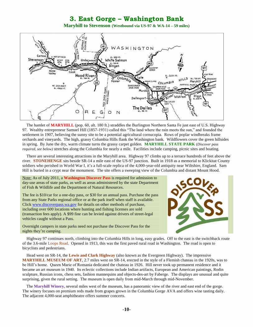
3. East Gorge – Washington Bank
Maryhill to Stevenson (Westbound via US-97 & WA-14 – 59 miles)
The hamlet of MARYHILL (pop. 60, alt. 180 ft.) straddles the Burlington Northern Santa Fe just east of U.S. Highway
97. Wealthy entrepreneur Samuel Hill (1857-1931) called this “The land where the rain meets the sun,” and founded the
settlement in 1907, believing the sunny site to be a potential agricultural cornucopia. Rows of poplar windbreaks frame
orchards and vineyards. The high, grassy Columbia Hills flank the Washington bank. Wildflowers cover the green hillsides
in spring. By June the dry, warm climate turns the grassy carpet golden. MARYHILL STATE PARK (Discover pass
required, see below) stretches along the Columbia for nearly a mile. Facilities include camping, picnic sites and boating.
There are several interesting attractions in the Maryhill area. Highway 97 climbs up to a terrace hundreds of feet above the
river. STONEHENGE sits beside SR-14 a mile east of the US-97 junction. Built in 1918 as a memorial to Klickitat County
soldiers who perished in World War I, it’s a full-scale replica of the 4,000-year-old antiquity near Wiltshire, England. Sam
Hill is buried in a crypt near the monument. The site offers a sweeping view of the Columbia and distant Mount Hood.
Highway 97 continues north, climbing into the Columbia Hills in long, easy grades. Off to the east is the switchback route
of the 3.6-mile Loops Road. Opened in 1913, this was the first paved rural road in Washington. The road is open to
bicyclists and pedestrians.
Head west on SR-14, the Lewis and Clark Highway (also known as the Evergreen Highway). The impressive
MARYHILL MUSEUM OF ART, 2.7 miles west on SR-14, erected in the style of a Flemish chateau in the 1920s, was to
be Hill’s home. Queen Marie of Romania dedicated the chateau in 1926. Hill never took up permanent residence and it
became an art museum in 1940. Its eclectic collections include Indian artifacts, European and American paintings, Rodin
sculpture, Russian icons, chess sets, fashion mannequins and objects-des-art by Faberge. The displays are unusual and quite
surprising, given the rural setting. The museum is open daily from mid-March through mid-November.
The Maryhill Winery, several miles west of the museum, has a panoramic view of the river and east end of the gorge.
The winery focuses on premium reds made from grapes grown in the Columbia Gorge AVA and offers wine tasting daily.
The adjacent 4,000-seat amphitheatre offers summer concerts.
Note: As of July 2011, a Washington Discover Pass is required for admission to
day-use areas of state parks, as well as areas administered by the state Department
of Fish & Wildlife and the Department of Natural Resources.
The fee is $10/car for a one-day pass, or $30 for an annual pass. Purchase the pass
from any State Parks regional office or at the park itself when staff is available.
Click www.discoverpass.wa.gov for details on other methods of purchase,
including over 600 locations where hunting and fishing licenses are sold
(transaction fees apply). A $99 fine can be levied against drivers of street-legal
vehicles caught without a Pass.
Overnight campers in state parks need not purchase the Discover Pass for the
nights they’re camping.

-11-
Highway 14 continues west along the benches and lower slopes of the rounded, grassy hills that rise in step-like succession
above the Columbia. The glistening white pyramid of Mount Hood commands the western horizon, rising above a stark
landscape coursed by the blue river. Patches of green farmland break the monotony.
A side road drops down to the riverside town of WISHRAM (pop. 340, alt 180 ft.). Founded by the Spokane, Portland &
Seattle Railroad (now Burlington Northern Santa Fe) in 1904, it was called Fallbridge until 1926. Wishram prospered into
the late 20th-century as a railroad division point with a busy switching yard and roundhouse. BNSF’s central Oregon line
branches off the mainline here. In prehistoric times, Native Americans gathered on the riverbank on the Washington side of
Celilo Falls to fish for salmon.
Three miles west the highway passes an access road to Avery Park, a windsurfing site. Another couple miles up the road
is Cascade Cliffs Winery specializing in red varietals. Their tasting room is open daily.
Columbia Hills State Park [Photo: Wash. State Parks]
COLUMBIA HILLS STATE PARK (Discover pass required, see p.
10) contains the largest concentration of Native American rock art in the
Northwest. Formerly known as Horsethief Lake State Park, the park
occupies the site of an Indian village, flooded by the reservoir behind
The Dalles Dam. Pictograph Trail leads to viewpoints showcasing the
ancient paintings and carvings on the cliff face. Due to vandalism, the
trail is open only to ranger-led guided tours offered Fridays and
Saturdays from April through October. Reservations are required; call
the park office at (509) 767-1159. The park has a campground and 1½
miles of river frontage with swimming, boating, windsurfing and fishing.
Rock climbing is popular on Horsethief Butte.
West of the junction with US-197 there are good views south to The
Dalles with its backdrop of Mount Hood. The landscape begins to
change. Oak and pine trees appear, first in protected sites; farther west
they dot the hillsides.
A paved road leads 2 miles south to DALLESPORT (pop. 1,200, alt. 220 ft.), located on a bench directly opposite The
Dalles. First called Rockport, later Grand Dalles and North Dalles, it was once an important trading town and served as seat
of Klickitat County until that function shifted to Goldendale. Linked with its larger Oregon neighbor by ferry until the bridge
opened in 1953, it’s now a quiet town flanked by orchards and the area’s airport.
The hamlet of MURDOCK (pop. 150, alt. 332 ft.) sits at the west end of Rowena Gap, the eastern rampart of the Columbia
Gorge. Steep slopes close in on the river. This narrow channel forced Ice Age floods some 12,000 years ago to temporarily
back up, eroding the hillsides a thousand feet above the river. At their base is Paha Cliffs, an impressive wall of regular
columnar basalt. DOUG’S BEACH STATE PARK (Discover pass required, see p. 10) is one of the gorge’s premier
windsurfing spots. The park is undeveloped and parking is at a premium, but the wind and river currents draw advanced
boarders from around the world.
Three miles west of Doug’s Beach is LYLE (pop. 500, alt. 140 ft.), at the mouth of the Klickitat River. Founded as
Klickitat Landing in 1880, it was renamed for James Lyle, who platted the townsite. In 1903 a railroad connected the town
with productive wheat and sheep ranching country in the upper Klickitat Valley. Cargo was loaded onto riverboats at the
landing until the north bank mainline opened in 1908. Mount Adams lamb was prized in eastern markets until the 1920s.
Today the sport of windsurfing is breathing new life into the community.
Highway 142 leads north from Lyle, through the scenic thousand-foot deep KLICKITAT GORGE. Stop at Fisher Hill
Bridge, two miles north of town. The bridge offers a great view of the narrow canyon where local Indians still fish with dip
nets from wooden platforms as they did at Celilo Falls. You may spot some old rope bridges, erected to provide access to
prime fishing spots. The lower 15 miles of the river are a noted whitewater rafting stream. A good way to discover this
lovely area is on the Klickitat Trail, a 30-mile recreation trail following the 1903 railroad right of way.
West of Lyle the forest thickens and the walls of the gorge close in. From various vantage points along this section you
can enjoy fine views of Mount Hood. Chamberlain Rest Area, 3 miles west of Lyle, has good spring wildflowers. There
are a variety of natural habitats among the lava terraces along nearby Catherine Creek. The desolate basalt rampart in the
Columbia’s mid-stream is Memaloose Island, an ancient Native American burial ground. Just down the road, Rowland
Lake is a nice spot for a picnic and fishing.
Luxuriant meadows herald our approach to BINGEN (pop. 735, alt. 130 ft.), on the flats opposite Hood River to which it
is connected by a toll bridge. Settlement started here in the 1850s. Over the next three decades, homesteaders planted fruit
orchards on the terraces above the river. German immigrants named the riverside hamlet, platted in 1892, for a like-named
city on the Rhine River. After the railroad arrived in 1908, Bingen became sawmilling town. A few of the buildings reflect

-12-
Germanic architectural themes. Stop by the Gorge Heritage Museum in the 1912 former Congregational Church at 202 E.
Humboldt Street, to learn about area history.
The adjoining town of WHITE SALMON (pop. 2,420, alt. 590 ft.) is located atop a bluff above the confluence of its
namesake river (named for the pale color of spawned-out salmon) with the Columbia. Orchards and small vineyards fringe
the outskirts. The bench-top location affords a panoramic view across the Columbia to Hood River and Mount Hood. The
post office was established in 1872, making White Salmon the older of the two communities. The two towns initially
disputed everything from water rights to the name of the local railway station. White Salmon too has traces of Germanic
motifs on some of its buildings including a Glockenspiel Tower, part of the City Hall at Jewett and Main.
The Bingen-White Salmon area offers a wide range of recreational activities including, windsurfing, kayaking, fishing,
golf, hiking and horseback riding. The White Salmon River offers excellent whitewater rafting with Class III, IV and V
rapids. The rafting season runs from March into December. There are also a number of small wineries in the area, most open
for wine tasting. The pleasant environs offer numerous scenic drives. Highway 141 is a scenic route, leading north along the
White Salmon River to Trout Lake and the foothills of Mount Adams.
Highway 14 crosses the White Salmon River to the community of UNDERWOOD (pop. 640, alt. 110 ft.), located beside
the Columbia at the base of a 300-foot bluff. Most of the residents live on the bench atop the bluff, in a district called
Underwood Heights. Its name recalls a pioneer homesteader who settled here in 1875 and platted a townsite in 1881. A
large lumber mill operated here until the mid 1980s. The Spring Creek National Fish Hatchery, on SR-14, is one of the
oldest hatcheries on the Columbia (established in 1901). Its visitor center documents the life cycle of the salmon. The
Hatchery is also one of the area’s prime windsurfing sites, but the strong winds and large swells make this for experienced
boarders only.
For several miles west of the hatchery SR-14 parallels the Broughton Log Flume. Until 1987 this water-filled trough
supported by wooden trestles floated lumber nine miles from the sawmill at Willard (north of Cook) down to the riverside
finishing mill at Underwood, a vertical drop of 1,000 feet. This was the last operating flume of its type in the country.
Arrowleaf balsamroot cloaks the slopes of Dog Mountain [Photo: Skamania County Chamber of Commerce]
Between Underwood and Cook, SR-14 runs along the widening
Columbia at the base of Mount Underwood. This stretch of
highway, noted for its design, frequently tunneling through the rocky
promontories rising abruptly from the river, opened in 1937. An
embankment supporting the highway and railroad encloses Drano
Lake, a popular fishing and boating area at the mouth of the Little
White Salmon River.
From COOK (pop. 100, alt. 105 ft.), a county road parallels the
Little White Salmon. Two hatcheries upstream raise Chinook and
Coho salmon. Two and a half miles west of Cook look for the Dog
Mountain Trailhead (trail No. 147). The steep, three-mile trail
twists up the flanks of 2,948-foot Dog Mountain offering sweeping
views. Its meadows abound in wildflowers, at their peak from mid-
May to mid-June.
Continuing westward, the vegetation becomes more verdant and the Columbia widens. Passing curiously-shaped Wind
Mountain, Douglas fir gradually replaces Ponderosa pine. At HOME VALLEY (pop. 40, alt. 120 ft.) we enter lush farming
country; the mountains open up to the north embracing the Wind River Valley. Norwegian homesteaders settled here in the
early 1890s, calling the district Heim Dal.
The highway crosses Wind River. A mile west, a side road leads a mile north to the town of CARSON (pop. 500, alt. 242
ft.), located on the bench-like floor of the lower Wind River Valley. Its name is a corruption of Kastner, an early settler,
although it was first called Ash. Lewis and Clark passed through this area in 1805, recording the presence of ash trees, the
first they had seen on their journey. Oregon ash (Fraxinus oregona) is a common hardwood along the streams and moist
valleys west of the Cascades. Carson Mineral Hot Springs Resort, a mile east on Hot Springs Avenue, was built 1897-
1901. It offers modest accommodations and therapeutic bath treatments in 126ºF mineral water. The Forest Service
established Wind River Experimental Forest in 1912, nine miles north of Carson, to test how non-native tree species would
adapt to the Northwest environment. The conclusion: indigenous trees are best adapted to survive here.
Highway 14 continues three miles west to Stevenson.

-13-
4. West Gorge – Washington Bank
Stevenson to Camas (Westbound via WA-14 – 30 miles)
STEVENSON (pop. 1,530, alt. 103 ft.) was established as seat of Skamania County in 1893. Its name recalls pioneer
fisherman and legislator John Stevenson. Just downstream from here is the site of Cascade Rapids, where fish wheels up to
40 feet in diameter once mechanically harvested salmon until they were outlawed by Washington in 1934 (following
Oregon’s lead in 1926). Stevenson’s original business district faces the Columbia. Its streets feature a range of interesting
shops and cafés and the Sternwheeler Columbia Gorge offers sightseeing boat trips on the river from Memorial Day into
December. Over the decades, the town has spread into the low hills above the river. The Columbia Gorge Interpretive
Center Museum, 990 SW Rock Creek Drive has comprehensive exhibits chronicling the natural and human history of the
area. Among the highlights are a full-scale replica of a fish wheel and the world’s largest collection of rosaries. The center is
open daily. Skamania Lodge, a destination resort crowning a wooded hill on the west side of town, draws guests from far
and wide.
The seven-mile stretch between Stevenson and North Bonneville is part of a massive, still active slide, which explains the
jumbled nature of the local topography – look up the hillside to the north of the highway. In about 1250 A.D. a gigantic
landslide here temporarily dammed the Columbia River, forming a lake that extended 135 miles upstream. The river
eventually broke through, but the narrowed channel remained studded with rocks, forming dangerous rapids.
Several miles downstream from Stevenson, the Bridge of the Gods (toll) spans the Columbia to Cascade Locks, Oregon.
West of here the highway passes the Washington side of BONNEVILLE DAM. The dam consists of four sections
connecting a series of rocky islands. Its Washington Shore Visitor Center describes the hydroelectric facility and area
history. The Fish Viewing Building has windows looking into the fish passageway. The building of the dam’s second
powerhouse in the mid-1970s forced the relocation of the town of North Bonneville.
Here too is site of Cascades, also known as Lower Cascades. In the early 1850s, this was the largest European settlement
in Washington Territory, was the site of Fort Cascades (established 1856) and became the seat of Skamania County when it
was established in 1854, prospering as a steamboat landing and portage around the rapids. The county seat moved upstream
to Stevenson in 1893 and a flood destroyed Cascades the following year. The community was reborn as the town of North
Bonneville when work started on Bonneville Dam in 1933.
The reincarnation of NORTH BONNEVILLE (pop. 965, alt. 74 ft.), four miles west of the dam, is a planned community
dedicated in 1978 after the construction of Bonneville Dam’s second powerhouse took over the original townsite. Bonneville
Hot Springs Resort is an upscale accommodation on the eastern edge of town. Its Day Spa offers a range of body
treatments, facials, massage and mineral baths.

-14-
Beacon Rock is a landmark of the west gorge [Photo: Washington State Parks]
Three miles west of North Bonneville stands Beacon Rock, an 848-foot
monolith towering above the highway (pictured at left). Thought to be the
vent plug of an ancient volcano, Beacon Rock is one of the largest features
of its kind in the world and forms the centerpiece of BEACON ROCK
STATE PARK (Discover pass required, see p. 10), created in 1938.
Lewis and Clark named the feature in 1805, but it was called Inoshoak
Castle and Castle Rock from 1811 until 1916, when the U.S. Board on
Geographic Names restored its original moniker. No one was able to
climb the monolith until 1901. In 1915 Henry Biddle purchased the rock
for $1 and started work on a trail to the summit the following year; it was
completed in 1918. The ¾-mile trail ascends the monolith at a 15 percent
grade, using 53 switchbacks and sections of steps and catwalks, all lined
by railing. The climb affords spectacular views.
The state park, which also includes 9,500 feet of river shoreline and nearby 2,500-foot Hamilton Mountain, has a
campground, picnic sites and more than 20 miles of trails for hiking, mountain biking or equestrian use. The river off Beacon
Rock marks the furthest upstream reach of tidal forces, a phenomenon described by Lewis and Clark in 1805.
West of the park, the Lewis and Clark Highway winds along the lower slops of forested hills overlooking the Columbia.
Through the trees you can occasionally glimpse the silvery waterfalls on the Oregon bank. The village of SKAMANIA
(pop. 200, alt. 55 ft.), a mile west of the park, bears an Indian name meaning swift water. It was first called Butler. Two
miles west the highway passes Franz Lake, a wildlife refuge. Birding is best here in winter, when tundra swans and other
migratory species are in residence.
Five miles west a side road leads down to the river at PRINDLE (alt. 56 ft.), a former station on the railway.
Homesteaders planted orchards on the slopes beside the river here in the early 1850s. A mile west, the highway begins its
route around the steep headland known as Cape Horn. A narrow lane winds down to the former settlement of CAPE
HORN, a way stop for 19th-century steamboats. Hudson’s Bay Company traders bestowed the evocative name to this
eminence in the mid 1820s as this stretch of river was particularly challenging – “like ‘rounding the Horn at the tip of South
America.”
This is one of the most spectacular sections of the Lewis and Clark Highway. The road hugs the cliffs over 700 feet above
the river offering panoramic views eastward. This was the most challenging part of the road for highway engineers who were
forced to blast the roadbed out of the almost sheer walls. A shed protects one section from rockfall and winter snow slides.
The railroad passes through a long tunnel beside the river at its base. Prior to 1929, when the Cape Horn route opened, the
highway took a more circuitous route away from the Columbia following the Washougal River into its namesake town.
The highway continues west, gradually dropping back down to river level. Farming country becomes more prevalent.
MOUNT PLEASANT (alt 120 ft.) is a small rural community. Look for the 1889 Mount Pleasant Grange beside the
highway, Washington’s oldest grange hall still in use. The highway skirts Steigerwald Lake National Wildlife Refuge at
the western edge of the Columbia River Gorge National Scenic Area. Its marshes and ponds provide habitat for over 200
avian species.
WASHOUGAL (pop. 14,210, alt. 65 ft.) is a pleasant city of tree-shaded streets straddling a peninsula between the
Columbia and its namesake river. Bearing an Indian name meaning rushing water, Washougal is the Washington gateway to
the Columbia Gorge and marks the eastern edge of the Portland-Vancouver metropolitan area. At Reed Island, three miles
southeast, the crew of the H.M.S. Chatham claimed the Columbia River for England in October, 1792. The expedition’s
leader William Broughton also named Mount Hood. Lewis and Clark camped at Cottonwood Beach on the Washougal River
(then called the Seal River) in March 1806. Settlement began along the Washougal River in the late 1840s, after American
possession of the Oregon Country north of the Columbia River was established in 1846. A townsite was platted in 1880 and
Washougal was incorporated in 1908.
The textile industry has been important since the early 1900s, and the Pendleton Woolen Mill, #2 17th Street, has
operated since 1912. Guided tours, offered weekdays except for a two-week period in August and December, demonstrate
how raw wool is made into fabric. Their factory store is open daily except major holidays. A block west at #1 16th Street,
Two Rivers Heritage Museum has exhibits documenting area history from Native American times to pioneer settlement.

-15-
CAMAS (pop. 21,220, alt. 80 ft.) adjoins Washougal on the west. First called LaCamas, its
name is derived from Camissia esculenta, a blue-flowered lily with an edible onion-like bulb
favored by Native Americans. The town was platted in 1883 when the site was selected for an
industrial center. Camas is known as the City of Paper for its giant waterfront mill,
established in the 1880s to supply newsprint to the Portland Oregonian, and its high school’s
mascot is the Papermakers. The Georgia Pacific mill now produces paper for towels and copy
machines. Mill employment, which once stood at over 3,000, has dropped to about 500.
Streets in the adjacent downtown district (pictured at left) are lined with trees, flower boxes
and benches.
The Lewis and Clark Highway bypasses the city to the south and via Lady Island. At the
western edge of Camas SR-14 becomes a freeway, which continues westward to
VANCOUVER (pop. 170,400, alt. 42 ft.). Our Auto Tour ends at the junction with I-205.
KEEPING
INFORMED ON
THE ROAD Here is a listing of
Columbia Gorge radio
stations . . .
GRESHAM KMHD – 89.1FM (NPR)
HOOD RIVER KIHR – 1340AM
KBNO – 89.3FM
KQHR – 90.1FM
KOPB – 94.3FM (NPR)
KZAS – 95.1FM
KCGB – 105.5FM
PORTLAND (selected stations)
KPOJ – 620AM
KXL – 750AM
KEX – 1190AM
KOPB – 91.5FM (NPR)
THE DALLES KACI – 1300AM
KODL – 1440AM
KOTD – 89.7FM (NPR)
KACI-FM – 97.7FM
KYYT – 102.3FM
KMCQ – 104.5FM
__________________________________________________________________
Photos by John King unless otherwise noted, Maps drawn by John King Updated 5 August, 2015- jpk
Be sure to pick up the latest edition of the AAA Oregon & Washington TourBooks at your local office!
For the first time ever, Oregon & Washington have
separate AAA TourBooks!
Redesigned in 2012, TourBooks contain updated
information on
Attraction Pricing & Hours of Operation
Exclusive Diamond Ratings for AAA-Approved Lodging & Restaurants
Best of all, TourBooks are FREE for members!
Download AAA Apps for Android & iPhone
Discounts, Roadside Assistance & TripTik Maps Available – Click www.aaawa.com to Download