Columbia County, Georgia
119
Columbia County, Georgia and the Cities of Grovetown and Harlem Multi-Jurisdictional Hazard Mitigation Plan 2021-2026
Transcript of Columbia County, Georgia

Columbia County, Georgia
and the Cities of
Grovetown and Harlem
Multi-Jurisdictional Hazard Mitigation Plan
2021-2026

Columbia County, Georgia
and the Cities of Grovetown and Harlem
Multi-Jurisdictional Hazard Mitigation Plan
Original Plan Approval: 08/17/2004
1st Update Plan Approval: 10/04/2011 2nd Update Plan Approval: 08/08/2016 3rd Update Plan Approval: ??/??/2021
Prepared For: Columbia County Emergency Management Agency
650-B Ronald Reagan Drive Post Office Box 498
Evans, Georgia 30809 Office - (706) 868-3303 Fax - (706) 868-3343
Prepared By: Central Savannah River Area
Regional Commission 3626 Walton Way Extension Suite 300
Augusta, Georgia 30909 (706) 210-2000
FAX (706) 210-2006

2021 Multi-Jurisdictional Hazard Mitigation Plan Update
TABLE OF CONTENTS
Page # Chapter One: Introduction to the Planning Process…………………………………………. 1
I. Purpose and Need of the plan, Authority & Statement of Problem………… 1 II. Local Methodology, Plan Update Process and Participants……………….... 2
III. Original Plan Review and Revision………………………………………….. 7 IV. Organization of the Plan……………………………………………………… 7 V. Local Hazard, Risk and Vulnerability…………………………..…………… 8
VI. Multi-Jurisdictional Considerations………………………………………….. 9 VII. Adoption, Implementation, Monitoring & Evaluation……………………..... 10
VIII. Plan Integration and Maintenance………………………………………….... 11 IX. Community Data……………………………………………………………...11
Chapter Two: Local Natural Hazard, Risk & Vulnerability (HRV) ………………………...19
I. Flooding………………………………………………………………..……..20 II. Tornado………………………………………………………………….….. .29
III. Earthquake…………………………………………………………………… 34 IV. Winter Storms …………………………… ………………………………… 38 V. Hurricanes/Tropical Storms ...……………………………………………… 41
VI. Drought…………………………………….…………………………............ 45 VII. Severe Thunderstorms……………………………………………………..… 49
VIII. Wildfires………………….………….………………………………………. 51 IX. Extreme Heat………………………………………………………………… 56 X. Dam Failures………………………………………………………………… 59
XI. Lightning…………………………………………………………………….. 62 XII. Hail………………………………………………………………………….. .64
Chapter Three: Mitigation Strategy…………………………………………………………..67
I. Introduction to Mitigation....……………….…………………………..……..68 II. Natural Hazards...…………………………………………………….............78
A. Flooding Action Plan………………...…………………….…………78 B. Tornado Action Plan....………………………………………….……78 C. Earthquake Action P………………………………………………….79 D. Winter Weather Action Plan………………………………………….79 E. Tropical Storm/Hurricane Action Plan……...……………………..…80 F. Drought……………………………………………………………….80 G. Severe Thunderstorm Action Plan……………………………………80 H. Wildfire Action Plan………………………………………………… 81 I. Extreme Heat Action Plan……………………………………………81 J. Dam Failure Action Plan……………………………………………..82 K. Lightning Action Plan………………………………………..……….82 L. Hail Action Plan………………………………………………………82
III. Mitigation Actions……………………………………………………………83 IV. Completed and Deleted Action Steps………………………………………...96
Chapter Four: Plan Integration and Maintenance…………………………………………....107

Columbia County
I. Implementation Action Plan …………………………………………………107 II. Evaluation, Monitoring, Updating……………………………………………110
III. Plan Update and Maintenance ……………………………………………...112 Chapter Five: Conclusion…………………………………………………………………......113
I. Summary……………………………………………………………………....113 II. References……………………………………………………………………..114
Appendices …………………………………………………………………………………...115

2021 Multi-Jurisdictional Hazard Mitigation Plan
Columbia County 1
CHAPTER I. INTRODUCTION TO THE PLANNING PROCESS Table 1.1 provides a brief description of each section in this chapter and a summary of the changes made. Table1.1
Chapter I. Sections Section Updates I. Purpose and Need of the Plan,
Authority & Statement of Problem Updated text of this section
II. Local Methodology, Plan Update Process and Participants
Updated list of committee members, revised information and text for the planning process.
III. Original Plan Review and Revision All sections of the original plan were analyzed and revised as needed.
IV. Organization of the Plan The plan is organized by GEMA local planning Local Hazard Mitigation Plan (HMP) Update Template and includes a timeline.
V. Local Hazard, Risk, and Vulnerability Summary, Local Mitigation Goals and Objectives
Reviewed all information and revised all content as needed.
VI. Multi-Jurisdictional Special Considerations
Reviewed and updated information regarding multijurisdictional concerns.
VII. Adoption, Implementation, Monitoring and Evaluation
This was evaluated. Additional text was added to clearly delineate the task of implementation and monitoring. Plan was adopted and submitted to GEMA and FEMA review.
VIII. Community Data Updated demographic and information for each jurisdiction
SECTION I. PURPOSE AND NEED OF THE PLAN, AUTHORITY AND STATEMENT
OF PROBLEM The Columbia County 2021 Plan Update is the review and improvement on our Multi-Hazard Pre-Disaster Mitigation Plan approved in August 2005 and subsequently updated and approved on November 10, 2011 and August 8, 2016. The update is written to comply with Section 409 of the Robert T. Stafford Disaster Relief and Emergency Assistance Act Title 44 CFR as amended by Section 102 of the Disaster Mitigation Act of 2000. The act gives state and local governments the framework to evaluate and mitigate all hazards as a condition of receiving federal disaster funds. The act provides federal assistance to state and local emergency management and other disaster response organizations in an effort to reduce damage from disasters. The plan has involved multiple community partners including elected officials, city and county personnel, fire, emergency medical services, law enforcement, and the business community. The ultimate goal of this plan is to identify natural hazards and develop strategies to lessen the impact on our community. The Columbia County Emergency Management Agency (EMA) is responsible for presenting this planning document on behalf of Columbia County, including all cities therein. The plan identifies

2021 Multi-Jurisdictional Hazard Mitigation Plan
Columbia County 2
all natural disasters that could threaten the lives and properties of our community. The scope of the update includes both short- and long-term mitigation strategies, implementation and possible sources of project funding. The plan also contains the following information on:
• The vision of mitigation in our community; • The profile of Columbia County, its geography, history, physical features and other
community indicators; • The planning process and the involvement of all municipal, state and federal governments,
the public, industry and other community players; • Documentation of past and predicted exposure to natural hazards and the potential risks that
include the impacts on critical infrastructure with anticipated losses; • An overview of all three jurisdictions’ capabilities to implement hazard mitigation goals
and objectives and policies that will effectively mitigate risks to the community; • Procedures for maintaining an effective, long-range HMP and strategy to implement; • An assessment of current policies, goals and regulations that pertain to hazard mitigation; • Documentation of the planning process; • Updated hazard events that occurred since 2016; • Updated critical facilities; • Documented mitigation strategies implemented since 2016; and • Examined and updated mitigation strategy goals, objectives and action steps.
The update is the product of the combined efforts of Columbia County and the cities of Grovetown and Harlem. Realizing that identifying the community’s risks and working collectively toward the prevention of disasters is in the county’s best interest, the EMA took the lead role in the update. Under the EMA’s leadership, there has been an endorsement and a commitment by Columbia County as well as the cities of Grovetown and Harlem. Continued mitigation planning is imperative to lessen the impacts of disasters in all three jurisdictions. This plan serves as an excellent method to organize and document current and ongoing mitigation strategies. The implementation of the plan and its components is vital to achieve a community that is resistant to the impact of a disaster. It is the goal of this plan, that implementation will result in a reduction of the loss of life and property, allowing the county to prosper with minimal disruption of services to the community. SECTION II. LOCAL METHODOLOGY, PLAN UPDATE PROCESS AND
PARTICIPANTS The Columbia County Board of Commissioners (BOC) contracted with the Central Savannah River Area Regional Commission (RC) to assist in the plan update. The RC has assisted eleven counties in the completion and update of their Pre-Disaster Mitigation Plans. The RC was tasked to review the current plan and identify and incorporate new information. The RC in conjunction with the EMA Director, supervised the project, organized the data, set meeting dates, documented in-kind services, and worked with GEMA to complete the update. The EMA Director was tasked with developing the HMP Committee. Table 1.2 identifies the 2021 planning committee members.

2021 Multi-Jurisdictional Hazard Mitigation Plan
Columbia County 3
Table 1.2 Name Title Organization
Scott Johnson County Manager CC Board of Commissioners Glenn Kennedy Deputy County Manager CC Board of Commissioners Matt Schlachter Deputy County Manager CC Board of Commissioners Andy Leanza EMA Director *(former) CC Board of Commissioners Shawn Granato EMA Deputy Director *(current) CC Board of Commissioners Suzie Hughes EMA Specialist CC Board of Commissioners Connie Smith Floodplain Manager CC Board of Commissioners Bill Clayton Water & Sewerage Division Director CC Board of Commissioners Mark Inglett Water & Sewerage Operations Manager CC Board of Commissioners
Margaret Doss Water & Sewerage Environmental Compliance Manager CC Board of Commissioners
Mike Zahner Stormwater Operations Manager CC Board of Commissioners Jeremy Wallen Fire Chief, Fire Rescue CC Board of Commissioners Jimmie Paschal Asst. Fire Chief, Fire Rescue CC Board of Commissioners Danny Kuhlmann Operations Chief, Fire Rescue CC Board of Commissioners David Dickenson Training Chief, Fire Rescue CC Board of Commissioners John Evans Lt., Fire Rescue CC Board of Commissioners Michael Blanchard Technology Services Director CC Board of Commissioners Larry Hobbs GIS Manager CC Board of Commissioners Sean McArdle Information Technology Manager CC Board of Commissioners Harold Sparrow Broadband Utility Manager CC Board of Commissioners Tim Holloway Roads & Bridges Manager CC Board of Commissioners Paul Scarbary Development Services Director CC Board of Commissioners John Luton Community & Leisure Services Director CC Board of Commissioners Capt. Butch Askew Captain Spec. Ops, Sheriff's Office CC Board of Commissioners John Hutcherson Lt., Fire Rescue CC Board of Commissioners David Bullard Lt., Fire Rescue CC Board of Commissioners Stephanie Pilcher Manager, CSIC/3-1-1 CC Board of Commissioners Vince Brogdon EMS Director Gold Cross EMS John T. Y. Smith Director of Operations Gold Cross EMS Jim Adkins LEPC Member / Private Sector Citizen Christine Jay LEPC Member / Private Sector Industry - Club Car Wendall Freeman LEPC Member / Private Sector CSX Railroad Caroline Guay LEPC Member / Private Sector Industry - Dixie LP Gas Pat Brown LEPC Member / Private Sector Industry - John Deere Doug Varnadore LEPC Member / Private Sector Industry - AB Beverage Jennifer Weeks LEPC Member / Private Sector University Hospital Andy Moats LEPC Member / Private Sector Hepaco Penny Jackson Associate Superintendent CC Board of Education Brett Cook City Manager City of Harlem

2021 Multi-Jurisdictional Hazard Mitigation Plan
Columbia County 4
Name Title Organization Robert Fields Director of Public Works City of Harlem Rob Lewis Police Chief City of Harlem Tripp Lonergan Fire Chief City of Harlem Kevin Stokes Assistant Fire Chief City of Harlem John Waller City Administrator City of Grovetown Scott Wheatley Chief of Public Safety City of Grovetown Capt. Wayne Kent Capt. - City Fire Services City of Grovetown Michael Woods Director of Public Works City of Grovetown Allison Foster Investigator, Grovetown DPS City of Grovetown Linda Graves Nurse Manager Dept. of Public Health Andrea Frazier Environmental Health Manager Dept. of Public Health Lindsey Land Operations Supervisor Atlanta Gas Light Company Mike Lewis Distribution Operations Manager Georgia Power Company Nathanial Haynes Emergency Manager Ft. Gordon, GA Tammy Shepherd President/CEO CC Chamber of Commerce Jennifer Kennedy QA Specialist, Augusta 9-1-1 Augusta-Richmond County
The committee was responsible for the organization, data collection and completion of the plan. It is the responsibility of the committee to include all pertinent departments within their respective governments and to request information needed for plan completion. The following agencies/departments/organizations provided specific information and support for the original plan and provided any new information for the update:
• Columbia County officials, department heads and staff were responsible for providing information for critical facilities relative to their departments, updating hazard events, identifying completed mitigation strategies and developing new strategies.
• Columbia County Health Department and Columbia County DFCS, identified vulnerable populations.
• Columbia County Fire Department provided staff support to the planning effort and contributed to mitigation strategies.
• Columbia County Road Department provided information on past effects on roads during hazard events.
• Grovetown and Harlem city officials and department heads provided information relative to their jurisdiction and updated critical facilities.
• Georgia Forestry Commission provided data on wildfire events and assisted with the formulation of mitigation measures.
• Columbia County EMA identified mitigation goals related to natural disasters. • Columbia County Development Authority assisted in identifying major businesses. • Columbia County Tax Assessor’s Office provided most of the aggregate values for the
critical structures. The valuations had to be converted to full values since they are figured at 40 percent of actual value. This information, combined with demographic data, is compiled on GEMA Worksheet #3a in Appendix A for all jurisdictions.
• Columbia County GIS produced several of the maps contained in the plan. Maps are located in Appendix A.

2021 Multi-Jurisdictional Hazard Mitigation Plan
Columbia County 5
Several resources were consulted to facilitate the development of the update. Data was collected from numerous sources, including the National Centers for Environmental Information (NCEI) Spatial Hazard Events and Losses Database for the United States (SHELDUS™), National Weather Service, US Geological Survey (USGS), Southeast Regional Climate Center (SERCC), US Census Bureau, Georgia Department of Natural Resources (DNR), Georgia Forestry Commission (GFC), Georgia Tornado History Project Database, Georgia Department of Community Affairs (DCA), US Department of Agriculture (USDA), and local and regional newspaper articles, as well as personal interviews. Table 1.3 provides a list of existing planning documents that provided information necessary for the completion of the plan update. Table 1.3
Record of Review Existing planning mechanisms Reviewed?
(Yes/No) Method of use in HMP
Columbia County Comprehensive Plan - Vision 2035
Yes Development trends, capability assessment, mitigation strategies
Harlem Comprehensive Plan 2016-2026
Yes Development trends, capability assessment, mitigation strategies
Grovetown Comprehensive Plan 2016-2026
Yes Development trends, capability assessment, mitigation strategies
Local Emergency Operations Plan
Yes Identifying hazards; Assessing vulnerabilities; Capability assessment
Georgia Emergency Operations Plan
Yes Identifying hazards; Assessing vulnerabilities;
Flood Damage Protection Ordinance
Yes Mitigation strategies, capability assessment
Building and Zoning Codes and Ordinances
Yes Development trends; Future growth, capability assessment, mitigation strategies
Storm Water Management Plan Yes Development trends; Future growth, capability assessment, mitigation strategies
Greenspace Plan Yes Development trends; Future growth, capability assessment, mitigation strategies
Regional Transportation Plan Yes Development trends; Future growth, capability assessment, mitigation strategies
Debris Management Plan Yes Capability assessment, mitigation strategies Mutual Aid Agreements Yes Assessing vulnerabilities, Determine assets
added to disaster relief and response. State Hazard Mitigation Plan Yes Risk assessment, review of recommended
strategies Hazard Risk Analyses Supplement (Hazus-MH) to the Columbia County Joint HMP
Yes Assessing vulnerabilities, Determine assets added to disaster relief and response.
Land Use Maps Yes Assessing vulnerabilities; Development trends; Future growth
Critical Facilities Maps Yes Locations

2021 Multi-Jurisdictional Hazard Mitigation Plan
Columbia County 6
Record of Review Existing planning mechanisms Reviewed?
(Yes/No) Method of use in HMP
Community Wildfire Protection Plan
Yes Mitigation strategies, risk assessment
Southern Wildfire Risk Assessment Summary Report.
Yes Assessing vulnerabilities, Mitigation strategies, risk assessment
Columbia County, Georgia Emergency Evacuation Plan For Dam Failure and Flooding Savannah River Dams
Yes
Risk Assessment, Mitigation strategies, capability assessment
Flood Insurance Study Yes Review for historical Data and Information CSRA Regional Plan 2040 Yes Development trends; Future growth, regional
concerns and data The committee held four meetings over a 22-month period to guide the development of the plan. Individual jurisdictions and/or agencies were contacted, as information was needed. The committee was responsible for developing the mission statement, as well as the goals, objectives, and action steps identified in the plan. The committee researched previous hazard information in the areas of flooding, wildfires, tornados, winter storms, hurricanes/tropical storms, extreme heat, severe thunderstorms, dam failure, earthquake, lightning, hail, and drought. Other hazards, such as avalanche, coastal erosion, coastal storm, expansive soils, land slide, SLOSH (Sea, Lake and Overland Surges from Hurricanes), Tsunami, and Volcano, were examined and eliminated due to their low level of risk. Committee members collected critical facilities information based on their area of expertise or jurisdiction. The RC was responsible for assessing vulnerability and estimating potential losses from the information collected. Potential losses include people, structures/properties, infrastructure, and other important community assets. Table 1.4 provides the dates and synopsis of committee meetings. All meetings were open to the public and meeting notices posted at governmental offices. Of the four meetings, two were advertised in The Columbia-News Time, the County’s legal organ. This is the most efficient means to disseminate information to residents and organizations located in the county. In order to meet the requirement to afford an opportunity for neighboring communities, local and regional agencies, businesses, academia and other private and non-profit interests to be involved in the planning process, invitations were extended by email. Invitations were extended to the following counties: Burke, Glascock, Hancock, Jefferson, Jenkins, Lincoln, McDuffie, Richmond, Taliaferro, Washington, Warren, and Wilkes including all their municipalities. It is noted that no public comments or feedback was provided by the public. Copies of correspondence, emails and advertisements are in Appendix E.
2021 Multi-Jurisdictional Hazard Mitigation Plan
Columbia County 7
Table 1.4 Ad/Meeting Date Purpose of Meeting
August 28, 2019 Public meeting notice ran in The Columbia-News Time, to advertise the kick-off meeting for September 4, 2019.
September 4, 2019 Meeting was to kick-off planning process. Discuss changes since last change. Begin critical facilities update and review of hazard events since 2016 update.
January 30, 2020 Reviewed Critical Faculties Data, began discussion on Mitigation Strategies and Update hazards since last plan.
August 26, 2020 This meeting was to ensure all data collected to date was correct with regards to critical facilities. Review of mitigation strategies were completed and new strategies identified.
Add after GEMA/FEMA approval
Public Meeting Notice ran in The Columbia-News Time, Advertising for public review and the date of final meeting
Add after GEMA/FEMA approval
After GEMA submitted the plan to FEMA and FEMA Approved Pending Adoption, the public was invited to review the final plan prior to adoption. The meeting was held after the review period to ensure that the public was afforded the opportunity provide input.
SECTION III. ORIGINAL PLAN REVIEW AND REVISION The Federal Disaster Mitigation Act of 2000 requires an update to the Pre-Disaster Mitigation Plan every five years. The EMA Director was responsible to meet this requirement. The committee, with the assistance of the RC, was involved in the planning process to ensure thorough data collection. All members of the committee were responsible for the evaluation of 2016 plan. During the review process, the committee noted mitigation accomplishments, updated and prioritized mitigation projects, added additional hazard information, developed new goals and objectives, solicited input from the public and made any needed or required revisions. The evaluation included analyzing any changes in the needs and/or capabilities of the county. SECTION IV. ORGANIZATION OF THE PLAN The estimated time to complete the plan update was approximately 22 months. Plan completion is identified by adoption of resolution by all jurisdictions. The update contains a Hazard, Risk, and Vulnerability (HRV) Assessment describing the natural hazards occurring within the county, as well as a review of all mitigation goals, objectives, and related courses of action. In addition, plan implementation and maintenance are reviewed, which includes methods to provide opportunities for public involvement. The hazards included in this plan are considered to have the highest probability of occurrence. The plan also identifies and prioritizes hazard mitigation opportunities in each area based on the input from the committee members, relevant government agencies, local businesses, and county citizens.

2021 Multi-Jurisdictional Hazard Mitigation Plan
Columbia County 8
SECTION V. LOCAL HAZARD RISK AND VULNERABILITY, SUMMARY LOCAL MITIGATION PLANNING GOALS OBJECTIVES
The committee, early in the update process, established a set of goals and objectives to ensure the effectiveness of this plan. These goals and objectives established the paradigm for the planning process and proved very successful by the many accomplishments of the 2016 plan. These goals and objectives are as follows:
• To actively involve and gain support from the cities of Grovetown and Harlem and Columbia County for the reduction of risk disasters in our community;
• Prioritize identified mitigation projects; • Seek and implement any grant funding to mitigation projects; • Monitor, evaluate, and update the progress of the plan as needed; • To form partnerships among local, state, and federal agencies to make Columbia County
more resistant to the effects of disasters; • Strengthen our communities against the impacts of disasters through the development of
new mitigation strategies and strict enforcement of current regulations that have proven effective;
• Reduce and where possible eliminate repetitive damage, loss of life and property from disasters;
• Bring greater awareness throughout the community about potential hazards and the need for community preparedness; and
• To further enhance common mitigation projects and goals between Columbia County and the cities of Grovetown and Harlem.
An HRV assessment was accomplished by compiling and reviewing historical data on the location of specific hazards, the value of existing assets located in hazard areas, and analyzing the risk to life, property and the environment. The committee accomplished the HRV goals and objectives by completing the following steps: Inventory of Critical Facilities: Critical facilities are crucial for providing essential services to preserve the safety and quality of life of all county residents. In addition, these facilities fulfill important public safety, emergency response, and/or disaster recovery functions. All critical facilities added to the Georgia Mitigation Information System (GMIS). Critical facilities for Columbia County and the cities of Grovetown and Harlem have been identified, updated, mapped, and illustrated in Appendix A. Hazard Identification: Maps and historical data sources were studied and reviewed to identify the geographic extent, intensity, and probability of occurrence for various hazard events. The committee identified 12 major hazards that have the potential to affect Columbia County: flooding, tornados, earthquakes, winter storms, hurricanes/tropical storms, drought, severe thunderstorms, wildfires, extreme heat, dam failure, lightning, and hail. An updated comprehensive hazard history for Columbia County as well as the cities of Grovetown and Harlem is provided in Appendix A.

2021 Multi-Jurisdictional Hazard Mitigation Plan
Columbia County 9
Profiling Hazard Events: The committee analyzed the causes and characteristics of each hazard to determine which part of the county’s population and infrastructure has historically been vulnerable to each specific hazard. An updated profile of each hazard is discussed in Chapter II. Vulnerability Assessment: This step was accomplished by comparing each previously identified hazard with the inventory of affected critical facilities and population exposed to each hazard. Worksheet #3a was updated and is provided in Appendix D outlining this step of the HRV assessment. Estimating Losses: Using the best available data, tax digest data, parcel maps, critical facilities maps and GMIS reports, allowed the committee to estimate damages and financial losses likely to be sustained in a geographic area. Describing vulnerability in terms of dollar losses provides a common framework in which to measure the effects of hazards on critical facilities. All information in this section has been updated (Appendix A and Appendix D). Mitigation Goals and Objectives: After ensuring that all interested persons had been given ample opportunity to contribute to strategy development, mitigation action steps were given priority status by committee members. To evaluate priorities, committee members used the STAPLEE (Social, Technical, Administrative, Political, Legal, Economic, and Environmental) planning tool prepared by FEMA. Mitigation strategy steps were evaluated using the STAPLEE worksheet as the guiding principle to identify the most beneficial and effective action steps for Columbia County. Steps were ranked as high priority, medium priority, or low priority. Past occurrences of disasters and historical trend data aided committee members in assigning priorities. A copy of the STAPLEE is located in Appendix D. SECTION VI. MULTI-JURISDICTIONAL SPECIAL CONSIDERATIONS Columbia County and the cities of Grovetown and Harlem provided active participants in the planning process and have identified mitigation goals, objectives and action items specific to their jurisdiction. The governing bodies for Columbia County and the cities of Grovetown and Harlem have formally adopted the Multi-Hazard Pre-Disaster Mitigation Plan. The cities of Grovetown and Harlem were notified in January 2018 of the requirement concerning the update plan. Representatives from all jurisdictions have worked collectively over the past months to gather data that included researching old records, newspaper articles, databases, historical data, past and present flood plain data, and technical information. Collected data was forwarded to the RC for review and plan development. The committee held subsequent meetings in an effort to ensure that all information was correct and that all agencies and organizations input was included. The EMA Director led activities for mitigation planning countywide. The committee goals are to work in partnership with the cities of Grovetown and Harlem toward a common mitigation strategy that significantly reduces vulnerability of natural disasters for all jurisdictions. Most natural threats overlap jurisdictions and are all susceptible to their affects. Columbia County and the cities of Grovetown and Harlem share the same desire for protecting and reducing risk through the

2021 Multi-Jurisdictional Hazard Mitigation Plan
Columbia County 10
mitigation projects. Specific risks and areas were identified through working relationships and data collection from all areas of the county and are identified in this plan. SECTION VII. ADOPTION, IMPLEMENTATION AND MONITORING AND
EVALUATION
Adoption Date Table 1.5
Adoption Date Columbia County Added after Approval by FEMA City of Grovetown Added after Approval by FEMA City of Harlem Added after Approval by FEMA
The plan was submitted to GEMA for review and then to FEMA for approval. Columbia County and the cities of Harlem and Grovetown served as active participants in the planning process and have identified mitigation goals, objectives, and actions specific to their jurisdiction. Their respective governing bodies have formally adopted the updated plan. The plan is intended to be implemented to enhance and complement state and federal recommendations for the mitigation of natural hazards in the following ways:
• Substantially reduce the risk of life, injuries, and hardship from the destruction caused by natural hazards;
• Create public awareness for the need of individual preparedness and building safer, disaster resistant communities;
• Develop strategies for long-term community sustainability during community disasters; and
• Develop governmental and business continuity plans that will continue essential private sector and governmental activities during disasters.
FEMA publishes many guidance documents for mitigating natural disasters. The plan fully recognizes, adopts, incorporates, and endorses the following principals:
• Develop a strategic mitigation plan for Columbia County; • Enforce current building codes; • Develop incentives to promote mitigation; • Incorporate mitigation of natural hazards into land use plans; • Promote awareness of mitigation opportunities throughout Columbia County on a
continual basis; and • Identify potential funding sources for mitigation projects.
The private sector is often an overlooked segment of the community during disasters. It is vital this sector is included in mitigation efforts that are consistent with state and federal recommendations as such:
• Develop mitigation incentives with insurance agencies and lending institutions; • Encourage the creation of a business continuity plan for the continuance of commerce
during disasters; and

2021 Multi-Jurisdictional Hazard Mitigation Plan
Columbia County 11
• Partner with businesses in effort to communicate with customers about the community hazards and possible solutions.
Also, individual citizens must be made aware of the hazards they face. Additionally, citizens need information on how to protect themselves from these hazards. They must be shown that mitigation in their community is an important part of reducing loss of life and property. Their support is critical to the success of any mitigation effort. The plan supports the following FEMA recommendations regarding individual citizens:
• Become educated on the hazards that your community and you may face; • Become part of the process by supporting and encouraging mitigation programs that reduce
vulnerability to disasters; and • That individual responsibility for safeguarding you and your family prior to a disaster is
essential. SECTION VIII. Plan Integration and Maintenance details the formal process to ensure this plan remains an active and relevant document. The maintenance process includes the annual monitoring and evaluating review, and producing a plan revision every five years. Additionally, Columbia County will develop steps to ensure public participation throughout the maintenance process. Finally, this section describes how Columbia County will incorporate the mitigation strategies identified in this plan into other relevant planning documents such as the Comprehensive Plans, Short-Term Work program (STWP) and its Local Emergency Operations Plan (LEOP). SECTION IX. COMMUNITY DATA Political Boundaries - Columbia County
Columbia County GA DCA Region 7 Georgia
History: Columbia County lies along the Savannah River in east central Georgia, bordering South Carolina just north of Augusta. It was created by an act of the Georgia legislature from a northern part of Richmond County on December 20, 1790. Named for explorer Christopher Columbus, the county was created in response to a request by settlers that they be given court sessions that would be more convenient than those held in Augusta. After the Georgia Railroad was laid through the county in the 1830’s, new communities such as Harlem and Grovetown sprang up and began to flourish. Today, Columbia County is a bustling, fast-growing suburban county. The county is also home to more than thirty prehistoric sites. The most notable, Stallings Island, a burial mound documenting a culture that flourished more than 4,000 years ago.

2021 Multi-Jurisdictional Hazard Mitigation Plan
Columbia County 12
The history of the city of Grovetown can be told through its cultural resources and those who built and occupied them. Some of these resources are still in existence, but many are gone forever, demolished by fire and the pressure of development throughout time. It is said that the community of Grovetown grew from Old Grove Baptist Church, established in 1808 in Columbia County. James M. Atkinson, a Georgia legislator, journalist, and the church’s minister, advocated for the community to incorporate. The city was incorporated in 1881 by charter from the Georgia General Assembly. James M. Atkinson is buried in the present day Grove Baptist Church Cemetery in Grovetown. The City of Harlem was founded in 1870 along the tracks of the Georgia Railroad. The city is located roughly half way between the state capitols of Georgia and South Carolina. Harlem’s location in southern Columbia County places it at the edge of the developing urbanized area of metro Augusta and adjacent to rural McDuffie County. Government: Columbia County is primarily comprised of an unincorporated jurisdiction governed by a Board of Commissioners. The county chairman, who is the chief elected officer responsible for the daily operations of the county government, is elected county wide every four years. As the board's presiding officer, the chairman sets the agenda and is responsible for the orderly conduct of commission meetings. In addition to the county chairman, there are also four elected commissioners. There are two municipalities located within Columbia County, with a small distribution of the population and land area. Both cities are governed by a Mayor and City Councils. The cities of Grovetown and Harlem participated in this planning effort, which included critical facility update, HRV information and mitigation strategy information for their respective governments. Demographics: Columbia County encompasses an area of roughly 308 square miles (197,120 acres), of which 290 square miles is land and 18 square miles is water. It is the seventh fastest growing county in Georgia. According to the U. S. Census 2019 American Community Survey 5-year Estimates (ACS) population for the County is 150,075, a 7.3 percent increase since 2015. Over the next 20 years Columbia County is projected to grow by approximately 50 percent. Table 1.6 provides a current comparison of the three jurisdictions. Table 1.6
Category Columbia County Grovetown Harlem Population 150,075 14,053 3,137 Number of Households 47,215 4,028 1,021 Average Household Size 3.17 3.48 3.07 Race - White 73.9% 61.3% 76.7% Race - Black 16.7% 27.8% 21.5% Race - Other 9.4% 10.9% 1.8% Median HH Income $82,339 $68,756 $64,135
Source: US Census Bureau ACS 2019 5-Year Estimates
Economy: In 2020, the average weekly wage for employment sectors was $1,113, compared to the statewide average of $1,090. The county’s 2018 annual per capita income is $76,938 while

2021 Multi-Jurisdictional Hazard Mitigation Plan
Columbia County 13
Georgia’s is $55,679. In 2018, the total number of employees in Columbia County was 37,426. Of the total work force, 67.5 percent were employed in the service providing sector and 16.5% percent in the government sector. The current unemployment rate is 3.6 percent. In 2019, 4.1% percent of the population in Columbia County live below poverty level.
The North American Industry Classification System (NAICS) is the standard used by federal statistical agencies in classifying business establishments for the purpose of collecting, analyzing, and publishing statistical data related to the U.S. business economy. Table 1.7 provides a list of industries, number of establishments and number of employees along with average weekly wages per job for the 1st quarter of 2020. Table 1.7
Columbia County Industry Mix – 1st Quarter 2020
INDUSTRY Average
Number of Establishments
Average Monthly
Employment
Average Monthly Percent
Average Weekly Wages
Goods-Producing 419 5,768 15.4 1,113 Agriculture, Forestry, Fishing & Hunting 8 54 .1 685
Construction 340 2,587 6.9 890 Manufacturing 68 3,087 8.2 1,304
Beverage and Tobacco Product * * * * Textile Mills * * * *
Fabricated Metal Product 8 * * * Machinery 4 773 2.1 1,844
Transportation Equipment 4 * * * Service-Providing 2,076 25,341 67.7 645
Utilities 3 * * * Wholesale Trade 87 559 1.5 991
Retail Trade 328 6,315 16.9 624 Transportation and Warehousing 54 287 1.5 991
Information 26 380 1.0 1,189 Finance and Insurance 136 620 1.7 1,152
Real Estate and Rental and Leasing 102 699 1.9 772 Professional, Scientific & Technical Svc 253 1,934 5.2 1,028
Management of Companies and Enterprises 9 * * * Admin., Support, Waste Mgmt., Remediation 207 2,545 6.8 540
Educational Services 46 674 1.8 482 Health Care and Social Assistance 330 4,452 11.9 482
Arts, Entertainment, and Recreation 33 377 1.0 334 Accommodation and Food Services 242 4,720 12.8 303
Other Services (except Public Admin.) 220 1,295 3.5 644 Unclassified - industry not assigned 167 109 0.3 814 Total - Private Sector 2,662 31,218 83.4 731 Total - Government 112 6,209 16.6 869
Federal Government 7 442 1.2 1,505 State Government 11 548 1.5 665
Local Government 94 5,219 13.9 836

2021 Multi-Jurisdictional Hazard Mitigation Plan
Columbia County 14
Columbia County Industry Mix – 1st Quarter 2020 ALL INDUSTRIES 2,774 37,426 100.0 755
Source: Georgia Department of Labor * Industry group does not meet criteria for disclosure Climate: Columbia County gets 45 inches of rain per year. The number of days with any measurable precipitation is 101. On average, there are 218 sunny days per year in Columbia County, GA. The July high is around 92 degrees and the January low is 34. Table 1.8
Climate Columbia County Rainfall (in.) 45 Snowfall (in.) .5 Precipitation Days 101 Sunny Days 218 Avg. July High 91.8 Avg. Jan. Low 34.1 Comfort Index (higher=better) 7.4 UV Index 5 Elevation ft. 361
Source: http://www.bestplaces.net/climate/county/georgia/columbia
Physical Features: Columbia County encompasses an area of roughly 308 square miles (197,120 acres), of which 290 square miles is land and 18 square miles is water. Columbia County lies just north of the fall line and thus is located within the Piedmont geologic province. Significant aquifer recharge areas in this province are characterized by thick soils and low slopes.
The United States Department of Agriculture has determined that the State of Georgia contains seven (7) different soil profile areas. A soil profile represents an arrangement of soil layers of varying thickness and physical and chemical properties.
The profile located in Columbia County is the Carolina and Georgia Sand Hills. Carolina & Georgia Sand Hills - Consists of a belt of gently sloping to steep, well-drained soils originally derived from marine sands, loams, and clays. The area is largely covered with sparse forest of scrub oaks and pines and has poor to good suitability for residential development and commercial-industry uses. Different types of soils are represented in Grovetown. These soil types can be differentiated by the multiple types of different mineral particles in a particular sample. Soil map is in Appendix A
Transportation Vehicle Traffic: Columbia County has immediate access to I-20, a major east-west corridor. US 221 provides a north-south route through the county. Road types in the City of Grovetown include: city routes, county roads, state routes, arterials, and private roads. Grovetown residents and visitors struggle with traffic congestion in certain parts of the city. According to the Augusta
2021 Multi-Jurisdictional Hazard Mitigation Plan
Columbia County 15
Regional Transportation Study (ARTS), portions of Wrightsboro Rd are classified as marginally congested and portions of Robinson Ave are seriously congested. A tier 2 long-range (2019-2029) ARTS project will be the widening of Wrightsboro Rd from SR 388 to SR 383 and to insert a roundabout at Old Berzalia Road and Harlem Grovetown Road. A tier 3 long-range (2030-2040) ARTS project is the widening of Wrightsboro Rd from Harlem-Grovetown Rd to Louisville Rd., increasing from two four lanes. Table 1.9
Mileage by Route and Road System Report 445 for 2018 Total Road Mileage Lane Mileage Vehicle Miles Traveled
State Route 123 330 1,783,686 County Road 782 1,570 1,775,135 City Street 65 130 120,655 Total 970 2,029 3,679,476
Source: Georgia Department of Transportation, Office of Transportation Data, “445 Series Reports.”
Public Transportation: Columbia County Public Transit (CCPT) based in Grovetown GA is a demand‐response rural transit service available for all residents of Columbia County. CCPT provides curb‐to‐curb service Monday thru Friday between the hours of 8:30 a.m. to 4:30 p.m. serving destinations in Columbia and Richmond counties (with the exception of areas south of Gordon Highway). The earliest drop off time is 10:00 am and the latest pick‐up time is 3:30 p.m. Riders who require physical assistance to enter or leave the vehicle must provide a personal escort. There are no restrictions regarding trip purpose, such as to medical appointments, grocery shopping, education, etc., but trip reservations must be booked a minimum of one business day in advance. Due to the specialized nature of this demand‐response system, users are charged a premium fare. Rail Traffic: The cities of Grovetown and Harlem are bisected by one rail line, the CSX Transportation Atlanta to Augusta mainline. CSX is defined by the federal Surface Transportation Board as a Class 1 railroad, meaning that its average annual operating revenue meets or exceeds $255 million. The rail system is used for freight and non-passenger rail. There is currently no passenger rail in the county. Port and Aviation Facilities: There are no port facilities or public airports in Columbia County. The county is located in close proximity to 3 public use airports providing a range of aviation services to the CSRA region. The three (3) closest passenger airports to Columbia County are:
• The Augusta Regional Airport – 20 miles away (Augusta, GA) • The Columbia Metropolitan Airport- 77 miles away (Columbia, SC) • Greenville-Spartanburg International Airport-120 miles away (Greer, SC)
There are also two small, private airports located within the county. Utilities Electricity: Georgia Power and Jefferson Energy Cooperative provide service to Columbia County.

2021 Multi-Jurisdictional Hazard Mitigation Plan
Columbia County 16
Natural gas: Natural Gas is provided by Georgia Power and SCANA Energy.
Water: Columbia County’s drinking water is withdrawn from either the Savannah River or the Thurmond Lake Reservoir at Clarks Hill. Up to 46 million gallons per day is withdrawn from the Savannah River and is treated at the Jim Blanchard Water Treatment Facility on Point Comfort Road. The Clarks Hill Water Treatment Plant is capable of treating a daily maximum of 8 million gallons per day. The City of Grovetown operates a municipally-owned water and wastewater system. The city water department is responsible for the treatment and distribution of drinking water and handles the collection, treatment, and disposal of wastewater (sanitary sewage). The city’s water supply comes from two areas. Ninety percent of the city’s water comes from Columbia County, with whom the city has an agreement to purchase water. The remainder comes from the city’s one well currently online, fed by the Crystalline Rock Aquifer. Three water tanks service the city, with a total capacity of 1.4 million gallons. The newest tank, located on Robinson Avenue, has a capacity of 750,000 gallons and was brought online in 2011. The city is exploring the idea of expanding the capacity of its 150,000 gallon tank on 3rd Avenue. Grovetown officials are unaware of any private wells. The city is currently looking into alternative water sources, for example, drilling new drinking water wells. Also, a new 8 inch line along Harlem/Grovetown Rd will tie into the Columbia County system, connecting to the above ground storage tank on Louisville Rd. Harlem's water comes from a blended supply of sources: Columbia County Water Utility and Thomson-McDuffie County. Columbia County currently withdraws up to 45,000,000 gallons a day of surface water from the Savannah River to Jim Blanchard Sr. Water Treatment Facility on Point Comfort Road. An additional 8,000,000 gallons a day of surface water could be withdrawn from the Clarks Hill Reservoir and treated at the Clarks Hill Water Treatment Facility on Highway 221. Thomson-McDuffie County's water sources come from Usry's Pond, a small spring and surface fed impoundment and Big Creek branch which is located on Clarks Hill Reservoir. In 2019, the City of Harlem purchased approximately 156,009,000 gallons from Columbia County Water Utility and approximately 23,805,000 gallons from Thomson-McDuffie County, which are both surface water, for a total amount of 179,814,000 gallons. The city has (2) entry points from Columbia County and (1) from Thomson-McDuffie County. The city has a total storage capacity of 925,000 gallons. Sewer: Columbia County has four waste water treatment plants: Little River, Crawford Creek Kiokee Creek and Reed Creek. These four water treatment plants have a permitted capacity of 12.4 million gallons per day. The City of Grovetown owns and operates a wastewater treatment facility along with seven lift stations. The wastewater treatment plant has a current daily load of 300,000 gpd, although it can support up to 580,000 gpd. Additionally, it sends approximately 300,000 gpd to Columbia County and 50,000 gpd to Richmond County through metering manholes The City of Harlem’s Public Works Department maintains a sewer system and treatment plant that handles approximately 250,000 gallons per day.

2021 Multi-Jurisdictional Hazard Mitigation Plan
Columbia County 17
Solid Waste: There are four waste removal companies in Columbia County. The County does not have a land fill and all solid waste is transported to the Augusta-Richmond County Landfill. The collection of solid waste in the cities of Grovetown and Harlem is handled by Advanced Disposal Systems and Inland Disposal under contracts with the City. Advanced Disposal handles commercial dumpsters throughout the city while Inland provides curbside pick-up service for residential customers in the city. Solid waste hauled by both companies is taken to the Augusta-Richmond County landfill via a company operated transfer station. Communications: Columbia County’s cable and internet service are provided by four (4) companies: AT&T, Columbia County Community Broadband Utility, Comcast, and WOW. Local print media consists of the Columbia County News-Times and The Augusta Chronicle. Columbia County is served by 13 AM radio stations and 16 FM radio stations. Seven television stations in metro Augusta broadcast in Columbia County. They are WJBF, WAGT, WRDW, WAAU, WBPI, WCES, and WFXG. Emergency Services Response: The Columbia County Sheriff’s Office E911 Communications Center is staffed 24 hours each day with six operators per shift. Their telephone system is equipped to recognize TTY/TDD machines utilized by the hearing/speech impaired community. They also have the ability to communicate with non-English speaking callers via a Language Line contract service, which provides translations for foreign languages and dialects.
The Communications Center is recognized as an internationally accredited Public Safety Answering Point (PSAP). With the assistance of the Office of Professional Standards, the Communications Center has maintained national accreditation as recognized by the Commission on Accreditation for Law Enforcement Agencies (CALEA). During the most recent assessment we were awarded Gold Standard.
EMA and Fire/Rescue: The EMA is a department of Columbia County Emergency and Operations Division and serves all of Columbia County, including the cities of Grovetown and Harlem. The EMA’s primary responsibilities are to develop and maintain emergency plans (including a HMP, conduct disaster training exercises for all County agencies, provide emergency public information, provide awareness and education programs, coordinate area emergency service agencies, and coordinate community warning systems. The Columbia County Fire Rescue Department has seventeen (17) engine companies located in the unincorporated area of Columbia County. Fifteen (15) stations are fully staffed 24 hours a day, and two stations are fully equipped un-staffed stations that are covered by volunteers. The department is a combination career paid and volunteer organization with 170 members, along with a business office staff and a 24/7 fire dispatch center. Most are also medical first responder, EMT, or paramedic qualified. The Department has a Class 1/1X Insurance Rating, which results in a 75 percent or better discount in homeowners insurance, well above the average in Georgia. The first number in the split rating applies to properties within 5 road miles of the responding fire station and 1,000 feet of a creditable water supply, such as a

2021 Multi-Jurisdictional Hazard Mitigation Plan
Columbia County 18
fire hydrant, suction point, or dry hydrant. A classification of “1” is the best that can be achieved by a community. The second number is the class that applies to properties within five road miles of a fire station but beyond 1,000 feet of a creditable water supply. The City of Grovetown maintains two fire stations; the secondary fire station is located at 105 West Robinson Avenue. The Fire Suppression Division operates a Fire Safety Education Program through use of the City’s Fire Safety House. This hands-on experience gives children and their parents actions to take should a fire occur at home. The department has 35 fire personnel, of which 23 are EMTs and 4 are first responders. The ISO rating is 3. The City of Harlem has two fire stations- one north and one south of the Georgia Railroad. Here is no full-time staff at either station as a vast majority of the fire department is a volunteer force. Three full-time public safety officers are cross-trained to provide immediate fire services in emergencies. There are a total of 22 volunteer firefighters in the city. The ISO rating is 2. Emergency Medical Services are provided by Gold Cross EMS. Gold Cross currently serves as the Emergency Response (911) provider for Columbia, Jefferson and Richmond Counties. Law Enforcement: The Columbia County Sherriff’s Office provides public safety services through the following Divisions: Administrative Services, Criminal Investigation, Community Services, Special Operations, Professional Standards, Patrol, and Detention and Court Services. The Detention Center has a rated bed space of 280 and an average of 6,400 inmates are processed through the facility each year. The City of Grovetown is composed of 16 full-time sworn officers and four (4) reserves. Police through a contract with Columbia County, the city provides some services to the unincorporated areas south of the city. The Department also has a detention facility on site. Additionally, it offers many services to the community including: concentrated patrols, house watches when residents are away from home, Neighborhood Watch programs, “National Night Out”, and K-9 unit. The City of Harlem’s police services are also provided by the City’s unified public safety department. As expressed in the section on fire protection, the public safety department has maximized existing staff services by cross-training many employees. The city anticipates that in the next 3 to 5 years, additional police staff will be necessary to meet the gradually increasing rates of calls for service.

2021 Multi-Jurisdictional Hazard Mitigation Plan
Columbia County 19
CHAPTER II. NATURAL HAZARD, RISK AND VULNERABILITY (HRV) Utilizing FEMA Worksheet #1 (Appendix D), the committee identified all natural hazards that could potentially affect Columbia County and the cities of Grovetown and Harlem. Task A of Worksheet #1 instructed committee members to research newspapers and other historical records, existing community plans and reports, as well as internet websites to determine which hazards might occur in the County. Task B narrowed the list to only hazards most likely to impact the county. Hazard websites were reviewed to determine if the County is located in a high-risk area. The committee determined that 12 natural hazards pose a direct, measurable threat to Columbia County: flooding, tornados, earthquakes, winter storms, hurricanes/tropical storms, drought, severe thunderstorms, wildfires, extreme heat, dam failures, lightning, and hail. The committee profiled each of these hazards using FEMA worksheet #2 and #3a, which included obtaining a base map and then recording hazard event profile information. The entire County is exposed to 10 of the 12 hazards: tornados, earthquakes, winter storms, hurricanes/tropical storms, drought, severe thunderstorm winds, wildfires, extreme heat, lightning, and hail. Flooding is isolated to select areas within the floodplain, while dam failure is isolated to areas downstream of the event. Table 2.1 list the potential hazards addressed in this plan. Table 2.1
Chapter II. Section Section Updates I. Flood Updated hazard events, critical facilities in GMIS, tax
information. Recalculated hazard frequency data. All sections were reviewed and text was edited as needed. Added information from Hazus-MH analyses.
II. Tornado Updated hazard events, critical facilities in GMIS, tax information. Recalculated hazard frequency data. All sections were reviewed and text was edited as needed.
III. Earthquake Updated hazard events, critical facilities in GMIS, tax information. Recalculated hazard frequency data. All sections were reviewed and text was edited as needed.
IV. Winter Storms Updated hazard events, critical facilities in GMIS, tax information. Recalculated hazard frequency data. All sections were reviewed and text was edited as needed. Added information from Hazus-MH analyses.
V. Hurricanes/Tropical Storms
Updated hazard events, critical facilities in GMIS, tax information. Recalculated hazard frequency data. All sections were reviewed and text was edited as needed.
VI. Drought Updated hazard events, critical facilities in GMIS, tax information. Recalculated hazard frequency data. All sections were reviewed and text was edited as needed.
VII. Severe Thunderstorms Updated hazard events, critical facilities in GMIS, tax information. Recalculated hazard frequency data. All sections were reviewed and text was edited as needed.

2021 Multi-Jurisdictional Hazard Mitigation Plan
Columbia County 20
Chapter II. Section Section Updates VIII. Wildfires Updated hazard events, critical facilities in GMIS, tax
information. Recalculated hazard frequency data. All sections were reviewed and text was edited as needed. Added information from Hazus-MH analyses.
IX. Extreme Heat Updated hazard events, critical facilities in GMIS, tax information. Recalculated hazard frequency data. All sections were reviewed and text was edited as needed.
X. Dam Failures Updated hazard events, critical facilities in GMIS, tax information. Recalculated hazard frequency data. All sections were reviewed and text was edited as needed.
XI. Lightning Added to update this year in a separate HRV. Added critical facilities to GMIS, added tax information. calculated hazard frequency data
XII. Hail Added to update this year. Added critical facilities to GMIS, added tax information. calculated hazard frequency data
SECTION I. FLOODING A. Hazard Identification: Flooding is a significant natural hazard throughout the United
States. The type, magnitude, and severity of flooding are functions of the amount and distribution of precipitation over a given area, the rate at which precipitation infiltrates the ground, the geometry and hydrology of the catchment, and flow dynamics and conditions in and along the river channel. Floods can be classified as one of three types: upstream floods, downstream floods, or coastal floods. Upstream floods, also called flash floods, occur in the upper parts of drainage basins and are generally characterized by periods of intense rainfall over a short duration. These floods arise with very little warning and often result in locally intense damage, and sometimes loss of life, due to the high energy of the flowing water. Flood waters can snap trees, topple buildings, and easily move large boulders or other structures. Six inches of rushing water can upend a person; another 18 inches might carry off a car. Generally, upstream floods cause damage over relatively localized areas, but they can be quite severe in the local areas in which they occur. Urban flooding is a type of upstream flood. Urban flooding involves the overflow of storm drain systems and can be the result of inadequate drainage combined with heavy rainfall or rapid snowmelt. Upstream or flash floods can occur at any time of the year in Georgia, but they are most common in the spring and summer months. Downstream floods, also called riverine floods, refer to floods on large rivers at locations with large upstream catchments. Downstream floods are typically associated with precipitation events that are of relatively long duration and occur over large areas. Flooding on small tributary streams may be limited, but the contribution of increased runoff may result in a large flood downstream. The lag time between precipitation and time of the flood peak is much longer for downstream floods than for upstream floods, generally providing ample warning for people to move to safe locations and, to some extent, secure some property against damage.

2021 Multi-Jurisdictional Hazard Mitigation Plan
Columbia County 21
Coastal floods occurring on the Atlantic and Gulf coasts may be related to hurricanes or other combined offshore, nearshore, and shoreline processes. The effects of these complex interrelationships vary significantly across coastal settings, leading to challenges in the determination of the base (1-percent-annual-chance) flood for hazard mapping purposes. Land area covered by floodwaters of the base flood is identified as a Special Flood Hazard Area (SFHA). Columbia County and the cities of Grovetown and Harlem will continue to comply with NFIP requirements and intend to remain in compliance by enforcing flood plain ordinances that prohibit or severely limit development in floodplains. Table 2.2 provides information about each jurisdictions participation level.
Table 2.2 Community Name Init FHBM
Identified Init FIRM Identified
Curr. Eff. Map Date
Reg-Emer Date
Columbia County 05/21/1976 05/01/1980 06/07/2019 05/01/1980 Grovetown 08/01/1975 01/28/1977 06/07/2019 01/28/1977 Harlem 07/18/1975 01/22/1977 06/07/2019 01/28/1977
B. Hazard Profile: Columbia County is within the Southern Piedmont and the Georgia Sandhills
land resource area of Georgia. Average elevation is 300 feet above sea level. As part of the Piedmont region, the majority of slopes in the County range from two to 10 percent. Steeper slopes of up to 25 percent are found along the Savannah River and the Kiokee, Little Kiokee and Uchee Creeks. The gauge at Lake Thurmond on the GA/SC border in Columbia County provides the best available data. The gauge data is below, as well as a map of where the gauge is located. Flooding isn’t just a threat to people living near water. Flooding in Columbia County is usually a result of intense rainfall in a brief period, which leaves more water than the ground can absorb. This type of flooding is known as flash flooding. Flash floods

2021 Multi-Jurisdictional Hazard Mitigation Plan
Columbia County 22
occur with little or no warning, move at very fast speeds, and can reach peak in a few minutes. They can roll rocks, tear down trees, and destroy building, roads, and bridges. Nature is not the only cause of flooding. New construction and paving alter land’s ability to drain properly. As a result, runoff is increased two to six times over what would occur over natural terrain. Areas that were initially zoned as low-risk can quickly become high-risk as urban development alters topography. In Columbia County, the most densely developed area is in the vicinity of Reed Creek, Betty’s Branch, and Jones Creek. Localized flooding may occur around these areas after heavy rainfall. The committee examined historical data from the NCEI, USGS, SHELDUSTM, past newspaper articles and conducted interviews on the effects of past flooding events. In the last 70 years, 42 flooding events were recorded in Columbia County, with four occurring since the last plan update. These flood events caused flooding of roadways, yards, parks, or homes. Table 2.3 list events that have occurred since the last update. A detailed table of all events is located in Appendix A.
Table 2.3 Date Fatality Inj PrD CrD Event Narrative
6/4/2015 0 0 $1,000 0.00 Flash Flood 8/1/2016 0 0 $10,000 0.00 Flash Flood 7/26/2017 0 0 $100 $100 Flash Flood 12/13/2019 0 0 $100 $10 Flood
The first documented flood event in Columbia County was a federal Presidential declared disaster. The flood occurred on October 12, 1990 and was attributed to two tropical storms – Marco and Klaus – which caused 15 inches of rainfall. Columbia County received $749,432 in Federal Funds for repairs. This was a 100-year flood event.
During the summer of 2013, a succession of thunderstorms in June, July and August resulted in accumulated rainfall totals ranging from 24 inches to 30 inches across the County causing sinkholes and flooding of streets, parks, yards and homes. Additionally, the U.S. Corps of Engineers opened all of the Thurmond Dam floodgates on July 1, 2013, to release water and test the spillway due to the long period of rain in 2013.
The Thurmond Dam flood gates were opened again on December 30, 2015 due to the extended heavy rainfall that fell across northern Georgia. The Reservoirs on the Savannah River Basin are saturated. The water level at Thurmond Reservoir had reached 334.04 – 4 feet into flood storage. This level demanded that they release water by opening the Thurmond Dam spillways so we can relieve some of the storage and make room for more rain as it comes. The other two Dams (Russell and Hartwell) also had their spillways opened as they worked to lower all three of the pools. There was some river flooding during this release, but there was little impact on Columbia County residents.

2021 Multi-Jurisdictional Hazard Mitigation Plan
Columbia County 23
Thurmond Dam Release, Decemver 2015 thru January 2016
While severe flooding within the county is an infrequent event, there is a potential for some issues. Flash flooding is the most prominent flooding event as riverbanks overflow due to rainfall. The GMIS flood hazard map assigns a flood zone rating of zero for the unincorporated parts of the County, as well as the cities of Grovetown and Harlem where there are no identified or undesignated flood hazards. FEMA flood maps, updated in 2019, show flood zones along known water ways. Based on a 20-year hazard cycle the chance of an annual flooding event occurring is:
• 155 percent for all of Columbia County; • 155 percent for unincorporated areas of Columbia County; • 140 percent for Grovetown; and • 120 percent for Harlem (See Appendix A and Appendix D).
C. Assets Exposed to Hazard and Estimate of Potential Losses: For determination of assets
exposed to risk this plan used FEMA flood plain maps in conjunction with county zoning, tax and parcel data. Based on FIRM, tax digests, parcel maps and FEMA Worksheet #3a for inventory of assets, the following assets are at risk during a flood event:
• Grovetown has 361 structures/properties valued at approximately $77 million with a population of 361;
• Harlem has 77 structures/properties valued at approximately $9 million with a population of 171; and
• Unincorporated Columbia County has 5,823 structures/properties valued at approximately $2.4 billion with an estimated population of 12,392.
All 6,044 structures/properties have been identified by federal flood plain maps and/or parcel maps. Not all structures that have been identified will experience damage from floods. The extent of each flood varies according to the amount of rainfall in a given area. If a complete loss of the 6,044 structures/properties located within flood zones would result in approximately $2.5 billion in damages assuming 100 percent loss, a 75 percent loss would represent

2021 Multi-Jurisdictional Hazard Mitigation Plan
Columbia County 24
approximately $1.9 billion, a 50 percent loss would represent approximately $1.25 billion, and a 25 percent loss would represent approximately $625 million.
The GMIS has 22 critical facilities with a hazard above zero with a value of over $53 million. Table 2.5 shows the breakdown of critical facilities by jurisdiction, flood hazard score, replacement value, and occupancy.
Table 2.5 Jurisdiction Hazard
Score # of Critical
Facilities Replacement Value $ Occupancy
Day Night Columbia County 4 1 38 0 2 Columbia County 3 10 3,260,180 8 0 Columbia County 2 6 49,528,244 6 3 Columbia County 0 220 1,285,561,461 33,586 2,640
Grovetown 3 3 179,907 0 0 Grovetown 0 25 10,1102,591 4479 14
Harlem 3 2 277,800 0 0 Harlem 0 31 30,384,375 2,212 4 TOTAL 298 1,470,294,596 40,291 2,661
There have been 23 mitigated properties and four properties have encountered repetitive flooding. There is no estimate for future structures since future development will be limited and regulated in areas where floodplains exist. (See Appendix A and Appendix D). The Hazard Risk Analyses performed by the Carl Vinson Institute of Government at the University of Georgia was used to determination of assets exposed to risk from a flooding event. Analysis was conducted using the FEMA Hazus-MH risk assessment tool. This tool enables communities of all sizes to predict estimated losses from floods, hurricanes, earthquakes, and other related phenomena and to measure the impact of various mitigation practices that might help reduce those losses. The probabilistic risk assessment involves an analysis of a 1% annual chance riverine flood event (100-Year Flood) and a 1% annual chance coastal flood. Buildings in Columbia County are vulnerable to flooding from events equivalent to the 1% riverine flood. The economic and social impacts from a flood of this magnitude can be significant. Table 2.4 provides a summary of the potential flood-related building damage in Columbia County by jurisdiction that might be experienced from the 1% flood. Table 2.4
Columbia County Riverine
1% Building Losses
Occupancy
Total Buildings
by Jurisdiction
Total Buildings
Damaged by Jurisdiction
Total Building Exposure by Jurisdiction
Total Losses to Buildings
by Jurisdiction
Loss Ratio of Exposed Buildings
to Damaged Buildings by Jurisdiction
Appling Residential 277 7 $48,567,161 $231,590 0.48%
Evans

2021 Multi-Jurisdictional Hazard Mitigation Plan
Columbia County 25
Columbia County Riverine
1% Building Losses
Occupancy
Total Buildings
by Jurisdiction
Total Buildings
Damaged by Jurisdiction
Total Building Exposure by Jurisdiction
Total Losses to Buildings
by Jurisdiction
Loss Ratio of Exposed Buildings
to Damaged Buildings by Jurisdiction
Residential 11,712 91 $2,750,859,971 $9,117,711 0.33% Religious 20 1 $71,834,947 $366,739 0.51%
Grovetown Residential 4,390 6 $655,397,202 $134,732 0.02%
Harlem Residential 1,270 6 $175,367,967 $353,589 0.20%
Martinez Residential 11,430 118 $2,057,381,838 $6,833,228 0.33% Industrial 123 1 $118,813,526 $1,723,790 1.45% Commercial 302 3 $272,085,045 $110,764 0.04%
Unincorporated Residential 66 1 $109,123,206 $93,676 0.09% Industrial 144 2 $132,268,213 $84,190 0.06% Commercial 23,666 253 $9,423,038,443 $14,751,320 0.16%
County Total 53,400 489 $15,814,737,519 $33,801,329
• Essential Facility Losses: The analysis identified no essential facilities being subject
to damage. • Flood Shelter Requirements: The scenario estimates 2,166 households are subject
to displacement. Displaced households represent 6,347 individuals, of which 4,714 may require short-term publicly provided shelter.
• Flood Debris: Hazus-MH estimates that an approximate total of 18,112 tons of debris might be generated by the flood. The model breaks debris into three general categories:
• Finishes (dry wall, insulation, etc.) – 5,917 tons generated;
• Structural (wood, brick, etc.) – 6,130 tons generated; and • Foundations (concrete slab, concrete block, rebar, etc.) – 6,064 tons generated.
The map illustrates the relationship of building locations to the 1% flood inundation boundary.

2021 Multi-Jurisdictional Hazard Mitigation Plan
Columbia County 26
D. Land Use and Development Trends: In the majority of the County, floodplains tend to be narrow, except in the lower part of the County where they are moderately wide. The upland soils are generally well drained. The bottomlands waterways drain off slowly and remain wet for long periods. The flood prone area encompasses about 17 percent of the acreage Columbia County’s total 196,823 acres. Most of this area is contained in the floodplain area, and is usable to some extent for non-intensive uses, such as agriculture, recreation, etc. Floodplain management is required under the National Flood Insurance Act of 1968 and the Flood Disaster Protection Act of 1973. The County as well as the cities of Grovetown and Harlem have adopted a Flood Damage Prevention ordinance, which sets forth guidelines and standards for development within the floodplain. Additional restrictions regarding lots containing flood prone areas and site plans are also outlined in the Zoning Ordinance Land Use Provisions. All of the growth in the Martinez-Evans area has occurred simultaneously with more frequent flooding in these developed areas. The same flooding threats could affect other areas throughout the County as development areas expand into Grovetown and Harlem. Table 2.6 shows current land use composition.
) Table 2.6
Source: Columbia County Comprehensive Plan 2035
Some of the development outlook constraints are: (1) There is significant floodplain acreage within the County, particularly along Kiokee, Little Kiokee, and Euchee Creek, as well as adjacent to Clark’s Hill Lake and the Savannah River. (2) The County is challenged to keep up with the pace of new growth with regard to the provision of public services such as water and sewer. (3) A significant portion of the lakefront at Thurmond Lake is controlled by the U. S. Army Corps of Engineers. Undeveloped lands are located throughout the county, but tend to predominate around areas that are zoned for non-residential use or are relatively unusable due to floodplain or wetlands on the property.
Undeveloped lands are clearly evident along the banks of the Savannah River and within the floodplain areas of several of its tributaries, such as Kiokee, Little Kiokee, and Uchee Creek. Water bodies such as lakes and streams are also considered undeveloped areas.
Existing Land Use Composition (includes Grovetown and Harlem)
Land Use Classification Acres % of Total Agriculture/Forestry 88,985 50.1% Parks/Recreation/Conservation 10,449 5.9% Residential (single-family) 55,200 31.1% Multi-Family 704 0.4% Manufactured Home Park 377 0.2% Commercial 3,003 1.7% Industrial 2,498 1.4% Public/Institutional 10,034 5.6% Transportation/Communication/Utilities 932 0.5%

2021 Multi-Jurisdictional Hazard Mitigation Plan
Columbia County 27
Over the next 20 years Columbia County is projected to grow by approximately 50 percent. The City of Grovetown’s population is projected to increase 74 percent, which is consistent with the city’s proximity to Fort Gordon and the anticipated employment growth that the Army base is expected to generate (and its need for close in ‘quick-response’ housing). Unlike Grovetown, Harlem’s growth is anticipated to take advantage of a somewhat different set of opportunities, including its access to I-20, developing commercial and workplace concentrations, and its relatively lower-priced housing market. From its small current size of almost 3,000 people, Harlem is expected to experience the highest growth rate in the county, increasing 125 percent to over 7,100 people by 2035.
E. Multi-Jurisdictional Concerns: During a large-scale flood event, many portions of the
County could potentially be impacted by flooding. However, the area’s most prone to flooding have historically been those areas located within the 100-year floodplain. Since flooding has the potential to affect all of the County, any mitigation steps taken related to flooding should be undertaken on a countywide basis to include the cities of Grovetown and Harlem. Areas that are of jurisdictional concern have been identified by all three jurisdictions. These are shown in the following four maps.
Flood Prone Areas – Unincorporated Area of Columbia County
Windmill Plantation Area Forest Creek Area

2021 Multi-Jurisdictional Hazard Mitigation Plan
Columbia County 28
Flood Prone Areas – City of Harlem Harlem has roadways that are subject to flooding during periods of heavy rain:
• North Bell Avenue • East Forrest Street • Ballard Drive/East
Trippe Street • Peachtree Street @
Hwy 221 Intersection
The city of Grovetown has one roadway that is subject to flooding during periods of heavy rain: Old Berzelia Road
Flood Prone Areas – City of Grovetown
The projected population increases discussed in the “Land Use and Development Trends” above, requires that all jurisdictions pay close attention to new construction and development to ensure that adequate storm water infrastructure is put in place to ensure that an increase in flooding does not occur because of the addition of impervious surfaces.
F. Hazard Summary: There have been 42 documented incidents of flooding in Columbia County in the last 70 years with slightly more than $1.6 million in property and crop damages reported. Based on a 20-year hazard cycle the chance of an annual flooding event is 155

2021 Multi-Jurisdictional Hazard Mitigation Plan
Columbia County 29
percent countywide. Specific mitigation actions for flood events are identified in Chapter III, Section III.
SECTION II. TORNADO
A. Hazard Identification: A tornado is a violent windstorm characterized by a twisting, funnel-shaped cloud. It is spawned by a thunderstorm or the result of a hurricane and is produced when cool air overrides a layer of warm air, forcing the warm air to rise rapidly. Tornados are among the most unpredictable and destructive of weather phenomena and can strike at any time of the year if the essential conditions are present. The damage from a tornado is a result of the high wind velocity and wind-blown debris. The positions of the subtropical and polar jet streams often are conducive to the formation of storms in the Gulf region. Table 2.7 shows the original Fujita Scale and the Enhanced Fujita Scale (in use since 2007) to rate the intensity of a tornado by examining the damage caused by the tornado after it has passed over a man-made structure.
Table 2.7
FUJITA SCALE DERIVED EF SCALE
OPERATIONAL EF SCALE
F Number
Fastest 1/4-mile (mph)
3 Second Gust
(mph)
EF Numb
er
3 Second Gust (mph)
EF Number
3 Second Gust (mph)
0 40-72 45-78 0 65-85 0 65-85 1 73-112 79-117 1 86-109 1 86-110 2 113-157 118-161 2 110-137 2 111-135 3 158-207 162-209 3 138-167 3 136-165 4 208-260 210-261 4 168-199 4 166-200 5 261-318 262-317 5 200-234 5 Over 200
Source: NOAA
B. Hazard Profile: Because the exact time and location of a tornado is not always predictable, all of the County is vulnerable. Based on 145 years of historical data, nine documented tornado events have occurred with one reported event since the last update. The highest magnitude reported was an EF-2. The tornado on 04/10/2009 had a path 17.68 miles long and 880 yards wide with 12 injuries reported. Table 2.8 lists the County’s tornado history.
Table: 2.8 DATE TIME LOCATION SCALE
03/20/1875 12:40 p.m. Appling / Harlem Communities Not Ranked 04/05/1957 7:10 a.m. Harlem 14 miles long, south of I-20 F-2 04/05/1957 7:30 a.m. Harlem 3 miles long, NNE-West of I-20 Rest
Area F-2
05/08/1978 8:15 p.m. Evans – 4 miles long - Belair to Owens to Washington
F-1
02/22/2003 10:18 a.m. Appling – 4 miles long – Clanton Rd./ Windmill Plantation
F-2

2021 Multi-Jurisdictional Hazard Mitigation Plan
Columbia County 30
DATE TIME LOCATION SCALE 01/13/2005 6:37 p.m. Appling – Little River Marina F-0 03/15/2008 4:53 p.m. Appling – Ray Owens Road EF-1 04/10/2009 10:30 p.m. Harlem & Grovetown Areas EF-2 03/03/2019 5:40 p.m. 5 miles west of Evans- 4 miles w-nw of Evans EF-2 Tornados have caused nearly $4 million in property damage throughout the County. The 1875 tornado was the most deadly in Columbia County, causing an estimated 25 deaths and 5 injuries. Since historical data does not list deaths by county, we are unable to determine the actual number of deaths in the county. The most recent tornado occurred on 03/03/2019, when a tornado developed along a strong line of thunderstorms ahead of a cold front. This tornado caused numerous trees to be uprooted in the Evans area and caused extensive damage to a home on Magnolia Lane. There was damage reported in the Summerhill Neighborhood area. The picture shows an aerial view of the damage. Tornados tend to strike in somewhat random fashion, making the task of calculating a recurrence interval extremely difficult. Using a 20-year hazard cycle, the annual chance for a tornado event is:
• 25 percent for the unincorporated areas of the county; • 5 percent for Grovetown; • 5 percent for Harlem; and • 25 percent for the entire County.
A detailed, complete list of tornado events is in Appendix A and hazard frequency tables for individual jurisdictions are in Appendix D.
C. Assets Exposed to Hazard and Estimate of Potential Losses: In evaluating assets exposed to tornados, the committee determined that all critical facilities, private and public property are susceptible to damage. Loss would be determined based on intensity, location, and track of the tornado. Table 2.9 shows assets by jurisdiction at risk of damage from a tornado.

2021 Multi-Jurisdictional Hazard Mitigation Plan
Columbia County 31
Table 2.9
Jurisdiction Number of Structure/Properties Value Population
Columbia County Unincorporated 334,683 $1,541,5851,209 132,885 Grovetown 28,024 $928,889,433 14,053 Harlem 10,007 $23,4792,458 3,137
Total for county 372,714 $16,579,533,100 150,075 Table 2.10 shows the number of critical facilities by jurisdictions, replacement value, and daily occupancy. Table 2.10
Jurisdiction
# of Critical
Facilities
Replacement Value $ Occupancy Day Night
Columbia County 237 1,338,349,923 33,600 2,643 Grovetown 28 101,282,498 4,478 14 Harlem 33 30,662,175 2,212 4
TOTAL 298 1,470,294,596 40,290 2,661 FEMA Hazus-MH Version 2.2 SP1 was used simulate the potential impact of an EF3 tornado in the county. (A copy of the Hazus report is in Appendix C.) The analysis used a hypothetical path based upon an EF3 tornado event running along the direction of historical tornados. The tornado path was placed to travel through Evans.
Hypothetical EF3 Tornado Path
The analysis estimated that approximately 1,851 buildings could be damaged, with estimated building losses of slightly more than $600 million. The building losses are an estimate of building replacement costs multiplied by the percentages of damage. The overlay was performed against parcel data provided by Columbia County that were joined with assessor records showing estimated property replacement costs. The assessor records often do not distinguish parcels by occupancy class if the parcels are not taxable and thus the number of buildings and replacement costs may be underestimated. Table 2.11 shows the estimated number of damaged building by occupancy type and monetary loss.

2021 Multi-Jurisdictional Hazard Mitigation Plan
Columbia County 32
Table 2.11 Occupancy Buildings Damaged Building Losses Residential 1,778 $89,434,772 Commercial 36 $18,706,436
Industrial 17 $2,377,714 Religious 1 $125,852 Education 4 $33,785,949
Government 15 $1,430,254 Total 1,851 $145,860,977
There were ten essential facilities located in the tornado path – five schools, three medical care facilities, one fire station, and one police station. According to the Georgia Department of Education, Lakeside High School’s enrollment was approximately 1,877 students, Columbia Middle School’s enrollment was approximately 996 students, Evans High School’s enrollment was approximately 1,905 students, Lakeside Middle School’s enrollment was approximately 621 students, and Blue Ridge Elementary School’s enrollment was approximately 570 students as of October 2019. Depending on the time of day, a tornado strike as depicted in this scenario could result in significant injury and loss of life. In addition, arrangements would have to be made for the continued education of the students in another location. Table 2.12 outlines the specific facility and the amount of damage under the scenario.
Table 2.12 Facility Amount of Damage
Morningside of Evans Major Damage University Extended Care (Westwood) Major Damage Lakeside High School Major Damage Columbia Middle School Minor Damage Georgia State Patrol (Grovetown Post) Minor Damage Columbia County Health Department Minor Damage Evans High School Minor Damage EMS HQ (Belair Road) Minor Damage Lakeside Middle School Minor Damage Blue Ridge Elementary School Minor Damage
D. Land Use and Development Trends: The County as well as the cities of Grovetown and
Harlem conforms to the building codes adopted by the Georgia Department of Community Affairs and the Georgia Fire Safety Commissioner. All justifications have zoning and land use ordinances to regulate development. Over the next 20 years Columbia County is projected to grow by approximately 50 percent. The City of Grovetown’s population is projected to increase 74 percent, which is consistent with the city’s proximity to Fort Gordon and the anticipated employment growth that the Army base is expected to generate. Unlike Grovetown, Harlem’s growth is anticipated to take advantage of a somewhat different set of opportunities, including its access to I-20, developing

2021 Multi-Jurisdictional Hazard Mitigation Plan
Columbia County 33
commercial and workplace concentrations, and its relatively higher-priced housing market. From its small current size of almost 3,000 people, Harlem is expected to experience the highest growth rate in the county, increasing 125 percent to over 7,100 people by 2035. This projected increase in population density may result in greater property damage and injuries or loss of life if a tornado occurs.
E. Multi-Jurisdictional Concerns: All of Columbia County is located in FEMA wind zone III which is associated with 200-mph wind speeds. Tornados tend to follow a straight path regardless of natural features or political boundaries, and no difference in severity is expected between jurisdictions. However, the impact may be more severe in places with higher population density due to more people being in danger, more people needing to evacuated, more debris from damaged buildings, and other impacts associated with higher population density. In jurisdictions without building codes and inspections, structures may exist that are not built to code and therefore may be especially vulnerable to the effects of strong winds and other hazards. In jurisdictions with a large number of mobile homes, the damage can be expected to be more severe.
• City of Harlem – Tornados pose a moderate threat to all areas in Columbia County, including the City of Harlem. The City of Harlem needs to install wind resistant windows and doors at all fire stations, police station, City Hall, and at public works facilities. The cost is approximately $150,000.
• City of Grovetown – Tornados pose a moderate threat to all areas in Columbia County, including the City of Grovetown. Although no specific mitigation projects were identified during the development of this plan, projects may be added during future updates of the plan.
F. Hazard Summary: Tornados do not touch down as frequently; however, the unpredictability
and the potential for excessive damage caused by tornados makes it imperative that mitigation measures identified in this plan receive full consideration. Based on 145 years of historical data, there have been nine reported tornados with one occurring since the last update. The highest magnitude reported was an EF2. Less than $4 million in property and crop damages

2021 Multi-Jurisdictional Hazard Mitigation Plan
Columbia County 34
with four known injuries and two fatalities reported. Tornados tend to strike in somewhat random fashion, making the task of calculating a recurrence interval extremely difficult. There is a 25 percent annual chance of a tornado event for the County as a whole. The GMIS has 90 percent of county with a wind hazard score of two, where wind speed is between 90 to 99 mph. The remaining 10 percent of the county has a wind hazard score of one, where wind speed is less than 90. There are 298 critical facilities in the county of which 291 have a wind hazard score of two and the remaining seven have a hazard score of one with a replacement cost of approximately $1.5 billion. To summarize, there are approximately 372,714 structures/properties in the county totaling slightly more than $16.5 billon with a population of 150,075 at risk from a tornado. A breakdown of information for individual jurisdictions can be found in Appendix A and Appendix D. Specific mitigation actions for tornado events are identified in Chapter III, Section III.
SECTION III. EARTHQUAKE A. Hazard Identification: Earthquakes are one of nature’s most damaging hazards. An
earthquake is a sudden motion or tumbling that is caused by a release of strain accumulated within or along the edge of Earth’s tectonic plates. The severity of these effects is dependent on the amount of energy released from the fault or epicenter. They usually occur without warning and after just a few seconds can cause massive damage and an extensive number of causalities. Common effects of earthquakes are ground motion and shaking, surface fault ruptures, and ground failure. If the earthquake occurs in a populated area, it may cause many deaths, injuries and extensive property damage.
Magnitude and intensity measure different characteristics of earthquakes. Magnitude measures the energy released at the source of the earthquake and is determined from measurements on seismographs. Intensity measures the strength of shaking produced by the earthquake at a certain location and is determined from effects on people, human structures, and the natural environment. Table 2.13 describes the Abbreviated Modified Mercalli Intensity Scale and Table 2.14 explains intensities that are typically observed at locations near the epicenter of an earthquake event.
Table 2.13
Magnitude Maximum Modified Mercalli Intensity
1.0 - 3.0 I 3.0 - 3.9 II - III 4.0 - 4.9 IV - V 5.0 - 5.9 VI - VII 6.0 - 6.9 VII - IX
7.0 and higher VIII or higher

2021 Multi-Jurisdictional Hazard Mitigation Plan
Columbia County 35
Table 2.14 Abbreviated Description of the 12 levels of Modified Mercalli Intensity.
Intensity Shaking Description/Damage I. Not felt Not felt except by a very few under especially favorable conditions. II. Weak Felt only by a few persons at rest, especially on upper floors of buildings. III. Weak Felt quite noticeably by persons indoors, especially on upper floors of buildings.
Many people do not recognize it as an earthquake. Standing motor cars may rock slightly. Vibrations similar to the passing of a truck. Duration estimated.
IV. Light Felt indoors by many, outdoors by few during the day. At night, some awakened. Dishes, windows, doors disturbed; walls make cracking sound. Sensation like heavy truck striking building. Standing motor cars rocked noticeably.
V. Moderate Felt by nearly everyone; many awakened. Some dishes, windows broken. Unstable objects overturned. Pendulum clocks may stop.
VI. Strong Felt by all, many frightened. Some heavy furniture moved; a few instances of fallen plaster. Damage slight.
VII. Very strong
Damage negligible in buildings of good design and construction; slight to moderate in well-built ordinary structures; considerable damage in poorly built or badly designed structures; some chimneys broken.
VIII. Severe Damage slight in specially designed structures; considerable damage in ordinary substantial buildings with partial collapse. Damage great in poorly built structures. Fall of chimneys, factory stacks, columns, monuments, walls. Heavy furniture overturned.
IX. Violent Damage considerable in specially designed structures; well-designed frame structures thrown out of plumb. Damage great in substantial buildings, with partial collapse. Buildings shifted off foundations.
X. Extreme Some well-built wooden structures destroyed; most masonry and frame structures destroyed with foundations. Rails bent.
XI. Extreme Few, if any (masonry) structures remain standing. Bridges destroyed. Rails bent greatly.
XII. Extreme Damage total. Lines of sight and level are distorted. Objects thrown into the air.
Within Columbia County, and the southeast region in general, there is concern over the threat of earthquakes due to the Woodstock Fault near Charleston, SC and the new Madrid Fault located near Mew Madrid, MO. Columbia County has felt earthquakes originating from both of these faults. The fact that earthquakes hit infrequently results in other problems, such as lack of equipment and supplies for urban search and rescue in the event that a major earthquake strikes.
Based on U.S. Geological Survey two-percent probability of exceedance in 50 years, peak ground acceleration is between 10-20 percent. Such predictions are based on limited information, and

2021 Multi-Jurisdictional Hazard Mitigation Plan
Columbia County 36
cannot necessarily be relied upon for their precision. However, they do help demonstrate that the threat of earthquakes cannot be overlooked even in a relatively inactive geographic area such as Columbia County.
B. Hazard Profile: The planning committee examined historical data from the NCEI, SHELDUSTM, and past newspaper articles on past earthquake events. There have been 26 recorded earthquakes in the last 208 years with no reported property damage. While earthquake events are a rare occurrence, the USGS states that the probability of an earthquake of Magnitude 5.0 or more occurring within the County over the next 25 years is between 1% and 2% (see map above). All data covers the county as a whole no data is available by jurisdiction. GMIS has 100 percent of the county with a seismic hazard score of three.
Source: GMIS
The first documented earthquake occurred on 3/18/1812. Known as the Great New Madrid earthquake, shocks were felt over most of the eastern United States. In Georgia, that earthquake reportedly shook some bricks from chimneys. This earthquake was a Level 4 on the Modified Mercalli Intensity scale, which is the lowest intensity where damage can occur. Columbia County has never experienced any known damage, injuries or deaths from earthquakes. Most of the earthquakes that have occurred in or near Columbia County measured very low on the Richter scale, save for the February 14, 2014 earthquake, which was a strong 4.1 magnitude earthquake that was felt for many miles. Based on a 20-year cycle hazard history there is an 85 percent chance of an annual earthquake event. Details of all documented earthquake occurrences are located in Appendix A.
C. Assets Exposed to Hazard and Estimate of Potential Losses: All critical facilities, personal
and public property in Columbia County are susceptible to damage caused by an earthquake.
SEISMIC HAZARD SCORES GMIS
Score Original
Value Description 4 D1 50 - 83% gravity 3 C 33 - 50% gravity 2 B 17 - 33% gravity 1 A 0 -17% gravity

2021 Multi-Jurisdictional Hazard Mitigation Plan
Columbia County 37
There are no damage records available in relation to earthquakes. Loss would be determined based on intensity and magnitude and would vary in each case. Table 2.15 list all assets by jurisdiction that could be at risk of damage from an earthquake. Table 2.15
Jurisdiction Number of Structure/Properties Value Population
Columbia County (Unincorporated) 334,683 $1,541,5851,209 132,885
Grovetown 28,024 $928,889,433 14,053 Harlem 10,007 $23,4792,458 3,137
Total for county 372,714 $16,579,533,100 150,075 Table 2.16 shows he number of critical facilities by jurisdictions, replacement value, and occupancy that could be at risk of damage from an earthquake.
Table: 2.16 Jurisdiction
Hazard Score
# of Critical
Facilities
Replacement Value $ Occupancy Day Night
Columbia County 3 237 1,338,349,923 33,600 2,643 Grovetown 3 28 101,282,498 4,478 14 Harlem 3 33 30,662,175 2,212 4
TOTAL 298 1,470,294,596 40,290 2,661 D. Land Use and Development Trends: The County as well as the cities of Grovetown and
Harlem conforms to the building codes adopted by the Georgia Department of Community Affairs and the Georgia Fire Safety Commissioner. All justifications have zoning and land use ordinances to regulate development. Over the next 20 years Columbia County is projected to grow by approximately 50 percent. The City of Grovetown’s population is projected to increase 74 percent, which is consistent with the city’s proximity to Fort Gordon and the anticipated employment growth that the Army base is expected to generate (and its need for close in ‘quick-response’ housing). Unlike Grovetown, Harlem’s growth is anticipated to take advantage of a somewhat different set of opportunities, including its access to I-20, developing commercial and workplace concentrations, and its relatively higher-priced housing market. From its small current size of almost 3,000 people, Harlem is expected to experience the highest growth rate in the county, increasing 125 percent to over 7,100 people by 2035. This projected increase in population density may result in greater property damage and injuries or loss of life if an earthquake event occurs.
E. Multi-Jurisdictional Concerns: All of Columbia County can potentially be negatively impacted by an earthquake. There are no differences in the threat for earthquakes between Columbia County and the cities of Grovetown and Harlem. As a result, any mitigation steps

2021 Multi-Jurisdictional Hazard Mitigation Plan
Columbia County 38
taken related to earthquakes should be undertaken on a countywide basis to include both municipalities. The projected increase in population density may result in greater property damage and injuries or loss of life in the event of an earthquake.
F. Hazard Summary: There have been 26 recorded earthquakes in the last 208 years. While earthquake events are a rare occurrence, the USGS states that the probability of an earthquake of Magnitude 5.0 or more occurring within the County over the next 25 years is between 1% and 2%. Based on a 20-year cycle hazard history there is an 85 percent chance of an annual earthquake event. There have been no known damage reports in Columbia County associated with past earthquakes and no known injuries or deaths.
To summarize, there are 372,764 properties/structures, with a value totaling more than $16.5 billion and a population of 150,075 at possible risk from an earthquake. The planning committee identified specific mitigation goals, objectives and action items related to earthquakes, which can be found in Chapter III, Section V.
SECTION IV. WINTER STORMS A. Hazard Identification: Southeastern snow or ice storms often occur when an area of low
pressure moves eastward across the northern Gulf of Mexico. To produce a significant winter storm in the south, not only must temperatures be cold enough, but there must also be enough moisture in the atmosphere to produce adequate precipitation. A freezing rain or ice storm occurs when the surface temperature falls below freezing. High winds accompanied by freezing rain are more likely to become an ice storm. Liquid that falls and freezes on impact results in a coat of ice glazed on exposed objects. An ice storm may range from a thin glaze to a heavy coating. A heavy accumulation of ice, especially when accompanied by high winds, devastates trees and power lines. Streets and highways become extremely hazardous to motorists and pedestrians, trees fall, and power outages occur. Mitigation of winter storm damage is best accomplished by using protective construction techniques, such as installation of power lines underground. Plans for large-scale power outages, emergency transportation, and delivery of necessities for homebound persons are among preparations required for this hazard. Response and recovery includes deicing roads, clearing debris, repairing power lines, and transporting stranded victims out of harm’s way. Usually, this hazard is short-term in nature. Driving hazards and power outages have been the most frequent problems associated with winter storms in Columbia County in the past.
B. Hazard Profile: Winter storms are not spatially defined and affect the entire planning area equally. The committee researched historical data from the NCEI, SHELDUSTM, SERCC, as well as information from past newspaper articles relating to winter storms. There have been 36 winter storm events recorded in the county over the last 148 years with approximately $12.5 million in estimated property and crop damage. There has not been a winter storm event since the last update. A complete list of winter events is located in Appendix A.

2021 Multi-Jurisdictional Hazard Mitigation Plan
Columbia County 39
Response and recovery includes deicing roads, clearing debris, repairing power lines, and transporting stranded victims out of harm’s way. Driving hazards and power outages have been the most frequent problems associated with past winter storms. The ice storm on February 11-13, 2014, had freezing rain and sleet with accumulations of up to 1½ inches of ice and 2 inches of snow and sleet across the area. The heavy sleet and snow overloaded branches that came down on top of power lines. The damages were primarily massive fallen debris, power outages and transportation impacts. The cost was $12 million to recover from this disaster. The greatest risk from a winter storm hazard is to public health and safety. Potential impacts for the planning area may include:
• Vulnerable populations, particularly the elderly and children under 5, can face serious or life threatening health problems from exposure to extreme cold including hypothermia and frostbite.
• Loss of electric power or other heat source can result in increased potential for fire injuries or hazardous gas inhalation because residents burn candles for light or use fires or generators to stay warm.
• Response personnel, including utility workers, public works personnel, debris removal staff, tow truck operators, and other first responders, are subject to injury or illness resulting from exposure to extreme cold temperatures.
• Response personnel would be required to travel in potentially hazardous conditions, elevating the life safety risk due to accidents and potential contact with downed power lines.
• Operations or service delivery may experience impacts from power outages due to winter storms.
• Power outages are possible throughout the planning area due to downed trees and power lines.
• Critical facilities without emergency backup power may not be operational during power outages.
• Emergency response and service operations may be impacted by limitations on access and mobility if roadways are closed, unsafe, or obstructed. Hazardous road conditions will likely lead to increases in automobile accidents, further straining emergency response capabilities.

2021 Multi-Jurisdictional Hazard Mitigation Plan
Columbia County 40
• Depending on the severity and scale of damage caused by ice and snow events, damage to power transmission and distribution infrastructure can require days or weeks to repair.
• A winter storm event could lead to tree, shrub, and plant damage or death. • Severe cold and ice could significantly damage agricultural crops. • Schools may be forced to shut early due to treacherous driving conditions. • Exposed water pipes may be damaged by severe or late season winter storms at both
residential and commercial structures, causing significant damages. Although winter storms are infrequent in the south, they have the potential to cause excessive damage to a community and disrupt the lives of residents. Based on the hazard frequency table located in Appendix D there is a 55 percent chance of an annual winter storm event for the entire county.
C. Assets Exposed to Hazard and Estimate of Potential Losses: In evaluating assets that may potentially be impacted by the effects of winter storms, the committee determined all critical facilities, as well as public, private, and commercial property are susceptible. Table 2.17 shows assets by jurisdiction at potential risk of damage from a winter storm. Table 2.17
Jurisdiction Number of Structure/Properties $ Value Population
Columbia County Unincorporated 334,683 $1,541,5851,210 132,885 Grovetown 28,024 $928,889,433 14,053 Harlem 10,007 $23,4792,458 3,137
Total for County 372,714 $16,579,533,100 150,075 The GMIS does not provide a report for winter storm damage. Table 2.18 shows the number of critical facilities by jurisdiction, replacement value and occupancy at risk from a severe winter storm event. Table 2.18
Jurisdiction
# of Critical
Facilities
Replacement Value $ Occupancy Day Night
Columbia County 237 1,338,349,923 33,600 2,643 Grovetown 28 101,282,498 4,478 14 Harlem 33 30,662,175 2,212 4
TOTAL 298 1,470,294,596 40,290 2,661
D. Land Use and Development Trends: While winter storms pose a significant risk to the county, there is currently no land use or development trends associated with this hazard. The County as well as the cities of Grovetown and Harlem conforms to the building codes adopted by the Georgia Department of Community Affairs and the Georgia Fire Safety Commissioner. All justifications have zoning and land use ordinances to regulate development.

2021 Multi-Jurisdictional Hazard Mitigation Plan
Columbia County 41
E. Multi-Jurisdictional Concerns: Severe Winter Storm events are usually area-wide, and no difference in severity is expected between Columbia County and the cities of Grovetown and Harlem. As a result, any mitigation steps taken related to winter storms should be undertaken on a countywide basis to include Grovetown and Harlem. In the event of icy roads, hazards would be greater along high-traffic corridors and in more densely populated areas. In the event of a power failure, households for which electricity is the only available source of heat will be more vulnerable to low temperatures. Households in more rural parts of the county may be without power longer than households in the more densely populated areas. People and animals are subject to health risks from extended exposure to cold air.
F. Hazard Summary: Winter storms pose a significant threat to Columbia County. In the past,
ice storms have caused major disruptions to life by impacting travel, causing power outages, and producing damage to homes and businesses. Historical severe winter storm events have caused nearly $12.5 million in property damages and 10 known injuries were reported. Based on a 20-year hazard cycle there is a 55 percent chance of an annual winter storm event.
SECTION V. HURRICANE/TROPICAL STORMS A. Hazard Identification: The National Hurricane Center describes a hurricane as a tropical
cyclone in which the maximum sustained wind with over 74 mph wind speed. Hurricanes in the Atlantic Ocean, Gulf of Mexico, and Caribbean form between June and November with the peak of hurricane season occurring in the middle of September. Hurricanes are usually accompanied by excessive rain, thunder and lightning. When hurricanes make landfall, they typically slow down. Hurricane intensities are measured using the Saffir-Simpson Hurricane Wind Scale (Table 2.19). This scale is a 1 to 5 categorization based on the hurricane's intensity at the indicated time.
Table 2.19
Category Wind Speed (mph) Damage
1 74 – 95 Very dangerous winds will produce some damage 2 96 – 110 Extremely dangerous winds will cause extensive damage 3 111 - 130 Devastating damage will occur 4 131 -155 Catastrophic damage will occur 5 > 155 Catastrophic damage will occur
Source: NCEI National Climatic Data Center Hurricanes/tropical storms bring a complex set of impacts. The winds can produce a rise in the water level at landfall called storm surge. Storm surges produce coastal flooding effects that can be as damaging as the hurricane’s winds. Hurricanes bring very intense inland riverine flooding. Hurricanes can also produce tornados that can add to the wind damages inland. In this area, hurricanes come inland and produce tropical storms. Tropical Storms are an organized system of strong thunderstorms with a defined surface circulation and maximum sustained winds of 39–73 MPH (34–63 knots).

2021 Multi-Jurisdictional Hazard Mitigation Plan
Columbia County 42
B. Hazard Profile: All of Columbia County is vulnerable to the threats of hurricanes/tropical storms. Based on 139 years of historical data, 11 hurricane/tropical storm events have been documented with property damages of approximately $537,175. Since the last plan, two events have been reported. Damages as a result of the hurricane/tropical storms were due to power outages, downed trees and flash flooding with no injuries reported. The storms affected the entire planning area. Data for each jurisdiction is not available. Based on a 20-year hazard frequency cycle, there is a 10 percent chance of an annual hurricane/tropical storm event for all jurisdictions. Table 2.20 list the 10 hurricane/tropical storm events. A complete list of is in Appendix A and hazard frequency tables for individual jurisdictions are in Appendix D. Table 2.20
The most recent event to affect Columbia County was on October 10, 2018 when the remnants of Hurricane Michael moved across the region. The wind caused over 2,500 power outages and downed 29 trees and 5 power lines across the county.
Coastal evacuations also provide challenges for Columbia County. Hurricanes Michael (2018), Irma (2017), and Florence (2018) sent hundreds seeking shelter in area hotels and evacuation shelters. In 2017, Liberty Park and Patriots Park were opened as evacuation shelters as coastal residents fled Hurricane Irma.
C. Assets Exposed to Hazard and Estimate of Potential Losses: In evaluating assets exposed to the natural hazard, the committee determined that all critical facilities, as well as all public, private and commercial property, are susceptible to hurricane/tropical storms. Table 2.21 provides data from FEMA Worksheet #3a that estimates the potential loss for each jurisdiction.
Table 2.21
Jurisdiction Number of Structure/Properties $ Value Population
Columbia County (Unincorporated) 334,683 $1,541,5851,210 132,885 Grovetown 28,024 $928,889,433 14,053 Harlem 10,007 $23,4792,458 3,137
Total for County 372,714 $16,579,533,100 150,075 Source: Georgia Department of Revenue
Date Details PrD 8/29/1881 Hurricane Unnamed Storm of August 29, 1881 9/17/1928 Hurricane Unnamed Storm of September 16-17, 1928 $5,000 9/29/1959 Hurricane Gracie $1,500 8/26/1964 Hurricane Opal 9/5/1979 Hurricane David $5,000 9/22/1989 Hurricane Hugo 6/5/1995 Hurricane Allison $140,000 10/5/1995 Hurricane Opal $2,500
9/13-15/1999 Hurricane Floyd $10,000 09/11/2017 Hurricane Irma $215,425 10/10/2018 Hurricane Michael $160,000

2021 Multi-Jurisdictional Hazard Mitigation Plan
Columbia County 43
Table 2.22 below shows the number of critical facilities by jurisdictions, hazard score, replacement value, and daily occupancy. Table 2.22
Jurisdiction
Hazard Score
# of Critical
Facilities
Replacement Value $ Occupancy Day Night
Columbia County 2 230 1,335,085,547 33,428 2,501 Columbia County 1 7 3264376 172 142 Grovetown 2 28 101,282,498 4,478 14 Harlem 2 33 30,662,175 2,212 4
TOTAL 298 1,470,294,596 40,290 2,661 Source: GMIS
There are 298 critical facilities in the county of which 291 have a wind hazard score of two placing them in Zone IV which has a wind speed of 90 to 99 mph. The remaining seven are in Zone I where wind speeds are less than 90mph.
The Hazard Risk Analyses performed by the Carl Vinson Institute of Government at the University of Georgia determined assets exposed to risk from a hurricane/tropical storm event. The FEMA Hazus-MH risk assessment tool enables communities to predict estimated losses from floods, hurricanes, earthquakes, and other related phenomena. Wind losses were determined from probabilistic models run for a Category 1 storm which equates to the one percent chance storm event. Buildings in Columbia County are vulnerable to storm events, and the cost to rebuild may have significant consequences to the community. Wind-related damage
Score Original Value
5 > 120 mph
4 110 to 119 mph
3 100 to 109 mph
2 90 to 99 mph
1 < 90 mph

2021 Multi-Jurisdictional Hazard Mitigation Plan
Columbia County 44
for the Category 1 (100-Year Event) storm is 404 buildings with a $32,919,120 replacement cost. Essential facilities are also vulnerable to storm events, and the potential loss of functionality may have significant consequences to the community. Table 2.23 list the Hazus-MH identified essential facilities that may be moderately or severely damaged by winds.
Table 2.23
Essential Facilities Damaged by Winds Emergency Operations Center 1 Fire Stations 20 Care Facilities 5 Police Stations 6 Schools 37
Hazus-MH estimates the amount of debris that will be generated by high velocity hurricane winds and quantifies it into three broad categories to determine the material handling equipment needed:
• Reinforced Concrete and Steel Debris
• Brick and Wood and Other Building Debris
• Tree Debris
The estimates of debris tonnage for this scenario is listed in Table 2.24. The amount of hurricane wind related tree debris that is estimated to require pick up at the public’s expense is listed in the eligible tree debris column.
Wind Related Debris Weight (Tons)
Table 2.24 Debris Weight Classification
Brick, Wood, Other
Reinforced Concrete/ Steel
Eligible Tree Debris
Other Tree Debris
Total
Category 1 1,895 0 5,614 21,037 28,546
D. Land Use and Development Trends: The County as well as the cities of Grovetown and Harlem conforms to the building codes adopted by the Georgia Department of Community Affairs and the Georgia Fire Safety Commissioner. All justifications have zoning and land use ordinances to regulate development.

2021 Multi-Jurisdictional Hazard Mitigation Plan
Columbia County 45
All of Columbia County is located in FEMA wind zone III, which is associated with 200-mph wind speeds. In response, the county has built safe rooms in several facilities across the county. The county continues to focus on educating the public on the dangers of hurricanes/tropical storms, enforcing existing ordinances, and informing the public about the severe weather warning systems in the county. The County as well as the cities of Grovetown and Harlem conforms to the building codes adopted by the Georgia Department of Community Affair and the Georgia Fire Safety Commissioner.
E. Multi-Jurisdictional Concerns: All of the county can potentially be negatively impacted by hurricanes/tropical storms. Such events are normally area-wide and no difference in the severity is expected between the county and Grovetown and Harlem. However, the impact of a hurricane/tropical storm will likely be more severe in places with higher population density, more people needing to evacuated, more debris from damaged buildings, and other impacts associated with higher population density. In the more rural areas of the county residents may be without power longer than the urban areas. Flooding is another major concern with hurricanes/tropical storms. As a result, any mitigation steps taken related to these events should be undertaken on a countywide basis and include Grovetown and Harlem.
F. Hazard Summary: The entire county has the potential to be affected by hurricanes/tropical
storms. In the last 139 years there have been 11 reported events with property and crop damages of approximately $160,000. Based on a 20-year hazard frequency cycle, there is a 10 percent chance of an annual tropical storm event for all jurisdictions (See Appendix D). The replacement value for all critical facilities is slightly less than $1.5 billion. In summary, there are approximately 372,714 structures/properties in the county totaling slightly less than $16.5 billon with a population of $150,075. A breakdown of information for individual jurisdictions can be found in Appendix A and Appendix D. Specific mitigation actions for hurricanes/tropical storms events are identified in Chapter III, Section III.
SECTION VI. DROUGHT A. Hazard Identification: Drought is a normal, recurrent feature of climate consisting of a
deficiency of precipitation over an extended period of time (usually a season or more). This deficiency results in a water shortage for some social or environmental sector. Drought should be judged relative to some long-term average condition of balance between precipitation and evapotranspiration in a particular area that is considered “normal.” Drought should not be viewed as only a natural hazard because the demand people place of water supply affects perceptions of drought conditions. The impacts of drought are vast, including limited water supplies in urban areas to insufficient water for farmland. The committee reviewed historical data from the Palmer Drought Index, NCEI, DNR, USDA and GFC in researching drought conditions. Drought conditions are identified by a prolonged period of moisture deficiency. Climatologists and hydrologists use five indicators of drought: rainfall, soil moisture, stream flows, lake levels and groundwater level. Drought conditions affect the cultivation of crops as well as water availability and water quality. Drought is also a key factor in wildfire development. Wildfire will be addressed in a separate HRV.

2021 Multi-Jurisdictional Hazard Mitigation Plan
Columbia County 46
B. Hazard Profile: Drought is not spatially defined and has the potential to affect the entire
planning area equally. Columbia County encompasses an area of roughly 308 square miles, of which 290 is land and 18 is water. More than 66 percent of the county is forested. According to the USDA 2017 Census of Agriculture there are 5,109 heads of livestock in the county. In the last 95 years, there have been 19 reported drought events, with one occurring since the last update. From 03/06/2018 to 05/22/2018 the County experienced Abnormally Dry to Moderate Drought conditions based on data from the Palmer Index. Historical data is only for the county as a whole. Agricultural losses due to drought are the primary losses. No critical facilities have sustained any damage or functional downtime due to dry weather conditions. According to the EWG Farm Subsidies Database, from 1995-2019, Columbia County received a total of $1.09 million in farm subsidy payments of which $812,000 was for disaster assistance. The Palmer Index is most effective in determining long-term drought, a matter of several months, and is not as good with short-term forecasts (a matter of weeks). The Palmer Index uses a zero for abnormally dry, and drought is shown in terms of minus numbers; for example, minus two is severe drought, minus three is extreme drought, and minus four is exceptional drought. NCEI data for surrounding counties and a review of The Palmer Index reveals there have been 19 drought events.
Data from https://droughtmonitor.unl.edu/Data/DataDownload/ComprehensiveStatistics.aspx reveals that from January 2000 to April 2020 the county experienced the following drought conditions:
• 102 weeks where all or a portion of the county experienced level D0 - Abnormally Dry; • 50 weeks where all or a portion of the county experienced level D1 - Moderate
Drought; • 25 weeks where all or a portion of the county experienced level D2 - Severe Drought; • 69 weeks where all or a portion of the county experienced level D3 - Extreme Drought;
and • 7 weeks where all or a portion of the county experienced level D4 - Exceptional
Drought. (US Drought Monitor Tables can be found in Appendix A)

2021 Multi-Jurisdictional Hazard Mitigation Plan
Columbia County 47
The graph below demonstrates the drought extent from January 2000 to January 2020.
Source: https://droughtmonitor.unl.edu/
The maps compares drought conditions for December 2010 and December 2019.
Historical data is only for the county. A severe, prolonged drought would mainly affect the areas in the county that make up the timber and agriculture businesses. This could result in loss of crops, livestock and create the conditions for a major wildfire event. This would also have an impact on the water systems of all three jurisdictions, as water restrictions would be enforced. Based on a 20-year hazard cycle history there is a 40 percent chance of an annual drought event for the County as well as Grovetown and Harlem. (See Appendix A and Appendix D.)
C. Assets Exposed to Hazard and Estimate of Potential Losses: Drought conditions typically pose little or no threat to structures; however, fires can occur as a result of dry weather. The greatest threat to assets in the county is to forestry and agricultural properties and livestock. No damage to critical facilities is anticipated as a result of drought conditions. Crop damage cannot be accurately quantified due to several unknown variables: duration of the drought, temperatures during the drought, severity of the drought, different crops require different amounts of rainfall, and different growing seasons. Based on FEMA Worksheet #3a the potential loss in agricultural and forestry properties for each jurisdiction is:
• The city of Grovetown has 17 agricultural/forestry structures/properties valued at
$921,188. • The city of Harlem has 282 agricultural/forestry structures/properties valued at
$10,362,710.
Columbia County

2021 Multi-Jurisdictional Hazard Mitigation Plan
Columbia County 48
• Unincorporated Columbia County has 11,585 agricultural/forestry structures/properties valued at $532,432,170.
There are a total of 11,884 agricultural/forestry properties/structures located in the County, including all jurisdictions valued at approximately $544 million. (See Appendix A and Appendix D)
D. Land Use and Development Trends: Columbia County currently has no land use or development trends related to drought conditions. When drought conditions do occur the County and the cities of Grovetown and Harlem follow the restrictions set forth by the Georgia DNR Drought Management Plan and the Statewide Outdoor Water Use Schedule. These guidelines are enforced by all water departments.
The Georgia Water Stewardship Act went into effect statewide on June 2, 2010. It allows daily outdoor watering for purposes of planting, growing, managing, or maintaining ground cover, trees, shrubs, or other plants only between the hours of 4 p.m. and 10 a.m. by anyone whose water is supplied by a water system permitted by the Environmental Protection Division.
The following outdoor water uses also are allowed daily at any time of the day by anyone: • Commercial Agriculture • Alternative sources of water (grey water, rain water, condensate, etc.) • Irrigation of food gardens • Irrigation of newly installed or reseeded turf for the first 30 days • Drip irrigation or soaker hoses • Hand watering with a shut off nozzle • Water from a private well • Irrigation of plants for sale • Irrigation of athletic fields, golf courses or public recreational turf • Hydro seeding
Outdoor water use for any purposes other than watering of plants, such as power washing or washing cars, is still restricted to the current odd/even watering schedule.
• Odd-numbered addresses can water on Tuesdays, Thursdays and Sundays. • Even-numbered and unnumbered addresses are allowed to water on Mondays,
Wednesdays and Saturdays. E. Multi-Jurisdictional Concerns: Agricultural losses associated with drought are more likely
to occur in the rural, less concentrated areas of the county. Although all incorporated jurisdictions are less likely to experience drought related losses, they should not be excluded from mitigation considerations. Drought creates a deficiency in water supply that affects water availability and water quality. Drought may increase the likelihood of wildfires. Water shortages can impede firefighting efforts at all levels. Droughts can and have severely affected municipal and industrial water supplies, agriculture, stream water quality, recreation at major reservoirs hydropower generation, navigation, and forest resources. All three jurisdictions have water systems and may be impacted differently

2021 Multi-Jurisdictional Hazard Mitigation Plan
Columbia County 49
based on their water supply. Another threat is to private wells for some County residents. Therefore, an additional goal is to conserve water to protect these private water supplies during periods of drought.
F. Hazard Summary: Drought is not spatially defined and equally affects the entire planning area. Droughts do not have the immediate effects of other natural hazards, but sustained drought can cause severe economic stress to not only the agricultural interests in Columbia County, but to the entire State of Georgia. The potential negative effects of sustained drought are numerous. Historical data is available only for the county as a whole. There are a total of 11,884 agricultural/forestry properties/structures located in the County valued at approximately $544 million. Based on a 20-year cycle hazard history there is a 40 percent chance of an annual drought event in Columbia County. In addition to an increased threat of wildfires, drought can affect private wells, municipal and industrial water supplies, stream-water quality, water recreation facilities, hydropower generation, as well as agricultural and forest resources.
SECTION VII. SEVERE THUNDERSTORMS A. Hazard Identification: The committee reviewed historical data from the NCEI,
SHELDUSTM, and newspapers in researching the past effects of thunderstorm events on Columbia County. Thunderstorm winds can cause death and injury, power outages, property damage, and can disrupt telephone service, severely affect radio communications and surface/air transportation which may seriously impair the emergency management capabilities of the affected jurisdictions. Thunderstorm winds arise as a result from convection (with or without lightning), with speeds of at least 50 knots (58 mph), or winds of any speed producing a fatality, injury, or damage. Severe thunderstorms develop powerful updrafts and downdrafts. An updraft of warm, moist air helps to fuel a towering cumulonimbus cloud reaching tens of thousands of feet into the atmosphere. A downdraft of relatively cool, dense air develops as precipitation begins to fall through the cloud. Winds in the downdraft can reach in excess of 100 miles per hour. When the downdraft reaches the ground, it spreads out forming a gust front: the strong wind that kicks up just before the storm hits. As the thunderstorm moves through the area, the full force of the downdraft in a severe thunderstorm can be felt as horizontal, straight-line winds with speeds well over 50 miles per hour. Straight-line winds are often responsible for most of the damage associated with a severe thunderstorm. Damaging straight-line winds occur over a range of scales. At one extreme, a severe single-cell thunderstorm may cause localized damage from a microburst, a severe downdraft extending not more than about two miles across. In contrast, a powerful thunderstorm complex that develops as a squall line can produce damaging winds that carve a path as much as 100 miles wide and 500 miles long. At any given moment, nearly 1,800 thunderstorms are in progress over the surface of the earth.
• A typical thunderstorm lasts 30 minutes. • A special class of thunderstorm, called a "supercell," can last for hours and is often
unusually violent.

2021 Multi-Jurisdictional Hazard Mitigation Plan
Columbia County 50
• Thunderstorms can occur at any time, but are most likely to occur in the afternoon and evening hours in the spring and summer.
• The straight-line winds in a thunderstorm can exceed 100 mph and can be as damaging as a tornado.
B. Hazard Profile: Thunderstorm events can affect the entire county given the right conditions.
Since the exact time and location of a thunderstorm event is not always predictable, all of the County is vulnerable to its threats. There have been 170 events recorded in the last 70 years with approximately $1.5 million in property and crop damages reported. There have been 41 recorded events since the last plan updated. Wind speeds as high as 91 knots have been reported with these events. Table 2.25 breaks down the thunderstorm events by jurisdiction. A complete table of thunderstorm wind events can be found in Appendix A. Table 2.25
Location # of Events County-Wide Events*
# per jurisdiction
Columbia County (Unincorporated) 77 66 143 Grovetown 20 66 86 Harlem 7 66 73
TOTAL FOR COUNTY 104 66 170
Source: NCEI and SHELDUSTM * It is assumed that all 66 county-wide events reported occurred in all jurisdiction
Using a 20-year hazard cycle, frequency tables calculates an annual chance for a thunderstorm event producing high winds at:
• 570 percent for the unincorporated areas of the county • 320 percent for Grovetown; and • 255 percent for Harlem.
Columbia County as a whole has an overall probability for a significant thunderstorm event of 695 percent. Hazard frequency tables for individual jurisdictions can be found in Appendix D.
C. Assets Exposed to Hazard and Estimate of Potential Losses: In evaluating assets exposed to severe thunderstorm wind, the committee determined that all critical facilities, private and public property are susceptible to damage. Losses would be determined based on intensity, location, and track of the damaging wind. Table 2.26 below shows assets by jurisdiction that could be at risk of damage from severe thunderstorms.
Table 2.26
Jurisdiction Number of Structure/Properties Value Population
Columbia County (Unincorporated) 334,683 $1,541,5851,209 132,885 Grovetown 28,024 $928,889,433 14,053 Harlem 10,007 $23,4792,458 3,137
Total for county 372,714 $16,579,533,100 150,075

2021 Multi-Jurisdictional Hazard Mitigation Plan
Columbia County 51
D. Land Use and Development Trends: The County as well as the cities of Grovetown and Harlem conforms to the building codes adopted by the Georgia Department of Community Affairs and the Georgia Fire Safety Commissioner. All justifications have zoning and land use ordinances to regulate development.
E. Multi-Jurisdictional Concerns: All of Columbia County has the same design wind speed of 200 mph as determined by the American Society of Civil Engineers (ASCE). Thunderstorms events pose a significant risk to life and property in Columbia County. As a result, any mitigation steps taken related for thunderstorm events should be considered on a county-wide basis to include all jurisdictions.
F. Hazard Summary: The entire county has the potential to be affected by thunderstorm events.
There have been 170 events recorded in the last 70 years with approximately $1.5 million in property and crop damages reported. There have been 41 recorded events since the last plan updated. Columbia County as a whole has an overall probability for a significant thunderstorm event of 695 percent. Of the 298 critical facilities, 291 have a wind hazard score of two placing them in Zone IV which has a wind speed of 90 to 99 mph. The remaining seven are in Zone I where wind speeds are less than 90mph. To summarize, there are approximately 372,714 structures/properties in the county totaling slightly more than $16.5 billon with a population of 150,075. A breakdown of information for individual jurisdictions can be found in Appendix A and Appendix D. Specific mitigation actions for thunderstorm events are identified in Chapter III, Section III.
SECTION VIII. WILDFIRES A. Hazard Identification: A wildfire is any uncontrolled fire occurring on undeveloped land that
needs fire suppression. The potential for wildfire is influenced by three factors: the presence of fuel, the area’s topography and air mass. There are three different classes of wildland fires. A surface fire is the most common type and burns along the floor of a forest, moving slowly and killing or damaging trees. A ground fire is usually started by lightning and burns on or below the forest floor. Crown fires spread rapidly by wind and move quickly by jumping along the tops of trees. Wildfires are usually signaled by dense smoke that fills the area for miles around. Wildfires by lightning have a very strong probability of occurring during drought conditions. Drought conditions make natural fuels (grass, brush, trees, dead vegetation) more fire-prone.
B. Hazard Profile: Columbia County encompasses an area of roughly 308 square miles (197,120 acres), of which 290 square miles is land and 18 square miles is water. Currently 66 percent of the entire county is forested. Given the right weather conditions and variables, wildfire creates a potential threat to the lives of residents and property in the planning area. The NCEI has never reported a significant wildfire event in Columbia County. To research wildfire events the committee reviewed local information along with historical data from the Georgia Forestry Commission, which is not found in the NCEI database. The GFC provides wildfire occurrences for the county as a whole and not for individual jurisdictions. According to Georgia Forestry data, from 1957 to 2019, there have been 2,520

2021 Multi-Jurisdictional Hazard Mitigation Plan
Columbia County 52
fire events burning a total of 10,460 acres for an average extent of 4.15 acres. Based on best available data these 2,520 wildfire events occurred in the unincorporated areas of the county. Based on a 20-year hazard cycle there is a 2,170 percent chance of an annual wildfire. The drier the condition the more susceptible the county is to wildfire. The map shows the Wildland Urban Interface (WUI) for Columbia County. The Fire Intensity Map with Scale and GMIS Wildfire Maps can be found in Appendix A.

2021 Multi-Jurisdictional Hazard Mitigation Plan
Columbia County 53
C. Assets Exposed to Hazard and Estimate of Potential Losses: While wildfires are more likely to occur in the county outside of the incorporated areas where forestry and woodland are prevalent. The committee concluded that wildfires present a threat to all existing buildings, infrastructure and critical facilities since wildfires can spread throughout the county and into the urban areas causing extensive damage to existing structures/properties. FEMA Worksheet #3a located in Appendix D shows the number and types of buildings found in Columbia County, as well as the value of these structures/properties and their population. Table 2.27 below indicates assets by jurisdiction that could potentially be exposed to wildfire hazard. Table 2.27
Jurisdiction Number of Structure/Properties Value Population
Columbia County (Unincorporated) 334,683 $1,541,5851,209 132,885 Grovetown 28,024 $928,889,433 14,053 Harlem 10,007 $23,4792,458 3,137
Total for county 372,714 $16,579,533,100 150,075
There are a total of 248 facilities with a wildfire score greater than zero with an estimated potential replacement cost of nearly $1.3 billion. Table 2.28 lists critical facilities in the county by jurisdiction, number of facilities, hazard score, replacement value, and daily occupancy exposed to wildfire hazard. A complete breakdown of each jurisdiction by hazard can be found in Appendix A.
Table 2.28 Jurisdiction Hazard
Score # of Critical
Facilities Replacement
Value $ Occupancy Day Night
Columbia County 3 17 73,376,488 2,024 685 Columbia County 2 128 693,426,500 21,782 1078 Columbia County 1 53 408,107,293 2,091 287 Columbia County 0 39 163,439,642 7,703 593 Grovetown 2 18 89,763,719 3,361 8 Grovetown 0 10 1,1518,779 1,117 6 Harlem 2 12 17,315,368 1230 2 Harlem 1 21 13,346,807 982 2
TOTAL 298 1,470,294,596 40,290 2,261 The GMIS has 17 critical facilities with a hazard score of three (moderate), 157 with a hazard score of two (low) and 74 with a hazard score of one (very low probability). The remaining 49 critical facilities have a hazard score of zero. The 249 critical facilities with a wildfire hazard score greater than zero have an estimated potential loss of approximately than $1.3 billion. There are 372,714 structures/properties with a population of 150,075 with a value of slightly more than $16.5 billion worth of assets countywide. If a wildfire started, it is not likely that all of these structures/properties would be affected (See Appendix A and Appendix D).

2021 Multi-Jurisdictional Hazard Mitigation Plan
Columbia County 54
D. Land Use and Development Trends: The areas of most intense development in Columbia County include both incorporated and unincorporated communities. South of I-20, the cities of Harlem and Grovetown have concentrations of development that are typical of small towns in the CSRA region, though Grovetown has seen more residential expansion that is largely attributable to its proximity to Fort Gordon. North of I-20, approximately one quarter of the county has been substantially developed in the unincorporated Evans and Martinez communities. Despite the significant levels of land development and population growth in recent decades, approximately half of Columbia County is still classified as Agriculture/Forestry; the vast majority being pine forest in active silviculture. An additional 5.9 percent of the county’s land area is classified as Parks/Recreation/Conservation, and 3.1 percent was determined to be “Undeveloped” by land use analysis. In total, approximately 59 percent of Columbia County has not been developed for residential or commercial/industrial land use. While Columbia County has in the past several decades become a rapidly growing suburban county with an estimated population of over 150,075; 66 percent of the land area still remains forested. There are large blocks of wildland remaining in the northern and western quadrants of the county. There is also suburban growth in the rapidly expanding suburbs of Augusta concentrated in the southeastern and central part of the county along with many homes and communities being built in traditionally forested areas of the county. This situation along with the many lake homes and communities nestled along the shores of Clark Hill Lake add to the growing concern among fire service agencies about the risks and hazards of protecting homes and infrastructure within the widening Wildland Urban Interface. Columbia County is well protected by three organized fire departments. The Harlem Fire Department covers the City of Harlem and the Grovetown Department of Public Safety covers the City of Grovetown (and a small area of the county just to the south of the city limits), each with two stations within their respective jurisdictions. The remainder of the county is covered by Columbia County Fire Rescue with 16 total fire stations well distributed throughout the unincorporated area county around the clock. One of these fire stations only houses equipment and is unstaffed. The Georgia Forestry Commission maintains a unit with wildland fire suppression capability centered in the county. While there are modern pressurized water systems available in the two incorporated cities and much of the suburban areas of Evans and Martinez, there is still a significant area outside these regions lacking ready access to hydrants and dependable water sources.
E. Multi-Jurisdictional Concerns: Columbia County is 66 percent forested. Wildfire does have the potential to spread to urban areas thus affecting the entire county. As a result, any mitigation steps taken related to wildfire should be undertaken on a countywide basis and include the incorporated jurisdiction. Several areas of concern: Evans-Martinez Suburban Area (Low Risk)
• Sections of grown up wildland fuels within developed areas. • Lack of Firewise construction and landscaping in some areas.

2021 Multi-Jurisdictional Hazard Mitigation Plan
Columbia County 55
Rural Unincorporated North and Western Columbia County (High Risk) • One way in and out in many communities. • Addresses to homes not clearly marked. • Long narrow driveways inaccessible to equipment. • Thick, highly flammable vegetation surrounding many homes. • Minimal defensible space around structures. • Homes with wooden siding and roofs with heavy accumulations of vegetative debris. • No pressurized or non-pressurized water systems available off major roads. • Dry hydrants and drafting sources unusable. • Above ground utilities. • Large, adjacent areas of forest or wildlands. • Undeveloped lots comprising half the total lots in many rural communities. • High occurrence of wildfires in the several locations. • Dead end roads with inadequate turn around
The City of Grovetown and the City of Harlem have a moderate risk of experiencing a wildfire. The risk was discussed in the previous section. Concerns for the City of Grovetown and adjacent subscription Area (Moderate Risk)
• Lack of defensible space in wildland interface area • Lack of Firewise construction and landscaping in some areas • Large, adjacent areas of forest or wildlands • Sections of grown up wildland fuels within developed areas
Concerns for the City of Harlem (Moderate Risk)
• Long, narrow, and poorly labeled driveways • Lack of defensible space in wildland interface areas • Lack of Firewise construction and landscaping in some areas • Large, adjacent areas of forest or wildlands • High occurrence of wildfires in the several locations • Equipment to respond to off road situations
F. Hazard Summary: Wildfires pose a significant threat to property in Columbia County. In the
suburban areas of Martinez and Evans the risk is low; however, the risk greatly increases in rural areas. Columbia County encompasses an area of roughly 308 square miles, of which 290 is land and 18 is water. More than 66 percent of the county is forested. Given the right weather conditions and variables, wildfire, creates a potential threat to the lives of residents and property in the planning area. According to Georgia Forestry data, from 1957 to 2019, there have been 2,520 fire events burning a total of 10,460 acres for an average extent of 4.15 acres. Based on a 20-year hazard cycle there is a 2,170 percent chance of an annual wildfire. The drier the condition the more susceptible the county is to wildfire. The GMIS has 17 critical facilities with a hazard score of three (moderate), 157 with a hazard score of two (low) and 74 with a hazard score of one (very low probability). The remaining 49 critical facilities have a hazard score of zero. The 249 critical facilities with a wildfire hazard

2021 Multi-Jurisdictional Hazard Mitigation Plan
Columbia County 56
score greater than zero have an estimated potential loss of approximately than $1.3 billion. There are 372,714 structures/properties with a population of 150,075 with a value of slightly more than $16.5 billion worth of assets countywide. If a wildfire started, it is not likely that all of these structures/properties would be affected. Mitigation Goals and Objectives concerning wildfires are in Chapter III, Section III.
SECTION IX. EXTREME HEAT A. Hazard Identification: Extreme heat, like drought, poses little risk to property. However,
extreme heat can have devastating effects on health. Extreme heat is often referred to as a “heat wave.” According to the National Weather Service (NWS), there is no universal definition for a heat wave, but the standard U.S. definition is any event lasting at least three days where temperatures reach ninety degrees Fahrenheit or higher. However, it may also be defined as an event at least three days long where temperatures are ten degrees greater than the normal temperature for the affected area. Heat waves are typically accompanied by humidity but may also be very dry. These conditions can pose serious health threats causing an average of 1,500 deaths each summer in the United States. According to the NOAA, heat is the number one weather-related killer among natural hazards, followed by frigid winter temperatures. The NWS devised the Heat Index as a mechanism to better inform the public of heat dangers. The Heat Index Chart, shown in Table 2.29, uses air temperature and humidity to determine the heat index or apparent temperature. Table 2.30 shows the dangers associated with different heat index temperatures. Table 2.29
Table 2.30
Classification Heat Index Effect on the body Caution 80°F - 90°F Fatigue possible with prolonged exposure and/or physical activity Extreme Caution
90°F - 103°F Heat stroke, heat cramps, or heat exhaustion possible with prolonged exposure and/or physical activity
Danger 103°F- 124°F Heat cramps or heat exhaustion likely, and heat stroke possible with prolonged exposure and/or physical activity
Extreme Danger
125°F or higher Heat stroke highly likely

2021 Multi-Jurisdictional Hazard Mitigation Plan
Columbia County 57
In urban areas stagnant atmospheric conditions trap pollutants, thus adding unhealthy air to excessively hot temperatures. In addition, the “urban heat island effect” can produce significantly higher nighttime temperatures because asphalt and concrete (which store heat longer) gradually release heat at night. High temperatures sustained over an extended period of time may cause heat-related injuries or deaths, especially to infants and young children, elderly, persons with disabilities, and migrant and/or seasonal farm workers.
Each National Weather Service Forecast Office issues some or all of the following heat-related products as conditions warrant. NWS local offices often collaborate with local partners to determine when an alert should be issued for a local area.
• Excessive Heat Warnings are issued within 12 hours of the onset of extremely dangerous heat conditions. The general rule of thumb for this Warning is when the maximum heat index temperature is expected to be 105° or higher for at least 2 days and night time air temperatures will not drop below 75°; however, these criteria vary across the country, especially for areas not used to extreme heat conditions.
• Excessive Heat Watches are issued when conditions are favorable for an excessive heat event in the next 24 to 72 hours. A Watch is used when the risk of a heat wave has increased but its occurrence and timing is still uncertain.
• Heat Advisories are issued within 12 hours of the onset of extremely dangerous heat conditions. The general rule of thumb for this Advisory is when the maximum heat index temperature is expected to be 100° or higher for at least 2 days, and night time air temperatures will not drop below 75°; however, these criteria vary across the country, especially for areas that are not used to dangerous heat conditions.
• Excessive Heat Outlooks are issued when the potential exists for an excessive heat event in the next 3-7 days. An Outlook provides information to those who need considerable lead-time to prepare for the event.
B. Hazard Profile: The committee examined historical data from the NCEI, SHELDUSTM and local hazard records to determine the number and effects of extreme heat events. There were 14 occurrences of extreme heat conditions reported in the last 90 years. There most recent event occurred in 2011 when excessive heat warnings were issued for the area. Heat index temperatures were expected in the range of 110 to 115 degrees. This highest temperature ever recorded in the Columbia County area was 108 degrees. This occurred twice: on August 21, 1983 and again on August 10, 2007. Due to the tendency of the NCEI report to lump multiple jurisdictions into hazard events, the specific hazard information by jurisdiction was unavailable. Based on available data, there is a 10 percent chance of an annual extreme heat event for all jurisdictions. A hazard event frequency table for extreme heat is listed in Appendix A. When extreme heat events are expected, the county will operate cooling centers. These centers are located all across the county, including the cities of Grovetown and Harlem. Although the most complete available data were used for this analysis, the possibility remains that other events may have occurred in the community that went unreported or underreported.

2021 Multi-Jurisdictional Hazard Mitigation Plan
Columbia County 58
C. Assets Exposed to Hazard and Estimate of Potential Losses: Extreme heat is not spatially defined and has the potential to affect the entire planning area equally. While the entire planning area is exposed to extreme temperatures, existing buildings, infrastructure, and critical facilities are not likely to sustain significant damage from extreme heat events. Therefore, any estimated property losses associated with the extreme heat hazard are anticipated to be minimal. Extreme temperatures do present a significant threat to life and safety for the population of the County as a whole. Heat casualties are typically caused by a lack of adequate air conditioning or heat exhaustion. The most vulnerable population are the elderly or infirmed who frequently live on low fixed incomes and cannot afford to run air-conditioning on a regular basis. This population is sometimes isolated, with no immediate family or friends to look out for their well-being. In addition, populations living below the poverty level are unable to run air-conditioning on a regular basis and are limited in their ability to seek medical treatment. Another at risk population are those whose jobs consist of strenuous labor outdoors. Additionally, livestock and crops can become stressed, decreasing in quality or in production. According to the USDA 2017 Agriculture Census there are 5,109 heads of livestock in the county. The US Census 2019 ACS 1-Year Estimates has the population over 65 in the Columbia County is estimated at 22,070 and children under the age of five is an estimated total of 8,386. In addition, an estimated 4.1 percent of the population live below the poverty level.
D. Land Use and Development Trends: The growth and development trends discussed in
Section I. Flood (page 4) will increase the need for more cooling centers in the County as well as Grovetown and Harlem. While extreme heat does pose a significant risk to the county, there is currently no land use or development trends associated with this hazard.
E. Multi-Jurisdictional Concerns: Heat kills by pushing the human body beyond its limits. Under normal conditions, the body’s internal thermostat produces perspiration that evaporates and cools the body. However, in extreme heat and high humidity, evaporation is slowed and body must work extra hard to maintain a normal temperature. A prolonged drought that includes extreme heat conditions can have a serious economic impact on a community. Increased demand for water and electricity may result in shortages of resources. Moreover, food shortages may occur if agricultural production is damaged or destroyed by a loss of crops or livestock. The largest effect that extreme heat would have within the county would be if the extreme heat conditions evolved into drought conditions. Under those conditions governmental services that rely on water supplies could be disrupted.
F. Hazard Summary: During the planning process the planning committee did not find any
information regarding any significant losses or damage to critical infrastructure related to this hazard. There were 14 occurrences of extreme heat conditions in the last 90 years. There is a 10 percent chance of an annual extreme heat event for all jurisdictions. According to the USDA 2017 Agriculture Census there are 5,109 heads of livestock in the county. The US Census 2019 ACS 1-Year Estimates has the population over 65 in the Columbia County is estimated at 22,070 and children under the age of five is an estimated total of 8,386. In addition, an

2021 Multi-Jurisdictional Hazard Mitigation Plan
Columbia County 59
estimated 4.1 percent of the population live below the poverty level. Mitigation goals and objectives are in Chapter III, Section III.
SECTION X. DAM FAILURES A. Hazard Identification: Dam failures and incidents involve unintended release or surges of
impounded water. They can destroy property and cause injury and death downstream. While they may involve the total collapse of a dam, that is not always the case. Damaged spillways, overtopping of a dam or other problems may result in a hazardous situation. Dam failures may be caused by structural deficiencies in the dam itself. Dam failures may also come from other factors including but not limited to debris blocking spillways, flooding, improper operation and vandalism. Dam failures are potentially the worst flood events. When a dam fails, a large quantity of water is suddenly released downstream, destroying anything in its path and posing a threat to life and property. Dams are classified into three categories:
• High Hazard – Dams where failure or disoperation will probably cause loss of human life.
• Significant Hazard – Dams where failure or disoperation will probably not result in loss of life, but can cause economic loss, environmental damage, and disruption of lifeline facilities or other concerns.
• Low Hazard – Dams where failure or disoperation will probably not result in loss of life and cause only low economic and/or environmental loss.
B. Hazard Profile: Based on the current data from the National Inventory of Dams there are 65 dams located in Columbia County. The 65 dams are classified as:
• High hazard seven • Significant hazard two • Low hazard 55 • One is not categorized.
Dam ownership is: • One is Federal • Five are local government • One is utility • Three information is not provided • 55 are privately owned.
Another area of concern is the three Savannah River dams located along the Georgia-South Carolina border north of Augusta, Georgia.
• The J. Strom Thurmond Dam is located approximately 13 (RIVER) miles upstream from the Stevens Creek Hydro-electric plant. The dam is concrete gravity type with earth embankments at either end and has a gate-controlled spillway. The maximum height of the concrete section, foundation to roadway, is 200 feet. The concrete section is 2,282 feet long and the total length is 5,680 feet or just over one mile. Maximum reservoir capacity is 2,900,000 acre-feet at flood control pool.

2021 Multi-Jurisdictional Hazard Mitigation Plan
Columbia County 60
• The Hartwell Dam is located approximately 80 (RIVER) miles above the Stevens
Creek Hydro-electric plant. The dam is constructed similarly to the J. Strom Thurmond Dam. The maximum height of the concrete section is 204 feet. The concrete section is 1,900 feet long, and the total length, including earth embankments and saddle dike is 17,852 feet or about 3.4 miles. Maximum reservoir capacity is 2,842,700 acre-feet at flood control pool.
• The Richard B. Russell Dam is located approximately 50 (RIVER) miles above the
Stevens Creek Hydro-electric plant. The dam is also similar to the J. Strom Thurmond Dam. The maximum height of the concrete section is 195 feet. The concrete section is 1,883.5 feet long, and the total length is 4,523.5 feet or almost one mile. Maximum reservoir capacity is 1,166,166 acre-feet at flood control pool.
The probability of the failure of any of these dams with or without warning is extremely remote. Any unsafe condition or situation would normally be detected early and remedial action initiated as appropriate. If a controlled release from a spillway should be required or if any possibility of dam failure was indicated, state and local Emergency Management organization would be immediately advised by the Savannah District Emergency Management Division.
It should be noted that a failure of either Russell or Hartwell Dam would require an immediate emergency release from the downstream dam(s). This procedure would help preclude subsequent failure(s) due to overtopping. Such an emergency release from J. Strom Thurmond Dam could result in flooding in Columbia County almost as severe as from failure of the dam.

2021 Multi-Jurisdictional Hazard Mitigation Plan
Columbia County 61
Columbia County EMA, in coordination with the U. S. Army Corps of Engineers, updated the “Emergency Evacuation Plan for Dam Failure and Flooding” for Savannah River Dams, in February 2013. This plan includes the inundation map for Columbia County. Additionally, Columbia County, in coordination with South Carolina Electric & Gas, updated the “Dam Failure and flooding SCE&G Stevens Creek Dam – Savannah River” plan in November 2011. Executive summaries of these documents can be found in Appendix C. While there has never been a reported dam failure event to date, the committee felt that it was important to address the issue. A map and complete table of the dams can be found in Appendix A by classification and jurisdiction.
Based on interviews and best available data no dam failure has occurred within the last 70 years. Based on a 20-year hazard cycle the chance of an annual dam failure occurring is less than one percent for all of Columbia County.
C. Assets Exposed to Hazard and Estimate of Potential Losses: There are seven high hazard dams that pose potential loss of life hazards to Columbia County residents and the number of residents living downstream. For determination of assets exposed to risk if a dam failure were to occur at one of the Savannah River Dams, this plan used the Columbia County inundation map in conjunction with county zoning, tax and parcel data. FEMA Worksheet #3a for inventory of assets reveals 5,797 structures/properties valued at approximately $2.3 billion with a population of 14,973 at risk. It is noted that without further study determination of assets exposed to risk from low hazard dams cannot be determined at this time.
D. Land Use and Development Trends: Columbia County has experienced extremely rapid growth and that trend continues with the 2019 population of 150,075 exploding to 191,103 by the year 2030. Columbia County currently reviews plans for single dwelling houses and subdivisions in an effort to prevent the creation of dam break hazards. The Columbia County Plan Review Team is comprised of representatives of all departments having responsibility for enforcing rules and regulations and making recommendations preventing the future construction of dwellings below a dam. This has been an effective process in preventing the creation of high hazard dams. Columbia County’s position is that of the Georgia Safe Dams Program Division: it is the dam owner’s responsibility to maintain and operate a safe dam which would prevent loss of life and damage to property.
E. Multi-Jurisdictional Concerns: There is no way to determine with any statistical significance
whether dams in one area of Columbia County are in danger of failure more than others. • City of Harlem – The City of Harlem would not be affected by dam failure at the
Savannah River Dams; however, small earthen dams could cause minor damages. • City of Grovetown –The City of Grovetown would not be affected by dam failure at
the Savannah River Dams; however, small earthen dams, such as the Cawley Dam which is located within the City of Grovetown could cause minor damages.
F. Hazard Summary: The potential failure of a dam may result in people living downstream and
being in imminent danger of flooding. Weathering, mechanical changes, and chemical agents
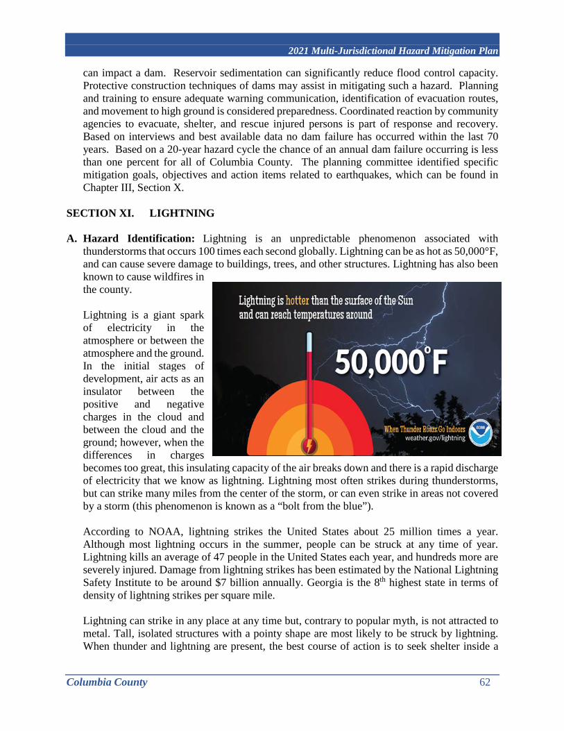
2021 Multi-Jurisdictional Hazard Mitigation Plan
Columbia County 62
can impact a dam. Reservoir sedimentation can significantly reduce flood control capacity. Protective construction techniques of dams may assist in mitigating such a hazard. Planning and training to ensure adequate warning communication, identification of evacuation routes, and movement to high ground is considered preparedness. Coordinated reaction by community agencies to evacuate, shelter, and rescue injured persons is part of response and recovery. Based on interviews and best available data no dam failure has occurred within the last 70 years. Based on a 20-year hazard cycle the chance of an annual dam failure occurring is less than one percent for all of Columbia County. The planning committee identified specific mitigation goals, objectives and action items related to earthquakes, which can be found in Chapter III, Section X.
SECTION XI. LIGHTNING A. Hazard Identification: Lightning is an unpredictable phenomenon associated with
thunderstorms that occurs 100 times each second globally. Lightning can be as hot as 50,000°F, and can cause severe damage to buildings, trees, and other structures. Lightning has also been known to cause wildfires in the county. Lightning is a giant spark of electricity in the atmosphere or between the atmosphere and the ground. In the initial stages of development, air acts as an insulator between the positive and negative charges in the cloud and between the cloud and the ground; however, when the differences in charges becomes too great, this insulating capacity of the air breaks down and there is a rapid discharge of electricity that we know as lightning. Lightning most often strikes during thunderstorms, but can strike many miles from the center of the storm, or can even strike in areas not covered by a storm (this phenomenon is known as a “bolt from the blue”). According to NOAA, lightning strikes the United States about 25 million times a year. Although most lightning occurs in the summer, people can be struck at any time of year. Lightning kills an average of 47 people in the United States each year, and hundreds more are severely injured. Damage from lightning strikes has been estimated by the National Lightning Safety Institute to be around $7 billion annually. Georgia is the 8th highest state in terms of density of lightning strikes per square mile. Lightning can strike in any place at any time but, contrary to popular myth, is not attracted to metal. Tall, isolated structures with a pointy shape are most likely to be struck by lightning. When thunder and lightning are present, the best course of action is to seek shelter inside a
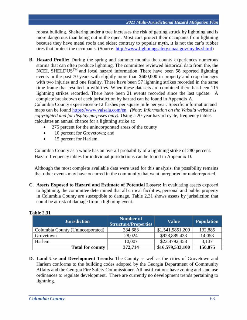
2021 Multi-Jurisdictional Hazard Mitigation Plan
Columbia County 63
robust building. Sheltering under a tree increases the risk of getting struck by lightning and is more dangerous than being out in the open. Most cars protect their occupants from lightning because they have metal roofs and sides; contrary to popular myth, it is not the car’s rubber tires that protect the occupants. (Source: http://www.lightningsafety.noaa.gov/myths.shtml)
B. Hazard Profile: During the spring and summer months the county experiences numerous storms that can often produce lightning. The committee reviewed historical data from the, the NCEI, SHELDUSTM and local hazard information. There have been 58 reported lightning events in the past 70 years with slightly more than $600,000 in property and crop damages with two injuries and one fatality. There have been 57 lightning strikes recorded in the same time frame that resulted in wildfires. When these datasets are combined there has been 115 lightning strikes recorded. There have been 21 events recorded since the last update. A complete breakdown of each jurisdiction by hazard can be found in Appendix A.
Columbia County experiences 6-12 flashes per square mile per year. Specific information and maps can be found https://www.vaisala.com/en. (Note: Information on the Vaisala website is copyrighted and for display purposes only). Using a 20-year hazard cycle, frequency tables calculates an annual chance for a lightning strike at:
• 275 percent for the unincorporated areas of the county • 10 percent for Grovetown; and • 15 percent for Harlem.
Columbia County as a whole has an overall probability of a lightning strike of 280 percent. Hazard frequency tables for individual jurisdictions can be found in Appendix D. Although the most complete available data were used for this analysis, the possibility remains that other events may have occurred in the community that went unreported or underreported.
C. Assets Exposed to Hazard and Estimate of Potential Losses: In evaluating assets exposed to lightning, the committee determined that all critical facilities, personal and public property in Columbia County are susceptible to damage. Table 2.31 shows assets by jurisdiction that could be at risk of damage from a lightning event.
Table 2.31
Jurisdiction Number of Structure/Properties Value Population
Columbia County (Unincorporated) 334,683 $1,541,5851,209 132,885 Grovetown 28,024 $928,889,433 14,053 Harlem 10,007 $23,4792,458 3,137
Total for county 372,714 $16,579,533,100 150,075
D. Land Use and Development Trends: The County as well as the cities of Grovetown and Harlem conforms to the building codes adopted by the Georgia Department of Community Affairs and the Georgia Fire Safety Commissioner. All justifications have zoning and land use ordinances to regulate development. There are currently no development trends pertaining to lightning.
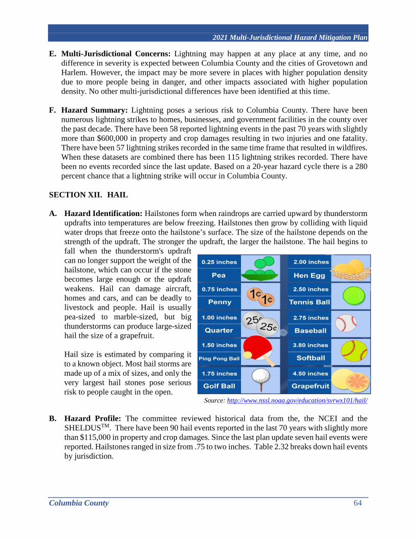
2021 Multi-Jurisdictional Hazard Mitigation Plan
Columbia County 64
E. Multi-Jurisdictional Concerns: Lightning may happen at any place at any time, and no difference in severity is expected between Columbia County and the cities of Grovetown and Harlem. However, the impact may be more severe in places with higher population density due to more people being in danger, and other impacts associated with higher population density. No other multi-jurisdictional differences have been identified at this time.
F. Hazard Summary: Lightning poses a serious risk to Columbia County. There have been numerous lightning strikes to homes, businesses, and government facilities in the county over the past decade. There have been 58 reported lightning events in the past 70 years with slightly more than $600,000 in property and crop damages resulting in two injuries and one fatality. There have been 57 lightning strikes recorded in the same time frame that resulted in wildfires. When these datasets are combined there has been 115 lightning strikes recorded. There have been no events recorded since the last update. Based on a 20-year hazard cycle there is a 280 percent chance that a lightning strike will occur in Columbia County.
SECTION XII. HAIL A. Hazard Identification: Hailstones form when raindrops are carried upward by thunderstorm
updrafts into temperatures are below freezing. Hailstones then grow by colliding with liquid water drops that freeze onto the hailstone’s surface. The size of the hailstone depends on the strength of the updraft. The stronger the updraft, the larger the hailstone. The hail begins to fall when the thunderstorm's updraft can no longer support the weight of the hailstone, which can occur if the stone becomes large enough or the updraft weakens. Hail can damage aircraft, homes and cars, and can be deadly to livestock and people. Hail is usually pea-sized to marble-sized, but big thunderstorms can produce large-sized hail the size of a grapefruit. Hail size is estimated by comparing it to a known object. Most hail storms are made up of a mix of sizes, and only the very largest hail stones pose serious risk to people caught in the open.
Source: http://www.nssl.noaa.gov/education/svrwx101/hail/ B. Hazard Profile: The committee reviewed historical data from the, the NCEI and the
SHELDUSTM. There have been 90 hail events reported in the last 70 years with slightly more than $115,000 in property and crop damages. Since the last plan update seven hail events were reported. Hailstones ranged in size from .75 to two inches. Table 2.32 breaks down hail events by jurisdiction.

2021 Multi-Jurisdictional Hazard Mitigation Plan
Columbia County 65
Table 2.32
Location # of Events County-Wide Events*
# of events per jurisdiction
Columbia County (Unincorporated) 55 11 66
Grovetown 18 11 29 Harlem 6 11 17 TOTAL COUNTY 79 11 90
* It is assumed that all 11 county-wide events occurred in all jurisdiction. Source: NCEI and SHELDUSTM Based on a 20-year hazard cycle, frequency tables calculate an annual chance for a hail event at:
• 205 percent for the unincorporated areas of the county; • 70 percent for Grovetown; and • 20 percent for Harlem
Overall, there is a 295 percent chance that an annual hail event will occur in Columbia County. A complete list of hail events is in Appendix A and hazard frequency tables for individual jurisdictions are in Appendix D. Although the most complete available data were used for this analysis, the possibility remains that other events may have occurred in the community that went unreported or underreported.
C. Assets Exposed to Hazard and Estimate of Potential Losses: In evaluating assets exposed to hail, the committee determined that all critical facilities, as well as all public, private, and commercial property are susceptible. Table 2.33 provides data from FEMA Worksheet #3a that estimates the potential loss for each jurisdiction Table 2.33
Jurisdiction Number of Structure/Properties Value Population
Columbia County (Unincorporated) 334,683 $1,541,5851,209 132,885
Grovetown 28,024 $928,889,433 14,053 Harlem 10,007 $23,4792,458 3,137
Total for county 372,714 $16,579,533,100 150,075
D. Land Use and Development Trends: The County as well as the cities of Grovetown and Harlem conforms to the building codes adopted by the Georgia Department of Community Affairs and the Georgia Fire Safety Commissioner. All justifications have zoning and land use ordinances to regulate development. There are currently no development trends with regards to hail.
E. Multi-Jurisdictional Concerns: Hail may happen at any place at any time, and no difference in severity is expected between Columbia County and the Cities of Grovetown and Harlem.

2021 Multi-Jurisdictional Hazard Mitigation Plan
Columbia County 66
All of Columbia County can potentially be affected by hail. However, the impact may be more severe in places with higher population density due to more people being in danger, and other impacts associated with higher population density. No other multi-jurisdictional differences have been identified at this time.
E. Hazard Summary: There have been 90 hail events reported in the last 70 years with slightly more than $115,000 in property and crop damages. Since the last plan update seven hail events were reported. Hailstones ranged in size from .75 to two inches. To summarize, there are approximately 372,714 structures/properties in the county totaling slightly more than $16.5 billion with a population of 150,075 exposed to the dangers of a hail event. A breakdown of information for individual jurisdictions can be found in Appendix A and Appendix D. Specific mitigation actions for hail events are identified in Chapter III, Section III.

2021 Multi-Jurisdictional Hazard Mitigation Plan
Columbia County 67
CHAPTER III. MITIGATION STRATEGIES
Table 3.1 provides a brief description of each section in this chapter and a summary of the changes to the plan. Table 3.1
Hazard Event Updates to Section I. Flood Completed action steps were removed. All text was reviewed
and edited as needed. Goals, Objective, and Actions Steps were updated.
II. Tornado Completed action steps were removed. All text was reviewed and edited as needed. Goals, Objective, and Actions Steps were updated.
III. Earthquake Completed action steps were removed. All text was reviewed and edited as needed. Goals, Objective, and Actions Steps were updated.
IV. Winter Storm Completed action steps were removed. All text was reviewed and edited as needed. Goals, Objective, and Actions Steps were updated.
V. Hurricanes/Tropical Storms
Completed action steps were removed. All text was reviewed and edited as needed. Goals, Objective, and Actions Steps were updated.
VI. Drought Completed action steps were removed. All text was reviewed and edited as needed. Goals, Objective, and Actions Steps were updated.
VII. Thunderstorms Completed action steps were removed. All text was reviewed and edited as needed. Goals, Objective, and Actions Steps were updated.
VIII. Wildfire Completed action steps were removed. All text was reviewed and edited as needed. Goals, Objective, and Actions Steps were updated.
IX. Extreme Heat Completed action steps were removed. All text was reviewed and edited as needed. Goals, Objective, and Actions Steps were updated.
X. Dam Failure Completed action steps were removed. All text was reviewed and edited as needed. Goals, Objective, and Actions Steps were updated.
XI. Lightning Added to the update as a separate hazard event. Action Plan along with Goals, Objective, and Actions Steps were added.
XII. Hail Added to the update as a separate hazard event. Action Plan along with Goals, Objective, and Actions Steps were added.

2021 Multi-Jurisdictional Hazard Mitigation Plan
Columbia County 68
SECTION I. INTRODUCTION TO MITIGATION STRATEGY This chapter addresses the mitigation strategy requirements of 44 CFR Section 201.6 (c)(3): “A mitigation strategy provides the jurisdiction’s blueprint for reducing the potential losses identified in the risk assessment, based on existing authorities, policies, programs and resources, and its ability to expand on and improve these existing tools. This section shall include:
i) A description of mitigation goals to reduce or avoid long‐term vulnerabilities to the identified hazards.
ii) A section that identifies and analyzes a comprehensive range of specific mitigation actions and projects being considered to reduce the effects of each hazard, with particular emphasis on new and existing buildings and infrastructure. All plans approved by FEMA after October 1, 2008, must also address the jurisdiction’s participation in the NFIP, and continued compliance with NFIP requirements, as appropriate.
iii) An action plan describing how the actions, identified in paragraph (c)(3)(ii) of this section, will be prioritized, implemented, and administered by the local jurisdiction. Prioritization shall include a special emphasis on the extent to which benefits are maximized according to a cost benefit review of the proposed projects and their associated costs.
iv) For multi‐jurisdictional plans there must be identifiable action items specific to the jurisdiction requesting FEMA approval or credit of the plan.”
A. Priority Changes from Previously Approved Plan There have been no significant priority changes from the previous plan. The goal of Columbia County as well as the cities of Grovetown and Harlem is to protect the safety, health and well-being of all county citizens, to protect public and private property, and to lessen the overall effects of a hazard event.
The Columbia County Comprehensive Plan, Vision 2035 presents future development scenarios for Columbia County. As Columbia County grows, there will be pressures on rural areas to transition to neighborhood development at suburban densities. The current pace of growth was cited as an issue during the Visioning Process, with residents expressing concerns that too many new housing developments detract from the rural character of the county and result in an irreplaceable loss of open space and agricultural land. Land use policy, sewer infrastructure planning, and continued application of proactive greenspace preservation measures can be used to preserve rural areas. Grovetown’s 2016-2026 Comprehensive Plan is the official guiding document for the future
the city. The comprehensive plan serves the following functions: • It lays out a desired future • It guides how that future is to be achieved • It formulates a coordinated long-term planning program
The plan also addresses issues regarding housing, economic development, and land use in a coordinated manner and serves as a guide for how:
• land will be developed;

2021 Multi-Jurisdictional Hazard Mitigation Plan
Columbia County 69
• housing will be improved and made available; and • businesses will be attracted and retained.
Harlem’s 2016-2026 Comprehensive Plan is the official guiding document and serves the following purposes:
• outlines a desired future; • provides a guide to how that future is achieved; and • formulates a coordinated long-term planning program
The plan also seeks to capitalize on opportunities in the areas of transportation, economic development, cultural & natural resources, and land uses. This is accomplished by providing guidance for:
• land development; • attraction and retention of jobs; • improvements of recreational facilities; and • provision of public services and facilities.
Over the next 20 years Columbia County is projected to grow by approximately 50%. The City of Grovetown’s population is projected to increase 74%, which is consistent with the city’s proximity to Fort Gordon and the anticipated employment growth that the Army base is expected to generate. Unlike Grovetown, Harlem’s growth is anticipated to take advantage of a somewhat different set of opportunities, including its access to I-20, developing commercial and workplace concentrations, and its relatively higher-priced housing market. From its small current size of almost 3,000 people, Harlem is expected to experience the highest growth rate in the county, increasing 125% to over 7,100 people by 2035.
B. Capability Assessment Columbia County and the cities of Grovetown and Harlem identified current capabilities for implementing hazard mitigation activities. The capability assessment identifies administrative, technical, legal and fiscal capabilities. This includes a summary of departments and their responsibilities associated with hazard mitigation as well as codes, ordinances, and plans already in place that contain mitigation activities or programmatic structure. The second part of the assessment examined the fiscal capabilities applicable to providing financial resources to implement identified mitigation action items. The annual budget for each jurisdiction is approximately:
• $195 million for Columbia County • $9 million for Grovetown; and • $3 million for Harlem.
It should be noted that mitigation action steps with high dollar amounts cannot be completed without grant funds and careful budget planning by all three jurisdictions. While all technical and administrative skills may not found in-house for all jurisdictions, the county and cities have access to multiple staff through the RC and can contract out with

2021 Multi-Jurisdictional Hazard Mitigation Plan
Columbia County 70
private firms or any professional services needed. The three tables below identify administrative, technical, legal and fiscal capabilities of each jurisdiction.
Table 3. 2 Legal and Regulatory Capabilities (Y/N) Regulatory Tools (ordinances, codes, plans) Columbia
County City of
Grovetown City of Harlem
Does State Prohibit
Building codes Y Y Y N Zoning ordinance Y Y Y N Subdivision ordinance or regulations Y Y Y N Special purpose ordinances (floodplain management, storm water management, soil erosion)
Y Y Y N
Growth management ordinances (also called “smart growth” or anti- sprawl programs)
Y Y Y N
Site plan review requirements Y Y Y N General or comprehensive plan Y Y Y N A capital improvements plan Y Y Y N An economic development plan Y Y Y N An emergency response plan Y Y Y N A post-disaster recovery plan N N N N A post-disaster recovery ordinance N N N N Real estate disclosure requirements Y Y Y N Table 3. 3 Fiscal Capabilities
Financial Resources Columbia County
City of Grovetown
City of Harlem
Accessible or Eligible to Use
(Yes/No) Community Development Block Grants (CDBG)
Y Y Y Y
Capital improvements project funding Y Y Y Y Authority to levy taxes for specific purposes Y Y Y Y – Vote
required Fees for water, sewer, gas, or electric service Y Y Y Y Impact fees for homebuyers or developers for new developments/homes
N N N N
Incur debt through general obligation bonds Y Y Y Y Incur debt through special tax and revenue bonds
Y Y Y Y – Vote required
Withhold spending in hazard-prone areas N N N N Other Grants Y Y Y N Table 3.4 Administrative and Technical Capabilities Staff/Personnel Resources Columbia
County City of
Grovetown City of Harlem
Dept./Agency and Position
Planner(s) or engineer(s) with knowledge of land development and land management practices
Y Y Y CC Engineering/ Development Services/ Stormwater Utility/Building Dept./ Code Enforcement/ Public Works CSRA

2021 Multi-Jurisdictional Hazard Mitigation Plan
Columbia County 71
Staff/Personnel Resources Columbia County
City of Grovetown
City of Harlem
Dept./Agency and Position
RC/Contract as Needed Engineer(s) or professional(s) trained in construction practices related to buildings and/or infrastructure
Y Y Y CC Engineering/ Development Services/ Stormwater Utility/Building Dept./ Code Enforcement/ Public Works CSRA RC/Contract as Needed
Planners or Engineer(s) with an understanding of natural and/or manmade hazards
Y Y Y CC Engineering/ Environmental Services/Development Services/ Stormwater Utility/Building Dept./ Code Enforcement/ Public Works CSRA RC/Contract as Needed
Floodplain manager Y N N CC Floodplain Manager Surveyors N N N CC Engineering/
Contracted as needed Staff with education or expertise to assess the community’s vulnerability to hazards
Y Y Y EMA/Fire Dept./Sheriff’s Office/Police Depts./Public Safety
Personnel skilled in GIS and/or HAZUS
Y Y Y CC GIS/CSRA RC
Emergency manager Y Y Y CC EMA Director Grant writers Y Y Y CSRA RC
C. Community Mitigation Goals
Collectively, the jurisdictions reviewed hazard profiles and loss estimates in Section II and used it as a basis for developing mitigation goals, objectives and action steps. Mitigation goals are preventive measures to lessen the effect of and losses due to hazard events and are typically long-range visions adapted toward jurisdictional policy. Mitigation objectives are strategies to attain identified goals. Goals and objectives are formulated by reviewing hazard historical data, existing local plans, policy documents, regulations, and public input. Each jurisdiction developed objectives and actions unique to specific vulnerabilities or concerns within its boundaries.
Mitigation actions were developed as the means to carrying out the objectives and attain goals. All action steps are compatible with the plans, policies, and regulations of each jurisdiction. The jurisdictions must also have the legal, administrative, fiscal, and technical capacities to perform each action. The capabilities assessment above aided in forming realistic mitigation actions. This capabilities assessment can then incorporate results of the STAPLEE worksheet to identified obstacles that may hinder the completion actions. Each jurisdiction identified and

2021 Multi-Jurisdictional Hazard Mitigation Plan
Columbia County 72
prioritized actions steps along with an implementation schedule, funding source, and coordinating individual or agency.
Based on the capabilities assessment, the STAPLEE and six categories listed below in Section D, all jurisdictions identified the following goals:
• Goal 1: Protect the safety, health and well-being of all county citizens; • Goal 2: Protect public infrastructure and private property; • Goal 3: Educate the community about natural hazards affecting the community and
disaster preparedness. • Goal 4: Manage current and future development to minimize loss; • Goal 5: Natural Resources Protection; and • Goal 6: Structural modifications to reduce the impacts of hazard events.
D. Identification & Analysis of Range of Mitigation Actions: The framework used to guide
jurisdictions in identifying mitigation measures was developed by FEMA and is captured by the following six categories:
• Prevention: Government administrative or regulatory actions or processes that influence the way land and buildings are developed and built. These actions also include public activities that reduce hazard losses. Examples include building and construction code revisions; zoning regulation changes; and computer hazard modeling.
• Property Protection: Actions that involve the modifications of existing buildings or structures to protect them from a hazard, or removal from the hazard area. Examples include roadway elevations, improving wind and impact resistance, and flood proofing.
• Public Education and Awareness: Action to inform and educate citizens, elected officials, and property owners about the hazards and potential ways to mitigate them. Examples include programs that target repetitive loss properties and vulnerable populations.
• Natural Resources Protection: Actions that, in addition to minimizing hazard losses also preserve or restore the function of natural systems. Examples include projects to create open space, green space, and stream restoration.
• Structural Projects: Actions that involve the construction of structures to reduce the impact of a hazard. Examples include projects that control floodwater, reconstruction of dams, and construction of regional retention areas.
• Emergency Services: Actions that protect people and property during and immediately after a disaster event or hazard event. Examples include enhancements that provide advanced warning and redundant communications.
i. Structural and Non-Structural
Mitigation relates to concrete actions which are put into practice to reduce the risk of destruction and casualties. Mitigation is generally split into two main types of activities: Structural mitigation refers to any physical construction to reduce or avoid possible impacts of hazards, which include engineering measures and construction of hazard-resistant and protective structures and infrastructure. Non-structural mitigation

2021 Multi-Jurisdictional Hazard Mitigation Plan
Columbia County 73
refers to policies, awareness, knowledge development, public commitment, and methods and operating practices, including participatory mechanisms and the provision of information, which can reduce risk with related impacts. The committee has identified both structural and non-structural mitigation measures to ensure that the community adequately addresses all relevant dam failure issues. Structural and non-structural actions are identified in Table 3.6.
ii. Existing Polices, Regulations, Ordinances, and Land Use Columbia County and the Cities of Grovetown and Harlem have adopted the following Mandatory codes:
• Georgia State Minimum Standard Building Code (International Building Code with Georgia State Amendments).
• Georgia State Minimum Standard One- and Two-Family Dwelling Code (International Residential Code for One- and Two-Family Dwellings with Georgia State Amendments).
• Georgia State Minimum Standard Fire Code (International Fire Code with Georgia State Amendments).
• Georgia State Minimum Standard Plumbing Code (International Plumbing Code with Georgia State Amendments).
• Georgia State Minimum Standard Mechanical Code (International Mechanical Code with Georgia State Amendments).
• Georgia State Minimum Standard Gas Code (International Fuel Gas Code with Georgia State Amendments).
• Georgia State Minimum Standard Electrical Code (National Electrical Code with Georgia State Amendments).
• Georgia State Minimum Standard Energy Code (International Energy Conservation Code with Georgia State Supplements and Amendments).
• Life Safety Code (NFPA 101). The following plans were adopted by resolution:
• Columbia County Comprehensive Plan - Vision 2035 • Grovetown Comprehensive Plan 2016-2026 • Harlem Comprehensive Plan 2016-2026
The joint comprehensive plan update takes place every five years. The planning process examines the current and future trends and assess the strengths and opportunities available to achieve their community vision. This document drives the decision making process for the County and the cities of Grovetown and Harlem. The Comprehensive Plans also examines existing land use and projects future land use. Land Use Maps can be found in Appendix B.
iii. Community Values, Historic & Special Considerations In 1990 the Columbia County Board of Commissioners authorized a survey of all historic resources in the County built prior to 1940. Approximately 95% of the county was surveyed, resulting in a list of 26 properties identified as being eligible for

2021 Multi-Jurisdictional Hazard Mitigation Plan
Columbia County 74
nominating to the National Register of Historic Places. At that time, about 75% of the properties surveyed were in good condition. In the written survey prepared by the surveyor, it was stated that numerous important historic sites were being neglected as a result of rapid development and increasing property values. In 2004, a second survey was conducted around the Harlem are, but the original county-wide survey has not been updated, and the status of several of the national Register-eligible properties has changed. Properties have been demolished over the past 25 years, and other structures or sites now have greater historical significance due to their age.
The following list identifies the National Register of eligible resources from the original historic resources survey, with a current status of the building, where known:
• “The Cedars,” c. 1885 • Macedonia Baptist Church, c. 1880 – Original building gone, replaced by c.
1948 structure • Evans School Dormitory, c. 1900 – Demolished • Evans School Arch and Columns, c. 1925 – Relocated due to development • G.B. Lamkin House, c. 1925 – Demolished • “Cedar Hill,” c. 1820 • Old Washington Road • Damascus Baptist Church, c. 1900 • Dunns’ Chapel, c. 1890 • Winfield Area, c. 1840 • Sharon Church, 1869 • William Few house site, c. 1930 • Shiloh Church, c. 1857 • Cedar Dale, c. 1858 • Appling Community (multiple sites, c. 1850-1925) • Shucraft Road House, c. 1890 • Columbia Road at Hereford Farm Road, c. 1870 • Plantation House on Columbia Road, c. 1830 • Columbia Road, c. 1790 • Otts House, c. 1865 • Wrightsboro Road, c. 1815 • Magruder Home, c. 1810 • Grovetown (multiple sites along Robinson Avenue) • The Dodge House, c. 1910 • Campania • Harlem (multiple sites, c. 1850) – (see Local Historic Districts Section)
Local Historic Districts While National Register designation is largely symbolic, a locally-designated historic district can afford meaningful protection to a historic resource. The City of Harlem is the only jurisdiction that has adopted locally-designated historic districts: The Central, Sanders, and Sawdust Districts. Local designation, accomplished by adoption

2021 Multi-Jurisdictional Hazard Mitigation Plan
Columbia County 75
of an ordinance, requires review and approval of proposed exterior alterations to an affected property. A historic preservation commission (HPC) is appointed as the reviewing body, and approvals are granted in the form of a Certificate of Appropriateness (COA). An HPC is also authorized to review and approve proposed relocation or demolition of a building. A COA must be granted before building permits are issued. Archaeological Resources Stallings Island is a National Historic Landmark site. It was a major settlement of Late Archaic Native Americans from 3,500 to 4,500 years ago. Located in the Savannah River, the 16-acre private island is the namesake of Stallings Culture. It is maintained by the Augusta Archaeological Society. As a National Historic Landmark, Stallings Island is automatically listed on the National Register of Historic Places. Historic Preservation Boards Columbia County Historical Society The Columbia County Historical Society was founded in 1975 to promote and preserve the County’s history. The Historical Society endeavors to preserve and restore significant buildings and sites and promote awareness of the area’s history. The group meets monthly at the restored county jail in Appling. Columbia County Historic Preservation Advisory Committee The newly formed seven-member advisory committee, appointed by the Board of Commissioners, is charged with raising awareness of Columbia County’s history, making recommendations about historic properties and other preservation issues and collecting and preserving historic documents and artifacts. Certified Local Government Program The Certified Local Government Program (CLG) is a federal program administered at the state level by HPD. Any city, town, or county that has enacted a historic preservation ordinance and enforces that ordinance through a local preservation commission, is eligible to become a CLG. The benefits of becoming a CLG include eligibility for federal historic preservation grant funds, the opportunity to review local nominations for the National Register prior to consideration by the Georgia National Register Review Board, opportunities for technical assistance, and improved communication and coordination among local, state, and federal preservation activities. The City of Harlem is a CLG. Recreation Columbia County is proud to have some of the most pristine, historical, and educational parks in the area. From Reed Creek Park to the Savannah Rapids Park, the county has 12 parks and more are in the planning process. With major recreation

2021 Multi-Jurisdictional Hazard Mitigation Plan
Columbia County 76
complexes and off-street trail system projects ongoing, Columbia County strives to provide the best in class greenspace and parks for families, visitors, and pets. Reed Creek Park is open daily from sunrise to sunset. This is a popular destination for walking and jogging, and taking in the sites of nature. Reed Creek is often used for field trips for local students, where they can see a live animal presentation, learn about the effects of pollution, take a nature hike, and explore a pond and creek. Savannah Rapids is listed on the National Historic Registry and as one of the most well-known parks in the CSRA, the scenic Savannah Rapids Park and Canal Headgates provide an array of outdoor recreations options, rich history, an events pace for wedding or corporate meetings. Wildwood Park is a calm 75-acre park that offers access to the 72,000-acre Clarks Hill Lake, which provides the area’s best spots for boating and fishing. The park hosts multiple fishing tournaments each year and was votes “Best Campground” in Columbia County Patriots Park is a multi-purpose recreation facility that is home to different sports’ fields, parts, and court, the complex is also experiencing grown to improve infrastructure to and from the park, while adding additional fields to hold more practices, games, and tournaments. In addition, Columbia County has 44 athletic fields, 14 tennis courts, 10 boat ramps, four disk golf courses, and numerous gymnasiums to strengthen an active community.
iv. Prioritization of Actions: Mitigation actions given high priority are in two groups:
life safety-related actions that can be accomplished relatively quickly and changes to protect critical facilities on which other emergency management systems are dependent, for example communications focal points. Actions likely to require extended time frames to accomplish received medium priority status.
The committee used the STAPLEE worksheet to select and prioritize the most appropriate mitigation alternatives and is in Appendix D. This methodology requires that seven categories be considered when reviewing potential actions. This process helped ensure that the most equitable and feasible actions would be undertaken based on each jurisdictions capabilities. Table 3.5 provides information regarding the review and selection criteria for alternatives.
Table 3.5
STAPLEE REVIEW AND SELECTION CRITERIA FOR ALTERNATIVES • Is the proposed action acceptable by the community? • Is the action compatible with current and future community values? • Are equity concerns involved that would result in unjust treatment of any segment of the population? • Will the proposed action cause social disruption? TECHNICAL • Will the proposed action achieve the stated objective and further mitigation goals?

2021 Multi-Jurisdictional Hazard Mitigation Plan
Columbia County 77
STAPLEE REVIEW AND SELECTION CRITERIA FOR ALTERNATIVES • Will the proposed action create more problems than it solves? • Does the proposed action resolve the problem completely or partially? • It is the most useful action in light of other community values? ADMINISTRATIVE • Does the community have the capability to implement proposed action? • Is there someone to lead or coordinate the proposed action? • Is there sufficient funding, staff and technical support to implement the proposed action step? • Are there ongoing administrative needs that are required? POLITICAL • Is the proposed action politically acceptable? • Have political leaders participated in the planning process? • Who are the stakeholders for this proposed action? • Have all stakeholders been afforded an opportunity to participate in the planning process? • Is there public support to implement and maintain the action? LEGAL • Does the community have the authority to implement the proposed action? • Is there a clear legal basis for the proposed action? • Are there legal side effects (i.e. could the action be construed as a taking)? • Is the proposed action allowed in the general plan? • Will the community be liable for action or lack thereof? • Will the proposed action be challenged? ECONOMIC • What is the cost-benefit of the proposed action (do the benefits exceed the cost)? • Have initial, maintenance and administrative costs been taken into account? • Has funding been secured for the proposed action? If not have funding sources been identified? • Will the proposed action affect the fiscal capabilities and/ or budget of the jurisdiction? • Will the proposed action place a tax burden on the community? • Does the proposed action contribute to other community goals (capital improvements, economic
development)? ENVIRONMENTAL • Will the proposed action have a positive or negative effect on the environment? • Does the proposed action require environmental regulatory approvals? • Does the proposed action meet local and state regulations? • Does the proposed action impact a threatened or endangered species?
E. Introduction to Action Plan
The next two sections of Chapter III., Section II. Natural Hazards Actions, comprise the strategies Columbia County together with cities of Grovetown and Harlem have identified to reduce the effects of natural hazards. Section II outlines the objectives to achieve the goals stated on pages 59-63 for each hazard affecting the County. Section III provides specific mitigation actions to be undertaken to achieve listed goals and objectives. Mitigation actions

2021 Multi-Jurisdictional Hazard Mitigation Plan
Columbia County 78
given high priority are in two groups: (1) life safety-related actions that can be accomplished relatively quickly and (2) changes to protect critical facilities on which other emergency management systems are dependent, for example communications focal points. Those actions likely to require extended time frames to accomplish received medium or low priority status.
SECTION II. NATURAL HAZARDS A. Flooding Action Plan
Columbia County has experienced a great amount of damage from flooding since the October 12, 1990 flood. We feel that if we focus on goals of the continuing the Storm Water Utility, completing identified storm water projects, having aggressive public education programs, pursuing FEMA Hazard Mitigation Program Grants, and strictly enforcing policies, we will greatly reduce our level of exposure to repetitive flooding. The Columbia County Flood Maps have been updated with the effective date of the new DFIRMs being Jun 7, 2019. The county has identified problem areas and storm water mitigation projects targeted to reducing flooding. These projects include replacing culverts, elevating structures, and stabilizing streams. The county is also flood-proofing commercial buildings whose first floor is below the 100-year flood elevation. In addition, the county is strictly enforcing ordinances and has started an aggressive public education program aimed at reducing property damage.
Objective A1. Improve the effectiveness of existing flood insurance program. Objective A2. Evaluate and improve existing storm drainage infrastructure. Objective A3. Enforce Storm Water Management Design Manual regulations for all
new development and improvements to existing storm drainage infrastructure.
Objective A4. Warn citizens when the potential for flooding exist. Objective A5. Lessen the impact to existing buildings, critical facilities and
infrastructure as a result of flooding. Objective A6. Limit future development in flood prone areas. Objective A7. Reduce the threat of water contamination caused by flooding.
B. Tornado Action Plan
Since the exact time and location of a tornado is not always predictable, all of Columbia County is vulnerable. A tornado can cause significant damage to both property and agricultural crops could result. In addition, the potential for injuries and loss of life is substantial due to the unpredictability and violent nature of these storms. There is great benefit in identifying appropriate steps that can be taken to help minimize losses to new and existing structures in Columbia County as a result of a tornado event. The committee has identified several courses of action that both local officials and citizens can use in their mitigation efforts against the effects of tornados.
Objective B1. Provide near-absolute protection during a tornado event for emergency personnel.
Objective B2. Increase public awareness of tornadoes.

2021 Multi-Jurisdictional Hazard Mitigation Plan
Columbia County 79
Objective B3. Increase awareness of Public Warning Systems. Objective B4. Increase awareness of existing ordinances and policies. Objective B5. Minimize damage to property from a tornado events. Objective B6. Minimize damage to public buildings and critical facilities to ensure
continual operations of vital services. Objective B7. Educate the public including citizens and business owners on disaster
preparedness and safety. C. Earthquake Action Plan
Columbia County has not experienced a damaging earthquake to date, but historical data indicates that an earthquake occurrence on the Charleston fault would affect our area and possibly damage buildings and infrastructure. Earthquake conditions have the potential to affect all of Columbia County. As a result, any mitigation steps related to an earthquake event should be undertaken on a countywide basis and specifically include all incorporated jurisdictions.
Objective C1. Minimize risk of damage to buildings, utilities, and personal property. Objective C2. Develop Techniques to Improve Earthquake-Resistant Design. Objective C3. Publicize and promote an understanding of earthquake safety, structural
mitigation, and non-structural mitigation. Objective C4. Conduct outreach to builders, architects, engineers, and inspectors. Objective C5. Use all methods to disseminate information to the public.
D. Winter Weather Action Plan
Within Columbia County, and the southeast region in general, there is great concern over the threat of winter storms. Although this area does not typically receive the amounts of snow and ice that other regions do, nor do they experience winter storms as frequently as other regions, these communities must be prepared for the damage caused by winter storms. The fact that winter storms hit the County infrequently results in other problems, such as lack of equipment and supplies to combat treacherous winter storm conditions. The time lapse between these storms diminishes the preparedness capabilities of citizens due to the lack of practical use. The committee has determined that several steps could be undertaken to minimize the effects of winter storms to protect the health and safety of citizens, as well as damage to new and existing structures.
Objective D1. Prevent property damage as a result of a winter storm event. Objective D2. Minimize power outages during winter storms. Objective D3. Minimize damage to public buildings and critical facilities to ensure
continual operations of vital services. Objective D4. Assure readiness for winter storms by government and private sector
services. Objective D5. Educate the public on preparedness and safety issues for winter storm
events. Objective D6. Provide emergency transportation. Objective D7. Assist vulnerable populations.

2021 Multi-Jurisdictional Hazard Mitigation Plan
Columbia County 80
E. Hurricane/Tropical Storms Plan In 2018, the remnants of Hurricane Michael moved across Columbia County causing over 2,500 power outages in the county. There were also numerous trees and five power lines that were downed. There is a misconception among inland counties that hurricanes only affect coastal communities. Although coastal communities are hit the hardest and have a significant risk for storm surge, inland counties could feel the effects from hurricane strength winds, flooding, tornadoes, and sheltering coastal evacuees. Therefore, we would like to focus on goals and objectives that will increase public awareness of hurricane risks in our community and mitigation strategies that will save lives through proper planning.
Objective E1. Reduce residents’ exposure to hurricanes/tropical storms. Objective E2. Provide near-absolute protection during a hurricane/tropical storm event
for emergency personnel. Objective E3. Prepare the community for direct and secondary effects from a
hurricane/tropical storm. Objective E4. Minimize damage to property from a tornado events. Objective E5. Minimize damage to public buildings and critical facilities to ensure
continual operations of vital services. Objective E6. Educate the public including citizens and business owners on disaster
preparedness and safety. Objective E7. Increase awareness of Public Warning Systems.
F. Drought Action Plan
Columbia County has experienced severe drought in the past. Climatologists and hydrologists use five indicators of drought: rainfall, soil moisture, stream flows, lake levels and groundwater level. One of the primary effects of drought on our community is water restrictions caused by low groundwater levels and limited amounts of available drinking water during summer droughts. These restrictions are imposed at both the state and local level. In Columbia County, rapid growth has brought numerous new subdivisions, which bring hundreds of new homes with in-ground sprinkler systems. This growth continues, along with an increase in water usage.
Objective F1. Minimize the effects of drought. Objective F2. Monitor water supply to ensure that there is an adequate water supply
during periods of drought. Objective F3. Educate citizens on water conservation issues. Objective F4. Inform citizens when drought conditions exist and water restrictions are
implemented. Objective F5. Upgrades to water system infrastructure as needed.
G. Thunderstorm Action Plan
One of the most prevalent hazards affecting Columbia County has been severe thunderstorms events. Since 1950, there have been 170 documented severe thunderstorms events causing $1.5 million in damages, injuring six people. Thunderstorms are unpredictable and can happen at any place and at any time. Because these storms may be extremely violent and cause great damage, the committee believes that the comprehensive range of Mitigation

2021 Multi-Jurisdictional Hazard Mitigation Plan
Columbia County 81
Goals, Objectives, and Action Steps should be implemented to reduce this hazard’s potential impact on the community.
Objective G1. Provide near-absolute protection in a severe thunderstorm event for emergency personnel.
Objective G2. Increase public education and awareness of severe thunderstorm events.
Objective G3. Increase awareness of existing ordinances and policies. Objective G4. Minimize property damage as a result of severe thunderstorm events. Objective G5. Minimize damage to public buildings and critical facilities to ensure
continual operations of vital services.
H. Wildfire Action Plan As indicated in Chapter II, Section VIII, wildfires have the potential to cause costly damage in Columbia County. From a danger or hazard perspective, the greatest threat posed by wildfire is the damage to forest, woodlands and agriculture property. The possibility for wildfires is distinct and poses a significant threat to the county. Forest fires are generally the result of dry conditions combined with lightning or carelessness. The committee determined that mitigation goals were necessary to prevent damage to undeveloped areas of the county as well as damage to new and existing structures caused by wildfires.
Objective H1. Educate the community on wildfire hazard and how to reduce wildfire
risk through structural ignitability reduction Objective H2. Reduce threat of wildfire occurrence. Objective H3. Improve community wildland fire response. Objective H4. Warn citizens of wildfire conditions, watches and warnings. Objective H5. Ensure there is an adequate water supply.
I. Extreme Heat Action Plan
Most native Columbia County residents are accustomed to extreme heat. However, extreme heat as defined in this plan includes periods of three or more days when the temperature consecutively ranges between 102 and 107 degrees. There were 14 instances of this found during the research for this plan, which determined that there is one occurrence of extreme heat every five years. For residents without air conditioning, people on medication, or senior citizens these extreme heat situations are very dangerous. Therefore, we would like to focus on goals and objectives to do a better job of educating people about extreme heat, actions they can take to prevent illness, and also designated cooling centers available during the summer months. Improve the effectiveness of existing flood insurance programs.
Objective I1. Increase awareness of extreme heat risk and safety. Objective I2. Identify at risk population and assist vulnerable populations from the
effects of extreme heat events. Objective I3. NOAA alert radios in all public facilities.

2021 Multi-Jurisdictional Hazard Mitigation Plan
Columbia County 82
J. Dam Failures Based on the current data from the National Inventory of Dams there are 65 dams located in Columbia County. Of the 65 dams are classified as:
• High hazard seven • Significant hazard two • Low hazard 55 • One is not categorized.
The potential failure of a dam may result in people living downstream being in imminent danger of flooding. Weathering, mechanical changes, and chemical agents can impact a dam. Reservoir sedimentation can significantly reduce flood control capability. Therefore, we will look at mitigation goals that will prevent dam failure, as well as prepare the community in the event of a failure. Improve the effectiveness of existing flood insurance programs.
Objective J1. Reduce exposure to effects of dam failure. Objective J2. Identify at risk population and properties. Objective J3. Develop proposal to regulate protective measures for dam breach zones. Objective J4. Educate public concerning dam construction and safety.
K. Lightning Action Plan
As previously indicated in Chapter II, Section XII, lightning may happen at any place at any time. Since 1950, there have been 115 documented lightning strikes with slightly more than $600,000 in property and crop damages with two injuries and one fatality.
Objective K1. Install lightning warning and protection equipment at critical facilities. Objective K2. Increase awareness of public warning systems. Objective K3. Minimize damage to public buildings and critical facilities to ensure
continual operations of vital services. Objective K4. Educate the public including citizens and business owners on disaster
preparedness and safety
L. Hail Action Plan Hail is unpredictable and can happen at any place and at any time. Due to the damage it may cause, the committee believes that the comprehensive range of Mitigation Goals, Objectives, and Action Steps should be implemented to reduce this hazard’s potential impact on the community. There have been 90 hail events reported in the last 70 years with slightly more than $115,200 in property and crop damages.
Objective L1. Minimize property damage as a result of hail storm. Objective L2. Warn citizens of potential hail events when possible. Objective L3. Minimize damage to public buildings and critical facilities to ensure
continual operations of vital services. Objective L4. Educate the public including citizens and business owners on disaster
preparedness and safety

2021 Multi-Jurisdictional Hazard Mitigation Plan
Columbia County 83
SECTION III. MITIGATION ACTIONS Table 3.6 Action
# Mitigation Action and Description
Jurisdiction Responsible Agency/ Dept.
Hazards Addressed
Objective Supported
Goal Structural/ Non-
Structural
Estimated Project
Cost
Possible Funding Source
Time frame
Status Priority
1. Investigate Increased participation in the CRS
Columbia County
CC Environmental Management/ Flood Plain Manager
Flood A1 2/6 Non-Structural
5,000 General Fund
2023 New Medium
2. Continue to assess stormwater runoff.
Columbia County/ Grovetown/ Harlem
Public Works Grovetown & Harlem/ CC Stormwater Operations
Flood A2/A3/A7 1/2/4/6 Non-Structural
Staff Time General Funds
2021-2026
Ongoing As part of work duties
High
3. Construct as needed, more storm water retention facilities, storm drain improvements and channel improvements to protect existing and new developments.
Columbia County/ Grovetown/ Harlem
Public Works Grovetown & Harlem/ CC Stormwater Operations
Flood A2/A3/A5/A6/A7
1/2/4/6 Structural $7,000,000 General Funds/ CDBG, USDA, EPA, DNR/ FEMA Strom Water Utility/ SPLOST
2021-2026
Ongoing As funding becomes available
High
4. Clear run-off and water retention ditches.
Columbia County/ Grovetown/ Harlem
Public Works Grovetown & Harlem/ CC Stormwater Operations/ CC Road Department
Flood A2/A3/A5/ A7
1/2/4/6 Structural Staff Time General Funds
2021-2026
Ongoing Ditches are cleared by Road Dept. as part of work load.
High
5. Minimize the potential for obstruction of flow and stream erosion through design and implementation of stream erosion stabilization projects.
Columbia County
CC Stormwater Operations, CC Environmental Management
Flood A3/A5/A7 1/2/4/5/6
Structural $2,000,000 General Funds/ CDBG, USDA, EPA, DNR/ FEMA SWF
2022-2025
Ongoing As funds become available
Low

2021 Multi-Jurisdictional Hazard Mitigation Plan
Columbia County 84
Action #
Mitigation Action and Description
Jurisdiction Responsible Agency/ Dept.
Hazards Addressed
Objective Supported
Goal Structural/ Non-
Structural
Estimated Project
Cost
Possible Funding Source
Time frame
Status Priority
6. Purchase or Elevate Repetitive Loss Properties due to Localized Flooding
Columbia County
CC Environmental Management
Flood A1,A3 1/2/6 Non- Structural/ Structural
$1,000,000 FEMA 2025 Ongoing As funds become available
Low
7. Provide Safe Room information through mailers, tours and presentations to citizens and businesses.
Columbia County
EMA Tornado/ Earthquake/ Hurricane-Tropical Storms/ T’Storms/ Lightning/ Hail
B1, B7, E2, E6, G1, K4, L1
1/3/6 Non- Structural
$2,000 General Fund/ FEMA
2021-2026
Ongoing High
8.
Implement education and awareness programs utilizing news and print media, social media, website, bulletins, flyers, etc. to inform citizens of hazards and mitigation measures to reduce injuries, fatalities, and property damages.
Columbia County/ Grovetown/ Harlem
EMA / Grovetown Fire Dept. & Police Dept./ Harlem Fire Dept./ BOE/ Sheriff’s Office
All Hazards A4, B2, B3, B7, C3, C4, D4, D5, E6, E7, F3, F4, G2, G3, H5, I1, J4, K2, K5, L2, L4
1/2/3 Non-Structural
$10,000 General Fund/ FEMA
2021-2026
Ongoing High
9. Encourage participation in annual statewide drills
Columbia County/ Grovetown/ Harlem
EMA/ Harlem Fire Dept./ Grovetown Fire Dept. & Police Dept.
All Hazards A4, B2, B3, B7, C3, C4, D4, D5, E6, E7, F3, F4, G2, G3, H5, I1, J4, K2, K5, L2, L4
1/2/3 Non-Structural
$5,000 General Fund/ FEMA
2021-2026
Ongoing High
10. Provide assistance locating safe areas in buildings and conducting drills
Columbia County/ Grovetown/ Harlem
EMA/Sheriff’s Office/Police Depts./Fire Depts./BOE
Tornado/ Earthquake/ Hurricane-Tropical Storms/ T’Storms
B7, C3, E6, G2,
1/3 Non-Structural
Staff Time General Fund/ FEMA
2021-2026
Ongoing High

2021 Multi-Jurisdictional Hazard Mitigation Plan
Columbia County 85
Action #
Mitigation Action and Description
Jurisdiction Responsible Agency/ Dept.
Hazards Addressed
Objective Supported
Goal Structural/ Non-
Structural
Estimated Project
Cost
Possible Funding Source
Time frame
Status Priority
11. Use all communication methods to disseminate information to the public about types and access to public warning systems
Columbia County/ Grovetown/ Harlem
EMA/ Harlem Fire Dept./ Grovetown Fire Dept. & Police Dept.
All Hazards A4, B2, B3, B7, C3, D5, D7, E6, E7, F4, G2, H4, I1, I3, J4, K2, K4, L2, L4
1/3 Non-Structural
$5,000/ General Fund/ FEMA
2021-2026
Ongoing High
12. Place NOAA Radios in public facilities and ensure all are operational
Columbia County/ Grovetown/ Harlem
EMA/ Harlem Fire Dept./ Grovetown Fire Dept. & Police Dept.
All Hazards A4, B2, B3, B7, C3, D5, D7, E6, E7, F4, G2, H4, I3, J4, K2, K4, L2, L4
1/3 Non-Structural
$10,000 General Fund/ FEMA
2021-2026
Ongoing High
13. Continue to provide public venues to assist with NOAA radio programing
Columbia County/ Grovetown/ Harlem
EMA/ Harlem Fire Dept./ Grovetown Fire Dept. & Police Dept.
All Hazards A4, B2, B3, B7, C3, D5, E6, E7, F4, G2, H4, I3, J4, K2, K4, L2, L4
1/3 Non-Structural
Staff Time General Fund/ FEMA
2021-2026
Ongoing High
14. Advise citizens on how to register for CodeRed Alert System Notifications
Columbia County/ Grovetown/ Harlem
EMA All Hazards A4, B2, B3, B7, C3, D5, E6, E7, F4, G2, H4, I3, J4, K2, K4, L2, L4
1/3 Non-Structural
Staff Time General Fund/ FEMA
2021-2026
Ongoing High
15. Use all communication methods to disseminate information on tie-down requirements for mobile homes
Columbia County/ Grovetown/ Harlem
CC Development. Services, Planning, Code Enforcement/ Harlem Planning, Community Development/ Grovetown Planning & Development
Tornado/ Earthquake/ Hurricane-Tropical Storms/ T’Storms
B4, B5, B7, C2, C3, E3, E4, E6, G2, G3
1/2/3 Non-Structural
Staff Time General Fund/ FEMA
2021-2026
Ongoing High

2021 Multi-Jurisdictional Hazard Mitigation Plan
Columbia County 86
Action #
Mitigation Action and Description
Jurisdiction Responsible Agency/ Dept.
Hazards Addressed
Objective Supported
Goal Structural/ Non-
Structural
Estimated Project
Cost
Possible Funding Source
Time frame
Status Priority
16. Enforce building codes and ordinances for all current and future development.
Columbia County/ Grovetown/ Harlem
CC Development. Services, Planning, Code Enforcement/ Harlem Planning, Community Development/ Grovetown Planning & Development/
Flood/ Tornado/ Earthquake/ Winter Weather/ Hurricane-Tropical Storms/ T’Storms/ Wildfire/ Dam Failure
1/2/4 Non-Structural/
Staff Time General Fund
2021-2026
Ongoing High
17. Revise building codes to include earthquake resistance provisions
Columbia County/ Grovetown/ Harlem
BOC, CC Development Services/ Harlem City Council, Planning Dept./ Grovetown City Council. Planning Dept.
Earthquake C1, C3 1/2 Non- Structural
Staff Time General Fund
2023 Ongoing Low
18. Identify and Retrofit non-reinforced masonry building and non-ductile concrete facilities that are vulnerable to ground shaking
Columbia County
CC Development. Services/ CC Building Maintenance
Earthquake C1, C2, C3 1/4/6 Structural $50,000 General Fund/ FEMA
2021-2026
Ongoing Low
19. Retrofit building veneers to prevent failure
Columbia County
CC Development. Services/ CC Building Maintenance
Earthquake C2, C3 1/2/6 Structural $35,000 General Fund/ FEMA
2021-2026
Ongoing Low
20. Build Safe Rooms to provide near-absolute protection during hazard events.
Columbia County
EMA/CC Development. Services/
Tornado/ Earthquake/ Hurricane-Tropical Storms/ T’Storms/
B1, C2, C3, E2, E5, G1
1/6 Structural $150,000 General Fund/ FEMA
2021-2026
Ongoing High
21. Installing window film to prevent
Columbia County
EMA/CC Development
Tornado/ Earthquake/
B6, C1, C2, C3, E4, E5,
1/6 Structural $25,000 General Fund/
2021-2026
Ongoing High

2021 Multi-Jurisdictional Hazard Mitigation Plan
Columbia County 87
Action #
Mitigation Action and Description
Jurisdiction Responsible Agency/ Dept.
Hazards Addressed
Objective Supported
Goal Structural/ Non-
Structural
Estimated Project
Cost
Possible Funding Source
Time frame
Status Priority
injuries from shattered glass
Services/ CC Building Maintenance
Hurricane-Tropical Storms/ T’Storms/
G4 FEMA
22. Anchoring rooftop-mounted equipment (i.e., HVAC units, satellite dishes, etc.)
Columbia County
CC Dev. Services/County Building Maintenance
Tornado/ Earthquake/ Hurricane-Tropical Storms/ T’Storms/
B6, C1, C2, C3, E4, E5, G4
1/6 Structural $35,000 General Fund/ FEMA
2021-2026
Ongoing Medium
23. Conduct outreach on seismic code provisions for new and existing buildings to enhance code use and enforcement by local architects, engineers, contractors, and code enforcement personnel
Columbia County
CC Development Services/ CC Engineering
Earthquake C4 3/4 Non-Structural
$750 General Fund/ FEMA
2021-2026
Ongoing High
24. Coordinate routine Tabletop Exercises in EOC
Columbia County
EMA All Hazards A4, B2, B3, B7, C3, C4, D4, D5, E6, E7, F3, F4, G2, G3, H5, I1, J4, K2, K5, L2, L4
1/2/3 Non-Structural
$1,000 General Fund/ FEMA/ DNR
2021-2026
Ongoing High
25. Publicize emergency transportation contact information
Columbia County
EMA Winter Weather/ Extreme Heat
D5 1 Non-Structural
$500 General Fund
2021-2026
Ongoing High
26. Purchase and install generators at all critical facilities
Columbia County/ Grovetown/ Harlem
EMA/ Harlem Fire Dept./ Grovetown Fire Dept. & Police Dept.
Tornado/ Earthquake/ Winter Weather/ Hurricane-Tropical Storms/
B6, C1, D3, D4, E3, E5, G5, K3, L3
2/6 Structural $1,000,000 General Fund/ FEMA
2021-2026
Ongoing
High

2021 Multi-Jurisdictional Hazard Mitigation Plan
Columbia County 88
Action #
Mitigation Action and Description
Jurisdiction Responsible Agency/ Dept.
Hazards Addressed
Objective Supported
Goal Structural/ Non-
Structural
Estimated Project
Cost
Possible Funding Source
Time frame
Status Priority
T’Storms/ Lightning/ Hail
27. Identify populations that are vulnerable in the event of a long-term power outage
Columbia County/ Grovetown/ Harlem
EMA/Health Dept./BOE/ Recreation Dept./Senior Center
Tornado/ Earthquake/ Winter Weather/ Hurricane-Tropical Storms/ T’Storms/
B7, C3, D5, E6, G2,
1 Non-Structural
$1,500 General Fund/ FEMA
2021-2026
Ongoing High
28. Organize outreach efforts to vulnerable populations, including establishing and promoting accessible heating and cooling centers.
Columbia County
EMA/ Harlem Fire Dept./ Grovetown Fire Dept. & Police Dept.
Winter Weather/ Extreme Heat
D5, D7, I2 1 Non-Structural
$1,500 General Fund/ FEMA
2021-2026
Ongoing High
29. Flood-proof commercial building in-place whose first floor elevation is below the 100-year flood elevation
Columbia County
CC Engineering Services
Flood A5 1/2/6 Structural $300,000 General Fund/ FEMA/ Storm Utility/ IPTF
2021-2026
Ongoing Low
30. Relocate businesses outside of the 100-year flood plain, to the extent practical
Columbia County
CC Engineering Services
Flood A5 1/2/6 Structural $300,000 General Fund/ FEMA/ Storm Utility/ IPTF
2021-2026
Ongoing Low
31. Publicize the statewide tornado drill
Columbia County
EMA/CC Engineering Services/BOE
Tornado B2, B7 1/3 Non-Structural
Staff Time General Fund
2021-2026
Ongoing High
32. Evaluate existing water systems and repair and upgrade as needed.
Columbia County/ Grovetown/ Harlem
CC Water Utility/ CC Engineering Services/ Grovetown Public Works/ Harlem Public
Drought/ Wildfire
F2, H5 1/2/6 Structural $1,000,000 FEMA/ Water Utility Fund/ SPLOST/DNR/ CDBG/
2021-2026
Ongoing High

2021 Multi-Jurisdictional Hazard Mitigation Plan
Columbia County 89
Action #
Mitigation Action and Description
Jurisdiction Responsible Agency/ Dept.
Hazards Addressed
Objective Supported
Goal Structural/ Non-
Structural
Estimated Project
Cost
Possible Funding Source
Time frame
Status Priority
Works USDA 33. Enact a program to
educate the residents about water conservation issues and awareness of outdoor watering restrictions and bans.
Columbia County/ Grovetown/ Harlem
CC Water Utility/ Grovetown Public Works/ Harlem Public Works
Drought F3, F4 1/3 Non-Structural
$5,000 General Fund/ Water Utility Fund/ FEMA/
2021-2026
Ongoing High
34. Educate community to create a minimum of 30-feet of defensible space by educating homeowners to trim shrubs and vines to 30 feet from structures, trim overhanging limbs, replace flammable plants near homes with less flammable varieties, remove vegetation around chimneys.
Columbia County/ Grovetown/ Harlem
EMA/ CC Fire Dept./Harlem Fire Dept./ Grovetown Fire Dept./GFC
Wildfires H1, H2 1/2/3 Non-Structural
$25,000 General Fund/ FEMA/ DNR
2021-2026
Ongoing High
35. Reduce structural ignitability by educating community to clean flammable vegetative material from roofs and gutters, store firewood appropriately, install skirting around raised structures, store water hoses for ready access,
Columbia County/ Grovetown/ Harlem
EMA/ CC Fire Dept./Harlem Fire Dept./ Grovetown Fire Dept./GFC
Wildfires H1, H2 1/2/3 Non-Structural
$25,000 General Fund/ FEMA/ DNR
2021-2026
Ongoing High

2021 Multi-Jurisdictional Hazard Mitigation Plan
Columbia County 90
Action #
Mitigation Action and Description
Jurisdiction Responsible Agency/ Dept.
Hazards Addressed
Objective Supported
Goal Structural/ Non-
Structural
Estimated Project
Cost
Possible Funding Source
Time frame
Status Priority
replace pine straw and mulch around plantings with less flammable landscaping materials.
36. Work with Homeowner Associations to encourage to cut, prune, and mow vegetation in shared community spaces
Columbia County/ Grovetown/ Harlem
EMA/ CC Fire Dept./Harlem Fire Dept./ Grovetown Fire Dept./GFC
Wildfires H1, H2 1/2/3 Non-Structural
$5,000 General Fund/ FEMA/ DNR
2021-2026
Ongoing High
37. New road signage with minimum 4 inch reflective lettering on non-flammable poles. Dead end
Columbia County/ Grovetown/ Harlem
CC Road Dept., Planning, Grovetown Public Works/ Harlem Public Works
Wildfires H3 1/6 Non-Structural
$25,000 General Fund/ FEMA/
2021-2026
Ongoing High
38. Work with developers to identify and create alternate access and exit routes to subdivisions and communities with only one way in and out
Columbia County/ Grovetown/ Harlem
CC Development. Services, Planning, Code Enforcement/ Harlem Planning, Community Development/ Grovetown Planning & Development
Wildfires H3 1/6 Non-Structural
$5,000 General Fund
2021-2026
Ongoing Medium
39. Amend and enforce existing building codes as they relate to skirting, propane tank locations, and public nuisances Implement property address marking standards and other relevant concerns.
Columbia County/ Grovetown/ Harlem
CC Development. Services, Planning, Code Enforcement/ Harlem Planning, Community Development/ Grovetown
Wildfires H2 1/2/4 Non-Structural
$5,000 General Fund
2021-2026
Ongoing Medium

2021 Multi-Jurisdictional Hazard Mitigation Plan
Columbia County 91
Action #
Mitigation Action and Description
Jurisdiction Responsible Agency/ Dept.
Hazards Addressed
Objective Supported
Goal Structural/ Non-
Structural
Estimated Project
Cost
Possible Funding Source
Time frame
Status Priority
As zoning, planning, and subdivision ordinances are updated, include fire department and emergency services input in the design
Planning & Development
40. Enter into discussion with the Corps of Engineers land management on fuel reduction activities adjacent to residential areas
Columbia County
CC Development. Services
Wildfire H2 1/5 Non-Structural
Staff Time General Fund/
2021-2026
Ongoing Medium
41. Inspect, maintain and improve access to existing dry hydrants. Add signage to mark the hydrants
Columbia County
EMA/ CC Fire Dept./CC Road Dept.
Wildfire H3 1/2/5 Non-Structural
$100,000 General Fund/ FEMA/
2021-2026
Ongoing High
42. Replace or install more fire hydrants as needed.
Columbia County/ Grovetown/ Harlem
CC Water Dept./ Grovetown Public Works/ Harlem Public Works
Wildfire H3 1/2/4/6 Structural $100,000 General Fund/ FEMA/ Water Utility Fund
2021-2026
New High
43. Maintain wildland hand tools, lightweight wildland PPE gear, larger capacity hose, and investigate the need for brush trucks
Columbia County/ Grovetown/ Harlem
EMA/ CC Fire Dept./Harlem Fire Dept./ Grovetown Fire Dept./
Wildfire H3 1,2,5 Non-Structural
$200,000 General Fund/ FEMA/ SPLOST
2021-2026
Ongoing High
44. Seek reductions in the ISO rating
Grovetown/ Harlem
EMA/ CC Fire Dept./Harlem Fire Dept./ Grovetown Fire Dept./
Wildfire H4 5 Non- structural
$5,000 General Fund
2021-2026
Ongoing Medium

2021 Multi-Jurisdictional Hazard Mitigation Plan
Columbia County 92
Action #
Mitigation Action and Description
Jurisdiction Responsible Agency/ Dept.
Hazards Addressed
Objective Supported
Goal Structural/ Non-
Structural
Estimated Project
Cost
Possible Funding Source
Time frame
Status Priority
45. Pursue the Firewise Community Initiative
Columbia County/ Grovetown/ Harlem
EMA/CC Development. Services, Planning/ Harlem Planning, Community Development/ Grovetown Planning & Development
Wildfire H4 5 Non- structural
$25,000 General Fund/ FEMA/ DNR/ GFC
2021-2026
Ongoing Medium
46. Sponsoring local “slash and clean-up days” to reduce fuel loads along the wildland-urban interface
Columbia County/ Grovetown/ Harlem
EMA/CC Road Dept./ CC Fire Dept./Harlem Fire Dept./ Grovetown Fire Dept./ Grovetown Public Works/ Harlem Public Works
Wildfire H2 1/2/6 Structural $10,000 General Fund/ FEMA/
2021-2026
Ongoing Medium
47. Performing maintenance including fuel management techniques such as pruning and clearing dead vegetation, downed trees, selective logging, cutting high grass, planting fire-resistant vegetation, and creating fuel/firebreaks
Columbia County/ Grovetown/ Harlem
EMA/CC Road Dept./ CC Fire Dept./Harlem Fire Dept./ Grovetown Fire Dept./ Grovetown Public Works/ Harlem Public Works
Wildfire H2 1/2/6 Structural $25,000 General Fund/ FEMA/
2021-2026
Ongoing High
48. Linking wildfire safety with environmental protection strategies (e.g., improving forest ecology,
Columbia County
EMA/CC Development. Services, Planning Environmental Management
Wildfire H2 1/5 Non-Structural
$5,000 General Fund/ FEMA/
2021-2026
Ongoing Medium

2021 Multi-Jurisdictional Hazard Mitigation Plan
Columbia County 93
Action #
Mitigation Action and Description
Jurisdiction Responsible Agency/ Dept.
Hazards Addressed
Objective Supported
Goal Structural/ Non-
Structural
Estimated Project
Cost
Possible Funding Source
Time frame
Status Priority
wildlife habitat, etc.)
49. Developing a vegetation management plan
Columbia County
EMA/CC Development. Services, Planning/
Wildfire H2 1/2 Non-Structural
$25,000 General Fund/ FEMA/
2021-2026
Ongoing Low
50. Open several “Cooling Centers” from June 1 thru September 30
Columbia County/ Grovetown/ Harlem
EMA/ CC Fire Dept./Harlem Fire Dept./ Grovetown Fire Dept./
Extreme Heat
I2 1 Non-Structural
$200 General Fund/ FEMA/
2021-2026
Ongoing High
51. Publicize “Cooling Center” locations and transportation phone number for citizens in need of transportation to the center locations.
Columbia County/ Grovetown/ Harlem
EMA/ CC Fire Dept./Harlem Fire Dept./ Grovetown Fire Dept./
Extreme Heat
I2 1/3 Non-Structural
$5,000 General Fund/ FEMA/
2021-2026
Ongoing High
52. Communicate any local concerns about a moderate or low hazard dam that has had homes, businesses and other structures developed below those dams
Columbia County
EMA/CC Environmental Management/ Flood Plain Manager
Dam Failure J1 1/2 Non-Structural
$2,500 General Fund/
2021-2026
Ongoing High
53. Respond to complaints of small dams not listed as high hazard by DNR to determine if there is a risk – and contact the DNR Safe Dam Program staff to determine further action needed
Columbia County
EMA/CC Environmental Management/ Flood Plain Manager
Dam Failure J1 1/2 Non-Structural
$2,500 General Fund/
2021-2026
Ongoing High

2021 Multi-Jurisdictional Hazard Mitigation Plan
Columbia County 94
Action #
Mitigation Action and Description
Jurisdiction Responsible Agency/ Dept.
Hazards Addressed
Objective Supported
Goal Structural/ Non-
Structural
Estimated Project
Cost
Possible Funding Source
Time frame
Status Priority
54. Assist private dam owners with the development of emergency action plans.
Columbia County
CC Engineering Services/
Dam Failure J1, J4 1/2 Non-Structural
$2,500 General Fund/ FEMA/ DNR
2021-2026
Ongoing High
55. Identify/install measures to contain and retain accidental spills of untreated or partially treated wastewater at treatment plants including but not limited to, early alert systems, diversion mechanisms, containment basins, and clean-up equipment/ supplies
Columbia County/ Grovetown/ Harlem
CC Engineering Services/ CC Sewer and Waste Water Utility/ Grovetown Public Works/ Harlem Public Works
Flood/ Tornado/ Earthquake/ Hurricane-Tropical Storms/ T’Storms/ Dam Failure
A2, A5,A7, B5, B6, C1, E5, G4, G5, J1
1/2/6 Structural $100,000 General Fund/ FEMA/ EPA/ USDA/ Sewer Utility Fund/ IPTF
2021-2026
New High
56. Identify and Rehabilitate Sewer System Manholes for Structural Integrity
Columbia County/ Grovetown/ Harlem
CC Engineering Services/ Sewer and Waste Water Utility/ Grovetown Public Works/ Harlem Public Works
Flood/ Tornado/ Earthquake/ Hurricane-Tropical Storms/ T’Storms/ Dam Failure
A2, A5,A7, B5, B6, C1, E5, G4, G5, J1
1/2/6 Structural $500,000 General Fund/ FEMA/ EPA/ USDA/ Sewer Utility Fund/ IPTF
2021-2026
New High
57. Identify and rehab or replace failing sewer main to prevent I & I.
Columbia County/ Grovetown/ Harlem
CC Engineering Services/ Grovetown Public Works/ Harlem Public Works
Flood/ Tornado/ Earthquake/ Hurricane-Tropical Storms/ T’Storms/ Dam Failure
A2, A5,A7, B5, B6, C1, E5, G4, G5, J1
1/2/6 Structural $2,500,000 General Fund/ FEMA/ EPA/ USDA/ Sewer Utility Fund/ IPTF
2021-2026
New High

2021 Multi-Jurisdictional Hazard Mitigation Plan
Columbia County 95
Action #
Mitigation Action and Description
Jurisdiction Responsible Agency/ Dept.
Hazards Addressed
Objective Supported
Goal Structural/ Non-
Structural
Estimated Project
Cost
Possible Funding Source
Time frame
Status Priority
58. Identify and install lighting protection systems on critical facilities and high value assets.
Columbia County/ Grovetown/ Harlem
CC Engineering Services/ Recreation /EMA/ Grovetown Public Works/ Harlem Public Works
Lightning K1, K2 1/2/6 Structural $100,000 General Fund/ FEMA/
2021-2026
New High

2021 Multi-Jurisdictional Hazard Mitigation Plan
Columbia County 96
A. New Buildings and Infrastructure: All objectives and action steps are applicable to new buildings and infrastructure.
B. Existing Buildings and Infrastructure: All objectives and action steps are applicable to existing buildings and infrastructure except adopt building codes. Enforcing building codes on existing buildings is not always feasible. Buildings maybe retrofitted but cannot always be brought up to stricter regulations.
C. Special Multi-Jurisdictional Strategy and Considerations: Over the next 20 years
Columbia County is projected to grow by approximately 50 percent. The City of Grovetown’s population is projected to increase 74 percent, which is consistent with the city’s proximity to Fort Gordon and the anticipated employment growth that the Army base is expected to generate. Unlike Grovetown, Harlem’s growth is anticipated to take advantage of a somewhat different set of opportunities, including its access to I-20, developing commercial and workplace concentrations, and its relatively higher-priced housing market. From its small current size of almost 3,000 people, Harlem is expected to experience the highest growth rate in the county, increasing 125 percent to over 7,100 people by 2035. Undeveloped lands are clearly evident along the banks of the Savannah River and within the floodplain areas of several of its tributaries, such as Kiokee, Little Kiokee, and Uchee Creek. Water bodies such as lakes and streams are also considered undeveloped areas. As Columbia County and its jurisdiction continue to grow it is imperative that this rapid growth does not create circumstances that increase the risk of County residents to greater loss of property and life. The County as well as the cities of Grovetown and Harlem must continue to enforce the ordinances and policies already in place to regulate growth and lessen hazard effects.
SECTION IV. COMPLETED/DELETED ACTION STEPS/ UNCHANGED AND/OR ONGOING ACTION STEPS
Action
# Mitigation Action and Description Status Comments/Accomplishments
1. Old Petersburg Road. Replace culvert to alleviate flooding.
Completed Completed as part of RiverWathc Pkwy Extension
2. Crystal Creek Way. Purchase property or elevate structures.
Ongoing Items 2-15 of Actions Steps were combined and are now Item3,5, or 6 in Table 3.6 Mitigation Strategies
3. 4413 Sapelo Dr. -Flood control measures Ongoing Items 2-15 of Actions Steps were combined and are now Item3,5, or 6 in Table 3.6 Mitigation Strategies
4. Wynngate Tributary -Culvert upgrade to Wynngate Tributary at The Pass -Culvert replacement on Timberridge Drive -Stream Stabilization downstream of Old Petersburg Road -Brittany Way culvert upgrade
Ongoing Items 2-15 of Actions Steps were combined and are now Item3,5, or 6 in Table 3.6 Mitigation Strategies
5. Betty’s Branch. -Culvert upgrade and stream stabilization at Silver Lake Drive; -Culvert upgrade at Hardy McManus Road;
Ongoing Items 2-15 of Actions Steps were combined and are now Item3,5, or 6 in Table 3.6 Mitigation Strategies
2021 Multi-Jurisdictional Hazard Mitigation Plan
Columbia County 97
Action #
Mitigation Action and Description Status Comments/Accomplishments
-Basin wide analysis of lake dams; -Culvert upgrade at Wildwood Drive; -Stream stabilization downstream of Betty’s Branch
6. Jones Creek -Stream stabilization Downstream of Fury Ferry Road -Fecal Coliform TMDL Source Tracking
Ongoing Items 2-15 of Actions Steps were combined and are now Item3,5, or 6 in Table 3.6 Mitigation Strategies
7. Reed Creek -Stream stabilization Downstream of Fury Ferry Road -Fecal Coliform TMDL Source Tracking
Ongoing Items 2-15 of Actions Steps were combined and are now Item3,5, or 6 in Table 3.6 Mitigation Strategies
8. Euchee Creek -Fecal Coliform TMDL Source Tracking -Flood control 4413 Sapelo Drive
Removed Listed twice.
9. Hamden Drive -Stabilize bank Ongoing Items 2-15 of Actions Steps were combined and are now Item3,5, or 6 in Table 3.6 Mitigation Strategies
10. Jones Creek Basin -Stabilize bank Ongoing Items 2-15 of Actions Steps were combined and are now Item3,5, or 6 in Table 3.6 Mitigation Strategies
11. Martinez Post Office area -Velocity control
Ongoing Items 2-15 of Actions Steps were combined and are now Item3,5, or 6 in Table 3.6 Mitigation Strategies
12. Reed Creek Basin-Replace culverts Ongoing Items 2-15 of Actions Steps were combined and are now Item3,5, or 6 in Table 3.6 Mitigation Strategies
13. Saddletree Subdivision -Stabilization projects
Ongoing Items 2-15 of Actions Steps were combined and are now Item3,5, or 6 in Table 3.6 Mitigation Strategies
14. Sparkleberry Drive -Stabilize stream bank
Ongoing Items 2-15 of Actions Steps were combined and are now Item3,5, or 6 in Table 3.6 Mitigation Strategies
15. Waterford Drive -Velocity flow -Stream restoration
Ongoing Items 2-15 of Actions Steps were combined and are now Item3,5, or 6 in Table 3.6 Mitigation Strategies
16. Reed Creek Trunk Sewer Between Old Evans Road and Fury’s Ferry Rd. -Relocate parts of the sewer line further from the stream bank - Phase I: Old Evans Rd. to Blue Ridge Dr. 3,800 linear ft. -Phase II: Blue Ridge Dr. to Fury’s Ferry Rd. 8,800 linear ft. -Phase III: Fury’s Ferry Rd. to Bowen Pond 6,500 linear ft.
Partially Completed
Phase I has been completed $2,000,000 Phase II has is ready to go to bid. This action step has been combined in Number 57.
17. Provide “Safe Room” information in Water bill mailers
Ongoing Combined Safe Room Education under action #7 in table 3.6
18. Schedule tours for citizens and builders Ongoing Combined Safe Room Education under action #7 in table 3.6
19. Conduct public presentations about safe room benefits
Ongoing Combined Safe Room Education under action #7 in table 3.6
20. Distribute FEMA Safe Room plans Ongoing Combined Safe Room Education under action #7 in table 3.6
21. Increase Public Tornado Awareness, Severe Thunderstorms, Hail, and Lightning
Ongoing Combined all public outreach under action #8 in table 3.6 Information is posted on the CC EMA Facebook Page and on the EMA website
22. Encourage participation on annual statewide drills Ongoing Information is posted on the CC EMA

2021 Multi-Jurisdictional Hazard Mitigation Plan
Columbia County 98
Action #
Mitigation Action and Description Status Comments/Accomplishments
Facebook Page 23. Distribute information via, news media, mass email,
water bill mailer, website, social media, and presentations
Ongoing Combined all public outreach under action #8 in table 3.6 Information is posted on the CC EMA Facebook Page and on the EMA website
24. Provide assistance with locating safe areas in buildings and conducting tornado drills
Ongoing
25. Test all warning systems monthly Removed This is completed as part of staff workload.
26. Use all communication methods to disseminate information to the public about types and access to public warning systems
Ongoing CC EMA Facebook Page and on the EMA website, mailers.
27. Continue to place NOAA weather Alert Radios in public facilities
Ongoing EMA has distributed 35 NOAA radios to departments and community groups.
28. Continue to provide public venues to assist with NOAA radio programing
Ongoing
29. Advise citizens about registering their phone numbers to receive Reverse Telephone Notifications and encourage registration.
Removed Covered under action step# 14 in Table 3.6
30. Use all communication methods to disseminate information the public about County tie-down requirements for mobile homes
Ongoing Information can be found on the EMA Facebook page and EMA website.
31. Work with Code Enforcement to assure enforcement of all county code requirements
Ongoing Combined all code enforcement under action # 16 table 3.6
32. Enforce existing building codes for new buildings Ongoing Combined all code enforcement under action # 16 table 3.6
33. Review current enforcement procedures for areas of enforcement improvement
Ongoing Combined all code enforcement under action # 16 table 3.6
34. Revise building codes to include substantial earthquake resistance provisions
Ongoing
35. Strengthening and retrofitting non-reinforced masonry building and non-ductile concrete facilities that are particularly vulnerable to ground shaking
Ongoing As funds become available
36. Retrofitting building veneers to prevent failure Ongoing As funds become available 37. Building a Safe Room to provide protection during Ongoing Will build as potential sites are identified. 38. Installing window film to prevent injuries from
shattered glass Ongoing As funds become available
39. Anchoring rooftop-mounted equipment (i.e., HVAC units, satellite dishes, etc.)
Ongoing As funds become available
40. Constructing masonry chimneys greater than 6 feet above a roof with continuous reinforced steel bracing
Removed
41. Incorporate mitigation steps into the CERT training program
Completed This is done to the greatest extent possible.
42. Meet with community groups, builders, realtors, and home supply stores to further communicate earthquake mitigation/safety
Ongoing Combined under Mitigation step 23 in table 3.6
43. Develop public service announcements and use all other available methods to disseminate information to the public
Ongoing Combined all public outreach under action #8 in table 3.6 Information is posted on the CC EMA Facebook Page and on the EMA website
44. Conduct information sessions or other forms of outreach on seismic code provisions for new and existing buildings to enhance code use and enforcement by local architects, engineers, contractors, and code enforcement personnel
Ongoing Combined under Mitigation step 23 in table 3.6

2021 Multi-Jurisdictional Hazard Mitigation Plan
Columbia County 99
Action #
Mitigation Action and Description Status Comments/Accomplishments
45. Train building department staff and officials on Form ATC-20 for post-earthquake building evaluation. The report provides procedures and guidelines for making on-the-spot evaluations and decisions regarding continued use and occupancy of earthquake-damaged buildings
Removed Post disaster action. Staff is trained.
46. Mail information about winter storm safety in water bills
Ongoing Combined all public outreach under action #8 in table 3.6 Information is posted on the CC EMA Facebook Page and on the EMA website
47. Conduct public forums and presentation to educate citizens
Ongoing Combined all public outreach under action #8 in table 3.6 Information is posted on the CC EMA Facebook Page and on the EMA website. A list of events can be found in appendix D.
48. Utilize county Website to optimum level
Ongoing Combined all public outreach under action #8 in table 3.6 Information is posted on the CC EMA Facebook Page and on the EMA website
49. Disseminate information via mass email alerts and social media
Ongoing Combined all public outreach under action #8 in table 3.6 Information is posted on the CC EMA Facebook Page and on the EMA website
50. Coordinate routine Tabletop Exercises in EOC Ongoing Conducted 8 tabletops exercises on flooding, 3 tornado scenarios, damage assessment and EOC functions.
51. Support budget requests for specialized equipment and supplies
Ongoing As needs are identified.
52. Update call lists at least two times each year Completed This is done as part of staff workload. 53. Begin coordination and listing emergency transport
drivers in November of each year Completed This is done as part of staff workload
54. Continuously recruit new drivers Completed This is done as part of staff workload
55. Utilize county work vehicles Completed This is done to the greatest extent possible. 56. Assure background and MVR checks are conducted
on all drivers Removed This is a personnel issue and is done during
the higher process. 57. Publicize emergency transportation Ongoing This information is disseminated as needed. 58. Research, purchase, and installation of Diesel
generators for Columbia County Critical Facility, Columbia Count Fire Rescue Stations 1, 13,&15
Completed Completed in 2018. $150,000
59. Research, purchase, and installation of fixed natural gas generator for Columbia County Critical Facility, Sheriff’s substation
Completed Completed in 2016. $70,000
60. Research, purchase and installation of fixed Natural Gas Generator for Columbia County Critical Facility, Sheriff’s Office 9-1-1 Center
Completed Completed in 2016. $70,000
61. Research, purchase and installation of a Generator for a City of Harlem Critical Facility, Equip One (1) Booster Station (Pumpkin Center)
Completed Completed in 2017. $50,000
62. -Research, purchase and installation of a Generator for a City of Harlem Critical Facility, Provide Backup Generator Power to Barrett Street Lift Station
Completed Completed in 2017. $50,000
63. Research, purchase and installation of a Generator for City of Harlem Critical Facility, Provide backup power to S. Bell Ext. Lift Station
Completed Completed in 2017. $50,000

2021 Multi-Jurisdictional Hazard Mitigation Plan
Columbia County 100
Action #
Mitigation Action and Description Status Comments/Accomplishments
64. Research, purchase and installation of fixed Generators at Critical Facility, Provide Backup Generator Power to Key Traffic Corridor Signals and County Owned/Operated Broadband Utility Equipment Sites.
Ongoing As funds become available
65. Research, purchase and installation of fixed Generator for Columbia County Critical Facility, Columbia County Water Utility Headquarters
Completed $700,000 will be completed in 2021
66. Research, purchase and installation of fixed Generator for Columbia County Critical Facility, Columbia County Reed Creek Water Treatment Plant
In process $125,000 will be completed in 2021
67. Research, purchase and installation of fixed Generator for Columbia County Critical Facility, Columbia County Fire Rescue Headquarters
In process $125,000 will be completed in 2021
68. Research, purchase Mobile Generators for Columbia County Critical Facility, Columbia County Fire Rescue Stations Without Fixed Generators
In process $500,000 will be completed in 2021
69. Research, purchase and installation of fixed Generator for Columbia Co. Critical Facility, Columbia Co. Kelarie Subdivision Lift Station
In process $140,000 will be completed in 2021
70. Research, purchase and installation of fixed Generator for Columbia County Critical Facility, Columbia Co. Water Utility Central Lab
In process $109,000 will be completed in 2021
71. Research, purchase and installation of fixed Generator for Columbia Co. Critical Facility, Columbia Co. Flowing Wells Booster pump station
Ongoing As funds become available
72. Action Step: Research, purchase and installation of fixed Generator for Columbia Co. Critical Facility, Columbia Co. N Belair Booster Pump Station
Ongoing As funds become available
73. Research, purchase and installation of fixed Generator for Columbia County Critical Facility, Columbia Co. Old Louisville Road Booster Pump Station
Ongoing As funds become available
74. Research, Purchase Mobile and Fixed Generators for Columbia County Critical Facility, Columbia County Critical Facilities Without Fixed Generators
Ongoing As funds become available
75. Identify specific at-risk populations that may be exceptionally vulnerable in the event of a long-term power outage
Ongoing This effort is conducted through EMA
76. Organize outreach efforts to vulnerable populations, including establishing and promoting accessible heating centers in the community
Ongoing Moved to table 3.6 action #28
77. Assure continuance of Storm Water Utility fund through public education programs and political discussions
Completed Storm water utility is in excellent condition.
78. Staff and train Storm Water Utility Department for optimum level
Completed Staff attend all necessary training.
79. Maintain a strict timeline to complete flood mitigation projects, as funding allows
Removed Covered in table 3.6 action # 3, 5, and 6
80. Assure vigorous enforcement of mobile home ordinances requiring tie downs
Ongoing Combined all code enforcement under action # 16 table 3.6
81. Monitor and apply for available hazard mitigation matching grants
Removed This is done as needed.
82. Submit projects for eligible General Obligation Bond funding, when opportunities are available
Removed This is a funding Source.

2021 Multi-Jurisdictional Hazard Mitigation Plan
Columbia County 101
Action #
Mitigation Action and Description Status Comments/Accomplishments
83. Flood-proof commercial building in-place whose first floor elevation is below the 100-year flood elevation
Ongoing As projects are identified and funding becomes available,
84. Relocate businesses outside of the 100-year flood plain, to the extent practical
Ongoing As projects are identified and funding becomes available,
85. Publicize the model safe room Removed Covered under action #7 in table 3.6 86. Publicize the statewide tornado drill Ongoing Information is posted on the CC EMA
Facebook Page. 87. Provide printed information, post information on
Website, and send out information in the water bill mailer
Ongoing Combined all public outreach under action #8 in table 3.6 Information is posted on the CC EMA Facebook Page and on the EMA website
88. Continue placement of NOAA Alert Radios in public facilities
Ongoing Combined in Action #12 Table 3.6
89. Provide information about warning systems in all media distributions
Combined Covered in Action #11 Table 3.6
90. Conduct routine tests of all public warning systems Completed This is done as part of regular work schedule.
91. Educate citizens on water conservation, via media, water bill mailers, Website and public forums and presentations
Ongoing Combined all public outreach under action #8 in table 3.6 Information is posted on the CC EMA Facebook Page and on the EMA website A list of education events can be found in Appendix D
92. Publicize watering conservation mandates on a routine basis code
Ongoing Combined all public outreach under action #8 in table 3.6 Information is posted on the CC EMA Facebook Page and on the EMA website
93. Monitor residential outdoor watering and strictly enforce code
Ongoing Combined all public outreach under action #8 in table 3.6 Information is posted on the CC EMA Facebook Page and on the EMA website
94. Continue to regularly check for leaks to minimize water supply losses
Combined Part of action #32 table 3.6
95. Improve water supply monitoring by purchasing updated leak detection equipment
Combined Part of action #32 table 3.6
96. Review and update the plan annually Completed All plans are updated as required by local, state and federal agencies.
97. Update local ordinance to meet new State requirements, which restricts the use of public water resources for non-essential usage, such as landscaping, washing cars, filling swimming pools, etc.
Completed Updated in 2016
98. Adopting ordinances to prioritize or control water use, particularly for emergency situations like firefighting
Completed Updated in 2016
99. Purchase and distribute water saving retrofit kits for toilets installed prior to low-flow devices being required. This would encompass about 50% of the water utility customer base at $25 per kit
Removed This will be done as part of public education The County does not purchase items for private property owners.
100. Educate homeowners to trim shrubs and vines to 30 feet from structures, trim overhanging limbs, replace flammable plants near homes with less flammable varieties, and remove vegetation around chimneys;
Ongoing This is done by GFC public education, and fire department education outreach.
101. Educate homeowners to clean flammable vegetative material from roofs and gutters, store firewood appropriately, install skirting around raised structures, store water hoses for ready access, replace pine straw and mulch around plantings with
Ongoing This is done by GFC public education, and fire department education outreach

2021 Multi-Jurisdictional Hazard Mitigation Plan
Columbia County 102
Action #
Mitigation Action and Description Status Comments/Accomplishments
less flammable landscaping materials
102. Work with Homeowner Associations to encourage to cut, prune, and mow vegetation in shared community spaces where needed
Ongoing This is done by GFC public education, and fire department education outreach
103. New road signage with minimum 4 inch reflective lettering on non-flammable poles. Dead end (no outlet or turn-around) should be prominently tagged
Ongoing
104. Work with developers to identify and create alternate access and exit routes to subdivisions and communities with only one way in and out
Ongoing
105. Amend and enforce existing building codes as they relate to skirting, propane tank locations, and public nuisances (trash/debris on property). Implement property address marking standards and other relevant concerns. As zoning, planning, and subdivision ordinances are updated, include fire department and emergency services input in the design of these
Ongoing This is done as part of design plan review and code enforcement.
106. Encourage prescribed burning for private landowners and industrial timberlands, particularly those adjacent to residential areas;
Removed Prescribed burns are a function of the GFC.
107. Enter into discussion with the Corps of Engineers land management on fuel reduction activities adjacent to residential areas
Ongoing
108. Clean and re-harrow existing fire lines Removed This activity is performed by the GFC 109. Inspect, maintain and improve access to existing dry
hydrants. Add signage along roadways to mark the hydrants
Ongoing
110. Maintain wildland hand tools, lightweight wildland PPE gear, larger capacity hose, and investigate the need for brush trucks
Ongoing As funds become available
111. Seek reductions in the ISO rating, in coordination with Columbia County Fire Rescue, Harlem Fire Department and Grovetown Fire Department
Completed for CC will remain for Grovetown and Harlem
Columbia County was re-evaluated by ISO in 2016, Effective February 1, 2017, CC ISO Class 1/1X. Grovetown ISO Class 2 Harlem ISO Class of 3
112. Pursue “Firewise Community” status, in coordination with U.S.D.A. Forestry Service
Ongoing As areas are identified.
113. Performing maintenance including fuel management techniques such as pruning and clearing dead vegetation, selective logging, cutting high grass, planting fire-resistant vegetation, and creating fuel/firebreaks (i.e., areas where the spread of wildfires will be slowed or stopped by the removal of fuels)
Ongoing
114. Using prescribed burning to reduce fuel loads that threaten Fire Dept. and property
Ongoing Combined in Action #50 Table 3.6
115. Identifying and clearing fuel loads created by downed trees
Combined Combined in Action #50 Table 3.6
116. Cutting firebreaks into public wooded areas in the wildland-urban interface
Combined Combined in Action #50 Table 3.6
117. Sponsoring local “slash and clean-up days” to reduce fuel loads along the wildland-urban interface
Ongoing
118. Linking wildfire safety with environmental protection strategies (e.g., improving forest ecology, wildlife habitat, etc.)
Ongoing

2021 Multi-Jurisdictional Hazard Mitigation Plan
Columbia County 103
Action #
Mitigation Action and Description Status Comments/Accomplishments
119. Developing a vegetation management plan Ongoing As staff time permits 120. Conduct routine tests of the public warning systems Completed Part of regular operations. 121. Publicize NOAA Alert Radios and CodeRED
emergency telephone notifications as additional warning resources
Combined Covered under Action #11 in table 3.6
122. Develop and conduct public education programs Ongoing Combined all public outreach under action #8 in table 3.6 Information is posted on the CC EMA Facebook Page and on the EMA website https://www.columbiacountyga.gov/county/emergency-services/emergency-management-agency
123. Disseminate information via all available methods Ongoing Combined all public outreach under action #8 in table 3.6 Information is posted on the CC EMA Facebook Page and on the EMA website https://www.columbiacountyga.gov/county/emergency-services/emergency-management-agency
124. Open several “Cooling Centers” from June 1 thru September 30 each year
Ongoing Are opened as needed.
125. Provide transportation for those who need it Ongoing As needed. Combined with action #51 ii table 3.6
126. Publicize “Cooling Center” locations and number for Transportation
Ongoing Information is posted on the CC EMA Facebook Page and on the EMA website https://www.columbiacountyga.gov/county/emergency-services/emergency-management-agency A list of all cooling centers are placed on the Columbia County Website Calendar in May.
127. Review locations where NOAA radios have been placed and assure all are operational
Ongoing Information is posted on the CC EMA Facebook Page and on the EMA website https://www.columbiacountyga.gov/county/emergency-services/emergency-management-agency
128. Monitoring weekly National Weather Service tests Completed This is done as part of normal operations. 129. Provide public information programs via all
methods available Ongoing Combined all public outreach under action
#8 in table 3.6 Information is posted on the CC EMA Facebook Page and on the EMA website
130. Participate in routine “NOAA Radio Programming” events to assist citizens
Ongoing Moved to Action #
131. Review list “High Hazard Dams,” as submitted by DNR
Completed High Hazard Dams was updated in 2018
132. Notify and coordinate with DNR’s Safe Dam Program staff on a regular basis to maintain an updated listing of Category 1 dams
Completed High Hazard Dams was updated in 2018
133. Communicate any local concerns about a moderate or low hazard dam that has had homes, businesses and other structures developed below those dams
Ongoing
134. Respond to complaints of small dams not listed as high hazard by DNR to determine if there is a Fire Dept. risk – and contact the DNR Safe Dam Program staff to determine further action needed
Ongoing
135. Assist private dam owners with the development of emergency action plans, as requested
Ongoing Completed two in 2020 Windmill Planation Dam Vernon Pond Dam

2021 Multi-Jurisdictional Hazard Mitigation Plan
Columbia County 104
Other Mitigation efforts accomplished this year but not listed as a strategy in the 2016 Update. Columbia County:
New development brought the installation of 275 new fire hydrants along with investments to public infrastructure
Miles Installed Paid by Developer Paid by County Water 52.54 $9,007,919 $14,203,133
Sewer 43.68 $12,308,406 $9,347,904 Columbia County purchased the following equipment:
FLEET SERVICES Fire Services: 29 vehicles, $3,514,860 Sheriff’s Department: 149 vehicles, $3,714,184.26
COLUMBIA COUNTY FIRE SERVICES
Items Quantity Total Protective Clothing 152 $ 480,000.00 Hazmat Meters and Sensors Misc. $ 50,000.00 Thermal Imaging Camera 10 $ 125,000.00 SCBA Replacement 25 $ 150,000.00 Ballistic Vests 20 $ 20,000.00 Hazmat Training Misc. $ 35,000.00 Cancer Reduction 8 $ 160,000.00 Extrication Tools 7 $ 210,000.00 Communication Tools 12 $ 100,000.00 Firefighting Equipment $ 300,000.00 Technology Replacement $ 200,000.00
TOTAL $ 1,830,000.00 Grovetown
New development brought the installation of 63 new fire hydrants along with investments to public infrastructure
Linear Feet Installed Paid by Developer Paid by City Water 31,553 $820,245 $51,457
Sewer 30,876 $4,314,130 $510,759 WPCP $12,719,781

2021 Multi-Jurisdictional Hazard Mitigation Plan
Columbia County 105
Harlem
Replaced 22 hydrants at a cost of $128,833.00. Sewer system Improvements:
• Station Pump Replacements- 2 replacements; $15,424.00 and $15,332.00
Number and cost of turnout gear and other firefighting equipment: • 11 Full Sets of Turnout Gear and various other replacement items for turnout
gear (boots, gloves, etc.) - $$37,739.24 • 1 Thermal Imaging Camera - $6,259.00 • 22 SCBA/50 Cylinders/30 Face pieces - $171,602.45
Number and cost of any new police vehicles:
• 1 2017 Ford Explorer - $32,060.00; Purchased May 2017 • 1 2017 Ford Explorer - $35,880.00; Purchased July 2017 • 2 2019 Ford F-150 - $40,132.00 each • 1 2019 Ford F-150 - $36,740.00 • 1 2019 Ford F-150 - $40,200.00
2021 Multi-Jurisdictional Hazard Mitigation Plan Update
Columbia County 107
CHAPTER IV. PLAN INTEGRATION AND MAINTENANCE The table below provides a brief description of each section in this chapter and a summary of the changes that have been made.
Chapter 1 Section Updates to Section I. Implementation Action Plan General text edits based on current conditions
and schedules; elaborated on how HMP is incorporated into other plans.
II. Evaluation, Monitoring, Updating Note whether the original method and schedule worked
Text edits based on previous experiences and future public involvement.
III. Plan update and maintenance Regulated update and maintenance schedule and public involvement
SECTION I. Implementation Action Plan A. Administrative Actions: Columbia County Emergency Management Agency was
responsible for overseeing the original HMP planning process and the plan update. Facilitation of the planning process was conducted by the Central Savannah River Area Regional Commission. The Columbia County Board of Commissioners has authorized the submission of this plan to both GEMA and FEMA for their respective approvals. The Columbia County Board of Commissioners and the City Councils of Grovetown and Harlem have formally adopted this plan after approval from GEMA and FEMA was obtained.
B. Authority and Responsibility: Upkeep and maintenance of the plan shall be the responsibility of the EMA Director, as determined during the planning process. It shall be the responsibility of the EMA Director to ensure that this plan is utilized as a guide for initiating the identified mitigation measures within the community. The Columbia County Board of Commissioners and the Mayors of all incorporated jurisdictions will be responsible for assigning appropriate staff members to implement the action steps identified in this plan for their jurisdictions. The EMA Director, or his designee, shall be authorized to call the committee to review and update this plan periodically (at least annually) throughout the useful life of the plan, not to exceed five years.
• Doug Duncan, Chairman, Columbia County Board of Commissioners • Roxanne Whitaker, Mayor of Harlem • Gary Jones, Mayor of Grovetown
During the plan update process, the EMA Director and committee members shall identify projects that have been successfully undertaken in initiating mitigation measures within the community. These projects shall be noted within the planning document to indicate their completion. Additionally, the committee called together by the EMA Director shall discuss and identify any additional mitigation projects that are necessary in the community.

2021 Multi-Jurisdictional Hazard Mitigation Plan Update
Columbia County 108
C. Prioritization: The mitigation goals, objectives and related action items were initially compiled from the input of the committee, as well as from others in the community. The committee prioritized the mitigation actions based on what would be perceived as most beneficial to the community, and the action steps have been listed in this plan as the committee prioritized them. Several criteria were established to assist committee members in the prioritization of these suggested mitigation actions. Criteria included perceived cost benefit or cost effectiveness, availability of potential funding sources, overall feasibility, measurable milestones, multiple objectives, and both public and political support for the proposed actions.
1. Methodology for prioritization: To assist with the prioritization of mitigation actions, the STAPLEE worksheet and criteria recommended by FEMA was used. STAPLEE is a tool used to assess the costs and benefits and overall feasibility of mitigation actions. STAPLEE stands for the following:
i. Social: Will the action be acceptable to the community? Could it have an unfair effect on a particular segment of the population?
ii. Technical: Is the action technically feasible? Are there secondary impacts? Does it offer a long-term solution?
iii. Administrative: Are there adequate staffing, funding and maintenance capabilities to implement the project?
iv. Political: Will there be adequate political and public support for the project? v. Legal: Does your jurisdiction have the legal authority to implement the
action? vi. Economic: Is the action cost-beneficial? Is there funding available: Will the
action contribute to the local economy? vii. Environmental: Will there be negative environmental consequences from the
action? Does it comply with environmental regulations? Is it consistent with community environmental goals?
The committee was asked to review the STAPLEE score sheet and list of mitigation actions. Each action item was discussed and a consensus reached by the group on the importance of each item. A score of high, medium or low was assigned to each to each item to help determine the priority level.
• High: Strategies that would have a direct, large impact on mitigation of hazards. A project that meets multiple plan goals and objectives, benefits exceed cost, has funding secured under existing programs or authorizations, or is grant-eligible, and can be completed in 1 to 5 years. It may also be a project that just requires staff time but has great benefit, i.e., adoption of flood plain ordinances.
• Medium: Strategies that meet at least one plan goal and objective, benefits exceed costs, funding has not been secured or requires substantial staff time and can be completed in 1 to 5 years.
• Low: Strategies that are important but requires substantial staff time, or addition of staff and resources that are not readily available to implement

2021 Multi-Jurisdictional Hazard Mitigation Plan Update
Columbia County 109
Implementation of mitigation actions for some of these hazards will also depend on factors outside of local government control, as follows: Cooperation from state and federal official having responsibility for certain hazard mitigation actions, i.e., Georgia Forestry Services, Georgia DNR Dam Safety Program, and the U.S. Army Corps of Engineers availability of funds for mitigation actions for each hazards.
2. Use of cost benefit refer to Worksheet #4: Through the STAPLEE prioritization process, several projects emerged as being a greater priority than others. Some of the projects involved expending considerable amounts of funds to initiate the required actions. Other projects allowed the community to pursue completion of the project using potential grant funding. Still others required no significant financial commitment by the community.
The determination of the cost benefit of a project was based upon the anticipated cost in relation to the perceived benefit of the action taken. A proposed action with a high price tag, but minimal benefit to the community, was considered to have a low cost benefit. Conversely, if minimal expenditures were required and the entire community would benefit, this received a favorable cost benefit rating. All proposed mitigation actions were evaluated to determine the favorability of the benefit in relation to the cost associated with completing the project. Determining the economic feasibility of mitigating hazards can provide decision makers with an understanding of the potential benefits and costs of an activity, as well as a basis upon which to compare alternative projects.
3. Use of other calculations: Estimation of potential damages and costs in the event of
a natural hazard achieves two ends: (1) it enables the identification of critical economic targets for mitigation measures and (2) to enhance the ability to prioritize post-disaster response in aiding the community to recover.
4. Use of other review structure: All goals were discussed in detail to determine what
was considered a priority for the EMA personnel and all three jurisdictions. D. Incorporation of Local HMP Plan into other plans/planning measures: The Columbia
County HMP planning Team consists of key staff from all departments involved in planning functions and enterprise risk management. This team will be involved in the review meetings to assure that the mitigation strategy and other information in the plan is incorporated into other plans and ordinances, including but not limited to, include the following:
• Columbia County Risk Management Plan, • Columbia County 2035 Comprehensive Plan • Grovetown 2016-2026 Comprehensive Plan • Harlem 2016-2026 Comprehensive Plan • Columbia County Land Use Management Plan

2021 Multi-Jurisdictional Hazard Mitigation Plan Update
Columbia County 110
• Columbia County Storm Water Drainage Plans and Maintenance Program • Columbia County Community Wildfire Protection Plan • Columbia County Greenspace Plan • Vision 2040 Regional Transportation Plan
Additionally, the risk and vulnerability information outlined in the HMP was incorporated into updates of the following emergency management plans to assure that all plans confirm to the same strategies:
• Columbia County Local Emergency Operations Plan (LEOP) • Columbia County Debris Management Plan • Columbia County Evacuation Plan for Flooding on Savannah River dams
The 2021 HMP will be reviewed to determine if any of the mitigation activities need to be added to the above-mentioned documents. Columbia county as well as Grovetown and Harlem are beginning the updates to their comprehensive plan. EMA is also updating the current LEOP. The requirements of this HMP will be taken into consideration and incorporated into Comprehensive Plans, Five-Year Short-Term Work Program (STWP), LEOP, and all other such plans as appropriate.
The RC facilitates the planning process for the Grovetown and Harlem Comprehensive Plan and STWP. The County handles their planning process in-house. The 2021 HMP will be reviewed by the County and the cities of Grovetown and Harlem and incorporated into the comprehensive plan updates as well as the STWP. The EMA will ensure the review of the HMP while updating the LEOP. This hazard plan will be reviewed and incorporated into all plans as deemed relevant. Goals and strategies will be incorporated in the land use section of the comprehensive plan update. Mitigation strategies will be listed in the STWP to ensure their eligibility for funding from the state if available. In addition, relevant sections were will be included in the revision of the LEOP in 2021. Once this plan is approved, it will be used by the consultants and planning committees responsible for the update process for the Comprehensive Plans, STWP, and all other plans that could incorporate the requirements of this plan. To facilitate inclusion of this plan, Columbia County as well as Grovetown and Harlem, will provide a copy of this plan to the persons and/or committees responsible for writing and updating plans.
SECTION II. EVALUATION, MONITORING AND UPDATING A. Method: The Plan is intended to be a ‘living’ document that informs stakeholders about
hazard mitigation projects and plans undertaken by the county and their jurisdictions. In accordance with the requirements set forth in the Disaster Mitigation Act of 2000, Columbia County is required to review the plan annually and revise the plan every five years. The revision process will be consistent with the FEMA planning requirements as stipulated in the 44 CFR 201.6.

2021 Multi-Jurisdictional Hazard Mitigation Plan Update
Columbia County 111
In Columbia County, each individual having responsibility for accomplishing the actions and projects outlined in the HMP will perform a quarterly review and provide any changes/updates to the Emergency Management Director, who will submit updates and maintain a status report for monitoring and evaluating progress of the plan
B. Criteria to be used to monitor and evaluate the plan annually or after any natural
disaster event. • Each hazard will be reviewed. Any new information pertaining to new and/or
previous events will be added to the plan. • Any new critical facilities will be added to the plan. • Critical facilities information will be updated as needed. • All mitigation goals, objectives and action steps will be reviewed for relevance and
completion status. • All mitigation goals, objectives and action steps that have been completed or are no
longer relevant will be documented. • New mitigation activities will be added if necessary. • Public participation will be monitored and documented.
C. Responsibility: At the direction of the EMA Director, the committee shall be reconvened for
the revision process which will include a schedule, timeline, and a list of the agencies or organizations participating in the plan revision. Columbia County and all incorporated jurisdictions have designated the following participants of the committee to guide plan maintenance and update activities to ensure that the information in the plan is current. The update committee will also be responsible for disseminating information to stakeholders within their respective jurisdictions.
Jurisdiction Hazard Mitigation Update Committee Review
Point-of-Contact Schedule Columbia County Emergency Management Director Annually City of Harlem Mayor Annually City of Harlem Public Works Director Annually City of Grovetown Mayor Annually City of Grovetown Public Works Director Annually Columbia County Stormwater Utility Annually Columbia County Development Services Division Director Annually Columbia County Fire Marshall Annually Columbia County Forestry Services Annually Columbia County Engineering Division Director Annually Columbia County Water Utility Services Director Annually Columbia County Internal Services Director Annually Dam Mitigation Georgia DNR Dam Safety Program Director Annually
D. Timeframe: The committee has set the second Tuesday of every August for the annual
review of the plan update and within two months after any natural disaster event. A public

2021 Multi-Jurisdictional Hazard Mitigation Plan Update
Columbia County 112
notice will be submitted to the legal organ of each jurisdiction and the notice will be published at all government and community buildings. However, updates will be maintained on a routine bases to monitor implementation process.
SECTION III. PLAN UPDATE AND MAINTENANCE A. Public involvement: Columbia County is committed to having active public participation
during reviews and updates of the HMP Plan. Public participation will follow the guidelines set forth in 44 CFR 201.6. Future public involvement of the community will be more stringent. The original method was not as successful as anticipated in ensuring community involvement. With this in mind, two weeks before the annual December review meeting, a notice will be published in the legal organ of Columbia County. Flyers will be placed at all government and community gathering places to ensure that citizens of the county are made aware of the annual review process. The EMA website and Facebook page will also provide ongoing information about the plan and its implementation.
B. Timeframe: Pursuant to the requirements set forth in the Disaster Mitigation Act of 2000,
the community is again required to update and evaluate the plan no more than five years after its adoption. At least one year prior to the end of the required five-year update period, the EMA Director will begin the planning process for a new update to this plan. This will consist of establishing a new planning committee that will be tasked with completing the update following the same process used for this update.
No later than the conclusion of the five-year period following approval of the plan update, the EMA Director shall submit a revised HMP to GEMA for its approval. It is important to note that the plan update process, as established by the planning committee, is subject to change, depending upon subsequent regulations and/or requirements set forth by GEMA and FEMA.

2021 Multi-Jurisdictional Hazard Mitigation Plan Update
Columbia County 113
CHAPTER V. Conclusion SECTION I. Summary Through the update process of this plan, Columbia County has developed a more thorough hazard history, an inventory of critical facilities, and an updated contact list for emergency contacts at critical facilities. Natural hazards have been identified countywide and goals, objectives and mitigation actions have been compiled and prioritized. The committee has been able to work together effectively and efficiently to produce this document and establish a greater awareness of our risks and our mitigation strategies. As a result of the update HMP planning process, Columbia County officials have obtained more complete and accurate information and knowledge regarding the County’s disaster history, the presence of natural hazards, and the likelihood of each of these hazards occurring within the County, and the potential impacts and challenges these hazards present to the community. All meetings were open to the public and two were advertised in The Columbia News-Times, providing Columbia County citizens with the opportunity to comment on and offer suggestions concerning disaster mitigation actions within the community. The committee found that it is difficult to predict the geographic threat, and therefore the resulting impact of some natural disasters as compared to others. Tornados and related severe weather strike randomly, usually affecting a small, localized area. On the other hand, natural disasters such as winter ice storms and drought can blanket the entire county, affecting all businesses, public facilities, and residents. Recognizing this challenge, the committee identified both general and specific measures to aid in the mitigation of several natural hazards most likely to impact Columbia County. These measures include, but are not limited to, the protection of critical facilities and infrastructure, progressive governmental policies, and the proactive use of codes and regulations. It is worth noting that local government policies can often be the single most important and cost efficient component of HMP. The committee feels that this plan, when implemented, will help to make all of Columbia County a safer place to live and work for all of its citizens.

2021 Multi-Jurisdictional Hazard Mitigation Plan Update
Columbia County 114
SECTION II – REFERENCES Numerous sources were utilized to ensure the most complete planning document could be assembled. In an effort to ensure that all data sources consulted are cited, references are listed in the following format: 1) Publications, 2) Web Sites, 3) Other Sources. Publications: FEMA Pre-Disaster Mitigation How-to Guides #1, 2, 3, 7 (FEMA) GEMA Supplements to FEMA Pre-Disaster Mitigation How-to Guides (GEMA) The Columbia News-Times The Augusta Chronicle Summary of Floods in the United States During 1990 and 1991 http://pubs.er.usgs.gov/publication/wsp2474 FLOODS IN GEORGIA. FREQUENCY AND MAGNITUDE. By. R. W. Carter. Http://pubs.usgs.gov/circ/1951/0100/report.pdf Web Sites: FEMA https://www.fema.gov/ GEMA https://gema.georgia.gov/ Georgia Department of Community Affairs http://www.dca.state.ga.us/ Georgia Forestry Commission http://weather.gfc.state.ga.us NOAA NCEI https://www.ncdc.noaa.gov/ SHELDUS™ | Spatial Hazard Events and Losses Database for the United States https://sheldus.asu.edu/SHELDUS National Inventory of Dams https://nid.sec.usace.army.mil/ords/f?p=105:1:::::: New Georgia Encyclopedia http://www.georgiaencyclopedia.org/nge/Home.jsp United States Census Bureau http://www.census.gov/ United States Drought Monitor https://droughtmonitor.unl.edu/Data/DataDownload/WeeksInDrought.aspx USDA, NASS, 2017 CENSUS OF AGRICULTURE http://www.nass.usda.gov/Census_of_Agriculture/index.asp The Southeast Regional Climate Center (SERCC) https://sercc.com/ Midwestern Regional Climate Center https://mrcc.illinois.edu/gismaps/cntytorn.htm Earth Networks https://get.earthnetworks.com/resources/maps/cloud-to-ground-georgia-lightning-2019 United States Geological Survey https://www.usgs.gov/ Other Sources: American Red Cross CSRA Regional Commission Georgia Department of Natural Resources Georgia Forestry Commission Columbia County EMA City of Grovetown City of Harlem

2021 Multi-Jurisdictional Hazard Mitigation Plan Update
Columbia County 115
APPENDICES Appendix A – Hazard Identification, Risk Assessment and Vulnerability (HRV)
I. Hazard A - Flood a. Description b. Data – GEMA Critical Facility Inventory Report c. Maps
II. Hazard B - Tornado a. Description b. Data– GEMA Critical Facility Inventory Report c. Maps
III. Hazard C - Earthquake a. Description b. Data– GEMA Critical Facility Inventory Report c. Maps
IV. Hazard D – Winter Storm a. Description b. Data– GEMA Critical Facility Inventory Report c. Maps
V. Hazard E – Hurricanes/Tropical Storms a. Description b. Data– GEMA Critical Facility Inventory Report c. Maps
VI. Hazard F – Drought a. Description b. Data– GEMA Critical Facility Inventory Report c. Maps
VII. Hazard G – Severe Thunderstorm Wind
a. Description b. Data– GEMA Critical Facility Inventory Report c. Maps
VIII. Hazard F – Wildfires
a. Description b. Data- GEMA Critical Facility Inventory Report c. Maps
IX. Hazard G – Extreme Heat
a. Description b. Data- GEMA Critical Facility Report c. Maps

2021 Multi-Jurisdictional Hazard Mitigation Plan Update
Columbia County 116
X. Hazard H - Dam Failures a. Description b. Data- GEMA Critical Facility Report c. Maps
XI. Hazard I - Lightning
a. Description b. Data- GEMA Critical Facility Report c. Maps
XII. Hazard J – Hail
a. Description b. Data- GEMA Critical Facility Report c. Maps
Appendix B –Growth and Development Trends Community Information
I. Vision 2035 Columbia County, Georgia II. Grovetown, GA Comprehensive Plan 2016-2026
III. City of Harlem Comprehensive Plan 2016-2026 IV. Census of Agriculture County Profile 2017, Columbia County, GA V. Georgia Area Labor Profile 2019, Columbia County, GA
Appendix C –Other Planning documents
I. Executive Summary Local Emergency Operations II. Executive Summary GEMA State Emergency Operations
III. Hazard Risk Analysis (Hazus) IV. Flood Insurance Study V. Community Wildfire Protection Plan
VI. Southern Wildfire Risk Assessment Summary Report VII. Timber Impact Assessment GFC
VIII. Executive Summary CSRA Regional Commission Regional Plan
Appendix D – Worksheets used in planning process I. Completed GEMA/local worksheets
II. Blank GEMA/local worksheets III. Other misc. worksheets or planning process documents
Appendix E – Copies of Required Planning Documentation
I. Public notice II. Meeting Agendas / Meeting Minutes
III. Sign-in sheets IV. Local proclamations (copy of all resolution) V. GEMA/FEMA correspondence