
Colonel Talbot Pumping Station Schedule B Municipal Class ... · Sign-off Sheet . This document...
115
Colonel Talbot Pumping Station Schedule B Municipal Class Environmental Assessment Draft Project File Prepared for: The Corporation of the City of London Prepared by: Stantec Consulting Ltd. September 22, 2016
Transcript of Colonel Talbot Pumping Station Schedule B Municipal Class ... · Sign-off Sheet . This document...
Colonel Talbot Pumping Station Schedule B Municipal Class Environmental Assessment
Draft Project File
Prepared for: The Corporation of the City of London
Prepared by: Stantec Consulting Ltd.
September 22, 2016

Sign-off Sheet
This document entitled Colonel Talbot Pumping Station Schedule B Municipal Class Environmental Assessment was prepared by Stantec Consulting Ltd. (“Stantec”) for the account of City of London (the “Client”). Any reliance on this document by any third party is strictly prohibited. The material in it reflects Stantec’s professional judgment in light of the scope, schedule and other limitations stated in the document and in the contract between Stantec and the Client. The opinions in the document are based on conditions and information existing at the time the document was published and do not take into account any subsequent changes. In preparing the document, Stantec did not verify information supplied to it by others. Any use which a third party makes of this document is the responsibility of such third party. Such third party agrees that Stantec shall not be responsible for costs or damages of any kind, if any, suffered by it or any other third party as a result of decisions made or actions taken based on this document.
Prepared by (signature)
Stephanie Bergman, Planner
Reviewed by (signature)
Corri Marr, Senior Planner
Approved by (signature)
John Tyrrell, P. Eng. Project Manager
COLONEL TALBOT PUMPING STATION SCHEDULE B MUNICIPAL CLASS ENVIRONMENTAL ASSESSMENT
Table of Contents
ABBREVIATIONS ..................................................................................................................... VIII
1.0 INTRODUCTION ...........................................................................................................1.1 1.1 BACKGROUND ............................................................................................................... 1.1
1.1.1 Southwest Area Sanitary Servicing Master Plan (SASS) 2014 ................. 1.1 1.2 PROJECT SCOPE............................................................................................................. 1.3 1.3 PROJECT OBJECTIVES .................................................................................................... 1.4 1.4 STUDY AREA .................................................................................................................... 1.4
2.0 MUNICIPAL CLASS ENVIRONMENTAL ASSESSMENT PLANNING PROCESS ................2.6 2.1 TYPES OF PROJECTS ....................................................................................................... 2.6 2.2 5 PHASE PLANNING PROCESS ...................................................................................... 2.7 2.3 APPEAL PROCESS – PART II ORDER REQUESTS .......................................................... 2.10
3.0 CONSULTATION PLAN ...............................................................................................3.11 3.1 TRACER DOCUMENTATION SYSTEM ........................................................................... 3.13 3.2 FIRST NATIONS CONSULTATION .................................................................................. 3.14
4.0 PHASE 1 – PROBLEM AND OR OPPORTUNITY ...........................................................4.14 4.1 NEED AND JUSTIFICATION ........................................................................................... 4.14
4.1.1 Southwest Area Plan (SWAP) ................................................................... 4.14 4.1.2 Greenway PCP Expansion and Capacity Optimization ...................... 4.15 4.1.3 Southwest Area Sanitary Servicing Master Plan (SASS) 2014 ............... 4.15 4.1.4 Growth Management Implementation Strategy Update 2017
(GMIS) .......................................................................................................... 4.15 4.2 PROBLEM AND OPPORTUNITY STATEMENT ................................................................ 4.17
5.0 PHASE 2 – EXISTING CONDITIONS ............................................................................5.17 5.1 LAND USE AND PLANNING POLICY ........................................................................... 5.17
5.1.1 The Planning Act 2005............................................................................... 5.17 5.1.2 Provincial Policy Statement 2014 (PPS) ................................................... 5.18 5.1.3 City of London Official Plan ..................................................................... 5.19 5.1.4 Zoning Bylaw No. Z.1 ................................................................................. 5.23 5.1.5 Endangered Species Act ......................................................................... 5.23
5.2 GUIDELINES, REGULATIONS, AND APPROVALS ......................................................... 5.24 5.2.1 Ministry of the Environment and Climate Change ............................... 5.24 5.2.2 Upper Thames River Conservation Authority ......................................... 5.24
5.3 SOCIAL – CULTURAL ENVIRONMENT .......................................................................... 5.25 5.3.1 Cultural Heritage ....................................................................................... 5.25 5.3.2 Archaeology .............................................................................................. 5.25 5.3.3 Socio-Economic – Existing and Future Land Use ................................... 5.26
COLONEL TALBOT PUMPING STATION SCHEDULE B MUNICIPAL CLASS ENVIRONMENTAL ASSESSMENT
5.3.4 Transportation – Road Classifications .................................................... 5.29 5.4 NATURAL HERITAGE FEATURES .................................................................................... 5.29
5.4.1 Study Area .................................................................................................. 5.30 5.4.2 Natural Heritage Features ........................................................................ 5.30
5.5 SOILS/GEOLOGY/HYDROGEOLOGY ......................................................................... 5.35 5.5.1 Site Physiography ....................................................................................... 5.35 5.5.2 Surficial Geology ........................................................................................ 5.35 5.5.3 Bedrock Geology ...................................................................................... 5.35 5.5.4 Hydrogeology ............................................................................................ 5.35
5.6 SOURCEWATER PROTECTION ...................................................................................... 5.36 5.7 EXISTING SANITARY INFRASTRUCTURE ........................................................................ 5.37
5.7.1 Crestwood Pumping Station .................................................................... 5.39 5.7.2 Westfield Pumping Station ....................................................................... 5.40 5.7.3 Talbot Village Pumping Station ............................................................... 5.41 5.7.4 Southwinds Pumping Station .................................................................... 5.42 5.7.5 Existing PS Flow Data – Inflow and Infiltration ........................................ 5.43 5.7.6 Linear Sanitary Infrastructure .................................................................... 5.44
6.0 DESIGN GUIDELINES ..................................................................................................6.45 6.1 MOECC GUIDELINE D-5 (PLANNING FOR SEWAGE AND WATER SERVICES) ........ 6.45 6.2 MOECC DESIGN GUIDELINES FOR SEWAGE WORKS (2008) ................................... 6.45 6.3 CITY OF LONDON DESIGN SPECIFICATIONS AND REQUIREMENTS MANUAL
(2015) ............................................................................................................................. 6.46 6.4 POPULATION AND DESIGN FLOWS ............................................................................ 6.46
6.4.1 External Areas ............................................................................................ 6.49 6.5 OVERVIEW OF SERVICING STRATEGY ........................................................................ 6.50
7.0 PHASE 2 – ALTERNATIVE SOLUTIONS AND EVALUATION ..........................................7.51 7.1 ENVIRONMENTAL COMPONENTS ............................................................................... 7.51 7.2 PUMPING STATION LOCATION ALTERNATIVES .......................................................... 7.51 7.3 EVALUATION METHODOLOGY ................................................................................... 7.54 7.4 EVALUATION OF PUMPING STATION LOCATIONS .................................................... 7.55 7.5 RECOMMENDED PUMPING STATION LOCATION ..................................................... 7.57 7.6 FORCEMAIN/SEWER ROUTE ALTERNATIVES ............................................................... 7.57
7.6.1 Route 1: Southdale Road to Boler Road ................................................ 7.57 7.6.2 Route 2: Colonel Talbot Road – North Street ......................................... 7.57
7.7 EVALUATION METHODOLOGY ................................................................................... 7.59 7.8 EVALUATION OF FORCEMAIN/SEWER ROUTES ......................................................... 7.60 7.9 RECOMMENDED FORCEMAIN/SEWER ROUTE .......................................................... 7.62
8.0 PHASE 2 PUBLIC CONSULTATION ..............................................................................8.62 8.1 FIRST NATIONS CONSULTATION .................................................................................. 8.63
9.0 PRELIMINARY DESIGN ...............................................................................................9.64 9.1 PUMPING STATION ....................................................................................................... 9.64
COLONEL TALBOT PUMPING STATION SCHEDULE B MUNICIPAL CLASS ENVIRONMENTAL ASSESSMENT
9.1.1 Key Pump Selection Considerations ....................................................... 9.66 9.1.2 Wet Well Storage Volume ........................................................................ 9.67 9.1.3 Pump Cycle Time/Volume ....................................................................... 9.68 9.1.4 Urban Design Considerations .................................................................. 9.68 9.1.5 Site Layout .................................................................................................. 9.69 9.1.6 Odour Control ............................................................................................ 9.71
9.2 FORCEMAIN AND SEWERS .......................................................................................... 9.72 9.2.1 Determination of Forcemain Size ............................................................ 9.75
9.3 OVERFLOW STRATEGY ................................................................................................. 9.76 9.3.1 Interim – Pumped Overflow to Existing Creek along Colonel
Talbot Road ................................................................................................ 9.77 9.3.2 Ultimate – Overflow to Trunk Sanitary Sewers from Colonel Talbot
PS to Wonderland PS ................................................................................. 9.77 9.4 SOUTHWINDS PUMPING STATION UPGRADES ........................................................... 9.78
9.4.1 Modifications to Southwinds Pumping Station ...................................... 9.80 9.5 DECOMISSIONING OF THE CRESTWOOD PUMPING STATION (CITY OF
LONDON) ...................................................................................................................... 9.81 9.6 DECOMISSIONING OF WESTFIELD AND TALBOT VILLAGE PUMPING STATIONS ..... 9.82
10.0 IMPLEMENTATION CONSIDERATIONS ..................................................................... 10.82 10.1 PROPERTY REQUIREMENTS/EASEMENTS ................................................................... 10.82 10.2 PHASING ...................................................................................................................... 10.83 10.3 TIMING ......................................................................................................................... 10.85 10.4 LEVEL OF COST OPINIONS ......................................................................................... 10.85 10.5 REQUIRED APPROVALS .............................................................................................. 10.86
11.0 ENVIRONMENTAL IMPACTS AND MITIGATION ...................................................... 11.86 11.1 SOCIAL/CULTURAL IMPACTS ..................................................................................... 11.86
11.1.1 Built Cultural Heritage and Archaeology ............................................. 11.88 11.2 NATURAL ENVIRONMENT IMPACTS AND MITIGATION ........................................... 11.88
11.2.1 Species at Risk .......................................................................................... 11.90
12.0 MUNICIPAL CLASS EA COMPLETION ...................................................................... 12.93 12.1 CLASS EA FILING PROCEDURE .................................................................................. 12.94 12.2 CLOSING ..................................................................................................................... 12.95
13.0 REFERENCES ...............................................................................................................13.1
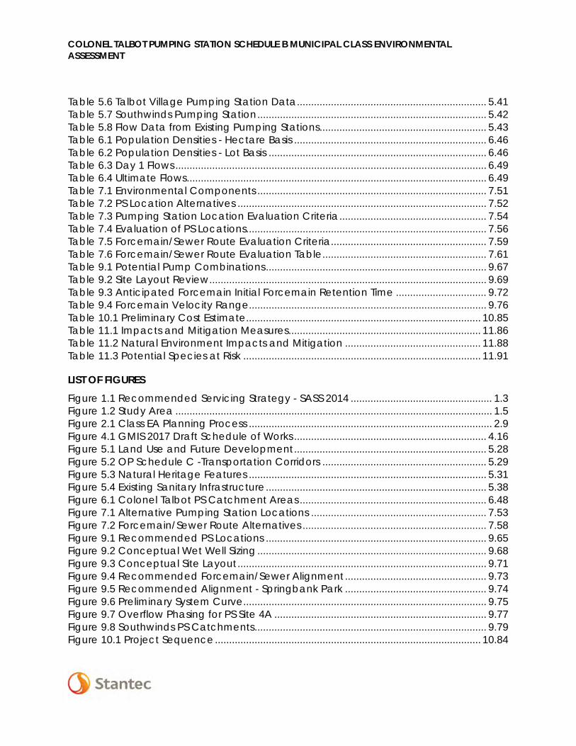
LIST OF TABLES Table 3.1 Consultation - Points of Contact .......................................................................... 3.12 Table 5.1 Aquatic SAR – Thames River .................................................................................. 5.32 Table 5.2 Floral Species at Risk ............................................................................................... 5.33 Table 5.3 Wildlife Species at Risk ............................................................................................ 5.33 Table 5.4 Crestwood Pumping Station ................................................................................. 5.39 Table 5.5 Westfield Pumping Station ..................................................................................... 5.40
COLONEL TALBOT PUMPING STATION SCHEDULE B MUNICIPAL CLASS ENVIRONMENTAL ASSESSMENT
Table 5.6 Talbot Village Pumping Station Data ................................................................... 5.41 Table 5.7 Southwinds Pumping Station ................................................................................. 5.42 Table 5.8 Flow Data from Existing Pumping Stations ........................................................... 5.43 Table 6.1 Population Densities - Hectare Basis .................................................................... 6.46 Table 6.2 Population Densities - Lot Basis ............................................................................. 6.46 Table 6.3 Day 1 Flows .............................................................................................................. 6.49 Table 6.4 Ultimate Flows .......................................................................................................... 6.49 Table 7.1 Environmental Components ................................................................................. 7.51 Table 7.2 PS Location Alternatives ........................................................................................ 7.52 Table 7.3 Pumping Station Location Evaluation Criteria .................................................... 7.54 Table 7.4 Evaluation of PS Locations..................................................................................... 7.56 Table 7.5 Forcemain/Sewer Route Evaluation Criteria ....................................................... 7.59 Table 7.6 Forcemain/Sewer Route Evaluation Table .......................................................... 7.61 Table 9.1 Potential Pump Combinations .............................................................................. 9.67 Table 9.2 Site Layout Review .................................................................................................. 9.69 Table 9.3 Anticipated Forcemain Initial Forcemain Retention Time ................................ 9.72 Table 9.4 Forcemain Velocity Range.................................................................................... 9.76 Table 10.1 Preliminary Cost Estimate ................................................................................... 10.85 Table 11.1 Impacts and Mitigation Measures .................................................................... 11.86 Table 11.2 Natural Environment Impacts and Mitigation ................................................ 11.88 Table 11.3 Potential Species at Risk .................................................................................... 11.91
LIST OF FIGURES Figure 1.1 Recommended Servicing Strategy - SASS 2014 .................................................. 1.3 Figure 1.2 Study Area ................................................................................................................ 1.5 Figure 2.1 Class EA Planning Process ...................................................................................... 2.9 Figure 4.1 GMIS 2017 Draft Schedule of Works .................................................................... 4.16 Figure 5.1 Land Use and Future Development .................................................................... 5.28 Figure 5.2 OP Schedule C -Transportation Corridors .......................................................... 5.29 Figure 5.3 Natural Heritage Features .................................................................................... 5.31 Figure 5.4 Existing Sanitary Infrastructure .............................................................................. 5.38 Figure 6.1 Colonel Talbot PS Catchment Areas .................................................................. 6.48 Figure 7.1 Alternative Pumping Station Locations .............................................................. 7.53 Figure 7.2 Forcemain/Sewer Route Alternatives ................................................................. 7.58 Figure 9.1 Recommended PS Locations .............................................................................. 9.65 Figure 9.2 Conceptual Wet Well Sizing ................................................................................. 9.68 Figure 9.3 Conceptual Site Layout ........................................................................................ 9.71 Figure 9.4 Recommended Forcemain/Sewer Alignment .................................................. 9.73 Figure 9.5 Recommended Alignment - Springbank Park .................................................. 9.74 Figure 9.6 Preliminary System Curve ...................................................................................... 9.75 Figure 9.7 Overflow Phasing for PS Site 4A ........................................................................... 9.77 Figure 9.8 Southwinds PS Catchments .................................................................................. 9.79 Figure 10.1 Project Sequence .............................................................................................. 10.84

COLONEL TALBOT PUMPING STATION SCHEDULE B MUNICIPAL CLASS ENVIRONMENTAL ASSESSMENT
LIST OF APPENDICES
SOUTHWEST AREA SANITARY SERVICING MASTER PLAN (SASS) ............. A.1 APPENDIX A
CITY OF LONDON REQUEST FOR PROPOSAL ............................................ B.1 APPENDIX B
CONSULTATION......................................................................................... C.1 APPENDIX CC.1 Stakeholder List ............................................................................................................. C.1 C.2 Notices ........................................................................................................................... C.1 C.3 PIC Presentation Material ............................................................................................ C.1 C.4 Public Input .................................................................................................................... C.1 C.5 Agency Consultation ................................................................................................... C.1 C.6 First Nations Consultation ............................................................................................. C.1
BACKGROUND COUNCIL REPORTS .......................................................... D.1 APPENDIX D
NATURAL HERITAGE INFORMATION .......................................................... E.1 APPENDIX E
SANITARY SEWER DESIGN SHEETS .............................................................. F.1 APPENDIX F
DETAILED COST OPINION .........................................................................G.1 APPENDIX G

COLONEL TALBOT PUMPING STATION SCHEDULE B MUNICIPAL CLASS ENVIRONMENTAL ASSESSMENT
i
Executive Summary
Introduction
In 2014, the City completed the Southwest Area Sanitary Servicing Master Plan (SASS) which identified a long term sanitary servicing strategy for the Lambeth, North Lambeth, North Talbot, and Bostwick neighbourhoods. The preferred servicing strategy included the implementation of sanitary sewers along existing/future road networks to the Wonderland Pumping Station and a sanitary sewer south along Colonel Talbot Road from Pack Road to a proposed pumping station (PS) in the vicinity of Diane Crescent. The proposed Colonel Talbot PS would convey flows from three existing temporary PS (Westfield, Crestwood, Talbot Village PS to be decommissioned by their respective owners), the Southwinds PS, as well as lands designated for future development up to a firm capacity of 250L/s. Flows would be conveyed via a new sanitary forcemain and gravity sewer to the Byron PS and ultimately to the Oxford PCP. The Preferred Servicing Strategy identified in the SASS is provided in Figure E.1.
Figure E.1 Recommended Servicing Strategy SASS 2014
COLONEL TALBOT PUMPING STATION SCHEDULE B MUNICIPAL CLASS ENVIRONMENTAL ASSESSMENT
ii
The City has undertaken the current Municipal Class Environmental Assessment (Class EA) to implement elements of the sanitary servicing strategy as outlined in the SASS by identifying the location of the proposed Colonel Talbot PS and the forcemain/sewer route to the Byron PS while taking into consideration the Social/Cultural, Natural, Technical, and Economic impacts of the project. The study was conducted in accordance with the Municipal Class Environmental Assessment requirements for Schedule B projects (Municipal Engineers’ Association 2000, as amended in 2007, 2011, and 2015).
Consultation Plan
At the initiation of the project, a contact list was created which includes relevant Federal and Provincial government agencies, local government officials, First Nations Communities throughout Southern Ontario, special interest groups, landowners and developers, including those who expressed interest in the SASS Master Plan. Initial project notification in the form of the Notice of Commencement was also mailed to all property owners within 120m of the study area which included the general PS location and potential forcemain/sewer routes to the Byron PS. All project notification (Notice of Commencement, Notice of Public Information Centre, and Notice of Completion) was published in two consecutive editions of the Londoner Newspaper.
One Public Information Centre was held on June 27th, 2016 at the Byron Community Centre (1308 Norman Avenue, London Ontario). The PIC was held in open house format with staff members from the City of London and Stantec Consulting Inc. in attendance to answer questions. All project notification and PIC information was made available on the City of London website (www.london.ca) and made available upon request.
Problem/Opportunity
In accordance with Phase 1 of the Class EA planning process, the Problem/Opportunity statement developed for the Colonel Talbot PS Class EA is as follows:
The Colonel Talbot PS Class EA is being undertaken to provide an environmentally sensitive and sustainable framework for the implementation of the recommendations within the SASS Master Plan, including a new sanitary PS along Colonel Talbot Road between Pack Road and Diane Crescent, and a forcemain/sewer connection to the Byron PS/Oxford PCP to address sanitary servicing needs for both existing and future developments.
Existing Sanitary Infrastructure
The service area identified for the proposed Colonel Talbot PS consists of existing serviced areas, and lands designated for future development. Vertical infrastructure within the study area consists of the following:
• Crestwood PS (City Owned)
COLONEL TALBOT PUMPING STATION SCHEDULE B MUNICIPAL CLASS ENVIRONMENTAL ASSESSMENT
iii
o Temporary PS located at 999 Gabor Street, built in 1999 to service approximately75ha of low-density residential development.
o Capacity: 11L/s. Flows are currently conveyed eastward to the Greenway PCPsewershed.
o The recommended servicing strategy within the SASS proposed that theCrestwood PS be decommissioned, and flows be conveyed southward throughthe Westfield and Talbot Village sewers to the proposed trunk sewer south onColonel Talbot Road, to the proposed PS in the vicinity of Diane Crescent.
• Westfield PS (Developer Owned)
o Temporary PS located at 3129 Pomeroy Lane, built in 2010 to service theWestfield Subdivision.
o Capacity: 29L/s. Flows are currently conveyed via a forcemain and gravity sewerwest on Southdale Road W, and north on Boler Road to the Byron PS.
o The recommended servicing strategy within the SASS proposed that theCrestwood PS be decommissioned (in accordance with the DevelopmentAgreement), and flows be directed southward to the proposed trunk sewer southon Colonel Talbot Road, to the proposed PS in the vicinity of Diane Crescent.
• Talbot Village PS (Developer Owned)
o Temporary PS located at 6664 Pack Road, built in 2003 to service the TalbotVillage Subdivision.
o Capacity: 75L/s. Flows are currently conveyed north to the Byron PS via aforcemain and gravity sewer north on Colonel Talbot Road.
o The recommended servicing strategy within the SASS proposed that the TalbotVillage PS be decommissioned (in accordance with the DevelopmentAgreement), and flows be directed southward to the proposed trunk sewer onColonel Talbot Road from Pack Road to the proposed PS in the vicinity of DianeCrescent.
• Southwinds PS (City Owned)
o Permanent PS located at 3938 West Graham Place, built in 1995 as a remedialsystem to resolve public health and environmental concerns arising from theinadequate performance of the original septic tank and leaching bed system.

COLONEL TALBOT PUMPING STATION SCHEDULE B MUNICIPAL CLASS ENVIRONMENTAL ASSESSMENT
iv
o 14L/s. Flows are currently conveyed north to the Byron PS via a forcemain andgravity sewer along Colonel Talbot Road.
o The recommended servicing strategy within the SASS proposed that theSouthwinds PS be modified to convey flows to the new Colonel Talbot PS in thevicinity of Diane Crescent.
The linear infrastructure downstream of the proposed Colonel Talbot PS, which includes the Colonel Talbot Road/North Street sewer and the Southdale Road/Boler Road sewer, was assessed using as-built drawings and sewer design sheets in order to identify existing capacity deficiencies and opportunities. Existing capacity issues were identified in the Colonel Talbot Road/North Street sewer, and thus a new sewer was considered for further analysis along this route from the top of the hill on Colonel Talbot Road through to the Byron PS.
No existing capacity concerns were identified on the Southdale Road/Boler Road sewer; however, the sewer has insufficient capacity for Day 1 flows from the Colonel Talbot PS. Since upsizing the existing sanitary sewer would create significant construction disturbance and complexities (frequent PDCs, water service connections, deep sewers), a new dedicated sewer would be more feasible along this route. Thus a dedicated sewer along Boler Road was considered for further analysis as a potential alignment to convey flows from the proposed Colonel Talbot PS to the Byron PS.
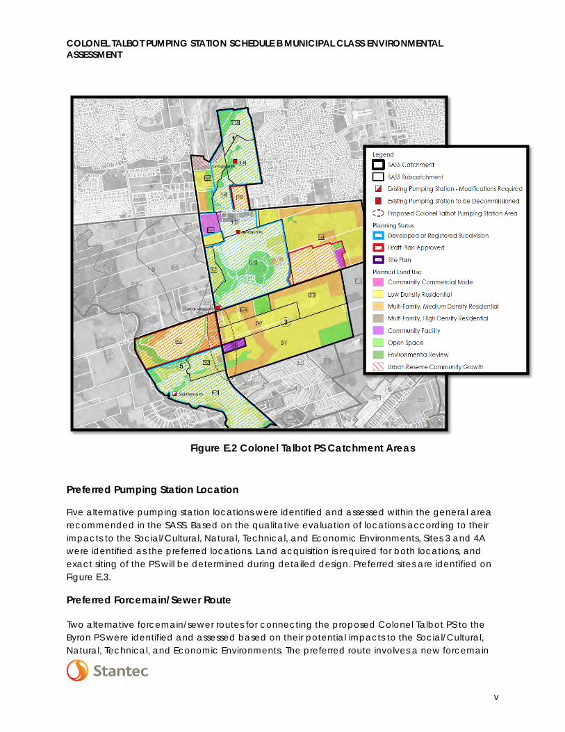
Population and Design Flows
The catchment areas with the potential to convey flows to the proposed Colonel Talbot PS are identified in Figure E.2, which include the existing service areas for the Crestwood PS, Westfield PS, Talbot Village PS, Southwinds PS, along with adjacent lands designated for future development.
Day 1 design flows to the Colonel Talbot PS (i.e. flows from existing catchments 1, 5-1, and 5-2) were calculated to be 102.0 L/s. Design flows for the ultimate build out of the service area were calculated to be 278.5 L/s.
The remaining undeveloped lands within and adjacent to the service area will ultimately flow via gravity to the Wonderland PS. Consideration may be given during detailed design to accommodate flows from External Catchment Area 9 in the design of the gravity trunk sewer south on Colonel Talbot Road from Pack Road.
COLONEL TALBOT PUMPING STATION SCHEDULE B MUNICIPAL CLASS ENVIRONMENTAL ASSESSMENT
v
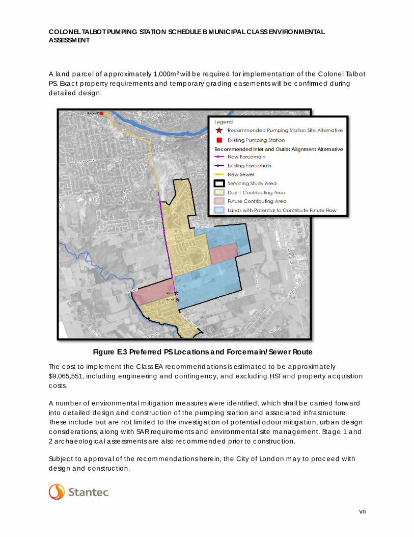
Preferred Pumping Station Location
Five alternative pumping station locations were identified and assessed within the general area recommended in the SASS. Based on the qualitative evaluation of locations according to their impacts to the Social/Cultural, Natural, Technical, and Economic Environments, Sites 3 and 4A were identified as the preferred locations. Land acquisition is required for both locations, and exact siting of the PS will be determined during detailed design. Preferred sites are identified on Figure E.3.
Preferred Forcemain/Sewer Route
Two alternative forcemain/sewer routes for connecting the proposed Colonel Talbot PS to the Byron PS were identified and assessed based on their potential impacts to the Social/Cultural, Natural, Technical, and Economic Environments. The preferred route involves a new forcemain
Figure E.2 Colonel Talbot PS Catchment Areas

COLONEL TALBOT PUMPING STATION SCHEDULE B MUNICIPAL CLASS ENVIRONMENTAL ASSESSMENT
vi
from the Colonel Talbot PS north along Colonel Talbot Road to a sanitary maintenance hole at the top of the hill. Flows would then enter a gravity sewer and be routed north along Colonel Talbot Road and North Street, and west along Commissioners Road approximately 200m before entering into Springbank Park. The sewer will cross Boler Road north of Fire Hall 12, and cross Halls Mills Road to enter the Byron PS located at 1322 Old Bridge Road. This route was preferred due to the construction flexibility provided by the route through Springbank Park lands, less impact to surrounding land uses and traffic operations, involves fewer utility relocations, and can be implemented at less cost as compared to the route along Boler Road. The preferred forcemain/sewer route is identified on Figure E.3.
Summary of Recommendations and Implementation Considerations
Recommendations of this Class EA contain the following components:
• Construction of the Colonel Talbot PS;
• A new trunk sewer from Pack Road south along Colonel Talbot Road to the new ColonelTalbot PS;
• A new forcemain along Colonel Talbot Road from the Colonel Talbot PS to the highpoint along Colonel Talbot Road north of Southdale Road;
• Construction of a trunk sewer from the high point along Colonel Talbot Road to theByron PS;
• Modifications to the Southwinds PS to allow for flows from area 5-3 and to change thepumping configuration to outlet the existing forcemain on Colonel Talbot Road near theColonel Talbot PS;
• Redirection of flows from the Talbot Village, Westfield, and Crestwood Pumping Stationson commissioning of the Colonel Talbot PS; and
• Decommissioning of the Talbot Village, Westfield, and Crestwood Pumping Stations bytheir respective owners.
COLONEL TALBOT PUMPING STATION SCHEDULE B MUNICIPAL CLASS ENVIRONMENTAL ASSESSMENT
vii
A land parcel of approximately 1,000m2 will be required for implementation of the Colonel Talbot PS. Exact property requirements and temporary grading easements will be confirmed during detailed design.
The cost to implement the Class EA recommendations is estimated to be approximately $9,065,551, including engineering and contingency, and excluding HST and property acquisition costs.
A number of environmental mitigation measures were identified, which shall be carried forward into detailed design and construction of the pumping station and associated infrastructure. These include but are not limited to the investigation of potential odour mitigation, urban design considerations, along with SAR requirements and environmental site management. Stage 1 and 2 archaeological assessments are also recommended prior to construction.
Subject to approval of the recommendations herein, the City of London may to proceed with design and construction.
Figure E.3 Preferred PS Locations and Forcemain/Sewer Route

COLONEL TALBOT PUMPING STATION SCHEDULE B MUNICIPAL CLASS ENVIRONMENTAL ASSESSMENT
viii
Abbreviations
Class EA Municipal Class Environmental Assessment
EAA Environmental Assessment Act
ESA Endangered Species Act
ESR Environmental Study Report
GMIS Growth Management Implementation Strategy
I&I Inflow and Infiltration
MOECC Ministry of the Environment and Climate Change
MEA Municipal Engineer’s Association
MNHSS Middlesex Natural Heritage System Study
NHIC Natural Heritage Information Centre
OP Official Plan
PCP Pollution Control Plant
PS Pumping Station
SAR/SARO Species at Risk/Species at Risk in Ontario List
SASS Southwest Area Sanitary Servicing Master Plan (Stantec 2014)
SWAP Southwest Area Plan
SWM Stormwater Management
TDH Total Dynamic Head
TRACER Team Response and Commitment to Environmental Requirements
COLONEL TALBOT PUMPING STATION SCHEDULE B MUNICIPAL CLASS ENVIRONMENTAL ASSESSMENT
Introduction September 22, 2016
bs v:\01656\active\165630067\planning\class ea\project file\final_for_30day_review\draft_colonel_talbot_pf_30_day_review_sept21.docx 1.1
1.0 INTRODUCTION
The City of London has completed a Municipal Class Environmental Assessment (Class EA) for the implementation of elements of the sanitary servicing strategy outlined in the Southwest Area Sanitary Servicing Master Plan (SASS) 2014 for both existing and future developments within the Crestwood, North Talbot, North Lambeth, and Southwinds neighbourhoods. The recommendations of the SASS included a new sanitary pumping station (PS) and associated forcemain/sewer connection to the Byron PS to convey flows from existing developments and lands designated for future development.
The Environmental Assessment Act (EAA) requires the completion of an Environmental Assessment before construction of any municipal infrastructure including sanitary pumping stations. This Project File addresses the recommendations of the SASS in order to identify the location of the new Colonel Talbot PS and forcemain/sewer route to the Byron PS while taking into consideration the Social, Cultural, Technical, and Economic impacts of the project. The study is being conducted in accordance with the Municipal Class Environmental Assessment (Class EA) requirements for Schedule B projects (Municipal Engineer’s Association 2000, as amended in 2007, 2011, and 2015).
1.1 BACKGROUND
1.1.1 Southwest Area Sanitary Servicing Master Plan (SASS) 2014
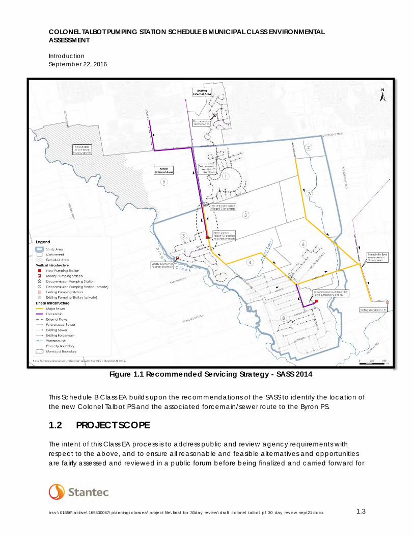
In 2014, the City completed the Southwest Area Sanitary Servicing Master Plan (SASS) which identified a long term sanitary servicing strategy for the Lambeth, North Lambeth, North Talbot, and Bostwick neighbourhoods as identified in the Southwest Area Plan (SWAP). The Executive Summary is provided in Appendix A.
The SASS Master Plan evaluated four existing pumping stations (PS), Southwinds PS, Talbot Village PS (privately owned), Westfield PS (privately owned), and Crestwood PS (City owned), and identified alternative servicing strategies with the objective being to reduce operational costs and allow for future growth. The preferred servicing strategy included the implementation of sanitary sewers along existing/future road networks to the Wonderland PS and sanitary sewers along Colonel Talbot Road to a new pumping station with a new forcemain to Boler Road. It was proposed that:
• A gravity sewer running south along Colonel Talbot Road from Pack Road to conveyflows from the Crestwood PS, Westfield PS and Talbot Village PS to the location of theproposed Colonel Talbot PS.
COLONEL TALBOT PUMPING STATION SCHEDULE B MUNICIPAL CLASS ENVIRONMENTAL ASSESSMENT
Introduction September 22, 2016
bs v:\01656\active\165630067\planning\class ea\project file\final_for_30day_review\draft_colonel_talbot_pf_30_day_review_sept21.docx 1.2
• A new pumping station (Colonel Talbot PS) constructed in the vicinity of Diane Crescentto pump flows via a new forcemain along Colonel Talbot Road to Boler Road and thento the Oxford PCP sewershed.
• A gravity sewer continuing from the Colonel Talbot PS through a future residentialsubdivision and south to Campbell Street.
• A gravity sewer running east along Hamlyn Street to Wonderland Road, and
• Connection to the common sewer along Wonderland Road which connects the studyarea and other areas north of Dingman Drive to the Wonderland PS.
The objective of the recommended strategy identified in the SASS is to provide flexibility in sanitary servicing within the service area. Under standard operating conditions, flow from the proposed Colonel Talbot PS is directed to the Oxford Pollution Control Plant (PCP). During non-standard operations, flows can be directed from the proposed Colonel Talbot PS to the Wonderland PS which pumps flows to the Greenway PCP. Non-standard operations can include upgrades, maintenance, or service disruptions at the Oxford PCP which can temporarily reduce capacity, or the like at the proposed Colonel Talbot Pumping Station.
This strategy, including the decommissioning of three existing temporary PS and modification to Southwinds PS, promotes integration of infrastructure elements and allows for optimization of the City’s existing sanitary infrastructure system.
The firm capacity for the proposed Colonel Talbot PS was identified in the SASS at approximately 250 L/s. This flow rate was determined based on optimal treatment capacity of the Oxford PCP.
Based on a preliminary review, the SASS also identified a potential forcemain and sewer route west on Southdale Road and north on Boler Road to connect to the Byron PS. This route and an alternate route have been evaluated as part of this Schedule B Class EA to determine a preferred alignment, taking into consideration Natural Environment, Social, Technical, and Economic impacts.
COLONEL TALBOT PUMPING STATION SCHEDULE B MUNICIPAL CLASS ENVIRONMENTAL ASSESSMENT
Introduction September 22, 2016
bs v:\01656\active\165630067\planning\class ea\project file\final_for_30day_review\draft_colonel_talbot_pf_30_day_review_sept21.docx 1.3
This Schedule B Class EA builds upon the recommendations of the SASS to identify the location of the new Colonel Talbot PS and the associated forcemain/sewer route to the Byron PS.
1.2 PROJECT SCOPE
The intent of this Class EA process is to address public and review agency requirements with respect to the above, and to ensure all reasonable and feasible alternatives and opportunities are fairly assessed and reviewed in a public forum before being finalized and carried forward for
Figure 1.1 Recommended Servicing Strategy - SASS 2014

COLONEL TALBOT PUMPING STATION SCHEDULE B MUNICIPAL CLASS ENVIRONMENTAL ASSESSMENT
Introduction September 22, 2016
bs v:\01656\active\165630067\planning\class ea\project file\final_for_30day_review\draft_colonel_talbot_pf_30_day_review_sept21.docx 1.4
implementation. The scope of the Class EA was developed based on the Request for Proposal 15-46 included in Appendix B and generally consists of the following:
• A review of background reports, investigations, and studies that provide the context andneed for the identified servicing works;
• An inventory of the Social/Cultural and Natural Environments;
• Identification and evaluation of alternative pumping station locations andforcemain/sewer routes, considering impacts to the Social/Cultural, Natural, Technical,and Economic Environments;
• Consultation with the public, First Nations, agencies, and other identified stakeholders toidentify and resolve potential issues that arise throughout the project;
• Identification of mitigation and monitoring plans to be carried forward into the detaileddesign and construction of recommended works for any potential impacts identified;
• Preparation and filing of a Project File to document in a clear and transparent mannerthe process undertaken in complying with the Municipal Class EA process.
1.3 PROJECT OBJECTIVES
The objective of this Class EA study is to confirm the appropriate location for the proposed Colonel Talbot PS which will ultimately provide flexibility in servicing the study area. The PS will allow the northerly region of the study area to develop and convey sewage to the Oxford PCP for treatment, while gravity trunk sanitary sewers will allow for sewage in the southerly region to be conveyed to the Wonderland PS/Greenway PCP. This strategy will provide optimal use of the City of London’s existing sanitary infrastructure.
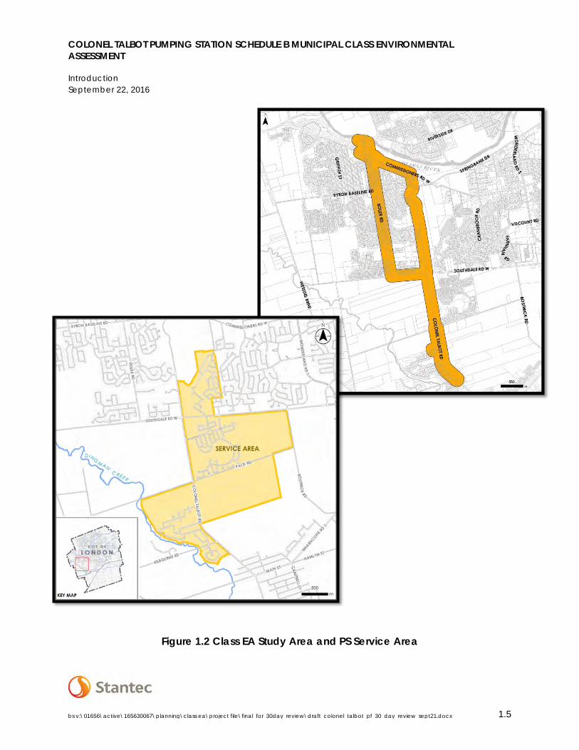
1.4 STUDY AREA
The Study Area for the project includes the area along Colonel Talbot Road between Pack Road and Diane Crescent identified in the SASS as the general location for the new Colonel Talbot PS based on topography and the function of gravity sewers (see Figure 1.2). The study area also includes the preliminary forcemain/sewer route west on Southdale Road, north on Boler Road up to the Byron PS located at 1322 Old Bridge Road as identified in the SASS. An alternate route was also identified north along Colonel Talbot Road to North Street and west on Commissioners Road. The general service area for the proposed Colonel Talbot PS shown on Figure 1.2 includes existing residential and commercial developments, as well as undeveloped lands designated for future development within the Southwest Area Plan (SWAP).
COLONEL TALBOT PUMPING STATION SCHEDULE B MUNICIPAL CLASS ENVIRONMENTAL ASSESSMENT
Introduction September 22, 2016
bs v:\01656\active\165630067\planning\class ea\project file\final_for_30day_review\draft_colonel_talbot_pf_30_day_review_sept21.docx 1.5
Figure 1.2 Class EA Study Area and PS Service Area
COLONEL TALBOT PUMPING STATION SCHEDULE B MUNICIPAL CLASS ENVIRONMENTAL ASSESSMENT
Municipal Class Environmental Assessment Planning Process September 22, 2016
bs v:\01656\active\165630067\planning\class ea\project file\final_for_30day_review\draft_colonel_talbot_pf_30_day_review_sept21.docx 2.6
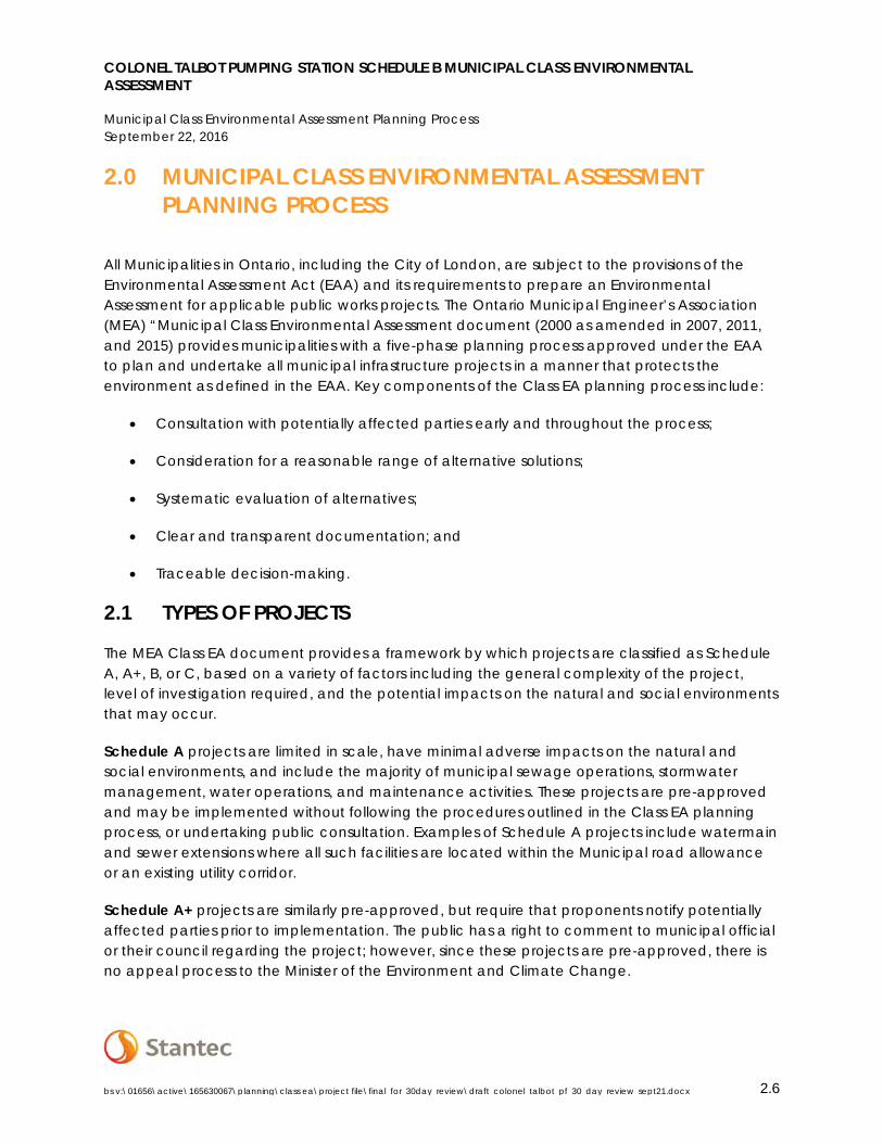
2.0 MUNICIPAL CLASS ENVIRONMENTAL ASSESSMENT PLANNING PROCESS
All Municipalities in Ontario, including the City of London, are subject to the provisions of the Environmental Assessment Act (EAA) and its requirements to prepare an Environmental Assessment for applicable public works projects. The Ontario Municipal Engineer’s Association (MEA) “Municipal Class Environmental Assessment document (2000 as amended in 2007, 2011, and 2015) provides municipalities with a five-phase planning process approved under the EAA to plan and undertake all municipal infrastructure projects in a manner that protects the environment as defined in the EAA. Key components of the Class EA planning process include:
• Consultation with potentially affected parties early and throughout the process;
• Consideration for a reasonable range of alternative solutions;
• Systematic evaluation of alternatives;
• Clear and transparent documentation; and
• Traceable decision-making.
2.1 TYPES OF PROJECTS
The MEA Class EA document provides a framework by which projects are classified as Schedule A, A+, B, or C, based on a variety of factors including the general complexity of the project, level of investigation required, and the potential impacts on the natural and social environments that may occur.
Schedule A projects are limited in scale, have minimal adverse impacts on the natural and social environments, and include the majority of municipal sewage operations, stormwater management, water operations, and maintenance activities. These projects are pre-approved and may be implemented without following the procedures outlined in the Class EA planning process, or undertaking public consultation. Examples of Schedule A projects include watermain and sewer extensions where all such facilities are located within the Municipal road allowance or an existing utility corridor.
Schedule A+ projects are similarly pre-approved, but require that proponents notify potentially affected parties prior to implementation. The public has a right to comment to municipal official or their council regarding the project; however, since these projects are pre-approved, there is no appeal process to the Minister of the Environment and Climate Change.
COLONEL TALBOT PUMPING STATION SCHEDULE B MUNICIPAL CLASS ENVIRONMENTAL ASSESSMENT
Municipal Class Environmental Assessment Planning Process September 22, 2016
bs v:\01656\active\165630067\planning\class ea\project file\final_for_30day_review\draft_colonel_talbot_pf_30_day_review_sept21.docx 2.7
Schedule B projects have the potential for some adverse environmental and social effects, and proponents are thus required to undertake a screening process involving mandatory contact with potentially affected members of the public, Aboriginal and First Nations Communities, and relevant review agencies to ensure that they are aware of the project and that their concerns are addressed. Schedule B projects require the completion of Phases 1 and 2 of the Class EA planning process, which is documented in a Project File that is submitted for a mandatory 30-day public review period. If concerns are raised that cannot be resolved, any member of the public may appeal to the Minister of the Environment and Climate Change to issue an order to comply with Part II of the EAA, bumping up the status of the project. Part II Order requests are discussed further below.
Schedule C projects have the potential for significant environmental impacts and must follow the full planning process specified in the Class EA document including Phases 1 through 4. The project is documented in an Environmental Study Report (ESR), which is then files for review by the Public, review agencies, and Aboriginal and First Nations communities. If concerns are raised that cannot be resolved, the Part II Order procedure may be invoked. Projects generally include the construction of new facilities, and major expansions to existing facilities.
2.2 5 PHASE PLANNING PROCESS
Figure 2.1illustrates the Municipal Class EA planning process. The figure incorporates steps considered essential for compliance with the requirements of the EAA, as discussed below.
Phase 1 Identify the problem (deficiency) or opportunity, which may include public consultation to confirm/review the problems and opportunities.
Phase 2 Identify a reasonable range of alternative solutions to address the problem or opportunity. This phase also includes an inventory of the existing environment, and to assist in the evaluation of alternatives. A preferred solution is chosen based on the results of the evaluation and taking into account input from the public, review agencies, and Aboriginal and First Nations communities. It is at this point that the appropriate project Schedule is chosen and/or confirmed. If the project is identified as a Schedule B activity, the process and decisions are then documented in a Project File. Schedule C projects proceed through Phases 3 and 4.
Phase 3 (For Schedule C projects only) Examine the alternative methods for implementing the preferred solution, i.e. design alternatives, based upon the existing environment, public and agency input, anticipated environmental effects and methods for minimizing negative effects and maximizing positive effects.
Phase 4 (For Schedule C projects only) Document the Class EA process followed in an Environmental Study Report (ESR), which includes a summary of the rationale and
COLONEL TALBOT PUMPING STATION SCHEDULE B MUNICIPAL CLASS ENVIRONMENTAL ASSESSMENT
Municipal Class Environmental Assessment Planning Process September 22, 2016
bs v:\01656\active\165630067\planning\class ea\project file\final_for_30day_review\draft_colonel_talbot_pf_30_day_review_sept21.docx 2.8
the planning, design, and consultation process followed for the project and make the documentation available for consideration by the public, review agencies, and Aboriginal and First Nations communities for a mandatory 30-day review period.
Phase 5 Completed contract drawings and documents, and proceed to construction and operation with monitoring to ensure adherence to environmental provisions and commitments.
The Class EA process and associated documentation serves as a public statement of the decision making process followed by Municipalities for the planning and implementation of necessary infrastructure.

Figure 2.1 – Municipal Class Environmental Assessment Planning Process
COLONEL TALBOT PUMPING STATION SCHEDULE B MUNICIPAL CLASS ENVIRONMENTAL ASSESSMENT
Municipal Class Environmental Assessment Planning Process September 22, 2016
bs v:\01656\active\165630067\planning\class ea\project file\final_for_30day_review\draft_colonel_talbot_pf_30_day_review_sept21.docx 2.10
2.3 APPEAL PROCESS – PART II ORDER REQUESTS
The planning process as outlined above encourages the identification and resolution of concerns throughout the project, and it is the obligation of the proponent to adequately address concerns raised by the public, Aboriginal and First Nations communities, and review agencies. If an interested party feels as though their concerns have not been adequately addressed, and that the proposed undertaking needs to be subject to a more in-depth planning process, a request for a Part II Order may be submitted to the Ministry of the Environment and Climate Change (MOECC). Under the provisions of Section 16 of the EAA, the Minister or delegate may require a proponent comply with Part II of the EAA by completing an Individual Environmental Assessment before proceeding to implementation. The Minister may deny the request, impose conditions on the proposed undertaking, or for Schedule B projects, the Minister may elevate the status of the project to a Schedule C project, requiring the completion of the full EA planning process prior to implementation.
As per Section A.2.8 of the MEA Municipal Class Environmental Assessment document, the process for requesting a Part II Order involves the following:
• Persons with a concern brings it to the attention of the proponent during the planningprocess;
• If the concern is not resolved through consultation with the proponent, the person mayrequest that the proponent voluntarily elevate the status of the project to a Schedule Cproject, or an Individual Environmental Assessment;
• If the proponent refuses to elevate the status of the project, the person with the concernmay send a request to the Minister of the Environment and Climate Change during the30 day review period to issue an order to comply with Part II of the EAA, in writing, with acopy to the proponent;
• The request must be made upon the completion of the planning process (after a Noticeof Completion is issued, outlining the public review period) so that all potentialenvironmental impacts and impact management measures are understood;
• Must not be made for the sole purpose of delaying, stopping, or frustrating the planningand implementation of a project;
• Must focus on potential environment effects ( including the social, cultural and naturalenvironments) of the project, and not on decisions made outside of the Class EA process(for example, land use planning decisions made under the Planning Act, or issues relatedto municipal funding of projects);
• Must not raise issues that are not related to the project; and• Should be withdrawn promptly by the requester if the proponent has satisfied the
concerns of the requester.
It is the proponent’s responsibility to provide several opportunities for public, First Nations and agency review and input. It is also the responsibility of the public, First Nations, and agency to bring their concern to the attention of the proponent early in the planning process. Every
COLONEL TALBOT PUMPING STATION SCHEDULE B MUNICIPAL CLASS ENVIRONMENTAL ASSESSMENT
Consultation Plan September 22, 2016
bs v:\01656\active\165630067\planning\class ea\project file\final_for_30day_review\draft_colonel_talbot_pf_30_day_review_sept21.docx 3.11
reasonable effort must be made by the proponent to address the concerns brought forward. If concerns have not been addressed upon the issuance of the Notice of Completion, any member of the public may submit a request with the following information to the Minister of the Environment and Climate Change or delegate within the 30-day public review period as outlined in the Notice:
• Project name and proponent;• Environmental impacts of the project and their significance;• The adequacy of the planning process;• The availability of alternatives to the project;• The adequacy of the public consultation program and the opportunities for public
participation;• The involvement of the requester in the planning of the project;• The nature of the specific concerns which remain unresolved;• Details of any discussions held between the requester and the proponent;• The benefits of requiring the proponent to undertake a higher level of assessment; and• Any other important matters considered relevant.
More information on submitting a Part II Order request can be found in Section A.2.8 of the MEA Municipal Class EA document.
3.0 CONSULTATION PLAN
Consultation is a vital part of the Class EA process. Active engagement with all potentially affected parties including government agencies, community members, special interest groups, and Aboriginal and First Nations communities ensures a transparent and responsible planning process.
At the initiation of the project, a contact list was created which includes relevant Federal and Provincial government agencies, local government officials, and First Nations Communities throughout Southern Ontario, special interest groups, land owners and developers (Appendix C.1). Those who expressed interest in the SASS Master Plan were also included on the projectmailing list. The initial project notification in the form of the Notice of Commencement was alsomailed to all property owners within 120m of the study area which included the general PSlocation and forcemain/sewer connection to the Byron PS.
One Public Information Centre (PIC) was held on June 27th, 2016 at the Byron Community Centre at 1308 Norman Avenue, London Ontario. The PIC was held in open house format with staff members from the City of London and Stantec Consulting Inc. in attendance to answer questions. All presentation materials and comments received have been included in Appendix C.
COLONEL TALBOT PUMPING STATION SCHEDULE B MUNICIPAL CLASS ENVIRONMENTAL ASSESSMENT
Consultation Plan September 22, 2016
bs v:\01656\active\165630067\planning\class ea\project file\final_for_30day_review\draft_colonel_talbot_pf_30_day_review_sept21.docx 3.12
Comments received as part of the SASS Master Plan were also reviewed in order to identify potential concerns with respect to the works subject to the Colonel Talbot PS Class EA.
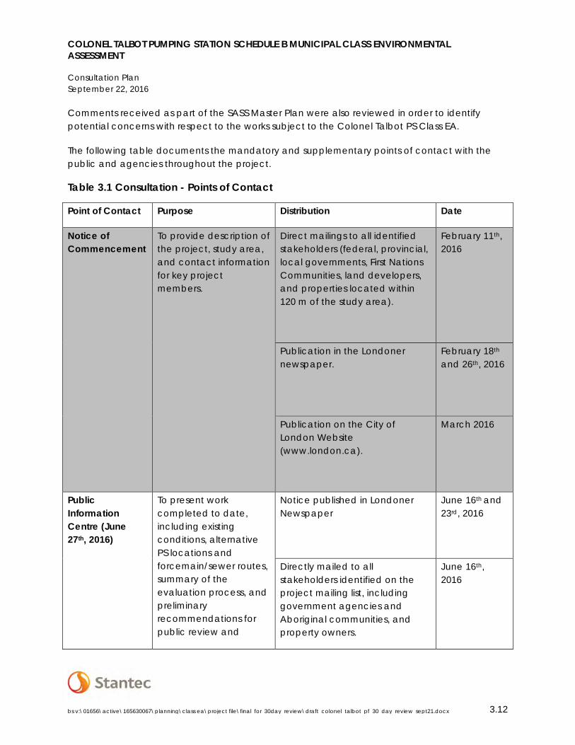
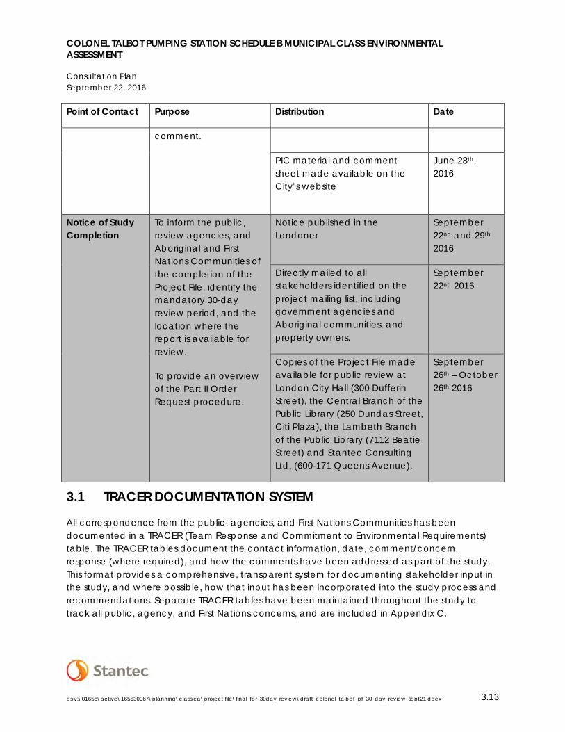
The following table documents the mandatory and supplementary points of contact with the public and agencies throughout the project.
Table 3.1 Consultation - Points of Contact
Point of Contact Purpose Distribution Date
Notice of Commencement
To provide description of the project, study area, and contact information for key project members.
Direct mailings to all identified stakeholders (federal, provincial, local governments, First Nations Communities, land developers, and properties located within 120 m of the study area).
February 11th, 2016
Publication in the Londoner newspaper.
February 18th and 26th, 2016
Publication on the City of London Website (www.london.ca).
March 2016
Public Information Centre (June 27th, 2016)
To present work completed to date, including existing conditions, alternative PS locations and forcemain/sewer routes, summary of the evaluation process, and preliminary recommendations for public review and
Notice published in Londoner Newspaper
June 16th and 23rd, 2016
Directly mailed to all stakeholders identified on the project mailing list, including government agencies and Aboriginal communities, and property owners.
June 16th, 2016
COLONEL TALBOT PUMPING STATION SCHEDULE B MUNICIPAL CLASS ENVIRONMENTAL ASSESSMENT
Consultation Plan September 22, 2016
bs v:\01656\active\165630067\planning\class ea\project file\final_for_30day_review\draft_colonel_talbot_pf_30_day_review_sept21.docx 3.13
Point of Contact Purpose Distribution Date
comment.
PIC material and comment sheet made available on the City’s website
June 28th, 2016
Notice of Study Completion
To inform the public, review agencies, and Aboriginal and First Nations Communities of the completion of the Project File, identify the mandatory 30-day review period, and the location where the report is available for review.
To provide an overview of the Part II Order Request procedure.
Notice published in the Londoner
September 22nd and 29th 2016
Directly mailed to all stakeholders identified on the project mailing list, including government agencies and Aboriginal communities, and property owners.
September 22nd 2016
Copies of the Project File made available for public review at London City Hall (300 Dufferin Street), the Central Branch of the Public Library (250 Dundas Street, Citi Plaza), the Lambeth Branch of the Public Library (7112 Beatie Street) and Stantec Consulting Ltd, (600-171 Queens Avenue).
September 26th – October 26th 2016
3.1 TRACER DOCUMENTATION SYSTEM
All correspondence from the public, agencies, and First Nations Communities has been documented in a TRACER (Team Response and Commitment to Environmental Requirements) table. The TRACER tables document the contact information, date, comment/concern, response (where required), and how the comments have been addressed as part of the study. This format provides a comprehensive, transparent system for documenting stakeholder input in the study, and where possible, how that input has been incorporated into the study process and recommendations. Separate TRACER tables have been maintained throughout the study to track all public, agency, and First Nations concerns, and are included in Appendix C.
COLONEL TALBOT PUMPING STATION SCHEDULE B MUNICIPAL CLASS ENVIRONMENTAL ASSESSMENT
Phase 1 – Problem and or Opportunity September 22, 2016
bs v:\01656\active\165630067\planning\class ea\project file\final_for_30day_review\draft_colonel_talbot_pf_30_day_review_sept21.docx 4.14
3.2 FIRST NATIONS CONSULTATION
Seven First Nations Communities were contacted throughout the project, identified based on the location of the study area, known interests, and direct communication with the Ministry of Aboriginal Affairs and included:
• Chippewas of the Thames First Nation;• Oneida Nation of the Thames;• Munsee-Delaware Nation;• Delaware Nation (Moravian of the Thames);• Bkejwanong Territory (Walpole Island First Nation);• Caldwell First Nation;• Chippewas of Kettle and Stony Point First Nation.
First Nations Communities were consulted throughout the project, and all correspondence is included in the TRACER table found in Appendix C.6.
Chippewas of the Thames First Nation requested a meeting for more information on the project, which is scheduled to occur on September 27th, 2016 during the 30-day public review period. The Draft Project File will be updated to reflect the outcome of the meeting including any concerns expressed by COTTFN.
4.0 PHASE 1 – PROBLEM AND OR OPPORTUNITY
Phase 1 of the Class EA process involves identification of the problem and/or opportunities, and documentation of the factors leading to the determination that improvements are required.
4.1 NEED AND JUSTIFICATION
A number of background reports, studies, and investigations have been completed which identify the need and justification for the proposed sanitary works. The southwest area has been identified as a significant growth area within the City of London, and these reports and studies provide the framework in which development is to occur.
4.1.1 Southwest Area Plan (SWAP)
The Southwest Area Plan (SWAP) provided a land use concept and accompanying policies to guide future development in the southwest portion of the City of London.
COLONEL TALBOT PUMPING STATION SCHEDULE B MUNICIPAL CLASS ENVIRONMENTAL ASSESSMENT
Phase 1 – Problem and or Opportunity September 22, 2016
bs v:\01656\active\165630067\planning\class ea\project file\final_for_30day_review\draft_colonel_talbot_pf_30_day_review_sept21.docx 4.15
4.1.2 Greenway PCP Expansion and Capacity Optimization
An expansion of the Greenway PCP was investigated within the Greenway Pollution Control Centre Class EA (Stantec 2010) to address future growth within the southwest area (see the July 19, 2010 staff report to the Environment and Transportation Committee in Appendix D). Expanding and optimizing the Greenway PCP was considered a more desirable solution than building the Southside treatment plant based on the high initial cost for a new plant, which included substantial piping costs.
While undertaking necessary upgrades to the Greenway PCP, the City identified opportunities to optimize the use of their existing sanitary treatment infrastructure. A phased approach has been undertaken to implement the expansion, and includes upgrades to the Wonderland PS. The upgrades to the Wonderland PS are currently underway, and involve an increase of the rated capacity of the PS in order to accept additional flows from the Southwest Area, which are then conveyed to the Greenway PCP. See the Greenway Wastewater Treatment Plant Expansion and Upgrade Update report presented to the Civic Works Committee on October 28th, 2013 included in Appendix D.
4.1.3 Southwest Area Sanitary Servicing Master Plan (SASS) 2014
The SASS evaluated alternative servicing strategies for a portion of the Southwest Area including the Lambeth, North Lambeth, North Talbot, and Bostwick neighbourhoods, as discussed in Section 1.1.1. The recommended alternative including the proposed Colonel Talbot PS was identified to provide flexibility within the City’s existing sanitary treatment system. Treatment capacities at both the Greenway and Oxford PCPs can be optimized based on water usage and incoming flows, and the strategy allows for the diversion of flows during non-standard operating conditions (maintenance, upgrades, wet weather events, etc.).
The general location along the Colonel Talbot Road right of way in the vicinity of Diane Crescent was identified for the proposed PS based on the proximity to the connecting sewers (i.e. the trunk sewer along Colonel Talbot Road conveying flows from the Talbot Village, Crestwood, and Westfield PSs), and the timing of implementation.
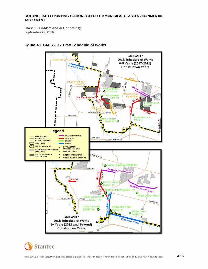
4.1.4 Growth Management Implementation Strategy Update 2017 (GMIS)
The City of London has developed a Growth Management Implementation Strategy (GMIS) to guide growth in an orderly manner by balancing the needs of new development with the costs of extending major infrastructure. The servicing and infrastructure requirements are guided by the policies of the Official Plan, Capital Budget, servicing master plans, current development applications, and the findings of the Development Charges Background Study.
Based on the findings of the SASS and the Development Charges Background Study (2014), the City has identified a construction year of 2017 for the Colonel Talbot PS (Figure 4.1). The completion of this Class EA is required for implementation of the GMIS recommendations.
COLONEL TALBOT PUMPING STATION SCHEDULE B MUNICIPAL CLASS ENVIRONMENTAL ASSESSMENT
Phase 1 – Problem and or Opportunity September 22, 2016
bs v:\01656\active\165630067\planning\class ea\project file\final_for_30day_review\draft_colonel_talbot_pf_30_day_review_sept21.docx 4.16
Figure 4.1 GMIS 2017 Draft Schedule of Works
GMIS 2017 Draft Schedule of Works 0-5 Years (2017-2021)
Construction Years
GMIS 2017 Draft Schedule of Works
5+ Years (2022 and Beyond) Construction Years

COLONEL TALBOT PUMPING STATION SCHEDULE B MUNICIPAL CLASS ENVIRONMENTAL ASSESSMENT
Phase 2 – Existing Conditions September 22, 2016
bs v:\01656\active\165630067\planning\class ea\project file\final_for_30day_review\draft_colonel_talbot_pf_30_day_review_sept21.docx 5.17
Project SS15C represents the gravity sewer running south along Colonel Talbot Road connecting the existing temporary pumping stations to the new Colonel Talbot PS. Both projects (the PS and gravity sewer) are identified for construction in 2017 in the 2017 GMIS Update.
SS15 Phase 2 identified for construction in 2018, includes a gravity trunk sewer to connect to sewers leading to the Wonderland PS, to convey flows from an Approved Draft Plan of Subdivision (Colonel Talbot Subdivision – Auburn Developments Inc.).
SS15B identified for construction in 2025 involves the connection of gravity sewers to the south (SS15 Phase 1 and 2) to the new Colonel Talbot PS.
4.2 PROBLEM AND OPPORTUNITY STATEMENT
Phase 1 of the Class EA process includes an identification of the problem and/or opportunity that shall be addressed by the study. Based on the City’s land use and development concept found in the Southwest Area Plan (SWAP), and the work completed as part of the Southwest Area Sanitary Servicing Master Plan (SASS), the following Problem/Opportunity Statement was developed for the project:
The Colonel Talbot PS Class EA is being undertaken to provide an environmentally sensitive and sustainable framework for the implementation of the recommendations within the SASS Master Plan, including a new sanitary PS along Colonel Talbot Road between Pack Road and Diane Crescent, and a forcemain/sewer connection to the Byron PS/Oxford PCP to address sanitary servicing needs for both existing and future developments.
5.0 PHASE 2 – EXISTING CONDITIONS
This section of the report summarizes existing conditions within the study area. The information was used to identify, confirm, and evaluate alternatives and their potential impacts to the social, cultural, and natural environments.
5.1 LAND USE AND PLANNING POLICY
The following outlines the relevant federal, provincial, and municipal policies and planning objectives that provide the framework and context for the study.
5.1.1 The Planning Act 2005
The Planning Act (2005) sets the framework for land use planning in Ontario. According to the provisions within the Planning Act, the Province of Ontario is the primary authority for planning matters within Ontario, and the Act enables the Province to delegate some of its planning
COLONEL TALBOT PUMPING STATION SCHEDULE B MUNICIPAL CLASS ENVIRONMENTAL ASSESSMENT
Phase 2 – Existing Conditions September 22, 2016
bs v:\01656\active\165630067\planning\class ea\project file\final_for_30day_review\draft_colonel_talbot_pf_30_day_review_sept21.docx 5.18
authority to the upper-tier municipalities (i.e. counties and regional/district municipalities, and planning boards) while retaining control through the approval process. Municipalities must conform to approved policies of the Provincial government and its agencies. Provincial ministries, municipal councils, planners, and other stakeholders implement the Act when such actions include:
• Preparing Official Plans and planning policies that guide future development consideringprovincial interests, such as protecting and managing natural resources;
• Regulating and controlling land uses through zoning by-laws and minor variances; and
• Dividing land into separate lots for sale or development through Plans of Subdivision or aLand Severance.
This study considers development applications approved under the Planning Act and associated conditions of approval along with lands designated for future development.
5.1.2 Provincial Policy Statement 2014 (PPS)
The Provincial Policy Statement, issued under Section 3 of the Planning Act, sets a policy foundation for regulating the development and use of land. It provides direction on matters of provincial interest and supports the enhancement of the quality of life for all citizens of Ontario. In accordance with Section 3 of the Planning Act, decisions affecting planning matters shall have regard for the Provincial Policy Statement.
The PPS 2014 provides for enhanced protection of the environment by requiring the identification of the natural heritage system and water resources, including natural hazards, water quality, air quality, and energy use. The policies provide for intensification and Brownfield development to ensure the maximum use of sewer, water, and energy systems, roads, and transit.
Five general principles are established in the PPS that are further elaborated on in a detailed set of policies that address the following matters:
• Building Strong Healthy Communities;
• Wise Use and Management of Resources; and
• Protecting Public Health and Safety.
Section 1.6.6 contains specific policies applicable to the planning and implementation of sanitary servicing:
• 1.6.6.1 Planning for sewage and water services shall:
COLONEL TALBOT PUMPING STATION SCHEDULE B MUNICIPAL CLASS ENVIRONMENTAL ASSESSMENT
Phase 2 – Existing Conditions September 22, 2016
bs v:\01656\active\165630067\planning\class ea\project file\final_for_30day_review\draft_colonel_talbot_pf_30_day_review_sept21.docx 5.19
o Direct and accommodate expected growth or development in a manner thatpromotes the efficient use and optimization of existing:
Municipal sewage services and municipal water services; and Private communal sewage services and private communal water services,
where municipal sewage services and municipal water services are notavailable.
o Ensure that these systems are provided in a manner that; Can be sustained by the water resources upon which such services rely; Is feasible, financially viable and complies with all regulatory requirements;
and Protects human health and the natural environment;
o Promote water conservation and water use efficiency; ando Integrate servicing and land use considerations at all stages of the planning
process.
The preferred alternative and supporting recommendations will meet the objectives of the PPS by providing for infrastructure that is appropriate to address the projected needs, protects the natural heritage system, and protects public health and safety.
5.1.3 City of London Official Plan
The Official Plan (OP) for the City of London contains policies to guide short and long term development of land within the City boundary. It provides direction for the allocation of land use, provision of services and facilities, and policies to control the use of land, having regard for social, economic, and environmental matters. The existing 1989 Official Plan is in force and effect, and all recommendations must comply with the policies therein. An overview of relevant policies is provided below.
City Council recently adopted The London Plan as the City’s new Official Plan (June 2016); however, it is currently being reviewed by the Province before final approval is given and before the policies come into effect. As such, the recommendations of this Class EA shall have regard for the policies of the London Plan as a reflection of the direction of Council, while acknowledging that the policies within the City’s current OP have legal standing. Sanitary Sewage Infrastructure policies are contained within Policy 473, Civic Infrastructure, of the current Council Adopted version of the London Plan.
As the policies of the current Official Plan are in force and effect, an overview of the relevant policies is provided below, with which the recommendations of this study shall be consistent.

COLONEL TALBOT PUMPING STATION SCHEDULE B MUNICIPAL CLASS ENVIRONMENTAL ASSESSMENT
Phase 2 – Existing Conditions September 22, 2016
bs v:\01656\active\165630067\planning\class ea\project file\final_for_30day_review\draft_colonel_talbot_pf_30_day_review_sept21.docx 5.20
5.1.3.1 Sanitary Sewerage Policies
Section 17.2 of the OP provides policies relating to the provision of sanitary servicing, including sewer lines, pump stations and sewage treatment plants within the City. An overview of relevant policies is provided below:
• 17.2.2.i A sanitary sewerage hierarchy has been developed to evaluate developmentapplications within the City as follows. Where a higher priority option is feasible, no otheroption shall be permitted:
o Extension of servicing from one of the centralized municipal Sewage TreatmentPlants (Adelaide, Greenway, Oxford, Pottersburg, Vauxhall).
o Extension of servicing from the Westminster and Southland Sewage TreatmentPlants;
o The development of a new temporary sanitary sewerage system; and
o Individual on-site wastewater treatment system (i.e. an autonomous sewagedisposal system for new development that is owned, operated and managed bythe owner of the property upon which the system is located and which does notserve more than five residential units).
• 17.2.2.iii Where temporary systems are approved (i.e. temporary pumping station) toservice a proposed development, the proposed development shall represent a logicalextension of the urban area, provides for an efficient utilization of land and does not seta precedent for or contribute to a new scattered or “leap-frog” development pattern.
• 17.2.3 The city will not extend municipal sanitary sewerage services beyond the limits ofthe Urban Growth Area except for:
o The provision of services to areas of existing development that are experiencinghealth hazards related to their private wastewater treatment systems orsignificant environmental problems; or
o The provision of services to areas within an adjoining municipality as provided forunder an agreement between the City and the benefiting municipality.
• 17.2.4 The City generally does not support the use of temporary sanitary sewage systems;however, benefits may exist in certain circumstances, and shall be considered on a caseby case basis subject to full evaluation.
o In general, costs associated with feasibility studies, environmental assessments,design construction, startup, operation and maintenance, and ultimate removal
COLONEL TALBOT PUMPING STATION SCHEDULE B MUNICIPAL CLASS ENVIRONMENTAL ASSESSMENT
Phase 2 – Existing Conditions September 22, 2016
bs v:\01656\active\165630067\planning\class ea\project file\final_for_30day_review\draft_colonel_talbot_pf_30_day_review_sept21.docx 5.21
of the system and integration of the system with the permanent system will be the responsibility of the Developer.
• 17.2.5 The City may utilize interim sanitary servicing/phasing of sanitary servicing works tomake efficient use of existing infrastructure or defer the cost of the future infrastructure.
• 17.2.6 Individual wastewater treatment systems (e.g. private septic systems) areconsidered the primary means of sanitary sewerage treatment outside of the UrbanGrowth Area, and may be permitted within the Urban Growth Area under specificcircumstances.
• 17.2.7.i. All new development in the City shall comply with the requirements of theMinistry of the Environment, the Environmental Protection Act, Ontario Water ResourcesAct, and other provincial/municipal requirements.
o 17.2.7.ii Sanitary and storm sewers will be sized to accommodate the ultimatedevelopment anticipated by the City within the drainage area.
o 17.2.7.iii-iv Combined sanitary and storm sewers, or weeping tile/downspoutconnections to the sanitary sewers will not be permitted in any new developmentareas;
o 17.2.7.v The design of sanitary sewers should avoid the need for sewage pumpingstations wherever possible.
• 17.2.8 The development industry shall contribute to the cost of trunk sewer and treatmentfacilities. The cost of local services within a subdivision shall be borne entirely by thedeveloper as part of the subdivision process.
• 17.2.9 Sewage treatment facilities will be provided to accommodate existing and futuredevelopment contemplated by the City, having due regard for the need to protect andenhance water quality and hydrology.
• 17.2.10 To reduce potential problems from development occurring in close proximity tosewage treatment plants, Council will prepare and adopt regulations to directdevelopment in areas adjacent to sewage treatment plants including minimumseparation distances for residential/sensitive land uses (in accordance with ProvincialPolicy). Open space or recreational, and industrial uses that predominantly involve largeareas of open storage or similar types of low intensity activity will be the preferred landuses within minimum separation distances around sewage treatment facilities.
COLONEL TALBOT PUMPING STATION SCHEDULE B MUNICIPAL CLASS ENVIRONMENTAL ASSESSMENT
Phase 2 – Existing Conditions September 22, 2016
bs v:\01656\active\165630067\planning\class ea\project file\final_for_30day_review\draft_colonel_talbot_pf_30_day_review_sept21.docx 5.22
5.1.3.2 Natural Heritage Policies
Natural Heritage policies, found in Section 15 of the Official Plan establish requirements for refinement and protection of the Natural Heritage System identified on Schedule A – Land Use, Schedule B1 – Natural Features, and Schedule B2 – Natural Hazards through public ownership/acquisition, stewardship, management and rehabilitation, ecological buffers, and the preparation of area planning studies, environmental impact studies, environmental assessments, or conservation master plans. Open Space land use designations represent a wide range of significant natural features and ecological functions, including Provincially Significant Wetlands (PSW), Environmentally Significant Areas (ESA), significant river, stream, and Ravine Corridors, Earth and Life Science Areas of Natural and Scientific Interest (ANSI), habitat for endangered and threatened species, significant woodlands, etc.
Any works recommended as part of this study must comply with all relevant policies of the Official Plan including but not limited to:
• 15.3.2 Permitted Uses in the Open Space Designation – notwithstanding policy 8A.2.2development and site alteration shall not be permitted in Provincially SignificantWetlands or in the significant habitat of Endangered and Threatened Species except for:
o Activities that create or maintain infrastructure in accordance with Section 15.3.3;or
o Works subject to the Drainage Act.
• Notwithstanding policy 8A2.2, development and site alteration shall not be permitted inother natural heritage areas designated as Open Space except:
o Creation or maintenance of infrastructure subject to Section 15.3.3.
• 15.3.3 Infrastructure – It is the preference of Council that the preferred location ofinfrastructure not be within the Natural Heritage System. New or expanded infrastructureshall only be permitted within the Natural Heritage System where it is clearlydemonstrated through an environmental assessment process under the EnvironmentalAssessment Act that it is the preferred location for the infrastructure, and that thealternatives are all evaluated in accordance with the policies of the Official Plan,including the completion of an environmental impact study accepted by the City. Forany alternative location identified within the Natural Heritage System, an environmentalimpact study, accepted by the City, shall be completed to further assess potentialimpacts, identify mitigation measures, and determine appropriate compensatorymitigation.
o 15.3.3.iii As a condition of approving infrastructure projects within the NaturalHeritage System, the City shall require specific mitigation and compensatory
COLONEL TALBOT PUMPING STATION SCHEDULE B MUNICIPAL CLASS ENVIRONMENTAL ASSESSMENT
Phase 2 – Existing Conditions September 22, 2016
bs v:\01656\active\165630067\planning\class ea\project file\final_for_30day_review\draft_colonel_talbot_pf_30_day_review_sept21.docx 5.23
mitigation measures identified in the environmental impact study. Mitigation shall mean the replacement of the natural heritage feature removed or disturbed on a one-for-one land area basis. Compensatory mitigation shall mean additional measures required to address impacts on the functions of the natural heritage system affected by the proposed works.
5.1.3.3 Southwest Area Plan (SWAP) Official Plan Section 20.5
The study area is located within the Southwest Area Plan (SWAP). The SWAP is intended to provide greater detail in the form of specific policies for development of the lands in the southwest part of the City.
The SWAP contains objectives with which the planning and implementation of servicing identified in this report shall be consistent:
• 20.5.1.4.v A model of Sustainable Growth Management
a) Extend infrastructure in a logical and cost-effective manner;
b) Implement a development phasing strategy consistent with the approved GrowthManagement Implementation Strategy.
5.1.4 Zoning Bylaw No. Z.1
Policies of the Official Plan are implemented through the provisions within the Zoning Bylaw No. Z.1. Pursuant to the General Provisions, Section 4.20 Public Uses, the use of land or theuse/erection of any building or structure in any zone for the purpose of the provision of essentialservices or utilities or drainage work by the City is permitted. Therefore, the zoning of parcels ofland shall not impact the location of the proposed Colonel Talbot Pumping Station.
5.1.5 Endangered Species Act
The Endangered Species Act (ESA) identifies wildlife species considered to be at-risk in Ontario and designates them as threatened, endangered, extirpated or of special concern. Provincial species at risk are identified by the Committee on the Status of Species at Risk in Ontario (COSSARO), comprised of wildlife experts and scientists including those who provide traditional aboriginal knowledge.
The ESA protections species listed as Endangered or Threatened by prohibiting anyone from killing, harming, harassing or capturing them, as well as prohibiting any damage or destruction to their habitat. Endangered or Threatened species identified on the SARO list are provided with general habitat protection under the ESA, which extends to areas that species depend on to carry out their life processes, such as reproduction, rearing, hibernation, migration or feeding. For some listed species, specific habitats may be identified through a regulation under the Act.
COLONEL TALBOT PUMPING STATION SCHEDULE B MUNICIPAL CLASS ENVIRONMENTAL ASSESSMENT
Phase 2 – Existing Conditions September 22, 2016
bs v:\01656\active\165630067\planning\class ea\project file\final_for_30day_review\draft_colonel_talbot_pf_30_day_review_sept21.docx 5.24
Regulated habitats provide a more precise definition of a species’ habitat and may describe features, geographic boundaries, or other unique characteristics. Once finalized and passed by the Minister of the Environment and Climate Change, protection of regulated habitat replaces the general habitat protection for that species.
Any activity that may impact a protected species or its habitat requires the prior issuance of a permit from the MNRF, unless the activity or species is subject to any of the special provisions listed in Ontario Regulation 242/08, generally limited to activities required to protect human health and safety, activities that will assist in the protection or recovery of the species, activities that will result in an overall benefit to the species or activities that may provide significant social or economic benefit without jeopardizing the survival or recovery of the species in Ontario.
This project shall comply with the regulations of the Endangered Species Act for the protection of Species at Risk and their Regulated Habitats.
5.2 GUIDELINES, REGULATIONS, AND APPROVALS
5.2.1 Ministry of the Environment and Climate Change
The Ontario Ministry of the Environment and Climate Change (MOECC) administers the Ontario EA Act. Although no formal application procedure is required, this report will be available to the MOECC to ensure that the requirements of the EA Act and Class EA process have been met.
In addition to Provincial Environmental Assessment requirements, implementation of the recommendations identified in this report are subject to Municipal sewerage servicing works which require an approval in accordance with Section 47.3 of the Environmental Protection Act. No person shall use, operate, establish, alter, extend or replace new or existing sewage works except under and in accordance with an environmental compliance approval. The MOECC administers the EPA and requires a formal application to obtain an Environmental Compliance Approval prior to the implementation of the recommended works.
5.2.2 Upper Thames River Conservation Authority
The study area is located within the jurisdiction of the Upper Thames River Conservation Authority, as per Ontario Regulation 157/06 under Section 28 of the Conservation Authorities Act. The regulation fulfills the general purpose of ensuring public safety and preventing property damage and social disruption due to natural hazards such as flooding and erosion along watercourses, valleys, wetlands, or shorelines, known as the “Regulation Limit”. The approximate Regulation Limit within the study area is shown on Figure 5.3. For any works occurring within or adjacent to the Regulation Limit, a permit under Section 28 of the Conservation Authorities Act will be required. Works subject to the regulation include: construction, reconstruction, erection or placing of a building of any kind, and site grading or the temporary/permanent placing, dumping or removal of any material originating on the site or elsewhere.
COLONEL TALBOT PUMPING STATION SCHEDULE B MUNICIPAL CLASS ENVIRONMENTAL ASSESSMENT
Phase 2 – Existing Conditions September 22, 2016
bs v:\01656\active\165630067\planning\class ea\project file\final_for_30day_review\draft_colonel_talbot_pf_30_day_review_sept21.docx 5.25
5.3 SOCIAL – CULTURAL ENVIRONMENT
5.3.1 Cultural Heritage
The following resources were consulted in identifying cultural heritage resources within the study area:
• The City of London’s Inventory of Heritage Resources
• The Directory of Federal Heritage Designations(http://www.pc.gc.ca/apps/dfhd/default_eng.aspx)
• The Ontario Heritage Trust Online Plaque Guide (http://www.heritagetrust.on.ca/)
• Canadian Cemeteries Project (http://cemetery.canadagenweb.org/map/)
There are two Designated Heritage Properties (Section IV of the Heritage Act) within the study area: 1040 Flint Lane (within Springbank Park), and 1097 Commissioners Road West.
There is one Registered Burial Site within the Study Area, located at 3551 Colonel Talbot Road, just north of its intersection with Clayton Walk. It is listed as the Mathers Burial Plot, originally part of the James Mathers farm. The following text associated with the burial plot is taken from Delaware & Westminster Townships Honouring Our Roots (Westminster Township Historical Society, 2006):
This land was originally part of the James Mathers farm. In 1976, the provincial government passed a bill requiring that all abandoned cemeteries be restored and fenced. In the fall of 1977, under the supervision of Lloyd Penfold, a small crew of workmen replaced the base, levelled the ground and covered the surface with cut stone. Four corner posts were installed and a chain was hung around the perimeter of the tombstone area.
The potential for impacts to these Cultural Heritage Resources shall be identified during the evaluation of alternative pumping station locations and forcemain/sewer routes, and should be avoided wherever possible. For any potential impacts resulting from implementation of the recommended solutions, mitigation measures shall be identified.
5.3.2 Archaeology
Archaeological sites are known to occur in the vicinity of the study area, and the general area has high potential for archaeological resources. Prior to the construction of any recommended works identified as part of this study, Stage 1 and 2 archaeological assessments will be required, and clearance required from the Ministry of Tourism, Cultural, and Sport (MTCS).

COLONEL TALBOT PUMPING STATION SCHEDULE B MUNICIPAL CLASS ENVIRONMENTAL ASSESSMENT
Phase 2 – Existing Conditions September 22, 2016
bs v:\01656\active\165630067\planning\class ea\project file\final_for_30day_review\draft_colonel_talbot_pf_30_day_review_sept21.docx 5.26
5.3.3 Socio-Economic – Existing and Future Land Use
The future service area for the Colonel Talbot PS consists of existing developments, Draft Approved Subdivisions, and land designated for future development. Existing and future land uses within the study area and active developments are identified on Figure 5.1. The majority of the developed areas consist of Low Density Residential. A small Community Commercial Node exists at the corner of Colonel Talbot Road and Southdale Road West.
An overview of the active development applications and their status is provided below.
Subdivision 39T-14504 Silverleaf Estates (York Developments): The Plan of Subdivision on a 40.5 hectare parcel of land located southwest of the Colonel Talbot Road/Pack Road intersection was granted Draft Plan Approval by City Council in January 2015. The development consists of Low Density and Open Space blocks within the interior of the parcel, with Multi-Family Medium Density blocks along Colonel Talbot Road and Pack Road. The preliminary servicing strategy for the development, subject to revision prior to final approval and registration, includes potential upgrades to sanitary sewers and Southwinds PS to ultimately convey flows to the new Colonel Talbot PS. Consideration may also be made for servicing the eastern portion of the development directly via the proposed trunk sewer along Colonel Talbot Road.
Subdivision 39T-14506 Talbot Village: The Plan of Subdivision on an approximately 26 hectare parcel of land located northeast of the Colonel Talbot Road/Pack Road intersection (adjacent to earlier phases of the Talbot Village Subdivision) was granted Draft Plan Approval by City Council in June 2015. The development consists of Low Density Residential blocks, a school block (Community Facility), and a park block. As identified in the Conditions and Amendment to Final Approval for the Registration of the Subdivision (June 29th 2015), the development shall not proceed until the completion of the Colonel Talbot PS and all associated linear works (sanitary trunk sewer south on Colonel Talbot Road, sanitary forcemain northward on Colonel Talbot Road, and downstream sewer improvements). The decommissioning of the existing Talbot Village temporary PS and associated works at the cost of the developer is also included in the Conditions of Final Approval. Conditions also state that should the development wish to proceed in advance of the scheduled capital works, the development shall demonstrate sufficient capacity exist in the existing sanitary conveyance system and temporary Talbot Village PS.
Subdivision 39T-13503: The Plan of Subdivision on a 4.5 hectare parcel of land located northeast of the Colonel Talbot Road and Southdale Road West intersection was granted Draft Plan Approval in late 2013. The development consists of 66 Low Density Residential units. Sanitary servicing for the development will initially be connecting to the existing Crestwood conveyance system, which will ultimately connect to sanitary sewers south through the Talbot Village subdivision, to the new Colonel Talbot Road trunk sewer upon implementation of the Colonel Talbot PS.
3680 Colonel Talbot Road: Site Plan Approval for a new Community Facility was granted in 2012.
COLONEL TALBOT PUMPING STATION SCHEDULE B MUNICIPAL CLASS ENVIRONMENTAL ASSESSMENT
Phase 2 – Existing Conditions September 22, 2016
bs v:\01656\active\165630067\planning\class ea\project file\final_for_30day_review\draft_colonel_talbot_pf_30_day_review_sept21.docx 5.27
Undeveloped Lands: There are currently undeveloped lands designated as Multi-Family, Medium Density and Low Density Residential located east of Colonel Talbot Road adjacent to Clayton Walk and Diane Crescent. While no formal applications have been submitted to the City to-date, pre-consultation has been initiated, and applications for Draft Plan of Subdivisions are expected by late 2016.
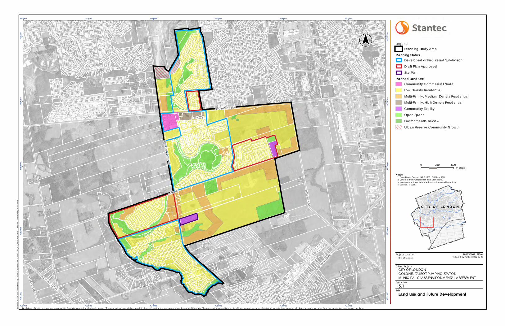
Project Location
Client/Project
Figure No.
Title
MAIN ST
HAMLYN STLONGWOODS RD
WHARN
CLIFFE
RD S
EXETER RD
WESTD
EL BRNE
WO
ND
ERLAN
D RD
S
SOUTHDALE RD W
KILBOURNE RD
BOLER RD
PACK RD
BOSTW
ICK
RD
CO
LON
EL TALBO
T RD
472000
472000
473000
473000
474000
474000
475000
475000
476000
476000
477000
477000
4751
000
4751
000
4752
000
4752
000
4753
000
4753
000
4754
000
4754
000
4755
000
4755
000
5.1
Notes
0 250 500metres
LegendServicing Study Area
Planning StatusDeveloped or Registered Subdivision
Draft Plan Approved
Site Plan
Planned Land UseCommunity Commercial Node
Low Density Residential
Multi-Family, Medium Density Residential
Multi-Family, High Density Residential
Community Facility
Open Space
Environmentla Review
Urban Reserve Community Growth
V:\
0165
6\a
ctiv
e\16
5630
067\
Pla
nnin
g\D
raw
ing
\GIS
\M
XD\P
IC1\
1656
3006
7_PI
C1_
Serv
ice
Are
a.m
xd
Rev
ised
: 201
6-06
-22
By: k
buc
han
an
($$¯
165630067 REVA
Disclaimer: Stantec assumes no responsibility for data supplied in electronic format. The recipient accepts full responsibility for verifying the accuracy and completeness of the data. The recipient releases Stantec, its officers, employees, consultants and agents, from any and all claims arising in any way from the content or provision of the data.
City of London Prepared by KDB on 2016-06-22
Land Use and Future Development
1. Coordinate System: NAD 1983 UTM Zone 17N2. Land use from Official Plan and Draft Plans.3. Imagery and base data used under license with the Cityof London, © 2015.
CITY OF LONDONCOLONEL TALBOT PUMPING STATIONMUNICIPAL CLASS ENVIRONMENTAL ASSESSMENT
C I T Y O F L O N D O N
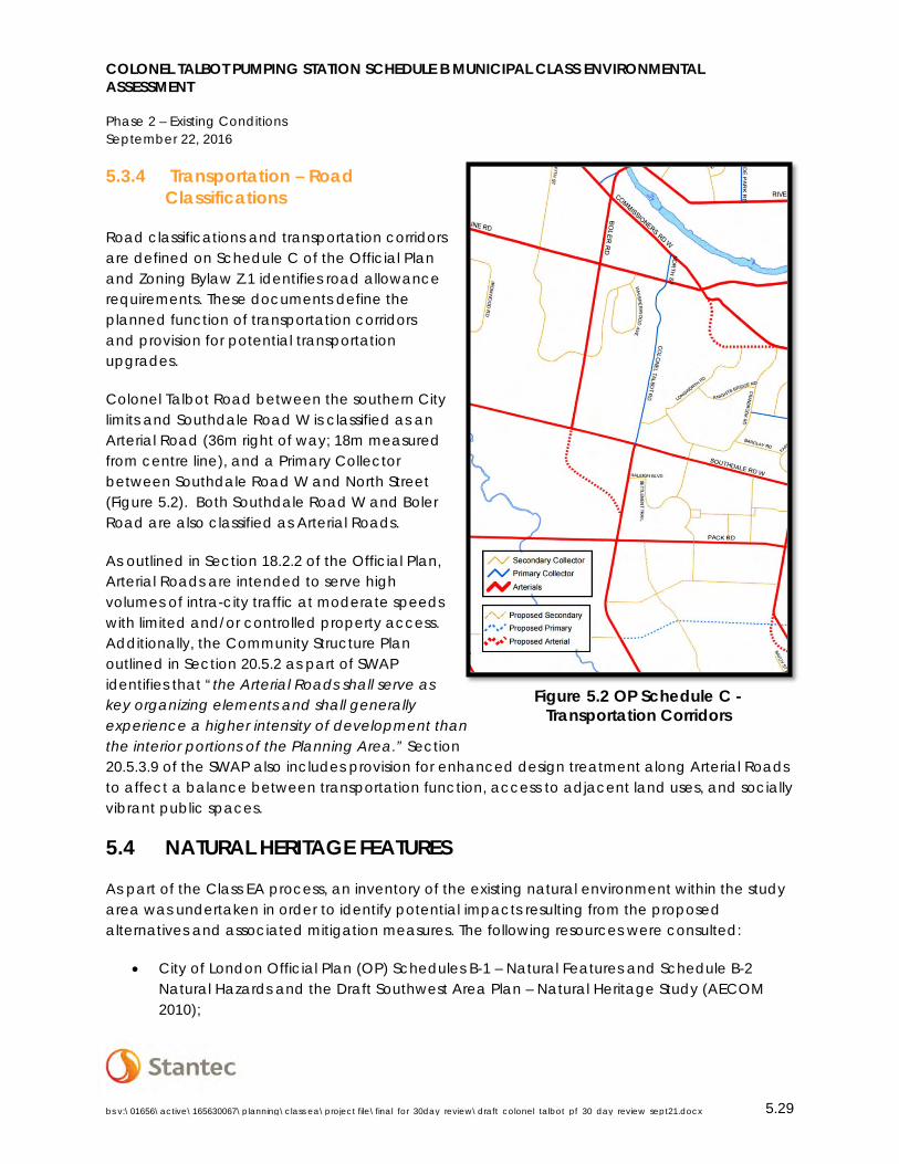
COLONEL TALBOT PUMPING STATION SCHEDULE B MUNICIPAL CLASS ENVIRONMENTAL ASSESSMENT
Phase 2 – Existing Conditions September 22, 2016
bs v:\01656\active\165630067\planning\class ea\project file\final_for_30day_review\draft_colonel_talbot_pf_30_day_review_sept21.docx 5.29
5.3.4 Transportation – Road Classifications
Road classifications and transportation corridors are defined on Schedule C of the Official Plan and Zoning Bylaw Z.1 identifies road allowance requirements. These documents define the planned function of transportation corridors and provision for potential transportation upgrades.
Colonel Talbot Road between the southern City limits and Southdale Road W is classified as an Arterial Road (36m right of way; 18m measured from centre line), and a Primary Collector between Southdale Road W and North Street (Figure 5.2). Both Southdale Road W and Boler Road are also classified as Arterial Roads.
As outlined in Section 18.2.2 of the Official Plan, Arterial Roads are intended to serve high volumes of intra-city traffic at moderate speeds with limited and/or controlled property access. Additionally, the Community Structure Plan outlined in Section 20.5.2 as part of SWAP identifies that “the Arterial Roads shall serve as key organizing elements and shall generally experience a higher intensity of development than the interior portions of the Planning Area.” Section 20.5.3.9 of the SWAP also includes provision for enhanced design treatment along Arterial Roads to affect a balance between transportation function, access to adjacent land uses, and socially vibrant public spaces.
5.4 NATURAL HERITAGE FEATURES
As part of the Class EA process, an inventory of the existing natural environment within the study area was undertaken in order to identify potential impacts resulting from the proposed alternatives and associated mitigation measures. The following resources were consulted:
• City of London Official Plan (OP) Schedules B-1 – Natural Features and Schedule B-2 Natural Hazards and the Draft Southwest Area Plan – Natural Heritage Study (AECOM 2010);
Figure 5.2 OP Schedule C -Transportation Corridors
COLONEL TALBOT PUMPING STATION SCHEDULE B MUNICIPAL CLASS ENVIRONMENTAL ASSESSMENT
Phase 2 – Existing Conditions September 22, 2016
bs v:\01656\active\165630067\planning\class ea\project file\final_for_30day_review\draft_colonel_talbot_pf_30_day_review_sept21.docx 5.30
• Natural Heritage Information Centre Biodiversity Explorer (NHIC, Ministry of Natural Resources, 2016) (accessed March 29, 2016); and Land Information Ontario (LIO) (accessed March 29th 2016);
• Consultation with the Ministry of Natural Resources and Forestry (MNRF)– Aylmer District (see Appendix C);
• Upper Thames River Conservation Authority Regulation Mapping (O. Reg. 157/06); the Dingman Creek Watershed Report Card 2015; and the Middlesex Natural Heritage Systems Study (MNHSS 2014);
• Fisheries and Oceans Canada – UTRCA Distribution of Fish/Mussel Species at Risk and Critical Habitat Mapping 2015.
5.4.1 Study Area
The study area, including the potential future service area for the proposed Colonel Talbot Pumping Station, lay within the Dingman Creek watershed, extending into the boundary of the River Bend, and Forks Watersheds. All works associated with the linear infrastructure improvements will be restricted to the existing right of way, with the exception of the potential route through Springbank Park.
5.4.2 Natural Heritage Features
The following sections detail the Natural Features identified within and adjacent to the study area based on a review of the information sources cited above. Features are identified on Figure 5.3.
5.4.2.1 Wetlands
A review of the MNRF Mapping and Schedule B1 of the City of London OP identifies the North Talbot Provincially Significant Wetland located east of Colonel Talbot Road, north of Pack Road, with additional segments located north of Southdale Road. No unevaluated wetlands were identified within the study area through the record review.
5.4.2.2 Environmentally Significant Areas
The Lower Dingman Corridor runs adjacent to Dingman Creek west of the Community of Lambeth and west of the study area, and provides an important linkage with neighbouring areas for a diverse assemblage of species.
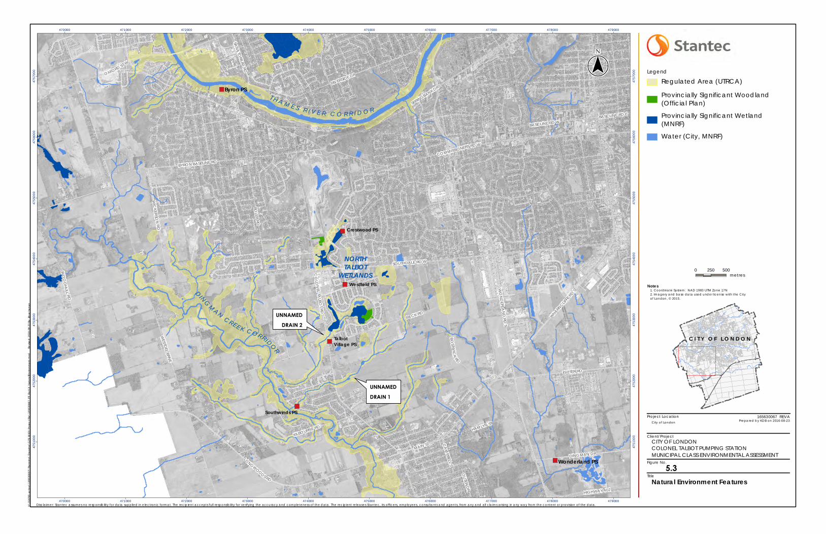
Project Location
Client/Project
Figure No.
Title
")
")
")
")
")
")
T H A M E S R I V E R C O R R I D O R
DINGMAN CREE K CORRIDOR
NORTHTALBOT
WETLANDS
UNNAMED
DRAIN 1
UNNAMED
DRAIN 2
CO
LON
E LTA
L BOT
RD
HAMLYN ST
SPRINGBANK DR
CA
MPBELL ST
LONGWOODS RD
BASE LINE RD E
COMMISSIONERS RD W
EXETER RD
WHARN
CLIFFE
RD S
RIVERSIDE DROXFORD ST W
HIGHWAY 402
SOUTHDALE RD W
KILBOURNE RD
MAIN ST
WESTD
EL BRNE
WIC
KERSON
RD
PACK RD
BOST W
ICK
RD
DINGMAN DR
WO
OD
HU
LLRD
WO
ND
ERLAN
D RD
S
BOLER RD
OUTER D
R
BASE LINE RD W
SAN
ATO
RIUM RD
BYRON BASELINE RD
Southwinds PS
TalbotVillage PS
Westfield PS
Crestwood PS
Byron PS
Wonderland PS
470000
470000
471000
471000
472000
472000
473000
473000
474000
474000
475000
475000
476000
476000
477000
477000
478000
478000
479000
479000
4751
000
4751
000
4752
000
4752
000
4753
000
4753
000
4754
000
4754
000
4755
000
4755
000
4756
000
4756
000
4757
000
4757
000
Notes
0 250 500metres
Legend
Regulated Area (UTRCA)
Provincially Significant Woodland(Official Plan)
Provincially Significant Wetland(MNRF)
Water (City, MNRF)
V:\0
1656
\act
ive\
1656
3006
7\Pl
ann
ing\
Dra
win
g\G
IS\M
XD\P
roje
ct F
ile\1
6563
0067
_PF_
FigX-
X_N
atur
alE
nviro
nmen
t.mxd
Revi
sed:
201
6-08
-23
By: k
buc
hana
n
($$¯
165630067 REVA
Disclaimer: Stantec assumes no responsibility for data supplied in e lectronic format. The recipient accepts full responsibility for verifying the accuracy and completeness of the data. The recipient releases Stantec, its officers, employees, consultants and agents, from any and all claims arising in any way from the content or provision of the data.
City of London Prepared by KDB on 2016-08-23
Natural Environment Features
1. Coordinate System: NAD 1983 UTM Zone 17N2. Imagery and base data used under license with the Cityof London, © 2015.
CITY OF LONDONCOLONEL TALBOT PUMPING STATIONMUNICIPAL CLASS ENVIRONMENTAL ASSESSMENT
C I T Y O F L O N D O N
5.3
COLONEL TALBOT PUMPING STATION SCHEDULE B MUNICIPAL CLASS ENVIRONMENTAL ASSESSMENT
Phase 2 – Existing Conditions September 22, 2016
bs v:\01656\active\165630067\planning\class ea\project file\final_for_30day_review\draft_colonel_talbot_pf_30_day_review_sept21.docx 5.32
5.4.2.3 Aquatic Features and Species at Risk
An Unnamed Drain runs across Colonel Talbot Road, just south of Clayton Walk (Unnamed Drain 1 – Figure 5.3). This Drain has been assigned a classification of F based on the OMAFRA Constructed Drain dataset. F drain classifications refer to intermittent drains, which do not require site specific review for maintenance works. No aquatic Species at Risk were identified through a review of the DFO SAR mapping (2015), or through a search of the MNRF Natural Heritage Information Centre (NHIC) for SAR records from 1970s-present.
A second Unnamed Drain runs across Colonel Talbot Road north of Pack Road (Unnamed Drain 2 – Figure 5.3). Stormwater in the Talbot area is conveyed to a SWM facility, which discharges southward via a grass swale, and eventually into Dingman Creek to the southwest. This drain is similarly classified as an intermittent type F drain according to the OMAFRA Constructed Drain dataset, and no SAR were identified through a review of DFO SAR mapping (2015), or through a search of the MNRF NHIC database.
The Thames River runs north of the study area. Three SAR associated with the Thames River corridor were identified based on the NHIC records review and MNRF correspondence, identified in Table 5.1. There are no Thames River crossings being investigated as part of this study, and the recommendations are not anticipated to impact the Thames River Corridor.
Table 5.1 Aquatic SAR – Thames River
Common Name Scientific name COSSARO/MNR Status
Lake Sturgeon (Great Lakes Population)
Acipenser fulvescens
Threatened
Silver Shiner (Thames River) Notropis photogenis Threatened
Salamander Mussel (Thames River)
Simpsonaias ambigua Endangered
5.4.2.4 Terrestrial Features and Species at Risk
Schedule B-2 identifies an unevaluated vegetation patch, as well as a small Significant Woodland patch to the east of Colonel Talbot Road north of Southdale Road, adjacent to a potential forcemain/sewer route; however, a substantial portion of the unevaluated vegetation patch appears to have been disturbed by activities at the adjacent gravel pit. While all construction is anticipated to occur within the existing right of way, further investigation may be

COLONEL TALBOT PUMPING STATION SCHEDULE B MUNICIPAL CLASS ENVIRONMENTAL ASSESSMENT
Phase 2 – Existing Conditions September 22, 2016
bs v:\01656\active\165630067\planning\class ea\project file\final_for_30day_review\draft_colonel_talbot_pf_30_day_review_sept21.docx 5.33
required prior to construction to determine the significance of the vegetation patch and to confirm and/or modify the boundaries of the Significant Woodland.
Floral SAR identified on the SARO list as Endangered, Threatened, or Special Concern with the potential to occur within the study area were identified through a search of the NHIC database (records from 1970-present), as well as through consultation with the MNRF (see Appendix E for full NHIC species records). SAR listed as Endangered or Threatened with the potential to occur within the study area are included in Table 5.2. The 1km NHIC squares with which the species records are associated are identified in Appendix E.
Table 5.2 Floral Species at Risk
Common Name Scientific name COSSARO/MNR Status
American Chestnut Castanea dentata Endangered
Eastern Flowering Dogwood Cornus florida Endangered
False Hop Sedge
Carex lupuliformis Endangered
Butternut Juglans cinerea Endangered
5.4.2.5 Wildlife Species at Risk
Faunal SAR identified on the SARO list as Endangered, Threatened, or Special Concern with the potential to occur within the study area were identified through a search of the NHIC database (records from 1970-present), as well as through consultation with the MNRF (see Appendix E for full NHIC records and consultation with the MNRF). SAR listed as Endangered or Threatened with the potential to occur within the study area are included in the Table 5.3.
Table 5.3 Wildlife Species at Risk
Species General Habitat Description COSSARO/MNRF Status
American Badger Taxidea taxus
Badgers are found in a variety of habitats, including tall grass prairies, sand barrens, and farmland, with a number of reported sightings in Middlesex County over the past 20 years (Recovery Strategy for the American Badger in Ontario, MNRF 2010).
Endangered with Regulated Habitat Protection under the ESA.
COLONEL TALBOT PUMPING STATION SCHEDULE B MUNICIPAL CLASS ENVIRONMENTAL ASSESSMENT
Phase 2 – Existing Conditions September 22, 2016
bs v:\01656\active\165630067\planning\class ea\project file\final_for_30day_review\draft_colonel_talbot_pf_30_day_review_sept21.docx 5.34
Species General Habitat Description COSSARO/MNRF Status
Henslow’s Sparrow Ammodramus henslowii
Henslow’s Sparrows are very rare in Ontario, and no breeding occurrences have been confirmed in the province in many years. They require large continuous patches of grassland habitat, including tallgrass prairie, abandoned fields, ungrazed and lightly grazed pasture, fallow hayfields with high clover and alfalfa content, grassy swales in open farmland, wet meadows, and infrequently mowed fields (MNRF 2013). Based on these habitat requirements, suitable habitat is not likely to occur in the study area.
Endangered with General Habitat Protection under the ESA.
Barn Swallow Hirundo rustica
Barn Swallows typically nest in man-made structures including barns, under bridges, and in culverts (MNRF 2013).
Threatened with General Habitat Protection under the ESA.
Bank Swallow Riparia riparia
Bank swallows nest in burrows within both natural and human-made settings with vertical faces in silt or sandy deposits including along the banks of rivers as well as active sand and gravel pits (MNRF 2016).
Threatened with General Habitat Protection under the ESA.
Chimney Swift Chaetura pelagica
Chimney swifts nest in both natural and human made structures including hollow trees and chimneys. Only Category 1 habitat has been identified under the General Habitat Description issued under the ESA, which includes the nest feature and a 90m area (MNRF 2013).
Threatened with General Habitat Protection under the ESA.
Eastern Hog-nose snake Heterodon platirhinos
Prefers sandy, well-drained habitats such as beaches and dry forests, primarily in areas where their primary toads (primary food source) can be found (MNRF 2015).
Threatened with General Habitat Protection under the ESA.
The presence of suitable habitat and species presence should be confirmed and detailed mitigation measures identified as required prior to construction activities.
COLONEL TALBOT PUMPING STATION SCHEDULE B MUNICIPAL CLASS ENVIRONMENTAL ASSESSMENT
Phase 2 – Existing Conditions September 22, 2016
bs v:\01656\active\165630067\planning\class ea\project file\final_for_30day_review\draft_colonel_talbot_pf_30_day_review_sept21.docx 5.35
5.5 SOILS/GEOLOGY/HYDROGEOLOGY
Information on existing soil conditions and hydrogeology within the study area was obtained through a review of the following:
• Stormwater Servicing and Tributary Works for the North Lambeth P9 Stormwater Management (SWM) Facility Municipal Class Environmental Assessment Schedule B Screening Report (Stantec, 2015); and
• Municipal Class Environmental Assessment for Storm Drainage and SWM Servicing Works Dingman Creek No. B-4 SWM Facility and Tributary Channel Improvement/Modification (Parsons, 2015).
5.5.1 Site Physiography
In general, the existing topography in the vicinity of the proposed locations of the Colonel Talbot PS can be described as relatively flat to slightly undulating. The ground surface elevation decreases toward the watercourses between Diane Crescent and Clayton Walk and between Clayton Walk and Pack Road. The local site physiography can be described as Spillways and Undrumlinized Till Plain as it was formed from glacial action approximately 20,000 years before present.
5.5.2 Surficial Geology
Based on previous investigations within proximity to the proposed pumping station locations, it is anticipated that shallow subsurface soil conditions would consist of silty sand or sand and gravel deposits overlying a natural silt or clayey silt till (underlying any fill material that may be present), with shallow deposits of silt or clayey silt till underlying surficial topsoil layers.
5.5.3 Bedrock Geology
The underlying bedrock consists of limestone, dolostone and shales from the Hamilton Group. The Hamilton Group (from the Middle Devonian) is a calcareous shale-dominated unit with relatively thin carbonate horizons. Based upon three wells within the vicinity of the proposed pumping station locations, bedrock was not encountered at the well termination depths which ranged from 38 to 54 metres below ground surface.
5.5.4 Hydrogeology
Information on potable wells has been well documented in the documents cited above. Three wells exist within the vicinity of the proposed pumping station locations. Based on the data recorded by the Groundwater Information Network (http://gw-info.net) these wells are summarized below:
COLONEL TALBOT PUMPING STATION SCHEDULE B MUNICIPAL CLASS ENVIRONMENTAL ASSESSMENT
Phase 2 – Existing Conditions September 22, 2016
bs v:\01656\active\165630067\planning\class ea\project file\final_for_30day_review\draft_colonel_talbot_pf_30_day_review_sept21.docx 5.36
1. Well Identification Number 4103917 a. General location – North of Diane Crescent, south of Clayton Walk, east of
Colonel Talbot Rd, b. Municipal address – 3700 Colonel Talbot Rd, c. Surface elevation of well 262.13 m, d. Water level is 237.5 m (approximately 39 m below ground surface);
2. Well Identification Number 4112333 a. General location – North of Clayton Walk, south of Pack Rd, east of Colonel
Talbot Rd, b. Municipal address – 3358 Colonel Talbot Rd, c. Surface elevation of well 259.99 m, d. Water level is 238.0 m (approximately 38 m below ground surface); and
3. Well Identification Number 4110354 a. General location – Northeast of Clayton Walk, south of Pack Rd, east of Colonel
Talbot Rd, b. Municipal address – 3358 Colonel Talbot Rd, c. Surface elevation of well 265.18 m, d. Water level is 229.2 m (approximately 36 m below ground surface).
5.6 SOURCEWATER PROTECTION
The Thames-Sydenham and Region Source Protection Committee (TSRSPC) has prepared an Assessment Report for the Upper Thames River Source Protection Area. As defined by the Clean Water Act (2006) and identified by the TSRSPC, the yellow area on the Thames-Sydenham & Region Source Protection Region Map shows that the proposed locations of the Colonel Talbot PS are within an area where activities may be Moderate and Low Threats within a defined Designated Vulnerable Area. Designated Vulnerable Areas are defined as vulnerable, in accordance with provincial standards, by virtue of their importance as a drinking water source. (Provincial Policy Statement, 2014) In the context of source water protection pursuant to the Clean Water Act, they are vulnerable areas containing a significant groundwater recharge area, a highly vulnerable aquifer, a surface water intake protection zone, or a wellhead protection area (Clean Water Act, 2006 - O. Reg. 28/07). The current City Official Plan has taken this designation into account and the current and proposed land uses are compatible with Source Water Protection.
Vulnerable Areas as delineated within the approved Assessment Reports are subject to policies within the Thames-Sydenham Source Protection Plan Volume III. Sewage activities to be implemented as part of this Class EA (i.e. construction of a new sanitary pumping station) within areas of Moderate and Low Drinking Water Threats are subject to Policy 3.03 – New Prescribed Instruments Related to Moderate and Low Threats – Management. This Policy states that the proposed activity would be subject to provincially-issued terms and conditions (i.e. an MOECC
COLONEL TALBOT PUMPING STATION SCHEDULE B MUNICIPAL CLASS ENVIRONMENTAL ASSESSMENT
Phase 2 – Existing Conditions September 22, 2016
bs v:\01656\active\165630067\planning\class ea\project file\final_for_30day_review\draft_colonel_talbot_pf_30_day_review_sept21.docx 5.37
Environmental Compliance Approval – ECA), which, when implemented, should manage the activity such that it does not become a Significant Drinking Water Threat.
5.7 EXISTING SANITARY INFRASTRUCTURE
Figure 5.4 identifies the existing sanitary infrastructure and future service area, which forms part of two sanitary sewersheds:
• Greenway Pollution Control Plant (PCP) (109 Greenside Avenue, London);
• Oxford Pollution Control Plant (PCP) (1450 Oxford Street W).
An overview of the existing sanitary infrastructure is provided in the following sections.
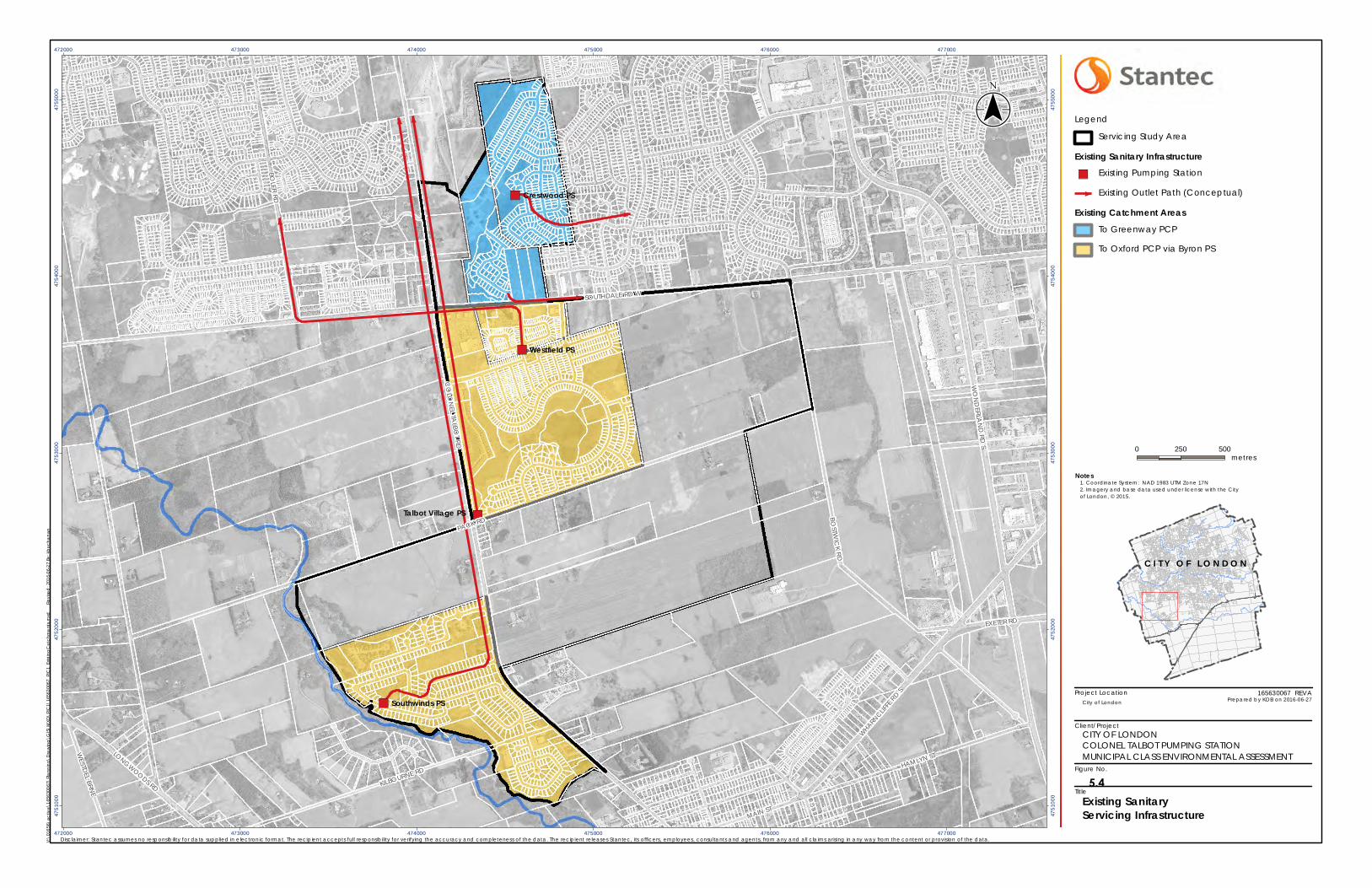
Project Location
Client/Project
Figure No.
Title
")
")
")
")
MAIN ST
HAMLYN STLONGWOODS RD
WHARN
CLIFFE
RD S
EXETER RD
WESTD
EL BRNE
WO
ND
ERLAN
D RD
S
SOUTHDALE RD W
KILBOURNE RD
BOLER RD
PACK RD
BOST W
ICK
RD
CO
LON
EL TALBO
T RD
Southwinds PS
Talbot Village PS
Westfield PS
Crestwood PS
472000
472000
473000
473000
474000
474000
475000
475000
476000
476000
477000
477000
4751
000
4751
000
4752
000
4752
000
4753
000
4753
000
4754
000
4754
000
4755
000
4755
000
Notes
0 250 500metres
Legend
Servicing Study Area
Existing Sanitary Infrastructure") Existing Pumping Station
Existing Outlet Path (Conceptual)
Existing Catchment AreasTo Greenway PCP
To Oxford PCP via Byron PS
V:\0
1656
\act
ive\
1656
3006
7\Pl
ann
ing\
Dra
win
g\G
IS\M
XD\P
IC1\
1656
3006
7_PI
C1_
Exist
ing
Cat
chm
ent
s.m
xd
Re
vise
d: 2
016-
06-2
7 By
: kbu
cha
nan
($$¯
165630067 REVA
Disclaimer: Stantec assumes no responsibility for data supplied in e lectronic format. The recipient accepts full responsibility for verifying the accuracy and completeness of the data. The recipient releases Stantec, its officers, employees, consultants and agents, from any and all claims arising in any way from the content or provision of the data.
City of London Prepared by KDB on 2016-06-27
Existing SanitaryServicing Infrastructure
1. Coordinate System: NAD 1983 UTM Zone 17N2. Imagery and base data used under license with the Cityof London, © 2015.
CITY OF LONDONCOLONEL TALBOT PUMPING STATIONMUNICIPAL CLASS ENVIRONMENTAL ASSESSMENT
C I T Y O F L O N D O N
5.4
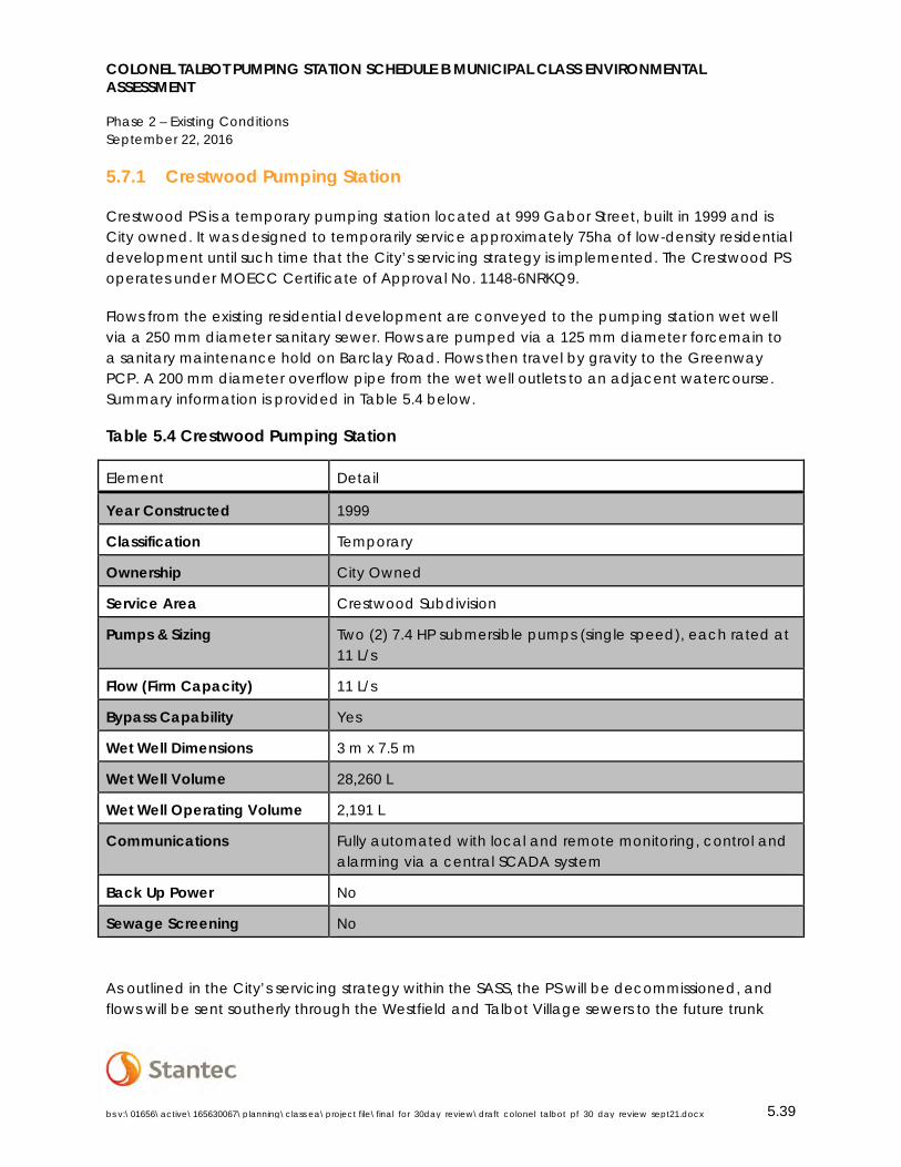
COLONEL TALBOT PUMPING STATION SCHEDULE B MUNICIPAL CLASS ENVIRONMENTAL ASSESSMENT
Phase 2 – Existing Conditions September 22, 2016
bs v:\01656\active\165630067\planning\class ea\project file\final_for_30day_review\draft_colonel_talbot_pf_30_day_review_sept21.docx 5.39
5.7.1 Crestwood Pumping Station
Crestwood PS is a temporary pumping station located at 999 Gabor Street, built in 1999 and is City owned. It was designed to temporarily service approximately 75ha of low-density residential development until such time that the City’s servicing strategy is implemented. The Crestwood PS operates under MOECC Certificate of Approval No. 1148-6NRKQ9.
Flows from the existing residential development are conveyed to the pumping station wet well via a 250 mm diameter sanitary sewer. Flows are pumped via a 125 mm diameter forcemain to a sanitary maintenance hold on Barclay Road. Flows then travel by gravity to the Greenway PCP. A 200 mm diameter overflow pipe from the wet well outlets to an adjacent watercourse. Summary information is provided in Table 5.4 below.
Table 5.4 Crestwood Pumping Station
Element Detail
Year Constructed 1999
Classification Temporary
Ownership City Owned
Service Area Crestwood Subdivision
Pumps & Sizing Two (2) 7.4 HP submersible pumps (single speed), each rated at 11 L/s
Flow (Firm Capacity) 11 L/s
Bypass Capability Yes
Wet Well Dimensions 3 m x 7.5 m
Wet Well Volume 28,260 L
Wet Well Operating Volume 2,191 L
Communications Fully automated with local and remote monitoring, control and alarming via a central SCADA system
Back Up Power No
Sewage Screening No
As outlined in the City’s servicing strategy within the SASS, the PS will be decommissioned, and flows will be sent southerly through the Westfield and Talbot Village sewers to the future trunk
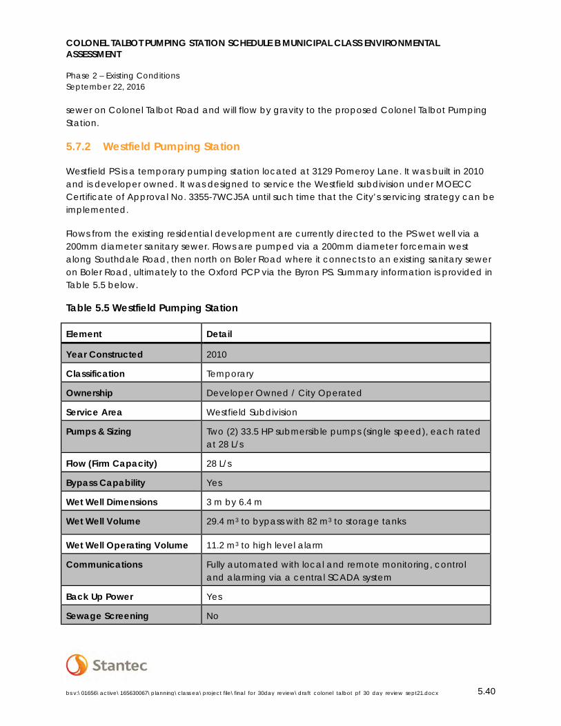
COLONEL TALBOT PUMPING STATION SCHEDULE B MUNICIPAL CLASS ENVIRONMENTAL ASSESSMENT
Phase 2 – Existing Conditions September 22, 2016
bs v:\01656\active\165630067\planning\class ea\project file\final_for_30day_review\draft_colonel_talbot_pf_30_day_review_sept21.docx 5.40
sewer on Colonel Talbot Road and will flow by gravity to the proposed Colonel Talbot Pumping Station.
5.7.2 Westfield Pumping Station
Westfield PS is a temporary pumping station located at 3129 Pomeroy Lane. It was built in 2010 and is developer owned. It was designed to service the Westfield subdivision under MOECC Certificate of Approval No. 3355-7WCJ5A until such time that the City’s servicing strategy can be implemented.
Flows from the existing residential development are currently directed to the PS wet well via a 200mm diameter sanitary sewer. Flows are pumped via a 200mm diameter forcemain west along Southdale Road, then north on Boler Road where it connects to an existing sanitary sewer on Boler Road, ultimately to the Oxford PCP via the Byron PS. Summary information is provided in Table 5.5 below.
Table 5.5 Westfield Pumping Station
Element Detail
Year Constructed 2010
Classification Temporary
Ownership Developer Owned / City Operated
Service Area Westfield Subdivision
Pumps & Sizing Two (2) 33.5 HP submersible pumps (single speed), each rated at 28 L/s
Flow (Firm Capacity) 28 L/s
Bypass Capability Yes
Wet Well Dimensions 3 m by 6.4 m
Wet Well Volume 29.4 m3 to bypass with 82 m3 to storage tanks
Wet Well Operating Volume 11.2 m3 to high level alarm
Communications Fully automated with local and remote monitoring, control and alarming via a central SCADA system
Back Up Power Yes
Sewage Screening No
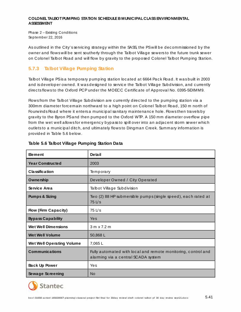
COLONEL TALBOT PUMPING STATION SCHEDULE B MUNICIPAL CLASS ENVIRONMENTAL ASSESSMENT
Phase 2 – Existing Conditions September 22, 2016
bs v:\01656\active\165630067\planning\class ea\project file\final_for_30day_review\draft_colonel_talbot_pf_30_day_review_sept21.docx 5.41
As outlined in the City’s servicing strategy within the SASS, the PS will be decommissioned by the owner and flows will be sent southerly through the Talbot Village sewers to the future trunk sewer on Colonel Talbot Road and will flow by gravity to the proposed Colonel Talbot Pumping Station.
5.7.3 Talbot Village Pumping Station
Talbot Village PS is a temporary pumping station located at 6664 Pack Road. It was built in 2003 and is developer owned. It was designed to service the Talbot Village Subdivision, and currently directs flows to the Oxford PCP under the MOECC Certificate of Approval No. 0395-5EXMM9.
Flows from the Talbot Village Subdivision are currently directed to the pumping station via a 300mm diameter forcemain northward to a high point on Colonel Talbot Road, 150 m north of Fourwinds Road where it enters a municipal sanitary maintenance hole. Flows then travels by gravity to the Byron PS and then pumped to the Oxford WTP. A 150 mm diameter overflow pipe from the wet well allows for emergency bypass to spill over into an adjacent storm sewer which outlets to a municipal ditch, and ultimately flows to Dingman Creek. Summary information is provided in Table 5.6 below.
Table 5.6 Talbot Village Pumping Station Data
Element Detail
Year Constructed 2003
Classification Temporary
Ownership Developer Owned / City Operated
Service Area Talbot Village Subdivision
Pumps & Sizing Two (2) 88 HP submersible pumps (single speed), each rated at 75 L/s
Flow (Firm Capacity) 75 L/s
Bypass Capability Yes
Wet Well Dimensions 3 m x 7.2 m
Wet Well Volume 50,868 L
Wet Well Operating Volume 7,065 L
Communications Fully automated with local and remote monitoring, control and alarming via a central SCADA system
Back Up Power Yes
Sewage Screening No
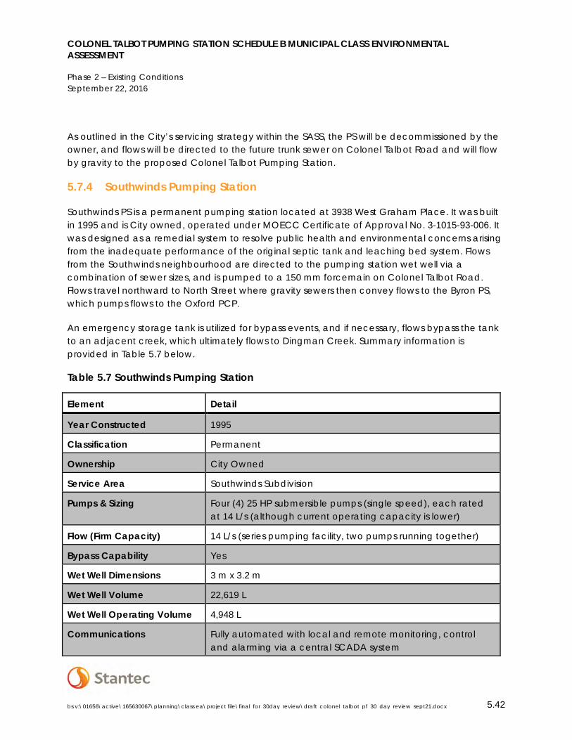
COLONEL TALBOT PUMPING STATION SCHEDULE B MUNICIPAL CLASS ENVIRONMENTAL ASSESSMENT
Phase 2 – Existing Conditions September 22, 2016
bs v:\01656\active\165630067\planning\class ea\project file\final_for_30day_review\draft_colonel_talbot_pf_30_day_review_sept21.docx 5.42
As outlined in the City’s servicing strategy within the SASS, the PS will be decommissioned by the owner, and flows will be directed to the future trunk sewer on Colonel Talbot Road and will flow by gravity to the proposed Colonel Talbot Pumping Station.
5.7.4 Southwinds Pumping Station
Southwinds PS is a permanent pumping station located at 3938 West Graham Place. It was built in 1995 and is City owned, operated under MOECC Certificate of Approval No. 3-1015-93-006. It was designed as a remedial system to resolve public health and environmental concerns arising from the inadequate performance of the original septic tank and leaching bed system. Flows from the Southwinds neighbourhood are directed to the pumping station wet well via a combination of sewer sizes, and is pumped to a 150 mm forcemain on Colonel Talbot Road. Flows travel northward to North Street where gravity sewers then convey flows to the Byron PS, which pumps flows to the Oxford PCP.
An emergency storage tank is utilized for bypass events, and if necessary, flows bypass the tank to an adjacent creek, which ultimately flows to Dingman Creek. Summary information is provided in Table 5.7 below.
Table 5.7 Southwinds Pumping Station
Element Detail
Year Constructed 1995
Classification Permanent
Ownership City Owned
Service Area Southwinds Subdivision
Pumps & Sizing Four (4) 25 HP submersible pumps (single speed), each rated at 14 L/s (although current operating capacity is lower)
Flow (Firm Capacity) 14 L/s (series pumping facility, two pumps running together)
Bypass Capability Yes
Wet Well Dimensions 3 m x 3.2 m
Wet Well Volume 22,619 L
Wet Well Operating Volume 4,948 L
Communications Fully automated with local and remote monitoring, control and alarming via a central SCADA system
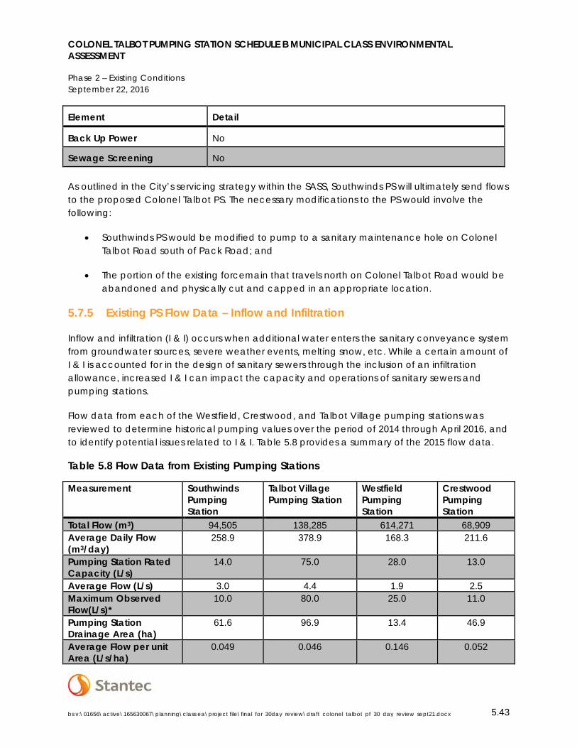
COLONEL TALBOT PUMPING STATION SCHEDULE B MUNICIPAL CLASS ENVIRONMENTAL ASSESSMENT
Phase 2 – Existing Conditions September 22, 2016
bs v:\01656\active\165630067\planning\class ea\project file\final_for_30day_review\draft_colonel_talbot_pf_30_day_review_sept21.docx 5.43
Element Detail
Back Up Power No
Sewage Screening No
As outlined in the City’s servicing strategy within the SASS, Southwinds PS will ultimately send flows to the proposed Colonel Talbot PS. The necessary modifications to the PS would involve the following:
• Southwinds PS would be modified to pump to a sanitary maintenance hole on Colonel Talbot Road south of Pack Road; and
• The portion of the existing forcemain that travels north on Colonel Talbot Road would be abandoned and physically cut and capped in an appropriate location.
5.7.5 Existing PS Flow Data – Inflow and Infiltration
Inflow and infiltration (I & I) occurs when additional water enters the sanitary conveyance system from groundwater sources, severe weather events, melting snow, etc. While a certain amount of I & I is accounted for in the design of sanitary sewers through the inclusion of an infiltration allowance, increased I & I can impact the capacity and operations of sanitary sewers and pumping stations.
Flow data from each of the Westfield, Crestwood, and Talbot Village pumping stations was reviewed to determine historical pumping values over the period of 2014 through April 2016, and to identify potential issues related to I & I. Table 5.8 provides a summary of the 2015 flow data.
Table 5.8 Flow Data from Existing Pumping Stations
Measurement Southwinds Pumping Station
Talbot Village Pumping Station
Westfield Pumping Station
Crestwood Pumping Station
Total Flow (m3) 94,505 138,285 614,271 68,909 Average Daily Flow (m3/day)
258.9 378.9 168.3 211.6
Pumping Station Rated Capacity (L/s)
14.0 75.0 28.0 13.0
Average Flow (L/s) 3.0 4.4 1.9 2.5 Maximum Observed Flow(L/s)*
10.0 80.0 25.0 11.0
Pumping Station Drainage Area (ha)
61.6 96.9 13.4 46.9
Average Flow per unit Area (L/s/ha)
0.049 0.046 0.146 0.052
COLONEL TALBOT PUMPING STATION SCHEDULE B MUNICIPAL CLASS ENVIRONMENTAL ASSESSMENT
Phase 2 – Existing Conditions September 22, 2016
bs v:\01656\active\165630067\planning\class ea\project file\final_for_30day_review\draft_colonel_talbot_pf_30_day_review_sept21.docx 5.44
Measurement Southwinds Pumping Station
Talbot Village Pumping Station
Westfield Pumping Station
Crestwood Pumping Station
*The exceedance of PS rated capacity is generally addressed through the provision of storage in the PS wet well.
While the design criteria for Colonel Talbot Pumping Station capacity shall be based upon the MOECC Design Guidelines for Sewage Works, 2008 and the City’s Design Specifications & Requirements Manual, April 2015, it is recommended that the flow data from the existing pumping stations be considered. This can help establish the typical average flow values and the sort of flow events that the proposed Colonel Talbot Pumping Station will likely experience. This would allow the City to select an appropriate range of pumps to provide for maximum design flows while balancing the requirements for energy efficiency and mitigation of potential odour issues.
5.7.6 Linear Sanitary Infrastructure
The linear infrastructure downstream of the proposed Colonel Talbot PS was assessed using as-built drawings and sewer design sheets in order to identify existing capacity deficiencies and opportunities. Sewer design sheets are included in Appendix F.
5.7.6.1 Colonel Talbot Road/North Street
Forcemains from the Southwinds PS and Talbot Village PS currently run northward along Colonel Talbot Road and discharge to a gravity sewer at the top of the hill approximately 800m north of Southdale Road W. The gravity sewer continues northward along Colonel Talbot Road and North Street, and then to a sewer along Commissioners Road before entering into Springbank Park west of the main entrance. The sewer continues behind the commercial building at the intersection of Boler Road and Commissioners Road, crosses Boler Road north of Fire Hall 12 (275 Boler Road), and crosses Halls Mills Road to the Byron PS located at 1322 Old Bridge Road.
Under existing conditions, 10 of a total of 28 sewer runs are over capacity based on existing design flows, taking into account areas with the potential to contribute flows. Therefore, a new sewer would be proposed to convey flows along this route from the top of the hill on Colonel Talbot Road to the Byron PS. A new dedicated sewer would alleviate existing capacity issues, and would provide additional capacity for additional development in the Byron area with only 1 run remaining over capacity based on the design flows.
5.7.6.2 Boler Road Sewer
A forcemain from the Westfield PS currently runs west along Southdale Road, and north on Boler Road to the Byron PS. No capacity issues were identified along the route based on existing design flows.

COLONEL TALBOT PUMPING STATION SCHEDULE B MUNICIPAL CLASS ENVIRONMENTAL ASSESSMENT
Design Guidelines September 22, 2016
bs v:\01656\active\165630067\planning\class ea\project file\final_for_30day_review\draft_colonel_talbot_pf_30_day_review_sept21.docx 6.45
With the addition of Day 1 flows from the proposed Colonel Talbot PS, 8 of a total of 30 runs would be over capacity (this increases to 24 runs with the ultimate design flow from the Colonel Talbot PS). Upsizing the existing sanitary sewer would create significant construction complexities due to existing infrastructure within the right of way which include frequent private drain connections (PDCs), water service connections, and depth of the sewer.
Therefore, a new dedicated sewer would be more feasible along Boler Road compared to upsizing the existing sewer since it could be installed at a shallower elevation to minimize conflicts with existing infrastructure, would reduce road reconstruction and overall implementation cost. As a result, a dedicated sewer along Boler Road has been considered for further analysis as a potential alignment to convey flows from the proposed Colonel Talbot PS to the Byron PS.
6.0 DESIGN GUIDELINES
The following sections outline the applicable design objectives and guidelines referenced during the development of alternative solutions and recommendations.
6.1 MOECC GUIDELINE D-5 (PLANNING FOR SEWAGE AND WATER SERVICES)
MOECC Guideline D-5 describes an approach to municipal planning for wastewater and water services to ensure an acceptable quantity and quality of water supply and the proper collection, treatment, and disposal of wastewater for development. It is consistent with the provincial goal to manage growth and change in order to build communities that are socially, economically, environmentally, and culturally healthy, and that make efficient use of land, new and existing infrastructure, and public service facilities.
The approach provided in the document is intended to guide municipal land use planning for sewage and water services in accordance with the objectives of the Provincial Policy Statement, and is administered under the legislative authority of Environmental Protection Act, Ontario Water Resources Act, and the Planning Act.
6.2 MOECC DESIGN GUIDELINES FOR SEWAGE WORKS (2008)
This document is a reference for those who are responsible for designing wastewater works, ministry engineers responsible for reviewing and approving the designs of such works, and municipalities/owners of the wastewater works. This document provides design guidance on the design of sewage treatment facilities, associated linear infrastructure, odour control, etc. Current legislation and/or regulations in place take precedence over the design guidelines and must be adhered to.
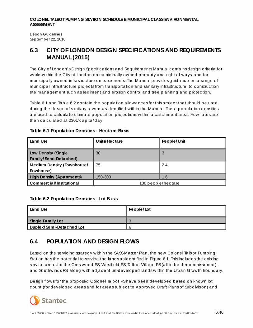
COLONEL TALBOT PUMPING STATION SCHEDULE B MUNICIPAL CLASS ENVIRONMENTAL ASSESSMENT
Design Guidelines September 22, 2016
bs v:\01656\active\165630067\planning\class ea\project file\final_for_30day_review\draft_colonel_talbot_pf_30_day_review_sept21.docx 6.46
6.3 CITY OF LONDON DESIGN SPECIFICATIONS AND REQUIREMENTS MANUAL (2015)
The City of London’s Design Specifications and Requirements Manual contains design criteria for works within the City of London on municipally owned property and right of ways, and for municipally owned infrastructure on easements. The Manual provides guidance on a range of municipal infrastructure projects from transportation and sanitary infrastructure, to construction site management such as sediment and erosion control and tree planning and protection.
Table 6.1 and Table 6.2 contain the population allowances for this project that should be used during the design of sanitary sewers as identified within the Manual. These population densities are used to calculate ultimate population projections within a catchment area. Flow rates are then calculated at 230L/capita/day.
Table 6.1 Population Densities - Hectare Basis
Land Use Units/Hectare People/Unit
Low Density (Single Family/Semi-Detached)
30 3
Medium Density (Townhouse/ Rowhouse)
75 2.4
High Density (Apartments) 150-300 1.6 Commercial/Institutional 100 people/hectare
Table 6.2 Population Densities - Lot Basis
Land Use People/Lot
Single Family Lot 3 Duplex/Semi-Detached Lot 6
6.4 POPULATION AND DESIGN FLOWS
Based on the servicing strategy within the SASS Master Plan, the new Colonel Talbot Pumping Station has the potential to service the lands as identified in Figure 6.1. This includes the existing service areas for the Crestwood PS, Westfield PS, Talbot Village PS (all to be decommissioned), and Southwinds PS, along with adjacent un-developed lands within the Urban Growth Boundary.
Design flows for the proposed Colonel Talbot PS have been developed based on known lot count (for developed areas and for areas subject to Approved Draft Plans of Subdivision) and

COLONEL TALBOT PUMPING STATION SCHEDULE B MUNICIPAL CLASS ENVIRONMENTAL ASSESSMENT
Design Guidelines September 22, 2016
bs v:\01656\active\165630067\planning\class ea\project file\final_for_30day_review\draft_colonel_talbot_pf_30_day_review_sept21.docx 6.47
land use as identified in SWAP for areas designated for future development. Figure 6.1 identifies the catchment areas with the potential to convey flows to the proposed Colonel Talbot PS.
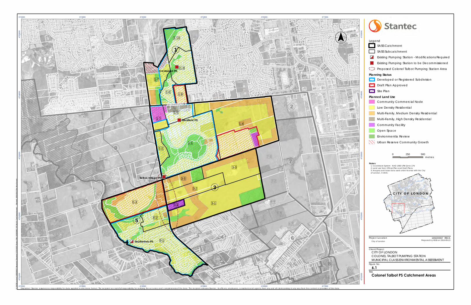
Project Location
Client/Project
Figure No.
Title
"
Ò
Ï
"S
"S
"S
MAIN ST
HAMLYN STLONGWOODS RD
WHARN
CLIFFE
RD S
EXETER RD
WESTD
EL BRNE
WO
ND
ERLAN
D RD
S
SOUTHDALE RD W
KILBOURNE RD
BOLER RD
PACK RD
BOST W
ICK
RD
CO
LON
E LTA
LBOT
R D
Southwinds PS
Talbot Village PS
Westfield PS
Crestwood PS
9-4
6-8
8-1
8-1
8-28-3
6-5
8-66-4 6-3
7-1
9-2
9-5
9-6
7-2
9-3
6-1 6-6
6-2
9-7
9-8
4-4
4-3
4-2
4-1 4-5
6-9
7-3
6-7
1-7
1-8
1-9
1-4
1-3
1-2
1-1
5-3
5-1
5-2
1-5
1-6
1-10
3-3
3-5
3-1
3-2
3-4
(4
(9
(2
(7
(6
(8
(3
(1
(5
472000
472000
473000
473000
474000
474000
475000
475000
476000
476000
477000
477000
4751
000
4751
000
4752
000
4752
000
4753
000
4753
000
4754
000
4754
000
4755
000
4755
000
6.1
Notes
0 250 500metres
LegendSASS Catchment
SASS Subcatchment
"
Ò
Ï Existing Pumping Station - Modifications Required
"S Existing Pumping Station to be Decommissioned
Proposed Colonel Talbot Pumping Station Area
Planning StatusDeveloped or Registered Subdivision
Draft Plan Approved
Site Plan
Planned Land UseCommunity Commercial Node
Low Density Residential
Multi-Family, Medium Density Residential
Multi-Family, High Density Residential
Community Facility
Open Space
Environmentla Review
Urban Reserve Community Growth
V:\0
1656
\act
ive\
1656
3006
7\Pl
ann
ing\
Dra
win
g\G
IS\M
XD\P
roje
ct F
ile\1
6563
0067
_PF_
FigX-
X_C
atch
me
nts.
mxd
Revi
sed
: 201
6-08
-23
By: k
buch
ana
n
($$¯
165630067 REVA
Disclaimer: Stantec assumes no responsibility for data supplied in e lectronic format. The recipient accepts full responsibility for verifying the accuracy and completeness of the data. The recipient releases Stantec, its officers, employees, consultants and agents, from any and all claims arising in any way from the content or provision of the data.
City of London Prepared by KDB on 2016-08-23
Colonel Talbot PS Catchment Areas
1. Coordinate System: NAD 1983 UTM Zone 17N2. Land use from Official P lan and Draft P lans.3. Imagery and base data used under license with the Cityof London, © 2015.
CITY OF LONDONCOLONEL TALBOT PUMPING STATIONMUNICIPAL CLASS ENVIRONMENTAL ASSESSMENT
C I T Y O F L O N D O N
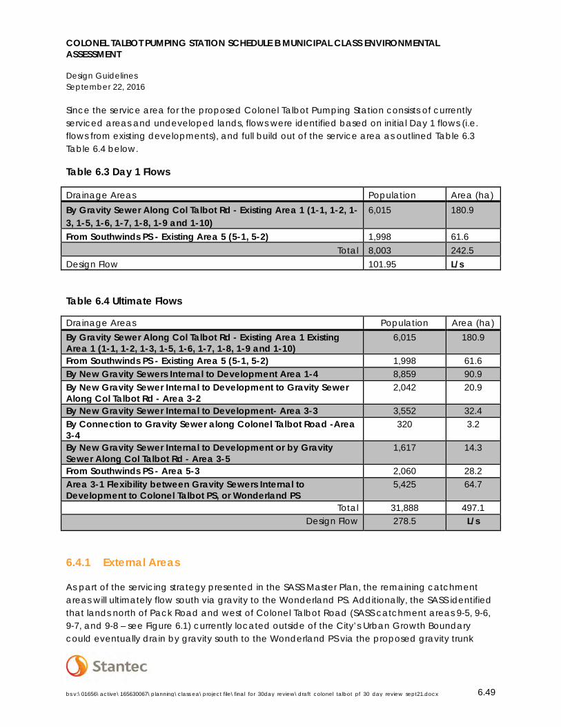
COLONEL TALBOT PUMPING STATION SCHEDULE B MUNICIPAL CLASS ENVIRONMENTAL ASSESSMENT
Design Guidelines September 22, 2016
bs v:\01656\active\165630067\planning\class ea\project file\final_for_30day_review\draft_colonel_talbot_pf_30_day_review_sept21.docx 6.49
Since the service area for the proposed Colonel Talbot Pumping Station consists of currently serviced areas and undeveloped lands, flows were identified based on initial Day 1 flows (i.e. flows from existing developments), and full build out of the service area as outlined Table 6.3 Table 6.4 below.
Table 6.3 Day 1 Flows
Drainage Areas Population Area (ha) By Gravity Sewer Along Col Talbot Rd - Existing Area 1 (1-1, 1-2, 1-3, 1-5, 1-6, 1-7, 1-8, 1-9 and 1-10)
6,015 180.9
From Southwinds PS - Existing Area 5 (5-1, 5-2) 1,998 61.6 Total 8,003 242.5
Design Flow 101.95 L/s
Table 6.4 Ultimate Flows
Drainage Areas Population Area (ha) By Gravity Sewer Along Col Talbot Rd - Existing Area 1 Existing Area 1 (1-1, 1-2, 1-3, 1-5, 1-6, 1-7, 1-8, 1-9 and 1-10)
6,015 180.9
From Southwinds PS - Existing Area 5 (5-1, 5-2) 1,998 61.6 By New Gravity Sewers Internal to Development Area 1-4 8,859 90.9 By New Gravity Sewer Internal to Development to Gravity Sewer Along Col Talbot Rd - Area 3-2
2,042 20.9
By New Gravity Sewer Internal to Development- Area 3-3 3,552 32.4 By Connection to Gravity Sewer along Colonel Talbot Road -Area 3-4
320 3.2
By New Gravity Sewer Internal to Development or by Gravity Sewer Along Col Talbot Rd - Area 3-5
1,617 14.3
From Southwinds PS - Area 5-3 2,060 28.2 Area 3-1 Flexibility between Gravity Sewers Internal to Development to Colonel Talbot PS, or Wonderland PS
5,425 64.7
Total 31,888 497.1 Design Flow 278.5 L/s
6.4.1 External Areas
As part of the servicing strategy presented in the SASS Master Plan, the remaining catchment areas will ultimately flow south via gravity to the Wonderland PS. Additionally, the SASS identified that lands north of Pack Road and west of Colonel Talbot Road (SASS catchment areas 9-5, 9-6, 9-7, and 9-8 – see Figure 6.1) currently located outside of the City’s Urban Growth Boundary could eventually drain by gravity south to the Wonderland PS via the proposed gravity trunk
COLONEL TALBOT PUMPING STATION SCHEDULE B MUNICIPAL CLASS ENVIRONMENTAL ASSESSMENT
Design Guidelines September 22, 2016
bs v:\01656\active\165630067\planning\class ea\project file\final_for_30day_review\draft_colonel_talbot_pf_30_day_review_sept21.docx 6.50
sewer along Colonel Talbot Road south of Pack Road. This in no way advocates for a modification of the City’s Urban Growth Boundary, and servicing of lands shall be provided according to the Sanitary Sewerage Policies of the Official Plan (OP Section 17, discussed in Section 5.1.3.1 above). Any modification of the Urban Growth Boundary would be subject to a Comprehensive Review of the Official Plan mandated by the Provincial Policy Statement 2014 (Policy 1.3.8) to ensure that any expansion of the boundary was in accordance with the objectives of the Policy; however, since the life-span of sanitary sewers extends beyond the 10-20 year planning horizon for the study, estimated flows from these areas shall be considered in the design of sewers as part of this project to minimize the potential for greater economic and construction impacts triggered by future development.
The anticipated service population, area, and flows for external catchment areas 9-5, 9-6, 9-7, and 9-8 are as follows, determined assuming low density residential development:
• Population: 13,452;
• Approximate Developable Area: 173.35ha; and
• Estimated flows: 138.3 L/s.
6.5 OVERVIEW OF SERVICING STRATEGY
Following the servicing strategy identified in the SASS Master Plan, the proposed Colonel Talbot PS will provide the flexibility to send flows north to the Byron PS and Oxford PCP (up to 250 L/s) in order to optimize operations at the Oxford PCP. Flows from the service area and adjacent to the service area in excess of 250 L/s will be directed south via gravity sewers to the Wonderland PS and Greenway PCP.
COLONEL TALBOT PUMPING STATION SCHEDULE B MUNICIPAL CLASS ENVIRONMENTAL ASSESSMENT
Phase 2 – Alternative Solutions and Evaluation September 22, 2016
bs v:\01656\active\165630067\planning\class ea\project file\final_for_30day_review\draft_colonel_talbot_pf_30_day_review_sept21.docx 7.51
7.0 PHASE 2 – ALTERNATIVE SOLUTIONS AND EVALUATION
As part of Phase 2 of the Class EA process, defining the framework and criteria for evaluating the alternative solutions for each servicing component (i.e. pumping station location and associated forcemain/sewer route) is undertaken and reasonable and feasible solutions that can be implemented to address the problem and/or opportunity are identified. The following sections describe the alternative solutions, and environmental components, evaluation criteria, and methodology considered during the evaluation of alternatives.
7.1 ENVIRONMENTAL COMPONENTS
The environmental components outlined below represent a broad definition of the environment as described in the Environmental Assessment Act.
Table 7.1 Environmental Components
Environmental Component
Description
Social/Cultural Component that evaluates potential effects on residents, neighbourhoods, businesses, community character, social cohesion, community features and historical/archaeological and heritage components.
Natural Environment Component having regard for protecting significant natural and physical elements of the environment (i.e. air, land, water and biota) including natural heritage and environmental features and functions.
Technical Component that considers technical suitability and other engineering aspects of the servicing options.
Economic Component that addresses the potential effects on costs.
7.2 PUMPING STATION LOCATION ALTERNATIVES
The SASS identified a general location for the new Colonel Talbot Pumping Station along Colonel Talbot Road, south of Pack Road in the vicinity of Diane Crescent. This general location was identified based on topography, contributing catchment areas, and depth of connecting sewers. A location further south, closer to Diane Crescent was more preferred based on the functionality of existing gravity sewers. The location was directed to the Colonel Talbot Road
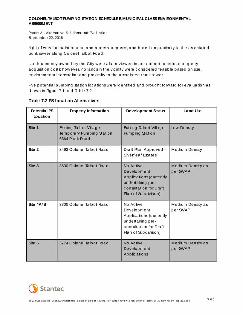
COLONEL TALBOT PUMPING STATION SCHEDULE B MUNICIPAL CLASS ENVIRONMENTAL ASSESSMENT
Phase 2 – Alternative Solutions and Evaluation September 22, 2016
bs v:\01656\active\165630067\planning\class ea\project file\final_for_30day_review\draft_colonel_talbot_pf_30_day_review_sept21.docx 7.52
right of way for maintenance and access purposes, and based on proximity to the associated trunk sewer along Colonel Talbot Road.
Lands currently owned by the City were also reviewed in an attempt to reduce property acquisition costs; however, no lands in the vicinity were considered feasible based on size, environmental constraints and proximity to the associated trunk sewer.
Five potential pumping station locations were identified and brought forward for evaluation as shown in Figure 7.1 and Table 7.2.
Table 7.2 PS Location Alternatives
Potential PS Location
Property Information Development Status Land Use
Site 1 Existing Talbot Village Temporary Pumping Station, 6664 Pack Road
Existing Talbot Village Pumping Station
Low Density
Site 2 3493 Colonel Talbot Road Draft Plan Approved – Silverfleaf Estates
Medium Density
Site 3 3630 Colonel Talbot Road No Active Development Applications (currently undertaking pre-consultation for Draft Plan of Subdivision)
Medium Density as per SWAP
Site 4A/B 3700 Colonel Talbot Road No Active Development Applications (currently undertaking pre-consultation for Draft Plan of Subdivision)
Medium Density as per SWAP
Site 5 3774 Colonel Talbot Road No Active Development Applications
Medium Density as per SWAP
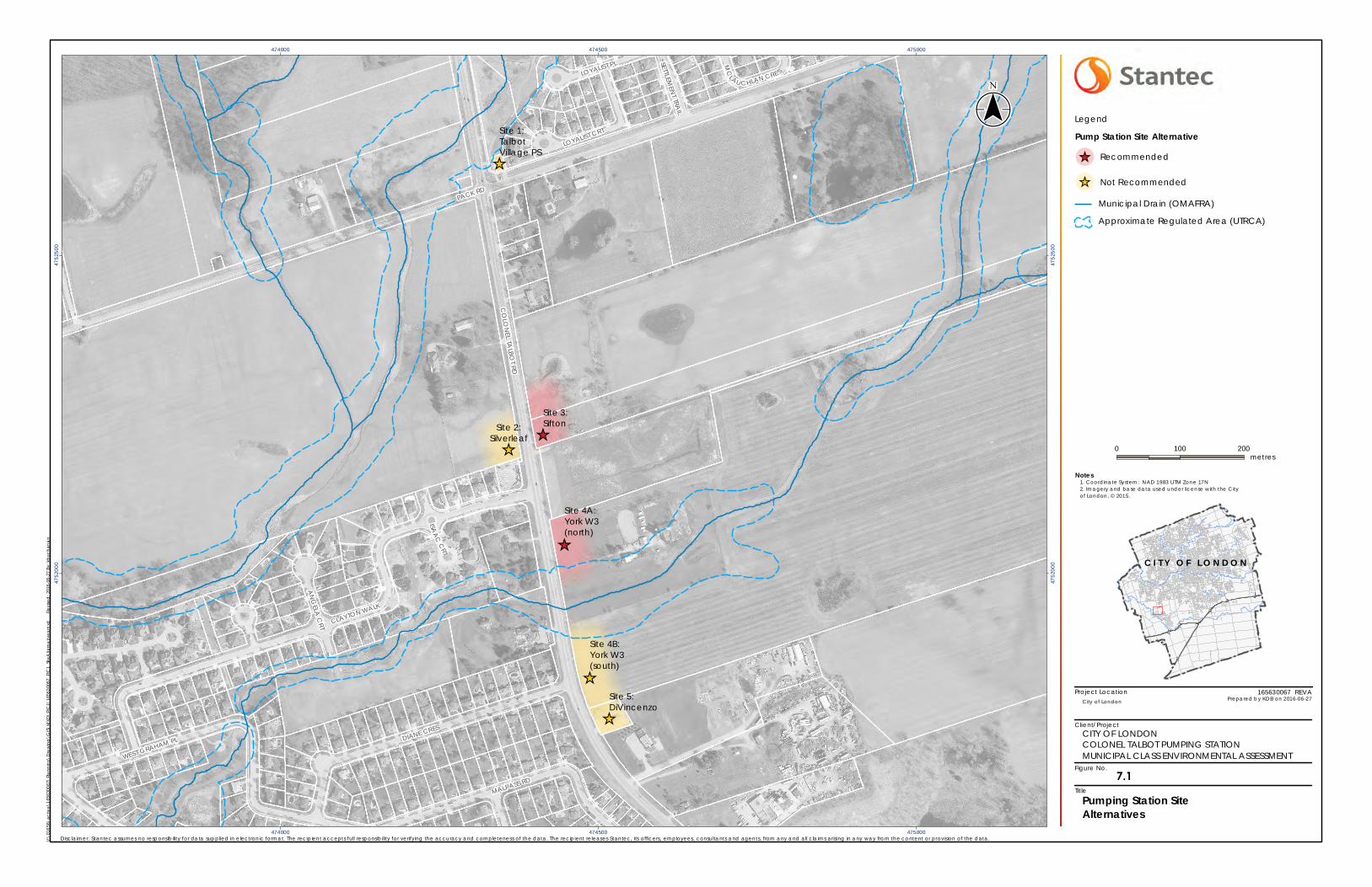
Project Location
Client/Project
Figure No.
Title
_̂
_̂
_̂
_̂
_̂
_̂
AN
GELA
CRT
LOYALIST PL
ISAA
CC
RT
SETTLEMEN
T TRAIL
MALPASS RD
CO
LON
EL TALBO
T RD
PACK RD
DIANE CRES
CLAYTON WALK
MC
LAU CHLAN CRE S
WEST GRAHAM PL
LOYALIST CRTSite 1:TalbotVillage PS
Site 2:Silverleaf
Site 4A:York W3(north)
Site 5:DiVincenzo
Site 4B:York W3(south)
Site 3:Sifton
474000
474000
474500
474500
475000
475000
4752
000
4752
000
4752
500
4752
500
Notes
0 100 200metres
Legend
Pump Station Site Alternative
!̂_ Recommended
!̂_ Not Recommended
Municipal Drain (OMAFRA)
Approximate Regulated Area (UTRCA)
V:\0
1656
\act
ive\
1656
3006
7\Pl
ann
ing\
Dra
win
g\G
IS\M
XD\P
IC1\
1656
3006
7_PI
C1_
SiteA
ltern
ativ
es.m
xd
Re
vise
d: 2
016-
06-2
7 By
: kbu
chan
an
($$¯
165630067 REVA
Disclaimer: Stantec assumes no responsibility for data supplied in e lectronic format. The recipient accepts full responsibility for verifying the accuracy and completeness of the data. The recipient releases Stantec, its officers, employees, consultants and agents, from any and all claims arising in any way from the content or provision of the data.
City of London Prepared by KDB on 2016-06-27
Pumping Station Site Alternatives
1. Coordinate System: NAD 1983 UTM Zone 17N2. Imagery and base data used under license with the Cityof London, © 2015.
CITY OF LONDONCOLONEL TALBOT PUMPING STATIONMUNICIPAL CLASS ENVIRONMENTAL ASSESSMENT
C I T Y O F L O N D O N
7.1
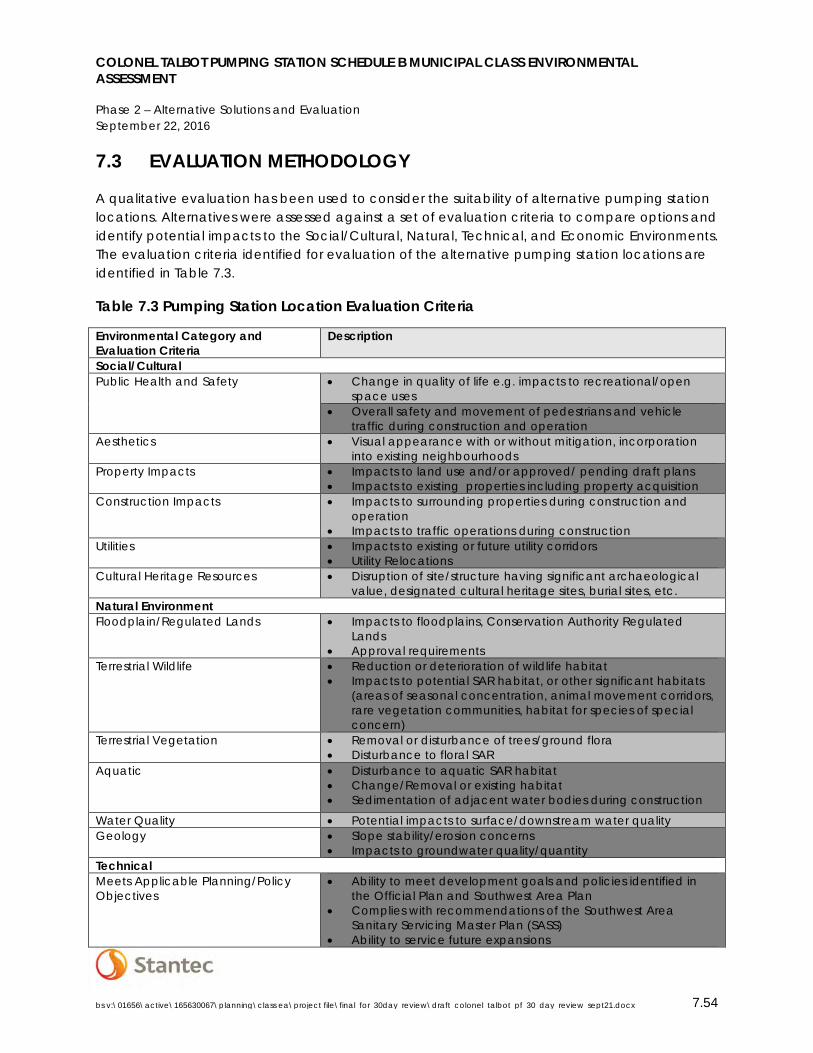
COLONEL TALBOT PUMPING STATION SCHEDULE B MUNICIPAL CLASS ENVIRONMENTAL ASSESSMENT
Phase 2 – Alternative Solutions and Evaluation September 22, 2016
bs v:\01656\active\165630067\planning\class ea\project file\final_for_30day_review\draft_colonel_talbot_pf_30_day_review_sept21.docx 7.54
7.3 EVALUATION METHODOLOGY
A qualitative evaluation has been used to consider the suitability of alternative pumping station locations. Alternatives were assessed against a set of evaluation criteria to compare options and identify potential impacts to the Social/Cultural, Natural, Technical, and Economic Environments. The evaluation criteria identified for evaluation of the alternative pumping station locations are identified in Table 7.3.
Table 7.3 Pumping Station Location Evaluation Criteria
Environmental Category and Evaluation Criteria
Description
Social/Cultural Public Health and Safety • Change in quality of life e.g. impacts to recreational/open
space uses • Overall safety and movement of pedestrians and vehicle
traffic during construction and operation Aesthetics • Visual appearance with or without mitigation, incorporation
into existing neighbourhoods Property Impacts • Impacts to land use and/or approved/ pending draft plans
• Impacts to existing properties including property acquisition Construction Impacts • Impacts to surrounding properties during construction and
operation • Impacts to traffic operations during construction
Utilities • Impacts to existing or future utility corridors • Utility Relocations
Cultural Heritage Resources • Disruption of site/structure having significant archaeological value, designated cultural heritage sites, burial sites, etc.
Natural Environment Floodplain/Regulated Lands • Impacts to floodplains, Conservation Authority Regulated
Lands • Approval requirements
Terrestrial Wildlife • Reduction or deterioration of wildlife habitat • Impacts to potential SAR habitat, or other significant habitats
(areas of seasonal concentration, animal movement corridors, rare vegetation communities, habitat for species of special concern)
Terrestrial Vegetation • Removal or disturbance of trees/ground flora • Disturbance to floral SAR
Aquatic • Disturbance to aquatic SAR habitat • Change/Removal or existing habitat • Sedimentation of adjacent water bodies during construction
Water Quality • Potential impacts to surface/downstream water quality Geology • Slope stability/erosion concerns
• Impacts to groundwater quality/quantity Technical Meets Applicable Planning/Policy Objectives
• Ability to meet development goals and policies identified in the Official Plan and Southwest Area Plan
• Complies with recommendations of the Southwest Area Sanitary Servicing Master Plan (SASS)
• Ability to service future expansions
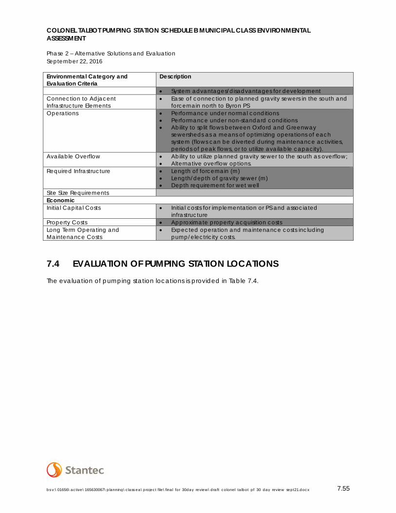
COLONEL TALBOT PUMPING STATION SCHEDULE B MUNICIPAL CLASS ENVIRONMENTAL ASSESSMENT
Phase 2 – Alternative Solutions and Evaluation September 22, 2016
bs v:\01656\active\165630067\planning\class ea\project file\final_for_30day_review\draft_colonel_talbot_pf_30_day_review_sept21.docx 7.55
Environmental Category and Evaluation Criteria
Description
• System advantages/disadvantages for development Connection to Adjacent Infrastructure Elements
• Ease of connection to planned gravity sewers in the south and forcemain north to Byron PS
Operations • Performance under normal conditions • Performance under non-standard conditions • Ability to split flows between Oxford and Greenway
sewersheds as a means of optimizing operations of each system (flows can be diverted during maintenance activities, periods of peak flows, or to utilize available capacity).
Available Overflow • Ability to utilize planned gravity sewer to the south as overflow; • Alternative overflow options.
Required Infrastructure • Length of forcemain (m) • Length/depth of gravity sewer (m) • Depth requirement for wet well
Site Size Requirements Economic Initial Capital Costs • Initial costs for implementation or PS and associated
infrastructure Property Costs • Approximate property acquisition costs Long Term Operating and Maintenance Costs
• Expected operation and maintenance costs including pump/electricity costs.
7.4 EVALUATION OF PUMPING STATION LOCATIONS
The evaluation of pumping station locations is provided in Table 7.4.
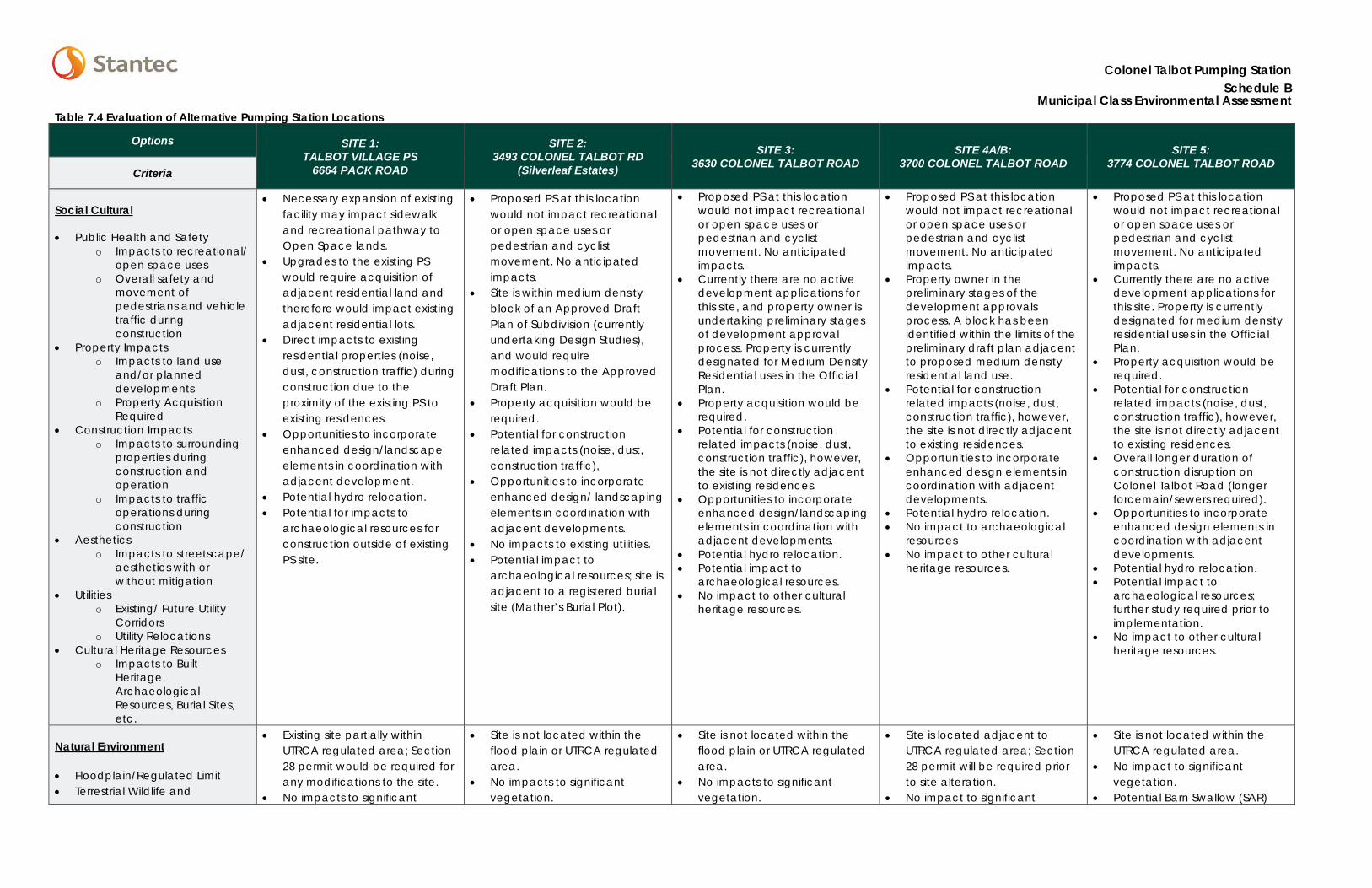
Colonel Talbot Pumping Station Schedule B
Municipal Class Environmental Assessment Table 7.4 Evaluation of Alternative Pumping Station Locations
Options SITE 1: TALBOT VILLAGE PS
6664 PACK ROAD
SITE 2: 3493 COLONEL TALBOT RD
(Silverleaf Estates)
SITE 3: 3630 COLONEL TALBOT ROAD
SITE 4A/B: 3700 COLONEL TALBOT ROAD
SITE 5: 3774 COLONEL TALBOT ROAD
Criteria
Social Cultural
• Public Health and Safetyo Impacts to recreational/
open space useso Overall safety and
movement ofpedestrians and vehicletraffic duringconstruction
• Property Impactso Impacts to land use
and/or planneddevelopments
o Property AcquisitionRequired
• Construction Impactso Impacts to surrounding
properties duringconstruction andoperation
o Impacts to trafficoperations duringconstruction
• Aestheticso Impacts to streetscape/
aesthetics with orwithout mitigation
• Utilitieso Existing/ Future Utility
Corridorso Utility Relocations
• Cultural Heritage Resourceso Impacts to Built
Heritage,ArchaeologicalResources, Burial Sites,etc.
• Necessary expansion of existingfacility may impact sidewalkand recreational pathway toOpen Space lands.
• Upgrades to the existing PSwould require acquisition ofadjacent residential land andtherefore would impact existingadjacent residential lots.
• Direct impacts to existingresidential properties (noise,dust, construction traffic) duringconstruction due to theproximity of the existing PS toexisting residences.
• Opportunities to incorporateenhanced design/landscapeelements in coordination withadjacent development.
• Potential hydro relocation.• Potential for impacts to
archaeological resources forconstruction outside of existingPS site.
• Proposed PS at this locationwould not impact recreationalor open space uses orpedestrian and cyclistmovement. No anticipatedimpacts.
• Site is within medium densityblock of an Approved DraftPlan of Subdivision (currentlyundertaking Design Studies),and would requiremodifications to the ApprovedDraft Plan.
• Property acquisition would berequired.
• Potential for constructionrelated impacts (noise, dust,construction traffic),
• Opportunities to incorporateenhanced design/ landscapingelements in coordination withadjacent developments.
• No impacts to existing utilities.• Potential impact to
archaeological resources; site isadjacent to a registered burialsite (Mather’s Burial Plot).
• Proposed PS at this locationwould not impact recreationalor open space uses orpedestrian and cyclistmovement. No anticipatedimpacts.
• Currently there are no activedevelopment applications forthis site, and property owner isundertaking preliminary stagesof development approvalprocess. Property is currentlydesignated for Medium DensityResidential uses in the OfficialPlan.
• Property acquisition would berequired.
• Potential for constructionrelated impacts (noise, dust,construction traffic), however,the site is not directly adjacentto existing residences.
• Opportunities to incorporateenhanced design/landscapingelements in coordination withadjacent developments.
• Potential hydro relocation.• Potential impact to
archaeological resources.• No impact to other cultural
heritage resources.
• Proposed PS at this locationwould not impact recreationalor open space uses orpedestrian and cyclistmovement. No anticipatedimpacts.
• Property owner in thepreliminary stages of thedevelopment approvalsprocess. A block has beenidentified within the limits of thepreliminary draft plan adjacentto proposed medium densityresidential land use.
• Potential for constructionrelated impacts (noise, dust,construction traffic), however,the site is not directly adjacentto existing residences.
• Opportunities to incorporateenhanced design elements incoordination with adjacentdevelopments.
• Potential hydro relocation.• No impact to archaeological
resources• No impact to other cultural
heritage resources.
• Proposed PS at this locationwould not impact recreationalor open space uses orpedestrian and cyclistmovement. No anticipatedimpacts.
• Currently there are no activedevelopment applications forthis site. Property is currentlydesignated for medium densityresidential uses in the OfficialPlan.
• Property acquisition would berequired.
• Potential for constructionrelated impacts (noise, dust,construction traffic), however,the site is not directly adjacentto existing residences.
• Overall longer duration ofconstruction disruption onColonel Talbot Road (longerforcemain/sewers required).
• Opportunities to incorporateenhanced design elements incoordination with adjacentdevelopments.
• Potential hydro relocation.• Potential impact to
archaeological resources;further study required prior toimplementation.
• No impact to other culturalheritage resources.
Natural Environment
• Floodplain/Regulated Limit• Terrestrial Wildlife and
• Existing site partially withinUTRCA regulated area; Section28 permit would be required forany modifications to the site.
• No impacts to significant
• Site is not located within theflood plain or UTRCA regulatedarea.
• No impacts to significantvegetation.
• Site is not located within theflood plain or UTRCA regulatedarea.
• No impacts to significantvegetation.
• Site is located adjacent toUTRCA regulated area; Section28 permit will be required priorto site alteration.
• No impact to significant
• Site is not located within theUTRCA regulated area.
• No impact to significantvegetation.
• Potential Barn Swallow (SAR)
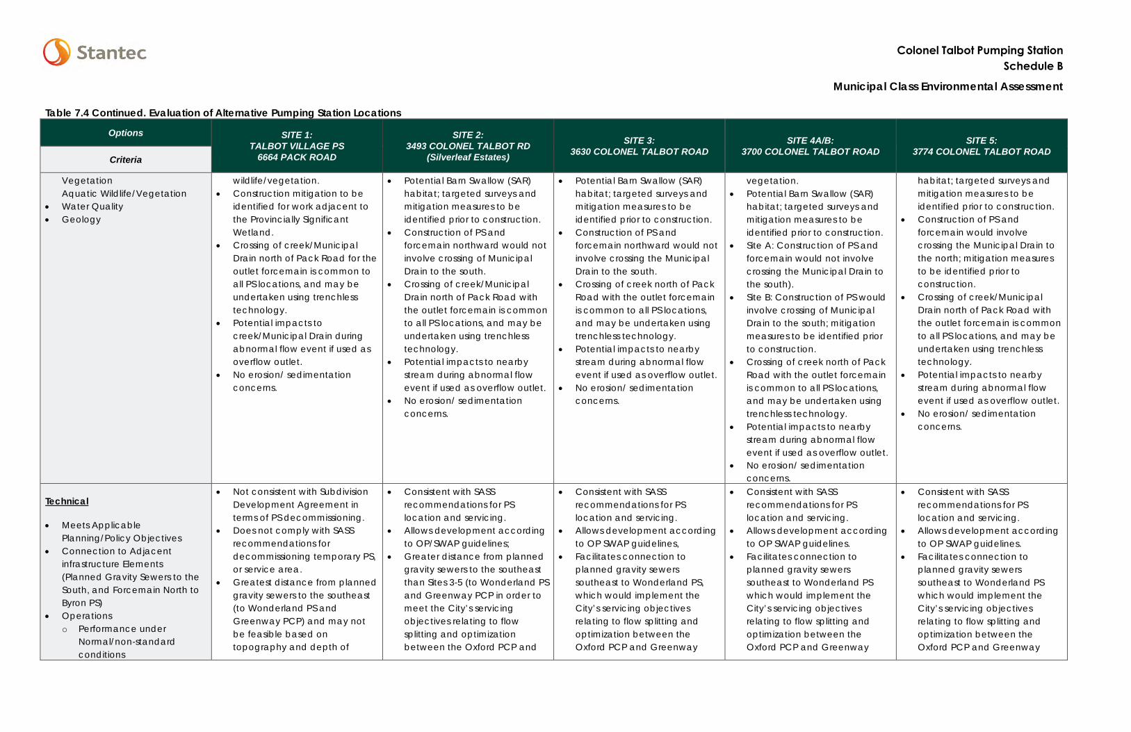
Colonel Talbot Pumping Station Schedule B
Municipal Class Environmental Assessment
Table 7.4 Continued. Evaluation of Alternative Pumping Station Locations
Options SITE 1: TALBOT VILLAGE PS
6664 PACK ROAD
SITE 2: 3493 COLONEL TALBOT RD
(Silverleaf Estates)
SITE 3: 3630 COLONEL TALBOT ROAD
SITE 4A/B: 3700 COLONEL TALBOT ROAD
SITE 5: 3774 COLONEL TALBOT ROAD
Criteria
Vegetation Aquatic Wildlife/Vegetation
• Water Quality• Geology
wildlife/vegetation. • Construction mitigation to be
identified for work adjacent tothe Provincially SignificantWetland.
• Crossing of creek/MunicipalDrain north of Pack Road for theoutlet forcemain is common toall PS locations, and may beundertaken using trenchlesstechnology.
• Potential impacts tocreek/Municipal Drain duringabnormal flow event if used asoverflow outlet.
• No erosion/ sedimentationconcerns.
• Potential Barn Swallow (SAR)habitat; targeted surveys andmitigation measures to beidentified prior to construction.
• Construction of PS andforcemain northward would notinvolve crossing of MunicipalDrain to the south.
• Crossing of creek/MunicipalDrain north of Pack Road withthe outlet forcemain is commonto all PS locations, and may beundertaken using trenchlesstechnology.
• Potential impacts to nearbystream during abnormal flowevent if used as overflow outlet.
• No erosion/ sedimentationconcerns.
• Potential Barn Swallow (SAR)habitat; targeted surveys andmitigation measures to beidentified prior to construction.
• Construction of PS andforcemain northward would notinvolve crossing the MunicipalDrain to the south.
• Crossing of creek north of PackRoad with the outlet forcemainis common to all PS locations,and may be undertaken usingtrenchless technology.
• Potential impacts to nearbystream during abnormal flowevent if used as overflow outlet.
• No erosion/ sedimentationconcerns.
vegetation. • Potential Barn Swallow (SAR)
habitat; targeted surveys andmitigation measures to beidentified prior to construction.
• Site A: Construction of PS andforcemain would not involvecrossing the Municipal Drain tothe south).
• Site B: Construction of PS wouldinvolve crossing of MunicipalDrain to the south; mitigationmeasures to be identified priorto construction.
• Crossing of creek north of PackRoad with the outlet forcemainis common to all PS locations,and may be undertaken usingtrenchless technology.
• Potential impacts to nearbystream during abnormal flowevent if used as overflow outlet.
• No erosion/ sedimentationconcerns.
habitat; targeted surveys and mitigation measures to be identified prior to construction.
• Construction of PS andforcemain would involvecrossing the Municipal Drain tothe north; mitigation measuresto be identified prior toconstruction.
• Crossing of creek/MunicipalDrain north of Pack Road withthe outlet forcemain is commonto all PS locations, and may beundertaken using trenchlesstechnology.
• Potential impacts to nearbystream during abnormal flowevent if used as overflow outlet.
• No erosion/ sedimentationconcerns.
Technical
• Meets ApplicablePlanning/Policy Objectives
• Connection to Adjacentinfrastructure Elements(Planned Gravity Sewers to theSouth, and Forcemain North toByron PS)
• Operationso Performance under
Normal/non-standardconditions
• Not consistent with SubdivisionDevelopment Agreement interms of PS decommissioning.
• Does not comply with SASSrecommendations fordecommissioning temporary PS,or service area.
• Greatest distance from plannedgravity sewers to the southeast(to Wonderland PS andGreenway PCP) and may notbe feasible based ontopography and depth of
• Consistent with SASSrecommendations for PSlocation and servicing.
• Allows development accordingto OP/SWAP guidelines;
• Greater distance from plannedgravity sewers to the southeastthan Sites 3-5 (to Wonderland PSand Greenway PCP in order tomeet the City’s servicingobjectives relating to flowsplitting and optimizationbetween the Oxford PCP and
• Consistent with SASSrecommendations for PSlocation and servicing.
• Allows development accordingto OP SWAP guidelines,
• Facilitates connection toplanned gravity sewerssoutheast to Wonderland PS,which would implement theCity’s servicing objectivesrelating to flow splitting andoptimization between theOxford PCP and Greenway
• Consistent with SASSrecommendations for PSlocation and servicing.
• Allows development accordingto OP SWAP guidelines.
• Facilitates connection toplanned gravity sewerssoutheast to Wonderland PSwhich would implement theCity’s servicing objectivesrelating to flow splitting andoptimization between theOxford PCP and Greenway
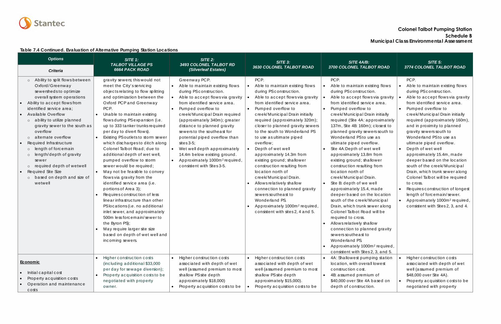
Colonel Talbot Pumping StationSchedule B
Municipal Class Environmental Assessment
Table 7.4 Continued. Evaluation of Alternative Pumping Station Locations
Options SITE 1: TALBOT VILLAGE PS
6664 PACK ROAD
SITE 2: 3493 COLONEL TALBOT RD
(Silverleaf Estates)
SITE 3: 3630 COLONEL TALBOT ROAD
SITE 4A/B: 3700 COLONEL TALBOT ROAD
SITE 5: 3774 COLONEL TALBOT ROAD
Criteria
o Ability to split flows betweenOxford/Greenwaysewersheds to optimizeoverall system operations
• Ability to accept flows fromidentified service area;
• Available Overflowo ability to utilize planned
gravity sewer to the south asoverflow
o alternate overflow• Required Infrastructure
o length of forcemaino length/depth of gravity
sewero required depth of wetwell
• Required Site Sizeo based on depth and size of
wetwell
gravity sewers; this would not meet the City’s servicing objects relating to flow splitting and optimization between the Oxford PCP and Greenway PCP.
• Unable to maintain existingflows during PS expansion (i.e.up to 333 tanker trunks requiredper day to divert flows).
• Existing PS outlets to storm sewerwhich discharges to ditch alongColonel Talbot Road; due toadditional depth of wet well,pumped overflow to stormsewer would be required;
• May not be feasible to conveyflows via gravity from theidentified service area (i.e.portions of Area 3);
• Requires construction of lesslinear infrastructure than otherPS locations (i.e. no additionalinlet sewer, and approximately500m less forcemain/sewer tothe Byron PS);
• May require larger site sizebased on depth of wet well andincoming sewers.
Greenway PCP. • Able to maintain existing flows
during PS construction.• Able to accept flows via gravity
from identified service area.• Pumped overflow to
creek/Municipal Drain required(approximately 340m); greaterdistance to planned gravitysewers to the southeast forpotential piped overflow thansites 3-5;
• Wet well depth approximately14.4m below existing ground.
• Approximately 1000m2 required,consistent with Sites 3-5.
PCP. • Able to maintain existing flows
during PS construction.• Able to accept flows via gravity
from identified service area.• Pumped overflow to
creek/Municipal Drain initiallyrequired (approximately 320m);closer to planned gravity sewersto the south to Wonderland PSto use as ultimate pipedoverflow;
• Depth of wet wellapproximately 14.3m fromexisting ground; shallowerconstruction resulting fromlocation north ofcreek/Municipal Drain.
• Allows relatively shallowconnection to planned gravitysewers southeast toWonderland PS.
• Approximately 1000m2 required,consistent with sites 2, 4 and 5.
PCP. • Able to maintain existing flows
during PS construction.• Able to accept flows via gravity
from identified service area.• Pumped overflow to
creek/Municipal Drain initiallyrequired (Site 4A: approximately137m, Site 4B: 160m); closest toplanned gravity sewers south toWonderland PS to use asultimate piped overflow.
• Site 4A:Depth of wet wellapproximately 13.8m fromexisting ground; shallowerconstruction resulting fromlocation north ofcreek/Municipal Drain.
• Site B: depth of we wellapproximately 15.4, madedeeper based on the locationsouth of the creek/MunicipalDrain, which trunk sewer alongColonel Talbot Road will berequired to cross.
• Allows relatively shallowconnection to planned gravitysewers southeast toWonderland PS.
• Approximately 1000m2 required,consistent with Sites 2, 3, and 5.
PCP. • Able to maintain existing flows
during PS construction.• Able to accept flows via gravity
from identified service area.• Pumped overflow to
creek/Municipal Drain initiallyrequired (approximately 160m),and in proximity to plannedgravity sewers south toWonderland PS to use asultimate piped overflow.
• Depth of wet wellapproximately 15.4m, madedeeper based on the locationsouth of the creek/MunicipalDrain, which trunk sewer alongColonel Talbot will be requiredto cross.
• Requires construction of longestlength of forcemain/sewer.
• Approximately 1000m2 required,consistent with Sites 2, 3, and 4.
Economic
• Initial capital cost• Property acquisition costs• Operation and maintenance
costs
• Higher construction costs(including additional $33,000per day for sewage diversion);
• Property acquisition costs to benegotiated with propertyowner.
• Higher construction costsassociated with depth of wetwell (assumed premium to mostshallow PS site depthapproximately $18,000)
• Property acquisition costs to be
• Higher construction costsassociated with depth of wetwell (assumed premium to mostshallow PS site depthapproximately $15,000).
• Property acquisition costs to be
• 4A: Shallowest pumping stationlocation, with overall lowestconstruction cost.
• 4B: assumed premium of$40,000 over Site 4A based ondepth of construction.
• Higher construction costsassociated with depth of wetwell (assumed premium of$48,000 over Site 4A).
• Property acquisition costs to benegotiated with property
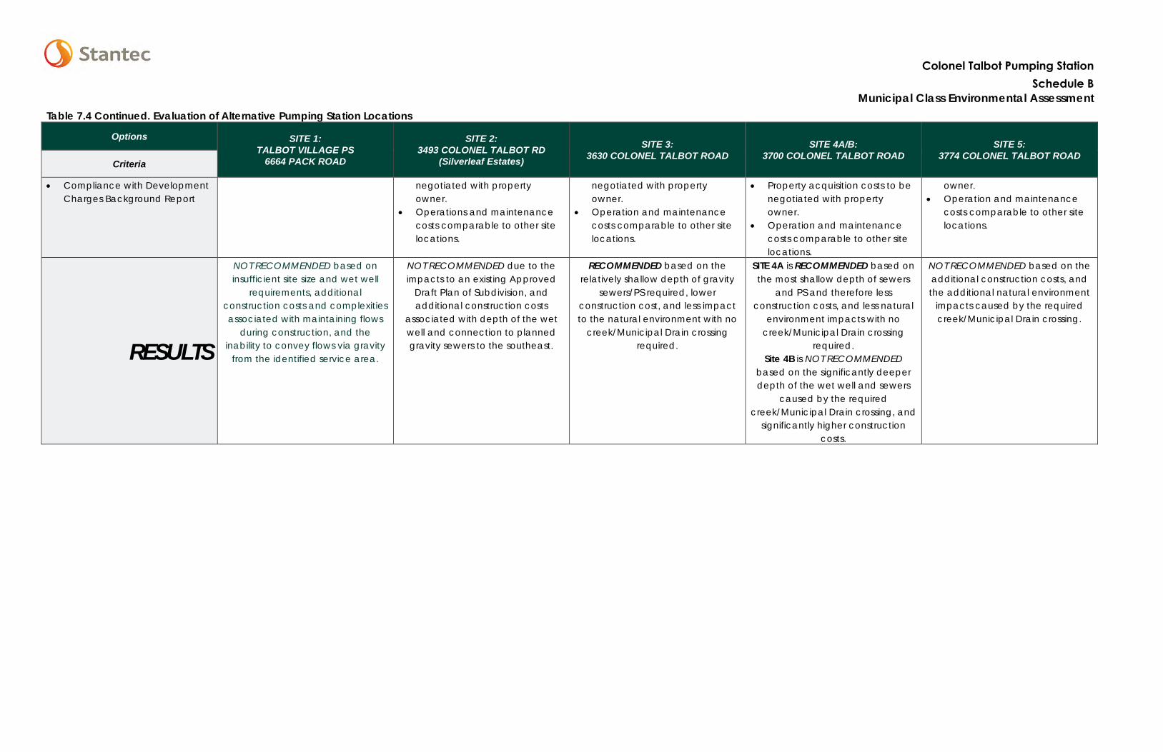
Table 7.4 Continued. Evaluation of Alternative Pumping Station Locations
Options SITE 1: TALBOT VILLAGE PS
6664 PACK ROAD
SITE 2: 3493 COLONEL TALBOT RD
(Silverleaf Estates)
SITE 3: 3630 COLONEL TALBOT ROAD
SITE 4A/B: 3700 COLONEL TALBOT ROAD
SITE 5: 3774 COLONEL TALBOT ROAD
Criteria
• Compliance with DevelopmentCharges Background Report
negotiated with property owner.
• Operations and maintenancecosts comparable to other sitelocations.
negotiated with property owner.
• Operation and maintenancecosts comparable to other sitelocations.
• Property acquisition costs to benegotiated with propertyowner.
• Operation and maintenancecosts comparable to other sitelocations.
owner. • Operation and maintenance
costs comparable to other sitelocations.
RESULTS
NOT RECOMMENDED based on insufficient site size and wet well
requirements, additional construction costs and complexities associated with maintaining flows
during construction, and the inability to convey flows via gravity
from the identified service area.
NOT RECOMMENDED due to the impacts to an existing Approved
Draft Plan of Subdivision, and additional construction costs
associated with depth of the wet well and connection to planned gravity sewers to the southeast.
RECOMMENDED based on the relatively shallow depth of gravity
sewers/PS required, lower construction cost, and less impact to the natural environment with no
creek/Municipal Drain crossing required.
SITE 4A is RECOMMENDED based on the most shallow depth of sewers
and PS and therefore less construction costs, and less natural
environment impacts with no creek/Municipal Drain crossing
required. Site 4B is NOT RECOMMENDED
based on the significantly deeper depth of the wet well and sewers
caused by the required creek/Municipal Drain crossing, and
significantly higher construction costs.
NOT RECOMMENDED based on the additional construction costs, and the additional natural environment
impacts caused by the required creek/Municipal Drain crossing.
Colonel Talbot Pumping StationSchedule B
Municipal Class Environmental Assessment
COLONEL TALBOT PUMPING STATION SCHEDULE B MUNICIPAL CLASS ENVIRONMENTAL ASSESSMENT
Phase 2 – Alternative Solutions and Evaluation September 22, 2016
bs v:\01656\active\165630067\planning\class ea\project file\final_for_30day_review\draft_colonel_talbot_pf_30_day_review_sept21.docx 7.57
7.5 RECOMMENDED PUMPING STATION LOCATION
While all five sites were considered technically feasible, Sites 3 and 4A were identified as the preferred locations for the future Colonel Talbot Pumping Station. These sites have sufficient land available to accommodate the structure, wet well, and ultimate capacity of the pumping station, allow for the connection of incoming sewers at a relatively shallow depth reducing construction costs, and result in less impact to the natural environment by avoiding a crossing of the unnamed drain south of Clayton Walk.
7.6 FORCEMAIN/SEWER ROUTE ALTERNATIVES
The SASS suggested a forcemain/sewer route northward on Colonel Talbot Road, west on Southdale Road, and north on Boler Road to the Byron PS located at 1322 Old Bridge Road. As part of this study, an additional route was also considered in order to reduce potential impacts to the social, technical, natural and economic environments.
7.6.1 Route 1: Southdale Road to Boler Road
Route 1 involves a new forcemain from the new Colonel Talbot PS north along Colonel Talbot Road, west along Southdale Road, and north along Boler Road to a sanitary maintenance hole in the vicinity of the Byron Optimist Sport Complex at 651 Boler Road. Flows would then enter a gravity sewer and be routed north along Boler Road, past the Commissioners Road intersection, turn west past Fire Hall 12 (275 Boler Road), and cross Halls Mills Road to the Byron PS.
7.6.2 Route 2: Colonel Talbot Road – North Street
Route 2 involves a new forcemain from the Colonel Talbot PS north along Colonel Talbot Road, across the intersection with Southdale Road to a sanitary maintenance hole at the top of the hill. Flows would then enter a gravity sewer and be routed north along Colonel Talbot Road and North Street, and then west along Commissioners Road approximately 200m before entering into Springbank Park. The sewer will cross Boler Road north of Fire Hall 12 (275 Boler Road), and cross Halls Mills Road to enter the Byron PS located at 1322 Old Bridge Road. Figure 7.2 identifies the general alignment of the route. The alignment through Springbank Park Lands is subject to further coordination with City of London Parks Planning.
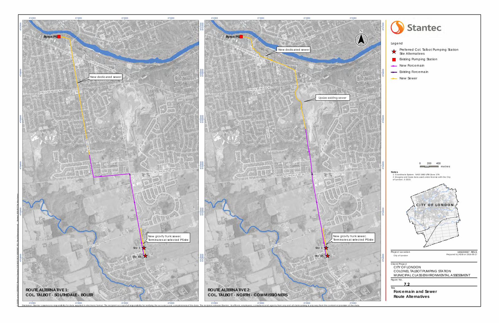
")
_̂
_̂
Upsize existing sewer
New gravity trunk sewer; Terminates at selected PS site
RIVERSIDE DR
COMMISSIONERS RD W
BYRON BASELINE RD
COLONEL TALBOT RD
SOUTHDALE RD W
PACK RD
BOLER RD
Byron PS
Site 4A
Site 3
472000
472000
473000
473000
474000
474000
475000
475000
4752
000
4752
000
4753
000
4753
000
4754
000
4754
000
4755
000
4755
000
4756
000
4756
000
4757
000
4757
000
Project Location
Client/Project
Figure No.
Title
")
_̂
_̂
New dedicated sewer
New gravity trunk sewer;Terminates at selected PS site
RIVERSIDE DR
COMMISSIONERS RD W
BYRON BASELINE RD
CO
LON
ELTA
LB OT
RD
SOUTHDALE RD W
PACK RD
BOLER RD
Byron PS
Site 4A
Site 3
472000
472000
473000
473000
474000
474000
475000
475000
4752
000
4752
000
4753
000
4753
000
4754
000
4754
000
4755
000
4755
000
4756
000
4756
000
4757
000
4757
000
Notes
0 200 400metres
Legend
_̂Preferred Col. Talbot Pumping StationSite Alternatives
") Existing Pumping Station
New Forcemain
Existing Forcemain
New Sewer
V:\0
1656
\act
ive\
1656
3006
7\Pl
ann
ing\
Dra
win
g\G
IS\M
XD\P
IC1\
1656
3006
7_PI
C1_
Rout
eAlte
rna
tives
.mxd
Revi
sed
: 201
6-06
-27
By: k
buch
ana
n
($$¯
165630067 REVA
Disclaimer: Stantec assumes no responsibility for data supplied in e lectronic format. The recipient accepts full responsibility for verifying the accuracy and completeness of the data. The recipient releases Stantec, its officers, employees, consultants and agents, from any and all claims arising in any way from the content or provision of the data.
City of London Prepared by KDB on 2016-06-27
Forcemain and SewerRoute Alternatives
1. Coordinate System: NAD 1983 UTM Zone 17N2. Imagery and base data used under license with the Cityof London, © 2015.
CITY OF LONDONCOLONEL TALBOT PUMPING STATIONMUNICIPAL CLASS ENVIRONMENTAL ASSESSMENT
ROUTE ALTERNATIVE 1:COL. TALBOT - SOUTHDALE - BOLER
ROUTE ALTERNATIVE 2:COL. TALBOT - NORTH - COMMISSIONERS
C I T Y O F L O N D O N
New dedicated sewer
7.2
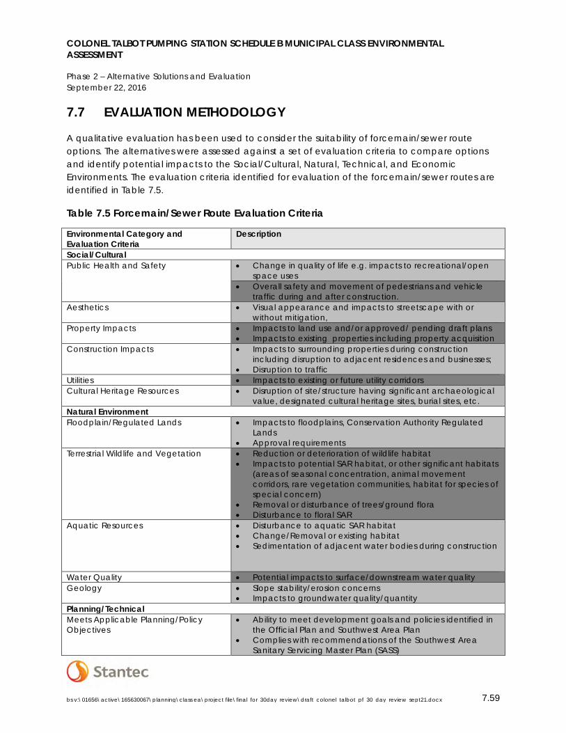
COLONEL TALBOT PUMPING STATION SCHEDULE B MUNICIPAL CLASS ENVIRONMENTAL ASSESSMENT
Phase 2 – Alternative Solutions and Evaluation September 22, 2016
bs v:\01656\active\165630067\planning\class ea\project file\final_for_30day_review\draft_colonel_talbot_pf_30_day_review_sept21.docx 7.59
7.7 EVALUATION METHODOLOGY
A qualitative evaluation has been used to consider the suitability of forcemain/sewer route options. The alternatives were assessed against a set of evaluation criteria to compare options and identify potential impacts to the Social/Cultural, Natural, Technical, and Economic Environments. The evaluation criteria identified for evaluation of the forcemain/sewer routes are identified in Table 7.5.
Table 7.5 Forcemain/Sewer Route Evaluation Criteria
Environmental Category and Evaluation Criteria
Description
Social/Cultural Public Health and Safety • Change in quality of life e.g. impacts to recreational/open
space uses • Overall safety and movement of pedestrians and vehicle
traffic during and after construction. Aesthetics • Visual appearance and impacts to streetscape with or
without mitigation, Property Impacts • Impacts to land use and/or approved/ pending draft plans
• Impacts to existing properties including property acquisition Construction Impacts • Impacts to surrounding properties during construction
including disruption to adjacent residences and businesses; • Disruption to traffic
Utilities • Impacts to existing or future utility corridors Cultural Heritage Resources • Disruption of site/structure having significant archaeological
value, designated cultural heritage sites, burial sites, etc. Natural Environment Floodplain/Regulated Lands • Impacts to floodplains, Conservation Authority Regulated
Lands • Approval requirements
Terrestrial Wildlife and Vegetation • Reduction or deterioration of wildlife habitat • Impacts to potential SAR habitat, or other significant habitats
(areas of seasonal concentration, animal movement corridors, rare vegetation communities, habitat for species of special concern)
• Removal or disturbance of trees/ground flora • Disturbance to floral SAR
Aquatic Resources • Disturbance to aquatic SAR habitat • Change/Removal or existing habitat • Sedimentation of adjacent water bodies during construction
Water Quality • Potential impacts to surface/downstream water quality Geology • Slope stability/erosion concerns
• Impacts to groundwater quality/quantity Planning/Technical Meets Applicable Planning/Policy Objectives
• Ability to meet development goals and policies identified in the Official Plan and Southwest Area Plan
• Complies with recommendations of the Southwest Area Sanitary Servicing Master Plan (SASS)
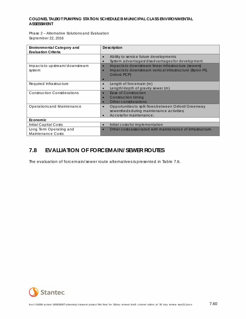
COLONEL TALBOT PUMPING STATION SCHEDULE B MUNICIPAL CLASS ENVIRONMENTAL ASSESSMENT
Phase 2 – Alternative Solutions and Evaluation September 22, 2016
bs v:\01656\active\165630067\planning\class ea\project file\final_for_30day_review\draft_colonel_talbot_pf_30_day_review_sept21.docx 7.60
Environmental Category and Evaluation Criteria
Description
• Ability to service future developments • System advantages/disadvantages for development
Impacts to upstream/downstream system
• Impacts to downstream linear infrastructure (sewers) • Impacts to downstream vertical infrastructure (Byron PS,
Oxford PCP) •
Required Infrastructure • Length of forcemain (m) • Length/depth of gravity sewer (m)
Construction Considerations • Ease of Construction • Construction timing • Other considerations
Operations and Maintenance • Opportunities to split flows between Oxford/Greenway sewersheds during maintenance activities;
• Access for maintenance; Economic Initial Capital Costs • Initial costs for implementation Long Term Operating and Maintenance Costs
• Other costs associated with maintenance of infrastructure.
7.8 EVALUATION OF FORCEMAIN/SEWER ROUTES
The evaluation of forcemain/sewer route alternatives is presented in Table 7.6.

Colonel Talbot Pumping Station Schedule B
Municipal Class Environmental Assessment Table 7.6 Forcemain/Sewer Route Evaluation
Options Route 1 Boler Road via Southdale Road Route 2: Colonel Talbot Road and Commissioners Road/ Springbank Park Criteria Social/Cultural
• Public Health and Safety • Property and Construction Impacts • Utilities • Cultural Heritage/ Archaeology
• Greater impacts/risks to pedestrians and traffic during construction than Route 2 since route runs along road right of way with sidewalk and through busy commercial intersection of Boler Road and Commissioners Road W.
• No property acquisition required. • Significant disruption to residential properties fronting Boler Road during construction. • Potential impact to streetscape, including removal of young trees. • Significant disruption to adjacent residential properties along Boler Road. • Significant disruption to commercial properties at Commissioners Road W/ Boler Road
intersection. • Significant disruption to traffic operations at commercial accesses and Commissioners Road W/
Boler Road intersection during construction. • Utility relocations required. • No impact to archaeological/ built heritage resources; construction work will be undertaken
within existing right of way.
• Potential impacts to Springbank Park property fronting Commissioners Road, but provides the opportunity for potential landscape enhancements. Minimal impacts to existing park trails.
• Existing route is adjacent to soccer fields; mitigation measures to be identified to minimize impacts (i.e. construction timing).
• Less overall impact/risk to pedestrians and traffic during construction since majority of construction occurs along Colonel Talbot Road with minimal-no pedestrian traffic or sidewalks.
• No property acquisition required; • Significantly fewer residential properties along route, therefore less overall impacts to
property access. • Potential impact to streetscape including limited tree removal. • Flexibility in routing gravity sewer through Springbank Park lands to avoid significant
streetscape impacts. • Significantly less impact due to fewer properties along Colonel Talbot Road (Byron
Gravel Pit located adjacent to route). • Fewer utility relocations required. • Potential impact to archaeological resources; archaeological investigation required. • One heritage property along route (1097 Commissioners Rd W – Flint Cottage). No
impacts to property anticipated. Natural Environment
• Floodplain/Regulated Limit • Terrestrial/Aquatic Wildlife and
Vegetation • Water Quality • Geology
• Potential construction required through UTRCA regulated land; permit may be required. • All work within existing right of way; no impacts to significant features/habitats. • Tree removal may be required along Boler Road. Tree removal to be restricted based on
breeding period identified by the MNRF. • Potential impacts to SAR habitats along the route; habitat assessments to be undertaken during
detailed design. • Creek/Municipal Drain crossing required for both alternatives north of Pack Road; feasibility of
direct drilling to be investigated, and mitigation measures to be identified. • No anticipated impact to water quality;
• Potential construction required through UTRCA regulated land; permit may be required. • All work will be within existing right of way, and through grassed open space areas. • Tree Removal may be required along Colonel Talbot Road/Commissioners Road W.
Tree removal to be restricted based on breeding period identified by MNRF. • Significant Woodlot/unevaluated vegetation patch located along the east of Colonel
Talbot Road north of Southdale Road; construction activities anticipated to be restricted to west right of way.
• Potential impacts to SAR habitats along the route; habitat assessments to be undertaken during detailed design.
• Creek/Municipal Drain crossing required for both alternatives north of Pack Road; feasibility of direct drilling to be investigated, and mitigation measures to be identified.
• No anticipated impacts to water quality; Technical
• Meets planning objectives and policies (SASS Master Plan, GMIS, etc.)
• Impacts to upstream/downstream infrastructure
• Construction Considerations • Implementation/Phasing
• Consistent with SASS recommendations. • Allows development according to OP SWAP land use designations and development
objectives. • Existing gravity sewer on Boler Road does not have capacity to accept additional flows;
upsizing or new dedicated sewer required; • Upsized/new dedicated sewer addresses existing capacity issues in Boler Road sewer, North
Street and Commissioners Road, and provides capacity in gravity sewers for future development of Urban Reserve Lands (Byron Gravel Pits).
• Upgrades to Byron PS consistent between routing options. • Dedicated gravity sewer would require more shallow gravity sewer, and less complicated
construction. • Work along roadway will be restricted to May1st through November 15th period ( standard
period during which asphalt reconstruction can take place)
• Consistent with SASS recommendations. • Allows development according to OP SWAP land use designations and development
objectives. • Existing gravity sewer on Colonel Talbot Road/North Street/Commissioners Road W does
not have capacity to accept additional flows; upsizing/new dedicated sewer required; • New gravity sewer would alleviate capacity issues in the existing sewer along North
Street and Commissioners Road, and provides capacity in gravity sewers for future development of Urban Reserve Lands (Byron Gravel Pits).
• Upgrades to Byron PS consistent between routing options. • Less complicated construction with fewer PDCs, and route through Springbank Park will
significantly reduce construction complexity, with minimal traffic controls required. • Route through Springbank Park (grassed area) provides flexibility in construction timing;
since no asphalt restoration may be required, construction can be undertaken outside of the May1st through November 15th period.
Economic • Initial Capital Costs • Property Acquisition • Operation and Maintenance • Compliance with Development
Charges Background Study
• $3.3 million (excluding engineering and contingency) • No property acquisition required. • Standard operation and maintenance costs between routes.
• $2.6 million (excluding engineering and contingency) • No property acquisition required. • Standard operation and maintenance costs between routes.
COLONEL TALBOT PUMPING STATION SCHEDULE B MUNICIPAL CLASS ENVIRONMENTAL ASSESSMENT
Phase 2 Public Consultation September 22, 2016
bs v:\01656\active\165630067\planning\class ea\project file\final_for_30day_review\draft_colonel_talbot_pf_30_day_review_sept21.docx 8.62
7.9 RECOMMENDED FORCEMAIN/SEWER ROUTE
While both alternative routes were considered technically feasible, Route 2: Colonel Talbot Road to North Street was preferred due to the construction flexibility provided by the route through Springbank Park lands, less impact to surrounding land uses and traffic operations, fewer utility relocations, and less cost as compared to Route 1.
8.0 PHASE 2 PUBLIC CONSULTATION
The background information on the study, alternative pumping station locations and forcemain/sewer routes, evaluation methodology and preliminary recommendations were presented to the public at a Public Information Centre (PIC) on Monday, June 27th 2016 at the Byron Community Centre 1308 Norman Ave.
The Notice of PIC was published in the Londoner newspaper on June 16th and 23rd 2016 (see Appendix C.2), advertised on the City of London website (www.london.ca), and directly mailed to those on the project mailing list including property owners, government agencies, and those who have expressed interest in the study (see Stakeholder List in Appendix C.1).
All material presented at the PIC was made available on the City of London’s website, and is included in Appendix C.3.
All comments submitted throughout the project and in response to the information presented at the PIC were documented in the TRACER Table included in Appendix C.4.
Concerns from Neighbouring Residents
Several concerns were expressed following the PIC regarding the potential impact that a new pumping station will have on existing residences, in terms of noise and odour emissions, aesthetic impacts, and an overall adverse impact on property values within the existing residential neighbourhood adjacent to the proposed PS location. These concerns have been acknowledged, and specific measures have been identified to address these concerns raised by neighbouring residents. The specific impacts and mitigation measures are detailed in Section 11.0 Environmental Impacts and Mitigation Measures, and include the following:
• Air quality/odour impacts from sanitary pumping stations are attributed to the retention time for sewage flows to a pumping station. Retention times are associated with the flows to a pumping station relative to the design capacity (i.e. the potential for odour impacts increases when a pumping station is receiving flows that are significantly less than its design capacity). Since the Colonel Talbot PS is expected to receive 102L/s of the 250L/s as day 1 flow from existing developments, there is less

COLONEL TALBOT PUMPING STATION SCHEDULE B MUNICIPAL CLASS ENVIRONMENTAL ASSESSMENT
Phase 2 Public Consultation September 22, 2016
bs v:\01656\active\165630067\planning\class ea\project file\final_for_30day_review\draft_colonel_talbot_pf_30_day_review_sept21.docx 8.63
potential for odour impacts. Nonetheless, point-source odour control measures will be incorporated into the design of the new Colonel Talbot PS.
• Aesthetic Impacts: The City of London is committed to a high standard of urban design. Significant efforts will be made to design the PS site to minimize aesthetic impacts by ensuring the site is consistent with the character and style of the surrounding environment (see Section 9.1.4 for Urban Design elements). Landscaping plans will be developed to enhance the aesthetics of the site and to act as screening for mechanical equipment, and building, paving, and fence material will be selected to enhance the appearance of the site.
Future Servicing – External Lands
Correspondence was received from landowners within Catchment Area 9, northwest of the intersection of Colonel Talbot Road and Pack Road. While these lands are currently located outside of the City’s Urban Growth Boundary, landowners are interested in pursuing development. The landowners requested that consideration be given as part of this project for providing capacity to address future development of the subject lands. A meeting was held on September 8th 2016, at which it was discussed that while the Colonel Talbot PS is not being designed to provide additional capacity, consideration can be made during detailed design to appropriately size the gravity trunk sewer on Colonel Talbot Road south of Pack Road to address potential flows. This could be considered as a low cost way to address the potential for future growth and minimize future economic and construction impacts, recognizing that the lifecycle of the linear infrastructure being implemented extends beyond the 10-20 year planning period of the study. Correspondence is included in Appendix C.4.
8.1 FIRST NATIONS CONSULTATION
Prior to the PIC, an information package including pumping station location and forcemain/sewer route mapping was mailed to First Nations contacts to provide an update on the project and the alternatives being considered (see Appendix C.6 for information package). Subsequent to the PIC, the presentation material was emailed to all First Nations contacts inviting communities to respond with any questions or concerns. All consultation with First Nations communities has been documented in the TRACER Table included Appendix C.6.
No comments or concerns were expressed from First Nations communities in response to the information presented at the PIC. A meeting was requested by Chippewas of the Thames First Nation and is currently scheduled for September 27th 2016 during the public review period. The Draft Project File will be updated to reflect comments or concerns expressed.
COLONEL TALBOT PUMPING STATION SCHEDULE B MUNICIPAL CLASS ENVIRONMENTAL ASSESSMENT
Preliminary Design September 22, 2016
bs v:\01656\active\165630067\planning\class ea\project file\final_for_30day_review\draft_colonel_talbot_pf_30_day_review_sept21.docx 9.64
9.0 PRELIMINARY DESIGN
The following sections define the basis and concepts upon which the detailed design of the new Colonel Talbot PS and associated linear infrastructure may be developed.
9.1 PUMPING STATION
Based on the evaluation of alternative pumping station locations in Section 7.4, both Sites 3 and 4A are recommended locations for the construction of the Colonel Talbot PS. The exact siting of the pumping station components will be determined based on negotiations with the subject property owners prior to detailed design. Siting of the pumping station shall also have regard for the UTRCA Regulation Limit located south of Site 4A.
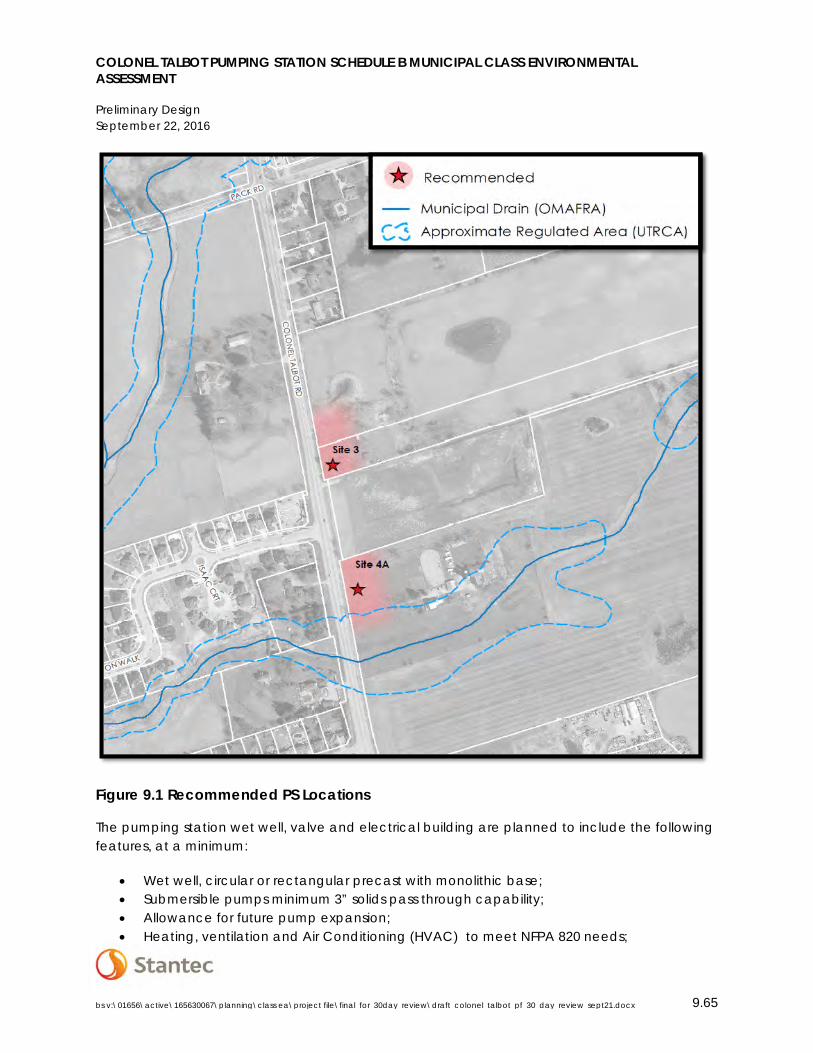
COLONEL TALBOT PUMPING STATION SCHEDULE B MUNICIPAL CLASS ENVIRONMENTAL ASSESSMENT
Preliminary Design September 22, 2016
bs v:\01656\active\165630067\planning\class ea\project file\final_for_30day_review\draft_colonel_talbot_pf_30_day_review_sept21.docx 9.65
Figure 9.1 Recommended PS Locations
The pumping station wet well, valve and electrical building are planned to include the following features, at a minimum:
• Wet well, circular or rectangular precast with monolithic base; • Submersible pumps minimum 3” solids pass through capability; • Allowance for future pump expansion; • Heating, ventilation and Air Conditioning (HVAC) to meet NFPA 820 needs;
COLONEL TALBOT PUMPING STATION SCHEDULE B MUNICIPAL CLASS ENVIRONMENTAL ASSESSMENT
Preliminary Design September 22, 2016
bs v:\01656\active\165630067\planning\class ea\project file\final_for_30day_review\draft_colonel_talbot_pf_30_day_review_sept21.docx 9.66
• Safety lighting; • Inlet sewer drop structure; • Level control; • Overflow solution to meet MOECC requirements; • Pressure/surge relief; • Pre-cast insulated valve chamber; • Magnetic flow meter(s); • Wet well pump out solution; • Check, plug, and knife gate valves; • Gravity sump with drain to wet well; • Double leaf insulated roof hatch; • Removable safety guard rails and self-closing doorway; • Passive ventilation; • Air release valve if required; • Level indication in valve chamber if required. • RPU cabinet; • Lighting panel; • Automatic transfer switch; • Control panel; • Emergency diesel generator; • Oversized generator pad to accommodate future needs; and • Sound enclosure.
9.1.1 Key Pump Selection Considerations
Preliminary pump selection was reviewed based upon the following considerations:
• Design flows; • Actual flow data; • MOECC design criteria require a minimum cycle time of 10 minutes or maximum 6 starts
per hour; • Use of Variable Frequency Drives (VFDs) to allow for range of pump flow; • Anticipated hydraulic characteristics of pumping station and forcemain; and • Uncertainty of the actual rate of growth of the catchment area.
Based upon these considerations, a range of pump options were considered from a single operating pump that would handle current design flows to a range of pumps that could handle the maximum required future flow of the proposed Colonel Talbot PS. These are summarized in Table 9.1.
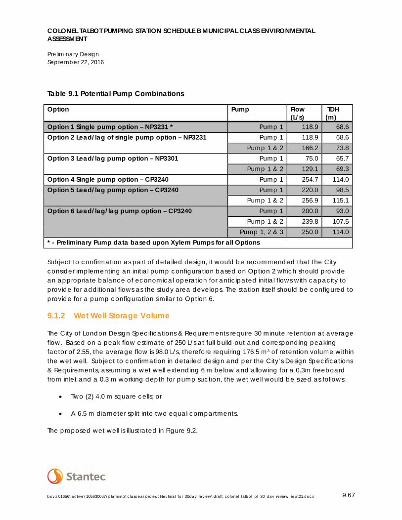
COLONEL TALBOT PUMPING STATION SCHEDULE B MUNICIPAL CLASS ENVIRONMENTAL ASSESSMENT
Preliminary Design September 22, 2016
bs v:\01656\active\165630067\planning\class ea\project file\final_for_30day_review\draft_colonel_talbot_pf_30_day_review_sept21.docx 9.67
Table 9.1 Potential Pump Combinations
Option Pump Flow (L/s)
TDH (m)
Option 1 Single pump option – NP3231 * Pump 1 118.9 68.6 Option 2 Lead/lag of single pump option – NP3231 Pump 1 118.9 68.6
Pump 1 & 2 166.2 73.8 Option 3 Lead/lag pump option – NP3301 Pump 1 75.0 65.7
Pump 1 & 2 129.1 69.3 Option 4 Single pump option – CP3240 Pump 1 254.7 114.0 Option 5 Lead/lag pump option – CP3240 Pump 1 220.0 98.5
Pump 1 & 2 256.9 115.1 Option 6 Lead/lag/lag pump option – CP3240 Pump 1 200.0 93.0
Pump 1 & 2 239.8 107.5 Pump 1, 2 & 3 250.0 114.0
* - Preliminary Pump data based upon Xylem Pumps for all Options
Subject to confirmation as part of detailed design, it would be recommended that the City consider implementing an initial pump configuration based on Option 2 which should provide an appropriate balance of economical operation for anticipated initial flows with capacity to provide for additional flows as the study area develops. The station itself should be configured to provide for a pump configuration similar to Option 6.
9.1.2 Wet Well Storage Volume
The City of London Design Specifications & Requirements require 30 minute retention at average flow. Based on a peak flow estimate of 250 L/s at full build-out and corresponding peaking factor of 2.55, the average flow is 98.0 L/s, therefore requiring 176.5 m³ of retention volume within the wet well. Subject to confirmation in detailed design and per the City’s Design Specifications & Requirements, assuming a wet well extending 6 m below and allowing for a 0.3m freeboard from inlet and a 0.3 m working depth for pump suction, the wet well would be sized as follows:
• Two (2) 4.0 m square cells; or
• A 6.5 m diameter split into two equal compartments.
The proposed wet well is illustrated in Figure 9.2.
COLONEL TALBOT PUMPING STATION SCHEDULE B MUNICIPAL CLASS ENVIRONMENTAL ASSESSMENT
Preliminary Design September 22, 2016
bs v:\01656\active\165630067\planning\class ea\project file\final_for_30day_review\draft_colonel_talbot_pf_30_day_review_sept21.docx 9.68
Figure 9.2 Conceptual Wet Well Sizing
9.1.3 Pump Cycle Time/Volume
MOECC Design Guidelines suggest a minimum cycle time of 10 minutes or maximum 6 starts per hour. From an operational perspective, the City may choose to increase that value to reduce the number of pump starts per hour and conserve energy while managing odours. The final wet well depth and operating levels will be determined as part of the detailed design stage and be coordinated with the energy management and odour control strategy.
9.1.4 Urban Design Considerations
The City of London is committed to implementing a high-standard of urban design for all new developments. Thus, the City has developed a draft Urban Design Manual (January 2015). The Manual provides guidance to applicants and their project teams to assist in creating engaging places within the City. The Southwest Area Plan also contains objectives for a high standard of design treatment particularly along Arterial Roads (20.5.3.9).
The design of the Colonel Talbot Pumping Station shall be consistent with the following objectives of the Manual:
COLONEL TALBOT PUMPING STATION SCHEDULE B MUNICIPAL CLASS ENVIRONMENTAL ASSESSMENT
Preliminary Design September 22, 2016
bs v:\01656\active\165630067\planning\class ea\project file\final_for_30day_review\draft_colonel_talbot_pf_30_day_review_sept21.docx 9.69
1. Site Character and Context: “Preserving environmental and natural heritage features and ensuring that development responds to the existing site constraints and opportunities;”
2. Site Organization: “Creating highly functional and aesthetically pleasing sites which seamlessly integrate with the public realm and surrounding development;”
3. Building: “Protecting built heritage, creating attractive commercial and office environments and expanding residential opportunities;”
4. Connectivity: “Prioritizing city-wide connectivity for pedestrians, cyclists, transit and vehicles;”
5. Public Realm: “Creating dynamic and welcoming public streetscapes and recreational spaces.”
During detailed design, Architectural and Urban Design Guidelines will be developed to better identify and prioritize the urban design objectives for the specific pumping station site. The guidelines will review the site’s character and context including existing site features (topography, vegetation, etc.) in conjunction with existing and proposed adjacent land uses. The massing and scaling of the proposed structure(s) should be selected to create a consistent urban form, at a human scale, and to be in keeping with the architectural style of the surrounding environment.
The site will be laid out to meet the vehicular and human operational requirements, in addition to equipment screening, safety and security requirements of the site will be incorporated into recommendations related to site connectivity and specifically address plant material, paving and fence material selections. Crime Prevention through Environmental Design (CPTED) principles will be considered and incorporated into the guidelines. It is the intent to design a wastewater pumping station that is visually appealing and which blends seamlessly into the surrounding context.
9.1.5 Site Layout
Based upon the depth of the incoming sanitary sewer and the size of the required wet well, a property area of approximately 1000m2 is anticipated to be required. Two conceptual site layouts were reviewed and each has a number of advantages and disadvantages, outlined in the Table 9.2.
Table 9.2 Site Layout Review
Option Description Advantages Disadvantages
1 2 structures: Wet well, single building consisting of electrical and valves
• Ease of maintenance within building envelope
• NFPA 820 considerations for electrical. Requires HVAC, gas detection, etc.
• More complex to construct

COLONEL TALBOT PUMPING STATION SCHEDULE B MUNICIPAL CLASS ENVIRONMENTAL ASSESSMENT
Preliminary Design September 22, 2016
bs v:\01656\active\165630067\planning\class ea\project file\final_for_30day_review\draft_colonel_talbot_pf_30_day_review_sept21.docx 9.70
Option Description Advantages Disadvantages
foundation for depressed valve area
• Larger building footprint • Higher capital cost • Higher energy consumption
2 3 structures: Wet well, valve chamber, electrical building.
• Pre-cast structures can be used, which reduces cost and construction timing
• No NFPA restrictions • Ease of construction • Smaller building footprint
provides for more opportunity for urban design to incorporate into surroundings
• Low energy consumption
• Exterior valve chamber access – confined space
Option 2 was selected as preferred site layout concept, since it has the most advantages in terms of construction timing, ease of implementation, and greater opportunities to incorporate landscape design features. Figure 9.3 provides a conceptual site layout.
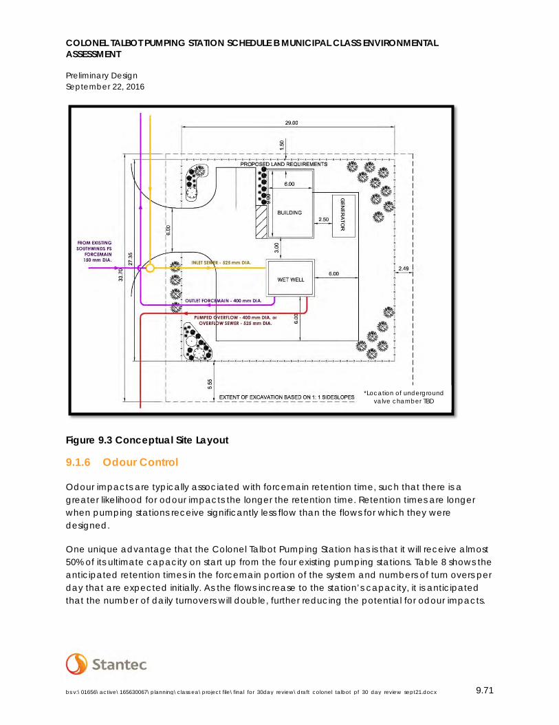
COLONEL TALBOT PUMPING STATION SCHEDULE B MUNICIPAL CLASS ENVIRONMENTAL ASSESSMENT
Preliminary Design September 22, 2016
bs v:\01656\active\165630067\planning\class ea\project file\final_for_30day_review\draft_colonel_talbot_pf_30_day_review_sept21.docx 9.71
Figure 9.3 Conceptual Site Layout
9.1.6 Odour Control
Odour impacts are typically associated with forcemain retention time, such that there is a greater likelihood for odour impacts the longer the retention time. Retention times are longer when pumping stations receive significantly less flow than the flows for which they were designed.
One unique advantage that the Colonel Talbot Pumping Station has is that it will receive almost 50% of its ultimate capacity on start up from the four existing pumping stations. Table 8 shows the anticipated retention times in the forcemain portion of the system and numbers of turn overs per day that are expected initially. As the flows increase to the station’s capacity, it is anticipated that the number of daily turnovers will double, further reducing the potential for odour impacts.
*Location of underground valve chamber TBD
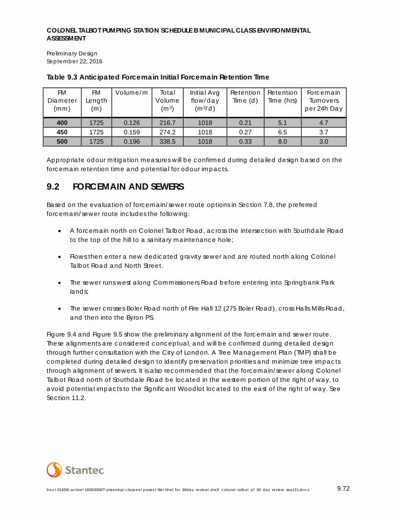
COLONEL TALBOT PUMPING STATION SCHEDULE B MUNICIPAL CLASS ENVIRONMENTAL ASSESSMENT
Preliminary Design September 22, 2016
bs v:\01656\active\165630067\planning\class ea\project file\final_for_30day_review\draft_colonel_talbot_pf_30_day_review_sept21.docx 9.72
Table 9.3 Anticipated Forcemain Initial Forcemain Retention Time
FM Diameter
(mm)
FM Length
(m)
Volume/m Total Volume
(m3)
Initial Avg flow/day
(m3/d)
Retention Time (d)
Retention Time (hrs)
Forcemain Turnovers
per 24h Day
400 1725 0.126 216.7 1018 0.21 5.1 4.7 450 1725 0.159 274.2 1018 0.27 6.5 3.7 500 1725 0.196 338.5 1018 0.33 8.0 3.0
Appropriate odour mitigation measures will be confirmed during detailed design based on the forcemain retention time and potential for odour impacts.
9.2 FORCEMAIN AND SEWERS
Based on the evaluation of forcemain/sewer route options in Section 7.8, the preferred forcemain/sewer route includes the following:
• A forcemain north on Colonel Talbot Road, across the intersection with Southdale Road to the top of the hill to a sanitary maintenance hole;
• Flows then enter a new dedicated gravity sewer and are routed north along Colonel Talbot Road and North Street.
• The sewer runs west along Commissioners Road before entering into Springbank Park lands;
• The sewer crosses Boler Road north of Fire Hall 12 (275 Boler Road), cross Halls Mills Road, and then into the Byron PS.
Figure 9.4 and Figure 9.5 show the preliminary alignment of the forcemain and sewer route. These alignments are considered conceptual, and will be confirmed during detailed design through further consultation with the City of London. A Tree Management Plan (TMP) shall be completed during detailed design to identify preservation priorities and minimize tree impacts through alignment of sewers. It is also recommended that the forcemain/sewer along Colonel Talbot Road north of Southdale Road be located in the western portion of the right of way, to avoid potential impacts to the Significant Woodlot located to the east of the right of way. See Section 11.2.
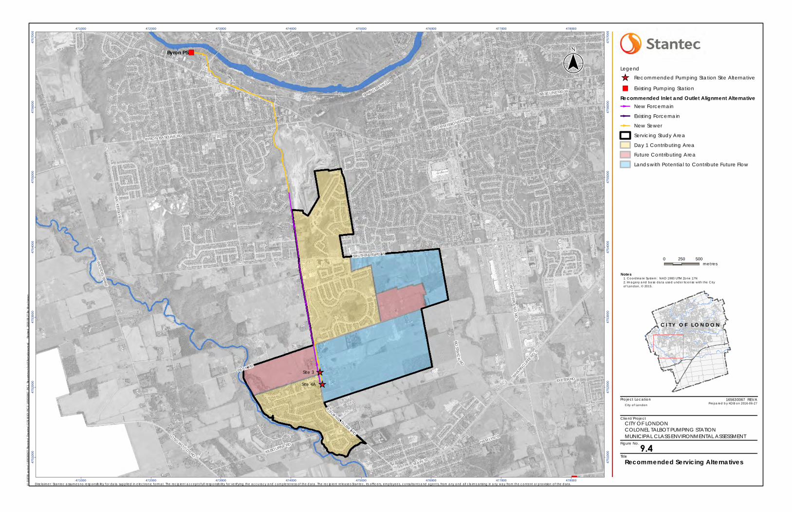
Project Location
Client/Project
Figure No.
Title
_̂
_̂
")
")
CO
LONEL TALBOT RD
RIVERSIDE DR
HAMLYN ST
COMMISSIONERS RD W
WHARN
CLIFFE
RD S
EXETER RD
SPRINGBANK DR
BYRON BASELINE RD
LONGWOODS RD
SOUTHDALE RD W
KILBOURNE RD
MAIN ST
WESTD
EL BRNE
WIC
KERSON
RD
PACK RD
BOSTW
ICK
RD
BOLER RD
BASE LINE RD W
WO
ND
ERLAN
D RD
S
Byron PS
Site 4A
Site 3
471000
471000
472000
472000
473000
473000
474000
474000
475000
475000
476000
476000
477000
477000
478000
478000
4751
000
4751
000
4752
000
4752
000
4753
000
4753
000
4754
000
4754
000
4755
000
4755
000
4756
000
4756
000
4757
000
4757
000
Notes
0 250 500metres
Legend
_̂ Recommended Pumping Station Site Alternative
") Existing Pumping Station
Recommended Inlet and Outlet Alignment AlternativeNew Forcemain
Existing Forcemain
New Sewer
Servicing Study Area
Day 1 Contributing Area
Future Contributing Area
Lands with Potential to Contribute Future Flow
V:\0
1656
\act
ive\
1656
3006
7\Pl
ann
ing\
Dra
win
g\G
IS\M
XD\P
IC1\
1656
3006
7_PI
C1_
Reco
mm
end
edA
ltern
ativ
es.m
xd
Re
vise
d: 2
016-
06-2
7 By
: kb
ucha
nan
($$¯
165630067 REVA
Disclaimer: Stantec assumes no responsibility for data supplied in e lectronic format. The recipient accepts full responsibility for verifying the accuracy and completeness of the data. The recipient releases Stantec, its officers, employees, consultants and agents, from any and all claims arising in any way from the content or provision of the data.
City of London Prepared by KDB on 2016-06-27
Recommended Servicing Alternatives
1. Coordinate System: NAD 1983 UTM Zone 17N2. Imagery and base data used under license with the Cityof London, © 2015.
CITY OF LONDONCOLONEL TALBOT PUMPING STATIONMUNICIPAL CLASS ENVIRONMENTAL ASSESSMENT
C I T Y O F L O N D O N
9.4
Project Location
Client/Project
Figure No.
Title
C I T Y O FL O N D O N
STEPHEN ST
BYRON BASELINE RD
SPRINGBANK AVE
ARBORETUM AVE (PVT)
CO
LVILLE BLVD
NASHUA AVE
OLD BRIDGE RD HALLS MILL PL
FOYSTO
N RD
BYRON BLVD
BROC
K ST
GLENROSE DR
COMMISSIONERS RD W
HALL
SM
ILLRD
NORMAN AVE
STORYBOOK LANE (PVT)
NORTH ST
WILLARD C
RES
FLINT LANE (PVT)
BOLER
RD
SPRING
BAN
KG
ATE(PV
T)
LYNDEN CRES
RIVERS EDGE DR (PVT)
Byron PS
Notes
0 100 200metres
LegendExisting Byron PSNew Gravity Sewer
V:\0
1656
\act
ive\
1656
3006
7\Pl
ann
ing\
Dra
win
g\G
IS\M
XD\P
IC1\
1656
3006
7_PI
C1_
Com
miss
ione
rsClo
seup
.mxd
Revi
sed
: 201
6-06
-27
By: k
buch
anan
($
$¯
165630067 REVA
Disclaimer: Stantec assumes no responsibility for data supplied in electronic format. The recipient accepts full responsibility for verifying the accuracy and completeness of the data. The recipient releases Stantec, its officers, employees, consultants and agents, from any and all claims arising in any way from the content or provision of the data.
City of London Prepared by KDB on 2016-06-27
Alternative 2 Detail:Commissioners Road W
1. Coordinate System: NAD 1983 UTM Zone 17N2. Imagery and base features produced underlicense with the City of London, © 2015.
CITY OF LONDONCOLONEL TALBOT PUMPING STATIONMUNICIPAL CLASS ENVIRONMENTAL ASSESSMENT
9.5

COLONEL TALBOT PUMPING STATION SCHEDULE B MUNICIPAL CLASS ENVIRONMENTAL ASSESSMENT
Preliminary Design September 22, 2016
bs v:\01656\active\165630067\planning\class ea\project file\final_for_30day_review\draft_colonel_talbot_pf_30_day_review_sept21.docx 9.75
9.2.1 Determination of Forcemain Size
There is a significant elevation distance to overcome to the end of the forcemain on Colonel Talbot Road north of Southdale Road. This requires that the size of the forcemain balance the initial construction cost (i.e. the smaller the diameter of the pipe, the more friction is required which results in higher electrical operating costs). The Preliminary System Curves shown in Figure 9.6 identifies the Total Dynamic Height (the total height that fluid is pumped, taking into account friction losses in the pipe) for various forcemain sizes, based on initial design flows, and ultimate design flows for the Colonel Talbot PS.
Figure 9.6 Preliminary System Curve
Another consideration is the velocity of the sewage in the forcemain which should be maintained at least 0.6m/s and range between 0.6 and 1.1m/s with the maximum velocity limited to 3m/s. The minimum velocity is required to ensure that the forcemain is self-cleaning and the maximum velocity is required to avoid damage to the forcemain. Table 9.4 shows the range of forcemain velocities based on the forcemain size.
Initial Design Flow, 102 L/s
Ultimate Design Flow, 250 L/s
40
60
80
100
120
140
160
180
200
0 20 40 60 80 100 120 140 160 180 200 220 240 260 280 300
TDH
(m)
Colonel Talbot PS Flow (L/s)
Colonel Talbot PS Preliminary System Curve 250mm Forcemain 300mm Forcemain 350mm Forcemain400mm Forcemain 450mm Forcemain 500mm Forcemain
Design Conditions Hazen-Williams 'C' factor of 120 for all pipe LWL in wet well = 253.10 m

COLONEL TALBOT PUMPING STATION SCHEDULE B MUNICIPAL CLASS ENVIRONMENTAL ASSESSMENT
Preliminary Design September 22, 2016
bs v:\01656\active\165630067\planning\class ea\project file\final_for_30day_review\draft_colonel_talbot_pf_30_day_review_sept21.docx 9.76
Table 9.4 Forcemain Velocity Range
Forcemain Size (diameter mm)
Velocity 102 L/s
Velocity 125 L/s
Velocity at 250 L/s
250 2.2 2.5 5.1 300 1.6 1.8 3.5 350 1.1 1.3 2.6 400 0.9 1.0 2.0 450 0.7 0.8 1.6 500 0.6 0.6 1.3 550 0.5 0.5 1.1 600 0.4 0.4 0.9
650 0.3 0.4 0.8
Subject to confirmation of a specific size during detailed design, it is assumed that a forcemain in the range of 400-500 mm will be required for this project.
9.3 OVERFLOW STRATEGY
MOECC and City Design Specifications require that pumping stations provide a by-pass overflow by gravity to an existing storm sewer system, or allow for emergency pumping to another gravity outlet when the capacity of the PS is overwhelmed due to excessive inflow and infiltration (typically caused by severe weather events), or during a power failure. Given the depth of the Colonel Talbot Pumping Station relative to the existing surface drainage features and anticipated future storm sewers servicing adjacent development, it is anticipated that emergency pumping will be required. The City’s GMIS has scheduled the connection of the gravity sewer from the Wonderland Pumping Station, which will act as the bypass overflow for the PS, to occur in 2025. Therefore the overflow strategy will be phased as follows:
• Interim – Pumped overflow to existing creek (Unnamed Drain 1) along Colonel Talbot Road;
• Ultimate – Overflow to sanitary trunk sewer from the Colonel Talbot PS to the Wonderland PS.
The overflow strategy is illustrated in Figure 9.7 for Site 4A.
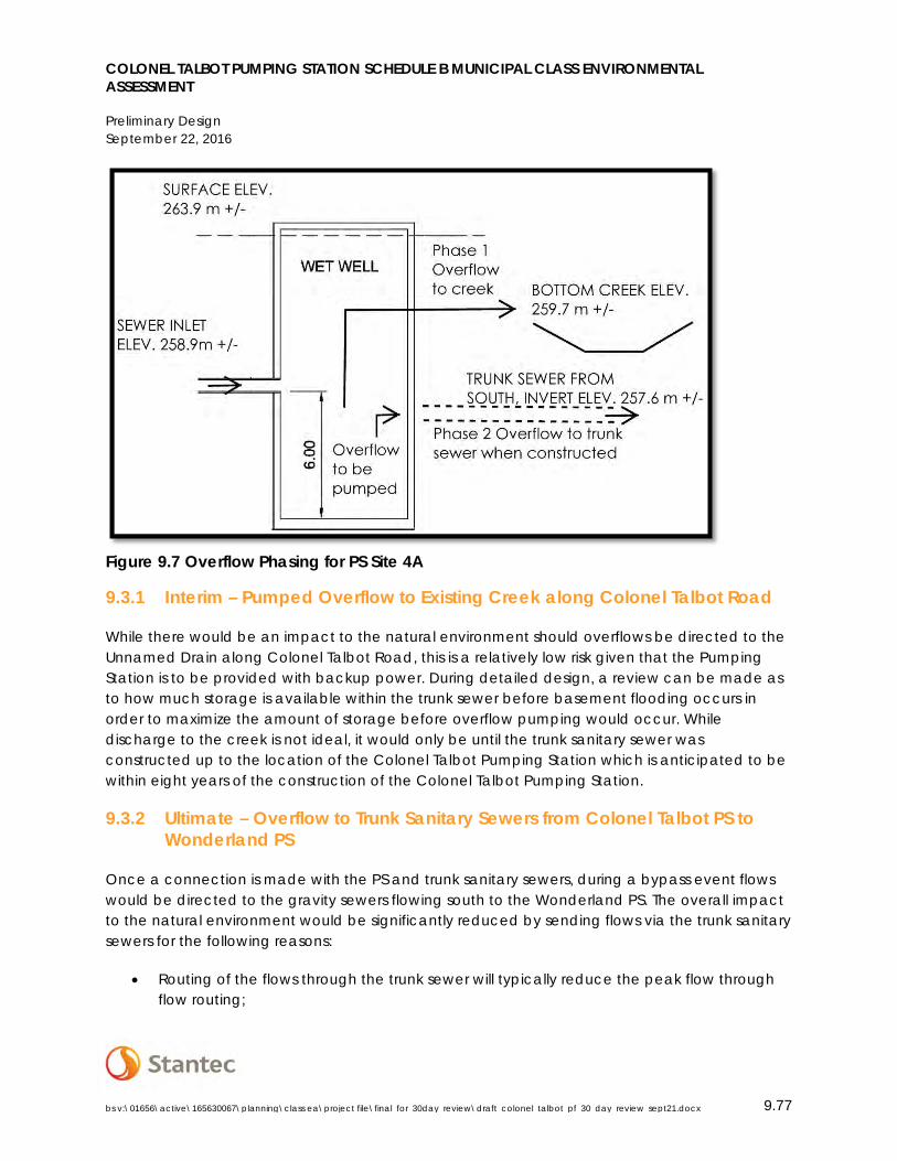
COLONEL TALBOT PUMPING STATION SCHEDULE B MUNICIPAL CLASS ENVIRONMENTAL ASSESSMENT
Preliminary Design September 22, 2016
bs v:\01656\active\165630067\planning\class ea\project file\final_for_30day_review\draft_colonel_talbot_pf_30_day_review_sept21.docx 9.77
Figure 9.7 Overflow Phasing for PS Site 4A
9.3.1 Interim – Pumped Overflow to Existing Creek along Colonel Talbot Road
While there would be an impact to the natural environment should overflows be directed to the Unnamed Drain along Colonel Talbot Road, this is a relatively low risk given that the Pumping Station is to be provided with backup power. During detailed design, a review can be made as to how much storage is available within the trunk sewer before basement flooding occurs in order to maximize the amount of storage before overflow pumping would occur. While discharge to the creek is not ideal, it would only be until the trunk sanitary sewer was constructed up to the location of the Colonel Talbot Pumping Station which is anticipated to be within eight years of the construction of the Colonel Talbot Pumping Station.
9.3.2 Ultimate – Overflow to Trunk Sanitary Sewers from Colonel Talbot PS to Wonderland PS
Once a connection is made with the PS and trunk sanitary sewers, during a bypass event flows would be directed to the gravity sewers flowing south to the Wonderland PS. The overall impact to the natural environment would be significantly reduced by sending flows via the trunk sanitary sewers for the following reasons:
• Routing of the flows through the trunk sewer will typically reduce the peak flow through flow routing;
COLONEL TALBOT PUMPING STATION SCHEDULE B MUNICIPAL CLASS ENVIRONMENTAL ASSESSMENT
Preliminary Design September 22, 2016
bs v:\01656\active\165630067\planning\class ea\project file\final_for_30day_review\draft_colonel_talbot_pf_30_day_review_sept21.docx 9.78
• The catchment area of the Wonderland PS is larger than that of the Colonel Talbot PS, so if peak flows are induced by precipitation, the larger catchment area typically reduces the overall intensity;
• The Wonderland PS may have a better ability to handle high flows which would have triggered the overflow at the Colonel Talbot PS;
• If the overflow was the result of a concurrent main power failure and back-up power failure at the Colonel Talbot PS (which would be a very rare occurrence), the chances are even more remote that the Wonderland PS would experience the same concurrent failure in the same event; and
• If the Wonderland PS experienced an overflow event, it is in an area that is more remote from residential population than is the Colonel Talbot PS.
Detailed design will review how best to configure the overflow arrangement to the gravity sewer, i.e. the overflow integrated into the Colonel Talbot PS or through a separate overflow/bypass structure.
9.4 SOUTHWINDS PUMPING STATION UPGRADES
The servicing strategy outlined in the SASS anticipated that the Southwinds Pumping Station would be modified to take additional flow from catchment area 5-3 (Silverleaf Estates, subject to Draft Plan Approval – see Figure 9.8) and direct flow to the new Colonel Talbot PS.
Options for implementing this servicing strategy were reviewed as part of this Class EA, and were considered based on the impacts to design and construction of the Colonel Talbot PS and associated trunk sewer. Considerations included construction and operational (pumping) costs, design challenges, social impacts including traffic, environmental impacts, and natural environment impacts. An overview of the options considered for the Southwinds PS catchment area and their impacts on the proposed Colonel Talbot PS and forcemain is provided below.
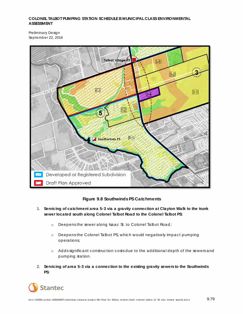
COLONEL TALBOT PUMPING STATION SCHEDULE B MUNICIPAL CLASS ENVIRONMENTAL ASSESSMENT
Preliminary Design September 22, 2016
bs v:\01656\active\165630067\planning\class ea\project file\final_for_30day_review\draft_colonel_talbot_pf_30_day_review_sept21.docx 9.79
Figure 9.8 Southwinds PS Catchments
1. Servicing of catchment area 5-3 via a gravity connection at Clayton Walk to the trunk sewer located south along Colonel Talbot Road to the Colonel Talbot PS:
o Deepens the sewer along Isaac St. to Colonel Talbot Road;
o Deepens the Colonel Talbot PS, which would negatively impact pumping operations;
o Adds significant construction costs due to the additional depth of the sewers and pumping station.
2. Servicing of area 5-3 via a connection to the existing gravity sewers to the Southwinds PS:
COLONEL TALBOT PUMPING STATION SCHEDULE B MUNICIPAL CLASS ENVIRONMENTAL ASSESSMENT
Preliminary Design September 22, 2016
bs v:\01656\active\165630067\planning\class ea\project file\final_for_30day_review\draft_colonel_talbot_pf_30_day_review_sept21.docx 9.80
o Consistent with the servicing strategy within the Conditions of Draft Approval for the Silverleaf Subdivision (39T-14504).
o May require reconstruction of approximately 200m of sewers within the Southwinds Subdivision to the Southwinds PS (undertaken as part of the Silverleaf Estates development);
o Requires upgrades to the Southwinds PS (as per the SASS servicing strategy);
o There could be some flexibility to direct flows from portions of area 5-3 to the Colonel Talbot Road trunk sewer without impacting anticipated sewer depth;
o This can be implemented at a lower cost to Option 1.
To minimize impacts to construction costs and technical impacts to the design and pumping operations of the Colonel Talbot PS, Option 2 was determined to be the most preferred option for servicing area 5-3; however, consideration may be made for servicing a portion of the development through the trunk sewer along Colonel Talbot Road to minimize necessary upgrades to Southwinds PS and the existing distribution system.
9.4.1 Modifications to Southwinds Pumping Station
The Southwinds PS will collect sewage from the existing areas 5-1, 5-2, and future area 5-3 to the north. It is anticipated that the design flow will be modified from the current 29.0 L/s to an estimated 48.4 L/s, with the final capacity to be determined during detailed design based on the final servicing strategy identified.
The Southwinds PS is a series pumping facility with two sets of two duty/standby pumps with one of each set running together to achieve the required lift to the top of the hill on Colonel Talbot Road. A portion of the existing sanitary forcemain will be reused to direct flows to the Colonel Talbot PS. The forcemain will be terminated at a maintenance hold of the new trunk sewer that will run south along Colonel Talbot Road. While the design flows to the PS will increase, the required pressure to convey sewage to the new trunk sewer will be significantly reduced. This will result in the modification of the pumping system from a series pumping facility to a duty/standby or a lead/lag pumping arrangement with a single set of pumps.
With regard to the existing storage capacity of the Southwinds PS, the wet well and emergency storage tanks are hydraulically connected. The current capacities for storage of the Southwinds PS are as follows:
• Wet-well storage below inlet sewer 11.9 m3 ;
• Emergency storage below inlet sewer 19.5 m3 ;
COLONEL TALBOT PUMPING STATION SCHEDULE B MUNICIPAL CLASS ENVIRONMENTAL ASSESSMENT
Preliminary Design September 22, 2016
bs v:\01656\active\165630067\planning\class ea\project file\final_for_30day_review\draft_colonel_talbot_pf_30_day_review_sept21.docx 9.81
• Total Storage 31.4 m3;
• 30-minute Storage Required according to City of London Design Standards is 28.4 m3. This is derived upon an estimated design flow of 48.4 L/s and an average flow of 14.4 L/s (design flow divided by a peaking factor of 3.3); and
• The number of minutes of total storage in the case of disruption to Pumping Station operations will be reduced from the current 241 minutes to 136 minutes with the addition of Area 5-3.
With the reduction in storage time at Southwinds and the use of the current emergency storage tank to provide for storage on a more regular basis, it is recommended that the City provide dedicated back up power to the pumping station.
9.5 DECOMISSIONING OF THE CRESTWOOD PUMPING STATION (CITY OF LONDON)
Following the switchover of flow to the Colonel Talbot PS, the decommissioning of the Crestwood PS would generally consist of the following activities:
• Removal of the pumps and associated equipment in the wet well;
• Removal of the external storage chamber;
• Removal of the small control building and its associated equipment;
• Cutting and capping the existing forcemain at the wet well and at the property line by the street;
• Removal of the equipment and piping from the meter chamber;
• Removal of the lids on the wet well storage tank and the meter chamber followed by backfilling;
• Removal of the electrical service to the site;
• Removal of the fence and gate; and
• Restoration of the area where the pumping station and building were removed.
COLONEL TALBOT PUMPING STATION SCHEDULE B MUNICIPAL CLASS ENVIRONMENTAL ASSESSMENT
Implementation Considerations September 22, 2016
bs v:\01656\active\165630067\planning\class ea\project file\final_for_30day_review\draft_colonel_talbot_pf_30_day_review_sept21.docx 10.82
9.6 DECOMISSIONING OF WESTFIELD AND TALBOT VILLAGE PUMPING STATIONS
Following the switchover of flow to the Colonel Talbot PS, the decommissioning of the Westfield and Talbot Village Pumping Stations will be undertaken by the respective owners based on the respective Development Agreements made upon final approval of the Plan of Subdivisions.
10.0 IMPLEMENTATION CONSIDERATIONS
The recommendations of this Class EA contain the following components:
• Construction of the Colonel Talbot PS;
• Construction of a trunk sewer from Pack Road south along Colonel Talbot Road to the new Colonel Talbot PS;
• A new forcemain along Colonel Talbot Road from the Colonel Talbot PS to the high point along Colonel Talbot Road north of Southdale Road;
• Construction of a trunk sewer from the high point along Colonel Talbot Road to the Byron PS;
• Modifications to the Southwinds PS to allow for flows from area 5-3 and to change the pumping configuration to outlet the existing forcemain on Colonel Talbot Road near the Colonel Talbot PS;
• Redirection of flows from the Talbot Village, Westfield, and Crestwood Pumping Stations on commissioning of the Colonel Talbot PS; and
• Decommissioning of the Talbot Village, Westfield, and Crestwood Pumping Stations by their respective owners.
10.1 PROPERTY REQUIREMENTS/EASEMENTS
Based on the preliminary site layout provided in Figure 9.3 a land parcel approximately 1000m2 will be required for implementation of the Colonel Talbot PS. Exact property requirements will be confirmed during detailed design and will include the required road widening along Colonel Talbot Road as identified in Zoning Bylaw Z.1. Temporary grading easements may also be required during construction and shall be arranged with adjacent property owners.
COLONEL TALBOT PUMPING STATION SCHEDULE B MUNICIPAL CLASS ENVIRONMENTAL ASSESSMENT
Implementation Considerations September 22, 2016
bs v:\01656\active\165630067\planning\class ea\project file\final_for_30day_review\draft_colonel_talbot_pf_30_day_review_sept21.docx 10.83
10.2 PHASING
Figure 10.1 identifies the general sequence of events required for the implementation of the Class EA recommendations.
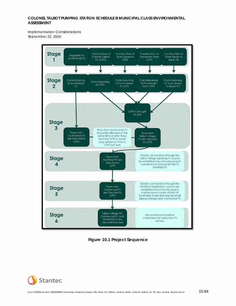
COLONEL TALBOT PUMPING STATION SCHEDULE B MUNICIPAL CLASS ENVIRONMENTAL ASSESSMENT
Implementation Considerations September 22, 2016
bs v:\01656\active\165630067\planning\class ea\project file\final_for_30day_review\draft_colonel_talbot_pf_30_day_review_sept21.docx 10.84
Figure 10.1 Project Sequence
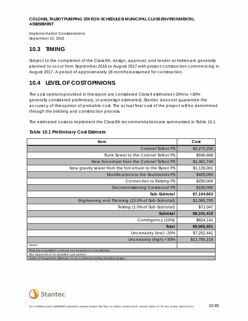
COLONEL TALBOT PUMPING STATION SCHEDULE B MUNICIPAL CLASS ENVIRONMENTAL ASSESSMENT
Implementation Considerations September 22, 2016
bs v:\01656\active\165630067\planning\class ea\project file\final_for_30day_review\draft_colonel_talbot_pf_30_day_review_sept21.docx 10.85
10.3 TIMING
Subject to the completion of the Class EA, design, approval, and tender activities are generally planned to occur from September 2016 to August 2017 with project construction commencing in August 2017. A period of approximately 18 months is assumed for construction.
10.4 LEVEL OF COST OPINIONS
The cost opinions provided in this report are considered Class 4 estimates (-20% to +30% generally considered preliminary, or predesign estimates). Stantec does not guarantee the accuracy of this opinion of probable cost. The actual final cost of the project will be determined through the bidding and construction process.
The estimated costs to implement the Class EA recommendations are summarized in Table 10.1.
Table 10.1 Preliminary Cost Estimate
Item Cost Colonel Talbot PS $3,270,250
Trunk Sewer to the Colonel Talbot PS $596,668 New forcemain from the Colonel Talbot PS $1,361,744
New gravity sewer from the forcemain to the Byron PS $1,126,001 Modifications to the Southwinds PS $400,000
Connection to Existing PS $250,000 Decommissioning Crestwood PS $100,000
Sub-Subtotal $7,104,663 Engineering and Planning (15.0% of Sub-Subtotal) $1,065,700
Testing (1.0% of Sub-Subtotal) $71,047 Subtotal $8,241,410
Contingency (10%) $824,141 Total $9,065,551
Uncertainty (low) -20% $7,252,441 Uncertainty (high) +30% $11,785,216
Notes: Property acquisition costs are not included in cost estimate. See Appendix G for detailed cost opinion. Order of Magnitude Estimate, to be confirmed during detailed design.
COLONEL TALBOT PUMPING STATION SCHEDULE B MUNICIPAL CLASS ENVIRONMENTAL ASSESSMENT
Environmental Impacts and Mitigation September 22, 2016
bs v:\01656\active\165630067\planning\class ea\project file\final_for_30day_review\draft_colonel_talbot_pf_30_day_review_sept22.docx 11.86
10.5 REQUIRED APPROVALS
In addition to the Provincial EA requirement as satisfied by the completion of the Class EA, implementation of the recommendations identified in this report are subject to the requirements of the Environmental Protection Act. The MOECC administer the EPA and requires a formal application to obtain an Environmental Compliance Approval (ECA) for the construction and operation of municipal sewage works, including the construction of the Colonel Talbot PS associated linear infrastructure. The ECA for the Southwinds PS will need to be revised to reflect the revised capacity, pumping configuration, and the addition of back-up power generation.
Recommended PS 4A is located adjacent to lands regulated by the Upper Thames River Conservation Authority under O. Reg. 157/06. A permit under Section 28 of the Conservation Authorities Act may be required from the UTRCA prior to construction or site alteration adjacent to Regulated Lands.
The Construction of the Colonel Talbot PS is also be subject to the City of London Site Plan Approval Process.
11.0 ENVIRONMENTAL IMPACTS AND MITIGATION
The following mitigation measures should be implemented in order to mitigate negative impacts from the proposed works on the environment. It is also recommended that mitigation and monitoring measures be included as part of the detailed design process and within the special provisions section of the tender documents, where applicable. All design reports and plans should be based on best management practices that focus on preventing negative impacts, protection of the existing environment and rehabilitation and/or enhancement of the disturbed areas.
11.1 SOCIAL/CULTURAL IMPACTS
A review of existing conditions and consultation with affected landowners identified potential impacts associated with the construction and operation of the new Colonel Talbot Pumping Station. Table 11.1 identifies potential impacts, and mitigation measures to be carried forward into detailed design and construction to eliminate or lessen the potential for impacts.
Table 11.1 Impacts and Mitigation Measures
Potential Impacts Mitigation Measures
Emissions and noise from pumping station operations (mechanical equipment and
Exhausts and silencers will be included in the design of the PS to meet MOECC requirements
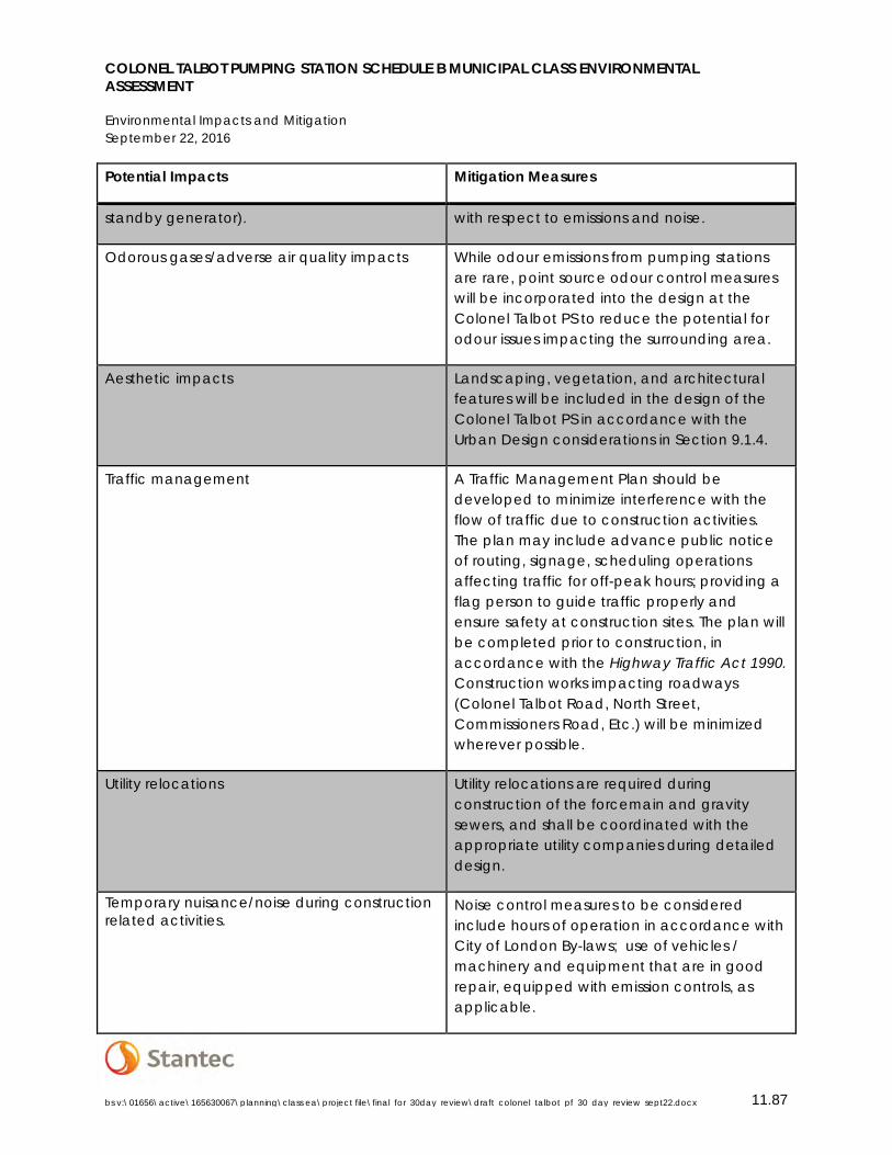
COLONEL TALBOT PUMPING STATION SCHEDULE B MUNICIPAL CLASS ENVIRONMENTAL ASSESSMENT
Environmental Impacts and Mitigation September 22, 2016
bs v:\01656\active\165630067\planning\class ea\project file\final_for_30day_review\draft_colonel_talbot_pf_30_day_review_sept22.docx 11.87
Potential Impacts Mitigation Measures
standby generator). with respect to emissions and noise.
Odorous gases/adverse air quality impacts While odour emissions from pumping stations are rare, point source odour control measures will be incorporated into the design at the Colonel Talbot PS to reduce the potential for odour issues impacting the surrounding area.
Aesthetic impacts Landscaping, vegetation, and architectural features will be included in the design of the Colonel Talbot PS in accordance with the Urban Design considerations in Section 9.1.4.
Traffic management A Traffic Management Plan should be developed to minimize interference with the flow of traffic due to construction activities. The plan may include advance public notice of routing, signage, scheduling operations affecting traffic for off-peak hours; providing a flag person to guide traffic properly and ensure safety at construction sites. The plan will be completed prior to construction, in accordance with the Highway Traffic Act 1990. Construction works impacting roadways (Colonel Talbot Road, North Street, Commissioners Road, Etc.) will be minimized wherever possible.
Utility relocations Utility relocations are required during construction of the forcemain and gravity sewers, and shall be coordinated with the appropriate utility companies during detailed design.
Temporary nuisance/noise during construction related activities.
Noise control measures to be considered include hours of operation in accordance with City of London By-laws; use of vehicles / machinery and equipment that are in good repair, equipped with emission controls, as applicable.
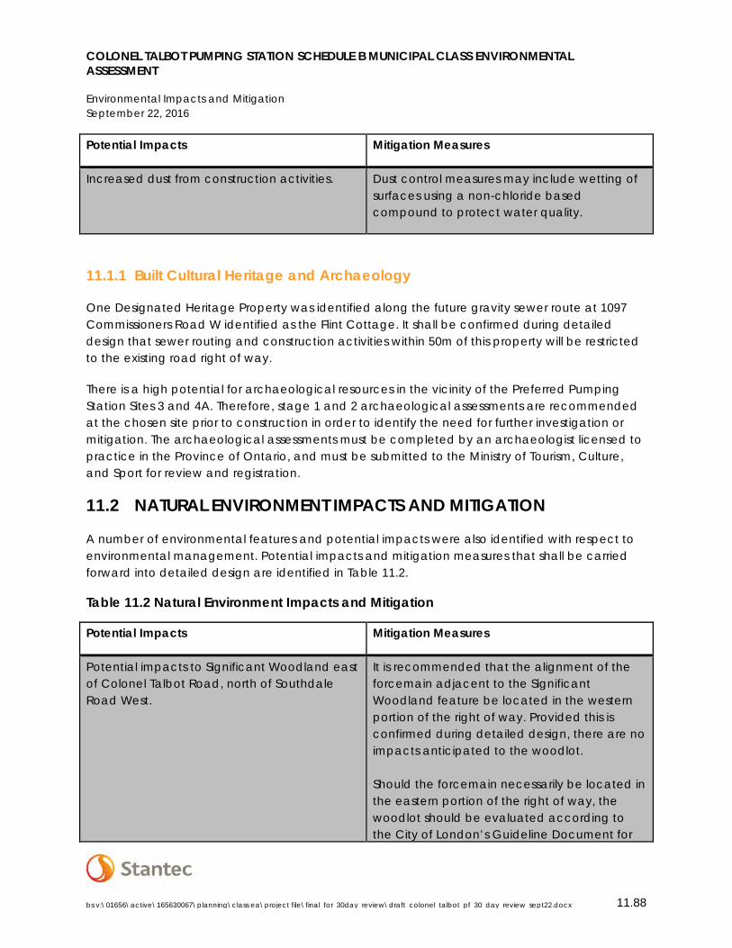
COLONEL TALBOT PUMPING STATION SCHEDULE B MUNICIPAL CLASS ENVIRONMENTAL ASSESSMENT
Environmental Impacts and Mitigation September 22, 2016
bs v:\01656\active\165630067\planning\class ea\project file\final_for_30day_review\draft_colonel_talbot_pf_30_day_review_sept22.docx 11.88
Potential Impacts Mitigation Measures
Increased dust from construction activities. Dust control measures may include wetting of surfaces using a non-chloride based compound to protect water quality.
11.1.1 Built Cultural Heritage and Archaeology
One Designated Heritage Property was identified along the future gravity sewer route at 1097 Commissioners Road W identified as the Flint Cottage. It shall be confirmed during detailed design that sewer routing and construction activities within 50m of this property will be restricted to the existing road right of way.
There is a high potential for archaeological resources in the vicinity of the Preferred Pumping Station Sites 3 and 4A. Therefore, stage 1 and 2 archaeological assessments are recommended at the chosen site prior to construction in order to identify the need for further investigation or mitigation. The archaeological assessments must be completed by an archaeologist licensed to practice in the Province of Ontario, and must be submitted to the Ministry of Tourism, Culture, and Sport for review and registration.
11.2 NATURAL ENVIRONMENT IMPACTS AND MITIGATION
A number of environmental features and potential impacts were also identified with respect to environmental management. Potential impacts and mitigation measures that shall be carried forward into detailed design are identified in Table 11.2.
Table 11.2 Natural Environment Impacts and Mitigation
Potential Impacts Mitigation Measures
Potential impacts to Significant Woodland east of Colonel Talbot Road, north of Southdale Road West.
It is recommended that the alignment of the forcemain adjacent to the Significant Woodland feature be located in the western portion of the right of way. Provided this is confirmed during detailed design, there are no impacts anticipated to the woodlot. Should the forcemain necessarily be located in the eastern portion of the right of way, the woodlot should be evaluated according to the City of London’s Guideline Document for
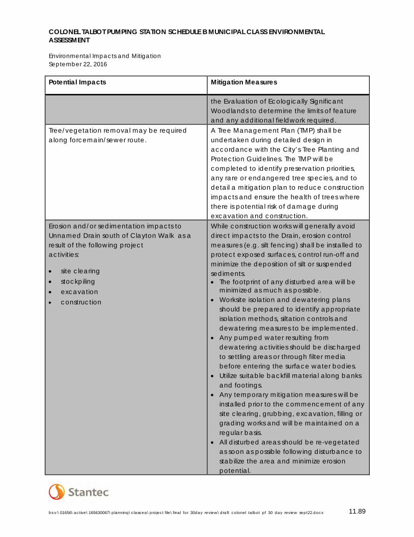
COLONEL TALBOT PUMPING STATION SCHEDULE B MUNICIPAL CLASS ENVIRONMENTAL ASSESSMENT
Environmental Impacts and Mitigation September 22, 2016
bs v:\01656\active\165630067\planning\class ea\project file\final_for_30day_review\draft_colonel_talbot_pf_30_day_review_sept22.docx 11.89
Potential Impacts Mitigation Measures
the Evaluation of Ecologically Significant Woodlands to determine the limits of feature and any additional fieldwork required.
Tree/vegetation removal may be required along forcemain/sewer route.
A Tree Management Plan (TMP) shall be undertaken during detailed design in accordance with the City’s Tree Planting and Protection Guidelines. The TMP will be completed to identify preservation priorities, any rare or endangered tree species, and to detail a mitigation plan to reduce construction impacts and ensure the health of trees where there is potential risk of damage during excavation and construction.
Erosion and/or sedimentation impacts to Unnamed Drain south of Clayton Walk as a result of the following project activities:
• site clearing • stockpiling • excavation • construction
While construction works will generally avoid direct impacts to the Drain, erosion control measures (e.g. silt fencing) shall be installed to protect exposed surfaces, control run-off and minimize the deposition of silt or suspended sediments. • The footprint of any disturbed area will be
minimized as much as possible. • Worksite isolation and dewatering plans
should be prepared to identify appropriate isolation methods, siltation controls and dewatering measures to be implemented.
• Any pumped water resulting from dewatering activities should be discharged to settling areas or through filter media before entering the surface water bodies.
• Utilize suitable backfill material along banks and footings.
• Any temporary mitigation measures will be installed prior to the commencement of any site clearing, grubbing, excavation, filling or grading works and will be maintained on a regular basis.
• All disturbed areas should be re-vegetated as soon as possible following disturbance to stabilize the area and minimize erosion potential.
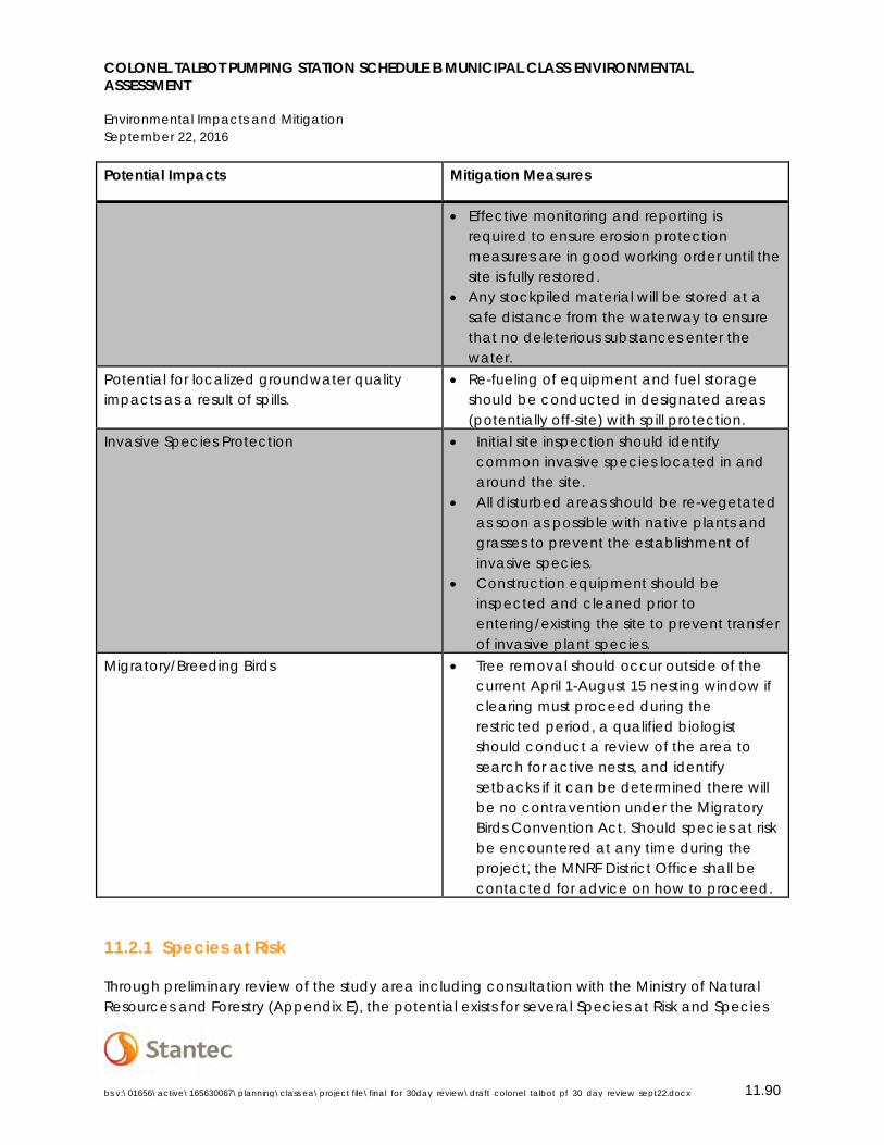
COLONEL TALBOT PUMPING STATION SCHEDULE B MUNICIPAL CLASS ENVIRONMENTAL ASSESSMENT
Environmental Impacts and Mitigation September 22, 2016
bs v:\01656\active\165630067\planning\class ea\project file\final_for_30day_review\draft_colonel_talbot_pf_30_day_review_sept22.docx 11.90
Potential Impacts Mitigation Measures
• Effective monitoring and reporting is required to ensure erosion protection measures are in good working order until the site is fully restored.
• Any stockpiled material will be stored at a safe distance from the waterway to ensure that no deleterious substances enter the water.
Potential for localized groundwater quality impacts as a result of spills.
• Re-fueling of equipment and fuel storage should be conducted in designated areas (potentially off-site) with spill protection.
Invasive Species Protection • Initial site inspection should identify common invasive species located in and around the site.
• All disturbed areas should be re-vegetated as soon as possible with native plants and grasses to prevent the establishment of invasive species.
• Construction equipment should be inspected and cleaned prior to entering/existing the site to prevent transfer of invasive plant species.
Migratory/Breeding Birds • Tree removal should occur outside of the current April 1-August 15 nesting window if clearing must proceed during the restricted period, a qualified biologist should conduct a review of the area to search for active nests, and identify setbacks if it can be determined there will be no contravention under the Migratory Birds Convention Act. Should species at risk be encountered at any time during the project, the MNRF District Office shall be contacted for advice on how to proceed.
11.2.1 Species at Risk
Through preliminary review of the study area including consultation with the Ministry of Natural Resources and Forestry (Appendix E), the potential exists for several Species at Risk and Species
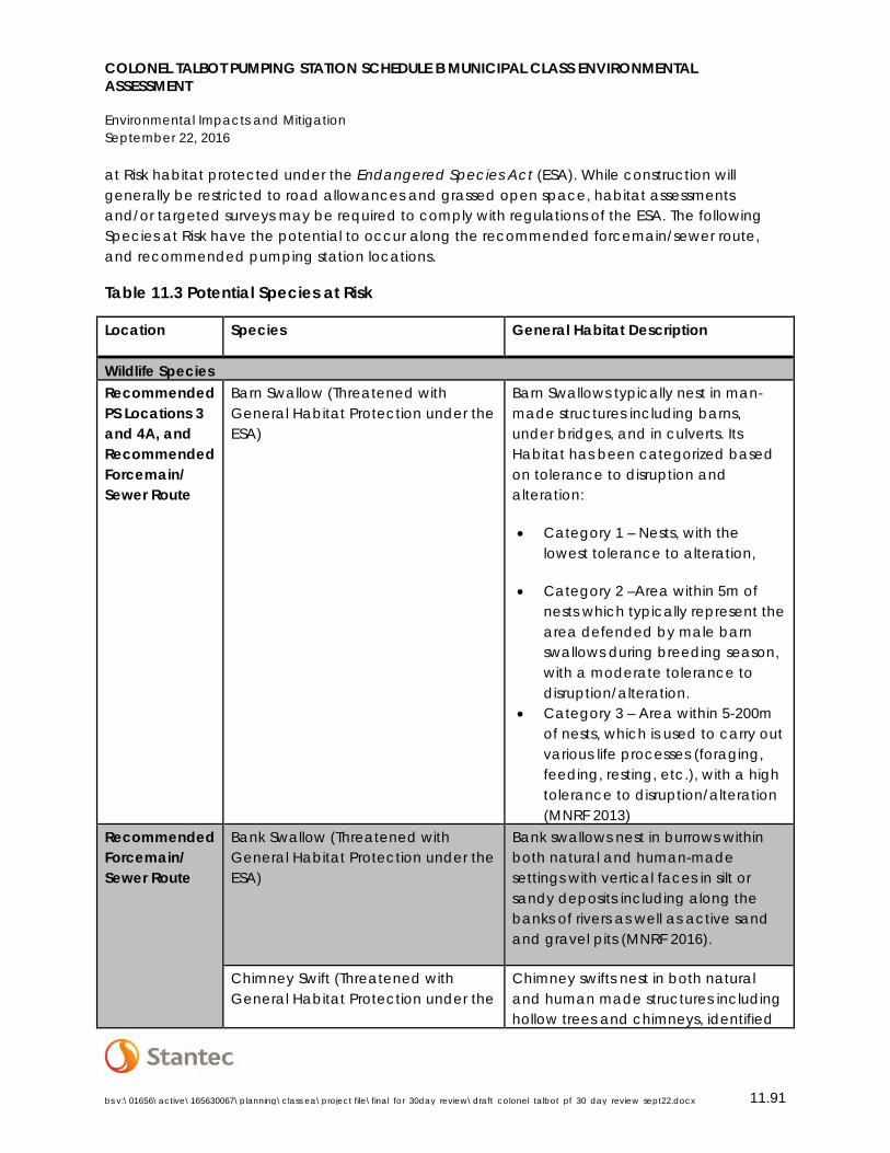
COLONEL TALBOT PUMPING STATION SCHEDULE B MUNICIPAL CLASS ENVIRONMENTAL ASSESSMENT
Environmental Impacts and Mitigation September 22, 2016
bs v:\01656\active\165630067\planning\class ea\project file\final_for_30day_review\draft_colonel_talbot_pf_30_day_review_sept22.docx 11.91
at Risk habitat protected under the Endangered Species Act (ESA). While construction will generally be restricted to road allowances and grassed open space, habitat assessments and/or targeted surveys may be required to comply with regulations of the ESA. The following Species at Risk have the potential to occur along the recommended forcemain/sewer route, and recommended pumping station locations.
Table 11.3 Potential Species at Risk
Location Species General Habitat Description
Wildlife Species Recommended PS Locations 3 and 4A, and Recommended Forcemain/ Sewer Route
Barn Swallow (Threatened with General Habitat Protection under the ESA)
Barn Swallows typically nest in man-made structures including barns, under bridges, and in culverts. Its Habitat has been categorized based on tolerance to disruption and alteration:
• Category 1 – Nests, with the lowest tolerance to alteration,
• Category 2 –Area within 5m of nests which typically represent the area defended by male barn swallows during breeding season, with a moderate tolerance to disruption/alteration.
• Category 3 – Area within 5-200m of nests, which is used to carry out various life processes (foraging, feeding, resting, etc.), with a high tolerance to disruption/alteration (MNRF 2013)
Recommended Forcemain/ Sewer Route
Bank Swallow (Threatened with General Habitat Protection under the ESA)
Bank swallows nest in burrows within both natural and human-made settings with vertical faces in silt or sandy deposits including along the banks of rivers as well as active sand and gravel pits (MNRF 2016).
Chimney Swift (Threatened with General Habitat Protection under the
Chimney swifts nest in both natural and human made structures including hollow trees and chimneys, identified
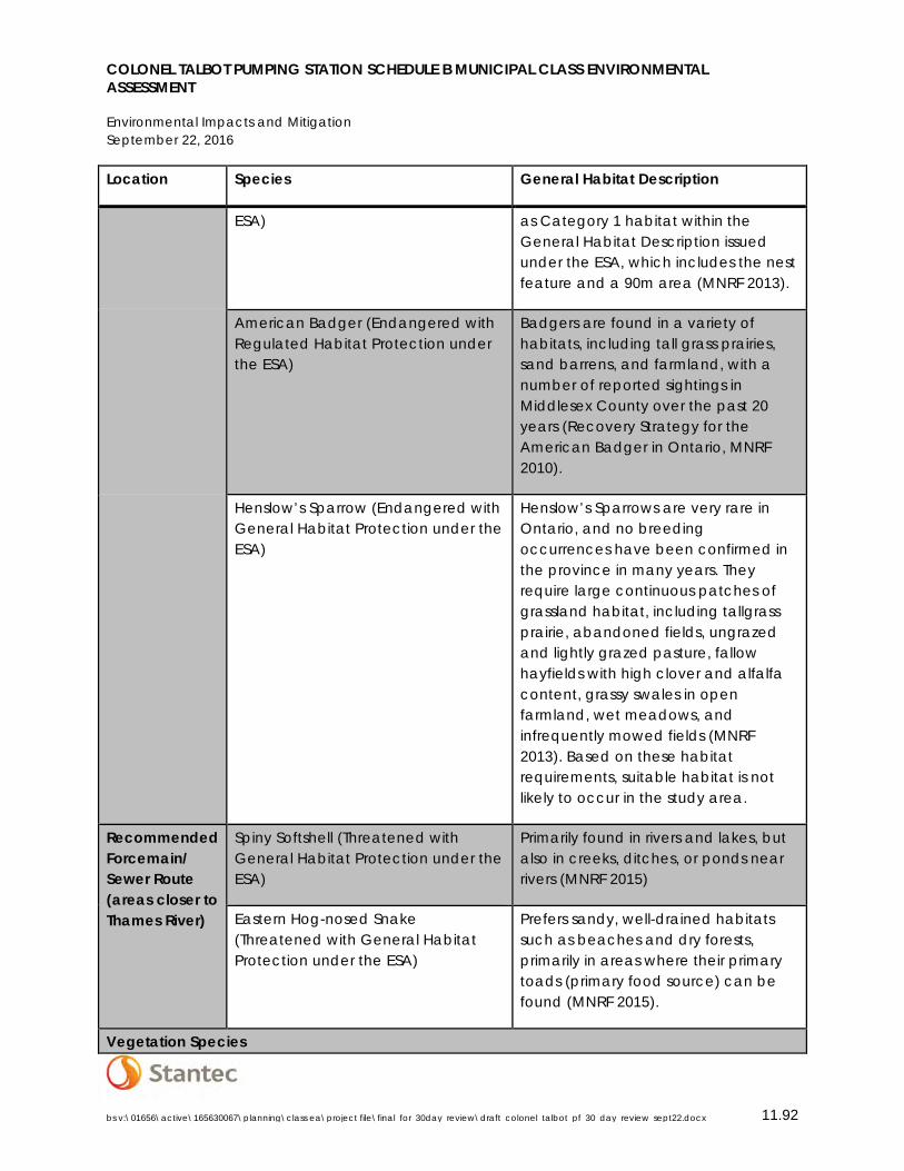
COLONEL TALBOT PUMPING STATION SCHEDULE B MUNICIPAL CLASS ENVIRONMENTAL ASSESSMENT
Environmental Impacts and Mitigation September 22, 2016
bs v:\01656\active\165630067\planning\class ea\project file\final_for_30day_review\draft_colonel_talbot_pf_30_day_review_sept22.docx 11.92
Location Species General Habitat Description
ESA) as Category 1 habitat within the General Habitat Description issued under the ESA, which includes the nest feature and a 90m area (MNRF 2013).
American Badger (Endangered with Regulated Habitat Protection under the ESA)
Badgers are found in a variety of habitats, including tall grass prairies, sand barrens, and farmland, with a number of reported sightings in Middlesex County over the past 20 years (Recovery Strategy for the American Badger in Ontario, MNRF 2010).
Henslow’s Sparrow (Endangered with General Habitat Protection under the ESA)
Henslow’s Sparrows are very rare in Ontario, and no breeding occurrences have been confirmed in the province in many years. They require large continuous patches of grassland habitat, including tallgrass prairie, abandoned fields, ungrazed and lightly grazed pasture, fallow hayfields with high clover and alfalfa content, grassy swales in open farmland, wet meadows, and infrequently mowed fields (MNRF 2013). Based on these habitat requirements, suitable habitat is not likely to occur in the study area.
Recommended Forcemain/ Sewer Route (areas closer to Thames River)
Spiny Softshell (Threatened with General Habitat Protection under the ESA)
Primarily found in rivers and lakes, but also in creeks, ditches, or ponds near rivers (MNRF 2015)
Eastern Hog-nosed Snake (Threatened with General Habitat Protection under the ESA)
Prefers sandy, well-drained habitats such as beaches and dry forests, primarily in areas where their primary toads (primary food source) can be found (MNRF 2015).
Vegetation Species
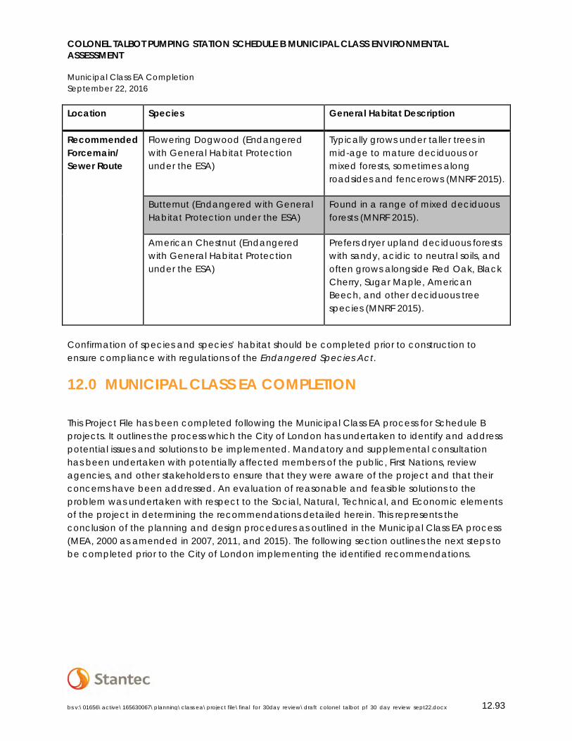
COLONEL TALBOT PUMPING STATION SCHEDULE B MUNICIPAL CLASS ENVIRONMENTAL ASSESSMENT
Municipal Class EA Completion September 22, 2016
bs v:\01656\active\165630067\planning\class ea\project file\final_for_30day_review\draft_colonel_talbot_pf_30_day_review_sept22.docx 12.93
Location Species General Habitat Description
Recommended Forcemain/ Sewer Route
Flowering Dogwood (Endangered with General Habitat Protection under the ESA)
Typically grows under taller trees in mid-age to mature deciduous or mixed forests, sometimes along roadsides and fencerows (MNRF 2015).
Butternut (Endangered with General Habitat Protection under the ESA)
Found in a range of mixed deciduous forests (MNRF 2015).
American Chestnut (Endangered with General Habitat Protection under the ESA)
Prefers dryer upland deciduous forests with sandy, acidic to neutral soils, and often grows alongside Red Oak, Black Cherry, Sugar Maple, American Beech, and other deciduous tree species (MNRF 2015).
Confirmation of species and species’ habitat should be completed prior to construction to ensure compliance with regulations of the Endangered Species Act.
12.0 MUNICIPAL CLASS EA COMPLETION
This Project File has been completed following the Municipal Class EA process for Schedule B projects. It outlines the process which the City of London has undertaken to identify and address potential issues and solutions to be implemented. Mandatory and supplemental consultation has been undertaken with potentially affected members of the public, First Nations, review agencies, and other stakeholders to ensure that they were aware of the project and that their concerns have been addressed. An evaluation of reasonable and feasible solutions to the problem was undertaken with respect to the Social, Natural, Technical, and Economic elements of the project in determining the recommendations detailed herein. This represents the conclusion of the planning and design procedures as outlined in the Municipal Class EA process (MEA, 2000 as amended in 2007, 2011, and 2015). The following section outlines the next steps to be completed prior to the City of London implementing the identified recommendations.
COLONEL TALBOT PUMPING STATION SCHEDULE B MUNICIPAL CLASS ENVIRONMENTAL ASSESSMENT
Municipal Class EA Completion September 22, 2016
bs v:\01656\active\165630067\planning\class ea\project file\final_for_30day_review\draft_colonel_talbot_pf_30_day_review_sept22.docx 12.94
12.1 CLASS EA FILING PROCEDURE
Following the publication of the Notice of Completion on September 22nd and 29th, 2016, the draft Project File shall be placed on record for the mandatory 30-day public review period beginning September 26th to October 26th, 2016 at the following locations:
City of London Clerk’s Office, 3rd Floor and Environmental Services, 8th Floor 300 Dufferin Avenue, London, Ontario, 519-661-2500 Hours: Monday – Friday: 8:30 a.m. to 4:30 p.m.
London Public Library – Lambeth Branch 7112 Beattie Street, London, ON Phone:(519) 652-2951 Hours: Tuesday & Thursday: 1:00 p.m. – 5:00 p.m. & 6:00 p.m. -9:00 p.m.; Wednesday, Friday & Saturday 9:00 a.m. - noon & 1:00 p.m. – 5:00 p.m.
Stantec Consulting Ltd. 600-171 Queens Ave. London, ON N6A 5J7 Ph: 519-645-2007 Hours: Monday to Friday 8:30 a.m. – 5:00 p.m.
London Public Library – Central Branch 251 Dundas Street London, Ontario, 519-661-4600 Hours: Monday – Thursday: 9:00 a.m. to 9:00p.m; Friday: 9:00 a.m. to 6:00 p.m. Saturday: 9:00 a.m. to 5:00 p.m.
The Notice of Completion shall be mailed out to each of the previously identified review agencies, special interest groups, members of the public, and First Nations Communities. This notice is included in Appendix C.2 and identified the study recommendations, provided an overview of the Class EA process followed, identified the 30-day public review period, and details of the right to request to the Minister of the Environment and Climate Change to issue an order to comply with Part II of the EA Act.
As per Section A.2.8 of the MEA Municipal Class Environmental Assessment document (2000, as amended in 2007, 2011, and 2015), the process for requesting a Part II Order involves the following:
• Project name and proponent; • Environmental impacts of the project and their significance; • The adequacy of the planning process; • The availability of alternatives to the project; • The adequacy of the public consultation program and the opportunities for public
participation; • The involvement of the requester in the planning of the project; • The nature of the specific concerns which remain unresolved; • Details of any discussions held between the requester and the proponent; • The benefits of requiring the proponent to undertake a higher level of assessment; and • Any other important matters considered relevant.
COLONEL TALBOT PUMPING STATION SCHEDULE B MUNICIPAL CLASS ENVIRONMENTAL ASSESSMENT
Municipal Class EA Completion September 22, 2016
bs v:\01656\active\165630067\planning\class ea\project file\final_for_30day_review\draft_colonel_talbot_pf_30_day_review_sept22.docx 12.95
The Minister shall consider both sides of the argument and make a decision on the matter. If the Minister agrees to the Part II Order request, then the Minister shall give notice with reasons to the proponent and the person requesting the Part II Order that the Class EA approval does not apply to the specific project under discussion. The proponent shall then be required to prepare and submit documentation as requested, or resolve the issue with the individual making the request, or defer the project. If the Minister does not agree to the Part II Order request, then the Minister shall give notice with reasons to the person making the request and to the proponent, and the project may proceed to implementation.
12.2 CLOSING
The work undertaken in preparing this report represents the completion of the EA process for the Colonel Talbot Pumping Station Schedule B project. Subject to approval of the recommendations identified herein, the City of London may proceed to design and implementation.

COLONEL TALBOT PUMPING STATION SCHEDULE B MUNICIPAL CLASS ENVIRONMENTAL ASSESSMENT
References September 22, 2016
bs v:\01656\active\165630067\planning\class ea\project file\final_for_30day_review\draft_colonel_talbot_pf_30_day_review_sept21.docx 13.1
13.0 REFERENCES
AECOM Canada Ltd. (2009). Sanitary Servicing Development Charge Update 2008 DC Study.
AECOM Canada Ltd. (2010). Southwest London Area Plan Sanitary and Water Servicing Report.
Ministry of Natural Resources and Forestry (2015). Natural Heritage Information Centre Biodiversity Explorer. https://www.ontario.ca/page/get-natural-heritage-information. Accessed March 29th, 2016.
Ministry of Natural Resources and Forestry. Species at Risk in Ontario List. https://www.ontario.ca/environment-and-energy/species-risk-ontario-list. Accessed March 29th 2016.
Municipal Engineer’s Association (2000 as amended in 2007, 2011, and 2015). Municipal Class Environmental Assessment Planning Process.
Stantec Consulting Ltd. (2014) Southwest Area Sanitary Servicing Master Plan.
The Corporation of the City of London (1989). Official Plan.
The Corporation of the City of London (2014). Southwest Area Plan (SWAP).
The Corporation of the City of London (2015). Design Specifications and Requirements Manual.
The Corporation of the City of London (2016) Growth Management Implementation Strategy (GMIS) update for 2017-2022.
The Corporation of the City of London (2016). The London Plan.

COLONEL TALBOT PUMPING STATION SCHEDULE B MUNICIPAL CLASS ENVIRONMENTAL ASSESSMENT
Appendix A Southwest Area Sanitary Servicing Master Plan (SASS) September 22, 2016
G.1
SOUTHWEST AREA SANITARY SERVICING Appendix AMASTER PLAN (SASS)
CITY OF LONDON REQUEST FOR PROPOSAL Appendix B
CONSULTATION Appendix C
C.1 STAKEHOLDER LIST
C.2 NOTICES
C.3 PIC PRESENTATION MATERIAL
C.4 PUBLIC INPUT
C.5 AGENCY CONSULTATION
C.6 FIRST NATIONS CONSULTATION
BACKGROUND COUNCIL REPORTS Appendix D
NATURAL HERITAGE INFORMATION Appendix E
SANITARY SEWER DESIGN SHEETS Appendix F
DETAILED COST OPINION Appendix G