Colebrook 5A Prince Edward County to Loyalist OAKVILLE ... · Map 5-2 Carte Map 5-2 Carte Picton...
10
14 q lelWk v S Hb 4 ekoPaColebrook o Point Anne 538 525 526 543 544 S 522 556 566 570 579 582 593 599 611 S S 14 13 12 28 35 13 17 13 11 68 23 9 9 31 10 28 20 12 CN Canal Murray Canal CFB/BFC TRENTON Musée Hastings County Museum Ferry/Bac Musée des United Empire Loyalists Museum Li Cataraq Parc provincial North Beach Provincial Park Parc provincial Sandbanks Provincial Park Parc provincial Lake on the Mountain Provincial Park Rés. nat. prov. Timber Island Prov. Nat. Res. Prov. Nat. Res. H.R. Frink Quinte Macaulay Mountain Little Bluff le de faune et Island life Area RNF Wellers Bay NWA Point Petre Réserve nationale de faune Prince Edward Point National Wildlife Area Nicholson Island Salmon Point Waupoos I. Timber Island Long Point Main Duck Island Amherst Island Athol Bay Consecon Lake Muscote Bay Big Bay v er Moira River Parks Bay of Quinte S Hb East Lake Prince Edward Bay Bay Hay Adolphus Beach North Channel Winton Cr. Salmon 62 62 401 37 64 14 5 15 10 13 10 8 24 17 10 13 9 8 9 8 22 7 8 7 5 4 6 1 11 11 12 4 19 4 18 20 1 21 23 5 4 9 17 18 41 4 2 2 2 49 2 38 11 33 33 49 2 8 2 1 1 19 3 14 23 12 27 33 33 14 2 33 2 2 8 20 enton Belleville Stirling Foxboro Frankford Plainfield Honeywell Corners kHoards oler atawa Glen Miller Bayside Rednersville Carrying Place Ameliasburg Rossmore Rosehall Hillier Consecon squ’ile Point Wellington West Lake Cannifton Corbyville Mountain View Wellman Glen Ross Quinte West Albury Melville Gardenville ale Prince Edward County Bloomfield Forest Mills Selby East Colebrook Yarker Newburgh Odessa Marysville Deseronto Bath Napanee Morven Millhaven Sandhurst Conway Adolphustown Tyendinaga Waupoos Cherry Valley Milford North Port Demorestville Picton Fawcettville Glenora Shannonville Stella Elgi Wilton Westbro o Elmwood Collins Bay Strathcona Violet Gosport Dorland Ernestown Greater Napanee Black Creek Outlet Solmesville Belleville Amherst B4 B2 B1 Picton Belleville Quinte West Profile Belleville Profile Tyendinaga Profile Greater Napanee Profile Prince Edward County Profile Deseronto Profile Napanee B3 1 3 4 2 B5 B5 Prince Edward County to Loyalist 5A www.waterfronttrail.org
Transcript of Colebrook 5A Prince Edward County to Loyalist OAKVILLE ... · Map 5-2 Carte Map 5-2 Carte Picton...

Point Anne538
525526
543544
556
S
522
556
566570
579582
593 599611
SS
14
44
30
24
13
12
28
35
13
17
23
13
1168
23
9
9
31
10
28
2012
CN
ADDINGTON
Canal Murray Canal
CFB/BFCTRENTON
Musée HastingsCounty Museum
Ferry/Bac
Musée des United Empire Loyalists Museum
LiCataraq
Parc provincialNorth Beach
Provincial Park
Parc provincialSandbanks
Provincial Park
Parc provincial Lake on the Mountain Provincial Park
Rés. nat. prov.Timber IslandProv. Nat. Res.
Rés. nat. prov.Menzel Centennial
Prov. Nat. Res.
ColonelRoscoe
Vanderwater
H.R. Frink
Quinte
MacaulayMountain
LittleBluff
le de fauneet Islandlife Area
RNFWellers Bay
NWA
Point Petre
Réserve nationale de faunePrince Edward PointNational Wildlife Area
NicholsonIsland
Salmon Point
Waupoos I.
Timber Island
Long Point
Main Duck Island
AmherstIsland
AtholBay
ConseconLake
MuscoteBay
BigBay
verMoira
Rive
r
Parks
Bayof Quinte
S Hb
East Lake
Prince EdwardBay
Bay
Hay
Adolphus Beach
NorthChannel
Varty Lake
Winton
Cr.
Salm
on
Rive
rCreek
Napan
ee
62
62
401
37
64
145
15
10
1310
8
24
17
10
13
9
89
8
22
7
8
7
54 6
1
111
11
12
4
27
19
418
17 20
1
21
23
54
9
17
18
41
4
2
2
2
49
2
38
11
33
33
492
19
8
8
2
1
1
19
3
1423
12
27
33
33
14
2
33
2 2
8
20
enton
Belleville
Stirling
Foxboro
Frankford
Roslin
Thomasburg
Plainfield
HoneywellCorners
p gBrook
Ivanhoe
ks
Hoards
oleratawa Glen
Miller
BaysideRednersville
CarryingPlace
Ameliasburg
Rossmore
Rosehall
HillierConseconsqu’ilePoint
WellingtonWest Lake
Cannifton
Corbyville
MountainView
Wellman
GlenRoss
MoiraMinto
Quinte West
Albury
MelvilleGardenville
ale
P r i n c e E d w a r d C o u n t y
Bloomfield
Roblin
ForestMills
Selby
CamdenEast
Colebrook
Yarker
Newburgh
Odessa
Marysville
Deseronto Bath
Napanee
Morven
Millhaven
Sandhurst
Conway
Adolphustown
Tyendinaga
Waupoos
CherryValley
Milford
NorthPort
Demorestville
Picton
FawcettvilleGlenora
Shannonville
Stella
ElgiWilton
Westbroo
ElmwoodCollins Bay
Strathcona
Violet
Gosport
Dorland
ErnestownGreater Napanee
BlackCreek
Outlet
Solmesville
Belleville
Amherst
OAKVILLEPrince Edward County to Loyalist5A
B4B2
B1
Picton
Belleville
Quinte WestProfile
BellevilleProfile
TyendinagaProfile
GreaterNapanee
Profile
Prince EdwardCounty Profile
DeserontoProfile
Napanee
B3
1
34
2
B5B5
Prince Edward County to Loyalist5A
www.waterfronttrail.org

Map
5-1
Car
te
Map
5-1
Car
teArea
Harry SmithConservation Area
Wellers BayNational Wildlife
Area
Sawguin
Roblin Lake
Consecon Lake
MelvilleC
Wellers Bay
NorthBay
PleasantBay
HuycksBay
WellingtonBay
HubbsCr.
Robinson Point
SniderPoint
Island Point
Huycks Point
NicholsonIsland
SpencerPoint
Bald Head
Beach
AllisonvilleConservationArea
62
P
Centre/ht
ConseconMill Dam
ConservationArea
FortKenté
PeddlesdenWinery
Millennium Trail
Whitney Memorial DamConservation Area
North BeachProvincial Park(day-use only)
MURRAY CANAL
Rd.
Ameliasburg Historical Museum
M. Adams Genealogical Research Centre
Millennium
Trail
Gardenville
Albury
Ameliasburg
MountainView
Centre
Victoria
ConseconStation
Consecon
Hillier
Melville
Allisonville
Hillcrest
RosehallHubbs
NilesCorners
Wellington
Bowermans
BarcovanBeach
Twelve O'ClockPoint
Burr
Roseland AcresC.
Mount
Carrying Place
Wellington Community Museum
Busy roadRoute achaladée
Very poor road conditionChaussée très déteriorée!
McM
aster Rd.
Hendricks R
d.
Hennessey
Rd.
Boulton
Rd.dall
English Settlement Rd.
Loya
list
Pkw
y.
Powerline Rd.
Murray Canal Rd.
Shore R
d.
Alyea
Rd.
Carter R
d.
Lange
Rd.
ovan Beach Rd.
County R
d. 40
Carrying
Place Rd.
.
Rd.ntal
d.
Loyalist Pkwy.
Taft Rd.
Loyalist Pkwy.
Gardenville Rd.
Smokes Point
Rd.
Victoria
Bryant R
d.
Dem
psey Rd.W
eese Rd.
Snider Rd.
Badgley Rd.C
unningham R
d.
Salem R
d.
Harba
rd
Rd.
Carnrike R
d.Lakeside D
r.
Zufelt Rd.
Edward
Dr.
Art
hur
Rd.
Partridge Hollow Rd.
Pleasant Bay
Rd.
Cold Creek Rd.Loyalist
Pkwy.
Loyalist Pkwy.
Palmer-B
urris Rd
.
Station R
d.
Shores R
d.
Little Creek
Alexander
Rd.
North
Beach Rd.
Hiscock
Greer Rd.
Hubbs C
reek Rd.
Benw
ay Rd.
Closson
Rd
Chase R
d.Trumpour Rd.
Swamp College Rd.
Baitleys R
d.
Townline R
d.
Wilson Rd.
Lo
Ivy Ridge Rd.
Valley
Rd.
Melvil
le
Carter Rd.
Burr
Rd.
Christi
McF
aul
Rd.
Dutch Rd.
d.
Gore
R
McIntyre Rd.
Victoria Rd.
Eatonville
Rd.
Re Huf
Victoria
Bakker Rd.
Danforth Rd
Rd.
Hubb's R
d.Rd.
Old Orch
ard
Rd.
19
39
33
33
29
1
2
2
2
19
23
27
20
33
1
19
3
WellingtonBeach
P r i n c e E d w a rdC o u n t y
B A Y O F
Q U I N T E
To/vers Trenton 8 km
To/versBrighton
Legend / Légende
2.0
Great Lakes Waterfront Trail /Sentier riverain
On-road / Sur la route
Off-road / Hors route
Connection / Liaison
Alerts / Alertes
Distance / Distance (km)
Other Connecting Trails /Autres sentiers de liaison
Park, Natural Area /Parc, Espace naturel
Cemetery / Cimetière
$
P
?Hospital / Hôpital
Beach / Plage
Campground / Camping
Attraction / Attraction
Marina / Marina
Parking / Stationnement
Lookout / Vue panoramique
Shopping / Zone commerciale
Town Hall / Hôtel de ville
Information / Renseignements
Washrooms / W.-C.
Index Map
Prince Edward CountySee Profile:
Map Displayed#5–1
1
2
3
4
5
5B6
7
Carrying Placewww.waterfronttrail.orgMap updated April, 2017
4-11 5-2
5B-6
Scale0 1 2 km
N
© Lucidmap Inc. 2017
Map 1 Trail Length: 35.7 km Map 5-1 : Carrying Place

Map
5-2
Car
te
Map
5-2
Car
te
PictonAirport
Sunset Lookout
RutherfordStevensLookout
ConservationArea
Macaulay Mountain
ConservationArea
Demorestville DamConservation Area
Bloomfield Mill Pond
H.J. McFarlandConservation Area
Milford Mill PondConservation Area
Beaver MeadowConservation Area
Creek
West Lake
Muscote Bay
Carnachan Bay
MalloryBay
SouthBay
Bloomfield
Creek
Demorestville
k
River
Pic
ton
Bay
Cr.
GarrattIsland
GasketIsland
ShebaIsland
HickoryIsland
33
P
The Sandbanks
Birdhouse City
Lake on the Mountain
Ferry
MacaulayHeritage Park
The WhiteChapel (1809)
Millennium
Trail
Crofton
ns
Huff'sCorners
Hallowell
Bloomfield
WaringsCorner
Picton
Gilbert Mills
Bethel
Demorestville
Elmbrook
Woodville
Glenora
Lake On The Mountain
BlackRive
MilfordPortMilford
Woodrous
YerexvilleFawcettville
CherryValley
D
Adol
C.F.B.Mountain View
Lake on the MountainProvincial Park
AtholWestLake
$
P
P
2210
8
10
4
6
d.
Gilead Rd.
Conley R
d.
Wes
ley
Acres Rd.
Wes
t
Lak
e
Rd.
Winns
Dr.
Island Rd.
Loyalist Pkwy.
Kleinsteuber
Parks Rd.
Ridge
Rd.
Marisett Rd.Young
Rd.
Murphy Rd.
Miller
R
d.
Old
Milf
ord
Rd
.
Jacksons Falls Rd.
Morriso
Bond Rd.
Johnston Rd.
Crowes Rd.
Scotts Mill Rd.
Eames
Rd.
Thompson
Rd.
Jone
s R
d.
Fry
Rd.
Yere
xvill
e
Rd.
May
Rd.
Mal
lory
Rd.
Hull Rd.
Kingsley
Old
Milfo
rdR
d.
Airp
ort
La.
Cla
rke
R
d.
Ros
seau
Chuckery Hill Rd.
Loya
list
P
kwy.
Talbot St.
Johnson St. Cro
ssro
ad
Whi
teCha
pel R
d.
Rd.
Mowbray Rd.
McK
inl
ey
Mitchells
Cross
ro
ad
Crossroads
Luc
ksC
ross
road
Wilkes R
d.W
ild Oak La.
Morgan
Rd. M
atth
ie R
d.
Qua
ker
Rd.
Trip
p R
d.
Tubbs R
d.
Old Belleville R
d.
Wilson
Rd.
Slaven R
d.
Matthie
Rd.
Christia
n
Rd.
Crofton Rd.
Pumphouse
La. Doxsee R
d.
Black Rd.
Bethel Rd. Trum
ble Rd.
GomRd.
Gorsline Rd.
Fish Lake
R
Gorsline
Rd. Fr
y
R
d.
GagneRd.
Elm
broo
k
Rd.
Bethesda Rd.
Dav
is
Rd.
Rd.
3rd
Concession Rd.
Staples
La.
Ruth's
La.
Thompson
PointYoung’s
Point
Rd.
Oram Rd.
62
33
18
11
10
25
13
1317
17
16
45
34
33
1
14
5
49
12
32
4
1
7
WellingtonBeach
P r i n c e E d w a rdC o u n t y
Bra
dle
y C
ross
road
B A Y O F
Q U I N T E
LAKE /LAC
ONTARIOEast Lake
Legend / Légende
2.0
Great Lakes Waterfront Trail /Sentier riverain
On-road / Sur la route
Off-road / Hors route
Connection / Liaison
Alerts / Alertes
Distance / Distance (km)
Other Connecting Trails /Autres sentiers de liaison
Park, Natural Area /Parc, Espace naturel
Cemetery / Cimetière
$
P
?Hospital / Hôpital
Beach / Plage
Campground / Camping
Attraction / Attraction
Marina / Marina
Parking / Stationnement
Lookout / Vue panoramique
Shopping / Zone commerciale
Town Hall / Hôtel de ville
Information / Renseignements
Washrooms / W.-C.
Scale0 1 2 km
N
Index Map
See Profile:
Map Displayed#5–2
1
2
34
5
5B
6
7
Prince Edward County
Picton
5-1 5-3
www.waterfronttrail.orgMap updated April, 2017
PictonHarbour
Mar
sh
Creek
Chimney Pt
Brick Kiln Pt
Prince EdwardMemorial
Fairgrounds
Prince EdwardYacht Club
BensonHall
Prince EdwardCounty Museum
MacaulayHeritage
Park Macaulay
Mountain
?
$
$
Johnson St
Mai
n
St
E
Bridge
St
Main S
t
W
8
Mai
tland
S
tPaul St
King St
Elizabeth St
Ferg
uson
St
McD
onald
Dr
Hill
St
Centre St
Bowery St
York StWashburn
St
Av
MacSteven Dr
Mary St
W
Picton ArtGallery
RegentTheatre
LairdLa
������� ���N
Picton
© Lucidmap Inc. 2017
Map 2 Trail Length: 29 km Map 5-2 : Picton

Map
5-3
Car
te
Map
5-3
Car
te
Nap
anee
CN
Car
nach
an B
ay
BA
Y
OF
QU
INT
E
Wilt
on
Spring
Little
Long
Reach
Hay
Bay
Suck
er
Cre
ek
Th
e R
ock
Ind
ian
Po
int
Co
le P
oin
t
Lyo
ns
I.
Cla
rkIs
lan
d
?
Fer
ry Gle
no
ra
eB
on
gar
d
Bo
ng
ard
Co
rner
s
Cre
ssy
Co
le W
har
f
Hu
ff W
har
f
Gre
enp
oin
t
Mo
rven
Gal
ts C
orn
er
Haw
ley
Sills
ville
San
dh
urs
t
San
dh
urs
tSh
ore
s
Co
nw
ay
The
Pin
es
Wat
erco
mb
e
Go
spo
rt Do
rlan
d
Ad
olp
hu
sto
wn
An
der
son
Gre
tna
Bet
han
y
Nap
anee
Hay
Bay
Hay
bu
rn
Ch
rist
C
hu
rch
(184
3)
Exi
t 57
0
Lo
yalis
t C
ult
ura
lC
entr
e an
d M
use
um
Ad
olp
hu
sto
wn
Lo
yalis
t P
ark
Alla
nM
acp
her
son
Ho
use
Len
no
x &
Ad
din
gto
nC
ou
nty
Mu
seu
m
Lak
e o
n t
he
Mo
un
tain
Pro
vin
cial
Par
k
Hay
Bay
Ch
urc
h (
1792
)Gr
ea
te
rN
ap
an
ee
Ber
ger
on
Est
ate
Win
ery
and
Cid
er C
o.
Lennox AddingtonCycle Route D
:Shoreline
Th
irty
Th
ree
Vin
es W
iner
y
Lennox Addington Cycle
Route E: Hay River
P
Bongards
Crossroad
Rd.
3rd
Con
ces s
ion
Rd
.Staples
La.
Ruth's
La.Sh
erm
an's
Poi
nt R
d.
Hickory La.
Young’s
Point
Rd.
South Shore
R
ock
C
rossroad
Loya
list
Pkw
y.
Loya
list
Pkw
y.
Road
1
B
aysh
ore
Rd.
Abrams
Rd.
Fitchett
Rd.
South S
hore
R
d.
Sou
th S
hore
Rd.
Rid
ge Rd.
Stor
eyBig
Cre
ek R
d.Pe
rry
Rd.
Big
C
reek
Rd.
Littl
e
Cre
ek
R
d.
H
ambl
y
Huyck
St.
Gal
t St
.
St.
Cuthill
La.
The Hamburg
Rd.
Rd
.
Oliver Sideroad
River Rd.
Barker Sdrd.
Woo
dcoc
k
St.
Brid
ge
St.
W.
TownlineRd.
Bathurst
St.
Cre
ssy
Lak
eside
Rd.
Benn’
s
Poin
t Rd.
Switz
ervi
lle
Old Ham
burgh
R
d.
Blv
Deseronto Rd.
Fralick Rd.
Sha
rpe
401
33
7
9 2
5
8
22
8
8
7
8
9
10
1
2
9 2
8
8
21
8
2
Lo
yalis
t M
emo
rial
Ch
urc
h (
1822
)
Hay
Bay
Pic
kere
lP
ark
Nap
aneeeeee
NNNap
aneeee
neee
aneee
anee
apa
apa
NNNN
Alla
nA
llallaM
acp
her
son
MMa
Ma
Ho
use
Ho
Ho
no
x &
Ad
din
gt
enn
nnn
on
dd
ox
& A
dd
ing
ten
nn
nd
dn
od
dL
enn
ox
& A
dd
ing
ton
no
xn
ox
Le
din
gto
nL
enn
ox
& A
dd
ing
ton
ou
nty
Mu
seu
mC
oC
ooC
oM
uo
Mu
ntyty
er eeee
eeeeee
The Hamburg
The
River Rd.
OldHam
bu
Blv
8
See
Nap
anee
Map
(5B
-1)
Bet
han
y
Ch
ris
hri
st
C Ch
Ch
urc
h(1
843)2
See
Des
ero
nto
Map
(5B
-2)
Low
er
Sla
sh
Rd
.
Nar
row
to
no
sh
ou
lder
sA
cco
tem
ents
étr
oit
so
u in
exis
tan
ts!
Pave
dsh
ou
lder
sA
cco
tem
ents
pav
és
Des
ero
nto
Gre
en P
oint
La.
Pri
nye
r P
oin
t
Cress
y Bay
side
Rd.
Prin
yers
Cove
Cr.
No
rth
Fre
dri
cksb
urg
hC
on
serv
atio
n A
rea
Leg
end
/ L
égen
de
2.0
Gre
at L
akes
Wat
erfr
ont
Tra
il /
Sen
tier
rive
rain
On-
road
/ S
ur la
ro
ute
Off
-ro
ad /
Ho
rs r
out
e
Co
nnec
tion
/ Li
aiso
n
Ale
rts
/ A
lert
es
Dis
tanc
e /
Dis
tanc
e (k
m)
Oth
er C
onn
ectin
g T
rails
/A
utre
s se
ntie
rs d
e lia
iso
n
Co
unty
Cyc
ling
Ro
ute
Par
k, N
atur
al A
rea
/P
arc,
Esp
ace
natu
rel
Cem
eter
y /
Cim
etiè
re
$P ?H
osp
ital /
Hô
pita
l
Bea
ch /
Pla
ge
Cam
pg
roun
d /
Cam
pin
g
Att
ract
ion
/ A
ttra
ctio
n
Mar
ina
/ M
arin
a
Par
king
/ S
tatio
nnem
ent
Loo
kout
/ V
ue p
ano
ram
ique
Sho
pp
ing
/ Z
one
co
mm
erci
ale
Tow
n H
all /
Hô
tel d
e vi
lle
Info
rmat
ion
/ R
ense
igne
men
ts
Was
hro
om
s /
W.-
C.
Ind
ex M
ap
See
Pro
file:
Map
Dis
pla
yed
#5–3
1
2
34
55B6
7
Nap
anee
, Des
ero
nto
Grea
ter
Napa
nee
5-2
5-4
5B-1
5B-2
ww
w.w
ater
fro
nttr
ail.o
rgM
ap u
pd
ated
Ap
ril,
2017
© L
ucid
map
Inc.
201
7
Map 3 Trail Length: 20.5 km Map 5-3 : Greater Napanee
Sca
le0
12
km
N

Map
5-4
Car
te
Map
5-4
Car
te
Parrott'sBay
ConservationArea
CNCN
WempsBay
AmherstBay
QU I N T E
North
Channel
U p p e r Ga
p
Collins
Millhave
n
Cre
ek
Wilton
Sprin
g
Col
lins
Bay
LongPointBay
SandBay
PrestonCove
IndianPoint
AMHERSTISLAND
GullPoint
NutIsland Emeric
Point
BarryPoint
AmherstBar
PigPoint
LemoinePoint
BluffPoint
LemoinePoint
ConservationArea
Norman Rodgers(Kingston)
Airport
P
Fairfield House(1793)
Fairfield Park /
Owl WoodsConservation
Area
Emerald
Stella
Westbrook
Collins Bay
AmherstviewBayview
NicholsonsPoint
MillhavenBath
Ernestown
Asselstine
Violet
StormsCornersMorven
McIntyre
MillersCorners
Galts Corner
Hawley
Sandhurst
SandhurstShores
KINGSTON
Ferry
Finkle ShoresPark
BathMuseum
Queens AcresConservation
Area
L o y a l i s t
Griffin PointFairfield GuzeitHouse (1796)
HeritagePark
War of 1812 Discovery Centre WaterfrontPark
MacKinnon BrothersBrewing Co.
P
Bath CentennialPark
Ridge
Rd.
Storey
Big Creek R
d.Perry
Rd.
d.
Rd.
Huyck
St.
Galt St.
St.Taylor
Kidd
Blvd.
Wing R
d.
Lucas
Rd.
Rd.
Millhave
n Rd.
Doyle Rd.
Absalom
Rd.
Link
Rd.
Townline
Rd.
Irish Rd.
Violet Rd.
Brandon R
d.
Ham
Rd.
Shibley
Rd.
McIntyre
McIntyre Rd
Loyalist
P
kwy.
Front
Rd.
Lower Rd.M
arshall Rd.
Stella Rd.
Dum
p Rd.
Kerr P
t. R
d.
2nd Concession Rd.
3rd
Con
cess
ion
Rd.
Emerald Rd.
Long
Poi
nt R
d.
South S
hore
R
d.
FrontRd.
FrontRd.
Rd.
Back
Beach R
d.
Bathurst
St.
Art
McG
inn's
Benn’s
Point Rd.
Rd
Mill
have
n R
d.
Caton Rd. Clark Rd.
Coronation B
lvd.
Amherst Dr.
Nic
hols
onP
oint
Rd.
JimS
now
Dr.
BraRd.
Bay
ridge
Dr.
PrincessSt.
W
Woodbine Rd.
Col
lins
Bay
Rd
.
Fralick Rd.
Sharpe
Rd.
Withers R
d.
8
22
2
2
7
4
28
6
23
26
24
8
8
21
2
TopsyFarms
PBack Beach
Park
$
Neilson StoreMuseum
Kingston FieldNaturalistsBird Sanctuary
L owe r
G
a p
Factory
St.
Fairbanks
St.
Narrow to no shouldersAccotements étroitsou inexistants
!
Legend / Légende
2.0
Great Lakes Waterfront Trail /Sentier riverain
On-road / Sur la route
Off-road / Hors route
Connection / Liaison
Alerts / Alertes
Distance / Distance (km)
Other Connecting Trails /Autres sentiers de liaison
County Cycling Route
Park, Natural Area /Parc, Espace naturel
Cemetery / Cimetière
$
P
?Hospital / Hôpital
Beach / Plage
Campground / Camping
Attraction / Attraction
Marina / Marina
Parking / Stationnement
Lookout / Vue panoramique
Shopping / Zone commerciale
Town Hall / Hôtel de ville
Information / Renseignements
Washrooms / W.-C.
Index Map
See Profile:Map Displayed
#5–4
1
2
34
5
5B6
7
Loyalist
Bath
5-3 6-1
www.waterfronttrail.orgMap updated April, 2017
Scale0 1 2 km
N
© Lucidmap Inc. 2017
Map 4 Trail Length: 28.4 km Map 5-4 : Bath

Map
5B-
1 Ca
rte
Map
5B-
1 Ca
rte
Napanee
River
Na
pa
ne
e
R iver
Quinte Detention
Centre
CN
SpringsidePark
Napanee
Golf and
Country
Club
LionsPark
Lennox and Addington County General Hospital
CN
Fairgrounds
MarketSquare
KinsmenPark
Lennox & AddingtonCounty Museum
& ArchivesAllanMacphersonHouse
$
NapaneeConservation
Area
P
$
Exit 579Sortie 579
G r e a t e r N a p a n e e
Lenn
ox A
ddin
gton
Cou
nty
Cyc
le R
oute
E: H
ay B
ay
The NapaneeBeer Company
Macdonald-Cartier Freeway
Pal
ace
Rd
Cam
den Rd
Industrial
Blvd
Centre St N
Pal
ace
Rd
Belleville RdBrid
ge St E
Centre St S
Dundas S
t
W
Ham
burgh Rd
Newbur
gh
Rd
Dundas S
t E
Riv
er
Rd
Old H
amburg Rd
Bridge S
t W
Church S
t
Church St
Switzervi
lle
Rd
Golf Course
La
Original Rd
Hen
ry S
t
Alfred St
James S
t
Thomas St E
Isabell
St
W
E
Robinson St
Richard St
Donald St
Union St
Union St
Mill St W
Raglan Rd
Napier St
Hessford St
Richm
ond Park Dr
Thomas
St
W
Dairy Av
Richmond Blvd
Advance Av
Water St W
Graham St
E
S
l ash Rd
401
5
411
2
2
8
9
West St
Robert StJohn St
Elizab
eth
St
Jim Kimmett
Blvd
MacP
herson
Rd
Paved shouldersAccotements pavés
3.2 km to Deseronto(5B-2)
3.2 km à Deseronto(5B-2)
15 km to HWY 33and Lake Ontario15 km à Route 33
et Lac Ontario
Legend / Légende
$
P
?
2.0
Great Lakes Waterfront Trail /Sentier riverain
On-road / Sur la route
Off-road / Hors route
Connection / Liaison
Alerts / Alertes
Distance / Distance (km)
Other Connecting Trails /Autres sentiers de liaison
Park, Natural Area /Parc, Espace naturel
Cemetery / Cimetière
Hospital / Hôpital
Beach / Plage
Campground / Camping
Attraction / Attraction
Marina / Marina
Parking / Stationnement
Lookout / Vue panoramique
Shopping / Zone commerciale
Town Hall / Hôtel de ville
Information / Renseignements
Washrooms / W.-C.
Index Map
See Profile:
Map Displayed #5B–1
1
2
34
5
5B6
7
Greater Napanee
Napanee
5-3www.waterfronttrail.orgMap updated April, 2017
© Lucidmap Inc. 2017
NScale
0 .25 .5 km
Map 1 Trail Length: 7 km Map 5B-1 : Napanee
5B-2
Map
5B-
2 Ca
rte
Map
5B-
2 Ca
rte
2
49
2
49
1st St
2nd St
4th St
Prince
Centre S
t
Mill S
t
Dundas St
Dundas St
Brant S
t
Pearl S
t
Main St
9
10
Deseronto R
d
Water St
Bayshore Rd
15
St
Mohawk
Bay
ForestersIsland
Deseronto
Bethany
T y e n d i n a g a
M o h a w k T e r r i t o r y
2.6
2.0
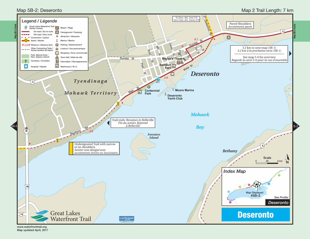
0.7
Paved ShouldersAccotements pavés
Undesignated Trail with narrow or no shoulders.Sentier non désigné avecaccotements étroits ou inexistants.
To Hwy. 401, Exit 570Vers l’Aut. 401, Sortie 570
Trail ends: Resumes in BellevilleFin du sentier. Reprend
à Belleville
3.2 km to next map (5B-1)3.2 km à la prochaine carte (5B-1)
See map 5-6 for overviewRegarde la carte 5-6 pour la vue d'ensemble
Legend / LégendeGreat Lakes Waterfront Trail /Sentier riverain
On-road / Sur la route
Off-road / Hors route
Connection / Liaison
Alerts / Alertes
Distance / Distance (km)
Other Connecting Trails /Autres sentiers de liaison
Park, Natural Area /Parc, Espace naturel
Cemetery / Cimetière
Hospital / Hôpital
Beach / Plage
Campground / Camping
Attraction / Attraction
Marina / Marina
Parking / Stationnement
Lookout / Vue panoramique
Shopping / Zone commerciale
Town Hall / Hôtel de ville
Information / Renseignements
Washrooms / W.-C.
Index Map
See Profile:
Map Displayed #5B–2
1
2
34
5
5B
6
7
Deseronto
Deseronto
5B-3 5-3
www.waterfronttrail.orgMap updated April, 2017
© Lucidmap Inc. 2017
NScale
0 .25 .5 km
Map 2 Trail Length: 7 km Map 5B-2 : Deseronto

Map
5B-
3 Ca
rte
Map
5B-
3 Ca
rte
BellevilleAirport Tyendinaga
(Mohawk)Airport
CP
CN
Big Bay
Cole Point
Smiths
Cr.
Long
Rea
ch
HungryBay
Blessin
gton
Sucker
Creek
B A Y O F Q U I N T E
Marysville
SalmonIsland
Big Island
HuffsIsland
Trident Point
NativeRenaissance II
Northport
BethesdaRoblin
Mills
MountCarmel
Solmesville
Cole Wharf
Huff Wharf
Greenpoint
Watercombe
Gospo
PointAnne
Blessington
Melrose
LonsdaleStation
Marysville
Milltown
Shannonville
Tyendinaga
Massassauga PointConservation Area
Christ Church(1843)
Exit 570
Exit 566
Exit 556
ShannonvilleSpeedway
Undesignated Trail. Busy roadwith narrow or no shouldersSentier non désigné. Route achalandéeavec accotements étroits ou inexistants
Railway crossingPassage à niveau!
Tyendinaga Mohawk Territory
Eggleton
Rd.
Atkin R
d.
Elm
wood D
r.
Airport Pkwy.
Mitchell R
d. N
.
Mitchell R
d. S.
Casey
Rd.
Blessin
gton Rd.
Bethany
Rd.
Brennan Rd.
Harmony R
d.
Craig R
d.
Milltow
n Rd.
Melrose Rd.
Wym
an Rd.
Callaghan Rd.
Hinchey Rd.
Tucker
Rd.
Waddingham
Rd.
Marysville R
d.
Mow
bray Rd.
Lower Slash Rd.
Bayshore
Rd
Old Hwy. 2 Point A
nne Rd.
McFarlane R
d.
Weese R
d.
Read R
d.
Manley Dr.
Kennelly
Rd.
Plum
b
Rd.
Murphy
Rd.
Shelley
Rd.
Upper Slash Rd.
Lazier Rd.
Rd.
Sand
y Cov
e Dr.Rd
.
Sunrise Dr.
Norton Rd.
Rd.
Allison
Rd.
N
orth
Big
Islan
d
Rd.
Caughey R
d. B
igIsland
Rd.
Sprague Rd.
Water Rd.
Rd.
Bethesda Rd.
Fish
Lake
Robinson Rd.
acH
ill's
Rd.
Sherman's
Point Rd.
Hic
kory
La.
Northport
Rd.
Foster Rd.
Bridge
on's Sideroad
Deseronto R
d.
Rd.
Melrose Rd.
Airport Rd
Norw
ay’s Side R
d
Ridge
R
d
Beach Rd
401
401
21
15
5
9
15
49
35
10
1
2
10
Hay
NativeRenaissance II
Chrishrist CChChurch(1843)
Bayshore
Rd
2
See Deseronto Map (5B-2)
Deseronto
Green Point
La.
T y e n d i n a g aB e l l e v i l l e
Kim
merly
Rd.
MountPleasant
Legend / Légende
2.0
Great Lakes Waterfront Trail /Sentier riverain
On-road / Sur la route
Off-road / Hors route
Connection / Liaison
Alerts / Alertes
Distance / Distance (km)
Other Connecting Trails /Autres sentiers de liaison
Park, Natural Area /Parc, Espace naturel
Cemetery / Cimetière
$
P
?Hospital / Hôpital
Beach / Plage
Campground / Camping
Attraction / Attraction
Marina / Marina
Parking / Stationnement
Lookout / Vue panoramique
Shopping / Zone commerciale
Town Hall / Hôtel de ville
Information / Renseignements
Washrooms / W.-C.
Index Map
See Profile:Map Displayed
#5B–3
1
2
34
5
5B
6
7
Tyendinaga / Shannonville
Tyendinaga
5B-4 5B-2
www.waterfronttrail.orgMap updated April, 2017
Scale0 1 2 km
N
© Lucidmap Inc. 2017
Map 3 Trail Length: 30.8 km Map 5B-3 : Tyendinaga

Map
5B-
4 Ca
rte
Map
5B-
4 Ca
rte
Victoria
Av
Bridge
St
E
Herchim
er Av
Palm
er Rd
Bridge St W
College S
t W
Bridge S
t E
Victoria
Av
Moi
ra
St
E
Station
S
t
Dundas St E
Sid
ney St
Dundas St E
Bay B
ridg
e Rd
Moira St W
Front St
Colem
an St
North Front S
t
Pinnacle S
t
Statio
n
St
Can
nift
on
Rd
Pkw
y
A
College St
E
Dunda
s
S
t
W
Selena A
v
Harder Dr Dunnett B
lvd
Palm
er Rd
Singleton D
r
Bradgate R
d
Elizabeth C
r
Munro Av
Herchim
er Av
MacD
onald Av
Dufferin A
v
Bleecker A
v
Chatham
St
Burnham
St
S. Foster S
t Keegan P
kwy.
New
berry
St
St. Paul St
S. G
eorge St
George S
tS
. John St
S. C
hurch St
Church S
t
Yeomans S
t
Wellington S
t
Catherine St
Hig
hlan
d A
v
Wilkie S
t
Ap
plew
ood
Dr
MeyersPier
HennesseyPoint
CowIsland
Moi
raR
iver
Belleville
HarbourEastBasin
Belleville
BAY OF
QUINTE
ZwickIsland
2.2
Busy RoadRoute achalandée
Busy RoadRoute achalandée
Sharp Turnvirage serré
1.8 3.0
Trails connect under bridgeLes sentiers se relient sous le pont
Farley Av
Haig R
d
To Rednersville Rd /Prince Edward County
Very soft surfaceSurface très meuble
Low Underpass, Cyclists Dismount
Passage inférieur bas,les cyclistes doivent
descendre
Trail endsResumes inDeseronto, 78 km.Fin de sentier.Reprends enDeseronto, 78 km.
Legend / Légende
2.0
On-road / Sur la route
Off-road / Hors route
Connection / Liaison
Alerts / Alertes
Distance / Distance (km)
Other Connecting Trails /Autres sentiers de liaison
Park, Natural Area /Parc, Espace naturel
Cemetery / Cimetière
Hospital / Hôpital
Beach / Plage
Campground / Camping
Attraction / Attraction
Marina / Marina
Parking / Stationnement
Lookout / Vue panoramique
Shopping / Zone commerciale
Town Hall / Hôtel de ville
Information / Renseignements
Washrooms / W.-C.
Waterfront Trail /Sentier riverain
Index Map
See Profile:
Map Displayed#5B–4
1
2
34
5
5B
6
7
Belleville
Belleville
5B-5 5B-3
www.waterfronttrail.orgMap updated April, 2017
NScale
0 .25 .5 km
© Lucidmap Inc. 2017
Map 4 Trail Length: 6.6 km Map 5B-4 : Belleville

Map
5B-
5 Ca
rte
Map
5B-
5 Ca
rte
QuinteConservation
Area
Orval Berry Museum
Loyalist College
TrentonAirportRCAF Memorial
Museum
BleasdellBoulder
Trenton GreenbeltConservation Area
Glen MillerConservationArea
T
CP
CN
Creek
Moira
anal
SagerConservationArea
SidneyConservation
Area
Lock7
Exit 522
Exit 525
Exit 526
C.F.B.Trenton
Trenton Lock 1
Trent Lock 5
BatawaLock 4
Sydney Lock 2
Frankford Lock 6
Glen Miller Lock 3
Rednersville
Rossmore
FenwoodGardens
Trenton
GlenRoss
Frankford Wallbridge
Foxboro
Chatterton
BellevilleJohnstown
Glen Miller
Corbyville
Cannifton
OakLake
manding
Stockdale
HoneywellCorners
Thrasher'sCorners
Batawa
Bayside
MountZion
SpencersLanding
Exit 544
Exit 543
Exit 538
Busy roadRoute achaladée
Marsh H
Oak Lake Rd.
Airport Rd.
Forsyth Rd
Deer Run Rd.
Gle
n
R
oss
R
d.H
earn
s R
d.Hearns
Rd.
Scotts
Church R
d.
Flyboy
Rd.
Huffman
Rd.
Fish and G
ame Club Rd.
McM
ullen
Rd.
Wallbridge
Mackenzie R
d.
Stickles R
d.
Acm
e
Rd
.
Jeffery Dr.
St. H
ilaires Rd
.
Moira St. W.
Montrose R
d.
Rd.
Harrington Rd.
Whites R
d.
Meyers Creek Rd. Aikens
Johnstown Rd.
Sand
ercock
Rd
.
RC
AF R
d.
Sidney
Rd.
Curtis Rd.
Dixon
Dr.
Moira St. W.
Avonlough R
d.
Bridge St. W.
Mor
ia
St.
E.
Palm
er Rd
.
Wallbridge- Loyalist R
d.
Sidney S
t.
Bellevue Dr.
College St. W.
College St.
E.
Station
St.
Victoria Ave.
Herchim
er Ave.
Dundas St. W.
Dundas St. E.
WilsonR
d.
Farnham D
r.
Forsythe Rd.
Ritz R
d.
Wis
erR
d.
H
Shaw
Rd.
Harmony Rd.
Hom
an Rd.
N. M
ain
St.
Main
St.
M
udca
t
Moran
Rd.
Corrigan
Rd.
w R
d.
ens Rd.
Rd.
Zion R
d.
Flouds Brid
ge Rd.
Thom
pson
Rd.
Maybee
Rd.
Carr
Rd.
Stockdale Rd. McCauley
Broatch R
d.
emen
t
Rd.
Potter
Rd.
Murray St.
Downs Rd.
Telephone
Rd.
Miron Rd.
Helyer R
d.Tate R
d.
Frase
2nd Dughill R
d.
Riv
er Rd.
Dun
das St.
Sto
ckda
le R
d.
Bata Rd.
Flying C
lub
Rd.
Rose R
d. Frankford Rd.
Rd.
Bonisteel
Rd.
Grills
Rd.
Hamilton Rd.
Glen M
iller Rd
.
Platt Rd.
Boa
rdm
anR
d.
Foxboro-Stirling Rd.
Wooler R
d. /
Plum
pton
Rd.
Sunningdale
Dr.
Frankford Rd
.
Vermilyea Rd.
Crow
e
Rd.
Golf
Course
Rd
.
Wannamaker
Rd.
Tank
Farm Rd.
Maitla
nd D
r.
Cloverleaf
Dr.
agers
ors. Rd
.
Pitchers Rd.
Dr.
Wes
tlake
Rd.
Lock
Rd.
Harcourt
Rd.
Mor
Sta
Hannah
Rd.
Russett
Rd
.
Trillium
Rd.
Philburn R
d.
Hunting-
woodD
r.Roblin Rd.
County Rd. 40
Duffe
Bridge St.Sidney S
t.Rd.
Hamilton Rd.
ay Palmer
R
d.
Murray-
Harrington R
d.
Par
ks R
d.
Pulv
Barley
Rd.
Spencer Rd.
Marsh
Rd.
Mass
assauga
Salisb
ury
Rd.
Weatherhead
Rd.
Hennessey
St.
Peat
'sPo
int
Rd.
Hamilton Rd.
Fran
kford-
Stirlin
g R
d.
Old Highway 2
R
33
33
14
62
2
3
B e l l e v i l l eQ u i n t e We s t
BA
Y O F Q U I N T E
Legend / Légende
2.0
On-road / Sur la route
Off-road / Hors route
Connection / Liaison
Alerts / Alertes
Distance / Distance (km)
Other Connecting Trails /Autres sentiers de liaison
Park, Natural Area /Parc, Espace naturel
Cemetery / Cimetière
Hospital / Hôpital
Beach / Plage
Campground / Camping
Attraction / Attraction
Marina / Marina
Parking / Stationnement
Lookout / Vue panoramique
Shopping / Zone commerciale
Town Hall / Hôtel de ville
Information / Renseignements
Washrooms / W.-C.
Waterfront Trail /Sentier riverain
Index Map
See Profile:
Map Displayed#5B–5
1
2
34
5
5B
6
7
Quinte West
Bayside
5B-4
www.waterfronttrail.orgMap updated April, 2017
© Lucidmap Inc. 2017
Map 5 Trail Length: 10 km Map 5B-5 : Bayside
Scale0 1 2 km
N