Coffin Field Saltford, near Bath · 5 Fig. 3 OS Explorer Map, 1:25000. @ Crown-copy2015. Licence...
34
1 Coffin Field Saltford, near Bath Archaeological Field Evaluation and Post-Excavation Assessment May 2019 Author R. Holley Site Code CFS/18
Transcript of Coffin Field Saltford, near Bath · 5 Fig. 3 OS Explorer Map, 1:25000. @ Crown-copy2015. Licence...

1
Coffin Field
Saltford, near Bath
Archaeological Field Evaluation and
Post-Excavation Assessment
May 2019
Author R. Holley
Site Code CFS/18
2
Archaeological Field Evaluation
And
Post-Excavation Assessment
Contents
1 List of Illustrations
2 Summary
3 Acknowledgements
4 Description and Location of the site
5 Geology and Soils
6 Location Map
7 Research Aims and Objectives
8 The Geophysical Survey
9 Conclusion of the Geophysical Survey
10 Excavation Methods and Techniques
11 The Recorded Archaeology from the Trench
12 Finds
13 Small Finds Master Record Sheet
14 Pottery Table
15 Pennant Sandstone Tiles
16 Daub or Burnt Clay
17 Ceramic Building Materials
18 Shaped Stone or Tool Objects
19 Slag or Clinger Iron and Copper Alloy
20 Glass Objects
21 Iron Objects
22 Flint Objects
23 Charcoal and Coal
24 Animal and Bird Bones Report
25 Discussion
26 Bibliography
27 Project Archive
28 Master Context Index and Sheets

3
1. List of Illustrations.
Figure,
Illustrations &
Table Numbers
Description Page Numbers
Fig. 1 Photograph of the volunteers carrying out the
excavation -North- north east facing
Report Front Cover
Fig. 2 General location Map showing the location of Bath
and North East Somerset Unitary Authority
5
Fig. 3 OS Explorer Map, 1:25000. @ Crown-copy2015.
Licence No. 100060399.
6
Fig. 4 “Map data ©2019 Google 6
Fig. 5 Magnetometer Results 9
Fig. 6 Resistance Results 10
Fig. 7 Photograph of the trench after the topsoil had been
removed.
13
Fig. 8 Photograph of the trench showing the subsoil being
excavated.
13
Fig. 9 Photograph of the trench showing the stones being
exposed.
14
Fig. 10 Photograph of the trench showing the stones being
exposed in the northern half.
14
Fig. 11 Photograph of the trench showing the stones being
exposed.
15
Fig. 12 Photograph of the complete trench showing the
exposed stones.
16
Fig. 13 Photograph of the northern side of the trench
showing the exposed stones, East facing.
17
Fig. 14 Photograph of the southern side of the trench
showing the exposed stones, East facing
17
Fig. 15 Photograph of the north west corner of the trench
showing the exposed Pad stone.
18
Fig. 16 Photograph of the north west corner of the trench
showing the exposed Pad stone.
18
Fig. 17 Photograph of the trench being backfilled firstly by
stones
19
Fig. 18 Photograph of immature sheep skeletons buried in a
shallow pit.
24
4
2. Summary
Saltford Environment Group (SEG) have been researching and recording the history of the
village. As part of this research a field to the south of the village has been of particular
archaeological interest. It is known locally as the Coffin Field. In 1948 a Roman stone
coffin complete with a skeleton of a young man was found in the field when the farmer was
removing a tree. A year later some trial trenches had been dug, these unearthed pottery
fragments, coins, nails and utensils together with ‘oyster shells too numerous to record’. In
recent years metal detectorists have discovered Roman coins and brooches in the field as well
as a late Bronze Age axe. Oyster shells, sherds of Roman pottery, glass, iron and copper
alloy slag or waste, ceramic building materials, pieces of pennant sandstone, flints and
tesserae may be spotted when field walking.
In 2018 volunteers from the Bath and Counties Archaeological Society (BACAS) and SEG
carried out an excavation at this site. This report constitutes the findings from the excavation
and post analysis/assessment of the finds recovered. The excavation was carried out between
the 13th
to 15th
August.
3. Acknowledgements
The author would like to thank and is indebted to the landowner Adam Stratton for
allowing access onto his property to carry out this excavation.
The author would also like to thank the following:
- Roger Vaughan for organising the excavation, dealing with equipment requirement
and washing and bagging the many finds.
- Former Bath and North East Somerset Archaeological Officer Richard Sermon for
his advice, encouragement and assistance
- Members of SEG and BACAS for their much appreciated help with this project, they
include Steve Drew, Heather Greenwood, Bob Mordle, Chris Higgs, Wendy Russ, Mike
Headford, John Knapper, Richard Hatton, John Richards, Adrian Betts, Ray Buchanan, Rick
Crowley, Frances Eggbeer, Phil Harding, Mike Headford, Keith Miller and Andrew Stainer.
4. Description and Location of the Site
The field involved in this project lies to the south of Keynsham Manor, Manor Road,
Saltford in the Unitary Authority of Bath and North East Somerset. It is shown as
Field 3137 on the 1965 1:2500 scale Ordnance Survey National Grid series map, and
on older County series maps as Field 794. The field is locally known as the Coffin
Field and is 17.0 acres or 7.24 hectares. The field has mixed hedgerows with small
trees which delineate its boundaries. At the time of the excavation the cereal crop had
been harvested but the land had not been ploughed or harrowed. This field is centred
on ST 67326640 at a height of 70 metres OD.
5
5 Geology and Soils
The underlying geology consists of blue lias formation overlain by a silty sandy clay
with copious number of stones (British Geological Survey South Sheet, 3rd
Edition
1979). The overlaying soils vary in depth which increases significantly further down
the slope, the southern half of the field drains towards the north.
6. Location Maps
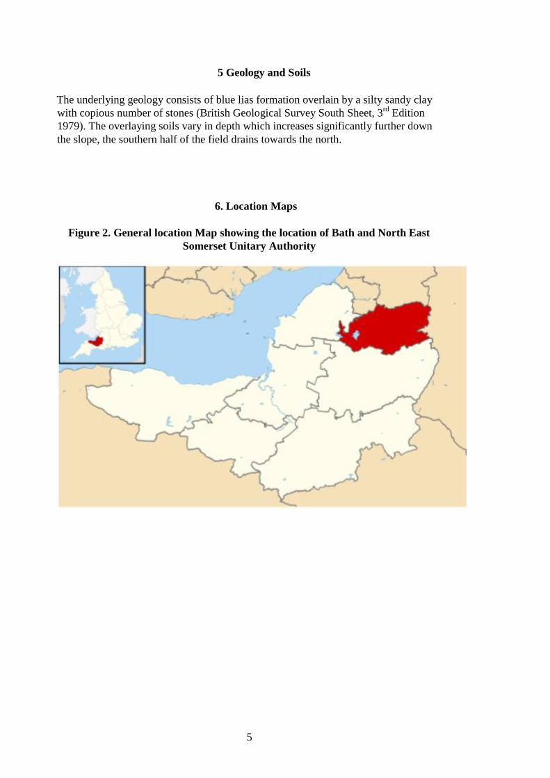
Figure 2. General location Map showing the location of Bath and North East
Somerset Unitary Authority

6
Figure 3. OS Explorer Map, 1:25000. @ Crown copy 2015. Licence No.
100060399. Site is marked by a black star.
Figure 4.“Map data ©2019 Google”. Site marked by a black star

7
7. Research Aims and Objectives
The Project Design was to locate any archaeological structure or remains:
To determine the extent, condition, nature, character, quality and date of any
archaeological remains present. To establish the Eco factual and environmental
potential of archaeological deposits and features, as well as establishing a
stratigraphic sequence.
To obtain a coherent plan of the site in terms of complete structures, particularly
buildings and to attempt a reconstruction of the history and use of the site.
To recover a well dated stratigraphic sequence and recover coherent artefacts, and
environmental samples to assist in defining the character and to the dating of activity
on the site.
To address relevant research issues relating to the site, and to place them into context
locally and nationally, to make available and to publish the result of the
investigations.
8. The Geophysical Survey
A geophysical survey of the field, led by John Oswin, was carried out jointly by
BACAS and SEG, in 2015 and 2016
The first phase of the survey in 2015, which covered roughly half of the field,
indicated the possible presence of prehistoric round houses in the northern portion of
the field; and signs of what may be a Roman structure on the higher ground in the
southern part of the field, near to where the Roman coffin was discovered in 1948.
There would also appear to be a smaller structure in the northwest corner of the field.
In the eastern part of the field, the magnetometry identified a feature which may
possibly be a washing pool.
The second phase of the survey in 2016 completed the geophysics and focussed
mainly on the southern half of the field. The results suggested that there was a large
structure, probably of Roman origin in this area. It would appear to be encompassed
within a pair of parallel ditches extending westwards.
Twin-prod resistance Geoscan RM15 and TR/CIA meters also a magnetometer
Bartington 601-2 twin fluxgate gradiometer was utilized to obtain these results, see
results figures 5 & 6.

8
9. Conclusion of the Geophysical Survey
Early indications from these geophysical anomalies perhaps suggest occupation of the
site for a considerable length of time. In the north and west areas of the field several
features can be made out through the plough lines. These round features might
represent prehistoric round houses. In the far southern area of the field is an area very
disturbed, which appears to contain rectangular shapes. This could be a major
structure probably of Roman date, it is curious that it lies across the contours rather
than along the slope.
Immediately to the west, this structure is encompassed by a pair of lines, probably
ditches, heading west. Field boundaries appear to have been aligned on them, but they
could well be older and likely of Roman origin.
This conclusion was extracted from the BACAS reports (see Oswin, J. and Vaughan,
R. 2016 and 2017).

9
Figure 5. Magnetometer Results

10
Figure 6. Resistance Results
11
10. Excavation Methods and Techniques
To achieve the research aims it was decided to lay out a single trench across the area
where the geophysics survey suggested ditches and other features might be located.
This trench was excavated by hand and was dug down to the uppermost surviving
levels of archaeological significance, or until natural deposits were reached.
All discrete features were excavated to a degree enough to establish the extent,
character and where possible to date the feature.
An appropriately qualified archaeologist monitored all intrusive groundworks.
A unique site code (CFS/18) was agreed prior to the commencement of the
excavation.
All features and deposits were recorded using BACAS pro forma recording systems,
with all features and deposits being assigned a unique number.
All archaeological features and deposits were planned at a scale of 1:20 with sections
drawn at 1:10. The Ordnance Datum (OD) height of all principal features and levels
was calculated, and all plans and sections were annotated with OD heights.
A full photographic record of the investigations and individual features was
maintained throughout the excavations using a digital camera.
Finds were treated in accordance with the principles and practices set out by the
Institute of Field Archaeologists’ Standards and Guidance for Archaeological
Excavation (revised 2001).
At the completion of the work, the trench was reinstated using the excavated
materials.
.

12
11. The Recorded Archaeology from the Trench
The trench was positioned at NGR ST67306645 at approximate height of 78m AOD.
and orientated in a north south direction. It measured 5.5 metres in length and 2.5
metre in width and varied in depth from 0.45m at the northern end to 0.72 at the
southern end; this greater depth is likely to be derived from hill-wash and represents a
colluvial action
After the removal of stubble from the summer crop, the topsoil was revealed (011),
which was a firm dark brown silty clay, containing pieces of white lias and other
stones, which amounted to about 10% of the overburden and varied in depth between
15 to 20cm in-depth.
Directly under the topsoil, the subsoil (012) consisted of friable yellowish-brown silty
clay with numerous fragments of white lias stone about 20% and averaged 0.075 cm
deep.
The trench was divided in half on an east-west axis and allocated separate numbers for
fills and cuts. [13] was the cut for the northern half and its fill (014) consisted of a
firm light fawn to brown layer of small to medium sized white lias stones, on average
0.15cm in-depth which appeared to have been levelled to form a surface. In between
these stones were occasional areas of greyish brown clay. The southern half cut [015]
and the fill (016) had a similar fill as (014) but the depth average was 0.18cm. This
stone layer might represent a layered floor inside an unknown workshop or farm
structure, but it might represent an external yard surface, as it was noted that this area
had occasional small shallow pits dug into the surface where immature bones of sheep
were deposited (see Figure 18).
Context [17] was a laid white lias stone pad in the north east corner of the trench and
measured 32cm in length x 30cm wide and 10cm in-depth. What this stone
represents is currently unclear, it might be a stone pad onto which a large wooden post
would have stood, perhaps to support a roof. It does appear to have been deliberately
laid as a level area of clay was discovered under this stone.
After all the contexts (11), (12), (14) and (16) were removed the natural underlying
white lias bedrock (18) was found. It was not excavated.

13
Figure 7. Photograph of the trench after the topsoil had been removed.
Figure 8. Photograph of the trench showing the subsoil being excavated.
14
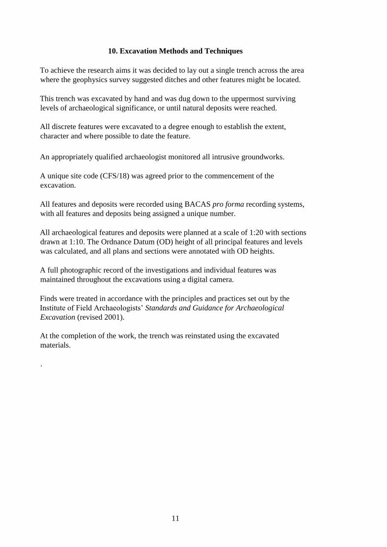
Figure 9. Photograph of the trench showing the stones being exposed.
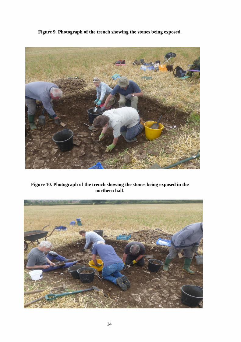
Figure 10. Photograph of the trench showing the stones being exposed in the
northern half.

15
Figure 11. Photograph of the trench showing the stones being exposed.

16
Figure 12. Photograph of the complete trench showing the exposed stones

17
Figure 13. Photograph of the northern side of the trench showing the exposed
stones, East facing.
Figure 14. Photograph of the southern side of the trench showing the exposed
stones, East facing.

18
Figure 15. Photograph of the north west corner of the trench showing the
exposed Pad stone.
Figure 16. Photograph of the north west corner of the trench showing the
exposed Pad stone.
19
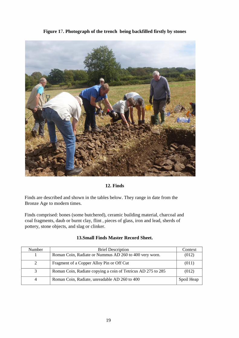
Figure 17. Photograph of the trench being backfilled firstly by stones
12. Finds
Finds are described and shown in the tables below. They range in date from the
Bronze Age to modern times.
Finds comprised: bones (some butchered), ceramic building material, charcoal and
coal fragments, daub or burnt clay, flint , pieces of glass, iron and lead, sherds of
pottery, stone objects, and slag or clinker.
13.Small Finds Master Record Sheet.
Number Brief Description Context 1 Roman Coin, Radiate or Nummus AD 260 to 400 very worn. (012)
2 Fragment of a Copper Alloy Pin or Off Cut (011)
3 Roman Coin, Radiate copying a coin of Tetricus AD 275 to 285 (012)
4 Roman Coin, Radiate, unreadable AD 260 to 400 Spoil Heap

20
14. Pottery Table
Chronological breakdown of pottery assemblage (number / weight in gm and Kg.)
Surface Context (11) Context (12) Context (14) Context (16) Context (18)
Fabric Count Weight Count Weight Count Weight Count Weight Count Weight Count
Bronze Age Pottery 1 8 N/A
Iron Age Pottery 6 76 N/A
Roman Samain Ware 5 7 4 26 1 4 N/A
Roman Black Burnished Ware 2 10 5 18 12 102 20 152 30 237 N/A
Roman Black Ware 46 238 N/A
Roman Grey Ware 1 10 5 49 24 159 15 144 11 64 N/A
Roman Coloured Coated Ware 7 38 4 30 N/A
Roman New Forest Pottery 2 5 N/A
Roman Fine Ware 16 143 14 79 N/A
Roman Locally Produded Wares 2 10 41 206 32 173 2 23 N/A
Roman Savernake Ware 1 21 1 14 N/A
Roman Severn Valley Type Wares 2 12 9 47 67 358 12 49 7 34 N/A
Roman Oxford Ware 3 15 4 64 N/A
Medieval Wares Green Glazed 1 29 N/A
Post Medieval Ware Brown Glazed 1 48 N/A
Post Medieval Ware Blue/White 1 6 N/A
5 32 24 207 223 1271 113 822 52 376
An assemblage of some 417 sherds of pottery which weighed 2.708Kg was recovered
from the trench and the surface area surrounding the trench. Of the 417 sherds of
pottery recovered 0.24% was Bronze Age, 1.44% Iron Age, 97.6% Romano-British,
0.24% Medieval and 0.48% Post Medieval.
The pottery assemblage includes diagnostic sherds from the middle to late Bronze
through to the post medieval period.
The system used to classify the sherds was based on identifying known wares first;
the material was then looked at in terms of its date, origin and any evidence of
function, a reference collection was also employed to assist in this process. The
assemblage was quantified by weight and shard count and individual sherds were
checked using a hand lens (X10) to identify the principal fabric types; the results are
shown in the Pottery Table 14.
Almost all the pottery was derived from stratified contexts. The pottery provides the
primary dating evidence for the site. Most of this assemblage is in good condition but
the Medieval and Post Medieval sherds were probably residual to the site.
The pottery collection suggests that the material recovered is primary domestic in origin and
possibly comes from a settlement on or in the near vicinity to the site.
This assemblage of pottery contains important information about the types of pottery
to be found in this area and will contribute to the understanding of land usage in and
around the Coffin Field area of Saltford.

21
15. Pennant Sandstone Tiles
Surface C (11) C (12) C (14) C (16)
Fabric Count Weight Count Weight Count Weight Count Weight Count Weight
Pennant Sandstone
Tiles 1 246 5 98 12 1373 5 237 5 125
28 fragments of Pennant Sandstone roof tiles weighing 2.079Kg were recovered from the site
suggesting a building in the near vicinity was roofed using this material.
16. Daub or Burnt Clay
Surface C (11) C (12) C (14) C (16)
Fabric Count Weight Count Weight Count Weight Count Weight Count Weight
Daub or Burnt
Clay 4 31 6 28 17 165
27 pieces of daub or fired clay were recovered from the trench. Wattle/twig/stick impressions
were found on some of the daub or fired clay, and this may represent structural material from
a building with walls made of this material or the remains of an oven.
17 Ceramic Building Materials
Surface C (11) C (12) C (14) C (16)
Fabric Count Weight Count Weight Count Weight Count Weight Count Weight
Ceramic Building
Materials 1 63 2 23
16 112
There were 19 fragmentsof Romano-British Ceramic Building Materials found in and around
the excavated trench, which weighed 198gm. These items came predominately from tegulae,
ridge or imbrex tiles.
18. Shaped Stones or Tool Objects
Surface C (11) C (12) C (14) C (16)
Fabric Count Weight Count Weight Count Weight Count Weight Count Weight
Shaped Stones or
Tools Objects 1 138 2 158
White Lias
Tesserae 1 138
3 Shaped stones or tool objects were recovered perhaps used to polish or smooth items such
as leather. Also found was 1 solitary white lias tesserae.
19. Slag or Clinger, Iron and Copper Alloy
Surface C (11) C (12) C (14) C (16)
Fabric Count Weight Count Weight Count Weight Count Weight Count Weight
Copper and Iron
Residue 3 101 5 77 4 76 2 63

22
20. Glass Objects
Surface C (11) C (12) C (14) C (16)
Fabric Count Weight Count Weight Count Weight Count Weight Count Weight
Romano-British
Window Glass 1 2
Romano-British
Vessel Glass 1 2
Post Medieval
Window Glass 1 3
Post Medieval
Vessel Glass 2 38 1 2
2 Shards of Romano-British window and vessel glass were recorded. Also recovered were 4
shards of Post Medieval window and vessel glass.
21. Iron Objects
Surface C (11) C (12) C (14) C (16)
Fabric Count Weight Count Weight Count Weight Count Weight Count Weight
Iron Hobnails 1 1 1 1 51 79 41 77 1 1
Iron Nails 2 14 6 24 28 281 3 18
Iron Small Bar 1 21 2 98
Iron Boot or
Horse Shoe,
Fragments 2 32
Iron Small Pieces
of Sheeting 4 10
Unidentifiable
Objects 4 91
Cleat or Hasp 1 56
148 Iron objects were recovered weighing 804gm, these items range from the Romano-
British through to the modern period.
22. Flint Objects
Surface C (11) C (12) C (14) C (16)
Fabric Count Weight Count Weight Count Weight Count Weight Count Weight
Flint Objects 1 7 1 6 3 53 2 75 2 14
9 pieces of flint were discovered, none showed any signs of have been struck or worked for
tools. A small number of this collection show various degrees of thermal damage by fire.
The recovery of this burnt flint is of interest, but not datable.
23. Charcoal and Coal
Surface C (11) C (12) C (14) C (16)
Fabric Count Weight Count Weight Count Weight Count Weight Count Weight
Charcoal and Coal 1 1 25 14 9 7 4 3
23
39 pieces of coal and charcoal were recovered of which 21 wood charcoal fragments were
noted. Most of the charcoal was poorly preserved, but species identified included hazel
(Corylus avellana), alder (Alnus)and possibly birch (Betula).
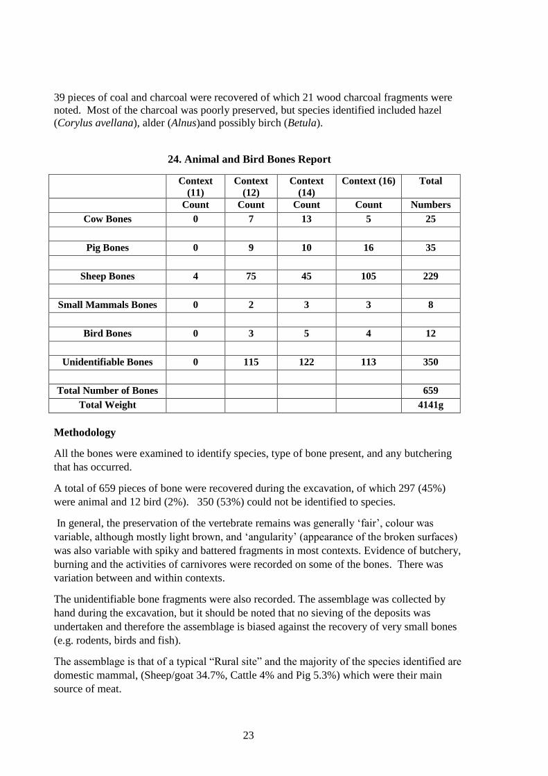
24. Animal and Bird Bones Report
C
(11) C (12)
C
(14) C (16)
Context
(11)
Context
(12)
Context
(14)
Context (16) Total
Count Count Count Count Numbers
Cow Bones 0 7 13 5 25
Pig Bones 0 9 10 16 35
Sheep Bones 4 75 45 105 229
Small Mammals Bones 0 2 3 3 8
Bird Bones 0 3 5 4 12
Unidentifiable Bones 0 115 122 113 350
Total Number of Bones 659
Total Weight 4141g
Methodology
All the bones were examined to identify species, type of bone present, and any butchering
that has occurred.
A total of 659 pieces of bone were recovered during the excavation, of which 297 (45%)
were animal and 12 bird (2%). 350 (53%) could not be identified to species.
In general, the preservation of the vertebrate remains was generally ‘fair’, colour was
variable, although mostly light brown, and ‘angularity’ (appearance of the broken surfaces)
was also variable with spiky and battered fragments in most contexts. Evidence of butchery,
burning and the activities of carnivores were recorded on some of the bones. There was
variation between and within contexts.
The unidentifiable bone fragments were also recorded. The assemblage was collected by
hand during the excavation, but it should be noted that no sieving of the deposits was
undertaken and therefore the assemblage is biased against the recovery of very small bones
(e.g. rodents, birds and fish).
The assemblage is that of a typical “Rural site” and the majority of the species identified are
domestic mammal, (Sheep/goat 34.7%, Cattle 4% and Pig 5.3%) which were their main
source of meat.

24
Figure18. Photograph of immature sheep skeletons buried in a shallow pit.
25. Discussion
The focus of the 2015/2016 geophysical survey and the 2018 excavations was to
locate any archaeological structure or remains in the Coffin Field at Saltford.
A specific area of the field was targeted for the excavation as the geophysical survey
suggested that there might be a Romano-British structures in that location.
Unfortunately, where we positioned the trench over the most interesting features in
the field, we failed to find any type or form of structure. This is a difficult site to
interpret, there is a real possibility that we positioned our trench in the wrong area of
the field or perhaps the geophysical survey showed the natural underlying geology
and there were no archaeological remains to be found.
Numerous artefacts of varying types mostly from the Romano-British period were
recovered also ceramic building material and Pennant sandstone tiles, but no evidence
of a building was seen. The recovered finds do suggest there is a structure probably a
working farm with workshops, yards etc. in the very near vicinity to the position of
the 2018 excavated trench.

25
If a further excavation is planned, a new small geophysical survey should be
undertaken, and the area marked out on the ground showing where a structure might
be found.
26. Bibliography
Oswin, J. and Vaughan, R. 2016, Geophysics at Saltford , 2015
Oswin, J. and Vaughan, R. 2017, Geophysics at Saltford, Phase 2 2016
27. Project Archive
The full archive including documentary and physical evidence will be deposited with
SEG who it is understood may wish to display some of the finds in the Saltford
Heritage Centre. A copy of this evaluation report is being given to the landowner,
Adam Stratton, to BACAS, and to the South West Heritage Trust to enter onto the
Historic Environment Record (HER).
Site Name:
Coffin Field. Saltford
Site Code
CFS/18
Trench
Number
Context
Number
Context Type and Brief Description Depth Tools used
1 [010] Cut of Trench 1, 5.5m x 2.5m N/A
1 (011) Topsoil or Overburden 15-20cm Spade and Trowel
1 (012) Subsoil 6-9cm Spade and Trowel
1 [013] Cut of Stone Feature, Northern half of
Trench
N/A
1 (014) Stone fill of [013] 12-19cm Spade and Trowel
1 [015] Cut of Stone Feature, Southern half of
Trench
N/A
1 (016) Stone fill of [015] 12-24cm Spade and Trowel
1 [017] Stone pad in North -East side of Trench N/A
1 (018) Underlying Natural Bedrock Not Fully
Excavated
N/A
28. Master Context Index and Sheets

26
Context sheets [010]
Project Code: Area:
CFS/18 Trench 1
Co-ordinates: E / N
/
Context Type: Context No:
Cut [010]
DEPOSIT 1. Compaction
2. Colour
3. Texture/composition
4. Inclusions
5. Dimensions
6. Contamination
7. Method/level of recovery
8. Weather conditions
CUT 1. Shape in plan Rectangular
2. Orientation North to South
3. Profile []
4. Sides Vertical
5. Base Uneven
6. Dimensions 5.5m x 2.5m
7. Fill numbers 11,12, 14, 16 18
Sketch
plan/section/matrix
Further DESCRIPTIVE data including significant physical relationships:
Contd?
STRATIGRAPHIC MATRIX [010]
INTERPRETATION:
Cut of Trench 1.
Related Contexts:
Plan:
Section/other drawings: Environmental samples:
Digital:
Recorded by and Date:
R.J.Holley 13th August 2018
Excavated contents:
See finds register

27
Context sheet (011)
Project Code: Area:
CFS/18 Trench 1
Co-ordinates: E / N
/
Context Type: Context No:
Deposit (011)
DEPOSIT 1. Compaction Firm
2. Colour Dark Brown
3. Texture/composition Silty Clay
4. Inclusions 10% Stones White Lias
5. Dimensions 5.5m x 2.5m x 15-20cm in depth
6. Contamination High
7. Method/level of recovery Spade and Trowel
8. Weather conditions Warm but overcast
CUT 1. Shape in plan
2. Orientation
3. Profile
4. Sides
5. Base
6. Dimensions
7. Fill numbers
Sketch
plan/section/matrix
Further DESCRIPTIVE data including significant physical relationships:
Contd?
STRATIGRAPHIC MATRIX (011)
INTERPRETATION:
Topsoil or Overburden
Related Contexts:
Plan:
Section/other drawings: Environmental samples:
Digital:
Recorded by and Date:
R.J.Holley 13th
August 2018
Excavated contents:
See finds register

28
Context sheet (012)
Project Code: Area:
CFS/18 Trench 1
Co-ordinates: E / N
/
Context Type: Context No:
Deposit (012)
DEPOSIT 1. Compaction Friable
2. Colour Yellowish Brown
3. Texture/composition Silty Clay
4. Inclusions 20% Stones – White Lias
5. Dimensions 5.5m x 2.5m x 6-9cm in depth
6. Contamination Medium
7. Method/level of recovery Spade and Trowel
8. Weather conditions Warm
CUT 1. Shape in plan
2. Orientation
3. Profile
4. Sides
5. Base
6. Dimensions
7. Fill numbers
Sketch
plan/section/matrix
Further DESCRIPTIVE data including significant physical relationships:
Contd?
(011)
STRATIGRAPHIC MATRIX (012)
INTERPRETATION:
Subsoil
Related Contexts:
Plan:
Section/other drawings: Environmental samples:
Colour print:
Colour slide: Black & White print: Digital:
Yes
Recorded by and Date:
R.J.Holley 13th
August 2018
Excavated contents:
See finds register

29
Context sheet [013]
Project Code: Area:
CFS/18 Trench 1
Co-ordinates: E / N
/
Context Type: Context No:
Cut [013]
DEPOSIT 1. Compaction
2. Colour
3. Texture/composition
4. Inclusions
5. Dimensions
6. Contamination
7. Method/level of recovery
8. Weather conditions
CUT 1. Shape in plan Half of the Trench
2. Orientation North to South
3. Profile []
4. Sides Vertical
5. Base Uneven
6. Dimensions 2.25m x 1.25m
7. Fill numbers 14
Sketch
plan/section/matrix
Further DESCRIPTIVE data including significant physical relationships:
Contd?
STRATIGRAPHIC MATRIX [013]
INTERPRETATION:
Cut of Stones Laid feature, Northern Half of Trench only.
Related Contexts:
Plan: 1
Section/other drawings: 1 Environmental samples:
Digital:
Recorded by and Date:
R.J.Holley 13th August 2018
Excavated contents:

30
Context sheet (014)
Project Code: Area:
CFS/18 Trench 1
Co-ordinates: E / N
/
Context Type: Context No:
Deposit (014)
DEPOSIT 1. Compaction Firm
2. Colour Light Fawn/Brown
3. Texture/composition Lias Stones
4. Inclusions Occasional areas of Clay between the Stones
5. Dimensions 2.25m x 1.25m x 12-19cm in depth
6. Contamination Low
7. Method/level of recovery Spade and Trowel
8. Weather conditions Warm but overcast
CUT 1. Shape in plan
2. Orientation
3. Profile
4. Sides
5. Base
6. Dimensions
7. Fill numbers
Sketch
plan/section/matrix
Further DESCRIPTIVE data including significant physical relationships:
Contd?
[013]
STRATIGRAPHIC MATRIX (014)
INTERPRETATION:
Fill of Stones Laid feature, Northern Half of Trench only.
Related Contexts:
Plan:
Section/other drawings: Environmental samples:
Digital:
Recorded by and Date:
R.J.Holley 13th
August 2018
Excavated contents:
See finds register

31
Context sheet [015]
Project Code: Area:
CFS/18 Trench 1
Co-ordinates: E / N
/
Context Type: Context No:
Cut [015]
DEPOSIT 1. Compaction
2. Colour
3. Texture/composition
4. Inclusions
5. Dimensions
6. Contamination
7. Method/level of recovery
8. Weather conditions
CUT 1. Shape in plan Half of the Trench
2. Orientation North to South
3. Profile []
4. Sides Vertical
5. Base Uneven
6. Dimensions 3.25m x 1.25m
7. Fill numbers 16
Sketch
plan/section/matrix
Further DESCRIPTIVE data including significant physical relationships:
Contd?
STRATIGRAPHIC MATRIX [015]
INTERPRETATION:
Cut of Stones Laid feature, Southern Half of Trench only.
Related Contexts:
Plan:
Section/other drawings: Environmental samples:
Digital:
Recorded by and Date:
R.J.Holley 13th August 2018
Excavated contents:

32
Context sheet (016)
Project Code: Area:
CFS/18 Trench 1
Co-ordinates: E / N
/
Context Type: Context No:
Deposit (016)
DEPOSIT 1. Compaction Firm
2. Colour Light Fawn/Brown
3. Texture/composition Lias Stones
4. Inclusions Occasional areas of Clay between the Stones
5. Dimensions 3.25m x 1.25m x 12-24cm in depth
6. Contamination Low
7. Method/level of recovery Spade and Trowel
8. Weather conditions Warm but overcast
CUT 1. Shape in plan
2. Orientation
3. Profile
4. Sides
5. Base
6. Dimensions
7. Fill numbers
Sketch
plan/section/matrix
Further DESCRIPTIVE data including significant physical relationships:
Contd?
[015]
STRATIGRAPHIC MATRIX (016)
INTERPRETATION:
Fill of Stones Laid feature, Southern Half of Trench only.
Related Contexts:
Plan:
Section/other drawings: Environmental samples:
Digital:
Recorded by and Date:
R.J.Holley 13th
August 2018
Excavated contents:
See finds register

33
Context sheet [017]
Project Code: Area:
CFS/18 Trench 1
Co-ordinates: E / N
/
Context Type: Context No:
Cut [017]
DEPOSIT 1. Compaction
2. Colour
3. Texture/composition
4. Inclusions
5. Dimensions
6. Contamination
7. Method/level of recovery
8. Weather conditions
CUT 1. Shape in plan Uneven Square
2. Orientation West to East
3. Profile
4. Sides Uneven
5. Base Uneven
6. Dimensions 30cm wide x 32cm long x 10cm deep
7. Fill numbers N/A
Sketch
plan/section/matrix
Further DESCRIPTIVE data including significant physical relationships:
Contd?
STRATIGRAPHIC MATRIX [017]
INTERPRETATION:
Stone Laid pad in the North-East end of Trench, White Lias.
Related Contexts:
Plan:
Section/other drawings: Environmental samples:
Digital:
Recorded by and Date:
R.J.Holley 13th August 2018
Excavated contents:

34
Context sheet (018)
Project Code: Area:
CFS/18 Trench 1
Co-ordinates: E / N
/
Context Type: Context No:
Deposit (018)
DEPOSIT 1. Compaction Firm
2. Colour Light Fawn
3. Texture/composition Lias Stones
4. Inclusions Occasional areas of Clay
5. Dimensions 5.5m x 2.5m
6. Contamination Low
7. Method/level of recovery Not excavated as natural underlying bedrock.
8. Weather conditions Warm but overcast
CUT 1. Shape in plan
2. Orientation
3. Profile
4. Sides
5. Base
6. Dimensions
7. Fill numbers
Sketch
plan/section/matrix
Further DESCRIPTIVE data including significant physical relationships:
Contd?
(011) (012) (014) (016)
STRATIGRAPHIC MATRIX (018)
INTERPRETATION:
Underlying Natural White Lias Bedrock.
Related Contexts:
Plan:
Section/other drawings: Environmental samples:
Digital:
Recorded by and Date:
R.J.Holley 13th
August 2018
Excavated contents:
None