COASTAL ZONE MANAGEMENT PLAN FOR THE TOWN BEACH COASTLINE EMERGENCY MANAGEMENT PLAN ·...
14
COASTAL ZONE MANAGEMENT PLAN FOR THE TOWN BEACH COASTLINE EMERGENCY MANAGEMENT PLAN PREPARED BY: COUNCIL’S NATURAL RESOURCES SECTION AND TECHNICAL SERVICES SECTION December 2006
Transcript of COASTAL ZONE MANAGEMENT PLAN FOR THE TOWN BEACH COASTLINE EMERGENCY MANAGEMENT PLAN ·...
COASTAL ZONE MANAGEMENT PLAN
FOR THE
TOWN BEACH COASTLINE
EMERGENCY MANAGEMENT PLAN
PREPARED BY: COUNCIL’S NATURAL RESOURCES SECTION AND
TECHNICAL SERVICES SECTION
December 2006
COASTAL ZONE MANAGEMENT PLAN FOR THE TOWN BEACH COASTLINE EMERGENCY MANAGEMENT PLAN
Page 2 of 14
TABLE OF CONTENTS
PART 1 - INTRODUCTION ............................................................................................... 3
1 PURPOSE ................................................................................................................... 3
2 AUTHORITY ............................................................................................................... 3
3 AREA COVERED BY THE PLAN ............................................................................... 3
4 SPECIFIC RISK AREAS ............................................................................................. 4
5 RESPONSIBILITIES ................................................................................................... 6
6 REVIEW OF THE PLAN ............................................................................................. 7
PART 2 – PREPAREDNESS ............................................................................................ 8
7 ACTIVATION .............................................................................................................. 8
8 WARNINGS ................................................................................................................ 8
PART 3 – RESPONSE .................................................................................................... 10
9 CONTROL ................................................................................................................ 10
10 OPERATIONS CENTRES ..................................................................................... 10
11 INFORMATION ..................................................................................................... 10
12 ROAD CONTROL ................................................................................................. 10
13 COASTAL RESCUES ........................................................................................... 10
14 EVACUATIONS ..................................................................................................... 11
PART 4 – RECOVERY ................................................................................................... 12
15 ALL CLEAR .......................................................................................................... 12
16 DEBRIEF ............................................................................................................... 12
Attachment 1 – Coastal Hazard Risk and Foundation Zones ..................................... 13
Attachment 2 – Wave Runup Limits ............................................................................. 14
COASTAL ZONE MANAGEMENT PLAN FOR THE TOWN BEACH COASTLINE EMERGENCY MANAGEMENT PLAN
Page 3 of 14
PART 1 - INTRODUCTION
1 PURPOSE
1.1 This plan covers preparedness measures, the conduct of response,
operations and the coordination of immediate recovery measures to address coastline hazards affecting Town Beach, Port Macquarie.
1.2 The plan addresses the immediate hazard threat posed by beach erosion
and storm surge events within the Town Beach area, Port Macquarie and caters for both Port Macquarie-Hastings Council’s control of operations and, where appropriate, the handover of control in part or all to the SES Local Controller.
2 AUTHORITY
2.1 This Emergency Management Plan (EMP) forms part of the Town Beach
Management Plan (2006).
2.2 The Town Beach Management Plan (2006) and this EMP have been prepared in accordance with the procedure espoused in the NSW Government’s Coastline Management Manual (1990) and to accord with the requirements of Part 4A Coastal Protection Act 1979.
2.3 The EMP has been prepared in consultation with and endorsed by the Port
Macquarie-Hastings Local Emergency Management Committee 2.4 The Town Beach Management Plan (incorporating this EMP) was approved
on (**insert date**) by the Minister for Natural Resources in accordance with Section 55G Coastal Protection Act 1979 and gazetted by Port Macquarie Hastings Council on (***insert date***).
3 AREA COVERED BY THE PLAN
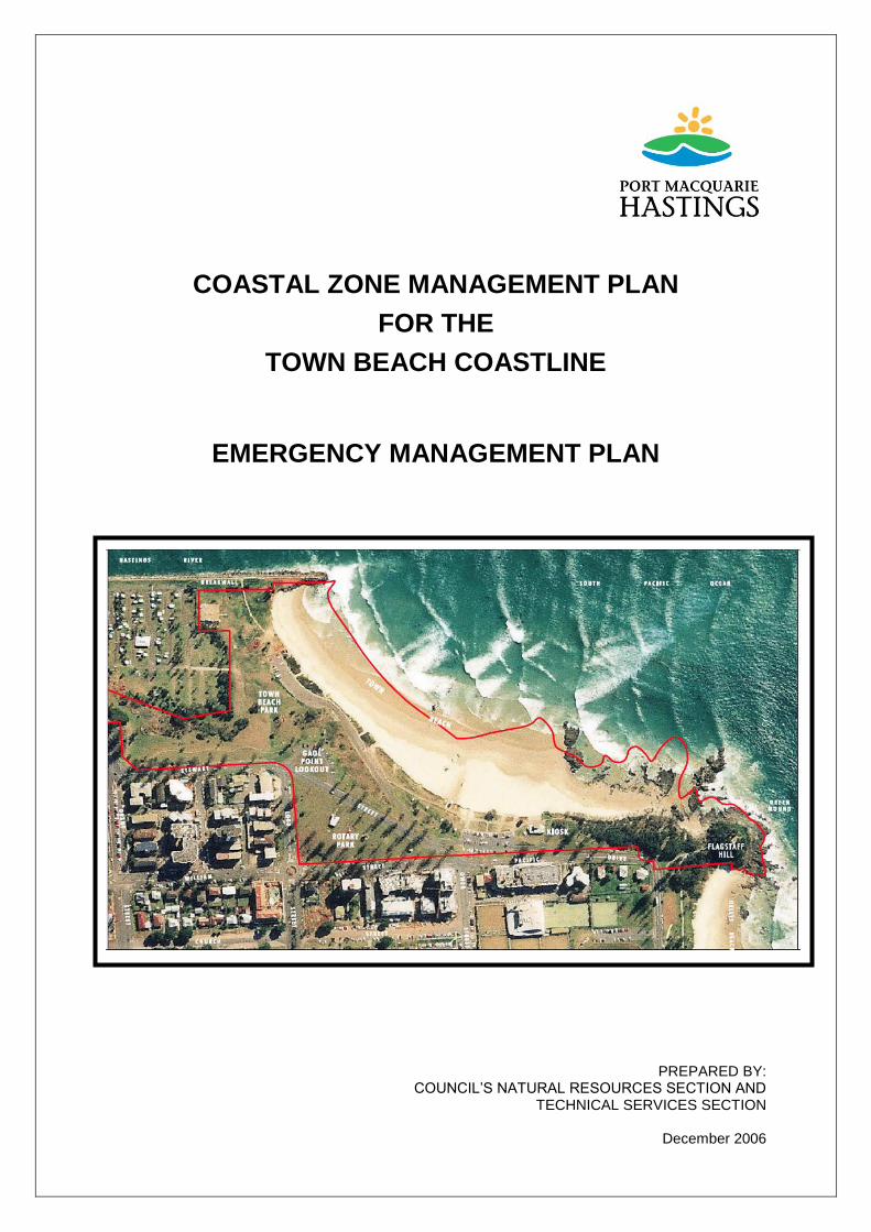
3.1 The area covered by the plan is the Town Beach precinct in Port Macquarie,
which includes the carpark, access roads and open space areas that are included from the southern breakwall in the north, the Sundowner Caravan Park to the west, Stewart Street/ Pacific Drive to the south and Flagstaff Hill in the east. The spatial extent of the study area is illustrated in Figure 1.

COASTAL ZONE MANAGEMENT PLAN FOR THE TOWN BEACH COASTLINE EMERGENCY MANAGEMENT PLAN
Page 4 of 14
Figure 1
4 SPECIFIC RISK AREAS
The Town Beach Coastline Hazard Definition Study (SMEC 2005), which forms part of the Town Beach Management Plan (2006) has defined immediate and short term beach erosion hazard zones as well as the potential for longer term recession of the shoreline. It has also defined areas that may be subject to wave overtopping and inundation during a 1 in 100 year Average Recurrence Interval (ARI) storm event. The following areas have been determined by SMEC (2005) to be at immediate threat during a beach erosion and/or wave overtopping event requiring the recommended emergency management response:
4.1 Proposed new Sea Rescue/Beach patrol facility - Part of the proposed location for the new Sea Rescue/Beach Patrol facilities at the southern end of the beach are indicated within the immediate hazard zone (refer Attachment 1). SMEC (2005) wave runup modeling indicates that the proposed new facilities will be located landward of the 2% Wave Runup Limit but within the maximum predicted Wave Runup Limit (refer Attachment 2). The recommended responses to address these issues include:
evacuation of the facility during major storm events where erosion or wave runup threaten the building;
building foundation system will be designed on piles sufficient to support the building and absorb wave breaking forces when beach sand is removed during an erosion event from around and beneath the structure;
no physical protection works will be undertaken at this site during an emergency; and

COASTAL ZONE MANAGEMENT PLAN FOR THE TOWN BEACH COASTLINE EMERGENCY MANAGEMENT PLAN
Page 5 of 14
follow up inspections will be carried out by Port Macquarie Hastings Council engineering staff to assess damage to building and instigate repairs (as necessary) in a timely manner.
4.2 Northern foreshore reserve area including the Caravan Park (ie north of
Gaol Point) – This area is currently prone to wave overtopping from Average Wave Runup during a 1 in 100 year ARI event. The dune reconstruction works (completed November 2006) will protect this foreshore reserve from wave overtopping for wave runup heights up to a Significant Wave Runup Level, however the dune will still be overtopped during larger wave runup events (see Attachment 2). The recommended responses to address these issues include:
the erection of appropriate signage along the foreshore reserve warning of potential wave overtopping;
evacuation of the public from the northern foreshore reserve area when wave runup levels threaten to overtop the frontal dune system;
closure of the road access and existing car park north of Gaol Point when wave runup levels threaten to overtop the frontal dune;
evacuation of the Caravan Park in the event that wave overtopping threatens the park site during a significant ocean storm even.
all of the above mentioned situations will require onsite monitoring during significant ocean storm events.

COASTAL ZONE MANAGEMENT PLAN FOR THE TOWN BEACH COASTLINE EMERGENCY MANAGEMENT PLAN
Page 6 of 14
5 RESPONSIBILITIES
5.1 The general responsibilities of emergency service organisations and supporting services (functional areas) are detailed in the Port Macquarie-Hastings Local Disaster Plan (DISPLAN). Specific responsibilities for the Town Beach area are detailed in the following sections.
5.2 Port Macquarie-Hastings Council (PMHC) Director Infrastructure Services
(DIS) is responsible for dealing with all coastal hazards at the Town Beach precinct and will:
Monitor coastal storm surges
Monitor coastal hazard response operations
Coordinate support by the SES Local Controller as necessary
Close the beach, kiosk facilities, carpark areas and roads as necessary
Control coastal hazard emergency operations
5.3 PMHC General Works crews will:
Maintain plant and equipment resource necessary to manage and respond to coastal hazards
Deploy manpower and resources for coastal hazard related activities
Close and reopen all carpark, roads and beaches within the area affected by coastal hazards.
5.4 The Hastings SES Local Controller (SES) will:
Monitor the Bureau of Meteorology (BOM) for storm surge warnings
Advise the PMHC DIS of any storm surge warnings
Provide support to the Port Macquarie-Hastings (Council) Local Emergency Management Officer as necessary.
5.5 Assist PMHC DIS during severe storm periods with the management of the
coastal erosion/inundation problem. This may include:
Directing the conduct of monitoring and reconnaissance of those areas known to be at risk of coastal erosion/inundation
Directing the evacuation of persons from property known to be at risk from coastal erosion/inundation.
5.6 NSW Police Service will:
Control and coordinate the evacuation from the area affected by the emergency as necessary.

COASTAL ZONE MANAGEMENT PLAN FOR THE TOWN BEACH COASTLINE EMERGENCY MANAGEMENT PLAN
Page 7 of 14
5.7 NSW Ambulance Service will:
Provide medical treatment as necessary.
5.8 Sundowner Caravan Park owners/operators will:
prepare an evacuation plan for their park to be approved by the Hastings SES Local Controller and PMHC LEMO;
ensure caravan owners/occupiers and visitors are aware of coastal hazards and evacuation procedures;
evacuate the caravan parks as required in accordance with the evacuation plan.
6 REVIEW OF THE PLAN
6.1 The Port Macquarie-Hastings Council will maintain the currency of this plan
by:
ensuring that all participants are aware of their roles and responsibilities;
reviewing the contents of the plan after each coastal hazard operation in conjunction with the SES Local Controller and amending the EMP as necessary to address identified deficiencies etc; and
reviewing the plan at intervals not exceeding five years.

COASTAL ZONE MANAGEMENT PLAN FOR THE TOWN BEACH COASTLINE EMERGENCY MANAGEMENT PLAN
Page 8 of 14
PART 2 – PREPAREDNESS
7 ACTIVATION
7.1 This plan will be activated by the Port Macquarie-Hastings (Council) Local Emergency Management Officer when the following circumstances apply:
On receipt from the Hastings SES Local Controller that the Bureau of Meteorology has issued a Coastal Hazard Warning for Port Macquarie coastal area.
On receipt of advice from any source of a significant storm surge.
7.2 The following persons and organizations will be advised of activation for all levels of coastal hazards.
Hastings Local SES Controller.
NSW Police – Port Macquarie-Hastings Patrol Headquarters.
NSW Ambulance Service (Port Macquarie Stations).
DEMO
8 WARNINGS
8.1 The Bureau of Meteorology will issue Coastal Hazard Warnings to the
Hastings SES Local Controller, or the Oxley SES Division Headquarters. On receipt of Coastal Hazard Warnings, which apply to the Port Macquarie coastal area, the Hastings SES Local Controller will advise the Port Macquarie-Hastings Director of Infrastructure Services (DIS).
8.2 Warning message construction is the responsibility of the DEMO.
8.3 Warning messages are to:
describe the storm event
say what is happening currently
say what is expected to happen and when it will occur
indicate how people should act.
8.4 It should be made clear to the public whether or not the storm prediction is at a peak or if further ocean rises are anticipated.

COASTAL ZONE MANAGEMENT PLAN FOR THE TOWN BEACH COASTLINE EMERGENCY MANAGEMENT PLAN
Page 9 of 14
8.5 Evacuation warning messages will include:
Instructions to evacuate
The location of assembly areas for transport to evacuation centres
The location of evacuation centres for those using private transport
Authorised or recommended evacuation routes
Arrangements for the registration of evacuees
Arrangements for elderly or infirm residents unable to self evacuate
Likely duration of evacuations
What to bring and what not to bring to evacuation centres
What radio stations to listen to for further information
Who to call for further information
8.6 Warnings will be issued using the following methods:
Radio
Television
Public address systems from Police and other emergency service vehicles
Sirens mounted on emergency service vehicles

COASTAL ZONE MANAGEMENT PLAN FOR THE TOWN BEACH COASTLINE EMERGENCY MANAGEMENT PLAN
Page 10 of 14
PART 3 – RESPONSE
9 CONTROL
All coastal hazard operations within the Town Beach area will be controlled by the SES Local Controller.
10 OPERATIONS CENTRES
The Port Macquarie-Hastings Council office is located at the corner of Lord and Burrawan Street, Port Macquarie. The Port Macquarie SES office is located at 73-85 Gordon Street, Port Macquarie.
11 INFORMATION
The Port Macquarie-Hastings Council will provide local information to the public in relation to coastal hazards, storm surge behaviour, road closures and advice on temporary mitigation measures. The SES Local Controller is to ensure that the Oxley SES Division Controller is regularly briefed on the progress of operations and likely resource needs.
12 ROAD CONTROL
Two (2) roads within the Town Beach area are affected by coastal hazard. Details are shown in Figure 1. The Council may close and reopen these roads as necessary. The NSW Police Service has the authority to close and reopen roads but will normally only do so (if the Council has not already acted) if public safety requires such action.
13 COASTAL RESCUES
Coastal rescues, if necessary, will be conducted by the Port Macquarie Sea Rescue. Further resources may be requested through the SES Local Controller.
COASTAL ZONE MANAGEMENT PLAN FOR THE TOWN BEACH COASTLINE EMERGENCY MANAGEMENT PLAN
Page 11 of 14
14 EVACUATIONS
General Arrangements
14.1 Wherever possible, evacuations will be conducted in advance of inundation or storm surges.
14.2 Council staff will assist beach users as required.
14.3 Evacuation Areas - beach and foreshore users will need to be able to
evacuate to safe areas which are above the maximum 1 in 100 year ARI storm events wave runup level, and also areas prone to inundation from wave overtopping during a 1 in 100 year ARI storm event. Safe areas identified are:
The car park area adjacent to the proposed new Sea Rescue/Beach Patrol facilities at the southern end of the beach is landward of the maximum wave runup limit and provides a close and safe place for patrons of the Sea Rescue/Beach Patrol facilities.
Gaol Point reserve.
Evacuation procedures should be implemented at the same time that people are evacuated from the northern foreshore reserve area.

COASTAL ZONE MANAGEMENT PLAN FOR THE TOWN BEACH COASTLINE EMERGENCY MANAGEMENT PLAN
Page 12 of 14
PART 4 – RECOVERY
15 ALL CLEAR
15.1 When the immediate danger to life and property has passed, the SES Local
Controller will issue an 'all clear' message signifying that response operations have been completed.
16 DEBRIEF
After an emergency:
16.1 The PMH DIS will conduct a combined agencies debrief within 14 days of the issue of the stand down.
16.2 The PMH DIS will report to the Local Emergency Management Committee
(LEMC) on lessons learned and highlighted during the debrief. A copy of the report will be sent to the District Emergency Management Officer (DEMO).

COASTAL ZONE MANAGEMENT PLAN FOR THE TOWN BEACH COASTLINE EMERGENCY MANAGEMENT PLAN
Page 13 of 14
Attachment 1 – Coastal Hazard Risk and Foundation Zones

COASTAL ZONE MANAGEMENT PLAN FOR THE TOWN BEACH COASTLINE EMERGENCY MANAGEMENT PLAN
Page 14 of 14
Attachment 2 – Wave Runup Limits