Georges Duby Author, Arthur Goldhammer Translator The Three Orders Feudal Society Imagined 1981.pdf

Abstract This paper explores the functioning of coastal societies against thebackground of the changing role of coastal ‘contact zones’ on both sides of theChannel and southern North Sea region, between AD 600 and 1100. In so doing, itreassesses aspects of the generalising frameworks of interpretation applied over thepast quarter of a century in favour of a more contextual approach, enabled by longknown (although sometimes forgotten) and recent archaeological discoveries, to-gether with new geological research. Regional and local complexity is a recurrentfeature. A revolutionary increase in our awareness of the extent to which marginalcoastal landscapes were occupied and exploited is matched by a commensurateincrease in our knowledge of the number and complexity of settlements andseasonally used sites, involved in maritime exchange networks. Ultimately, thiscontribution confronts the dynamism of regional coastal societies with the widersocio-political structures in which they were incorporated.
Keywords Europe Æ Southern North Sea Æ English Channel Æ Emporia ÆCoastal identities
Introduction: background, aims and scope of the review
Since the end of the 1970s, archaeological interpretation of the remains of societiesin early medieval northern Europe has been articulated primarily through conceptsand models borrowed from social anthropology, sometimes linked to textual sources
C. Loveluck (&)Department of Archaeology, School of Humanities, University of Nottingham, Nottingham,UKe-mail: [email protected]
D. TysDepartment of Archaeology and Art History, Free University of Brussels (Vrije UniversiteitBrussels), Brussels, Belgiume-mail: [email protected]
123
J Mari Arch (2006) 1:140–169DOI 10.1007/s11457-006-9007-x
ORI GI N A L P A PE R
Coastal societies, exchange and identity alongthe Channel and southern North Sea shoresof Europe, AD 600–1000
Chris Loveluck Æ Dries Tys
Published online: 11 November 2006� Springer Science+Business Media, Inc. 2006

(Polanyi and Polanyi 1978: 92–96; Hodges 1982, Arnold 1982a: 124–131; Hodges andMoreland 1988: 79–95). The major trading and artisan centres (often called empo-ria), founded on both sides of the English Channel and southern North Sea coasts,between the seventh and ninth centuries, have been interpreted as ‘ports-of-trade’ or‘gateway communities’, controlling the redistribution of imported luxuries, surplusesand manufactured goods for kings or regional rulers (Hodges 1982). At the time oftheir application, the interpretations of the roles of these coastal centres could not beeasily placed within the context of the early medieval societies and settlement pat-terns in their immediate vicinities because of a general lack of wider archaeologicalsurvey or excavation. During the past 10 years, however, discoveries and rediscov-eries on both sides of the Channel have produced indications of a much morecomplex range of settlement patterns and sites of exchange than has previously beenenvisaged in coastal zones. The purpose of this paper is to begin to situate thediverse elements of coastal societies against the background of the changing role ofcoastal ‘contact zones’, on both sides of the Channel and southern North Sea region,between AD 600 and 1100 approximately (Cunliffe 2001: 55, Fig. 1). In so doing, weaim to reassess aspects of the frameworks of interpretation applied in the past twentyyears, which have tended towards generalising theories, in favour of a more con-textual approach.
New archaeological finds from the coastal regions of the Channel waterway,discovered through systematic or chance methods of recovery, now indicate thatearly medieval societies in this coastal area had a much wider access to imported
Fig. 1 Map showing the Channel and southern North Sea region as defined in this paper, and majorsites discussed in the text (drawn by P. Copeland)
123
J Mari Arch (2006) 1:140–169 141

commodities at all levels of society, than might be expected if the anthropologicalmodels of access to rare imported luxuries or ‘prestige goods’ were appropriate tosocieties as a whole, whatever their geographical circumstances (Friedman andRowlands 1978: 224–232). There is no doubt that the appreciation of the sociallyactive role of material culture and the application of these anthropological models,and now post-processual ideas, has resulted in huge advances in interpretation ofearly medieval archaeological remains (Theuws 1999: 339–346; Scull 1999: 17–24;Moreland 2000: 1–34). Yet, they have also been ‘normative’ in the sense that forthem to have worked in reality all sections of societies would have had to hold thesame notions of value towards particular material culture (Loveluck 1996: 46).Deviation and regional differences from the perceived norms of hierarchical accessand attitude to resources have not been easily explainable in these models, but theapplication of the theories on the scale of ‘societies as a whole’ renders it easy todiscount apparent ‘exceptions to rules’ (Verhaeghe 1992, 1999). The discoveriesdiscussed below, however, now apparent on both sides of the English Channel andsouthern North Sea coasts, can be described as ‘consistent exceptions’ to the generalmodels of social interpretation, especially in relation to access to perceived luxurycommodities or ‘prestige goods’ as markers of rank, and the extent of exchange(Loveluck 2001: 111–112).
Surveys, excavations and chance discoveries in these coastal zones indicate thatsocial practices and use of material culture may not have aligned with those ofsocieties away from maritime communications or those possibly desired for societiesas a whole by contemporary elites. Ease of access to maritime communications nowsuggests specifically coastal attitudes to commodities, which developed because ofsituation on major waterborne thoroughfares and the perceived marginal situation ofcoastal dwellers, in relation to inland settlement and social hierarchies (Tilley 1994:16–19; Tys 2003; Loveluck 2005: 236–237). Geographical location and access to socialnetworks via marine and river waterways provided coastal societies with bothopportunities and constraints. Certain artefacts and commodities which now appearto have been commonplace on the coasts may have been imbued with a muchgreater social value further inland, and in different social contexts. Conversely,certain resources may not have been available in coastal zones, encouragingexchange. The brief review which follows aims to confront the problem of differentscales of interpretation, analysing the archaeological reflections of coastal societiesand the reality of their social networks against generalising models of social rela-tions. If, as we believe, current frameworks of general interpretation are nowlimiting our ability to identify the complexities of how early medieval societiesfunctioned in north western Europe, then greater awareness of regional and localcomplexity, and the potential actions of individuals as agents of social change, mustbe incorporated more thoroughly into the general explanatory theories (Hodder2000: 21–22).
The theme of local and regional complexity and specialisation has also been aprimary focus for historical research, going back to the works of Georges Duby andRobert Fossier; and increasingly, research on Continental evidence emphasizes thedifferences between societies rather more than similarities at the local level, for theperiod between the seventh and eleventh centuries (Innes 2000; Verhulst 2002: 73–83). This is especially the case with regard to the range of exchange mechanisms inoperation from the eighth and ninth centuries, and the extent of specialist husbandryor artisan activity undertaken by communities in particular locations. Adriaan
123
142 J Mari Arch (2006) 1:140–169

Verhulst, in particular, cites the existence for specialist ironworking communities,and salt, wool, flax, glass and pottery producers, amongst others. Critically, he alsodemonstrates the range of options those producers had in the distribution of theirspecialist products. The majority probably had to render a certain proportion of theirproduce to the secular or monastic estates to which they were linked. However, it isalso clear that the specialist products could be ‘sold’ in the sense of alienableexchange, for bartered commodities or coinage (Gregory 1982: 43; Verhulst 2002:74–78). It would, therefore, seem that a greater degree of ‘free’ exchange took placeon the part of specialists than is generally allowed by the social anthropologicalmodels (Loveluck 2005: 253).
Since inhabitants of coastal zones often lived in marginal landscapes, housing alimited range of crops, animals or products, it can be expected that specialistactivities would have developed for the purpose of exchange, and this is certainlyindicated in documentary sources. The inhabitants of the coastal plains are attestedas having been heavily involved in wool, textile and salt production along theContinental Channel and North Sea coasts in the eighth and ninth centuries (Ver-hulst 1995: 500, 2002: 75–76). The historical visibility of these actions, however, isseen through the filter of documents linked to monastic landholders, and this doesnot allow an exploration of the full range of interactions on the part of coastaldwellers vis a vis all their maritime-, river- and land-focussed links. This discussion ofthe existing, recent and emerging archaeological evidence on both sides of theEnglish Channel and southern North Sea region attempts to take into account boththe limitations of the generalising anthropological models of social interpretation,and the complexities and potential distortions indicated in the textual sources. Thegeographical scope of the study extends primarily from northern France and Flan-ders to the Scheldt–Meuse–Rhine deltas and Friesland on the Continental shore; andfrom Cornwall to the Humber Estuary, in England (Fig. 1). The ultimate aim is tobegin to arrive at a greater understanding of how coastal societies worked andinteracted with the wider socio-political structures in which they were incorporated,during the second half of the first millennium AD.
Emporia, imports and coastal identity, AD 600–900
The most important discoveries and rediscoveries of recent years emphasize thecomplexity of exchange and other social networks operating through the coastalzones of the Channel and North Sea, between the seventh and eleventh centuries. Inthe past, major emporia settlements have been viewed as royal foundations orre-foundations linked to specific kingdoms (Hodges 1982) but this was becomingincreasingly untenable on the basis of the English and Continental evidence, duringthe 1990s (Scull 1997; Lebecq 1997: 75; Samson 1999; Gardiner et al. 2001: 161–162).It would now appear that the range of trading and artisan centres was significantlylarger than has been assumed, on both sides of the Channel and southern North Seacoasts, between the seventh and late ninth centuries, and possibly later.
Examining the archaeological and textual evidence for significant trading andartisan settlements on the Continent, extending from northern Holland westward,through the Rhine–Meuse–Scheldt deltas and into Flanders and northern France,there were centres at Medemblik (Besteman 1974; Bazelmans et al. 2004: 22–23);Dorestad (Van Es and Verwers 1980); Domburg/Walcheren (Lebecq 1995: 80–86;
123
J Mari Arch (2006) 1:140–169 143

van Heeringen 1995: 28–32); Antwerp; Bruges, Veurne; the currently unlocatedIserae Portus on the River Ysere (Tys 2003); Wissant; Quentovic (Hill et al. 1990;Lebecq 1993); and a range of trading settlements on the River Seine leading toRouen (Le Maho 2003: 234–237), (Fig. 2). In addition, an array of beach exchangesites probably existed in the belts of sand dunes along the coast and at the mouths oftidal channels, two of which may be indicated by imported pottery and coin findsnear Oostende and at De Panne, in coastal Flanders (Tys 2003; Scheers 1991: 32–42).All of the fore-mentioned sites were in existence between the seventh and ninthcenturies.
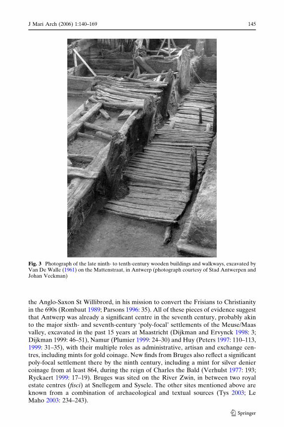
Not all of the remains from these settlements are new finds, and perhaps the mostsignificant omission in consideration over the past fifty years has been the role ofAntwerp as a major trading and central place during the early medieval period.Between 1952 and 1961, Van De Walle excavated a number of tenements on theMattenstraat, near the waterfront of the town. He discovered a complex and longoccupation sequence, which was never fully excavated or published. The earliestexcavated buildings were of wood, and probably dated from the ninth century, butthere were also significant unexcavated structures and deposits below these build-ings, in addition to a range of imports, suggestive of a major trading settlement (VanDe Walle 1961: 123–136; Tys 2004, 186) (Fig. 3). Documentary sources also describeAntwerp as a castrum, castellum, and civitas burnt down by the Vikings in 836(Verhulst 1977: 196–198; Rombaut 1989). Furthermore, it was also a known mint forgold tremissis coinage during the seventh century, and was the first centre used by
Fig. 2 Map showing the location of emporia, other major centres involved in exchange, coastal andestuarine settlements, and beach/dune sites on the Continental shore, from Friesland, Netherlands,to Brittany, France, (drawn by P. Copeland)
123
144 J Mari Arch (2006) 1:140–169
the Anglo-Saxon St Willibrord, in his mission to convert the Frisians to Christianityin the 690s (Rombaut 1989; Parsons 1996: 35). All of these pieces of evidence suggestthat Antwerp was already a significant centre in the seventh century, probably akinto the major sixth- and seventh-century ‘poly-focal’ settlements of the Meuse/Maasvalley, excavated in the past 15 years at Maastricht (Dijkman and Ervynck 1998: 3;Dijkman 1999: 46–51), Namur (Plumier 1999: 24–30) and Huy (Peters 1997: 110–113,1999: 31–35), with their multiple roles as administrative, artisan and exchange cen-tres, including mints for gold coinage. New finds from Bruges also reflect a significantpoly-focal settlement there by the ninth century, including a mint for silver deniercoinage from at least 864, during the reign of Charles the Bald (Verhulst 1977: 193;Ryckaert 1999: 17–19). Bruges was sited on the River Zwin, in between two royalestate centres (fisci) at Snellegem and Sysele. The other sites mentioned above areknown from a combination of archaeological and textual sources (Tys 2003; LeMaho 2003: 234–243).
Fig. 3 Photograph of the late ninth- to tenth-century wooden buildings and walkways, excavated byVan De Walle (1961) on the Mattenstraat, in Antwerp (photograph courtesy of Stad Antwerpen andJohan Veckman)
123
J Mari Arch (2006) 1:140–169 145

The foundation of coastal and estuarine emporia centres has been interpreted as adirect reflection of the desire to control access to luxury ‘prestige’ commodities onthe part of Anglo-Saxon, Frankish and Frisian ‘royal’ aristocracies (Hodges 1982;Hodges and Moreland 1988: 93; Heidinga 1997: 27–32). Although, Verhulst recentlyobserved that on the Continent, the Carolingian Kings were interested in the col-lection of tolls in silver coinage rather than in the control of specific exotic luxuries(Verhulst 2002: 130). Stephane Lebecq has also highlighted that the foundation ofsettlements like Dorestad and Quentovic was a result of the maritime dynamism ofFrisian and Anglo-Saxon cross-Channel exchange contacts, which had controls im-posed on them significantly later than their foundation, in the form of Carolingianroyal officers administering toll collection (Lebecq 1997: 75). Verhulst noted thetitles of these royal officers in relation to Quentovic and Dorestad—procurator orprefectus emporii (Verhulst 2002: 130). There is no evidence of great concern aboutaccess to imported luxuries as long as tolls were paid. At other significant settlementsinvolved in exchange, there is less evidence of strict taxation, although toll collectionis indicated at Medemblik, Domburg and Rouen, and can probably be assumed forAntwerp (Bazelmans et al. 2004: 22–23; Le Maho 2003: 235). The extent to whichtolls were collected at smaller ports, beach, and dune sites is totally unknown.
If, as appears to be the case, revenue generation through tolls at the extremities ofthe Frankish realms was the primary concern of the later Merovingian and Caro-lingian kings, then the ways in which major emporia and other sites of exchangefunctioned need to be reassessed. Tolls appear to have been raised primarily onexported and imported bulk goods, in coin and perhaps, sometimes ‘in kind’. Thereis no denying the likely paramount importance of Dorestad, Quentovic and Rouenas the pre-eminent conduits for long-distance exchange on the Continental coast ofthe Channel and southern North Sea region. This is reflected in their early emer-gence as trading settlements during the seventh century, their multiple functions,their roles as mints, and their high visibility in textual sources of evidence until themid to late ninth century (De Groot 1996: 13–17; Lebecq 1997: 75–76; Le Maho 2003:235). Yet, the demonstration of real power and royal prestige associated with themlay in the royal ability to tax bulk goods. This is not to say that rarer imported itemswere not ‘entangled’ with particular social values, within exchange systems (More-land 2000: 29). Rather, control of access to them does not appear to have been aparticular concern of kings and royal lineages. It becomes increasingly difficult,therefore, to hold the view that establishment of royal control over major Conti-nental emporia was ever linked directly to control of access to apparently rare,imported ‘prestige goods’, as opposed to taxation of lower-value bulk commoditiesand finished manufactured products. Indeed, it is only possible to hold the notionthat possession of rare luxuries reflected and created high social standing with anassessment of the true rarity of those items perceived as luxury prestige goods(Loveluck 2001: 111–112).
The old idea of major Continental emporia acting as centres for controlledredistribution of imported, rare ‘prestige goods’ can now be examined against theevidence from the larger range of significant centres involved in exchange andproduction in coastal locations, as well as the more ephemeral beach and dune-belttrading sites, and a growing corpus of coastal rural settlements. It is also possible tomake some comparisons with remains from a growing range of settlements situatedfurther inland. Most of the evidence for coastal sites outside the major emporia isknown currently from the area extending from the Dutch province of Friesland,
123
146 J Mari Arch (2006) 1:140–169

through the Rhine delta and into the western extremity of Flanders, with lessarchaeological evidence from the coast of northern France, at present (Fig. 2). Theterp settlements of Tjitsma-Wijnaldum and Tritsum in Westergo, Friesland provideexamples of settlements in the Frisian coastal area with excavated evidence foraccess to high value materials in the form of silver and gold, together with importedpottery from the Rhineland (Tulp 2003: 232; Heidinga 1997: 38). Indeed, seventh-century gold tremissis coinage and early to mid eighth-century silver sceatta coins,struck in the Rhine mouths area and Frisia, have been recovered consistently withother imports on terp settlements across Westergo and Oostergo (Heidinga 1997:32). Anthonie Heidinga has also pointed out that the occupants of these raisedmound settlements possessing these imports did not live in settlements with osten-tatious structures (Heidinga 1997: 38). Consequently, Heidinga, Lebecq and Schmidhave all suggested that the wide dispersion of imports on terps indicates occupantswho could be characterised as wealthy ‘free peasant traders’ or ‘marchands-paysans’,rather than an aristocracy (Lebecq 1983; Schmid 1991; Heidinga 1997: 31–32).
Thus, the settlement pattern and society around the eighth-century and latertrading settlement at Medemblik, at which tolls were collected for the Carolingiankings, possessed a wide access to imports, precious metals, and coinage, prior to andduring its early stages of existence, at the very least. Moving westward from Fries-land to the Rhine delta region, it is also becoming clear that imported items andcommodities are consistently present on the known rural settlements and in ceme-teries, dating from the late sixth- and early seventh century onwards. Some findsreflect long-distance exchange contacts across the North Sea to England, prior to thefoundation of Dorestad further upstream. Work by Menno Dijkstra on the settle-ment and cemetery at Rijnsburg and the cemetery at Katwijk, all at the mouth of theOld Rhine in south Holland, has demonstrated the presence of Anglo-Saxon gildeddisplay artefacts with affinities to Kent and East Anglia, including a style II drinking-horn terminal, with close parallels to those from Sutton Hoo, mound 1 (Bazelmanset al. 2004: 26). From the seventh to mid eighth century it is suggested that thesettlement at Rijnsburg acted as an agricultural estate centre, involved in some inter-regional exchange for the supply of an assumed lord and clients (Bazelmans et al.2004: 22). The excavated remains of another settlement in the Old Rhine delta, atValkenburg De Woerd are also thought to represent a settlement controlled by anaristocratic family, although with a significant element of the population involved incraft-working and exchange rather than agriculture, between the seventh and ninthcenturies (Bult and Hallewas 1990: 86; Bazelmans et al. 2004: 22). In the Scheldtdelta area too, a concentration of seventh- to ninth-century settlements, with largequantities of imported ceramics, has also been excavated near Woensdrecht (TrimpeBurger 1973; Verwers 1986), reflecting a regional pattern in the Scheldt–Meuse–Rhine delta zone.
Although the researchers working on the Rijnsburg and Valkenburg sites cur-rently interpret the evidence for exchange as controlled by a regional aristocracy(Bazelmans et al. 2004: 22–23), the occurrence of imported materials could beinterpreted in exactly the same context as the material from the Friesland sites. Thepresence of imports amongst the coastal and riverside settlements of the Old Rhinedelta is such that the extent of control on exchange by an aristocracy can be ques-tioned in favour of a wider access to imported goods amongst free lineages ingeneral. Bazelmans et al. themselves note an absence of any documentary evidencefor toll collection or control of exchange in the coastal area of the Old Rhine delta,
123
J Mari Arch (2006) 1:140–169 147

in contrast to Dorestad further inland (ibid, 2004: 23). And Heidinga has suggestedthat Rijnsburg, Valkenburg, and Leiderdorp could have acted as market sites (He-idinga 1997: 32). To some extent, the long-term focus on the trading role of theseventh- to ninth-century Frisians, from Friesland to the Rhine mouths area, mightencourage the view that their coastal social relations were exceptional. Yet, recentand current research, further south-west in coastal Flanders, suggests that this rel-atively abundant access to imported goods amongst households of coastal societiesrepresents a wider picture along the Continental shore of the southern North Seaand Channel.
Detailed landscape research in the Kamerlings Ambacht of west Flanders(Fig. 5), has brought together archaeological finds, textual and topographic studies(Tys 2003), and new archaeological survey projects, conducted by the authors(Loveluck and Tys 2002) in conjunction with Marnix Pieters (Flemish governmentarchaeology service) and the provincial government of West Flanders. This hasdemonstrated that at least small quantities of later seventh to ninth-centuryimported goods are present on nearly all known early medieval sites in this part ofthe Flanders coastal plain.1 This evidence is discussed in greater detail in thefollowing section below; here, it is appropriate to note that the Kamerlings Ambachtis the only part of the Flanders coastal plain where systematic study has taken place,and that the imported material has been recovered in the form of pottery (Tys 2003),from the Rhineland (Badorf wares) and southern England (fabrics from Hamwic-Southampton). The pottery has been found during integrated surface collection,geophysical and geochemical survey. The settlement and dune or beach trading sites(near Oostende and De Panne) in the Kamerlings Ambacht are currently unexca-vated, and are known only from surface or chance finds of pottery and coinage. Yet,the apparently wide geographical distribution of imports in the coastal plain isextremely reminiscent of the situation in the coastal areas of the Rhine delta andFriesland. Access to imported goods may have been limited to higher rankinghouseholds or particular members of their families on these Flemish coastal sites, butit is extremely difficult to make a case for aristocratic or royal control of access toimported goods, on the basis of the emerging evidence for wide dispersal in thesouthern North Sea coastal plains.
The reality of the Continental settlement patterns along the coast of the southernNorth Sea, between the seventh and late ninth centuries AD, was a complex hier-archy of significant coastal settlements acting as central places involved in long-distance inter-regional exchange, in addition to the centres of Dorestad, Quentovicand Rouen. Alongside the larger coastal settlements was a range of beach or dune-belt trading sites, either focussed on permanently occupied rural settlements in thesesituations, or on seasonal gathering points. Then, there was a wider network of ruralsettlements, also possessing imported items and raw materials. The extent to whichthis was also the case on the Channel coast of northern France, across the Pas de
1 The archaeological survey work has been conducted through the ‘Leffinge medieval settlementand landscape pilot survey project’ in 2002, funded primarily by the University of Southampton andthe British Academy, with additional funding from the province of West Flanders, the Free Uni-versity of Brussels and the IAP Vlaanderen; and by follow-up survey in 2003 as part of the ACI-Techniques, Terrain, Theories project, funded by the IAP Vlaanderen, CNRS-University ofTours—Laboratoire Archeologie et territories, and the British Academy. Only results from theLeffinge pilot project of 2002, and pottery analyses completed prior to the ACI project are discussedhere.
123
148 J Mari Arch (2006) 1:140–169
Calais, and into Normandy and Brittany is less clear from the standpoint of thearchaeological evidence.
The presence of ‘Anglo-Saxon’ dress accessories has long been known from sixth-century graves in the cemeteries of the lower Orne valley, between Caen and theChannel coast at Ouistreham, in Normandy (Lorren 1980: 231–250; Arnold 1982b;Pilet et al. 1990: 34–35), (see Fig. 2). They have their closest parallels with thematerial culture of the Isle of Wight, southern Hampshire and Kent, demonstratingcross-Channel contacts, and perhaps elements of a common sense of identity createdby use of the Channel seaways, especially between the Isle of Wight and lowerNormandy. Yet, the social dispersion of imported items and goods amongst com-munities, and different elements of settlement and social hierarchies is difficult toassess from this mortuary evidence, other than to say that Anglo-Saxon artefactswere present in wealthier furnished graves. Archaeological evidence for the receiptand dispersion of imported goods beyond the sixth century is scarcer, althoughpottery made in the Rouen area at La Londe was exported to southern Englandduring the eighth to ninth centuries (Hodges 1991: 882–887; Roy 1993). The textualevidence on Rouen and other trading sites in the lower Seine valley (Le Maho 2003:242–243) might also reflect a similar situation to the coastal zones of Flanders,Holland and Friesland, although this cannot be proven at present. The discovery, onthe south-west coast of England, of sixth and seventh-century pottery made inwestern France (DSP- and E-wares), and common monumental and iconographictraditions also demonstrates cross-Channel contacts with Brittany and the Bay ofBiscay until the late seventh century, if not later (Thomas 1981; Campbell 1996: 88–92; Davies et al. 2000). Linguistic links seen in Old-English/Anglo-Frisian place-names from coastal Normandy, such as Ouistre-ham, also reflect maritime contactsand perhaps aspects of a common group identity; just as the P-Celtic place-names ofBrittany and Cornwall provide more certain evidence of strong group and ‘ethnic’affiliation on facing shores of the western Channel waterway.
As on the Continent, the importance of the major coastal emporia in England hasalso been stressed in relation to the control of trade and exchange by Anglo-Saxonroyal dynasties, from the later seventh to ninth centuries AD. The archaeologicalassemblages from the majority of these settlements, such as Hamwic-Southampton(Hodges 1981; Morton 1992; Andrews 1997), London (Vince 1990; Blackmore et al.1998: 60–63; Malcolm, Bowsher and Cowie 2003), Ipswich (Wade 1988; Scull 1997);and York (Kemp 1996) were relatively isolated when excavated, due to the absenceof many larger scale surveys and excavations in their hinterlands. Archaeologicalevidence from rural settlements or finds concentrations in regions nearby the coastalcentres tended to come from sites associated with documentary references, i.e., theywere important enough to be mentioned, and were usually royal or aristocraticestate centres or monasteries (Loveluck 2001: 104–107). Quantities of apparentlyrare, imported luxuries were found on these important rural settlements, and thisreinforced the equation of imports with high social status, and the idea that theywere funnelled through emporia controlled by royal officers. Fortunately, like theEuropean mainland, a combination of new excavations, surveys, reassessment ofexisting archaeological evidence, and metal-detected finds now allows us to begin toplace the dispersion of imports in coastal landscapes within a wider settlement, socialand geographical setting, for the period contemporary with the major emporia.
On the south and east coasts of England, as far north as the Humber estuary, weare faced with an ever growing number of sites, occupied or used between the
123
J Mari Arch (2006) 1:140–169 149

seventh and ninth centuries, which received imported goods via North Sea andChannel maritime networks (Fig. 4). Beginning the review with the Channel coast,the finds concentrations from the south coast of Kent, the Wantsum channel and theIsle of Thanet have long been thought to reflect either royal-controlled, majortrading settlements or toll collection points (Kelly 1992, 10; Hill et al. 1990). Thesesettlements at Dover (Parfitt 2001: 95–98; Philp 2003); Fordwich (Hill 2001: 98);Sandwich (Holman 2001: 100–102); and Sarre (Perkins 2001: 102–103), amongstothers, took advantage of their geographical situation and long-established com-munications routes (Brookes 2003: 96). Alongside the latter sites, it is now possibleto gauge access to imports outside these probable centres. Excavations at Sandtun,West Hythe, on the south coast of Kent, have revealed a beach and dune settlementon a coastal inlet, involved in cross-Channel exchange from the seventh century untilthe late ninth century, with additional later reuse in the eleventh century (Gardineret al. 2001: 268–270). The discoveries at Sandtun have provided the first compre-hensive archaeological profile of such a dune-beach site from the south-east coast ofEngland, facing the Pas de Calais and Flanders. Gardiner has presented a veryconvincing argument for the site having been a settlement and landing place whichhoused a community involved in fishing, salt production, cross-Channel exchangeand supporting craft activity, including iron smithing, textile production andleatherworking (Gardiner et al. 2001: 272). He sees the site as linked with, andpossibly dependent on another settlement(s) nearby, as reflected in the importedanimal and crop remains, and cites the possibility that the settlement was occupiedon a seasonal basis (ibid 2001: 272–273).
Moving west along the English south coast there are archaeological indicationsof landing places, possibly similar to Sandtun or more substantial permanent
Fig. 4 Map showing the location of emporia, coastal and estuarine settlements, beach/dune sites andfinds concentrations on the English shore, from the Humber estuary to Cornwall (drawn by P.Copeland)
123
150 J Mari Arch (2006) 1:140–169

settlements, at Carisbrooke/Bowcombe, and possibly Benbridge and BenbridgeHarbour, on the Isle of Wight (Ulmschneider 1999: 30–32; Rippon 1997, 130); and aseries of sites around the River Solent and south Hampshire coast, such as Ham-blemouth (Morton 1999: 51) and Totton (Ulmschneider 2003: 83). All these landingplaces were in close proximity to the emporium at Hamwic-Southampton, andchance finds from the majority indicate probable involvement in cross-Channelexchange with a high proportion of imports in the form of coins, dating from theseventh to ninth centuries, some of which have never been recovered from Hamwic(Ulmschneider 2003: 80). Further west again, a series of excavations on the dunesand beach at Bantham Ham, at the mouth of the River Avon in Devon, has revealedthe remains of a site with substantial quantities of eastern Mediterranean and northAfrican pottery, in the form of amphorae and fine wares dating from the later fifth toearly seventh centuries, and also pottery wares from Cornwall, with some later finds(Fox 1955: 55–67; Silvester 1981: 89–118; May and Weddel 2002: 421). Other beachsites involved in cross-Channel or longer distance exchange networks have beensuggested at Mothecombe, southern Devon, on the basis of imported amphoraefragments (Thomas 1981: 12); and Gwithian, west Cornwall, where middens, hutsand a range of Mediterranean imports were excavated on a bluff of blown sand, atthe mouth of a tidal creek (Thomas 1958: 19). The Gwithian beach settlement alsocontinued in use, between the eighth and twelfth centuries (Thomas 1958: 23).
On the North Sea coast of eastern England to the River Humber, there is also agrowing abundance of coastal sites on major estuaries, at the mouths of tidal creeks,and in delta locations. A range of coastal landing places is being located in theThames estuary, East Anglia and the Fen edge of Norfolk and Lincolnshire. On theThames estuary, another site like Sandtun may be reflected in pottery and coin findsfrom the shore of Canvey Island, Essex; whilst other shore finds from GoldhangerCreek, Essex, and sites on the north coast of Kent, probably reflect further landingplaces and settlements (Rippon 1997: 130–3). The settlements at Bawsey, WestWalton and Burnham provide examples from East Anglia: Bawsey seemingly awealthy settlement on a tidal inlet, West Walton located on raised silt banks offormer river channels in the Fenland, and Burnham just inland from a beach landingplace (Rogerson 2003: 112–119; Fig. 4). Others are located on the Humber estuary,either in beach or inlet locations or overlooking the river deltas feeding into it. Forexample, late seventh- to mid eighth-century silver sceattas indicate probable beachtrading and ferry sites at North Ferriby, East Yorkshire (Loveluck 1994, vol 1: 311,vol 2: 258–259; 1996: 44), Barton-upon-Humber (Drinkall 1998: 291; Didsbury 1998:311; Williams and Martin 2002: 920) and South Ferriby (Blackburn 1993: 89), northLincolnshire. Whereas, the materially rich settlement at Flixborough, north Lin-colnshire overlooks the lower floodplain and delta of the River Trent as it flows intothe Humber (Loveluck 1998: 146, Fig. 4). Again all of the places above have pro-vided evidence for the receipt of imports or involvement in exchange, dating fromthe period between the seventh to late ninth centuries, in the form of coinage,pottery, lava querns or scales and weights. They encompass a range of permanentlyoccupied settlements, such as Flixborough and Bawsey; and beach sites like Sandtun,Bantham, Gwithian, and North Ferriby which reflect landing places possibly occu-pied on a seasonal basis as fishing and trading sites.
We are, therefore, presented with a picture of a complex range of landing places,settlements and other sites of exchange on the English side of the Channel andsouthern North Sea coasts, in addition to the major emporia. These, in turn were
123
J Mari Arch (2006) 1:140–169 151

faced with the Continental shore from Normandy to Friesland, with its own networkof beach trading sites, and both small and larger trading centres, in addition toDorestad, Quentovic and Rouen. Not all the fore-mentioned sites on the Channeland southern North Sea coasts of England need have been landing places for ships,between the seventh and late ninth centuries. Landing places relating to the Flix-borough settlement, were probably located on the River Trent in the floodplainbelow the site (Loveluck in press); whilst the Burnham landing place was probably abeach site, perhaps like Sandtun. This raises the issue of the wider dispersion ofimported goods from the coastal landing places in England, other than the emporia.In coastal and estuarine areas, and also on major river communications routesleading to them, access to imported commodities appears abundant when comparedto most settlements further inland. This situation seems to mirror the wide disper-sion of imports in Frisia and Flanders already discussed, and appears to be char-acteristic of the ‘entry-point regions’ or ‘contact zones’ along the Channel andsouthern North Sea coasts.
For example, all the settlements subjected to systematic excavation on or in thehinterland of the Humber estuary have yielded imported goods, whether coinage,pottery or lava querns (Loveluck 1998: 158–159; 2001: 111–112; Ulmschneider 2000:57; Fig. 4). Some river landing places running inland from the estuary could havebeen directly controlled within estate structures. For example, the excavated jetty onthe River Hull at Skerne, East Yorkshire could have been directly linked with thenearby royal estate centre at Driffield (Loveluck 1996: 45; Swanton 1996: 41; Dentet al. 2000). Silver coinage was certainly used in the area of Driffield contemporarywith its appearance on the Humber, which was earlier than at York, and this suggestsroyal interest in the role of the estuary for exchange (Teasdill 1965: 355–359,Loveluck 1996: 44–45). Yet, not all the settlements with imports can be viewed ashigh-status centres, housing secular aristocrats or monasteries. The dispersion ofimports is too wide in the hinterland of the Humber to suggest denial or control ofaccess to imported goods by royal authority. There is certainly textual evidence fromlaw codes and the Anglo-Saxon Chronicle which suggests that royal officers (reeves)administered collection of tolls at major centres, as on the Continent, but thenumber of reeves and their ability to administer all coastal trade is unlikely to havecovered all landing places or exchange transactions. The limitations of their poweraway from major centres are demonstrated graphically in the killing of a reeve atPortland, Dorset, by ‘three ships of Northmen’ from Hordaland in western Norway,in 789 (Swanton 1996: 55). Away from the presence of a royal officer with enoughmanpower to enforce taxation of exchange directly, control in coastal areas mayhave been sporadic—especially in marginal coastal locations with difficult landwardaccess.
Even if reeves did manage to be present at all coastal sites involved in exchange,proximity of coastal populations to goods needed by mariners, such as water, foodand desirable commodities for exchange, such as salt, presented even low rankingcoastal dwellers with much greater opportunity to enter into exchange transactionswith foreign traders than their counterparts living further inland. This made a rel-ative abundance of imported commodities normal rather than exceptional, withregard to certain items, which have been interpreted in the past as both ‘utilitarian’(lava querns) and ‘prestige’ or high-value objects (silver coinage, fine-ware pottery).Furthermore, as many coastal dwellers lived in marginal landscapes, such as mar-shes, this increased the incentives for trade because their living environments
123
152 J Mari Arch (2006) 1:140–169

necessitated specialist husbandry and production for exchange. In such a way,specifically coastal material culture identities can be distinguished which weredivorced from the hierarchical distributions of imported goods which seem to haveoperated in most regions away from the sea, with some exceptions. In England, theexcavated evidence from Gosberton on the seaward side of the northern Fenmarshlands, in Lincolnshire, has provided indications of a modest settlementinvolved in animal husbandry, salt production, and some crop cultivation (Lane1993: 30–1). Significantly, Katharina Ulmschneider has pointed out that this site andothers on the former seaward side of the Fens possessed imported pottery, made atthe emporium at Ipswich, together with lava querns from the Rhineland. She alsoobserved that contemporary sites, on the landward side of the Fens, did not haveaccess to Ipswich ware and that the presence of the querns and Ipswich ware on theseaward side represented a specifically coastal distribution (Ulmschneider 2000: 70).This coastal exchange network may have been totally free of any control.
A similar coastal material culture profile can be suggested for the Humberestuary, although there, more direct elite toll collection at sites of exchange mayhave occurred, due to proximity of royal authority. However, there is no evidence ofrestriction of access to high value items or goods in coastal zones once tolls and otherforms of embedded redistribution had been exacted, such as renders of livestock,crops or products to estate centres. Furthermore, once socially embedded dues hadbeen paid, there is no evidence that alienable exchange was controlled, whether itwas conducted by barter or purchase with coinage. Advantageous geographicalsituation, possession of essential provisions for mariners and specialist products, andin certain instances distance from authority, gave coastal societies outside emporiathe opportunity to obtain imported products to an extent that would have seemedexceptional further inland. In this sense, the growing indications of wide socialdispersion of imported goods reflects a specific phenomenon of coastal societies,which is common at least to eastern England and the region from Friesland west-wards through Flanders and probably into northern France, on the Continentalshore of the southern North Sea and Channel waterways. The extent that this wasalso true of the Channel coast of southern England is less clear at present, but thefact that imported pottery and coinage stayed at the dune-beach settlement atSandtun also suggests a relatively wide access to imported goods amongst a signifi-cant proportion of coastal households not of aristocratic status. The indications ofthe sheer range of coastal sites involved in exchange, whether the largest emporia,other significant centres like Antwerp, beach trading sites, or coastal settlements,and above all their contemporaneity, demonstrates the need for the abandonment ofany evolutionary categorisation of these sites, as has occurred in the past (Hodges1982: 50–52)
Maritime situation and the necessity for specialist husbandry and manufacture ofcertain products, for estate renders and exchange without attached social obliga-tions, created the material identity of the societies of the coasts, and their dune beltsand marshes, between the sixth and late ninth centuries. The broad access to importsamongst coastal societies contrasts with the apparent hierarchical access to importsand fashions of social display in regions inland from the northern French, Flemishand Dutch coastal areas, and into the German Rhineland (Loveluck 2005). Majorroyal palace, palace-monastery complexes and poly-focal settlements, like Saint-Denis, reflect conspicuous consumption using imported ‘feasting kits’, in the form ofdrinking vessels and pottery fine-wares from the Rhineland (Wyss 2001: 195).
123
J Mari Arch (2006) 1:140–169 153

Secular estate centres and smaller monasteries, such as Petegem, Flanders (Calle-baut 1994: 95–97), Serris, Seine-et-Marne (Foucray and Gentili 1995: 139–143) andHamage, Nord (Louis 1997: 55–60), reflect display in stone or stone sill architecture,elements of ostentatious display in drinking vessels, and integration into inlandexchange networks using coinage. Whilst nucleated settlements, such as Saleux-les-Coutures (Somme), involved primarily in mixed farming had limited access toimported commodities (Catteddu 1997: 143–144). The exceptions to this pattern ofdispersion were settlements of craft specialists. The excavations at the settlement ofDevelier-Courtetelle, Jura, have uncovered the remains of a metalworking com-munity, which had access to imported items from the northern Rhineland, althoughthe inhabitants do not appear to have been of high social standing (Federici-Sche-nardi and Fellner 1997: 125–128). Their access to imported goods seems to reflect thegreater necessity and opportunity for exchange on their part, once any obligations tolinked estates had been fulfilled; and in this sense they show distinct similarities withinhabitants of coastal zones, with their incentives for specialist production andexchange (Loveluck 2005: 236). Similar hierarchical access to imports is alsoreflected in England, although settlements of specialists away from coastal zoneshave proved more elusive.
Ease of communication by rivers, tidal creeks and seaways may also have createda perspective on the part of coastal dwellers, which looked seawards with regard togroup affiliation and ‘cultural ties’. Authority and government usually manifestedthemselves and approached these coastal societies in marshes and dunes from thelandward side, sometimes via difficult communications routes. Indeed, the percep-tion of these marginal landscapes and societies, from an inland perspective, appearsas highly peripheral and negative in eighth- and ninth-century documentary sources(Coates 1998: 58). This may have resulted in a greater willingness on the part ofcoastal dwellers to adopt and co-operate with new influences and fashions arrivingvia the sea. It is within this context, that the developments of the tenth century mustbe viewed, in relation to permanent habitation of coastal areas, and the control ofthe activities of their populations.
Living in coastal landscapes: seasonality and permanently occupied settlementhierarchies, AD 600–1000
Up until the late 1990s, and major reassessments of the formation of coastal plains,estuarine landscapes, and their inhabitability through the first millennium AD(Baeteman 1999; Baeteman et al. 2002; Tys 2001, 2005), prevailing explanations ofoccupation in these areas have favoured their exploitation for seasonal activities.Such explanations were based on models of cyclical marine transgression (sea-levelrise) and regression, when coastal plains and lowland estuaries became permanentlyinundated by water; or became wetland ecological habitats, whether saltmarsh, siltfen or lowland moors for peat accumulation, during periods of sea-level rise (Behreet al. 1982). Within the transgression and regression models, the period between AD300 and 800 has been characterised as an era of marine transgression (the Dunkirk IItransgression), and exploitation and occupation of the North Sea coastal plains, lowlying estuarine zones and coastal dune belts has been suggested as seasonal andlimited in nature, due to inhospitable conditions.
123
154 J Mari Arch (2006) 1:140–169
The suggested absence of the potential for permanent settlement in most coastalareas during the defined Dunkirk II transgression has been based on an apparentcorrelation between archaeo-botanical evidence from Lower Saxony and other areasaround the North Sea coast, with certain charter references to grants of coastalpasture to leading monasteries, from the seventh to tenth centuries AD (Behre et al.1982; Verhulst 1995, 1998; Hooke 1998). Such ideas became an accepted orthodoxyon both the Continental and British sides of the Channel and North Sea, withhistorical references of land grants to major ecclesiastical institutions often beingviewed as immediate precursors to wetland drainage and land reclamation, espe-cially in Flanders and the English Fens. For example, despite the Fenland archae-ological survey in England, the historian Jordan still considered a handful of chartersconcerning donations of coastal estates to Cistercian abbeys as the main argument tosupport the idea of embankment of the Fenland coastal plain under their auspices,during the thirteenth century (Jordan 2002).
The historical sources have also tended to be used in an inconsistent way byarchaeologists, in relation to early medieval activity in coastal zones, often followingassumptions made on the basis of sporadic and limited textual sources. For example,the first references to settlements or individuals associated with settlements in theFlanders coastal plain date from the end of the eighth century. They were landgrants to the abbey of St. Peters, Ghent, comprising seasonal grazing, and an estateassociated with at least one settlement in the coastal plain, near Oostburg (Gotts-chalk 1955: 16). Verhulst saw these grants as an indication of the end of the DunkirkII transgression, and an onset of land reclamation, primarily sponsored by majormonasteries from the Scheldt valley. The general absence of textual evidencerelating to activities in the coastal plain prior to the late eighth century was then usedas evidence of an absence of permanent activity and settlement in this area, i.e.textual visibility governed all interpretation of early medieval activity in the Flemish,northern French and Zeeland coastal claylands.
Yet, in Frisia (from the Rhine delta eastwards to Friesland), the oldest textualreferences to settlement and activities in the coastal tract also date from the eighthcentury, but the archaeological research on terp settlements has long demonstratedthe permanent habitation of this region, in the early medieval period, several cen-turies before activity became visible in the historical records (see above; De Langen1992). In Flanders and northern France, however, the archaeological record wasforced into the textually dated chronological framework (Verhaeghe 1977). Prior tothe English Fenland survey, in southern Lincolnshire, Cambridgeshire and Norfolk,the role of major monasteries has also been stressed in colonisation, land drainageand reclamation of the Fens from the tenth century onwards, co-ordinated from thesites of re-founded seventh-century monastic centres, often on island locations(Stocker 1993: 101–110; Hooke 1998: 172–3). Yet, as in Frisia, survey by surfacecollection and some subsequent excavation has demonstrated wider settlementwithin the Fen wetlands, and on the sea coast of the Fens, from at least the seventhcentury (Hayes and Lane 1992; Lane 1993; Ulmschneider 2000: 70). Nothing in theevidence demonstrated seasonal occupation, as opposed to permanent settlement,although seasonal occupation has been suggested on the basis of scarcity of metal-work compared to sites on good land communications routes, further inland(Ulmschneider 2000: 71).
Recent detailed and systematic geomorphological research in Flanders, based onsediments and their radiocarbon dating, by Cecile Baeteman and her team from the
123
J Mari Arch (2006) 1:140–169 155

Belgian Geological survey and the Free University of Brussels (VUB), has shownthat in the early medieval period the Flemish coastal plain was a stable and notsignificantly inundated area of saltmarsh, interspersed with tidal channels whichwere actively silting up and evolving into channel ridges (Baeteman 1999; Baetemanet al. 2002). These findings render the Dunkirk II transgression model redundant asa significant barrier to permanent human activity and settlement in this coastal plain.They may not only have localised implications for coastal Flanders, they may alsohave considerable relevance to other areas of the Channel and North Sea littoral.Even if, however, the results are specific to coastal Flanders, they highlight diversityin the potential for human activity in low-lying coastal regions during the earlymedieval period, rendering allegiance to generalising models dangerous.
In the light of the re-assessment of the geomorphological evidence in coastalFlanders, and the demonstrable danger of following the textual sources as indi-cators of settlement, recent and current research in the coastal plain, combininganalyses of medieval and early modern cadastral (terrier) sources, field and dykesystems, and archaeological sources, has sought to evaluate the evidence for thedevelopment of settlement in this area from an inter-disciplinary perspective (Tys2003). This research has suggested the existence of a settlement hierarchy ofFlachsiedlungen farmsteads on the contemporary ground surfaces of silted-up tidalchannel ridges, focussed on nucleated settlements of multiple households, locatedon terp mounds such as Leffinge and Bredene (Tys 2003: 588–598, 2005; see Fig. 5).The nucleated settlements like Leffinge became the central foci for their micro-regions of approximately fifteen square kilometres, at the administrative, religiousand economic levels, from at least the tenth century; and there are indications of
Fig. 5 Map showing the location of settlements, beach sites and finds concentrations, dating fromthe period between the sixth and eleventh centuries AD, in the coastal plain of West Flanders(drawn by P. Copeland)
123
156 J Mari Arch (2006) 1:140–169

their central role from at least the Carolingian period. This has parallels with thesuggested role of ‘‘trade terps’’ in Frisia, suggested by Halbertsma (1963) andothers.
Analysis of the textual sources for property relations in the Flanders coastal plain,from the tenth to fifteenth centuries, also shows that the populations of these terp-focussed settlement hierarchies were free proprietors (Tys 2003: 266–273, in press).That is to say, they may have owed some dues to respective regional lords, whetherCounts or Kings, but with the exception of these possible obligations there is noevidence that they came under any other significant socio-political control, in theperiod covered by this paper. As mentioned above, a similar situation can be sug-gested for the Westergo and Oostergo regions of Friesland (Heidinga 1997: 31–32)and Oost Friesland in Germany, where Schmid has suggested that free farmers(Bauerenkaufleute) lived in the higher coastal salt marshes, involving themselves inwool production and trade from their Langenwurten settlement mounds (Schmid1988: 134–137).
Therefore, in the area containing the known early medieval coastal trading set-tlements, at Wissant, Veurne, Bruges, Antwerp and Walcheren/Domburg, and theunlocated Iserae Portus, there appear to have been permanent surrounding settle-ment patterns, with at present unconsidered relationships to them (see below; MGHFormulae Imperiales). Again, as stated in the previous section, this further demon-strates the potential significance of this coast line and the connection with openwater for exchange, with its coastal centres lying between Quentovic and Dorestad.The populations of the coastal landscape, largely located on tidal channels up untilthe tenth/eleventh century (Verhaeghe 1977; see below) possessed a maritime focuswithin a landscape which is unlikely to have fulfilled all their subsistence needs. Theprimary activities for the nutritional support of their households would have fo-cussed on sheep husbandry and fishing (Verhulst 1995, 2002). The population, likeothers involved in specialist production of limited products, must also have beeninvolved in a significant degree of exchange for the provision of the cereal compo-nent of their diet, and commodities such as wood. The likely major commodities forexchange would have been wool or finished wool garments (the so-called palliafresonica), fish and salt (Ervynck et al. 2004; Tys 2005).
The physical nature of the settlements surrounding the terps in coastal Flanders isgradually becoming apparent through reconsideration of previously excavatedmaterial and current surveys (Fig. 5). At Lampernisse, in West Flanders, a sequenceof settlement deposits dating from the seventh to ninth centuries was excavated onthe sand ridge of a tidal channel, demonstrating the presence of a settlement of somestatus which was also the predecessor of a later manor (Verhaeghe 1977; Demolonand Verhaeghe 1993; Ervynck et al. 1999). More recently, in the same modernprovince, rescue excavations in advance of modern development have uncovered theremains of earth-fast foundations of farm buildings, dating from the seventh to theeleventh centuries at Uitkerke (Pype 2002), and from the ninth to twelfth century atPlassendale (Vanhoutte and Pieters 2003). Further east, in the area around Oost-burg, in the Dutch part of the former County of Flanders, Van Heeringen and othershave also excavated a series of settlement sites, dating from the ninth to tenthcentury (Vos and Van Heeringen 1997: 96–97). Until now, these excavated sites havebeen interpreted as isolated and exceptional evidence of settlement in areas whereonly seasonal activity was deemed possible.
123
J Mari Arch (2006) 1:140–169 157
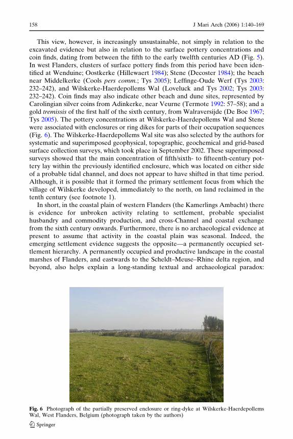
This view, however, is increasingly unsustainable, not simply in relation to theexcavated evidence but also in relation to the surface pottery concentrations andcoin finds, dating from between the fifth to the early twelfth centuries AD (Fig. 5).In west Flanders, clusters of surface pottery finds from this period have been iden-tified at Wenduine; Oostkerke (Hillewaert 1984); Stene (Decoster 1984); the beachnear Middelkerke (Cools pers comm.; Tys 2005); Leffinge-Oude Werf (Tys 2003:232–242), and Wilskerke-Haerdepollems Wal (Loveluck and Tys 2002; Tys 2003:232–242). Coin finds may also indicate other beach and dune sites, represented byCarolingian silver coins from Adinkerke, near Veurne (Termote 1992: 57–58); and agold tremissis of the first half of the sixth century, from Walraversijde (De Boe 1967;Tys 2005). The pottery concentrations at Wilskerke-Haerdepollems Wal and Stenewere associated with enclosures or ring dikes for parts of their occupation sequences(Fig. 6). The Wilskerke-Haerdepollems Wal site was also selected by the authors forsystematic and superimposed geophysical, topographic, geochemical and grid-basedsurface collection surveys, which took place in September 2002. These superimposedsurveys showed that the main concentration of fifth/sixth- to fifteenth-century pot-tery lay within the previously identified enclosure, which was located on either sideof a probable tidal channel, and does not appear to have shifted in that time period.Although, it is possible that it formed the primary settlement focus from which thevillage of Wilskerke developed, immediately to the north, on land reclaimed in thetenth century (see footnote 1).
In short, in the coastal plain of western Flanders (the Kamerlings Ambacht) thereis evidence for unbroken activity relating to settlement, probable specialisthusbandry and commodity production, and cross-Channel and coastal exchangefrom the sixth century onwards. Furthermore, there is no archaeological evidence atpresent to assume that activity in the coastal plain was seasonal. Indeed, theemerging settlement evidence suggests the opposite—a permanently occupied set-tlement hierarchy. A permanently occupied and productive landscape in the coastalmarshes of Flanders, and eastwards to the Scheldt–Meuse–Rhine delta region, andbeyond, also helps explain a long-standing textual and archaeological paradox:
Fig. 6 Photograph of the partially preserved enclosure or ring-dyke at Wilskerke-HaerdepollemsWal, West Flanders, Belgium (photograph taken by the authors)
123
158 J Mari Arch (2006) 1:140–169

namely, the large ring-forts constructed at the end of the ninth century/early tenthcentury, from Veurne in West Flanders to Oost Souburg, Domburg and Burgh, inthe Scheldt delta, and Rijnsburg, in the Rhine delta (Henderikx 1995: 76–81; Dijk-stra pers comm.). These large ring forts have been interpreted as vluchtburgen or‘refuge forts’ during periods of Viking raiding, in their late ninth- to tenth-centurystages (Henderikx 1995: 71). Yet, historians and most archaeologists have, until now,viewed the Flanders and Zeeland coastal plain as seasonally occupied, which begsthe question ‘Why build large and ostentatious ring forts in a coastal region occupiedonly by a sparse population of fishermen, shepherds and salt-workers in the sum-mer?’ The answer to the paradox of the past is now apparent in the indications of avibrant, permanently occupied settlement hierarchy, which was worth protecting andcontrolling closely.
The detailed discussion of the new finds from Flanders, and the review of thebetter known evidence from the Scheldt–Meuse–Rhine deltas and Frisia (Dutch andGerman Friesland) all points to the value of coastal location and the opportunitiesfor coastal societies. In England too, the remains from the beach settlement atSandtun, the sites from the coastal edge of the Fens and East Anglia, and settlementsoverlooking deltas and coasts also testify to similar opportunity. Although, mostEnglish beach sites and settlements in wetlands are still often equated with seasonaluse, although often without proof. Evidence for use of the coastal wetlands and theinter-tidal zone of the Channel and southern North Sea coast is growing all the time(Rippon 1997: 143–145), but remains of habitation sites have proved elusive incertain coastal wetlands of England, for the period prior to the tenth century. Forexample, the Humber wetlands survey of the late 1990s did not identify any newAnglo-Saxon settlement sites, with the exception of tenth- to eleventh-century saltworkings at Marsh Chapel, in the Lincolnshire marshlands of the Humber estuary(Fenwick 2001: 231–241). Activity on the Humber seems to have been focussed onthe beach sites on the estuary itself, linked to better drained settlement areasoverlooking the rivers and on river banks, leading into the estuary. Rather thanassume uniform levels of habitation of marginal coastal landscapes, it would seem tobe most sensible to envisage regional patterns of coastal settlement and use, but itremains likely that the extent of occupation within marginal coastal zones of Eng-land has been significantly underestimated. Indeed, Rippon has previously observedthat coastal landing places and settlements are more visible in textual sources fromthe eleventh century, especially in the Domesday survey, than in the archaeologicalrecord (Rippon 1997: 132); and this could be a reflection of limited work in dunebelts, in particular.
A final phenomenon associated with the English and the Continental coastal sitesrelates to the visibility of tenth-century activity. In Flanders, Zeeland and theRhineland, tenth- to eleventh-century phases of occupation and use of sites tend tobe visible from the presence of small but consistent quantities of fine-ware pottery,usually Pingsdorf-type ware. Metalwork and coinage are rarer, and were it not forthe diagnostic and highly visible forms of pottery, most of the tenth- and eleventh-century phases of settlements would be invisible archaeologically. In England, tenth-century phases of activity for coastal fishing and trading settlements such as Sandtunare not suggested, despite ‘Later Saxon’ types of pottery which are suggested to belate ninth century in date, and mid eleventh-century activity reflected in silvercoinage and some pottery forms (Gardiner et al. 2001: 267–270). The appearance ofa hiatus in occupation or use during the tenth century is a recurrent trend for eastern
123
J Mari Arch (2006) 1:140–169 159

and south-eastern England. Much of the occupation sequence for the tenth centuryat Flixborough, in the hinterland of the Humber estuary, would have beenarchaeologically invisible but for the exceptional vertical stratigraphic sequence ofbuildings and refuse, dated later than the end of the ninth century, and before thearrival of diagnostic later tenth- and early eleventh-century pottery (Loveluck 2001:117–119). It is also true that most of the pottery-based chronologies for ninth- toeleventh-century England are ultimately cross-referenced by association with coindates. Coinage is rare between the end of the 880s and the 970s in much of easternEngland, outside certain key centres like York, Norwich and London (Story 2003:248), and use of hack silver and bullion-exchange systems was the norm at sites suchas Flixborough in the tenth century (Loveluck 2001: 103–104; Kruse 1992). Hence,pottery date ranges may emphasise association with mint dates for coinage up to the880s and from the 970s onwards, rather than real late ninth-century production andloss dates. It is, therefore, conceivable that an apparent hiatus in use of a site likeSandtun, during the tenth century, could be a product of the way we construct ourartefact chronologies, rather than an image of reality.
Indeed, more and more evidence is emphasising the long-term continuity in theuse and occupation of coastal landscapes along the Channel and southern North Seacoasts, between the sixth and eleventh centuries AD. In this sense, it is interesting toobserve that with the exception of the demise of the two largest continental emporiamost closely associated with the Carolingian kings, at Dorestad and Quentovic, othersignificant coastal centres like Antwerp did not decline. Indeed, the construction ofthe large ring fort at Domburg at the end of the ninth century, adjacent to the earlieremporia site, also reflects continuity of occupation and use of significant coastalsettlements through the tenth and eleventh centuries, integrated by the sea and riverwaterways (Lebecq 1995: 75–76). Long-term continuity in the exploitation of asignificant proportion of coastal sites into the eleventh century, and sometimes later,is also reflected in England, if the tenth century ‘hiatus’ is more apparent than real.This is true not only on the Channel and east coasts (Gardiner et al. 2001; Pestell2003: 126–131), but also on the Irish Sea, as at Meols, in the Wirral (Griffiths 2001:20–25, 2003).
Conclusions: coastal dynamism and social identity, AD 600–1000
This brief review of the evidence for the settlement patterns and social relations ofcoastal societies along the shores of the English Channel and southern North Sea,during the early Middle Ages, has highlighted the need for a total re-evaluation ofthe generalising social and environmentally deterministic interpretations of the past.New archaeological survey work, publication of excavations, and renewed analysis ofknown and forgotten sites, indicates that there was a much greater degree ofexploitation and occupation of marginal coastal landscapes than has been suggested,on both the Continental and English shores, between the sixth and tenth centuriesAD. Not all coastal environments need have been covered with permanentlyoccupied settlements, but the archaeological evidence is emerging which indicatesthat most of them were permanently inhabited landscapes. Previous assumptions ofseasonal exploitation and occupation were based largely on assumptions led eitherby past absence of evidence or adherence to models of coastal plain environments assubject to extensive marine inundation, between AD 300 and 800 approximately.
123
160 J Mari Arch (2006) 1:140–169

The evidence from settlements on the coastal edges of the English Fenlands, theestuarine zones of the Humber and Thames, the dune belts of the English southcoast; coastal West Flanders, the Scheldt–Meuse–Rhine delta, and Dutch andGerman Friesland, all now suggest permanently occupied and vibrant settlementhierarchies in coastal areas.
Settlement and exploitation of the Channel and southern North Sea coastscomprised utilisation of poorly drained delta and estuarine landscapes, saltmarshes,peat and silt fens, former banks of palaeo-channels, and coastal dune belts and beachsites. Embankment of these environments within sea dykes does not appear to haveoccurred until the tenth and eleventh centuries, imposed by authorities whichwanted to impose agricultural regimes based on those from better-drained regionsfurther inland. There is no evidence to suggest a lack of dynamism within coastalsocieties, prior to this time. Indeed, the limitations and opportunities of coastalenvironments encouraged specialist production of finished goods and materials forexchange, in the form of products like fish, salt, livestock, wool and finished textiles.Where the evidence is available a significant proportion of coastal dwellers inmarginal landscapes also appear to have been ‘free proprietors’, although some weretied to inland estate structures. Yet, once any renders of goods had been delivered toestate centres within socially embedded redistribution networks, there is no evidencethat alienable exchange of surpluses did not take place, on the part of tied settle-ments. The need to be involved in exchange for goods not available in marginalcoastal landscapes, and direct access to maritime and river waterways gave coastalhouseholds opportunistic access to products exported over long distances, andabundant access to them, relative to communities further inland. Such a degree ofaccess on the part of, often modest households, put coastal dwellers outside thesocial norms and relations reinforced by access to imported commodities, withinsettlement hierarchies away from the coasts. Hence, any interpretations of socialstatus and identity founded on exchanged items must be viewed within theirimmediate context.
The revolution in our awareness of the habitability of seemingly marginal coastallandscapes has been matched by the increase in our knowledge of the number andcomplexity of settlements and sites involved in maritime and cross-Channelexchange. The documented major emporia of the seventh to ninth centuries AD canno longer be viewed as the controlling points for the funnelling of imported ‘prestigegoods’. They were, instead, the main points at which royal authorities taxed long-distance exchange in finished goods and bulk commodities through the collection oftolls. There is no evidence of royal interest in limiting access to imported materialsonce tolls had been paid. In addition to the emporia there were also other significantcentres involved in exchange all along the coast of the continent, such as Antwerp,together with a host of smaller trading centres, coastal settlements, and beach ordune sites. The degree of toll collection or control at the smaller sites of exchange isunknown. Furthermore, all these settlements involved in long-distance exchangewere contemporary, and it seems to be a mistake to place them into an evolutionarytypology in terms of their development, or a hierarchical framework of redistribu-tion as controlled exchange sites or markets. A significant number of the smallersites of exchange and beach sites have access to imported items, such as coinage andpottery fine-wares, which have not been found in larger centres or emporia, sug-gesting an independent role in cross-Channel and long-distance exchange, ratherthan funnelled redistribution of imports from major centres. The simple fact appears
123
J Mari Arch (2006) 1:140–169 161
to be that a broader social spectrum of coastal societies had access to a greaterquantity of imports than contemporaries inland, even if the sites of exchange wereoverseen by local royal officers.
Fortunately for landward political authorities, any socially destabilising influ-ences, which may have been caused by more abundant access to luxuries in coastalareas were counterbalanced by difficult access to marginal coastal landscapes, withtheir marshes and tidal creek systems. Indeed, the attitudes of landward elitestowards the coasts treated marginal coastal landscapes as inhospitable and‘unholy’ places in comparison to better drained and more stable topographicalenvironments (Coates 1998: 58). Ideologies of socio-political control focussed onland and land-derived resources, and it is not clear how they viewed sea-going andriver communities involved in fishing, long-distance maritime travel, and its relatedopportunities, in the form of trade and piracy. The perceived marginal andboundary situation of coastal dwellers in land-dominated societies promotedgreater affinity with coastal communities on either side of the Channel andsouthern North Sea coasts (Jenkins 1997: 53–56). Hence, we see elements of theexpression of a common, maritime group identity in the relative abundance ofexchanged material in coastal zones, distributed both across the Channel andalong the Continental coastline. Greater affinity with other maritime groups, incertain instances, rather than with the social elites based inland, may also havepromoted rather different links than textual sources suggest in coastal locations.For example, elements among coastal societies may have used the disruption ofexisting political authority, caused by Viking raiders in the ninth century, toundertake a greater degree of alienable exchange for profit than may have beenthe case in the eighth and early ninth centuries. The location of coastal societies ina geographical and social environment which can be defined as ‘outside’ or ‘other’than anything further inland may also have been a reason for the construction ofthe ring forts at the end of the ninth and early tenth centuries, on the Continentalshore. They can be interpreted as the first signs of direct control on coastaldwellers by central authorities based further inland, as much as protection fromScandinavian raiding.
The more limited datable material from the tenth century on the English andContinental shores of the Channel and southern North Sea seems to be a sign of thegrowing regionalisation of political structures and the reorganisation of exchangenetworks. The evidence from coastal Flanders suggests total continuity in occupationof the coastal settlement hierarchy, as does the construction of the large ring fortsoverlooking earlier trading places, not just in Flanders but also eastwards to theRhine delta and beyond. Similar indications of settlement continuity through thetenth century are suggested in England, although there are archaeological visibilityproblems relating to the demonstration of tenth-century activity in eastern England.Maritime and river-borne contacts in England and on the Continent are reflected inregional and inter-regional distribution of pottery, rather than in abundant coinage,suggesting a regional focus and an increasing outlook towards the growing towns ofthe tenth and eleventh centuries AD. Greater integration within increasingly cen-tralised ‘kingdom’ and town-focussed authorities changed the relationship of townand countryside, and also elements of the outward-looking and maritime perspectiveof coastal societies, incorporating them within the overarching collective regionalidentities of the Central Middle Ages.
123
162 J Mari Arch (2006) 1:140–169

Acknowledgments Chris Loveluck would like to acknowledge the support provided by a BritishAcademy postdoctoral research fellowship and a British Academy Small Grant for the funding ofthis research. Sincere thanks must also go to the University of Southampton for funding themajority of the research undertaken during the Leffinge Pilot project, and grateful thanks are alsoextended to Dr Marnix Pieters, Glenn Gevaert, the Province of West Flanders, and the communityof Middelkerke.Dries Tys would like to acknowledge the support provided by the ResearchFoundation-Flanders research assistant-mandate and postdoctoral research fellowship and thesupport by Brussels Free University (VUB). Thanks also go to Dr Marnix Pieters from the FlemishHeritage Institute for all his support and friendship in our joint research in the Flemish coastalplain; Prof Dr C. Baeteman for sharing her insights with us and special thanks go to my promotor,Prof Dr F. Verhaeghe for his everlasting inspiration.We are also very grateful to Antwerp CityCouncil and Johan Veckman for providing Figure 3, and to Penny Copeland for producing thelocation maps.
References
Andrews P (ed) (1997) Excavations at Hamwic: Vol 2, CBA Research Report 109, Council forBritish Archaeology, York
Arnold CJ (1982a) Stress as a stimulus for socio-economic change: England in the seventh century.In: Renfrew C, Shennan S (eds) Ranking, resource and exchange: aspects of the archaeology ofearly European society. CUP, Cambridge
Arnold CJ (1982b) The Anglo-Saxon cemeteries of the Isle of Wight. British Museum Publications,London
Baeteman C (1999) The Holocene depositional history of the IJzer palaeovalley (western Belgiancoastal plain) with reference to the factors controlling the formation of intercalated peat beds’.Geol Belgica 2-1-2:39–72
Baeteman C, Scott DB, Van Strydonck M (2002) Changes in coastal zone processes at high-sea-levelstand: a late Holocene example from Belgium. J Quaternary Sci 17(5–6):547–559
Bazelmans J, Dijkstra M, De Koning J (2004) Holland during the First Millennium. In: LodewijckxM (ed) Bruc Ealles well—archaeological essays concerning the peoples of north-west Europe inthe First Millennium AD. Leuven University Press, Leuven, pp 3–36
Behre K-E, Brandt K, Kucan D, Schmid P, Zimmermann WH (1982). Mit dem Spaten in dieVergangenheit. 5000 Jahre Siedlung und Wirtschaft im Elbe-Weser-Dreieck, Bremerhaven:Niedersachsisches Institut fur Historische Kustenforschung, Wilhelmshaven
Besteman JC (1974) Carolingian Medemblik. Berichten ROB 24:43–106Blackburn MAS (1993) Coin finds and coin circulation in Lindsey, c. 600–900. In: Vince A (ed)
Pre-Viking Lindsey, Lincoln Archaeological Studies 1. Lincoln, CLAU, pp 80–90Blackmore L, Bowsher D, Cowie R, Malcolm G (1998) Royal opera house. Curr Archaeol 158, 14.2:
60–63Brookes S (2003) The Early Anglo-Saxon framework for middle Anglo-Saxon economics: the case of
East Kent. In: Pestell T, Ulmschneider K (eds) Markets in early medieval Europe—trading and‘Productive’ sites, vol 650–850. Windgather Press, Macclesfield, pp 84–96
Bult E, Hallewas D (1990) Archaeological evidence for the early medieval settlement around theMeuse and Rhine deltas up to c. AD 1000. In: Besteman J, Bos J, Heidinga HA (eds) Medievalarchaeology in the Netherlands: studies presented to H.H. van Regteren Altena, Assen/Maas-tricht, pp 71–98
Callebaut D (1994) Residences fortifiees et centres administratifs dans la vallee de l’Escaut (IXe-XIesiecle). In: Demolon P, Galinie H and Verhaeghe F (eds) Archeologie des villes dans le Nord-Ouest de l’Europe (VIIe-XIIIe siecle). Actes du IVe Congres International d’ArcheologieMedievale, Douai, pp 93–112
Campbell E (1996) The archaeological evidence for external contacts: imports, trade and economy inCeltic Britain, AD 400–800. In: Dark KR (ed) External contacts and the economy of late Romanand Post-Roman Britain. Boydell Press, Woodbridge, pp 83–96
Catteddu I (1997) Le site medieval de Saleux ‘‘Les Coutures’’: habitat, necropole, et eglises du hautMoyen Age. In: De Boe G, Verhaeghe F (eds) Rural Settlements in Medieval Europe, Papers ofthe ‘Medieval Europe—Brugge 1997’ conference, Vol 6. Zellik, I.A.P., pp 143–148
Coates P (1998) Nature—western attitudes since ancient times. Polity Press, CambridgeCunliffe B (2001) Facing the ocean—the Atlantic and its peoples. Oxford University Press, Oxford
123
J Mari Arch (2006) 1:140–169 163

Davies W, Graham-Campbell J, Handley M, Kershaw P, Koch JT, Le Duc G, Lockyear K (2000)The inscriptions of early medieval Brittany. Celtic Studies Publications, Oakville, Connecticutand Aberystwyth
De Boe G (1967) Middelkerke: Frankische triens. Archeologie 1:39–40Decoster M (1984) Archeologisch onderzoek van de Gemeente Stene (Oostende). Prospec-
tie—Analyse—Synthese. Unpublished disseration University of GentDe Groot HL (1996) Utrecht and Dorestad: fifteen miles apart, a world of difference. In: de Bievre E
(ed) Utrecht, Britain and the continent: archaeology, art and architecture. British Archaeolog-ical Association Conference Transactions XVIII. Leeds, Maney, pp 12–21
De Langen G (1992) Middeleeuws Friesland. De economische ontwikkeling van het gewest Oost-ergo in de Vroege en de Volle Middeleeuwen. Wolters, Groningen
Demolon P, Verhaeghe F (1993) La ceramique du Vieme au Xieme siecle dans le nord de la Franceet en France belge, Etat de la question. In: Piton D (ed) Travaux du groupe de Rechercheset d’Etudes sur la Ceramique dans le Nord - Pas-de-Calais. Actes du colloque d’Outreau (10–12avril 1992). Nord-Ouest Archeologie Hors-Serie, Berck-sur-Mer, pp 385–407
Dent J, Loveluck CP, Fletcher W (2000) The early medieval site at Skerne. In: Van de Noort R, EllisS (eds) Wetland heritage of the hull valley—an archaeological survey, Humber Wetlands Project(English Heritage). Hull, University of Hull, pp 214–242
Didsbury P (1998) A Frankish Jug, in G. Drinkall, M. Foreman. The Anglo-Saxon Cemetery atCastledyke South, Barton-on-Humber: 311. Humber Archaeology Partnership, Sheffield Exca-vation Reports 6. Sheffield, Sheffield Academic Press
Dijkman W (1999) Maastricht. In: Plumier-Torfs JS, Regnard M, Dijkman W (eds) Mosa Nos-tra—La Meuse merovingienne de Verdun a Maastricht, Ve-VIIIe siecles. Ministere de la Regionwallonne, Namur, pp 46–51
Dijkman W, Ervynck A (1998) Antler, Bone, Horn, Ivory and Teeth: The Use of Animal SkeletalMaterials in Roman and Early Medieval Maastricht. Municipality of Maastricht/Instituut voorhet Archeologisch Patrimonium Vlaanderen, Archaeologica Mosana 1, Maastricht
Drinkall G (1998) Scales and weights (Grave I). In: Drinkall G, Foreman M (eds) The Anglo-Saxoncemetery at castledyke south, Barton-on-Humber: 291. Humber Archaeology Partnership,Sheffield Excavation Reports 6. Sheffield, Sheffield Academic Press
Ervynck A, Baeteman C, Demiddele H, Hollevoet Y, Pieters M, Schelvis J, Tys D, Verhaeghe F(1999) Human occupation because of a regression or the cause of a transgression? A critical viewon the interaction between geological events and human occupation history in the Belgiancoastal plain during the first millennium AD. Probleme der Kustenforschung im sudlichenNordseegebiet 26:97–121
Ervynck A, Van Neer W, Pieters M (2004) How the North was Won (and lost Again). Historical andarchaeological data on the exploitation of the north Atlantic by the flemish fishery. In: HousleyR, Coles G (eds) Atlantic connections and adaptations. Economies, environments and subsis-tence in lands bordering the North Atlantic. Oxbow, Oxford, pp 230–239
Federici-Schenardi M, Fellner F (1997) L’habitat rural du haut moyen age de Develier-Courtetelle(Jura, Suisse). In De Boe G, Verhaeghe F (eds) Rural settlements in medieval Europe. Papers ofthe ‘Medieval Europe, Brugge 1997’ Conference, Vol 6. Zellik, IAP, pp 121–130
Fenwick H (2001) Medieval salt production and landscape development in the lincolnshire marsh.In: Ellis S, Fenwick H, Lillie M, Van de Noort R (eds) Wetland heritage of the lincolnshiremarsh: an archaeological survey. University of Hull/English Heritage, Kingston-upon-Hull, pp231–241
Foucray B, Gentili F (1995) Le Village de Haut Moyen Age de Serris (Seine-et-Marne), lieudit ‘LesRuelles’ (VIIe-Xe siecle), In: Lorren C, Perin P (eds) L’habitat rural du haut Moyen Age(France, Pays-Bas, Danemark et Grande-Bretagne). A.F.A.M., tome 6, Conde-sur-Noireau,Corlet, pp 139–143
Fox A (1955) Some evidence for a Dark Age trading site at Bantham, near Thurlestone, SouthDevon. Antiq J 35:55–67
Friedman J, Rowlands MJ (1978) Notes towards an epigenetic model of the evolution of ‘civilisa-tion’’. In: Friedman J, Rowlands M (eds) The evolution of social systems. Duckworth, London,pp 201–276
Gardiner M, Cross R, Macpherson-Grant N, Riddler I (2001) Continental trade and non-urban portsin mid-saxon England. Excavations at sandtun, West Hythe, Kent. Archaeolog J 158:161–290
Gottschalk MKE (1955) Historische geografie van westelijk Zeeuws-Vlaanderen I: Tot de St-Eli-sabethsvloed van 1404. Van Gorcum, Assen
Gregory C (1982) Gifts and commodities. Academic Press, London
123
164 J Mari Arch (2006) 1:140–169

Griffiths DW (2001) Meols. Brit Archaeol 62:20–25Griffiths DW (2003) Markets and ‘Productive’ sites: a view from Western Britain. In: Pestell T,
Ulmschneider K (eds) Markets in early medieval Europe—trading and ‘Productive’ sites, vol650–850. Macclesfield, Windgather Press, pp 62–72
Halbertsma H (1963) Terpen tussen Vlie en Eems. Een geografisch-historische benadering.Vereniging voor terpenonderzoek, Groningen
Hayes P, Lane T (1992) Fenland Project 5: Lincolnshire survey, The South-West Fens, East AnglianArchaeological Report 55, Sleaford
Heidinga HA (1997) Frisia in the first millennium—an outline, Frisia project. Matrijs, UtrechtHenderikx PA (1995) De ringwalburgen in het mondingsgebied van de Schelde in historisch per-
spectif. In: Van Heeringen R, Henderikx PA, Mars A (eds) Vroeg-Middeleeuwse ringwalburgenin Zeeland. ROB, Amersfoort/Goes, pp 71–112
Hill D (2001) Fordwich, Kent, in Appendix 2: Gazetteer of possible Anglo-Saxon Wics: 95–103. In:Hill D, Cowie R (eds) The early mediaeval trading centres of Northern Europe. University ofSheffield, Sheffield
Hill D, Maude D, Warburton K, Worthington M (1990) Quentovic defined. Antiquity 64:51–58Hillewaert B (1984) Oostkerke-bij-Brugge, Archeologische Inventaris Vlaanderen 2, Ghent: Uni-
versity of GhentHodder I (2000) Agency and individuals in long-term processes. In: Dobres M-A, Robb J, (eds)
Agency in archaeology. Routledge, London and New York, pp 21–33Hodges R (1981) The Hamwih pottery: The local and imported wares from 30 years’ excavations at
Middle Saxon Southampton and their European context. Southampton Archaeological ResearchCommittee Report 2. CBA Research Report 37, London
Hodges R (1982) Dark age economics: the origins of towns and trade, AD 600–1000. Duckworth,London
Hodges R (1991) The 8th-century pottery industry at La Londe, near Rouen, and its implications forcross-channel trade with Hamwic, Anglo-Saxon Southampton. Antiquity 65:882–887
Hodges R (2000) Towns in the Age of Charlemagne, Duckworth Debates in Archaeology Series.Duckworth, London
Hodges R, Moreland J (1988) Power and exchange in Middle Saxon England. In: Driscoll ST, NiekeMR (eds) Power & politics in early medieval Britain and Ireland. Edinburgh University Press,Edinburgh, pp 79–95
Holman D (2001) Sandwich, Kent, in D. Hill et al., Appendix 2: Gazetteer of Possible Anglo-SaxonWics: 95–103. In: Hill D, Cowie R (eds) The early mediaeval trading centres of NorthernEurope. Sheffield, University of Sheffield
Hooke D (1998) The landscape of Anglo-Saxon England. Leicester University Press, LondonInnes M (2000) State and society in the early middle ages: the middle Rhine valley 400–1000.
Cambridge University Press, CambridgeJenkins R (1997) Rethinking ethnicity—arguments and explorations. Sage, LondonJordan E (2002) Patronage, prayers and polders: assessing cistercian foundations in thirteenth
century Flanders and Hainaut. Citeaux Commentarii Cistercienses 53–3–4:99–126Kelly S (1992) Trading privileges from eighth-century England. Early Medieval Europe 1:3–28Kemp RL (1996) Anglian settlement at 46–54 Fishergate, The Archaeology of York, vol 7: Anglian
York, Fascicule 1, York: York Archaeological Trust/Council for British ArchaeologyKruse SE (1992) Late saxon balances and weights from England. Med Archaeol 36:67–95Lane T (1993) Fenland Project 8: Lincolnshire Survey, The Northern Fen Edge, East Anglian
Archaeological Report 66. Sleaford, East Anglian ArchaeolgyLebecq S (1983) Marchands et navigateurs frisons du haut Moyen Age, vol 2. University of Lille,
LilleLebecq S (1993) Quentovic: un etat de la question. Studien zur Sachsenforschung 8:73–82Lebecq S (1995) L’Emporium Proto-Medieval de Walcheren-Domburg: Une mise en perspective. In:
Duvosquel J-M, Thoen E (eds) Peasants & Townsmen in Medieval Europe—Studia in HonoremAdriaan Verhulst, Belgisch Centrum voor Landelijke Geschiedenis/Centre Belge d’histoireRurale 14. Ghent, Snoeck-Ducaju & Zoon, pp 73–89
Lebecq S (1997) Routes of change: production and distribution in the west (5th–8th century). In:Webster L, Brown M (eds) The transformation of the Roman World AD 400–900. London,British Museum Press, pp 67–78
Le Maho J (2003) The fate of the ports of the lower seine valley at the end of the ninth century. In:Pestell T, Ulmschneider K (eds) Markets in early medieval Europe—trading and ‘Productive’sites, vol 650–850. Macclesfield, Windgather Press, pp 234–247
123
J Mari Arch (2006) 1:140–169 165

Lorren C (1980) Des Saxons en Basse Normandie au Vie siecle? A propos de quelques decouvertesarcheologiques funeraires faites recemment dans la basse vallee de l’Orne. Studien zur SachsenForschung 2:231–258
Louis E (1997) Archeologie des batiments monastiques, VIIeme—IXeme siecles: Le cas de Hamage(France, Departement du Nord). In: De Boe G, Verhaeghe F (eds) Religion and Belief inMedieval Europe, Papers of the ‘Medieval Europe Brugge 1997’ conference, vol 4. Zellik, I.A.P,pp 55–63
Loveluck CP (1994) Exchange and society in early medieval England, 400–700 AD, vol 2. Ph.DThesis, University of Durham
Loveluck CP (1996) The development of the Anglo-Saxon landscape, economy and society ‘onDriffield’, East Yorkshire. In: Griffiths D (ed) Anglo-Saxon studies in archaeology and history,vol 9. Oxford University Committee for Archaeology, Oxford, Oxbow, pp 25–48
Loveluck CP (1998) A high-status Anglo-Saxon settlement at Flixborough, Lincolnshire. Antiquity72:146–61
Loveluck CP (2001) Wealth, waste and conspicuous consumption: Flixborough and its importancefor middle and late Saxon rural settlement studies. In: Hamerow H, MacGregor A (eds) Imageand power in the archaeology of early medieval Britain—essays in honour of rosemary cramp.Oxbow, Oxford, pp 78–130
Loveluck CP (2005) Rural settlement hierarchy in the age of Charlemagne. In: Story J (ed) Char-lemagne, empire and society. Manchester University Press, Manchester, pp 230–258
Loveluck CP (in press) Rural settlement, lifestyles and social change in the later first millenniumAD. Excavations at Flixborough, Vol 4. Oxford, Oxbow/English Heritage
Loveluck CP, Tys D (2002) The development of the medieval settlement pattern and landscape incoastal Flanders, AD 400–1500: the Leffinge pilot project, unpublished report, University ofSouthampton
Malcolm G and Bowsher D, Cowie R (2003) Middle Saxon London: Excavations at the Royal OperaHouse 1989-1999, MoLAS monograph series 15, London
May J, Weddell P (2002) Bantham: a dark age puzzle. Curr Archaeol 178, 15.10:420–22Moreland J (2000) Concepts of the early medieval Economy. In: Hansen IL, Wickham C (eds) The
long eighth century – production, distribution and demand. The Transformation of the RomanWorld Series, Leiden, Brill, pp 1–34
Morton A (1992) Excavations at Hamwic, vol 1. CBA Research Report No. 84. Council for BritishArchaeology, London
Morton A (1999) Hamwic in its context. In: Anderton M (ed) Anglo-Saxon trading centres: beyondthe Emporia. Cruithne Press, Glasgow, pp 48–62
Parfitt K (2001) Dover, Kent. (Appendix 2: Gazetteer of Possible Anglo-Saxon Wics 95–103). In:Hill D, Cowie R (eds) The early mediaeval trading centres of Northern Europe. University ofSheffield, Sheffield
Parsons D (1996) England and the Low Countries at the time of St Willibrord. In: de Bievre E (ed)Utrecht, Britain and the continent: archaeology, art and architecture. British ArchaeologicalAssociation Conference TransactionsXVIII, Leeds, Maney, pp 30–48
Perkins T (2001) Sarre, Isle of Thanet, Kent (Appendix 2: Gazetteer of Possible Anglo-Saxon Wics:95–103). In: Hill D, Cowie R (eds) The early mediaeval trading centres of Northern Europe.University of Sheffield, Sheffield
Pestell T (2003) The Afterlife of ‘Productive’ Sites in East Anglia. In: Pestell T, Ulmschneider K(eds) Markets in early medieval Europe—trading and ‘Productive’ sites, vol 650–850. Mac-clesfield, Windgather Press, pp 122–137
Peters C (1997) Les fouilles de la rue Sous-le-Chateau a Huy: evolution d’un quartier medieval. In:De Boe G, Verhaeghe F (eds) Urbanism in Medieval Europe. Papers of the ‘Medieval EuropeBrugge 1997’ Conference, Volume 1, Rapporten 1, Zellik, Instituut voor het ArcheologischPatrimonium, pp 109–115
Peters C (1999) Huy. In: Plumier-Torfs J&S, Regnard M, Dijkman W (eds) Mosa Nostra—La MeuseMerovingienne, de Verdun a Maastricht, Ve-VIIIe siecles. Namur, Ministere de la Regionwallonne, pp 31–35
Philp B (2003) The discovery and excavation of Anglo-Saxon Dover, Kent Monograph Series Re-search Report 9. Dover, Kent Archaeological Rescue Unit
Pilet C, Alduc-Le-Bagousse A, Blondiaux J, Buchet L, Grevin G, Pilet-Lemiere J (1990) Lesnecropoles de Giberville (Calvados), fin du Ve siecle—fin du VIIe siecle apres J.C. Archeol Med20: 3–140
123
166 J Mari Arch (2006) 1:140–169

Plumier J (1999) Namur. In: Plumier-Torfs J&S, Regnard M, Dijkman W (eds) Mosa Nostra—LaMeuse merovingienne, de Verdun a Maastricht Ve-VIIIe siecles. Namur, Ministere de la Regionwallonne, pp 24–30
Polanyi K, Polanyi I (1978) Trade, markets and money in the European early middle ages. Nor-wegian Archaeolog Rev 11:92–96
Pype P (2002) Archeologisch onderzoek van een landelijke bewoningskern uit de Vroege en deVolle Middeleeuwen te Uitkerke (Blankenberge) (West-Vlaanderen). Archaeol Med 25:33–34
Rippon SJ (1997) The Saxon, medieval and post-medieval periods. In: Allen JRL, Bradley RJ,Fulford MG, Mithen SJ, Rippon SJ, Tyson HJ (eds) The archaeological resource: chronologicaloverview, in Fulford M, Champion T, Long A (eds) England’s Coastal Heritage—A survey forEnglish Heritage and the RCHME: 103–153, English Heritage Archaeological Report 15,London: English Heritage
Rogerson A (2003) Six middle Anglo-Saxon sites in West Norfolk. In: Pestell T, Ulmschneider K(eds) Markets in early medieval Europe—trading and ‘Productive’ sites, vol 650–850. Mac-clesfield, Windgather Press, pp 110–121
Rombaut H (1989) De Echternachteksten betreffende Antwerpen: nieuwe argumenten. Bijdragentot de geschiedenis 72:1–2, 3–26
Roy N (1993) Un atelier potier du Haut Moyen age en foret de La Londe, pres de Rouen (SeineMaritime). Etat de la recherche. In: Piton D (ed) Travaux du Groupe de Recherches etD’Etudes sur la Ceramique dans le Nord—Pas-de-Calais. Actes du Colloque d’Outreau (10–12Avril 1992). Berck-sur-Mer, Nord-Ouest Archeologie Hors-Serie, pp 341–55
Ryckaert M (1999) Du 1er au XIIe siecle—L’histoire des debuts, De l’epoque romaine au meutre deCharles le Bon. In: Ryckaert M, Vandewalle A (eds) Bruges—l’histoire d’une ville europeene.Lannoo, Tielt, pp 3–27
Samson R (1999) Illusory emporia and mad economic theories. In: Anderton M (eds) Anglo-Saxontrading centres: beyond the Emporia. Cruithne Press, Glasgow, pp 76–90
Scheers S (1991) Numismatiek en Archeologie in West-Vlaanderen. Westvlaamse Archaeolog 7:31–42
Schmid P (1988) Die Mittelalterliche Neubesiedlung der Niedersachsischen Marsch. In: Bierma M,Harsema OH, Van Zeist W (eds) Archeologie en Landschap, 133–164, Bijdragen aan het geli-jknamige symposium gehouden op 19 en 20 Oktober 1987, ter gelegenheid van het afscheid vanH.T. Waterbolk. Groningen: Rijksuniversiteit Groningen
Schmid P (1991) Mittelalterliche Besiedlung, Deich- und Landesausbau im niedersachsichenMarschgebiet. In: Bohme HW (ed) Siedlungen und Landesausbau zur Salierzeit I: in derNordlichen Landschaften des Reiches. Sigmarinen, pp 9–36
Scull C (1997) Urban centres in pre-Viking England?. In: Hines J (eds) The Anglo-Saxons from themigration period to the eighth century. An ethnographic perspective. Boydell Press, Wood-bridge, pp 269–310
Scull C (1999) Social Archaeology and Anglo-Saxon Kingdom Origins. In: Dickinson T, Griffiths D(eds) The Making of Kingdoms, Anglo-Saxon Studies in Archaeology and History 10:17–24
Silvester RJ (1981) An excavation on the post-Roman site at Bantham, south Devon. Proce DevonArchaeolog Soc 39:89–118
Stocker D (1993) The Early Church in Lincolnshire: A study of the sites and their significance. In:Vince A (ed) Pre-Viking Lindsey. Lincoln Archaeological Studies 1, CLAU, Lincoln, pp 101–122
Story J (2003) Carolingian connections—Anglo-Saxon England and carolingian Francia, c. Ashgate,Aldershot, Burlington, pp 750–870
Swanton MJ, trans. (1996) The Anglo-Saxon Chronicle. Dent, LondonTeasdill G (1965) The Finds, in C., E. Grantham, ‘An Earthwork and Anglian Cemetery at Garton-
on-the-Wolds, East Riding, Yorkshire’. Yorkshire Archaeolog J 41:355–359Termote J (1992) Wonen op het duin: De bewoningsgeschiedenis van het duingebied tot aan de
Franse Revolutie. In: Termote J (ed) Tussen land en zee: het duinengebied van Nieuwpoort totDe Panne. Lannoo, Tielt, pp 46–85
Theuws F (1999) Changing settlement patterns, burial grounds and the symbolic construction ofancestors and communities in the late Merovingian southern Netherlands. In: Fabech C,Ringtved J (eds) Settlement and landscape. Aarhus University Press, Jutland ArchaeologicalSociety, Aarhus, pp 337–349
Thomas C (1958) Gwithian, Ten Years’ Work (1949–1958). West Cornwall Field Club, GwithianThomas C (1981) A Provisional List of Imported Pottery in Post-Roman Western Britain and
Ireland, Institute of Cornish Studies Special Report, No. 7. Redruth, ICSTilley C (1994) A Phenomenology of landscape. Berg, Oxford and Providence
123
J Mari Arch (2006) 1:140–169 167

Trimpe Burger JA (1973) The islands of Zeeland and South Holland in Roman times. BerichtenROB 23:135–148
Tulp C (2003) Tijtsma, Wijnaldum: An Early Medieval Production Site in the Netherlands. In:Pestell T, Ulmschneider K (eds) Markets in early medieval Europe-trading and ‘Productive’Sites, vol 650-850. Windgather Press, Macclesfield, pp 221–233
Tys D (2001) De verwerping van het zgn. Duinkerke-transgressiemodel en nieuwe inzichten in devroegste bedijking van de kustvlakte. In: Huys E, Vandermaesen M (eds) Polders en wateringenin maritiem Vlaanderen, Miscellanea Archivistica Studia 123:17–53
Tys D (2003) Een Middeleeuws Landschap als Materiele Cultuur: De Interactie tussen Macht enRuimte in een Kustgebied en de Wording van een Laatmiddeleeuws tot Vroegmodern Lands-chap – Kamerlings Ambacht, 500–1200/1600, unpublished Doctoral thesis in History, FreeUniversity of Brussels (VUB), 5 volumes
Tys D (2004) Middeleeuwse wegen en transport, in Vlaanderen 53, No.300, April 2004Tys D (2005) De inrichting van een getijdenlandschap. De problematiek van de vroegmiddeleeuwse
nederzettingsstructuur en de aanwezigheid van terpen in de kustvlakte: het voorbeeld vanLeffinge (gemeente Middelkerke, provincie West-Vlaanderen). Archeologie in Vlaanderen8:257–279
Tys D (in press). Domeinvorming in de ‘wildernis’ en de ontwikkeling van vorstelijke macht: hetvoorbeeld van het bezit van de graven van Vlaanderen in het IJzerestuarium tussen 900 en 1200,Jaarboek voor Middeleeuwse Geschiedenis 7
Ulmschneider K (1999) Archaeology, History, and the Isle of Wight in the Middle Saxon Period.Med Archaeol 43:19–44
Ulmschneider K (2000) Settlement, economy and the ‘Productive’ site: middle Anglo-Saxon Lin-colnshire AD, 650–780. Med Archaeol 44:53–79
Ulmschneider K (2003) Markets around the Solent: Unravelling a ‘Productive’ Site on the Isle ofWight. In: Pestell T, Ulmschneider K (eds) Markets in early medieval Europe—trading and‘Productive’ sites, vol 650–850. Macclesfield, Windgather Press, pp 73–83
Van De Walle ALJ (1961) Excavations in the ancient centre of Antwerp. Med Archaeol 5:123–136Van Es WA, Verwers WJH (1980). Excavations at Dorestad 1. The Harbour: Hoogstraat I,
Nederlandse Oudheden 9, Amersfoot: ROBVan Heeringen RM (1995) De resultaten van het archeologisch onderzoek van de Zeeuwse ring-
walburgen. In: van Heeringen RM, Henderikx PA, Mars A (eds) Vroeg-Middeleeuwse ring-walburchten in Zeeland. ROB, Amersfoort/Goes, pp 16–69
Vanhoutte S, Pieters M (2003) Archeologisch noodonderzoek op het toekomstige bedrijventerreinPlassendale III (Zandvoorde, stad Oostende, prov. West-Vlaanderen). Interimverslag 2000–2001, Archeologie in Vlaanderen, 7 – 1999/2000: 95–110
Verhaeghe F (1977) De middeleeuwse landelijke bewoningssites in een deel van Veurne-Ambacht,Bijdrage tot de middeleeuwse archeologie, Onuitgegeven DoctoraatsverhandelingRijksuniversiteit Gent
Verhaeghe F (1992) Ceramiekverspreiding en handel in de middeleeuwen: interpretatie en pro-blemen. In: Carmiggelt A (ed) Rotterdam Papers, A contribution to medieval archaeology,Teksten van lezingen gehouden tijdens het symposium ‘Handel, handelsplaatsen en handelswaarvanaf de vroege middeleeuwen in de vroege middeleeuwen in de lage Landen’ te Rotterdam van2–3 november 1990, 85–116, Rotterdam: Stad Rotterdam
Verhaeghe F (1999) Trade in ceramics in the North Sea region, 12th to 15th centuries: a method-ological problem and a few pointers. In: Glaser M (ed) Lubecker Kolloqium zur Stadtarchaol-ogie im Hanseraum II: Der Handel. Verlag Schmidt-Romhild, Lubeck, pp 139–167
Verhulst A (1977) An aspect of continuity between antiquity and middle ages: the origin of Flemishcities. J Med Hist 3:175–206
Verhulst A (1995) Economic organisation. In: McKitterick R (ed) The New Cambridge MedievalHistory II c.700-c.900. Cambridge, Cambridge University Press, pp 481–509
Verhulst A (1998) Sheep-breeding and wool production in pre-thirteenth century Flanders and theircontribution tot the rise of Ypres, Ghent and Bruges as centres of the textile industry. In:Dewilde M, Ervynck A, Wielemans A (eds) Ypres and the medieval cloth industry in Flanders,archaeological and historical contributions. IAP, Zellik, pp 33–42
Verhulst A (2002) The Carolingian economy, Cambridge medieval textbooks series. CambridgeUniversity Press, Cambridge
Verwers WJH (1986) Archeologische kroniek van Noord-Brabant 1981–1982. provincie Noord-Brabant, Waalre
Vince A (1990) Saxon London—an archaeological investigation. Seaby, London
123
168 J Mari Arch (2006) 1:140–169
Vos PC, van Heeringen RM (1997) Holocene geology and occupation history of the Province ofZeeland (SW Netherlands). In: Fischer MM (ed) Holocene evolution of Zeeland (SW Nether-lands). Nederlands Instituut voor Toegepaste Geowetenschappen TNO, Haarlem, pp 5–110
Wade K (1988) Ipswich. In: Hodges R, Hobley B (eds) The rebirth of towns in the west AD 700–1050, CBA Research Report 68: 93–100. London, Council for British Archaeology
Williams A, Martin GH (eds) (2002) Domesday book, a complete translation. Alecto/Penguin,London
Wyss M (2001) Un etablissement Carolingien mis au jour a proximite de l’abbaye de Saint-Denis: laquestion du palais du Charlemagne. In: Renoux A (ed) ‘Aux Marches du Palais’. Qu’ est-ce-qu’un palais medieval? Actes du VIIe Congres international d’Archeologie Medievale LeMans—Mayenne, 9–11 septembre 1999: 191–200. Le Mans, Universite de Maine
123
J Mari Arch (2006) 1:140–169 169