Coastal Management Plan - Department of Environment · PDF fileIf you need to access this...
21
Coastal Management Plan Department of Environment and Heritage Protection Great state. Great opportunity.
Transcript of Coastal Management Plan - Department of Environment · PDF fileIf you need to access this...

Coastal Management Plan
Department of Environment and Heritage Protection
Great state. Great opportunity.
Prepared by: Coastal Planning, Department of Environment and Heritage Protection © State of Queensland, 2013. The Queensland Government supports and encourages the dissemination and exchange of its information. The copyright in this publication is licensed under a Creative Commons Attribution 3.0 Australia (CC BY) licence.
Under this licence you are free, without having to seek our permission, to use this publication in accordance with the licence terms. You must keep intact the copyright notice and attribute the State of Queensland as the source of the publication. For more information on this licence, visit http://creativecommons.org/licenses/by/3.0/au/deed.en Disclaimer
This document has been prepared with all due diligence and care, based on the best available information at the time of publication. The department holds no responsibility for any errors or omissions within this document. Any decisions made by other parties based on this document are solely the responsibility of those parties. Information contained in this document is from a number of sources and, as such, does not necessarily represent government or departmental policy. If you need to access this document in a language other than English, please call the Translating and Interpreting Service (TIS National) on 131 450 and ask them to telephone Library Services on +61 7 3170 5470. This publication can be made available in an alternative format (e.g. large print or audiotape) on request for people with vision impairment; phone +61 7 3170 5470 or email <[email protected]>. March 2014

iii
Foreword Coastal areas are key focal points for our Queensland lifestyle and economy. Locals and visitors alike love the coast, creating high demand for freely accessible public beaches, tidal waterways and foreshore reserves. This Coastal Management Plan describes how to effectively manage these areas to ensure enjoyment of the coast and growth of a strong and prosperous Queensland.
The Coastal Management Plan will shape decisions about management activities and managing coastal resources on public coastal land that fall outside the scope of the Sustainable Planning Act 2009 (SPA) planning and development framework. The Coastal Management Plan replaces the Queensland Coastal Plan. Previously the Queensland Coastal Plan provided for both land-use planning and development under the SPA and for general guidance for management and use of the coast.
All of the State’s coastal land-use planning and development interests under the SPA are now integrated into the State Planning Policy; for local government to reflect in local government planning schemes and development decisions. Coastal development assessment requirements are also integrated in the State Development Assessment Provisions, which set out the matters of interest to the State for development assessment.
The Coastal Management Plan complements but does not duplicate the State Planning Policy. It provides important guiding policies about other matters, such as driving on beaches, coastal rehabilitation and the provision of public access.
The Coastal Management Plan is aimed primarily at local government, which is responsible for managing large areas of public coastal land and beaches, and preserving the qualities and amenity that make many of these areas so precious.
State Government, Traditional Owners, national and state marine park managers, port authorities, and operators who manage specialist areas of the coast and tidal water, will also find the policies and supporting information useful in guiding management decisions about activities and resources in the coastal zone.
Andrew Powell MP
Minister for Environment and Heritage Protection

iv
Contents Coastal Management Plan ........................................................................................................................................... 1
Foreword ...................................................................................................................................................................... iii
Part 1 - Introduction ...................................................................................................................................................... 1
Purpose ..................................................................................................................................................................... 1
Pressures on the coastal zone .................................................................................................................................. 3
Other related policies ................................................................................................................................................ 4
Application and Implementation ................................................................................................................................ 5
Part 2—How coastal land is to be managed ................................................................................................................ 7
1. Coastal landforms and physical coastal processes .............................................................................................. 7
Principle ................................................................................................................................................................. 7
Coastal management outcomes ............................................................................................................................ 7
Policy context......................................................................................................................................................... 7
Dunes and other coastal landforms ....................................................................................................................... 8
2. Nature conservation .............................................................................................................................................. 9
Principle ................................................................................................................................................................. 9
Policy context......................................................................................................................................................... 9
Protecting MSES through management of beach driving ................................................................................... 10
3. Indigenous cultural heritage ................................................................................................................................ 11
Principle ............................................................................................................................................................... 11
Coastal management outcomes .......................................................................................................................... 11
Policy context....................................................................................................................................................... 11
4. Public access and enjoyment of the coast .......................................................................................................... 12
Principle ............................................................................................................................................................... 12
Coastal management outcomes .......................................................................................................................... 12
Policy context....................................................................................................................................................... 12
5. Management planning ......................................................................................................................................... 13
Principle ............................................................................................................................................................... 13
Coastal management outcomes .......................................................................................................................... 13
Policy context....................................................................................................................................................... 13
6. Knowledge sharing and community engagement ............................................................................................... 14
Principle ............................................................................................................................................................... 14
Coastal management outcomes .......................................................................................................................... 14
Policy context....................................................................................................................................................... 14
Review of the Coastal Management Plan ............................................................................................................... 15
Glossary .................................................................................................................................................................. 16
Appendix 1 .............................................................................................................................................................. 17
Sample management plan template for coastal areas ........................................................................................ 17

Coastal Management Plan
1
Part 1 - Introduction
Purpose The Coastal Management Plan is prepared under the Coastal Protection and Management Act 1995 (Coastal Act) to describe how the coastal zone of Queensland is to be managed (see figure 1 – Coastal zone).
The objects of the Coastal Act related to coastal management are to-
• provide for the protection, conservation, rehabilitation and management of the coastal zone, including its resources and biological diversity, and
• encourage the enhancement of knowledge of coastal resources and the effect of human activities on the coastal zone.
This plan provides direction and guidance for use of Queensland's coastal resources to achieve coastal management outcomes. It is primarily aimed at local government, which is responsible for managing large areas of public coastal land and beaches. However State Government, Traditional Owners, national and state marine park managers, port authorities, and operators who manage specialist areas of the coast and tidal water, will also find the policies and supporting information useful in guiding management decisions on the coast.
Figure 1: Coastal zone
What are coastal resources?
Coastal resources consist of the natural and cultural resources of the coastal zone and include physical features, processes, places or objects that have ecological, economic or social value.
Queensland's coastal resources include coastal waters, 1165 offshore islands and cays, and land along its 6900km of coastline. Coastal resources have significant natural resource and ecosystem service values that support the state’s economic and social prosperity (see Table 1: Coastal resources, values and pressures).

2
Coastal environments are constantly changing because of dynamic natural processes such as tides, waves and storms; creating a unique set of management challenges. However, it is the community's high demand to use coastal resources including land on the coast that puts the greatest pressure on coastal environments. This can result in coastal resources becoming degraded, or used for purposes contrary to the objects of the Coastal Act. The Coastal Management Plan is one of the tools used to address these pressures.
Figure 2: Pressures on Coastal Resources
1 Ecosystem services defined in glossary. 2 Climate variability including projected increases in sea levels and storm intensity, and changed rainfall patterns, will compound the vulnerability of Queensland’s low-lying coastal areas. Degraded environments can accelerate this rate of change and increase instability.
Coastal Resources Coastal resources include: • beaches and dune systems
• rocky foreshores and headlands
• coastal waterways, wetlands, forestsand heathlands and their ecosystems
• habitat and plant and animal diversity
• marine ecosystems including coral reefsand estuarine waterways
• cultural resources and sites
• state land
• quarry material such as sand and gravel.
Coastal resources are valued for:
• ecosystem services 1
• scenic amenity
• recreation and tourism
• cultural and social significance
• food production ‐ commercial fishing and aquaculture‐ commercial products such as nutritional supplements and medicines
• construction material.
Pressures
Key pressures that impact the coastal environment include:
• Population growth and urban andindustrial development
• water pollution
• climate variability.2

3
Pressures on the coastal zone Population growth and urban and industrial development
Approximately 80% of Queenslanders live on the coast. In addition it draws significant numbers of visitors that serves to increase demand for access infrastructure and accommodation. This concentrated urbanisation creates pressures (both directly and indirectly) on the coastal environment. Together with an increase in industrial development, including port and marine infrastructure on the coast, this has resulted in habitat loss, degradation and fragmentation and subsequent loss of biodiversity. Where not sensitively managed, these pressures may undermine the very values which draw such visitation numbers and development in the first place.
Continued population growth in Queensland has increased the demand for quarry material, including sand and gravel in urban centres. Quarry materials extracted from tidal water are commonly used for manufacturing concrete products and fill for airports, ports, factories, hospitals, schools and homes. Extracting quarry material has the potential to trigger river bank erosion near the activity and beach erosion away from the river mouth, due to reduced sediment supply. Other potential impacts include loss of vegetation, declining water quality (sediments and contaminants in any water leaving the site) and air quality (dust and diesel emissions), and increases in ambient noise levels.
Water pollution
Pollution entering coastal and marine waters from freshwater streams has had major impacts in some regions. Pollution sources range from chemical pollutants (including fertilisers, sewage and stormwater); physical pollutants (such as sediments and litter); and biological pollutants (including vegetation from invasive water weeds and organic debris).
Pollution can have direct effects on coastal resources, such as smothering by sediments and indirect effects, such as eutrophication (an increase in nutrient concentrations in aquatic ecosystems which can reduce water quality). For example, rural diffuse pollution, (even from far inland) is strongly linked to the decline of coral cover. Reducing these discharges would improve reef resilience to other emerging pressures from ocean warming and acidification due to atmospheric carbon pollution.
Marine litter, sourced from both land and sea-based activities, is of growing concern. Littering and illegal dumping is the cause of water pollution in the environment. Litter and illegally dumped waste reduces the aesthetic value and visual amenity of a place and reduces environmental values.
Climate variability
Impacts from climate variability could include permanent inundation of land and increasing rates of coastal erosion over time. Coastal ecosystems play an important role by increasing the resilience of plant and animal communities and coastal environments to coastal hazard impacts. For example, mangrove forests can be effective in reducing the destructive forces of a storm tide for communities and infrastructure landward of the forest.
Responses to key pressures
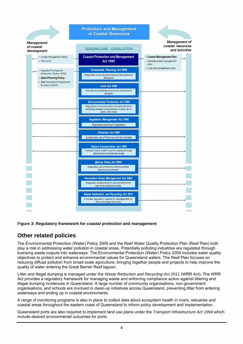
Urban and industrial development is managed to protect coastal resources primarily through the planning and development framework established under the Sustainable Planning Act 2009 (SPA). State requirements for planning and development assessment are identified in the State Planning Policy (SPP) prepared under the SPA. The SPP includes specific outcomes about development assessment to address pressures on the coast and to protect people and property from coastal hazards such as coastal erosion (see figure 3 – Regulatory framework for coastal protection and management). The outcomes to address such pressures will primarily be delivered through local government planning schemes. Coastal development assessment requirements have also been integrated in the State Development Assessment Provisions (SDAP), which set out the matters of interest to the State for development assessment. Further information about the SPP or SDAP can be found on the Department of State Development, Infrastructure and Planning website at www.dsdip.qld.gov.au.
The Coastal Management Plan complements this by providing management policies for use of coastal resources that fall outside the scope of the planning and development requirements under the SPA. The Coastal Management Plan includes a range of measures to achieve objects of the Coastal Act that can be adopted to minimise any potential adverse impacts resulting from use of coastal resources. The Coastal Act also specifically identifies that other relevant legislation should be used wherever practicable to achieve its objects. Decisions made under the SPA to manage development on the coast for example, play a key role in achieving sound coastal management outcomes.
4
Figure 3: Regulatory framework for coastal protection and management
Other related policies The Environmental Protection (Water) Policy 2009 and the Reef Water Quality Protection Plan (Reef Plan) both play a role in addressing water pollution in coastal areas. Potentially polluting industries are regulated through licensing waste outputs into waterways. The Environmental Protection (Water) Policy 2009 includes water quality objectives to protect and enhance environmental values for Queensland waters. The Reef Plan focuses on reducing diffuse pollution from broad scale agriculture, bringing together people and projects to help improve the quality of water entering the Great Barrier Reef lagoon.
Litter and illegal dumping is managed under the Waste Reduction and Recycling Act 2011 (WRR Act). The WRR Act provides a regulatory framework for managing waste and enforcing compliance action against littering and illegal dumping incidences in Queensland. A large number of community organisations, non-government organisations, and schools are involved in clean-up initiatives across Queensland, preventing litter from entering waterways and ending up in coastal environments.
A range of monitoring programs is also in place to collect data about ecosystem health in rivers, estuaries and coastal areas throughout the eastern coast of Queensland to inform policy development and implementation.
Queensland ports are also required to implement land use plans under the Transport Infrastructure Act 1994 which include desired environmental outcomes for ports.

5
Application and Implementation This plan is applied to guide management planning, activities and works that are not assessable development under the SPA.
Land-use planning and development decisions including self-assessable or compliance development, made under the SPA are out of scope for this Coastal Management Plan. The Coastal Management Plan will assist local government when developing a shoreline erosion management plan.
The Coastal Management Plan will also be important in guiding other coastal stakeholders, such as community groups, natural resource management (NRM) bodies, research organisations, businesses, and individuals (see figure 4 – Application of Coastal Management Plan). It applies where these activities affect State coastal land, and coastal resources within the coastal zone. NRM bodies may use the Coastal Management Plan to develop their management plans.
State coastal land includes coastal roads and esplanades (type of road), reserves and unallocated State land3
including land under tidal water. The Coastal Management Plan can also be used to support coastal management outcomes on freehold land and other land tenures that include coastal resources.
The Coastal Management Plan is intended to guide land managers and the land under their control. However it does not bind local government to take action to protect private land from coastal erosion.
3 Roads, reserves and unallocated State land are defined under the Land Act 1994.

6
Figure 4: Application of Coastal Management Plan
• Managers of local and State government-controlled coastal land; for example local government
• Community groups • Natural resource management bodies; for example SEQ NRM • Research organisations • Businesses • Individuals that own coastal land.
• Management planning • Management activities
• Decisions and works that are not regulated under the SPA; for example development of a local government shoreline erosion management plan.
• State coastal land and other land tenures that include coastal resources.
• Non-regulatory best practice coastal management policies.
Applied on
Applied to
Applied by
Coastal Management
Plan
7
Part 2—How coastal land is to be managed
1. Coastal landforms and physical coastal processes
Principle
The long-term stability of dunes and other coastal landforms are preserved and physical coastal processes including erosion, accretion and the movement of sediment are able to occur without interruption.
Coastal management outcomes
1.1 Activities on the coast avoid interrupting the natural fluctuations of the coast (erosion and accretion).
1.2 Land stabilisation against wind and water erosion, and dune-building processes are maintained or enhanced by protecting, managing and rehabilitating native vegetation.
1.3 Dunes, mangroves and coastal wetlands that protect or buffer communities, infrastructure and terrestrial ecosystems from coastal hazards are maintained or enhanced, or where changes to these features cannot be avoided, risks to the community are mitigated.
1.4 Dune crest heights and sand volume in the active beach system are maintained for the protection of adjacent property, structures and coastal resources against storm wave attack and wave over wash processes.
1.5 Longshore transport of sand or delivery of sediment to the coast is not disrupted unless:
• it can be demonstrated that this does not adversely affect coastal processes, or
• impacts are mitigated by works including sand bypassing or beach nourishment.
1.6 Where there is an imminent threat to the community or infrastructure from coastal erosion, development of a shoreline erosion management plan (SEMP) is recommended to deliver a science-based solution to the erosion problem that considers social, environmental and economic issues.
1.7 Management planning for assets in areas at risk from erosion should consider the following hierarchy of approaches to maintain coastal processes and resources: avoid, retreat, accommodate or defend.
1.8 Where defence of coastal assets is the most suitable option, beach nourishment; which restores sediment supply and transport, is the preferred option over hard structures (such as sea walls), which can interfere with natural coastal processes. Where seawalls are considered, beach nourishment should be also be undertaken to balance the loss of sediment locked up behind the walls.
1.9 Sediment which is dredged or excavated from within an erosion prone area and is not allocated for another purpose, is to be retained wherever practicable within the erosion prone area and placed on the dunes, beaches, banks or other tidal areas at an approved disposal site.
1.10 The impacts of climate variability including sea level rise are considered in managing the coast.
Policy context
The natural forces of sea and weather drive coastal processes which continually reshape the coast by cycles of erosion and accretion. Coastal erosion is shoreline recession due to erosion by wave and tidal forces resulting in a permanent loss of land. Accretion is the natural build-up of coastal landforms with sediment supplied by wave, tidal flow or wind processes, usually assisted by vegetation trapping the sediment. A typical example of accretion is dune build-up with sand blown up from the beach. Sediment transport is also a key coastal process which maintains or builds beaches, dunes and other landforms. These policies are to ensure coastal processes are maintained to preserve beaches, which are highly valued recreational and aesthetic assets, and prevent new erosion threats which can be caused by removing sediment or disrupting its transport along the coast and impact on existing development.
Natural coastal landforms, physical coastal processes and natural ecosystems and habitats are interdependent and provide essential ecosystem services. Coastal vegetation (e.g. dunes, freshwater estuarine and marine wetlands) stabilises sediment and processes nutrients which promotes healthy groundwater and surface water processes and water quality. Dunes have highly permeable soils functioning as aquifers, by holding groundwater in the intergranular voids between sand grains. Dunes regulate hydrology of freshwater wetlands and perform an important role in water quality polishing and groundwater movement along the shoreline between freshwater wetlands, land and sea.

8
The Department of Environment and Heritage Protection’s (EHP) preferred method for managing shoreline erosion; including estuaries and tidal reaches of rivers, is preparing and implementing a SEMP. A SEMP is used to investigate the causes and expected future impacts of erosion, analyse management options, and recommend a solution, with consideration to social, economic and environmental issues. A SEMP can also include information about related policy requirements that may impact how erosion is managed, for example fish habitat area policies regulated under the Fisheries Act 1994. Further information about how to prepare a SEMP is available from the EHP website at www.ehp.qld.gov.au. SEMP's are commonly undertaken by local government either for council controlled land or on behalf of a community. But individuals or groups may also prepare a SEMP. SEMP's may form part of a broader strategic management or adaptation framework for a region which also considers land use, dune management, recreational opportunity and commercial activities.
Coastal hazards are a reference to coastal erosion and storm tide inundation. Further information about coastal hazards can be found on the EHP website at www.ehp.qld.gov.au. For maps identifying areas that may be vulnerable to the risk of adverse coastal hazard impacts, refer to the Department of Development, Infrastructure and Planning (DSDIP) website http://www.dsdip.qld.gov.au/
Dunes and other coastal landforms
Human-induced changes to dune systems and degraded dune vegetation can significantly limit the protection provided to development from coastal hazards, cause wind erosion problems and adversely impact on neighbouring landforms.
Vegetation is important to form and stabilise coastal sand dunes. Vegetation on the beach and dunes tends to occur in zones, according to the degree of exposure to harsh coastal conditions. Closest to the sea is the pioneer zone, extending landward from the debris line at the top of the beach in an area called the foredune or frontal dune.
Pioneer plants trap and hold windblown sand in the foredune and help create conditions that encourage other plant communities such as woodland, scrub, heath and forest to establish and grow. All plants, whether they are herbs, shrubs or trees, growing either singly or in groups, have a role in developing vegetative cover and together they help stabilise dunes. A well vegetated riparian zone is important to stabilise creeks, rivers and estuaries and provide resilience to pressures such as sea level rise, storms and floods.
Windblown sand, trapped in the foredune by vegetation, serves as a reservoir of sand for the beach during periods of wave erosion. In the absence of sand-trapping dune vegetation, windblown sand from the beach moves inland and is lost to the beach and dune system. Wind erosion of the beach and un-vegetated foredunes causes coastline recession. The above-ground parts of dune plants act as obstructions, increase surface roughness and reduce the surface speed of sand-carrying wind. Sand spinifex grass (Spinifex sericeus) is the most successful sand trapping plant colonising dunes along most of the Queensland coastline, having the ability to grow through accumulations of windblown sand. Cycles of sand deposition and plant growth form and build dunes.
Rehabilitating a degraded dune system includes stabilising the surface against wind erosion and establishing endemic dune plants to provide long-term stability and reinstate sand trapping and dune building processes. Management actions may include enrichment planting to increase biodiversity and managing pest plants and animals. Pests compete with native plants and animals for habitat, food, light and nutrients. Sometimes, they out-compete the native plants and animals and reduce habitat quality, diversity and aesthetic and recreational value.
Pest management plans or strategies should be developed identifying priority actions for preventing and controlling invasive pests. The Land Protection [Pest and Stock Route Management] (Land Protection Act) Act 2002 requires every local government in Queensland to develop a pest management plan for their area. Refer to the Department of Agriculture, Fisheries and Forestry website at http://www.daff.qld.gov.au/plants/weeds-pest-animals-ants/pest-management-planning/index-to-plans/local-government-area-pmps.
Dune vegetation is naturally exposed to harsh environmental conditions, including sand blast, salt spray and high wind velocities. This can make dunes vulnerable to even small additional pressures, including impacts such as pedestrian use, grazing stock and four wheel drive vehicles. To maintain dune stability against wind erosion, these pressures may be managed by exclusion or providing fenced and hardened access points for pedestrians, and increasing stock or plant vigour by periodic fertilising.
Management and rehabilitation efforts vary in cost, intensity, resource requirements, timeframes, and the suitability of techniques to particular sites and situations. Ongoing maintenance is required to ensure they are effective. It may be useful to develop maintenance checklists that note necessary approvals, insurance, standards and notifications to be checked and, as needed, rectified each time the site is visited.
In addition to dunes, a well vegetated zone along the banks of rivers, creeks, estuaries and other wetlands is important to maintain the biodiversity and ecological function of these systems and to provide resilience to pressures such as climate variability, storms and floods.

9
2. Nature conservation
Principle
Matters of state environmental significance (MSES) are conserved by avoiding impacts or where impacts cannot be avoided residual impacts are mitigated through rehabilitation measures.
Coastal management outcomes
2.1 Areas containing MSES are conserved by:
• protecting areas containing MSES, sensitive natural ecosystems, their process and habitat (particularly feeding, nesting and roosting sites) from threats4, and
• maintaining, enhancing or re-establishing habitat connectivity for species movement.
2.2 Where impacts on MSES cannot be avoided, impacts are mitigated by actions such as restoring or rehabilitating natural environmental values of similar or adjacent habitat or other actions that reduce threats to MSES.
Policy context
MSES have a critical role in maintaining biodiversity and ecosystem processes and ecosystem services of coastal land and coastal resources. MSES are drawn from matters protected by existing State environmental and natural resource legislation.
This policy seeks to protect MSES, including those identified on maps and additional areas identified by coastal land managers. Protection includes ensuring pedestrian, tourist and marine activities are managed to avoid adverse effects on ecological values. Management actions may include: seasonal and night closures of turtle nesting beaches and preventing artificial light pollution, education about threats to the coastal environment or seasonal closures at times when migratory birds are present or other species are nesting.
The protection of a broader suite of environmental values will further contribute to maintaining healthy and resilient ecosystems and ensure sustainable, long-term conservation of biodiversity. In many cases, mapping is available to indicate the presence of other environmental values such as remnant vegetation or koala rehabilitation areas. MSES mapping layers are available from the DSDIP website: http://www.dsdip.qld.gov.au/about-planning/spp-mapping-online-system.html. The MSES mapping methodology can be found on the EHP website: http://www.ehp.qld.gov.au/land/natural-resource/method-mapping-mses.html. Other environmental values mapping, including property or area-based reports can be obtained from the EHP website at www.ehp.qld.gov.au. The relevant local authority may also be contacted for other applicable environmental values mapping.
4 Threats include: clearing and degrading of vegetation, uncontrolled pedestrian or vehicle traffic, pollution, marine debris
(including lost or discarded fishing gear), light pollution, seagrass dieback, drainage of habitat, boat strikes and pest plants and animals.
Suggested management actions
Exclusion fencing to protect dunes. Providing fenced and hardened access points for pedestrians. Periodic fertilising to increase stock or plant vigour. Ensuring banks of rivers, creeks, estuaries and wetlands are vegetated. Developing site specific maintenance checklists that identify necessary approvals, insurance,
standards and notifications.
10
Protecting MSES through management of beach driving
Activities such as beach driving should be actively managed to prevent significant adverse impacts on coastal ecosystems, including beach and benthic plants and animals. Research indicates that compaction of sand by vehicles is destructive for sand-dwelling invertebrates. Vehicle traffic can also disturb feeding or roosting shorebirds and nesting turtles and destabilise dune systems by damaging the vegetation.
Generally vehicle access to and along foreshore areas is regulated by local governments under the Local Government Act 1993. Additionally, councils are often appointed as the trustee of State coastal reserves.
The Department of National Parks, Recreation, Sport and Racing (NPRSR) has jurisdiction to regulate the use of vehicles on beaches that are within protected areas under the Nature Conservation Act 1992, in marine parks under the Marine Parks Act 2004 and in declared recreation areas under the Recreation Areas Management Act 2006.
Once specific regulations or laws are in place to govern vehicle access, the Transport Operations (Road Use Management) Act 1995 can be administered on these beaches by the authority that regulates access (i.e. NPRSR, if within a protected area; or local government in all other instances).
Prior to allowing beach driving, the relevant authority should have a qualified and experienced ecologist prepare a report identifying the relevant ecological and species values of the beach. The report should recommend how adverse impacts on these values (caused by beach driving) can be minimised.
Where it is necessary to allow beach driving to provide access to foreshore or adjacent areas, adverse impacts are managed using a range of tools including: a permit system, speed limits, closure during the period two or more hours each side of high tide, night closures, temporary or permanent diversions onto inland tracks that avoid sensitive areas, and seasonal closures during nesting periods for sea turtles and times when migratory bird species are present.
Where vehicles are used on beaches, they should be driven below the drift line, away from dune vegetation. Vehicles also should not be driven along debris or drift lines, as these often harbour wildlife.
Specific regulations or local laws, using signs and physical exclusion devices will help ensure compliance with conditions for vehicle use of beaches. A regular compliance presence will also be necessary.
Revenue raised through a beach driving permit system can be used to offset the costs of coastal protection and rehabilitation programs.
Suggested management actions
Seasonal and night closures of turtle nesting beaches. Preventing artificial light pollution on turtle nesting beaches. Seasonal closures for areas with nesting migratory birds or other protected species. Pest control at turtle nesting beaches. Beach clean ups to remove marine debris. Education about the impacts of boat strikes and marine debris on MSES. Regulating beach driving by-
o introducing a permit system o speed limits o beach closures o seasonal and night closures for protected species, and o restricting vehicle access to below the drift line, away from dune vegetation.
Rehabiliting damaged vegetation.

11
3. Indigenous cultural heritage
Principle
Aboriginal People and Torres Strait Islanders are the primary guardians, keepers and knowledge holders of their cultural heritage; their connection to coastal and marine resources should be maintained and enhanced.
Coastal management outcomes
3.1 Management plans and programs should engage Traditional Owners to enable access to coastal resources for cultural activities.
3.2 Changes to arrangements to allow access to cultural resources, including beach driving and access to facilities, should occur in consultation with relevant Traditional Owners to prevent any adverse impacts on cultural resources.
Policy context
Traditional Owners have been managing their cultural resources for millennia as part of their cultural practices. Currently, a number of factors affect the ability of Traditional Owners to be involved in the ongoing management of land. These factors include: land tenure, access rights, and financial capacity.
Incorporating Indigenous knowledge about land and sea management contributes significantly to achieving the objects of the Coastal Act.
Both the Aboriginal Cultural Heritage Act 2003 and the Torres Strait Islander Cultural Heritage Act 2003 (the cultural heritage acts) provide for effective recognition, protection and conservation of Aboriginal and Torres Strait Islander cultural heritage. The cultural heritage acts recognise that traditional owner participation in activities involving the conservation and management of cultural heritage is important as this allows Traditional Owners to reaffirm their obligations to country.
The cultural heritage acts establish a duty of care that requires all land users to take all reasonable and practicable measures to ensure their activities do not harm Aboriginal or Torres Strait Islander cultural heritage.
Consultation with the Aboriginal or Torres Strait Islander party for an area may be necessary if there is a high risk that the activity may harm Aboriginal or Torres Strait Islander cultural heritage.
The cultural heritage duty of care can be met by acting:
• in compliance with gazetted cultural heritage duty of care guidelines
• under an approved Cultural Heritage Management Plan (CHMP) developed under Part 7 of the acts
• under a native title agreement or another agreement with an Aboriginal or Torres Strait Islander party, unless cultural heritage is not subject to the agreement.
Traditional Owners in many areas have developed plans for the sustainable management of marine resources through processes including Traditional Use of Marine Resources Agreements (TUMRA) and Sea Country Plans. In the Great Barrier Reef Marine Park, Traditional Owners work in partnership with the Australian and Queensland governments to manage cultural activities in sea country through theTUMRA. A TUMRA implementation plan may also describe ways to educate the public about traditional connections to sea country, and to educate other members of a Traditional Owner group about the conditions of the TUMRA. Traditional Owners may also enter into an agreement with NPRSR on the use of marine resources within state marine parks.
Sea Country Plans focus on the sustainable management of marine resources and have also been developed in areas within the Great Barrier Reef Marine Park and the east and west coasts of Cape York. Additionally, plans have been developed by Traditional Owner and ranger groups throughout central and southern Queensland. The plans describe Indigenous community and other interested parties’ objectives for the conservation and management of sea country.
Indigenous Land and Sea Rangers work in many regional communities throughout Queensland to achieve environmental outcomes and raise awareness of the importance of looking after country, land and sea. Many rangers are also Traditional Owners of the areas in which they work. Engaging Land and Sea Rangers and Traditional Owners is an important element in achieving sound coastal management outcomes.

12
4. Public access and enjoyment of the coast
Principle
Public access and use of the coast is maintained or enhanced for current and future generations.
Coastal management outcomes
4.1 Public access and use of the coast is maintained by avoiding the use of State coastal land for:
• creating exclusive private access to the foreshore
• creating exclusive private use of beaches
• locating erosion control structures to protect private property from coastal erosion.
4.2 The use of undeveloped esplanades and road reserves vulnerable to coastal erosion for vehicular access is supported if they provide the only lawful means of vehicular access.
4.3 The use of State coastal land for public beach access and associated facilities is encouraged if the facilities are located, designed, constructed and managed to conserve coastal resources and their values.
4.4 Beach driving is supported where:
• no practical alternative to access the coast exists or can be reasonably established
• management ensures there are no significant adverse impacts to the stability of dunes, coastal ecosystems or species
• it does not adversely affect public access to and enjoyment of beaches and foreshore areas by other users, including pedestrians.
Policy context
This policy intends to ensure there is no net loss of public access to the foreshore, coastal waters or State coastal land, and ensure that State coastal land continues to contribute to coastal management outcomes.
State and local government may encounter strong pressure from property owners to locate erosion control structures on State coastal land (including on esplanades and beaches) to protect private property. However, using public land for this purpose is generally considered inappropriate. Structures to protect private properties should be located on private land. Only where it is demonstrated that this is not practicable and it is in the public interest, appropriate authority may be considered to provide for a structure on public land and granted to a public authority.
Without careful management some existing uses of State land, such as unapproved beach or fishing huts or jetties, could potentially influence future settlement patterns. These structures are generally inappropriately sited within areas vulnerable to coastal hazards, sometimes potentially leading to significant long-term costs to the community if settlements were to subsequently develop. The Land Act 1994 provides for administering of permits to occupy (if that is determined to be an acceptable tenure solution) that do not establish a permanent use right.
The preferred approach for existing access infrastructure such as roads and tracks is for continued maintenance and management. Where they become impassable from erosion or storm damage, and it is not feasible to reinstate their existing alignment, an alternative alignment consistent with the overall policy outcomes of the Coastal Management Plan should be determined by the relevant management authority.
Establishing public access through sensitive areas such as dunes may degrade or destabilise these areas, especially by damaging vegetation which can lead to wind erosion and dune blow-outs. Access must be located, designed, constructed and maintained to avoid these adverse impacts and should consider solutions appropriate to the level of use and risk from providing the access.
Suggested management actions
Consult with Traditional Owners about activities involving the conservation and management of cultural heritage.
Refer to TUMRA, Sea Country Management Plans and their implementation plans.
13
Beaches that are used for the driving or riding of motor vehicles (whether on payment of a fee or otherwise) are roads under the Transport Operations (Road Use Management) Act 1995 and all road rules apply. Allowing beach driving, where it is necessary to provide access to the foreshore or adjacent areas should be actively managed to maintain public access and enjoyment.
Options employed to manage beach driving include: the use of a permit system, speed limits, and closures during peak periods including seasonal closures, temporary or permanent diversions on to inland tracks that avoid popular beach areas, and prohibitions. An assessment of how the beach would preferably be used by vehicle owners and other users, including consultation with affected user groups, should guide these types of management decisions.
5. Management planning
Principle
Managing and using coastal land is planned, monitored, reported on and reviewed to achieve continuous improvement in management outcomes.
Coastal management outcomes
5.1 Coastal land managers are encouraged to prepare and implement local plans, where appropriate, to guide activities consistent with the management policies of this Coastal Management Plan.
5.2 The community, Traditional Owners, State and local government land owners and land managers, relevant interest groups including natural resource management bodies, and other stakeholders such as local business owners, should be consulted when preparing local plans.
5.3 Local management plans should preferably incorporate a framework for assessing the effectiveness of management practices and decisions over time by:
• establishing extent and condition of resources, and measurable performance indicators
• committing to an associated monitoring, reporting and review program.
Policy context
The type, structure, content and implementation mechanisms identified in a management plan are at the discretion of the State coastal land manager and should be tailored to suit the purpose for which the land is used and any special management considerations.
EHP can provide support and guidance about the coastal management components of a management plan. The Land Act 1994 makes provision for trustees to prepare and submit a land management plan for trust land they manage.
A trustee may be requested to prepare a land management plan for the primary use, and is generally required to prepare a land management plan for trust land subject to secondary uses (refer to the Department of Natural Resources and Mines’ Policy Secondary Use of Trust Land PUX/901/209). Also the Land Protection [Pest and Stock Route Management)] (Land Protection Act) Act 2002 requires every local government in Queensland to develop a pest management plan for their area. Refer to the Department of Agriculture, Fisheries and Forestry website at http://www.daff.qld.gov.au/plants/weeds-pest-animals-ants/pest-management-planning/index-to-plans/local-government-area-pmps
Suggested management actions
Maintain and manage public access walkways and recreational facilities. Placement and design of access infrastructure minimises impacts on coastal resources. Beach driving manages access using-
o a permit system o speed limits o closures during peak periods, or o temporary or permanent diversion tracks; that avoid popular beaches.

14
A sample management plan template for coastal areas is included in Appendix 1. To avoid duplication, a management plan could be tailored to include Coastal Management Plan considerations and address requirements under the Land Act 1994 and Land Protection Act 2002.
The Land Management Planning for Reserves or Deeds of Grant in Trust–Information Kit provides guidance about how to prepare these plans. It is available from the Department of Natural Resources and Mines website at www.dnrm.qld.gov.au.
6. Knowledge sharing and community engagement
Principle
Knowledge of coastal resources and their management is shared with the community and the community is engaged in decision-making processes and activities that affect them.
Coastal management outcomes
6.1 Coastal land managers actively engage the community and share knowledge of coastal management issues, planning and activities through:
• providing opportunities for direct consultation with the community and special interest groups about management proposals and decisions
• encouraging and facilitating the sharing and use of knowledge, including traditional Indigenous knowledge of country, to promote awareness and understanding of coastal issues and environmentally responsible behaviours (stewardship) in the community
• encouraging and facilitating the active participation of the community, including special interest groups in managing their coastal areas where appropriate
• facilitating participation, collaboration and integration within and between programs and community networks.
Policy context
Awareness and understanding of coastal issues can be encouraged within communities through community-based social marketing strategies and providing education and awareness programs and information. This is best achieved at the local level.
Effective coastal management must involve all stakeholders and members of the public. Effective collaboration and partnerships are more likely to improve coastal management outcomes because they combine resources to help reduce costs, recognise diversity in approaches, and coordinate management activities.
Regional natural resource management bodies, community groups and individuals currently commit funding, time, and effort to prepare strategies, such as integrated catchment management plans and natural resource management strategies. They also contribute to on-the-ground works and activities, such as rehabilitation projects that help manage coastal areas. This contribution can be supported by sourcing funding and knowledge from local, state and federal government, and industry programs. An integrated approach that uses indigenous knowledge and contemporary science together may further improve outcomes for community-based initiatives.
Suggested management actions-
Establish a local management plan that includes-
o resource extent and condition performance indicators o monitoring, reporting and review requirements.
Consult with the broader community when developing a local management plan.

15
Review of the Coastal Management Plan The Coastal Act stipulates that a coastal plan only has effect for 10 years, after which time it must be replaced.
Suggested management actions
Develop key stakeholder lists for consultation on coastal management issues.
Use a variety of methods to engage with the community and local interest groups including- o direct contact with stakeholders o advertising management plans in newspapers o community workshops o workshops with tertiary institutions.
16
Glossary Coastal hazard as defined in the Coastal Protection and Management Act 1995.
Coastal resources as defined in the Coastal Protection and Management Act 1995. It includes natural and physical features and landforms, vegetation, wildlife, quarry material, soil, water and places and objects that have anthropological, archaeological, historical, scientific, spiritual, visual or sociological significance or value, including such significance or value under Aboriginal tradition or Island custom.
Coastal processes are the natural processes of the coast, including sediment transport to and along the coast; fluctuations in the location and form of the foreshore, beaches, dunes and associated ecosystems; waves; tides and tidal currents; changes in sea-level and coastal hazard, hydrological processes including groundwater, ecological processes (for example, migration of plant and animal species) and the natural water cycle (for example coastal wetlands' role in filtration and flood mitigation).
Ecosystem services are the life support systems all living creatures (including humans) rely on. These include:
• provision of services such as oxygen, food and water
• regulating services such as regulation of climate, land degradation, and disease
• supporting services such as soil formation and nutrient cycling for agriculture, and
• cultural services such as recreational, spiritual, religious, and other non-material benefits for recreation and tourism.
Imminent threat is a one in 100 year event (including waves and storm tide). For details on the short-term erosion event see section on the short-term component of erosion prone areas in the Coastal Hazards Technical Guide available on the EHP website: http://www.ehp.qld.gov.au/coastalplan/pdf/hazards-guideline.pdf.
Matters of state environmental significance (MSES) includes matters protected by existing State environmental and natural resource legislation. The MSES mapping methodology can be found on the EHP website: http://www.ehp.qld.gov.au/land/natural-resource/method-mapping-mses.html.
State coastal land as defined in the Coastal Protection and Management Act 1995.

17
Appendix 1
Sample management plan template for coastal areas
Note: For guidance only. Different styles and content may suit different scenarios.
Introduction
Requirement for a land management plan
Process
Working group
Consultation
Use of this plan
Implementation.
Background
Legislative and policy setting
Land management plan area (map)
Objectives of the land management plan.
Critical management considerations (may) include:
Population growth
Visitor growth
Foreshore stability considering variable sea levels
Vegetation management
Commercial use and leased areas
Unmanaged foreshore and reserve access
Management resources for implementing the plan
Monitoring and evaluating the plan.
Desired outcomes and actions
Area 1: xxxx
Preamble
Land tenure
Historical changes
Vegetation description.
Coastal management issues and actions (may) include:
1. Pedestrian access
2. Passive recreation
3. Vehicular use of beaches, trail bikes, horse riding
4. Camping and occupation
5. Fire management
6. Vegetation management
7. Management of other coastal resources
8. Management of coastal erosion and shoreline retreat (refer to EHP’s shoreline erosion management plan)
9. Restoration of degraded dune systems
10. Pest, including weed control
11. Water quality.
Glossary and abbreviations
References
Appendices
Maps
Background information
Practice guidelines
Foreshore proclamation
Bathing reserve
Recreation area