Coastal and marine environment - EPA
39
191 Coastal and marine environment 1 Why is it important? South Australia’s marine environment spans more than 60 000 square kilometres of waters and more than 5000 kilometres of coastline (Geoscience Australia 2010). The coast, estuaries and adjacent marine waters are a unique part of the South Australian environment. It is a distinct, complex and interconnected natural system, with finite resources that are vulnerable to overuse and degradation when not well managed. 1.1 Unique features and species endemism Australia’s long period of geologic isolation from the rest of the world (more than 65 million years), the state’s extensive continental shelf, the long east–west ice-free extent of the southern coastline, and the characteristic low nutrient condition of coastal waters have all contributed to the biological richness and endemism of South Australia’s temperate marine environments (Edyvane 1999). South Australia has a wide range of coastal landforms and marine habitats, and also a variety of oceanographic conditions, including a high degree of variability in sea temperatures. Of particular significance are the two large, sheltered tidal gulf ecosystems of Gulf St Vincent and Spencer Gulf, which provide habitat for some of the largest areas of temperate mangrove, seagrass and tidal saltmarsh communities in Australia. In addition, the marine fauna and flora of South Australia include both the typical cold temperate biota of Tasmania, Victoria and southern New South Wales and the transitional warm to cool temperate biota of southern Western Australia. A range of habitats is evident, from warm salty waters in the gulfs to cool- water kelp forests in the south-east, and from the low- productivity waters of the Great Australian Bight to the nutrient-rich upwellings of the south-east. These factors have combined to produce a rich diversity of organisms and communities along the South Australian coast, which is unparalleled in Australia and the world (Edyvane 1999). South Australian waters support more than 6000 invertebrate species, 350 fish species, 16 breeding seabird species, 33 mammal species, 1200 algae species and 12 seagrass species. In the Southern Ocean, 75% of the red algae species, 85% of the fish species and 95% of the seagrass species are found nowhere else in the world, giving them local, national and international significance (Government of South Australia 2004). The largest breeding colonies of Australian sea lion, and more than 80% of the total population, are found in our state. South Australia also has 32 species of whales and dolphins and more than 70 species of seabirds, including little penguin, osprey and the white-bellied sea eagle. We are still to discover some of the many species of invertebrates. South Australia has 24 coastal wetlands that support populations of migratory birds of conservation significance. Opposite page: Yellow-nosed albatross (Diomedea chlororhyncos Lath.) Richter HC in Gould’s birds of Australia, National Library of Australia an10049041
Transcript of Coastal and marine environment - EPA

191
Coastal and marine environment
1 Why is it important?
South Australia’s marine environment spans more than 60 000 square kilometres of waters and more than 5000 kilometres of coastline (Geoscience Australia 2010). The coast, estuaries and adjacent marine waters are a unique part of the South Australian environment. It is a distinct, complex and interconnected natural system, with finite resources that are vulnerable to overuse and degradation when not well managed.
1.1 Unique features and species endemism
Australia’s long period of geologic isolation from the rest of the world (more than 65 million years), the state’s extensive continental shelf, the long east–west ice-free extent of the southern coastline, and the characteristic low nutrient condition of coastal waters have all contributed to the biological richness and endemism of South Australia’s temperate marine environments (Edyvane 1999). South Australia has a wide range of coastal landforms and marine habitats, and also a variety of oceanographic conditions, including a high degree of variability in sea temperatures.
Of particular significance are the two large, sheltered tidal gulf ecosystems of Gulf St Vincent and Spencer Gulf, which provide habitat for some of the largest areas of temperate mangrove, seagrass and tidal saltmarsh communities in Australia. In addition, the marine fauna
and flora of South Australia include both the typical cold temperate biota of Tasmania, Victoria and southern New South Wales and the transitional warm to cool temperate biota of southern Western Australia. A range of habitats is evident, from warm salty waters in the gulfs to cool-water kelp forests in the south-east, and from the low-productivity waters of the Great Australian Bight to the nutrient-rich upwellings of the south-east. These factors have combined to produce a rich diversity of organisms and communities along the South Australian coast, which is unparalleled in Australia and the world (Edyvane 1999). South Australian waters support more than 6000 invertebrate species, 350 fish species, 16 breeding seabird species, 33 mammal species, 1200 algae species and 12 seagrass species. In the Southern Ocean, 75% of the red algae species, 85% of the fish species and 95% of the seagrass species are found nowhere else in the world, giving them local, national and international significance (Government of South Australia 2004).
The largest breeding colonies of Australian sea lion, and more than 80% of the total population, are found in our state. South Australia also has 32 species of whales and dolphins and more than 70 species of seabirds, including little penguin, osprey and the white-bellied sea eagle. We are still to discover some of the many species of invertebrates. South Australia has 24 coastal wetlands that support populations of migratory birds of conservation significance.
Opposite page: Yellow-nosed albatross (Diomedea chlororhyncos Lath.)
Richter HC in Gould’s birds of Australia, National Library of Australia an10049041

Coas
tal a
nd m
arin
e en
viro
nmen
t
192
In summary
Aspect and observation Assessment grade ConfidenceVery poor Poor Good Very good In grade In trend
Extent and condition of coastal and marine ecosystems
The extent and condition of coastal ecosystems (including foreshore, rocky reefs, seagrass, saltmarsh and mangroves) are declining.
• � �
Disturbance and pollution
The quality and use of treated wastewater are increasing.The capture and reuse of stormwater are increasing.The area occupied by aquaculture is increasing.Human population in the coastal zone is increasing. The quality of coastal and marine waters is improving.
• � �
Threatened species and ecosystems
Marine protected areas have increased in size and number.New fishery recovery strategies have been implemented.There has been an increase in some species (e.g. New Zealand fur seal and southern right whale).Ocean salinity and currents are changing.Ocean acidity is increasing. Sea level is rising. Coastal and marine ecosystem extent, condition and diversity are variable and declining.There is a decline in some species (e.g. giant cuttlefish and little penguin).
• � �
Pest plants and animals
Port handling and shipping traffic has increased, which increases the risk of pest species incursions. • � �
Recent trend
• Improving • Stable Level of confidence
� Evidence and consensus too low to make an assessment
• Deteriorating • Unclear � Limited evidence or limited consensus
� Adequate high-quality evidence and high level of consensus
Grades Very poor Poor Good Very good

Coastal and marine environm
ent
193Within the Flindersian Province, a biogeographic region that extends across the southern coast of Australia, approximately 1155 species of macroalgae, 22 species of seagrass, 600 species of fish, 110 species of echinoderms and 189 species of ascidians have been recorded (Lewis et al. 1998). Of these, approximately 85% of fish species, 95% of molluscs and 90% of echinoderms are endemic. In contrast, approximately 13% of fish, 10% of molluscs and 13% of echinoderms are endemic in the tropical regions of Australia. Similarly, marine macrofloral diversity and endemism in the temperate regions of Australia are among the highest in the world. The richness of the temperate macroalgal flora (i.e. 1155 species) is 50–80% greater than for comparable regions around the world, with approximately 800 species and more than 75% endemism recorded in red algae alone. The level of temperate species biodiversity in macroalgae is approximately three times the level recorded in the tropical regions of Australia, where approximately 200–400 species of macroalgae have been described (Edyvane 1999).
South Australia has many fish species of conservation significance, including two types of seadragons, and several species of seahorses and pipefish, as well as the world’s largest known breeding aggregation of Australian giant cuttlefish (Steer et al. 2013). Our waters are feeding grounds for endangered blue whales, bottlenose dolphins, and sperm and pilot whales, and attract increasing numbers of southern right whales to breed and calve each year. At the other end of the spectrum, our waters are also home to the world’s smallest live-bearing starfish, known locally as ‘Little Patty’, which is found in only one location on the west coast of Eyre Peninsula.
Ninety metre–high limestone cliffs extend from the Western Australian border to Cape Adieu, and Spencer Gulf has some of the largest mangrove forests in southern Australia. South Australia has the second largest (after Western Australia) area of temperate-water seagrass meadows. The Coorong, as well as being a wetland of international importance, also has the largest high-energy beaches in the Southern Hemisphere. Colourful sponge gardens can be found in the shallow waters of Pelican Lagoon and Bay of Shoals off Kangaroo Island. The deep trenches at Backstairs Passage have sponges that are more than one metre in diameter, and gorgonian corals. Underwater forest communities of giant kelp reaching up to 30 metres tall can be found in the south-east, along with the smaller intertidal and subtidal bull kelp.
1.2 Ecosystem services
Seagrasses dominate the South Australian sheltered nearshore habitats and provide important spawning and nursery areas for a wide variety of fish and invertebrates. Seagrass performs many functions, including nutrient cycling, carbon storage, reducing coastal erosion (by stabilising sand and attenuating wave action) and filtering out suspended solids in the water column.
Rocky reefs and their macroalgae create complex habitats and support some of the most productive and biologically diverse ecosystems. These systems have been shown to be important spawning and nursery areas for a wide variety of fish and invertebrates, and contribute to biodiversity and ecosystem services. They are also easily accessible to humans.
South Australia’s coastal, estuarine and marine ecosystems provide a large number of ecosystem services that have yet to be quantified. Provisioning, regulating, cultural and supporting services include food supply, bioprospecting, flood and storm protection, education, research and nutrient cycling.
1.3 Economic and social benefits
More than 90% of South Australians live within 50 kilometres of the coast (ABS 2002), and many rely on the coast and adjacent marine waters for their livelihood. Social and economic benefits from the coast and marine environment include benefits from recreation, tourism, urban development, commercial fisheries and aquaculture, shipping and transportation, coastal agriculture, mining, manufacturing, science and education.
Fishing (both commercial and recreational) and aquaculture (tuna, oysters, mussels, abalone, freshwater and marine finfish, marron, yabbies and others) have become increasingly economically important to South Australia; the total value of seafood production in 2010–11 was almost $426 million (EconSearch 2012). South Australia’s total seafood production in 2009–10 was approximately 68 000 tonnes, of which aquaculture contributed approximately 49%. Tuna is the largest single sector in the state’s aquaculture industry, accounting for approximately 53% of the state’s gross value of aquaculture production in 2009–10. The other two main sectors are oysters (18%) and marine finfish (14%) (EconSearch 2011). The industry is expected to contribute $306 million to gross state product in 2010–11 (EconSearch 2012).

Coas
tal a
nd m
arin
e en
viro
nmen
t
194
2 What do we know about it?
Nearshore Australian coastal and marine environments are classified into 60 distinct marine biogeographical regions. Each of these bioregions can be considered a large marine ecosystem, with biological and physical characteristics that are distinct from those elsewhere in Australia. These ecosystems have distinctive oceanographic and ecological characteristics, comprising different proportions of habitat types, and are home to a variety of species, some with only limited distribution. The eight marine bioregions in South Australia—Eucla, Murat, Eyre, Spencer Gulf, North Spencer Gulf, Gulf St Vincent, Coorong and Otway—are shown in Figure 1.
2.1 Bioregional environmental assessment
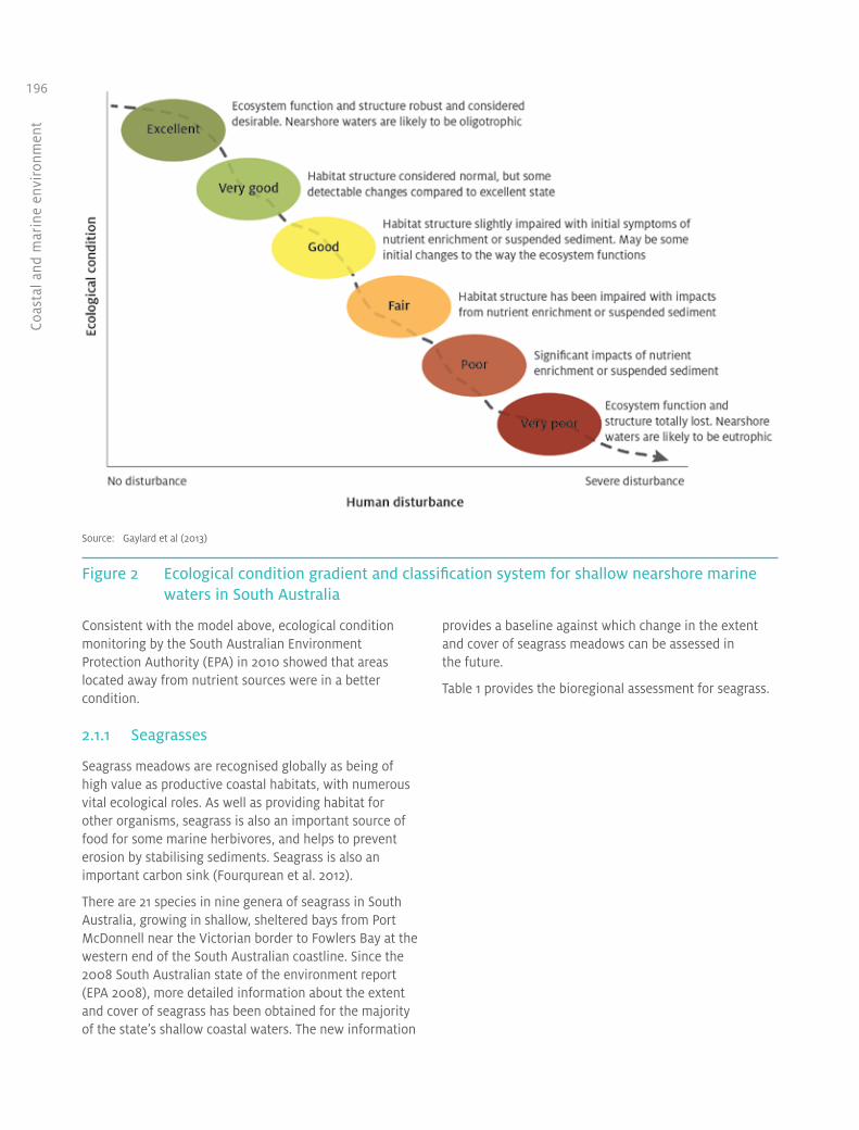
Key ecosystems, habitats and species that make up the South Australian coastal and marine environments have been assessed; they include seagrasses, reefs, sandflats and mudflats, estuaries, beaches and dunes. The information is provided at bioregional scale, where possible. The assessment of South Australia’s shallow coastal waters is based on a classification system that incorporates seagrass and reef habitat condition indices, and water quality parameters. The classification system is based on a model of change in biological condition along a gradient of human disturbance (Figure 2).
Figure 1 South Australia’s marine bioregions

Coastal and marine environm
ent
195
Southern right whale cow and calf, Great Australian Bight Marine Park
Saras Kumar, Department of Environment, Water and Natural Resources
Coas
tal a
nd m
arin
e en
viro
nmen
t
196
Source: Gaylard et al (2013)
Figure 2 Ecological condition gradient and classification system for shallow nearshore marine waters in South Australia
Consistent with the model above, ecological condition monitoring by the South Australian Environment Protection Authority (EPA) in 2010 showed that areas located away from nutrient sources were in a better condition.
2.1.1 Seagrasses
Seagrass meadows are recognised globally as being of high value as productive coastal habitats, with numerous vital ecological roles. As well as providing habitat for other organisms, seagrass is also an important source of food for some marine herbivores, and helps to prevent erosion by stabilising sediments. Seagrass is also an important carbon sink (Fourqurean et al. 2012).
There are 21 species in nine genera of seagrass in South Australia, growing in shallow, sheltered bays from Port McDonnell near the Victorian border to Fowlers Bay at the western end of the South Australian coastline. Since the 2008 South Australian state of the environment report (EPA 2008), more detailed information about the extent and cover of seagrass has been obtained for the majority of the state’s shallow coastal waters. The new information
provides a baseline against which change in the extent and cover of seagrass meadows can be assessed in the future.
Table 1 provides the bioregional assessment for seagrass.

Coastal and marine environm
ent
197Table 1 Bioregional assessment of seagrass
Eucla There are no seagrass beds currently mapped in the Eucla bioregion. However, an expedition by Gurgel and others located extensive patches of seagrass beds dominated by Amphibolis antarctica at the Coymbra study site between the beach and the outer limestone reefs (F Gurgel, Department of Environment, Water and Natural Resources, pers. comm., November 2012). The study did not evaluate the condition of the seagrass, and further assessment and mapping are required to determine the condition of seagrass habitats in this bioregion.
Murat Fowlers Bay is the last large area of seagrass before the Western Australian border. This bioregion represents 15% of the total area of seagrass recorded in South Australia, covering an area of 86 160 hectares in Streaky Bay and Smoky Bay alone (DEH 2007a). Anecdotal evidence suggests that loss of seagrass beds in Smoky Bay is likely to be due to high levels of nutrient inflow.
Eyre The large number of sheltered, sandy embayments in the Eyre bioregion—including Baird, Venus, Waterloo, Sceale, Coffin, Proper, Boston, Louth and Peake bays off Eyre Peninsula, and D’Estrees Bay at Kangaroo Island—boast extensive areas of seagrass meadows, which are estimated to cover an area of 56 956 hectares. The lee side of some islands in the bioregion, such as the Sir Joseph Banks and Investigator groups, provides sheltered conditions and supports dense seagrasses in excellent condition. The seagrasses of the Investigator Group region are expansive and diverse. Almost all known South Australian species have been documented across the region, including six species of Posidonia, two species of Amphibolis, two species of Heterozostera, and Halophila australis (Bryars and Wear 2008). The seagrass meadows in the Investigator Group region are all considered healthy.
Within Boston Bay, sea-cage aquaculture, stormwater run-off from Port Lincoln, the Billy Lights Point wastewater treatment plant and fish-processing discharges all contribute nutrients into the sheltered bays. This is likely to contribute to the eutrophic condition of both Boston and Louth bays and subsequent seagrass losses. The remaining seagrass in these bays was in moderate to poor condition, with dense epiphytic algal growth indicating widespread nutrient enrichment in these areas. The seagrasses in other areas of the Eyre region were largely in good condition and the overall condition of the bioregion was considered good. Many of the seagrass meadows in these bays provide habitat and nursery areas for prawns and various fishes of commercial and recreational importance. D’Estrees Bay supports the only seagrass bed on the south coast of Kangaroo Island; this bed is considered to be in very good condition (KI NRM Board 2009).
Spencer Gulf Although seagrasses are not widespread in this bioregion, they occur in the more sheltered areas, such as Franklin Harbour in the west, Hardwicke Bay in the east, Port Victoria and areas around the Wardang Island group, and other areas along the mid-east coast (including Balgowan). Highly productive seagrass meadows are also a feature of the Tiparra Reef area, which is exposed to strong currents. There were small stands of seagrass (often interspersed with reef patches or sand) in the south-east of Spencer Gulf, such as off Port Minlacowie and the southern part of Hardwicke Bay. The Environment Protection Authority assessed the ecological condition between Arno Bay and Franklin Harbour as good, while on the eastern side of the gulf, around Moonta and Wallaroo, the ecological condition was classified as excellent with seagrass meadows of Posidonia spp. and Amphibolis spp. Throughout Spencer Gulf there are signs of nutrient enrichment reflected in dense growths of epiphytic algae on the seagrasses, indicating that the habitats are under stress (Gaylard et al. 2013).
North Spencer Gulf
North Spencer Gulf bioregion’s warm, shallow waters support seagrass beds over 53% of the sea floor, mostly in the central and northern reaches. At 4215 square kilometres (50% of the state’s total seagrass coverage), this is the largest area of seagrass meadows recorded in South Australia, and one of the largest areas of temperate seagrass meadows in Australia. The area has limited water movement and low wave energy, so it is vulnerable to land-based sources of pollution that are not readily dissipated. There has been a loss of Amphibolis antarctica due to exposure to heat and ultraviolet light (Seddon 2000). This trend is expected to continue and might increase with climate change, as temperatures in the gulf rise.
continued

Coas
tal a
nd m
arin
e en
viro
nmen
t
198
Gulf St Vincent Adelaide Metropolitan coastline
Seagrass beds along the metropolitan coastline have been characterised by the loss of more than 5000 hectares of both Amphibolis spp. and Posidonia spp. in the nearshore waters and in several locations adjacent to wastewater discharges, as indicated in the Adelaide Coastal Water Quality Improvement Plan (EPA 2013). The remaining seagrasses are fragmented, leaving them vulnerable to further degradation. The numerous discharges of nutrients and sediment into the coastal waters, and the high residence time of discharges in the nearshore waters, due to lack of mixing with deeper waters are likely to continue to cause further loss of seagrass along this section of coastline. The EPA assessed the shallow waters throughout this part of the coast and determined that the condition was fair, with some areas of intact seagrasses particularly around Semaphore, while the area between Grange and Glenelg was degraded (Gaylard et al. 2013). Although losses have been reported for the deeper waters offshore, recent investigations by the EPA determined the ecological condition to be very good because the meadows surveyed were typically dense with low epiphyte loads in clear water. Further south, the ecological condition of the waters less than 15 metres deep is considered to be poor because the seagrasses are patchy, and there are indications of nutrient enrichment throughout the region. Testing of rehabilitation methods by Irving et al. (2010) found that sand-filled hessian bags provided a viable and cost-effective option for mitigating losses; however, successful long-term recovery will rely on improvements in water quality, as outlined in the draft Adelaide Coastal Water Quality Improvement Plan (EPA 2013).
Yankalilla Bay and Light River
Levels of epiphyte cover observed in Yankalilla Bay are low. Seagrass off the Light River delta is in very good condition and not affected by discharges from the Light River.
Northern Gulf St Vincent (Clinton bio-unit)
Seagrass meadows dominate the shallow, low-energy environment at the top of Gulf St Vincent and are subjected to large tides and limited water exchange. Overall, the sites were dominated by dense seagrass habitats consisting mainly of Posidonia spp. and Amphibolis spp., and the region was considered to be in very good condition. However, there are emerging signs of nutrient enrichment, which might lead to seagrass loss in the future (Gaylard et al. 2013).
Yorke Peninsula (Orontes bio-unit)
The low–wave energy environment of western Gulf St Vincent sustains large seagrass meadows between Ardrossan and Troubridge Island. Recent investigations by the EPA classified the ecological condition of the region as very good, but large parts of the region were under significant stress because of nutrient enrichment, particularly near small coastal developments such as Black Point and Wool Bay (Nelson et al. 2013).
Kangaroo Island (Nepean bio-unit)
The northern coast of Kangaroo Island is dominated by seagrass-filled embayments punctuated by rocky headlands. In some of these bays, there is evidence that seagrass meadows are degraded and seagrass habitat has been lost (Western Cove), probably as a result of eutrophication (Bryars et al. 2003, Gaylard 2005). The region was assessed as generally in good condition, but in some areas the seagrass was significantly impacted (such as Western Cove) while in others (such as Bay of Shoals) it was in good condition. Throughout the region there were heavy epiphyte loads on seagrasses, indicating that the area is under stress from excess nutrients (Gaylard et al. 2013).
Coorong Seagrass beds are scarce along most of the coast because of high wave energy and active sand movement. In the more sheltered waters of Lacepede Bay, there is a dense and extensive seagrass meadow (25 062 hectares). This meadow is vulnerable to the impacts of high-nutrient water flowing from agricultural drains and coastal development. There is little seagrass north of the Granites because of higher wave power; some patches of seagrass are interspersed between reefs and sandy areas in the western part of the bioregion. The nearshore seagrass has regressed approximately 100 metres offshore in front of the township of Kingston.
Table 1 continued
continued

Coastal and marine environm
ent
199
Otway Seagrasses are a minor feature of the Otway bioregion. The most easterly bed of Posidonia is found at Port MacDonnell, and other small patches occur near Beachport and Boatswain Point. Seagrass meadows in the Otway bioregion are dominated by strapweed (Posidonia australis), wire grass (Amphibolus antartica) and eelgrass (Heterozostera tasmanica). Historical seagrass loss documented in Rivoli Bay has been attributed to the impacts of drain discharges (Seddon et al. 2003). The remaining seagrass in the bay is vulnerable to high wave energy and seabed instability resulting from the previous losses (Wear et al. 2006).
Adelaide coastline, looking south from Port Adelaide
Dr Jane McKenzie
Table 1 continued

Coas
tal a
nd m
arin
e en
viro
nmen
t
200 2.1.2 Reefs
The strip of land that fringes the sea and lies between the extremes of tides constitutes an important series of coastal environments. Intertidal rocky reefs help to reduce the impact of high-energy wave action on coastal zones, preventing erosion of sandy beaches. Covered by high tides but exposed during low tides, these intertidal
zones are one of the most accessible parts of the marine environment for human recreation and other pursuits. They also suffer the highest impact from pollution and harvesting. With continued population growth, these intertidal areas are likely to undergo considerable change. The health of most reefs in South Australia is not known because of limited monitoring.
Table 2 provides the bioregional assessment for reefs.
Table 2 Bioregional assessment of reefs
Eucla Of the habitats that have been mapped in the Eucla bioregion, approximately 12.5% are subtidal reef. Isolation and difficult coastal access have helped to ensure that the environments of the Great Australian Bight are relatively pristine.
The marine habitats of the Alinytjara Wilurara Natural Resource Management Region have not been systematically surveyed because of the relative inaccessibility of the area; therefore, no overall trend can be assigned. Surveys around the Bunda Cliffs considered the seascape to be excellent (AW NRM Board 2011).
Murat Of the habitats that have been mapped in the Murat bioregion, 17.2% are subtidal reef. Reefs in the bioregion, including rocky parts of bays, headlands and around islands, support a diverse cover of brown canopy macroalgae (including various species of Cystophora and Sargassum), and many species of red algae. Nuyts Reef, Fowlers Bay and Point Bell are characterised by a diversity of red algae. The diverse assemblages of algae provide an important food source for herbivores and habitat for other animals.
Eyre The coast of the Eyre bioregion alternates between intermittent, island and reef exposures. There is a highly diverse range of subtidal reef habitats, including ledges, boulders, caves, crevasses, overhangs, cobble reefs, wave-exposed granite outcrops and reef platforms. In some parts of the Eyre bioregion, reefs extend from intertidal wave-cut shore platforms to at least 50 metres deep. Reefs at the bottom of Yorke Peninsula and Eyre Peninsula support different assemblages, despite their geographic proximity. These reefs generally have a large diversity and abundance of invertebrates (sponges, ascidians, bryozoans and hydroids), including some rare and uncommon species. The condition of two reefs within the Eyre bioregion, located around the toe of Yorke Peninsula, has been described as typical through Reef Health surveys (DEH 2008).
Parts of the west and south coast of Kangaroo Island also support a dense cover of macroalgae, including regionally unusual assemblages. Intertidal reefs (rocky shores) are a common feature of the coastline of Kangaroo Island and have high invertebrate and algal diversity. Two sites in this area—Browns Beach and Hanson Bay—are identified as having higher species richness than other Australian temperate coastlines (KI NRM Board 2009).
Spencer Gulf
The Spencer Gulf shoreline includes a wide variety of bedrock platforms and intertidal reefs. Although a large portion of the inshore benthic habitats have been mapped, the condition of ecological communities is still largely unknown.
North Spencer Gulf
The only intertidal reef in the North Spencer Gulf bioregion is found around Black Point and Point Lowly. It consists of a platform of plate-like fragments, which extends out beyond the intertidal zone and gradually becomes low-relief subtidal rocky reef out to 70–130 metres offshore. The subtidal reef around Point Lowly is recognised as an important area for spawning aggregations of the Australian giant cuttlefish Sepia apama. The area also provides habitat for the many species and abundant numbers of echinoderms, including sea urchins, molluscs and ascidians (sea squirts). The overall condition of these reefs is not known. A decline in numbers of cuttlefish in 2011 has prompted an extension of the protection area and an investigation by the South Australian Government (PIRSA 2012ab).
continued

Coastal and marine environm
ent
201
Gulf St Vincent
Intertidal reefs in the Gulf St Vincent bioregion are typically calcareous or limestone rock platforms. Intertidal limestone reefs occur at Aldinga Reef Aquatic Reserve and Lady Bay. Harder reefs of granite, basalt and volcanic conglomerates occur at Second Valley and Hallett Cove. Around the tip of Fleurieu Peninsula, the intertidal zone occurs as a narrow band adjacent to sheer coastal cliffs, and is little studied. The intertidal communities vary according to wave exposure and type of substrate. Red and brown leafy algae dominate lower intertidal zones on cliffs of hard crystalline rock around the high-energy tips of Yorke and Fleurieu peninsulas and some nearshore islands. Above the algae, layers of polychaete worms, green algae, barnacles and limpets can be observed, while little blue snails appear in crevices.
In 2006–07, results of surveys of 15 intertidal reefs around Fleurieu Peninsula suggested that, in general, these reefs were in good health, with diverse invertebrate communities at most sites and no introduced species. The lowest invertebrate biodiversity was recorded within the Noarlunga Reef and Aldinga aquatic reserves, where there was heavy recreational traffic. Lady Bay on Fleurieu Peninsula appeared to have a higher intertidal species richness (AMLR NRM Board 2008). The remote boulder fields found at Myponga and Kings Beach, near Victor Harbor, indicated high invertebrate biodiversity, probably due to the lack of disturbance. Relatively low diversity recorded within boulder field areas at Aldinga Aquatic Reserve appeared to be due to unusually abundant populations of the predatory crab Ozius truncatus. The unusually high densities of scavenging and predatory crustaceans within these aquatic reserves might indicate disruptions to the normal ecological balance (AMLR NRM Board 2008). Research is required to determine the role of predatory crabs in marine systems.
Biodiversity surveys were undertaken at the Port Stanvac intertidal reef in 1988, in 1998 and at the end of 2007. According to Dutton and Benkendorff (2008), the Port Stanvac area appears to have biological importance for intertidal diversity along the Adelaide metropolitan coast and Fleurieu Peninsula. The surveys identified Port Stanvac as an important reef in the region for molluscs, echinoderms and red algae, because it supports rare species that have not been recorded to date on other intertidal reefs in South Australia. Over the past 20 years, there appeared to be an overall increase in the number of taxa found.
The subtidal rocky reefs in the Gulf St Vincent bioregion were dominated by large macroalgae and abundant invertebrate life, such as sponges, bryozoans, ascidians, hydroids, echinoderms, molluscs and crustaceans. The reefs also provided abundant habitat for several species of fish, including the western blue groper, the western blue devil, the harlequin and several species of wrasse. Based on the health indices developed during the Reef Health surveys, many of the reefs along the metropolitan coastline have a health status index of caution (Turner et al. 2007). Reefs that were considered good were predominantly in the south and nonmetropolitan areas. There is a general trend for the condition of Adelaide metropolitan reefs to improve in condition from north (worst condition) to south (best condition) (Westphalen 2011).
A preliminary baseline investigation of the sedimentation on 12 metropolitan reefs was conducted over winter, summer and autumn from 2007 to 2008. Spatial variation in reef sedimentation was found along the metropolitan coast. The highest amount of sedimentation was found between Hallett Cove and Southport near the mouth of the Onkaparinga River (fluvial origin), and in autumn (Turner et al. 2007). The ecological condition for waters less than 15 metres deep in the area between Marino and Sellicks was considered to be fair.
Based on the presence of larger brown algae and the number and diversity of fish as a measure of coastal reef health (Turner et al. 2007), the subtidal reefs on Kangaroo Island could be considered to be in good condition, since they are covered in a dense canopy of macroalgae and have a high fish diversity and abundance (Brock and Kinloch 2007).
Table 2 continued
continued

Coas
tal a
nd m
arin
e en
viro
nmen
t
202
Coorong Most of the reef habitat within the Coorong bioregion is subtidal; there is only a small portion of intertidal reef. Limited research has been conducted on the intertidal reefs in this region, and little is known about their condition.
Subtidal reefs include low platform reefs, offshore calcareous reefs to the south, and fringing granite reefs in Encounter Bay. Much of the sea-floor habitat for this region is unmapped. Low platform reefs, approximately 4.5 kilometres offshore, run parallel along much of the Coorong coast. Many of these reefs are covered in sand as a result of the high turbulence in the region, and few plants and animals are found on them. In the western part of the bioregion, near Port Elliot, there is a series of reef structures, which are complex as a result of the presence of ledges, crevices and cracks. They are ideal habitat for adult and juvenile rock lobsters. In the shallow high-energy areas, reef systems are mostly dominated by kelps and other tough, brown, branching algae, with a diverse understorey of green and red foliose algae, and crustose coralline algae. The latter is a known habitat for juvenile abalone. The reefs at the southern end of Lacepede Bay are dominated by a different mix of algae, with an abundance of bryozoans in waters deeper than 20 metres.
In the southern part of the Coorong bioregion, mixed patch reef and sand habitat is dominated by coarse sediments, bryozoans and mixed red macroalgae to a depth of at least 35 metres. Surveys have also revealed the presence of offshore reefs dominated by invertebrates and immobile filter feeders, rather than algal species. In deeper water (more than 25 metres), the flat calcareous platform reefs contain many holes and crevices and are a major habitat for rock lobster, sponges and other benthic invertebrates. The parallel calcareous reefs in this area stretch from the Coorong to Cape Jaffa, on the Lacepede Shelf, from a depth of around 11 metres to 60 metres.
Margaret Brock Reef, west of Cape Jaffa and at the southerly extent of the Coorong bioregion, is located in the transition between two biogeographical regions. Giant kelp, which typically dominates the high-energy reefs of the neighbouring Otway bioregion and other cold-water areas of south-eastern Australia, is found on the outer, more exposed parts of the reef. This is of special interest because Cape Jaffa represents the most westerly extent of this cold-water plant.
Otway In the Otway bioregion, nearshore rocky platforms and rocky intertidal areas provide habitat for an abundance of plant and animal species. Apart from long stretches of high-energy beach, such as the Canunda area, much of the coastline from Cape Jaffa to Cape Northumberland is dominated by flat limestone reefs. The shallow calcareous platform reefs in the Robe area extend to a depth of about 20 metres. In the intertidal area, many rocky pools and crevices contain sea stars, gastropods and bivalve shells, anemones and other invertebrates. There is no condition baseline or benchmark for the general condition of most habitat types in the south-east, including intertidal reefs (SE NRM Board 2010).
Margaret Brock Reef, on the boundary between the Coorong and Otway bioregions, is considered to be a ‘hot spot’ of biodiversity. The limestone reefs around Robe and Nora Creina are also considered ecologically important because they provide habitat for various attached and mobile invertebrates, and have a high diversity of brown, green and red macroalgae.
Table 2 continued

Coastal and marine environm
ent
2032.1.3 Sandflats and mudflats
Intertidal habitats provide a transition zone between terrestrial and marine ecosystems. They are narrow in extent but are relatively open systems that rely on other marine habitats for connectivity, and are also regularly inundated by the tides. These habitats create a range of niches for plants and animals that can tolerate the often extreme conditions of wetting, drying, salinity, temperature, exposure to sun and submersion (AMLR NRM Board 2008). Sandy beaches, and estuarine sandflats and mudflats are the soft-sediment habitats within the intertidal zone.
Intertidal flats are generally associated with low-energy coastlines and have complex food webs. The smaller plants and animals provide food for crustaceans, small fishes and shorebirds (some of national and international importance). Mudflats, continually washed by the tide, provide a linking habitat between mangroves and the adjacent seagrass meadows. The larvae of many species settle and grow in these rich feeding areas. Most medium-energy to high-energy beaches are associated with dunes and reef, seagrass or soft-sediment subtidal habitats. As in other subtidal soft-bottomed communities, many tiny plants and animals live within the ‘gaps’ or interstices between the sand grains (Womersley and Thomas 1976). High-energy habitats have coarser and
more mobile sand grains and are dominated by burrowing species, including polychaete worms. They also provide foraging areas and habitat for migratory and resident wading birds or shorebirds.
These beach habitats are vulnerable to human impacts from both land-based and ocean-based activities, including coastal development, urban run-off, marine pollution, and recreational activities such as bait digging for fishing and especially driving on beaches. The beaches are also impacted by human collection of living organisms and trampling (AMLR NRM Board 2008, Dutton and Benkendorff 2008).
Soft-sediment bottoms contain a rich infauna and epifauna. The epifauna itself provides a substrate and habitat for a rich fauna and captures the productivity of the water column via its filter feeders. The organisms on the bottom are critically important as food for higher levels of the food web and contribute to maintaining stability of the bottom. Soft-sediment habitats are vulnerable to any activities that disturb the seabed. These can result from urban and industrial development, and include dredging and dumping, stormwater run-off, sewage and industrial discharges, and trawling. Knowledge of the condition of these habitats is very poor.
Table 3 provides the bioregional assessment for sandflats and mudflats.
Table 3 Bioregional assessment of sandflats and mudflats
Eucla Intertidal soft sediment includes the Merdayerrah Sandpatch (a geological monument at the most western edge of the bioregion). East of the Bunda Cliffs and Head of Bight to Cape Adieu, the coastline is characterised by beaches backed with dune barriers and interspersed with rocky headlands and reefs. The wave-exposed beach habitats are in some areas backed by a large and dynamic dune system, and fronted by sandbars. The vast stretches of relatively undisturbed beach coastline are used by birds, including little penguins, hooded plovers and oystercatchers (AW NRM Board 2011).
A lack of coastal development and limited exploitation or harvesting of coastal resources mean that the nearshore and coastal environments are pristine compared with other coastal areas in South Australia. The only exception is the impact of four-wheel-drive vehicles associated with fishing (AW NRM Board 2008).
Soft sediments form the majority of the Eucla bioregion benthic environment (i.e. the environment associated with the sea floor). Filter-feeding invertebrate animals, such as sponges, ascidians and bryozoans, are a dominant feature of the sea floor in the shelf waters of the Eucla bioregion. These invertebrates, particularly the larger sponges, form three-dimensional structures on the sea floor. For many fish and mobile large invertebrates in the Great Australian Bight, the invertebrate-covered sea floor provides areas for feeding, breeding, camouflage and shelter.
continued

Coas
tal a
nd m
arin
e en
viro
nmen
t
204
Murat Surf beaches and sheltered beaches are scattered within the Fowlers Bay area; they are less common in the Streaky Bay area because many of the embayments are dominated by mangrove and saltmarsh habitats (DEH 2007a, EP NRM Board 2009). Where reefs protect the coastline, the beach profiles tend to be shallow. This contrasts with exposed beaches on the western side of Murat, which are generally deeper and accumulate bigger sand-dune systems. Shallow, sandy bays, mudflats and tidal areas in mangrove forests provide key nursery habitat for fish and western king prawns. Many species of fish and birds, including migratory birds, visit these areas to feed. Subtidal soft sediments are not a dominant feature of the Murat bioregion, accounting for only 4% of its area.
Eyre There are many small sandy beaches that are open to high-energy wave action between the calcarenite cliffs, or at bases of cliffs, in the western area of this bioregion. The beaches along the lower Spencer Gulf are generally low-energy environments, either reflective or low-tide terraces. They are typically dominated by low-wind waves and are commonly fronted by seagrass meadows. The Eyre, Jussieu and Bolingbroke peninsula beaches are mostly sheltered from south-westerly swells, and this has helped to form a series of bays and estuaries, sandy beaches and rocky shores (DEH 2007b). Wader birds, which are protected by bilateral agreements between Australia and China, Japan and the Republic of Korea, use the tidal flats and beaches throughout the region (DEH 2007ac, DSEWPaC 2009a, EP NRM Board 2009).
Much less is known about the condition of intertidal soft-sediment habitats and communities in this bioregion than about their extent. The Kangaroo Island Natural Resources Management (NRM) Board (KI NRM Board 2008) reported that many of the island’s coastal and marine ecosystems were in good condition (as a result of the low level of coastal development), but recognised that data were patchy. Water quality in the nearshore environments on the Eyre Peninsula (Boston Bay, Coffin Bay, Venus Bay) was relatively good, with the lowest nutrient levels recorded of the Environment Protection Authority’s 65 ambient water-quality monitoring sites. Sandy bottom forms a large proportion of the region’s mapped benthic habitat. Soft-sediment communities are found in sheltered embayments; they support a large variety of invertebrates, particularly molluscs and worms, and provide habitat for various fishes and crustaceans.
Spencer Gulf The beaches of Spencer Gulf are generally low-energy environments and are dominated by low-wind waves, with greater tidal ranges in the upper reaches. The Eyre Peninsula beaches are mostly protected from the south-west swell, and waves generally develop from onshore winds. Most beaches have wide intertidal sand flats, backed by very low-energy to moderate-energy high-tide beaches, with extensive seagrass meadows at the front (EP NRM Board 2009). Much of the mid-eastern side of the gulf comprises long, sandy beaches with a single or narrow belt of dunes behind, interspersed with small rocky headlands, and shore platforms. Much less is known about the condition of intertidal soft-sediment habitats and communities in this bioregion than about their extent. Water quality in the nearshore environments at Port Hughes is relatively good. Subtidal soft sediments are a feature of the sheltered waters in the northern parts of the Spencer Gulf bioregion.
North Spencer Gulf Coastal geomorphology north of Point Lowly consists of wide supratidal samphire and mudflats, intertidal mudflats, mangroves and sandflats. The supratidal zone comprises mainly of bare carbonate flats, which are occasionally inundated by high spring or storm tides. The diversity and productivity of the area are increased by the tidal currents of the northern gulf region. The majority of the beaches have wide intertidal sandflats, backed by very low-energy to moderate-energy high-tide beaches, with extensive seagrass meadows at the front. A distinctive feature of North Spencer Gulf is the unusual coastal sand barriers, which are absent from higher energy stretches of the lower gulf and form under the influence of storm surges or extreme tidal events. About 340 of these barriers are arranged in lines parallel to the shore along the sheltered shoreline, from Cowell to Port Augusta. They average 400 metres long, 10–50 metres wide, and rarely more than 1 metre high. Landward of the actively forming barrier islands are multiple lines of earlier stranded barriers, separated by supratidal flats that are active only when flooded by spring high tides and storm surges. Soft-sediment communities form a large proportion of the North Spencer Gulf bioregion.
Table 3 continued
continued

Coastal and marine environm
ent
205
Gulf St Vincent This bioregion is home to a diverse group of soft-sediment communities, which were identified as six distinct assemblages by Shepherd and Sprigg (1976). More recent surveys (Tanner 2005) report declines or losses in all of these assemblages, both within the gulf and in Investigator Strait. The losses were linked predominantly to prawn trawling, but other impacts, such as dredging and wastewater discharges, also contributed.
Sandy to muddy tidal flats dominate the upper portion of Gulf St Vincent from Port Clinton to Port Adelaide (Womersley and Thomas 1976, AMLR NRM Board 2008). Mudflats on eastern Gulf St Vincent are associated with coastal mangroves, samphire habitats and seagrasses. Overall, beach biodiversity in gulf waters is relatively modest (AMLR NRM Board 2008). Dissipative beaches, which are around the eastern Fleurieu coast towards Goolwa, are rich in fauna (AMLR NRM Board 2008). Tidal mudflats and other habitats in Gulf St Vincent are nationally and internationally important for wading birds or shorebirds.
The Kangaroo Island NRM Board (2008) reported that many of the island’s coast and marine ecosystems were in good condition (as a result of the low level of coastal development), but recognised that data were patchy. A link has been found between nitrogen (particularly ammonia) in the nearshore regions of Nepean Bay and seagrass loss in the Kangaroo Island region (Bryars et al. 2006).
Monitoring indicated that water quality along the metropolitan coast was in poor condition for several indicators and continues to decline. Results from an ecological assessment in 2011 of Adelaide’s beach-nourishing program showed that 58 macroinvertebrate taxa and 558 individuals were found across the 15 metropolitan beaches studied. The most dominant taxa of invertebrates found were typically terrestrial species (mostly beetles). The total number of species found ranged between 77 at Semaphore South and 8 at Torrens Outlet.
Coorong The Coorong bioregion is a large, sandy ‘barrier coast’, dominated by large dunes, beach ridges and high-energy sandy beaches, including one of Australia’s longest continual sandy beaches (194 kilometres from the Murray mouth to Cape Jaffa). The lengthy ocean beach is an important feeding, breeding and nursery area for many marine species, including Australia’s largest single population of cockles. The region is also an important nesting site for the state’s listed vulnerable hooded plover and for migratory wading birds (SE NRM Board 2010). The condition and trends of the intertidal coastal environment in the south-east are unknown because of inconsistent and insufficient information (SE NRM Board 2010).
The region directly offshore from the Murray mouth is characterised by fine sediments. The high energy and constant sand movements in this area prevent immobile species from settling, but are also likely to provide habitat for bottom-dwelling and burrowing invertebrates. Animals associated with these sandy areas include flatfishes (e.g. flounder and flathead); rays and skates; worms; crustaceans, such as sand crabs; sea snails; and a variety of bivalve molluscs, including the well-known Goolwa cockle or pipi.
Otway The intertidal and subtidal areas in the Otway bioregion are dominated by both flat and high-relief limestone reefs, patches of sand, and small areas of seagrass in some of the more sheltered bays. Where reefs are absent, sandy beaches and coastal dunes and barriers can be found. Subtidal soft-bottom habitats are not a dominant feature of the Otway bioregion, accounting for approximately 7% of its area. They are mostly found as patches of sand interspersed among the reefs.
Table 3 continued

Coas
tal a
nd m
arin
e en
viro
nmen
t
206 2.1.4 Coastal water quality
The coastal waters of South Australia are typically low in nutrients (oligotrophic) and clear, and the plants and animals have evolved to thrive in these conditions. Consequently, even small increases in nutrient concentrations can have disproportionate degenerative effects on biotic environments. These effects include increasing epiphyte loading on seagrass, and a shift from canopy macroalgal ecosystems to turf-dominated reef ecosystems.
The pressure on water quality in the lower Spencer Gulf comes from sea-cage aquaculture of both southern bluefin tuna and yellowtail kingfish in the waters offshore from Port Lincoln. The cumulative effect of many farms in this region is discharge of high loads of nutrients into waters. Although the bulk of the aquaculture farms are located well offshore, the wind and tidal action drives the nutrients into nearshore areas such as Louth Bay. Monitoring at Louth Bay in 2010 showed the seagrasses were in poor condition, with signs of excess nutrients, particularly during autumn. Other nutrient sources in this region include run-off from agriculture into the Tod River in periods of heavy rain, and leakage from septic tanks located near small coastal towns. Within Boston Bay, stormwater run-off from Port Lincoln, the Billy Lights Point wastewater treatment plant and fish processing discharges all contribute nutrients into the sheltered bays. This is likely to contribute to the eutrophic conditions found in both Boston and Louth bays.
Other parts of the Lower Spencer Gulf region, including Tumby and Arno bays, receive nutrients discharged from sea-cage and land-based aquaculture, septic-tank leakage and agricultural run-off. The ecological condition monitored in 2010 in these regions was considered to be good. The Lower Spencer Gulf has a variety of pressures that are likely to affect the ecological condition of the receiving waters.
Adelaide’s metropolitan coast receives nutrient-rich discharges from three wastewater treatment plants, as well as from a large manufacturer of soda ash and sodium bicarbonate. These discharges contribute nutrient loads into the marine environment. The nutrients promote the growth of fast-growing epiphytes, which smother seagrasses, reduce the amount of light available to seagrass leaves or result in breakage of leaves. A program to reduce the impacts from these discharges shows promising results (see Section 4).
Urban stormwater contributes large loads of suspended solids into nearshore coastal waters after periods of rain. This discoloured water is retained in the nearshore
waters, where it can decrease the clarity of the water and the amount of light available to seagrass and algae. This problem is exacerbated by the suspended sediments and dead seagrass being discharged into the nearshore waters from dredging at boating facilities such as West Beach and North Haven. To date, the combination of increases in nutrients and decreases in water clarity has resulted in a loss of over 5000 hectares of seagrass and the degradation of rocky reefs along the Adelaide metropolitan coast. Seagrass planting trials in areas where water quality has improved are showing positive results.
The northern and eastern Yorke Peninsula is subject to a variety of pressures, including high densities of septic tanks, which result in the leakage of nitrogen through the groundwater into the nearshore marine environment. Present and past land management practices on Yorke Peninsula (in addition to stormwater run-off from coastal towns) transport nutrients and sediment into the nearshore waters after rain, which could lead to future loss of seagrass.
The southern region of Gulf St Vincent receives nutrient-rich and sediment-rich run-off that is discharged from agricultural lands, particularly into the Cygnet River bay on Kangaroo Island. These discharges can cause the degradation of seagrass and rocky reefs, reducing biodiversity and impacting on commercial and recreational fisheries. In addition to agricultural run-off, high densities of septic tanks in coastal towns can result in nutrient discharges to the nearshore environment. To date, there has been a loss or degradation of more than 2695 hectares of seagrass from Western Cove. Additionally, monitoring between 2009 and 2011 indicated that additional seagrass habitats throughout Nepean Bay are under stress from nutrient enrichment, and further seagrass loss is possible.
A study of metal uptake in translocated bivalve mussels throughout South Australia showed that some areas had relatively high metal levels (Gaylard et al. 2011). An association existed between metal levels in the translocated mussels and the broad land use (rural, urban or industrial). The highest metal levels occurred in areas that have a long history of industrialisation, including Port Pirie, Whyalla and the Port River. Urban areas, including the majority of Adelaide’s metropolitan coast, showed a slight elevation in levels of metals, which were largely associated with discharges such as stormwater and water from the Glenelg wastewater treatment plant.
Coastal and marine environm
ent
2072.1.5 Estuaries
In South Australia, an estuary has been defined as ‘a partially enclosed coastal body of water, including its ecosystem processes and associated biodiversity, which is either permanently, periodically, intermittently or occasionally open to the ocean within which there is a measurable variation in salinity due to the mixture of seawater with water derived from on or under the land’ (Natural Resources Management Act 2004). Estuaries are critical transition zones linking land, freshwater habitats and the sea. They provide many ecosystem services and functions, including erosion control and storm-surge protection, filtration of water as it flows from land to sea, regulation and cycling of nutrients, and habitat for plants and animals.
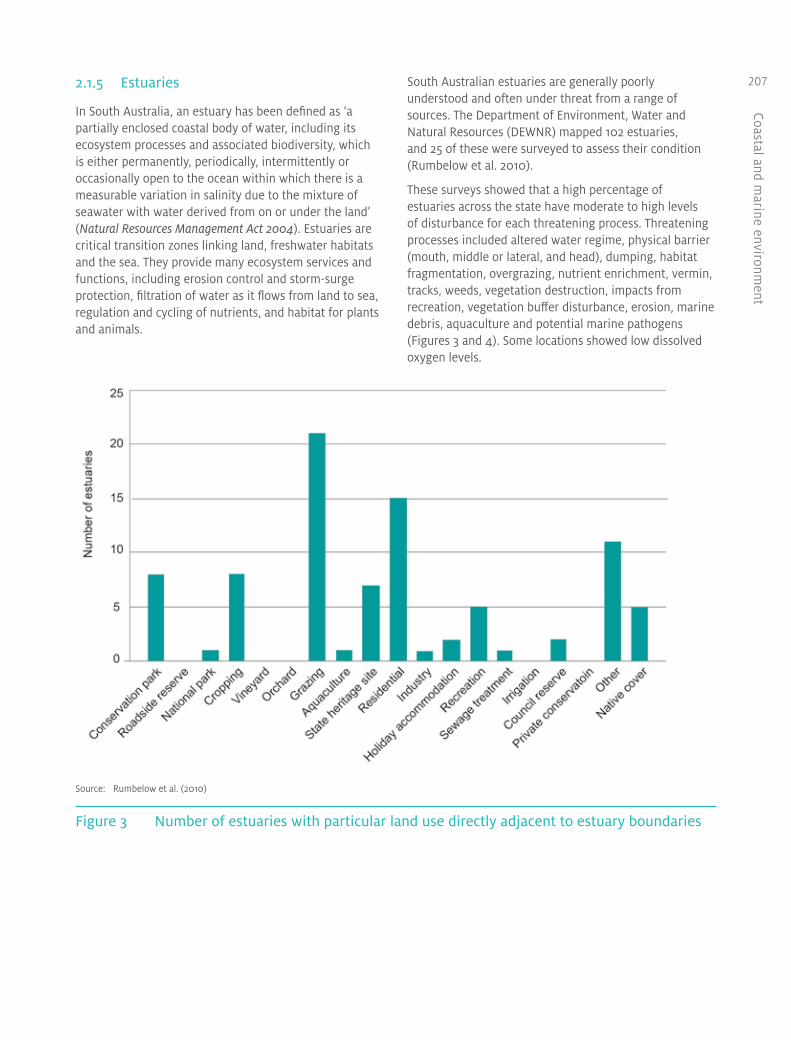
South Australian estuaries are generally poorly understood and often under threat from a range of sources. The Department of Environment, Water and Natural Resources (DEWNR) mapped 102 estuaries, and 25 of these were surveyed to assess their condition (Rumbelow et al. 2010).
These surveys showed that a high percentage of estuaries across the state have moderate to high levels of disturbance for each threatening process. Threatening processes included altered water regime, physical barrier (mouth, middle or lateral, and head), dumping, habitat fragmentation, overgrazing, nutrient enrichment, vermin, tracks, weeds, vegetation destruction, impacts from recreation, vegetation buffer disturbance, erosion, marine debris, aquaculture and potential marine pathogens (Figures 3 and 4). Some locations showed low dissolved oxygen levels.
Source: Rumbelow et al. (2010)
Figure 3 Number of estuaries with particular land use directly adjacent to estuary boundaries

Coas
tal a
nd m
arin
e en
viro
nmen
t
208
Source: Rumbelow et al. (2010)
Figure 4 Extent of threatening processes across estuaries surveyed in South Australia
These results highlight how estuarine systems around the state are considerably affected by threatening processes. Each of the sites surveyed was subject to multiple disturbances, and many had a high level of impact. These surveys need to be repeated, and the number of sites need to be increased to cover all marine bioregions.
2.1.6 Beaches and dunes
All of the 1788 beaches along the South Australian coast have been mapped and described. They have also been classified according to physical characteristics and safety (Short 2001). In addition, the Coast Protection Board funds a coastal survey program that monitors the condition of beaches that are critical to protecting infrastructure from coastal erosion. These are located mainly in townships and are regularly profiled to detect loss of beach volume, a fall in beach height or foreshore erosion.
Adelaide’s metropolitan beaches have declining sediment and require management to prevent erosion. The 30-kilometre Adelaide beach, for example, has declining sediment due to a reduced sand input and a northward littoral drift. It has been necessary to combine rock-wall protection with a sand management program to protect coastal infrastructure and development from erosion. Beach levels and volumes are monitored, and this information is used to guide the beach replenishment program. Sand is currently shifted using trucks; since 2012, a sand-pumping system has been operational south of Torrens Inlet. Figure 5 has been compiled from DEWNR’s beach-monitoring data. It compares the 2008 beach volumes at 60 monitored locations along the Adelaide coast with 2009, 2010 and 2011 values. Differences between years can be observed at some locations, reflecting both natural sand transport processes and human intervention.

Coastal and marine environm
ent
209
2.2 Threatened species
Threatened and rare coast and marine species are protected under the National Parks and Wildlife Act 1972 and the Fisheries Management Act 2007. Species protected under the National Parks and Wildlife Act can be listed as endangered, vulnerable or rare (Table 4).
A comprehensive desktop review was undertaken for many species, including more than 200 species of noncommercial fish, to determine their conservation status. However, most species are deficient in data that could determine their conservation status. One example is the harlequin fish Othos dentex, a coastal reef fish endemic to Australia and occurring from the central coast of Victoria to south-west Western Australia (Atlas of Living Australia 2012). The harlequin fish prefers high-quality coastal waters less than 45 metres deep, and rocky reefs with drop-offs, caves and ledges. The fish, which grows to 76 centimetres in length, is incidentally captured on hook and line by commercial, recreational and charter-boat fishers, is targeted by recreational spear fishers,
and is taken as bycatch in commercial and recreational lobster pots.
The Adelaide and Mount Lofty Ranges Natural Resources Management (NRM) Board commissioned a survey of the species and concluded that population estimates were not possible at the sites surveyed because of the low numbers observed—only three individuals were photo-catalogued at Aldinga Reef, and none were sighted at Seacliff, Northern Outer, Macs Ground or Milkies reefs. Further studies are needed to better ascertain the status of the harlequin fish and the many other species of conservation concern in South Australian waters (Bryars 2011). (See the Introduction for more information about NRM regions.)
Source: Department of Environment, Water and Natural Resources
Figure 5 Variation in volumes of beach sediment, 2009–11

Coas
tal a
nd m
arin
e en
viro
nmen
t
210 Table 4 Coast and marine species protected under South Australian legislation
National Parks and Wildlife Act Fisheries Management Act
Endangered Vulnerable Protected
Blue whale (Balaenoptera musculus)
Subantarctic fur seal (Arctocephalus tropicalis)
White-bellied sea eagle (Haliaeetus leucogaster)
Osprey (Pandion haliaetus)
Yellow-nosed albatross (Indian Ocean subspecies) (Diomedea chlororhynchos carteri)
Yellow-nosed albatross (Atlantic Ocean subspecies) (Diomedea chlororhynchos chlororhynchos)
Royal albatross (northern subspecies) (Diomedea epomophora sanfordi)
Sooty albatross (Diomedea fusca)
Little tern (Sterna albifrons)
Fairy tern (Sterna nereis)
Loggerhead turtle (Caretta caretta)
Southern right whale (Eubalaena australis)
Sei whale (Balaenoptera borealis)
Fin whale (Balaenoptera physalus)
Humpback whale (Megaptera novaeangliae)
Australian sea lion (Neophoca cinerea)
Hooded plover (Thinornis rubricollis)
Buller’s albatross (Diomedea bulleri)
Shy albatross (Diomedea cauta cauta)
Salvin’s albatross (Diomedea cauta salvini)
Grey-headed albatross (Diomedea chrysostoma)
Royal albatross (southern subspecies) (Diomedea epomophora epomophora)
Wandering albatross (Diomedea exulans)
Black-browed albatross (Campbell Island subspecies) (Diomedea melanophris impavida)
Light-mantled albatross (Diomedea palpebrata)
Great skua (Macquarie and Heard Island subspecies) (Catharacta skua lonnbergi)
Southern giant petrel (Macronectes giganteus)
Green turtle (Chelonia mydas)
Leatherback turtle (Dermochelys coriacea)
Western blue groper (Achoerodus gouldii) in the waters of or near Spencer Gulf and Gulf St Vincent
Great white shark (Carcharodon carcharias)
Scalefish of the family Syngnathidae
Scalefish of the genus Ambassidae
Scalefish of any species of Mogurnda
Crustaceans of the following classes carrying external eggs:
• bug (Ibacus sp.)
• blue swimmer crab (Portunus pelagicus)
• giant crab (Pseudocarcinus gigas)
• slipper lobster (Scyllarides sp.)
• southern rock lobster (Jasus edwardsii)
Australian sea lion pups in rockpool at North Page Island
Dr Jane McKenzie

Coastal and marine environm
ent
211
3 What are the pressures?
Pressures on the coast, estuaries and adjacent marine waters result from both land-based and marine-based human activities, as well as broader global influences such as climate change.
3.1 Land-based activities
More than 90% of South Australians live within 50 kilometres of the coast (ABS 2002), and approximately 75% live in greater Adelaide. Many commercial, industrial and recreational activities benefit from South Australia’s diverse coastal and marine resources. This inevitably comes at some environmental cost (see Box 1), in the form of pollution, erosion, degradation of habitats, introduction of pests and unsustainable use of some resources. Unless these impacts are well managed, including for their cumulative impacts, the ability of the coastal and marine environment to sustain the varied economic and recreational benefits may be compromised.
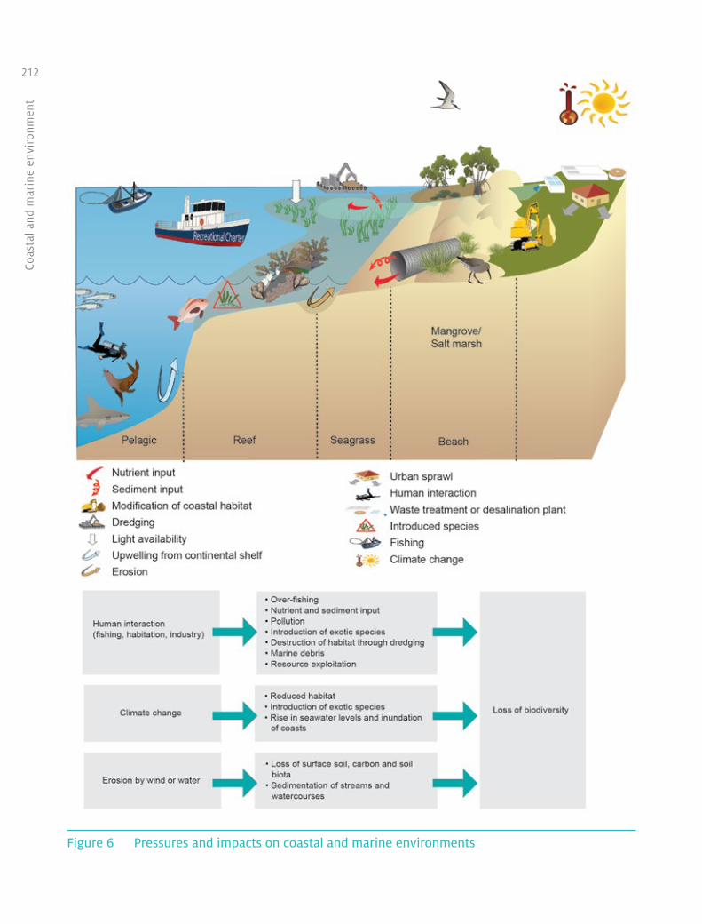
Uses such as recreational boating, shipping traffic and aquaculture are increasing. Most fisheries are fully fished, and some are overfished. The growing number of coastal developments along the coastline includes regional boating facilities, public access points, offshore aquaculture, marinas and boat ramps. Sediments from erosion or run-off, and nutrients or toxins from effluent, stormwater, industry and agriculture persist in the marine environment, entering and changing the food web of the entire underwater world and influencing many biological systems (Figure 6).
Box 1 Water quality
Water quality in coastal and estuarine areas is greatly affected by how the surrounding area is used. Major land uses in coastal catchments that affect estuaries and coastal waters include pastoralism, cropping, horticulture, sea-cage aquaculture and forestry. Additionally, stormwater, wastewater treatment plants, and sewage treatment and effluent disposal systems in coastal towns discharge substantial quantities of nutrients, heavy metals, microbiological loads and organic matter into estuaries and coastal waters.
These pressures have influenced several of the state’s estuaries and coastal waters. For example, breakdown of organic matter in the Inman River estuary sediments and nutrient processing cause high levels of ammonia in the estuary (above 40 milligrams per litre). This is toxic to numerous species, particularly fish species, and can cause algal blooms. The Onkaparinga and Cygnet estuaries also receive excessive amounts of nutrients and organic matter.
Seagrass losses in Nepean Bay and Boston Bay are likely to be due to high nutrient levels. Seagrass and mangrove losses in the Spencer Gulf coastal waters have been attributed to a combination of nutrient enrichment, industrial pollution and climatic conditions. It is also likely that at least some of the seagrass loss in Rivoli Bay (in the south-east) is attributable to discharges of agricultural drainage water from Lake George (Wear et al. 2006).
Coas
tal a
nd m
arin
e en
viro
nmen
t
212
Figure 6 Pressures and impacts on coastal and marine environments

Coastal and marine environm
ent
213
Source: Department of Primary Industries and Regions South Australia, Fisheries and Aquaculture, unpublished data
Figure 7 South Australian aquaculture development, 2008–12 and planned
3.2 Aquaculture
Aquaculture production in South Australia increased from 3883 tonnes in 1997 to 13 548 tonnes in 2002 and 20 549 tonnes in 2010. In 2010–11, aquaculture contributed $90 172 million to the gross state product (Figure 7). Approximately 70% of this was generated in regional South Australia (EconSearch 2012).
There are approximately 650 individual aquaculture licensees farming a variety of marine and freshwater species, including southern bluefin tuna, yellowtail kingfish, abalone, oysters, yabbies and marron, barramundi and algae.
There is evidence that the abundance and distribution of certain seabirds and marine vertebrates have markedly increased because of human activities in the marine environment, particularly refuse discharge and fishery discards (Harrison 2003). As a result of the increase in food entering the water, adverse interactions with marine vertebrates have been reported, albeit rarely.
Wildlife interactions that might occur with some marine farming include interactions with seabirds, sharks and protected marine mammals (Harrison 2003).
3.2.1 Tuna
Southern bluefin tuna accounts for 53% of South Australia’s gross value of production (GVP) from aquaculture (EconSearch 2011). In recent years, production has risen steadily; it is projected to continue to increase by 10% in 2011–12 and 20% in 2012–13 (EconSearch 2011). The pressures on the marine environment from tuna farming include increased nitrification, co-infection from parasites and marine debris.
Australia is a member of the Commission for the Conservation of Southern Bluefin Tuna, which was established in 1993 to protect the species from overfishing. A 2011 stock assessment showed that the spawning stock biomass remains relatively low, but that the outlook for the stock is positive (CCSBT 2011).
Coas
tal a
nd m
arin
e en
viro
nmen
t
214 3.2.2 Finfish
Yellowtail kingfish contribute 14% of South Australia’s total aquaculture GVP (EconSearch 2011). Reporting requirements have revealed that escapes of stock can occur from finfish-licensed holding cages. A report by Fowler et al. (2003) concluded that escaped yellowtail kingfish, when recaptured, exhibit poor health and do not seem to survive for long. Therefore, it is not anticipated that escapes have long-lasting ecological impacts. Other pressures from finfish farming are similar to those for southern bluefin tuna farming, described above.
3.2.3 Subtidal shellfish
Blue mussels and greenlip abalone are the farmed subtidal shellfish species. Culture techniques for both species vary; they include contained and uncontained longlines, and benthic structures to harbour stock to grow out and harvest. Collectively, the subtidal shellfish culture sector contributes 8% of aquaculture GVP in South Australia. Subtidal shellfish has more than doubled in value since 2003, and the value is projected to grow by approximately 19.5% per year over the next three years (EconSearch 2011). As with southern bluefin tuna and marine finfish, the accidental loss and/or disposal of debris related to subtidal shellfish aquaculture is recognised as an environmental pressure.
3.2.4 Intertidal shellfish
Intertidal shellfish culture is the farming of Pacific oysters. Oyster farms mostly use hanging baskets or, far less commonly, fixed ‘rack and rail’ systems within the intertidal zone to contain stock to grow out and harvest. Collectively, the intertidal shellfish culture sector contributes 18% of aquaculture GVP in South Australia. Intertidal shellfish farming has more than doubled in value since 2003, and the value is projected to grow by approximately 10% per year over the next three years (EconSearch 2011).
Because Pacific oysters are exotic to South Australian waters, concern has been raised over the establishment of wild populations. Small populations of wild Pacific oysters were reported for the first time in Franklin Harbour and Denial Bay in 1990. The pressures from these feral populations include competition for food and space with native oysters (Ostrea angasi) and other filter feeders (Wear et al. 2004).
3.2.5 Land-based aquaculture
Land-based aquaculture in South Australia comprises predominantly abalone, finfish species, yabbies and marron. Pressures from land-based aquaculture include nutrient discharge to coastal or freshwater environments, the potential spread of disease to native flora and fauna
populations, and the threat of escape of stock into natural waterways.
3.3 Fishing
During 2009–10, the total volume of production of South Australia’s commercial wild fisheries was 47 581 tonnes, worth an estimated $202 million. This represented an increase in production of 24% (9102 tonnes) since 2008–09 (Knight and Tsolos 2011). Aquatic resources are finite, and there is a risk that continued overexploitation might lead to irreparable damage to the aquatic environment. Fishing also brings economic and social benefits to the state that could be lost if aquatic resources are harvested at unsustainable levels.
Species targeted by commercial and recreational fishing play important roles in their marine ecosystems, and overfishing has the potential to reduce biodiversity and impact negatively on ecosystems. Bycatch of commercial fishing must also be managed to minimise the footprint that fishing places on the aquatic environment.
South Australian commercial fisheries include the following:
• Snapper: Snapper is highly valued by both commercial and recreational fishers, and South Australia is the major contributor to the national catch. In spite of a large increase in targeted longline effort for snapper, stocks were assessed as healthy and at sustainable levels in 2008–09, except for the southern Spencer Gulf, where the biomass was considered low (Fowler et al. 2010).
• King George whiting: King George whiting is considered an ‘icon’ species of South Australia, and is heavily targeted by both recreational and commercial fishers. The latest stock assessment report, published in July 2011, stated that the fishery has been stable for several years, and that there is no immediate need to reconsider management arrangements (Fowler et al. 2011). The statewide catch of King George whiting is split evenly between recreational and commercial fishers ( Jones 2009).
• Pipi (Goolwa cockle): The pipi fishery moved to a quota management system in 2007 to address sustainability concerns, following years of increasing catch effort and decreasing catch rates. A limit of 300 tonnes was set for the 2009–10 fishing season, increasing to 400 tonnes for the 2011–12 fishing season.
• Southern rock lobster: Following a decline in numbers of southern rock lobster, there have been positive signs for recovery of the species in recent years. Effort and fishing days have substantially decreased,

Coastal and marine environm
ent
215while catch per unit effort has considerably increased. Despite this, the fishery faces continuing challenges to ensure healthy levels of recruitment (Linnane et al. 2011).
• Greenlip and blacklip abalone: The total commercial catch of abalone from South Australian waters is about 870 tonnes per year. The recreational take of abalone was estimated at less than 10 tonnes in 2007–08 ( Jones 2009). Recent catches are at sustainable levels across the fishery (Mayfield et al. 2008, Mayfield and Hogg 2011, Stobart et al. 2011).
• Australian sardine: The South Australian sardine fishery is the largest South Australian fishery by volume of catch. Evidence indicates that catches are at sustainable levels, with the level of spawning biomass being within the target range (Ward et al. 2010).
• Western king prawn: Historical reductions in effort, relatively stable catches and increases in prawn size over time suggest that the Spencer Gulf prawn fishery is being fished within sustainable limits (Dixon et al. 2010). The Gulf St Vincent prawn fishery has experienced a decline in biomass, which is likely to have reduced the potential egg production for the fishery (Dixon et al. 2011), and a recovery strategy for the gulf is in place. Spencer Gulf catches have remained stable since the 1973–74 season, with catches ranging from 1048 to 2522 tonnes. West coast fishing is more opportunistic, with annual catches generally less than 200 tonnes since 1990–91.
Details on other fisheries are available from the Department of Primary Industries and Regions South Australia (PIRSA) (Knight and Tsolos 2011, Knight and Vainickis 2011).
PIRSA Fisheries and Aquaculture classifies the stocks of commercially exploited species (Table 5) into three categories:
• Underfished—underutilised and has the potential to sustain harvest levels higher than those currently being taken.
• Fully fished—harvest levels are at, or close to, optimum sustainable levels. Current fishing pressure is considered sustainable.
• Overfished—harvest levels are not sustainable and/or yields may be higher in the long term if catch or effort levels are reduced in the short term, or the stock may still be recovering from previous excessive fishing pressure. Recovery strategies will be developed to reduce fishing pressure and ensure that stocks recover to acceptable levels within agreed timeframes.
Table 5 Fisheries stock status for selected species
Fishery Status
Pipi (Lakes and Coorong) Fully fished
Southern Zone southern rock lobster Fully fished
Northern Zone southern rock lobster Overfished
Southern garfish Overfished
Southern calamari Fully fished
King George whiting Overfished
Snapper Fully fished
Giant crab Fully fished
Blue crab Fully fished
Sardine Fully fished
Gulf St Vincent prawn Overfished
Spencer Gulf prawn Fully fished
Southern Zone abalone Fully fished
Central Zone abalone Fully fished
Western Zone abalone Fully fished
Source: PIRSA (2006)
Fishing activities can interact with threatened, endangered or protected species. Some species have been listed as protected and/or of conservation concern under the Fisheries Management Act 2007 and other environmental legislation, and must not be taken or deliberately interfered with. From data submitted voluntarily by commercial licence holders to the South Australian Research and Development Institute (SARDI), there were 582 incidents involving interactions with 1921 threatened, endangered or protected species in South Australian–managed fisheries during 2009–10 to 2011–12. Of these, 1802 animals were released or escaped, and 119 died. Dolphins accounted for 609 of the animals and 917 individual pinnipeds were involved in interactions. The latter figure is skewed by a large number of seals interacting with fishing in the Lakes and Coorong during 2009–10 and 2010–11. Over the three-year period, 97% of all the encounters involved trawl or net operations (Tsolos and Boyle 2013).
Fishing activities also have the potential to damage habitat. Potential impacts include deployment of illegal artificial reefs, mooring over seagrass beds and damage to reefs from anchors.

Coas
tal a
nd m
arin
e en
viro
nmen
t
216 3.4 Marine debris
The Environment Protection and Biodiversity Act 1999 (EPBC Act; Cwlth) lists marine debris as a key threatening process: ‘Injury and fatality to vertebrate marine life caused by ingestion of, or entanglement in, harmful marine debris’. Harmful marine debris refers to all plastics and other types of debris from domestic or international sources that might cause harm to vertebrate marine wildlife.
Marine debris continues to be a persistent pressure on the South Australian marine environment. It includes land-sourced plastic garbage (e.g. bags and bottles), ropes, fibreglass, piping, insulation, paints and adhesives; derelict fishing gear from recreational and commercial fishing activities; and ship-sourced, solid, nonbiodegradable floating materials lost or disposed of at sea.
For marine species, entanglement in debris can restrict mobility, leading to starvation. It can also create wounds, infections, and damage to body and limbs, and can facilitate drowning. Debris (e.g. plastic bags, rubber, balloons, plastic fragments and food wrappers) can be ingested by marine wildlife that mistake the debris as prey species. This can affect their digestive systems, causing physical blockage, internal scarring and injuries that lead to starvation and death.
3.5 Pest plants and animals
South Australia’s coastal waters are under increasing threat from a range of marine pest species, resulting from increased vessel traffic. Marine pests can outcompete native species for habitat and food, thereby adversely affecting the ecosystems on which fishing and aquaculture industries depend. Once a pest is well established, eradication is rarely possible, and control is expensive. Biosecurity programs are in place to identify, assess and respond to all pests that pose a threat to our fish stocks and their habitats, and to raise awareness of pests. These pests and the programs to manage them are outlined in the Biodiversity chapter.
Commercial shipping is one of the most commonly recognised marine pest vectors. Recent research by Hewitt and Campbell (2010) suggests that vessel biofouling is a larger contributor (60%) to the translocation of marine pests than ballast water from commercial shipping (24%) in Australia.
South Australia’s shipping industry is an important contributor to the economy—some 500 vessels traverse our waters, making more than 1000 port calls and carrying more than 26.8 million tonnes of product. During 2010–11, South Australia’s commercial ports had a total of 1509 port calls by cargo ships (Figure 8).
Little penguin killed by marine debris at Troubridge Island
Dr Jane McKenzie

Coastal and marine environm
ent
217
Source: BITRE (2012)
Figure 8 Number of port calls by cargo ships in South Australia, 2001–02 to 2010–11
Globally, there is a trend towards larger ships that require deeper channels and larger berths, but are more efficient and require fewer trips for any given freight task. The average size of large vessels, including bulk carriers and container vessels, visiting Adelaide has increased (BITRE 2012).
The Australian Government, through the National System for the Prevention and Management of Marine Pest Incursions, and the shipping industry play important roles in preventing the spread of marine pests. Pests are contained primarily by managing ballast water according to Australia’s mandatory ballast water management requirements, and by minimising the amount of biofouling on vessels.
Thirteen of the 99 pest species reported in South Australia since the 1800s are currently listed as trigger species in the marine pest monitoring manual, which means that they are regarded as species of particular concern (Wiltshire et al. 2010). More detailed information on these species is provided in the pest species section of the Biodiversity chapter.
A comprehensive set of management arrangements for domestic ballast water is being developed to complement the existing requirements for international vessels. These arrangements will be consistent with the International Maritime Organization’s International Convention for the Control and Management of Ships’ Ballast Water and Sediments.
The Australian Government is also investigating new biofouling management requirements for vessels arriving
in Australian waters. In developing these requirements, the Australian Government has been working with stakeholders to ensure that implementation arrangements are both practical and effective in minimising the biosecurity risk posed by biofouling.
With an expected increase in shipping traffic due to mineral exports and natural growth in other trades, there will be continued focus on risk-based management of the coastal waters.
3.6 Coastal and offshore exploration and production
Coastal and offshore exploration activities include mineral and petroleum exploration and production. Offshore mining has the potential to alter patterns of sediment movement, and affect ecological processes and associated biodiversity. A large number of mineral exploration licences and production leases are located onshore near the coast, and several of the salt and gypsum extraction tenements extend into inland waters. A substantial amount of Spencer Gulf is covered by 16 mineral exploration licence applications. There is one inshore petroleum licence covering most of Gulf St Vincent, but little exploration has occurred under the licence to date, and none in the marine part of it. One application is pending for petroleum exploration in part of Spencer Gulf. A geothermal exploration licence also covers part of Spencer Gulf and a small portion of Guichen Bay in the south-east.

Coas
tal a
nd m
arin
e en
viro
nmen
t
218 A major offshore seismic survey is being undertaken in the Great Australian Bight. Further seismic exploration is expected, as well as drilling of five deepwater petroleum wells in 2013–14. Seismic surveys have the potential to impact on whales. Baleen whales might be more affected than toothed whales, as their acoustic range is thought to operate in the same frequency as the air-gun pulses used in seismic exploration. Seismic operations are regulated by Commonwealth legislation and guided by the Australian Government’s Guidelines on the application of the Environment Protection and Biodiversity Conservation Act to interactions between offshore seismic operations and larger cetaceans (Environment Australia 2001; revised in 2007) and EPBC Act Policy Statement 2.1—Interaction between offshore seismic exploration and whales, (DEWHA 2008).
Oil-well drilling has the potential to cause spills, which can have major environmental impacts on marine and coastal ecological communities. Lessons have been learnt from past disasters in the Gulf of Mexico and north-west Australia that could reduce the chances that this type of disaster could occur in South Australia.
3.7 Climate changeGlobal sea level has risen 0.21 metres over the last century and is continuing to rise (Climate Commission 2013). Coastal infrastructure is particularly vulnerable to the risks of sea level rise caused by climate change. Recognising this, South Australia has led the nation in developing strategic responses to climate change impacts in coastal areas. The Coast Protection Board’s 1991 sea level rise policy (Policy on Coast Protection and New Coastal Development 1991) was incorporated into the Planning Strategy for South Australia and local government development plans in 1994. This policy is currently being updated to reflect more recent projections and analysis.
The consequences of sea level rise could include increased seawater flooding risk, increased coastal erosion, changing distribution of tidal plant communities and rising coastal groundwater levels.
Although changes in sea level are relatively well understood, there is limited information available about the South Australian impacts of other changes in the ocean environment, such as changes in acidity, salinity and temperature due to climate change. Various research initiatives are addressing this gap in knowledge.
Pearson Island
Dr Jane McKenzie

Coastal and marine environm
ent
219
4 What are we doing about it?
The South Australian Government has established policies and programs to protect and improve the environmental health of the coastal and marine environment.
4.1 South Australia’s Strategic Plan and Natural Resources Management Plan
South Australia’s Strategic Plan (Government of South Australia 2011a) has a target to ‘maintain the health and diversity of South Australia’s unique marine environments’ (Target 71). The plan includes the following measures for meeting the target:
• effectiveness of management of South Australia’s marine park network (from a 2011 baseline)
• results from the monitoring, evaluation and reporting program for the marine parks network.
The South Australian Natural Resources Management Plan 2012–2017 (Government of South Australia 2011b) has a target to improve the condition of coastal and marine ecosystems (Target 10), including the following measures:
• trends in the extent and condition of coastal ecosystems (including foreshore, rocky reefs, seagrass, saltmarsh and mangroves)
• trends in the condition of habitats and species in marine parks and sanctuary zones.
Apart from programs for the ongoing management of the coastal and marine environment, the following initiatives are in place to achieve the identified targets.
4.2 Marine protected areas
The South Australian Government holds a number of marine areas under different forms of protection.
4.2.1 Marine parks network
The South Australian Government established the Representative System of Marine Protected Areas, commonly known as marine parks, in 2009. This
network comprises 19 multiple-use marine parks that are distributed across South Australia’s bioregions. The network includes representative areas of each of the eight marine bioregions that overlap with the state’s marine jurisdiction. The marine parks network covers a total area of 26 912 square kilometres—approximately 44% of South Australia’s waters—and includes the Great Australian Bight Marine Park (Figure 1).
The aim of the network of marine parks is to conserve and protect South Australia’s marine biological diversity and habitats, and to assist in:
• maintaining ecological processes in the marine environment
• adapting to the impacts of climate change in the marine environment
• protecting and conserving features of natural or cultural heritage importance
• allowing ecologically sustainable development and use of marine environments
• providing opportunities for public appreciation, education, understanding and enjoyment of marine environments.
The Centre for Policy Development in Sydney estimated the ecosystem services value of the marine park highly protected zones, which cover almost 6% of state waters, to be worth approximately $20 million per year (Hoisington 2012).
4.2.2 Great Australian Bight Marine Park
The Great Australian Bight Marine Park Whale Sanctuary was proclaimed under the Fisheries Act 1982 in June 1995. In September 1996, the Great Australian Bight Marine National Park was proclaimed under the National Parks and Wildlife Act 1972. These two areas comprise the Great Australian Bight Marine Park.
The Great Australian Bight region, in general, and the area adjacent to the Nullarbor Cliffs, in particular, have biological and physical resources and values that are of

Coas
tal a
nd m
arin
e en
viro
nmen
t
220 international and national significance under the EPBC Act and the National Parks and Wildlife Act. They include:
• breeding and calving areas for the endangered southern right whale (particularly at the Head of Bight), which are the most important breeding and calving areas for this species in Australia, and one of two major calving sites in the world
• important populations and breeding colonies of the rare Australian sea lion (particularly along the Nullarbor Cliffs), which, because of their isolation and probably negligible rates of sealing, represent a source of genetic diversity for the species
• seasonal habitat for other species of rare and endangered marine mammals, including sperm whales, killer whales and rorquals (blue whales, minke whales and humpbacks)
• important marine biodiversity, particularly among invertebrate fauna (such as sea squirts and sea slugs); because of the presence of a tropical current, the area also contains elements of warm tropical marine fauna and flora
• limestone-dominated coastal areas of high geomorphological interest, including the spectacular Nullarbor Cliffs and the extensive transgressive dunes of the Merdayerrah Sandpatch.
Although there is no habitat monitoring in the state waters of the park, the number of southern right whales has been increasing, and 2011 saw the highest number of female–calf pairs—67—recorded at the Head of Bight in 20 years of annual monitoring (Figure 9).
Source: Data collected by Eubalaena Pty Ltd and the Department of Environment and Natural Resources
Figure 9 Numbers of calving southern right whales at the head of the Great Australian Bight
4.2.3 Adelaide Dolphin Sanctuary
The Port Adelaide River and Barker Inlet is possibly the most intensively used marine waterway in South Australia. It contains:
• metropolitan Adelaide’s power plants
• a large wastewater treatment plant
• light and heavy industries
• the state’s major port, with thousands of vessel movements annually
• new developments, both industrial and residential
• European and Aboriginal cultural and historical values
• important recreational activities, including fishing, birdwatching and dolphin watching.
The area is also home to about 30 resident Indo–Pacific bottlenose dolphins (Tursiops aduncus), with at least an additional 300 dolphins as occasional visitors to the park. The mangroves, seagrass, saltmarsh, tidal flats, tidal creeks and estuarine rivers in the region all provide habitat and food for the dolphins.
Intensive use over 150 years has severely affected the environment, which has seen an increase in chemical and thermal pollution, introduced marine pests, litter and excess nutrients in the water.
The Adelaide Dolphin Sanctuary, which was proclaimed in 2005, is designed to protect the dolphins by protecting the environment where they live. The dolphin sanctuary manages existing and future activities to support the viability of the regional environment. The Adelaide Dolphin Sanctuary Act 2005 sets out to:
• protect the dolphins from physical harm
• maintain, protect and restore key habitat features
• improve water quality
• ensure that the interests of the community are taken into account in management of the area
• promote public awareness of the importance of a healthy environment to the economic, social and cultural prosperities of the area
• promote the principles of ecologically sustainable development in management of the area.
4.3 Coastal and estuaries action plans
The Adelaide and Mount Lofty Ranges NRM Board has completed coastal and estuary action plans for its region (AMLR NRM Board 2007, 2009). These plans contain detailed maps, and plant and animal lists. They outline key conservation priorities along the coast,

Coastal and marine environm
ent
221make recommendations for action and identify key stakeholders. They also describe the management and rehabilitation tasks required to protect estuaries, and identify actions for stakeholders towards achieving the objectives of the plans.
Key goals of the plans are to understand and facilitate the conservation, protection and maintenance of natural resources, and to establish conservation priorities for the coast.
The completed plans are:
• Metropolitan Adelaide and Northern Coastal Action Plan
• Southern Fleurieu Coastal Action Plan
• Thompson Beach Coastal Action Plan
• Parham Coastal Action Plan
• Light Beach Coastal Action Plan
• Onkaparinga Estuary Rehabilitation Action Plan
• three Fleurieu Estuary Action Plans for the Hindmarsh, Inman and Bungala rivers.
Various other initiatives by NRM boards in South Australia aim to protect and improve coastal and marine ecosystems. The Kangaroo Island NRM Board, for example, has trialled the use of sand-filled hessian sacks to recruit seagrass seedlings and evaluate revegetation. The results showed recruitment (up to three species at some sites), but many of the bags disintegrated before the seedlings had a chance to take hold. The board is currently trialling direct transplantation of two Posidonia species in Western Cove, coupled with measuring epiphyte loads on artificial seagrass as an indicator of nutrients within the bay. The results of both studies will inform future management actions to improve seagrass condition in Western Cove.
4.4 Aquaculture and fisheries management
Management of aquaculture and fishing in South Australia is governed by the Aquaculture Act 2001 and the Fisheries Management Act 2007 and associated Regulations. Both Acts rely on a system of licensing; the objective is to protect, manage, use and develop the state’s aquatic resources in a sustainable manner.
Options to reduce nutrient loads from aquaculture activities include locating the activities in deeper water and increasing the use of integrated multitrophic aquaculture, to reduce impacts on nearshore environments. The Aquatic Sciences division of the SARDI is developing models to predict the fate and transport
of pollutants from aquaculture and other sources within Spencer Gulf, to aid the management of many different sources of pollution in the gulf.
South Australian commercial fisheries are assessed by the Australian Government Department of Sustainability, Environment, Water, Population and Communities against the Guidelines for the ecologically sustainable management of fisheries (DEWR 2007) under the EPBC Act. All South Australian fisheries have current exemptions from the export controls under the Act, recognising that South Australian fisheries are managed in an ecologically sustainable manner.
Two fish stocks in South Australia—southern garfish and mulloway—require a recovery strategy that aims to rebuild stocks by implementing a range of management measures. Five recovery strategies have been implemented for South Australia’s fish stocks in response to sustainability concerns, using a range of management measures aimed at rebuilding stocks. These fisheries are mud cockles in the Port River area, the Northern and Southern Zone Rock Lobster fisheries, the Gulf St Vincent Prawn Fishery, and pipi in the Lakes (Lakes Alexandra and Albert) and Coorong Fishery.
In March 2013, in response to a decline in giant cuttlefish populations at the Point Lowly aggregation site, the South Australian Government approved a temporary closure of all fishing for cuttlefish in northern Spencer Gulf as a precautionary measure while investigating the decline.
SARDI prepares annual fishery assessment reports and stock status reports on the sustainability of key commercial species in South Australia. Management plans for commercial fisheries set performance indicators, against which the performance of the fishery can be assessed. A review of performance against these indicators can suggest whether management changes are required.
Recreational fishing in South Australia continues to be an important leisure activity. The most recent survey into recreational fishing in South Australia was undertaken in 2007–08 and estimated that 236 000 people undertook recreational fishing activities in that year. Recreational fishing brings important social and economic benefits to the state. Projects under way for the management of recreational fishing in South Australia include a recreational fishing strategic plan; a recreational fishing management plan; a review into bag, boat and size limits; and a survey investigating the social aspects of recreational fishing in South Australia.
Coas
tal a
nd m
arin
e en
viro
nmen
t
222 Future priorities for the fisheries sector are:
• addressing resource access and allocation issues
• maintaining and improving sustainable management of commercial and recreational fisheries
• integrating socio-economic considerations into fisheries management decision-making
• promoting co-management in fisheries management
• developing and implementing management plans for commercial fisheries pursuant to the requirements under the Fisheries Management Act 2007
• developing and implementing a strategic plan and management plan for recreational fishing.
4.5 Reducing pollution
Plans and programs are under way to address water pollution and debris.
4.5.1 Adelaide Coastal Water Quality Improvement Plan
The Adelaide Coastal Water Quality Improvement Plan (ACWQIP; EPA 2013) sets targets to reduce discharges from industry, wastewater treatment plants and stormwater to improve coastal water quality and, over time, allow the return of seagrass and improved reef condition.
The community-agreed vision in the ACWQIP is ‘Healthy aquatic ecosystems where environmental, social and economic values are considered in equal and high regard in a balanced management approach that aims to see the return of the blue-line of seagrass closer to shore by 2050’.
Healthy seagrass ecosystems are important to Gulf St Vincent and the Adelaide region. They provide habitat for species that are fished by commercial and recreational fishers, carbon storage values that are many times greater than equivalent terrestrial-based areas of native vegetation, and protective and stabilising services for beaches and shorelines.
Issues of poor water quality, loss of seagrass, declining reef health and sediment instability were first noticed by the Adelaide community, environmental managers and searchers as early as 60 years ago. The Adelaide Coastal Waters Study (ACWS) was a scientific program undertaken through CSIRO from 2001 to 2007 on how to respond to extensive loss of seagrass, poor water quality and sediment instability along Adelaide’s coastline. Inputs of nutrients and sediments from industrial, wastewater and stormwater discharges were found by the ACWS to be the
main cause of poor water quality and seagrass loss. The ACWQIP has been based on these findings.
Community and stakeholder input has been a key part of developing the community-agreed vision, environmental values and water-quality objectives in the ACWQIP, to guide desired water quality improvement for Adelaide’s catchments and coastal waters. The community-agreed environmental values identified for Adelaide’s coastal waters include aquatic ecosystems, cultural and spiritual, aquatic food consumption, industrial, raw drinking water (via desalination), primary and secondary recreation, and visual appreciation.
The ACWQIP identifies eight strategies for implementation that have been developed in a partnership approach with other agencies, local government and communities. The document is linked to key government policy including the 30-Year Plan for Greater Adelaide, Water for Good, and the Adelaide and Mount Lofty Ranges (AMLR) Natural Resource Management Regional Plan.
The EPA drives reduction of nutrients and sediments from point-source discharges through licensing conditions. Management of stormwater discharges involves many more players, including the AMLR NRM Board, local governments, a range of state agencies and local communities. The ACWQIP promotes application of water-sensitive urban design from catchment to coast, to improve water quality from stormwater (EPA 2013).
4.5.2 Marine debris
In June 2009, the Australian Government developed the Threat abatement plan for the impacts of marine debris on vertebrate marine life (DSEWPaC 2009b) under the EPBC Act. The threat abatement plan aims to provide a coordinated national approach to mitigating and preventing the impacts of harmful marine debris on vertebrate marine life, including implementing measures of the plan at local levels.
NRM regional boards have facilitated marine debris surveys. Combined with nongovernment organisations (e.g. Tangaroa Blue, Teachwild), their actions have achieved some of the objectives of the national threat abatement plan. On Eyre Peninsula, a regional community-based marine debris monitoring program, involving schools and Green Corps teams, has been running since 2008 (Government of South Australia 2011c). Volunteers survey one-kilometre transects at 20 selected sites up to four times per year.
In the Great Australian Bight Marine Park, annual surveys have been conducted at three locations. Marine species in this region that are most at risk from entanglement in

Coastal and marine environm
ent
223marine debris are southern right whales and Australian sea lions. At each site, NRM staff, rangers and school children surveyed one-kilometre transects. This included three surveys at Twin Rocks (March 2010, 2011 and 2012), two at Merdayerrah Sandpatch (December 2010 and November 2011) and one at Mexican Hat (November 2010).
Plastics, which can be ingested or facilitate entanglement, were the most common type of beach rubbish at each site. Information on temporal trends will become available as the data from the most recent surveys at Twin Rocks and Merdayerrah Sandpatch are combined and assessed. Recommendations from the 2011 report include ongoing beach surveys coinciding with the whale migration season, determining the origin of the debris (particularly marine ropes) and standardising survey methods across NRM regions.
The Kangaroo Island NRM Board has been working on biennial beach rubbish (including marine debris) data collections since 2005. In 2007, the first full survey was conducted in conjunction with Clean Up Australia Day. This provided baseline information on the amount, type and distribution of beach rubbish around the island. In March 2009 and 2011, two further surveys were conducted. The results from the surveys indicated less terrestrial-based debris in 2011 (170 kilograms) than in 2009 (192 kilograms). Marine debris mainly consisted of marine rope and hard plastic fragments. These are considered a threat through entanglement or ingestion to the seal and penguin colonies.
A large project involving predominantly community volunteers and AMLR NRM Board staff surveyed 38 sites in the Gulf St Vincent bioregion for marine debris between August and October 2010. Of the 985 kilograms and 12 603 items, 10 major litter groups were identified that could potentially affect wildlife through ingestion or entanglement. These comprised a range of soft and hard plastics associated with numerous user groups and sources, such as packaging, containers, and debris associated with fishing, boating and aquaculture, from both terrestrial and marine-based sources. The most commonly encountered debris type (by number) across the bioregion was hard polymer plastic fragments. In the eastern part of the bioregion, debris was dominated by plastic food packaging (wrappers), presumably associated with the proximity to metropolitan Adelaide.
The South East Cooperative Coastal Conservation Initiative was devised by the South East Local Government Association and DEWNR. One of its projects set out to clear up marine debris along 100 kilometres of coastline from the Victorian border. Approximately
80 kilometres have been cleared in the region, with the participation of school classes, groups of friends and community volunteers. The current focus of the project is to remove debris from the coastline but not to quantify its type and origin. There is no formal quantitative assessment in the region for classifying harmful sources of marine debris.
The Eyre Peninsula NRM Board launched its Regional Marine Debris Monitoring Program in 2008. This project consists of a region-wide community-based monitoring program, supported by board coast and marine officers, to encourage local communities to take an active role in their coastal environments. Since 2008, volunteers at 20 sites across Eyre Peninsula have collected more than 2.5 tonnes of debris, from sites as far west as Fowlers Bay near the Great Australian Bight to Whyalla on the shores of Spencer Gulf.
4.6 Education, capacity building and citizen science
NRM boards provide members of the public who volunteer for the Coastal Ambassadors Program with knowledge and practical skills required to care for, monitor and protect coastal, estuarine and marine environments. The boards also hold workshops to assist the community with sourcing, planting and caring for native local coastal plants.
Reefwatch is a community environmental monitoring project run by the Conservation Council of South Australia and overseen by a community steering committee. It includes reef and intertidal monitoring, as well as programs with schools. The Feral or in Peril Program has been designed to enable recreational divers, anglers and boaters to help keep track of marine organisms that are of special concern. It has been designed to identify introduced marine pests that are a potential threat to the marine ecosystem, as well as local species that might be in danger of disappearing.
A citizen science program, with the aim of engaging the community to monitor the effectiveness of the marine parks network, is being developed as a partnership between DEWNR and the Conservation Council of South Australia.
Partnerships between DEWNR, the Marine Discovery Centre, the South Australian Maritime Museum and the South Australian Museum have allowed the delivery of several education programs to school groups.

Coas
tal a
nd m
arin
e en
viro
nmen
t
224
5 What can we expect?
Many areas of South Australia’s coastal and marine environments are declining, with increased pressure resulting from development and resource use. There is a high level of awareness of the needs of our coasts, and a number of plans and programs hope to address existing and future challenges.
5.1 Climate change: understanding resilience and connectivity
Climate change is likely to profoundly affect the coastal and marine environment, although the severity and extent of potential and existing changes in the marine environment due to climate change are not certain and still have to be quantified. Ocean salinity and currents are changing; ocean acidity, sea level and storm frequency are rising; all of these changes will impact marine species. There are concerns, for example, that some coastal vegetation, such as mangroves and saltmarshes, might not have space to retreat when sea levels rise. Research by Falkenberg et al. (2012) from the University of Adelaide on the resistance of kelp forests to impacts of pollutants indicates that, although forecast climates might increase the probability of phase shifts, maintenance of intact populations of foundation species could enable the continued strength of interactions and persistence of communities. Our understanding of resilience and connectivity in South Australian marine systems is too limited for any inference on how marine ecosystems cope with and adapt to multiple pressures, including climate change. Greater knowledge in this field is needed.
The high number of fish deaths along the South Australian coast in early 2013 has been ascribed to unusually high water temperatures and possible harmful algae. Satellite imagery for March 2013 confirmed the presence of algal blooms. Conditions favourable for oceanic upwellings, coupled with increased temperature, support algal blooms.
5.2 Growth in the resources sector and shipping
The number of mines is forecast to increase during the next few years (SACOME 2012). There is considerable pressure on the Spencer Gulf marine environment from the expansion in mining and the cumulative impacts from various related facilities, such as port facilities and desalination plants.
The expected growth of the oil and gas industry, particularly in the western part of the state, is likely to increase pressure on marine habitats and migratory species, such as the southern right whale.
Globally, there is a trend towards larger ships that will require deeper channels and larger berths. This will probably require new or expanded ports, with related impacts on coastal and marine environments.
5.3 Further coastal and offshore development
Monitoring of ecological conditions in nearshore marine waters throughout South Australia demonstrates that, wherever there is development near waters or in the water (e.g. sea-based aquaculture), there is an observable degradation of the adjacent marine ecosystems. In the absence of exceptional planning controls and pollution management, the trend of development on and off the coast will lead to further degradation of the nearshore environment. For example, expansion of aquaculture zones into ecosystems in good condition presents a risk of ecological harm.
Wave and tide farms for energy production have been proposed during the past two years. Although such initiatives could potentially make a contribution to reducing carbon emissions, potential impacts on marine mammals have to be carefully evaluated.

Coastal and marine environm
ent
2255.4 Improved monitoring, evaluation and reporting
Knowledge of coastal, estuarine and marine ecosystems has improved greatly during the past five years. However, much more has to be done to assess and properly report on the condition of these ecosystems across the state. For many regions, it is not possible to fully evaluate the effectiveness of management actions because of inadequate monitoring. Furthermore, baseline information on the condition of ecological communities is greatly needed for many areas. Assessment of the effectiveness of key government strategies and plans, such as marine parks (Government of South Australia 2012), No Species Loss nature conservation strategy (Government of South Australia 2007), and the State Natural Resources Management Plan (Government of South Australia 2011b), is restricted by a lack of comprehensive and ongoing monitoring, evaluation and reporting under these strategies and plans. The monitoring, evaluation and reporting program envisaged for the state’s marine parks network and the reporting framework anticipated in the state NRM plan aim to evaluate the effectiveness of current and future projects and programs. This will allow us to further improve efforts
to protect and restore our coastal and marine environments.
5.5 Valuing ecosystem services and adopting an ecosystem-based approach to management
In spite of the obvious and significant social and economic benefits described in this chapter, there has been no comprehensive attempt to value the products and services provided by coastal, estuarine and marine ecosystems. Better understanding and quantification of these products and services would improve our ability to manage them sustainably, and to fully consider the costs and benefits of developments and uses that affect them. An ecosystem-based approach that integrates management across sectors and identifies thresholds for ecosystems, taking into account the ecosystem services they provide, is greatly needed (Millennium Ecosystem Assessment 2005). This should build on the work under way to value ecosystem services as part of monitoring, evaluation and reporting of marine parks and the Adelaide Coastal Waters Improvement Plan.
Tuna aquaculture, feeding sardines to tuna with scavenging seagulls, offshore from Port Lincoln
Dr Jane McKenzie

Coas
tal a
nd m
arin
e en
viro
nmen
t
226
6 References
ABS (2002). Regional population growth, Australia and New Zealand, 2001–02, cat. no. 3218.0, Australian Bureau of Statistics, Canberra.
AMLR NRM Board (2007). Southern Fleurieu Coastal Action Plan 2007 (parts A–E), Adelaide and Mount Lofty Ranges Natural Resources Management Board, Adelaide.
AMLR NRM Board (2008). Creating a sustainable future: an integrated natural resources management plan for the Adelaide and Mount Lofty Ranges region, vol 1, State of the region report, Adelaide and Mount Lofty Ranges Natural Resources Management Board, Adelaide.
AMLR NRM Board (2009). Metropolitan Adelaide and Northern Coastal Action Plan 2009, 2 volumes, Adelaide and Mount Lofty Ranges Natural Resources Management Board, Adelaide.
Atlas of Living Australia (2012). TeachWild: National Marine Debris Project, Atlas of Living Australia, www.ala.org.au/get-involved/citizen-science/fielddata-software/teachwild/#t1.
AW NRM Board (2011). Natural Resources Management Regional Plan, Alinytjara Wilurara Natural Resources Management Board, Adelaide.
BITRE (2012). Sea freight report 2010–11, Bureau of Infrastructure, Transport and Regional Economics, Canberra, www.bitre.gov.au/publications/2012/files/asf_2010_11.pdf.
Brock DJ and Kinloch MA (2007). Reef fish biodiversity on Kangaroo Island, Coast and Marine Program report CMP07/006, Kangaroo Island Natural Resource Management Board, Kangaroo Island.
Bryars S (2011). Monitoring marine fishes of conservation concern on Adelaide coastal reefs: combined results of 2009–2010 and 2010–2011 surveys for the southern blue devil and harlequin fish, report to the Adelaide and Mount Lofty Ranges Natural Resources Management Board, South Australian Department of Environment and Natural Resources, Adelaide.
Bryars S and Wear R (2008). Investigator Group expedition 2006: seagrasses of the Investigator Group region: Posidonia meadow condition in a pristine offshore marine environment. Transactions of the Royal Society of South Australia 132:81–94.
Bryars S, Miller D, Collings G, Fernandes M, Mount G and Wear R (2006). Field surveys 2003–2005: assessment of the quality of Adelaide’s coastal waters, sediments and seagrasses, ACWS technical report 14, prepared for the Adelaide Coastal Waters Study Steering Committee, SARDI publication RD01/0208-15, South Australian Research and Development Institute (Aquatic Sciences), Adelaide.
Bryars S, Neverauskas V, Brown P, Gilliland J, Gray L and Halliday L (2003). Degraded seagrass meadows and evidence of eutrophication in Western Cove, Kangaroo Island, PIRSA Fish Habitat Program, Primary Industries and Resources South Australia, Adelaide
CCSBT (2011). Report of the sixteenth meeting of the scientific committee, Commission for the Conservation of Southern Bluefin Tuna, Bali, Indonesia.
Climate Commission (2013). The critical decade: extreme weather, Climate Commission, Canberra, http://climatecommission.gov.au/report/extreme-weather/.
DEH (2007a). A regional perspective of the Far West marine, coastal and estuarine environments—draft report, South Australian Department for Environment and Heritage, Adelaide.
DEH (2007b). A regional perspective of the Lower Spencer Gulf marine, coastal and estuarine environments—draft report, South Australian Department for Environment and Heritage, Adelaide.
DEH (2007c). A regional perspective of the West marine, coastal and estuarine environments—draft report, South Australian Department for Environment and Heritage, Adelaide.
DEH (2008). Biodiversity of Rocky Reefs Yorke Peninsula—South Australia, draft report, South Australian Department for Environment and Heritage, Adelaide.
DEWHA (2008). EPBC Act Policy Statement 2.1—Interaction between offshore seismic exploration and whales, Australian Government Department of the Environment, Water, Heritage and the Arts, Canberra.
DEWR (2007). Guidelines for the ecologically sustainable management of fisheries, Australian Government Department of Environment and Water Resources, Canberra.

Coastal and marine environm
ent
227Dixon CD, Hooper GE and Roberts SD (2010). Spencer Gulf Prawn, Penaeus (Melicertus) latisulcatus, Fishery 2008–09. Fishery assessment report to PIRSA Fisheries, SARDI publication F2007/000770-4, SARDI research report 511, South Australian Research and Development Institute (Aquatic Sciences), Adelaide.
Dixon CD, Roberts SD and Hooper GE (2011). Gulf St Vincent Prawn, Penaeus (Melicertus) latisulcatus, Fishery 2009–10. Fishery assessment report to PIRSA Fisheries and Aquaculture, SARDI publication F2007/000782-4, SARDI research report 526, South Australian Research and Development Institute (Aquatic Sciences), Adelaide.
DSEWPaC (2009a). Bilateral migratory bird agreements, Australian Government Department of Sustainability, Environment, Water, Population and Communities, Canberra, www.environment.gov.au/biodiversity/migratory/waterbirds/bilateral.html#jambacamba.
DSEWPaC (2009b). Threat abatement plan for the impacts of marine debris on vertebrate marine life, Australian Government Department of Sustainability, Environment, Water, Population and Communities, Canberra. www.environment.gov.au/biodiversity/threatened/publications/tap/marine-debris.html.
Dutton A and Benkendorff K (2008). Biodiversity assessment and monitoring of the Port Stanvac intertidal reef, report to the Adelaide and Mount Lofty Natural Resources Management Board by the School of Biological Sciences, Flinders University, Adelaide.
EconSearch (2011). The economic impact of aquaculture on the South Australian state and regional economies 2009–10, EconSearch Pty Ltd, Marryatville.
EconSearch (2012). The economic impact of aquaculture on the South Australian state and regional economies 2010–11, report prepared for Primary Industries and Regions South Australia (Fisheries and Aquaculture), EconSearch Pty Ltd, Marryatville.
Edyvane KS (1999). Conserving marine biodiversity in South Australia, part 1, Background, status and review of approach to marine biodiversity conservation in South Australia, report 38, South Australian Research and Development Institute (Aquatic Sciences), Adelaide.
Environment Australia (2001). Guidelines on the application of the Environment Protection and Biodiversity Conservation Act to interactions between offshore seismic operations and larger cetaceans, Marine Species Section, Environment Australia, Canberra.
EPA (2008). State of the environment report for South Australia 2008, Environment Protection Authority South Australia, Adelaide, www.epa.sa.gov.au/soe/home.
EPA (2013). Adelaide Coastal Water Quality Improvement Plan (ACWQIP), Environment Protection Authority South Australia, Adelaide.
EP NRM Board (2009). State of our resources: recognising the state of natural resources of the Eyre Peninsula, Eyre Peninsula Natural Resources Management Board, Port Lincoln.
Falkenberg LJ, Russell BD and Connell SD (2012). Stability of strong species interactions resist the synergistic effects of local and global pollution in kelp forests. PLOS ONE 7:3, e33841.
Fourqurean JW, Lovelock C, Kennedy HA, Marbà N, Mateo MA, Kendrick GA and Duarte CM (2012). Blue carbon stored in the seagrass beds of the world, International Blue Carbon Policy Working Group, Guayaquil, Ecuador.
Fowler AJ, Ham J and Jennings P (2003). Discriminating between cultured and wild yellowtail kingfish (Seriola lalandi) in South Australia, report to PIRSA Aquaculture by the South Australian Research and Development Institute (Aquatic Sciences), publication RD03/0159, SARDI, Adelaide.
Fowler AJ, McGarvey R, Burch P, Feenstra JE and Jackson WB (2010). Snapper (Chrysophrys auratus) Fishery assessment report to PIRSA, SARDI publication F2007/000523-2, SARDI research report 473, South Australian Research and Development Institute (Aquatic Sciences), Adelaide.
Fowler AJ, McGarvey R, Burch P and Feenstra JE (2011). King George Whiting (Sillaginodes punctatus) Fishery assessment report to PIRSA Fisheries and Aquaculture, SARDI publication F2007/000843-3, SARDI research report 562, South Australian Research and Development Institute (Aquatic Sciences), Adelaide.
Gaylard S (2005). Ambient water quality monitoring: Nepean Bay, Kangaroo Island, report 1: 1999–2004, Environment Protection Authority, Adelaide.
Gaylard S, Thomas S and Nelson M (2011). An assessment of the current status of bioavailable metal contamination across South Australia using translocated mussels Mytilus galloprovincalis. Transactions of the Royal Society of South Australia 135(1):39–54.
Gaylard S, Nelson M and Noble N (2013). The South Australian monitoring, reporting and evaluation program for aquatic ecosystems: rationale and methods for the assessment of nearshore marine waters, Environment Protection Authority, Adelaide.
Geoscience Australia (2010). Coastline lengths, Geoscience Australia, Canberra, www.ga.gov.au/education/geoscience-basics/dimensions/coastline-lengths.html.
Government of South Australia (2004). Living Coast Strategy for South Australia, South Australian Department for Environment and Heritage, Adelaide.

Coas
tal a
nd m
arin
e en
viro
nmen
t
228 Government of South Australia (2007). No species loss—a nature conservation strategy for South Australia 2007–2017, South Australian Department for Environment and Heritage, Adelaide, www.environment.sa.gov.au/Conservation/Ecosystem_conservation/No_species_loss.
Government of South Australia (2011a). South Australia’s Strategic Plan, Department of Premier and Cabinet, Adelaide, http://saplan.org.au,
Government of South Australia (2011b). Our place. our future: state natural resources management plan, South Australia 2012–2017, Government of South Australia, Adelaide, www.nrm.sa.gov.au/Portals/0/Reports/nrm-gen-stateNRMplan.pdf.
Government of South Australia (2011c). Marine debris surveys, Government of South Australia, Adelaide, www.epnrm.sa.gov.au/CoastMarine/MarineDebrisSurveys.aspx.
Government of South Australia (2012). South Australia’s marine parks network explanatory document, Government of South Australia, Adelaide, http://www.environment.sa.gov.au/marineparks/About.
Harrison S (2003). Interactions between seabirds and tuna farms near Port Lincoln. Honours thesis, Flinders University, Adelaide.
Hewitt C and Campbell M (2010). The relative contribution of vectors to the introduction and translocation of marine invasive species, National Centre for Marine Conservation and Resource Sustainability, Australian Maritime College, Hobart.
Hoisington C (2012). Zoning South Australia’s marine parks: an economic evaluation, occasional paper 22, Centre for Policy Development, Sydney.
Irving AD, Tanner JE, Seddon S, Miller D, Collings GJ, Wear RJ, Hoare SL and Theil MJ (2010). Testing alternate ecological approaches to seagrass rehabilitation: links to life-history traits. Journal of Applied Ecology 47:1119–1127.
Jones K (2009). 2007–08 South Australian Recreational Fishing Survey (December 2009), South Australian Fisheries Management Series paper 55, Primary Industries and Resources South Australia, Adelaide.
KI NRM Board (2009). Kangaroo Island Natural Resources Management Plan, vol 1, State of the region 2009, Kangaroo Island Natural Resources Management Board, Kangaroo Island.
Knight MA and Tsolos A (2011). South Australian wild fisheries information and statistics report 2009/10, SARDI publication F2008/000804-3, SARDI research report 521, South Australian Research and Development Institute (Aquatic Sciences), Adelaide.
Knight M and Vainickis A (2011a). Non-confidential 2010–11 data summary of the South Australian Recreational Charter Boat Fishery, SARDI publication F2011/000437-1, SARDI research report 579, South Australian Research and Development Institute (Aquatic Sciences), Adelaide.
Lewis RK, Edyvane KS and Newland N (eds) (1998). The state of our seas and coasts—description, uses and impacts on South Australia’s marine and estuarine environment, technical reference document for the Government of South Australia, Adelaide.
Linnane A, McGarvey R, Feenstra J and Hoare M (2011). Northern Zone Rock Lobster ( Jasus edwardsii) Fishery status report 2010–11 to PIRSA Fisheries and Aquaculture, SARDI publication F2007/000714-5, SARDI research report 589, South Australian Research and Development Institute (Aquatic Sciences), Adelaide.
Mayfield S and Hogg A (2011). Southern Zone Abalone (Haliotis rubra & H. laevigata) Fishery assessment report to PIRSA Fisheries and Aquaculture, SARDI publication F2007/000552-3, SARDI research report 535, South Australian Research and Development Institute (Aquatic Sciences), Adelaide.
Mayfield S, Carlson IJ and Chick RC (2008). Central Zone Abalone (Haliotis laevigata & H. rubra) Fishery assessment report to PIRSA Fisheries and Aquaculture, SARDI publication F2007/000611-2, SARDI research report 306, South Australian Research and Development Institute (Aquatic Sciences), Adelaide.
Millennium Ecosystem Assessment (2005). Ecosystems and human well-being: synthesis, Island Press, Washington DC, http://millenniumassessment.org/documents/document.356.aspx.pdf.
PIRSA (2006). South Australian fisheries resources—current status and recent trends 2006, South Australian Fisheries Management Series, paper 49, Primary Industries and Resources South Australia, Adelaide.
PIRSA (2012a). Fish Facts, newsletter, June 2012, Primary Industries and Resources South Australia, Adelaide.
PIRSA (2012b). PIRSA fisheries—fishing closures, Primary Industries and Resources South Australia, Adelaide, www.pir.sa.gov.au/fisheries/closures/closed_areas.
Rumbelow K, Speziali A and Bloomfield A (2010). Working towards a statewide inventory of estuaries: advancing the inventory of estuaries in five NRM regions of South Australia, Department of Environment and Natural Resources, Adelaide.
SACOME (2012). Mining in SA, fact sheet, South Australian Chamber of Mines and Energy, Adelaide.

Coastal and marine environm
ent
229Seddon S (2000). Causes and ecological consequences of the Spencer Gulf seagrass dieback. PhD thesis, Department of Environmental Biology, University of Adelaide.
Seddon S, Miller D, Fotheringham D, Burgess S and McKechnie J (2003). Beachport seagrass loss and links with drain M in the Wattle Range Catchment, prepared for the Coast Protection Board, South Australian Department for Environment and Heritage, and Environment Protection Authority South Australia, SARDI publication RD03/0190, South Australian Research and Development Institute (Aquatic Sciences), Adelaide.
SE NRM Board (2010). Natural Resources Management Plan, part one, Regional description, South East Natural Resources Management Board, Mount Gambier.
Shepherd SA and Sprigg RC (1976). Substrate, sediments and subtidal ecology of Gulf St Vincent and Investigator Strait. In: Natural history of the Adelaide region, Twindale CR, Tyler MJ and Webb BP (eds), Royal Society of South Australia, Adelaide, 161−174.
Short A (2001). Beaches of the South Australian coast and Kangaroo Island: a guide to their nature, characteristics, surf and safety, University of Sydney Press, Sydney.
Steer MA, Galylard S and Loo M (2013). Monitoring the relative abundance and biomass of South Australia’s giant cuttlefish breeding population, SARDI publication no. F2013/000074-1, SARDI research report series no. 684, South Australian Research and Development Institute (Aquatic Sciences), Adelaide.
Stobart B, Dent JJ, Matthews RC, Chick RC and Mayfield S (2011). Western Zone Abalone (Haliotis rubra & H. laevigata) Fishery (Region A) status report to PIRSA Fisheries and Aquaculture, SARDI publication F2011/000290-1, SARDI research report 565, South Australian Research and Development Institute (Aquatic Sciences), Adelaide.
Tanner JE (2005). Three decades of habitat change in Gulf St Vincent, South Australia. Transactions of the Royal Society of South Australia 129:65–73.
Tsolos A and Boyle M (2013). Interactions with threatened, endangered or protected species in South Australian managed fisheries—2009–10, 2010–11 and 2011–12, report to Primary Industries and Regions South Australia Fisheries and Aquaculture, SARDI publication F2009/000544-3, SARDI research report 682, South Australian Research and Development Institute (Aquatic Sciences), Adelaide.
Turner DJ, Kildea T and Westphalen G (2007). Examining the health of subtidal reef environments in South Australia, part 2, Status of selected South Australian reefs based on the results of surveys undertaken in 2005, SARDI publication RD03/0252-6: 81, South Australian Research and Development Institute (Aquatic Sciences), Adelaide.
Ward TM, Burch P and Ivey AR (2010). South Australian Sardine (Sardinops sagax) Fishery assessment report 2010 to PIRSA Fisheries and Aquaculture, SARDI publication F2007/000765-3, SARDI research report 496, South Australian Research and Development Institute (Aquatic Sciences), Adelaide.
Wear RJ, Mandee T, Bryars S, Tanner J and De Jong S (2004). Environmental risk assessment of intertidal shellfish aquaculture in South Australia, Fisheries Research and Development Corporation project 2003/223, South Australian Research and Development Institute (Aquatic Sciences), South Australia.
Wear RJ, Eaton A, Tanner JE and Murray-Jones S (2006). The impact of drain discharges on seagrass beds in the South East of South Australia, final report prepared for the South East Natural Resource Consultative Committee and the South East Catchment Water Management Board, SARDI publication RD04/0229-3, South Australian Research and Development Institute (Aquatic Sciences) and Department of Environment and Heritage, Coast Protection Branch, Adelaide.
Westphalen G (2011). Surveys across reefs in the Adelaide and Mt Lofty Ranges Natural Resource Management Region 2010–2011, report to the Conservation Council of South Australia and Reef Watch, Adelaide.
Wiltshire K, Rowling K and Deveney M (2010). Introduced marine species in South Australia: a review of records and distribution mapping, SARDI publication F2010/000305-1, SARDI research report 468, South Australian Research and Development Institute (Aquatic Sciences), Adelaide.
Womersly HBS and Thomas IM (1976). Intertidal ecology. In: Natural history of the Adelaide region, Twidale CR, Tyler MJ and Webb BA (eds), Royal Society of South Australia Inc, Adelaide.