CO-LOCATION SURVEY (Le Lamentin, French West...
42
SERVICE DE GEODESIE ET NIVELLEMENT JC Poyard CO-LOCATION SURVEY (Le Lamentin, French West Indies) July 2013 DIFFUSION OUVERTE N° archive Date de création N° de version RT/G 171 28466 18/10/2013 1
Transcript of CO-LOCATION SURVEY (Le Lamentin, French West...
SERVICE
DE GEODESIE
ET NIVELLEMENT
JC Poyard
CO-LOCATION SURVEY
(Le Lamentin, French West Indies)
July 2013
DIFFUSION OUVERTEN° archive
Date de création
N° de version
RT/G 171
28466
18/10/2013
1
IGNService
de Géodésieet Nivellement
J-C. Poyard RT/Gv
page
1711
2/42
CO-LOCATION SURVEY(Le Lamentin, French West Indies)
Mots-clé
Rattachement ; ITRF ; Marégraphe ; Antilles ; Martinique ; Le Lamentin; DORIS; REGINA; RGP; Tidegauge; French West Indies.
Résumé
Suite à l’installation d’une station DORIS au Lamentin (cf. RT166_V1_POYARD_Installation
DORISLeLamentin-juin2013) un rattachement entre les antennes DORIS et GNSS est réalisé. L’occasion
est également saisie pour rattacher le marégraphe situé à Fort-de-France.
Ce rapport décrit les travaux réalisés et les résultats obtenus.
Following the installation of a DORIS station in Martinique at Le Lamentin (cf. RT166_V1_POYARD_
Installation DORISLeLamentin-juin2013) a local tie survey was carried out between the DORIS and
GNSS antennas. The tide gauge located at Fort-de-France was also connected.
This report describes the works performed and the results obtained.
Matériel
Système d’exploitation Logiciel
Windows 7 Professionnel LibreOffice Writer 4.0
Validation
Fonction Nom Visa
Commanditaire Chef d’unité RSI Bruno Garayt 16/01/2014 – signé
Rédacteur principal Responsable de production Jean-Claude Poyard 28/11/2013 – signé
Lecteur Responsable SIRS DORIS Jérôme Saunier 13/12/2013 – signé
Approbateur Chef de service Alain Harmel 23/01/2014 – signé
Vérificateur Responsable qualité Thierry Person 28/03/2014 – signé
IGN ● Service de géodésie et nivellement 73 avenue de Paris, 94165 Saint-Mandé Cedex ● Tél : 01 43 98 83 25 ● sgn@ign. fr

IGNService
de Géodésieet Nivellement
J-C. Poyard RT/Gv
page
1711
3/42
CO-LOCATION SURVEY(Le Lamentin, French West Indies)
Diffusion
Organisme / Service Fonction / Nom Numérique Papier
IGN / DPRDirecteur de la production des référentiels / Philippe Gerbe
oui -
IGN / DPR DPR adjoint / Didier Moisset oui -
IGN / DPC Chargé MO géodésie / François Becirspahic oui -
IGN / DPR / SDOG / CDOC Chef du centre documentation / Richard Grimm oui -
IGN / DRE / SRSIG / LAREG Chef de laboratoire / Olivier Jamet oui -
IGN / DRE / ENSG / DPTS Chef de département / Serge Botton oui -
IGN / DPR / SGN Chef de service / Alain Harmel oui -
IGN / DPR / SGN Responsable qualité / Thierry Person oui -
IGN / DPR / SGN / PMC Responsable documentation / Xavier della Chiesa non 3
IGN / DPR / SGN / PMT Responsable produits / François L’Ecu oui -
IGN / DPR / SGN Chefs de départements oui -
CNES / DCT / ME / OT Thierry Guinle oui -
CNES / DCT / ME / OT Cédric Tourain oui 1
CNES / DCT / ME / OT François Boldo oui 1
Université de La Rochelle Médéric Gravelle oui -
Université de La Rochelle Pascal Tiphaneau oui -
Université de La Rochelle Guy Wöppelmann oui -
IGN / DRE / SRSIG / LAREG Zuheir Altamimi oui -
IGN / DRE / SRSIG / LAREG Xavier Collilieux oui -
IGN / DPR / SGN / PMM Thomas Donal oui -
IGN / DPR / SGN / PMM Bruno Garayt oui -
IGN / DPR / SGN / PMM Jean-Claude Poyard oui -
IGN / DPR / SGN / PMM Jérôme Saunier oui 1
IGN / DPR / SGN / PMM Charles Velut oui 1
CNES / DCT / ME REGINA.opération oui -
IGN / DPR / SGN / PMM Archives DORIS non 1
IGN ● Service de géodésie et nivellement 73 avenue de Paris, 94165 Saint-Mandé Cedex ● Tél : 01 43 98 83 25 ● sgn@ign. fr

IGNService
de Géodésieet Nivellement
J-C. Poyard RT/Gv
page
1711
4/42
CO-LOCATION SURVEY(Le Lamentin, French West Indies)
TABLE OF CONTENTS
1.CO-LOCATED SITE DESCRIPTION.............................................................................................................................6
1.1.CONTEXT................................................................................................................................................................6
1.2.SITE DESCRIPTION...............................................................................................................................................7
1.3.CO-LOCATED POINTS DESCRIPTION...............................................................................................................9
1.3.1.GNSS station....................................................................................................................................................9
1.3.2.DORIS station..................................................................................................................................................9
1.3.3.Tide gauge......................................................................................................................................................10
2.LOCAL TIE DESCRIPTION..........................................................................................................................................11
2.1.ORGANIZATION..................................................................................................................................................11
2.2.MEASUREMENT INSTRUMENTS CHARACTERISTICS................................................................................11
2.3.OBSERVATIONS POLYGON..............................................................................................................................12
2.4.SURVEY METHOD...............................................................................................................................................12
2.4.1.Antennas reference points..............................................................................................................................13
2.4.2.Centring equations..........................................................................................................................................13
2.4.3.GNSS observations.........................................................................................................................................13
3.COMPUTATION............................................................................................................................................................14
3.1.ON SITE VALIDATION........................................................................................................................................14
3.2.GNSS BEARINGS.................................................................................................................................................14
3.3.FINAL ADJUSTMENT..........................................................................................................................................14
4.RESULTS........................................................................................................................................................................15
4.1.STATION NAME TRANSLATION TABLE........................................................................................................15
4.2.ADJUSTED COORDINATES AND CONFIDENCE REGIONS.........................................................................15
4.3.VECTORS..............................................................................................................................................................16
5.APPENDICES.................................................................................................................................................................17
5.1.APPENDIX 1 : “LAOB” DORIS station site log (extract)....................................................................................18
5.2.APPENDIX 2 : “LMMF” GNSS station site log (extract).....................................................................................19
5.3.APPENDIX 3 : “FFTG” GNSS station site log (extract).......................................................................................21
5.4.APPENDIX 4 : fiche d’observatoire de marée (extract).........................................................................................23
5.5.APPENDIX 5 : LEICA Geo Office report file.......................................................................................................27
5.6.APPENDIX 6 : weather tracker data......................................................................................................................28
5.7.APPENDIX 7 : adjustment input file......................................................................................................................29
5.8.APPENDIX 8 : adjustment output file....................................................................................................................32
5.9.APPENDIX 9 : Le Lamentin SINEX file...............................................................................................................41
IGN ● Service de géodésie et nivellement 73 avenue de Paris, 94165 Saint-Mandé Cedex ● Tél : 01 43 98 83 25 ● sgn@ign. fr

IGNService
de Géodésieet Nivellement
J-C. Poyard RT/Gv
page
1711
5/42
CO-LOCATION SURVEY(Le Lamentin, French West Indies)
INTRODUCTION
The International Terrestrial Reference Frame is the result of a combination of different terrestrial reference
frames provided by the four space geodetic techniques (i.e. GNSS, SLR, DORIS and VLBI). To perform this
combination between independent reference frames, it is necessary to have some co-location sites where the
various techniques are observing and whose tie vectors between their reference points have been surveyed in
three dimensions.
The ITRS realization improvement consists in adding some co-location sites in the combination or, with the
advent of new instruments, in increasing the local surveys accuracy. The accuracy as stated by GGOS
should reach 1 mm.
IGN ● Service de géodésie et nivellement 73 avenue de Paris, 94165 Saint-Mandé Cedex ● Tél : 01 43 98 83 25 ● sgn@ign. fr
IGNService
de Géodésieet Nivellement
J-C. Poyard RT/Gv
page
1711
6/42
CO-LOCATION SURVEY(Le Lamentin, French West Indies)
1. CO-LOCATED SITE DESCRIPTION
1.1. CONTEXT
On July 2009, a GNSS station has been installed by “Institut national de l'information géographique et
forestière” (IGN-France) in the premises of Météo-France. This station managed by IGN is part of the
French continuously operating network RGP and has been later integrated into IGS and REGINA networks.
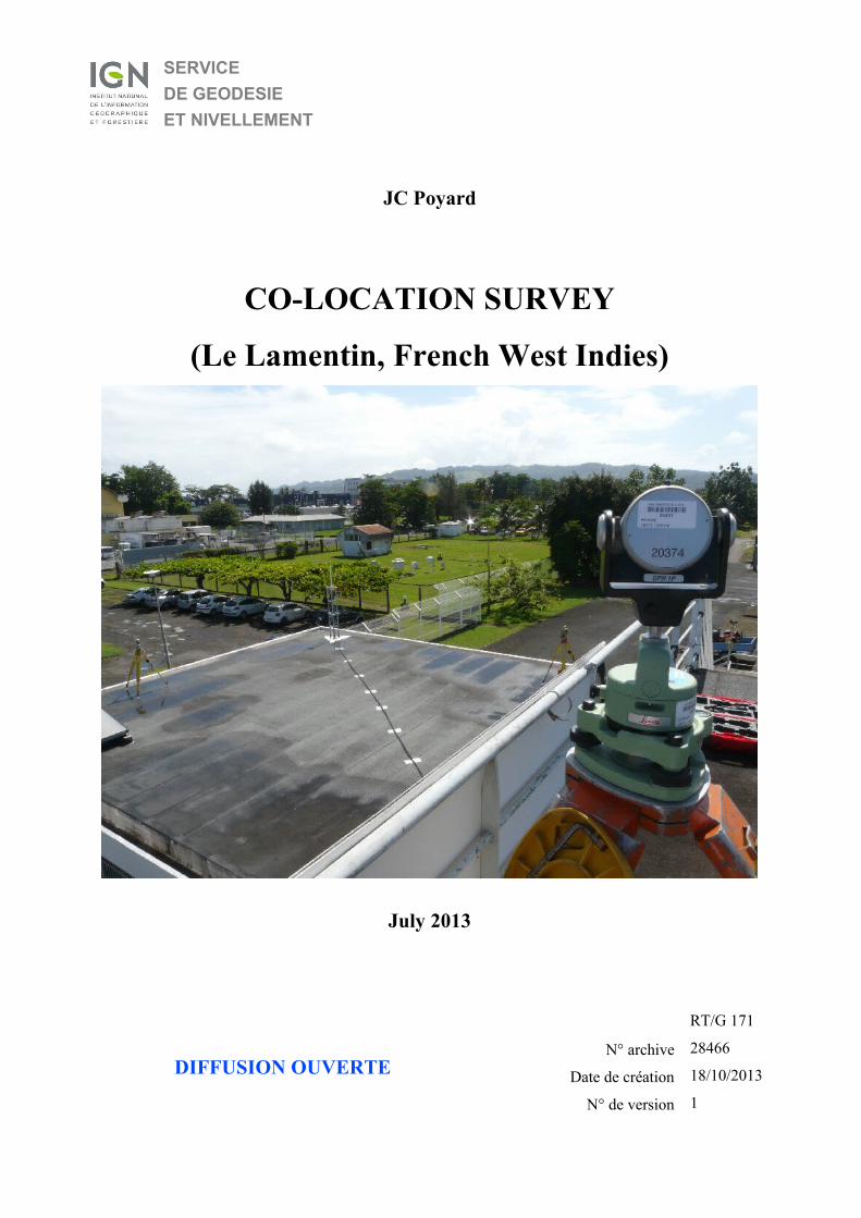
On late June 2013, a DORIS station has been installed at Le Lamentin in co-location with this GNSS station.
Moreover, for a long time the harbour of Fort-de-France, situated 7 km apart, is equipped with a tide gauge.
On October 2005 the tide gauge was upgraded and then tied to the GNSS station FFTG on December 2011.
This tide gauge n°338 part of the GLOSS network is managed by SHOM in partnership with french entities
(i.e. Météo-France, Marine Nationale, Université of La Rochelle, Institut de physique du globe de Paris).
After the DORIS station installation, the opportunity was taken to survey a local tie between these two
stations by classic technique. At the same time a connection between the position of the antennas and the tide
gauge GNSS monitoring station was achieved by GNSS survey.
Within this context, the local tie survey performed fulfils the triple purpose :
➢ assign coordinates to the new DORIS station (i.e. antennna reference point) ;
➢ provide vectors between instruments reference points (i.e. DORIS, GNSS, tide gauge) ;
➢ produce the results (i.e. SINEX file) to LAREG for the next ITRF solution.
IGN ● Service de géodésie et nivellement 73 avenue de Paris, 94165 Saint-Mandé Cedex ● Tél : 01 43 98 83 25 ● sgn@ign. fr

IGNService
de Géodésieet Nivellement
J-C. Poyard RT/Gv
page
1711
7/42
CO-LOCATION SURVEY(Le Lamentin, French West Indies)
1.2. SITE DESCRIPTION
Part of the West Indies archipelago, Martinique is located in the Caribbean Sea approximately by 15° north
and 61° west, that's to say about 450 km north of the coast of South America or 900 km south-east of
Dominican Republic.
Martinique stretches 60 km in length and less than 30 km in width ; so with a total area of 1,100 square
kilometres, it's the 3rd largest island in the Lesser Antilles after Trinidad and Guadeloupe.
The island is volcanic in origin, lying along the subduction fault where the North American Plate slides
beneath the Caribbean Plate. The highest point is the volcano of “Montagne Pelée” at 1,397 metres notorious
for the island's most dramatic feature which suddenly destroyed Saint-Pierre and killed 28,000 people during
the eruption of May 8th, 1902.
The northern end of the island is mountainous, heavily forested and catches the bulk of the rainfall when the
southern part is drier and concentrates the white sand beaches.
The “Météo-France” regional service of Martinique is located between these two parts on the west coast just
on north of the international airport in Le Lamentin.
From a geodetic point of view, this site is equipped with various scientific instruments :
➢ a DORIS station;
➢ a GNSS station.
Moreover, the harbour of Fort-de-France, located 7 km away, is equipped with a tide gauge and GNSS
station respectively managed by the “service hydrographique et océanographique de la Marine” (SHOM) and
the LIENs laboratory.
IGN ● Service de géodésie et nivellement 73 avenue de Paris, 94165 Saint-Mandé Cedex ● Tél : 01 43 98 83 25 ● sgn@ign. fr

IGNService
de Géodésieet Nivellement
J-C. Poyard RT/Gv
page
1711
8/42
CO-LOCATION SURVEY(Le Lamentin, French West Indies)
Le Lamentin site location
(source : www.geoportail.fr)
IGN ● Service de géodésie et nivellement 73 avenue de Paris, 94165 Saint-Mandé Cedex ● Tél : 01 43 98 83 25 ● sgn@ign. fr
marégraphe GLOSS n°338+
station GNSS FFTG
station DORIS LAOB+
station GNSS LMMF

IGNService
de Géodésieet Nivellement
J-C. Poyard RT/Gv
page
1711
9/42
CO-LOCATION SURVEY(Le Lamentin, French West Indies)
1.3. CO-LOCATED POINTS DESCRIPTION
1.3.1. GNSS station
The GNSS station is installed on top of a 1 metre high galvanized mast, fixed on the terrace roof of Météo-
France building. This GNSS station is part of the IGS network.
Acronym : LMMF DOMES number : 97205M001
General view Close-up view (reference point)
Description : Top and centre of a stainless steel triangular plate.Antenna height is 0,000 m.
1.3.2. DORIS station
Since late June 2013, a DORIS station is set up close to the GNSS station.
IGN ● Service de géodésie et nivellement 73 avenue de Paris, 94165 Saint-Mandé Cedex ● Tél : 01 43 98 83 25 ● sgn@ign. fr

IGNService
de Géodésieet Nivellement
J-C. Poyard RT/Gv
page
1711
10/42
CO-LOCATION SURVEY(Le Lamentin, French West Indies)
Acronym : LAOB DOMES number : 97205S001
General view Close-up view (reference point)
Description : DORIS antenna reference point (Starec type).
The DORIS reference point is tied with a marker centred under the antenna.
IGN ● Service de géodésie et nivellement 73 avenue de Paris, 94165 Saint-Mandé Cedex ● Tél : 01 43 98 83 25 ● sgn@ign. fr

IGNService
de Géodésieet Nivellement
J-C. Poyard RT/Gv
page
1711
11/42
CO-LOCATION SURVEY(Le Lamentin, French West Indies)
Acronym : DORIS mark No DOMES number
General view Close-up view (reference point)
Description : domed hexagonal mark glued on the roof waterproof cladding.
1.3.3. Tide gauge
The first sea level observations from the Fort-de-France tide gauge started on October 31th, 1976. After some
big gaps, observations resumed on late 2005. Identified with the name “Fort-de-France” and GLOSS number
338, it is managed by SHOM in collaboration with local authorities including Météo-France
(see http ://refmar. shom. fr/en/fort-de-france ).
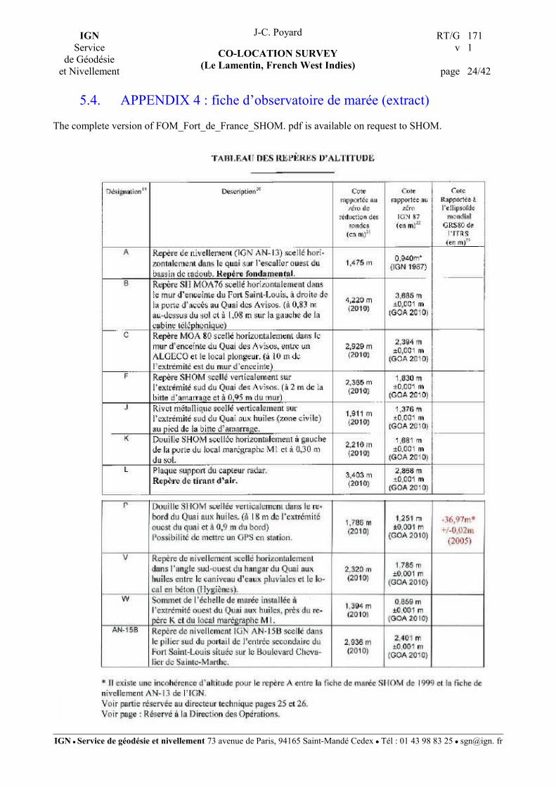
Many reference marks are available around this tide gauge (see extracts of
FOM_Fort_de_France_SHOM.pdf in appendix 4). They have not been measured during this campaign.
IGN ● Service de géodésie et nivellement 73 avenue de Paris, 94165 Saint-Mandé Cedex ● Tél : 01 43 98 83 25 ● sgn@ign. fr

IGNService
de Géodésieet Nivellement
J-C. Poyard RT/Gv
page
1711
12/42
CO-LOCATION SURVEY(Le Lamentin, French West Indies)
2. LOCAL TIE DESCRIPTION
2.1. ORGANIZATION
The GNSS observations for the survey bearing started on Wednesday 26th June 2013 but most of the survey
was carried out by GNSS or classic techniques on Monday 1st July.
All the topometric survey instruments and equipments belong to IGN and were sent by plane. No spirit
leveling equipment was shipped.
2.2. MEASUREMENT INSTRUMENTS CHARACTERISTICS
The equipment belongs to IGN and is regularly checked and calibrated in our offices.
The following table provides the specification and identification of the equipment used for the survey :
Equipment Trademark, Serial ref. n° Specifications, accuracy
Total station Leica TC2002 n° 20102 EDM st. dev. 1mm + 1 pmm
Angular st. dev. 0.15 mgon
Checked by IGN on 01/01/2013
Prism Leica GPH 1P n°20373 Dist. Corr. 0.0 mm
Prism Leica GPH 1P n°20374 Dist. Corr. 0.0 mm
Device : Prism mini rod Leica GLS14 n°40913 -
Meteorological station Kestrel 4500NV serial n°672710 Temp. st. dev. 0.5°C
Pressure st. dev. 1 hPa
GNSS unit Receiver : Leica GS10 n°50113
Antenna : Leica AS10 n°50113
Static post-processing accuracies
Horiz. 3 mm + 0.5 ppm
Vert. 6 mm + 0.5 ppm
Tripods (5) Leica (no references) Made of wood,
Tribrack Leica (no reference)
2.3. OBSERVATIONS POLYGON
IGN ● Service de géodésie et nivellement 73 avenue de Paris, 94165 Saint-Mandé Cedex ● Tél : 01 43 98 83 25 ● sgn@ign. fr

IGNService
de Géodésieet Nivellement
J-C. Poyard RT/Gv
page
1711
13/42
CO-LOCATION SURVEY(Le Lamentin, French West Indies)
At Le Lamentin, in spite of the soft roof waterproof cladding, the survey was conducted on that site with
close attention in order to provide the best possible accuracy in the determination of the 3D vectors between
the observing reference points. Indeed the adjustment provides a suitable accuracy on all observed points.
Hereafter is the observations polygon.
2.4. SURVEY METHOD
Four stations (numbered 10, 11, 12 and 13) in the immediate vicinity of the reference points were surveyed.
All the visible lines of sight were observed with the total station. Horizontal directions and zenith angles
were observed in data sets : each set consisting in one reading in both direct and reverse theodolite positions.
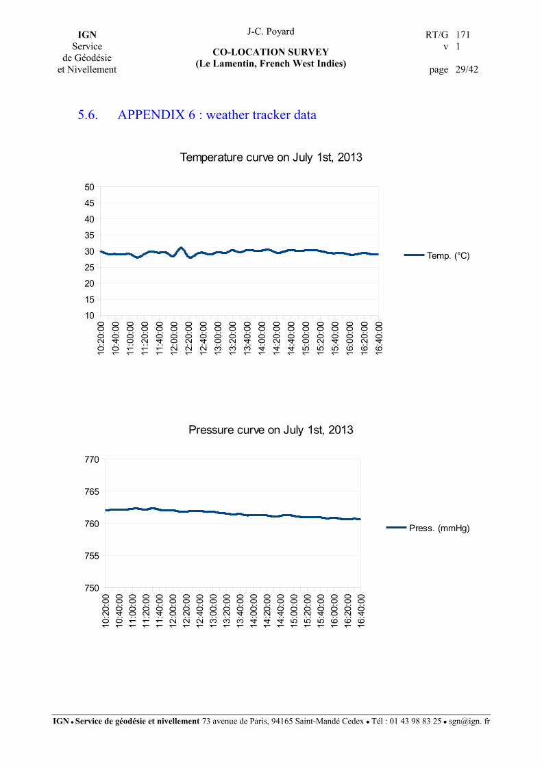
Distance measurements were observed at least once over each line. Meteorological data (atmospheric
pressure and temperature), used to correct the distances, were recorded at the beginning of each station
occupation. During the survey these values were around 29 °C and 761 mm of mercury (see appendix 6).
IGN ● Service de géodésie et nivellement 73 avenue de Paris, 94165 Saint-Mandé Cedex ● Tél : 01 43 98 83 25 ● sgn@ign. fr

IGNService
de Géodésieet Nivellement
J-C. Poyard RT/Gv
page
1711
14/42
CO-LOCATION SURVEY(Le Lamentin, French West Indies)
2.4.1. Antennas reference points
As our strategy was to keep in place the DORIS or GNSS antennas (i.e. LAOB, LMMF), their reference
points have to be determined indirectly.
For the planimetric position :
From each survey station aiming at the antennas, the right and left sides of the antenna theoretically centred
on the antenna reference point (ARP) were observed. This element was chosen so that it is optically well
defined for the operator, and in the adjustment, horizontal angle observations were simply averaged to get its
planimetric centred position.
For the altimetric position :
Vertical angles have been measured on a well-defined element of the antenna. Then, the resulting position
has been reduced to the reference point using the manufacturer values, and some centring equations have
been included in the adjustment.
2.4.2. Centring equations
If a point is centred above another this leads to centring equations with distances and accuracies between
these points.
The measurements come either from manufacturer values or from on field observations (calliper rule, tape
measure).
2.4.3. GNSS observations
GNSS observations were carried out in order to provide the polygon bearing. For this purpose two references
named Ref_Est and Ref_N-E have been determined.
Data from “LMMF” and “FFTG” GNSS stations were downloaded from either the RGP website or SONEL
website in order to process the baseline.
IGN ● Service de géodésie et nivellement 73 avenue de Paris, 94165 Saint-Mandé Cedex ● Tél : 01 43 98 83 25 ● sgn@ign. fr
IGNService
de Géodésieet Nivellement
J-C. Poyard RT/Gv
page
1711
15/42
CO-LOCATION SURVEY(Le Lamentin, French West Indies)
3. COMPUTATION
3.1. ON SITE VALIDATION
All these instruments allowed the observations to be recorded electronically on memory cards or storage
devices. GNSS and total station data were downloaded on a laptop PC for checkings and on site validation.
3.2. GNSS BEARINGS
Back at the office, GNSS baselines were processed with Leica Geo Office V 8.1 software using the original
set of “absolute” GNSS antenna calibrations (igs08.atx). The IGb08 ep2005.0 coordinates of the fixed point
LMMF introduced into the LGO calculation came from the IGS cumulative solution file IGS13P34.ssc
(see LGO report file in appendix 5).
3.3. FINAL ADJUSTMENT
The final computation is carried out by a 3D least squares adjustment with Microsearch GeoLab 2001
version 2001.9.20.0 software. The input file (see appendix 6) comes from :
➢ total station observations : horizontal and zenithal angles, distances;
➢ centring equations : relative positions between points;
➢ bearing from GNSS data process;
➢ LMMF IGb08 ep2005.0 coordinates derived from IGS13P34. ssc file constrained at 1 mm.
The a priori standard deviations used for the different observations are :
➢ 0.8 mgon for horizontal angles;
➢ 1.2 mgon for vertical angles;
➢ 1 mm for distances;
➢ 1 mm for heights measured with a two-metre rule;
➢ 1 mm for height differences derived from spirit levelling made by SHOM.
These values are commonly used in most of our Microsearch GeoLab computation input file. The adjustment
provides points coordinates (see appendix 7) and an associated covariance matrix.
IGN ● Service de géodésie et nivellement 73 avenue de Paris, 94165 Saint-Mandé Cedex ● Tél : 01 43 98 83 25 ● sgn@ign. fr

IGNService
de Géodésieet Nivellement
J-C. Poyard RT/Gv
page
1711
16/42
CO-LOCATION SURVEY(Le Lamentin, French West Indies)
4. RESULTS
4.1. STATION NAME TRANSLATION TABLE
The following list sums up the most interesting points used in the Microsearch GeoLab input file with the
main points in bold (appendix 6).
Point description Code or DOMES number Computation name
DORIS station and marker
LAOB Antenna Reference Point
DORIS conservation mark
97205S001
97205M002
LAOB
DORIS_mark
GNSS stations
IGS GNSS antenna at ARP 97205M001 LMMF
Tide gauge GNSS antenna at ARP 97201M006 FFTG
4.2. ADJUSTED COORDINATES AND CONFIDENCE REGIONS
LMMF station was installed in 2008, so the last ITRS realization (ITRF2008) did not use LMMF data.. For
the needs of the survey, LMMF coordinates (IGS08 ep2005.0) from the IGS cumulative solution file
IGS13P34.ssc constrained at 1 mm were used..
The results of the adjustment are the coordinates of all points as well as their confidence ellipsoids in IGb08
reference frame at epoch 2005.0.
The table below provides the 3D coordinates and confidence regions at 95 % of the points of interest.
================================================================================ (LE LAMENTIN - MARTINIQUE) REGINA&DORIS (and TIDE GAUGE) TIESMicrosearch GeoLab, V2001.9.20.0 GRS 80 UNITS: m,GRAD Page 0003================================================================================Adjusted XYZ Coordinates: X-COORDINATE Y-COORDINATE Z-COORDINATE CODE FFF STATION STD DEV STD DEV STD DEV ---- --- ------------ ------------------ ------------------ ------------------ XYZ DORIS_rep1 2993392.5440 -5399349.6838 1596767.3898 m 0 0.0012 0.0012 0.0012 XYZ FFTG 2986963.6671 -5402703.8389 1597459.1262 m 0 0.0017 0.0022 0.0015 XYZ LAOB 2993393.6539 -5399351.6873 1596767.9871 m 0 0.0013 0.0016 0.0013 XYZ LAOB/2GHz 2993393.8813 -5399352.0974 1596768.1093 m 0
IGN ● Service de géodésie et nivellement 73 avenue de Paris, 94165 Saint-Mandé Cedex ● Tél : 01 43 98 83 25 ● sgn@ign. fr

IGNService
de Géodésieet Nivellement
J-C. Poyard RT/Gv
page
1711
17/42
CO-LOCATION SURVEY(Le Lamentin, French West Indies)
0.0012 0.0012 0.0012 XYZ LAOB/400MHz 2993393.6532 -5399351.6871 1596767.9862 m 0 0.0012 0.0012 0.0012 XYZ LMMF 2993387.2705 -5399363.9818 1596747.9471 m 0 0.0011 0.0011 0.0011
================================================================================ (LE LAMENTIN - MARTINIQUE) REGINA&DORIS (and TIDE GAUGE) TIESMicrosearch GeoLab, V2001.9.20.0 GRS 80 UNITS: m,GRAD Page 0010================================================================================2-D and 1-D Station Confidence Regions (95.000 and 95.000 percent):STATION MAJOR SEMI-AXIS AZ MINOR SEMI-AXIS VERTICAL------------ --------------------- --- ------------------- --------------------DORIS_rep1 0.0031 30 0.0029 0.0024FFTG 0.0035 50 0.0034 0.0049LAOB 0.0032 30 0.0030 0.0033LAOB/2GHz 0.0031 30 0.0029 0.0024LAOB/400MHz 0.0031 30 0.0029 0.0024LMMF 0.0028 0 0.0028 0.0022
The whole covariance matrix was computed, then it was possible to extract from it the covariance submatrix
for the 2 points of interest (i.e. LMMF and LAOB). Lastly, this covariance submatrix has been converted
into SINEX format using “geotosnx” tool. The resulting SINEX file (97205_IGN_2013-183_v10.SNX) is
presented in appendix 8.
4.3. VECTORS
The following table sums up LMMF coordinates and local tie vectors with the most interesting points :.
Coordinates IGb08 ep2005.0
Acronym DOMES number X (m) Y (m) Z (m)
LMMF 97205M001 2993387.271 -5399363.982 1596747.947
Local tie vectors from LMMF
Acronym DOMES number dX (m) dY (m) dZ (m)
LAOB 97205S001 6.383 12.295 20.040
FFTG 97201M006 -6423.603 -3339.857 711.179
IGN ● Service de géodésie et nivellement 73 avenue de Paris, 94165 Saint-Mandé Cedex ● Tél : 01 43 98 83 25 ● sgn@ign. fr

IGNService
de Géodésieet Nivellement
J-C. Poyard RT/Gv
page
1711
18/42
CO-LOCATION SURVEY(Le Lamentin, French West Indies)
5. APPENDICES
IGN ● Service de géodésie et nivellement 73 avenue de Paris, 94165 Saint-Mandé Cedex ● Tél : 01 43 98 83 25 ● sgn@ign. fr
IGNService
de Géodésieet Nivellement
J-C. Poyard RT/Gv
page
1711
19/42
CO-LOCATION SURVEY(Le Lamentin, French West Indies)
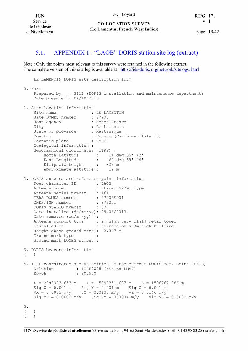
5.1. APPENDIX 1 : “LAOB” DORIS station site log (extract)
Note : Only the points most relevant to this survey were retained in the following extract.The complete version of this site log is available at : http ://ids-doris. org/network/sitelogs. html
LE LAMENTIN DORIS site description form
0. Form Prepared by : SIMB (DORIS installation and maintenance department) Date prepared : 04/10/2013
1. Site location information Site name : LE LAMENTIN Site DOMES number : 97205 Host agency : Meteo-France City : Le Lamentin State or province : Martinique Country : France (Caribbean Islands) Tectonic plate : CARB Geological information : Geographical coordinates (ITRF) : North Latitude : 14 deg 35' 42'' East Longitude : -60 deg 59' 46'' Ellipsoid height : -29 m Approximate altitude : 12 m
2. DORIS antenna and reference point information Four character ID : LAOB Antenna model : Starec 52291 type Antenna serial number : 161 IERS DOMES number : 97205S001 CNES/IGN number : 972051 DORIS SSALTO number : 337 Date installed (dd/mm/yy): 29/06/2013 Date removed (dd/mm/yy) : Antenna support type : 2m high very rigid metal tower Installed on : terrace of a 3m high building Height above ground mark : 2.367 m Ground mark type : Ground mark DOMES number :
3. DORIS beacons information( )
4. ITRF coordinates and velocities of the current DORIS ref. point (LAOB) Solution : ITRF2008 (tie to LMMF) Epoch : 2005.0
X = 2993393.653 m Y = -5399351.687 m Z = 1596767.986 m Sig X = 0.001 m Sig Y = 0.001 m Sig Z = 0.001 m VX = 0.0082 m/y VY = 0.0108 m/y VZ = 0.0146 m/y Sig VX = 0.0002 m/y Sig VY = 0.0004 m/y Sig VZ = 0.0002 m/y
5. ( )( )
IGN ● Service de géodésie et nivellement 73 avenue de Paris, 94165 Saint-Mandé Cedex ● Tél : 01 43 98 83 25 ● sgn@ign. fr

IGNService
de Géodésieet Nivellement
J-C. Poyard RT/Gv
page
1711
20/42
CO-LOCATION SURVEY(Le Lamentin, French West Indies)
5.2. APPENDIX 2 : “LMMF” GNSS station site log (extract)
Note : Only the points most relevant to this survey were retained in the following extract.
The complete version of this site log is available at : http ://igscb. jpl. nasa. gov/network/site/ lmmf . html
LMMF Site Information Form (site log) International GPS Service See Instructions at: ftp://igscb.jpl.nasa.gov/pub/station/general/sitelog_instr.txt
0. Form Prepared by (full name) : Equipe RGP Date Prepared : 2013-09-13( )
1. Site Identification of the GNSS Monument
Site Name : Aeroport Aime CESAIRE-LE LAMENTIN-Meteo Fra. Four Character ID : LMMF Monument Inscription : NONE IERS DOMES Number : 97205M001 CDP Number : NONE Monument Description : INOX TRIANGULAR PLATE ON TOP OF METALLIC PILAR Height of the Monument : 1.0 m Monument Foundation : ROOF Foundation Depth : 10.0 m Marker Description : TOP AND CENTRE OF THE TRIANGULAR PLATE Date Installed : 2008-07-11( )
2. Site Location Information
City or Town : LE LAMENTIN State or Province : Martinique (972 ) Country : France Tectonic Plate : CARIBBEAN Approximate Position (ITRF) X coordinate (m) : 2993387.952 Y coordinate (m) : -5399363.731 Z coordinate (m) : 1596748.042 Latitude (N is +) : +143541.33871 Longitude (E is +) : -0605946.21428 Elevation (m,ellips.) : -27.0 Additional Information : (multiple lines)
3. GNSS Receiver Information( )
3.10 Receiver Type : TRIMBLE NETR9 Satellite System : GPS+GLO+GAL+BDS+SBAS Serial Number : 5118K75440 Firmware Version : 4.81 Elevation Cutoff Setting : 3 Date Installed : 2013-09-13T08:00Z Date Removed : (CCYY-MM-DDThh:mmZ)
IGN ● Service de géodésie et nivellement 73 avenue de Paris, 94165 Saint-Mandé Cedex ● Tél : 01 43 98 83 25 ● sgn@ign. fr

IGNService
de Géodésieet Nivellement
J-C. Poyard RT/Gv
page
1711
21/42
CO-LOCATION SURVEY(Le Lamentin, French West Indies)
Temperature Stabiliz. : (none or tolerance in degrees C) Additional Information : (multiple lines)
4. GNSS Antenna Information
4.3 Antenna Type : TRM57971.00 NONE Serial Number : 5311118262 Antenna Reference Point : BAM Marker->ARP Up Ecc. (m) : 0.00 Marker->ARP North Ecc(m) : 0.00 Marker->ARP East Ecc(m) : 0.00 Alignment from True N : 0 Antenna Radome Type : NONE Radome Serial Number : Antenna Cable Type : (vendor & type number) Antenna Cable Length : 30 m Date Installed : 2013-06-24T13:00Z Date Removed : (CCYY-MM-DDThh:mmZ) Additional Information : (multiple lines)
5. Surveyed Local Ties( )( )
13. More Information
Primary Data Center : IGNE Secondary Data Center : CDDIS URL for More Information : http://rgp.ign.fr/STATIONS/liste.php Hardcopy on File Site Map : http://rgp.ign.fr/ Site Diagram : (Y) Horizon Mask : (Y) Monument Description : (Y) Site Pictures : http://rgp.ign.fr/ Additional Information : (multiple lines) Antenna Graphics with Dimensions
TRM57971.00
/ ----------------------+--------------------- \ + + + \ -------------------------------------------- / \ / \ / \-----+-----/ <-- 0.0000 ARP=BAM
<-- 0.3396 -->
IGN ● Service de géodésie et nivellement 73 avenue de Paris, 94165 Saint-Mandé Cedex ● Tél : 01 43 98 83 25 ● sgn@ign. fr

IGNService
de Géodésieet Nivellement
J-C. Poyard RT/Gv
page
1711
22/42
CO-LOCATION SURVEY(Le Lamentin, French West Indies)
5.3. APPENDIX 3 : “FFTG” GNSS station site log (extract)
Note : Only the points most relevant to this survey were retained in the following extract.
The complete version of this site log (fftg_20130708. log) is available on SONEL website.
FFTG Site Information Form (site log) International GNSS Service See Instructions at: ftp://igscb.jpl.nasa.gov/pub/station/general/sitelog_instr.txt
0. Form( )
1. Site Identification of the GNSS Monument
Site Name : Fort de France tide gauge Four Character ID : FFTG Monument Inscription : IERS DOMES Number : 97201M006 CDP Number : (A4) Monument Description : Height of the Monument : (m) Monument Foundation : (STEEL RODS, CONCRETE BLOCK, ROOF, etc) Foundation Depth : (m) Marker Description : (CHISELLED CROSS/DIVOT/BRASS NAIL/etc) Date Installed : 2012-04-04T00:00Z Geologic Characteristic : (BEDROCK/CLAY/CONGLOMERATE/GRAVEL/SAND/etc) Bedrock Type : (IGNEOUS/METAMORPHIC/SEDIMENTARY) Bedrock Condition : (FRESH/JOINTED/WEATHERED) Fracture Spacing : (1-10 cm/11-50 cm/51-200 cm/over 200 cm) Fault zones nearby : (YES/NO/Name of the zone) Distance/activity : (multiple lines) Additional Information :
2. Site Location Information
City or Town : Fort de France State or Province : Martinique Country : France Tectonic Plate : CARIBBEAN Approximate Position (ITRF) X coordinate (m) : 2987018.641 Y coordinate (m) : -5402770.779 Z coordinate (m) : 1597485.018 Latitude (N is +) : 143605.398416 Longitude (E is +) : -0610347.52684 Elevation (m,ellips.) : (F7.1) Additional Information : (multiple lines)
3. GNSS Receiver Information( )
4. GNSS Antenna Information
4.1 Antenna Type : TPSPG_A1+GP Serial Number : 310-0972 Antenna Reference Point : BPA
IGN ● Service de géodésie et nivellement 73 avenue de Paris, 94165 Saint-Mandé Cedex ● Tél : 01 43 98 83 25 ● sgn@ign. fr

IGNService
de Géodésieet Nivellement
J-C. Poyard RT/Gv
page
1711
23/42
CO-LOCATION SURVEY(Le Lamentin, French West Indies)
Marker->ARP Up Ecc. (m) : 0.000 Marker->ARP North Ecc(m) : 0.000 Marker->ARP East Ecc(m) : 0.000 Alignment from True N : 0.000 deg Antenna Radome Type : NONE Radome Serial Number : Antenna Cable Type : (vendor & type number) Antenna Cable Length : (m) Date Installed : 2011-12-20 Date Removed : (CCYY-MM-DDThh:mmZ) Additional Information : (multiple lines)
5. Surveyed Local Ties( )
6. Frequency Standard( )
7. Collocation Information
7.1 Instrumentation Type : TIDE GAUGE Status : PERMANENT Effective Dates : 1976-10-31/CCYY-MM-DD Notes : (multiple lines)
8. Meteorological Instrumentation( )
9. Local Ongoing Conditions Possibly Affecting Computed Position( )
10. Local Episodic Effects Possibly Affecting Data Quality( )
11. On-Site, Point of Contact Agency Information( )
12. Responsible Agency (if different from 11.)( )
13. More Information( )
TPSPG_A1+GP
_____ <-- 0.0537 -/ \- ____| |____ __| |__ +-----------|-------------------------|-----------+ <-- 0.0300 TGP +-------------------------------------------------+ <-- 0.0275 BGP \ / \ / +-----------+ <-- 0.0000 BPA=ARP
<-- 0.2000 -->
IGN ● Service de géodésie et nivellement 73 avenue de Paris, 94165 Saint-Mandé Cedex ● Tél : 01 43 98 83 25 ● sgn@ign. fr
IGNService
de Géodésieet Nivellement
J-C. Poyard RT/Gv
page
1711
24/42
CO-LOCATION SURVEY(Le Lamentin, French West Indies)
5.4. APPENDIX 4 : fiche d’observatoire de marée (extract)
The complete version of FOM_Fort_de_France_SHOM. pdf is available on request to SHOM.
IGN ● Service de géodésie et nivellement 73 avenue de Paris, 94165 Saint-Mandé Cedex ● Tél : 01 43 98 83 25 ● sgn@ign. fr

IGNService
de Géodésieet Nivellement
J-C. Poyard RT/Gv
page
1711
25/42
CO-LOCATION SURVEY(Le Lamentin, French West Indies)
IGN ● Service de géodésie et nivellement 73 avenue de Paris, 94165 Saint-Mandé Cedex ● Tél : 01 43 98 83 25 ● sgn@ign. fr

IGNService
de Géodésieet Nivellement
J-C. Poyard RT/Gv
page
1711
26/42
CO-LOCATION SURVEY(Le Lamentin, French West Indies)
In the same report “ Compte-rendu d’intervention sur le MCN Fort-de-France ” the permanent GNSS station
installation is described. The leveling performed with a laser distance sensor and the results are in the extract
hereafter :
IGN ● Service de géodésie et nivellement 73 avenue de Paris, 94165 Saint-Mandé Cedex ● Tél : 01 43 98 83 25 ● sgn@ign. fr

IGNService
de Géodésieet Nivellement
J-C. Poyard RT/Gv
page
1711
27/42
CO-LOCATION SURVEY(Le Lamentin, French West Indies)
IGN ● Service de géodésie et nivellement 73 avenue de Paris, 94165 Saint-Mandé Cedex ● Tél : 01 43 98 83 25 ● sgn@ign. fr

IGNService
de Géodésieet Nivellement
J-C. Poyard RT/Gv
page
1711
28/42
CO-LOCATION SURVEY(Le Lamentin, French West Indies)
5.5. APPENDIX 5 : LEICA Geo Office report file
IGN ● Service de géodésie et nivellement 73 avenue de Paris, 94165 Saint-Mandé Cedex ● Tél : 01 43 98 83 25 ● sgn@ign. fr
IGNService
de Géodésieet Nivellement
J-C. Poyard RT/Gv
page
1711
29/42
CO-LOCATION SURVEY(Le Lamentin, French West Indies)
5.6. APPENDIX 6 : weather tracker data
IGN ● Service de géodésie et nivellement 73 avenue de Paris, 94165 Saint-Mandé Cedex ● Tél : 01 43 98 83 25 ● sgn@ign. fr
10:2
0:00
10:4
0:00
11:0
0:00
11:2
0:00
11:4
0:00
12:0
0:00
12:2
0:00
12:4
0:00
13:0
0:00
13:2
0:00
13:4
0:00
14:0
0:00
14:2
0:00
14:4
0:00
15:0
0:00
15:2
0:00
15:4
0:00
16:0
0:00
16:2
0:00
16:4
0:00
10
15
20
25
30
35
40
45
50
Temperature curve on July 1st, 2013
Temp. (°C)
10:2
0:00
10:4
0:00
11:0
0:00
11:2
0:00
11:4
0:00
12:0
0:00
12:2
0:00
12:4
0:00
13:0
0:00
13:2
0:00
13:4
0:00
14:0
0:00
14:2
0:00
14:4
0:00
15:0
0:00
15:2
0:00
15:4
0:00
16:0
0:00
16:2
0:00
16:4
0:00
750
755
760
765
770
Pressure curve on July 1st, 2013
Press. (mmHg)

IGNService
de Géodésieet Nivellement
J-C. Poyard RT/Gv
page
1711
30/42
CO-LOCATION SURVEY(Le Lamentin, French West Indies)
5.7. APPENDIX 7 : adjustment input file
TITL (LE LAMENTIN - MARTINIQUE) REGINA&DORIS (and TIDE GAUGE) TIES SURVEY CARRIED OUT BY J-C POYARD (IGN-F) ON JULY 2013
COMP ADJ ELIP GRS 80 6378137 6356752.3141 0.0000 0.0000 0.0000 m MAXI 15 CONF YES YES YES YES NO PSOL NO YES PMIS NO NO PRES YES NO PADJ NO NO YES NO YES NO VARF YES YES NO RTST TAU MAX LUNT m 1.000000000000 CONV 0.00010 CLEV 95.000 ANGT GRD LDEC 4
*************************************************************************************************** LIST OF POINTS for the SURVEY ADJUSTMENT (ITRF ACRONYMS, n° DOMES and POINTS DESCRIPTION) ***************************************************************************************************
*POINTS OF INTEREST*------------------ *GNSS*LMMF : 97205M001 = RGP/REGINA ref. pt. (IGS GNSS station) Antenna Height = 0.000 m
*DORIS*LAOB : (DOMES 97205S001) = DORIS antenna ref. pt. (Starec type)*LAOB/2GHz : (no DOMES ) = DORIS LAOB 2GHz Phase Centre*DORIS_rep1 : 97205M002 = DORIS_marker_1 (under LAOB) (glued mark, will last ???)
*TIDE GAUGE*FFTG : (DOMES 97201M006) = Tide Gauge GNSS station *OTHER POINTS*10 : (no DOMES number) = temporary station *11 : (no DOMES number) = temporary station*12 : (no DOMES number) = temporary station*13 : (no DOMES number) = temporary station
*xxxx_P : Prism on a mini-pole (H=0,20m) on mark xxxx*LMMF_Prism : Mini-prism under the GNSS antenna (H = -0,116 / LMMF_ARP)*LMMF_axis : GNSS ANTENNA AXIS (value issued from average from left and right antenna sides values)
**********************AZIMUT DEDUCTED FROM THE GPS DETERMINATION********************************** AZIM LMMF Ref_N-East 52 49 65.0 0.005 AZIM LMMF Ref_East 82 72 23.0 0.004
*LMMF IGS08 EP 2005:001 COORDINATES ISSUED FROM IGS13P34.ssc FILE CONSTRAINED AT 1 MM 3DC XYZ 000 LMMF 2993387.2705 -5399363.9818 1596747.9471 m COV CT DIAG ELEM 0.000001 0.000001 0.000001
*Approximate Coordinates PLH 000 Ref_N-East N 14 35 43.89038 W 60 59 43.40171 -35.0396 m 0 PLH 000 Ref_East N 14 35 42.56500 W 60 59 41.70524 -33.4681 m 0 PLH 000 10 N 14 35 41.50192 W 60 59 46.24229 -26.7792 m 0 PLH 000 11 N 14 35 41.31883 W 60 59 46.09571 -26.7984 m 0 PLH 000 12 N 14 35 41.72379 W 60 59 45.83420 -30.2182 m 0 PLH 000 13 N 14 35 42.00820 W 60 59 46.09448 -30.3690 m 0 PLH 000 LMMF_axis N 14 35 41.33665 W 60 59 46.23825 -27.0521 m 0 PLH 000 DORIS_rep1 N 14 35 42.03039 W 60 59 45.85253 -31.8283 m 0 PLH 000 DORIS_rep1_P N 14 35 42.03038 W 60 59 45.85251 -31.6290 m 0 PLH 000 LAOB/2GHz N 14 35 42.03042 W 60 59 45.85255 -28.9776 m 0
IGN ● Service de géodésie et nivellement 73 avenue de Paris, 94165 Saint-Mandé Cedex ● Tél : 01 43 98 83 25 ● sgn@ign. fr

IGNService
de Géodésieet Nivellement
J-C. Poyard RT/Gv
page
1711
31/42
CO-LOCATION SURVEY(Le Lamentin, French West Indies)
PLH 000 LAOB N 14 35 42.03040 W 60 59 45.85257 -29.4617 m 0 PLH 000 LAOB/400MHz N 14 35 42.03040 W 60 59 45.85257 -29.4617 m 0 PLH 000 LAOB/base N 14 35 42.03040 W 60 59 45.85258 -29.8388 m 0 PLH 000 LMMF N 14 35 41.33664 W 60 59 46.23825 -27.1007 m 0 PLH 000 LMMF_Prism N 14 35 41.33664 W 60 59 46.23825 -27.2167 m 0
*************************************CENTRING EQUATIONS*****************************************
*LMMF centred 0.1160 m above LMMF_Prism 3DD PLH 000 LMMF n 14 35 41.337000 w 60 59 46.238000 -27.0000 PLH 000 LMMF_Prism n 14 35 41.337000 w 60 59 46.238000 -27.1160 COV LG DIAG ELEM 0.00000009 0.00000009 0.00000016
2DD PL 00 LMMF_axis n 14 35 41.337000 w 60 59 46.238000 PL 00 LMMF n 14 35 41.337000 w 60 59 46.238000 COV LG DIAG ELEM 0.00000009 0.00000009
3DD PLH 000 DORIS_rep1_P N 14 35 42.03000 W 60 59 45.85300 -31.6000 PLH 000 DORIS_rep1 N 14 35 42.03000 W 60 59 45.85300 -31.8000 COV LG DIAG ELEM 0.00000009 0.00000009 0.00000009
2DD PL 00 LAOB/2GHz n 14 35 42.030000 w 60 59 45.853000 PL 00 LAOB n 14 35 42.030000 w 60 59 45.853000 COV LG DIAG ELEM 0.00000009 0.00000009
*************************************DORIS HEIGHT (tape measurement)****************************
OHDF DORIS_rep1 LAOB 2.367 0.001
****************************TOTAL STATION OBSERVATIONS****************************************** SIGM AH 8.0 SIGM ZA 12.0 SIGM DP 0.0010
HIST NEW
DSET AH DIR 10 Ref_East 0 0 0.0 DIR 10 11 72 87 94.0 DIR 10 LMMF_Prism 113 51 98.1 DIR 10 LMMF_axis 113 51 84.3 DIR 10 13 332 66 85.4 DIR 10 LAOB/2GHz 354 68 19.9 DIR 10 LAOB/400MHz 354 68 20.8 DIR 10 LAOB/base 354 68 12.3 DIR 10 12 382 61 80.8 DIR 10 Ref_N-East 369 69 1.3 DSET AH DIR 11 Ref_N-East 0 0 0.0 DIR 11 LMMF_Prism 257 48 59.4 DIR 11 LMMF_axis 257 49 20.4 DIR 11 10 307 20 65.6 DIR 11 13 349 47 37.6 DIR 11 DORIS_rep1 369 81 71.2 DIR 11 LAOB/2GHz 369 81 36.0 DIR 11 LAOB/400MHz 369 81 25.7 DIR 11 LAOB/base 369 81 22.2 DIR 11 12 385 10 20.3 DSET AH DIR 12 Ref_East 0 0 0.0 DIR 12 10 180 71 40.7 DIR 12 LMMF_Prism 163 64 48.7 DIR 12 LMMF_axis 163 64 51.2 DIR 12 11 148 86 74.4
IGN ● Service de géodésie et nivellement 73 avenue de Paris, 94165 Saint-Mandé Cedex ● Tél : 01 43 98 83 25 ● sgn@ign. fr

IGNService
de Géodésieet Nivellement
J-C. Poyard RT/Gv
page
1711
32/42
CO-LOCATION SURVEY(Le Lamentin, French West Indies)
DIR 12 13 266 78 76.0 DIR 12 DORIS_rep1 309 42 68.5 DIR 12 LAOB/2GHz 309 42 31.6 DIR 12 LAOB/400MHz 309 41 91.6 DIR 12 LAOB/base 309 41 76.3 DIR 12 DORIS_rep1_P 309 43 12.4 DIR 12 Ref_N-East 365 96 57.6 DSET AH DIR 13 Ref_N-East 0 0 0.0 DIR 13 DORIS_rep1 33 65 46.5 DIR 13 LAOB/2GHz 33 64 60.9 DIR 13 LAOB/400MHz 33 65 23.2 DIR 13 LAOB/base 33 65 10.6 DIR 13 12 93 29 27.3 DIR 13 LMMF_Prism 152 71 77.5 DSET AH DIR 13 Ref_N-East 0 0 0.0 DIR 13 11 139 74 27.8 DIR 13 10 157 26 78.5 DIR 13 LMMF_axis 152 71 63.6 DIR 13 DORIS_rep1_P 33 65 75.3
*ZANG ZA 10 Ref_East 103 4 30.4 20.0 ZANG ZA 10 11 100 16 56.3 15.0 ZANG ZA 10 LMMF_Prism 105 46 78.2 *ZANG ZA 10 LMMF_axis 103 42 17.9 25.0 ZANG ZA 10 LAOB/2GHz 106 97 17.7 ZANG ZA 10 LAOB/400MHz 108 49 29.3 *ZANG ZA 10 LAOB/base 109 65 48.5 ZANG ZA 10 12 115 34 51.8 *ZANG ZA 10 Ref_N-East 104 67 41.3 *ZANG ZA 11 Ref_N-East 104 63 88.1 ZANG ZA 11 LMMF_Prism 106 17 24.7 *ZANG ZA 11 LMMF_axis 103 74 93.7 ZANG ZA 11 10 99 82 70.5 ZANG ZA 11 13 110 62 70.5 ZANG ZA 11 DORIS_rep1 113 67 85.5 ZANG ZA 11 LAOB/2GHz 106 0 10.8 ZANG ZA 11 LAOB/400MHz 107 32 67.8 *ZANG ZA 11 LAOB/base 108 34 14.7 ZANG ZA 11 12 114 54 82.5 *ZANG ZA 12 Ref_East 101 64 26.8 15.0 ZANG ZA 12 10 84 65 37.3 ZANG ZA 12 LMMF_Prism 88 85 33.7 *ZANG ZA 12 LMMF_axis 88 24 65.2 ZANG ZA 12 11 85 45 0.9 ZANG ZA 12 13 100 81 65.8 ZANG ZA 12 DORIS_rep1 110 75 55.1 ZANG ZA 12 LAOB/2GHz 91 67 30.3 ZANG ZA 12 LAOB/400MHz 94 90 94.8 *ZANG ZA 12 LAOB/base 97 44 90.3 ZANG ZA 12 DORIS_rep1_P 109 44 59.4 *ZANG ZA 12 Ref_N-East 103 10 88.1 *ZANG ZA 13 Ref_N-East 102 99 60.1 ZANG ZA 13 DORIS_rep1 112 60 51.4 ZANG ZA 13 LAOB/2GHz 87 95 92.6 ZANG ZA 13 LAOB/400MHz 92 10 12.3 *ZANG ZA 13 LAOB/base 95 36 50.2 ZANG ZA 13 12 99 17 99.7 ZANG ZA 13 LMMF_Prism 90 55 27.5 *ZANG ZA 13 Ref_N-East 102 99 51.0 ZANG ZA 13 11 89 37 22.5 ZANG ZA 13 10 86 9 84.9 *ZANG ZA 13 LMMF_axis 90 6 38.4 ZANG ZA 13 DORIS_rep1_P 110 91 88.2
DIST DP 10 11 7.13522 DIST DP 10 LMMF_Prism 5.09979 DIST DP 10 13 16.57048 DIST DP 10 12 14.40510 DIST DP 11 LMMF_Prism 4.32172 DIST DP 11 10 7.13532 DIST DP 11 13 21.48625 DIST DP 11 12 15.09525 DIST DP 12 10 14.40548
IGN ● Service de géodésie et nivellement 73 avenue de Paris, 94165 Saint-Mandé Cedex ● Tél : 01 43 98 83 25 ● sgn@ign. fr

IGNService
de Géodésieet Nivellement
J-C. Poyard RT/Gv
page
1711
33/42
CO-LOCATION SURVEY(Le Lamentin, French West Indies)
DIST DP 12 LMMF_Prism 17.22903 DIST DP 12 11 15.09554 DIST DP 12 13 11.71009 DIST DP 12 DORIS_rep1_P 9.54350 DIST DP 13 12 11.70993 DIST DP 13 LMMF_Prism 21.31828 DIST DP 13 11 21.48654 DIST DP 13 10 16.57081 DIST DP 13 DORIS_rep1_P 7.38212
*************************************************************************************************** The tide gauge shelter is equiped with a GNSS station. The antenna FFTG is tied by levelling ** to the tide gauge marks (see "FOM_Fort_de_France_SHOM.pdf" report). March 25th, 2013 data from ** these 2 stations FFTG and LMMF have been processed. ***************************************************************************************************
VSCA 15
*GRP Obs #00001 mareg.asc 3DD DXYZ LMMF FFTG -6423.6034 -3339.8571 711.1791 m COV CT UPPR ELEM 8.943193799999999e-08 -8.943193799999999e-08 3.577277519999999e-08 m ELEM 1.788638760000000e-07 -5.365916279999999e-08 m ELEM 5.365916279999999e-08 m
HIST ALL Toutes les observations END
5.8. APPENDIX 8 : adjustment output file
================================================================================ (LE LAMENTIN - MARTINIQUE) REGINA&DORIS (and TIDE GAUGE) TIESMicrosearch GeoLab, V2001.9.20.0 GRS 80 UNITS: m,GRAD Page 0001================================================================================Fri Mar 21 13:46:31 2014
Input file: D:\JCPOYARD\En_cours_Poy\2013001_Le_Lamentin\Geolab\LeLamentin_2013_sansRep-Maregra.iobOutput file: D:\JCPOYARD\En_cours_Poy\2013001_Le_Lamentin\Geolab\LeLamentin_2013_sansRep-Maregra.lstOptions file: C:\Program Files (x86)\Microsearch\GeoLab\default.gpj
----------------------------------------------------------------------------- | PARAMETERS | OBSERVATIONS ||-----------------------------------------------------------------------------|| Description | Number | Description | Number ||-----------------------------------------------------------------------------|| No. of Stations | 16 | Directions | 44 || Coord Parameters | 44 | Distances | 18 || Free Latitudes | 16 | Azimuths | 2 || Free Longitudes | 16 | Vertical Angles | 0 || Free Heights | 12 | Zenithal Angles | 28 || Fixed Coordinates| 4 | Angles | 0 || Astro. Latitudes | 0 | Heights | 0 || Astro. Longitudes| 0 | Height Differences| 1 || Geoid Records | 0 | Auxiliary Params. | 0 || All Aux. Pars. | 5 | 2-D Coords. | 0 || Direction Pars. | 5 | 2-D Coord. Diffs. | 4 || Scale Parameters | 0 | 3-D Coords. | 3 || Constant Pars. | 0 | 3-D Coord. Diffs. | 9 || Rotation Pars. | 0 | | || Translation Pars.| 0 | | || | | | || | -------- | | -------- || Total Parameters | 49 | Total Observations| 109 |
IGN ● Service de géodésie et nivellement 73 avenue de Paris, 94165 Saint-Mandé Cedex ● Tél : 01 43 98 83 25 ● sgn@ign. fr

IGNService
de Géodésieet Nivellement
J-C. Poyard RT/Gv
page
1711
34/42
CO-LOCATION SURVEY(Le Lamentin, French West Indies)
|-----------------------------------------------------------------------------|| Degrees of Freedom = 60 | -----------------------------------------------------------------------------
------------------------------------------------------------------------------- SUMMARY OF SELECTED OPTIONS------------------------------------------------------------------------------- OPTION | SELECTION------------------------------------------------------------------------------- Computation Mode | Adjustment Maximum Iterations | 15 Convergence Criterion | 0.00010 Residual Rejection Criterion | Tau Max Confidence Region Types | 1D 2D 3D Station Variance Factor (VF) Known | Yes Scale Covariance Matrix With VF | Yes Scale Residual Variances With VF | No Force Convergence in Max Iters | No Distances Contribute To Heights | No Compute Full Inverse | Yes Optimize Band Width | Yes Generate Initial Coordinates | Yes Re-Transform Obs After 1st Pass | Yes Geoid Interpolation Method | Bi-Quadratic-------------------------------------------------------------------------------
================================================================================ (LE LAMENTIN - MARTINIQUE) REGINA&DORIS (and TIDE GAUGE) TIESMicrosearch GeoLab, V2001.9.20.0 GRS 80 UNITS: m,GRAD Page 0002================================================================================Adjusted PLH Coordinates: LATITUDE LONGITUDE ELIP-HEIGHT CODE FFF STATION STD DEV STD DEV STD DEV ---- --- ------------ ----------------- ----------------- ------------ PLH 000 10 N 14 35 41.50192 W 60 59 46.24229 -26.7792 m 0 0.0012 0.0012 0.0012 PLH 000 11 N 14 35 41.31882 W 60 59 46.09572 -26.7984 m 0 0.0012 0.0012 0.0012 PLH 000 12 N 14 35 41.72378 W 60 59 45.83421 -30.2183 m 0 0.0012 0.0012 0.0012 PLH 000 13 N 14 35 42.00820 W 60 59 46.09448 -30.3690 m 0 0.0012 0.0012 0.0012 PLH 000 DORIS_rep1 N 14 35 42.03038 W 60 59 45.85253 -31.8284 m 0 0.0012 0.0012 0.0012 PLH 000 DORIS_rep1_P N 14 35 42.03038 W 60 59 45.85251 -31.6290 m 0 0.0012 0.0012 0.0012 PLH 000 FFTG N 14 36 5.28189 W 61 3 48.05214 -31.1039 m 0 0.0014 0.0014 0.0025 PLH 000 LAOB N 14 35 42.03042 W 60 59 45.85256 -29.4614 m 0 0.0013 0.0012 0.0017 PLH 000 LAOB/2GHz N 14 35 42.03042 W 60 59 45.85256 -28.9768 m 0 0.0012 0.0012 0.0012 PLH 000 LAOB/400MHz N 14 35 42.03039 W 60 59 45.85257 -29.4621 m 0 0.0012 0.0012 0.0012 PLH 001 LAOB/base N 14 35 42.03039 W 60 59 45.85258 -29.8388 m 0 0.0012 0.0012 0.0000 PLH 000 LMMF N 14 35 41.33664 W 60 59 46.23825 -27.1007 m 0 0.0011 0.0011 0.0011 PLH 000 LMMF_Prism N 14 35 41.33663 W 60 59 46.23825 -27.2167 m 0 0.0012 0.0012 0.0012 PLH 001 LMMF_axis N 14 35 41.33664 W 60 59 46.23825 -27.0521 m 0 0.0012 0.0012 0.0000 PLH 001 Ref_East N 14 35 42.56499 W 60 59 41.70528 -33.4681 m 0 0.0088 0.0313 0.0000 PLH 001 Ref_N-East N 14 35 43.89038 W 60 59 43.40171 -35.0396 m 0 0.0091 0.0098 0.0000
IGN ● Service de géodésie et nivellement 73 avenue de Paris, 94165 Saint-Mandé Cedex ● Tél : 01 43 98 83 25 ● sgn@ign. fr

IGNService
de Géodésieet Nivellement
J-C. Poyard RT/Gv
page
1711
35/42
CO-LOCATION SURVEY(Le Lamentin, French West Indies)
================================================================================ (LE LAMENTIN - MARTINIQUE) REGINA&DORIS (and TIDE GAUGE) TIESMicrosearch GeoLab, V2001.9.20.0 GRS 80 UNITS: m,GRAD Page 0003================================================================================Adjusted XYZ Coordinates: X-COORDINATE Y-COORDINATE Z-COORDINATE CODE FFF STATION STD DEV STD DEV STD DEV ---- --- ------------ ------------------ ------------------ ------------------ XYZ 10 2993386.6950 -5399363.1930 1596752.9440 m 0 0.0012 0.0012 0.0012 XYZ 11 2993391.2104 -5399362.2898 1596747.4934 m 0 0.0012 0.0012 0.0012 XYZ 12 2993394.9305 -5399352.8573 1596758.6762 m 0 0.0012 0.0012 0.0012 XYZ 13 2993386.9787 -5399354.5805 1596767.0976 m 0 0.0012 0.0012 0.0012 XYZ DORIS_rep1 2993392.5440 -5399349.6838 1596767.3898 m 0 0.0012 0.0012 0.0012 XYZ DORIS_rep1_P 2993392.6380 -5399349.8524 1596767.4397 m 0 0.0012 0.0012 0.0012 XYZ FFTG 2986963.6671 -5402703.8389 1597459.1262 m 0 0.0017 0.0022 0.0015 XYZ LAOB 2993393.6539 -5399351.6873 1596767.9871 m 0 0.0013 0.0016 0.0013 XYZ LAOB/2GHz 2993393.8813 -5399352.0974 1596768.1093 m 0 0.0012 0.0012 0.0012 XYZ LAOB/400MHz 2993393.6532 -5399351.6871 1596767.9862 m 0 0.0012 0.0012 0.0012 XYZ LAOB/base 2993393.4762 -5399351.3684 1596767.8914 m 0 0.0010 0.0007 0.0012 XYZ LMMF 2993387.2705 -5399363.9818 1596747.9471 m 0 0.0011 0.0011 0.0011 XYZ LMMF_Prism 2993387.2160 -5399363.8837 1596747.9177 m 0 0.0012 0.0012 0.0012 XYZ LMMF_axis 2993387.2933 -5399364.0229 1596747.9595 m 0 0.0010 0.0006 0.0011 XYZ Ref_East 2993498.3282 -5399284.4874 1596782.8771 m 0 0.0263 0.0171 0.0085 XYZ Ref_N-East 2993448.2068 -5399298.7998 1596821.9020 m 0 0.0075 0.0067 0.0088
================================================================================ (LE LAMENTIN - MARTINIQUE) REGINA&DORIS (and TIDE GAUGE) TIESMicrosearch GeoLab, V2001.9.20.0 GRS 80 UNITS: m,GRAD Page 0004================================================================================Residuals (critical value = 3.525):NOTE: Observation values shown are reduced to mark-to-mark. OBSERVATION RESIDUAL STD RESTYPE AT FROM TO STD DEV STD DEV PPM---- ------------ ------------ ------------ ----------------- -------- --------AZIM LMMF Ref_N-East 52 49 65.0 0.0 0.0 0.0 0.0 *AZIM LMMF Ref_East 82 72 23.0 -0.0 -0.0 0.0 0.0 *XCT LMMF 2993387.27050 0.0000 0.0000 0.0010 0.0000 *YCT LMMF -5399363.98180 -0.0000 -0.0000 0.0010 0.0000 *ZCT LMMF 1596747.94710 0.0000 0.0000 0.0010 0.0000 *ELAT LMMF LMMF_Prism 0 00 0.00000 -0.0002 -0.9106 0.0003 0.0002 1639.04
IGN ● Service de géodésie et nivellement 73 avenue de Paris, 94165 Saint-Mandé Cedex ● Tél : 01 43 98 83 25 ● sgn@ign. fr

IGNService
de Géodésieet Nivellement
J-C. Poyard RT/Gv
page
1711
36/42
CO-LOCATION SURVEY(Le Lamentin, French West Indies)
ELON LMMF LMMF_Prism 0 00 0.00000 -0.0001 -0.3451 0.0003 0.0002 618.60 EHGT LMMF LMMF_Prism -0.11600 0.0000 7.6561 0.0004 0.0000 0.00 ^^^^^^^^^^^^^^^^^^^^^^^^^^^^^^^ELAT LMMF_axis LMMF 0 00 0.00000 -0.0002 -0.7296 0.0003 0.0003 3852.17 ELON LMMF_axis LMMF 0 00 0.00000 -0.0000 -0.0000 0.0003 -0.0000 1006.96 ELAT DORIS_rep1_P DORIS_rep1 0 00 0.00000 0.0003 1.0696 0.0003 0.0003 1438.84 ELON DORIS_rep1_P DORIS_rep1 0 00 0.00000 -0.0005 -1.8493 0.0003 0.0003 2447.21 EHGT DORIS_rep1_P DORIS_rep1 -0.20000 0.0006 2.1242 0.0003 0.0003 2834.01 ELAT LAOB/2GHz LAOB 0 00 0.00000 0.0000 0.0000 0.0003 0.0001 0.00 ELON LAOB/2GHz LAOB 0 00 0.00000 0.0000 0.0000 0.0003 -0.0000 0.00 OHDF DORIS_rep1 LAOB 2.36700 0.0000 0.0000 0.0010 0.0000 0.00*DIR 10 Ref_East 0 0 0.0 13.9 2.2 8.0 6.3 DIR 10 11 72 87 94.0 -11.2 -2.2 8.0 5.1 DIR 10 LMMF_Prism 113 51 98.1 -0.8 -0.3 8.0 2.3 DIR 10 LMMF_axis 113 51 84.3 -3.3 -1.3 8.0 2.5 DIR 10 13 332 66 85.4 -4.3 -0.7 8.0 6.1 DIR 10 LAOB/2GHz 354 68 19.9 -0.2 -0.0 8.0 6.8 DIR 10 LAOB/400MHz 354 68 20.8 -1.3 -0.2 8.0 6.8 DIR 10 LAOB/base 354 68 12.3 -0.7 -0.1 8.0 6.8 DIR 10 12 382 61 80.8 2.6 0.4 8.0 6.0 DIR 10 Ref_N-East 369 69 1.3 5.3 0.8 8.0 6.7 DIR 11 Ref_N-East 0 0 0.0 -7.3 -1.4 8.0 5.2 DIR 11 LMMF_Prism 257 48 59.4 1.1 0.7 8.0 1.7 DIR 11 LMMF_axis 257 49 20.4 -2.2 -1.4 8.0 1.6 DIR 11 10 307 20 65.6 11.3 2.1 8.0 5.3 DIR 11 13 349 47 37.6 1.2 0.2 8.0 6.6 DIR 11 DORIS_rep1 369 81 71.2 -5.8 -0.8 8.0 6.9 DIR 11 LAOB/2GHz 369 81 36.0 2.3 0.3 8.0 7.0 DIR 11 LAOB/400MHz 369 81 25.7 4.7 0.7 8.0 7.0 ================================================================================ (LE LAMENTIN - MARTINIQUE) REGINA&DORIS (and TIDE GAUGE) TIESMicrosearch GeoLab, V2001.9.20.0 GRS 80 UNITS: m,GRAD Page 0005================================================================================Residuals (critical value = 3.525):NOTE: Observation values shown are reduced to mark-to-mark. OBSERVATION RESIDUAL STD RESTYPE AT FROM TO STD DEV STD DEV PPM---- ------------ ------------ ------------ ----------------- -------- --------DIR 11 LAOB/base 369 81 22.2 1.4 0.2
IGN ● Service de géodésie et nivellement 73 avenue de Paris, 94165 Saint-Mandé Cedex ● Tél : 01 43 98 83 25 ● sgn@ign. fr

IGNService
de Géodésieet Nivellement
J-C. Poyard RT/Gv
page
1711
37/42
CO-LOCATION SURVEY(Le Lamentin, French West Indies)
8.0 7.0 DIR 11 12 385 10 20.3 -6.7 -1.0 8.0 6.7 DIR 12 Ref_East 0 0 0.0 -6.8 -2.2 8.0 3.1 DIR 12 10 180 71 40.7 -1.9 -0.3 8.0 5.9 DIR 12 LMMF_Prism 163 64 48.7 0.1 0.0 8.0 6.9 DIR 12 LMMF_axis 163 64 51.2 4.5 0.7 8.0 6.8 DIR 12 11 148 86 74.4 0.4 0.1 8.0 5.8 DIR 12 13 266 78 76.0 5.2 1.1 8.0 4.9 DIR 12 DORIS_rep1 309 42 68.5 7.0 1.9 8.0 3.6 DIR 12 LAOB/2GHz 309 42 31.6 -0.8 -0.2 8.0 3.3 DIR 12 LAOB/400MHz 309 41 91.6 -1.3 -0.4 8.0 3.3 DIR 12 LAOB/base 309 41 76.3 -0.3 -0.1 8.0 3.3 DIR 12 DORIS_rep1_P 309 43 12.4 -5.2 -1.8 8.0 2.9 DIR 12 Ref_N-East 365 96 57.6 -1.0 -0.2 8.0 5.6 DIR 13 Ref_N-East 0 0 0.0 1.5 0.3 8.0 4.8 DIR 13 DORIS_rep1 33 65 46.5 3.2 1.4 8.0 2.3 DIR 13 LAOB/2GHz 33 64 60.9 -0.2 -0.1 8.0 1.7 DIR 13 LAOB/400MHz 33 65 23.2 -0.3 -0.2 8.0 1.7 DIR 13 LAOB/base 33 65 10.6 0.0 0.0 8.0 1.7 DIR 13 12 93 29 27.3 -6.9 -1.4 8.0 5.1 DIR 13 LMMF_Prism 152 71 77.5 2.7 0.5 8.0 5.5 DIR 13 Ref_N-East 0 0 0.0 -4.3 -0.9 8.0 4.7 DIR 13 11 139 74 27.8 5.7 0.9 8.0 6.2 DIR 13 10 157 26 78.5 -8.7 -1.4 8.0 6.4 DIR 13 LMMF_axis 152 71 63.6 9.6 1.5 8.0 6.6 DIR 13 DORIS_rep1_P 33 65 75.3 -2.3 -1.0 8.0 2.3 ZANG 10 11 100 16 56.3 -55.4 -3.1 19.2 17.9 ZANG 10 LMMF_Prism 105 46 78.2 -2.8 -0.4 12.0 7.4 ZANG 10 LAOB/2GHz 106 97 17.7 37.1 3.3 12.0 11.2 ZANG 10 LAOB/400MHz 108 49 29.3 23.1 2.1 12.0 11.2 ZANG 10 12 115 34 51.8 -19.7 -1.8 12.0 11.1 ZANG 11 LMMF_Prism 106 17 24.7 -1.9 -0.3 12.0 6.4 ZANG 11 10 99 82 70.5 -18.5 -1.9 12.0 9.8 ZANG 11 13 110 62 70.5 -17.1 -1.5 12.0 11.5
IGN ● Service de géodésie et nivellement 73 avenue de Paris, 94165 Saint-Mandé Cedex ● Tél : 01 43 98 83 25 ● sgn@ign. fr

IGNService
de Géodésieet Nivellement
J-C. Poyard RT/Gv
page
1711
38/42
CO-LOCATION SURVEY(Le Lamentin, French West Indies)
ZANG 11 DORIS_rep1 113 67 85.5 -2.1 -0.2================================================================================ (LE LAMENTIN - MARTINIQUE) REGINA&DORIS (and TIDE GAUGE) TIESMicrosearch GeoLab, V2001.9.20.0 GRS 80 UNITS: m,GRAD Page 0006================================================================================Residuals (critical value = 3.525):NOTE: Observation values shown are reduced to mark-to-mark. OBSERVATION RESIDUAL STD RESTYPE AT FROM TO STD DEV STD DEV PPM---- ------------ ------------ ------------ ----------------- -------- -------- 12.0 11.4 ZANG 11 LAOB/2GHz 106 0 10.8 21.4 1.9 12.0 11.4 ZANG 11 LAOB/400MHz 107 32 67.8 18.9 1.7 12.0 11.4 ZANG 11 12 114 54 82.5 -12.8 -1.1 12.0 11.2 ZANG 12 10 84 65 37.3 7.4 0.7 12.0 11.1 ZANG 12 LMMF_Prism 88 85 33.7 11.9 1.1 12.0 11.3 ZANG 12 11 85 45 0.9 -5.3 -0.5 12.0 11.2 ZANG 12 13 100 81 65.8 -25.1 -2.3 12.0 11.1 ZANG 12 DORIS_rep1 110 75 55.1 0.5 0.1 12.0 9.3 ZANG 12 LAOB/2GHz 91 67 30.3 -22.4 -2.4 12.0 9.2 ZANG 12 LAOB/400MHz 94 90 94.8 -10.9 -1.2 12.0 9.2 ZANG 12 DORIS_rep1_P 109 44 59.4 16.1 1.8 12.0 9.1 ZANG 13 DORIS_rep1 112 60 51.4 -10.5 -1.3 12.0 7.8 ZANG 13 LAOB/2GHz 87 95 92.6 -3.2 -0.4 12.0 7.5 ZANG 13 LAOB/400MHz 92 10 12.3 -5.9 -0.8 12.0 7.5 ZANG 13 12 99 17 99.7 -10.6 -1.0 12.0 11.1 ZANG 13 LMMF_Prism 90 55 27.5 6.9 0.6 12.0 11.5 ZANG 13 11 89 37 22.5 7.9 0.7 12.0 11.5 ZANG 13 10 86 9 84.9 2.4 0.2 12.0 11.2 ZANG 13 DORIS_rep1_P 110 91 88.2 -1.8 -0.2 12.0 7.5 DIST 10 11 7.13520 0.0002 0.1798 0.0010 0.0010 24.72 DIST 10 LMMF_Prism 5.09970 0.0006 0.5639 0.0010 0.0010 109.08 DIST 10 13 16.57040 0.0000 0.0041 0.0010 0.0010 0.23 DIST 10 12 14.40510 0.0001 0.0675 0.0010 0.0010 4.54 DIST 11 LMMF_Prism 4.32170 -0.0002 -0.2143 0.0010 0.0010 49.05 DIST 11 10 7.13530 0.0001 0.0779 0.0010 0.0010 10.70 DIST 11 13 21.48620 0.0002 0.1656 0.0010 0.0009 7.19 DIST 11 12 15.09520 0.0001 0.0724 0.0010 0.0010 4.62 DIST 12 10 14.40540 -0.0002 -0.2422 0.0010 0.0010 16.29
IGN ● Service de géodésie et nivellement 73 avenue de Paris, 94165 Saint-Mandé Cedex ● Tél : 01 43 98 83 25 ● sgn@ign. fr

IGNService
de Géodésieet Nivellement
J-C. Poyard RT/Gv
page
1711
39/42
CO-LOCATION SURVEY(Le Lamentin, French West Indies)
DIST 12 LMMF_Prism 17.22900 0.0001 0.0593 0.0010 0.0010 3.27 DIST 12 11 15.09550 -0.0002 -0.2391 0.0010 0.0010 15.25 DIST 12 13 11.71000 -0.0002 -0.1806 0.0010 0.0010 14.95 DIST 12 DORIS_rep1_P 9.54350 0.0003 0.3298 0.0010 0.0010 33.50 DIST 13 12 11.70990 -0.0001 -0.0774 0.0010 0.0010 6.41 DIST 13 LMMF_Prism 21.31820 0.0002 0.1809 0.0010 0.0009 7.91 ================================================================================ (LE LAMENTIN - MARTINIQUE) REGINA&DORIS (and TIDE GAUGE) TIESMicrosearch GeoLab, V2001.9.20.0 GRS 80 UNITS: m,GRAD Page 0007================================================================================Residuals (critical value = 3.525):NOTE: Observation values shown are reduced to mark-to-mark. OBSERVATION RESIDUAL STD RESTYPE AT FROM TO STD DEV STD DEV PPM---- ------------ ------------ ------------ ----------------- -------- --------DIST 13 11 21.48650 -0.0001 -0.1560 0.0010 0.0009 6.77 DIST 13 10 16.57080 -0.0004 -0.4142 0.0010 0.0010 23.90 DIST 13 DORIS_rep1_P 7.38210 0.0003 0.3388 0.0010 0.0010 44.86 DXCT LMMF FFTG -6423.60340 0.0000 0.0000 0.0012 0.0000 *DYCT LMMF FFTG -3339.85710 -0.0000 -0.0000 0.0016 0.0000 0.00*DZCT LMMF FFTG 711.17910 -0.0000 -0.0000 0.0009 0.0000 0.00*
================================================================================ (LE LAMENTIN - MARTINIQUE) REGINA&DORIS (and TIDE GAUGE) TIESMicrosearch GeoLab, V2001.9.20.0 GRS 80 UNITS: m,GRAD Page 0008================================================================================
--- |:::| |:::| |:::| |:::| |:::| |:::| ---|:::| |:::|:::| |:::|:::| |:::|:::| |:::|:::| |:::|:::| 0.4 - |::***::| |:*:|:*:| |*::|::*| *:::|:::* R |:::|:::| e *|:::|:::|* l |:::|:::| a |:::|:::| t 0.3 - * |:::|:::| * i |:::|:::| v * |:::|:::| * e |:::|:::| |:::|:::| F * |:::|:::| *
IGN ● Service de géodésie et nivellement 73 avenue de Paris, 94165 Saint-Mandé Cedex ● Tél : 01 43 98 83 25 ● sgn@ign. fr

IGNService
de Géodésieet Nivellement
J-C. Poyard RT/Gv
page
1711
40/42
CO-LOCATION SURVEY(Le Lamentin, French West Indies)
r |:::|:::| e * |:::|:::| * q 0.2 - |:::|:::| u -*- |:::|:::| * e |:::| |:::|:::| n |:::| |:::|:::| c |*::| |:::|:::|--- * y |:::| |:::|:::|:::| *:::| |:::|:::|:::| * |:::|---|:::|:::|:::| 0.1 - *|:::|:::|:::|:::|:::| * * |:::|:::|:::|:::|:::| * |:::|:::|:::|:::|:::|--- --- *--|:::|:::|:::|:::|:::|:::|--* --- |:::*:::|:::|:::|:::|:::|:::|:::|:::*:::| |::*|:::|:::|:::|:::|:::|:::|:::|:::|*::| |:*:|:::|:::|:::|:::|:::|:::|:::|:::|:*:| ***::|:::|:::|:::|:::|:::|:::|:::|:::|::*** +---+---+---+---+---+---+---+---+---+---+---+---+---+---+---+---+---+---+ -4 -3 -2 -1 0 1 2 3 4 Toutes les observations (109 residuals)
================================================================================ (LE LAMENTIN - MARTINIQUE) REGINA&DORIS (and TIDE GAUGE) TIESMicrosearch GeoLab, V2001.9.20.0 GRS 80 UNITS: m,GRAD Page 0009================================================================================
-----------------------------------------------------------------------------| || S T A T I S T I C S S U M M A R Y || | -----------------------------------------------------------------------------| | || Residual Critical Value Type | Tau Max || Residual Critical Value | 3.5246 || Number of Flagged Residuals | 1 || Convergence Criterion | 0.0001 || Final Iteration Counter Value | 3 || Confidence Level Used | 95.0000 || Estimated Variance Factor | 1.2867 || Number of Degrees of Freedom | 60 || | | -----------------------------------------------------------------------------| || Chi-Square Test on the Variance Factor: || || 9.2682e-01 < 1.0000 < 1.9071e+00 ? || || THE TEST PASSES || | -----------------------------------------------------------------------------
----------------------------------------------------------------------------- | || NOTE: All confidence regions were computed using the following factors: || ---------------------------------------------------------------- || Variance factor used = 1.2867 || 1-D expansion factor = 1.9600 || 2-D expansion factor = 2.4477 || 3-D expansion factor = 2.7955 || || Note that, for relative confidence regions, precisions are || computed from the ratio of the major semi-axis and the spatial || distance between the two stations. || | -----------------------------------------------------------------------------
IGN ● Service de géodésie et nivellement 73 avenue de Paris, 94165 Saint-Mandé Cedex ● Tél : 01 43 98 83 25 ● sgn@ign. fr

IGNService
de Géodésieet Nivellement
J-C. Poyard RT/Gv
page
1711
41/42
CO-LOCATION SURVEY(Le Lamentin, French West Indies)
================================================================================ (LE LAMENTIN - MARTINIQUE) REGINA&DORIS (and TIDE GAUGE) TIESMicrosearch GeoLab, V2001.9.20.0 GRS 80 UNITS: m,GRAD Page 0010================================================================================2-D and 1-D Station Confidence Regions (95.000 and 95.000 percent):STATION MAJOR SEMI-AXIS AZ MINOR SEMI-AXIS VERTICAL------------ --------------------- --- ------------------- --------------------10 0.0029 7 0.0028 0.002411 0.0029 90 0.0028 0.002412 0.0030 43 0.0028 0.002413 0.0030 16 0.0029 0.0024DORIS_rep1 0.0031 30 0.0029 0.0024DORIS_rep1_P 0.0031 29 0.0029 0.0024FFTG 0.0035 50 0.0034 0.0049LAOB 0.0032 30 0.0030 0.0033LAOB/2GHz 0.0031 30 0.0029 0.0024LAOB/400MHz 0.0031 30 0.0029 0.0024LAOB/base 0.0031 30 0.0029 0.0000LMMF 0.0028 0 0.0028 0.0022LMMF_Prism 0.0028 113 0.0028 0.0024LMMF_axis 0.0028 113 0.0028 0.0000Ref_East 0.0795 74 0.0028 0.0000Ref_N-East 0.0326 47 0.0028 0.0000
================================================================================ (LE LAMENTIN - MARTINIQUE) REGINA&DORIS (and TIDE GAUGE) TIESMicrosearch GeoLab, V2001.9.20.0 GRS 80 UNITS: m,GRAD Page 0011================================================================================3D Station Confidence Regions (95.000 percent):STATION MAJ-SEMI (AZ,VANG) MED-SEMI (AZ,VANG) MIN-SEMI (AZ,VANG)------------ --------------------- --------------------- ---------------------10 0.0034 (192, 90) 0.0033 ( 7, 0) 0.0032 ( 97, 0)11 0.0034 (195, 90) 0.0033 ( 90, 0) 0.0032 (360, 0)12 0.0034 (216, 90) 0.0034 ( 43, 0) 0.0033 (313, 0)13 0.0034 (196, 0) 0.0034 ( 16, 90) 0.0033 (106, 0)DORIS_rep1 0.0035 (210, 0) 0.0034 ( 36, 90) 0.0033 (300, 0)DORIS_rep1_P 0.0035 (209, 0) 0.0034 ( 34, 90) 0.0033 (299, 0)FFTG 0.0070 ( 42, 86) 0.0039 (232, 4) 0.0038 (142, 1)LAOB 0.0047 (163, 90) 0.0036 ( 30, 0) 0.0034 (300, 0)LAOB/2GHz 0.0035 (210, 0) 0.0034 ( 36, 90) 0.0033 (300, 0)LAOB/400MHz 0.0035 (210, 0) 0.0034 ( 36, 90) 0.0033 (300, 0)LAOB/base 0.0035 ( 30, 0) 0.0033 (120, 0) 0.0000 ( 0, 90)LMMF 0.0032 (209, 0) 0.0032 (303, 90) 0.0032 (119, 0)LMMF_Prism 0.0034 (193, 90) 0.0032 (293, 0) 0.0032 ( 23, 0)LMMF_axis 0.0032 (113, 0) 0.0032 ( 23, 0) 0.0000 ( 0, 90)Ref_East 0.0908 ( 74, 0) 0.0032 (344, 0) 0.0000 ( 0, 90)Ref_N-East 0.0373 ( 47, 0) 0.0032 (317, 0) 0.0000 ( 0, 90)
Fri Mar 21 13:46:31 2014
IGN ● Service de géodésie et nivellement 73 avenue de Paris, 94165 Saint-Mandé Cedex ● Tél : 01 43 98 83 25 ● sgn@ign. fr

IGNService
de Géodésieet Nivellement
J-C. Poyard RT/Gv
page
1711
42/42
CO-LOCATION SURVEY(Le Lamentin, French West Indies)
5.9. APPENDIX 9 : Le Lamentin SINEX file
%=SNX 1.00 IGN 14:080:00000 IGN 13:183:00000 13:183:00000 C 00006*-------------------------------------------------------------------------------+FILE/COMMENT* File created by geotosnx software (Z.Altamimi)* Original input file: LeLam.cov * Matrix Scalling Factor used: 1.0000000000-FILE/COMMENT*-------------------------------------------------------------------------------+SITE/ID*CODE PT __DOMES__ T _STATION DESCRIPTION__ APPROX_LON_ APPROX_LAT_ _APP_H_ LMMF A 97205M001 97205M001 299 00 13.7 14 35 41.3 -27.1 LAOB A 97205S001 97205S001 299 00 14.1 14 35 42.0 -29.5-SITE/ID*-------------------------------------------------------------------------------+SOLUTION/EPOCHS*Code PT SOLN T Data_start__ Data_end____ Mean_epoch__-SOLUTION/EPOCHS*-------------------------------------------------------------------------------+SOLUTION/ESTIMATE*INDEX TYPE__ CODE PT SOLN _REF_EPOCH__ UNIT S __ESTIMATED VALUE____ _STD_DEV___ 1 STAX LMMF A 1 13:183:00000 m 2 0.299338727050000E+07 0.11343E-02 2 STAY LMMF A 1 13:183:00000 m 2 -.539936398180000E+07 0.11343E-02 3 STAZ LMMF A 1 13:183:00000 m 2 0.159674794710000E+07 0.11343E-02 4 STAX LAOB A 1 13:183:00000 m 2 0.299339365390000E+07 0.16505E-02 5 STAY LAOB A 1 13:183:00000 m 2 -.539935168730000E+07 0.13046E-02 6 STAZ LAOB A 1 13:183:00000 m 2 0.159676798710000E+07 0.12554E-02-SOLUTION/ESTIMATE*-------------------------------------------------------------------------------+SOLUTION/MATRIX_ESTIMATE L COVA*PARA1 PARA2 ____PARA2+0__________ ____PARA2+1__________ ____PARA2+2__________ 1 1 0.128670048528899E-05 2 1 0.446229431531178E-19 0.128670048541122E-05 3 1 0.343770350820598E-17 -.176005839054785E-18 0.128670048527669E-05 4 1 0.128669961411643E-05 -.133692290963747E-12 -.225054740628992E-12 4 4 0.272398523502339E-05 5 1 0.153952335595383E-12 0.128669972862593E-05 -.591407879802004E-12 5 4 0.711660960045920E-09 0.170185644429716E-05 6 1 -.225042952976020E-12 0.513379080355237E-12 0.128670041980531E-05 6 4 0.320660850988232E-06 -.273310350912590E-08 0.157599645535550E-05-SOLUTION/MATRIX_ESTIMATE L COVA%ENDSNX
IGN ● Service de géodésie et nivellement 73 avenue de Paris, 94165 Saint-Mandé Cedex ● Tél : 01 43 98 83 25 ● sgn@ign. fr