'11En te g Operations, Inc. River Road Ago James R. (Randy ...
CNRFCWater Supply Operations
Trinity River Management Working Group Meeting, September 10, 2012
California-Nevada River Forecast CenterNational Weather Service
http://www.cnrfc.noaa.gov

CNRFC Forecast Methods
Ensemble Streamflow Prediction Statistical Water Supply

Community Hydrologic Processing System (CHPS) Hydrologic Models
Rain-Snow Elevation Snow-17 Soil Model (SAC-SMA) Unit Hydrograph Reservoir Models (RES-SNGL) River Routing Models
Lumped (not distributed) Mountainous basins
Subdivided into Upper / Lower Upper / Middle / Lower
TENSION WATER STORAGE
FREE WATER STORAGE
PRIMARYFREE
WATERSTORAGE
TENSIONWATER
STORAGE
TENSIONWATER
STORAGE
SUPPLEMENTARYFREE WATER
STORAGE
LOWER ZONE
UPPER ZONE DIRECTRUNOFF
INTERFLOW
SURFACERUNOFF
BASEFLOW
SUBSURFACEOUTFLOW

Ensemble Streamflow Prediction
16-dayGFS Run
Daily RFCForecasting•Data Ingest•Data QC•Model Updating
Current Conditions•Soil•Reservoir Levels•Streamflow
HistoricalTime Series
All Years ofRecord
FMAPFMAT
Snow Levels
Mean ArealTime Series
PrecipitationTemperature
CHPSHydrologic
Models
Time St
ream
flow
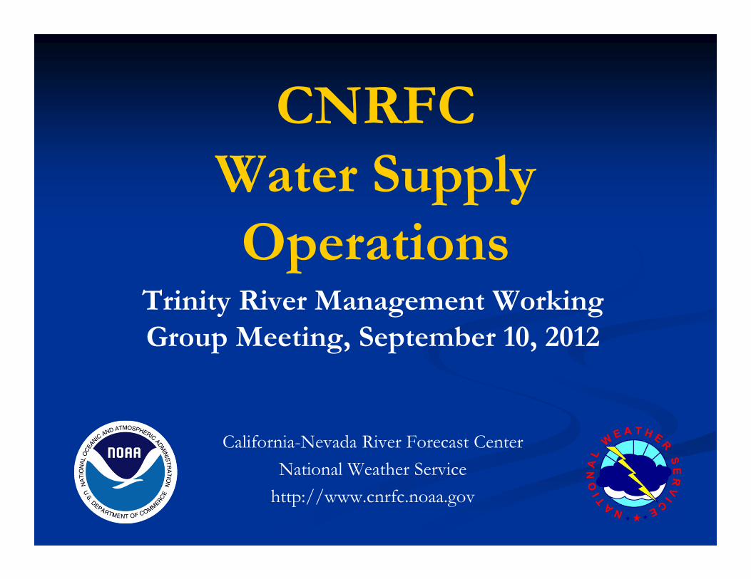
April-July
EPP3
Trace ProcessingSt
ream
flow
Time
April-July

AHPS/ESPTrace Analysis Interface – Create Your Own Product
Create your own product is generating output from raw traces from CHPS.
Has documentation on general ensemble theory, making selections and interpreting results.
http://www.cnrfc.noaa.gov/ahps.php

Forecast Generation – AHPS/ESPTrace Analysis – Create Your Own Product
Forecast Methods
April-July Forecasts issued 1st of month January through May. Monthly breakdown for Trinity issued February through May.
For the CNRFC, emphasis will be on daily updates of water supply forecasts using Ensemble Streamflow Prediction. Forecasts will go daily out to 10 days, every four days out to 20 days, April-Jul or any other long-term interval up to one year.

How Precipitation Forecasts forCNRFC River Models are Made
Forecast intervals are 6-hours out to 6 days.
Guidance is provided by several numerical weather prediction models that are updated every 6 or 12 hours.
Forecasters interpret and assess the model guidance and apply local knowledge and experience.
Forecasts are made for specific point locations. There are over 25 forecast points just in northern CA.
The Grid Forecast Editor tool (pictured on the right) distributes point precipitation forecasts to a4-km grid using a technique that takes into account a precipitation climatology dataset known as PRISM.
Gridded 6-Hour Precipitation Forecast in GFE

A single-value MAP (Mean Areal Precipitation) is calculated for each basin by averaging the forecast precipitation for all grid points that fall inside the basin boundary.
How Precipitation Forecasts forCNRFC River Models are Made
Gridded 6-Hour MAP Forecast in GFE

Temperature
MUMC1: Mumbo BasinCFRC1: Coffee RidgeBFLC1: Big FlatRRMC1: Red Rock MtnSHMC1: Shimmy LakeTYRC1: Taylor RidgeTGSC1: Trinity Guard StnWEAC1: Weaverville RS
Trinity River
Temperature Sensors used in the CHPS Calibration for ESP

Snow Courses used for the Trinity Basin
Shimmy Lake, Middle Boulder 3, Dynamite Meadow, Swampy John, Etna Mtn, Bear Basin (not in May), Deadfall Lakes (not in May)
DFKC1
BBSC1
SWJC1 ETMC1
DYMC1
MDBC1
SHMC1

CNRFC Forecast Publication
Currently archived inhttp://www.cnrfc.noaa.gov/water_supply.php
Probability forecasts by month were placed in a publication per request from Andreas Krause, Trinity River Restoration Program. First monthly forecasts published February 2004.
Starting next water year, the CNRFC monthly publication will be discontinued. Instead, forecasts will be located on the CNRFC web site and updated daily.
http://www.cnrfc.noaa.gov/index.php?type=ensemble
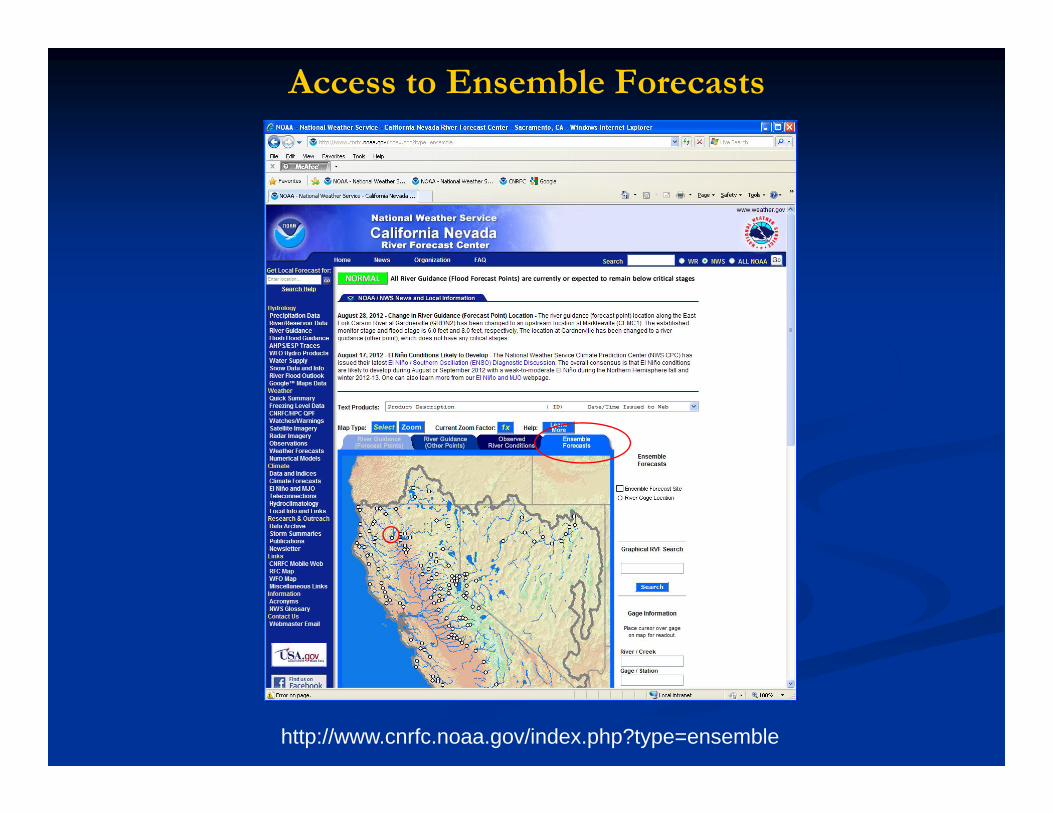
Access to Ensemble Forecasts
http://www.cnrfc.noaa.gov/index.php?type=ensemble
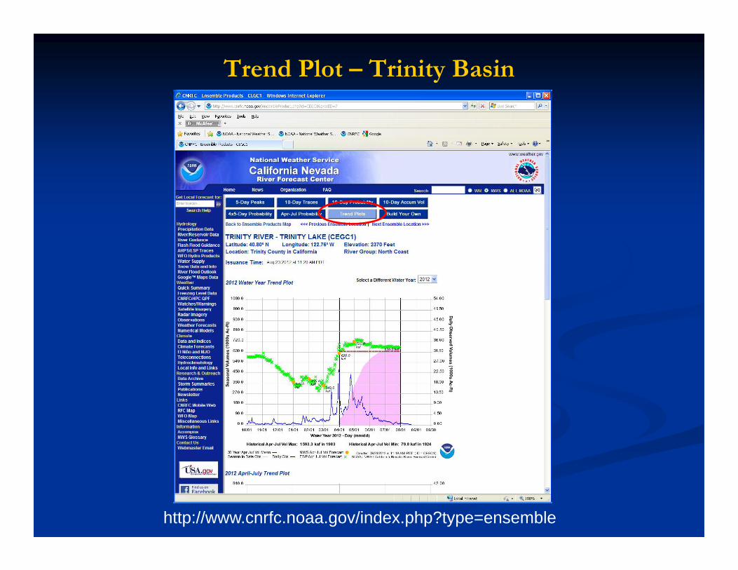
Trend Plot – Trinity Basin
http://www.cnrfc.noaa.gov/index.php?type=ensemble

Trend Plot – Trinity Basin
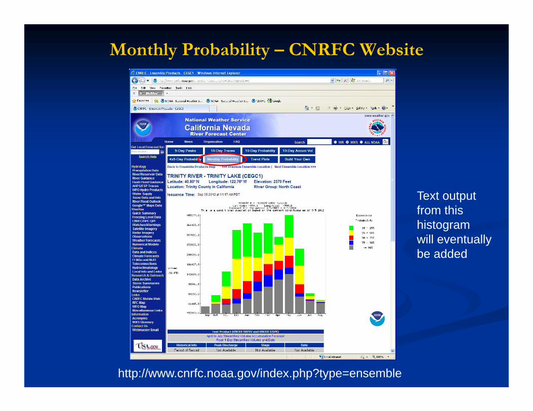
Monthly Probability – CNRFC Website
http://www.cnrfc.noaa.gov/index.php?type=ensemble
Text outputfrom thishistogram will eventuallybe added

CNRFC Forecast Publicationhttp://www.cnrfc.noaa.gov/water_supply.php
Also see CADWR Bulletin 120: http://cdec.water.ca.gov/cgi-progs/iodir_ss/b120

CNRFC Trinity River Contacts
Contacts:Andy Morin, [email protected], 916-979-3056 x324Alan Haynes, [email protected], 916-979-3056 x328
Presently, First of the month April-July Trinity River forecasts are coordinated with CADWR before release to publication.

Questions?

Additional Slides

CEGC1: 10-Day Traces
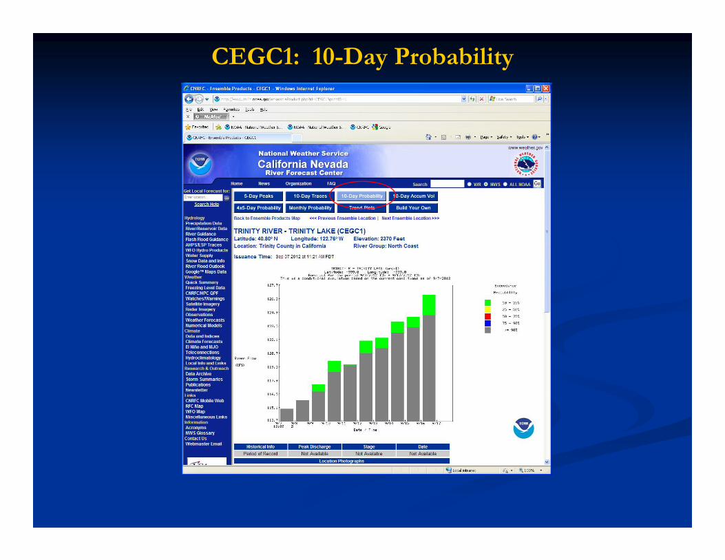
CEGC1: 10-Day Probability
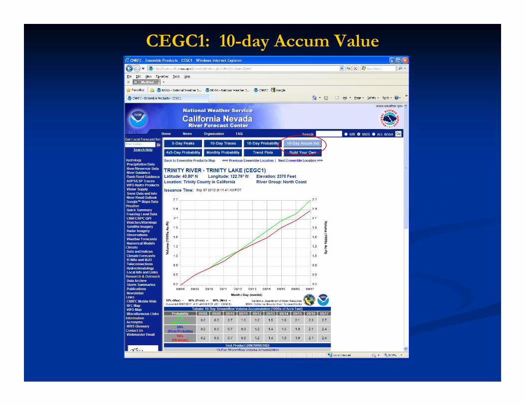
CEGC1: 10-day Accum Value
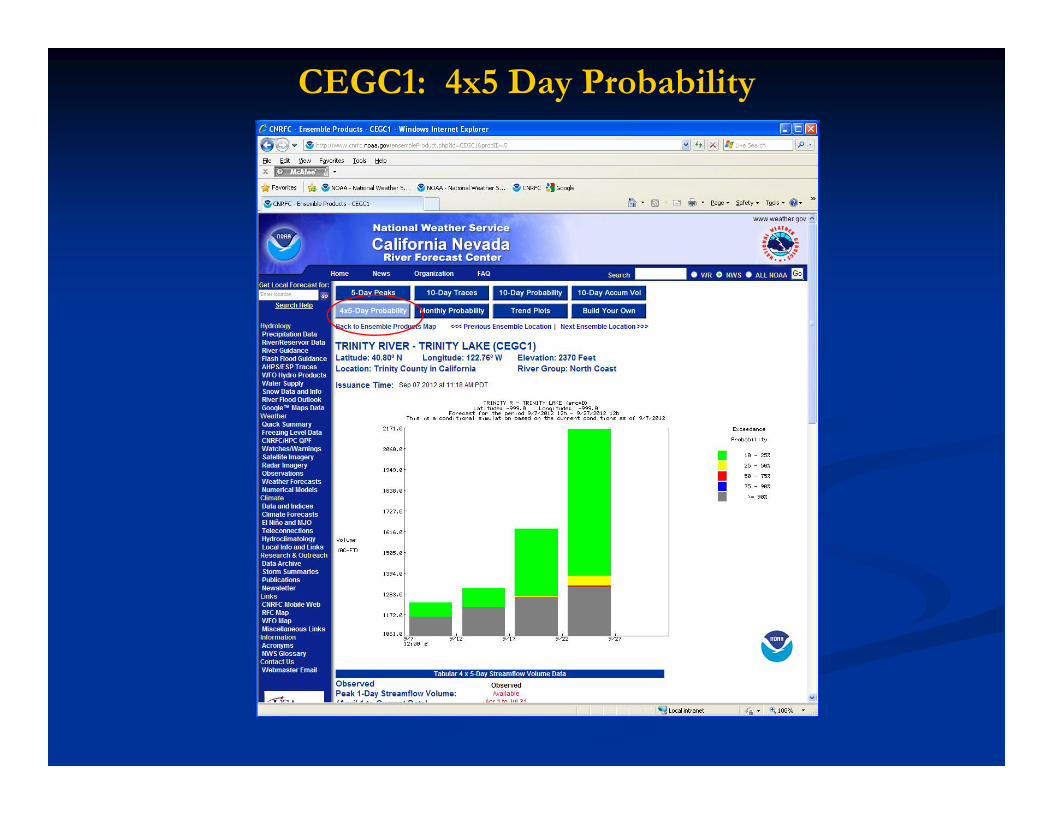
CEGC1: 4x5 Day Probability
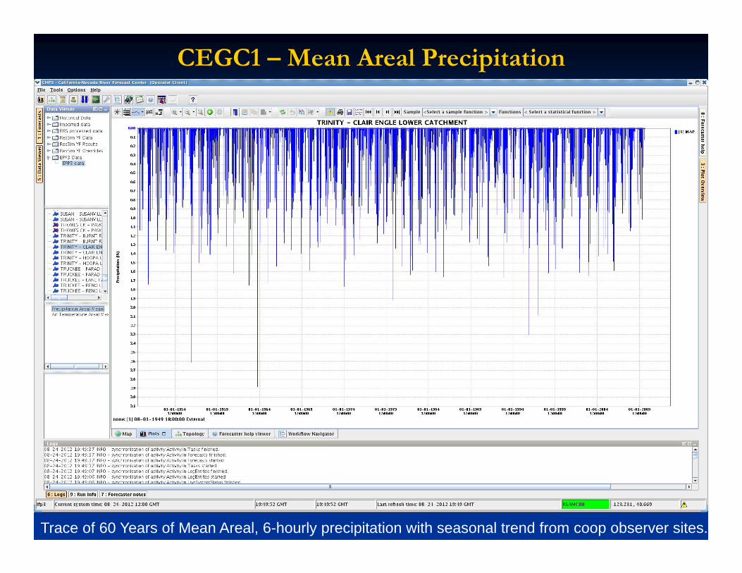
CEGC1 – Mean Areal Precipitation
Trace of 60 Years of Mean Areal, 6-hourly precipitation with seasonal trend from coop observer sites.
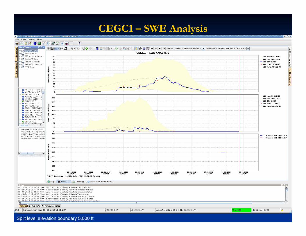
CEGC1 – SWE Analysis
Split level elevation boundary 5,000 ft
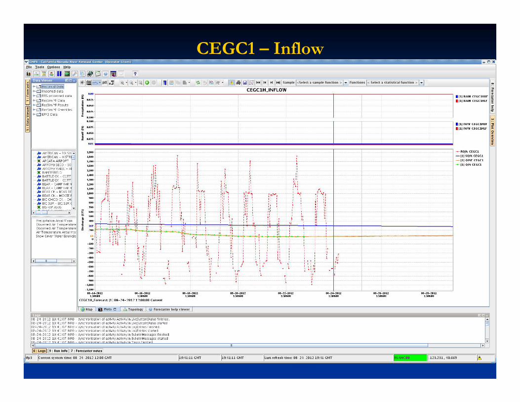
CEGC1 – Inflow

CEGC1 – Model Parameters