Climatology and Environments of Derecho-Producing Convective Systems
28
Climatology and Climatology and Environments of Environments of Derecho-Producing Derecho-Producing Convective Systems Convective Systems Mike Coniglio CIMMS/OU BAMEX Forecasters Workshop March 18-19, 2003
-
Upload
arthur-murray -
Category
Documents
-
view
30 -
download
0
description
Climatology and Environments of Derecho-Producing Convective Systems. Mike Coniglio CIMMS/OU BAMEX Forecasters Workshop March 18-19, 2003. Outline. Derecho definitions & climatology of 15 May - 15 July events 500-mb flow patterns Parameter distributions - PowerPoint PPT Presentation
Transcript of Climatology and Environments of Derecho-Producing Convective Systems

Climatology and Environments Climatology and Environments of Derecho-Producing of Derecho-Producing Convective SystemsConvective Systems
Mike Coniglio
CIMMS/OU
BAMEX Forecasters Workshop
March 18-19, 2003

OutlineOutline
• Derecho definitions & climatology of 15 May - 15 July events
• 500-mb flow patterns• Parameter distributions
– wind speeds derived from NCEP/NCAR Reanalysis
– proximity soundings

• progressive or swaths of wind gusts 26 ms-1 with a major axis length 400 km.
3 reports, separated by 64 km or more, of either F1 damage, or gusts 33 ms-1
• no more than 3 h can elapse between successive wind gust reports.
• multiple swaths of wind gusts must be a part of the same MCS and show linear/bowed radar signature
““Mid-End” Derechos (Johns and Mid-End” Derechos (Johns and Hirt, 1987)Hirt, 1987)

• progressive or swaths of wind gusts 26 ms-1 with a major axis length 400 km.
3 reports, separated by 64 km or more, of either F1 damage, or gusts 33 ms-1
• no more than 3 h can elapse between successive wind gust reports.
• multiple swaths of wind gusts must be a part of the same MCS and show linear/bowed radar signature
““Low-End” DerechosLow-End” Derechos

• progressive or swaths of wind gusts 26 ms-1 with a major axis length 400 km.
3 reports, separated by 64 km or more, of either F1 damage, or gusts 33 ms-1
• no more than 3 h can elapse between successive wind gust reports.
• multiple swaths of wind gusts must be a part of the same MCS and show linear/bowed radar signature
3 reports of F2 damage or gusts 40 ms-1 during the initial and mature stages
““High-End” DerechosHigh-End” Derechos

Distribution of all Derechos Distribution of all Derechos (131)(131)

Distribution “Low-End” Distribution “Low-End” Derechos (46)Derechos (46)

Distribution of “Mid-End” Distribution of “Mid-End” Derechos (54)Derechos (54)

Distribution of “High-End” Distribution of “High-End” Derechos (31)Derechos (31)

Temporal Distribution of all Temporal Distribution of all Derechos within BAMEX (99)Derechos within BAMEX (99)
0
2
4
6
8
10
12
14
16
18
20
00-02 02-04 04-06 06-08 08-10 10-12 12-14 14-16 16-18 18-20 20-22 22-00
TIME (UTC)
FR
EQ
UE
NC
Y
First Report
Midpoint
Last Report

Patterns associated with Patterns associated with Derechos (Johns, 1993)Derechos (Johns, 1993)
“Warm Season” Pattern “Dynamic” Pattern
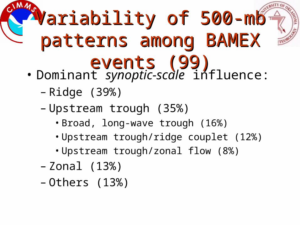
Variability of 500-mb patterns Variability of 500-mb patterns among BAMEX events (99)among BAMEX events (99)
• Dominant synoptic-scale influence:– Ridge (39%)– Upstream trough (35%)
• Broad, long-wave trough (16%)
• Upstream trough/ridge couplet (12%)
• Upstream trough/zonal flow (8%)
– Zonal (13%)– Others (13%)

Ridge example:Ridge example:
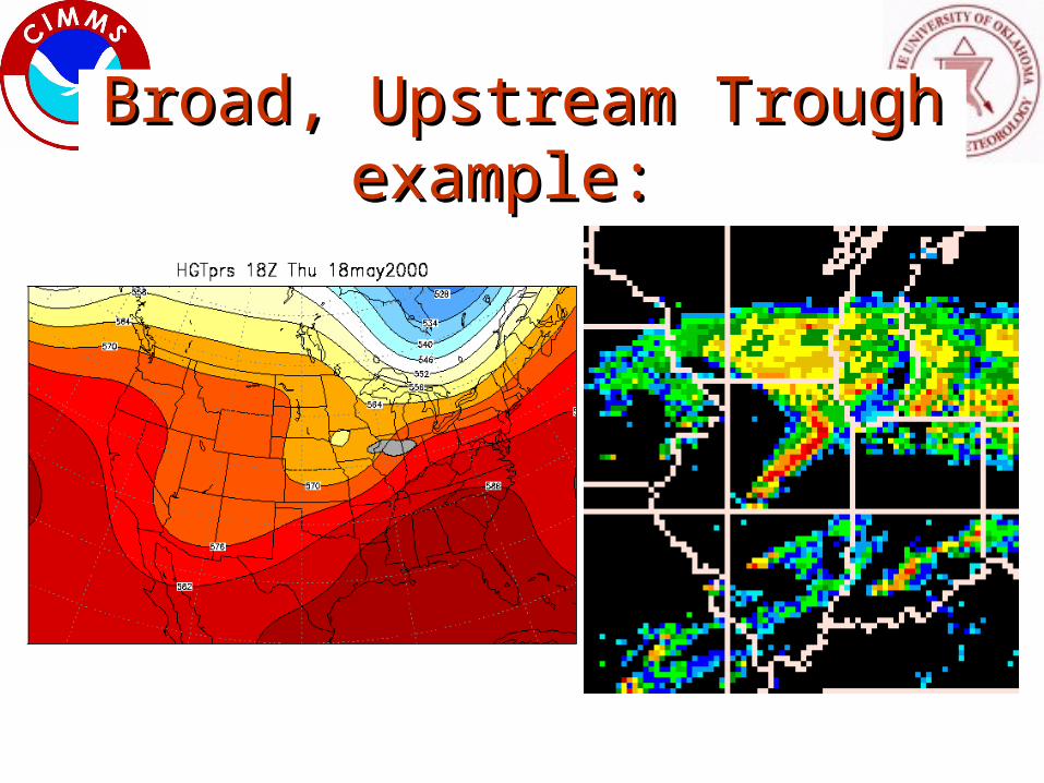
Broad, Upstream Trough Broad, Upstream Trough example: example:

Upstream Trough/Ridge Couplet Upstream Trough/Ridge Couplet example: example:

Upstream Trough/Zonal Flow Upstream Trough/Zonal Flow example: example:

Zonal Flow example: Zonal Flow example:

Other example: Other example:
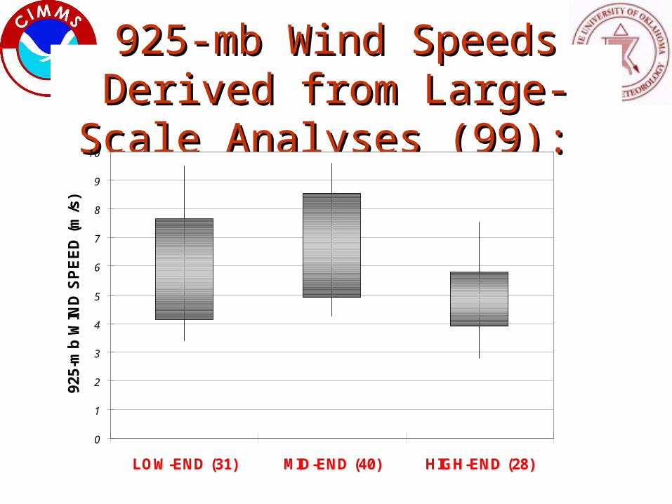
925-mb Wind Speeds Derived 925-mb Wind Speeds Derived from Large-Scale Analyses (99): from Large-Scale Analyses (99):
0
1
2
3
4
5
6
7
8
9
10
LOW-END (31) MID-END (40) HIGH-END (28)
925-
mb
WIN
D S
PE
ED
(m
/s)
0
5
10
15
20
25
30
LOW-END (31) MID-END (40) HIGH-END (28)
500-
mb
WIN
D S
PE
ED
(m
/s)
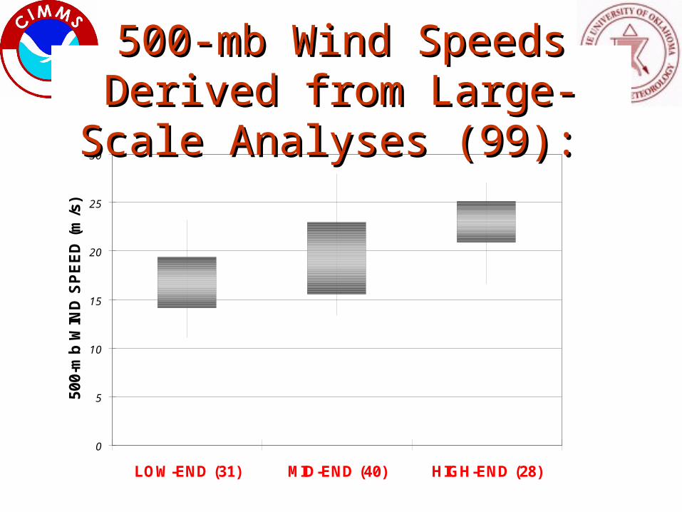
500-mb Wind Speeds Derived 500-mb Wind Speeds Derived from Large-Scale Analyses (99): from Large-Scale Analyses (99):

0
5
10
15
20
25
30
35
40
45
50
LOW-END (31) MID-END (40) HIGH-END (28)
200-
mb
WIN
D S
PE
ED
(m
/s)
200-mb Wind Speeds Derived 200-mb Wind Speeds Derived from Large-Scale Analyses (99): from Large-Scale Analyses (99):

CAPE/0-2.5 km shear Derived CAPE/0-2.5 km shear Derived from Proximity Soundings (38): from Proximity Soundings (38):
0
1000
2000
3000
4000
5000
6000
7000
8000
9000
10000
0 5 10 15 20 25 30
0-2.5-km BULK SHEAR (m/s)
CA
PE
(J/
kg
)
LOW-END (11)
MID-END (17)
HIGH-END (10)
Median: 12.2 m/sIQR: 10.0-15.1 m/s

0
1000
2000
3000
4000
5000
6000
7000
8000
9000
10000
0 5 10 15 20 25 30
0-5-km BULK SHEAR (m/s)
CA
PE
(J/
kg
)
LOW-END (11)
MID-END (17)
HIGH-END (10)
Median: 20.1 m/sIQR: 15.9-22.6 m/s
CAPE/0-5 km shear Derived CAPE/0-5 km shear Derived from Proximity Soundings (38): from Proximity Soundings (38):

0
1000
2000
3000
4000
5000
6000
7000
8000
9000
10000
0 5 10 15 20 25 30
5-10-km BULK SHEAR (m/s)
CA
PE
(J/
kg
)
LOW-END (11)
MID-END (17)
HIGH-END (10)
Median: 11.8 m/sIQR: 7.5-18.3 m/s
CAPE/5-10 km shear Derived CAPE/5-10 km shear Derived from Proximity Soundings (38): from Proximity Soundings (38):

Vertical RH Distribution Derived Vertical RH Distribution Derived from Proximity Soundings (38):from Proximity Soundings (38):
0.0
0.5
1.0
1.5
2.0
2.5
3.0
3.5
4.0
4.5
5.0
0 10 20 30 40 50 60 70 80 90 100
RELATIVE HUMIDITY (%)
HE
IGH
T (
km A
GL
)
10th90th
25th75thMedian
90 % of cases have RH < 58% at ~3 km

0.0
0.5
1.0
1.5
2.0
2.5
3.0
3.5
4.0
4.5
5.0
315 320 325 330 335 340 345 350 355 360 365 370
EQUIVALENT POTENTIAL TEMP (K)
HE
IGH
T (
km A
GL
)
10th 90th25th 75thMedian
90 % of cases have e < 331 at ~4-5 km
Medain e drops~27 K in 0-5 km
Vertical Vertical ee Distribution Derived Distribution Derived
from Proximity Soundings (38):from Proximity Soundings (38):
SummarySummary• Climatological distributions
– “Low-End” events favored in southern & eastern portions of BAMEX domain
– “High-end” events favored in northern corridor– Temporally, peak in midpoints spread between 2000-0800
UTC
• 500-mb large-scale patterns– Upstream trough occurs with nearly equal frequency to
“classic” warm-season derecho pattern– Remaining events (26%) occur under zonal flow and mixture
of the three regimes

Summary (cont.)Summary (cont.)• Parameter distributions
– 500 and 200-mb wind speeds (derived from NCEP/NCAR Reanalysis) are significantly larger for “high-end” events
– 0-2.5 km shear is mostly weak to moderate; 0-5 km usually shear moderate to strong
– Shear above 5 km is usually non-zero mid-upper-level environment is usually baroclinic
– 3-4 km AGL is often relatively dry
– Vertical decrease in e relatively large large convective instability


![Climatology [Autosaved]](https://static.fdocuments.us/doc/165x107/577cd2e91a28ab9e78964bc6/climatology-autosaved.jpg)