Climate Change and Regional Coastal Hazards - IOOC€¦ · Climate Change and Regional Coastal...
37
U.S. Department of the Interior U.S. Geological Survey Dr. Virginia Burkett USGS Chief Scientist for Global Change Research Climate Change and Regional Coastal Hazards
Transcript of Climate Change and Regional Coastal Hazards - IOOC€¦ · Climate Change and Regional Coastal...
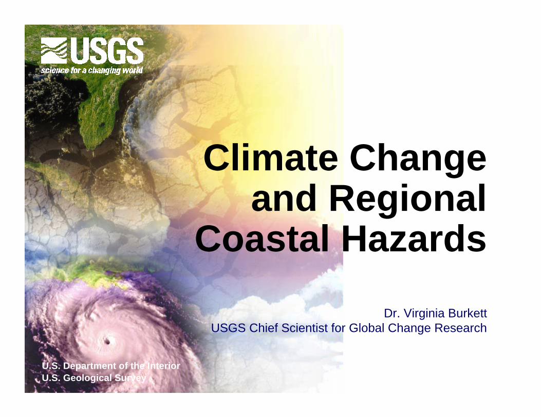
U.S. Department of the InteriorU.S. Geological Survey
Dr. Virginia BurkettUSGS Chief Scientist for Global Change Research
Climate Change and Regional
Coastal Hazards

OutlineOutlineI.I. Global and regional climate trends Global and regional climate trends
and projectionsand projections
II.II. Key climate change drivers in coastal Key climate change drivers in coastal systemssystems
III.III. Effects on coastal hazards and Effects on coastal hazards and infrastructure infrastructure
Small Sea Changes: BIG Infrastructure ImpactsHouston, TexasNovember 13, 2009

379 ppm379 ppm
Temperature and C02 record from Vostok, Antarctica ice core projectTemperature and C02 record from Vostok, Antarctica ice core project
Lower, red line = temperature Lower, red line = temperature Upper, blue line = C02 levelUpper, blue line = C02 level
(Petit et al. 1999)
Past 400,000 Years:

-55
-50
-45
-40
-35
-30
-25
05101520
Tem
pera
ture
in C
entra
l Gre
enla
nd (C
)
Thousands of years before present
10º C increase in several decades at end of Younger Dryas interval (YD)
(based on Alley, 2000)
warmer
colder
YD
Past 20,000 Years:

©IPC
C W
G1, 2007
Past 10,000 Years:

© IPCC, 2007
Atmospheric ChangeAtmospheric Change• C02 increased 35%, methane increased 150% compared to pre-industrial levels (attributed to fossil fuel use & land use change)
Past 100 years:
• Global average temperature increased 0.74 ºC over past 100 yrs, 0.65 ºC over past 50 years

Change in ice and snow:Change in ice and snow:• Arctic summer sea ice has shrunk
7.4% per decade since 1978 • Less snow at low altitudes and
earlier spring runoff• Mountain glaciers declined globally
©IPC
C, 2007
Glacier Mass
March-April Snow Cover in the Northern Hemisphere
© IPCC, 2007

• Ocean temperature increased from surface down to at least 3000 m
• Increase in N. Atlantic hurricane activity • Increase in ocean acidity
Geographic Variability in the Rate of
Sea Level Rise (1955 to 2003)
© IPCC, 2007
Ocean change:Ocean change:
(acceleration or natural variability?)
• Global sea level rise - 1.7 mm/yr during 20th century- 3.1 mm/yr during 1993-2003
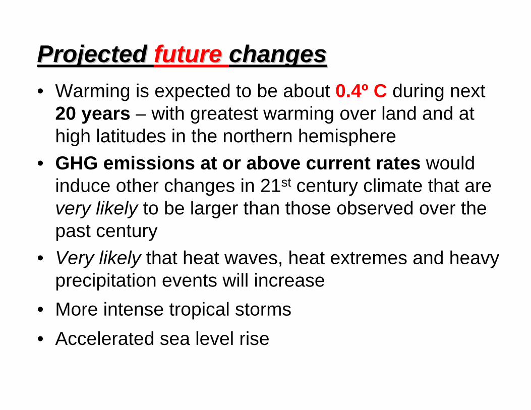
Projected Projected future future changes changes • Warming is expected to be about 0.4º C during next
20 years – with greatest warming over land and at high latitudes in the northern hemisphere
• GHG emissions at or above current rates would induce other changes in 21st century climate that are very likely to be larger than those observed over the past century
• Very likely that heat waves, heat extremes and heavy precipitation events will increase
• More intense tropical storms • Accelerated sea level rise

© IPCC, 2007
Climate Change Drivers in Coastal Systems

Church, J.A. and White, N.J. (2006) http://maps.grida.no/go/graphic/trends-in-sea-level-1870-2006
Global Mean Sea Level Rise, 1870-2006

Other causes of subsidence in Gulf Coast region:
NORMAL LAKE 1.0 FT LEVEL
SPH DESIGN ELEV 11.5 FT17.5 FT
HURRICANEPROTECTION LEVEE& FLOODWALL
AVG ANNUAL HIGHWATER 14 FT18 FT PROJECT FLOWLINE23 FT
FLOODWALL ALONGMISSISSIPPI RIVER
GENTILLYRIDGE
UNOUNO
UN
O S
IDE
OF
UN
O S
IDE
OF
WA
INR
IGH
T D
RW
AIN
RIG
HT
DR
WA
INR
IGH
T D
RW
AIN
RIG
HT
DR
AT
L.C
. SIM
ON
AT
L.C
. SIM
ON
ST. A
NTH
ON
Y A
TST
. AN
THO
NY
AT
WIL
DA
IR D
RW
ILD
AIR
DR
DIL
LAR
D U
NIV
DIL
LAR
D U
NIV
CA
MPU
SC
AM
PUS
GEN
TILL
Y B
LVD
GEN
TILL
Y B
LVD
AT
ALL
ENA
T A
LLEN
DER
BIG
NY
AT
ID
ERB
IGN
Y A
T I -- 1
010
ESPL
AN
AD
E A
TES
PLA
NA
DE
AT
ST. C
LAU
DE
ST. C
LAU
DE
ST. L
OU
ISST
. LO
UIS
CA
THED
RA
LC
ATH
EDR
AL
CA
NA
L ST
AT
RIV
ERC
AN
AL
ST A
T R
IVER
ELEV
ATI
ON
S IN
FEE
T N
GVD
-20
-10
0
10
20
30
-20
-10
0
10
20
30
B
LAKEPONTCHARTRAIN
SHORE
RIV
ER B
AN
K
MIS
SISS
IPPI
A
Net Effect on New Orleans Elevation
“Relative sea level rise” is a combination of eustacy and regional or local land surface elevation change generally
associated with tectonism, isostacy, or subsidence

2.14 mm/yr
6.5 mm/yr
9.85 mm/yr
NOAA Historical Tide Gauge Data (1900-2000)

As the oceans warm and land ice declines, sea level rise is expected to accelerate
(IPCC, WGI, 2007)

As the oceans warm and land ice declines, sea level rise is expected to accelerate
The Greenland Ice Sheet Dominates
Land Ice in the Arctic
Over the past two decades, the melt area on the Greenland ice
sheet has increased on average by about
0.7%/year (or about 20% from 1979 to
2005).
The Greenland Ice Sheet Dominates
Land Ice in the Arctic
Over the past two decades, the melt area on the Greenland ice
sheet has increased on average by about
0.7%/year (or about 20% from 1979 to
2005). Photo Source: Business Week 2004
(USG
CR
P 20
09)
Melt area of the Greenland ice sheet increased on average by 0.7% per yr
between 1979 and 2005.
With sustained warming of 4º-13ºF over central Greenland most of the
Greenland Ice Sheet will melt, raising sea level 6-7 m.
(USG
CR
P 2009)

Mean Sea
Level (Meters)
MeltwaterPulses
Onset of Holocene Delta Formation
present sea level

Sea-level rise influences coastal ecosystems through several mechanisms
LA
FL
SC
• Increases salinity • Alters plant community structure & productivity• Alters fish, shellfish & wildlife populations
MD
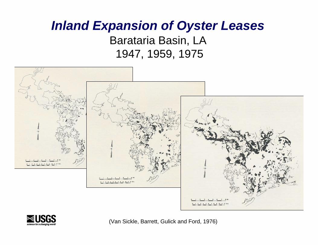
Inland Expansion of Oyster LeasesBarataria Basin, LA 1947, 1959, 1975
(Van Sickle, Barrett, Gulick and Ford, 1976)

Sea-level rise influences coastal ecosystems through several mechanisms
• Increases salinity • Alters plant community structure & productivity• Alters fish, shellfish & wildlife populations• Accelerates shoreline erosion• Makes restoration more difficult & expensive• Enhances infilling of estuaries with coastal sediment• Amplifies effects of other stresses, such as
navigation channels• Increases storm surge & normal tide levels

Increased temperature of the sea surface affects both the volumeof the ocean (sea level) and the propensity for hurricanes.
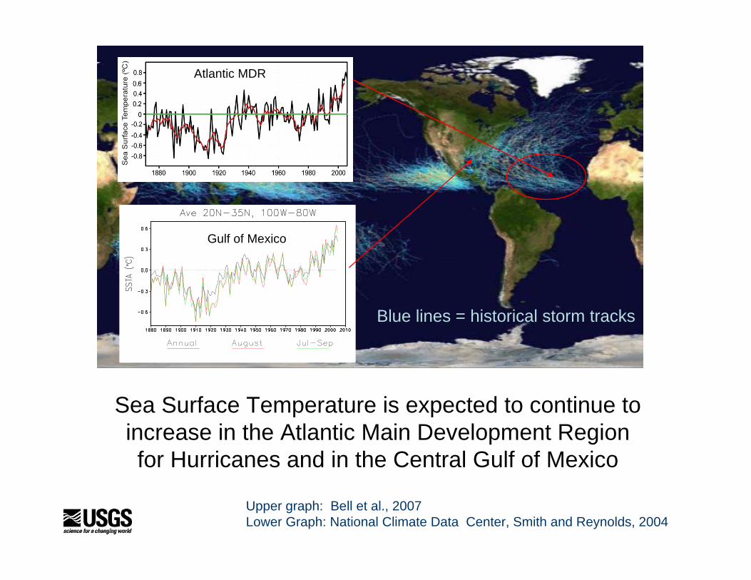
Map of the cumulative tracks of all tropical cyclones during the1985–2005 time period.
Atlantic MDR
Gulf of Mexico
Upper graph: Bell et al., 2007Lower Graph: National Climate Data Center, Smith and Reynolds, 2004
Sea Surface Temperature is expected to continue to increase in the Atlantic Main Development Region for Hurricanes and in the Central Gulf of Mexico
Blue lines = historical storm tracks

Increased storm intensity amplifies the effects of sea-level rise

Low-lying coastal communities may be inundated by rising sea level and coastal erosion will accelerate if storms increase in intensity.
Dauphin Island, AL

Source: United Houma Nation
Source: Isle De Jean Charles band
Source: United Houma Nation

Historical photo source: United Houma Nation
Isle de Jean Charles tribe pursues relocating from island (Houma Courier, Sept. 22, 2009)
HOUMA — Members of a local American Indian tribe are making a new push for government help moving away from their ancestral home on a remoteTerrebonne Parish island.Related Links:Council to take up potential relocation of islanders In search of higher ground Island Road repairs will cost millions Island residents insist on staying put Federal hurricane-recovery dollars may be available to help pay for a mass relocation from Isle de Jean Charles to higher ground, parish and state officials saidAnd the group’s leader said he wants to seize the chance before the island’s residents disperse on their own and lose their community.Since Hurricane Lili in 2002, families have trickled from the island. Now an estimated two dozen families remainon the one-and-one-half-mile sliver of land.Albert Naquin chief of the Band of Biloxi-Chitimacha

Examples of impacts on oil and gas operations
Port Fourchon, LA
1. Onshore oil and gas facilities could be more difficult to permit, construct, and maintain (due to stresses on coasts associated with climate change and sea level rise).

Examples of impacts on oil and gas operations
1. Onshore oil and gas facilities could be more difficult to permit, construct, and maintain (due to stresses on coasts associated with climate change and sea level rise).
2. Sea level rise and/or increase in tropical storm intensity will affect oil and gas infrastructure (offshore and onshore)
Rig damage during Hurricane Lilli
off the LA coast, Eugene Island area

3. Surface transportation systems that are essential to coastal onshore and offshore oil and gas development may be impassable more frequently or permanently.
Net Effect of Relative Sea Level Rise in Lafourche Parish
LA Highway 1, less than a foot above sea level, is a key highway that supports the offshore oil and gas industry in the Central Gulf Coast Region

4. Erosion of coastal barriers will affect wave energy and storm surge in oil and gas fields that were developed under more protected conditions.
(Stone et al. 2003)
Terrebonne BayChange in Wave Height
8’-10’ Change in Storm Surge, 1950-1990

(Stone et al. 2003)
Red dots are oilfield platforms in Terrebonne Bay, LA and adjacent
nearshore waters
East Timbalier
island
Terrebonne Bay

5. High-energy waves can erode sediments, exposing a pipeline to stress levels it was not designed to withstand, causing a fracture. An exposed offshore pipeline also could be vulnerable to lateral and vertical displacement during storms, exposure to vessel traffic and fishing trawls, or rupture by currents.
(Seismic profile from Dave Twitchell, USGS Woods Hole)
Terrebonne Bay
Pits scoured in flat-lying deposits seaward of the Chandeleur Islands

Erosional Features in Chandeleur Island Bathymetry
NAVD88 Elevation (m)
0.5 -15
AB
A
B
Pits Linear troughs
(Dave Twitchell, USGS Woods Hole)

Distribution of erosional pits
Pit dimensionsmin: 7.1 mmax: 339.8 mmean: 78.5 m
(Dave Twitchell, USGS Woods Hole)

6. Permafrost decline is already affecting oil and gas facilities in coastal Alaska.
The U.S. Bureau of Land Management has identified about 30 old oil exploration wells that will soon be in danger of erosion. BLM has plans to plug these wells to prevent contamination.
Stan Porhola photo (BLM)
J.W. Dalton wellsite, National Petroleum Reserve AK
September - 2005
Susan Flores photo (BLM)
September - 2004

7. Hazards associated with the formation of thermokarstlakes in the coastal zone and the stability of shelf sediments due to thawing ice in sediments and the release of gas from clathrates.
Accelerated land loss and formation of thermokarst lakes
along Alaska Beaufort Sea coast
John (Lyle) Mars, Dave Houseknecht, & Chris Garrity, USGS

8. Navigation routes through the Northwest and Northeast Passages may be opened, even if ice simply thins to the point that shipping lanes can be mechanically maintained by icebreakers. Longer ice free season for exploration and development.
Arctic Summer Sea Icesource: NASA GSFC
1979
2007

What can be done to reduce adverse impacts?
mitigation• Reduction of greenhouse gas
emissions or enhancement of carbon sequestration
adaptation• Purposeful actions taken to reduce
undesirable effects or enhance positive effects of climate change