Climate Change and Drought in Pakistan - EDITORIA · •Pakistan has a long history of droughts....
28
Climate Change and Drought in Pakistan Muhammad Munir Sheikh Global Change Impact Studies Centre (GCISC) Islamabad, Pakistan 5 th Meeting of the GEOSS Asian Water Cycle Initiative (AWCI) & International Coordination Group (ICG) 15-18 December, 2009, Tokyo, Japan
-
Upload
nguyenkhue -
Category
Documents
-
view
216 -
download
0
Transcript of Climate Change and Drought in Pakistan - EDITORIA · •Pakistan has a long history of droughts....

Climate Change and Drought in Pakistan
Muhammad Munir SheikhGlobal Change Impact Studies Centre (GCISC)
Islamabad, Pakistan
5th Meeting of the GEOSS Asian Water Cycle Initiative (AWCI) & International Coordination Group (ICG)
15-18 December, 2009, Tokyo, Japan

Outline of the Study
• Location and physiographic features of Pakistan
• Aridity and desertification index maps to see areas susceptible to droughts
• Areas of remaining dry for more than 50% of the time to locate the droughtvulnerable areas
• Drought patters in Pakistan and their classification
• Natural forcing phenomena like ENSO and NAO in the context of their effect ondroughts and floods
• Hydrological drought in the context of variations in the IRS (Indus River System)flows
• Past and projected climate changes in temperature and precipitation anddesertification trend over the country to see their implications
• Drought implications under climate change
• Damages caused by droughts and possible adaptation strategies to counteracttheir adverse impacts
• Drought Management – Future Strategies

Pakistan’s Location and Physiographic Features
• Pakistan is located approximately within the latitudinal and longitudinalextensions 24°N to 37°N and 61°E to 76°E respectively
• The country is located in sub-tropics as well as in temperate region
• Physically it is the vast valley of mighty Indus River and its tributariesrunning through the whole country
• Northern mountains comprise parts of the Himalayan and Karakoramranges with a small part of the Hindukush range. Pakistan has moreglaciers than any other land outside north and south Poles and coversome 13,680 sq. km as glaciated area. Karakoram is the abode of sizableglaciers and as high as 37% of Karakoram area is under its glaciers againstHimalayas’ 17% and Alps’ 22%.
• Vast expanses of Arabian Sea lie to the south of Pakistan
• Areas below approximately 31°N constitute deserts. Thar desert spansthe border between India and Pakistan. Hamun-e-Mashkhel, some 87 kmlong and 35km wide is the largest desert found in Balochistan. The Dashtand Kharan deserts of Balochistan lie towards the western border ofPakistan with Iran.

Physiographic Map of Pakistan

Aridity Index Map of Pakistan (1951-2000)

• Northern half of the country above31°N is semi arid to humid with asub-humid belt running along thesouthern slopes of the sub-montaneregions
• Southern half of Pakistan below 31°Nis mostly arid to hyper arid
• The weighted precipitation in thesouthern half (~175mm) is one-third ofthe precipitation in the northern half(~600mm). The weighted rainfall insouthern half is almost half ofPakistan’s weightedprecipitation( around 330 mm)
• Pakistan receives around 50% of therainfall during monsoon (JJAS) seasonwhile about 30% is received in winter(DJFM) season
Northern & Southern Parts of Pakistanin the context of their climates
a) Northern Pakistan
b) Southern Pakistan

Desertification Criteria and Index for Pakistan
• Criterion used for defining a desert in Pakistan is that R<T/5,where R is annual precipitation in inches and T is annualaverage temperature (Desert Meteorology by Thomas T.Warner, 2004)
• Area below 31°N being arid and hyper arid fits well into thedefinition of a desert
• The highest desertification index is towards the westernborder of Pakistan with Iran having Dasht and Kharan desertsof Balochistan. Average annual rainfall in these deserts is lessthan 60 mm

Desertification Index Map of Pakistan

Desertification Trend (1951-2000)

Season-wise Drought Vulnerable areas (1961-1990)
Areas shown during different seasons on the average remain dry for more than 50% of the time and are termed as drought vulnerable during a particular season.
ON
AMDJFM
JJAS
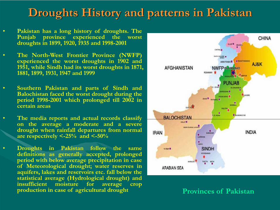
Droughts History and patterns in Pakistan• Pakistan has a long history of droughts. The
Punjab province experienced the worstdroughts in 1899, 1920, 1935 and 1998-2001
• The North-West Frontier Province (NWFP)experienced the worst droughts in 1902 and1951, while Sindh had its worst droughts in 1871,1881, 1899, 1931, 1947 and 1999
• Southern Pakistan and parts of Sindh andBalochistan faced the worst drought during theperiod 1998-2001 which prolonged till 2002 incertain areas
• The media reports and actual records classifyon the average a moderate and a severedrought when rainfall departures from normalare respectively <-25% and <-50%
• Droughts in Pakistan follow the samedefinitions as generally accepted, prolongedperiod with below average precipitation in caseof Meteorological drought; water reserves inaquifers, lakes and reservoirs etc. fall below thestatistical average (Hydrological drought) andinsufficient moisture for average cropproduction in case of agricultural drought Provinces of Pakistan

Natural Forcing Phenomena (ENSO & NAO) affecting Rainfall Variability during JJAS

Natural Forcing Phenomena (ENSO & NAO) affecting Rainfall Variability during DJFM

Droughts and Floods and their linkage to ENSO and NAO Indices
• El Nino years are generally seen to relate to deficient rains in thecountry leading to drought conditions whereas La Nina yearsbehave the other way round and bring excess rains
• The media reports and actual record support that the deficientrains during El Nino years in general, caused drought condition inthe country
• Positive NAOI values generally bring above normal rains duringwinter and negative values the deficient rains
• At times La Nina conditions negate the drought conditions innorthern half of Pakistan during winter (DJFM) as for examplethe case in 1998 when there was drought in the southern parts ofthe country

Indus River System and its tributaries

Distribution of Water in Main Rivers of Pakistan
% of IRS Inflows
% Seasonal Distribution Dominant Source in
SummerDominant Source
in WinterSummer (Apr-Sep)
Winter(Oct-Mar)
Indus 44 86 14 Snow/Glacial meltWinter Rainfall +
Base flow
Chenab 19 83 17Snow/Glacial melt +
MonsoonWinter Rainfall +
Base flow
Jhelum 16 78 22Mainly Snow melt +
MonsoonWinter Rainfall +
Base flow
Kabul 16 82 18 Snow/Glacial meltWinter Rainfall +
Base flow
Others 5

Variation in River Flows and implications during low-flow years
• The average annual river flows are about 141 maf (174 bcm) at RIM(River Inflow Monitoring) stations varying from 97 maf in a low-flow year (2002), the drought year to 172 maf in a high flow-year(1992), a worst flood year
• Some 82% of water inflows are during the Kharif period (i.e. thesummer months: April-September) about 18% in the Rabi period(i.e. the winter months: October-March)
• The average flow to the sea ( i.e. flow below Kotri) is about 35 maf(average for 1976-77 to 2002-03 period) with the minimum flow aslow as 0.8 maf (in 2000-01, the drought period and the maximumflow as high as 92 maf (in 1994-95), the flood period. (GoP-MoW&P2005)
• One of the most feared effects of climate change on Pakistan is thelikelihood of increased frequency of occurrence and severity ofextreme weather events as was witnessed during the last decade ofthe previous century and thereafter

Observed Trends in Temperature and Precipitation
Temperature
• The area averaged mean annual temperature over Pakistan increased by0.57C (in agreement with the global trend) over the period 1901-2000
• The 48-year period 1960-2007 recorded a slope of mean annual temperature as0.24C per decade as compared to 0.06 per decade during 1901-2000 reflectingmuch increased rate of warming in recent years (again in agreement with theglobal trend)
• Summer (April-May) temperatures (both mean and maximum) increased inall parts of Pakistan during 1951-2000
• During the same period, Balochistan Plateau, located in southern half of thecountry, was seen warmer in all the seasons.
• Monsoon (June-September) temperatures (both mean and maximum)dropped throughout Pakistan during 1951-2000 except in Balochistan Plateau
• During 1951-2000, the Greater Himalayan region (the abode of sizeableglaciers feeding the Indus River System) had a warming trend on annualbasis as well as in all seasons except monsoon season

Observed Trends in Temperature and Precipitation
Precipitation
• The area averaged mean annual precipitation over Pakistanincreased by 25% during the previous century
• Monsoon precipitation increased elsewhere except in coastalregions (where there was a significant drop) and the WesternBalochistan Plateau during 1951-2000
• During the above period, the winter rains decreased by 13-20% inSindh and western Balochistan. It may be seen that the Sindhprovince is particularly vulnerable to drought and remains dry formore than 50% of the time


Projected Changes in Average Precipitation of Northern and Southern Pakistan
(Corresponding to IPCC A2 Scenario)Based on Ensemble of 13 GCMs
(Corresponding to IPCC A1B Scenario)Based on Ensemble of 17 GCMs
-8
-4
0
4
8
12
16
1990s 2020s 2050s 2080s
Periods
Prec
ipita
tion
chna
ge (%
)
Series1 Series2Northern Pakistan Southern Pakistan
(Coarse Resolution Results)

PakistanNorthern Pakistan
Southern Pakistan
Annual 4.38 ± 0.44 4.67 ± 0.23 4.22 ± 0.18
Summer 4.13 ± 0.26 4.56 ± 0.28 3.90 ± 0.26
Winter 4.47 ± 0.20 4.72 ± 0.24 4.33 ± 0.18
Projected Temperature Changes in 2080s, ∆T (°C) by GCM Ensemble for A2 Scenario
• Temperature increases in both summer and winter are higher in Northern Pakistan than in Southern Pakistan
• Temperature increases in Northern and Southern Pakistan are higher in winter than in summer

Projected Precipitation Changes in 2080s, ∆P (%) by GCM Ensemble for A2 Scenario
Pakistan Northern Pakistan Southern Pakistan
Annual 3.48 ± 5.78 1.13 ± 3.95 4.28 ± 9.46
Summer 12.16 ± 8.91 1.08 ± 8.35 51.07 ± 39.78
Winter -5.12 ± 4.78 -2.24 ± 4.10 -20.51 ± 9.05
• The rather large errors make it difficult to draw any definiteconclusions about change in precipitation with time
• There is, however, some indication of precipitation increase insummer and precipitation decrease in winter in the SouthernPakistan

Damages caused by drought
• Agricultural growth suffered a severe setback during 2000-2001 as a result of thedrought. While major crops (wheat, cotton and rice) registered a negative growth ofalmost 10%, the overall agriculture recorded a negative growth of 2.6% during 2000-2001
• The performance of minor crops (cereals, vegetables, fruits, condiments, oil seeds,fodder and others) was also affected by the prevalent long dry spell. The droughtpersisted throughout 2001-2002, resulting in water shortage of up to 51% of normalsupplies as against 40% of the previous year
• The total flows of water in major rivers also declined to 109 bcm against an averageof 162 bcm. The rainfall has also been below normal
• Drought occurred during the period 1998-2001 in Pakistan affected over 3.3 millionpeople, including thousands who became refugees and hundreds who died of thirstand starvation, and about 30 million livestock, including over 2 million died (GoP-MoEnv 2003)
• The droughts have a great affect on the country’s economy. The State Bank ofPakistan calculated the effect of the drought to the tune of $ 927 million in the thirdquarter of the 2001-02 fiscal year. The anticipated GDP growth rate of 4.5% couldnot be achieved, rather, the GDP growth rate declined to less than 3% resulting instagnation of the per capita income (Annual Report, State Bank of Pakistan, 2001-02)

Drought Implications under Climate change
• More than 92% of water is consumed by irrigated agriculture, directimplication of drought years on irrigated agriculture and on rain fedareas affect adversely on the economy of the country as 22% of GDP iscontributed by this sector
• 44% of labour is engaged in the agriculture sector which too getsadversely affected during the drought years
• The past and projected temperature and precipitation trends, inparticular in the southern half of Pakistan, the drought susceptible region,the likelihood of enhanced desertification and consequently more andsevere droughts may occur
• The variability in monsoon rains and their changing distribution over thecountry may enhance the variability in the river flows
• Erratic and uncertain rainfall patterns under climate change may causedrought conditions in the rain fed agricultural areas, about 16% of thetotal cultivated area

Drought Implications under Climate changeContd..
• Intrusion of saline sea water into Indus deltaic region during the lowflows will affect coastal ecosystems and decline in water quality foragriculture. The situation may further aggravate on account of sea levelrise due to melting of glaciers due to general warming up of the HKHglaciated region under climate change
• Pressure on the ground water extraction, in particular, in the deltaicand coastal areas may cause the ground subsidence rates to increaseand consequently allow more sea water to intrude in the deltaic region
• The rangelands cover almost a third of Pakistan’s total area andsupport two third of the entire population of sheep and goats and overhalf of cattle population and provide livelihood to millions of herdersand pastoralists. There are particularly vulnerable to the impacts ofclimate changes as the capacity for adaptation to these impoverishedregions is very low

Drought Management - Future Strategies • The strategy calls for the use of improved irrigation methods and practices,
development of crops with high yields and lower water consumption, anduse of water saving techniques etc. It is envisaged that drought-tolerant andwater-use efficient crop varieties may be developed using thebiotechnological techniques
• Enough water needs to be allocated to ensure minimum environmental riverflows down stream Kotri. This is possible only through the construction oflarge dams upstream on the Indus rivers
• The extent of sea water intrusion in the deltaic region needs to be reliablyassessed through data on the sediment and water discharges from Indusriver into the Arabian Sea
• Ground water extraction needs to be regulated in the deltaic and coastalareas to lessen the ground subsidence rates to allow reduced sea waterintrusion during drought years
• Mini dams and rain water harvesting techniques need to be developed in thedrought vulnerable regions to help sustain the rangelands and livelihood ofthe people in the rain fed areas