Click to edit Master title style 2nd STG/IPY SAR2nd STG ... · PDF fileClick to edit Master...
25
2nd STG/IPY SAR Click to edit Master title style 2nd STG/IPY SAR Coordination Meeting • Click to edit Master text styles • Second level Second level • Third level F th l l • Fourth level • Fifth level V. Helm, H. Miller DLR, Oberpfaffenhofen, Germany, September 30 th to October 1 st 2008 DLR, Germany STG/IPY SAR Coordination Meeting – Veit Helm September 30 th to October 1 st , 2008 Alfred Wegener Institute
Transcript of Click to edit Master title style 2nd STG/IPY SAR2nd STG ... · PDF fileClick to edit Master...

2nd STG/IPY SARClick to edit Master title style2nd STG/IPY SAR Coordination Meeting
• Click to edit Master text styles• Second levelSecond level• Third level
F th l l• Fourth level• Fifth level
V. Helm, H. Miller
DLR, Oberpfaffenhofen, Germany, September 30th to October 1st 2008
DLR, GermanySTG/IPY SAR Coordination Meeting – Veit Helm September 30th to October 1st, 2008
,Alfred Wegener Institute

Overview
Click to edit Master title styleAWI activities and interests
• Click to edit Master text styles• Second levelSecond level• Third level
F th l l• Fourth level• Fifth level
CryoVEx – CryoSat Calibration Validation ExperimentASIRAS – Airborne SAR Interferometric Radar Altimeter
DLR, GermanySTG/IPY SAR Coordination Meeting – Veit Helm September 30th to October 1st, 2008

AWI Activities and Interests
general Interests:
Click to edit Master title style- Snow properties and their variations in time and space in different snow regimes (coastal to
How to understand microwave signals? (SAR backscatter, Altimetrie waveform shape and influence on elevation estimates)
• Click to edit Master text styles• Second level
p p p g (plateau traverse !!)
- SMB and change of phys. parameters of (sub)surface snow/firn (density, stratigraphy, porosity, densification) Second level
• Third levelF th l l
Ice flow velocity and its variation in time of Greenlands major outlet glacier (mass balance and sea level)
Sea ice extend and thickness? • Fourth level• Fifth levelRegion:
Antarctic Peninsula to Syowa station (mainly DML)
Satellite validation on Antarctic plateau and Blue Ice (Kohnen and Novo Airbase)?
y ( y )Greenland (outlet glaciers and Percolationzone)
Data:Altimetrie: CryoSat2, IceSat
DLR, GermanySTG/IPY SAR Coordination Meeting – Veit Helm September 30th to October 1st, 2008
SAR/InSAR: TerraSAR-X, TanDEM-X,ENVISAT, Radarsat2

Antarctica (DML) - Drill and pit positions
Click to edit Master title style
• Click to edit Master text styles• Second levelSecond level• Third level
F th l l• Fourth level• Fifth level
DLR, GermanySTG/IPY SAR Coordination Meeting – Veit Helm September 30th to October 1st, 2008

Accumulation map of DML
Click to edit Master title styleAWI‘s new accumulation radar will fill
• Click to edit Master text styles• Second level
AWI s new accumulation radar will fill gaps in the next years
Second level• Third level
F th l lBasis for satellite derived accumulation
• Fourth level• Fifth level
Rotschky, 2007
DLR, GermanySTG/IPY SAR Coordination Meeting – Veit Helm September 30th to October 1st, 2008

Micro CT
Click to edit Master title styleMicro structure of near surface firn (2.5 m depth)
• Click to edit Master text styles• Second levelSecond level• Third level
F th l l• Fourth level• Fifth level
DLR, GermanySTG/IPY SAR Coordination Meeting – Veit Helm September 30th to October 1st, 2008
Hörhold

Kottas traverse and Ritscherflya
Click to edit Master title style
• Click to edit Master text styles• Second levelSecond level• Third level
F th l l• Fourth level• Fifth level
Source: (Anschütz, 2008)
Ground data:Stake and GPS along traverseshallow firn cores (~12 m)snowpitsGPR
DLR, GermanySTG/IPY SAR Coordination Meeting – Veit Helm September 30th to October 1st, 2008
Source: (Anschütz, 2008) GPRdifferent snow regimes (coastal to plateau) !!!

Satellite validation
Click to edit Master title styleKohnen station: (Antarctic plateau)shallow firn cores snowpits
Available datasets
• Click to edit Master text styles• Second level
GPR gridEPICA deep ice core
Second level• Third level
F th l l
Future activities:(revisted site)
continue longterm observations (sub)surface phys. Parametersshallow cores
• Fourth level• Fifth level
surface roughness
Kohnen represents the vast Antarctic plateau (l l ti k t b ti i d d ld )
Longterm datasets are available in combination with a high scientificstandard in field data analysis and techn. equipment at AWI
(low accumulation, katabatic winds, dry cold snow)
DLR, GermanySTG/IPY SAR Coordination Meeting – Veit Helm September 30th to October 1st, 2008
Airborne acquisition can be combined with field activity

Variability of sea ice thickness in the central Arctic
Click to edit Master title style
• Click to edit Master text styles• Second levelSecond level• Third level
F th l l2007
• Fourth level• Fifth level
2004
DLR, GermanySTG/IPY SAR Coordination Meeting – Veit Helm September 30th to October 1st, 2008
Rabenstein, Hendricks, Leinweber, 2007Haas, 2004

CryoVEx: (CryoSat Validierungs-Experiment):
CryoVEx and ASIRAS
Click to edit Master title styleCryoVEx: (CryoSat Validierungs Experiment):
Calibration and Validation of CyoSat by simultaneous acquired ground-and airborne measurements
• Click to edit Master text styles• Second level
Ground measurements:• snow stratigraphie (upper 2m) • shallow firn cores ( ~10 m)Second level
• Third levelF th l l
shallow firn cores ( 10 m)• density profiles• surface topography • GPR (Dunse, 2008)
• Fourth level• Fifth levelAirborne measurements:
• Radar altimeter – ASIRAS (Airborne Sar Interferometric Radar Altimeter System)• laser scanner
DLR, GermanySTG/IPY SAR Coordination Meeting – Veit Helm September 30th to October 1st, 2008

POLAR5
Click to edit Master title style
• Click to edit Master text styles• Second levelSecond level• Third level
F th l l• Fourth level• Fifth level
ParameterParameter POLAR 5POLAR 5length, height, width (m) 20,66 / 5,20 / 29,00cabine: length, height, width (m) 12,85 / 2,00 / 2,34max. payload (kg) 3900f l i (k /h)fuel consumption (kg/h) 500operating distance (km) 2900 (up to 10h)number of passengers 18 max. flying altitude (m) 7600
i / d (k /h) 18 /400
DLR, GermanySTG/IPY SAR Coordination Meeting – Veit Helm September 30th to October 1st, 2008
min./max. speed (km/h) 185/400max. take off altitude (ski) (m) >3850

Instrumentation
Polar5
Click to edit Master title styleGPS
• Click to edit Master text styles• Second level
INS (Trägheitsplattform)
Second level• Third level
F th l l
Polar2
• Fourth level• Fifth level Laserscanner
ASIRAS
DLR, GermanySTG/IPY SAR Coordination Meeting – Veit Helm September 30th to October 1st, 2008
Bildquelle: http://www.esa.int/SPECIALS/Cryosat

Instrumentation
Click to edit Master title style
• Click to edit Master text styles• Second levelSecond level• Third level
F th l lL• Fourth level• Fifth level
LaserFootprint
ASIRASSAR -Footprint
DLR, GermanySTG/IPY SAR Coordination Meeting – Veit Helm September 30th to October 1st, 2008
Bildquelle: Leuschen, C. (2005)
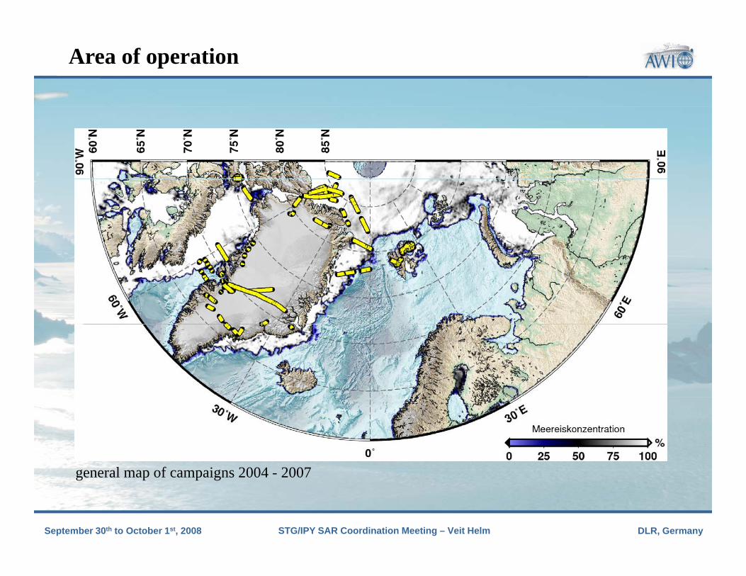
Area of operation
Click to edit Master title style
• Click to edit Master text styles• Second levelSecond level• Third level
F th l l• Fourth level• Fifth level
l f i 2004 2007
DLR, GermanySTG/IPY SAR Coordination Meeting – Veit Helm September 30th to October 1st, 2008
general map of campaigns 2004 - 2007

SAR-ProzessierungSAR-processed ASIRAS echos
Click to edit Master title styleRaw data
wer
• Click to edit Master text styles• Second level SAR-processedm
aliz
ed p
ow
Second level• Third level
F th l l
SAR processed
norm
• Fourth level• Fifth level
time [s]
DLR, GermanySTG/IPY SAR Coordination Meeting – Veit Helm September 30th to October 1st, 2008
distance to surface (range) [m]

Internal layering in Greenlands dry snow zone
Click to edit Master title styleflight distance [km]
• Click to edit Master text styles• Second levelat
ion
[m]
Second level• Third level
F th l lurfa
ce e
leva
• Fourth level• Fifth level
su
DLR, GermanySTG/IPY SAR Coordination Meeting – Veit Helm September 30th to October 1st, 2008
normalized power

Area of operation: percolation zone
Click to edit Master title style
• Click to edit Master text styles• Second levelSecond level• Third level
F th l l• Fourth level• Fifth level
DLR, GermanySTG/IPY SAR Coordination Meeting – Veit Helm September 30th to October 1st, 2008

Determination of winter accumulation
Next to the surface a secondClick to edit Master title styleNext to the surface a second very strong reflector is visible
This corresponds to the previous summer horizonva
tion
[m]
• Click to edit Master text styles• Second level
previous summer horizon (Parry, 2006)
urfa
ce e
lev
Second level• Third level
F th l l
su
flight distance [m]0 2700normalized power
• Fourth level• Fifth levelpo
wer
difference yields the winter accumulation no
rmal
ized
DLR, GermanySTG/IPY SAR Coordination Meeting – Veit Helm September 30th to October 1st, 2008
Helm (2007) (Density obtained from snow pit)distance to surface (range) [m]1100 1115 n

Thanks
Click to edit Master title style
• Click to edit Master text styles• Second levelSecond level• Third level
F th l l
CryoVex – Projektpartner:• Meereisgruppe (AWI – Stefan Hendricks)• ESA (R. Cullen)
• Fourth level• Fifth level
S ( Cu e )• Gateway Antarctica (W. Rack)• Danish National Space Center (L. Stenseng)• University of Oslo (J. O. Hagen)• Scott Polar Research Institute (R. Hawley)( y)• University of Alberta (C. Haas, Dave Burgess)• University of Edinburgh (P. Nienow, A. Shepherd)• University of Aberdeen (D. Mair)• University College London (D. Wingham)
DLR, GermanySTG/IPY SAR Coordination Meeting – Veit Helm September 30th to October 1st, 2008
y g ( g )• TU-Dresden (R. Dietrich), ….

Click to edit Master title style
• Click to edit Master text styles• Second levelSea Ice
~750 kmNeumayer Novo
Second level• Third level
F th l l
~600 km~550 km
• Fourth level• Fifth level Kohnen
DLR, GermanySTG/IPY SAR Coordination Meeting – Veit Helm September 30th to October 1st, 2008

ASIRAS - Profiles
Click to edit Master title style
• Click to edit Master text styles• Second levelSecond level• Third level
F th l l• Fourth level• Fifth level
DLR, GermanySTG/IPY SAR Coordination Meeting – Veit Helm September 30th to October 1st, 2008

Potsdam glacier - Drill positions
Click to edit Master title style
• Click to edit Master text styles• Second levelSecond level• Third level
F th l l• Fourth level• Fifth level
DLR, GermanySTG/IPY SAR Coordination Meeting – Veit Helm September 30th to October 1st, 2008
Source: (Anschütz, 2006)

Potsdam glacier - Drill and pit positions
Click to edit Master title style
• Click to edit Master text styles• Second levelSecond level• Third level
F th l l• Fourth level• Fifth level
DLR, GermanySTG/IPY SAR Coordination Meeting – Veit Helm September 30th to October 1st, 2008

Halvfarryggen and Søråsen - Drill positions
Click to edit Master title style
• Click to edit Master text styles• Second levelSecond level• Third level
F th l l• Fourth level• Fifth level C. Wesche, AWI
/å h
539-6.6670-71.5680FB07022006/2007Pre-IPICSHalvfarryggen, South
690-6.6989-71.1621B382006/2007Pre-IPICSHalvfarryggen, North
ElevationLongitudeLatitudeCores/PitsPeriodProjectLocation
DLR, GermanySTG/IPY SAR Coordination Meeting – Veit Helm September 30th to October 1st, 2008
760-9.5583-72.0640FB07042006/2007Pre-IPICSSøråsen, South
655-9.9167-71.4083B392006/2007Pre-IPICSSøråsen, North

Instrument characteristics
Click to edit Master title styleCryoSat ASIRAS
transmitted power 25 W 5 W
comp. pulse length 3.125 ns 1 ns
• Click to edit Master text styles• Second level
bandwidth 320 MHz 1 GHz
frequency 13.575 GHz 13.5 GHz
PRF 18.182 kHz 2 – 4 kHzSecond level• Third level
F th l l
flight altitude ~717 km 0.2 km bis 10 km
pulslimited footprint ~2.3 km ~51 m (R = 1100 m)
beamlimited footprint ~13.5 km ~44 m (R = 1100 m)
• Fourth level• Fifth level
SAR – resolution cell 0.3 km x 1 km 4 m x 50 m
theo. resolution in range ~0.47 m ~0.15 m
range window 60 m 22.5 m (HAM)
sample resolution ~0.47 m (128 samples) ~0.10 m (224 samples)
antenna gain 42 dB 26 dB
antenna angle (ac x al) ~1.2° x ~1.1° ~2.3° x ~9.8°
DLR, GermanySTG/IPY SAR Coordination Meeting – Veit Helm September 30th to October 1st, 2008
interferometric baseline 1.172 m 0.76 m