Effect of case management on neonatal mortality due to sepsis and ...
t
Comprehensive Theory
with Solved Examples and Practice Questions
Surveying and Geology
Civil Engineering
Publications
MADE EASY Publications
Corporate Office: 44-A/4, Kalu Sarai (Near Hauz Khas Metro Station), New Delhi-110016E-mail: [email protected]: 011-45124660, 8860378007
Visit us at: www.madeeasypublications.org
Surveying and Geology© Copyright by MADE EASY Publications.All rights are reserved. No part of this publication may be reproduced, stored in or introduced into a retrieval system, or transmitted in any form or by any means (electronic, mechanical, photo-copying, recording or otherwise), without the prior written permission of the above mentioned publisher of this book.
First Edition: 2015Second Edition (Revised and Updated): 2016
© All rights reserved by MADE EASY PUBLICATIONS. No part of this book may be reproduced or utilized in any form without the written permission from the publisher.
Publications

This book was motivated by the desire to further the evolution of a concise book
on Surveying and Geology. Keeping in focus the importance of this subject in
GATE and ESE, we have done a proper study and thereafter developed the
content of the book accordingly. This edition has an expanded discussion of
all relevant topics in the subject.
Initially, we compiled the perceptions of our students on their problems in
GATE and ESE while dealing with the questions from this subject. We identified
their various problems like- lack of fundamentals of the subject, difficulty in
solving simple solutions, shortage of a complete study package, etc. These strengthened
our determination to present a complete edition of Surveying and Geology textbook.
The book addresses all the requirements of the students, i.e. comprehensive coverage of theory, fundamental
concepts, objective type problems and conventional problems, articulated in a lucid language. The concise
presentation will help the readers grasp the concepts with clarity and apply them with ease to solve problems
quickly. The books not only covers the entire syllabus of GATE and ESE, but also addresses the need of many other
competitive examinations. Topics like ‘Linear Measurements, Chain Surveying, Compass Traverse, Theodolites,
Plane Table Surveying, Levelling and Contouring, Theory of Errors and Survey Adjustments, Traverse Computations
and Adjustments, Measurement of Area and Volume, Circular Curves, Transition Curve, Trigonometric Levelling,
Tacheometric Surveying, Triangulation, Aerial Surveying, Astronomy, GIS, GPS & Remote Sensing and Engineering
Geology’ are given full coverage in line with our research on their importance in competitive examinations.
We have put in our sincere efforts to present elaborate solutions for various problems, different problem solving
methodology, some useful quick techniques to save time while attempting MCQs without compromising the accuracy
of answers. A summary of important points to remember is added at the end of each topic. For the convenience
of readers, points to remember are specifically highlighted in the form of a note- both in theory as well as solved
examples. At the end of each chapter, sets of practice question are given with their keys, that will allow the readers
to evaluate their understanding of the topics and sharpen their problem solving skills.
Our team has made their best efforts to remove all possible errors of any kind. Nonetheless, we would highly
appreciate and acknowledge if you find and share with us any printing, calculation and conceptual error.
It is impossible to thank all the individuals who helped us, but we would like to sincerely thank all the co-authors,
editors and reviewers for putting in their efforts to publish this book. We also express our thanks to MADE EASY
publications for completing and publishing the book on time.
With Best Wishes
B. Singh
CMD, MADE EASY
Preface

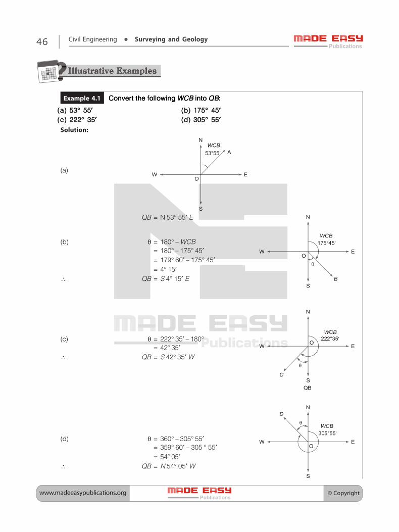
Chapter 1Introduction ............................................. 1 1.1 Need of Surveying .......................................................... 1 1.2 Types of Survey ................................................................ 1 1.3 Principles of Surveying ................................................. 3 1.4 Units of Measurement................................................... 4 1.5 Various Measurements in Surveying ....................... 5 1.6 Plan and Map.................................................................... 6 1.7 Errors incurring Due to Shrinkage of Map ............. 7 1.8 Errors incurring Due to Wrong Measuring Scale ......7 Objective Brain Teasers ........................................ 9 Student’s Assignments ............................. 10
Chapter 2Linear Measurements ............................11 2.1 Introduction ...................................................................11 2.2 Methods of Linear Measurements .........................11 2.3 Approximate Methods of Linear Measurements .. 11 2.4 Surveying Chains ..........................................................12 2.5 Some Special Types of Chains ..................................12 2.6 Chain Corrections .........................................................12 2.7 Measuring Tapes ...........................................................13 2.8 Tape Corrections ...........................................................15 2.9 Instruments Used for Linear Measurement ........16 2.10 Mistakes in Linear Measurements ..........................19 2.11 Degree of Accuracy in Linear Measurements ....19 Objective Brain Teasers .....................................20 Student’s Assignment .........................................21
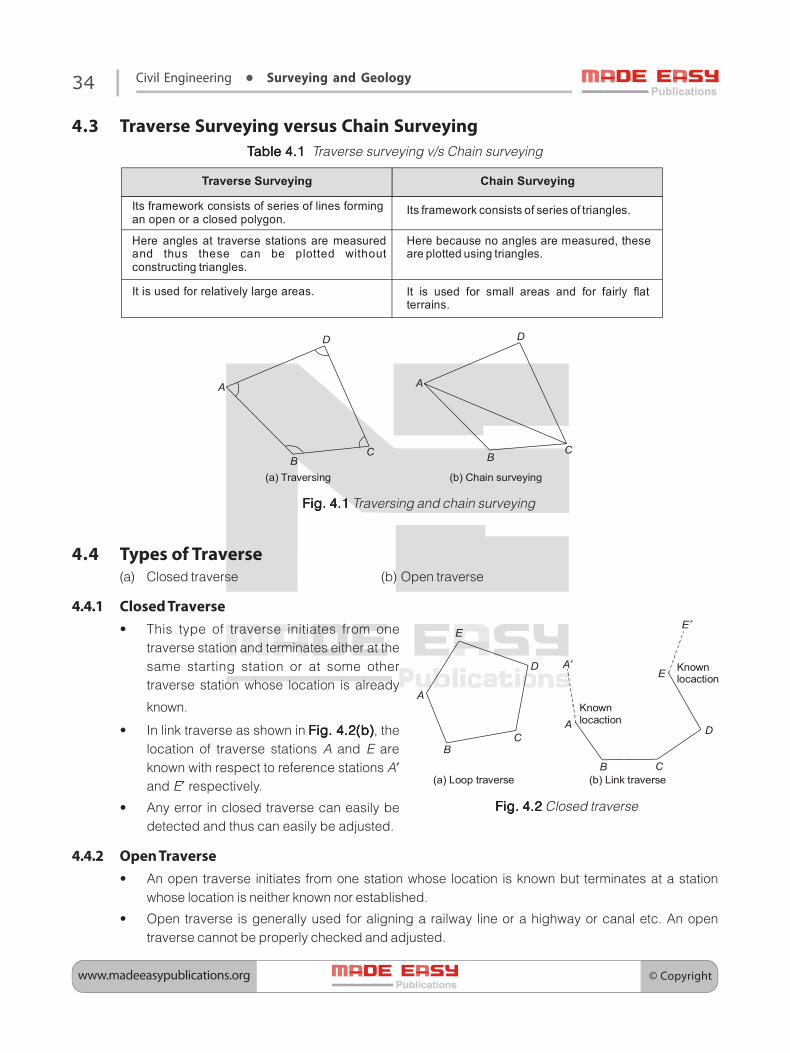
Chapter 3Chain Surveying ....................................22 3.1 Introduction ....................................................................22 3.2 Principles of Chain Surveying ...................................22 3.3 Terminologies in Chain Surveying ..........................23 3.4 Chain .................................................................................24
3.5 Well Conditioned Triangle .........................................25 3.6 Required Field Work in Chain Surveying ..............26 3.7 Limiting Length of the Offset ...................................27 3.8 Error in the Direction of Offset .................................27 3.9 Error in Offset Length and Direction Both ...........27 3.10 Obstacles/Difficulties in Ranging ............................29 3.11 Obstacles in Chaining and Ranging both ............29 3.12 Cross Staff Survey .........................................................31 3.13 Plotting of Chain Survey Work .................................31 3.14 Precautions to be Taken While Plotting the
Offsets ...............................................................................32 Objective Brain Teasers ......................................32
Chapter 4Compass Traverse ..................................33 4.1 Introduction ....................................................................33 4.2 Traversing Methods .....................................................33 4.3 Traverse Surveying versus Chain Surveying .......34 4.4 Types of Traverse ...........................................................34 4.5 Meridians .........................................................................35 4.6 Bearing..............................................................................36 4.7 Bearings Designation ..................................................36 4.8 Fore Bearing and Back Bearing ................................37 4.9 Magnetic Needle ...........................................................38 4.10 Using the Surveyor’s Compass .................................38 4.11 Using the Prismatic Compass ...................................38 4.12 Permanent Adjustment of a Compass ..................38 4.13 Prismatic Compass versus the Surveyor’s
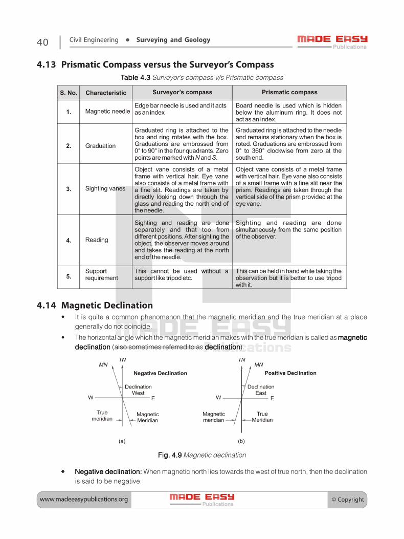
Compass ...........................................................................40 4.14 Magnetic Declination ..................................................40 4.15 Variations in Magnetic Declination ........................41 4.16 Effect of Variation in Magnetic Declination on
Survey Works ..................................................................42 4.17 True Bearing from the Magnetic Bearing .............42 4.18 Dip ......................................................................................42 4.19 Local Attraction .............................................................42
(v)
Surveying and GeologyContents

4.20 Errors in Compass Surveying ....................................43
4.21 Plotting a Compass Traverse .....................................44
4.22 Limits of Accuracy.........................................................45
Objective Brain Teasers ......................................54
Student’s Assignment ..........................................55
Chapter 5Theodolites ............................................56 5.1 Theodolite .......................................................................56
5.2 Components of a Vernier Theodolite .....................56
5.3 Measurement of Horizontal Angles .......................60
5.4 Theodolite as a Level ...................................................61
5.5 Angular Measurement Methods .............................61
5.6 Mistakes in Theodolite Surveying ...........................63
Objective Brain Teasers ......................................63
Chapter 6Plane Table Surveying ...........................65 6.1 Introduction ....................................................................65
6.2 Plane Table and its Types............................................65
6.3 Alidade ..............................................................................66
6.4 Plumbing Fork ................................................................67
6.5 Level Tube ........................................................................67
6.6 Trough Compass ...........................................................68
6.7 Drawing Sheet ...............................................................68
6.8 Pencil and Eraser ...........................................................68
6.9 Terminologies in Plane Tabling ................................68
6.10 Setting up of the Plane Table....................................69
6.11 Orienting the Plane Table ..........................................70
6.12 Radiation ..........................................................................71
6.13 Intersection .....................................................................71
6.14 Plane Table Traversing .................................................71
6.15 Resection .........................................................................72
6.16 Methods of Resection .................................................72
6.17 Contouring in Plane Table Surveying ....................78
6.18 Errors in Plane Tabling .................................................78
6.19 Advantages and Disadvantages of Plane Table
Surveying .........................................................................78
6.20 Plane Table Traverse versus Theodolite Traverse .... 79
6.21 Plane Table Traverse versus Chain Traverse .........79
Objective Brain Teasers ......................................79
Chapter 7Levelling and Contouring .....................82 7.1 Introduction ....................................................................82
7.2 Terminologies in Levelling.........................................82
7.3 Basic Principle of Levelling ........................................84
7.4 Theory of Simple Levelling ........................................85
7.5 Reciprocal Levelling .....................................................85
7.6 Balancing of Foresights and Backsights ...............86
7.7 Level Field Book .............................................................87
7.8 Errors in Levelling .........................................................87
7.9 Mistakes in Levelling....................................................90
7.10 Contour ............................................................................90
7.11 Characteristics of Contours .......................................90
7.12 Various Methods of Locating the Contours.........91
7.13 Direct Method of Contouring ...................................91
7.14 Indirect Methods of Contouring .............................92
7.15 Uses of Contour Maps .................................................93
7.16 Effect of Earth’s Curvature and Refraction ...........93
7.17 Distance of Visible Horizon ........................................95
Objective Brain Teasers ................................... 101
Student’s Assignment ....................................... 102
Chapter 8Theory of Errors and Survey Adjustments .................................... 103 8.1 Introduction ................................................................. 103
8.2 Types of Errors ............................................................. 103
8.3 Terminologies in Theory of Errors ........................ 104
8.4 Indices of Precision for Observations of Same
Weight ............................................................................ 105
8.5 The Law of Weights ................................................... 106
8.6 Indices of Precision for Observations of Different
Weights .......................................................................... 107
8.7 Corrections to be Applied to Field Measurements
for Closing Error .......................................................... 108
8.8 Theory of Least Squares .......................................... 109
8.9 Most Probable Values (MPV) of Directly Observed
Quantities ..................................................................... 110
8.10 Most Probable Values (MPV) of Indirectly
Observed Quantities ................................................. 110
8.11 The Method of Differences ..................................... 110
(vi)(vi)
(vii)(vii)
8.12 The Method of Correlates ......................................... 111
8.13 Adjustment of Two Connected Triangles ........... 111
8.14 Adjustment of a Braced Quadrilateral ................ 111
Objective Brain Teasers ................................... 118 Student’s Assignment ....................................... 119
Chapter 9Traverse Computations and Adjustments .................................... 120 9.1 Need for Traverse Adjustment .............................. 120 9.2 Methods of Traverse Adjustments ....................... 120 9.3 Gale’s Traverse Table ................................................. 122 9.4 Inversing ....................................................................... 122 9.5 Omitted Measurements .......................................... 122 Objective Brain Teasers ................................... 130 Student’s Assignment ....................................... 131
Chapter 10Measurement of Area and Volume .....132 10.1 Need for Computation of Area and Volume .... 132 10.2 Area Measurement ................................................... 132 10.3 Calculation of Areas by the Use of Geometric
Figures ........................................................................... 132 10.4 Calculation of Areas from Offsets ........................ 133 10.5 Calculation of Areas from Co-ordinates ............ 135 10.6 Calculation of Area from Latitude and Meridian
Distance ........................................................................ 135 10.7 Calculation of Area from Departure and Total
Latitude ......................................................................... 138 10.8 Calculation of Area from Co-ordinate Squares 139 10.9 Errors in Calculation of Area .................................. 139 10.10 Mistakes in Calculation of Area ............................ 139 10.11 Measurement of Volume ........................................ 139 Objective Brain Teasers .................................. 145 Student’s Assignment ...................................... 145
Chapter 11Circular Curves .....................................147 11.1 Introduction ................................................................. 147 11.2 Classification of Curves ............................................ 147 11.3 Horizontal Curves ...................................................... 147 11.4 Vertical Curves ............................................................ 149 11.5 Simple Circular Curve-A Detailed Overview .... 150 11.6 Setting Out a Simple Circular Curve ................... 154
11.7 Curve Passing Through a Fixed Point ................. 159 11.8 Compound Curve ...................................................... 160 11.9 Elements of Compound Curve .............................. 160 11.10 Reverse Curve...................................................................... Objective Brain Teasers ................................... 169 Student’s Assignment ....................................... 170
Chapter 12Transition Curve ..................................171 12.1 Need for Transition Curve ....................................... 171 12.2 Requirements of a Transition Curve .................... 171 12.3 Super-elevation .......................................................... 172 12.4 Length of Transition Curve ..................................... 173 12.5 Ideal Transition Curve ............................................... 174 12.6 The Cubic Parabola.................................................... 178 12.7 Insertion of the Transition Curve .......................... 182 12.8 Characteristics of Transition Curve ...................... 183 12.9 Lemniscate as a Transition Curve (at the end of
Circular Curve) ............................................................ 185 12.10 Comparison of Transition Curves Objective Brain Teasers ................................... 191 Student’s Assignment ....................................... 193
Chapter 13Trigonometric Levelling ......................194 13.1 Introduction ................................................................. 194 13.2 Determination of Height of Top Level of a High
Object when its Base is not Accessible .............. 194 13.4 Indirect Levelling on a Steep Slope ..................... 199 13.5 Effect Due to Refraction .......................................... 200 13.6 Effect Due to Curvature of Earth .......................... 202 13.7 Total Correction Due to Curvature and Refraction ...202 13.8 Axis Signal Correction .............................................. 203 Objective Brain Teasers ................................... 206 Student’s Assignment ....................................... 206
Chapter 14Tacheometric Surveying .....................207 14.1 Introduction ................................................................. 207 14.2 Advantages of Tacheometric Surveying ............ 207 14.3 Tacheometer ................................................................ 208 14.4 Major Characteristics of a Tacheometer ............ 208 14.5 Stadia Rod..................................................................... 208 14.6 Systems of Tacheometric Measurements.......... 209 14.6 Principle of Stadia Method of Tacheometry ..... 210

(viii)(viii)
14.7 Tacheometric Measurement with inclined Line of Sight and Staff Vertical ............................................. 211
14.8 Inclined Line of Sight with Staff Normal to the Line of Sight .......................................................................... 213
14.9 Advantages of Holding the Staff Vertical ............ 215 14.10 Advantages of Holding the Staff Normal to The
Line of Sight ................................................................. 215 14.11 Tangential Method of Tacheometry .................... 215 14.12 Disadvantages of Tangential Method of
Tacheometry ................................................................ 217
14.13 Errors in Tacheometric Surveying ........................ 217
Objective Brain Teasers ................................... 224
Student’s Assignment ....................................... 226
Chapter 15Triangulation .......................................227 15.1 Introduction ................................................................. 227
15.2 Importance of Triangulation .................................. 227
15.3 Principle of Triangulation ........................................ 228
15.4 Triangulation System ................................................ 228
15.5 System of Framework in Triangulation .............. 230
15.6 Classification of Triangulation System ............... 231
15.7 Signals ............................................................................ 231
15.8 Selection of Triangulation Stations ..................... 235
15.9 Base Line ....................................................................... 235
15.10 Measurement of Base Line ..................................... 236
15.11 Corrections to Base Line Measurement ............. 236
15.12 Computations in Triangulation ............................. 239
Objective Brain Teasers ................................... 244
Student’s Assignment ....................................... 246
Chapter 16Aerial Surveying ..................................247 16.1 Introduction ................................................................. 247
16.2 Terrestrial Photograph and Terrestrial
Photogrammetry ....................................................... 247
16.3 Aerial Photograph and Aerial Photogrammetry 247
16.4 Aerial Photograph ..................................................... 248
16.5 Terminologies in Aerial Surveying ....................... 249
16.6 Relief Displacement .................................................. 251
16.7 Area Covered by One Photograph ...................... 252
16.8 Exposure Interval ....................................................... 252
16.9 Air Base .......................................................................... 253
Objective Brain Teasers ................................... 259
Student’s Assignment ....................................... 260
Chapter 17Astronomy ............................................261 17.1 Field Astronomy ......................................................... 261 17.2 The Earth ....................................................................... 261 17.3 Terminologies in Astronomy ................................. 261 17.4 The Sun .......................................................................... 264 17.5 Locating the Position of Celestial Body ............. 265 17.6 Solution of Spherical Triangle ............................... 265 17.7 Time ................................................................................ 266 Objective Brain Teasers ................................... 269
Chapter 18GIS, GPS & Remote Sensing ................271
A. GIS (Geographical Information System) 18.1 Introduction ................................................................. 271 18.2 Development of GIS .................................................. 271 18.3 Importance of GIS ...................................................... 272 18.4 Components of GIS ................................................... 272 18.5 Applications of GIS .................................................... 273
B. GPS (Global Positioning System) 18.6 Introduction ................................................................. 273 18.7 Working of GPS ........................................................... 274 18.8 Structure of GPS ......................................................... 274 18.9 Applications of GPS ................................................... 275
C. Remote Sensing 18.10 Introduction ................................................................. 276 18.11 Electromagnetic Waves .......................................... 277 18.12 Scattering of Electromagnetic Radiation .......... 278 18.13 Interaction of Elecromagnetic Radiation with
Earth’s Surface ............................................................. 280 18.14 Remote Sensing Observation Platforms ........... 281 18.15 Applications of Remote Sensing Objective Brain Teasers ................................... 284
Chapter 19Engineering Geology ..........................285 19.1 Introduction ................................................................. 286 19.2 Geologic Mapping and Remote Sensing .......... 286 19.3 Minerology ................................................................... 287 19.4 Geological Agents ..................................................... 289 19.5 Structural Geology .................................................... 290 19.6 Importance of Engineering Geology .................. 297 19.7 Geological Hazards ................................................... 297 Objective Brain Teasers ................................... 297 Appendix ..............................................299
nnnn