City Planning, Social Progress, Colony, and Metropole ...
29
World History Connected Vol. 18, no. 3 October/November 2021 © 2021 by World History Connected IAN MORLEY City Planning, Social Progress, Colony, and Metropole: Expanding the Learning of U.S. History via Introducing the 1905 City Plan for Manila, the Philippines T his study examines how the practice of early-twentieth century city planning in the Philippines, a colony, came to influence urban design in the United States. Focusing on the city of Manila, it offers the means by which instructors of both World History and American History can employ the colonial “built environment” in the classroom to enhance student learning and writing. This “metropole-colony-metropole” urban design approach has the benefit of exposing to student learners to a fundamental aspect of the cities in world history: they shape the civilizations (literally, “city-dwelling”) in which they live. This study offers a brief review of the importance of cities in world history, followed by a short discussion how this case study fits into that scholarship, which it is hoped, is of value to historians at all levels of instruction. It then offers classroom approaches, includ- ing prompts for document use and guided discussion. While some of these may be more useful to post-secondary instructors, all are designed to employ this case study to enrich the teaching of world history and the American past. Cities and the Subject of History Eminent scholars of urban history and design have convincingly argued that both the accomplishments and shortcomings of civilizations are evident in their towns and cities. 1 As a result, the study of the character of past society necessitates viewing how urban places evolve in time and space to reflect their builder’s and inhabitant’s changing needs and intentions. In this intellectual context, changes in the urban form are viewed as reflecting the development of culture, aesthetics, politics, law, and economic conditions and aspira- tions. What is more, as a result, most American scholars focus upon dynamics occurring
Transcript of City Planning, Social Progress, Colony, and Metropole ...

World History Connected Vol. 18, no. 3 October/November 2021© 2021 by World History Connected
IAN MORLEY
City Planning, Social Progress, Colony, and Metropole: Expanding the Learning of U.S. History via Introducing the 1905 City Plan for Manila, the Philippines
This study examines how the practice of early-twentieth century city planning in the Philippines, a colony, came to influence urban design in the United States. Focusing
on the city of Manila, it offers the means by which instructors of both World History and American History can employ the colonial “built environment” in the classroom to enhance student learning and writing. This “metropole-colony-metropole” urban design approach has the benefit of exposing to student learners to a fundamental aspect of the cities in world history: they shape the civilizations (literally, “city-dwelling”) in which they live. This study offers a brief review of the importance of cities in world history, followed by a short discussion how this case study fits into that scholarship, which it is hoped, is of value to historians at all levels of instruction. It then offers classroom approaches, includ-ing prompts for document use and guided discussion. While some of these may be more useful to post-secondary instructors, all are designed to employ this case study to enrich the teaching of world history and the American past.
Cities and the Subject of History
Eminent scholars of urban history and design have convincingly argued that both the accomplishments and shortcomings of civilizations are evident in their towns and cities.1 As a result, the study of the character of past society necessitates viewing how urban places evolve in time and space to reflect their builder’s and inhabitant’s changing needs and intentions. In this intellectual context, changes in the urban form are viewed as reflecting the development of culture, aesthetics, politics, law, and economic conditions and aspira-tions. What is more, as a result, most American scholars focus upon dynamics occurring

Morley | 1905 City Plan for Manila, the Philippines
2
in the built environment within their nation’s territorial boundaries as an upshot of their intention to identify and explain national will and character. Examples of this approach are John Reps’ forceful account of the development of city planning during the colonial and postcolonial eras, and Robert Caro’s authoritative work on the changing face of New York City under the hand of Robert Moses.2 World historians, somewhat in contrast, often seek to study the evolution of cities as they experience global historical forces, for exam-ple Greg Clark’s investigation of cities and international trade, Howard Spodek’s study of Ahmedabad, India, and Birgit Tremml-Werner’s examination of Manila’s relationship to the emergence of early-modern global economy.3 This study adds to this scholarship by posi-tioning itself at the confluence of urban design and American colonialism in the Philippines.
Students of the Urban Environment
The academic study of History is broadly recognized as comprising a series of inquiries and discourses about the world at large.4 Historians acquire knowledge within their fields of study by gathering and interpreting primary and secondary sources.5 Consequently, the fundamental task of the historian is to collect and use source materials for the purpose of objectively explaining what life was like in earlier times and/or why events in the past occurred.6 When the urban environment comes under the magnifying glass of the histo-rian, three principles should guide the historical analysis: first, the historian must view the urban form within the perspective of time; second, he or she must recognize how the evolution of human meaning and intention is embedded within the structural and spatial transitions of cities as they change across time; and third, as a result of the first two steps, the historian should clarify and specify how the built fabrics of a country contain and express advancements in national culture, art and aesthetics, politics, law, and economic growth.7 This analytical framework produces readings and insights into the nature and growth of past civilizations. Can it, however, successfully be applied to cities beyond a nation’s terri-torial borders? That is the question posed by this article, specifically in regard to the urban environment of colonies acquired by the United States after the Spanish-American War (1898) and what they reveal about U.S. history. Assuming this is a fruitful approach, how should students be expected to learn and write about the history of colonial cities, and how should teachers assess the learners’ manufacture of knowledge? When encouraging students to draw their own original conclusions about the urban design history of the United States, it is worthwhile for teachers to stress that city planning activities in the Philippines during the early-1900s influenced subsequent environmental design events in North America. Few students, if any, will know that the colony directly affected the metropole. For instance, following his visit to the Philippines in late-1904 and early-1905, the architect-planner Daniel H. Burnham (1846–1912) composed grand City Beautiful-style plans for San Francisco and Chicago.8 Published in September 1905 and July

Morley | 1905 City Plan for Manila, the Philippines
3
1909, respectively, both projects9 demonstrated parallels with his 1905 scheme in Manila.10 The comparison of the Manila Plan with the San Francisco and Chicago projects enables the influence of the colony to be identified. Going a step further, the early-twentieth century urban planning of San Francisco and Chicago can be seen to have influenced the planning of cities in other countries, e.g., Canberra, Australia (by Walter Burley Griffin in 1912—see Image 1).11 All four cities, Manila, Chicago, San Francisco, and Canberra, had connection to local waterways, the design of which can be traced to a common root. Likewise, it must be recognized that all four plans focused on erecting grandiose public buildings at the physical and symbolic heart of each settlement: grand views were to be established in the center of each city, with the dome of the Capitol and City Hall in Manila and Chicago not only terminating the axes of boulevards and public spaces, but also anchoring multiple connections to the natural landscape and hinterland.12
In the context of a U.S. History course, discussion of the 1905 Manila Plan and Daniel Burnham’s professional brilliance will reveal that American societal progress was indeed shaped by the city planning process. It also shows that while a single person can compose a grand city plan, societal evolution inextricably interlinks the nature of the urban form with citizens’ lives. This is especially pertinent when thinking about topics such as public health. After all, as a tool of the state, urban planning grew in the United States during the late-1800s and early-1900s as a method to help tackle public sanitation and environmental pollution
Image 1: American City Beautiful planning “Down Under”: The south-west-wards view of Canberra, the Australian capital city, from Mount Ainslie. The vista includes the monumental planning axis marked by the Australian War Memorial, Anzac Parade, Lake Burley Griffin, and the Government House. Source: The author.

Morley | 1905 City Plan for Manila, the Philippines
4
problems in fast-growing industrial cities. Given that the history of disease is very much the history of cities,13 and vice versa, any narrative of the development of American civ-ilization presented to students should not downplay the significance of the relationship between urban planning and public health.
Image 2: Burnham’s 1905 Report on Proposed Improvements at Manila, composed with assistance from Peirce Anderson, contained just two illustrations. One image, top, showed Manila’s new environmental layout while the other illustration, bottom, pre-sented the layout of the “Ocean Boulevard” along the shoreline between Manila and the port town of Cavite to the south of the capital city. Source: Public Domain at https://commons.wikimedia.org/wiki/File:BurnhamPlanOf-Manila.jpg and https://commons.wikimedia.org/wiki/File:Cavite_Boulevard_sketch_by_Burnham.jpg.

Morley | 1905 City Plan for Manila, the Philippines
5
Teaching the Post-1898 American Urban Past: A Step-by-Step Pedagogy
As previously mentioned, to understand how the United States extended its urban forms beyond the North American continent one must acknowledge the events surrounding the Spanish-American War and the Treaty of Paris (signed December 10, 1898), which ceded the bulk of Spain’s overseas empire to America, including control of Puerto Rico, Guam, and the Philippines.14 This treaty, therefore, propelled America to the status of an imperial power.15 In exploring the impacts of American imperialism subsequent to 1898, it becomes apparent that colonial governance in the Philippines had several priorities. These included the enlargement of the public education system, the improvement of public health, eco-nomic expansion, political reform, city planning, and the construction of roads, railways, ports, and public edifices.16 This side of colonial history is probably unknown to most U.S. history students, hence the question: how can they be educated about a topic such as colo-nial city development in Manila, the Philippine capital city, so that new conclusions about the past disposition of American society can be formed? What primary sources should a teacher introduce? After all, textual study is a basic element of the apprentice historian’s training,17 and, factually speaking, American colonization endeavored to enact societal change/development in Southeast Asia by means of both education and example.18
In view of these goals, a teacher can develop the knowledge19 of his or her students by constructing an uncomplicated taxonomy of forms of engagement and assessment. A teacher may begin the students’ learning process20 by asking them to define what “city” and “urban planning” mean with reference to U.S. history. They can then be asked in small groups, or as a class, to generate a timeline of city planning practice in the country after 1776. In presenting this exercise an instructor swiftly concocts opportunity for students of different learning styles to demonstrate their general urban historical awareness. Sec-ond, it allows the teacher to gauge the students’ grasp of past U.S. urban-related develop-ments,21 and to detect their capacity to recognize any contextual influences. When asked a range of questions, the students can begin to more firmly appreciate the ties between, for example, the evolution of U.S. political power, the development of the national economy and culture, and the practice of urban design in the country. Third, this participatory exer-cise encourages students to work together in forging a pooled information base so that subsequently, to cite Lendol Calder (2006), signature pedagogy22 around a core historical theme, i.e., the American Empire, can be constructed. Then again, at this early point in the learning process, a teacher may wish to explain to students how the establishment of the American Empire complicated the American political self-identity as a democratic nation. Struggles with the nation’s psyche in the years following 1898, given its newfound status as an imperial power, may require some explanation. Such discussion can, should time permit, be broadened to discuss aspects of built heritage and decoloniality in the light of

Morley | 1905 City Plan for Manila, the Philippines
6
the emergence of contemporary social movements, e.g., Black Lives Matter. However, by broadly encouraging the students to acquire knowledge from each other during the early stage in the learning exercise, it acts as a bedrock for them to later on critically explore and explain how American city planning prior to the late-1800s affected architectural and spatial articulations in, for instance, Manila. Crucially too, to follow such an educational approach has other benefits: in getting the students to chronologically organize U.S. urban developments after 1776, it arouses them to ponder not just places and people/designers, but also different source types (e.g., maps, plans, photos, etc.); plus, in alliance with the aforementioned matter, on one hand, it permits the students to think about how different source types may be evaluated for their utility in the historical investigation of urban envi-ronments and, on the other hand, as the Stanford History Education Group has shown, by assisting students to develop fundamental investigative thinking skills the learners can accrue abilities to evaluate the strengths and weaknesses of particular source types.23 Evi-dently, as students learn more about sources types, their uses, and how History as a subject works, they can gain greater self-confidence and an increased understanding of American civilization from previously unconsidered standpoints and themes. Once the city planning lineage task is complete the class can move onto debating its data and reevaluating pertinent contextual matters previously raised by the students. New questions should at this point be tendered by the teacher. They will stimulate stu-dent reflection, advance ongoing discussions, and enhance management of the learning scaffold. Questions that can be asked include: “How might the layout of public buildings, spaces, and monuments convey the relationship between politics, idealism, power, wealth, and urban planning?”; “How can a capital city’s environmental character reflect the worl-dview of a nation’s elites?”; and, “How does urban design legitimize who constructs it, who uses it, and who is excluded from it?”24 Of note, this thinking-verbal exercise helps to excavate an elemental idea of bygone urban design practice: irrespective of the time and place where a city plan is implemented, the laying of the urban place will have both a form and a meaning, and ultimately any meaning will be determined by the citizens who see, use, and interact with the newly-arranged built fabric. Some curve balls may be thrown to the students in order to test and elicit their critical thinking: “How might the develop-ment of politics affect the definition of what ‘good city design’ is?”; “How might notions of public convenience, environmental beauty, and citizens’ well-being be amended once one governmental regime ends and another commences?”; and, “How might a country becoming an imperial power complicate its sense of political identity and destiny when its self-perception is historically rooted in its being a democratic nation? How do you think the United States’ conflicted identity as both an imperial and democratic power affected the city planning process in Manila?” Should students struggle to answer such questions, certain key texts can be suggested as an aid, e.g., James C. Scott’s Seeing Like a State (1998).

Morley | 1905 City Plan for Manila, the Philippines
7
Such texts will acquaint learners with how a government can enact social change, e.g., in the capital city, where its physical environment can be utilized to mirror national values. Scott’s book also underscores the importance of having political clout, technological know-how, and a robust legal framework for the state to make societal change happen. At this point in the learning pathway, the teacher can inform learners that following the signing of the Treaty of Paris in late-1898, the Americans desired to rank themselves alongside Old World powers, albeit with a difference. To do this, and to substantiate their claims as “civ-ilizers of the world,” the Americans who reformed civilization in the Philippine Islands emanated from the fields of science, medicine, architecture, and city planning:25 persons from the latter vocation, e.g., Daniel H. Burnham—see Image 3, proved vital in crafting and implementing a fresh architectural and spatial reality for Manila. His urban design vision for the city, initially borne at the Columbian World’s Exposition in Chicago in 1893 but reinforced by the urban renewal of Washington, D.C. in 1901–2 (as part of the McMil-lan Plan), was as the students must be told reintroduced to the United States in 1905 and subsequently came to inform strategies for aggrandizing more than 75 cities throughout North America.26 In short, Burnham’s experiences in the Philippines affected his, and oth-ers’, thoughts, visions, and planning practices within cities in the United States.
Image 3: A portrait of Daniel H. Burnham by Anders Zorn. The painting hangs upon the wall of the Ryerson Library Reading Room at the Art Institute of Chicago. Source: The author.

Morley | 1905 City Plan for Manila, the Philippines
8
In encouraging my students to expand their grasp of the cultural and political conno-tations of city designing I assign basic research as homework. I will ask them, for example, to probe Spain’s Laws of the Indies (passed in 1573) and the urban layouts it established.27 This rudimentary inquiry familiarizes them with the process of discovering and organizing new evidence, teaches them self-efficacy,28 introduces ownership of the learning process, and increases their factual understanding of urban design in the Philippines before the Americans arrived in 1898.29 To accomplish the task, students must answer two questions: “What urban environmental form did the Laws of the Indies create?”; and, “How was the importance of the Church and State woven into the Spanish colonial urban fabric?” To follow this up, in part to check for data accuracy but also to fortify newly gathered knowledge, I request in the next class that they compare and contrast the Spanish planning model with U.S. configurations proposed in Chicago, Cleveland, Washington, D.C., and San Francisco during the 1890s and early 1900s (as part of the urban design movement known as the City Beautiful). This assignment, in getting students to visualize and moralize Spain’s imperial
Image 4: Examples of City Beautiful planning by Daniel H. Burnham in the United States. Top left: The Court of Honor at the World’s Fair in Chicago (1893), and (top right) a perspective of the 1901–2 McMillan Plan for Washington, D.C. Bottom: The Group Plan of 1903 in Cleveland, Ohio. Source: Public Domain at Wikime-dia Commons (https://commons.wikimedia.org/wiki/File:Court_of_Honor_and_Grand_Basin.jpg, https://commons.wikimedia.org/wiki/File:Washington_Gardens_proposed_-_Senate_Park_Commission_-_1902.jpg, and https://commons.wikimedia.org/wiki/File:Group_Plan.jpg).
Morley | 1905 City Plan for Manila, the Philippines
9
urban planning archetype alongside the U.S. paradigm, prompts them to distinguish not just what the two nations’ divergent planning systems environmentally generated but how and why the built environments they established differed. If required, in case of any misunderstanding among the students, the learning proce-dure may be directed towards the writing of scholars such as Lewis Mumford. His classic text The City in History (1961) expounds on how civilizations and cities interact, and among the many themes examined by Mumford he discloses how power within society converts itself into built forms.30 To strengthen students’ conceptual grasp of how and why a state environmentally expresses its power, the works of Michel Foucault may be assigned: he observed how authority has been validated and used by governments throughout histo-ry.31 Ideally, after considering the assessments of scholars such as Mumford and Foucault, students will be armed with new erudition and, with this in mind, I can expect to continue the step-based pedagogy. It is at this point that I encourage the expansion of the learners’ critical thinking. Consequently, I push them to ruminate on city planning practice from a range of standpoints. In doing this they consider why, at a fixed point in time, a wholly new urban design order could be established: “What reasons might be behind the creation of a new urban layout/new city appearance?” Additionally, I ask: “What might colonized people think about the imposition of a new environmental arrangement?” Such a ques-tion can be reinforced by an evaluation of the nature of colonization when there is regime change: “If new colonizers [Americans] arrive in a place formerly occupied by another Western power, how might that succession affect how they see and read the existing built environment?”; “If the American purpose for colonizing an overseas territory is to civilize and modernize that place, how might they seek to change the nature of local civilization and thus the design of existing towns and cities? What, afterwards, would the new urban form denote to the colonizers and the colonized population?” And, allegorically, “What symbolic meanings will be attributed in terms of societal advancement via redesigning the colonial capital city?” Such questions purposefully expand critical knowledge/comprehen-sion derived from preliminary teacher-student discourse. In stimulating critical thinking my goal is to compel the students to embrace deep learning and to become better acquainted with the systemized logic that exists within the field of History.32 In this frame my learners begin to take on increased cognizance as to the roles that city planning can have as a social development tool. In short, critical thinking helps realign their awareness of the alliance between societal evolution and urban design; it helps them to combine several cultural, political, economic, legal, and environmental strands as well as to identify the bonds between them, and, in promoting active learning in and out of the classroom, it empowers students to think beyond the confines of the textbook. As a result, they come to realize that the United States’ history post-1776 has been shaped by an assortment of people, not just political heroes, who through their attitudes, decisions, and actions shaped both the country’s trajectory and, after 1898, its quasi-imperial narrative

Morley | 1905 City Plan for Manila, the Philippines
10
of promoting national development beyond North America. This awareness can have two fundamental impacts. It emboldens learning curiosity33 and it inspires students to invest personal time and energy into their education. Overall, students come to realize that they as citizens of a nation, and by dint of their own attitudes and actions, can positively—or not—influence their civilization’s course of advancement, just as people did in preceding times.
Critical Reading to Provide Frames for Explanatory Writing
An essential component of being a trainee historian is the composition of historical argu-ments, the interpretation of source materials, and the establishment of original conclusions. Yet, just as accomplished historians have explained past events in disparate ways, so too can sources be read and accounted for differently by students.34 Given this variance, how is it possible to teach students to objectively read35 historical documents and past urban environments so that, in due course, they can write accurately about them? To tackle this scholarly challenge, and giving reference again to my own classroom activity,36 I have composed worksheets: these documents assist my students in compre-hensively breaking down the meaning of different source types,37 in critically thinking without even knowing they are doing so, and in assessing the knowledge they already have in conjunction with the knowledge that they might be missing. One such worksheet informs students of how to scan urban environments shown in visual texts, such as pho-tographs and postcards. It supplies criteria so that the learners can dissect the character of the urban form. Basically, it prompts them to observe, identify, and evaluate architectural and environmental items that include:
The size, design style, texture, and color of prominent buildings;
Design features visible on the main facades of edifices;
The nature of the buildings—private/public?—and their function;
The location of entrances, their treatment, and evidence of any approaches to them;
Number of floor levels, general treatment of each floor level in terms of fenes-tration, sculpting, color, etc.,
The local road layout and any relationship of its configuration to the siting of statuary, monuments, and public buildings;
General environmental layout of the area about the public buildings, e.g., any use of greenery, the siting of trees, flower beds, water features, etc.;
Evidence of the establishment of vistas in the local environment, e.g., via the siting of an architectural feature in front of a prominent edifice, long thorough-fares running to and from a building or monument, etc.

Morley | 1905 City Plan for Manila, the Philippines
11
Another worksheet (Image 5) assists students in scrutinizing written documents. The first section of the worksheet concerns the description of a historical text, e.g., the date it was composed, by whom, his/her occupation, and the intended audience. The second section provokes students to think about the source’s association with broader societal dynamics. It presents tasks and questions, including: “List four things in the text that makes it histor-ically important”; “List four things the document says are important to understanding life in the United States at the time it was written”; and, “Write a question [about the content of the document] that is left unanswered by the author.” With the latter question in mind, when examining the first American planning report for a city in the Philippines, i.e., the 1905 Report on Improvement at Manila by Daniel H. Burnham and Pierce Anderson, what does the document not disclose about the Philippine capital’s environmental condition at
Image 5: The written source analysis worksheet given to students so as to aid the development of their critical inquiry skills. Source: The author.

Morley | 1905 City Plan for Manila, the Philippines
12
that time? What does it not reveal about life during the early years of American coloniza-tion? In addition, to facilitate greater consciousness of word forms, I encourage students to utilize textual analysis software. This exposes them to new skill-set creation.38
The emergence of the Digital Humanities has granted new occasion for document analysis. Computational tools allow scholars to text-mine and, so, to comprehend histor-ical sources as literary documents. This enables students, e.g., when reading Burnham and Anderson’s report, to comprehend the American colonial world in novel ways.39 Whereas hitherto a reader’s eye might superficially observe that Burnham and Anderson’s document is formed with seven parts, computational tools assist the reader to determine what the most frequently employed word forms are, where they are located within the document, and their lexicon associations. Consequently, a student can know that a word such as “park” is not only used 19 times in Burnham and Anderson’s text, but that it is also recurrently stated alongside words such as “boulevards” and “parkways.” This finding emphasizes, firstly, that green urban space and tree-lined roadways were highly prized in the American intentions for the city planning of Manila. Secondly, such insights encourage learners to uncover the connection between “big facts” and “small facts,”40 which, as Maria Bakalis (2003) has observed, challenges them during the writing process to jigsaw together historical inferences, factual details, and explanations, and to see them in new contexts.41 To explain this point further I venture to enlighten my learners, by way of a lecture on American col-onization and its impacts, to be conscious of the role that Burnham and Anderson’s report played in implementing the United States’ policy of “efficient governance,” alongside its projection of colonial power and prestige in the Philippine Islands.42 To reference these two points I clarify in the lecture how the Americans’ plan for the Philippine capital city was meant after 1905 to restructure social relations in terms of center-periphery, connec-tion-division, etc., as well as to redefine peoples’ identity and the meaning of the Philippine nation’s past, present, and future.43 To ensure that students possess an understanding of this, and can lucidly articulate it, they are tasked with writing a summary (500–750 words) of the lecture.
Critical Thinking to Provide New Frames for Explanatory Writing
When instructing students to write about a key historical source there is always a risk they will only describe its content, and/or describe the events upon which it focuses. So, as a teacher, it is crucial that I push my students into different domains of perspective-thinking and towards critical writing. To accomplish this objective, I reiterate to them how historians read, think, and write, and how these three core skills are interlinked. By doing this the students should come to more thoroughly appreciate what History, as an academic sub-ject, is, as well as its basic purposes and methods.44 In accordance, I construct assessment structures that measure students’ disciplinary understanding rather than mere factual

Morley | 1905 City Plan for Manila, the Philippines
13
comprehension. Mindful of what Lendol Calder (2006) calls the problem of teaching with a facts-first approach—namely, the inadvertent teaching of half-truths45—I design the grad-ing rubric so that the introduction and conclusion, use of evidence and wider reading, originality of thought, and other hallmarks of vigorous historical analysis comprise up to 75 percent of an assignment score.46 The use of this logic, which builds upon the students’ training in earlier Historiography courses, leads students to learn how to learn—see Image 6—and use different types of historical explanation. In this scholarly situation, particularly for essays of larger word length—3,000 words or more—I oblige the learners to demon-strate causal explanation. Fundamentally, if asked to discuss the 1905 Manila planning report, then I would expect their scripts to deal with the question, “Why did the American
Image 6: A diagram to show the generic process through which students are taught to learn how to learn. Within this process students are repeatedly informed of how to develop critical skills, but also embrace their responsibilities as a learner of History. Source: The author.
Morley | 1905 City Plan for Manila, the Philippines
14
colonial government need to implement city planning in Manila?” Notably too, within this specific line of inquiry, I also desire evidence of contrastive explanation. I wish to see the students explicate an answer to a converse of the initial question, “Why did the Americans not keep Manila as it was?” Intentionally, I strive to make the learning environment struc-tured enough to offer guided skill-growth, but also “loose” enough so that students have the openness to think and write creatively, to find their own educational motivation, and to expand on skills learnt in prior/introductory History courses. In embracing scholastic autonomy, unavoidably, learners should realize why Manila’s pre-1898 physical environ-ment was unacceptable to the Americans and why, as a result of this, the application of the City Beautiful planning model was essential to conferring “progress.” In essence, I want my learners to take on the responsibility of learning the urban past as it truly happened, utiliz-ing and expanding a range of skills in order to truthfully interpret historical occurrences, and discovering how to self-evaluate their learning process so that, in this case, they can explain the plethora of circumstances existent at the time Burnham and Anderson com-posed their influential text. One such historical occurrence being “epochal change,” a matter defined by Göran Therborn (2017) as the coming together of the American “national” with the global.47 Likewise, if considering the nature of American politics and identity change circa 1898, this model of instruction helps to explain why, by 1901, Washington, D.C. was redesigned. Quite simply, after 1898, the city did not befit the neoclassical image of what an American imperial capital should be. Parallels with Manila, its state of being at that time, e.g., the fallout of the 1902–4 cholera epidemic,48 and its new status as an American colonial capital, can be drawn by the students. In learning to be conversant with the “hows and whys” of History, students will mesh with C. Behan McCullagh’s (2004) concept of “profound explanation.”49 By learning to tie Manila’s renewal to the American exportation of modernity in Southeast Asia, they will discern the true significance of historical circumstance, realizing the true impact of the Americans’ perception of themselves as civilizers of the world as well as the influence of their view that Filipinos were “backward people.” In this intellectual environment stu-dents can exercise recursive intelligence, that is to say that they can revisit the knowledge garnered from earlier education so that similarities between the attitudes of Americans towards Filipinos and their assessment of “lesser” races in North America during the 1800s can be identified. But, why is such perspective-taking relevant to writing about a city plan? Four scholarly points need to be recognized: the overall educational process is designed to embolden students to empathize with historians and the subjects (people) they write about; it encourages students to make every effort to ensure their knowledge (and writing) corresponds to the reality of the past;50 to consider how historical texts stand in relation to the culture that produces them;51 and, by thinking contextually about what city planning was, and meant to those who created and used it, to view urban forms beyond a structuralist standpoint.

Morley | 1905 City Plan for Manila, the Philippines
15
Equipped with an accurate and detailed historical knowledge, students will evaluate the American quest to reshape Philippine society from previously unthought-of angles. That is why, with my encouragement, they can return to an appraisal of what the U.S. city planning model at the turn of the nineteenth century, i.e., the City Beautiful paradigm, was and meant to those who were reform-minded in both the United States and the Philippines. To mature background awareness of City Beautiful practice and its ties to the American Empire, we examine, as part of out-of-class online discussions, historical images showing the alleged “benefits” of city planning in North America and Southeast Asia (Image 7). Given the didactic structure of seeing and reading planned urban fabrics, students begin to wholly appreciate colonial motivations. They recognize, for example, the narrative that the Spanish colonies at the end of the Spanish-American War were alleged, thanks to the American use of the Black Legend and its propagation among reform-minded Filipinos, to contain oppressed people who were insistent on societal betterment (but this was now
Image 7: Left: The front cover of the June 1899 edition of the American magazine, Judge, with (right) a picture analysis worksheet employed to aid students to breakdown its visual and textual meaning. Source: Public Domain at Wikimedia Commons (https://commons.wikimedia.org/wiki/File:Judge_06-10-1899.jpg) and the author.

Morley | 1905 City Plan for Manila, the Philippines
16
to be instigated by the progressive, benevolent American hand).52 They recognize, as well thanks in part to their earlier research, that under the Laws of the Indies, the Native Filipi-nos, the Japanese, Chinese, and white populations all resided in separate districts in Manila, and, so, why after 1898 the Americans intended to spatially “correct” alleged civilizational shortcomings. In consequence, the students fathom the role and importance of American assumptions about what Filipinos, their culture, and their capital city were,53 and as a result they better come to terms with why these suppositions were translated into a new built fabric after the publication of Burnham and Anderson’s 1905 report. Owing to the American belief that the Philippine capital comprised a fractured racial-cultural-spatial make-up, Burnham and Anderson’s city plan, as a blank canvas for a new American vision of Filipino civilization for the twentieth century, contained a large number of public spaces. Decorated with lawns, trees, fountains, and statuary, these open areas supplied new sites for all races and social groups to come together, and for new civic, secular celebrations to be held. In one centrally located green space, whose design was modelled on Washington D.C.’s Mall, was erected a monument (completed in 1913) dedicated to Filipino hero José Rizal (1861–96), who was assassinated by the Spanish colo-nial state. The Americans were conscious of the visual propaganda value of architectural features dedicated to national champions and their pursuit of liberty. However, to aid my students in grasping the various functions of monuments, an analogy between the Rizal Monument and the Lincoln Memorial in Washington, D.C. is made. The Lincoln Memo-rial was built at about the same time as the Rizal Monument, was sited in a similarly con-spicuous downtown location, and also celebrated the life of an icon. In other words, both monuments—Image 8—were situated in prominent urban locations so as to be seen and revered by all persons who identified themselves as “Filipino” or “American.” In deepening an appreciation of how the Americans and Filipinos responded to see-ing new environmental features as they arose in the early 1900s within their capital cities, students undertake surveys of maps, postcards, and photos54 in the classroom and in online threads for homework. Additionally, they are tasked with reviewing the sites of new stat-uary in relation to the existing road layout, the presence of prominent public buildings and green spaces, and in the backdrop of Manila at its seafront, the site of the new “Water Gate.” Considering Manila’s urban environment as a whole, I encourage the students to recognize that from 1905 the city was to present itself as contrasting from what it had been during the Spanish colonial era. Of note, in this milieu, the students acknowledge that the “new city” articulated the colonizers’ appropriations and recontextualizations of existing local culture.55 This alteration in the city’s image, its visual and spatial character, and its reputation post-1898 as an “advanced city”, was, the students know, apparent not just within Manila but evident when approaching it from the hinterland. For example, boats entering into Manila Bay would turn onto an axis56 that was to run west from the mouth of the inlet directly to the “Water Gate” where, at its rear/east, was positioned the Rizal Monument,

Morley | 1905 City Plan for Manila, the Philippines
17
the Washington D.C.-esque Mall,57 and the Capitol Building. Whereas Spanish-controlled Manila had an urban landscape dominated by churches, “Modern Manila” was to have the Capitol’s dome as its signature visual feature. Moreover, this American vision of modernity, the students learn through wider reading, was fortified by the development of new forms of transportation and the application of new buildings materials. Students comprehend that the use of concrete for buildings and tarmac for roadways not only gave Manila a new face but supplied its citizens with a swifter, smoother surface with which to move about the city. In the district of Paco a large train station was built (in 1912, to a design by William E. Parsons). The first of its kind in Manila, it was sited in proximity the urban fringe so that as visitors from the provinces entered the capital city they would, upon leaving the railway station building, enjoy a monumental view towards the centrally-located Capitol and its iconic dome—not the Spanish colonial walled city and its churches which had previously dominated the cityscape. For students to understand why vistas were so critical to communicating the different character of “Modern Manila,” a return to the abstract meaning of city planning may be required. Class debate, once again, can be employed to enrich student knowledge. Presented
Image 8: Left: The Rizal Monument in Manila. Right: An image of the Lincoln Memorial taken from the 1913 Lincoln Memorial Commission Report, and the Abraham Lincoln Statue in Wash-ington, D.C. Source: The author and Public Domain at Wikimedia Commons (https://commons.wikimedia.org/wiki/File:Lincoln_memorial_commission_report_(1913)_(14783546143).jpg and https://commons.wikimedia.org/wiki/File:Lincoln_Memorial_Statue.jpg).

Morley | 1905 City Plan for Manila, the Philippines
18
with an engrossing and panoramic view towards a building or monument, the viewer can, thinking abstractly and as a member of the local community, “own” what it is they see, and viewing new environmental features in this way accentuates the feeling that what you see belongs to the now, not the past. Likewise, whereas races under the Laws of the Indies had been segregated into their own quarters, in abandoning that restrictive urban planning model American colonial rule “liberated” people to live and move without restraint, given that they were now simply identified as “Filipinos.” Taking everything into account, the application of city planning was vital to the Americans’ yearning to inform Filipinos that a different kind of “modern” society existed after 1898. Against this backdrop, in assessing student writing of the 1905 planning report, five matters should become identifiable. These matters test a student’s overall comprehension of the course material:
1. What . . . for city planning to occur, irrespective of the time and place of its imple-mentation, are fundamentals/conditions that must always be met?
2. How . . . in terms of Manila’s environmental structure did American colonial city planning establish an urban environment different in appearance, plan, and meaning from that laid down during the Spanish era by the Laws of the Indies?
3. Why . . . would the American colonial state require city planning to happen? Why, in the frame of President William McKinley’s strategy of benevolent assimilation, would it benefit the “uplifting” and “civilizing” of Filipinos? Why did some aspects of Manila society stay the same and others, e.g., the urban environment, change after 1898?58
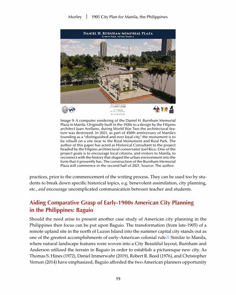
4. Who . . . was Daniel Burnham? What schemes had he designed in the United States pre-1905? What planning models from home and abroad inspired him? How did his experiences in the United States shape his approach to city planning in Manila? More so, how did his Philippine experiences influence his urban planning in the metropole after 1905? Plus, as Image 9 highlights, why in the context of many countries pulling down monuments associated with the colonial past is, in 2021, the Daniel H. Burnham Memorial being rebuilt in downtown Manila?
5. Meaning and writing . . . the basic meaning of the 1905 report gathered by the reader is not always the same as the literal meaning of the authors’ words. How can a reader of a text ensure basic and literal meaning are the same?
These five overarching questions proffer evidence of a student’s competence to ripen their source-based skills, to create and test hypotheses,59 to develop an expansive under-standing of the 1905 planning report as a text promoting cultural transformation, and to recon-struct the circumstances of the era when the source was composed.60 To help overcome any confusion or strains within the learning process, assignment planning sheets are made available. Issued weekly in the run-up to essay deadlines, these documents check and direct the knowledge-growth of the learners, particularly their critical thinking and reading
Morley | 1905 City Plan for Manila, the Philippines
19
practices, prior to the commencement of the writing process. They can be used too by stu-dents to break down specific historical topics, e.g. benevolent assimilation, city planning, etc., and encourage uncomplicated communication between teacher and students.
Aiding Comparative Grasp of Early-1900s American City Planning in the Philippines: Baguio
Should the need arise to present another case study of American city planning in the Philippines then focus can be put upon Baguio. The transformation (from late-1905) of a remote upland site in the north of Luzon Island into the summer capital city stands out as one of the greatest accomplishments of early-American colonial rule.61 Similar to Manila, where natural landscape features were woven into a City Beautiful layout, Burnham and Anderson utilized the terrain in Baguio in order to establish a picturesque new city. As Thomas S. Hines (1972), Daniel Immerwahr (2019), Robert R. Reed (1976), and Christopher Vernon (2014) have emphasized, Baguio afforded the two American planners opportunity
Image 9: A computer rendering of the Daniel H. Burnham Memorial Plaza in Manila. Originally built in the 1920s to a design by the Filipino architect Juan Arellano, during World War Two the architectural fea-ture was destroyed. In 2021, as part of 450th anniversary of Manila’s founding as a “distinguished and ever loyal city,” the monument is to be rebuilt on a site near to the Rizal Monument and Rizal Park. The author of this paper has acted as Historical Consultant to the project headed by the Filipino architectural conservator Joel Rico. One of the project goals is to encourage local citizens, and visitors to Manila, to reconnect with the history that shaped the urban environment into the form that it presently has. The construction of the Burnham Memorial Plaza will commence in the second half of 2021. Source: The author.
Morley | 1905 City Plan for Manila, the Philippines
20
to formulate a grand urban design scheme unhindered by nothing but the character of the natural surroundings.62 Consequently, Burnham and Anderson’s Baguio report, a text of little more than 1,000 words, outlines the form of the new city’s built fabric.63
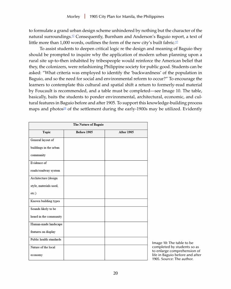
To assist students to deepen critical logic re the design and meaning of Baguio they should be prompted to inquire why the application of modern urban planning upon a rural site up-to-then inhabited by tribespeople would reinforce the American belief that they, the colonizers, were refashioning Philippine society for public good. Students can be asked: “What criteria was employed to identify the ‘backwardness’ of the population in Baguio, and so the need for social and environmental reform to occur?” To encourage the learners to contemplate this cultural and spatial shift a return to formerly-read material by Foucault is recommended, and a table must be completed—see Image 10. The table, basically, baits the students to ponder environmental, architectural, economic, and cul-tural features in Baguio before and after 1905. To support this knowledge-building process maps and photos64 of the settlement during the early-1900s may be utilized. Evidently
Image 10: The table to be completed by students so as to enlarge comprehension of life in Baguio before and after 1905. Source: The author.

Morley | 1905 City Plan for Manila, the Philippines
21
too, to ensure the learners do not struggle with the exercise, topics such as public health, the urban soundscape, local architectural styles, building types, and the type and use of public spaces, etc., are referenced in the aforementioned table. In other words, students are requested to outline the key features of life in Baguio pre-1905 and post the application of Burnham and Anderson’s city plan. The undertaking, if completed successfully by the learners, will uncover the many environmental and social transitions borne from American colonial governance’s appliance. These changes, perceived at the time by the Americans as ‘advancement’, can be employed as a foundation for subsequent discussion and reading. In strengthening the learning task, texts composed by David Brody (2001 and 2010), Rebecca Tinio McKenna (2017), Ian Morley (2018), and Russell P. Skelchy (2020) can be studied.65 Skelchy, for instance, in examining Baguio as a sound “contact zone” between the Americans and Filipinos, enquires “How did the American colonial state hear ‘develop-ment’?” In disclosing how particular noises in 1905 were viewed as “strange” and “alarm-ing” to the colonizers, and so in due course were replaced by “soothing” sounds associated with Western civilization, he builds upon the conclusions of intellectuals such as Michel de Certeau (1984)66: de Certeau calls attention to governments and their ploy when seeking to reform society to identify “pollutants”. Consequently, he asserts, once “pollutants” are spotted administrators will establish the means to remove them and, by doing this, the functions of life are redefined. Thus, reinforcing the broad point that Baguio after 1905 was to be of a higher type of civilization than what had existed beforehand, Tinio McKenna stresses that the city was deliberately configured so that nature, business, modern customs and values, and colonialism could be reconciled into a unified spatial-cultural construction. To bolster students’ grasp of this Benedict Anderson (1998) should be read. Anderson, by way of illustration, discusses American moral reasoning employed from 1898 to legitimate the “repairing” of Philippine society.67
For students interested in the visuality of Baguio’s transferal from “wild territory” to planned city, the work by Morley and Brody will be valuable. Brody notes how Baguio’s layout (Image 11) purposefully made local and national government buildings highly vis-ible, e.g., they were sited in proximity to hilltops, and they were positioned to terminate vistas established along roadways and through the large-sized green space at the urban core, Burnham Park (Image 12). In tendering this analysis Foucault’s description of the panopticon concept is remarked upon. Comparing the panopticon and Baguio’s layout, Brody suggests, helps to expose the nature of power installed in the Philippines by the Americans, and it additionally reinforces the importance of sight lines in facilitating control over the colonial landscape and colonial citizens. Morley, analogous to other scholars, investigates the prominent role of the landscape and vistas in Baguio. Significantly, however, he clarifies how the natural environment is not just a physical entity. Accordingly, regardless of the picturesque qualities produced by

Morley | 1905 City Plan for Manila, the Philippines
22
Image 11: The plan of Baguio as proposed by Burnham and Anderson in 1905 (but interpreted from 1906 by Consultant Architect, William E. Parsons). Source: Public Domain at Wikimedia Commons (https://commons.wikimedia.org/wiki/File:Burnham_Plan_Baguio.png).
Image 12: The view north-westwards across Burnham Park towards the City Hall. Source: the author.

Morley | 1905 City Plan for Manila, the Philippines
23
the road layout, the siting of buildings, landscape architecture, and the natural environ-ment being in harmonious accord, his inquiry assists teachers to highlight to their students the Westernization of the Philippine landscape. In consequence, Morley enlightens as to how the application of City Beautiful planning doused the natural environment with new cultural meanings. In other words, his analysis can encourage students to realize that the landscape is not just the surface of the earth: the landscape is physical surroundings, but it is also a cultural construct. So, regarding the conversion of a remote site in North Luzon into a new city, students better appreciate why the Americans sponsored a process of par-adigmatic modernity, viz. a type of modernization in which new values, mores, customs, and urban forms replaced allegedly “backward” ones. In turn, students can cognize the American colonial sensibility that to use new spaces, to see new buildings, have new urban experiences, was in effect to belong to a new type of society. All in all, Morley, as well as Jeffrey Cody (2003) and those scholars previously mentioned in this paper,68 can inspire learners to wholly comprehend why cities in the Philippines post-1898 were remodeled. But, of equal importance, their work gives exposure to the influence planning activity in Southeast Asia had upon urban designing in early-1900s North America. Consequently, to conclude the exercise of studying American city planning in the Philippines, it is advisable to draw students’ notice towards arguably the most famous planning document in U.S. history, Daniel Burnham and Edward Bennett’s 1909 report of the plan for Chicago. As a text articulating the distinct circumstances of the age,69 as well as the elites’ aspiration to make the city grander and life better organized, what does the 1909 report say as to why reshaping urban environments in the United States will make life in the future more prosperous and effectual for citizens?70 Ultimately, what does it say that was previously referenced in the 1905 reports to recondition Baguio and Manila?
Conclusion
The learning expectations an instructor has for their students corresponds to the learn-er’s status within the History program. The level of knowledge expected by the teacher in written compositions produced by freshmen differ from that for work manufactured by seniors or graduate students. While I demand all students to, as a matter of course, present general points alongside detailed facts in tidy, unified paragraphs, as well as to demonstrate attentiveness to matters such as source evaluation and key actors’ motiva-tion, I oblige advanced-level students to correspondingly present critical thinking about historical thinking in their written work. If their assignment is to explore how Burnham and Anderson’s 1905 reports impacted upon Filipinos’ lives in Manila and Baguio, advanced-level students must show some reference to, and understanding of, cultural theory. This is because Michel de Certeau (1985) has shown that when a new spatial system is enacted a psychological discontinuity results.71 He has also emphasized that to thoroughly study

Morley | 1905 City Plan for Manila, the Philippines
24
the operation of power requires a specific set of intellectual procedures,72 and alongside writers such as Michel Foucault, James C. Scott, and Henri Lefebvre, de Certeau supplied bases to critique colonizers’ objectives and deeds. Furthermore, as David Harvey (2019) has clarified,73 modernization (as a concept) should be understood as a reaction to crisis-ridden experiences of prior time and space. Therefore, urban planning was employed to transform the structure and culture of Manila and Baguio so that the alleged “primitiveness” of an earlier age, literally and figu-ratively, could be expunged by the Americans. At the same time the “experienced” History trainee should, if in possession of expansive critical thinking abilities, be able to present evidence of the impact of Burnham and Anderson’s planning reports in three analogous lenses: the environmental, the cultural, and the psychological. Why must the “developed” student do this? The answer is straightforward. Firstly, students with advanced skills are able to revisit facts and concepts learnt previously and, secondly, apply them to new think-ing and writing frameworks. Thirdly, they should know that for a source to fully reveal its secrets it needs to be objectively scrutinized. Finally, to not thoroughly analyze a source means running the risk of undervaluing the circumstances that existed at the time it was composed.74 All in all, proficient students who desire to label themselves as “historians” will know to convey analysis and argument as the basic essences of their writing.75 Armed with such skills they, like urbanists before them, will come to terms with the reasons why cities reveal the accomplishments and shortcomings of civilizations, and how urban expe-riences in one place do affect those in others.
Ian Morley is Associate Professor of Urban History at the Chinese University of Hong Kong. His research focuses upon the design of the built fabric in the Philippines during the American colonial era. His publications include Cities and Nationhood: American Imperialism and Urban Design, 1898–1916 (University of Hawai‘i Press, 2018) and American Colonisation and the City Beautiful: Filipinos and Planning in the Philippines, 1916–35 (Routledge, 2019), the latter being awarded the 2020 International Planning History Society Koos Bosma Prize in Planning History Innovation. He currently serves as a member of the editorial board for the journal Planning Perspectives. He is a Fellow of the Royal Historical Society, a Fellow of the Royal Society of Arts, and has a Senior Fellowship from Advance HE. He can be con-tacted at [email protected]. Prof. Morley wishes to offer sincerest thanks to Prof. Joseph Snyder for the opportu-nity to contribute to this edition of World History Connected, to the journal’s editorial staff, and to the two anonymous referees for their constructive comments.

Morley | 1905 City Plan for Manila, the Philippines
25
NOTES
1 Paul Knox, Atlas of Cities (Princeton: Princeton University Press, 2014), 10–15; Lewis Mum-ford, The City in History (London: Harcourt, Inc., 1961), 469–74; and John Reader, Cities (New York: Grove Press, 2004), 1.
2 John W. Reps, The Making of Urban America. A History of City Planning in the United States (Princeton: Princeton University Press, 1965); Robert Caro, The Power Broker: Robert Moses and the Fall of New York (New York: Alfred A. Knopf, 1974).
3 Greg Clark, Global Cities: A Short History (Washington, D.C.: Brookings Institution Press, 2016); Howard Spodek, Ahmedabad: Shock City of Twentieth-Century India (Bloomington: Indiana University Press, 2011); and Birgit Tremml-Werner, Spain, China, and Japan in Manila, 1571–1644: Local Comparisons and Global Connections (Amsterdam: Amsterdam University Press, 2015).
4 Keith Jenkins, Rethinking History (London: Routledge, 1991), 5.5 Arthur Marwick, “The Fundamentals of History,” History in Focus, accessed February 27,
2021, https://archives.history.ac.uk/history-in-focus/Whatishistory/marwick1.html.6 John Tosh, Historians on History (London: Routledge, 2000), 2.7 Spiro Kostof, The City Shaped: Urban Patterns and Meanings Through History (London: Thames
and Hudson, 1991), 9–14.8 Robert Cherny, “Burnham Plan 1905. Historical Essay,” Shaping San Francisco’s Digital Archive,
accessed March 1, 2021, https://www.foundsf.org/index.php?title=Burnham_Plan_1905.9 For both planning schemes Burnham was assisted by Edward Bennett (1874–1954), a British
born architect who later in his career worked with William E. Parsons, he being the first Consultant Architect in the Philippines and the professional responsible from 1906–14 for implementing Burn-ham’s 1905 Manila and Baguio plans.
10 Ian Morley, “The Form and Meaning of the ‘New Philippine City’ after 1898,” in Henco Bek-kering, Adèle Esposito, and Charles Goldblum, eds., Ideas of the City in Asian Settings (Amsterdam: Amsterdam University Press, 2019), 107–39.
11 Ian Morley, “Philippine Connections: Canberra’s Plan and Nationhood,” Fabrications: The Journal of the Society of Architectural Historians, Australia and New Zealand, 23, Issue 1—Canberra Centenary (Winter 2013): 26–57.
12 Ian Morley, Cities and Nationhood. American Imperialism and Urban Design in the Philippines, 1898–1916 (Honolulu: University of Hawai‘i Press, 2018), 132.
13 Ian Morley, “Rethinking Past Green Space Manufacture to Boost Equitable Future Urban Recovery,” The Journal of Public Space, 5, no. 3 (December 2020): 148.
14 Daniel Immerwahr, How to Hide an Empire (London: Vintage, 2019), 17.15 Morley, Cities and Nationhood, 19–21.16 Morley, Cities and Nationhood, 23–26 and 40–45.17 Tosh, Historians on History, 3.18 Stanley Karnow, In Our Image. America’s Empire in the Philippines (New York: Ballantine
Books, 1989), 196–98.19 The value of disciplined study has been discussed by, for instance, Lendol Calder and Tracy
Steffes, “Measuring College Learning in History,” in Richard Arum, Josipa Roksa, and Amanda Cook, eds., Improving Quality in American Higher Education: Learning Outcomes and Assessments for the 21st Century (San Francisco: John Wiley and Sons, 2016), 40.
Morley | 1905 City Plan for Manila, the Philippines
26
20 The teaching and learning process presented in this work is largely instructor driven. The top-down pedagogical approach the paper presents highlights how the redesign of a city in a newly acquired American colony, i.e., Manila in the Philippines, bestows a window into the American ethos at the turn of the nineteenth century.
21 Such knowledge may be fashioned from earlier experiences within the education system or from having visited, or lived in, historic urban places.
22 Lendol Calder, “Uncoverage: Toward a Signature Pedagogy for the American Survey,” The Journal of American History, 92, no. 4 (Spring 2006): 1360–1.
23 “Evaluating Sources,” Stanford History Education Group, accessed February 14, 2021, https://sheg.stanford.edu/history-lessons/evaluating-sources.
24 An overview of the relationship between capital cities and urban design has been given by many scholars, for instance, Michael Mickenberg, “Introduction: Power and Architecture. The Con-struction of Capitals, the Politics of Space, and the Space of Politics,” in Michael Minkenberg, ed., Power and Architecture. The Construction of Capitals and the Politics of Space (New York: Berghahn, 2014), 1–30 and Lawrence J. Vale, Architecture, Power, and National Identity (London: Routledge, 2008), 3–10.
25 Ian Morley, “The Interlacing of Disease, Death, and Colonial Discord: San Lazaro Crema-torium, Manila, the Philippines,” Mortality: Promoting the Interdisciplinary Study of Death and Dying (2021): 1–17.
26 The more than 75 plans issued for cities in the U.S. between 1905 and 1917 are listed by Jon Peterson, The Birth of City Planning in the United States, 1840–1917 (Baltimore: The Johns Hopkins University Press, 2003), 176 and 296.
27 The Spanish colonial era in the Philippines dates from 1565 to 1898. More than 1,000 urban communities were developed in accord with the Laws of the Indies. For a broad overview of the Laws of the Indies see Axel I. Mundigo and Dora P. Crouch, “The City Planning Ordinances of the Laws of the Indies Revisited. Part 1: Their Philosophy and Implications,” Town Planning Review 48, no. 3 (Summer 1977): 247–68. For a summary of Manila’s urban development under Spanish colonial rule refer to Robert R. Reed. Colonial Manila: The Context of Hispanic Urbanism and Process of Morphogenesis (Berkeley: University of California Press, 1978).
28 Dominic G. Morais, “Doing History in the Undergraduate Classroom: Project-Based Learning and Student Benefits,” The History Teacher 52, no. 1 (Fall 2018): 51.
29 Example texts to enlighten learners of Spanish colonial urbanism in the Philippines are: Daniel F. Doeppers, “The Development of Philippine Cities Before 1900,” The Journal of Asian Stud-ies 31, no. 4 (August 1972): 769–92; James B. Tueller, “Layers of Time and Place: San Pedro Makati, Metro Manila, the Philippines,” World History Connected 14, no. 3 (Fall 2017); and Donn Hart, The Philippine Plaza Complex: A Focal Point in Culture Change (New Haven: Yale University Southeast Asia Studies, 1955).
30 Mumford, The City in History, 3.31 See Michel Foucault, Power-knowledge: Selected interviews and Other Writings, 1972–77 (New
York: Pantheon Books, 1980).32 William Kelleher Storey, Writing History. A Guide for Students (Oxford: Oxford University
Press, 2009), 5.33 The importance of learner curiosity has been discussed by John Bickford III and Molly Sigler,
“Evoking Students’ Curiosity and Complicating Their Historical Thinking through Manageable, Engaging Confusion,” The History Teacher 49, no. 1 (Winter 2015): 63–88.

Morley | 1905 City Plan for Manila, the Philippines
27
34 Gordon Graham, Historical Explanation Reconsidered (Aberdeen: Aberdeen University Press, 1983), 66–77.
35 The value of the historian freeing himself/herself from bias has been discussed by Jenkins, Rethinking History, 36–39.
36 The traits of a ‘good History teacher’ are outlined by Dexter Perkins and John L. Snell, The Education of Historians in the United States (New York: McGraw-Hill Book Company, Inc., 1962); Hampshire Steering Group, “Principles for Enquiry,” History Resource Cupboard, accessed March 4, 2021, https://www.historyresourcecupboard.co.uk/; and Organization of American Historians, “Article Category: Classroom Resources,” accessed February 20, 2021, https://www.oah.org/tah/category/classroom-resources.
37 Source types include photographs, cartoons/illustrations, maps, and physical objects, e.g. coins.
38 Christopher J. Young, “Embracing the Digital Revolution in the History Classroom,” Teaching History 43, no. 2 (Spring 2018): 2.
39 The concept of reading the historical world through words has been explained by Tina L. Heafner and Dixie Massey, “Situated Word Inquiry: Supporting Inquiry and Language-Rich Envi-ronments through Technology-Mediated, Contextualized Word Learning,” The History Teacher 52, no. 3 (May 2019): 442.
40 The problem of overloading factual learning within US history survey courses has been raised by Calder, “Uncoverage,” 1358–70.
41 Maria Bakalis, “Direct Teaching of Paragraph Cohesion,” Teaching History, no. 110 (March 2003): 18–26.
42 Morley, Cities and Nationhood, 46.43 Göran Therborn, Cities of Power. The Urban, the National, the Popular, the Global (London:
Verso, 2017), 12–13.44 Calder, “Uncoverage,” 1363.45 Calder, “Uncoverage,” 1361.46 For any written assessment exercise student work is returned with a grade sheet. It gives
the score for the assessment exercise in relation to the evaluation criteria. This informs students of what score they received, and how it was awarded. Students are, therefore, able to review their written work to identify their strengths and weaknesses. Furthermore, for work undertaken early in the term students are asked to complete a self-evaluation worksheet. In it they review, and score, their own work process.
47 Therborn, Cities of Power, 1–2.48 The impact of the epidemic upon the redesign of Manila in 1905 can be found in Ian Morley,
“Spatial Change and the Cholera Epidemic in Manila, the Philippines,” in Mohammad Gharipour and Caitlin DeClerq, eds., Epidemic Urbanism: Contagious Diseases in Global Cities (Bristol: Intellectual Books, 2021), 289–96.
49 C. Behan McCullagh, The Logic of History (London: Routledge, 2004), 177–81.50 Mark Donnelly and Claire Norton, Doing History (London: Routledge, 2011), 87.51 Donnelly and Norton, Doing History, 87–88.52 Morley, Cities and Nationhood, 23.53 The Americans believed, wrongly, that a Filipino sense of nationhood did not exist at the time
the Spanish Empire collapsed/American imperialism commenced. Morley, Cities and Nationhood, 29.

Morley | 1905 City Plan for Manila, the Philippines
28
54 A photograph worksheet is given to students to guide them in terms of description and analysis, e.g., “List people, objects, behaviors, etc. seen in the image,” “Make deductions based on what you have identified,” and “Consider what other source materials can be used to confirm if your visual presumptions are correct.”
55 Students can learn this matter through an analogy of American images of the Native Amer-ican peoples as “noble savages.” See Justin Krueger, “To Challenge the Settler Colonial Narrative of Native Americans in Social Studies Curriculum: A New Way Forward for Teachers,” The History Teacher 53, no. 2 (Winter 2019): 291–318.
56 This urban planning alignment, labelled a “grand imperial axis,” has been discussed by Morley, Cities and Nationhood, 76–80.
57 This green public space is known as Rizal Park. The links between Burnham’s planning activities in Washington, D.C. and Manila have been examined by Eddie Lachica, “Burnham’s Plan for Manila,” Bulletin of the American Historical Collection (Manila: American Association of the Phil-ippines 5, no. 2 (April 1977): 68–72.
58 This question can be explored via referring to types of modernity the Americans introduced, e.g., paradigmatic and gradualistic. This topic has been discussed and explained by Ian Morley, American Colonisation and the City Beautiful: Filipinos and Planning in the Philippines, 1916–35 (London: Routledge, 2019), 27–31 and 200–205.
59 Kelleher Storey, Writing History, 28–29.60 Ludmilla Jordanova, History in Practice (London: Bloomsbury, 2006), 159.61 Morley, Cities and Nationhood, 86.62 Thomas S. Hines, “The Imperial Façade: Daniel H. Burnham and American Architectural
Planning in the Philippines,” Pacific Historical Review, 41, no. 1 (Feb. 1972): 42–3 and 46–8; Immer-wahr, How to Hide an Empire, 129; Robert R. Reed, City of Pines: The Origins of Baguio as a Colonial Hill Station and Regional Capital (Baguio: A-Seven Publishing, 1976), 101–2; and Christopher Vernon, “Daniel Hudson Burnham and the American City Beautiful,” Thesis Eleven, 123, no. 1 (2014): 89–94.
63 Daniel H. Burnham and Peirce Anderson, “Preliminary Plan of Baguio, Province of Benguet, P.I.,” in 6th Annual Philippine Commission Report, 1905 Part 3 (Washington, D.C.: Government Printing Office, 1906), 405–6.
64 An excellent impression of how photography was used to present certain messages as to the backwardness of Filipinos, and likewise the ‘benefits’ of American colonial rule, is by Paul A. Kramer, The Blood of Government. Race, Empire, the United States and the Philippines (Chapel Hill: The University of North Carolina Press, 2006). However, to present to students cartoon imagery of Fili-pinos (as published in American newspapers c. 1900) then arguably the best source is Abe Ignacio, Enrique de la Cruz, Jorge Emmanuel, and Helen Toribio, The Forbidden Book: The Philippine American War in Political Cartoons (San Francisco: T’Boli Publishing and Distribution, 2004).
65 David Brody, “Building Empire: Architecture and American Imperialism in the Philippines,” Journal of Asian American Studies 4, no. 2 (June 2001): 123–45; David Brody, Visualizing American Empire. Orientalism and Imperialism in the Philippines (Chicago: Chicago University Press, 2010), 152–58; Rebecca Tinio McKenna, American Imperial Pastoral. The Architecture of US Colonialism in the Philippines (Chicago: Chicago University Press, 2017): 94–106; Morley, Cities and Nationhood, 84–114; Russell P. Skelchy, “Auditory and Spatial Regimes of United States Colonial Rule in Baguio, Philippines,” Sound Studies: An Interdisciplinary Journal 7, no. 2: 1–19.
Morley | 1905 City Plan for Manila, the Philippines
29
66 Michel de Certeau, The Practice of Everyday Life (Los Angeles: University of California Press, 1984).
67 See Benedict Anderson, The Spectre of Comparisons: Nationalism, Southeast Asia and the World (London: Verso, 1998).
68 Jeffrey Cody, Exporting American Architecture 1870–2000 (London: Routledge, 2003), 22–24.69 Carl Smith, The Plan of Chicago. Daniel Burnham and the Remaking of the American City (Chicago:
Chicago University Press, 2006), xv.70 Daniel Burnham and Edward Bennett, Plan of Chicago (Chicago: The Commercial Club,
1909), 74 and 124.71 Michel de Certeau, “Practices of Space,” in Marshall Blonsky, ed., On Signs (Baltimore: The
Johns Hopkins University Press, 1985), 128.72 Simon Gunn, History and Cultural Theory (Harlow: Pearson Longman, 2006), 43.73 David Harvey, “The Enigma of Capital and the Crisis of Time,” presented to the Ameri-
can Sociological Association, August 16, 2010, Atlanta, USA, accessed February 12, 2021, http://davidharvey.org/2010/08/the-enigma-of-capital-and-the-crisis-this-time/.
74 Jordanova, History in Practice, 159.75 Jeremy Black and Donald Macraild, Studying History (New York: MacMillan, 2007), 211.