CITY OF SAN ANTONIO · Mariana Ornelas – District 1 Santos Villarreal – District 7 ... Ricardo...
73
CITY OF SAN ANTONIO Zoning Commission Agenda Cliff Morton Development and Business Services Center 1901 S. Alamo Street Board Room Tuesday, April 1, 2014 12:45 PM ZONING COMMISSIONERS Mariana Ornelas – District 1 Santos Villarreal – District 7 William Shaw III – District 2 Francine Romero – District 8 Terry Boyd – District 3 John J. Middleton, II – District 9 Ricardo Briones – District 5 Milton R. McFarland – District 10 Christopher Martinez – District 6 Vacant – District Mayor Orlando Salazar – District 4 Chairman 1. 12:45 PM - Work Session – discussion of policies and administrative procedures and any items for consideration on the agenda for April 1, 2014. 2. 1:00 P.M. Board Room– Call to Order. 3. Roll Call. 4. Pledge of Allegiance. 5. Consideration of March 18, 2014 Zoning Commission Minutes. 6. Election of Zoning Commission Officers to take effect April 15, 2014. 7. ZONING CASE NUMBER Z2014123 (Council District 2) - POSTPONED: A request for a change in zoning from “I-2 EP-1” Heavy Industrial Facility Parking/Traffic Control Overlay District to “L EP- 1” Light Industrial Facility Parking/Traffic Control Overlay District on Lot 10, NCB 10127; 3030 Aniol. 8. ZONING CASE NUMBER Z2014052 CD (Council District 5): A request for a change in zoning from “C-1 CD AHOD” Light Commercial Airport Hazard Overlay District with a Conditional Use for Auto Parking and/or Storage-Short Term related to Auto and Light Truck Repair to “C-1 CD AHOD” Light Commercial Airport Hazard Overlay District with a Conditional Use for Auto and Light Truck Repair on Lots 11, 12 and 13, Block 21, NCB 2630; 920 Big Foot. 9. ZONING CASE NUMBER Z2014097 (Council District 5): A request for a change in zoning from “R-6 AHOD” Residential Single-Family Airport Hazard Overlay District to “IDZ AHOD” Infill Development Zone Airport Hazard Overlay District with Single-Family Residential Uses not to exceed 25 units per acre on 0.54 of an acre out of Lot 1, NCB 15 and Lot 6, NCB 16; 302 Clay Street. 10. ZONING CASE NUMBER Z2014099 (Council District 3): A request for a change in zoning from “C-3” General Commercial District to “MF-25” Low Density Multi-Family District on 21.1981 acres out of NCB 10847 on a portion of the 7200 Block of South WW White Road.
Transcript of CITY OF SAN ANTONIO · Mariana Ornelas – District 1 Santos Villarreal – District 7 ... Ricardo...

CITY OF SAN ANTONIO Zoning Commission Agenda
Cliff Morton Development and Business Services Center
1901 S. Alamo Street Board Room
Tuesday, April 1, 2014
12:45 PM
ZONING COMMISSIONERS
Mariana Ornelas – District 1 Santos Villarreal – District 7 William Shaw III – District 2 Francine Romero – District 8 Terry Boyd – District 3 John J. Middleton, II – District 9 Ricardo Briones – District 5 Milton R. McFarland – District 10 Christopher Martinez – District 6 Vacant – District Mayor
Orlando Salazar – District 4 Chairman
1. 12:45 PM - Work Session – discussion of policies and administrative procedures and any items for
consideration on the agenda for April 1, 2014.
2. 1:00 P.M. Board Room– Call to Order.
3. Roll Call.
4. Pledge of Allegiance.
5. Consideration of March 18, 2014 Zoning Commission Minutes.
6. Election of Zoning Commission Officers to take effect April 15, 2014.
7. ZONING CASE NUMBER Z2014123 (Council District 2) - POSTPONED: A request for a change in zoning from “I-2 EP-1” Heavy Industrial Facility Parking/Traffic Control Overlay District to “L EP-1” Light Industrial Facility Parking/Traffic Control Overlay District on Lot 10, NCB 10127; 3030 Aniol.
8. ZONING CASE NUMBER Z2014052 CD (Council District 5): A request for a change in zoning from “C-1 CD AHOD” Light Commercial Airport Hazard Overlay District with a Conditional Use for Auto Parking and/or Storage-Short Term related to Auto and Light Truck Repair to “C-1 CD AHOD” Light Commercial Airport Hazard Overlay District with a Conditional Use for Auto and Light Truck Repair on Lots 11, 12 and 13, Block 21, NCB 2630; 920 Big Foot.
9. ZONING CASE NUMBER Z2014097 (Council District 5): A request for a change in zoning from “R-6 AHOD” Residential Single-Family Airport Hazard Overlay District to “IDZ AHOD” Infill Development Zone Airport Hazard Overlay District with Single-Family Residential Uses not to exceed 25 units per acre on 0.54 of an acre out of Lot 1, NCB 15 and Lot 6, NCB 16; 302 Clay Street.
10. ZONING CASE NUMBER Z2014099 (Council District 3): A request for a change in zoning from “C-3” General Commercial District to “MF-25” Low Density Multi-Family District on 21.1981 acres out of NCB 10847 on a portion of the 7200 Block of South WW White Road.

11. ZONING CASE NUMBER Z2014110 CD (Council District 5): A request for a change in zoning from “R-4 AHOD” Residential Single-Family Airport Hazard Overlay District to “R-4 CD AHOD” Residential Single-Family Airport Hazard Overlay District with a Conditional Use for a Professional Office on Lot 16, Block 5, NCB 10605; 202 Adolph.
12. ZONING CASE NUMBER Z2014104 (Council District 1): A request for a change in zoning from “MF-33 AHOD” Multi-Family Airport Hazard Overlay District and “O-2 AHOD” High-Rise Office Airport Hazard Overlay District to “MF-33 AHOD” Multi-Family Airport Hazard Overlay District on Lots 38, 44, 45, 47, 48, 49 and 50, NCB 11880 and Lot 84, NCB 11887; 8051 Broadway and 1718 West Lawndale Drive.
13. ZONING CASE NUMBER Z2014105 (Council District 1): A request for a change in zoning from “C-3 AHOD” General Commercial Airport Hazard Overlay District to “MF-33 AHOD” Multi-Family Airport Hazard Overlay District on Lots 29 and 30, NCB 12025; 202 Birchleaf.
14. ZONING CASE NUMBER Z2014106 (Council District 1): A request for a change in zoning from “C-3NA RIO-2 AHOD” General Commercial Nonalcoholic Sales River Improvement Overlay-2 Airport Hazard Overlay District to “IDZ RIO-2 AHOD” Infill Development Zone River Improvement Overlay-2 Airport Hazard Overlay District with uses permitted in “RM-5” Residential Mixed District and "C-1" Light Commercial District on Lots 8 and 9, Block A, NCB 7006; 119 West Grayson Street.
15. ZONING CASE NUMBER Z2014107 (Council District 10): A request for a change in zoning from “O-2 AHOD” High-Rise Office Airport Hazard Overlay District to “MF-40 AHOD” Multi-Family Airport Hazard Overlay District on Lot 5, NCB 11898; 1779 Nacogdoches Road.
16. ZONING CASE NUMBER Z2014109 S (Council District 2): A request for a change in zoning from “L EP-1” Light Industrial Facility Parking/Traffic Control Overlay District to “L S EP-1” Light Industrial Facility Parking/Traffic Control Overlay District with a Specific Use Authorization for Lofts on 1.168 acres out of Tract 7A, NCB 10234; 3363 East Commerce Street.
17. ZONING CASE NUMBER Z2014112 (Council District 2): A request for a change in zoning from “C-3 AHOD” General Commercial Airport Hazard Overlay District to “MHP AHOD” Manufactured Housing Park Airport Hazard Overlay District on 34.5 acres out of Lot 15, NCB 15894 on a portion of the 7200 Block of Woodlake Parkway.
18. ZONING CASE NUMBER Z2014115 (Council District 1): A request for a change in zoning from “R-6 H AHOD” Residential Single-Family Tobin Hill Historic Airport Hazard Overlay District to “R-4 H AHOD” Residential Single-Family Tobin Hill Historic Airport Hazard Overlay District on The east 25 feet of Lot 6 and the west 13.29 feet of Lot 7, Block 5, NCB 1752; 415 East Park Avenue.
19. ZONING CASE NUMBER Z2014117 (Council District 10): A request for a change in zoning from “R-5 AHOD” Residential Single-Family Airport Hazard Overlay District to “RM-6 AHOD” Residential Mixed Airport Hazard Overlay District on 0.65 of an acre out of Tract 12, Block A, NCB 8695; 301 Rainbow Drive.
20. ZONING CASE NUMBER Z2014118 (Council District 4): A request for a change in zoning from “I-2 AHOD” Heavy Industrial Airport Hazard Overlay District to “C-2 AHOD” Commercial Airport Hazard Overlay District on the north 109.8 feet of Lot 5, Block 2, NCB 17431; 3006 Southwest Military Drive.
21. ZONING CASE NUMBER Z2014124 (Council District 3): A request for a change in zoning from “C-3NA CD AHOD” General Commercial Nonalcoholic Sales Airport Hazard Overlay District with a Conditional Use for Operative Truck Parking to “R-4 AHOD” Residential Single-Family Airport Hazard Overlay District on Lots 37 and 38, Block 12, NCB 10894 on a portion of the 200 Block of Esma.

22. ZONING CASE NUMBER Z2014126 CD (Council District 5): A request for a change in zoning from “R-6 AHOD” Residential Single-Family Airport Hazard Overlay District to “C-2 CD AHOD” Commercial Airport Hazard Overlay District with a Conditional Use for Auto and Light Truck Repair on Lots 9 and 10, Block 2, NCB 8086; 1720 Castroville Road.
23 ZONING CASE NUMBER Z2013195 (Council District 6): A request for a change in zoning from “DR” Development Reserve to "I-1" General Industrial District on Lot 10, NCB 34449 on a portion of the 6000 block of Leslie Road.
24. Director’s Report – Current status of large area wide rezonings; Commission roles and responsibilities; Administrative items.
25. Executive Session: consultation on attorney-client matters (real estate, litigation, personnel and security matters) as well as any of the above agenda items may be discussed.
26. ADJOURNMENT.
Accessibility Statement
This meeting is wheelchair accessible. Accessible entrances are located at the front and side of the building at 1901 South Alamo Street. Accessible parking spaces are located at
the front and rear of the building. Auxiliary Aids and Services are available upon request (Interpreters for the Deaf must be requested forty-eight [48] hours prior to
the meeting). For Assistance, Call (210) 207-7268 Voice/TTY.

909
105
118 114 108
912918920924926930
925 923 921 919 917 915 913 911 907 901
920 918 916 914 912 908 904 902
903907911917
19141905
1849
1801
1920
1912
1904
1828
1816
Knox
Green St
Nogalit
os St
Big Foot
Kirk Place
Taft BlvdC3R
R4
C3R
R4
C3R
C3RR4
R4
R4
R4R4
R4
R4
R4
R4
C3R
R4
R4
R4 R4
R4
R4
R4 R4
R4R4
R4
R4
C3RR4
R4 R4R4
R4
R4
C1-CD
R4
C3R
R4
C3R
R4
R4
C3R
R4R4
R4
R4
R4
MF33
R4
R4 R4
R4
R4
R4
R4
R4
C3R
R4
R4
R4
C3R
R4
R4
R4
R4 R4R4
R4
R4R4R4 R4 R4
C3R HS
R4 R4
R4
R4 R4R4
Scale: 1" approx. = 100 Feet
Council District: 5TEXT(TEXT)
Current ZoningRequested Zoning Change
Zoning Case Notification PlanCase Z-2014-052 CD
LegendSubject Properties
200' Notification Area
Subject Property Legal Description(s):
0.248 Acres)
100-Year DFIRM Floodplain
NCB 02630 - BLOCK 021 - LOT 11, 12, & 13Single Family Residential 1R
Note: All Current and Requested Zoning includes AHOD (Airport Hazard Overlay District).
Development Services DeptCity of San Antonio
(12/17/2013 - R. Martinez)
^
Collins Gardens
Palm Heights
San Juan Brady
Concepcion Creek
Apache Creek
W Hwy 90
Tyler
Cass
Walton Ave
Taft Blvd
S IH
35
Drake Ave
Green St
Prado St
Saldana St
Cleo
Pruitt
HearneJennings Ave Recio
IH 10 E
Boehmer
W Glenn Ave
W Hwy 90
Prado St
W Hwy 90
S IH
35
®
Location Map
School District: San Antonio I.S.D.
(C1 CD)
Hair Salon
BarberShop
Feed Store1R1R
Car Wash
Auto Repairs ParkingArea
2R
1R 1R 1R 1R Vacant 1R
1R 1R
Auto Sales
PrintShop
Restaurant 1R 1R 1R 1R 1R 1R 1R 1R 1R 1R 1R
1R 1R 1R 1R 1R 1R

Case # Z2014052 CD Hearing Date: April 1, 2014
o City of San Antonio Development Services Department Staff Report To: Zoning Commission
Zoning Case #: Z2014052 CD
Hearing Date: April 1, 2014
Property Owner: Juan Gabriel Aragon
Applicant: Juan Gabriel Aragon
Representative: Joanne V. Kelly
Location: 920 Big Foot
Legal Description: Lots 11, 12 and 13, Block 21, NCB 2630
Total Acreage: 0.2486
City Council District: 5
Case Manager: Ernest Brown, Planner
Case History: This is the second public hearing for this zoning case. The rezoning request was continued from the February 4, 2014 Zoning Commission public hearing.
Proposed Zoning Change Current Zoning: "C-1 CD AHOD" Light Commercial Airport Hazard Overlay District with a Conditional Use for Auto Parking and/or Storage-Short Term related to Auto and Light Truck Repair
Requested Zoning: "C-1 CD AHOD" Light Commercial Airport Hazard Overlay District with a Conditional Use for Auto and Light Truck Repair
Procedural Requirements The request was publicly noticed in accordance with Section 403 of the Unified Development Code (UDC). The application was published in The Daily Commercial Recorder, an official newspaper of general circulation on January 17, 2014. Notices were sent to property owners and registered neighborhood associations within two hundred (200) feet of the subject property on January 22, 2014. Additionally, notice of this meeting was posted at city hall and on the city’s internet website on March 28, 2014, in accordance with Section 551.043(a) of the Texas Government Code.
Notices Mailed Owners of Property within 200 feet: 40
Registered Neighborhood Associations within 200 feet: Palm Heights Neighborhood Association
Planning Team: 26 - Nogalitos/South Zarzamora Community Plan
Applicable Agencies: None

Case # Z2014052 CD Hearing Date: April 1, 2014
Property Details Property History: The subject property is located within the city limits as recognized in 1938 and was originally zoned “B” Residence District. In a 1992 City-initiated large-area case, the property was rezoned to “R-7” Small Lot Residence District. Upon adoption of the 2001 Unified Development Code, the previous base zoning district converted to “R-4” Residential Single-Family District. In 2005, the property was rezoned to the current “C-1 CD” Light Commercial District with Conditional Use for Auto Parking and/or Storage-Short Term related to Auto and Light Truck Repair. The subject property consists of three platted lots (Volume 368, Page 186). The subject property includes two structures that are under construction; however, a stop work order has been issued because no building permits were obtained.
Topography: The subject property does not include any abnormal physical features such as significant slope or inclusion in a flood plain.
Adjacent Base Zoning and Land Uses Direction: North, West and Southwest Current Base Zoning: “C-3R” Current Land Uses: Barber Shop, Salon, Feed Store, Carwash, Auto Sales, Auto Repair, Print Shop and Restaurant
Direction: South, East and Northeast Current Base Zoning: “R-4” Current Land Uses: Single-Family Residences, Vacant Lot and a Duplex
Overlay and Special District Information: All surrounding properties carry the "AHOD" Airport Hazard Overlay District, due to their proximity to an airport or approach path. The "AHOD" does not restrict permitted uses, but can require additional review of construction plans by both the Development Services Department and the Federal Aviation Administration.
Transportation Thoroughfare: Big Foot and Green Street Existing Character: Local Streets; one lane in each direction with sidewalks Proposed Changes: None Known
Thoroughfare: Nogalitos Street Existing Character: Secondary Arterial; two lanes in each direction with sidewalks Proposed Changes: None Known
Public Transit: The nearest VIA bus lines are the 51, 54, and 251, which operate along Nogalitos Street with stops near the subject property.
Traffic Impact: A Traffic Impact Analysis (TIA) is not required because traffic generated by the proposed development does not exceed the threshold requirements.
Parking Information: Off-street vehicle parking requirements typically are determined by the type of use and building size. The rezoning application refers to a proposed auto and light truck repair facility.
Minimum Requirement: 1 space per 500 square feet of Gross Floor Area (GFA) including service bays, wash tunnels and retail areas
Maximum Allowance: 1 space per 375 square feet of Gross Floor Area (GFA) including service bays, wash tunnels and retail areas
No parking is shown on the Conditional Use site plan; however, it does include a note indicating that a cooperative parking agreement will be sought with a neighboring property. Cooperative parking agreements are reviewed when a Certificate of Occupancy is applied for. Should the zoning change request be approved, but a parking agreement or variance not be obtained, the proposed auto repair use will not be permitted on the subject property.

Case # Z2014052 CD Hearing Date: April 1, 2014
Staff Analysis and Recommendation: Denial Criteria for Review: According to Section 35-421, zoning amendments shall be based on the approval criteria below.
1. Consistency: The subject property is located within the Nogalitos/South Zarzamora Community Plan and is currently designated as Neighborhood Commercial in the future land use component of the plan. The requested “C-1” base zoning district is consistent with the adopted future land use designation. However, the plan specifically discourages the establishment of additional auto-related uses (Action Step 3.1.4, page 30). 2. Adverse Impacts on Neighboring Lands: Staff has found the requested Conditional Use for Auto and Light Truck Repair will likely have an adverse impact on the established abutting residential single family neighborhood. Conditional zoning is designed to provide for a land use that is not permitted by the established zoning district, but due to individual site considerations or unique development requirements, would be compatible with the adjacent uses under given conditions. Auto and Light Truck Repair is an intense commercial land use, permitted by-right in the “C-3” and “L” zoning districts. The use often can be accommodated in lower commercial zoning districts where mitigating efforts are taken to protect surrounding uses. The “C-1” district requires a minimum 10-foot side and 30-foot rear setback where abutting residential zoning or uses. Similarly, a 15-foot Type B landscape buffer is required where abutting single-family residential zoning. The district also carries a 20-foot maximum front setback so buildings are located to the front the property, and requires parking be located behind the primary structure. The proposed site configuration and existing structures can not comply with the basic building setback, landscape buffer, or parking location requirements of the “C-1” base zoning district. Should the requested Conditional Use be approved by the City Council, multiple Board of Adjustment variances would be needed to allow the proposed use and existing structures on the subject property. The intense proposed land use, in addition to the size and scale of the existing structures to be used would not protect, preserve or enhance the character of the abutting residential community. 3. Suitability as Presently Zoned: The existing zoning and conditional use were approved in 2005 (Ordinance 100862) with conditions requiring a Type C (15-foot) landscape buffer and a solid screen fence along the south and east property lines, and requiring all lighting be directed onto the site in a way that does not illuminate neighboring residences. These conditions were not met. Additionally, recent construction activities have placed large structures within the required building setback and landscape buffer area. The work was started without obtaining proper plan review or building permits. The existing zoning may be appropriate for the subject property, but only through compliance with the development standards of the “C-1” district and adherence to the approved conditions relating to the current Conditional Use. The property was never brought into compliance with the current zoning ordinance. If the existing conditional use for the Auto Parking and/or Storage-Short Term related to Auto and Light Truck Repair was in compliance with its conditional requirements, it would be suitable. The Neighborhood Commercial land use designation encourages small-scale retail and service uses that serve the immediate neighborhood without encroaching on surrounding residential uses. 4. Health, Safety and Welfare: Staff has concerns that the change in zoning request could have a negative impact on public health, safety and welfare. The community plan promotes pedestrian walkable access to small commercial areas. However, the current lot configuration does not incorporate the design and development standards that ensure appropriate scale or protections for the surrounding neighborhood. 5. Public Policy: The “C-1” Light Commercial District is meant to serve the immediate neighborhood and to provide an appropriate transition between residential uses and intense commercial uses or major thoroughfares. The proposed Conditional Use and site plan do not meet the requirements or intent of the “C-1” district. 6. Size of Tract: The subject property measures 0.2486 of an acre in size. Although the subject property could reasonably accommodate the uses and development standards of the “C-1” district, the proposed site configuration is not sufficient to protect neighboring residences. 7. Other Factors: The requisite Conditional Use site plan shows no parking on the subject property, and includes a note indicating a shared parking agreement with the property at 1904 Nogalitos Street. The proposed rezoning will not bring the construction into compliance unless variances are granted by the Board of Adjustment. If the current zoning request is approved, and the needed variances are not, the proposed auto and light truck repair use will not be permitted on the property.

Z2014052 CD

Clay St
E Cevallos
Simon St
Apple
white
St
I2
I2
R6
C2P
I2
IDZ
R6
I2
R6
I2
RM6
MF50 IDZI2
R6
R4
R6
MF25 IDZ
R6R6
R6
R6
R6
R6R6
R6R6
RM4
IDZ
R6
IDZ
R6
R6
R6
R6
C2P
R6
R6
R6R6
R6
R4
NC IDZNC IDZ
R4
IDZ
R6
RM4
R6-CD
R3
MF25 IDZ
R6-CD
RM4
R4
R6
I2
IDZ
IDZ
R6
IDZ
R4-CD
Scale: 1" approx. = 100 Feet
Council District: 5TEXT(TEXT)
Current ZoningRequested Zoning Change
Zoning Case Notification PlanCase Z-2014-097
LegendSubject Properties
200' Notification Area
Subject Property Legal Description(s):
(0.540 Acres)
100-Year DFIRM Floodplain
NCB 00015 & 00016 - BLOCK 000 - LOT 0.54 of an acre of Lot 1 and Lot 6Single Family Residential 1R
Note: All Current and Requested Zoning includes AHOD (Airport Hazard Overlay District).
Development Services DeptCity of San Antonio
(02/25/2014 - R. Martinez)
^
Roosevelt
RiverwalkUnion Pacific
Union Pacific
Union Pacific
Apache Creek
San Pedro Creek
Fir
Bank StCass
Wickes
FurnishHelena St
Camp St
S Frio
Pruitt
Rehmann StRalph Ave Lone Star Blvd
Forcke
Cedar St
®
Location Map
School District: San Antonio I.S.D.
(IDZ)
1R
1R1R
1R
1R1R
Vacant
1R
1R
1R
Vacant
Vacant
Vacant
1R
Vacant
Vacant
2R1R
1R1R
1R1R
1R1R
Meat Distributor
Parking Lot
Office
Vacant1R
Parking Lot1R

Case # Z2014097 Hearing Date: April 1, 2014
City of San Antonio Development Services Department Staff Report To: Zoning Commission
Zoning Case #: Z2014097
Hearing Date: April 1, 2014
Property Owner: Robert Cruz
Applicant: Intrepid Equity Investments, LLC (by Justin Day, Manager)
Representative: Justin Day
Location: 302 Clay Street
Legal Description: 0.54 of an acre out of Lot 1, NCB 15 and Lot 6, NCB 16
Total Acreage: 0.54
City Council District: 5
Case Manager: Tony Felts, Planner
Case History: This is the second public hearing for this zoning case. The case was continued by the Zoning Commission at the March 18, 2014, meeting.
Proposed Zoning Change Current Zoning: "R-6 AHOD" Residential Single-Family Airport Hazard Overlay District
Requested Zoning: "IDZ AHOD" Infill Development Zone Airport Hazard Overlay District with Single-Family Residential Uses not to exceed 25 units per acre
Procedural Requirements The request was publicly noticed in accordance with Section 403 of the Unified Development Code (UDC). The application was published in The Daily Commercial Recorder, an official newspaper of general circulation on February 28, 2014. Notices were sent to property owners and registered neighborhood associations within two hundred (200) feet of the subject property on March 5, 2014. Additionally, notice of this meeting was posted at city hall and on the city’s internet website on March 28, 2014, in accordance with Section 551.043(a) of the Texas Government Code.
Notices Mailed Owners of Property within 200 feet: 31
Registered Neighborhood Associations within 200 feet: Lone Star Neighborhood Association
Planning Team: Lone Star Community Plan (No Planning Team)
Applicable Agencies: None

Case # Z2014097 Hearing Date: April 1, 2014
Property Details Property History: The subject property is located within the City Limits as they were recognized in 1938, and was originally zoned “L” First Manufacturing District. In a 2006 City-initiated large-area case, the subject property was rezoned to the current “R-6” Residential Single-Family District. The property is occupied by a vacant 996 square-foot single-family residential structure that was built in 1920. The property is not platted in its current configuration.
Topography: The property does not include any abnormal physical features such as slope or inclusion in a floodplain.
Adjacent Zoning and Land Uses Direction: North Current Base Zoning: “C-2P”, “IDZ”, and “RM-4” Current Land Uses: Offices, Single-Family Residences, and Vacant Land
Direction: East and West Current Base Zoning: “R-6” and “RM-6” Current Land Uses: Single-Family Residences and Vacant Land
Direction: South Current Base Zoning: “I-2” and “R-6” Current Land Uses: Vacant Land, Single-Family Residences, and Duplexes
Overlay and Special District Information: All surrounding properties carry the "AHOD" Airport Hazard Overlay District, due to their proximity to an airport or approach path. The "AHOD" does not restrict permitted uses, but can require additional review of construction plans by both the Development Services Department and the Federal Aviation Administration.
Transportation
Thoroughfare: Clay Street Existing Character: Local street; one lane in each direction, with sidewalks Proposed Changes: None known
Public Transit: The nearest VIA bus lines are the 43, 44, 51, 54, and 243 which operate along South Flores Street to the west of the subject property, and the 46 and 246 which operate along Probandt Street to the east of the subject property.
Traffic Impact: The Traffic Impact Analysis has been waived for the following reasons: “IDZ” zoning is exempt from TIA requirements.
Parking Information: The application refers to ten proposed single-family residences. Single-family residential uses are typically required to provide at least one parking space per dwelling. The “IDZ” district waives off-street vehicle parking requirements.

Case # Z2014097 Hearing Date: April 1, 2014
Staff Analysis and Recommendation: Approval, pending plan amendment Criteria for Review: According to Section 35-421, zoning amendments shall be based on the approval criteria below.
1. Consistency:
The subject property is located within the Lone Star Community Plan and is designated as Medium Density Residential in the future land use component of the plan. The applicant has requested a plan amendment to Low Density Mixed Use in order to accommodate the proposed “IDZ” base zoning district. Staff and Planning Commission recommend approval of the plan amendment request.
2. Adverse Impacts on Neighboring Lands:
Staff has found no evidence of likely adverse impacts on neighboring lands in relation to this zoning change request. Rather, the rezoning may have the effect of spurring redevelopment of a vacant property, thereby mitigating the current adverse impacts on neighboring properties. The subject property area has long been developed with a mix of residential and industrial uses, but has recently transitioned to residential/commercial mixed-use development. Many of the properties have utilized the “IDZ” base zoning district to accommodate the mixed-use projects. Parking may become an issue with continued residential development with “IDZ” zoning. While the area is served by many public transit lines, staff does encourage the inclusion of parking for new residential projects.
3. Suitability as Presently Zoned:
The existing “R-6” base zoning district is consistent with the current adopted future land use designation and could be considered appropriate for the area, though it may limit the amount and type of development on the property.
4. Health, Safety and Welfare:
Staff has found no indication of likely adverse effects on the public health, safety or welfare.
5. Public Policy:
Should the requested plan amendment be approved, the rezoning request does not appear to conflict with any public policy objective.
6. Size of Tract:
The subject property measures 0.54 of an acre in size. The requested residential density will allow a maximum of 13 dwelling units on the property; however, the “IDZ” site plan shows 10 single-family lots.
7. Other Factors:
New construction in an “IDZ” zoning district is subject to a range of design and development criteria meant to ensure the new construction remains in scale with surrounding buildings. There are a number of design criteria options (the development must meet at least 2 of 5) that are not required to be shown on the zoning case site plan, but that will be reviewed for when the property is platted and when building plans are being formulated.

SHEET
PLEASE RECYCLE
PRELIM
IN
ARY
ID
Z SITE PLAN
EXHIBIT
LEGEND
md16780
Typewritten Text
Z2014097

Loop
410 S
E
S WW White Rd
Loop
410 S
E
I1
C3
NP-10NP-10
I1
I1
RM4
C2
I1
I1
C3
I1
I1
I1
I1C3
I1
C3
I1
I1
NP-10
C3
C3
C3
C3
C3
I1
C3
Rosillo Creek
Rosillo Creek
Scale: 1" approx. = 300 Feet
Council District: 3TEXT(TEXT)
Current ZoningRequested Zoning Change
Zoning Case Notification PlanCase Z-2014-099
LegendSubject Properties
200' Notification Area
Subject Property Legal Description(s):
(21.198 Acres)
100-Year DFIRM Floodplain
NCB 10847 BLOCK 000 - LOT: Part of TR A-1, P-2 (20.170) & P-100 (1.027)Single Family Residential 1R
Development Services DeptCity of San Antonio
(02/25/2014 - R. Martinez)
R̂osillo Creek
Salad
o Cree
k
Loop
410 S
E
S WW White Rd
S WW White Rd
®
Location Map
School District: East Central I.S.D.
(MF25)
C3 (MF25)
Vacant
Vacant
Vacant Vacant Vacant
Vacant
Vacant
Vacant
Sign Services
Parking Lot Vacant
VacantVacant
Sign Services
Vacant
VacantVacant
Vacant
Printing Services

Case # Z2014099 Hearing Date: March 18, 2014
City of San Antonio Development Services Department Staff Report To: Zoning Commission
Zoning Case #: Z2014099
Hearing Date: March 18, 2014
Property Owner: Tamir Enterprises, Ltd. (by Tibor Ritter, Director, T.R., L.C., General Partner)
Applicant: Charles Christian
Representative: Charles Christian
Location: A portion of the 7200 Block of South WW White Road
Legal Description: 21.1981 acres out of NCB 10847
Total Acreage: 21.1981
City Council District: 3
Case Manager: Krystin Ramirez, Planning Technician
Case History: This is the first public hearing for this zoning case.
Proposed Zoning Change Current Zoning: "C-3" General Commercial District
Requested Zoning: "MF-25" Low Density Multi-Family District
Procedural Requirements The request was publicly noticed in accordance with Section 403 of the Unified Development Code (UDC). The application was published in The Daily Commercial Recorder, an official newspaper of general circulation on February 28, 2014. Notices were sent to property owners and registered neighborhood associations within two hundred (200) feet of the subject property on March 5, 2014. Additionally, notice of this meeting was posted at city hall and on the city’s internet website on March 14, 2014, in accordance with Section 551.043(a) of the Texas Government Code.
Notices Mailed Owners of Property within 200 feet: 16
Registered Neighborhood Associations located within 200 feet: None
Planning Team: None
Applicable Agencies: None

Case # Z2014099 Hearing Date: March 18, 2014
Property Details Property History: The subject property was annexed in 1985 and was originally zoned “Temp R-1” Temporary Single Family Residence District. In a 1989 City-initiated large-area case, the property was rezoned to “B-3” Business District. Upon adoption of the 2001 Unified Development Code, the previous base zoning districts converted to the current “C-3” General Commercial District.
Topography: The property is vacant does not include any abnormal physical features such as slope or inclusion in a floodplain.
Adjacent Zoning and Land Uses Direction: North and East Current Base Zoning: “C-3” and “I-1” Current Land Uses: Vacant, printing services, sign services, and parking lot
Direction: South Current Base Zoning: “C-2” and “NP-10” Current Land Uses: Vacant
Overlay and Special District Information: None.
Transportation Thoroughfare: South WW White Road Existing Character: Secondary Arterial Type A; one lane in each direction Proposed Changes: None known
Thoroughfare: Loop 410 Existing Character: Freeway; two lanes in each direction Proposed Changes: None known
Public Transit: There are no public transit lines near the subject property.
Traffic Impact: A Traffic Impact Analysis (TIA) is required. A traffic engineer must be present at the zoning commission meeting.
Parking Information: Off-street parking requirements for multi-family residential uses are determined by the number of dwelling units. Minimum Requirement: 1.5 spaces per unit; Maximum Allowance: 2 spaces per unit.

Case # Z2014099 Hearing Date: March 18, 2014
Staff Analysis and Recommendation: Approval Criteria for Review: According to Section 35-421, zoning amendments shall be based on the approval criteria below.
1. Consistency:
The subject property is not located within a neighborhood, community or sector plan; therefore a finding of consistency is not required. The property’s location between an expressway and an arterial thoroughfare is appropriate for multi-family development.
2. Adverse Impacts on Neighboring Lands:
Staff finds no evidence of likely adverse impacts on neighboring lands in relation to this zoning change request. The “MF-25” district provides an appropriate transition between the residentially-zoned property to the south and the more intense commercial uses to the north. Any new construction will trigger both building setbacks and landscape buffers to protect abutting residential property.
3. Suitability as Presently Zoned:
Both the existing “C-3” and requested “MF-25” base zoning districts are appropriate for properties with frontage on a major thoroughfare.
4. Health, Safety and Welfare:
Staff has found no indication of likely adverse effects on the public health, safety, or welfare.
5. Public Policy:
The rezoning request does not appear to conflict with any public policy objective.
6. Size of Tract:
The subject property is 21.1981 acres in size, which should reasonably accommodate the uses permitted in “MF-25” and required parking. The property will accommodate a maximum of 529 dwelling units; however, the Traffic Impact Analysis worksheet shows 378 proposed units.
7. Other Factors:
None.

Buffalo St
Adolph
W Southcross
S IH 3
5Linden Ave
S IH 3
5
R4
C2
C2
R4
R4
C2
R4
R4
R4
R4
R4
R4
R4
R4
R4
R4
R4R4 R4
R4R4 R4
R4R4R4R4
R4
R4 R4
R4
R4
R4
C2
R4
R4
R4
R4
C3NA
R4
C3NA
R4
R4
R4
R4
Scale: 1" approx. = 100 Feet
Council District: 5 TEXT(TEXT)
Current ZoningRequested Zoning Change
Zoning Case Notification PlanCase Z-2014-110
LegendSubject Properties
200' Notification Area
Subject Property Legal Description(s):
(0.166 Acres)
100-Year DFIRM Floodplain
NCB 10605 - BLOCK 005 - LOT 016Single Family Residential 1R
Note: All Current and Requested Zoning includes AHOD (Airport Hazard Overlay District).
Development Services DeptCity of San Antonio
(03/03/2014 - R. Martinez)
^Jimmy Flores
S IH 3
5
W Mayfield
Keats
Rosebud Lane
W Southcross
Cole
Halse
y
Ella
Kendalia Ave
Flanders Ave Tuna
Elks Dr
W Harlan AveFitch St
W Gerald
Keats
Ella
S IH 3
5
S IH
35
W Gerald
Keats
®
Location Map
School District: Harlandale I.S.D.
Leal Middle School
Gas Station
Office
Restaurant1R
1R
1R
1R
1R1R 1R 1R
1R 1R 1R 1R
1R
1R
Office1R
Office
Office
(R4 CD)

Case # Z2014110 CD Hearing Date: April 1, 2014
City of San Antonio Development Services Department Staff Report To: Zoning Commission
Zoning Case #: Z2014110 CD
Hearing Date: April 1, 2014
Property Owner: Jose Luis Mendez
Applicant: Edward R. Campos
Representative: Edward R. Campos
Location: 202 Adolph
Legal Description: Lot 16, Block 5, NCB 10605
Total Acreage: 0.166
City Council District: 5
Case Manager: Osniel Leon, Planner
Case History: This is the second public hearing for this zoning case. The case was continued from the March 18, 2014 Zoning Commission public hearing.
Proposed Zoning Change Current Zoning: "R-4 AHOD" Residential Single-Family Airport Hazard Overlay District
Requested Zoning: "R-4 CD AHOD" Residential Single-Family Airport Hazard Overlay District with a Conditional Use for a Professional Office
Procedural Requirements The request was publicly noticed in accordance with Section 403 of the Unified Development Code (UDC). The application was published in The Daily Commercial Recorder, an official newspaper of general circulation on February 28, 2014. Notices were sent to property owners and registered neighborhood associations within two hundred (200) feet of the subject property on March 5, 2014. Additionally, notice of this meeting was posted at city hall and on the city’s internet website on March 28, 2014, in accordance with Section 551.043(a) of the Texas Government Code.
Notices Mailed Owners of Property within 200 feet: 22
Registered Neighborhood Associations within 200 feet: Tierra Linda Neighborhood Association
Planning Team: Nogalitos/South Zarzamora Community Plan (26)
Applicable Agencies: None

Case # Z2014110 CD Hearing Date: April 1, 2014
Property Details Property History: The property was annexed in 1944 and was originally zoned “B” Residence District. Upon adoption of the 2001 Unified Development Code, the previous base zoning district converted to the current “R-4” Residential Single-Family District. According to the Bexar County Appraisal District, the subject property is currently developed as a single-family residence measuring approximately 864 square feet built in 1953. The subject property was platted into its current configuration in 1952 (Volume 3025, Page 274 in the Deed and Plat Records of Bexar County, Texas).
Topography: The subject property does not include any abnormal physical features such as significant slope or inclusion in a flood plain.
Adjacent Base Zoning and Land Uses Direction: North Current Base Zoning: “R-4”, “C-2” Current Land Uses: Leal Middle School, single-family residences, office, gas station
Direction: East Current Base Zoning: “C-2”, “C-3NA” Current Land Uses: Offices, restaurant
Direction: West and South Current Base Zoning: “R-4”, Current Land Uses: Single-family residences
Overlay and Special District Information: All surrounding properties carry the "AHOD" Airport Hazard Overlay District, due to their proximity to an airport or approach path. The "AHOD" does not restrict permitted uses, but can require additional review of construction plans by both the Development Services Department and the Federal Aviation Administration.
Transportation Thoroughfare: West Southcross Boulevard Existing Character: Secondary Arterial Type B; two lanes in each direction with sidewalks Proposed Changes: None known
Thoroughfare: Adolph Existing Character: Local Street; one lane in each direction with one sidewalk Proposed Changes: None known
Public Transit: The number 46, 246 and 515 VIA bus lines operate along West Southcross Boulevard, with multiple stops near the subject property.
Traffic Impact: A Traffic Impact Analysis (TIA) report is not required. The traffic generated by the proposed development does not exceed the threshold requirements.
Parking Information: Off-street vehicle parking requirements are typically determined by the type of use and building size. The rezoning application refers to a proposed office use.
Profession Office - Minimum Parking Requirement: 1 space per 300 square feet of Gross Floor Area (GFA). Maximum Parking Requirement: 1 space per 140 square feet of GFA.
The requisite Conditional Use site plan shows 4 parking spaces located behind the primary structure.

Case # Z2014110 CD Hearing Date: April 1, 2014
Staff Analysis and Recommendation: Approval, with conditions Criteria for Review: According to Section 35-421, zoning amendments shall be based on the approval criteria below.
1. Consistency:
The subject property is located within the Nogalitos/South Zarzamora Community Plan and is currently designated as Medium Density Residential in the future land use component of the plan. The requested “R-4” base zoning district is consistent with the adopted land use designation.
2. Adverse Impacts on Neighboring Lands:
Staff finds the requested “R-4 CD” to be appropriate given that the subject property will continue to permit residential development and the proposed office will be located within the existing structure. Additionally, staff finds no evidence of likely adverse impacts on neighboring lands in relation to this zoning change request and finds the requested zoning to be appropriate because of the subject property’s location at the periphery of the neighborhood along an arterial thoroughfare and in close proximity to an interstate highway.
3. Suitability as Presently Zoned:
The “R-4” base zoning district is appropriate for the subject property and is consistent with the future land use designation of the Nogalitos/South Zarzamora Community Plan.
4. Health, Safety and Welfare:
Staff has found no indication of likely adverse effects on the public health, safety or welfare.
5. Public Policy:
The request does not appear to conflict with any public policy objective.
6. Size of Tract:
The subject property is 0.166 acres, which should be able to reasonably accommodate the proposed use as illustrated on the required site plan.
7. Other Factors:
Per Section 35-422(e)(3), the following conditions shall apply to the operation of a nonresidential conditional use within any residential district, unless otherwise approved by the city council:
A. There shall be no exterior display or sign with the exception that a nameplate, not exceeding three (3) square feet in area, may be permitted when attached to the front of the main structure.
B. No construction features shall be permitted which would place the structure out of character with the surrounding residential neighborhood.
C. Business or office hours of operations shall not be permitted before 7:00 a.m. or after 6:00 p.m.
Staff recommends the following additional conditions:
1. A "Type A" landscape buffer shall be maintained where the subject property abuts residential zoning or uses; however, the buffer width shall be reduced to 5 feet.
2. All on-site lighting shall be directed onto the site, away from any surrounding residential uses or zoning.
3. Use of the parking lot shall be limited to the business or office hours of operation.
4. The parking lot shall be provided with a gate or other sufficient barrier against vehicle entry during the hours the facility served is closed.
5. The parking area shall comply with all applicable provisions of Section 35-526 of the Unified Development Code.
Conversion of a residential structure into a commercial use may impose additional city code requirements including but not limited to the building code, electric code and/or fire code.


Broadway
W Sunset Rd
W Lawndale Dr
Flamingo Dr
E Sunset Rd
E Lawndale Dr
MF33
C2
O2
O2
MF33
I1I1
C1
C2 R5
O2
C2
R5
MF33
MF33
C2
C2
O2
C2
C2 C2C1 C2
O2
C1C1 R5
C2
C1
C2
R5
R5
R5
C2
R5
R5 C2R5
R5
R5
RM4
O2
C2
C2
I1C1
C2
R5
C3RMF40
R5
NP-8
R5
R5
R5
C3NA
R5
MF33
C2NA
R5
MF40
MF40
C1 O2
R6
NP-8
R5
O2
R5 O2
C2
O2
R5
R5
R5
R6
R6
RM4R6
R6
RM4
MF33
MF33
MF40 MF40 MF40 MF40MF40 MF40
R5 RM4
Scale: 1" approx. = 200 Feet
Council District: 1TEXT(TEXT)
Current ZoningRequested Zoning Change
Zoning Case Notification PlanCase Z-2014-104
LegendSubject Properties
200' Notification Area
Subject Property Legal Description(s):
(8.120 Acres)
100-Year DFIRM Floodplain
NCB 11880 & 11887 - BLOCK 000 - LOTS 38, 44, 45, 47, 48, 49 & 50 & 84Single Family Residential 1R
Note: All Current and Requested Zoning includes AHOD (Airport Hazard Overlay District).
Development Services DeptCity of San Antonio
(02/27/2014 - R. Martinez)
Apartments
^
Union
Pacifi
c
N Hwy
281
Hiler Rd
Lynette
Zerche
r
Flamingo Dr
Merriford
Parkridge
Oakleaf
E Sunset RdCamellia Dr
Tophill Rd
Loop 410 NEHallmark
Gault
Lane
Treeline Park
E Terra Alta
Lorenz Rd
®
Location Map
School District: Alamo Heights I.S.D.
(MF33)
(MF33)
Apartments
Townhomes
Apartments
Parking Lot
Office
OfficeChurch
Townhomes1R1R 1R 1R
2R
2R
Office
Office
OfficeOffice
Office
Office
Office
LiquorStore Office
Salon Office
OfficeBldgsKennels
Office
Bakery
Office Office
Office Office Offices

Case # Z2014104 Hearing Date: April 1, 2014
City of San Antonio Development Services Department Staff Report To: Zoning Commission
Zoning Case #: Z2014104
Hearing Date: April 1, 2014
Property Owner: Linden Tara, LLC
Applicant: Linden Tara, LLC
Representative: Langley and Banack, Inc. (Paul Fletcher)
Location: 8051 Broadway and 1718 West Lawndale Drive
Legal Description: Lots 38, 44, 45, 47, 48, 49 and 50, NCB 11880 and Lot 84, NCB 11887
Total Acreage: 8.12
City Council District: 1
Case Manager: Osniel Leon, Planner
Case History: This is the first public hearing for this zoning case.
Proposed Zoning Change Current Zoning: "MF-33 AHOD" Multi-Family Airport Hazard Overlay District and "O-2 AHOD" High-Rise Office Airport Hazard Overlay District
Requested Zoning: "MF-33 AHOD" Multi-Family Airport Hazard Overlay District
Procedural Requirements The request was publicly noticed in accordance with Section 403 of the Unified Development Code (UDC). The application was published in The Daily Commercial Recorder, an official newspaper of general circulation on March 14, 2014. Notices were sent to property owners and registered neighborhood associations within two hundred (200) feet of the subject property on March 19, 2014. Additionally, notice of this meeting was posted at city hall and on the city’s internet website on March 28, 2014, in accordance with Section 551.043(a) of the Texas Government Code.
Notices Mailed Owners of Property within 200 feet: 47
Registered Neighborhood Associations within 200 feet: Oak Park-Northwood Neighborhood Association is located within 200 feet.
Planning Team: San Antonio International Airport Vicinity Land Use Plan (No planning team)
Applicable Agencies: None

Case # Z2014104 Hearing Date: April 1, 2014
Property Details Property History: The subject property was annexed in 1952 and was originally zoned “D” Apartment District and “E” Office District. Upon adoption of the 2001 Unified Development Code, the previous base zoning districts converted to the current “MF-33” Multi-Family District and “O-2” High-Rise Office District, respectively. The property is currently developed as an apartment complex built in 1965. The subject property consists of multiple platted lots.
The proposed rezoning is meant to bring the existing apartments into compliance, allowing the possible expansion and/or reconstruction of the development.
Topography: The subject property slopes to the south and to the west. The property is not included in a flood plain.
Adjacent Base Zoning and Land Uses Direction: North Current Base Zoning: “R-5”, “RM-4”, “C-2”, “O-2” Current Land Uses: Single-family residences, townhomes, church, offices
Direction: East Current Base Zoning: “O-2” Current Land Uses: Offices and townhomes
Direction: South Current Base Zoning: “C-2”, “C-1”, “C-2NA”, “C-3R”, “R-5” Current Land Uses: Offices, liquor store, beauty salon, bakery
Direction: West Current Base Zoning: “RM-4”, “MF-33”, “C-1”, “C-3NA”, “C-2” Current Land Uses: Apartments, duplex, parking lot, office, kennels
Overlay and Special District Information: All surrounding properties carry the "AHOD" Airport Hazard Overlay District due to their proximity to an airport or approach path. The "AHOD" does not restrict permitted uses, but can require additional review of construction plans by both the Development Services Department and the Federal Aviation Administration.
Transportation Thoroughfare: Broadway Existing Character: Secondary Arterial Type B; 2 lanes in each direction with sidewalks Proposed Changes: None known
Thoroughfare: West Sunset Road Existing Character: Local Street (functions as a Collector Street); 1 lane in each direction with sidewalks Proposed Changes: None known
Thoroughfare: West Lawndale Drive Existing Character: Local Street; 1 lane in each direction with sidewalks Proposed Changes: None known
Public Transit: VIA bus lines 9 and 209 operate along Broadway east of the subject property; and VIA bus line 647 operates along West Sunset Road south of the subject property. Both routes include multiple stops immediately adjacent to the subject property.
Traffic Impact: A Traffic Impact Analysis is not required. The traffic generated by the proposed development does not exceed the threshold requirements.
Parking Information: Parking requirements for multi-family residential uses are determined by the total number of dwelling units.
Minimum Parking Requirement: 1.5 spaces per unit. Maximum Parking Requirement: 2 spaces per unit.

Case # Z2014104 Hearing Date: April 1, 2014
Staff Analysis and Recommendation: Approval Criteria for Review: According to Section 35-421, zoning amendments shall be based on the approval criteria below.
1. Consistency:
The subject property is located within the San Antonio International Airport Vicinity Land Use Plan, and is currently designated as High Density Residential in the future land use section of the plan. The zoning request is consistent with the future land use designation.
2. Adverse Impacts on Neighboring Lands:
Staff has found no evidence of likely adverse impacts on neighboring lands in relation to this zoning change request. The subject property is located on an arterial thoroughfare, near established commercial nodes, in an area that includes a wide range of residential densities and commercial uses.
3. Suitability as Presently Zoned:
The existing multi-family zoning is appropriate for the subject property and is consistent with the adopted land use plan; however, the existing “O-2” High-Rise Office District is neither appropriate nor consistent with the land use plan. The “O-2” district is meant to accommodate large multi-tenant office buildings.
Staff finds the requested base zoning district compatible with the surroundings land uses and overall character of the community. Furthermore, it will bring the nonconforming portion of the property into compliance.
4. Health, Safety and Welfare:
Staff has found no indication of likely adverse effects on the public health, safety or welfare.
5. Public Policy:
The request does not appear to conflict with any public policy objective.
6. Size of Tract:
The subject property is approximately 8.12 acres in size which should be able to accommodate the proposed multi-family residences and the parking requirements.
7. Other Factors:
None.

E Rampart
McCu
lloug
h Ave
Birchleaf
Wakefield
Redcliff Dr
Senova Dr
E Rampart
C3
C3
R5
C3
C3
C3
C3
C3
C3
C3
C3
R5
C3
C3
R5
C3
C3
R5
R5
C3
R5
C3
C3
R5
R5
C3
R5
C3
R5
R5
R5
Scale: 1" approx. = 120 Feet
Council District: 1TEXT(TEXT)
Current ZoningRequested Zoning Change
Zoning Case Notification PlanCase Z-2014-105
LegendSubject Properties
200' Notification Area
Subject Property Legal Description(s):
(1.601 Acres)
100-Year DFIRM Floodplain
NCB 12025 - BLOCK 000 - LOTS 29 & 30Single Family Residential 1R
Note: All Current and Requested Zoning includes AHOD (Airport Hazard Overlay District).
Development Services DeptCity of San Antonio
(02/27/2014 - R. Martinez)
^ E Rampart
Loop 410 NE
E Rector
Sprucewood
Aher
n Dr
Waxwood
Redcliff Dr
Pinewood LaneSpringwood Lane
Teakwood Lane
Langton
Marquis Lane
Meadowood Lane
W Rector
NW 410 NW 410
Sprucewood
Waxwood
®
Location Map
School District: North East I.S.D.
Apartments
Apartments
Apartments
Retail Center
Restaurant
Parking Lot
Parking Lot
Auto Repair
Gas StationCondominiums
DrainageROW
1R
1R
1R
1R
Retail Center
Dry Cleaners(MF33)

Case # Z2014105 Hearing Date: April 1, 2014
City of San Antonio Development Services Department Staff Report To: Zoning Commission
Zoning Case #: Z2014105
Hearing Date: April 1, 2014
Property Owner: Linden Tara, LLC
Applicant: Linden Tara, LLC
Representative: Langley and Banack, Inc. (Paul Fletcher)
Location: 202 Birchleaf
Legal Description: Lots 29 and 30, NCB 12025
Total Acreage: 1.6014
City Council District: 1
Case Manager: Trenton Robertson, Planner
Case History: This is the first public hearing for this zoning case.
Proposed Zoning Change Current Zoning: "C-3 AHOD" General Commercial Airport Hazard Overlay District
Requested Zoning: "MF-33 AHOD" Multi-Family Airport Hazard Overlay District
Procedural Requirements The request was publicly noticed in accordance with Section 403 of the Unified Development Code (UDC). The application was published in The Daily Commercial Recorder, an official newspaper of general circulation on March 14, 2014. Notices were sent to property owners and registered neighborhood associations within two hundred (200) feet of the subject property on March 19, 2014. Additionally, notice of this meeting was posted at city hall and on the city’s internet website on March 28, 2014, in accordance with Section 551.043(a) of the Texas Government Code.
Notices Mailed Owners of Property within 200 feet: 15
Registered Neighborhood Associations within 200 feet: Shearer Hills/Ridgeview Neighborhood Association
Planning Team: North Central Neighborhoods Community Plan - 46
Applicable Agencies: None

Case # Z2014105 Hearing Date: April 1, 2014
Property Details Property History: The subject property was annexed in 1952 and was originally zoned “H” Local Retail District. Upon adoption of the 2001 Unified Development Code, the previous base zoning district converted to the current "C-3" General Commercial District. The property consists of two platted lots that were platted into their current configuration in 1962 (volume 4700, page 10 of the Deed and Plat Records of Bexar County, Texas). The subject property is developed as an apartment complex that was built in 1960.
Topography: The subject property does not include any abnormal physical features such as significant slope or inclusion in a flood plain.
Adjacent Base Zoning and Land Uses Direction: North, West and South Current Base Zoning: “C-3” Current Land Uses: Apartments, retail center, parking lot, restaurant, condominiums and gas station
Direction: East Current Base Zoning: “C-3” and “R-5” Current Land Uses: Auto repair, dry cleaners, retail center and single-family residences
Overlay and Special District Information: All surrounding properties carry the "AHOD" Airport Hazard Overlay District, due to their proximity to an airport or approach path. The "AHOD" does not restrict permitted uses, but can require additional review of construction plans by both the Development Services Department and the Federal Aviation Administration.
Transportation Thoroughfare: Birchleaf, Senova Drive and East Rampart Existing Character: Local streets; one lane in each direction with sidewalks Proposed Changes: None known
Thoroughfare: McCullough Avenue Existing Character: Secondary Arterial Type B 70’-86’; two lanes in each direction with partial sidewalks Proposed Changes: None known
Public Transit: VIA bus lines 5 and 204 operate along McCullough Avenue, with multiple stops east of the subject property.
Traffic Impact: A Traffic Impact Analysis (TIA) report is not required. The traffic generated by the proposed development does not exceed the threshold requirements.
Parking Information: The off-street vehicle parking requirements for multi-family residential uses are determined by the total number of dwelling units.
Multi-Family Dwellings - Minimum requirement: 1.5 spaces per unit; Maximum allowance: 2 spaces per unit

Case # Z2014105 Hearing Date: April 1, 2014
Staff Analysis and Recommendation: Approval Criteria for Review: According to Section 35-421, zoning amendments shall be based on the approval criteria below.
1. Consistency:
The property is located within the North Central Neighborhoods Community Plan and is currently designated as Mixed Use in the future land use component of the plan. The requested “MF-33” base zoning district is consistent with the adopted land use designation.
2. Adverse Impacts on Neighboring Lands:
Staff has found no evidence of likely adverse impacts on neighboring lands in relation to the proposed zoning change. The area is fully developed and includes many apartment complexes. The existing apartments are legally nonconforming and the rezoning request is meant to bring the complex into compliance while also allowing possible future expansion and/or reconstruction.
3. Suitability as Presently Zoned:
The existing “C-3” zoning district is not consistent with the adopted land use designation. However, McCullough Avenue is an established commercial corridor and the subject property is part of a larger commercial and multi-family development node.
4. Health, Safety and Welfare:
Staff has found no indication of likely adverse effects on the public health, safety, or welfare.
5. Public Policy:
The rezoning request does not appear to conflict with any public policy objective.
6. Size of Tract:
The subject property is 1.6014 of an acre in size, which should be able to reasonably accommodate the uses permitted in the “MF-33” district and required parking.
7. Other Factors:
None.
E Euc
lid Av
e
E Elm
ira St
W Josephine
W Grayson St
E Locust
River
Rd
E Grayson StE E
lmira
St
E Locust
I1
I1
R6 HL RIO-2
I1 RIO-2
I1
C3NA RIO-2
I1 RIO-2
I1 RIO-2
I1 RIO-2
C3NA RIO-2
C3 RIO-2
C3NA RIO-2
R6 HS RIO-2
I1
C3NA
C3NA RIO-2
C3 RIO-2
C3NA RIO-2I1
I1
C3NA RIO-2
San Antonio River
Scale: 1" approx. = 100 Feet
Council District: 1TEXT(TEXT)
Current ZoningRequested Zoning Change
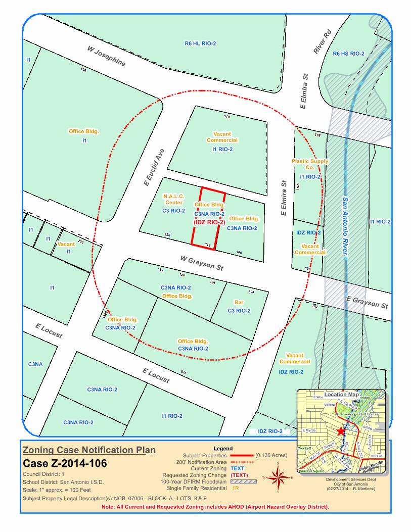
Zoning Case Notification PlanCase Z-2014-106
LegendSubject Properties
200' Notification Area
Subject Property Legal Description(s):
(0.136 Acres)
100-Year DFIRM Floodplain
NCB 07006 - BLOCK A - LOTS 8 & 9Single Family Residential 1R
Note: All Current and Requested Zoning includes AHOD (Airport Hazard Overlay District).
Development Services DeptCity of San Antonio
(02/27/2014 - R. Martinez)
^
Brackenridge Golf Course
Brackenridge
Crockett
Madison Square Union Pacific
E WoodlawnValdez
N Hwy 281Erie
E Craig Place
E Myrtle
Karn
es
Alling
N IH 35
Austi
n St
W Jones Ave
Newell
N IH 35
®
Location Map
School District: San Antonio I.S.D.
C3NA RIO-2(IDZ RIO-2)
VacantCommercial
VacantCommercial
Office Bldg. VacantCommercial
Plastic SupplyCo.
Bar
Vacant
N.A.L.C.Center
Office Bldg.
Office Bldg.
Office Bldg.
Office Bldg.
Office Bldg.
IDZ RIO-2
IDZ RIO-2
IDZ RIO-2

Case # Z2014106 Hearing Date: April 1, 2014
City of San Antonio Development Services Department Staff Report To: Zoning Commission
Zoning Case #: Z2014106
Hearing Date: April 1, 2014
Property Owner: Janet & Robert Noll
Applicant: James Sykes
Representative: James Sykes
Location: 119 West Grayson Street
Legal Description: Lots 8 and 9, Block A, NCB 7006
Total Acreage: 0.136
City Council District: 1
Case Manager: Osniel Leon, Planner
Case History: This is the first public hearing for this zoning case. The case is being expedited to City Council for consideration on April 17, 2014.
Proposed Zoning Change Current Zoning: "C-3NA RIO-2 AHOD" General Commercial Nonalcoholic Sales River Improvement Overlay-2 Airport Hazard Overlay District
Requested Zoning: "IDZ RIO-2 AHOD" Infill Development Zone River Improvement Overlay-2 Airport Hazard Overlay District with uses permitted in "RM-5" Residential Mixed District and "C-1" Light Commercial District
Procedural Requirements The request was publicly noticed in accordance with Section 403 of the Unified Development Code (UDC). The application was published in The Daily Commercial Recorder, an official newspaper of general circulation on March 14, 2014. Notices were sent to property owners and registered neighborhood associations within two hundred (200) feet of the subject property on March 19, 2014. Additionally, notice of this meeting was posted at city hall and on the city’s internet website on March 28, 2014, in accordance with Section 551.043(a) of the Texas Government Code.
Notices Mailed Owners of Property within 200 feet: 13
Registered Neighborhood Associations within 200 feet: The Tobin Hill Community Association
Planning Team: Tobin Hill Neighborhood Plan (13)
Applicable Agencies: Office of Historic Preservation

Case # Z2014106 Hearing Date: April 1, 2014
Property Details Property History: The property is located within the City Limits as they were recognized 1938, and was originally zoned “J” Commercial District. In a 1995 City-initiated large area case, the property was rezoned to “B-3NA” Non-Alcoholic Sales District. Upon adoption of the Unified Development Code, the previous base zoning district converted to the current “C-3NA” Non-Alcoholic Sales General Commercial District. The subject property is currently developed with a commercial structure measuring 3,650 square feet and was built in 1960.
The purpose of the rezoning request is to allow adaptive reuse of the existing structure for both residential and commercial uses.
Topography: The property does not include any abnormal physical features such as significant slope or inclusion in a flood plan.
Adjacent Base Zoning and Land Uses Direction: North Current Base Zoning: “I-1” Current Land Uses: Vacant commercial structure
Direction: East Current Base Zoning: “I-1”, “IDZ”, and “C-3NA” Current Land Uses: Plastic supply, bar/restaurant (under construction), and offices
Direction: Southeast and South Current Base Zoning: “IDZ”, “C-3”, and “C-3NA” Current Land Uses: Vacant commercial structure, bar, and offices
Direction: West Current Base Zoning: “I-1” and “C-3” Current Land Uses: Offices
Overlay and Special District Information: All surrounding properties carry the "AHOD" Airport Hazard Overlay District, due to their proximity to an airport or approach path. The "AHOD" does not restrict permitted uses, but can require additional review of construction plans by both the Development Services Department and the Federal Aviation Administration.
Many surrounding properties carry the "RIO" River Overlay District, due to their proximity to the San Antonio River. The purpose of these districts is to establish regulations to protect, preserve and enhance the San Antonio River and its improvements by establishing design standards and guidelines.
Transportation Thoroughfare: West Grayson Street, East Elmira Street and East Euclid Avenue Existing Character: Local Streets; 1 lane in each direction with sidewalks Proposed Changes: None Known
Public Transit: The nearest VIA bus line is the number 20, which operates north of the subject property, along Josephine Street. Additionally, the number 8 line operates west of the subject property, along St. Mary’s Street.
Traffic Impact: A Traffic Impact Analysis is not required. Infill Development Zone (IDZ) requests are exempt from the TIA requirement.
Parking Information: Off-street vehicle parking requirements are determined by use, and often size of the development. The rezoning application proposes three dwelling units and office/retail space.
Dwelling – 3 Family: Minimum requirement - 1.5 spaces per unit. Maximum allowance - 2 spaces per unit.
Professional Office: Minimum requirement – 1 space per 300 square feet of Gross Floor Area (GFA); Maximum allowance: 1 space per 140 square feet of GFA.
Parking requirements for other service and retail uses are determined by the individual use.
Infill Development Zone waives off-street parking requirements.

Case # Z2014106 Hearing Date: April 1, 2014
Staff Analysis and Recommendation: Approval Criteria for Review: According to Section 35-421, zoning amendments shall be based on the approval criteria below.
1. Consistency:
The property is located within the Tobin Hill Neighborhood Plan and is currently designated as High Density Mixed Use. The subject property is located within the River Redevelopment District, which is a sub-area identified in the plan. The plan includes individualized guidelines for future development of each sub-area. For the River Redevelopment District, the plan encourages concentration on arts, culture, and entertainment as well as creation of active and passive recreational spaces. The requested “IDZ” Infill Development District with uses permitted in “RM-5” Residential Mixed District and “C-1” Light Commercial District is consistent with the adopted land use designation.
2. Adverse Impacts on Neighboring Lands:
Staff has found no evidence of likely adverse impacts related to the zoning request.
3. Suitability as Presently Zoned:
The existing commercial zoning is not consistent with the adopted future land use designation. The current "C-3" General Commercial District is designed to provide uses that are typically characterized as community and regional power centers such as shopping malls, movie theaters, and hospitals. The “C-3” zoning district is most suitable when located on large acreage lots at intersections of highways and major arterials; and therefore, is not appropriate for the subject property.
4. Health, Safety and Welfare:
Staff has found no indication of likely adverse effects on the public health, safety, or welfare. Although the “IDZ” district waives off-street parking requirements, the subject property includes some parking and may have space available for additional parking spaces.
5. Public Policy:
The request does not appear to conflict with any established public policy. The property is located within the Inner City Reinvestment Policy (ICRIP) area. The purpose of the ICRIP is to promote growth and development in the inner city, specifically in areas that are currently served by public infrastructure and transit, but underserved by residential and commercial real estate markets.
6. Size of Tract:
The subject property is 0.136 of an acre in size, which should be able to reasonably accommodate the proposed development with the flexibility offered by “IDZ”.
7. Other Factors:
None.


E Terra Alta
Nacogdo
ches R
d
N New Braunfels AveFor
restgle
n
Woodhaven
Oakleaf
O2
MF33
NP-10
R5
NP-10
C2
C2R4
R5 C2
C2
R5
NP-10
NP-10
NP-10
R5
R5
NP-10
C2
R4
R5
NP-10
NP-10
R4
R5
R4
NP-10
NP-10
NP-10
NP-10 NP-10NP-10
NP-10
R4
NP-10
C2
C2
NP-10
NP-10
MF33
NP-10NP-8
NP-8
NP-10
NP-10
NP-10
NP-10
NP-10
Scale: 1" approx. = 120 Feet
Council District: 10TEXT(TEXT)
Current ZoningRequested Zoning Change
Zoning Case Notification PlanCase Z-2014-107
LegendSubject Properties
200' Notification Area
Subject Property Legal Description(s):
(1.312 Acres)
100-Year DFIRM Floodplain
NCB 11898 - BLOCK 000 - LOT 005Single Family Residential 1R
Note: All Current and Requested Zoning includes AHOD (Airport Hazard Overlay District).
Development Services DeptCity of San Antonio
(02/28/2014 - R. Martinez)
^
NorthridgeClaywell
Hillview Dr
Hiler Rd
Blanton
Flamingo Dr
W Sunset Rd
Merriford Oakleaf
Calumet
E Sunset Rd
E Nottingham
Oakhurst Place
Camellia Dr
Larkwood Dr
Robinhood
NorthridgeLorenz Rd
Broa
dway
®
Location Map
School District: Alamo Heights I.S.D.
Apartments Bank
Parking Lot
2R 2R 2R2R
1R
1R
1R
1R
1R1R
1R1R
1R 1R
2R
1R
1R
1R
Bank
pv92484
Typewritten Text
pv92484
Typewritten Text
(MF40)
pv92484
Typewritten Text
Alley
pv92484
Typewritten Text
Convenience Store With Gasoline
pv92484
Typewritten Text
pv92484
Typewritten Text

Case # Z2014107 Hearing Date: April 1, 2014
City of San Antonio Development Services Department Staff Report To: Zoning Commission
Zoning Case #: Z2014107
Hearing Date: April 1, 2014
Property Owner: Linden Tara, LLC
Applicant: Linden Tara, LLC
Representative: Langley and Banack, Inc. (Paul Fletcher)
Location: 1779 Nacogdoches Road
Legal Description: Lot 5, NCB 11898
Total Acreage: 1.3124
City Council District: 10
Case Manager: Pedro Vega, Planner
Case History: This is the first public hearing for this zoning case.
Proposed Zoning Change Current Zoning: "O-2 AHOD" High-Rise Office Airport Hazard Overlay District
Requested Zoning: "MF-40 AHOD" Multi-Family Airport Hazard Overlay District
Procedural Requirements The request was publicly noticed in accordance with Section 403 of the Unified Development Code (UDC). The application was published in The Daily Commercial Recorder, an official newspaper of general circulation on March 14, 2014. Notices were sent to property owners and registered neighborhood associations within two hundred (200) feet of the subject property on March 19, 2014. Additionally, notice of this meeting was posted at city hall and on the city’s internet website on March 28, 2014, in accordance with Section 551.043(a) of the Texas Government Code.
Notices Mailed Owners of Property within 200 feet: 24
Registered Neighborhood Associations within 200 feet: Oak Park-Northwood Neighborhood Association
Planning Team: Northeast Inner Loop Neighborhood Plan-34
Applicable Agencies: None

Case # Z2014107 Hearing Date: April 1, 2014
Property Details Property History: The property was annexed in September of 1952, and was originally zoned “A” Single Family Residence District. In September of 1963, the property was rezoned to “E” Office District. Upon adoption of the 2001 Unified Development Code, the previous base zoning district converted to the current "O-2" High-Rise Office District. The subject site consists of an existing apartment complex with 46 units measuring 15,484 square feet in size. According to the Bexar County Appraisal District, the existing structure was built in 1970. The property consists of one lot that was platted into the current configuration in 1965 (Volume 5300, page 50 of the Deed and Plat Records of Bexar County, Texas).
Topography: The property does not include any abnormal physical features such as slope or inclusion in a floodplain.
Adjacent Zoning and Land Uses
Direction: North and Northeast Current Base Zoning: “R-4” and “C-2” Current Land Uses: Two-Family Dwellings, 18 Foot Alley and Convenience Store with Gasoline
Direction: Northwest and Southwest Current Base Zoning: “NP-10” Current Land Uses: Single-Family Dwellings
Direction: South and Southeast across Nacogdoches Road Current Base Zoning: “NP-10” and “C-2” Current Land Uses: Single-Family Dwellings and Bank
Overlay and Special District Information: All surrounding properties carry the "AHOD" Airport Hazard Overlay District, due to their proximity to an airport or approach path. The "AHOD" does not restrict permitted uses, but can require additional review of construction plans by both the Development Services Department and the Federal Aviation Administration.
Transportation
Thoroughfare: Nacogdoches Road and North New Braunfels Avenue Existing Character: Secondary Arterial Type B; 1 lane in each direction with sidewalks Proposed Changes: None known
Thoroughfare: East Terra Alta Existing Character: Local Street; 1 lane in each direction with partial sidewalks Proposed Changes: None known
Public Transit: VIA bus line 10 operates along Nacogdoches Road with a bus stop at the corner of Nacogdoches Road and North New Braunfels Avenue.
Traffic Impact: A new Traffic Impact Analysis (TIA) is not required. The traffic generated by the proposed development does not exceed the threshold requirements.
Parking Information: Off-street parking requirements for multi-family residential uses are determined by the number of dwelling units. Minimum Requirement: 1.5 spaces per unit; Maximum Allowance: 2 spaces per unit.

Case # Z2014107 Hearing Date: April 1, 2014
Staff Analysis and Recommendation: Approval, pending plan amendment. Criteria for Review: According to Section 35-421, zoning amendments shall be based on the approval criteria below.
1. Consistency:
The subject property is located within the Northeast Inner Loop Neighborhood Plan and is identified as Neighborhood Commercial in the future land use component of the plan. The zoning request is not consistent with the adopted future land use designation. A master plan amendment has been submitted, requesting to change the plan to High Density Residential. Staff and Planning Commission recommend approval of the plan amendment request.
2. Adverse Impacts on Neighboring Lands:
Granting the "MF-40" Multi-Family District is not likely to have an adverse impact on the neighboring lands. Multi-family zoning is most appropriate at the periphery of single-family neighborhoods, and along arterials or major thoroughfares where supporting infrastructure, such as public transportation and commercial facilities are present. The site is located in an area where there is accessibility to public services and traffic circulation to major thoroughfares.
3. Suitability as Presently Zoned:
The existing “O-2” High-Rise Office District is not appropriate for the subject property and is not consistent with either the adopted or the requested land use designations. The “O-2” district is meant to accommodate large, multi-tenant offices.
4. Health, Safety and Welfare:
Staff has found no indication of likely adverse effects on the public health, safety, or welfare. The proposed zoning request will allow redevelopment of the existing apartment complex with a maximum of six additional dwelling units.
5. Public Policy:
Should the plan amendment request be approved, the request does not appear to conflict with any public policy objective. The High Density Residential land use classification supports the goals of the Northeast Inner Loop Neighborhood Plan of preserving the housing and distinctive character of the Northeast Inner Loop neighborhoods.
6. Size of Tract:
The subject property measures 1.3124 acres in size which should be able to reasonably accommodate the proposed "MF-40" district and required parking.
7. Other Factors:
Multi-family dwellings were a use permitted by-right on any tract or parcel zoned “E” Office District under the 1938 zoning code.

E Commerce St
Honey Blvd
L EP-1
AE-4 EP-1
AE-4 EP-1
AE-4 EP-1
AE-4 EP-1
AE-3 EP-1
AE-4 EP-1AE-4 EP-1
AE-3-S EP-1
R4 EP-1
AE-3 EP-1 AE-3 EP-1
AE-4 EP-1
AE-3-S EP-1
Union Pacific
Second BaptistPark
Scale: 1" approx. = 150 Feet
Council District: 2 TEXT(TEXT)
Current ZoningRequested Zoning Change
Zoning Case Notification PlanCase Z-2014-109 S
LegendSubject Properties
200' Notification Area
Subject Property Legal Description(s):
(1.168 Acres)
100-Year DFIRM Floodplain
NCB 10234 - BLOCK 000 - LOT Tract 7ASingle Family Residential 1R
Development Services DeptCity of San Antonio
(03/13/2014 - R. Martinez)
^Lincoln
Willow Springs Golf Course
Dafoste
Coliseum Oaks
Second Baptist
Dorie Miller
Union
Pacif
ic
Union Pacific
Salado Creek
Dorie St
Corliss
Sterling StIH 10 E
Hub Ave
Ezell
E Houston St
Baxter
E Commerce St
IH 10
E
®
Location Map
School District: San Antonio I.S.D.
3363
3323
3419
(L S EP-1)Textile Plant
Vacant Commercial
Signage Shop

Case # Z2014109 S Hearing Date: April 1, 2014
City of San Antonio Development Services Department Staff Report To: Zoning Commission
Zoning Case #: Z2014109 S
Hearing Date: April 1, 2014
Property Owner: Eugene & Betty Braden
Applicant: Eugene & Betty Braden
Representative: P.W. Christensen, P.C. (Patrick Christensen)
Location: 3363 East Commerce Street
Legal Description: 1.168 acres out of Tract 7A, NCB 10234
Total Acreage: 1.168
City Council District: 2
Case Manager: Tony Felts, Planner
Case History: This is the first public hearing for this zoning change request.
Proposed Zoning Change Current Zoning: "L EP-1" Light Industrial Facility Parking/Traffic Control Overlay District
Requested Zoning: "L S EP-1" Light Industrial Facility Parking/Traffic Control Overlay District with a Specific Use Authorization for Lofts
Procedural Requirements The request was publicly noticed in accordance with Section 403 of the Unified Development Code (UDC). The application was published in The Daily Commercial Recorder, an official newspaper of general circulation on March 14, 2014. Notices were sent to property owners and registered neighborhood associations within two hundred (200) feet of the subject property on March 19, 2014. Additionally, notice of this meeting was posted at city hall and on the city’s internet website on March 28, 2014, in accordance with Section 551.043(a) of the Texas Government Code.
Notices Mailed Owners of Property within 200 feet: 3
Registered Neighborhood Associations within 200 feet: Jefferson Heights Neighborhood Association
Planning Team: 22 - Arena District/Eastside Community Plan
Applicable Agencies: None

Case # Z2014109 S Hearing Date: April 1, 2014
Property Details Property History: The subject property is a portion of a larger lot. It was annexed in 1951, and was originally zoned “L” First Manufacturing District. Upon adoption of the 2001 Unified Development Code, the previous base zoning district converted to “I-2” Heavy Industrial District. In a 2008 City-initiated rezoning case, the subject property was rezoned to "AE-4" Arts and Entertainment-4 District. In 2012, the property was rezoned to the current “L” Light Industrial District.
The subject property is currently developed as an approximately 50,427 square foot warehouse that was constructed in 1964. The rezoning request is meant to allow a portion of the existing structure to be refurbished as loft apartments.
Topography: The property does not include any abnormal physical features such as significant slope or inclusion in a flood plain.
Adjacent Zoning and Land Uses
Direction: North, East, West Current Base Zoning: “AE-4" Current Land Uses: Warehousing, light manufacturing, offices
Direction: South Current Base Zoning: “AE-3”, “R-4” Current Land Uses: Church, park, library, upholstery shop, service garage
Overlay and Special District Information: The subject property and all surrounding properties carry the “EP-1” Facility Parking/Traffic Control District which establishes regulations for parking and traffic around large facilities that attract large amounts of vehicle traffic. The overlay district is meant to regulate parking of vehicles in areas not properly zoned for commercial parking; to reduce aesthetic and traffic problems for persons and businesses in these areas; to reduce visual blight, congestion, and wear and tear on city streets; and to increase access for emergency vehicles in these areas.
Transportation Thoroughfare: East Commerce Street Existing Character: Primary Arterial Type B; two lanes in each direction without sidewalks Proposed Changes: None known
Public Transit: The nearest VIA bus line is the number 25, which operates along East Commerce Street in the vicinity of the subject property.
Traffic Impact: A Traffic Impact Analysis (TIA) is not required. The traffic generated by the proposed development does not exceed the threshold requirements.
Parking Information: Off-street vehicle parking requirements for residential uses are typically determined by number of dwelling units. The zoning application refers to lofts. The UDC does not include separate parking requirements for loft dwellings, but the closest related use would be multi-family residences. Multi-family dwellings require a minimum of 1.5 spaces per unit, and a maximum of 2 spaces per unit.
The requisite Specific Use Authorization site plan does not indicate parking, as the Specific Use Authorization applies only to the building and none of the larger site; however, a staff field visit indicated sufficient area for parking on the site.

Case # Z2014109 S Hearing Date: April 1, 2014
Staff Analysis and Recommendation: Approval Criteria for Review: According to Section 35-421, zoning amendments shall be based on the approval criteria below.
1. Consistency:
The subject property is located within the Arena District/Eastside Community Plan and is designated as Light Industrial in the future land use component of the plan. This zoning request does not propose to change the current “L” base zoning district, which is consistent with the adopted future land use designation, but add a Specific Use Authorization for Lofts. The Arena District/Eastside Community Plan does envision new housing types in the plan area.
2. Adverse Impacts on Neighboring Lands:
Staff has found no evidence of likely adverse impacts on neighboring lands in relation to this zoning change request. The immediate vicinity consists of a mix of various uses and zoning districts, including single-family residential, commercial, and industrial.
3. Suitability as Presently Zoned:
Both the current and requested zoning districts are appropriate for the subject property and surrounding properties.
4. Health, Safety and Welfare:
Staff has found no indication of likely adverse effects on the public health, safety or welfare.
5. Public Policy:
The request does not appear to conflict with any public policy objective.
6. Size of Tract:
The subject property is 1.168 acres in size, which should reasonably accommodate the proposed lofts.
7. Other Factors:
While none of the base zoning districts in the immediate vicinity of the subject property to the north of East Commerce Street allow any type of dwelling by right, to the south of East Commerce Street, the area is a mix of commercial, residential, and recreational uses. The “L” base zoning district does allow for some mixed use residential, and this, combined with the uses on the south side of East Commerce Street make the requested Specific Use Authorization appropriate for the subject property.

Christensen
TextBox
The proposed rezoning is for the building only. There are no parking spaces, driveways, landscaping, buffers, or setbacks required in the area to be rezoned. All required parking , driveways, landscaping, buffers, and/or setbacks will be provided on the lot outside of the rezoning area.

Woodlake Pkwy
Walzem Rd
Arlene
Wisteria
Hill
Earl's Way
Midc
rown D
r E
Azalea SquarePrimrose Post
Azzalie Lane
Bluebonnet Bay
Wind
sor O
aks
Eisenhauer Rd
Clematis Trail
Mesa Bonita
Plumbago Place
C3
C3
R4R6
R5
R6 R6
C3 C3
R5
R4
OCL
R4
R4
BP
OCL
C3R6
R6
R6
OCL OCL
R4
Rosillo Creek
Scale: 1" approx. = 400 Feet
Council District: 2 TEXT(TEXT)
Current ZoningRequested Zoning Change
Zoning Case Notification PlanCase Z-2014-112
LegendSubject Properties
200' Notification Area
Subject Property Legal Description(s):
(34.500 Acres)
100-Year DFIRM Floodplain
NCB 15894 - BLOCK 000 - LOT 34.50 Ac. out of 15Single Family Residential 1R
Note: All Current and Requested Zoning includes AHOD (Airport Hazard Overlay District).
Development Services DeptCity of San Antonio
(03/04/2014 - R. Martinez)
^
Union Pacific
Rosillo Cree
k
Martinez Creek
Eisenhauer Rd
Arlene
Orchid Star
Oak C
hase
Fore
st Fla
me
Plumbago Place
New
World
Dr
Mesquite Farm
®
Location Map
School District: Northeast I.S.D. / Judson I.S.D.
Vacant
Vacant
Vacant Vacant
Vacant
Vacant
R4R4
R4R4
R4TxDOTOffice
Elementary School
ManufacturedHomes
Vacant
Bexar County LineSan Antonio City Limits
pv92484
Typewritten Text
pv92484
Typewritten Text
pv92484
Typewritten Text
(MHP)

Case # Z2014112 Hearing Date: April 1, 2014
City of San Antonio Development Services Department Staff Report To: Zoning Commission
Zoning Case #: Z2014112
Hearing Date: April 1, 2014
Property Owner: Woodlake Estate Limited Partnership (by Rick North, Executive Vice President)
Applicant: Scott Roberts, CEO, Roberts Resorts
Representative: Kara J. Heasley, P.E., LEED AP, Associate/Project Manager, Vickrey & Associates, Inc.
Location: A portion of the 7200 Block of Woodlake Parkway
Legal Description: 34.5 acres out of Lot 15, NCB 15894
Total Acreage: 34.5
City Council District: 2
Case Manager: Pedro Vega, Planner
Case History: This is the first public hearing for this zoning case.
Proposed Zoning Change Current Zoning: "C-3 AHOD" General Commercial Airport Hazard Overlay District
Requested Zoning: "MHP AHOD" Manufactured Housing Park Airport Hazard Overlay District
Procedural Requirements The request was publicly noticed in accordance with Section 403 of the Unified Development Code (UDC). The application was published in The Daily Commercial Recorder, an official newspaper of general circulation on March 14, 2014. Notices were sent to property owners and registered neighborhood associations within two hundred (200) feet of the subject property on March 19, 2014. Additionally, notice of this meeting was posted at city hall and on the city’s internet website on March 28, 2014, in accordance with Section 551.043(a) of the Texas Government Code.
Notices Mailed Owners of Property within 200 feet: 21 Registered Neighborhood Associations within 200 feet: None Planning Team: None Applicable Agencies: None

Case # Z2014112 Hearing Date: April 1, 2014
Property Details Property History: The subject property was annexed in December of 1996 (Ordinance 85087), and was originally zoned “Temp R-1” Temporary Single Family Residence District. Upon adoption of the 2001 Unified Development Code, the previous base zoning district converted to “R-6” Residential Single-Family District. In a 2002 zoning case, the 34.5acre site was rezoned to the current "C-3" General Commercial District. The subject property is a portion of a platted lot. While the subject portion of the lot is undeveloped, the remaining part of the parent tract is developed as a manufactured home park.
Topography: A small amount of the northwest portion of the 34.5-acre site is located within the 100-year floodplain and slopes slightly to the northwest, toward Rosillo Creek.
Adjacent Base Zoning and Land Uses Direction: Northeast and Southeast Current Base Zoning: "C-3" and “R-6” Current Land Uses: Undeveloped land, Valero Store, Single-Family Dwelling, Texas Department of Transportation Office and Manufactured Housing Development. Direction: Northwest and Southwest across Woodlake Parkway Current Base Zoning: "C-3", “R-4” and “R-5” Current Land Uses: Undeveloped land, Single-Family Dwellings and Elementary School
Overlay and Special District Information: All surrounding properties carry the "AHOD" Airport Hazard Overlay District, due to their proximity to an airport or approach path. The "AHOD" does not restrict permitted uses, but can require additional review of construction plans by both the Development Services Department and the Federal Aviation Administration.
Transportation Thoroughfare: Woodlake Parkway Existing Character: Secondary Arterial Type A; one lane in each direction with curbs and without sidewalks Proposed Changes: None known Public Transit: There are no public transit lines in the immediate vicinity of the 34.5-acre site. Traffic Impact: A Traffic Impact Analysis is not required. The traffic generated by the proposed development does not exceed the threshold requirements.
Parking Information: Off-street vehicle parking requirements for residential uses are typically determined by the number of dwelling units.
HUD-Code Manufactured Homes (residential): Minimum Vehicle Spaces - 1space per unit. Maximum Vehicle Spaces - None.

Case # Z2014112 Hearing Date: April 1, 2014
Staff Analysis and Recommendation: Approval Criteria for Review: According to Section 35-421, zoning amendments shall be based on the approval criteria below.
1. Consistency:
The subject property is not located within any neighborhood, community or sector land use plan. Although much of the zoning in the immediate vicinity is commercial, many of the existing uses are residential in nature.
2. Adverse Impacts on Neighboring Lands:
Staff finds no evidence of likely adverse impacts on neighboring lands in relation to this zoning change request.
3. Suitability as Presently Zoned:
Both the current and requested zoning district are appropriate as the surrounding zoning are both commercial and residential in nature. The property is located in an area that is predominately undeveloped.
4. Health, Safety and Welfare:
Staff has found no indication of likely adverse effects on the public health, safety or welfare. The proposed "MHP" Manufactured Housing Park District will allow development of Woodlake Estates Phase II. The Woodlake Estates Phase I was constructed in the late 1990’s and early 2000’s. Both sites were included in an approved Manufactured Home Park Plan recorded in 1998.
5. Public Policy:
Should the request be approved, the request does not appear to conflict with any public policy objective.
6. Size of Tract:
The subject property is 34.5 acres in size, and should reasonably accommodate the Manufactured Housing Park development.
7. Other Factors:
The applicant requests the zoning change in order to allow a manufactured housing development with 164 HUD-code manufactured homes. Development of the park will be subject to the development standards specified in UDC Section 35-356 (for individual homes on individually platted lots) or UDC Section 35-379 (for multiple homes on a single lot).
The manufactured housing park "MHP" district is composed of areas suitable for manufactured homes and compatible uses. The districts are intended to provide suitable locations for HUD-Code manufactured homes for manufactured home parks. The district regulations are designed to provide adequate protection both for the manufactured homes and for the surrounding development.

221
515511
502 506430428426422418412408404
509505415411409407405
403
407405403
514506
222
502
429
422418408404
E Myrtle
E Park Ave
Paschal
Gillespie
Gillespie
R6 H
MF33 H
R6 H R6 HR6 H
R6 H
R6 H
R6 H R6 H
R6 H R6 H R6 H
MF33 H
R6 H R6 H
R6 H
R6 H
R6 H
R6 H
R6 H
R6 H
RM4 H
R6 H
R6 H HS
R6 HR6 H
R6 H
RM4 H HS RM4 H HS
R6 H
R6 HR6 HR6 H
R6 H HS
RM4 H
R6 H
R6 HR6 H
R6 H
R6 HR6 H HS
R6 H HS
R6 H
MF33 H
R6 H R6 H
R6 H
R6 H
MF33 H
R6 H
RM4 H
R6 H R6 H
R6 H
R6 H
R6 H HSR6 H HS
R6 H
R6 H HS R6 H HS
MF33 H MF33 H MF33 HMF33 H MF33 H MF33 H MF33 H RM4 HMF33 H MF33 HMF33 H
Scale: 1" approx. = 100 Feet
Council District: 1 TEXT(TEXT)
Current ZoningRequested Zoning Change
Zoning Case Notification PlanCase Z-2014-115
LegendSubject Properties
200' Notification Area
Subject Property Legal Description(s):
(0.113 Acres)
100-Year DFIRM Floodplain
NCB 01752 - BLOCK 005 - LOT E 25 FT OF 6 & W 13.29 FT OF 7Single Family Residential 1R
Note: All Current and Requested Zoning includes AHOD (Airport Hazard Overlay District).
Development Services DeptCity of San Antonio
(03/14/2014 - R. Martinez)
^
Brackenridge Golf Course
San Pedro Springs
Brackenridge
Crockett
Madison Square Maverick Park
San A
ntonio
Rive
r
E WoodlawnValdez
ErieN IH 35
Bethel
Broa
dway
E Locust
N Ma
in Av
e
Newell
®
Location Map
School District: San Antonio I.S.D.
Vacant
(R4 H)
Apartments
1R 1R1R3R 1R 1R 1R 1R
1R 1R 1R 1R 1R 1R 1R 1R 1R
1R1R 1R
1R
1R 1R 1R 1R 1R
1R
pv92484
Typewritten Text
pv92484
Typewritten Text
3R
pv92484
Typewritten Text
2R
pv92484
Typewritten Text
3R
pv92484
Typewritten Text
Vacant

Case # Z2014115 Hearing Date: April 1, 2014
City of San Antonio Development Services Department Staff Report To: Zoning Commission
Zoning Case #: Z2014115
Hearing Date: April 1, 2014
Property Owner: Manuel M. and Yolanda C. Mendoza
Applicant: Manuel M. Mendoza
Representative: Manuel M. Mendoza
Location: 415 East Park Avenue
Legal Description: The east 25 feet of Lot 6 and the west 13.29 feet of Lot 7, Block 5, NCB 1752
Total Acreage: 0.1134
City Council District: 1
Case Manager: Pedro Vega, Planner
Case History: This is the first public hearing for this zoning request.
Proposed Zoning Change Current Zoning: "R-6 H AHOD" Residential Single-Family Tobin Hill Historic Airport Hazard Overlay District
Requested Zoning: "R-4 H AHOD" Residential Single-Family Tobin Hill Historic Airport Hazard Overlay District
Procedural Requirements The request was publicly noticed in accordance with Section 403 of the Unified Development Code (UDC). The application was published in The Daily Commercial Recorder, an official newspaper of general circulation on March 14, 2014. Notices were sent to property owners and registered neighborhood associations within two hundred (200) feet of the subject property on March 19, 2014. Additionally, notice of this meeting was posted at city hall and on the city’s internet website on March 28, 2014, in accordance with Section 551.043(a) of the Texas Government Code.
Notices Mailed Owners of Property within 200 feet: 31
Registered Neighborhood Associations within 200 feet: The Tobin Hill Community Association
Planning Team: Tobin Hill Neighborhood Plan-13
Applicable Agencies: City of San Antonio Office of Historic Preservation

Case # Z2014115 Hearing Date: April 1, 2014
Property Details Property History: The subject property is located within the city limits as they were recognized in 1938, and was originally zoned “D” Apartment District. In a 1995 City-initiated a large-area case, the property was rezoned to “R-1” Single-Family Residence District. Upon adoption of the 2001 Unified Development Code, the previous base zoning district converted to the current “R-6” Residential Single-Family District. The property is undeveloped and consists of portions of two platted lots.
The subject property does not meet the minimum lot size requirement for the “R-6” district; therefore, the rezoning request is meant to allow new single-family residential construction on a lot that is less than 6,000 square feet in size.
Topography: The property does not include any abnormal physical features such as significant slope or inclusion in a flood plain.
Adjacent Zoning and Land Uses Direction: North, West and East Current Base Zoning: “R-6” and “MF-33” Current Land Uses: Single-Family Dwellings, Two and Three- Family Dwellings and Vacant Lot
Direction: South across East Park Avenue Current Base Zoning: “R-6”, “RM-4” and “MF-33” Current Land Uses: Single-Family Dwellings, Three- Family Dwellings, Office, Apartments and Vacant House
Overlay and Special District Information: All surrounding properties carry the “AHOD” Airport Hazard Overlay District, due to their proximity to an airport or approach path. The “AHOD” does not restrict permitted uses, but can require additional review of construction plans by both the Development Services Department and the Federal Aviation Administration.
The Tobin Hill Historic District reflects a wide range of architectural styles including residences from late the Victorian era, numerous Craftsman bungalows, later Colonial Revival and English or Tudor style residences, and four-squares. Tobin Hill, to the north of the city core, is one of San Antonio’s oldest urban neighborhoods. The historic district is bounded by E. Dewey Place to the north, McCullough Avenue to the west, Evergreen to the south, and St. Mary’s Street to the east, and includes a two block section of W. Park Avenue between McCullough and Main Avenues. Tobin Hill was designated a local historic district in two phases through City Council approval on December 9, 2007 and March 16, 2008.
Transportation Thoroughfare: East Park Avenue Existing Character: Local Street; 1 lane in each direction with sidewalks Proposed Changes: None known
Thoroughfare: Gillespie Street Existing Character: Local Street; 1 lane in each direction with partial sidewalks Proposed Changes: None known
Public Transit: The nearest VIA bus line is the 5, which operates along McCullough Avenue located west of the subject property.
Traffic Impact: A Traffic Impact Analysis (TIA) is not required because traffic generated by the proposed development does not exceed the threshold requirements.
Parking Information: Dwelling: Single-family - Minimum vehicle spaces: 1 per unit; Maximum vehicle spaces: N/A

Case # Z2014115 Hearing Date: April 1, 2014
Staff Analysis and Recommendation: Approval Criteria for Review: According to Section 35-421, zoning amendments shall be based on the approval criteria below.
1. Consistency:
The subject property is located within the Tobin Hill Neighborhood Plan and is designated as Low Density Residential in the future land use component of the plan. Low Density Residential is composed of single-family homes on individual lots, on streets with low traffic volumes. The "R-4" Residential Single-Family District is consistent with the future land use designation.
2. Adverse Impacts on Neighboring Lands:
Staff finds no likely adverse impact on the surrounding properties related to the zoning change request. This zoning change will allow new construction on a vacant lot. All constructions plans will be subject to the design standards of the Tobin Hill Historic District and will be reviewed for compliance by the Office of Historic Preservation to ensure the character of the neighborhood is preserved.
3. Suitability as Presently Zoned:
Both the current and requested zoning districts could be appropriate for the subject property. However, the property does not meet the minimum lot size required by the current “R-6” zoning district; therefore, the property cannot be platted and building permits cannot be issued for the proposed construction. As such, the existing zoning is not suitable for the subject property.
4. Health, Safety and Welfare:
Staff has found no indication of likely adverse effects on the public health, safety, or welfare due to this request. The "R-4" Residential Single-Family District will maintain and preserve the quality of the existing residential neighborhood and promote infill housing.
5. Public Policy:
The request does not appear to conflict with any public policy objective.
This request conforms to the Tobin Hill Neighborhood Plan. The second goal in the Tobin Hill Neighborhood Plan is housing, and the goal states, "Improve the quality, appearance, and variety of existing and new housing for all ages while increasing home ownership and investment in the area".
6. Size of Tract:
The subject property measures 4,978 square feet in size, meeting the minimum lot size requirement for the “R-4” zoning district.
7. Other Factors:
The subject property is located a few blocks north from the Downtown area on the north side of East Park Avenue, east of McCullough Avenue. Uses along East Park Avenue are predominantly single-family or low-density multi-family residential uses.
The applicant is seeking a zoning change to "R-4" Residential Single-Family District to allow construction of a new detached 2-1/2 story single-family dwelling of approximately 2000 square feet and into compliance with the UDC.

Rainb
ow D
r
Deerwood Dr
R5
MF33
MF33
R5
R5
R5
MF33
R4
MF33
R4
C2
MF33
MF33
R4
R5
R5
R4
MF33
R4
MF33
R4
R4
R4
C2
C2
RM4
R4
RM4
RM4
C2
R5
MF33
RM4
Scale: 1" approx. = 120 Feet
Council District: 10 TEXT(TEXT)
Current ZoningRequested Zoning Change
Zoning Case Notification PlanCase Z-2014-117
LegendSubject Properties
200' Notification Area
Subject Property Legal Description(s):
(0.650 Acres)
100-Year DFIRM Floodplain
NCB 08695 - BLOCK A - LOT 0.650 of an acre out of Tract 12Single Family Residential 1R
Note: All Current and Requested Zoning includes AHOD (Airport Hazard Overlay District).
Development Services DeptCity of San Antonio
(03/14/2014 - R. Martinez)
^Northridge Haskin
Byrnes
Irvington DrBrees Blvd
Sumner
Knight Robin
Sheila Dr
Olney Dr
Bent Bow
Rittiman Rd
Larkwood Dr
Bryn Mawr
Albin Dr
Mt Calvary
Eisenhauer Rd
Byrnes
Albin Dr
®
Location Map
School District: NorthEast I.S.D.
Apartments
Apartments
1R
1R
1R
1R
1R1R
1R
1R
1R 1R
1R
1R
1R
1R
(RM6)

Case # Z2014117 Hearing Date: April 1, 2014
City of San Antonio Development Services Department Staff Report To: Zoning Commission
Zoning Case #: Z2014117
Hearing Date: April 1, 2014
Property Owner: Rodolfo A. & Rosa Maria Reyes
Applicant: Rodolfo A. Reyes
Representative: Rodolfo A. Reyes
Location: 301 Rainbow Drive
Legal Description: 0.65 of an acre out of Tract 12, Block A, NCB 8695
Total Acreage: 0.65
City Council District: 10
Case Manager: Tony Felts, Planner
Case History: This is the first public hearing for this zoning change request.
Proposed Zoning Change Current Zoning: "R-5 AHOD" Residential Single-Family Airport Hazard Overlay District
Requested Zoning: "RM-6 AHOD" Residential Mixed Airport Hazard Overlay District
Procedural Requirements The request was publicly noticed in accordance with Section 403 of the Unified Development Code (UDC). The application was published in The Daily Commercial Recorder, an official newspaper of general circulation on March 14, 2014. Notices were sent to property owners and registered neighborhood associations within two hundred (200) feet of the subject property on March 19, 2014. Additionally, notice of this meeting was posted at city hall and on the city’s internet website on March 28, 2014, in accordance with Section 551.043(a) of the Texas Government Code.
Notices Mailed Owners of Property within 200 feet: 16
Registered Neighborhood Associations within 200 feet: None
Planning Team: Northeast Inner Loop Neighborhood Plan - 34
Applicable Agencies: City of San Antonio Aviation Department

Case # Z2014117 Hearing Date: April 1, 2014
Property Details Property History: The subject property was annexed in 1952 and was originally zoned “A” Single Family Residence District. Upon adoption of the 2001 Unified Development Code, the previous base zoning district converted to the current “R-5” Residential Single-Family District. The property is not currently platted. The property is developed with a single-family residential structure, constructed in 1946, with an attached accessory dwelling unit.
The purpose of the rezoning request is to add a separate electrical meter to the attached accessory dwelling unit, thus converting it and the single-family residence, into a single duplex.
Topography: The property does not include any abnormal physical features such as significant slope or inclusion in a flood plain.
Adjacent Zoning and Land Uses Direction: North, South, West Current Base Zoning: “R-5”, “MF-33” Current Land Uses: Single-Family Residences, Apartments
Direction: East Current Base Zoning: “R-4” Current Land Uses: Single-Family Residences
Overlay and Special District Information: All surrounding properties carry the "AHOD" Airport Hazard Overlay District, due to their proximity to an airport or approach path. The "AHOD" does not restrict permitted uses, but can require additional review of construction plans by both the Development Services Department and the Federal Aviation Administration.
Transportation Thoroughfare: Rainbow Drive Existing Character: Local Street; two lanes in each direction, with no sidewalks Proposed Changes: None known
Public Transit: The nearest VIA bus lines are the 504 and 647, which operate along Eisenhauer Road to the north of the subject property.
Traffic Impact: A Traffic Impact Analysis (TIA) is not required. The traffic generated by the proposed development does not exceed the threshold requirements.
Parking Information: Off-street vehicle parking requirements for residential uses are typically determined by number of dwelling units. The zoning application refers to two existing dwelling units. Off-street vehicle parking requirements for a duplex are a minimum of 1.5 spaces per unit, and a maximum of 2 spaces per unit.

Case # Z2014117 Hearing Date: April 1, 2014
Staff Analysis and Recommendation: Approval Criteria for Review: According to Section 35-421, zoning amendments shall be based on the approval criteria below.
1. Consistency:
The subject property is located within the Northeast Inner Loop Neighborhood Plan and is designated as High Density Residential in the future land use component of the plan. The proposed “RM-6” base zoning district is consistent with the adopted future land use designation.
2. Adverse Impacts on Neighboring Lands:
Staff has found no evidence of likely adverse impacts on neighboring lands in relation to this zoning change request. The area around the property is a mix of single-family and multi-family uses, and the addition of a duplex would not be out of character for the area.
3. Suitability as Presently Zoned:
Both the current and requested zoning districts are appropriate for the subject property and surrounding properties.
A single-family residence with an attached accessory dwelling unit is currently constructed on the site, and is permitted by-right under the current zoning designation. The applicant wishes to modify the attached accessory dwelling unit by adding a separate electrical meter. By definition, accessory dwellings should be connected to the primary dwelling’s utilities. Therefore, by adding a separate utility meter to the second unit, the entire structure will be considered a duplex by UDC definition. Duplexes/Two-family dwellings are not permitted in the “R-5” Residential Single-Family District.
4. Health, Safety and Welfare:
Staff has found no indication of likely adverse effects on the public health, safety or welfare. No new construction is proposed.
5. Public Policy:
The request does not appear to conflict with any public policy objective.
6. Size of Tract:
The subject property is 0.65 acres in size, which should reasonably accommodate the uses permitted in the “RM-6” base zoning district and required parking.
7. Other Factors:
The subject property is located within the San Antonio International Airport Awareness Zone; therefore the rezoning application was reviewed by the City of San Antonio Aviation Department. Although the property is located within a day/night noise contour that experiences increased levels of noise, the rezoning request will not increase the overall residential density; therefore the Aviation Department does not object to the rezoning request.

3003
Barlit
e Blvd
SW Military Dr
I2
I2
I1
I2
I1
I2
C3
I2
C3
I2
C2
C3
I2
I2
I2
R6 R6 R6R6 R6
I2
Scale: 1" approx. = 120 Feet
Council District: 4 TEXT(TEXT)
Current ZoningRequested Zoning Change
Zoning Case Notification PlanCase Z-2014-118
LegendSubject Properties
200' Notification Area
Subject Property Legal Description(s):
(0.569 Acres)
100-Year DFIRM Floodplain
NCB 17431 - BLOCK 002 - LOT N 109.80 FT OF 5Single Family Residential 1R
Note: All Current and Requested Zoning includes AHOD (Airport Hazard Overlay District).
Development Services DeptCity of San Antonio
(03/14/2014 - R. Martinez)
^Northridge Haskin
Byrnes
Irvington DrBrees Blvd
Sumner
Knight Robin
Sheila Dr
Olney Dr
Bent Bow
Rittiman Rd
Larkwood Dr
Bryn Mawr
Albin Dr
Mt Calvary
Eisenhauer Rd
Byrnes
Albin Dr
®
Location Map
School District: South San I.S.D.
Auto Sales
Gas Station
Restaurant
Car Wash
Tile Store
Retail Center
Tire & Battery Sales
Sam's Club
Vacant(C2)
Parking Lot

Case # Z2014118 Hearing Date: April 1, 2014
City of San Antonio Development Services Department Staff Report To: Zoning Commission
Zoning Case #: Z2014118
Hearing Date: April 1, 2014
Property Owner: Purple Orchid, LLC (by Margaret O'Neil, Manager)
Applicant: Ryan Rumohr
Representative: Charles Pope
Location: 3006 Southwest Military Drive
Legal Description: The north 109.8 feet of Lot 5, Block 2, NCB 17431
Total Acreage: 0.5692
City Council District: 4
Case Manager: Ernest Brown, Planner
Case History: This is the first public hearing for this zoning case.
Proposed Zoning Change Current Zoning: "I-2 AHOD" Heavy Industrial Airport Hazard Overlay District
Requested Zoning: "C-2 AHOD" Commercial Airport Hazard Overlay District
Procedural Requirements The request was publicly noticed in accordance with Section 403 of the Unified Development Code (UDC). The application was published in The Daily Commercial Recorder, an official newspaper of general circulation on March 14, 2013. Notices were sent to property owners and registered neighborhood associations within two hundred (200) feet of the subject property on March 19, 2014. Additionally, notice of this meeting was posted at city hall and on the city’s internet website on March 28, 2014, in accordance with Section 551.043(a) of the Texas Government Code.
Notices Mailed Owners of Property within 200 feet: 9
Registered Neighborhood Associations within 200 feet: None
Planning Team: West/Southwest Sector Plan - 36
Applicable Agencies: None

Case # Z2014118 Hearing Date: April 1, 2014
Property Details Property History: The subject property was annexed in 1952 and was originally zoned “MM” Second Manufacturing District. Upon the adoption of the 2001 Unified Development Code, the previous base zoning district converted to the current “I-2” Heavy Industrial District. The subject property was platted in 1983 (Volume 9509, Page 74), then divided without a replat in its current configuration. It was developed in 1994 with 2,370 total square feet of commercial structures.
Topography: The subject property does not include any abnormal physical features such as significant slope or inclusion in a flood plain.
Adjacent Base Zoning and Land Uses Direction: North Current Base Zoning: “I-1”, “C-3” Current Land Uses: Tire Shop, Parking Lot, Auto Sales, and Tire & Battery Sales
Direction: East, South, West Current Base Zoning: “I-2” Current Land Uses: Gas Station, and Retail
Overlay and Special District Information: All surrounding properties carry the "AHOD" Airport Hazard Overlay District, due to their proximity to an airport or approach path. The "AHOD" does not restrict permitted uses, but can require additional review of construction plans by both the Development Services Department and the Federal Aviation Administration.
Transportation Thoroughfare: Southwest Military Drive Existing Character: Arterial Type A; three lanes in each direction with center turn lanes and sidewalks. Proposed Changes: None
Thoroughfare: Barlite Boulevard Existing Character: Collector; two lanes in each direction with sidewalks. Proposed Changes: None
Public Transit: The nearest VIA bus lines are the 550 and 551 which operate along Southwest Military Drive, and the 54 and 524 which operate along Barlite Boulevard with multiple bus stops in the vicinity to the subject property.
Traffic Impact: A Traffic Impact Analysis (TIA) is not required. The traffic generated by the proposed development does not exceed the threshold requirements.
Parking Information: Off-street vehicle parking requirements for a restaurant with drive thru lanes are a minimum of 1 space per 150 square feet of gross floor area and a maximum of 1 space per 40 square feet of gross floor area.
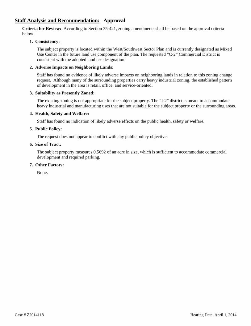
Case # Z2014118 Hearing Date: April 1, 2014
Staff Analysis and Recommendation: Approval Criteria for Review: According to Section 35-421, zoning amendments shall be based on the approval criteria below.
1. Consistency:
The subject property is located within the West/Southwest Sector Plan and is currently designated as Mixed Use Center in the future land use component of the plan. The requested “C-2” Commercial District is consistent with the adopted land use designation.
2. Adverse Impacts on Neighboring Lands:
Staff has found no evidence of likely adverse impacts on neighboring lands in relation to this zoning change request. Although many of the surrounding properties carry heavy industrial zoning, the established pattern of development in the area is retail, office, and service-oriented.
3. Suitability as Presently Zoned:
The existing zoning is not appropriate for the subject property. The “I-2” district is meant to accommodate heavy industrial and manufacturing uses that are not suitable for the subject property or the surrounding areas.
4. Health, Safety and Welfare:
Staff has found no indication of likely adverse effects on the public health, safety or welfare.
5. Public Policy:
The request does not appear to conflict with any public policy objective.
6. Size of Tract:
The subject property measures 0.5692 of an acre in size, which is sufficient to accommodate commercial development and required parking.
7. Other Factors:
None.

Palos
Esma
Sligo St
R4
R4
R4
R4R4
R4 R4
R4
R4
R4
R4 R4 R4
R4
R4 R4 R4R4
R4 R4 R4 R4 R4 R4R4
R4 R4 R4
MH
R4 R4
MH MH
R4
R4 R4R6R4
R4 R4 R4 R4 R4 R4
R4R4 R4R4R4MH
R4
R4
R4
R4
MH
R4
R4
R4
MH
RM4-CD RM4-CD
R4 R4R4R4 R4R4
Scale: 1" approx. = 100 Feet
Council District: 3 TEXT(TEXT)
Current ZoningRequested Zoning Change
Zoning Case Notification PlanCase Z-2014-124
LegendSubject Properties
200' Notification Area
Subject Property Legal Description(s):
(0.287 Acres)
100-Year DFIRM Floodplain
NCB 10894 - BLOCK 012 - LOT 037 & 038Single Family Residential 1R
Note: All Current and Requested Zoning includes AHOD (Airport Hazard Overlay District).
Development Services DeptCity of San Antonio
(03/17/2014 - R. Martinez)
^
Brooks
Hwy 181 S
IH 37 S
Esma
Loop 410 SE
Margo St
S Presa St
Sligo StLebanon St
Lema
y Rd
Juniper St
Shane Rd
IH 37 S
Lemay Rd
SE Loop 410
®
Location Map
School District: East Central I.S.D.
C3NA CDC3NA CDC3NA CD (R4)
Vacant
1R1R1R 1R 1R
1R VacantVacant 1R Vacant 1R 1R 1R
1R 1R
1RVacant1R 1R 1RVacant Vacant Vacant
1R 1R 1RVacant1R1R
Vacant1R
1R

Case # Z2014124 Hearing Date: April 1, 2014
City of San Antonio Development Services Department Staff Report To: Zoning Commission
Zoning Case #: Z2014124
Hearing Date: April 1, 2014
Property Owner: Juanita V. Rodriguez
Applicant: Lenora Ann Pena
Representative: Lenora Ann Pena
Location: A portion of the 200 Block of Esma
Legal Description: Lots 37 and 38, Block 12, NCB 10894
Total Acreage: 0.287
City Council District: 3
Case Manager: Osniel Leon, Planner
Case History: This is the first public hearing for this case.
Proposed Zoning Change Current Zoning: "C-3NA CD AHOD" General Commercial Nonalcoholic Sales Airport Hazard Overlay District with a Conditional Use for Operative Truck Parking
Requested Zoning: "R-4 AHOD" Residential Single-Family Airport Hazard Overlay District
Procedural Requirements The request was publicly noticed in accordance with Section 403 of the Unified Development Code (UDC). The application was published in The Daily Commercial Recorder, an official newspaper of general circulation on March 14, 2014. Notices were sent to property owners and registered neighborhood associations within two hundred (200) feet of the subject property on March 19, 2014. Additionally, notice of this meeting was posted at city hall and on the city’s internet website on March 28, 2014, in accordance with Section 551.043(a) of the Texas Government Code.
Notices Mailed Owners of Property within 200 feet: 33
Registered Neighborhood Associations within 200 feet: None
Planning Team: San Antonio International Airport Vicinity Land Use Plan
Applicable Agencies: City of San Antonio Aviation Department

Case # Z2014124 Hearing Date: April 1, 2014
Property Details Property History: The property was annexed in 1952 and was originally zoned “B” Residence District. In a 1998 case, the property was rezoned to “B-3NA SUP” Non-Alcoholic Sales District with a special use permit for operative truck parking. Upon adoption of the 2001 Unified Development Code, the previous base zoning district converted to the current “C-3NA CD” General Commercial Nonalcoholic Sales District with a Conditional use for Operative Truck Parking. The subject property consists of two platted lots and is currently undeveloped.
Topography: The property does not include any abnormal physical features such as significant slope or inclusion in a flood plain.
Adjacent Base Zoning and Land Uses Direction: All Current Base Zoning: “R-4”, “R-6”, “RM-4 CD”, “C-3NA CD” Current Land Uses: Single family residences and undeveloped land
Overlay and Special District Information: All surrounding properties carry the "AHOD" Airport Hazard Overlay District, due to their proximity to an airport or approach path. The "AHOD" does not restrict permitted uses, but can require additional review of construction plans by both the Development Services Department and the Federal Aviation Administration.
Transportation Thoroughfare: Esma Street, Palos Street and Sligo Street Existing Character: Local Streets; 1 lane in each direction Proposed Changes: None known
Public Transit: There are no VIA bus lines in the vicinity.
Traffic Impact: A Traffic Impact Analysis is not required. The traffic generated by the proposed development does not exceed the threshold requirements.
Parking Information: Single-family residential uses are generally required to provide at least one parking space per dwelling unit.

Case # Z2014124 Hearing Date: April 1, 2014
Staff Analysis and Recommendation: Approval Criteria for Review: According to Section 35-421, zoning amendments shall be based on the approval criteria below.
1. Consistency:
The subject property is located within the Stinson Airport Vicinity Land Use Plan and is currently designated as Low Density Residential in the future land use component of the plan. The requested “R-4” district is consistent with the adopted land use designation.
2. Adverse Impacts on Neighboring Lands:
A denial of the zoning request could lead to future development of intense commercial uses on the subject property. Staff supports this request in order to further protect adjacent residential uses.
3. Suitability as Presently Zoned:
The existing zoning is not appropriate for the subject property or the surrounding neighborhood. The current commercial zoning is the result of out-dated zoning practices that were once common. Current zoning practices would not place intense commercial zoning in or near established residential neighborhoods.
The “C-3”General Commercial zoning district is designed to provide for more intense uses that are typically characterized as community and regional power centers such as shopping malls, movie theaters, hospitals and wholesalers, among others. Due to its classification, the “C-3” General Commercial base zoning district is best located at intersections of major arterials and within commercial nodes.
4. Health, Safety and Welfare:
Staff has found no indication of a likely negative influence on public health, safety or welfare in relation to this zoning change request.
5. Public Policy:
The request does not appear to conflict with any established public policy.
6. Size of Tract:
The subject property measures 0.287 of an acre and would appear to be of sufficient size to accommodate the proposed use.
7. Other Factors:
The subject properties are located within the Stinson Airport Awareness Area; therefore the application was sent to the Aviation Department for review and comment. Due to the properties’ distance from the airport (over 2 miles), the Aviation Department does not object to the rezoning request.

Allen
de
Rome
ro
Castroville Rd
Allen
de
Rome
roI1
R6
R4
C2NA
R4
R6
R4
R6
C2
R6-CD
R4
R4
C2NA
R4
R4
C2NA-CD
R6
R4
R6
R4
R4
R4
R4
R4
R4
R4 R4
R4R4
R4
R4
R4
R4
R4R4
R4
R4
R4
R4
R4
R4
R4
R4
R4
R4
R4
C2-S
R4
R4
R4
R4
R5R4
R4
R4
C2NA
R4
R4
R4
C2NA
R6
R4
R4
C1-CD
R4
R4
C2NA-CD
R4
R4
R4
R5
R4
Scale: 1" approx. = 100 Feet
Council District: 5 TEXT(TEXT)
Current ZoningRequested Zoning Change
Zoning Case Notification PlanCase Z-2014-126 CD
LegendSubject Properties
200' Notification Area
Subject Property Legal Description(s):
(0.156 Acres)
100-Year DFIRM Floodplain
NCB 08086 - BLOCK 002 - LOT 009 & 010Single Family Residential 1R
Note: All Current and Requested Zoning includes AHOD (Airport Hazard Overlay District).
Development Services DeptCity of San Antonio
(03/17/2014 - R. Martinez)
^
Patrolman Richard Cuellar
Athe
l
Olga
Dr
Motes Dr
Brady Blvd
Toltec
W Hwy 90
Allen
de
Arteago
Barn
ey Av
e Madr
id St
Rome
ro
SW 34
th St Co
rtez A
ve
Morelia
Balbo
a St
Arisp
eCeralvo St
S San
Dar
io
SW 35
th St
SW 34
th St
Madr
id St
W Hwy 90
®
Location Map
School District: Edgewood I.S.D.
(C2 CD)
Retail Center
1R
1R
1R
1R
1R
1R
1R
Restaurant
Office
1R
1R
1R 1R
1R
Apartments
1R
Retail Center
Tire Shop
1R
1R
1R
1R
Tire Shop
1R
1R
C2NA CD
pv92484
Typewritten Text
Vehicle Storage
pv92484
Typewritten Text
Building
pv92484
Typewritten Text
Carport
pv92484
Typewritten Text
Auto Repair
pv92484
Typewritten Text
Vehicle Storage
pv92484
Typewritten Text
Thrift Store
pv92484
Typewritten Text
1R

Case # Z2014126 CD Hearing Date: April 1, 2014
City of San Antonio Development Services Department Staff Report To: Zoning Commission
Zoning Case #: Z2014126 CD
Hearing Date: April 1, 2014
Property Owner: Gustavo Cruz Alvarado
Applicant: Gustavo Cruz Alvarado
Representative: Norman J. Alvarado
Location: 1720 Castroville Road
Legal Description: Lots 9 and 10, Block 2, NCB 8086
Total Acreage: 0.1377
City Council District: 5
Case Manager: Pedro Vega, Planner
Case History: This is the first public hearing for this zoning request.
Proposed Zoning Change Current Zoning: "R-6 AHOD" Residential Single-Family Airport Hazard Overlay District
Requested Zoning: "C-2 CD AHOD" Commercial Airport Hazard Overlay District with a Conditional Use for Auto and Light Truck Repair
Procedural Requirements The request was publicly noticed in accordance with Section 403 of the Unified Development Code (UDC). The application was published in The Daily Commercial Recorder, an official newspaper of general circulation on March 14, 2014. Notices were sent to property owners and registered neighborhood associations within two hundred (200) feet of the subject property on March 19, 2014. Additionally, notice of this meeting was posted at city hall and on the city’s internet website on March 28, 2014, in accordance with Section 551.043(a) of the Texas Government Code.
Notices Mailed Owners of Property within 200 feet: 30
Registered Neighborhood Associations within 200 feet: None
Planning Team: West/Southwest Sector Plan (35)
Applicable Agencies: None

Case # Z2014126 CD Hearing Date: April 1, 2014
Property Details Property History: The property was annexed in September of 1952 and was originally zoned “JJ” Commercial District. Upon adoption of the 2001 Unified Development Code, the previous base zoning district converted to “I-1” General Industrial District. In a 2009 City-initiated large-area rezoning case, the property was rezoned to “R-6” Residential Single-Family District. The subject property consists of two platted lots that were platted into the current configuration in December of 1943 (Volume 1625, page 201 of the Deed and Plat Records of Bexar County, Texas).
The property is currently occupied with one office building and two detached carports. The building was constructed in 1965, measuring approximately 600 square feet in size.
Topography: The property does not include any abnormal physical features such as significant slope or inclusion in a flood plain.
Adjacent Zoning and Land Uses Direction: North across Castroville Road Current Base Zoning: “C-2NA CD” and “C-2 S” Current Land Uses: Retail Center with Auto and Light Truck Repair and Office Use
Direction: Southwest and Northeast Current Base Zoning: “R-4”, “R-6” and “C-2NA CD” Current Land Uses: Single-Family Dwellings, Vehicle Storage and Tire Shops
Direction: Southwest across Romero Current Base Zoning: “C-2NA CD” and “R-6 CD” Current Land Uses: Auto and Light Truck Repair, Vehicle Storage, Thrift Store and Apartments
Overlay and Special District Information: All surrounding properties carry the “AHOD” Airport Hazard Overlay District, due to their proximity to an airport or approach path. The “AHOD” does not restrict permitted uses, but can require additional review of construction plans by both the Development Services Department and the Federal Aviation Administration.
Transportation Thoroughfare: Castroville Road Existing Character: Secondary Arterial Type A; 2 lanes in each direction with sidewalks Proposed Changes: None known
Thoroughfare: Romero Existing Character: Local Street; 1 lane in each direction with sidewalks Proposed Changes: None known
Public Transit: The nearest VIA bus line is the 68, which operates along Castroville Road with a bus stop in the immediate vicinity of the subject property.
Traffic Impact: A Traffic Impact Analysis (TIA) is not required because traffic generated by the proposed development does not exceed the threshold requirements.
Parking Information: Off-street vehicle parking requirements typically are determined by the type of use and building size. The rezoning application refers to a proposed auto and light truck repair facility.
Minimum Requirement: 1 space per 500 square feet of Gross Floor Area (GFA) including service bays, wash tunnels and retail areas
Maximum Allowance: 1 space per 375 square feet of Gross Floor Area (GFA) including service bays, wash tunnels and retail areas

Case # Z2014126 CD Hearing Date: April 1, 2014
Staff Analysis and Recommendation: Approval, with conditions Criteria for Review: According to Section 35-421, zoning amendments shall be based on the approval criteria below.
1. Consistency: The subject property is located within the West/Southwest Sector Plan and is currently designated as General Urban Tier in the future land use component of the plan. The requested “C-2” base zoning district is consistent with the adopted future land use designation.
The uses permitted in the “C-2” district are typically considered Community Commercial uses that draw their customer base from multiple residential areas. Community commercial uses in the General Urban Tier should be located at the intersection of arterials and/or collectors.
2. Adverse Impacts on Neighboring Lands: Staff finds no likely adverse impact on the surrounding properties related to the requested Conditional Use for Auto and Light Truck Repair. This zoning change would be appropriate at this location and will not alter the character of the neighborhood. Although the abutting property to the east also carries residential zoning, the property appears to be used for vehicle storage and would not be negatively impacted by the zoning change request.
Conditional zoning is designed to provide for a land use that is not permitted by the established zoning district, but due to individual site considerations or unique development requirements, would be compatible with the adjacent uses under given conditions. Motor Vehicle Sales is a use permitted by-right in "C-3" General Commercial District and "L" Light Industrial District. The use often can be accommodated in lower commercial zoning districts where mitigating efforts are taken to protect surrounding uses.
3. Suitability as Presently Zoned: The “R-6” base zoning is not appropriate for properties with frontage on a major thoroughfare. The subject property is located on Castroville Road, a major thoroughfare, and is situated on a corner lot with frontage on Romero, a local access street. The subject property is better suited for small-scale office and commercial uses, not residential uses.
For the 2009 City-initiated rezoning case that created the current zoning, all vacant properties were given residential zoning; however, existing uses were generally accommodated through approval of Conditional Uses. Had the proposed auto repair facility been in operation at the time, staff likely would have recommended “C-2 CD” for the property.
4. Health, Safety and Welfare: Staff has found no indication of likely adverse effects on the public health, safety, or welfare due to this request. Approval of the rezoning request will allow viable use of the property.
The existing buildings will be required to comply with all commercial building and safety codes prior to the issuance of a Certificate of Occupancy. Any new construction will trigger both building setbacks and landscape buffers to protect abutting residential uses.
5. Public Policy: The request does not appear to conflict with any public policy objective.
6. Size of Tract: The subject site is 0.1377 of an acre in size. The small size of the property will serve to limit the scale of the proposed use. A zoning change request for a Conditional Use requires the applicant to submit a site plan of the subject property that includes all existing and proposed development.
7. Other Factors: The “C-2” district requires a minimum 10-foot side and 30-foot rear setback where abutting residential zoning or uses. Similarly, a 15-foot Type B landscape buffer is required where abutting single-family residential zoning. The proposed site configuration and existing structures can not comply with the basic building setback and landscape buffer requirements. However, the existing structures can be used without triggering the development requirements as long as there is no new construction.
Staff recommends the following conditions:
1. No storage of junk vehicles.
2. Vehicles must be licensed.
3. Outdoor speakers and amplification systems shall be prohibited.


DR
R6C2
OCL
MH
C2
C3
C2
C2
C3R
C3R
OCL
OCL
C2
OCL
C2
C2 C2
C3
Culebra CreekPark Le
slie R
d
Liberty Field
Barclay Point
Cortla
nd O
ak
Anarbor FieldArmor
Arch
Loop
W 16
04 N
Creston Ford
Creston Gate
Butterfly Flat
Ballard Peak
Cres
ton Co
urt
Cres
ton Bl
uff
Culebra Creek
Development Services DeptCity of San Antonio
(08/30/2013 - R Martinez)Scale: 1" approx. = 400 FeetCouncil District 6
Zoning Case Notification Plan Case Z-2013-195
Legend
Subject Property Legal Description(s):
(48.842 Acres)
NCB 34449 - BLOCK 000 - LOT 010 Single Family Residential 1R100-Year DFIRM Floodplain
(TEXT)Requested Zoning ChangeTEXTCurrent Zoning
200' Notification AreaSubject Properties
®
^ SW Lo
op 16
04
Lesli
e Rd
Liberty Field
Cortla
nd O
ak
Culebra Rd
Location Map
San Antonio City Limits
San A
ntonio
City
Limits
Bexa
r Cou
nty Li
ne
Bexar County Line
7109
7003
6931
6839
6703
NCB 17635 - Block 001
NCB 17635 - Block 001
Culebra Creek Wastewater
ApartmentsWal-mart
Alamo Concrete Products
VacantStorage Office
(I1)

Case # Z2013195 Hearing Date: April 1, 2014
City of San Antonio Development Services Department Staff Report To: Zoning Commission
Zoning Case #: Z2013195
Hearing Date: April 1, 2014
Property Owner: City of San Antonio
Applicant: City of San Antonio – Transportation and Capital Improvements Department (by Hector Reynoso - Senior Real Estate Specialist)
Representative: Debbie Racca-Sittre, Assistant Director, Transportation and Capital Improvements Department
Location: A portion of the 6000 block of Leslie Road
Legal Description: Lot 10, NCB 34449
Total Acreage: 48.842
City Council District: 6
Case Manager: Ernest Brown, Planner
Case History: This is the second public hearing for this zoning case. The rezoning request was continued from the March 4, 2014 Zoning Commission public hearing.
Proposed Zoning Change Current Zoning: "DR" Development Reserve
Requested Zoning: "I-1" General Industrial District
Procedural Requirements The request was publicly noticed in accordance with Section 403 of the Unified Development Code (UDC). The application was published in The Daily Commercial Recorder, an official newspaper of general circulation on February 14, 2014. Notices were sent to property owners and registered neighborhood associations within two hundred (200) feet of the subject property on February 19, 2014. Additionally, notice of this meeting was posted at city hall and on the city’s internet website on March 28, 2014, in accordance with Section 551.043(a) of the Texas Government Code.
Notices Mailed Owners of Property within 200 feet: 9
Registered Neighborhood Associations within 200 feet: Bridgewood Association is located within 200 feet of the subject property; however, the association was not registered with the City at the time notices were mailed.
Planning Team Members: 35 – West/Southwest Sector Plan
Applicable Agencies: None

Case # Z2013195 Hearing Date: April 1, 2014
Property Details Property History: The subject property was annexed in 2000 and was originally zoned “DR” Development Reserve District. The property is platted in its current configuration. The property previously served as SAWS facility but is currently undeveloped. Topography: The subject property does not include any abnormal physical features such as significant slope or inclusion in a flood plain.
Adjacent Zoning and Land Uses
Direction: West and North Current Base Zoning: OCL Current Land Uses: Single-Family Residences, Vacant Land and a Mobile Home Park
Direction: Northeast, East and South Current Base Zoning: “MH”, “C-3” and “C-2” Current Land Uses: Mobile Home Park, Concrete Contractor, Office and Vacant Land
Overlay and Special District Information: None
Transportation
Thoroughfare: Leslie Road Existing Character: Local Street; one lane in each direction Proposed Changes: None known
Public Transit: The nearest VIA bus line is the 660, which operates along Westwood loop. There are two stops near the subject property, but none immediately adjacent.
Traffic Impact: A Traffic Impact Analysis (TIA) is not required. The traffic generated by the proposed development does not exceed the threshold requirements.
Parking Information: Off-street vehicle parking requirements are typically determined by type of use and building size. The application states the proposed use as a Service Center. The UDC does not include specific parking requirements for Service Centers, but does include requirements for Utility land uses such as Sanitary Landfill, Solid Waste Facilities, Telephone Equipment Facilities, etc., as 1 space per service employee.

Case # Z2013195 Hearing Date: April 1, 2014
Staff Analysis and Recommendation: Approval, pending plan amendment. Criteria for Review: According to Section 35-421, zoning amendments shall be based on the approval criteria below.
1. Consistency:
The subject property is located within the West/Southwest Sector Plan and is currently designated as Suburban Tier in the future land use component of the plan. The requested “I-1” base zoning district is not consistent with the adopted land use designation. The applicant has requested a plan amendment to Civic Center, which would accommodate the proposed City-facility. Unlike other land use designations, consistency with the Civic Center classification is not determined by base zoning district; instead consistency is determined by the type of use (institutional, governmental, religious, and/or educational).
Staff and Planning Commission recommended approval of the requested plan amendment.
2. Adverse Impacts on Neighboring Lands:
Staff has found no evidence of likely adverse impacts on neighboring lands in relation to this zoning change request. The proposed site includes buffer areas, fencing, and placement of buildings to minimize impact on the surrounding residential areas. There is an existing service facility located on Callaghan Road and Commerce Street, zoned “I-1” and is developed closer than to the established residential neighborhood, with no evidence of adverse impacts on neighboring lands.
3. Suitability as Presently Zoned:
The “DR” zoning district is meant to be a temporary zoning designation for newly annexed lands and allows the same uses as the “R-6” Residential Single-Family District. The current zoning is not appropriate for the subject property and single-family residential development is not likely given the surrounding commercial uses, proximity to an expressway (Loop 1604) and the property’s previous water utility use.
4. Health, Safety and Welfare:
Staff has found no evidence of negative impacts on the public health, safety or welfare of the surrounding community.
5. Public Policy:
The request does not appear to conflict with any public policy objectives.
6. Size of Tract:
The subject property measures a total of 48.842 acres in size, which is sufficient to accommodate the uses permitted in the “I-1” district and the typical required parking, as well as appropriate buffering for the surrounding residential uses.
7. Other Factors:
None.