City of Red Bank City Manager Municipal Planning Commission€¦ · Municipal Planning Commission...
17
John Roberts Mayor City of Red Bank Municipal Planning Commission WORK SESSION AGENDA April 17th, 2017 6:00 pm Red Bank Community Center Randall G. Smith City Manager I. CALL TO ORDER II. ROLL CALL – Secretary – Billy Cannon Commissioner Cannon Commissioner Baker Commissioner Hafley Commissioner Smith Commissioner Browder III. Agenda items for the April 20 th regular planning commission meeting: A. CONSIDERATION OF THE MINUTES 1. Minutes from March 16 th , 2017 B. UNFINISHED BUSINESS 1. None. C. NEW BUSINESS 1. Rezoning Request, 1700 Ashmore Ave, R1 to RT-1 (Austin) 2. Rezoning Request, 105 W Newberry St, R-1 to C-1 (Pardue) IV. OTHER BUSINESS 1. Discussion of Zoning Ordinance review priorities V. ADJOURNMENT
-
Upload
nguyenhuong -
Category
Documents
-
view
215 -
download
0
Transcript of City of Red Bank City Manager Municipal Planning Commission€¦ · Municipal Planning Commission...

John Roberts
Mayor
City of Red Bank Municipal Planning Commission
WORK SESSION AGENDA
April 17th, 2017
6:00 pm
Red Bank Community Center
Randall G. Smith
City Manager
I. CALL TO ORDER
II. ROLL CALL – Secretary – Billy Cannon
Commissioner Cannon Commissioner Baker
Commissioner Hafley Commissioner Smith
Commissioner Browder
III. Agenda items for the April 20th regular planning commission meeting:
A. CONSIDERATION OF THE MINUTES
1. Minutes from March 16th, 2017
B. UNFINISHED BUSINESS
1. None.
C. NEW BUSINESS
1. Rezoning Request, 1700 Ashmore Ave, R1 to RT-1 (Austin)
2. Rezoning Request, 105 W Newberry St, R-1 to C-1 (Pardue)
IV. OTHER BUSINESS
1. Discussion of Zoning Ordinance review priorities
V. ADJOURNMENT


John Roberts
Mayor
City of Red Bank Municipal Planning Commission
AGENDA
April 20th, 2017
6:00 pm
Red Bank City Hall
Randall G. Smith
City Manager
I. CALL TO ORDER
II. ROLL CALL – Secretary – Billy Cannon
Commissioner Cannon Commissioner Baker
Commissioner Hafley Commissioner Smith
Commissioner Browder
III. INVOCATION – Commissioner Baker
IV. PLEDGE OF ALLEGIANCE – Commissioner Hafley
V. CONSIDERATION OF THE MINUTES
(a) Minutes from March 16th 2017
VI. UNFINISHED BUSINESS
(a) None
VII. NEW BUSINESS
(a) Rezoning Request, 1700 Ashmore Ave , R1 to RT-1 (Austin)
(b) Rezoning Request, 105 W Newberry St, R-1 to C-1 (Pardue)
VIII. OTHER BUSINESS
(a) Discussion of Zoning Ordinance review priorities
IX. ADJOURNMENT

John Roberts Mayor
MUNICIPAL PLANNING COMMISSION
MINUTES March 16, 2017
6:00 p.m. Red Bank City Hall
Randall G. Smith
City Manager
I. CALL TO ORDER
Chairman Hafley called the meeting to order at 6:05 pm
II. ROLL CALL
Commissioner Hafley called the roll. Commissioner Hafley, Browder, and Smith were in attendance.
The Commission’s planning advisor from the Southeast Tennessee Development District, Brian Taylor,
was also present. Red Bank City Manager Randall Smith was also present. Jay Bell and other members
of the public are included on the sign in sheet.
III. INVOCATION
Commissioner Smith gave the invocation.
IV. PLEDGE OF ALLEGIANCE
Commissioner Hafley led the pledge of allegiance.
V. CONSIDERATION OF THE MINUTES
a) February 17, 2017 Meeting Minutes
Motion by Commissioner Browder to approve the February minutes. Second by Commissioner
Smith. Motion passed unanimously.
VI. UNFINISHED BUSINESS
a) None
VII. NEW BUSINESS
a) Midvale Highlands Final Plat / PUD Plan (Bell)
Chairman Hafley invited Jay Bell forward to present his Final PUD Plan to the Planning Commission.
Jay Bell reported that curbs would be paved next week. All utilities have been installed and roads
have been graded. All remaining infrastructure except sidewalks and landscaping will be completed
in the coming weeks. Jay Bell said that he was agreeable to the bonding of sidewalks and
landscaping.

Staff noted that the Public Works director was receiving complaints about storm water issues from
property owners adjacent to the undeveloped site and had recommended that approval of the final
PUD plan include a condition that building permits not be issued until the completion of all storm
water facilities, roads and utilities. Mr. Bell was agreeable to these conditions and assured the
Planning Commission that he would do a walk-through of the development with Tim Thornbury after
all infrastructure improvements were made.
Jay Bell noted several changes to the final PUD Plan to clarify intent. The four variances granted for
the PUD were listed on the Final PUD Plan along with other conditions attached to the preliminary
PUD Plan. Mr. Bell also noted where a small parking area had been added for the model home, as
well as a spring house that was preserved on the edge of the property.
Chairman Hafley asked if the three fire hydrants were displayed on the PUD Plan. Rocky Chambers,
the Engineer for the Midvale Highlands PUD, noted that they were shown on the final plat. Mr.
Chambers rolled out the final plat for the Planning Commission. Commissioner Browder asked about
the trail and when the easement would be conveyed to the Trust for Public Land. Mr. Bell indicated
that his attorney was currently reviewing the matter. Mr. Chambers identified the 50’ easement for
the trail on the final plat.
Motion by Commissioner Browder to approve the Midvale Highlands Final PUD Plan under
the condition that a bond will be submitted for all incomplete sidewalks and landscaping shown
on the Final PUD Plan, and under the condition that all other infrastructure improvements will
be completed before building permits are issued. Second by Commissioner Smith. Motion
passed unanimously.
Jay Bell requested that the Planning Commission also approve the Final Plat pending signatures.
Tony Richmond, the surveyor for Mr. Bell, suggested that the Planning Commission approval date
could be added to the notes on the final plat.
Motion by Commissioner Browder to approve the final plat for the Midvale Highlands PUD
pending signatures. Second by Commissioner Smith. Motion passed unanimously.
b) Glenhill Subdivision Final Plat (Youngblood)
Staff reported that Mr. Youngblood asked that his Final Plat be tabled for the April meeting of the
Planning Commission.
Motion by Commissioner Hafley to revise the March agenda by removing the Glenhill final plat
and tabling the agenda item for the April Planning Commission meeting. Second by
Commissioner Browder. Motion passed unanimously.
c) Design Review Ordinance draft with revisions from City Commission
Staff gave an overview of the revisions made by the City Commission to the Design Review ordinance
draft. Chairman Hafley asked if there were any changes to recommend other than those from the City
Commission. Staff identified one additional recommendation from the Planning Commission working
session to modify the applicability section of the Design Review ordinance to include all commercial

zones, instead of C-1 and C-2, in the event that a C-3 zoning district was established off of Dayton
Blvd.
Motion by Commissioner Smith to recommend the Design Review Ordinance draft as revised for
approval by the City Commission. Second by Commissioner Browder. Motion passed
unanimously.
d) Municipal Code Amendment to Permit Food Trucks in C-1 and C-2 Zoning Districts
Chairman Hafley asked the City Manager to provide an overview of the Food Truck Amendment.
Randall Smith explained that this amendment would permit Food Trucks in the C-1 and C-2 zoning
districts under certain conditions. Food Trucks are currently only permitted in the C-2 zoning district.
Commissioner Browder felt that there was no reason to limit food trucks to the C-2 zoning district.
Chairman Hafley asked whether Food Trucks were permitted only on Dayton Boulevard.
Commissioner Browder asked if there were exceptions. The City Manager notes that Food Trucks
were permitted at other locations through special exceptions in the municipal code for events.
Motion by Commissioner Hafley to recommend the Food Truck ordinance amendment as
written for approval by the City Commission. Second by Commissioner Browder. Motion
passed unanimously.
VIII. OTHER BUSINESS
IX. ADJOURNMENT
Commissioner Hafley moved to adjourn; second by Commissioner Baker. Adjourned at 7:01
PM.
Chairman
Southeast Tennessee Development District
Community Development
P.O. Box 4757 - 1000 Riverfront Parkway
Chattanooga, TN 37405
Phone: (423) 266-5781 Fax: (423) 267-7705
www.sedev.org
MEMORANDUM
To: Members of the Red Bank Municipal Planning Commission
From: Brian Taylor, SETDD Regional Planner
Date: April 11, 2017
Subject: Rezoning Request for 1700 Ashemore Ave and 0 Mason Drive ; R-1 to RT-1
SUMMARY
Requested Rezoning: R-1 Residential to RT-1 Residential (Townhomes)
Property Address: 1700 Ashemore Ave. and 0 Mason Dr.
Tax Map #: 126K B parcels 004 and 024
Area to be rezoned: ~6 acre tract and 1 acre lot
Existing structures/uses on subject property: large vacant tract; single-family home on lot
Proposed use: Townhomes
Zoning of adjacent properties: Adjacent properties are zoned R-1 and R-3
Land use on adjacent properties: Single family homes; apartment complex
Floodplain? No
Background: An application has been submitted to rezone two properties located at the corner of
Ashmore Ave and Mason Dr (126K B parcels 004 and 024) from R-1 to RT-1. The applicant is the owner
of the property, Tommy Austin. The owner intends to subdivide the property and construct townhomes
for sale. The owner already successfully applied for the RT-1 zoning of this property around 2003, and
contends that the property was downzoned in 2015 without any prior notification by the City.
Recommendation: Staff recommend approval of the rezoning from R-1 to RT-1. Rezoning conditions
may be required to address compatibility and topography challenges.
ANALYSIS
Zoning Ordinance
The rezoning of the property to RT-1 would allow for a higher density of residential development in the
form of townhomes. The intent paragraph for RT-1 development reads as follows:
It is for the intent of this section to provide regulations for the development
of single-family townhouses (also called row houses and "attached"
homes) in a manner that is attractive, efficient, and compatible with
surrounding development. It is also the intent of these regulations that the
underlying real estate may be divided into small lots so that each unit can
be individually sold and owned on a "fee simple" basis. It is further
intended as a policy that any townhouse development of more than 8 units
should be located within 500' of a major arterial or collector street.
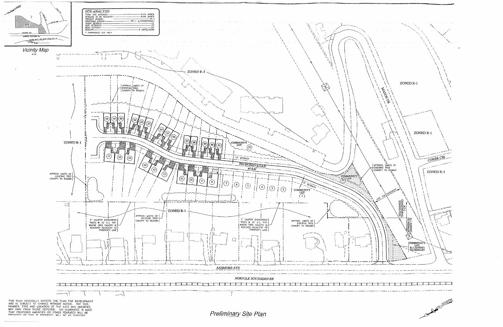
The property was already rezoned to RT-1 at the request of the owner in 2003. The preliminary site plan
appears to meet all dimensional requirements shown below (See appendix for site plan). The preliminary
site plan shows the use of the existing tree canopy for screening.
Dimensional Regulations
The following dimensional regulations would apply: 308.03 Height and Area Regulations (A) No building shall exceed 35 feet in height, except that every one foot of additional height over 35
feet, the building shall be set back one additional foot from all non-zero lot line property lines.
(B) A minimum building size for townhouse dwellings shall be 1350 square feet.
(C) The minimum lot width shall be 18 feet.
(D) All buildings must be set back at least 25 feet from any dedicated public street.
(E) Townhouse buildings (a continuous row of townhouse units) shall be separated by not less than 40
feet, front-to-end; or 40 feet front-to-front.
(F) No building shall be located less than 25 feet from any boundary of the RT-1 Residential
Townhouse Zone, except on side yards where an RT-1 zone abuts the RZ-1, R-T\Z R-4, R-3 or any
industrial and commercial zone, the minimum side yard requirement is 15 feet.
(G) Except as provided above, there are no minimum front, side, or rear yard setback requirements.
Screening
Screening for High Density Residential proposed adjacent to existing Low Density Residential
(C) Screening Type C: Provide a 10 feet deep (as measured towards the interior of the property) landscape
yard along the shared property line planted with:
1) Evergreen trees spaced a maximum of 10 feet on center or 2 staggered rows (spaced a maximum of 7
feet apart) of shrubs spaced a maximum of 8 feet on-center.
2) All plantings shall meet the installation and planting size requirements specified in the Plant Installation
Specifications section.
Existing and Proposed Use
The existing property to be rezoned includes one 6+ acre vacant tract and one adjacent 1 acre lot with an
existing single family home. The existing single-family home will be removed to allow access to the
proposed townhouses from Ashemore Avenue. The owner intends to construct 25 to 30 townhouses or as
many as the Zoning Ordinance will allow. The property is located within 500’ of Dayton Boulevard.
Compatibility with Surrounding Uses
There are ten single family residences along Ashemore Avenue with rear lot lines that abut the larger
tract. These adjacent lots range from 0.33 to 0.66 acres. The eastern edge of the property is flanked by an
apartment complex. The preliminary site plan drafted by the applicant shows a screening buffer of
existing trees between the single-family homes and the apartment complex (See Appendix).

Development Challenges
Potential challenges to development include powerlines, the lack of evergreens for screening, and the
steep contours of the property. Plans for stormwater retention are not known at this time.
Land Use Plan
The development of townhomes at this location would increase the variety of the housing stock in Red
Bank and address Goal C of the Red Bank Land Use Plan:
C-GOAL: Attract residential developers back to Red Bank for new development and
redevelopment.
ACTION: New residential zones that provide more options and diversity of development
while still protecting single-family neighborhoods.
ACTION: Reduced minimum lot size standards and setback requirements to make Red
Bank competitive with surrounding communities.
This higher density form of residential development, accompanied with the screening and setback
requirements for the RT-1 district, could be compatible with the existing neighborhood, which includes a
variety of small lot single family homes, an apartment complex, and nearby patio homes that are in
development. This higher density form of residential development is also well suited for these residential
areas closest to the Dayton Boulevard commercial corridor. Context sensitive design could help preserve
the character of the existing neighborhood and address issues stemming from steep topography.
RECOMMENDATION
Staff recommends approval of the rezoning from R-1 to RT-1. The placement of townhomes on the
applicant’s property can be made compatible with the surrounding land uses, and is in alignment with the
land use plan goal to increase housing variety. Furthermore, the property was already rezoned to RT-1 by
the City of Red Bank, prior to being downzoned in 2015 with the adoption of a new zoning map.
Rezoning conditions may be required to address screening and stormwater challenges. Note: Staff’s recommendation is based upon the information available at the time of this review and is subject to
change if information contrary to this analysis is presented at any time.

APPENDIX
Map 1. HCGIS Aerial of Parcels
Map 2. HCGIS Current Zoning Map 3. 2014 Zoning Map

Property Card
TAX_MAP_NO 126K B 024 126K B 004
OWNERNAME1 AUSTIN THOMAS A AUSTIN THOMAS A
ADDRESS 1700 ASHMORE AVE MASON DR
LEGALDESC1 LOT 1-2 MIDVALE PARK EXT SOUTH PB 15 PG 6
MIDVALE PARK EXT SOUTH PB 15 PG 6
LOTDIM1
1023X430.4IRR
CALCACRES 0 6.19
MAPACRES 0 0
DEEDACRES 0 0
LUCODE 111 910
NEIGHCODE 3R 3R
DISTRICT 3R 3R
CONTROLMAP
IMPCODE 0 0
PROPTYPE 22 22
CURRENTUSE RS RS
EXEMPTCODE
PLAT1BOOK 15
PLAT1PAGE 6
PLAT1LOT 1&2
SALE1DATE 8/28/2003 8/28/2003
SALE1CONSD 0 0
SALE1BOOK 6836 6836
SALE1PAGE 678 678
SALE1TYPE B B
SALE1CONF RR RR
SUBDIVNAME MIDVALE PARK EXT SOU
shape_area 29,154
307,929

Southeast Tennessee Development District
Community Development
P.O. Box 4757 - 1000 Riverfront Parkway
Chattanooga, TN 37405
Phone: (423) 266-5781 Fax: (423) 267-7705
www.sedev.org
MEMORANDUM
To: Members of the Red Bank Municipal Planning Commission
From: Brian Taylor, SETDD Regional Planner
Date: April 11, 2017
Subject: Rezoning Request for 105 W Newberry St, from R-1 to C-1
SUMMARY
Requested Rezoning: R-1 Residential to C-1 Commercial
Property Address: 105 W Newberry St
Tax Map #: 117E J 014
Property Area: 0.38 acres
Owner: Kenneth Pardue
Existing structures/uses on subject property: commercial warehouse building
Proposed use: commercial property for sale
Zoning of adjacent properties: adjacent properties are zoned R-1 and C-1
Land use on adjacent properties: single family home; auto parts store
In Floodplain: Yes
Background: An application has been submitted by Kenneth Pardue to rezone the property located at 105
W Newberry St from R-1 to C-1. The applicant has stated the intention of correcting an alleged error in
the zoning map adopted in 2015, which rezoned this commercial property from C-1 to R-1. The property
was rezoned from RT-1 to R-1 in 2015. The owner contends that the property was downzoned without
any prior notification by the City. He discovered that the property was had been rezoned when he tried to
sell it to a prospective buyer.
Recommendation: Approve with screening requirements / conditions to ensure compatibility with
adjacent R-1 properties. Alternatively consider rezoning to less intensive C-3 Neighborhood Commercial
that allows a more limited range of commercial uses that are more compatible with adjacent residential
development.

ANALYSIS
Existing Conditions
The 0.38 acre property is located at the southern end of the Red Bank CBD and 100+ feet west from
Dayton Boulevard (See Appendix Map 1). The property is occupied by a warehouse-style commercial
building that is used for the sale of surplus government products (See Figure 1). The property abuts a
commercial property (auto parts store) to the east that fronts Dayton Boulevard and a residential property
zoned R-1 to the west. The area of the property abutting the residential use is not screened. The property
is located in the 100 year floodplain and a portion of the building is located in the floodway (See
appendix).
Figure 1. Google Street View 105 W Newberry St
Proposed Zoning and Intended Use
The rezoning of the property to C-1 Commercial would return the business operating at this location from
a non-conforming use to a permitted use. The owner of the property intends to sell the property as a
commercial property. The existing warehouse building is unlikely to be used as a residence, and
constructing a single-family home at this location would be difficult and costly due to floodway and
floodplain building restrictions.
The 2035 Land Use Plan and the Red Bank Zoning Ordinance support commercial development along the
Dayton Boulevard corridor in cases where it does not create adverse impacts on neighboring properties.
This property is already being used for commercial purposes, but became a non-conforming use after the
new zoning map adopted in 2015. The owner believes that the property was mistakenly zoned R-1, or at
least rezoned without their notification.
Figure 2. City of Red Bank Zoning circa 2014
105 W Newberry St is shown to be zoned as C-1 Source: Hamilton County GIS

Red Bank Zoning Ordinance
The existing property is already in compliance with all dimensional requirements of the C-1 Commercial
district. Existing Proposed
R-1 Residential C-1 Commercial
Front Setback 25' 50'
Side Setback 25' 10' abutting residential or M-1 zone
Rear Setback 25' 25' abutting residential zone
Minimum Frontage 60' None
Minimum Lot Size 7500 sf None
Minimum House Size 1200 sf None
Section 14-902 requires that commercial uses be screened from existing residential properties with
screening type B. The lot is not currently screened from adjacent residential properties. An alternative
screening requirement may be required due to the narrow side yard adjacent to the R-1 property.
(B) Screening Type B: Provide a twenty (20) feet deep (as measured towards the interior of the property)
landscape yard along the shared property line planted with:
1) Evergreen trees spaced a maximum of ten (10) feet on center or two (2) staggered rows (spaced a
maximum of seven (7) feet apart) of shrubs spaced a maximum of eight (8) feet on-center, and one (1) row
of shade trees spaced a maximum of thirty-five (35) feet on-center.
2) All plantings shall meet the installation and planting size requirements specified in the Plant Installation
Specifications section.
RECOMMENDATION
Staff recommends approval of the rezoning of 105 W Newberry St from R-1 to C-1 given the location
next to Dayton Blvd, the previous commercial zoning, the commercial building style, and flood hazards
that would likely prevent any new construction. Continued compatibility with adjacent residential uses
can be ensured with modified screening conditions. The Planning Commission may also consider
rezoning the parcel to C-3 Neighborhood Commercial, given the lack of frontage on Dayton Blvd and the
surrounding residential development.
Note: Staff’s recommendation is based upon the information available at the time of this review and is subject to
change if information contrary to this analysis is presented at any time.

APPENDIX
Map 1. Aerial of Parcel showing Floodplain and Floodway
Map 2. Aerial of Property with Current Zoning
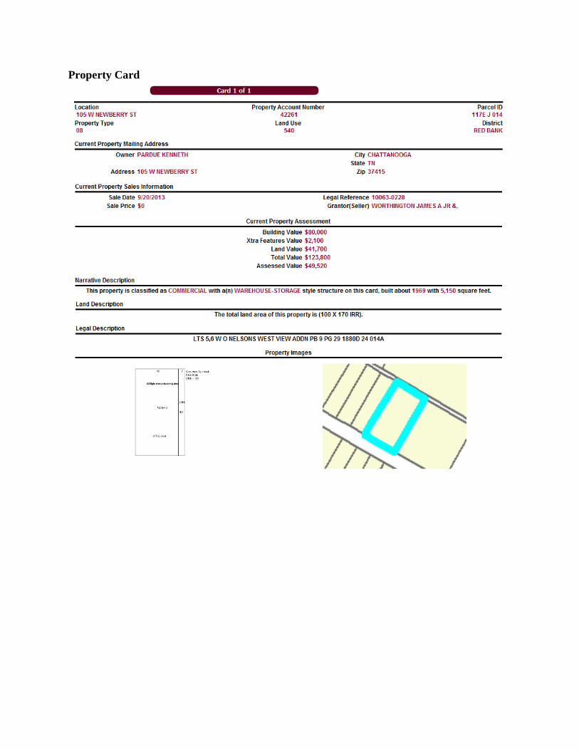
Property Card