City of Mountain Iron Comprehensive Plan Update · Greg Chad, Fire Cheif Annie Harala, ......
114
Transcript of City of Mountain Iron Comprehensive Plan Update · Greg Chad, Fire Cheif Annie Harala, ......

http://www.arrowheadplanning.org/mountainiron 1 | P a g e

http://www.arrowheadplanning.org/mountainiron 2 | P a g e
Acknowledgements
A special thank you goes out to the following City staff, elected officials, and citizens
that attended meetings and contributed their time and energy to the development of
this Comprehensive Plan Update. Thank you the unnamed individuals who completed
the community survey who also contributed their time and energy to inform this
Comprehensive Plan Update.
Gary Skalko, Mayor
Craig Wainio, City Administrator
Sally Yuccas, Library Director
Susan Tuomela, City Councilor
Alan Stanaway, Chair of the Public Health and Safety Board
Jim Techar, Planning and Zoning Commission
Joe Prebeg, City Councilor
Carolyn Olsen, Library Board
Steve Giorgi, RAMS
Steve Skogman, Chair of Planning and Zoning Commission
Greg Chad, Fire Cheif
Annie Harala, Community Health Board
Raymond Jobe, Statewide Health Improvement Plan Coordinator

http://www.arrowheadplanning.org/mountainiron 3 | P a g e
Contents Acknowledgements ..................................................................................................................... 2
Mountain Iron Vision Statement and Goal Statements .......................................................... 5
Vision Statement ....................................................................................................................... 5
Introduction and Background .................................................................................................... 7
Comprehensive Plan Description ........................................................................................... 7
Legal Foundation of Comprehensive Planning ................................................................ 7
Health in Comprehensive Planning .................................................................................... 7
Update Process ......................................................................................................................... 8
Planning Process .................................................................................................................... 8
Community Profile and Background ....................................................................................... 10
Community History .................................................................................................................. 10
Population Demographics .................................................................................................... 12
Past and Relevant Plans ........................................................................................................ 13
2008 Comprehensive Plan ................................................................................................. 13
2010 Mountain Iron Bicycle and Pedestrian Plan ........................................................... 14
2013 St. Louis County Hazard Mitigation Plan ................................................................. 14
Public Participation ................................................................................................................. 14
Public Visioning Session ...................................................................................................... 14
Community Survey .............................................................................................................. 15
Housing......................................................................................................................................... 17
Housing Indicator Report ....................................................................................................... 17
Housing Demographics.......................................................................................................... 17
Housing Goal and Recommendations ................................................................................ 18
Transportation ............................................................................................................................. 20
State and Local Roads ........................................................................................................... 20
Mesabi Trail .............................................................................................................................. 21
Transportation Demographics .............................................................................................. 21
Transportation Key Findings (US Census 2010 and ACS 2014) ....................................... 21
Transportation Goals and Recommendations ................................................................... 21
Utilities and Community Facilities ............................................................................................. 24
Complete/Living Streets ......................................................................................................... 24

http://www.arrowheadplanning.org/mountainiron 4 | P a g e
Utilities and Community Facilities Goal and Recommendations..................................... 24
Economic Development ........................................................................................................... 26
Employment and Income Demographics .......................................................................... 26
Employment Key Findings (US Census 2010 and ACS 2014) ......................................... 26
Income Key Findings (US Census 2010 and ACS 2014) .................................................. 27
Economic Development Goal and Recommendations .................................................. 27
Land Use ...................................................................................................................................... 29
Land Use Goal and Recommendations .............................................................................. 31
Mining, Natural, Agricultural, and Cultural Resources .......................................................... 35
Mining, Natural, Agricultural, and Cultural Resources Goal and Recommendations .. 35
Recreation, Parks, Open Space, Cultural Arts ........................................................................ 40
Recreation, Parks, Open Space, Cultural Arts Goal and Recommendations ............... 40
Intergovernmental Cooperation .............................................................................................. 42
Intergovernmental Cooperation Goal and Recommendations ..................................... 42
Implementation .......................................................................................................................... 43
Implementation Goal and Recommendations ................................................................. 43
Appendices ................................................................................................................................. 45
Appendix A: Implementation Table .................................................................................... 46
Appendix B: Community Survey Results Summary ............................................................ 54
Appendix C: Mountain Iron Community Survey Results Data ......................................... 56
Appendix D: Meeting Summaries ........................................................................................ 89

http://www.arrowheadplanning.org/mountainiron 5 | P a g e
Mountain Iron Vision Statement and Goal Statements
Vision Statement
“In the future, the City of Mountain Iron is a growing, well connected and
exciting community with a great business climate; providing opportunities for
visitors and residents to live, work, shop, and dine. It is a safe
walkable/bikeable, healthy and inviting community that is supported by a wide
variety of recreational opportunities. Mountain Iron will continue to be a city in
which tourists will want to visit and where residents proudly call home.”
Goal Statements
Housing Goal Statement: The City of Mountain Iron will strive to provide housing that
offers a selection of affordable and sustainable options that include varying lot sizes,
with rental and ownerships opportunities for residents of all ages; creating equitable
housing options with access to facilities that can contribute to a healthy lifestyle.
Transportation Goal Statement: The City of Mountain Iron will provide a safe, clean
transportation system with opportunities for various modes of transportation (auto, bike,
pedestrian, etc.) which connect to both local and regional destinations; creating a
system that enables safe and healthy travel options promoting equity for all
socioeconomic backgrounds of Mountain Iron’s citizens.
Utilities and Community Facilities: The City of Mountain Iron will stay committed towards
providing its residents with effective infrastructure to city structures, water and sanitary
systems, recreational facilities, and other public facilities and services, through a
systematic short-range planning process to ensure the health and equitable transfer of
resources to the citizens of Mountain Iron.
Economic Development: The City of Mountain Iron will promote and seek partnership
opportunities with new and existing businesses by advocating for manageable growth
and retaining an aesthetically pleasing environment while reducing conflict between
residential and commercial uses. Mountain Iron will promote and economic
environment that supports the health of its residents and visitors to the City.
Mining, Natural, Agricultural, and Cultural Resources: The City of Mountain Iron will utilize
and preserve its cultural, historical, and natural resources to provide a deeper
connection of a sense of place to its citizens and travelers in the area while addressing
local agricultural and mining efforts, considering resources that contribute to a
sustainable future and support the health of the City’s environment and people.

http://www.arrowheadplanning.org/mountainiron 6 | P a g e
Recreation, Parks, Open Space, and Cultural Arts: The City of Mountain Iron will strive to
enhance the recreational and cultural facilities/opportunities available by utilizing
public input, planning proactively, and implementing projects and programs to provide
an array of opportunities to residents and travelers of all ability levels. The City will
provide equitable access to facilities that promote the health and well-being of every
member in the community.
Land Use: The City of Mountain Iron will utilize policies that promote sustainable land
use by activity assessing future needs and promoting the most effective use of each
property while balancing cost efficient public services. Mountain Iron’s land use
policies will be clear, concise and easy to administer, contributing to the creation and
sustenance of an equitable and healthful environment.
Intergovernmental Cooperation: The City of Mountain Iron will work cooperatively with
St. Louis County, neighboring communities and other public and private entities to
provide high quality, cost effective, public services to residents throughout the
community on issues of economic, equitable, social, health, environmental, and
cultural significance.
Implementation: The City of Mountain Iron will work as an entity and with stakeholders
to complete the strategies and projects identified in the Comprehensive Plan Update
and will review and update implementation priorities and status annually.

http://www.arrowheadplanning.org/mountainiron 7 | P a g e
Introduction and Background
The following is the City of Mountain Iron’s Comprehensive Plan Update, adopted by
the Mountain Iron City Council on (INSERT DATE). The plan was created to guide
development of the City for future economic growth, population expansion, and
preservation of resources. The Mountain Iron Comprehensive Plan Update addresses
strategies and action steps to resolve key issues and preserve valued assets of the City.
Comprehensive Plan Description A comprehensive plan is the policy framework that communities use to guide
development and land use activities. The development of a comprehensive plan is
based on a process of engaging the public in local decisions, articulating the sort of
community they would like to live in and leave behind for the next generation. A
comprehensive plan is a tool to help a community identify their long-term choices and
goals, and to create strategies and action steps to work towards accomplishing their
vision.
Legal Foundation of Comprehensive Planning
The State of Minnesota gives its cities the legal authority to regulate land use. The State
does not require the creation of comprehensive plans for cities outside the seven-
county metropolitan area. However, it is recognized that a comprehensive plan is a
valuable tool that a city can use to express its vision and develop strategies, guiding
decision making into the future. The Municipal Planning Act (Minnesota Statutes
Sections 462.351 to 462.364) creates a single procedure that applies to all cities. The
comprehensive plan provides the legal foundation to enact land use controls and
other municipal actions to implement long-term growth and development strategies
and regulations. The City’s land use (zoning) ordinances and official zoning map should
be updated to conform to the Comprehensive Plan pursuant to adoption.
Health in Comprehensive Planning
Health has become an increasingly important topic for local communities to consider in
their planning efforts. Recent increases in chronic diseases have led to a trend in
healthier diets and active living. ARDC and the Carlton-Cook-Lake-St. Louis Community
Healthy Board (CHB) have joined forces on a pilot project to incorporate health specific
goals into comprehensive plans. The City of Mountain Iron was identified as a pilot
community to discuss health and the impact of social determinants such as food
access and active living.
Hundreds of studies have emerged linking the relationship between the built
environment and our cumulative public health. CHB uses the ‘public determinants’ of
health to guide their focus. As demonstrated below (left), social and economic factors
are considered to have the largest input on our overall wellness. Examples of these and
other ‘built’ or physical environment factors are demonstrated in the picture below
(right). Active transportation (walking, biking, and transit) and healthy food access are
two of the largest impact areas urban planners are incorporating into their work to help

http://www.arrowheadplanning.org/mountainiron 8 | P a g e
curtail escalating public health costs associated with preventable diseases, including
heart disease, obesity, diabetes, and others.
The primary goal of the pilot project is to identify assets, issues, and opportunities within
communities that affect the overall health of its residents. Things such as healthy food
markets, farmer’s markets, community gardens, and other food access points were
identified as priority areas for communities to plan that help residents identify healthier
food options. Improving the walkability and bicycle friendliness of a community is also a
priority. Creating a more accessible and safe network of sidewalks, bike lanes, and
walking and biking path allow residents of all mobility levels an opportunity to consider
living a more active life style.
Update Process In 2014, the City of Mountain Iron received a grant to update their comprehensive plan
from the Iron Range Resources and Rehabilitation Board (IRRRB) and partnered with the
Arrowhead Regional Development Commission to conduct the update process. The
update focused on emerging issues and updating the status of projects which have
been acted upon since the extensive 2008 planning process. An outline of the 2016
planning process has been provided below; while new goals, objectives, and strategies
have either been encompassed into existing chapters or designated new chapters of
their own.
Planning Process
January 13, 2016: Kick-off Meeting – ARDC met with the Mountain Iron
Comprehensive Plan Planning Committee to outline the scope of work, process,
and timeline of the project. The Committee also provided insight on emerging
trends and issues of concern that have arisen since the last plan, to provide
context for the plan update.
February 10, 2016: Public Visioning Session – The public visioning session was
advertised and promoted by the City with assistance from ARDC, in order to
obtain good attendance and incorporate public input into the priorities set forth

http://www.arrowheadplanning.org/mountainiron 9 | P a g e
in the plan. At the meeting, ARDC provided brief overview of the planning
process, while Annie Harala from the Community Health Board provided
information to the meeting participants such as factors that influence health and
well-being; social and economic factors to be addressed to achieve health
equity; and etc. The meeting attendees were also led through multiple public
engagement exercises to identify local assets to protect/preserve, potential
barriers, the City may face in the future, provide feedback on investment
priorities, and also help mold the vision statement to guide the City into the
future.
April 28, 2016: Public Visioning Review Meeting – The third meeting of the
process analyzed key demographics and summarized results from the visioning
session exercises. The Planning Committee also provided further discussion
focused on key issues and assets for the City of Mountain Iron. Additionally,
recommendations and projects identified from previous plans were examined
extensively to identify which projects have been implemented as well as to
determine if projects that haven’t been included should be carried over into the
Comprehensive Plan Update.
July 11, 2016 & September 14, 2016: Recommendation Review Meeting I & II –
Initial recommendations of goals and strategies were reviewed with the Planning
Committee to provide feedback on the extent and inclusion of each. Additional
discussion took place regarding additional analysis of other potential
recommendations or areas to explore. Revisions were made available to the
Planning Committee digitally after the meeting.
October 27, 2016: Public Review/Hearing Meeting – A public review meeting
was conducted to take comments on the draft version of the completed plan.
The plan was made available online and at City Hall prior to the hearing.
Comments and revisions were documented and summarized for the Planning
Committee’s review.
December 6, 2016: Final Planning Committee Meeting - A final Planning
Committee meeting was held to review comments expressed at the Public
Review/Hearing meeting and make necessary changes. Additionally, the
implementation table to determine the timeline (short-term, mid-term, long-term,
ongoing) to implement each identified recommendation/project and who
should take the lead on the project completion process.
(Insert Date): Plan Adoption

http://www.arrowheadplanning.org/mountainiron 10 | P a g e
Community Profile and Background
The City of Mountain Iron is located in west central St. Louis County. The total area of
the City is 71.31 square miles (76 km2). 68.52 square miles (177.47 km2) is land and 2.79
square miles (7.23 km2) is water. The City had a 2010 Census population of 2,869 and a
2014 American Community Survey (ACS) estimate of 2,847. U.S. Trunk Highway 169 runs
through the community, and links the City with U.S. Trunk Highway 53 which provides
service south to Duluth. Mountain Iron’s residents value their community’s location and
character. Along with the cities of Virginia, Eveleth, and Gilbert, Mountain Iron is Part of
the group of cities commonly referred to as the Quad Cities.
Community History The northeastern region of Minnesota was forested and mainly
populated by Native Americans until the discovery of iron ore
in the late 1890s. By 1900, the Minnesota iron ranges, including
the Mesabi Range, led the North American iron ore industry.
The rapid establishment of a major raw materials industry in a
relatively remote region populated and industrialized the
region quickly with over 100 town sites and mining locations
being established. Immigrant populations from the northern
and southern areas of Europe provided the bulk of a labor
needed for underground and open pit mining operations.
These pioneering towns were either established independently
or by mining companies.
One of these early town sites was Mountain Iron which is centrally located on the
Mesabi Range. In 1890, iron ore was discovered in Mountain Iron by the Merritt brothers
and has been known as the birthplace of iron ore mining on the Mesabi Iron Range.
The following are excerpts from the “History of Mountain Iron, Minnesota (through
1922)”, which can be found at Zenith City Online:
Through the Merritts, it was at Mountain Iron that the first iron ore mine of the
Mesabi Range was brought into operation; the first Mesabi mine reached by
railway was the Mountain Iron, entirely through the dogged persistence of the
Merritts; and Mountain Iron will always hold the unique position as being the
place where at the first shipment of ore from the Mesabi Range was made.
When the railway was brought to the mines, it seemed to be the triumphant
consummation of an almost hopeless undertaking, and one can well imagine
how proud those seven sons were when, after overcoming all obstacles and
bringing the railway to the mines in 1892 they had taken their aged mother to
the iron mines, and in their strong arms carried her to the top of the mound that
she might look down to see the work of her children.
The first development work on the Mountain Iron mine was done in 1891-1892, by
Captain A. P. Woods. A shaft was sunk, and from this in 1892, the first ore for

http://www.arrowheadplanning.org/mountainiron 11 | P a g e
shipment was raised. At the Biwabik mine, which had been subleased by the
Merritts to Kimberly and Jones, a steam shovel had been introduced in the spring
of 1892, with indifferent success, at first, and although it was early decided by
Captain Cohoe, who succeeded Captain Woods at Mountain Iron, that stripping
was to be done there, the work was given out to Donald Grant, a railway
contractor. He began the stripping at Mountain Iron early in 1893, using scrapers,
teams, and dump cars. This equipment soon gave way to a steam shovel, Mr.
Grant having brought one he had used in the construction of the Missabe Road.
During 1889 and 1890, Mountain Iron was, of course, but a “prospector’s camp in
a bleak wild spot,” almost “beyond the fringe of civilization.” Wilbur Merritt was
entrusted with the responsibility of looking after the camp store, and in 1891,
when the Merritts were exploring at Biwabik, two townships to the eastward; he
had charge of that store and office also. And all the supplies they needed had
to come in from Tower, or from Mesabi station, a week’s trip over an Indian Trail.
Albert Merritt wrote: “No one who has not gone through the hardships and
discouragements of keeping a camp going, so far from the base supplies, can
realize what one has to contend with”. However, no matter what the
discouragement, the principal
explorers were resolved to bear them,
as they were confident they were
going to find the ore; and the
Mountain Iron camp soon lost its
temporary aspect, settling into a
permanency. In 1890, of course, they
discovered ore, and thereafter the little
community constantly swelled in size
and in importance.
Still, the residents of Mountain Iron were
bent more upon the mining of iron
than the planning of a village. Other communities, of later establishment than
Mountain Iron, had gone ahead of that place in the matter of incorporation.
Mesaba Station, the nearest point on the railway (D. & I. R.) to the new mining
field, had grown almost overnight into a place of fifteen hotels and some very
active and comprehensive general stores, which endeavored to supply the
demand of the countless bands of explorers delving into the range into the
range 422 to the westward, had been granted the dignity of corporate
government in July, 1891; and the village of Merritt, at which place no
prospectors had started operations until 1891, became an incorporated place
almost before Mountain Iron town site had even been platted. And the villagers
of McKinley and Biwabik had both held their initial elections upon the question of
incorporation before a petition for incorporation of Mountain Iron had been
passed upon by the county commissioners.

http://www.arrowheadplanning.org/mountainiron 12 | P a g e
A town site of 80 acres was platted in April, 1892, the territory embraced in the
town site of sw.-sw. of section 3, 58-18, and the nw-nw. of section 10, 58-18. The
plat was marked as “Plat of Grant,” and filed with the Register of Deeds, at
Duluth, on April 16, 1892. In October, 1892, a petition was circulated among the
residents of the town site. It was addressed to the St. Louis County
Commissioners,” and asked “that a time and place be set when and where the
electors residing upon lands described as sw.-sw. section 3, t. 58 n., r. 18 w., and
nw.-nw. section 10, t. 58 n., r. 18 w., might vote for or against the incorporation of
such lands into the Village of Mountain Iron,” under the authority of chapter 145
of Laws of Minnesota 1885 compilation. The petition came before the county
commissioners on October 26, 1892, and met their approval. They ordered an
election to be held, to decide the question of incorporation, on November 28,
1892. A majority of the electors having voted in favor incorporation, an election
of officers for the village of Mountain Iron followed, that event occurred on
December 13, 1892, establishing the first village administration. The village was
administered under the charter granted in 1892 until 1913, when the residents
sought to be brought under the powers and privileges of the Revised State Laws,
1905, compilation. An election was held on June 2, 1913. 27 of 36 votes cast
then being in favor or re-incorporation.
In April 1909, a petition was presented the village council by residents upon
certain land contiguous to Mountain Iron, the signers being mainly employees of
the Iroquois mine. They wished their location brought within the village
boundaries. It was resolved to hold an election on May 1, 1909. The election
showed that a majority of the electors were in favor of the proposed annexation,
sixty-five of the seventy-two votes cast being in favor of the proposition. Then in
1918, a petition signed by C.M. Van Pelt and others sought to bring within the
village limits an immense acreage in townships 58 and 59 n., r. 18 w., in all
7,368.23 acres. An election held on January 31, 1918 brought only 22 voters to
the poll, but all votes cast were in favor of annexation.
At one time, it was expected that Mountain Iron was destined to become the
metropolis of the Mesabi Range. When the railway project was crystallized, it
was expected that Mountain Iron would be the northern terminus of the road,
the Duluth Missabe and Northern.
Population Demographics The City of Mountain Iron demographics were gathered from the U.S. Census Bureau
and the ACS. Information about the City of Mountain Iron was gathered in the following
categories: Population, Housing, Employment, Income, and Transportation with specific
tables/information found in their respective chapter. The Census data is both from the
U.S. Decennial census, which is collected every ten years, and the American
Community Survey, which provides estimates from the interim years (provided 1-5 years,

http://www.arrowheadplanning.org/mountainiron 13 | P a g e
varying on community size). More information about the census data can be found
online at http://www.census.gov/.
Mountain Iron Population Key Findings (U.S. Census 2010 and ACS 2012)
According to the 2010 Census, the City of Mountain Iron had a population of
2,869.
There is a slightly higher population of females (50.2%) than males (49.8%).
The City is predominantly Caucasian (98%) with the next largest racial groups of
people that are two or more races (2%) and American Indian and Alaska Native
(0.7%).
Since the 2000 U.S. Census, Mountain Iron’s previous population was 2,999 and
has decreased by 4.3%.
The median age is 45.4 years old (Males – 43.6 and Females – 47.3)
The top four largest age groups in Mountain Iron:
o 55 to 59 years of age (11.1% of population)
o 50 to 54 years of age (8.4% of population)
o 60 to 64 years of age (6.9% of population)
o 45 to 49 years of age (6.6% of population)
Past and Relevant Plans As previously mentioned in regards to the City of Mountain Iron Comprehensive Plan
Update process, ARDC reviewed existing documents and plans that are relevant to the
City. Primary documents that were reviewed included:
2008 Comprehensive Plan
2010 Mountain Iron Bicycle and Pedestrian Plan
2012 Mountain Iron Strategic Plan Update
2008 Comprehensive Plan
In 2008, Mountain Iron and the ARDC produced the 2008
Mountain Iron Comprehensive Plan, which too was an
update of a previous plan. At the time, the City needed a
new comprehensive plan to drive the community’s land
use and development goals in a direction that was more
reflective of current prospects. Issues that drove the plan
included: New housing developments in the City; changing
conditions of the local and regional economy related to
taconite mining and processing; and several large industrial
projects. Ultimately, the plan addressed land use decisions
as they affected transportation and community and
economic development. Also addressed were procedures
for the implementation and administration of the Plan’s recommendations and
everyday responsibilities of the City’s Planning and Zoning Commission.

http://www.arrowheadplanning.org/mountainiron 14 | P a g e
2010 Mountain Iron Bicycle and Pedestrian Plan
The Mountain Iron Bicycle and Pedestrian Plan was completed in 2010 with assistance
from ARDC. The Plan combined local non-motorized trail planning with a Safe Routes
to School (SRTS) element. Overall, it focused on expanding existing bicycle and
pedestrian facilities in the City of Mountain Iron to provide a safe, well-designed
network that connects popular destinations and is accessible to everyone in Mountain
Iron, especially students. Also addressed was walking and bicycling education and
promotion to the Mountain Iron-Buhl School District students.
2012 Mountain Iron Strategic Plan Update
In 2012, the City of Mountain Iron and ARDC
undertook an initiative to update the City’s
Strategic Plan which was last completed in May
2002. That document was complimentary to some
of the other existing plans at the times, such as the
2002 Old Town Plan, 2008 Comprehensive Plan,
2010 Economic Development Strategy, and 2012
Mountain Iron Bicycle and Pedestrian Plan. The
updated plan addressed the areas of Housing,
Economic Development, and Community
Infrastructure and Service’s Needs, and
recommends strategies and action steps for
implementation of prioritized projects.
2013 St. Louis County Hazard Mitigation Plan
Completed in 2013, the St. Louis County Hazard
Mitigation Plan was developed to determine how
to reduce or eliminate the loss of life and property damage resulting from natural and
human-caused hazards. The plan was first adopted in 2005 and was reviewed and
updated in 2012 in preparation for approval by Federal Emergency Management
Agency (FEMA) in 2012. The plan encompasses all natural, technological, and human-
caused hazards rather than only focusing on one type of hazards. St. Louis County
followed the guidelines and handouts that FEMA has created and any resources
provided by Homeland Security and Emergency Management (HSEM). Local
governments, including representatives from the City of Mountain Iron, participated in
the planning process by attending meetings and providing feedback towards the
development of the plan.
Public Participation Public Visioning Session
ARDC staff worked with the Planning Committee and the City of Mountain Iron to hold
a Public Visioning Session at 6:00 p.m. on Wednesday, February 10th, 2016 at the
Mountain Iron Community Center/City Hall.

http://www.arrowheadplanning.org/mountainiron 15 | P a g e
The Public Visioning Session provided the residents of Mountain Iron as well as public
health attendees a chance to participate in the process by helping to set community
goals. The meeting included a review of the planning process, key health information
and statistics, and public engagement exercises. Citizen participation in the Visioning
Session is critical to the success of the Comprehensive Plan. Residents, elected officials,
and other stakeholders from the community were encouraged to attend and healthy
refreshments were served to over 11 meeting attendees.
After a brief presentation on both comprehensive planning and health indicators,
ARDC led the meeting attendees through a pair of exercises to gather input on
community values and priorities. First the attendees were asked to work as small groups
at tables to mark assets and community issues on a map. Each table then reported
their findings, which were documented by ARDC. A brief description of the captured is
below:
Physical Assets: For example, attractions, gatherings places, city sidewalks and
campground.
Other Assets: For example, an asset not seen on the
map could include annual community events,
friendly atmosphere, etc.
Future Assets: Desired assets in the future.
Concern Identification:
o Identify Physical Concerns/Threats/Issues
o Identify “Unseen” Concerns/Threats/Issues
o Identify Future Concerns/Threats/Issues to be avoided
The second exercise focused on crafted a Vision Statement for the City of Mountain
Iron. Keeping the list of newly created assets in mind, participants were asked to think
about how they would finish the statement below.
“In the future, the City of Mountain Iron…”
For example: …has a good business environment
…is well connected to area recreational assets
These ‘Vision Nuggets’ were documented by ARDC, and then utilized with the Planning
Committee in crafting the community Vision Statement associated with this plan. The
Vision Statement projects the values the community would like to see preserved into the
future of the City.
Community Survey
To further engage the Mountain Iron community during the comprehensive planning
process, ARDC suggested administering a community survey. Developed by the
Planning Committee and ARDC, it was made available both online and in paper
format. The survey was answered by 36 respondents between February and July 2016.
A few results of important qualities/assets and issues and opportunities are listed below:

http://www.arrowheadplanning.org/mountainiron 16 | P a g e
Important Qualities and Community
Assets Current/Future Issues and Opportunities
Place to live, work, retire, and
raise children
Road repairs needed within the City.
County Highway 102 and Mineral
Avenue is not a good design
Sense of Community and
opportunities to participate in
community matters and issues
Decline of mining. Need for different
industries and new business
opportunities in Mountain Iron
Educational opportunities Preserve and maintain green space
for recreation opportunities
Access to markets, farms, health
and affordable food
Safe biking and walking paths. More
trails and sidewalks. Public
transportation options
Street and
sidewalk/maintenance
Need for a new main street. Where
will the new city center be at due to
the decline of Old Town?
Access to affordable quality
health and child care Preservation of Old Town
Openness and acceptance
towards people with diverse
backgrounds
Mountain Iron-Buhl School District
should build a school that is centrally
located
Snow removal Loose animals. Need leash
enforcement
Availability of paths, trail and
sidewalks that connect to
destinations
For a thorough summary of survey responses, a full break-down of survey questions and
responses, refer to the City of Mountain Iron Community Survey Results Summary and
City of Mountain Iron Community Survey Results in Appendix B and Appendix C,
respectively.

http://www.arrowheadplanning.org/mountainiron 17 | P a g e
Housing
Housing is an important part of Mountain Iron’s community development and
economic development efforts. Challenges include protecting existing neighborhoods,
stimulating new housing construction, increasing the customer base for local utilities,
balancing natural resource protection with desired development, and providing quality
and affordable housing across the range of residential needs. Providing quality,
affordable housing for the workforce and an aging population will become especially
important over the next decade.
The Center for Disease Control defines “aging in place” as the ability to live in one’s
own home and community safely, independently, and comfortably, regardless of age,
and income, or ability level. Design elements including single level homes with ADA
accessibility, shared maintenance services and opens space, and smaller lots/homes
within close proximity to services and transit options should be included when making
decisions on future housing to assist with the City’s/region’s aging population and to
allow residents to spend their entire life within the community they love and cherish.
Housing Indicator Report A Housing Indicator Report is an ongoing process to track current and past housing
marketing trends within the city and provides a snapshot of existing conditions. The
report provides information to private businesses, housing developers, property owners,
banking institutions and private and public community decision makers.
Statistics/Indicators can include population trends/projections building permits issued,
number of foreclosures, median sales price, rental rates, rental vacancy rates,
affordable housing rates, home/rental property surveys, among
others.
Housing Demographics The following Housing Key findings were developed using data
from the U.S. Census Bureau and the American Community
Survey (ACS). According to the 2010 Census, the City of
Mountain Iron had approximately 1,442 total housing units. Other
key findings from the review of housing are listed below.
Mountain Iron Housing Key Findings (U.S. Census 2010 and ACS 2014)
The City has 1,442 total housing units, which include 1,336 (92.6%) occupied units
There is an estimated 106 vacant housing units (7.4% of total, comprising of most
of these units that are categorized “all other vacant” (2.5%); while the next
highest percentage is “for rent” (2.1%)
Of the total amount of occupied units, approximately 67.8% are owner
occupied, while approximately 32.2% is renter occupied
The average household size is 2.14 while the average family size is 2.72

http://www.arrowheadplanning.org/mountainiron 18 | P a g e
Housing Goal and Recommendations
Goal: The City of Mountain Iron will strive to provide housing that offers a selection of
affordable and sustainable options that include varying lot sizes, with rental and
ownership opportunities for residents of all ages; creating equitable housing options with
access to facilities that can contribute to a healthy lifestyle.
Recommendations:
H 1: Address the elimination of blighted or problematic structures.
o H 1.1: Inventory properties throughout the City that are considered as
blight or problematic (beyond city scope of restorative efforts) and
enforce the City’s blight ordinance.
o H 1.2: Research and apply for IRRRB Commercial Redevelopment and/or
Residential Redevelopment grants as appropriate
(https://mn.gov/irrrb/grant-resources/community-programs.jsp). If
blighted properties and historic structures, the Minnesota Historic Society’s
funding may be applicable for restoration efforts.
o H 1.3: Review and update the City’s existing blight ordinance every 6-12
months.
H 2: Maintain and improve the quality of safe and affordable housing
throughout the neighborhoods in Mountain Iron.
o H 2.1: Promote rehab and preservation of public and subsidized housing
stock. This provides stability to lower-income families by ensuring their
access to quality and safe, affordable housing.
o H 2.2: Investigate and pursue development of new senior-friendly housing
opportunities throughout the City.
o H 2.3: Conduct a housing survey of the community to determine current
numbers and demographics of residents who own their home or rent in
Mountain Iron.
H 3: Promote maintenance of the existing housing stock in Mountain Iron.
o H 3.1: Advertise existing loan/grant programs for homeowners’
improvements through the use of social media (and local newsletter), the
website, or other means as a way to promote additional improvements to
celebrate successes by other homeowners throughout the community.
o H 3.2: Collaborate with existing organizations/grants programs to create
incentives for home maintenance.
Potential resources include: Community Development Block Grant,
Arrowhead Economic Opportunity Agency (AEOA) Housing
Department, St. Louis County Housing and Redevelopment
Authority, and others for a variety of improvements including home
maintenance, energy efficiency, exterior improvements, and
others.
H 4: Maintain the existing character of established neighborhoods.

http://www.arrowheadplanning.org/mountainiron 19 | P a g e
o H 4.1: Ensure that new commercial and industrial development is
buffered from residential areas and will minimally impact
commercial/industrial traffic in Mountain Iron’s residential neighborhoods.
H 5: Explore the feasibility of creating and annually reviewing a ‘Housing
Indicator Report’ which utilizes annual statistics regarding housing to provide a
snapshot of where the community is currently, and indicators of trends moving
forward to help spur private sector development and new housing.
o H 5.1: Components of a ‘Housing Indicator Report’ can include:
demographics (past and projected); employment/labor force trends;
homeownership trends; rental indicators (survey). The Survey should
address:
Rental rates
Vacancy rates
Derive: average rent (# of bedrooms/utilities paid vs. not
paid)
Housing production (*amount and costs of
sales/*foreclosures)
Number of building permits issued (new builds, additions, plats
approved)
Affordability analysis
Annual income necessary to afford particular rent/buy a
dwelling
% of income designated to take care of housing costs
H 6: Research and consider adopting housing development and/or subdivision
incentives to encourage design for future residential units and lots that
encompass lifestyles for users of all ages and abilities (including vacation and
short-term housing), as well as ‘Age in Place Principles’. Aging in Place is a tool
designed to help local governments plan and prepare for their aging
populations (http://www.aarp.org/content/dam/aarp/livable-
communities/plan/planning/aging-in-place-a-toolkit-for-local-governments-
aarp.pdf).
o H 6.1: Design elements may include: development of smaller, affordable
housing units in compact multi-house developments or allowing accessory
dwelling units, supported by facilities (commercial, pharmacy’s, etc.)
accessible by walking/biking or transit.

http://www.arrowheadplanning.org/mountainiron 20 | P a g e
Transportation
State and Local Roads The City of Mountain Iron’s transportation system consists of State, County, and local
street networks, a regional non-motorized transportation corridor of the Mesabi Trail,
and a Class One railroad. The City is located along the intersection of
Minnesota State Trunk Highways 169 and 53. These two highways are
the busiest roads in Mountain Iron and provide residents with
connections to neighboring cities and the region at large. They also
bring most of the City’s visitors and commercial traffic evidenced by
the concentration of most commercial activities within the Highway
169 and 53 corridors. Both highways are four-lane and have wide
shoulders through the City. The Minnesota Department of
Transportation (MnDOT) places a priority on US and State Highway
sections with high traffic volumes. The City should participate in
corridor and District planning processes in order to lobby for
continued maintenance and improvements to both highways.
One of the main transportation routes through the City is St. Louis County Road 102. The
road provides an east-west route that runs from its southern terminus at County 7 to U.S.
Highway 53, near the northern terminus of U.S. Highway 169. Since the completion of
the 2008 Plan, a section of the County road was rerouted to provide easier access to
MinnTac to account for high traffic flow, including heavy truck traffic, generated by the
company due to expansion of mining operations.
Overall, there 94.1miles of roads located in Mountain Iron consisting of U.S. Trunk
Highways, County State-Aid Highways, County Roads , and Municipal Streets. The
mileage and percentage by jurisdiction is found in the chart below.
Breakdown of Road Mileage by Jurisdiction
Road Type/Jurisdiction Total Mileage Percentage
US Trunk Highways 16.25 17.2%
County State-Aid
Highways 22.32 23.7%
County Roads 24.19 25.6%
Municipal Streets 31.35 33.2%
Total 94.10 100.0%
Of the 94.1 miles of roadway in Mountain Iron, 33.2% of all the roads are required to be
maintained by the City. St. Louis County oversees 49.3% of the roadways (County
http://www.arrowheadplanning.org/mountainiron 21 | P a g e
Roads and County State-Aid Highways) in the City. The County State-Aid Highways
make up 23.7% of the City’s roads, which are eligible for state and federal funding.
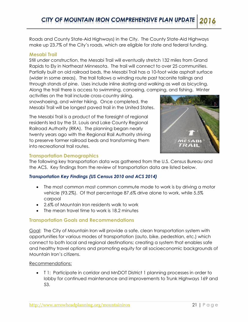
Mesabi Trail Still under construction, the Mesabi Trail will eventually stretch 132 miles from Grand
Rapids to Ely in Northeast Minnesota. The trail will connect to over 25 communities.
Partially built on old railroad beds, the Mesabi Trail has a 10-foot wide asphalt surface
(wider in some areas). The trail follows a winding route past taconite tailings and
through stands of pine. Uses include inline skating and walking as well as bicycling.
Along the trail there is access to swimming, canoeing, camping, and fishing. Winter
activities on the trail include cross-country skiing,
snowshoeing, and winter hiking. Once completed, the
Mesabi Trail will be longest paved trail in the United States.
The Mesabi Trail is a product of the foresight of regional
residents led by the St. Louis and Lake County Regional
Railroad Authority (RRA). The planning began nearly
twenty years ago with the Regional Rail Authority striving
to preserve former railroad beds and transforming them
into recreational trail routes.
Transportation Demographics The following key transportation data was gathered from the U.S. Census Bureau and
the ACS. Key findings from the review of transportation data are listed below.
Transportation Key Findings (US Census 2010 and ACS 2014)
The most common most common commute mode to work is by driving a motor
vehicle (93.2%). Of that percentage 87.6% drive alone to work, while 5.5%
carpool
2.6% of Mountain Iron residents walk to work
The mean travel time to work is 18.2 minutes
Transportation Goals and Recommendations
Goal: The City of Mountain Iron will provide a safe, clean transportation system with
opportunities for various modes of transportation (auto, bike, pedestrian, etc.) which
connect to both local and regional destinations; creating a system that enables safe
and healthy travel options and promoting equity for all socioeconomic backgrounds of
Mountain Iron’s citizens.
Recommendations:
T 1: Participate in corridor and MnDOT District 1 planning processes in order to
lobby for continued maintenance and improvements to Trunk Highways 169 and
53.

http://www.arrowheadplanning.org/mountainiron 22 | P a g e
T 2: Participate in the St. Louis County 5-year road and transportation planning
process.
T 3: Support the Mesabi Trail and regional bicycle connections projects.
T 4: Support and work to complete the City Bike Connections Route. There is a
designated and signed route between access points, which goes through the
older section of the City. Much of residential Mountain Iron is situated south of
Highway 169 and could use better connections to Mesabi Trail rather than using
narrow, busy roadways.
T 5: Connect existing and planned community destinations by expanding and
filling gaps in the existing sidewalk and trail system.
o T 5.1: Construct a 10’ wide paved trail running north-south along the east
side of the South Grove neighborhood.
o T 5.2: Construct a 10’ wide paved trail through the City’s ball fields near
the Mud Lake Road County Road 102 intersection.
o T 5.3: Construct a 10’ wide paved trail connecting the Mesabi Trail to the
Rock Ridge Retail Center.
o T 5.4: Complete sidewalk along 23rd Avenue W. on the south end of the
West Virginia neighborhood of Mountain Iron.
o T 5.5: Construct a sidewalk along the new County Road 102 from Nichols
Avenue to Walmart.
T 6: Collaborate with St. Louis County to
designate potential ATV routes within the City to
connect to St. Louis County roads that allow ATV
operation.
T 7: Monitor traffic flow, pedestrian movements,
safety considerations and potential business
opportunities at the intersection of Unity Drive
and County Road 7.
T 8: Promote and support public transit
opportunities such as Arrowhead Transit.
o T 8.1: Review transportation options, specifically for those in wheelchairs
and with limited mobility, and collaborate with potential partners to
enhance available services.
T 9: Evaluate creating a Living Streets Policy to provide for sustainable, ADA-
compliant, multimodal street designs when completing improvement projects.
The general nature of a Living Streets Policy is to enhance biking and walking
conditions; improve safety and security of streets; calm traffic; create livable
neighborhoods; and improve stormwater quality and neighborhood aesthetics.
T 10: Support the Iron Range Regional Rail Initiative which is a public/private
collaborative effort focused on improving rail infrastructure and access to
Northeast Minnesota. More information can be found at: http://www.senate.mn/committees/2015-
2016/3071_Transportation_and_Public_Safety_Budget_Division/SF2697%20Handout%20-
%20Iron%20Range%20Regional%20Rail%20Initiative.pdf
Intersection of
CR 7 & Unity Dr.

http://www.arrowheadplanning.org/mountainiron 23 | P a g e

http://www.arrowheadplanning.org/mountainiron 24 | P a g e
Utilities and Community Facilities
Utilities and community facilities are public services and infrastructure that the City of
Mountain Iron develops and maintains. Utilities include the water, stormwater, sewer,
communications, and waste collection infrastructure. Community facilities include
buildings such as City Hall/Community Center, the Library, and parks/recreational
facilities, (although recreational facilities may also
be addressed specifically in other sections of the
plan) among others. Maintaining these facilities
regularly can help minimize costs of major repairs in
the future while ensuring quality of life standards for
residents both current and future.
The City of Mountain Iron has been working with
internet providers and agencies to bring broadband
service to the community. The word “broadband” describes an internet signal of high
bandwidth or capacity. No one type of high-speed Internet can be labeled as
broadband because nearly all types of high-speed internet connections can be
referred to as broadband connections. Types of broadband internet can include
cable, satellite, DSL, fiber-optic or wireless.
Complete/Living Streets Complete Streets typically refers to street design that provides for multiple modes of
transportation. Green Streets typically refers to street design that reduces
environmental impacts by reducing impervious surface, managing stormwater, and
providing shade. Living Streets is a combination of the two. Living Streets combines the
concepts of complete streets and green streets, and also puts additional focus on
quality of life aspects for City residents.
Provide economic benefits: Lower initial costs; lower maintenance costs; increase
property value; economic revitalization.
Build community: Improve public health; increase safety; enhance neighborhood
beauty; strengthen sense of community; provide positive impact upon children.
Provide environmental benefits: Improve water quality; improve air quality; reduce the
urban heat island affect; reduce materials and energy used in street construction;
promote the planning of trees.
It is recommended the City investigate a Living Streets policy for the community, or
integrate design principles into regular road construction or reconstruction decisions.
Utilities and Community Facilities Goal and Recommendations
Goal: The City of Mountain Iron will stay committed towards providing its residents with
effective infrastructure to city structures, water and sanitary systems, recreational
Mountain Iron Library

http://www.arrowheadplanning.org/mountainiron 25 | P a g e
facilities, and other public facilities and services through a system short-range planning
process to ensure the health and equitable transfer of resources to the citizens of
Mountain Iron.
Recommendations:
UC 1: Identify and prioritize all City utility and infrastructure improvements and
secure funding for implementation.
o UC 1.1: Research and apply for IRRRB Development Infrastructure Grant
Program and the St. Louis County Community Development Block Grant
as appropriate.
UC 2: Create a Capital Improvement Program (CIP) planning process that
annually implements and reviews priorities to provide adequate infrastructure
(including roads, sidewalks, water/wastewater facilities, etc.) to the community
while balancing financial constraints in a systematic process.
UC 3: Incorporate the Mountain Iron recommendations from the 2013 St. Louis
County Hazard Mitigation Plan into the planning process to reduce potential
damage costs due to natural disasters.
o UC 3.1: Annually address, implement, and monitor projects and mitigation
strategies identified in the 2013 St. Louis County Hazard Mitigation Plan.
o UC 3.2: Include infrastructure and other mitigation improvements into the
Capital Improvement Program (CIP) planning process when addressing
annual maintenance/improvements.
UC 4: Explore opportunities to consolidate services and save costs when
possible.
UC 5: Explore permeable alternatives to traditional curb and gutter projects,
which can be incorporated in the development of a ‘Living Streets Policy’. This
allows for air and stormwater filtering through the alternative permeable material
to the soil below as opposed to the use
traditional concrete.
UC 6: Address opportunities to redevelop and
reinvigorate the vacant Mountain Iron-Buhl
High School building.
UC 7: Explore opportunities for improved
internet and Wi-Fi connection.
o UC 7.1: Research the Blandin Foundation’s Community Broadband
Program for potential grant and technical support opportunities. More
information about the Community Broadband Program can be found on
the following website: http://broadband.blandinfoundation.org/.
Mountain Iron-Buhl High School

http://www.arrowheadplanning.org/mountainiron 26 | P a g e
Economic Development
Economic development can be defined as the sustained, concerted action of policy
makers and communities that promotes that standard of living and economic health of
an area. Economic development efforts can include business or industry recruitment,
retention, and expansion, and building or site availability through property acquisition
and infrastructure development. Economic development efforts happen both in
private business efforts and policy actions. Along with physical projects, the City
understands the value for their residents of supporting social clubs, service organizations
and community celebrations.
Mountain Iron has existing commercial economic areas along Trunk Highway 169 and
Highway 53 with a variety of hotels, restaurants, automotive repair shops and retail
shopping center establishments such as Plaza 53, Walmart and others. The City has an
Economic Development Authority (EDA) is responsible for commercial, industrial and
residential development within the City. Currently, the EDA administers a number of Tax
Increment Financing Districts and various forms of development bonds. The Authority is
very aggressive in pursuing and accommodating commercial and industrial
development throughout the City.
Employment and Income Demographics The following key employment findings were developed using data from the US Census
Bureau and the American Community Survey (ACS). Key findings from the review of
employment data are listed below.
Employment Key Findings (US Census 2010 and ACS 2014)
In 2014, the City of Mountain Iron had an unemployment rate of 6.2%
The City has an estimated 1,411 employed residents that are at least 16 years of
age or older in the labor force
Top occupations in the City of Mountain Iron:
1. Sales and office occupations (30.8% of population)
2. Management, business, science, and arts occupations (29.8% of
population)
3. Production, transportation, and materials moving occupations (15.6% of
population)
Top employment industries in the City of Mountain Iron:
1. Educational services, and health care and social assistance (24.8% of
population)
2. Retail Trade (11.2% of population)
3. Finance and insurance, and real estate and rental leasing (10.1% of
population)
4. Transportation and warehousing, and utilities (9.1% of population)

http://www.arrowheadplanning.org/mountainiron 27 | P a g e
Income Key Findings (US Census 2010 and ACS 2014)
The City of Mountain Iron median household income is $49,570
The City of Mountain Iron median family income is $79,345
15.4% of households have annual incomes between $50,000-$74,999 & $75,000-
$99,999 and 14.7% of households have an annual income of $35,000-$49,999 &
$100,000-$149,999
The majority of families have an annual income of $100,000-$149,999 (23.4%)
Economic Development Goal and Recommendations
Goal: The City of Mountain Iron will promote and seek partnership opportunities with
new and existing businesses by advocating for manageable growth and retaining an
aesthetically pleasing environment while reducing conflict between residential and
commercial uses. Mountain Iron will promote an economic environment that supports
the health of its residents and visitors to the City.
Recommendations:
ED 1: Continue to develop Trunk Highway 169 as a commercial corridor
destination.
o ED 1.1: Map all available land and infrastructure existing or planned
along Highway 169 to support new commercial development.
o ED 1.2: Identify and pursue potential commercial opportunities for “big
box” retailers to locate on Highway 169.
o ED 1.3: Secure property and necessary infrastructure to available City-
owned retail sites.
o ED 1.4: Evaluate potential for a section of Highway 102 to be used as a
frontage road for development.
ED 2: Strategically identify and plan for new tourism and recreation resources
opportunities.
o ED 2.1: Inventory and map potential locations for a new scenic overlook
to the mine (i.e. Energy Park, new dump, across from City garage). As
appropriate, hold discussions with U.S. Steel to request support for creation
of a new overlook to the mine with the loss of Wacootah Overlook.
ED 3: Identify and secure outside funding for tourism-related initiatives.
o ED 3.1: Develop a grant application for IRRRB’s Culture and Tourism Grant
to support planning for an appropriate tourism project.
ED 4: Improve EDA (Economic Development Administration) cooperation with
the Planning Commission.
ED 5: Evaluate and implement an Old Town Revitalization Plan which can
include: urban design elements, storefront changes, public art, wayfinding
signage, ongoing programming, partnership funding, and other related
components.

http://www.arrowheadplanning.org/mountainiron 28 | P a g e
ED 6: Continue supporting existing businesses and encourage them to
participate in local business organizations, seize opportunities for growth, and
foster local talent.
ED 7: Continue the awareness and communication of local community events,
activities, and amenities on a local, regional, and statewide level.
o ED 7.1: Continue to update information on the City’s website, monitor
upgrade possibilities, and explore other information that can enhance
site’s effectiveness.
o ED 7.2: Create a formalized process for providing information about
recreational opportunities and community events to the public, via
multiple modes of a communication (online, newspaper, tourism
organizations, etc.).
ED 8: Work to restore and revitalize the Plaza 53 West area as a prime
commercial location for the community.

http://www.arrowheadplanning.org/mountainiron 29 | P a g e
Land Use
The purpose of this section is to briefly outline current land use patterns and policies in
Mountain Iron, describe concerns, identify goals, and map out desired land use
outcomes. The Comprehensive Plan is primarily a land use document and is intended
to allocate land among industry, commerce, residencies, public facilities, parks and
recreation, open and natural spaces, and other public and private uses. Changes to
the economy (local to global), housing patterns, transportation needs, and quality of
life concerns require that the City review existing allocations and adjust accordingly.
Many of the goals and actions described in this section will be referenced or repeated
elsewhere in the document.
Developing zoning regulations is one
of the most basic roles a city plays in
the development of the community.
The City’s zoning map and
ordinances are closely related to
existing and desired land uses. One
type of code highlighted in this
chapter is form-based code, which is
defined by the Form Based Codes
Institute as “a land development
regulation that fosters predicable built results and high-quality public realm by using
physical form (rather than separation of uses) as the organizing principle.” Cities are
widely adopting this system for its ties to aesthetics, economic development, and
equitable transportation.
Zoning can impact health in a variety of ways, ranging from developing residential and
commercial uses in close proximity/high density, enhancing accessibility for community
members of all mobility levels, and allowing community gardens and other agriculture
within the community, among others. The City endeavors to make the development
and permitting process straight forward, responsive, and fair for all residents.


http://www.arrowheadplanning.org/mountainiron 31 | P a g e
Land Use Goal and Recommendations
Goal: The City of Mountain Iron will utilize policies that promote sustainable land use by
activity assessing future needs and promoting the most effective use of each property
while balancing cost efficient public services. Mountain Iron’s land use policies will be
clear, concise and easy to administer, contributing to the creation and sustenance of
equitable and healthful environment.
Recommendations:
LU 1: Maintain a modern, up-to-date zoning ordinance, zoning map, official
map, and permitting documents.
o LU 1.1: Update the City Zoning Ordinance Code and procedures to
include modern developmental concerns, and streamline administration.
Make amendments to the code as needed in order for alternative energy
infrastructure to be implemented.
o LU 1.2: Update existing identified permit, variance, and other application
forms to enhance user friendliness and improve administration.
o LU 1.3: Make zoning ordinance, map, applications, and related materials
available online via City website for citizens and potential developers
alike.
LU 2: Update the City’s Sign Ordinance to regulate dynamic signs. (Dynamic
signs are signs that appear to have movement or that appear to change,
caused by any method other than physically removing and replacing the sign or
its components, whether the apparent movement or change in display, the sign
structure itself, or any other component of the sign. This includes a rotating,
revolving, moving, flashing, blinking, or animated display that incorporates
rotating panels, LED lights manipulated through digital input, “digital ink” or any
other method or technology that allows the sign face to present a series of
images or displays.)
o LU 2.1: Adopt the following items:
1) Dynamic displays may occupy no more than 35% of the actual
copy and graphic area. The remainder of the sign must not have
the capability to have dynamic displays even if not in use. Only
one, contiguous dynamic display area is allowed on a sign face.
2) A dynamic display may not change or move more often than
once every 20 minutes, except one for which changes are
necessary to correct hour-and-minute, date, or temperature
information. Time, date or temperature information is considered
on dynamic and may not be included as a component of any
other dynamic display. A display of time, date, or temperature
information must remain for at least 20 minutes before changing to
a different display, but the time, date, or temperature information
itself may change no more than once every three seconds.

http://www.arrowheadplanning.org/mountainiron 32 | P a g e
3) The images and messages displayed must be static, and the
transition from one static display to another must be instantaneous
without any special effects.
4) The images and messages displayed must be complete in
themselves, without continuation in content to the next image or
message or to any other sign.
5) Every line of copy and graphics in dynamic display must be at least
seven inches in height on a road with a speed limit of 25-34 miles
per hour, nine inches on a road a speed limit of 35-44 miles per
hour, 12 inches on a road with a speed limit of 55 miles per hour or
more. If there is insufficient room for copy and graphics of this size
in the area allowed under clause 1 above, then no dynamic
display is allowed.
6) Dynamic displays must be designed and equipped to freeze the
device in one position if a malfunction occurs. The displays must
also be equipped with a means to immediately discontinue the
display if it malfunctions, and the sign owner must immediately stop
the dynamic display when notified by the City that it is not
complying with the standards of this ordinance.
7) Dynamic displays must comply with the following brightness
standards:
a) No sign may be brighter than is necessary for clear and
adequate visibility.
b) No sign may be of such intensity or brilliance as to impair the
vision of a motor vehicle driver with average eyesight or to
otherwise interfere with the driver’s operation of a motor
vehicle.
c) The person owning or controlling the sign must adjust the
sign to meet the brightness standards in accordance with
the City’s instructions. The adjustment must be made
immediately upon notice of non-compliance from the City.
The person owning or controlling the sign may appeal the
City’s determination through the following appeal
procedure:
o After making the adjustment required by the City, the
person owning or controlling the sign may appeal the
City’s determination by delivering a written appeal to
the City Clerk within 10 days after the City’s non-
compliance notice. The written appeal must include
the name of a person unrelated to the person and
business making the appeal, who will serve on the
appeal panel.
http://www.arrowheadplanning.org/mountainiron 33 | P a g e
o Within five business days after receiving the appeal,
the City must name a person who is not an official or
employee of the City to serve on the appeal panel.
Within five business days after the City names its
representative and the two of them must appoint a
third member to the panel, who has no relationship to
either party.
o The appeal panel may develop its own rules of
procedure, but it must hold a hearing with five
business days after the third member is appointed.
The City and the sign owner must be given the
opportunity to present testimony, and the panel may
hold the hearing, or a portion of it, at the sign
location. The panel must issue its decision on what
level of brightness is needed to meet the brightness
standards within five business days after hearing
commences. The decision will be binding on both
parties.
8) All signs installed after adoption of the amendments that will have
illumination by a means other than natural light must be equipped
with a mechanism that automatically adjusts the brightness in
response to ambient conditions. These signs must also be
equipped with a means to immediately turn off the display or
lighting if it malfunctions, and the sign owner or operator must
immediately turn off the sign of lighting when notified by the City
that it is not comply with the standards in this section.
9) Dynamic displays existing as of adoption of the amended
ordinance must comply with the operational standards listed
above. An existing dynamic display that does not meet the
structural requirements in clause 1 may continue as an allowed
non-conforming use subject to restrictions place upon such uses.
LU 3: Ensure that green space and recreational opportunities are available to
the existing and newly-developed neighborhoods.
LU 4: Ensure buffers are set between commercial/industrial development and
existing and future residential properties in order to preserve neighborhood
intrinsic qualities desired by the community.
LU 5: Ensure land use practices within the City make the best use of available
land while also ensuring it’s compatibility with current and future surroundings.
o LU 5.1: Work with nearby agencies to ensure land use and developments
within the City are compatible with current and future mining activities.
o LU 5.2: Consider minimal to low impact development (i.e. open space,
recreational trails, etc.) in areas in close proximity to establish mining
deposits/interest areas.

http://www.arrowheadplanning.org/mountainiron 34 | P a g e
LU 6: Inventory Parkville properties that may be bought out by U.S. Steel and
identify a new location for the Parkville homes.

http://www.arrowheadplanning.org/mountainiron 35 | P a g e
Mining, Natural, Agricultural, and Cultural Resources
The City of Mountain Iron is located on the Mesabi Range, and iron ore and taconite
producing formation within the greater Iron Range area of Minnesota’s Arrowhead.
The Mesabi Range iron formation slices through
Northeastern Minnesota from Grand Rapids to the
Canadian border paralleling the North Shore of Lake
Superior about 50 miles to the north and west. Much of
the City, north of the residential areas include portions of
iron bearing formation and a number of abandoned and
active mines that area located within the City’s
boundaries and in nearby areas. Mining, described
earlier, has been an important factor in the history,
culture and economy of the City since its early stages of
establishment. In addition to its location on the Iron Range, the presence of an
abundance of lakes within the City adds a rich history of culture as an area full of
natural resources.
Working to preserve and improve the natural, cultural and historical resources of a
community can positively influence the quality of life for local residents, improve
community character, attractiveness and raise property values, and increase
recreational opportunities for tourism. The natural setting of the City of Mountain Iron
provides excellent quality-of-life for its residents and helps serve as an outdoor
recreation destination.
Mining, Natural, Agricultural, and Cultural Resources Goal and
Recommendations
Goal: The City of Mountain Iron will utilize and preserve its cultural, historical, and
natural resources to provide a deeper connection of a sense of place to its citizens and
travelers in the area while addressing local agricultural and mining efforts, considering
resources that contribute to a sustainable future and support the health of the City’s
environment and people.
Recommendation:
MNAC 1: It is recommended that the City examine any proposed developments
against future mining potential and how that might impact development.
o MNAC 1.1: Several organizations are involved in mining industry in
Minnesota. More information about mining can be gathered from the
following organizations and websites:
Laurentian Vision Partnership: http://www.lvpmn.org/. The
Laurentian Vision Partnership is an active coalition that provides
information about mining on the Iron Range.

http://www.arrowheadplanning.org/mountainiron 36 | P a g e
MnDNR, Minerals Division:
http://www.dnr.state.mn.us/lands_minerals/index.html
IRRRB Mining Impact Grants: https://mn.gov/irrrb/grant-
resources/mining-programs.jsp
MNAC 2: It is recommended that a copy of this plan be sent to the MnDNR
Minerals Division, area mining companies and area mineral rights owners. IRRRB
and MnDNR can help contact the appropriate people.
o MNAC 2.1: Mining interests recommend that no new developments occur
over the known iron formation (red area on map). This is because
any area within the iron formation has the potential to be mined in the
future, which would displace development.
Some areas of the iron formation are likely to be mined sooner than
others, but for the purpose of long-term planning, the entire
formation needs to be considered.
Interim, easily removed used could be considered for some
portions of the iron formation.
o MNAC 2.2: It is recommended that new development not occur within
one quarter (1/4) mile of the north edge of the iron formation (shown as
light red buffer ). This buffer is for blasting and other safety reasons.
o MNAC 2.3: It is recommended that new development not occur within
half (1/2) mile of the south edge of the iron formation (also shown as light
red buffer ). This buffer is for blasting and other safety reason, but
wider to account for the depth of the iron formation on the south edge.
o MNAC 2.4: It is recommended that new development not occur on or
immediately around iron bearing rock stockpiles (shown in dark red ).
These stockpiles have the significant potential to be processed for iron
production.
Interim, easily removed used could be considered for some
stockpiles.
o MNAC 2.5: It is recommended that new development not occur on or
immediately around fine tailings basins from natural ore processing (shown
in blue with hashes ). The stockpiles have the significant potential to
be processed for iron production.
Interim, easily removed used could be considered for some basins.
MNAC 3: Support community-oriented agriculture and the development of
community gardens, farmers market, or Community Supported Agriculture (CSA)
drop sites within the City.
o MNAC 3.1: Use public meetings to identify the need and/or potential sites
for a community garden, Farmer’s Market or Community Supported
Agriculture (CSA) drop sites.
o MNAC 3.2: Address and revise land use zoning where necessary to make
allowable use.

http://www.arrowheadplanning.org/mountainiron 37 | P a g e
o MNAC 3.3: Work with local interest group(s) to develop maintenance,
distribution, and use partnership(s) prior to establishing a garden or
Community Supported Agriculture (CSA) drop sites, or Farmer’s Market.
MNAC 4: Encourage the preservation of the City’s history and culture.
o MNAC 4.1: Continue supporting the preservation of the City’s mining
history through the identification, preservation, and displaying of historic
places and artifacts.
o MNAC 4.2: Seek federal and state grants and support local, grass roots
efforts for historic preservation and renovation projects.
o MNAC 4.3: Consider developing a “Mountain Iron History Walk”, which is
a community history and wellness initiative that encourages knowledge of
place-based history by bringing stories of the past to the streets through
the use of interpretive signage that highlights place and sights of historical
significance. See an example of the Proctor History Walk
(https://proctorhistorywalk.org/).

http://www.arrowheadplanning.org/mountainiron 38 | P a g e

http://www.arrowheadplanning.org/mountainiron 39 | P a g e

http://www.arrowheadplanning.org/mountainiron 40 | P a g e
Recreation, Parks, Open Space, Cultural Arts
Mountain Iron offers many recreational amenities including city parks with playground
equipment, outdoor hockey rinks, tennis and basketball courts, ball fields, and an
archery range. The City provides numerous access points
to the Mesabi Trail, which connects to neighboring
communities in the region. Mountain Iron is also home to
the Mesabi Family YMCA which focuses on youth
development, healthy living, and social responsibility that
empower people and communities to learn, grow and
thrive. Annually, the City hosts events and celebrations
such as the Taste of Mountain Iron, Fourth of July Events,
Merritt Days Festival, and other community gatherings.
Mountain Iron has a Park’s and Recreation Board
which is responsible for the operation, maintenance
and planning of the Mountain Iron parks and the
various recreation programs conducted by the City.
The Parks and Recreation Board is made up of seven
members who each serve a three year term and are appointed by the Mayor and
approved by the City Council. Providing recreational amenities and a healthy
environment can benefit a city in many ways: property values can increase; costs from
erosion will be minimized through greenspace; spending on recreational activities by
local residents will increase; parks and open space influence the quality of live and
location decisions of families and businesses; and community attractiveness and
recreational opportunities for tourism may increase.
Recreation, Parks, Open Space, Cultural Arts Goal and Recommendations
Goal: The City of Mountain Iron will strive to enhance the recreational and cultural
facilities/opportunities available by utilizing public input, planning proactively, and
implementing projects and programs to provide an array of opportunities to residents
and travelers of all ability levels. The City will provide equitable access to facilities that
promote the health and well-being of every member in the community.
Recommendations:
RC 1: Continue to support and make improvements to local playground and
recreational areas.
RC 2: Evaluate opportunities for Community Supported Agriculture (CSA)
activities, which provide healthy food options available within the community.
o RC 2.1: Provide open space for activities to take place if organized and
requested by local organization(s)/individual(s).

http://www.arrowheadplanning.org/mountainiron 41 | P a g e
RC 3: Encourage the maintenance and expansion of the recreational trails and
parks system throughout the City.
o RC 3.1: Inventory and document the existing condition of City parks and
trails. Examine them for deterioration, maintenance needs, and
infrastructure improvements.
o RC 3.2: Develop action priorities and cost estimates of improvements.
RC 4: Continue to support the organization of community events, celebrations,
and festivals such as Merritt Days, the Taste of Mountain Iron, and Annual Easter
Egg Hunt, etc.
o RC 4.1: Continue to support new and ongoing community events and
festivals to provide residents with community engagement, networking,
and volunteering opportunities as a way to stay engaged with the
community.
RC 5: Continue to identify and explore recreational facilities, programs, and
opportunities for all ages and abilities.
RC 6: Support and partner with the community YMCA in regards to programs,
possible expansion, general improvements, and other activities.
http://www.arrowheadplanning.org/mountainiron 42 | P a g e
Intergovernmental Cooperation
The cities on the Iron Range each have a distinct incorporation history with ties to
mining and timber. Cities in the early 1900s built village halls, schools and maintained
streets. Later cities offered water and sanitary services and police and fire protection.
Today the City of Mountain Iron, like its neighbors, often works with neighboring
communities and organizations to share services and costs. The City of Mountain Iron
understands the importance of working cooperatively to provide better solutions to
issues which affect all Iron Range cities. The City will work towards to achieving and
implementing the strategies and action steps described in this section.
Intergovernmental Cooperation Goal and Recommendations
Goal: The City of Mountain Iron will work cooperatively with St. Louis County,
neighboring communities and other public and private entities to provide high quality,
cost effective, public services to residents throughout the community on issues of
economic, equitable, social, health, environmental, and cultural significance.
Recommendations:
IGC 1: Collaborate with neighboring communities to enhance capacity,
strengthen regional relationships, and address consolidation of services when
possible.
IGC 2: Collaborate with St. Louis County, IRRRB, State of Minnesota, and other
entities, and their respective officials.
o IGC 2.1: Proactively collaborate with and inform St. Louis County, IRRRB,
State of Minnesota officials of the needs in Mountain Iron regarding
resources, housing, economic development, transportation, and other
issues as they arise.
IGC 3: Collaborate with regional entities, like Healthy Northland, local Statewide
Health Improvement Program (SHIP) coordinators, the Arrowhead Regional
Development Commission and other stakeholders, to implement active living
public health, and other related improvements and programming to promote
healthy lifestyles in the community.
IGC 4: Work cooperatively with nearby mining agencies, MnDNR, and other
interests regarding future land use and opportunities arise.
http://www.arrowheadplanning.org/mountainiron 43 | P a g e
Implementation
Implementation of the objectives laid out in the plan may be the most critical step for
the City moving forward. The City of Mountain Iron is committed to following through
with the plan’s recommended actions. Annual review and status updates of ongoing
activities laid out in the comprehensive plan assist in keeping the City on track to
completing objectives outlined in the planning process. Additionally, regular review
can allow the City to incorporate new or emerging issues that may have not been
prevalent during the planning process along with revising priorities due to unforeseen
circumstances.
A project implementation checklist has been included in Appendix A and is a resource
for conducting an annual review of the goals, objectives, and action steps outlined in
this plan. Additionally, up to date technical and financial assistance resources are
maintained by ARDC to enhance community capacity for implementation. This
‘Community Planning Toolkit’ can be accessed at
http://www.arrowheadplanning.org/communityplanningtoolkit.
Implementation Goal and Recommendations
Goal: The City of Mountain Iron will work as an entity and with stakeholders to
complete the strategies and projects identified in the Comprehensive Plan Update and
will review and update implementation priorities and status annually.
Recommendations:
IMP 1: Annually review the implementation checklist at a public meeting to
determine each step’s implementation status and re-determine each step’s
current priority level.
o IMP 1.1: Utilize the meeting as a public hearing/engagement session to
continue incorporating public priorities in the investment decisions.
o IMP 1.2: Change, update, or end actions that need alterations or have
been completed or new project priorities emerge.
o IMP 1.3: When appropriate, or whenever half of the finite objectives are
completed from the existing plan, begin discussion of identifying next
steps for a plan update process.
IMP 2: Monitor available grant opportunities to leverage funds to implement
projects identified within this plan.
o IMP 2.1: The City should remained informed of funding opportunities
through continued communication with its partnering agencies such as St.
Louis county, IRRRB, MnDOT, MnDNR, ARDC, and others.
o IMP 2.2: Utilize ARDC and other entities to help provide technical
assistance for project applications, management, GIS mapping and other
services offered when deemed necessary.

http://www.arrowheadplanning.org/mountainiron 44 | P a g e
o IMP 2.3: Review the Community Planning Toolkit that is hosted on ARDC’s
website (http://www.arrowheadplanning.org/communityplanningtoolkit).
The Community Planning Toolkit is a resource bank that was developed to
help communities achieve the goals outlined in their comprehensive
plans. Information on programs range from housing, transportation, land
use and zoning, utilities and facilities and more.

http://www.arrowheadplanning.org/mountainiron 45 | P a g e
Appendices
Appendix A, B, C, D, and E
1910 Locomotive

http://www.arrowheadplanning.org/mountainiron 46 | P a g e
Appendix A: Implementation Table

Goal Recommendation Strategy/Action StepLead
CommitteeTimeline Notes Status
Health & Safety, Planning & Zoning, City Staff
Ongoing
H 1.1: Inventory properties throughout the City that are considered as blight or problematic (beyond city scope of restorative efforts) and enforce the City's blight ordinance.
Health & Safety, Planning & Zoning, City Staff
Short-term/Ongoing
H 1.2: Research and apply for IRRRB Commercial Redevelopment and/or Residential Redevelopment grants as appropriate.
City Staff Ongoing
IRRRB Commercial Redevelopment and/or Residential Redevelopment Grants website (https://mn.gov/irrrb/grant-resources/community-programs.jsp) .
H 1.3: Review and update the City's existing blight ordinance every 6-12 months.
Health & Safety, Planning & Zoning, City Staff
Ongoing
Health & Safety, Planning & Zoning, City Staff, EDA
Ongoing
H 2.1: Promote rehab and preservation of public and subsidized housing stock. This provides stability of lower-income families by ensuring their access to quality and safe, affordable housing.
EDA Ongoing
H 2.2: Investigate and pursue development of new senior-friendly housing opportunities throughout the City.
EDA, Planning & Zoning
Ongoing
H 2.3: Conduct a housing survey of the community to determine current numbers and demographics of residents who own their home or rent in Mountain Iron.
City Staff Ongoing
EDA, City Staff
Ongoing
H 3.1: Advertise existing loan/grant programs for homeowners' improvements through the use of social media (and local newsletter), the website, or other means as a way to promote additional improvements to celebrate successes by other homeowners throughout the community.
EDA, City Staff
Ongoing
Potential resources include: Community
Development Block Grant, Arrowhead Economic
Opportunity Agency (AEOA) Housing Department,
St. Louis County Housing and Redevelopment
Authority, and others for a variety of
improvements including home maintenance,
energy efficiency, exterior improvements, and
others.
H 3.2: Collaborate with existing organizations/grant programs to create incentives for home maintenance.
EDA, City Staff
Ongoing
Planning & Zoning
Ongoing
H 4.1: Ensure that new commercial and industrial developments is buffered from residential areas and will minimally impact commercial/industrial traffic in Mountain Iron's residential neighborhoods.
Planning & Zoning
Ongoing
EDA,City Staff
Ongoing
H 5.1: Components to a Housing Indicator Report can include: demographics (past and projected); employment/labor force trends; homeownership trends; rental indicators (survey).
EDA,City Staff
Ongoing
The survey should address: rental rates, vacancy rates, number of buildings permits issued (new builds, additions, plats approved).
Mountain Iron 2016 Comprehensive Plan Update Implementation Table
H 5: Explore the feasibility of creating and annually reviewing a 'Housing Indicator Report' which utilizes annual statistics regarding housing to provide a snapshot of where the community is currently, and indicators of trends moving forward to help spur private sector development and new housing.
H 4: Maintain the existing character of established neighborhoods.
H 3: Promote maintenance of the existing housing stock in Mountain Iron.
H 2: Maintain and improve the quality of safe and affordable housing throughout the neighborhoods in Mountain Iron.
H 1: Address the elimination of blighted or problematic structures.
Ho
usi
ng
The City of Mountain Iron will strive to provide housing that offers a selection of affordable and sustainable options that include varying lot sizes, with rental and ownership opportunities for residents of all ages; creating equitable housing options with access to facilities that can contribute to a healthy lifestyle.
47

Goal Recommendation Strategy/Action StepLead
CommitteTimeline Notes Status
EDA,City Staff
Ongoing
Aging in Place is a tool designed to help local governments plan and prepare for their aging populations (http://www.aarp.org/content/dam/aarp/livable-communities/plan/planning/aging-in-place-a-toolkit-for-local-governments-aarp.pdf) .
H 6: Design elements may include: development of smaller, affordable housing units in compact multi-house developments or allowing accessory dwelling units, supported by facilities (commercial, pharmacy's etc.) accessible by walking/biking or transit.
EDA,City Staff
Ongoing
City Staff, Planning & Zoning, Streets & Alley
Ongoing
City Staff, Planning & Zoning, Streets & Alley
Ongoing
Parks & Recreation, City Staff, Planning & Zoning
Mid-term
Parks & Recreation, City Staff, Planning & Zoning
Mid-term
Parks & Recreation, City Staff, Planning & Zoning
Mid-term
T 5.1: Construct a 10' wide paved trail running north-south along the east side of the South Grove neighborhood.
Planning & Zoning
Mid-term
T 5.2: Construct a 10' wide paved trail through the City's ball fields near the Mud Lake Road County Road 102 intersection.
Planning & Zoning
Mid-term
T 5.3: Construct a 10' wide paved trail connecting the Mesabi Trail to the Rock Ridge Retail Center.
Parks & Recreation
Mid-term
T 5.4: Complete sidewalk along 23rd Ave W. on the south end of West Virginia neighborhood of Mountain Iron.
Parks & Recreation
Mid-term
T 5.5: Construct a sidewalk along the new County Road 102 from Nichols Avenue to Walmart.
Parks & Recreation
Mid-term
Parks & Recreation, Streets & Alleys
Short-term/
Ongoing
City Staff,
Law
EnforcementOngoing
Ho
usi
ng
The City of Mountain Iron will strive to provide housing that offers a selection of affordable and sustainable options that include varying lot sizes, with rental and ownership opportunities for residents of all ages; creating equitable housing options with access to facilities that can contribute to a healthy lifestyle.
Tran
spo
rtat
ion
The City of Mountain Iron will provide a safe, clean transportation system with opportunities for various modes of transportation (auto, bike, pedestrian, etc.) which connect to both local and regional destinations; creating a system that enables safe and healthy travel options and promoting equity for all socioeconomic backgrounds of Mountain Iron's citizens.
H 6: Research and consider adopting housing development and/or subdivision incentives to encourage design for future residential units and lots that encompass lifestyles for users for all ages and abilities (including vacation and short-term housing), as well as 'Age in Place Principles'.
T 1: Participate in corridor and MnDOT District 1 planning process in order to lobby for continued maintenance and improvements to Trunk Highways 169 and 53.
T 2: Participate in the St. Louis County 5-year road and transportation planning process.
T 3: Support the Mesabi Trail and regional bicycle connections projects.
T 4: Support and work to complete the City Bike Connection Route. There is a designated and signed route between access points, which goes through the older section of the City. Much of residential Mountain Iron is situated south of Highway 169 and could use better connection to Mesabi Trail rather than using narrow, busy roadways.
T 5: Connect existing and planned community destinations by expanding and filling gaps in the existing sidewalk and trail system.
T 6: Collaborate with St. Louis County to designate potential ATV routes within the City to connect to St. Louis County roads that allow ATV operation.
T 7: Monitor traffic flow, pedestrian movements, safety considerations and potential business opportunities at the intersection of Unity Drive and County Road 7.
48

Goal Recommendation Strategy/Action StepLead
CommitteeTimeline Notes Status
Health & Safety, Council, City Staff
Ongoing
T 8.1: Review transportation options, specifically for those in wheelchairs and with limited mobility, and collaborate with potential partners to enhance available services.
Health & Safety, Council, City Staff
Ongoing
Streets & Alleys, Safety & Health
Ongoing
The general nature of Living Streets Policy is to enhance biking and walking conditions; improve safety and security of streets; calm traffic; create livable neighborhoods; and improve storm water quality and neighborhood aesthetics.
City Staff, Public Works
Ongoing
UC 1.1: Research and apply for IRRRB Development Infrastructure Grant Program and the St. Louis County Community Development Block Grant as appropriate.
City Staff, Public Works
Ongoing
City Staff, Public Works
Ongoing
Health & Safety, City Staff
Ongoing
2013 St. Louis County Hazard Mitigation Plan
(http://www.stlouiscountymn.gov/Portals/0/library/law-n-public-safety/emergency-
operations/hazard-mitigation/St-Louis-County-Hazard-Mitigation-Plan-
2013.pdf?timestamp=1467733265423)
UC 3.1: Annually address, implement, and monitor projects and mitigation strategies identified in the 2013 St. Louis County Hazard Mitigation Plan.
Health & Safety, City Staff
Ongoing
UC 3.2: Include infrastructure and other mitigation improvements into the Capital Improvement Program (CIP) planning process when addressing annual maintenance/improvements.
Health & Safety, City Staff, Public Works
Ongoing
All Committees & City Staff
Ongoing
Streets & Alleys
Ongoing
EDA, Planning & Zoning
Ongoing
City Staff Ongoing
UC 7.1: Research the Blandin Foundation's Community Broadband Program for potential grant and technical support opportunities.
City Staff Ongoing
More information about the Blandin Foundations Community Broadband Program can be found at http://broadband.blandinfoundation.org/
The City of Mountain Iron will stay committed towards providing its residents with effective infrastructure to city structures, water and sanitary systems, recreational facilities, and other public facilities and services through a system short-range planning process to ensure the health and equitable transfer of resources to the citizens of Mountain Iron.
Uti
litie
s an
d C
om
mu
nit
y Fa
cilit
ies
UC 2: Create a Capital Improvement Program (CIP) planning process that annually implements and reviews priorities to provide adequate infrastructure (including roads, sidewalks, water/wastewater facilities, etc.) to the community while balancing financial constraints in a systematic process.
UC 3: Incorporate the Mountain Iron recommendations from the 2013 St. Louis County Hazard Mitigation Plan into the planning process to reduce potential damage costs due to natural disasters.
UC 4: Explore opportunities to consolidate services and save costs when possible.
UC 5: Explore permeable alternatives to traditional curb and gutter projects, which can be incorporated in the development of a 'Living Streets Policy'. This allows for air and storm water filtering through the alternative permeable material to the soil below as opposed to the use traditional concrete.
UC 6: Address opportunities to redevelop and reinvigorate the vacant Mountain Iron-Buhl High School building.
UC 7: Explore opportunities for improved internet and Wi-Fi connection.
Tran
spo
rtat
ion
The City of Mountain Iron will provide a safe, clean transportation system with opportunities for various modes of transportation (auto, bike, pedestrian, etc.) which connect to both local and regional destinations; creating a system that enables safe and healthy travel options and promoting equity for all socioeconomic backgrounds of Mountain Iron's citizens.
T 8: Promote and support public transit opportunities such as Arrowhead Transit.
T 9: Evaluate creating a Living Streets Policy to provide sustainable, ADA-compliant, multimodal street designs when completing improvement projects.
UC 1: Identify and prioritize all City utility and infrastructure improvements and secure funding for implementation.
49

Goal Recommendation Strategy/Action StepLead
CommitteeTimeline Notes Status
EDA Ongoing
ED 1.1: Map all available land and infrastructure existing or planned along Highway 169 to support new commercial development.
EDA,Planning & Zoning
Ongoing
ED 1.2: Identify and pursue potential commercial opportunities for "big box" retailers to locate on Highway 169.
EDA Ongoing
ED 1.3: Secure property and necessary infrastructure to available City-owned retail sites.
EDA Ongoing
ED 1.4: Evaluate potential for a section of Highway 102 to used as a frontage road for development.
Planning & Zoning
Ongoing
Parks & Recreation
Ongoing
ED 2.1: Inventory and map potential locations for a new scenic overlook to the mine (i.e. Energy Park, new dump, across from City garage). As appropriate, hold discussions with U.S. Steel to request support for creation of a new overlook to the mine with the loss of Wacootah Overlook.
Parks & Recreation
Ongoing
City Staff Ongoing
ED 3.1: Develop a grant application for IRRRB's Culture and Tourism Grant to support planning for an appropriate tourism project.
City Staff Ongoing
EDA, Planning & Zoning
Ongoing
EDA, City Staff
Ongoing
EDA, Council, City Staff
Ongoing
City Staff, Parks & Recreation
Ongoing
ED 7.1: Continue to update information on the City's website, monitor upgrade possibilities, and explore other information that can enhance site's effectiveness.
City Staff Ongoing
ED 7.2: Create a formalized process for providing information about recreational opportunities and community events to the public, via multiple modes of communication (online, newspaper, tourism, organizations, etc.).
City Staff Ongoing
EDA Ongoing
The City of Mountain Iron will promote and seek partnership opportunities with new and existing businesses by advocating for manageable growth and retaining an aesthetically pleasing environment while reducing conflict between residential and commercial uses. Mountain Iron will promote an economic environment that supports the health of its residents and visitors to the City.
ED 1: Continue to develop Trunk Highway 169 as a commercial corridor destination.
ED 4: Improve EDA (Economic Development Administration) cooperation with the Planning Commission.
ED 3: Identify and secure outside funding for tourism-related initiatives.
ED 2: Strategically identify and plan for new tourism and recreation resources opportunities.
ED 5: Evaluate and implement an Old Town Revitalization Plan which can include: urban design elements, storefront changes, public art, wayfinding signage, ongoing programming, partnership funding, and other related components.
ED 6: Continue supporting existing businesses and encourage them to participate in local business organizations, seize opportunities for growth, and foster local talent.
Eco
no
mic
Dev
elo
pm
ent
ED 7: Continue the awareness and communication of local community events, activities, and amenities on a local, regional and statewide level.
ED 8: Work to restore and revitalize the Plaza 53 West area as a prime commercial location for the community.
50

Goal Recommendation Strategy/Action StepLead
CommitteeTimeline Notes Status
City Staff, Planning & Zoning
Ongoing
MNAC 2.1: Mining interests recommend that no new developments occur over the known iron formation. This is because any area within the iron formation has the potential to be mined in the future, which would displace development.
City Staff, Planning & Zoning
Ongoing
MNAC 2.2: It is recommended that new development not occur within 1/4 mile of the north edge of the iron formation.
City Staff, Planning & Zoning
Ongoing
MNAC 2.3: It is recommended that new development not occur within 1/2 mile of the south edge of the iron formation.
City Staff, Planning & Zoning
Ongoing
MNAC 2.4: It is recommended that new development not occur on or immediately around iron bearing rock stockpiles.
City Staff, Planning & Zoning
Ongoing
MNAC 2.5: It is recommended that new development not occur on or immediately around fine tailing basins from natural ore processing.
City Staff, Planning & Zoning
Ongoing
Parks & Recreation, Planning & Zoning
Ongoing
MNAC 3.1: Use public meetings to identify the need and/or potential sites for a community garden, Farmer's Market or Community Supported Agriculture (CSA) drop sites.
Parks & Recreation, Planning & Zoning
Ongoing
MNAC 3.2: Address and revise land use zoning where necessary to make allowable use.
Planning & Zoning
Ongoing
MNAC 3.3: Work with local interest group(s) to develop maintenance, distribution, and use partnership(s) prior to establishing a garden or Community Supported Agriculture (CSA) drop sites, or Farmer's Market.
Planning & Zoning
Ongoing
City Staff, Planning & Zoning
The City of Mountain Iron will utilize and preserve its cultural, historical, and natural resources to provide deeper connection of a sense of place to its citizens and travelers in the area while addressing local agricultural and mining efforts, considering resources that contribute to a sustainable future and support the health of the City's environmental and people.
Min
ing,
Nat
ura
l, A
gric
ult
ura
l, a
nd
Cu
ltu
ral R
eso
urc
es
Information about mining can be gathered
from the following organizations and
websites:
- Laurentian Vision Partnership:
http://www.lvpmn.org/ . The Laurentian
Vision Partnership is an active coalition that
provides information about mining on the
Iron Range
- MnDNR, Minerals Division:
http://www.dnr.state.mn.us/lands_mineral
s/index.html
- IRRRB Mining Impact Grants:
https://mn.gov/irrrb/grant-
resources/mining-programs.jsp
MNAC 1: It is recommended that the City examine any proposed developments against future mining potential and how that might impact development.
MNAC 2: It is recommended that a copy of this plan be sent to the MnDNR Minerals Division, area mining companies and area mineral rights owners. IRRRB and MnDNR can help contact the appropriate people.
MNAC 3: Support community-oriented agriculture and the development of community gardens, farmers market, or Community Supported Agriculture (CSA) drop sites within the City.
Ongoing
51

Goal Recommendation Strategy/Action StepLead
CommitteeTimeline Notes Status
Council, Library Board
Ongoing
MNAC 4.1: Continue supporting the preservation of the City's mining history through the identification, preservation, and displaying of historic places and artifacts.
City Staff Ongoing
MNAC 4.2: Seek federal and state grants and support local, grass roots efforts for historic preservation and renovation projects.
City Staff Ongoing
MNAC 4.3: Consider developing a "Mountain Iron History Walk", which is a community history and wellness initiative that encourages knowledge of place-based history by bringing stories of the past to the past to the streets through the use of interpretive signage that highlights place and sights of historical significance.
Parks & Recreation, Library Board
OngoingSee an example of the Proctor History Walk (https://proctorhistorywalk.org/)
Parks & Recreation
Ongoing
Health & Safety
Ongoing
RC 2.1: Provide open space for activities to take place if organized and requested by local organization(s)/individual(s).
City Staff Ongoing
Parks & Recreation, Health & Safety
Ongoing
RC 3.1: Inventory and document the existing condition of City parks and trails. Examine them for deterioration, maintenance needs, and infrastructure improvements.
Parks & Recreation
Ongoing
RC 3.2: Develop action priorities and cost estimates of improvements.
Parks & Recreation
Ongoing
Special Events, Parks& Recreation
Ongoing
RC 4.1: Continue to support new and ongoing community events and festivals to provide residents with community engagement, networking, and volunteering opportunities as a way to stay engaged with the community.
Special Events, Parks& Recreation
Ongoing
Special Events, Parks& Recreation
Ongoing
Special Events, Parks& Recreation
Ongoing
The City of Mountain Iron will utilize and preserve its cultural, historical, and natural resources to provide deeper connection of a sense of place to its citizens and travelers in the area while addressing local agricultural and mining efforts, considering resources that contribute to a sustainable future and support the health of the City's environmental and people.
The City of Mountain Iron will strive to enhance the recreational and cultural facilities/opportunities available by utilizing public input, planning proactively, and implementing projects and programs to provide equitable access to facilities that promote the health and well-being of every member in the community.
Rec
reat
ion
al, P
arks
, Op
en
Sp
ace,
Cu
ltu
ral A
rts
RC 2: Evaluate opportunities for Community Supported Agriculture (CSA) activities, which provide healthy food options available within the community.
RC 3: Encourage the maintenance and expansion of the recreational trails and parks system throughout the City.
RC 4: Continue to support the organization of community events, celebrations, and festivals such as Merritt Days, the Taste of Mountain Iron, and Annual Easter Egg Hunt, etc.
RC 5: Continue to identify and explore recreational facilities, programs, and opportunities for all ages and abilities.
RC 6: Support and partner with the community YMCA in regards to programs, possible expansion, general improvements, and other activities.
RC 1: Continue to support and make improvements to local playground and recreational areas.
MNAC 4: Encourage the preservation of the City's history and culture.
Min
ing,
Nat
ura
l, A
gric
ult
ura
l, a
nd
Cu
ltu
ral
Re
sou
rce
s
52

Goal Recommendation Strategy/Action StepLead
CommitteeTimeline Notes Status
Planning & Zoning, City Staff
Ongoing
LU 1.1: Update the City Zoning Ordinance Code and procedures to include modern developmental concerns, and streamline administration. Make amendments to the code as needed in order for alternative energy infrastructure to be implemented.
Planning & Zoning, City Staff
Ongoing
LU 1.2: Update existing identified permit, variance, and other application forms to enhance use friendliness and improve administration.
Planning & Zoning, City Staff
Ongoing
LU 1.3: Make zoning ordinance, map, applications, and related materials available online via City website for citizens and potential developers alike.
Planning & Zoning, City Staff
Ongoing
Planning & Zoning, City Staff
Ongoing
LU 2.1: Adopt the items listed on pages 34-36 in the plan document.
Planning & Zoning, City Staff
OngoingSee pages 34-36 within the plan document
Parks & Recreation
Ongoing
Planning & Zoning
Ongoing
Planning & Zoning, EDA
Ongoing
LU 5.1: Work with nearby agencies to ensure land use and developments within the City are compatible with current and future mining activities.
Planning & Zoning, EDA, City Staff
Ongoing
LU 5.2: Consider minimal to low impact development (i.e. open space, recreational trails, etc.) in areas in close proximity to establish mining deposits/interest areas.
Planning & Zoning, EDA, City Staff
Ongoing
Planning & Zoning, EDA, City Staff
Ongoing
All Committees
Ongoing
City Staff Ongoing
IGC 2.1: Proactively collaborate with and inform St. Louis County, IRRRB, State of Minnesota officials of the needs in Mountain Iron regarding resources, housing, economic development, transportation, and other issues as they arise.
City Staff Ongoing
City Staff Ongoing
City Staff Ongoing
Lan
d U
se
IGC 1: Collaborate with neighboring communities to enhance capacity, strengthen regional relationships, and address consolidation of services when possible.
IGC 2: Collaborate with St. Louis County, IRRRB, State of Minnesota, and other entities, and their respective officials.
IGC 3: Collaborate with regional entities, like Healthy Northland, local Statewide Health Improvement Program (SHIP) coordinators, the Arrowhead Regional Development Commission and other stakeholders, to implement active living public health, and other related improvements and programming to promote healthy lifestyles in the community.
IGC 4: Work cooperatively with nearby mining agencies, MnDNR, and other interests regarding future land use and opportunities arise.
The City of Mountain Iron will work cooperatively with St. Louis County, neighboring communities and other public and private entities to provide high quality cost effective, public services to residents throughout the community on issues of economic, equitable, social, health, environmental, and cultural significance.
Inte
rgo
vern
men
tal C
oo
per
atio
n
LU 3: Ensure that green space and recreational opportunities are available to the existing and newly-developed neighborhoods.
LU 4: Ensure buffers are set between commercial/industrial development and existing and future residential properties in order to preserve neighborhood intrinsic qualities desired by the community.
LU 5: Ensure land use practices within the City make the best use of available land while also ensuring its compatibility with current and future surroundings.
LU 6: Inventory homes properties that may be bought out by U.S. Steel and identify a new location for those homes to go to.
The City of Mountain Iron will utilize policies that promote sustainable land use by activity assessing future needs and promoting the most effective use of each property while balancing cost efficient public services. Mountain Iron's land use policies will be clear, concise and easy to administer, contributing to the creation and sustenance of equitable and healthful environment.
LU 1: Maintain a modern, up-to-date zoning ordinance, zoning map, official map, and permitting documents.
LU 2: Update the City's Sign Ordinance to regulate dynamic signs.
53

http://www.arrowheadplanning.org/mountainiron 54 | P a g e
Appendix B: Community Survey Results Summary
The Mountain Iron community survey was uploaded online via Survey Monkey. A total
of 37 surveys were completed between February and July. 43% of the survey
respondents were between 35-44 years of age, while 21% were between 55-64 years of
age. Most respondents owned a home (88.9%); worked or shopped (70.3%); and/or
owned a business (11.1%) in Mountain Iron. Also, 50% of the survey respondents have
lived in the City for 20 years or more, 39% have lived in the City between 6-20 years.
Overall, the survey respondents generally believed that a number of qualities were
somewhat to very important to them in regards to living in Mountain Iron. A few of
them included:
Place to live, work, retire, and raise
children
Availability of paths, trails and
sidewalks that connect to
destinations
Sense of community and
opportunities to participate in
community matters/issues
Snow removal
Openness and acceptance
towards people with diverse
backgrounds
Street cleaning and lighting
Access to markets, farms, health
and affordable food Air and water quality
Educational opportunities Preservation of natural resource
and open space
Access to affordable quality
health and child care
Tourism, mining, and forestry
industry
Housing-lot size/condition/housing
options
Business or industry recruitment,
retention, promotion, expansion
Rental housing management Animal control
Attend cultural activities Police, fire services, emergency
medical services
Recreation opportunities and
access to public parks
Land use planning, zoning, code
enforcement
Street and sidewalk Services for youth and seniors
http://www.arrowheadplanning.org/mountainiron 55 | P a g e
condition/maintenance
Comments regarding future issues and opportunities that should be addressed
included:
Road repairs needed within the
City. County Highway 102 and
Mineral Avenue intersection is not
a good design
Concerns about Minntac: buying old
houses, closing their doors, air and
water quality
Decline of mining. There’s a
need for different industries and
new business opportunities in Mt.
Iron
Addressing blight and blight
enforcement
Preserve and maintain green
space for recreation
opportunities
Safe biking and walking paths. More
trails and sidewalks. Public
transportation options
Creation and promotion of
healthy activities. Partnering with
the YMCA and local clinics
Need for a “new Main Street”.
Where the new city center will be at
due to the decline of Old Town?
Preservation of Old Town.
Development of Farmers Market
to sell locally grown products
Mountain Iron-Buhl School District
should build a school that is centrally
located
Consider rentals, condos, or twin
homes
Loose animals. Need leash
enforcement

http://www.arrowheadplanning.org/mountainiron 56 | P a g e
Appendix C: Mountain Iron Community Survey Results Data

http://www.arrowheadplanning.org/mountainiron 57 | P a g e

http://www.arrowheadplanning.org/mountainiron 58 | P a g e

http://www.arrowheadplanning.org/mountainiron 59 | P a g e

http://www.arrowheadplanning.org/mountainiron 60 | P a g e

http://www.arrowheadplanning.org/mountainiron 61 | P a g e

http://www.arrowheadplanning.org/mountainiron 62 | P a g e

http://www.arrowheadplanning.org/mountainiron 63 | P a g e

http://www.arrowheadplanning.org/mountainiron 64 | P a g e
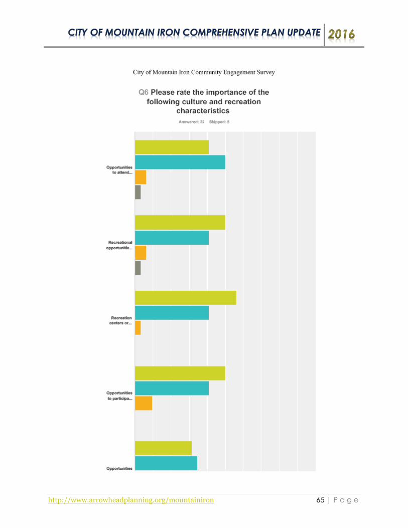
http://www.arrowheadplanning.org/mountainiron 65 | P a g e

http://www.arrowheadplanning.org/mountainiron 66 | P a g e

http://www.arrowheadplanning.org/mountainiron 67 | P a g e

http://www.arrowheadplanning.org/mountainiron 68 | P a g e

http://www.arrowheadplanning.org/mountainiron 69 | P a g e

http://www.arrowheadplanning.org/mountainiron 70 | P a g e

http://www.arrowheadplanning.org/mountainiron 71 | P a g e

http://www.arrowheadplanning.org/mountainiron 72 | P a g e
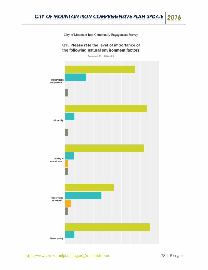
http://www.arrowheadplanning.org/mountainiron 73 | P a g e

http://www.arrowheadplanning.org/mountainiron 74 | P a g e

http://www.arrowheadplanning.org/mountainiron 75 | P a g e

http://www.arrowheadplanning.org/mountainiron 76 | P a g e

http://www.arrowheadplanning.org/mountainiron 77 | P a g e

http://www.arrowheadplanning.org/mountainiron 78 | P a g e

http://www.arrowheadplanning.org/mountainiron 79 | P a g e
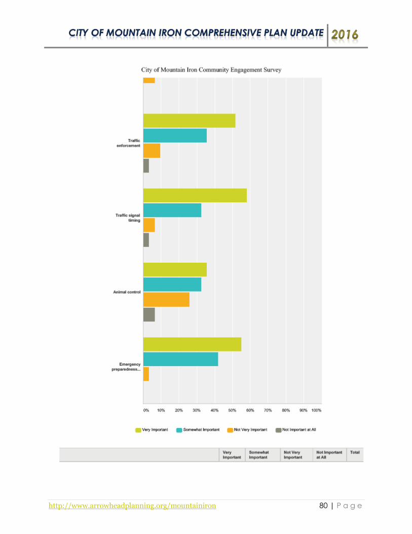
http://www.arrowheadplanning.org/mountainiron 80 | P a g e

http://www.arrowheadplanning.org/mountainiron 81 | P a g e
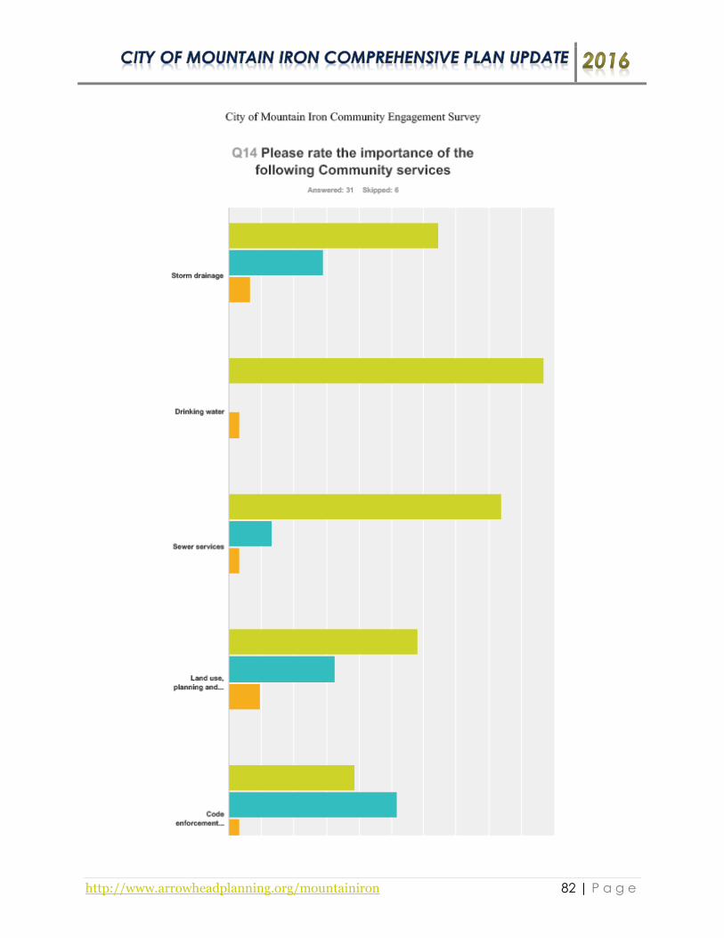
http://www.arrowheadplanning.org/mountainiron 82 | P a g e

http://www.arrowheadplanning.org/mountainiron 83 | P a g e

http://www.arrowheadplanning.org/mountainiron 84 | P a g e

http://www.arrowheadplanning.org/mountainiron 85 | P a g e

http://www.arrowheadplanning.org/mountainiron 86 | P a g e

http://www.arrowheadplanning.org/mountainiron 87 | P a g e

http://www.arrowheadplanning.org/mountainiron 88 | P a g e

http://www.arrowheadplanning.org/mountainiron 89 | P a g e
Appendix D: Meeting Summaries
City of Mountain Iron Comprehensive Plan Update Kick-Off Meeting
January 13th, 2016 – 6:00 p.m. Mountain Iron City Hall/Community Center
Introduction/Presentation
The Kick-Off meeting began at 6:00 p.m. in the Mountain Iron City Hall/Community Center, with Jarrett Valdez
and Justin Otsea from the Arrowhead Regional Development Commission (ARDC) welcoming the Steering
Committee members in attendance. Valdez proceeded to inform the Steering Committee about the comprehensive
planning process such as the scope of work, tentative timeline, as well as desired outcomes and effects of the project.
Additionally, Valdez provided an overview of some demographic information and a summary of the Sidewalk
Conditions Map and the Mining Features Map. The Steering Committee members expressed that not all of the
sidewalk data was collected for the City. The Old Town neighborhood of the City was only depicted with the New
Town neighborhood sidewalk conditions being left out. Valdez will provide a link to ARDC’s interactive map (click
here) to review the Mountain Iron’s sidewalk conditions.
Justin Otsea also informed the Steering Committee that Mountain Iron was a selected City to take part in the
‘Health in Comprehensive Planning’ project which is funded by the Center of Prevention at Blue Cross and Blue
Shield of Minnesota. He explained that the purpose of this pilot project is to learn more about how people access
food and assist communities with incorporating food access and health within a local comprehensive planning
process. Otsea informed the Committee that a new Statewide Health Improvement Program (SHIP) Coordinator,
that was recently hired and based out of Virginia, will help contribute their health expertise to this project. ARDC
will follow-up with the new SHIP Coordinator as it gets closer to the Public Visioning Session.
Survey Discussion
Near the end of the presentation, discussion centered on how to distribute the community survey as well as planning
for the public visioning session. The meeting participants were requested to look through the sample survey and
provide any necessary feedback regarding changes, etc… It was suggested that the community survey should be
announced to the public at the Visioning Session in February. An idea was mentioned that a survey announcement
could be within the City’s utility bill which would include an online link. February’s utility bill will be mailed out to
residents on the 12th or 13th. Also, paper surveys will be placed in various buildings throughout the City such as the
Library, City Hall/Community Center, Senior Center, and other locations.
The Steering Committee was asked if there were any past planning efforts that ARDC is not aware of that should be
reviewed. It was suggested to review the City’s 2009 EDA Economic Plan. Also, Valdez and Otsea were informed
that Mountain Iron is in the process of becoming a Minnesota Greenstep City, which should be mentioned in the
plan update.
Next Steps
ARDC will summarize the meeting, email it to those who attended, and also post it to the project’s website. The
Public Visioning Session is scheduled for February 10th, 2016 at 6 p.m. in the Community Center. ARDC will
create a flyer and ad to be released, announcing the Visioning Session. The Steering Committee will strategize ways
to promote it and encourage residents to attend. Potential outlets include, the public library, announcing the event
at various board meetings; public access television; community sporting events; announcement at the next City
Council meeting among others.
Anyone not able to attend/interested in the planning project is encouraged to contact Jarrett Valdez at ARDC at
218-529-7513 or [email protected] or visit www.ArrowheadPlanning.org/MountainIron for more information as well
as an opportunity to provide public comment into the vision of the City.

http://www.arrowheadplanning.org/mountainiron 90 | P a g e
Insert Visioning Flyer

http://www.arrowheadplanning.org/mountainiron 91 | P a g e
City of Mountain Iron – Comprehensive Plan Public Visioning Session Meeting Summary
February 10th, 2016 – 6:00 p.m. Mountain Iron City Hall/Community Center
Summary The City of Mountain Iron Visioning Session began at 6:00 p.m. in the Community Center/City Hall.
Jarrett Valdez from the Arrowhead Regional Development Commission (ARDC) welcomed eleven meeting participants in attendance and provided an overview of the Comprehensive Plan update planning process. A comprehensive plan is a document which sets communities priorities and
identifies goals and strategies in an array of fields including housing, transportation, parks and recreation, land use, and other areas and can provide guidance to local decision makers when making community investment decisions. The City of Mountain Iron last completed a
comprehensive plan in 2008. The project will involve two phases (Public Visioning and Plan Development) which consist of six meetings total.
Valdez continued by summarizing the goals of the evening which included using public engagement exercises to gather input/data identifying community/health assets and threats, vision statement ideas, and other community resources. In addition to the documented planning process, drafts of
the plan and other reference materials pertaining to the project can be found at http://www.arrowheadplanning.org/mountainiron.
Additionally, ARDC has initiated a pilot project to learn more about how people access food and assist communities with incorporating food access and health within local comprehensive planning process. Annie Harala from Community Health Board provided information to the meeting
participants such as factors that influence health and well-being; social and economic factors that should be addressed to achieve health equity; the need for changing laws, rules, policy or ordinances
to support healthier outcomes. Harala then asked everyone in the room what were some factors that
enable and hinder good health within the community. She also inquired the meeting participant’s wants and desires throughout the City that would enable good health. Harala also introduced Raymond Jobe, a newly hired Statewide Health Improvement Program (SHIP) coordinator who will
be based out of Virginia and be able to coordinate with the City of Mountain Iron on implementing projects identified in the process.
Asset & Threat Exercise The meeting participants were provided handouts and a map and directions for the Asset and Threat Mapping Exercise. Jarrett Valdez provided instructions for the asset exercise, which resulted in
identified physical, intangible and future assets within the City. The next step of the exercise was to identify barriers and issues facing the community currently and potentially in the future. Valdez facilitated the conversation and Justin Otsea recorded the results. Results of the exercise have been summarized on the following list:
Physical Assets
Community Center Carnegie Library
Jeremy Carpenter Community Park Locomotive Park South Grove Recreation Complex Numerous neighborhoods West Virginia Park Biking/walking trail West Two Rivers Campground Facility Historic downtown Plaza 53 (mall) Movie theatre Fire Department Minntac US Steel
YMCA Walmart
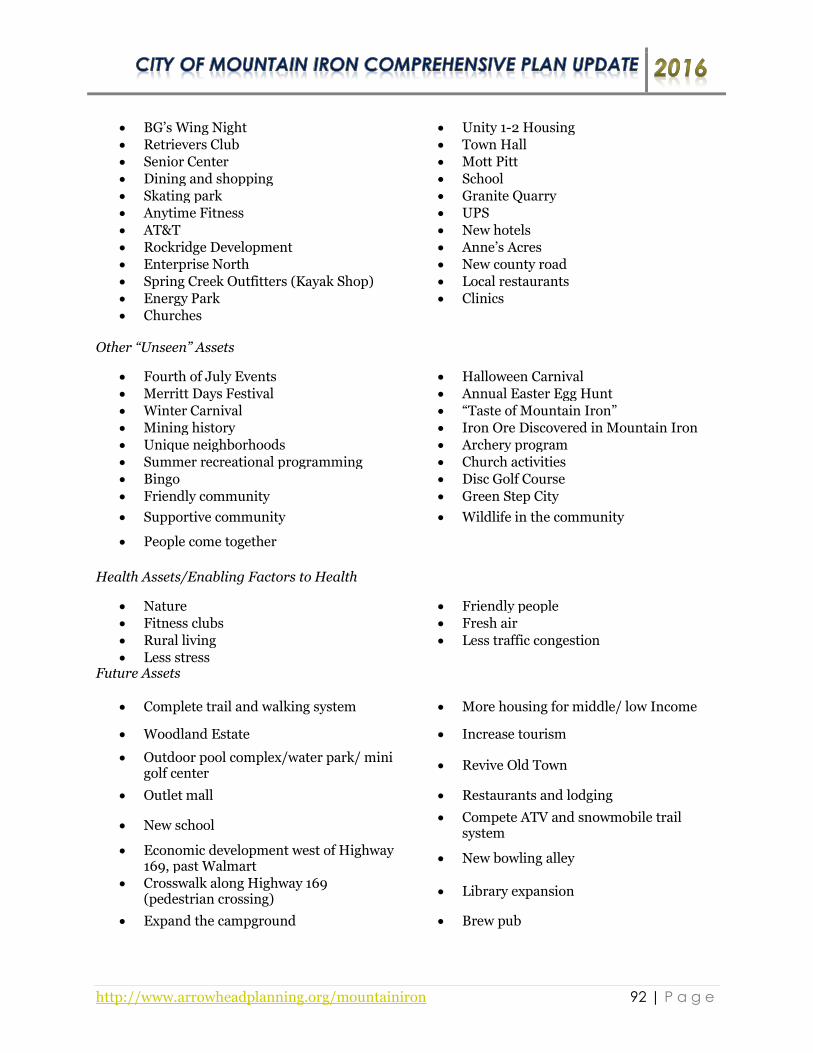
http://www.arrowheadplanning.org/mountainiron 92 | P a g e
BG’s Wing Night Unity 1-2 Housing Retrievers Club Town Hall Senior Center Mott Pitt Dining and shopping School Skating park Granite Quarry Anytime Fitness UPS
AT&T New hotels Rockridge Development Anne’s Acres Enterprise North New county road Spring Creek Outfitters (Kayak Shop) Local restaurants Energy Park Clinics Churches
Other “Unseen” Assets
Fourth of July Events Halloween Carnival Merritt Days Festival Annual Easter Egg Hunt Winter Carnival “Taste of Mountain Iron” Mining history Iron Ore Discovered in Mountain Iron Unique neighborhoods Archery program Summer recreational programming Church activities Bingo Disc Golf Course
Friendly community Green Step City
Supportive community Wildlife in the community
People come together
Health Assets/Enabling Factors to Health
Nature Friendly people Fitness clubs Fresh air
Rural living Less traffic congestion Less stress
Future Assets
Complete trail and walking system More housing for middle/ low Income
Woodland Estate Increase tourism
Outdoor pool complex/water park/ mini golf center
Revive Old Town
Outlet mall Restaurants and lodging
New school Compete ATV and snowmobile trail
system
Economic development west of Highway 169, past Walmart
New bowling alley
Crosswalk along Highway 169 (pedestrian crossing)
Library expansion
Expand the campground Brew pub

http://www.arrowheadplanning.org/mountainiron 93 | P a g e
Future Health Assets/Wants & Desires
Community gardens Finishing trail connection (SRTS) Physical Concerns/Threats/Issues
Disconnect between north and south of Highway 169
Increase in crime
Mining down turn Deterioration of Old Town Alcohol and drugs Deteriorating infrastructure Increase of hazardous materials via
highways and railroads Less medical services
Threat of hospital closing Existing housing stock
Land ownership Mining blasts have increased over the
last 5 years Other “Unseen” Concerns/Threats/Issues
Lack of volunteers for Fire Department and Merritt Days
Looking for leadership (engaging all generations)
Increase of crime Downturn of the mines Community attitudes (perpetual
negativity) Not enough activities for seniors
Lack of diversity Young children activities/programming Health Concerns/Threats/Issues/Hindering Factors
Pollution and blasts from Minntac Acid rain
Water pollution Long harsh winters Access to medical Chemical use Hazardous materials Availability and expense of fresh foods
Future Concerns/Threats/Issues
US Steel/Minntac expansion Lack of diversity
Sweet Water Energy (potential business coming to the Community)
Education (potential consolidation issues)
Overall community needs (opportunity for shared services) i.e. can local Fire Department afford a new truck, expand ambulance service, etc… but can a regional approach address this?
Virginia having a fire hall on Highway 53 to serve greater region (opportunity for DOT building?)
Large scale event (disaster/terrorism) emergency services
Public land availability
Visioning Statement Nugget Identification Exercise
The next exercise of the meeting asked attendees to develop visioning statement “nuggets” by finishing the sentence, “In the future, the City of Mountain Iron is….” The goal of the exercise is to
integrate the vision for the community, form the meeting attendees into an overarching vision for the

http://www.arrowheadplanning.org/mountainiron 94 | P a g e
future of the City to be discussed at the next meeting. Results of the exercise have been summarized on the following list:
Visioning Statement Nuggets
A well connected community Garbage pick-up Worth the trip An area for year-round guests Envy of the range and the city to live in Medical center of the area Able to provide a healthy living
environment for its citizens Is and will be an accessible community
Inviting new businesses to join us Filled with hope
Greenest City in Minnesota Walkable/bikeable community
supported by safe infrastructure
Community that cares and a place to call home
An area where people want to live in
Leader in economic development (and industrial environment)
A healthy, inviting community
The place to live, shop, to eat Planning and improving trails for
walking and biking
Growing and exciting community Trying to improve the aesthetics of the
City
Full of hometown pride A local fresh food/farmers market hub
for northern St. Louis County
Cooperation and teamwork in all areas Has more recreational opportunities
A City that people love Commercial center Education center Industrial leader
Population center Leader in economic development Tourist attraction Lowest taxes on the Range Preserving past history Year-round recreation destination
A happy place A place I am proud to call home A place of diversity A place with a great business climate
A healthy place
Next Steps ARDC will summarize the meeting and email to those who attended along with posting the
information to the project’s website. ARDC will also develop a categorized list of assets/issues and background information (demographic analysis, community survey data, relevant plans, etc…) for the next meeting. The next meeting is yet to be determined. Please look at the project website for future meeting announcements or contact ARDC.
Anyone not able to attend or is interested in the planning project is encouraged to contact Jarrett
Valdez of ARDC at 218-529-7513 or [email protected] for more information as well as an opportunity to provide public comment into the vision of the City.

http://www.arrowheadplanning.org/mountainiron 95 | P a g e
City of Mountain Iron – Comprehensive Plan Update Past Planning and Public Visioning Meeting Review
April 27, 2016 – 6:00 p.m. Mountain Iron Community Center /City Hall
Survey and Demographic Summary
Survey
The meeting began at 6:00 p.m. in the Mountain Iron Community Center with Jarrett Valdez and Justin Otsea,
from the Arrowhead Regional Development Commission (ARDC) welcoming the Planning Committee
members in attendance and providing a review of the community survey results. At the time of the meeting,
only 14 surveys were completed between February and April. The review included community attitudes and
importance of qualities such as: access to markets, farms, and affordable food; sense of community and
participation in community issues; availability of paths, trails and sidewalks; business and industry; and etc.
Survey respondents identified current and future issues that the City may face as well. It was suggested by
Otsea to the Committee, that the survey remain open for an additional period of time so more results can be
gathered. It was also suggested that perhaps the survey could be promoted and advertised again to garner more
inquiries. Valdez will email Craig the survey so that hard copies can be printed out and placed at designated
locations throughout the City.
Demographic Summary
Valdez proceeded to provide the Planning Committee members with an overview of the City’s demographics.
Key demographic data such as population, age/race, housing, and industry/income were gathered from the U.S.
Census Bureau and the American Community Survey (ACS). The Committee members requested that ARDC
follow-up to include various demographic data of other nearby cities in comparison to Mountain Iron. It was
also requested to see where mining ranks in comparison to other industries within the City. ARDC will
research and provide those results to the Planning Committee at the next meeting.
Vision Statement Development
Prior to the meeting ARDC crafted three vision statements which were developed from an exercise facilitated
from the Public Visioning Session. Valdez read the draft statements as followed:
1. In the future, the City of Mountain Iron is a growing and exciting community focused on providing a
healthy living environment for its visitors and residents, while becoming a leader in economic
development with many recreational opportunities. It will continue to be one of the greenest cities in
Minnesota, a year-round destination for tourists and a place that residents are proud to call home.
2. In the future, the City of Mountain Iron is a well-connected community with a great business climate,
providing opportunities for visitors and residents live, shop, and eat. It is a safe walkable/bikeable,
healthy and inviting community that is supported by a wide variety of recreational activities.
Mountain Iron will continue to be a city in which tourists will want to visit and where residents want
to live at.
3. In the future, the City of Mountain Iron is a happy and healthy community with a great business
climate, access to fresh local food, with an abundance of recreational opportunities. It is a growing and
exciting community dedicated to cooperation and teamwork, and predicated to becoming a desirable
city for tourists to visit and a place that residents are proud to call home.
Discussion soon followed after reading off the vision statements. The Planning Committee members suggested
that the vision statement should include some language of business and economics incorporated into the final

http://www.arrowheadplanning.org/mountainiron 96 | P a g e
version of it. ARDC will make changes necessary to form a single drafted vision statement and seek approval
from the Planning Committee for finalization.
Past Planning Efforts
Valdez provided the Committee with a handout of previous planning efforts that have taken place in Mountain
Iron within the last eight years. Recommendations and action strategies were reviewed from the 2008
Comprehensive Plan, 2010 Mountain Iron Bicycle Pedestrian Plan, and the 2012 Mountain Iron Strategic Plan
Update as a way to gauge which projects have and have not been implemented since each plan was completed.
During the review the Committee identified numerous projects that were completed from each plan. Also,
there were many projects identified in those plans that still haven’t been implemented. Those projects were
requested to be carried over to the Comprehensive Plan Update.
Categorized Assets, Issues and Goal Identification
Valdez reviewed the categorized assets, issues, and goals for each plan component required by IRRRB to
address within the plan. The Planning Committee provided comments regarding the results that were recorded
from the Public Visioning Session. Comments included:
South Forest Grove Housing is an opportunity and future asset with available lots
Having a fire hall in Virginia on Highway 53 to serve greater region would be a desire and asset to
serve the greater region instead of an issue, barrier, and threat
The potential business of Sweet Water Energy coming to Mountain could be considered an
opportunity due to the fact it would provide jobs and other benefits but also could be a potential
concern/threat due to the to the uncertainty of its impact
It was questioned on how big of a concern that water pollution is within the community and how real
of a concern or threat is acid rain is too
There is a lot happening for young children’s activities/programming and that it shouldn’t be
categorized as an issue or threat
Volunteerism in general should be included as threats/issues instead of identifying that there is a lack
of volunteers just for Merritt Days
It was suggested that alcohol/drugs and increase of crime should be deleted as a community health
issue and threat
A large scale event such as disaster/terrorism is not much of an issue or threat in Mountain Iron.
An old state garage on Highway 53 may become vacant which can be considered as an opportunity
Next Steps
ARDC will summarize the meeting and email to those who attended along with posting the information to the
project’s website. ARDC will also follow-up on the Committee’s demographic requests as well as create a
finalized vision statement for review. Additionally, the lists of threats will be studied and analyzed determine
preliminary course of action that the City can take to address individually. Suggestions and recommendation
ideas will be drafted for actions that create desired new assets. The meeting will be a review of the
recommended ideas for review and feedback. Please look at the project website for future meeting date
announcements.
Anyone not able to attend/interested in the planning project is encouraged to contact Jarrett Valdez at ARDC
at 218-529-7513 or [email protected] for more information as well as an opportunity to provide public
comment into the vision of the City.

http://www.arrowheadplanning.org/mountainiron 97 | P a g e
City of Mountain Iron Comprehensive Plan Update
Initial Recommendation Ideas Meeting Summary – Part I July 11, 2016 – 6:00 p.m. – Mountain Iron Community Center/City Hall
Demographic Update
The meeting began at 6:00 p.m. in the Mountain Iron Community Center/City Hall, with Jarrett Valdez
from the Arrowhead Regional Development Commission (ARDC) welcoming the Planning Committee
members in attendance and providing a brief review of the April 28th meeting. At the previous meeting,
the Planning Committee requested that ARDC follow-up with various demographic information of
Mountain Iron in comparison to other nearby cities. Valdez shared those results with the committee
members in the following tables below:
Community Population
(US Census)Community
Median Age
(US Census)
Biwabik 969 State of Minnesota 37.4
Buhl 1,000 Eveleth 39.6
Aurora 1,682 Chisholm 40.7
Gilbert 1,799 St. Louis County 40.8
Hoyt Lakes 2,017 Buhl 42
Mountain Iron 2,869 Gilbert 44.7
Eveleth 3,718 Virginia 44.9
Chisholm 4,976 Mountain Iron 45.4Virginia 8,712 Biwabik 46.8
St. Louis County 200,226 Aurora 48.4
State of Minnesota 5,303,925 Hoyt Lakes 49.3
Community Unemployment Rate (2014 ACS) Community Median Household Income
(2014 ACS)
Mountain Iron 3.6% Biwabik $32,432
Aurora 4.2% Virginia $33,143
Buhl 4.5% Eveleth $37,091
Gilbert 4.5% Aurora $41,185
State of Minnesota 4.5% Buhl $41,250
St. Louis County 4.9% Gilbert $44,821
Chisholm 5.3% St. Louis County $47,138
Hoyt Lakes 5.7% Hoyt Lakes $49,545
Virginia 7.0% Mountain Iron $49,570Eveleth 9.1% Chisholm $58,333
Biwabik 9.4% State of Minnesota $60,828
Community Total Housing Units
(US Census)
Total Occupied Housing Units
(US Census)Community
Median Family Income
(2014 ACS)
Buhl 496 430 (86.7%) Eveleth $42,217
Biwabik 543 469 (86.4%) Virginia $47,318
Aurora 877 777 (87.6) Aurora $49,271
Gilbert 937 835 (89.1%) Buhl $51,429
Hoyt Lakes 1,016 885 (87.1) Gilbert $52,750
Mountain Iron 1,442 1,336 (92.6%) Biwabik $53,938
Eveleth 1,942 1,682 (86.6%) Hoyt Lakes $58,214
Chisholm 2,524 2,256 (89.4%) Chisholm $58,333
Virginia 4,738 4,242 (89.5%) St. Louis County $64,088
St. Louis County 103,058 84,783 (82.3%) State of Minnesota $76,190
State of Minnesota 2,347,201 2,087,227 (88.9%) Mountain Iron $79,345
Mountain Iron Demographics Update

http://www.arrowheadplanning.org/mountainiron 98 | P a g e
Mountain Iron employed population 16 years and over: 1,411 (100%) (2014 American Community Survey)
Industry Total Number of
Employees Percentage
Educational services, and health care and social assistance 350 24.8%
Retail Trade 158 11.2%
Finance and insurance, and real estate and rental and leasing 142 10.1%
Transportation and warehousing, and utilities 129 9.1%
Manufacturing 116 8.2%
Arts, entertainment, and recreation, and accommodation and food services
102 7.2%
Agriculture, forestry, fishing, and hunting, and mining 96 6.8%
Professional, scientific, and management, and administrative and waste management services
93 6.6%
Construction 75 5.3%
Public administration 57 4.0%
Other services, except public administration 53 3.8%
Wholesale Trade 40 2.8%
Information 0 0.0%
Community Survey Update
Valdez informed the Planning Committee that since the April meeting, the amount of survey respondents
more than doubled. Currently there are a total of 36 surveys that have completed between the months of
February and July. Generally, the survey respondents felt that qualities such as educational opportunities;
place to live, work, retire, and raise children; availability of trails and sidewalks; and etc. was somewhat to
very important them. Valdez also shared survey comments with the Planning Committee which consisted
of desires to maintain and repair roads within the City, having blight enforcement, having more biking
and walking paths, and development of a Farmers Market to sell local grown products. The Planning
Committee members made comments in regards to participation from the City’s residents. There was
concern from a few members that the survey wasn’t promoted or advertised to its potential due to the low
turnout of respondents. However, it was explained that the survey was hosted through multiple platforms
and locations within the City.
Vision Statement Finalization
At the April 28th meeting, three drafted vision statements were presented to the Planning Committee
members. At that meeting, the committee suggested that the vision statement should include some
language about attracting and retaining businesses as well as combining individual elements of each vision
statement into a singular one. As a result, a single draft vision statement that was presented at the July
11th meeting read as followed:
“In the future, the City of Mountain Iron is a growing and exciting community with a great business climate;
providing opportunities for visitors and residents to live, work, shop, and eat. It is a safe, walkable/bikeable,
healthy and inviting community that is supported by a wide variety of recreational activities. Mountain Iron will
continue to be a city in which tourists will want to visit and where residents want to live at.”

http://www.arrowheadplanning.org/mountainiron 99 | P a g e
The Planning Committee members generally liked the vision statement but suggested adding “well
connected” and edit the final sentence to read: “Mountain Iron will continue to be a city in which
tourists will want to visit and where residents are proud to call home”, to ultimately finalize the vision
statement and to be declared as:
“In the future, the City of Mountain Iron is a growing, well connected and exciting community with a great
business climate; providing opportunities for visitors and residents to live, work, shop, and eat. It is a safe,
walkable/bikeable, healthy and inviting community that is supported by a wide variety of recreational activities.
Mountain Iron will continue to be a city in which tourists will want to visit and where residents are proud to call
home.”
Draft Goal & Recommendation Ideas
Valdez provided the Planning Committee recommendation ideas that the group would work off of for the
remainder of the meeting. About half of the required planning components were addressed with goal and
recommendation ideas. Much discussion ensued in addition to revisions made to the goal and
recommendation ideas that were covered.
Housing
Valdez read the housing goal and recommendation ideas to the Planning Committee. The drafted goal
statement read: The City of Mountain Iron will strive to provide housing that offers a selection of
affordable and sustainable options that include varying lot sizes, with rental and ownership opportunities
for residents of all ages; creating equitable housing option with access to facilities that can contribute to a
healthy lifestyle. There were a few recommendation ideas that were carried over from past plans that
weren’t implemented as well as some additional ones. The recommendation ideas referred to addressing
blight, home maintenance and redevelopment of Old Town.
The Planning Committee discussed on whether the focus on Old Town should be reworded to encompass
the entire City, since redevelopment of Old Town has been rather long and difficult for the past number
of years. It was stated that the goal for Old Town is not to draw business but to improve it as a residential
neighborhood. As a result, it was requested that recommendation H.3 (Develop commercial opportunities in
Old Town for provision of local services to local residents) be deleted. It was suggested to replace specific
“Old Town” language with “entire City”. The Planning Committee suggested including language about
reviewing and updating the City’s blight ordinance.
Transportation
Valdez read the drafted transportation goal which included: The City of Mountain Iron will provide a
safe, clean transportation system with opportunities for various modes of transportation (auto, bike,
pedestrian, etc.) which connect to both local and regional destinations; creating a system that enables safe
and healthy travel options and promoting equity for all socioeconomic backgrounds of Mountain Iron’s
citizens. Seven recommendations were reviewed with the Planning Committee that pertained to
participating in planning processes with MnDOT and St. Louis County in regards to improvements to
their roadways; connecting and filling in gaps to the existing trail and sidewalk system; supporting public
transit opportunities; as well as creating and implementing a Living Streets Policy.

http://www.arrowheadplanning.org/mountainiron 100 | P a g e
The Committee discussed that there is a desire for a sidewalk along the new County Road 102, between
Nichols Avenue and Walmart and that it should be included in the Plan. It was also expressed that the
City would like to work with St. Louis County as it relates to the County’s recently passed ATV
Ordinance. The County’s ordinance now allows ATV use on their public roads to allow connections to
area trails. It was mentioned by the Committee that the City should examine their roads and designate
city street routes that would connect to those county roads. This would strengthen connectivity since
there aren’t any authorized connections to the county roads.
There was expressed concern and opportunity for the intersection of County Road 7 and Unity Drive.
The Committee suggested that an additional recommendation idea should include language of monitoring
traffic flow, turning movements, and pedestrian traffic at the intersection.
Utilities and Community Facilities
The draft goal statement and five recommendation ideas were reviewed with the Planning Committee.
The recommendation ideas pertained to prioritizing City and utility/infrastructure improvements; creating
a Capital Improvement Program (CIP); incorporating recommendations from the 2013 St. Louis County
Hazard Mitigation Plan; and also explore consolidating services and costs. The Planning Committee
generally had no significant changes to the goals and recommendations. There was discussion about what
should be done concerning the soon to be vacant high school building in Old Town. The Committee
requested that it should be identified and included in the plan as there will need to be major decisions
over what to do with the building.
Economic Development
The economic development goal statement and seven recommendation ideas were read to the Planning
Committee for their review. The recommendation ideas included language suggesting the development of
Highway 169 as commercial corridor; plan for new tourism and recreation resource opportunities; support
of existing businesses; improved EDA cooperation with the Planning Commission; and continue
awareness and communication of community events and activities. As stated in the transportation
section, the Committee wanted the County Road 7 and Unity Drive intersection to be monitored in
regards to traffic flow of vehicles and pedestrians, but also for business opportunities.
Next Steps
ARDC will summarize the meeting and email to those who attended with posting to the project’s website.
ARDC will also make necessary edits, corrections, and additions to the planning chapter’s goal statements
and recommendation ideas covered for the night. The next meeting will cover the remaining chapters
(Mining, Natural, Agricultural, and Cultural Resources; Recreation, Parks, Open Space, Cultural Arts; Land
Use; Intergovernmental Cooperation; and Implementation) with the Planning Committee for their review and
feedback. Please look at the project website for future meeting date announcements. Anyone not able to
attend and/or interested in the planning project is encouraged to contact Jarrett Valdez at ARDC at 218-
529-7513 or [email protected] for more information as well as an opportunity to provide public comment
in the vision of the City.
http://www.arrowheadplanning.org/mountainiron 101 | P a g e
Insert Public Review Flyer
http://www.arrowheadplanning.org/mountainiron 102 | P a g e
Mountain Iron Comprehensive Plan Update 2016 Public Hearing Meeting Summary
October 27, 2016 – 6:00 p.m. Mountain Iron City Hall/Community Center
Welcome and Project Overview The public hearing began at 6:00 p.m. in the Mountain Iron City Hall/Community Center with Jarrett
Valdez and Justin Otsea from the Arrowhead Regional Development Commission (ARDC) welcoming
the Planning Committee members and the public in attendance. Valdez reviewed and highlighted
information regarding what is a Comprehensive Plan, the required chapters (land use, transportation,
housing, etc.), and the project’s scope of work which includes the piloted health component that ARDC
initiated. The finalized Vision Statement was read as followed:
“In the future, the City of Mountain Iron is growing, well connected and excited community with
a great business climate; providing opportunities for visitors and residents to live work, shop, and
eat. It is a safe walkable/bikeable, healthy and inviting community that is supported by a wide
variety of recreational activities. Mountain Iron will continue to be a city in which tourists will
want visit and where residents are proud to call home.”
Draft Goal and Recommendation Review Valdez proceeded to review each planning chapter’s goal, recommendations, and action steps. The
meeting attendees were provided the opportunity to comment on each of the following items:
Housing
Goal: The City of Mountain Iron will strive to provide housing that offers a selection of affordable and
sustainable options that include varying lot sizes, with rental and ownership opportunities for residents of
all ages; creating equitable housing options with access to facilities that can contribute to a healthy
lifestyle.
Recommendations:
H 1: Address the elimination of blighted or problematic structures.
o H 1.1: Inventory properties throughout the City that are considered as blight or
problematic (beyond city scope of restorative efforts) and enforce the City’s blight
ordinance.
o H 1.2: Research and apply for IRRRB Commercial Redevelopment and/or Residential
Redevelopment grants as appropriate (https://mn.gov/irrrb/grant-resources/community-
programs.jsp). If blighted properties and historic structures, the Minnesota Historic
Society’s funding may be applicable for restoration efforts.
o H 1.3: Review and update the City’s existing blight ordinance every 6-12 months.
H 2: Maintain and improve the quality of safe and affordable housing throughout the
neighborhoods in Mountain Iron.
o H 2.1: Promote rehab and preservation of public and subsidized housing stock. This
provides stability to lower-income families by ensuring their access to quality and safe,
affordable housing.

http://www.arrowheadplanning.org/mountainiron 103 | P a g e
o H 2.2: Investigate and pursue development of new senior-friendly housing opportunities
throughout the City.
o H 2.3: Conduct a housing survey of the community to determine current numbers and
demographics of residents who own their home or rent in Mountain Iron.
H 3: Promote maintenance of the existing housing stock in Mountain Iron.
o H 3.1: Advertise existing loan/grant programs for homeowner improvements through the
use of social media (and local newsletter), the website, or other means as a way to
promote additional improvements and celebrate successes by other homeowners
throughout the community.
o H 3.2: Collaborate with existing organizations/grant programs to create incentives for
home maintenance.
Potential resources include: Community Development Block Grant, Arrowhead
Economic Opportunity Agency (AEOA) Housing Department, St. Louis County
Housing and Redevelopment Authority, and others for a variety of improvements
including home maintenance, energy efficiency, exterior improvements, and
others.
H 4: Maintain the existing character of established neighborhoods.
o H 4.1: Ensure that new commercial and industrial development is buffered from
residential areas and will minimally impact commercial/industrial traffic in Mountain
Iron’s residential neighborhoods.
H 5: Explore the feasibility of creating and annually reviewing a ‘Housing Indicator Report’
which utilizes annual statistics regarding housing to provide a snapshot of where the community is
currently, and indicators of trends moving forward to help spur private sector development and
new housing.
o H 5.1: Components of a ‘Housing Indicators Report’ can include: demographics (past
and projected); employment/labor force trends; home ownership trends; rental indicators
(survey). The Survey should address:
Rental rates
Vacancy rates
Derive: average rent (# of bedrooms/utilities paid vs. not paid)
Housing production (*amount and costs of sales/*foreclosures)
Number of building permits issued (new builds, additions, plats approved)
Affordability analysis
Annual income necessary to afford particular rent/buy a dwelling
% of income designated to take care of housing costs
H 6: Research and consider adopting housing development and/or subdivision incentives to
encourage design for future residential units and lots that encompass lifestyles for users of all ages
and abilities (including vacation and short-term housing), as well as ‘Age in Place principles’.
Aging in Place is a tool designed to help local governments plan and prepare for their aging
populations (http://www.aarp.org/content/dam/aarp/livable-communities/plan/planning/aging-in-
place-a-toolkit-for-local-governments-aarp.pdf).
o H 6.1: Design elements may include: development of smaller, affordable housing units in
compact multi-house developments or allowing accessory dwelling units, supported by
facilities (commercial, pharmacy’s, etc.) accessible by walking/biking or transit.

http://www.arrowheadplanning.org/mountainiron 104 | P a g e
Public Comments: There were no comments made regarding the Housing recommendation section of the plan.
Transportation
Goal: The City of Mountain Iron will provide a safe, clean transportation system with opportunities for
various modes of transportation (auto, bike, pedestrian, etc.) which connect to both local and regional
destinations; creating a system that enables safe and healthy travel options and promoting equity for all
socioeconomic backgrounds of Mountain Iron’s citizens.
Recommendations:
T 1: Participate in corridor and MnDOT District 1 planning processes in order to lobby for
continued maintenance and improvements to Trunk Highways 169 and 53.
T 2: Participate in the St. Louis County 5-year road and transportation planning process.
T 3: Support the Mesabi Trail and regional bicycle connections projects.
T 4: Support and work to complete the City Bike Connections Route. There is a designated and
signed route between access points, which goes through the older section of the City. Much of
residential Mountain Iron is situated south of Highway 169 and could use better connections to
the Mesabi Trail rather than using narrow, busy roadways.
T 5: Connect existing and planned community destinations by expanding and filling gaps in the
existing sidewalk and trail system.
o T 5.1: Construct a 10’ wide paved trail running north-south along the east side of the
South Grove neighborhood.
o T 5.2: Construct a 10’ wide paved trail through the City’s ball fields near the Mud Lake
Road and CR 102 intersection.
o T 5.3: Construct a 10’ wide paved trail connecting the Mesabi Trail to the Rock Ridge
Retail Center.
o T 5.4: Complete sidewalk along 23rd Ave W. on the south end of the West Virginia
neighborhood of Mountain Iron.
o T 5.5: Construct a sidewalk along the new County Road 102 from Nichols Avenue to
Walmart.
T 6: Collaborate with St. Louis County to designate potential ATV routes within the City to
connect to St. Louis County roads that allow ATV operation.
T 7: Monitor traffic flow, pedestrian movements, safety considerations and potential business
opportunities at the intersection of Unity Drive and County Road 7.
T 8: Promote and support public transit opportunities such as Arrowhead Transit.
o T 8.1: Review transportation options, specifically for those in wheelchairs and with
limited mobility, and collaborate with potential partners to enhance available services.
T 9: Evaluate creating a Living Streets Policy to provide for sustainable, ADA-compliant, multi-
modal street designs when completing improvement projects. The general nature of a Living
Streets Policy is to enhance biking and walking conditions, improve safety and security of streets,
calm traffic, create livable neighborhoods, and improve stormwater quality and neighborhood
aesthetics.
Public Comments: There were no comments regarding the Transportation recommendation section of the plan.

http://www.arrowheadplanning.org/mountainiron 105 | P a g e
Justin Otsea explained to the public of the fundamentals and provided examples of what Living Streets is.
Utilities and Community Facilities
Goal: The City of Mountain Iron will stay committed towards providing its residents with effective
infrastructure to city structures, water and sanitary systems, recreational facilities, and other public
facilities and services, through a systematic short-range planning process to ensure the health and
equitable transfer of resources to the citizens of Mountain Iron.
Recommendation Ideas:
UC 1: Identify and prioritize all City utility and infrastructure improvements and secure funding
for implementation.
o UC 1.1: Research and apply for IRRRB Development Infrastructure Grant Program and
the St. Louis County Community Development Block Grant as appropriate.
UC 2: Create a Capital Improvement Program (CIP) planning process that annually implements
and reviews priorities to provide adequate infrastructure (including roads, sidewalks,
water/wastewater facilities, etc.) to the community while balancing financial constraints in a
systematic process.
UC 3: Incorporate the Mountain Iron recommendations from the 2013 St. Louis County Hazard
Mitigation Plan (http://www.stlouiscountymn.gov/Portals/0/library/law-n-public-safety/emergency-
operations/hazard-mitigation/St-Louis-County-Hazard-Mitigation-Plan-
2013.pdf?timestamp=1467733265423) into the planning process to reduce potential damage
costs due to natural disasters.
o UC 3.1: Annually address, implement, and monitor projects and mitigation strategies
identified in the 2013 St. Louis County Hazard Mitigation Plan.
o UC 3.2: Include infrastructure and other mitigation improvements into the Capital
Improvement Program (CIP) planning process when addressing annual
maintenance/improvements.
UC 4: Explore opportunities to consolidate services and save costs when possible.
UC 5: Explore permeable alternatives to traditional curb and gutter projects, which can be
incorporated in the development of a ‘Living Streets Policy’. This allows for air and stormwater
filtering through the alternative permeable material to the soil below as opposed to the use
traditional concrete.
UC 6: Address opportunities to redevelop and reinvigorate the vacant Mountain Iron-Buhl High
School building.
UC 7: Explore opportunities for improved internet and Wi-Fi connection.
o UC 7.1: Research the Blandin Foundation’s Community Broadband Program for
potential grant and technical support opportunities. More information about the
Community Broadband Program can be found on the following website:
http://broadband.blandinfoundation.org/.
Public Comment: There were not public comments regarding the Utilities and Community Facilities
recommendation section of the plan.
Economic Development
http://www.arrowheadplanning.org/mountainiron 106 | P a g e
Goal: The City of Mountain Iron will promote and seek partnership opportunities with new and existing
businesses by advocating for manageable growth and retaining an aesthetically pleasing environment while
reducing conflict between residential and commercial uses. Mountain Iron will promote an economic
environment that supports the health of its residents and visitors to the City.
Recommendation Ideas:
ED 1: Continue to develop Trunk Highway 169 as a commercial corridor destination.
o ED 1.1: Map all available land and infrastructure existing or planned along Highway 169
to support new commercial development.
o ED 1.2: Identify and pursue potential commercial opportunities for “big box” retailers to
locate on Highway 169.
o ED 1.3: Secure property and necessary infrastructure to available City-owned retails sites.
o ED 1.4: Evaluate potential for a section of Highway 102 to be used as a frontage road for
development.
ED 2: Strategically identify and plan for new tourism and recreation resource opportunities.
o ED 2.1: Inventory and map potential locations for a new scenic overlook to the mine (i.e.
Energy Park, new dump, across from City garage). As appropriate, hold discussions with
U.S. Steel to request support for creation of a new overlook to the mine with the loss of
Wacootah Overlook.
ED 3: Identify and secure outside funding for tourism-related initiatives.
o ED 3.1: Develop a grant application for IRRRB’s Culture and Tourism Grant to support
planning for an appropriate tourism project.
ED 4: Improve EDA (Economic Development Administration) cooperation with the Planning
Commission.
ED 5: Evaluate and implement an Old Town Revitalization Plan which can include: urban
design elements, storefront changes, public art, wayfinding signage, ongoing programming,
partnerships funding, and other related components.
ED 6: Continue supporting existing businesses and encourage them to participate in local
business organizations, seize opportunities for growth, and foster local talent.
ED 7: Continue the awareness and communication of local community events, activities, and
amenities on a local, regional, and statewide level.
o ED 7.1: Continue to update information on the City’s website, monitor upgrade
possibilities, and explore other information that can enhance site’s effectiveness.
o ED 7.2: Create a formalized process for providing information about recreational
opportunities and community events to the public, via multiple modes of communication
(online, newspaper, tourism organizations, etc.).
ED 8: Work to restore and revitalize the Plaza 53 West area as a prime commercial location for
the community.
Public Comment: There were no comments regarding the Economic Development recommendation section of the
plan.
Mining, Natural, Agricultural, and Cultural Resources

http://www.arrowheadplanning.org/mountainiron 107 | P a g e
Goal: The City of Mountain Iron will utilize and preserve its cultural, historical, and natural resources to
provide a deeper connection of a sense of place to its citizens and travelers in the area while addressing
local agricultural and mining efforts, considering resources that contribute to a sustainable future and
support the health of the City’s environment and people.
Recommendation Ideas:
MNAC 1: It is recommended that the City examine any proposed developments against future
mining potential and how that might impact development.
o MNAC 1.1: Several organizations are involved in the mining industry in Minnesota.
More information about mining can be gathered from the following organizations and
websites:
Laurentian Vision Partnership: http://www.lvpmn.org/. The Laurentian Vision
partnership is an active coalition that provides information about mining on the
Iron Range.
MnDNR, Minerals Division:
http://www.dnr.state.mn.us/lands_minerals/index.html
IRRRB Mining Impact Grant: https://mn.gov/irrrb/grant-resources/mining-
programs.jsp
MNAC 2: It is recommended that a copy of this plan be sent to the MnDNR Minerals Division,
area mining companies and area mineral rights owners. IRRRB and MnDNR can help contact
the appropriate people.
o MNAC 2.1: Mining interests recommend that no new developments occur over the
known iron formation (red area on map). This is because any area within the iron
formation has the potential to be mined in the future, which would displace development.
Some areas of the iron formation are likely to be mined sooner than others, but
for the purposes of long-term planning, the entire formation needs to be
considered.
Interim, easily removed uses could be considered for some portions of the iron
formation.
o MNAC 2.2: It is recommended that new development not occur within one quarter
(1/4) mile of the north edge of the iron formation (shown as light red buffer ). This
buffer is for blasting and other safety reasons.
o MNAC 2.3: It is recommended that new development not occur within one half (1/2)
mile of the south edge of the iron formation (also shown as light red buffer ). This
buffer is for blasting and other safety reasons, but wider to account for the depth of the
iron formation on the south edge.
o MNAC 2.4: It is recommended that new development not occur on or immediately
around iron bearing rock stockpiles (shown in dark red ). These stockpiles have the
significant potential to be processed for iron production.
Interim, easily removed used could be considered for some stockpiles.
o MNAC 2.5: It is recommended that new development not occur on or immediately
around fine tailings basins from natural ore processing (shown in blue with hashes ).
The stockpiles have the significant potential to be processed for iron production.

http://www.arrowheadplanning.org/mountainiron 108 | P a g e
Interim, easily removed used could be considered for some basins.
MNAC 3: Support community-oriented agriculture and the development of community gardens,
farmers market, or Community Supported Agriculture (CSA) drop sites within the City.
o MNAC 3.1: Use public meetings to identify the need and/or potential sites for a
community garden, Farmer’s Market or Community Supported Agriculture (CSA) drop
sites.
o MNAC 3.2: Address and revise land use zoning where necessary to make allowable use.
o MNAC 3.3: Work with local interest group(s) to develop maintenance, distribution, and
use partnership(s) prior to establishing a garden or Community Supported Agriculture
(CSA) drop sites, or Farmer’s Market.
MNAC 4: Encourage the preservation of the City’s history and culture.
o MNAC 4.1: Continue supporting the preservation of the City’s mining history through
the identification, preservation, and displaying of historic places and artifacts.
o MNAC 4.2: Seek federal and state grants and support local, grass roots efforts for historic
preservation and renovation projects.
o MNAC 4.3: Consider developing a “Mountain Iron History Walk” which is a community
history and wellness initiative that encourages knowledge of place-based history by
bringing stories of the past to the streets through the use of interpretive signage that
highlights places and sights of historical significance. See an example of the Proctor
History Walk (https://proctorhistorywalk.org/).
Justin Otsea explained what the Proctor History Walk was and how a similar model could be incorporated with
Mountain Iron.
Public Comments: There were no public comments regarding the Mining, Natural, Agriculture, and Cultural
Resources recommendations section of the plan.
Recreation, Parks, Open Space, Cultural Arts
Goal: The City of Mountain Iron will strive to enhance the recreational and cultural
facilities/opportunities available by utilizing public input, planning proactively, and implementing projects
and programs to provide an array of opportunities to residents and travelers of all ability levels. The City
will provide equitable access to facilities that promote the health and well-being of every member in the
community.
Recommendation Ideas:
RC 1: Continue to support and make improvements to local playground and recreational areas.
RC 2: Evaluate opportunities for Community Supported Agriculture (CSA) activities, which
provide healthy food options available within the community.
o RC 2.1: Provide open space for activities to take place if organized and requested by local
organization(s)/individual(s).
RC 3: Encourage the maintenance and expansion of the recreational trails and parks system
throughout the City
o RC 3.1: Inventory and document the existing condition of City parks and trails.
Examine them for deterioration, maintenance needs, and infrastructure improvements.

http://www.arrowheadplanning.org/mountainiron 109 | P a g e
o RC 3.2: Develop action priorities and cost estimates of improvements.
RC 4: Continue to support the organization of community events, celebrations, and festivals such
as Merritt Days, the Taste of Mountain Iron, the Annual Easter Egg Hunt, etc.
o RC 4.1: Continue to support new and ongoing community events and festivals to provide
residents with community engagement, networking, and volunteering opportunities as a
way to stay engaged with the community.
RC 5: Continue to identify and explore recreational facilities, programs, and opportunities for all
ages and abilities.
RC 6: Support and partner with the community YMCA in regards to programs, possible
expansion, general improvements, and other activities.
Public Comments: There were no public comments made regarding the Recreation, Parks, Open Space, Cultural
Arts section of the plan.
Land Use
Goal: The City of Mountain Iron will utilize policies that promote sustainable land use by activity
assessing future needs and promoting the most effective use of each property while balancing cost efficient
public services. Mountain Iron’s land use policies will be clear, concise and easy to administer,
contributing to the creation and sustenance of an equitable and healthful environment.
Recommendation Ideas:
LU 1: Maintain a modern, up-to-date zoning ordinance, zoning map, official map, and permitting
documents.
o LU 1.1: Update City Zoning Ordinance Code and procedures to include modern
developmental concerns, and streamline administration. Make amendments to the code
as needed in order for alternative energy infrastructure to be implemented.
o LU 1.2: Update existing identified permit, variance, and other application forms to
enhance user friendliness and improve administration.
o LU 1.3: Make zoning ordinance, map, applications, and related materials available online
via City website for citizens and potential developers alike.
LU 2: Update the City’s Sign Ordinance to regulate dynamic signs. (Dynamic signs are signs that
appear to have movement or that appear to change, caused by any method other than physically removing
and replacing the sign or its components, whether the apparent movement or change in display, the sign
structure itself, or any other component of the sign. This includes a rotating, revolving, revolving, moving,
flashing, blinking, or animated display that incorporates rotating panels, LED lights manipulated through
digital input, “digital ink” or any other method or technology that allows the sign face to present a series of
images or displays.)
o LU 2.1: Adopt the following items:
1) Dynamic displays may occupy no more than 35% of the actual copy and graphic
area. The remainder of the sign must not have the capability to have dynamic
displays even if not in use. Only one, contiguous dynamic display area is allowed
on a sign face.
2) A dynamic display may not change or move more often than once every 20
minutes, except one for which changes are necessary to correct hour-and-minute,

http://www.arrowheadplanning.org/mountainiron 110 | P a g e
date, or temperature information. Time, date, or temperature information is
considered on dynamic display and may not be included as a component of any
other dynamic display. A display of time, date, or temperature information must
remain for at least 20 minutes before changing to a different display, but the time,
date, or temperature information itself may change no more than once every
three seconds.
3) The images and messages displayed must be static, and the transition from one
static display to another must be instantaneous without any special effects.
4) The images and messages displayed must be complete in themselves, without
continuation in content to the next image or message or to any other sign.
5) Every line of copy and graphics in dynamic display must be at least seven inches
in height on a road with a speed limit of 25-34 miles per hour, nine inches on a
road with a speed limit of 35-44 miles per hour, 12 inches on a road with a speed
limit of 55 miles per hour or more. If there is insufficient room for copy and
graphics of this size in the area allowed under clause 1 above, then no dynamic
display is allowed.
6) Dynamic displays must be designated and equipped to freeze the device in one
position if a malfunction occurs. The displays must also be equipped with a
means to immediately discontinue the display if it malfunctions, and the sign
owner must immediately stop the dynamic display when notified by the City that
it is not complying with the standards of this ordinance.
7) Dynamic displays must comply with the following brightness standards:
a) No sign may be brighter than is necessary for clear and adequate
visibility.
b) No sign may be of such intensity or brilliance as to impair the vision of a
motor vehicle driver with average eyesight or to otherwise interfere with
the driver’s operation of a motor vehicle.
c) The person owning or controlling the sign must adjust the sign to meet
the brightness standards in accordance with the City’s instructions. The
adjustment must be made immediately upon notice of non-compliance
from the City. The person owning or controlling the sign may appeal the
City’s determination through the following appeal procedure:
o After making the adjustment required by the City, the person
owning or controlling the sign may appeal the City’s
determination by delivering a written appeal to the City Clerk
within 10 days after the City’s non-compliance notice. The
written appeal must include the name of a person unrelated to
the person and business making the appeal, who will serve on the
appeal panel.
o Within five business days after receiving the appeal, the City
must name a person who is not an official or employee of the City
to serve on the appeal panel. Within five business days after the
City names its representative and the two of them must appoint a

http://www.arrowheadplanning.org/mountainiron 111 | P a g e
third member to the panel, who has no relationship to either
party.
o The appeal panel may develop its own rules of procedure, but it
must hold a hearing with five business days after the third
member is appointed. The City and the sign owner must be
given the opportunity to present testimony, and the panel may
hold the hearing, or a portion of it, at the sign location. The
panel must issue its decision on what level of brightness is needed
to meet the brightness standards within five business days after
hearing commences. The decision will be binding on both
parties.
8) All signs installed after adoption of the amendments that will have illumination
by a means other than natural light must be equipped with a mechanism that
automatically adjusts the brightness in response to ambient conditions. These
signs must also be equipped with a means to immediately turn off the display or
lighting if it malfunctions, and the sign owner or operator must immediately turn
off the sign of lighting when notified by the City that it is not comply with the
standards in this section.
9) Dynamic displays existing as of adoption of the amended ordinance must comply
with the operational standards listed above. An existing dynamic display that
does not meet the structural requirements in clause 1 may continue as an allowed
non-conforming use subject to restrictions place upon such uses.
LU 3: Ensure that green space and recreational opportunities are available to the existing and
newly-developed neighborhoods.
LU 4: Ensure buffers are set between commercial/industrial development and existing and future
residential properties in order to preserve neighborhood intrinsic qualities desired by community.
LU 5: Ensure land use practices within the City make the best use of available land while also
ensuring it’s compatibility with current and future surroundings.
o LU 5.1: Work with nearby agencies to ensure land use and developments within the City
are compatible with current and future mining activities.
o LU 5.2: Consider minimal to low impact development (i.e. open space, recreational
trails, etc.) in areas in close proximity to established mining deposits/interest areas.
LU 6: Inventory Parkville properties that may be bought out by U.S. Steel and identify a new
location for the Parkville homes.
Public Comments: There were no public comments regarding the Land Use section of the plan.
Intergovernmental Cooperation
Goal: The City of Mountain Iron will work cooperatively with St. Louis County, neighboring
communities and other public and private entities to provide high quality, cost effective, public services to
residents throughout the community on issues of economic, equitable, social, health, environmental, and
cultural significance.
Recommendation Ideas:

http://www.arrowheadplanning.org/mountainiron 112 | P a g e
IGC 1: Collaborate with neighboring communities to enhance capacity, strengthen regional
relationships, and address consolidation of services when possible.
IGC 2: Collaborate with St. Louis County, IRRRB, State of Minnesota, and other entities, and
their respective officials.
o IGC 2.1: Proactively collaborate with and inform St. Louis County, IRRRB, State of
Minnesota officials of the needs in Mountain Iron regarding resources, housing, economic
development, transportation, and other issues as they arise.
IGC 3: Collaborate with regional entities, like Healthy Northland, local Statewide Health
Improvement Program (SHIP) coordinators, the Arrowhead Regional Development Commission,
and other stakeholders, to implement active living public health, and other related improvements
and programming to promote healthy lifestyles in the community.
IGC 4: Work cooperatively with nearby mining agencies, MnDNR, and other interests regarding
future land use and opportunities arise.
Public Comments: There were no public comments regarding the Intergovernmental Cooperation section of the
plan update.
Implementation
Goal: The City of Mountain Iron will work as an entity and with stakeholders to complete the strategies
and projects identified in the Comprehensive Plan Update and will review and update implementation
priorities and status annually.
Recommendation Ideas:
IMP 1: Annually review the implementation checklist at a public meeting to determine each
step’s implementation status and re-determine each step’s current priority level.
o IMP 1.1: Utilize the meeting as a public hearing/engagement session to continue
incorporating public priorities in the investment decisions.
o IMP 1.2: Change, update, or end actions that need alterations or have been completed or
new project priorities emerge.
o IMP 1.3: When appropriate, or whenever half of the finite objectives are completed from
the existing plan, begin discussion of identifying next steps for a plan update process.
IMP 2: Monitor available grant opportunities to leverage funds to implement projects identified
within this plan.
o IMP 2.1: The City should remained informed of funding opportunities through continued
communication with its partnering agencies such as St. Louis County, IRRRB, MnDOT,
MnDNR, ARDC, and others.
o IMP 2.2: Utilize ARDC and other entities to help provide technical assistance for project
applications, management, GIS mapping and other services offered when deemed
necessary.
o IMP 2.3: Review the Community Planning Toolkit that is hosted on ARDC’s website
(http://www.arrowheadplanning.org/Default.asp?PageID=1171). The Community
Planning Toolkit is a resource bank that was developed to help communities achieve the
goals outlined in their comprehensive plans. Information on programs range from
housing, transportation, land use and zoning, utilities and facilities and more.

http://www.arrowheadplanning.org/mountainiron 113 | P a g e
Public Comments: There were no comments regarding the Implementation section of the plan.
Next Steps Valdez informed the meeting attendees that ARDC will summarize the meeting and email to those who
attended along with posting to the project’s website. ARDC will also finalize the draft plan to be viewed
by the Planning Committee as well as the public on the projects website. The final Committee meeting
will be held at the beginning of December. The date is yet to be determined. The meeting will be a
review of the project implementation schedule to determine time responsible parties and time-frame.
Anyone not able to attend/interested in the planning project is encouraged to contact Jarrett Valdez of
ARDC at 218-528-7513 or [email protected] for more information as well as an opportunity to provide
public comment into the vision of the City.