City of Melville Local Planning Strategy
192
City of Melville Local Planning Strategy Prepared in Conjunction with Local Planning Scheme No.6 February 2016
Transcript of City of Melville Local Planning Strategy
City of Melville
Local Planning Strategy
Prepared in Conjunction with
Local Planning Scheme No.6
February 2016

City of Melville Local Planning Strategy – February 2016 ii
Page left blank intentionally

City of Melville Local Planning Strategy – February 2016 iii
Contents Introduction 1
Part 1 – Local Planning Strategy ........................................................................................................ 2
1. Vision and Planning Principles .................................................................................... 2
1.1 Vision ........................................................................................................................... 2
2. Planning objectives ...................................................................................................... 3
2.1 Social and cultural ....................................................................................................... 3
2.2 Economic ..................................................................................................................... 3
2.3 Environmental .............................................................................................................. 4
2.4 Governance .................................................................................................................. 4
3 Strategic plan ............................................................................................................... 4
3.1. Residential areas. ......................................................................................................... 6
3.2 Industrial and business locations ................................................................................. 6
3.3 Retail and commercial centres by type and function ................................................... 7
3.4 Regional open space ...................................................................................................19
3.5 District open space ......................................................................................................20
3.6 Existing and future local open space ..........................................................................21
3.7 Natural resource management and environmental protection areas ...........................21
3.8 Visual landscape protection and management areas ...................................................21
3.9 Strategically significant natural resource areas ...........................................................21
3.10 Constraints ..................................................................................................................22
3.11 Existing and proposed major transport routes ............................................................22
3.12 Existing and future transport interchanges .................................................................24
3.13 Existing and future utilities .........................................................................................25
4. Strategies and actions .................................................................................................25
4.1 Commerce, industry and employment ........................................................................25
4.2 Transport .....................................................................................................................27
4.3 Utilities .......................................................................................................................29
4.4 Environment ...............................................................................................................30
4.6 Heritage .......................................................................................................................31
4.7 Tourism .......................................................................................................................32
4.8 Housing .......................................................................................................................33
5. Implementation ...........................................................................................................34
5.1 Future opportunities – focus on Strategic Development Areas ..................................34
6. Monitoring and review................................................................................................47
7. Map .............................................................................................................................48

City of Melville Local Planning Strategy – February 2016 iv
Part 2 – Background Information and Analysis .................................................................................50
1. Introduction .................................................................................................................50
2 State and regional planning context ............................................................................50
2.1 State Planning Strategy ...............................................................................................50
2.2 State planning framework ...........................................................................................54
2.3 State planning policies ................................................................................................59
2.5 Regional planning schemes ........................................................................................78
2.6 Regional and sub-regional structure plans ..................................................................79
2.7 Operational policies ....................................................................................................79
2.8 Other relevant strategies, plans and policies ...............................................................84
2.9 Guidelines forecast and reports. ..................................................................................84
3. Local planning context................................................................................................84
3.1 Vision and mission statements ....................................................................................84
3.2 Local Government’s strategic plan for the future 2011 - 2015 ...................................97
3.3 Local planning policies. ............................................................................................105
4 Local profile ..............................................................................................................113
4.1 Physical features, climate, natural heritage and natural resource management. .......113
4.2 Water management ...................................................................................................114
4.3 Population and housing, including official forecasts ................................................115
4.4 Economy and employment .......................................................................................131
4.5 Tourism and visitors, including attractors and facilities ...........................................156
4.6 Recreation and open space ........................................................................................159
4.7 Community facilities ................................................................................................165
4.8 Urban design, character and heritage ........................................................................168
4.9 Traffic and transport .................................................................................................172
4.10 Infrastructure services. ..............................................................................................181
5 Opportunities for and constraints upon development. ..............................................184
5.1 Opportunities ............................................................................................................184
5.2 Constraints ................................................................................................................184
6 Analysis of key issues. ..............................................................................................184
6.1 Population growth .....................................................................................................185
6.2 Employment self sufficiency ....................................................................................185
6.3 Housing diversity ......................................................................................................185
6.4 Management of roads ...............................................................................................185
6.5 Murdoch activity centre ............................................................................................185
6.6 Canning Bridge .........................................................................................................186
6.7 Civic places and recreation spaces ............................................................................186
6.8 Climate change .........................................................................................................186

City of Melville Local Planning Strategy – February 2016 v
Version 1 April 2016 Endorsed by WAPC with
modifications
Comments
City of Melville Local Planning Strategy – February 2016 1
Introduction
The Local Planning Strategy (LPS) is the key strategic urban planning document for the
City of Melville and will be read in conjunction with the City of Melville Local Planning
Scheme No. 6 (LPS 6). It is closely linked to the ‘City of Melville’s corporate plan and
‘People Places Participation’ (The Community Plan for the City of Melville). It defines a
framework of land uses and activities and provides a broad statement of intent to guide
integrated and sustainable planning and development in the City of Melville over the
period 2012 – 2031 and beyond.
This strategy has been developed together with the Melville community through Melville
Visions – Community Perspectives on Our City- Our Future (Dialogue with the City of
Melville) project and the production of the City’s first Long Term Comjoamunity Plan
and represents the culmination of many participatory and consultation steps. The input
from the Melville community is acknowledged as a critical component in the content and
design of the LPS and the resulting scheme. Preparation has also included assessment of
all relevant state and regional plans, policies and strategies, including a comprehensive
review of all local strategies and numerous long standing City policies.
The Local Planning Manual (DoP March 2010) defines the purpose of the Local Planning
Strategy as
a framework for local planning
the strategic basis for local planning schemes
the interface between regional and local planning
setting out local government objectives for future planning and development
a broad framework for local government objectives
the means for addressing, economic, resource management, environmental and
social issues and factors that affect and are affected by land use and development.
The general concepts within the Local Planning Strategy aim to encourage increased
intensity in and around Activity Centres, transport nodes and along transport corridors in
order to provide a greater housing choice, improve employment and encourage
sustainable transport options. This strategy will enable the City to accommodate the
expected growth in population without wholesale change to the suburban areas that
characterise the City.

City of Melville Local Planning Strategy – February 2016 2
Part 1 – Local Planning Strategy
1. Vision and Planning Principles
1.1 Vision
The City of Melville has a rich and diverse history that has led to it being a place where
people choose to live because of the proximity to the CBD, diversity of housing,
opportunities for education, employment and recreation facilities to enhance their
lifestyle. This planning strategy aims to protect the history and environment that has
emerged as well as providing opportunities to cater for a growing population, increasing
employment self sufficiency and ensuring the potential for a whole of life cycle within
the City.
Taking into account the social, cultural, economic and environmental areas that the
community sees as important to contributing to a high quality of life in the City of
Melville, our vision is:
to create a safe, attractive City where the consequences of our actions for future
generations are taken into account;
to ensure that natural and built facilities are, where practicable, accessible to
everyone,
to generate a sense of place, belonging and community spirit
to ensure that all voices are heard through the creation of opportunities to
participate in decisions that affect the lives of our community.
The Local Planning Strategy will provide the vision for the City of Melville over the next
20 years and beyond and in particular addresses the following issues:
Establishes a strategic land use and development framework that manages the
impact of projected growth;
Provides strategic objectives for the diversity of land uses and housing types which
will establish the social and economic sustainability of the City;
Establishes a clarity and context for plans, strategies and decisions;
Provides a consistent basis for planning strategies, implementation, policy
development and governance for factors such as housing, business and industry,
open space and recreation, transport, infrastructure and environment;
Identifies a broad framework that defines the intent for land uses and activities over
the medium to longer term, in order to establish a context for implementation,
management and governance in conjunction with local planning schemes, local
planning policies, strategies, structure plans and guidelines which may be required
City of Melville Local Planning Strategy – February 2016 3
to facilitate and guide the development of a broad range of land uses, infrastructure
and activities (including capital works).
Complements and strengthens the links between Local Government, Sub Regional
and State and Federal strategic planning.
2. Planning objectives
The four key themes of the City of Melville’s Corporate Plan and Community Plan are:
Social and Cultural,
Economic,
Environmental and
Governance.
To facilitate continuity throughout the planning process these themes have been followed
through the Local Planning Strategy.
2.1 Social and cultural
That citizens can lead a safe, healthy active life with opportunities to participate in social
and cultural activities.
Provide safe, affordable and effective transport modes available for all sectors of
the community.
To protect and promote places of cultural heritage significance within the City
including significant sites, buildings, structures, trees and landscape elements.
Support housing choice and variety in neighbourhoods to match changing
household needs with community identity and high levels of amenity.
To maintain, increase and improve where required the quantity, quality, amenity
and accessibility of regional and local open space in accordance with the
recommendations of the City’s Open Space Strategy.
2.2 Economic
To have a strong, vibrant, diversified and sustainable local and regional economy with a
range of business and employment opportunities.
To ensure access to different levels and types of retail and commercial activity and
employment opportunities to promote a more liveable City in accordance with
Directions 2031 and beyond (Directions 2031) and Liveable Neighbourhood’s
Community Design Code Principles.
To provide a transport system that will contribute to the quality of life and
economic development of the City of Melville with minimum adverse effects on
residents and the natural environment.

City of Melville Local Planning Strategy – February 2016 4
To ensure that appropriate utilities are provided on time and in a sustainable
manner to suit the City’s growing needs.
To protect and promote appropriate tourism opportunities within the City having
regard to amenity and the environment.
Enhance and maintain a business friendly environment.
Have vibrant and diverse commercial centres that meet local and regional needs.
2.3 Environmental
To meet high standards of compliance and have a healthy and sustainable local
environment that makes a positive contribution towards the broader environment
To ensure that the natural environmental values of the City are protected and
conserved for existing and future generations
Contribute to the maintenance and enhancement of biodiversity for the preservation
of our natural flora and fauna.
Use natural resources sustainably to reduce our ecological footprint.
Provide a sustainable built urban environment.
2.4 Governance
To create an environment for excellence in governance and continuous improvement.
To provide a clear vision in Planning and Development for the City to enable more
coordinated forward planning and works.
Effective development of strategic directions and deployment of strategies.
visible leadership throughout the organisation and in the community.
3 Strategic plan
This Local Planning Strategy is guided by Western Australian State Government
legislation and policies, primarily the Planning and Development Act 2005 and the
Environmental Protection Act 1986
The Western Australia Planning Commission’s (WAPC) policies, strategies and
guidelines establish the principles, parameters and processes for the broad range of urban
planning issues addressed by Local Government. These are usually expressed through
WAPC policies such as State Planning Policies and high level strategies.
Of primary relevance to the Local Planning Strategy are WAPC policies and strategies
such as Perth and Peel @3.5 million, Directions 2031and beyond, the State Planning
Policy 4.2 - Activity Centres for Perth and Peel 2009 and the Liveable Neighbourhoods.
The Local Planning Manual and Structure Planning Guidelines have also been referred to
in preparation of this strategic plan.
City of Melville Local Planning Strategy – February 2016 5
Directions 2031 and beyond and the more recent Perth and Peel @3.5 million establishes
the City of Melville within the Central Sub-Region of the Metropolitan Area and provides
a planning framework for the transition from suburban to inner-urban. This trend is
reflected in changes to socio-economic profile, residential densities, mix of housing types
and increased commercial activity.
The Strategy seeks to clarify the basis for addressing these matters through the Local
Planning Scheme. The Strategy also provides direction on current best practice urban
planning standards such as liveable neighbourhood design, sustainable development
opportunities, promotion of mixed use development and transit oriented development, as
well as improved function of development standards, protection of cultural heritage and
environmental management.
The Local Planning Strategy provides the strategic intent and goals for the mix of
sustainable land uses and activities such as:
residential
strategic, district, neighbourhood and local activity centres (commercial and
industrial)
community facilities and services
transport infrastructure and services
open space and environmental resources.
The Local Planning Strategy also promotes an implementation framework including:
relevant State and local planning policies and guidelines
planning scheme measures
Local Government and State Government partnerships to facilitate development
(including capital works).
While the Local Planning Scheme will have a 5 year timescale, the strategy will look 20
years to the future and beyond.
The strategy presents a framework of land uses and activities as follows:
Identifies the primary areas for detailed strategic planning. These areas will be
designated Strategic Development Areas in the Local Planning Scheme.
Provides strategic goals for issues such as housing, business and industry, open
space and recreation, transport, infrastructure and environment.
shows the intent for the long term development of all parts of the City providing
more certainty and stability for residents and investors,
provides a stable plan to give confidence to major infrastructure investment.

City of Melville Local Planning Strategy – February 2016 6
3.1. Residential areas.
The City of Melville has developed with a predominance of low density residential
development. In keeping with the views expressed during consultation, the majority of
the suburban areas will experience little change. However, in line with the aims of the
Central Metropolitan Perth Sub-Regional Strategy, the Local Strategic Plan for the City
has explored ways to reduce the dominance of low density residential and increase the
proportion of medium and high densities. This is to be achieved by encouraging the
intensification of the District Centres and making use of the potential of public transport
nodes and corridors. Residential developments in the form of mixed use will be
encouraged inline with SPP 4.2 Activity Centres in Perth and Peel. This will not only
assist in managing the use of private transport but also encourage the diversity of housing
types in those local areas that are within the vicinity of facilities, as desired by the
community.
The major areas being considered for an increase in density include those properties in
the vicinity of the public transport corridors of Canning Highway, Marmion Street, South
Street and Riseley Street. The transport nodes of Canning Bridge, Bull Creek and
Murdoch Rail Stations and Booragoon Bus Station also lend themselves to supporting an
increase in densities to enhance the availability of the public transport links as well as the
other facilities available in the area. The Local Planning Strategy promotes studies
leading to the development of more detailed plans in these areas to enable a realisation of
this potential.
Leach Highway, although designated as a freight route, also has a high frequency of bus
services giving opportunity to investigate redevelopment potential that will allow for
reduced access to the freight corridor for private vehicles, noise attenuation measures and
increased densities that will promote more affordable housing options.
3.2 Industrial and business locations
The proportion of land supporting Industry in the City is to be protected over the next 20
years. It should be noted that the area zoned ‘mixed business’ or ‘service commercial’ in
Myaree extends further than the industrial zoning set aside in the Metropolitan Region
Scheme. The pressure to realise the financial potential of land as the City moves towards
an inner suburban environment is recognised, so the protection of the industrial areas
from infiltration of more urban commercial uses is an important part of the planning for
these areas. The focus will be on protecting the light industrial and service industries that
support the local economy and service the local community whilst also recognising the
need to accommodate larger format retail and showrooms. Myaree will continue to be the
City of Melville Local Planning Strategy – February 2016 7
focus for service type industries, showrooms and large format retail with the more intense
industries being focussed in Palmyra and Kardinya industrial areas. Heavy industry will
not be encouraged.
Two locations at Hulme Court and Marshall Road in Myaree have attracted smaller retail
and food based establishments that service the local mixed business area as well as the
local residential areas. Recognition of these locations as local centres is considered as a
method of reducing the pressure for these types of services to spread further into the
mixed business area.
3.3 Retail and commercial centres by type and function
A strong network of activity centres has developed within the City of Melville which
complement each other whilst reflecting their own unique character. Many of the centres
have grown organically and despite being developed under the focus of retail floor space
as the dominant planning control, have attained a reasonable level of diversity of land
use. The Local Commercial Activity Centre Strategy 2013 (LCACS) explains the new
dynamic brought to activity centre planning through the introduction of Directions 2031
and State Planning Strategy 4.2: Activity Centres for Perth and Peel in 2010. “Rather
than focusing on retail floorspace alone, local governments and developers are now
required to address activity centre development in a holistic manner. This approach
recognises the activity that exists, and the need for users to have convenient access to
activity, while reducing dependence on cars for transport. A more sustainable urban form
is envisaged using activity centres as the fundamental building block of urban form.”
(Pracsys 2013,)
Despite being developed under a planning system that has been dominated by access for
the private motor vehicle, local and regional relevance has seen most of the activity
centres maintain good relationship with public transport. The higher order Secondary,
Specialised and District centres are all situated on high frequency bus routes with
Murdoch and Canning Bridge also having walkable access to the Perth to Mandurah rail
service which was opened in 2007. Improved pedestrian and cycling access to adjoining
catchments has been a focus of the last decade for the neighbourhood and local centres.
As the city transitions from an outer urban or suburban environment to an inner urban
environment, the intensity of the activity centres becomes more relevant. Crucial to this
transition is the ability to increase the diversity of these centres enabling significant
change to take place without impacting on the majority of the suburban residential areas.
Major structural changes expected in the future City of Melville are:
City of Melville Local Planning Strategy – February 2016 8
Increased population, especially around Murdoch, Booragoon and Canning Bridge;
Continued high levels of demand for goods and services;
Further development of high-knowledge industries at Murdoch;
Further development of comparison shopping at Booragoon; and
Increased demand for public transport.
To deal with some of these changes, the LCACS will assist in facilitating:
The introduction of performance-based decision rules and metrics to test the
suitability of proposed commercial or activity centre development;
a shift in focus from travel by car to travel by public transport, walking or cycling
including a shift from consideration of parking demand to parking management;
encouragement of strategic public transport, walking and cycling links between
important employment and activity destinations; and
increased residential density in strategic locations, with regard to the affordability
of housing.
The LCACS is directed at facilitating the achievement of State Government planning
policy targets over the next 20 years. The strategy will also look beyond this horizon and
provide a framework to assist decision-making after the targets have been met.
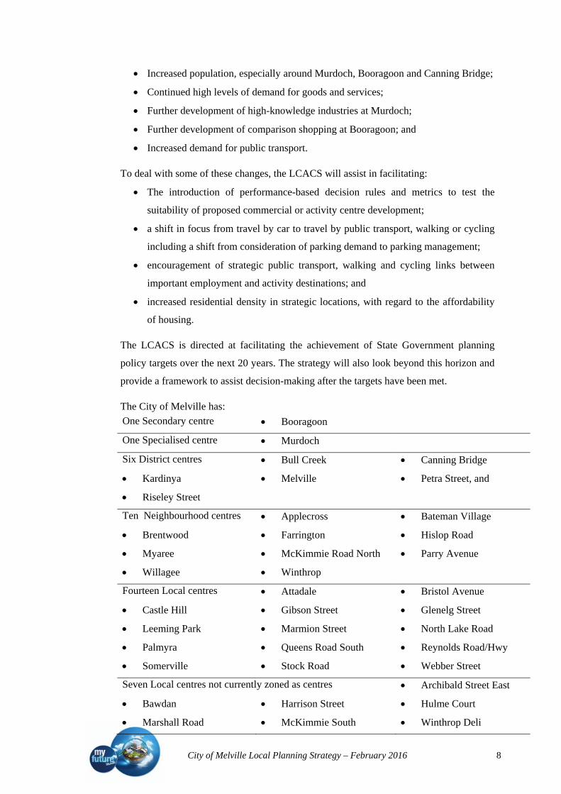
The City of Melville has:
One Secondary centre Booragoon
One Specialised centre Murdoch
Six District centres Bull Creek Canning Bridge
Kardinya Melville Petra Street, and
Riseley Street
Ten Neighbourhood centres Applecross Bateman Village
Brentwood Farrington Hislop Road
Myaree McKimmie Road North Parry Avenue
Willagee Winthrop
Fourteen Local centres Attadale Bristol Avenue
Castle Hill Gibson Street Glenelg Street
Leeming Park Marmion Street North Lake Road
Palmyra Queens Road South Reynolds Road/Hwy
Somerville Stock Road Webber Street
Seven Local centres not currently zoned as centres Archibald Street East
Bawdan Harrison Street Hulme Court
Marshall Road McKimmie South Winthrop Deli

City of Melville Local Planning Strategy – February 2016 9
The following main points can be derived from the market potential analysis of the
LCACS:
Retail market potential shows that under current conditions there is latent demand
for convenience goods and services across the City of Melville in almost all
activity centres. This indicates that new floorspace supply has not kept pace with
increases in demand. It may also be a reflection of the changing nature of retail and
the high affluence of the catchment.
Significant changes to the amount of floorspace supplied in the City of Melville,
such as the proposed expansions at Booragoon and Murdoch, are expected to have
some impacts on retail trade at other activity centres. The extent of the impact
depends largely on the amount of floorspace increased or decreased, the existing
latent demand in the local catchment of each centre, and the local population
growth around each centre.
If retail floorspace at Murdoch and Booragoon are expanded to the extent indicated
in their respective structure plans, Bull Creek is expected to show a slightly
concerning drop in floorspace productivity, which is a primary measure of
viability. This is related more to the fact that Bull Creek was modelled to have
minimal latent demand in the local catchment, rather than the increases at the other
centres being of an unreasonable scale in the regional context. The additional
population assumed to locate at Murdoch and Booragoon are also expected to
create additional local demand.
The district centres other than Bull Creek are modelled to be currently trading
within their ideal retail floorspace productivity limits, or above their minimum
threshold, meaning they have more 'room to move' than Bull Creek.
If retail floorspace supply is located at Canning Bridge, some impacts are expected
at the other district centres as a result. However, the existing latent demand in the
local catchment and the additional population assumed to locate at Canning Bridge
is expected to balance the effects of the additional retail floorspace supply in the
future.
Prior to structure planning at Riseley Street, demand modelling indicates that with
only projected natural population growth, approximately 5,000 m2 of additional
retail floorspace can be supported at Riseley Street, even with an expanded Garden
City Shopping Centre. Additional dwellings at Riseley Street will likely increase
demand at the location.
Myaree Mixed Business Precinct is an industrial centre that currently hosts a
diverse range of land uses, including almost all the bulky goods floorspace in the

City of Melville Local Planning Strategy – February 2016 10
City of Melville. The future vision for Myaree as an activity centre will need to be
determined, as there appears to be pressure for the centre to host other retail and
office uses.
The amount of future entertainment floorspace is likely to depend on the unique
characteristics of the floorspace, and the regional nature of entertainment demand.
It is expected entertainment floorspace demand will increase from current levels in
line with population growth, but growth in entertainment also depends on the
vision set for each activity centre to attract entertainment floorspace, the quality of
the offer provided, and the resulting catchment of the floorspace.
Population-driven office demand for the City of Melville has been estimated to
increase in line with population growth. While there are significant new office
developments indicated at Murdoch and Canning Bridge, the intention for much of
this floorspace is to provide for strategic industry development at these locations.
Population-driven office should be located near the catchment population it is
serving, and therefore dispersed throughout City of Melville activity centres.
Future strategic office demand cannot be modelled. It is an important part of high
level activity centres and the current State government's employment
decentralisation policy. Future strategic office in the City of Melville is expected to
locate primarily in Murdoch and Canning Bridge due to the favourable
characteristics of these centres for attracting strategic employment. Some strategic
office in other activity centres, including Riseley Street and Myaree, currently
exists and is likely to increase slightly in the future.
Bulky goods are a business model requiring large floorplates for display and
storage of goods, which requires direct large vehicle access and ample car parking.
Demand for bulky goods is regional rather than local to the City of Melville. Bulky
goods under the current business model are not considered appropriate for the core
of activity centres; although in some cases they may be located on the fringe.
Myaree Mixed Business Precinct hosts the majority of bulky goods floorspace in
the City of Melville. The future of this centre, and of bulky goods for the City,
should be considered as part of the future vision for Myaree.
One of the primary concerns of Directions 2031 is to more closely align the spatial
location of people’s place of residence and place of work by ensuring employment
opportunities are made available close to residential areas. Directions 2031 addresses the
challenge of aligning residents and employment from the employment end, by imposing
employment self sufficiency (ESS) targets on existing residential areas. The rationale
behind this is that by increasing ESS, employment self-containment (ESC) will also
increase.

City of Melville Local Planning Strategy – February 2016 11
Approximately 2,830 additional jobs will need to be created in City of Melville activity
centres by 2026 to meet the minimum employment self-sufficiency targets set within
Directions 2031.
This analysis assumes, in line with Directions 2031, that providing employment in the
outer sub-regions is the preferred trajectory to achieve a better alignment between place
of work and place of residence. An alternative to achieve this policy objective would be
to limit residential development in the outer sub-regions and increase infill within the
centre sub-region. This would dramatically change the employment targets for the City of
Melville.
In the context of structure planning for Murdoch, Booragoon, Riseley Street and Canning
Bridge, it is almost certain that the targets will be exceeded by these centres. It is also
important to note that these targets are based on the assumption that the level of
population driven employment per capita (which reflect the level of servicing) in the
southern sub-regions will increase. If this does not occur, all centres in the City of
Melville will experience greater pressure for growth and development of population
driven activity.
A brief look at the individual activity centres provides a guide to their future planning
focus.
3.3.1 Secondary centre
According to the State Planning Policy 4.2; Activity Centres for Perth and Peel, (SPP4.2)
‘secondary centres share similar characteristics with strategic metropolitan centres but
serve smaller catchments and offer a more limited range of services facilities and
employment opportunities. They perform an important role in the city’s economy and
provide essential services to their catchment.’ These centres are an important focus for
passenger rail and/or high frequency bus network.
The typical retail types include department stores; discount department stores,
supermarkets and specialty shops. Typically they are expected to incorporate major
offices and professional and service businesses.
Secondary centres are anticipated to service populations of up to 150,000 persons and
target a walkable catchment of 400m. The target residential density is a minimum of 25
dwellings per gross hectare with a desirable target of 35 dwellings per hectare. There is
also a target of between 20% and 50% non-retail floorspace as a proportion of the centres
total floor space. The non-retail floorspace target is dependent on a total floorspace
threshold.
City of Melville Local Planning Strategy – February 2016 12
3.3.1.1 Melville City Centre – (Booragoon)
Melville City Centre (Booragoon) is designated as a secondary centre under SPP 4.2.
This type of centre is a level below strategic metropolitan centres in the hierarchy.
Strategic metropolitan centres are defined as being multipurpose activity centres that
provide a diversity of uses. Secondary centres perform similar functions to strategic
metropolitan centres but offer a more limited range of services, facilities and employment
opportunities than strategic metropolitan centres, and typically serve smaller catchments.
They perform an important role in the regional economy and provide essential services to
their catchments.
An activity centre plan for Melville city centre (Booragoon) was endorsed by the WAPC
in April 2014. The intention of the activity centre plan is to explore significant expansion
of the retail floorspace and enabling the introduction of new land uses to increase the
diversity.
Booragoon Activity Centre is comprised of Garden City shopping centre, the Gateway
building, the Alcoa building, Booragoon Business Centre, the Booragoon Bus Station,
Riseley Corporate Centre and the City of Melville Civic Centre. The City Centre is
framed by a mix of smaller scale commercial and medium density residential
development as a buffer to the adjoining residential areas. The activity centre plan will
focus on increasing the diversity of the City Centre and working with the land owners to
create a more vibrant centre that caters for more activities outside of normal office and
retail hours by using the State Planning Policy 4.2; Activity Centres for Perth and Peel as
a guide to planning.
The Centre is well connected to public and private transport with a regionally significant
bus transfer station adjacent to the centre and good regional road access through Riseley
Street and Marmion Street. There is good local access through local roads and footpaths.
There are still significant gaps in the public transport system catering for the catchment of
the centre, specifically Applecross and Bicton. Better integration of the bus transfer
station with the centre could assist in relieving growing congestion on the roads around
the centre.
Modelling of the additional retail floorspace suggests that even with some competition
from planned expansions at nearby Murdoch and Cockburn Gateway, when the expansion
at Booragoon is completed it is expected to increase demand for goods and services at the
centre. The catchment size of the centre is likely to increase as the greater range makes
the centre more attractive, and people are more likely to travel from further away to visit
the centre. Demand for goods and services at the centre is expected to continue increasing
as the local and regional population grows.
City of Melville Local Planning Strategy – February 2016 13
3.3.2 Specialised centres
Specialised centres focus on regionally significant economic or institutional activities that
generate many work and visitor trips, which therefore require a high level of transport
accessibility. (DoP SPP 4.2)
This type of centre is unique in the hierarchy. Specialised centres provide opportunities
for the development of complementary activities, particularly knowledge based
businesses. A range of land uses that complement the primary function of these centres
will be encouraged on a scale that will not detract from other centres in the hierarchy.
Murdoch specifically has had its primary functions as a specialised centre defined as
health, education and research.
3.3.2.1 Murdoch activity centre
Murdoch Activity Centre is designated as a Specialised Centre in the Central
Metropolitan Perth –sub regional strategy for Directions 2031 and beyond as well as in
the State Planning Policy 4.2 Activity Centres for Perth and Peel focusing on Health,
Education and Research. The construction of the Fiona Stanley Hospital has created an
impetus to further develop the precinct.
The State Government has been leading a structure planning exercise for the activity
centre and surrounding areas of the precinct which will include the University and the
adjoining residential areas. There is a strong potential for an increase in density to
surrounding residential areas, particularly those areas within 400 metres of high
frequency bus routes however, the level of development will need to be closely managed
to ensure the infrastructure in the vicinity will not be compromised. The land between the
Hospital and the Murdoch train station (Murdoch Mix) has been investigated for a
commercial mixed use development to support the hospital including residential and
retail opportunities.
This specialised activity centre is currently well serviced by public transport with
Murdoch Train Station adjoining the site and regionally significant, high frequency buses
servicing the locality. The bus service, that is planned to complement the train service
will, when the hospital opens, rival any for a centre outside the CBD in terms of
frequency and accessibility.
It is expected that new floorspace at Murdoch Mix will begin trading, and new dwellings
occupied in the same area in the next five or ten years. The amount of retail floorspace
demand generated for Murdoch depends on the population growth in the local catchment,
including the number of new dwellings built as fulfillment of the Murdoch activity centre
structure plan. The new retail floorspace is likely to have some impacts on retail trade at

City of Melville Local Planning Strategy – February 2016 14
surrounding centres, and to be impacted by the planned expansion at Booragoon.
This analysis has excluded the additional retail demand that will likely be generated from
the current visitors to Murdoch University, the visitors to new office floorspace located at
Murdoch, and the Fiona Stanley Hospital workers and visitors, estimated to be around
10,000 per day.
3.3.3 District centres
The City of Melville has six District Centres within its boundaries. Several of these
centres service a catchment that includes adjoining authorities. A focus of the Local
Planning Strategy is to intensify these centres to encourage a better mix of activities
including residential in order to consolidate their role as community focal points. Mixed
use developments will be encouraged within the activity centres as a way of intensifying
their use. There will also be a trend to reduce the frame areas around the centres, which
serve as a transition between the centres and the surrounding residential areas in order to
encourage a greater concentration of commercial development within the centre whilst
maintaining the residential densities within walking distance to support it.
3.3.3.1 The Canning Bridge precinct
The Canning Bridge Precinct has developed historically as an office precinct. The unique
character of the area has also attracted high quality residential and retail development.
The area has been the focus of more intensive study to realise the potential of the area and
to enable the area to grow towards a planned vision which will include an increase in the
retail and residential components as promoted by the State Planning Policy 4.2 – Activity
Centres for Perth and Peel. The attraction of the area as a regionally significant office
location will continue to be encouraged. This location is ideal for a transit oriented
development focussing on the proximity of the railway station and the intensity of bus
services. The proximity to City of South Perth and the location of the station within the
adjoining authority lends itself to a joint approach to development of this precinct.
The retail component of this centre will remain at a level that services the local
community complementing the district centres in proximity and keeping with the
hierarchy shown in SPP 4.2 and the Local Commercial Strategy.
The vision for the precinct is to improve internal access through better pedestrian and
cycling environments, better connectivity to public transport and a greater emphasis on
self sustainability.
The quantity of future retail floorspace that can be supported at Canning Bridge depends
largely on the scale of the population increase at the centre, as part of the fulfillment of
the Canning Bridge structure plan. It is expected that even with the increase in retail
City of Melville Local Planning Strategy – February 2016 15
floorspace at Booragoon and minimal population growth at Canning Bridge the
floorspace supply will be within ideal ranges.
In the aspirational scenario the population shock of additional residents at Canning
Bridge significantly increases demand at the centre. While floorspace supply is also
increased the additional supply is not in proportion to the population increase. This
scenario indicates there is likely to be excess demand for goods and services at this
location. However, the extent of this will depend on a range of factors, including:
The quantity of new floorspace at nearby Riseley Street, which has not been
included in this model due to the preliminary stage of structure planning for this
centre;
The shopping behaviour of local residents and the alignment of the retail offer with
their needs at Canning Bridge;
The impact of workers also located at new office floorspace at Canning Bridge.
3.3.3.2 Riseley Street
The proximity of Riseley Street Centre to Canning Bridge and the City Centre and the
access between these centres by high frequency public transport services make this an
important centre in terms of the future growth of the City. The centre has grown to be an
entertainment hub with restaurant, high end retail and office uses. There is a good
diversity of commercial activity but the centre lacks the intensity of residential density
that is desired for an activity centre of this size. The focus of the strategy will be to
improve the proportional mix of uses within the centre to maintain its vibrancy.
Without any increase in the population at Riseley Street as part of the activity centre
structure plan, the modelling indicates there is latent demand at Riseley Street for goods
and services. Capturing this demand may require improvement of the offer available to
prospective consumers, including the amount of floorspace provided, the quality of the
goods and services provided, and the amenity of the general activity centre environment.
3.3.3.3 Melville and Petra Street
These centres are located on Canning Highway which links them with each other as well
as providing a link with Riseley Street and Canning Bridge. The Highway is also a very
strong public transport corridor. Although these centres are in close proximity to each
other they play different but complementary roles in servicing the local and district
communities. The focus of the Local Planning Strategy is to reduce the commercial
frames surrounding these centres to encourage an increase in intensity within the
commercial centre supported by medium density development within a walkable
catchment of the centres.

City of Melville Local Planning Strategy – February 2016 16
The modelling for Melville and Petra Street indicates that there is latent demand for
goods and services at both centres. No major dwelling increases or floorspace supply
increases were considered as part of the modelling, but both centres are expected to have
the capacity to support both a larger population and higher levels of retail floorspace.
3.3.3.4 Kardinya and Bull Creek
These two centres were developed as suburban ‘box’ shopping centres but have begun to
transform in recent years to more diverse activity centres. The strategy will encourage
further transformation within the State Planning Policy 4.2 guidelines with an increase in
other land uses including small scale offices. The community highlighted these centres as
places of opportunity for an increase in residential development.
The proximity of these centres to Murdoch will allow both complementary development
as well as providing weekly services for the adjoining catchment areas. Both centres are
located on major high frequency regional bus routes and have good access to regional
roads. Their catchment also takes in adjoining areas in neighbouring local authorities.
The modelling for Kardinya indicated that the centre is trading close to the maximum
floorspace capacity for the catchment size. Increasing the amount of floorspace at the
centre is likely to require an increase in the catchment size. This could be achieved
through increasing the size of the local population or increasing the attractiveness of the
centre (i.e. significantly increasing the offer of goods and services, and therefore
floorspace, at the centre). The vision for the future of centre should be considered in the
context of the role the centre is playing in meeting local demand for goods and services,
and the role it plays in the overall activity centre network.
The modelling for Bull Creek indicated that similar to Kardinya, the centre is trading
close to or at the maximum floorspace capacity for the catchment size. Expansions of
floorspace at Murdoch, Cockburn Central and Booragoon are expected to impact on the
level of floorspace that can be supported at Bull Creek due to their very close spatial
location, and the current focus of Bull Creek on convenience retail. Increasing the amount
of floorspace at the centre is likely to require an increase in the catchment size.
3.3.4 Neighbourhood and Local centres
The City is well serviced by neighbourhood and local centres. There are ten
neighbourhood and fourteen local centres currently zoned within the City of Melville. A
further five locations are operating as local centres but under Community Planning
Scheme 5 have a residential or mixed business zoning. Because of this the owners have
had difficulty in redeveloping these centres. The local commercial strategy recognises the
importance of these extra centres in the City network. In order to better facilitate the

City of Melville Local Planning Strategy – February 2016 17
vision for centres within walking or cycling distance of all residents the strategy will
promote the rezoning of these centres to recognise the current use and encourage their
development to service the local area. There may be an opportunity in the long term, with
an increase in population, to provide two or more neighbourhood centres in areas South
of Leach Highway to move towards the ideal of a centre within walking distance of most
residents.
The intent of Directions 2031 and SPP 4.2 is to provide an even distribution of jobs,
services and amenities in a hierarchy of activity centres. SPP 4.2 is mainly concerned
with the distribution, function, broad land use and urban design criteria of activity
centres, and with coordinating their land use and infrastructure planning.
The objectives of the LCACS essentially align with the policy objectives of SPP 4.2 in
the following areas:
1. Distribute activity centres to meet different levels of community need and enable
employment, goods and services to be accessed efficiently and equitably by the
community.
2. Apply the activity centre hierarchy as part of a long-term and integrated approach
by public authorities and private stakeholders to the development of economic and
social infrastructure.
3. Plan activity centres to support a wide range of retail and commercial premises and
promote a competitive retail and commercial market.
4. Increase the range of employment in activity centres and contribute to the
achievement of subregional employment self-sufficiency targets.
7. Maximise access to activity centres by walking, cycling and public transport while
reducing private car trips.
9. Concentrate activities, particularly those that generate high numbers of trips, within
activity centres.
Potential opportunities for the future development of City of Melville activity centres are:
Promote a network of district, neighbourhood and local centres to support the
community;
Promote Booragoon to develop to its full employment potential as a Secondary
Centre under Directions 2031;
Promote Murdoch to further develop as a Specialised activity centre;
Promote opportunities for new business development through working with the
Chamber of Commerce, local traders and other community leaders, recognising the
changing nature of business precincts such as the Myaree Mixed Business Zone;

City of Melville Local Planning Strategy – February 2016 18
Encourage and plan for appropriate ‘Main Street’ development within activity
centres;
Align transport and activity centre functions;
Encourage increased employment within appropriate activity centres; and
Enable the regeneration of existing activity centres to improve their amenity,
attractiveness and social and cultural vitality.
Gaps and opportunities that would improve performance outcomes of activity centres are:
Increase the density and diversity of housing in and around activity centres to
improve land efficiency, housing variety and support centre facilities. A more
rigorous pursuit of higher-density housing should be incorporated within and
immediately adjacent to activity centres to establish a sense of community and
increase activity outside normal business hours. Targets for residential density as
set out in SPP 4.2 should be applied throughout the City of Melville activity centre
network, with regard to the capacity of each centre to meet set targets.
For Booragoon Secondary Centre, an average minimum residential density of R35 is
suggested, and for District Centres, an average minimum of R30. In some instances
pursuing average higher densities may be appropriate. The area over which the average
minimum density is to be calculated will need to be considered.
Ensure activity centres provide sufficient development intensity and land use mix
to support high-frequency public transport.
Where practical, activity centres should be planned in line with transit-oriented
development principles to make it convenient and practicable for residents, employees
and visitors to travel by public transport, cycling or walking instead of by private car.
Where this approach is not practical the future development of the activity centre should
consider the need to minimise private car use.
Plan activity centre development around a legible street network and quality public
spaces.
Future urban design considerations for City of Melville activity centre are:
District centres and higher-order centres with a network of streets and public
spaces as principal elements;
Well-formed structure typically consists of small, walkable blocks that improve
accessibility within a centre;
Buildings and tenancies need to address streets and public spaces to promote
vitality and encourage natural surveillance;
Generally, activity centres should contain a mix of uses along street frontages, and
arrange key retail and other attractors to maximise pedestrian flows along streets;
City of Melville Local Planning Strategy – February 2016 19
New activity centre development or redevelopment should include ‘sleeving’ of
large-scale retail and car parks, more externally-oriented or ‘active’ building
frontages, and blank walls should be minimised; and
‘Town squares’, public and civic spaces, and parks need to be attractive, well-
located spaces and integrated into activity centres to provide quality meeting places
for the community and build the character of each centre.
As the current population ages, the diversity of stock offered within activity centres can
provide alternative housing options for older households, potentially encouraging the
release of 3 and 4 plus bedroom dwellings in the older residential neighbourhoods around
the City of Melville. This may provide increased opportunities for family households to
move to these areas and encourage the process of regeneration. Densification around
activity centres can offer lifestyle choice to a large range of different social groups given
the easy access to local facilities. The development of higher density dwellings in and
around activity centres should be complemented by other physical improvements to the
centres in terms of amenities and attractiveness in order to ensure that development is
occurring within an urban environment likely to prove attractive to a range of social
groups.
The Melville City Centre and the rail based activity centres are likely to attract most of
the future higher density development and it is desirable to concentrate on developing
policies to encourage this, in addition to encouraging increased development along major
transport networks.
3.4 Regional open space
The City of Melville has a large representation of land reserved as Parks and Recreation
under the MRS including foreshore reserves, remnant bush and ‘Bush Forever’ sites and
wetlands. The significant parks and recreation reserves under the Metropolitan Region
Scheme include Blackwall Reach and Point Walter reserves, Attadale Foreshore,
Tompkins Park, Applecross Foreshore, Heathcote reserve, Apex Park, Deepwater Point
and Bull Creek. Significant bushland is recognised through Harry Sandon Reserve,
Wireless Hill, Piney, Bluegum and Booragoon Lakes and Ken Hurst Park. The LPS
recognises the importance of protecting these reserves in terms of conservation as well as
recreation.
Many of the areas zoned Parks and Recreation under the MRS relate to foreshore areas
which provide passive and active recreation opportunities for the community. Some of
the areas of highest use include:
Bicton Baths reserve catering for water polo, fishing, swimming, boating, and other
water sports

City of Melville Local Planning Strategy – February 2016 20
Point Walter reserve in Bicton which caters for golf, adventure activities, outdoor
concerts, picnics and fishing, boating and other water sports
Attadale Foreshore catering for dog exercise areas, water sports and football and
cricket
Applecross Foreshores catering for tennis, kite boarding and wind surfing,
Heathcote Reserve in Applecross catering for yachting and passive recreation
Apex Park and Deepwater Point in Mount Pleasant cater for rowing, water skiing,
boating, cycling and jogging
The development of the majority of the City prior to the requirements for 10 percent open
space and the conversion of local reserves to regional reserves parks and recreation
through bush forever has left some of our suburbs with a predominance of regional open
space and little in the way of local open space. The ‘Open Space Strategy’ has identified
these areas and has suggested various methods of enhancing connectivity and usefulness
of those reserve areas within the suburbs. A review of the Open Space Strategy is being
undertaken to look at a wider context of public spaces within the City.
3.5 District open space
Several areas of significant size (some reserves and some freehold) have been reserved as
Local Parks and Recreation under the Local Planning Scheme and developed as active
parks to cater for the sporting and recreation needs of a wider community. These parks
are distributed throughout the City and attract a wide catchment of users. These recreation
areas include:
Morris Buzzacott Reserve in Kardinya which caters for a large number of sports
including tennis, hockey, football, cricket, and lawn bowls;
John Connell Reserve in Leeming which caters for soccer, golf, archery and lawn
bowls;
Len Shearer Reserve in Booragoon catering for aquatic sports, athletics, and
soccer;
Tompkins Park in Alfred Cove which caters for rugby, lacrosse, cricket, soccer and
lawn bowls, and trapeze;
Melville Reserve which caters for football, rugby, cricket, tennis, and indoor
sports.
These reserves also complement the network of local reserves to cater for the recreation
needs of the local community such as walking, jogging, exercise of pets , passive
recreation etc.

City of Melville Local Planning Strategy – February 2016 21
3.6 Existing and future local open space
The City is well serviced with a combination of regional and local open space in most
areas. In some of the older suburbs such as Mount Pleasant, Palmyra and Bicton local
reserves are more than 400 metres walk from some residences. Although it is difficult to
retrofit local open space in established areas in order to try and achieve a more equitable
access to open space, the City has developed memorandums of understanding with
schools that permit community access of school sites for recreational purposes. A review
of reserves and public spaces will explore more sustainable and effective options for
managing reserves including contributions from developments and the strategic
management of current assets.
A more strategic approach to land assets could allow for some parcels of land in areas
with a surplus of recreational spaces to be disposed of to assist in the acquisition of other
more appropriate spaces.
3.7 Natural resource management and environmental protection areas
A green plan has been developed for the City of Melville to provide a strategy for
bushland conservation and management. These areas are recognised within the Local
Planning Strategy and include those areas listed as ‘Bush Forever” sites under the MRS.
The City has been at the forefront of protecting the wetlands along the foreshores and in
reserves such as Piney, Bluegum and Booragoon Lakes. Larger areas of remnant bush and
wetland associated with Murdoch University and Fiona Stanley Hospital have also been
part of planning for protection of key environmental areas before, during and after
construction.
3.8 Visual landscape protection and management areas
The Swan and Canning River foreshore are recognised as key areas where protection of
visual landscape is an important consideration in planning for the future. The City and the
Swan River trust have historically tried to protect these areas through lower density urban
development with the aim of creating larger blocks and greater setbacks incorporating
greater areas for landscaping. The current trend in building larger houses has somewhat
eroded the desired outcomes for these areas. Other ways of protecting the visual
landscape and allowing more equitable access to riverside living should be explored.
3.9 Strategically significant natural resource areas
There is no mining or extraction of natural resources within the City of Melville.
The wetlands and Swan and Canning River catchments are strategically significant
natural resources that are in need of protection through increased awareness of the impact

City of Melville Local Planning Strategy – February 2016 22
of development and usage combined with increased restrictions on what is permitted to
enter the river through drainage systems.
3.10 Constraints
The impact of climate change is becoming increasingly relevant. The strategy
acknowledges the importance of recognising these impacts. Although only minimal the
impact of rising river levels and the changes in flooding patterns need to be considered.
Also the increasing draw on the water tables and the reduced replenishment rates will
impact on the use of landscaping.
3.11 Existing and proposed major transport routes
The City of Melville is well placed strategically in terms of transport routes. The
Kwinana Freeway traverses the City. Five entry points to the freeway allow easy access
through to the CBD, the Northern and Southern Suburbs. Connecting the City’s suburbs
to the Freeway and providing east/west connections are the Primary Regional Roads of
South Street, Leach Highway and Canning Highway. Primary and Other Regional Roads
following a north/south alignment are Stock Road, North Lake Road and Riseley Street.
An extensive network of local distributer roads connects these primary and secondary
roads to the local suburban road network.
Leach Highway, Kwinana Freeway and Stock Road form major freight routes for trucks
accessing the port at Fremantle. Although only a small portion of Roe Highway sits
within the City the impact is considerable. The extension of Roe Highway past Kwinana
Freeway is considered essential to relieve the pressure on South Street that will occur
when Fiona Stanley Hospital opens in 2014. A further extension to Stock Road is also
considered necessary to help to reduce the impact of freight traffic on the Freeway and
Leach Highway as well as providing an alternative southern access to the activity centre
at Murdoch.
The City is well serviced by public transport services.
The Perth to Mandurah Railway is located in the middle of Kwinana Freeway reserve.
There are two stations within the City of Melville at Murdoch and Bull Creek. Both also
serve as important bus transfer stations as well as having a large park and ride capacity
(Murdoch 1182 bays and Bull Creek 639 bays).
High frequency bus services operate down the public transport corridors of South Street
(98/99), Canning Highway (910/111) and Marmion Street (881/501) with another high
frequency service (940) traversing the suburbs of Kardinya, Winthrop, Booragoon,
Applecross and Mount Pleasant. Other services radiate from the rail stations to proximate
suburbs. Leach Highway, although primarily a freight corridor also plays an important

City of Melville Local Planning Strategy – February 2016 23
role as a public transport corridor between Stock Road and Bull Creek rail station.
Over 90 percent of residents are within 400 metres of a bus stop. The main gap in
services is a direct connection from Bicton, Attadale and the northern parts of Applecross
to Garden City. The provision of CAT style bus services connecting the main activity
centres is constantly requested through many of our community engagements. As
populations increase and centres intensify there may be more justification to introduce
services like this.
The recognition of the public transport corridors within this strategy reflects the growing
importance of public transport, increasing congestion and the need to reduce the
dependence on the car. Increased intensity of activity centres which are connected
through these public transport corridors and the increase in density along public transport
corridors will enhance the existing public transport services as well as support the
growing demand for light rail or rapid bus transport infrastructure. The major centres of
Canning Bridge, Booragoon and Murdoch could be considered for light rail as an
extension of the ‘Knowledge Arc’. This could be a staged introduction along Canning
Highway to Riseley Centre; Riseley Street to Booragoon and Murdoch Drive to Murdoch.
Canning Highway to Fremantle and Marmion Street from Booragoon to Fremantle and
South Street from Murdoch to Fremantle are also key transport corridors that should be
protected for future transport options such as Rapid Transit bus or light rail.
A network of cycle paths, shared paths and cycle friendly streets connect the city for a
growing proportion of the population using sustainable methods of transport including
cycling and walking. A Bike Plan for the City of Melville has been in place since 1998. A
new Bike Plan has been prepared in 2012.
A major deficiency in the transport network is the provision of ferry services on the river.
Although there have been unsuccessful attempts to introduce ferry services, they remain a
popular concept in community consultations and should continue to be considered in all
forward planning. For a ferry service to succeed there needs to be connectivity with other
public transport services and an increase in density around the terminals to generate walk
on/walk off patronage. The concept of providing a ferry service from Canning Bridge to
the University of WA has been included as part of the Vision for Canning Bridge.
This Strategy recognises the importance of a coordinated approach to all forms of
transport and the correlation with increased density and other land uses to improve the
viability of sustainable transport options. A gradual increase in the density along the
corridors beginning with the areas closest to activity centres and bus stops is preferred.
The area of intensity can then be extended over time so that the impact of change is not so
dramatic.

City of Melville Local Planning Strategy – February 2016 24
3.12 Existing and future transport interchanges
The introduction of the Perth to Mandurah Railway has provided the opportunity for
multiple transport interchanges within the City of Melville. Prior to the rail, the main
interchange within the City was the Booragoon bus station. This remains a key
interchange.
New major interchanges at Murdoch Station and Bull Creek Station allow good transfer
opportunities between train and bus services. The location of these interchanges in the
centre of major freeway and primary regional roads means they are surrounded by low
density residential developments adverse to the principles of transit oriented
development. Melville Visions highlighted these areas as potential sites for increased
density and increased height to realise the potential created by the improved access to
transport. The disparate ownership patterns in these areas make it more difficult to
provide a coordinated approach to redevelopment. Strategic plans will be prepared for
these locations to ensure a smoother transition to medium to high density development
complementing the transport interchanges.
Canning Bridge precinct, although separated from the Canning Bridge rail station by the
river, has developed into a transit oriented development in its own right. The bus stop
central to the precinct at Moreau Mews is a major interchange between bus services as
well as providing a direct shuttle link to the rail station. There has also been a noticeable
increase in the pedestrian traffic to the rail station from the precinct. This precinct is the
location for a joint strategic planning exercise with the Department of Planning, State
Government transport portfolios and the City of South Perth. There is a potential to create
a vibrant centre based on transport oriented principles.
Two district activity centres also have transport interchange roles with the adjacent bus
stops becoming important interchange locations between major bus services. Riseley
Centre is important in the interchange between east-west services along Canning
Highway and north-south services along Riseley Street allowing connection between the
suburbs north of Canning Highway and Booragoon. The importance of this interchange
will increase with any introduction of light rail or rapid bus transport infrastructure.
Kardinya is the other location for a transport interchange at an activity centre. The bus
stops on South Street provide a key interchange between the Circle Route and the high
frequency 940 service as well as other local routes. In future planning for the centre, the
personal interchange between north and south needs to be improved and the introduction
of a transfer station which is better integrated with the centre.

City of Melville Local Planning Strategy – February 2016 25
3.13 Existing and future utilities
The increased potential for development puts pressure on existing utilities and
infrastructure. Discussion has been taking place as to the location of new electrical sub
station sites to service the increasing infill within the City and surrounding localities. The
location of substations remains a contentious issue. The general consensus of the
community and Council is that new locations should be within industrial area, separated
from residential areas and this is to be encouraged.
Underground power continues to be implemented. The aim is to continue to bid for
projects until the whole of the City’s power is underground.
Sewer has been connected to all suburbs.
Although water supply is adequate and there are no issues of supply, there is a need to
work closely with the Water Corporation to ensure supply is not compromised by further
development.
The National Broadband Network has begun to be rolled out. Applecross and parts of
adjoining suburbs have been chosen as one of the initial rollouts in the metropolitan area.
This has the potential to increase economic opportunities within the centres at Canning
Bridge and Riseley Street as well as for home based businesses and other opportunities
throughout the suburbs.
4. Strategies and actions
Relevant strategies which apply to and result from the Local Planning Strategy, reviewed
Planning Scheme and other City of Melville initiatives and projects are:
4.1 Commerce, industry and employment
Aim:
1. To ensure access to different levels and types of retail and commercial activity and
employment opportunities.
2. To promote a more self sufficient, liveable City in accordance with Directions
2031 and beyond and Liveable Neighbourhoods Community Design Code
principles.
Strategies:
Promote the transition of the City from a ‘suburban’ context into an inner city
‘urban' area in accordance with the City’s Local Commercial Activity Centres
Strategy, Directions 2031 and beyond and the Central Metropolitan Sub Regional
Strategy
Promote a network of District, Neighbourhood and Local centres to support the

City of Melville Local Planning Strategy – February 2016 26
community;
Promote the City Centre at Booragoon to develop to its full potential as a
Secondary Centre under the WAPC Directions 2031 and beyond Strategy;
Promote Murdoch activity centre to develop as a Specialised Activity Centre under
the Directions 2031 and beyond Strategy
Promote opportunities for new business development through working with the
Chamber of Commerce and local traders and other community leaders recognizing
the changing nature of business precincts such as the Myaree Mixed Business
precinct;
Note: this may require a specific strategy to ensure that appropriate industrial
activities are prioritised and are not supplanted by commercial type businesses
that may be established under recent changes to permitted land uses /activities.
Encourage and plan for ‘Main Street’ development within activity centres;
Encourage work from home and mixed use development;
Encourage and plan for integration of community facilities within centres;
Align transport and activity centre functions;
Encourage increased employment within activity centres;
Ensure that centres remain attractive, accessible and viable and provide for a wide
range of facilities.
Ensure signage is appropriate to the amenity of the area and control of signage is
maintained.
Protect Industrial areas from encroaching residential and commercial uses.
Enable the regeneration of existing activity centres to improve their amenity,
attractiveness and social and cultural vitality.
Actions:
The City’s Local Commercial Activity Centres Strategy, completed in 2013 in
light of the introduction of State Planning Policy 4.2; Activity Centres for Perth
and Peel, will be reviewed on a regular basis.
Implement recommendations of the City’s Local Commercial Activity Centres
Strategy.
Prepare activity centre plans for all Secondary, Specialised and District activity
centres in accordance with State Planning Policy 4.2: Activity Centres for Perth
and Peel.
Prepare local development plans, urban design guidelines and transport strategies
for the purpose of improving functionality, employment opportunity and amenity
for neighbourhood centres.

City of Melville Local Planning Strategy – February 2016 27
Partner with Department of Planning and other key stakeholders to prepare
structure plans for transit nodes.
Incorporate appropriate provisions within the City’s Local Planning Scheme for all
centres, industry and employment related activities including the Myaree Mixed
Business precinct.
Budget for capital works for centre development.
Prepare and review policies in relation to
Home Office, Home Business;
Bed and Breakfast premises;
Retail Bulky Goods;
Fast Food Outlets;
Convenience Store location;
Showroom location;
Consulting Room location;
Incidental Uses.
Promote benefits of working from home and investigate network to link home
businesses.
Undertake a study of the O’Connor Industrial Area in conjunction with DoP and
the City of Fremantle.
Prepare a land assets strategy.
Prepare an Economic Development Strategy.
4.2 Transport
Aim:
1. To provide a transport system which will contribute to the quality of life and
economic development of the City of Melville with minimum adverse effects on
residents and the natural environment;
2. To provide safe, affordable and effective transport modes available for all sectors
of the community.
Strategies:
Maximise development to support viable public transport corridors in accordance
with Directions 2031 and beyond principles;
Provide for a safe and efficient network of local and arterial roads facilitating road
access and distribution of traffic through the area;
Maintain a high level of connectivity for local traffic;

City of Melville Local Planning Strategy – February 2016 28
Provide for a close home-work relationship, in particular encourage mixed use
development within district and neighbourhood activity centres;
Ensure that land use supports walking and cycling through mixed use
developments, safe routes and attractive pedestrian friendly precincts;
Manage roads to ensure they are used efficiently and to capacity;
Protect residential areas from transport of dangerous goods;
Promote public transport passenger movements to, from and within the area
(TravelSmart);
Participate in preparation of a Regional Integrated Transport Strategy for the South
West Metro Region;
Ensure that development contributes towards upgrading of transport networks
where necessary.
Actions:
Develop a comprehensive long-term Access Plan and integrated transport strategy
for the City of Melville;
Continue to lobby and plan for the extension of Roe Highway to Stock Road and
explore the connection options to support freight movement and in particular
relieve traffic congestion on South Street and Leach Highway; protect residential
amenity; enhance traffic management/safety; reduce community severance and
promote economic development of ports and other regional infrastructure;
Recognise and plan for the following major road connections to form the future
sub-arterial road network (Farrington Rd, Karel Ave, Murdoch Drive, Riseley
Street, North Lake Rd, Stock Rd);
Investigate re-classification of Public Transport Corridors;
Investigate re-classification of Murdoch Drive and Riseley Street from DD B road
to DD A road in the City of Melville Road Hierarchy;
Review the City Bike Plan;
Review the City of Melville Transport Strategy (incorporating shuttle or CAT
services and light rail or rapid bus transport opportunities);
Continue to support the TravelSmart Programs;
Develop transit oriented precinct plans for each rail station precinct based on
Liveable Neighbourhood Guidelines and WAPC’s DC Policy 1.6 Planning to
Support Transit Use and TOD;
Improve access to all stations;
Develop a Parking Management Strategy for the City;
Recognise the role of parking in transport demand management;
City of Melville Local Planning Strategy – February 2016 29
Undertake transport strategies for the Canning Bridge Centre, City Centre, Greater
Murdoch precincts and Bull Creek Rail precinct;
Review and rationalise the role and importance of Right of Ways and Pedestrian
Access Ways within the City;
Provide for bus priority along South Street and Canning Highway;
Prepare parking management plans around schools and activity centres;
Review parking requirements within the Local Planning Scheme;
Expand Perth’s river transport services;
Review end of trip cycling facilities policy;
Ensure Access and Travel Plans are prepared for all major developments;
Introduce noise attenuation conditions to lots adjoining fright corridors;
Include appropriate planning provisions in the Local Planning Scheme to enhance
the use of public transport and create an improved walking and cycling
environment.
4.3 Utilities
Aim:
1. To ensure that appropriate utilities are provided on time and in a sustainable
manner to suit the City’s growing needs.
Strategies:
Ensure that the necessary utilities required for development are sustainable.
Actions:
Promote further undergrounding of power in neighbourhoods;
Consult with the relevant utility and infrastructure providers during reviews of the
City’s Local Planning Scheme to ensure that proposals will be supported with the
necessary services;
In assessing structure plans, subdivisions and development proposals ensure that
necessary sustainable utilities are being provided for development;
Ensure that developments contribute toward future utility needs;
Investigate opportunities for green buildings and sustainable development
including tri-generation, solar and wind power, water recycling and other emerging
technology.
City of Melville Local Planning Strategy – February 2016 30
4.4 Environment
Aim:
1. To ensure that the natural environmental values of the City are protected,
conserved for existing and future generations.
Strategies:
Ensure the protection and enhancement of wetlands, native bushland, Swan and
Canning Rivers and Foreshore, Street Vegetation;
Actions:
Investigate methods of protection of trees including preparing a register of
significant trees as part of the Local Planning Scheme;
Undertake mapping of parks with significant natural vegetation regimes;
Identify and protect significant trees through the subdivision and development
approvals process;
Plan for appropriate edges and buffers to and management of Bush Forever sites;
Adopt a water sensitive urban design policy;
Review the City’s Street Tree (removal) Policy. Review the City’s Green Plan and
environmental strategies such as :
Foreshore Management Plans/precinct plans
Reserve Management Plans/precinct plans
Vegetation Management Plans
Stormwater Disposal and Nutrient Management Plans
Bushfire Management Plan
Planning Policy
4.5 Open space
Aim:
1. Ensure the provision and management of reserves and public spaces is
environmentally sustainable and contributes to the amenity of both the urban and
suburban components of the City’s resident and business communities.
Strategies:
Ensure availability of environmentally sustainable recreation spaces, enhance
parklands and ensure accessibility for all residents and visitors;
Ensure all residents have access to open space for passive and active recreation;
Connect residential areas to open spaces.
City of Melville Local Planning Strategy – February 2016 31
Actions:
Implement the recommendations of the City’s reserves and public open spaces
strategy;
Develop integrated and sustainable policies and strategies for managing reserves
and public spaces;
Use cash in lieu contributions to improve facilities and quality of open space;
Reserve within the Local Planning Scheme all existing parks within closed roads as
‘Local Reserve Parks and Recreation’ open space;
Negotiate additional memorandums of understanding with schools permitting use
of school ovals and other government owned land for community recreational
purposes;
Prepare outline development plans for the Heathcote Lower Lands and South Perth
Yacht Club land;
Investigate opportunities for funding of open space, including community benefit
and infrastructure contributions;
Encourage community ownership of local parks;
Review the City’s public art contribution policy;
Rationalise Council owned and managed land assets to achieve the most efficient
use of land;
Prepare a land acquisition and disposal strategy;
Prepare guidelines to ensure appropriate interface between regional parks and
recreation and urban development;
Ensure all new development enhances connectivity of cycle and pedestrian
networks.
4.6 Heritage
Aim:
1. To protect and promote places of cultural heritage significance within the City,
including significant sites, buildings, structures and trees and landscape elements.
Strategies:
Promote the story of the City of Melville through recognition of important
historical elements of that story;
Ensure places of heritage significance are recognised, enhanced and maintained;
Ensure the that the City of Melville’s Local Government Inventory is consistent
with the standards for inventories recommended by the Heritage Council;
City of Melville Local Planning Strategy – February 2016 32
Ensure that the inventory is comprehensive, up to date and provides guidance for
compliance with governance, statutory, land use and community planning
responsibilities under the Local Planning Scheme , other policies or corporate
documents;
Actions:
Prepare a Cultural Heritage Strategy for the City;
Review the Municipal Heritage Inventory on a regular basis ;
As part of the Scheme review incorporate relevant provisions in the Local Planning
Scheme for the protection, conservation and interpretation of places and areas of
significance in accordance with the Model Scheme Text, including provisions for
conservation incentives;
Implement the Cultural Heritage Strategy recommendations;
Prepare and implement planning policies to guide owners, applicants and the City
on heritage and related urban design matters;
Document and protect Aboriginal Heritage sites;
Take into account both European and Aboriginal heritage in the preparation of
master plans, structure plans, centre plans and landscape plans and in the
consideration of development and subdivision proposals;
Prepare conservation plans for City owned heritage sites;
Join WALGA Heritage Loan Scheme;
Prepare an incentive package for owners of heritage places;
Consider the actions of the Reconciliation Action Plan for the City of Melville.
4.7 Tourism
Aim:
1. To protect and promote appropriate tourism opportunities within the City having
regard to amenity and the environment.
Strategies:
Enhance the economic environment of the City of Melville by promoting the
tourism opportunities of the City;
Utilise the tourism assets within the City of Melville to build on its tourism
potential.
Actions:
Participate with the South West Group in undertaking a Tourism Strategy for the
region;
Promote and market the City of Melville tourism assets;

City of Melville Local Planning Strategy – February 2016 33
Encourage events and developments that enhance the appeal of existing and new
attractions;
Consider opportunities for short term accommodation in key activity centres.
4.8 Housing
Aim:
1. Support housing choice and variety in neighbourhoods to match changing
household needs with community identity and high levels of amenity.
Strategies:
Provide for a range of residential densities, to facilitate the development of a
variety of housing types and neighbourhood characteristics based on proximity to
services, existing character and landscape characteristics;
Encourage the incorporation of higher density housing in conjunction with suitable
secondary and district centre commercial development, subject to appropriate
design controls to ensure a satisfactory level of amenity for residents;
Promote innovative, high quality residential developments on opportunity sites;
Capitalise on residential development opportunities;
Support increases in housing density where character and amenity of the
neighbourhood is not prejudiced and there is capacity in existing infrastructure and
services;
Develop initiatives to increase the availability of affordable housing;
Investigate allowing the development of housing or additions to housing where
there is no significant adverse impact upon the amenity of adjoining properties;
Have regard to WAPC Directions 2031 and beyond (dwelling targets) for the City;
Undertake housing preference analysis of market trends;
Promote a diversity of housing to better enable ageing in place.
Actions:
Use local planning policy to encourage sustainable residential design for all
dwellings;
Participate in R-Codes reviews to promote better residential design;
Include land on major transport routes within Strategic Development Areas under
the Local Planning Scheme (ref: noise buffers);
In liaison with Department of Housing and Works identify opportunities to create
and implement strategies to improve the lifestyle quality of Willagee;
Introduce Mixed Use (residential/commercial) development within Activity
City of Melville Local Planning Strategy – February 2016 34
Centres and review Mixed Use policy. Prepare guidelines to demonstrate
appropriate standards;
Introduce the general principles of Directions 2031 and beyond, and Liveable
Neighbourhoods Community Design Code in Community Planning; Enable
increased development opportunities around public transport nodes, activity centres
and public transport corridors in order to meet minimum additional dwelling
targets of Directions 2031;
Provide opportunity for a minimum of 18,500 new dwellings beyond 2031 in areas
where access to transport and facilities can reduce dependency on private motor
vehicles;
Have regard to open space provision when reviewing housing density;
Review policy to protect residential amenity;
Review implications relating to Aged Persons and Single Bedroom Dwellings in
order to be able to provide more affordable and diverse housing responding to the
changing population trends of single person households and aging population;
Prepare a policy on Residential Buildings (lodging houses);
Review the Social Housing Taskforce report: Housing 2010: Future Directions for
Affordable Housing and consider the implications to the Local Planning Strategy
and Local Planning Scheme.
5. Implementation
Proposals set out in this strategy will be incorporated into the City of Melville’s Local
Planning Scheme as considered appropriate. The time period considered by this strategy
is to 2031 and beyond to relate to the State Strategies associated with Directions 2031
and beyond.
5.1 Future opportunities – focus on Strategic Development Areas
As part of the reviewed Local Planning Scheme, Strategic Development Areas have been
chosen as the basis for the co-ordination of re-development of brown-fields sites across
the City. These areas are likely to require comprehensive strategic urban planning studies
to facilitate the degree of change necessary to effectively achieve an acceptable level of
urban density and land use diversity. It should be noted that the strategic development
area boundaries in the local planning strategy are indicative only and subject to change as
more detailed structure planning progresses. .
The locations chosen reflect the greatest opportunity to increase dwelling numbers whilst
reducing the impacts of congestion. These areas are chosen for their access to public
transport, potential for increase in employment self sufficiency, proximity to local trip
City of Melville Local Planning Strategy – February 2016 35
generators and latent urban environment.
State Planning Policies recommend:
residential development of a minimum of 25 dwellings per hectare within 800
metres of train stations, and substantially higher for those sites that have the
advantage of close proximity to train stations;
a residential density target of 30 dwellings per gross hectare within 400 metres of
district centres; and
a residential density target of 35 dwellings per gross hectare within 400 metres of
secondary centres.
Further investigation of the Strategic Development Areas during the development of
Strategic Plans will investigate ways to achieve these densities.
Strategic development areas identified in the Local Planning Strategy plan include the
following:
5.1.1 Canning Bridge Precinct – (Strategic Development Area 1)
A vision for the Canning Bridge Precinct was supported by the Councils of the City of
Melville and the City of South Perth and endorsed by the Western Australian Planning
Commission in 2010. The Minister for Planning released the Vision in June 2011. It
provides a 50 year vision to create a Transit oriented development for the precinct which
is centred on the Canning Bridge Rail Station and incorporates the activity centre within
Melville as well as a substantial catchment within the City of South Perth. An activity
centre plan which provides guidelines for implementation of the vision was endorsed by
Council in March 2015 and by the Western Australian Planning Commission in
December 2015.
The Canning Bridge Activity Centre Plan (CBACP) is guided first and foremost by the
Canning Bridge Precinct Vision Statement:
‘The Canning Bridge area will evolve to become a unique, vibrant, creative community
centred on the integrated transport node of the Canning Bridge rail station. The area will
be recognised by its unique location, its integrated mix of office, retail, residential,
recreational and cultural uses that create areas of excitement, the promotion of its local
heritage and as a pedestrian friendly enclave that integrates with the regional transport
networks while enhancing the natural attractions of the Swan and Canning Rivers’
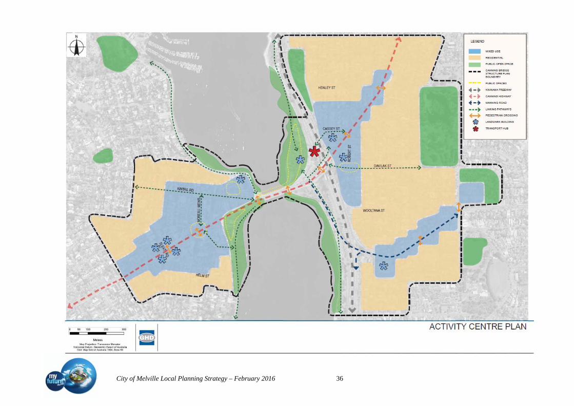
City of Melville Local Planning Strategy – February 2016 36
City of Melville Local Planning Strategy – February 2016 37
The main objectives of the activity centre plan are:
1. Meet district levels of community need and enable employment, goods and
services to be accessed efficiently and equitably by the community.
2. Support the activity centre hierarchy as part of a long-term and integrated approach
to the development of economic and social infrastructure.
3. Support a wide range of retail and commercial premises and promote a competitive
retail and commercial market.
4. Increase the range of employment within the CBACP area and contribute to the
achievement of sub-regional employment self-sufficiency targets
5. Increase the density and diversity of housing in and around the CBACP to improve
land efficiency, housing variety and affordability and support the facilities in the
area.
6. Ensure the CBACP area provides sufficient development intensity and land use
mix to support and increase high frequency public transport.
7. Maximise access to and through the CBACP area by walking, cycling and public
transport while reducing private car trips.
8. Plan development in the CBACP area around a legible street network and quality
public spaces.
9. Concentrate activities, particularly those that generate steady pedestrian activation,
within the CBACP area.
The following goals communicate the expectations for the CBACP area. They support the
Guiding Principles and Objectives of the CBACP by providing a basis for assessing the
success of the CBACP over time and present the broad intent for the CBACP area.
Consultation
G1The community continues to be involved in implementation for the CBACP area,
through online information and local news. Specific planning applications will be
communicated to affected landowners, and the City of Melville and the City of South
Perth will have a combined Design Advisory Group which will include representatives
from each Council that consider the quality and contribution of all new development.
Place activation
G2 The local character, function and strength of each unique ‘Quarter’ (see Section 7)
will be built upon in the implementation of the CBACP. Local events, such as fresh
produce and hawkers markets and concerts, will be encouraged and enabled and
the CBACP area will be known as a place to work, live and visit.
City of Melville Local Planning Strategy – February 2016 38
G3 Q6 will be a vibrant hub for passengers moving freely and safely between transport
types and enjoying the adjacent parklands and river front. The journey to and from
Q6 will be comfortable and memorable. Built Form
G4 The CBACP area will be a demonstration of quality architecture with a strong
focus on built form and public space interaction, providing multiple
accommodation, commercial and employment opportunities.
G5 The CBACP area will be welcoming to all members of the community and will
provide a range of accommodation and recreation options for the variety of
cultures, socio-economic groups and age groups which live, work and play in the
area.
Innovation
G6 Developers will be encouraged to provide innovative spaces and places that will
benefit the whole community, including areas to access views, Civic uses, open
space, recreation and entertainment.
Accessibility
G7 The CBACP area will be developed with consideration of safe, efficient, and
universal access to, through and within the diverse activities and facilities of the
area.
Sustainability
G8 The CBACP area will be a model for the development of greener buildings, more
efficient transport usage, and more sustainable lifestyle options. The local
residential community will be encouraged to work in the area or travel via public
transport to work and public open spaces will be encouraged horizontally and
vertically throughout.
Crime Prevention
G9 The CBACP area will be active and vibrant and the community who frequent it
will feel safe and secure. Design of buildings, spaces and services will contribute to
its safe enjoyment at all times of the day and night.
Environment
G10 Development of CBACP area responds to its excellent natural attributes, making
best use of the river and its adjacent areas for community enjoyment and ongoing
education about the local environment.
Staging and implementation
G11 Staging of development is considerate of the community impacts of development
over time, including transition from lower to higher density development and
provision of necessary community infrastructure.

City of Melville Local Planning Strategy – February 2016 39
G12 The CBACP area develops sensitively and carefully over time to ensure that the
benefits of development are realised by all members of community.
Although the dwelling targets proposed by SPP4.2 for areas within 400 metres of district
centres and in proximity to Railway stations would suggest a minimum of 1000 new
dwellings, the unique location in proximity to the river, the railway and the CBD are
recognised in Directions 2031 to provide the opportunity to achieve over and above these
recommendations. A minimum of 2500 new dwellings by 2031 is therefore proposed as
the area transforms to an inner urban environment.
5.1.2 Riseley Street Precinct – (Strategic Development Area 2)
The Riseley Activity Centre Structure Plan has been prepared by the City of Melville (the
City) to support the future revitalisation and growth of the Riseley Activity Centre as a
District Centre in line with urban outcomes envisaged within the State Government’s
high level spatial framework and strategic plan Directions 2031 and Beyond.
This structure plan responds to the growth challenges facing the City, including a steadily
increasing population, an aging population, the need for a range of housing choices and
the impacts this growth will have on the environment. This structure plan demonstrates
the City’s regard for the need to proactively plan for the future and guide change that is in
the best interest of it’s community.
The purpose of the Riseley Activity Centre Structure Plan is to set out a clear vision for
the future development of the Riseley Activity Centre. By way of its implementation, it is
intended for this document to act as a catalyst for both private sector and government
revitalisation and development, benefitting its visitors, businesses and residents within
and surrounding the centre by providing an improved level of amenity, activity and
diversity of housing choice and employment.
The key objectives for the Riseley Activity Centre, which form the basis of this structure
plan are to:
1. Create an attractive and sustainable activity centre that is a vibrant, desirable and
safe place to live, work and socialise;
2. Facilitate viable, enduring and high quality development in the activity centre with
an appropriate mix of land uses;
3. Enhance the character, streetscapes and public spaces in the activity centre;
4. Appropriately manage traffic, parking and accessibility issues;
5. Promote a mix of housing choices;
6. Encourage local employment and business opportunities; and
7. Provide certainty to enable investment decisions to be made with reasonable
confidence.

City of Melville Local Planning Strategy – February 2016 40
This structure plan recognises that urban revitalisation is an ongoing process that requires
resourcing and investment from both government and private sources. The role of this
structure plan is twofold. Firstly, it sets out acceptable development parameters within the
centre. Secondly it is intended to act as a catalyst to the revitalisation of the Riseley
Activity Centre, creating fresh opportunities for transformation and encouraging
investment.
Key Benefits and Features of the Structure Plan
Movement
Improve pedestrian safety and comfort within the street environment through:
Improve the visual quality, comfort and safety of access and parking.
Encourage higher use of alternative transportation modes
Provision of more on-street car parking.
Cater for the individual parking needs of developments (employee and visitor
parking) .
Activity
Increase activity levels day and night throughout the centre
An additional 133 dwellings by 2021 and an additional 300 dwellings by 2031.
Urban Form
Encourage the development of following five distinct character precincts:
Precinct 1 Riseley Core: The Riseley Core is a pedestrian-scaled, vibrant, mixed
use area with a boulevard character. Commercial, entertainment and retail uses are
envisaged on the ground floor to service the local community and visitors.
Residential dwellings and commercial uses are envisaged on upper levels of
buildings.
Precinct 2 Canning Corridor: The Canning Corridor has a high exposure to passing
traffic. Commercial, showroom and retail uses are envisaged on the ground floor,
with offices and residential uses on the upper levels of buildings.
Precinct 3 The Crescent: The Crescent is the vibrant heart of the activity centre
with a variety of fine-grained shops and entertainment activities on the ground
floor. Residential dwellings and commercial uses are envisaged on upper levels of
buildings. The Precinct provides the opportunity to live, work and play in an
exciting, urban place.
Precinct 4 Transitional Frame: The Transitional Frame provides for the incremental
expansion of the activity centre over time. The precinct is anticipated to change
from a predominately residential area to also include compatible commercial uses.

City of Melville Local Planning Strategy – February 2016 41
A key feature of the precinct is adaptability, where buildings can be used for
different uses over time.
Precinct 5 Residential Frame: The Residential Frame is intended to remain as a
predominately residential area and provides for medium to high density residential
development. Given its location next to a busy activity centre, the amenity of the
precinct will be different to the amenity found in suburban residential areas.
5.1.3 Melville City Centre – (Strategic Development Area 3)
The City of Melville’s commercial and civic heart is its City Centre. The City Centre
precinct and adjoining Commercial Centre Frames comprise Riseley Street, Almondbury
Road, Marmion Street, Davy Street and the eastern boundary of Wireless Hill Park.
The visionary statements contained within the City of Melville Corporate Plan are
designed to enhance the qualities that give the City of Melville its unique lifestyle and
sense of Community. Vision 5 from the plan epitomises the Council’s economic goal for
the City and particularly its City Centre. It reads, for the City Centre to be a focal point
for the City with a multitude of uses and activities.
To achieve Council’s goals and enable coordinated and progressive growth of the City
Centre, in line with world’s best practice and the community expectation, the City has
prepared and adopted an activity centre plan for the City Centre to guide land use,
development and investment opportunities for the future.
The Western Australian Planning Commission's (WAPC) Directions 2031 and Beyond
aims to achieve a more balanced distribution of population, dwellings and employment
across the metropolitan area.
One of its key objectives to is to concentrate growth and development in mixed use
'activity centres' (town and city centres). Concentrating businesses, community uses and
residential together can provide more vibrant, sustainable and diverse centres and reduce
the need to travel between different land uses. The co-location of complementary
activities can yield positive economic, environmental and social benefits. More diverse
centres are also more resilient in the face of external market forces and major urban
changes.
State Planning Policy 4.2 -Activity Centres for Perth and Peel(SPP 4.2) requires structure
plans to be prepared for major activity centres. The Melville City Centre is the designated
'Secondary Centre' for this region of Perth under SPP 4.2 and a major regional centre. The
city centre needs to provide a wide range of activities into the future, including office,
retail, community, cultural and entertainment uses to service residents within its rapidly
growing trade area. An opportunity exists to continue to encourage more mixed use and

City of Melville Local Planning Strategy – February 2016 42
higher-density residential development particularly given the high-frequency public
transport links.
Structure plan objectives
The vision for the Structure Plan area is based on the following key objectives:
The creation of a mixed use centre that caters for the needs of residents within the
region and provides for a suitable residential environment;
To contribute to the central sub-region employment self sufficiency targets;
The development of a high street;
The development of a centre that integrates with the Booragoon Bus Station;
To provide a safe and secure environment for all residents, workers and visitors;
A focus on built form and performance based outcomes with an emphasis on
contemporary architecture; and
To provide for developments that can incorporate energy efficient design, effective
waste disposal and reduction and water conservation
The key design elements incorporated within the Structure Plan will include:
Encouragement of a range of commercial, retail, community and residential;
A more suitable retail component including discount department stores,
supermarkets and associated specialty shops;
Main streets will connect Almondbury Road, through the City Square with Davy
Street and Marmion Street;
Marmion Street, Riseley Street and Almondbury Road - development and
redevelopment to allow for secondary active street development and act as a
transition from the high street with medium to high residential density to low
density residential areas beyond the Centre;
The creation of public spaces particularly along the high-street;
Development that is focused on public spaces;
Flexibility of residential development to help encourage the redevelopment of
poorly designed sites and to increase the potential for after-hours activity; and
Landmark Buildings –Encourage the creation of suitable landmarks to frame and
define the key sites.
The City of Melville will encourage a range of uses that will contribute to the
development of the city centre. The structure plan proposes to encourage a significant
residential presence within the centre with a range of densities and building heights. Non-
retail commercial development is also encouraged to help provide a balance in day / night
time activity in the centre.
City of Melville Local Planning Strategy – February 2016 43
A strong pedestrian focus will be created, with a focus on public transport links to the
Booragoon Bus Station and nearby Bull Creek Rail Station. The City and key landowners
plan to continue discussions with the Department of Transport with a view to improving
the public transport patronage. Promotion of bus use is expected within the shopping
centre.
The primary commercial focus of the centre will be the range of uses within the Garden
City Shopping Centre and along the proposed high street. Active land uses such as shops,
community facilities, cafes and restaurants with other commercial and residential uses
above will be encouraged. This is expected to create a lively streetscape and a pedestrian
friendly environment.
The improvements to the shopping centre will ensure that the centre remains one of the
key retail locations within the Perth Metropolitan Region. The integration of additional
uses is expected to improve the night time activity and will result in the centre become a
true activity centre.
The Melville City Centre is expected to improve its land use diversity in accordance with
the objectives of SPP 4.2. The intensity of the Melville City Centre is anticipated to
improve dramatically, and the number of residential dwellings is expected to exceed the
targets set in SPP4.2.
A residential density target of 35 dwellings per gross hectare within 400 metres of
secondary centres is proposed by SPP4.2. Currently the actual density within 400 metre
radius of Melville City Centre is approximately 8 dwellings per hectare. To achieve
between 25and 35 dwellings per hectare will require an additional 2000 to 3000 new
dwellings.
Ultimately the centre is expected to have strong residential and retail components, along
with improved eating and entertainment, civic, and office functions. Given the constraints
the centre faces, this is a very positive outcome for the city centre and the local
community.
It is also proposed that significant improvements to the surrounding road infrastructure
will occur as part of the development of the centre. It is expected that these upgrades will
improve the level of service of the intersections beyond what is experienced today.
5.1.4 Willagee – (Strategic Development Area 4)
The Willagee Structure Plan provides a spatial framework and an implementation
pathway to deliver the outcome the community needs, and wants. The Structure Plan
provides a rationale for the evolution, location and revitalisation of centres within the
study area; and recognises and enables the connections to external opportunities and
functions. It builds on placemaking principles and enables a range of development

City of Melville Local Planning Strategy – February 2016 44
opportunities encouraging growth, diversity and affordability of housing as well as
delivering a strategic masterplan for the Carawatha site
The Willagee Structure Plan is delivered in partnership between key stakeholders to
enable the regeneration of Willagee, and will provide direction for shared delivery of the
Structure Plan recommendations which includes the identification of areas for future
planning.
5.1.5 Bull Creek Station Precinct Transit Orientated Design (TOD) – (Strategic
Development Area 5) includes Brentwood Centre
The City of Melville will be required in accordance with Western Australian Planning
Commission Policy to undertake structure planning for the transit oriented precinct
around the Bull Creek train / bus transfer station.
This precinct will contain land within approximately 10-15 minutes walking time or 800
metre radius of the station as walkable catchment (refer WAPC DC 1.6).
The WAPC’s Transit Oriented Development Policy seeks to maximise the benefits to the
community of an effective and well used public transport system by promoting planning
and development that will sustain and support public transport.
The policy seeks to promote higher residential densities and mixed use developments,
good access, employment opportunities and compatible land uses such as community and
recreation uses in close proximity to train/bus transfer stations.
Opportunities for increasing density, access, connectivity and providing for compatible
land uses and mixed use development need to be considered in view of the following
constraints:
Land within this precinct generally comprises of individual residential allotments
of around 700-800 m2 in size. The existing residential density is relatively low-
Residential Density Code is R20 (1 dwelling per 500m2 lot);
The Brentwood local shopping Centre and RAAF Retirement Village which is
zoned for residential development at R60 sits within the 400 – 800 metre
catchment of the station;
The precinct does not enjoy good connectivity/permeability in terms of road access
for pedestrians and cyclists;
The station is sited in the centre of a freeway at the intersection of a major highway
(major roads make up a significant part of the catchment and pedestrian crossing
opportunities are restricted and add to travel time);
Commercial land uses are detached from the station precinct with the nearest centre
being at High Road in Willetton and Brentwood Neighbourhood centre.

City of Melville Local Planning Strategy – February 2016 45
Current dwellings/ha is approx. 12.5 within an 800 metre radius. To increase this to the
35 dwellings per gross ha as recommended in SPP 4.2 would require the potential for an
extra 1100 to 2600 new dwellings.
The City needs to access funding to undertake this study.
5.1.6 Murdoch Precinct TOD (Strategic Development Area 6)
A number of planning studies have been initiated by government agencies and key
stakeholders for the Murdoch Train Station/Fiona Stanley Hospital Precinct and
surrounding areas. These include a Murdoch Activity Centre Structure Plan part A;
Transit Orientated Development, Main Street and Mixed Use Plan; Fiona Stanley
Hospital Structure Plan; Murdoch University Masterplan and the Murdoch Activity
Centre Structure Plan B.
The Strategic activity centre potential is based on Murdoch being:
strategically located for the Fiona Stanley Hospital and Health Precinct;
Being selected as the location for the Fiona Stanley Hospital and Health Precinct;
the co-location of Murdoch University, Challenger TAFE and St John of God
Hospital;
A significant location of integrated education/health/commercial/residential
opportunity in southern quadrants of the City of Melville.
Potential development concepts for the area include:
higher densities for existing residential areas;
expanded commercial opportunities and mixed use precincts;
a strong employment focus;
education/health precinct type (associated health/technology centres);
an opportunity to closely integrate the centre with the station through design;
opportunity to integrate surrounding areas with Murdoch through design.
The principal study area is the 1000m radius from the Murdoch Train Station. The
boundary is not rigid and is treated as a guide only.
The Murdoch Activity Centre Structure Plan – Part A (MACSP) was prepared jointly by
the Department for Planning and the Department of Health (DoH), in full consultation
with the City of Melville and other major stakeholders.
The Western Australian Planning Commission (WAPC) approved the MACSP in June
2007.
The primary goal of the MACSP is to provide a flexible framework for future
development of a range of uses within the structure plan area.
It proposes to establish several major land holdings for the purpose of public health,
City of Melville Local Planning Strategy – February 2016 46
private health, education and residential and commercial development and considers road
networks, services environmental issues and transit orientated development.
The Structure Plan also identifies a mixed-use residential and commercial precinct
adjacent to land around the station and LandCorp is expected to finalise the planning for
this transit oriented development site to facilitate the release of development opportunities
for mixed use, residential and commercial opportunities within the next few years.
It is anticipated the short to medium term potential to create 1000 new dwellings will
come from the development of the land between the Railway Station and the Hospital.
Longer term potential, including increasing intensity of adjoining residential areas and
along South Street, within walking distance of the high frequency bus routes proposed for
this street, may provide opportunity for up to 3500 new dwellings
An urban design exercise was undertaken in July 2007 to look at future development of
the Mixed Use Precinct and Main Street. A range of objectives for the Mixed- Use
Precinct were identified, including:
A visual connection from the Main Street to the railway station pedestrian entrance
via the Town;
The Town Square is expected to provide for private vehicle drop-off and taxis rank
together with short term street parking;
The Town Square is to be “framed” by buildings and have active edges on all
sides; The Town Square will be designed with no kerbs to facilitate universal
access and provide all amenities expected in a civic place (seats, shelter,
landscape features, public art etc.);
Public alfresco areas could take advantage of the southern side with the possible
introduction of colonnades;
Provision for a public car park should be made beneath the Town Square; and
The secondary future pedestrian access to the railway station should be connected
to the Town Square.
More detailed planning for the Mixed Use precinct is being prepared by LandCorp with
amendments to the MRS anticipated to allow development to commence prior to the
hospital opening in 2014.
Main Street
The Fiona Stanley Hospital Master Plan broadly identifies the anticipated uses along
Main Street. The core facilities for stages 1 and 2 of the hospital include an
administration centre, a substantial cancer clinic, an oncology department, an area for
education/ research purposes. The land on the north side of Main Street is under the

City of Melville Local Planning Strategy – February 2016 47
freehold control of St John of God Hospital who are currently beginning the fist stage of
redevelopment which will provide better visual and movement connection with the
Fiona Stanley Hospital. The completion of the first stage is proposed to coincide with
the opening of the Fiona Stanley Hospital in 2014.
Fiona Stanley Hospital Precinct
The Fiona Stanley Hospital precinct is located immediately adjacent to the Main Street
and Mixed Use Precinct. Construction of the Fiona Stanley Hospital is well advanced.
Fiona Stanley Hospital is projected for opening in 2014.
The Murdoch Activity Centre Parking Policy limits the parking available to each of the
landowners according to the amount of land available for development.
6. Monitoring and review
This strategy will be monitored and reviewed when either
• new data becomes available; or
• when the Council considers an issue requires review due to a change in
circumstances; or
• when the Local Planning Scheme is reviewed.
This Local Planning Strategy should not be viewed as a fixed plan. Rather it will require
continual review. On this basis it is suggested that the strategy be reviewed every 5
years, coinciding with a review of the Local Planning Scheme.
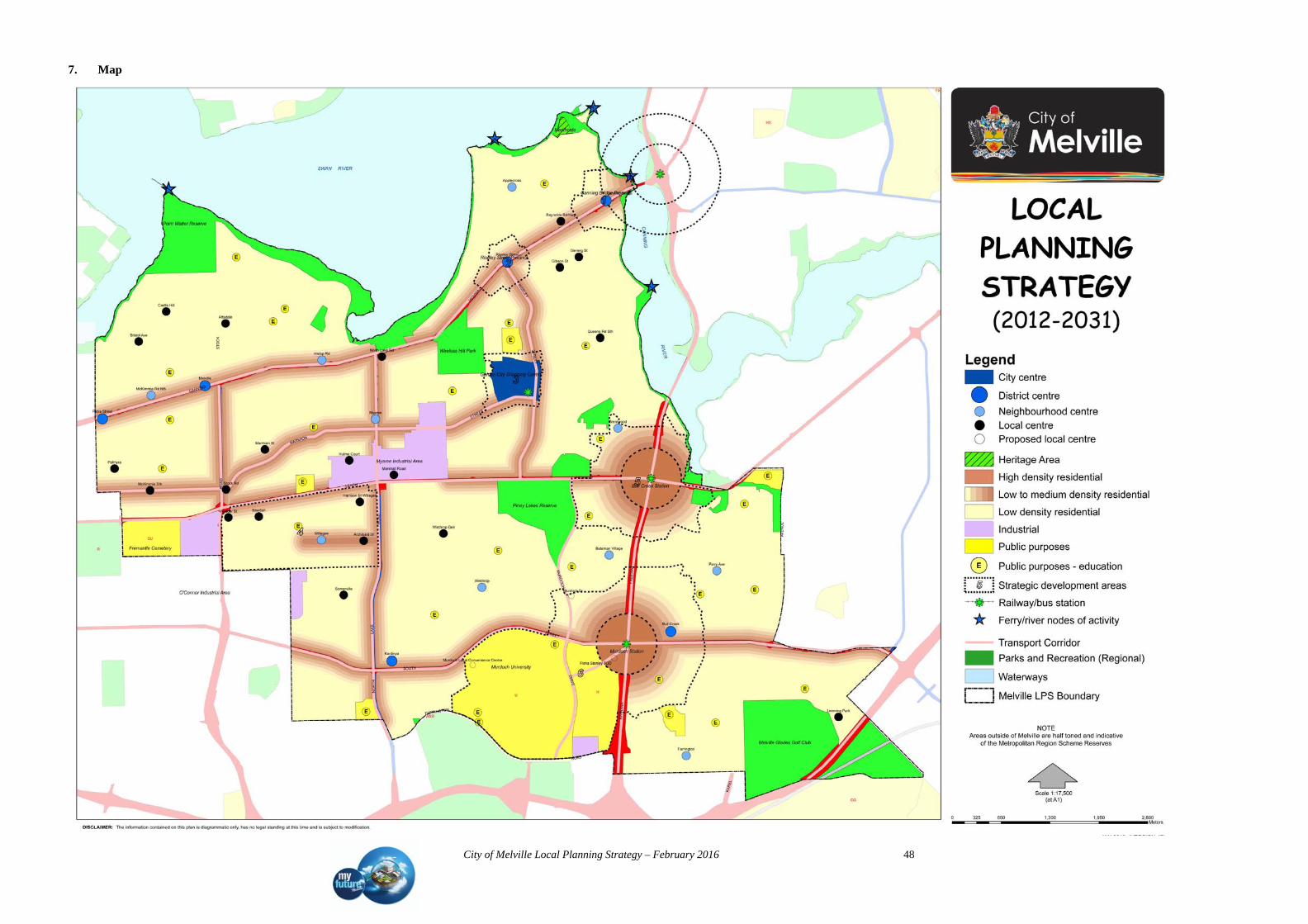
City of Melville Local Planning Strategy – February 2016 48
7. Map

City of Melville Local Planning Strategy – February 2016 49
Page left blank intentionally

City of Melville Local Planning Strategy – February 2016 50
Part 2 – Background Information and Analysis
1. Introduction
The Local Planning Strategy (LPS) is the key strategic urban planning document for the
City of Melville and will be read in conjunction with the City of Melville Local
Planning Scheme No. 6 (LPS 6). It is closely linked to the ‘City of Melville‘s plan for
the future’ (The corporate plan for the City) and ‘People Places Participation’ (The
Strategic Community Plan for the City of Melville). It defines a framework of land uses
and activities and provides a broad statement of intent to guide integrated and
sustainable planning and development in the City of Melville over the period 2012 –
2031 and beyond.
This strategy has been developed together with the Melville community through
Melville Visions – Community Perspectives on Our City- Our Future (Dialogue with the
City of Melville) project and the production of the City’s first Long Term Community
Plan and represents the culmination of many participatory and consultation steps. The
input from the Melville community is acknowledged as a critical component in the
content and design of the LPS and the resulting scheme. Preparation has also included
assessment of all relevant state and regional plans, policies and strategies, including a
comprehensive review of all local strategies and numerous long standing City policies.
The Local Planning Manual (DoP March 2010) defines the purpose of the Local
Planning Strategy as
a framework for local planning;
the strategic basis for local planning schemes;
the interface between regional and local planning;
setting out local government objectives for future planning and development;
a broad framework for local government objectives; and
the means for addressing, economic, resource management, environmental and
social issues and factors that affect and are affected by land use and development.
2 State and regional planning context
2.1 State Planning Strategy
The State Planning Strategy (SPS) is an overarching strategic document that informs all
other State, regional and local planning strategies, policies and approvals.

City of Melville Local Planning Strategy – February 2016 51
Six inter-related principles underpin and inform the SPS, which apply across all regions,
local government areas and communities.
Community: Enable diverse, affordable, accessible and safe communities;
Economy: Facilitate trade, investment, innovation employment and community
betterment;
Environment: Conserve the State’s natural assets through sustainable development;
Infrastructure: Ensure infrastructure supports development;
Regional development: Build the competitive and collaborative advantages of the
regions;
Governance: Build community confidence in development processes and practices.
The City of Melville is guided by the Strategic aspirations of the State Planning Strategy
specifically in:
A strategic approach to economic development;
Making suitable land available for industry and commerce
Ensuring infrastructure is well connected and coordinated and enhances
business efficiency and liveability
Continues to assist WA in being a leading international education provider
and a leading supplier of research services in science and technology
A strategic approach to planning for education, training and knowledge transfer;
Provide opportunity for major university hubs that compete globally for
students, researchers and investment
Successful creative, knowledge and industry clusters throughout the State.
Liveable and diverse communities
A strategic approach to the planning for tourism;
Public open spaces are used for cultural activities, events and festivals
Celebration of Aboriginal culture and heritage is secured
Cultural participation is available to all communities regardless of location
or demographics
A strategic approach to environmental planning;
Special controls in place for areas most affected by climate change
Coordinated, rigorous and timely Commonwealth, State and local approval
processes are in place to manage sustainable growth
A strategic approach to movement;
Majority of people, goods and services are contained within integrated
movement networks
Communities are connected with jobs and services

City of Melville Local Planning Strategy – February 2016 52
Reduced travel distance and travel costs
Movement networks have capacity to absorb increased travel demand
Coordinated and efficient freight logistics system incorporating road, rail, air
and sea transport
A strategic approach to water planning;
All new urban development is water sensitive as a development standard
A strategic approach to energy planning;
Climate responsive precinct and subdivision design
A strategic approach to telecommunications infrastructure;
Telecommunications are a matter of consideration in planning frameworks,
planning schemes and development decisions
The environmental impact of telecommunications is assessed during the
preparation of structure plans
A strategic approach to planning for spaces and places;
Opportunities for small scale entrepreneurship that can supply the
marketplace with more quality goods and services
Greater opportunities for local ownership, content and employment
A high degree of character and amenity that reflects the cultural values and
landscape quality of a community
Unique and locally responsive places that enhance social, cultural and
economic opportunities for communities
There is strong connectivity between people and their activities through
transit orientated developments
Accessible design standards are consistently applied to community spaces
and places
Streets are designed for people
Compact settlement structures incorporate good urban design to all civic
spaces
Vibrant and attractive public places and spaces encourage active living and
social interactions
The demographic make up of a community displays a mix of cultures, age
cohorts, skills and qualifications
A range of opportunities for local entrepreneurship, recreational activities
and cultural expression
There is variation in the built form and a range of cultural venues are
provided within a community
City of Melville Local Planning Strategy – February 2016 53
A strategic approach to planning for affordable living;
All development provides a variety of housing styles, types and sizes to
accommodate changes in demographics and market demand
Incentives and requirements for affordable housing are enabled through the
planning system
Increased density and diversity of housing though mixed use and transit
orientated developments
Communities are well connected by cycling infrastructure and public
transport
Reduced travel time and costs to access social services, employment and
amenities
Availability of affordable housing in areas well serviced by infrastructure
A strategic approach to health and wellbeing;
There is direct and safe access to health facilities, cultural events, social
support networks, sport and recreation activities
Compact settlement structures enable limited journey to work times through
transit orientated developments
Programs continue to promote and encourage walking, cycling and disability
access
Activity centres offer affordable floor space and incentives to enterprise
Community surveillance over the public realm
Public space encourages participation, social cohesion and a sense of place
Compact and interconnected settlement structures that are adaptable to
change
Developments are not located in areas that would adversely affect the health
of the public
Development minimises impact on the natural environment
A strategic approach to the sustainable supply of land for future development;
Sustained population growth that is contained within pre-defined precincts
and distribution of population as determined through a robust strategic
planning process
Land is used efficiently and appropriately
Land is readily available to cater for present and current demand levels
The provision of adequate land for housing, recreation, transport, water, food
and energy through the efficient use of land
Affordable and well located land that is accessible and well serviced

City of Melville Local Planning Strategy – February 2016 54
2.2 State planning framework
The State Planning Framework includes Directions 2031 and beyond, State Planning
Policies prepared by the Western Australian Planning Commission (WAPC) under Part 3
of the Planning and Development Act 2005 as well as regional and sub-regional
strategies, regional and sub regional structure plans, strategic policies and operational
policies.
Directions 2031 and beyond replaces previous high level frameworks, Metroplan and
Network City. It provides a high level strategic plan with a vision for future growth of the
Metropolitan Perth and Peel region. Directions 2031 provides a framework to guide the
detailed planning and delivery of housing, infrastructure and services necessary to
accommodate a range of growth scenarios.
Directions 2031 has identified three integrated networks that form the basis of the spatial
framework; Activity Centre networks, Movement network and Green Network; proposes
a ‘Connected City ‘as the preferred model for the Metropolitan Perth and Peel region and
proposes targets for achieving infill and greenfields housing.
The strategic plan for the City of Melville takes account of the key themes and strategies
of the Directions 2031. In particular the strategy has concentrated on the following
strategies:
Liveable:
Promote good urban design and development to enhance people’s experience of the
City;
Identify, protect and build our cultural identity, neighbourhood character and sense
of place;
Protect heritage places and values;
Improve community safety;
Design accessible, well connected and sustainable urban communities which
support and enable effective inclusion and participation in the community for all
residents;
Provide quality passive and active public open space;
Plan for increased housing supply in response to changing population needs;
Promote and increase housing diversity, adaptability, affordability and choice;
Ensure urban expansion occurs in a timely manner in the most suitable locations.
Prosperous:
Provide a hierarchy of places and locations for a range of economic activities and
employment across the metropolitan Perth and Peel region;

City of Melville Local Planning Strategy – February 2016 55
Plan for a diverse mix of services, facilities, activities, amenity and housing types
in centres to facilitate economic development and employment;
Increase the levels of employment self-sufficiency in sub-regional areas;
Facilitate and retain employment land to support economic growth and a balanced
distribution of employment across the metropolitan Perth and Peel region;
Promote and support tourism opportunities.
Accessible:
Connect communities with jobs and services;
Improve the efficiency and effectiveness of public transport;
Encourage a shift to more sustainable transport modes;
Maximise the efficiency of road infrastructure;
Manage and reduce congestion;
Protect freight networks and the movement economy;
Consider parking in the overall transport picture;
Plan and develop urban corridors to accommodate medium-rise higher density
housing development;
Plan and develop transit oriented developments to accommodate mixed use and
medium-rise higher density housing developments.
Sustainable:
Protect our natural and built environments and scarce resources; respond to social
change and optimise the land use and transport conditions that create vibrant,
accessible, healthy and adaptable communities
Protect and manage significant biodiversity areas;
Protect matters of national environmental significance;
Protect water resources;
Protect our coastline;
Mitigate and adapt to climate change;
Reduce waste generation and encourage reuse and recycling;
Improve air quality;
Expand and enhance our open space network;
Integrate natural resource management into land use planning.
Responsible:
Provide a hierarchy of strategic plans for the metropolitan Perth and Peel region;
Maximise essential urban infrastructure efficiency and equity; and, develop a
coordinated approach to infrastructure and land use planning and development;

City of Melville Local Planning Strategy – February 2016 56
Minimise conflict between land use and key infrastructure assets;
Allow for the strategic expansion of the urban area, with priority on the
development and use of land that is already zoned urban or urban deferred;
Plan for an efficient and equitable distribution of social infrastructure;
Engage with the development industry, State government agencies, local
government and the community to implement the strategy.
The City of Melville is located within the Central Sub Region. Sub Regional Strategies
such as the draft Central Metropolitan Perth Sub-Regional Strategy provide more detail
for the local authorities in that sub-region with Activity Centre hierarchies and dwelling
targets.
Within the City of Melville the Hierarchy of Centres lists Booragoon as a Secondary
Centre, Murdoch as a Specialised Centre and Myaree and O’Connor (Kardinya and
Palmyra industrial areas are considered as part of the greater O’Connor industrial centre)
as existing industrial centres. District centres are listed in the sub-regional strategy with
neighbourhood and local centres acknowledged but not listed individually.
The implementation plan for Directions 2031 suggests the local government is a lead
agency for the medium term initiative for a liveable city 5: develop local housing
strategies to complement or be incorporated in local planning strategies. The WAPC is a
partner/Stakeholder in this initiative.
The Local Government is a partner/stakeholder with the WAPC and Department of
Planning as Lead agency in the following initiatives.
Initiatives for a liveable city:
2. Review Liveable Neighbourhoods to update and incorporate contemporary
approaches to structure planning and subdivision design. Priority issues include
public open space, school sites, road standards and urban water management.
(Short term)
4. Review State Planning Policy 3.1 Residential Design Codes through:
adoption of a multi-unit housing design code that will focus on multiple and
grouped dwellings and the residential component of mixed use
developments; and
review of the existing codes relating to the control of ancillary
accommodation (short term).
Initiatives for a prosperous city:
1. Implement the activity centres network by:
implementing the activity centres policy for Perth and Peel that aligns with
and supports the strategic directions outlined in the spatial framework; and
City of Melville Local Planning Strategy – February 2016 57
preparing and regularly reviewing growth management strategies and
structure plans for subregional areas to ensure staging of new development
and investment in infrastructure supports and reinforces the spatial
distribution of centres (ongoing).
2. Undertake an activity centres planning program in collaboration with local
governments, key stakeholders and the community, to plan for the continued
development and diversification of priority activity centres which will be reviewed
every five years. This will include:
Activity centres audit: the Department of Planning will carry out an audit of
the identified activity centres in collaboration with local governments;
Activity centre model framework: the preparation of a set of guidelines to be
adopted as a model framework for the future planning and design of activity
centres;
Activity centre plans: where necessary the State Government will work in
partnership with local governments, key stakeholders and the community to
prepare plans for activity centres and develop strategies for their
implementation (ongoing).
9. Finalise the capital city planning framework to guide the future development of the
Perth central area (short term).
Initiatives for an accessible City:
1. The Department of Transport, in conjunction with its portfolio partners, is
preparing a Western Australian transport plan. The objective of the transport plan
is to address the state’s transport needs for the medium and long term. It is
envisaged that the transport plan will consist of three principal documents:
A high level policy document to articulate a long-term vision for Western
Australia’s transport system together with the objectives, targets and
strategic policy principles required to deliver the vision;
A high level integrated transport network strategy comprising two separately
themed, but interrelated documents covering metropolitan Perth and Peel
transport and regional transport (short term).

City of Melville Local Planning Strategy – February 2016 58
4. Prepare a metropolitan parking framework for centres that includes:
appropriate levels of parking relative to the capacity of the transport system;
a structure for assessing parking provision;
management and regulatory structures;
prioritised access, pricing and funding for public transport, cycling and
pedestrian facilities;
support for good urban design and amenity; and
guiding principles for local governments on good parking practices (medium
term).
5. Review road reservation requirements for major road network links (short term).
6. Review and identify primary regional road reservations in the MRS that are surplus
to requirements to progress their sale, improve the statutory process for approvals
along these roads and create landowner certainty (medium term).
Initiatives for a sustainable city:
1. Establish a policy direction for integration of natural resource management into the
planning framework in accordance with the Directions Paper on the Integration of
Natural Resources Management into Land Use Planning (ongoing).
Initiatives for a responsible city:
3. Develop and implement metropolitan sub-regional strategies to support the
implementation of Directions 2031 in the:
central metropolitan Perth sub-region; and
outer metropolitan Perth and Peel sub-regions (short term).
4. Develop a series of sub-regional structure plans to support the implementation of
the outer subregional strategy. The structure plans will provide more detailed
spatial information than that provided in the sub-regional strategy (short term).
6. Review sub-regional strategies based on information provided by the Office of
Land and Housing and Supply which was recently established by the Department
of Planning (short term).
7. Implement the initiatives identified in the State Government’s Planning Makes it
Happen: A Blueprint for Planning Reform including:
simplifying planning approvals;
developing more effective planning instruments;
prioritising major projects;
coordinating infrastructure and land use planning;
developing comprehensive regional planning framework; and
strengthening governance and institutional arrangements (ongoing).
City of Melville Local Planning Strategy – February 2016 59
9. Establish and implement an urban expansion management program responsible for
identifying and ensuring a sufficient supply of urban expansion areas to meet
medium to long-term residential housing needs (short term).
2.3 State planning policies
There are a number of State planning policies which have application at the local level,
and which have been taken into consideration in the preparation and application of the
local planning strategy and local planning scheme. A full list of these policies is included
in the Commission’s State Planning Policy No.1 – State Planning Framework Policy, but
the following are of particular relevance to the City:
State Planning Policy No.2: Environment and Natural Resources (2003)
The environment and natural resources policy defines the principles and
considerations that represent good and responsible planning in terms of
environment and natural resource issues within the framework of the State
Planning Strategy.
The objectives of the policy are to:
Integrate environment and natural resource management with broader land
use planning and decision-making;
Protect, conserve and enhance the natural environment;
Promote and assist in the wise and sustainable use and management of
natural resources.
In the context of the Local Planning Strategy for the City of Melville this policy
suggests that Planning strategies, schemes and decision-making should:
(i) Avoid development that may result in unacceptable environmental damage;
(ii) Actively seek opportunities for improved environmental outcomes including
support for development which provides for environmental restoration or
enhancement;
(iii) Take account of the availability and condition of natural resources, based on
best available information at the time;
(iv) significant natural, indigenous and cultural features, including sites and
features significant as habitats and for their floral, cultural, built,
archaeological, ethnographic, geological, geomorphological, visual or
wilderness values;
(v) Take into account the potential for economic, environmental and social
(including cultural) effects on natural resources;

City of Melville Local Planning Strategy – February 2016 60
(vi) Recognise that certain natural resources, including biological resources, are
restricted to particular areas and that these geographical areas or land types
may need to be identified accordingly and appropriate provision made to
protect the areas for the use of those resources;
(vii) Take account of the potential for on-site and off-site impacts of land use on
the environment, natural resources and natural systems;
(viii) Safeguard and enhance areas of environmental significance on the coast
including the marine environment;
(ix) Ensure use and development on or adjacent to the coast is compatible with
its future sustainable use for conservation, recreation and tourism in
appropriate areas;
(x) Support conservation, protection and management of native remnant
vegetation where possible, to enhance soil and land quality, water quality,
biodiversity, fauna habitat, landscape, amenity values and ecosystem
function;
(xi) Consider alternatives to land acquisition for conservation and landscape
protection where limited or no public access is required;
(xii) Take into account the potential for impacts from changes in climate and
weather on human activities and cultural heritage including coastal and
urban communities, natural systems and water resources;
(xiii) Consider any relevant accredited Natural Resource Management Regional
Strategy, or catchment management strategies prepared by catchment groups
and endorsed by State government agencies, with a view to integrating
implementation of appropriate and relevant parts through town planning
schemes and assessment of developments.
This policy informs the areas of development within the Local Planning Strategy
and Local Planning Scheme by providing a focus to supporting sustainable
development that minimizes the impact on the environment. The main implications
for the City of Melville relate to the protection of the river and wetland
environments through the recognition of reserves and open space relating to the
natural areas that remain within the City. In particular this policy is implemented
through sections 3.2.4 of the Strategic Plan for the Future (p80) , and 3.4- 3.10 of
the Local Planning Strategy (p16) as well as the strategies and actions in section
4.3, 4.4 and 4.5 (p23)
City of Melville Local Planning Strategy – February 2016 61
State Planning Policy No.2.8 Bushland Policy for the Perth Metropolitan Region
(2010)
The purpose of this policy is to guide and inform agencies, authorities, landowners
and the broader community on bushland protection and management issues that are
to be taken into account and given effect by the WAPC and local governments
when considering a planning proposal or in undertaking any decision-making
affecting significant bushland areas.
The main implication for this policy is in the protection of Bush Forever sites
within the City through recognition of the registered sites on the Local Planning
Scheme Maps and reserving other significant sites. The policy informs the
Strategies and Actions in section 4.4 of the Strategy.
The three key objectives of this policy are:
to establish a conservation system at the regional level (through Bush
Forever areas and to operate with the clearing controls under the
Environmental Protection Act 1986) that is, as far as is achievable,
comprehensive, adequate and representative of the ecological communities
of the Swan Coastal Plain portion of the Perth Metropolitan Region;
to seek to protect and manage significant bushland recommended for
protection and management for conservation purposes through a range of
implementation mechanisms and as a collective and shared responsibility
and general duty of care on the part of government, landowners and the
community; and
to provide a policy and implementation framework for significant bushland
areas recommended for protection and management to assist conservation
planning, planning assessment and decision-making processes.
The policy also provides a map of the Bush forever sites that need to be recognised
on the local planning scheme maps.
State Planning Policy No.2.9: Water Resources (2006)
This policy is directly related to the overarching sector policy SPP 2 Environment
and Natural Resources policy and provides clarification and additional guidance to
planning decision-makers for consideration of water resources in land use planning
strategy.
The objectives of this policy are to:
protect, conserve and enhance water resources that are identified as having
significant economic, social, cultural and/or environmental values;
City of Melville Local Planning Strategy – February 2016 62
assist in ensuring the availability of suitable water resources to maintain
essential requirements for human and all other biological life with attention
to maintaining or improving the quality and quantity of water resources; and
promote and assist in the management and sustainable use of water
resources.
In the context of the Local Planning Strategy for the City of Melville this policy
suggests that Planning strategies, structure plans, schemes and subdivisions and
development applications should adopt the following measures:
General Measures:
(i) Protect significant environmental, recreational and cultural values of water
resources;
(ii) Aim to prevent or, where appropriate, ameliorate the following potential
impacts:
any adverse effects on water quality and quantity;
increased nutrient loads into receiving waters;
increased acidity and leaching of acid sulfate soils;
the removal of associated native vegetation important for long-term
management of the water resource, particularly vegetation associated
with wetlands and waterways respectively;
increased erosion, sedimentation and turbidity, particularly at the
construction phase of development;
any potential adverse effects on environmental water requirements;
excessive build-up of organic matter;
pollution and contamination;
salinity over and above the natural levels; and
any potential cumulative impacts.
(iii) Promote improved outcomes such as:
environmental repair and rehabilitation of the water resource;
improved water quality;
reduction in nutrient export to receiving waters to a level lower than
existing;
restoration of natural flow regimes and variability; and
use of site works such as fencing, revegetation or water monitoring.
City of Melville Local Planning Strategy – February 2016 63
(iv) Inform planning actions by identifying all water resources above and below
ground in the subject area, and mapping and prioritising them in terms of
state, regional or local significance. Water resources to be identified include
wetlands, waterways (such as rivers, streams and creeks), estuaries,
groundwater and surface water catchments, dams, floodplains, foreshores
and existing and future surface and groundwater drinking water catchments
and sources;
(v) Take into account potential impacts the water resource may have on a land
use when determining the compatibility of locating a land use near natural or
artificial water resource/s (for example, flooding or disease vector and
nuisance insects such as mosquitoes and midges);
(vi) Recognise and take into account State Government management strategies
for water resource issues such as water protection areas, wetland protection,
water provisions for environmental flow requirements, riparian management
and water allocation plans;
(vii) Recognise and take into account water resource management plans as
required by the Rights in Water and Irrigation Act 1914.
(viii) Recognise and take into account relevant accredited natural resource
management strategies, endorsed by state government statutory authorities,
which contain recommendations to address water resource matters.
Measures for Surface and Groundwater Resources:
(i) Recognise the hydrological importance of groundwater and surface
catchments with regards to water management and the associated value of
catchment planning on a regional, district and local scale;
(ii) Protect, manage, conserve and enhance surface and groundwater catchments
and recharge areas supporting significant ecological features or having
identified environmental values, by ensuring, where possible, appropriate
management or limiting inappropriate land use/s to maintain water quality
and quantity for existing and future environmental and human uses;
(iii) Ensure the availability of water resources is compatible with the future
requirements of the proposed and surrounding land use through an
assessment of quantity and quality requirements for both the development
and the environment;
(iv) Take into account the potential adverse impacts that development may have
on catchment areas and encourage development to participate in catchment
management activities;

City of Melville Local Planning Strategy – February 2016 64
Wetlands, Waterways and Estuaries:
(i) Protect, manage, conserve and enhance the environmental functions and
values of waterways and estuaries. The natural alignment of waterways
should be retained except where adjustments are unavoidable and do not
compromise the natural environmental values;
(ii) Protect, manage, conserve and enhance the environmental attributes,
functions and values of significant wetlands, such as Ramsar wetlands,
conservation category wetlands and wetlands identified in any relevant
environmental protection policy;
(iii) Manage, conserve and, where possible, restore the environmental attributes,
functions and values of resource enhancement wetlands;
(iv) Ensure use of best management practices in the development and use of
multiple use wetlands, consistent with the principles of total water cycle
management (Schedule 4);
(v) Ensure adequate and appropriate buffering of wetlands, waterways and
estuaries to maintain or enhance the environmental attributes, functions and
values of the water resource and minimise the impact of nearby land uses,
both existing and future.
Total Water Cycle Management:
(i) Take into account total water cycle management and water-sensitive urban
design principles and ensure that development is consistent with current best
management practices and best planning practices for the sustainable use of
water resources, particularly stormwater;
(ii) Seek to achieve no net difference in water quality and quantity, unless
necessary to meet identified environmental water requirements, such that
post-development water quality and quantity conditions are equal to or better
than pre-development conditions;
(iii) Promote management of the urban water cycle as a single system in which
all urban water flows are recognised as a potential resource and where the
interconnectedness of water supply, stormwater, wastewater, flooding, water
quality, wetlands, waterways, estuaries and coastal waters is recognised;
(iv) Maximise the opportunities for compliance with best practice stormwater
management, including infiltration/detention of stormwater on site/at the
source;
(v) Promote water conservation mechanisms that increase the efficiency of the
use of water, including stormwater;

City of Melville Local Planning Strategy – February 2016 65
(vi) Incorporate the re-use and recycling of water, particularly stormwater and
grey water, consistent with state water strategy recycling objectives. Black
water reuse and recycling should be considered where deep sewerage is not
available. Alternative non-potable water sources should be considered where
appropriate for fit-for-purpose use;
(vii) Promote the retention and use of local native vegetation in developments to
minimise water use and maximise filtration, particularly where landscaping
is proposed.
In essence the protection of water resources within the local planning strategy area
are informed by this policy. In particular the implications are dealt with in section
3.7, 3.8 and 3.9 (p17) of the Local Planning Strategy, however the implications are
also dealt with in actions within Section 4.4 (p23)
State Planning Policy No.2.10: Swan – Canning River System (2006)
This policy contains a vision statement for the future of the Swan-Canning river
system, policies based on the guiding principles for future land use and
development in the precincts along the river system and performance criteria and
objectives for specific precincts.
The objectives of this policy are to:
provide a regional framework for the preparation of precinct plans based on
the precincts identified in the Swan River System Landscape Description;
provide a context for consistent and integrated planning and decision making
in relation to the river; and
ensure that activities, land use and development maintain and enhance the
health, amenity and landscape values of the river, including its recreational
and scenic values.
In the context of the Local Planning Strategy for the City of Melville this policy
suggests that planning strategies should consider the following:
Blackwall Reach
This section of the river is characterised by steeply sloping limestone landforms, a
variety of residential development and land uses and a wide range of water-based
activities. The river narrows and is flanked by high limestone bluffs sparsely
covered with natural vegetation. The area exhibits a relatively enclosed landscape,
with axial and sequential views unfolding along the deep waters and course of the
river towards Fremantle. This results in a greater sensitivity of the landscape to
urban development scale, density and proportions than in the wider parts of the
river.

City of Melville Local Planning Strategy – February 2016 66
There are a number of different land uses in this area. Residential development,
comprising a mixed tapestry of architectural styles, colour, form and scale, and
extensive active and passive recreational areas are predominant. The river and
foreshore is intensively used for commercial, recreation, transport and marine
activities and access and enjoyment of this part of the river by the public is
paramount.
Planning decisions in this area should:
protect view corridors from public vantage points, in particular from Chidley
Point, Point Roe, Minim Cove Park, Rocky Bay, Blackwall Reach,
Greenplace Reserve and Point Walter;
integrate new development with the distinctive limestone landforms and
native vegetation of the area, giving particular consideration to the scale and
proximity of limestone cliffs on each side of the river;
avoid substantial impact on the landscape qualities of the foreshore and
minimise the removal of natural foreshore vegetation, major changes to
natural ground levels or the erection of dominant structures protruding from
cliff faces and along the foreshore;
ensure that waterlines and ridgelines are maintained as the predominant
visible parameters of the river;
protect places of cultural significance, in particular places on the State
heritage register and the Department of Indigenous Affairs register of
significant places; and
ensure that commercial uses and associated development on or adjacent to
the river foreshore are confined to existing established nodes and proposed
nodes identified in an adopted Swan-Canning precinct plan.
Melville Water
This section of the river is characterised by broad expanses of water, being the
widest part of the river system. This allows extensive views of the residential
suburbs either side of the river and long views across the water to the Perth central
business district, Mount Eliza and Kings Park. This area is less sensitive to scale
than Blackwall Reach because it has a much more open visual character. However,
around Freshwater Bay, from Chidley Point to Point Resolution, the landform
features steeply sloping limestone cliffs, which create a moderate degree of visual
enclosure. The southern aspect of these cliffs results in a shadowed margin to the
river and the skyline is depicted by silhouette and form rather than colour and
texture.

City of Melville Local Planning Strategy – February 2016 67
Residential development is the predominant land use on both sides of the river and
foreshore reserves are generally extensive and developed as formal active and
passive recreation areas with some pockets of natural vegetation along cliff edges
and wetland bays. The area is also notable for a number of commercial,
institutional and recreational landmarks. These include: the Raffles hotel site, the
Sunset Hospital site, the University of Western Australia, Heathcote, Santa Maria,
Methodist Ladies and Christchurch colleges and the Royal Freshwater, Nedlands,
Royal Perth and South Perth yacht clubs. The Kwinana Freeway, Canning Bridge
and Mounts Bay Road provide continuous views of the river to a large number of
travellers on those roads.
Planning decisions in this area should:
protect views, in particular the long axial corridors from public vantage
points such as Pelican Point, Nedlands foreshore, Keanes Point, Attadale
foreshore, Point Heathcote, Canning Bridge, Mounts Bay Road, and the
intermediate views in Freshwater Bay, Matilda Bay and Alfred Cove;
improve opportunities for public access and use of the river, particularly
between Chidley Point and Keanes Point, parts of Freshwater Bay and Point
Resolution on the northern side, taking account of the terrain, public risk and
recreational opportunities;
protect places of cultural significance, in particular places on the State
heritage register and the Department of Indigenous Affairs register of
significant places;
ensure urban development complements natural landforms;
ensure that vegetation is integrated with development to minimise the
contrast between the natural and built elements of the landscape and that
ridgeline vegetation and its backdrop to the waterway is retained;
ensure that commercial uses and associated development on or adjacent to
the river foreshore are confined to existing established nodes and proposed
nodes identified in an adopted Swan-Canning precinct plan; and
protect the natural conservation values of marine parks at Alfred Cove and
Matilda Bay.

City of Melville Local Planning Strategy – February 2016 68
Lower Canning
The Canning River landscape near its confluence with the Swan River is dominated
by the elevated landform of Mount Henry and the public infrastructure of Kwinana
Freeway and the Canning and Mount Henry bridges. Beyond Mount Henry the
river forms two wide basins, Aquinas Bay and Shelley Basin. These are framed by
the ridgeline of Mount Henry, decreasing to the flatter, lower lying land of Salter
Point and Waterford.
Deep Water Point is a popular recreational node, clearly visible from the Canning
Bridge and used extensively for rowing, water skiing and other aquatic activities.
With the exception of some significant commercial development near the Canning
Bridge, most of the Canning River area has a suburban character, which is
generally screened by fringing vegetation and flat topography. Residential suburbs
are leafy, characterised by low density development with mature trees and a natural
river foreshore.
Several institutional land uses define the landscape along this section of the river.
These include Aquinas College, Clontarf and Castledare boys homes and further
upstream, the Canning City Council offices and gardens.
The area includes the Canning River Regional Park, which contains some of the
best estuarine vegetation of the Swan-Canning catchment. The Kent Street Weir
and Nicholson Bridge are notable landmarks along this part of the river.
Planning decisions in this area should:
protect views from public places, particularly from Canning and Mount
Henry bridges, Deep Water Point and Salter Point;
ensure that development and river uses do not degrade the visual amenity
and conservation value of the natural landscape, particularly within
significant areas such as the Canning River Regional Park;
protect places of cultural significance, in particular places on the Register of
Heritage Places and the Department of Indigenous Affairs register of
significant places;
ensure that commercial development on the foreshore reserve is confined to
existing recreation nodes and in accordance with an adopted Swan-Canning
precinct plan for the area;
enhance recreational opportunities where access is limited; and
ensure that the scale and density of new residential development blends
harmoniously with the leafy, suburban character and predominantly natural
features of the landscape.

City of Melville Local Planning Strategy – February 2016 69
The guidelines within this policy are reflected in the coding s proposed in Local
Planning Schemes as well as informing strategies and actions in section 4.4, 4.5,
4.6, 4.7 and 4.8 of the Local Planning Strategy (p23).
State Planning Policy No.3: Urban Growth and Settlement (2006)
This policy sets out the principles and considerations which apply to planning for
urban growth and settlements in Western Australia.
The objectives of this policy are:
To promote a sustainable and well planned pattern of settlement across the
State, with sufficient and suitable land to provide for a wide variety of
housing, employment, recreation facilities and open space;
To build on existing communities with established local and regional
economies, concentrate investment in the improvement of services and
infrastructure and enhance the quality of life in those communities;
To manage the growth and development of urban areas in response to the
social and economic needs of the community and in recognition of relevant
climatic, environmental, heritage and community values and constraints;
To promote the development of a sustainable and liveable neighbourhood
form which reduces energy, water and travel demand while ensuring safe
and convenient access to employment and services by all modes provides
choice and affordability of housing and creates an identifiable sense of place
for each community;
To coordinate new development with the efficient, economic and timely
provision of infrastructure and services.
The key elements are—
consolidating residential development in existing areas and directing urban
expansion into the designated growth areas which are, or will be, well
serviced by employment and public transport;
giving priority to infill development in established urban areas, particularly
through urban regeneration and intensification of development of under-
utilised urban land, whilst respecting neighbourhood character;
locating higher residential densities in locations accessible to transport and
services, such as in and around the CBD, regional and district centres,
activity corridors and higher education campuses, and in selected areas of
high amenity on the coast and river foreshores;

City of Melville Local Planning Strategy – February 2016 70
concentrating commercial, health, education, entertainment and cultural
developments in and around activity centres and corridors with good access
to public transport and which are easily accessible for the catchment
population;
developing an integrated land use and transport network which reduces car
dependence and broadens travel options, makes it easier for people to use
public transport or walk or cycle to their destinations, and establishes
defined transport corridors as the major network for the movement of goods
and people;
protecting biodiversity and areas of environmental significance, and
promoting the concept of an interlinked system of regional and local open
space; and
protecting water resources, and reducing the use of non-renewable resources
and waste generation.
State Planning Policy No.3.1: Residential Design Codes (2010)
The R-Codes provide a comprehensive basis for the control of residential
development throughout Western Australia. The R-Codes aims to address
emerging design trends, promote sustainability, improve clarity and highlight
assessment pathways to facilitate better residential design outcomes throughout
Western Australia.
The impact of the R-Codes have been considered throughout the Strategy in
determining the impact of increased development on the amenity of residential
areas, the number of new dwellings that could be introduced and the type of
dwellings that could be anticipated under the existing and proposed R-Codes.
State Planning Policy No.3.4: Natural Hazards and Disasters
The purpose of this policy is to inform and guide the WAPC in the undertaking of
its planning responsibilities, and in integrating and coordinating the activities of
State agencies that influence the use and development of land that may be affected.
The implications of this policy are reflected in the transport and land use
components of the Strategy specifically section 3.1, 3.2, 3.11 and 3.12 as well as
the strategies and actions in section 4.2.
Consistent with the purpose of the policy, the objectives of this policy are to:
Include planning for natural disasters as a fundamental element in the
preparation of all statutory and non-statutory planning documents,
specifically town planning schemes and amendments, and local planning
strategies; and

City of Melville Local Planning Strategy – February 2016 71
Through the use of these planning instruments, to minimise the adverse
impacts of natural disasters on communities, the economy and the
environment
State Planning Policy No 3.5: Historic Heritage Conservation (2007)
This policy sets out the principles of sound and responsible planning for the
conservation and protection of Western Australia’s historic heritage.
The implications of this policy are reflected in the strategies and actions of section
4.6 Heritage of this Strategy.
The objectives of this policy are:
To conserve places and areas of historic heritage significance.
To ensure that development does not adversely affect the significance of
heritage places and areas.
To ensure that heritage significance at both the State and local levels is given
due weight in planning decision-making.
To provide improved certainty to landowners and the community about the
planning processes for heritage identification, conservation and protection.
State Planning Policy 3.6: Development Contributions for Infrastructure
This Policy sets out development contribution provisions for standard
infrastructure items applied by the Western Australian Planning Commission
(WAPC) on the subdivision, strata subdivision, or development of land; and
provides a consistent, accountable and transparent system for local governments to
plan and charge for community infrastructure items which are not included in the
standard provisions through development contribution plans.
Although this policy is not directly reflected in the Local Planning Strategy, it has
influenced the considerations for structure planning in the Strategic development
Areas, Strategies and actions in section 4.3 and the inclusion of clauses in the Local
Planning Scheme 6.
State Planning Policy No.4.2: Activity Centres for Perth and Peel (2010)
The Activity Centres Policy is a state planning policy for the planning and
development of activity centres throughout Perth and Peel.
This policy impacts directly on Clause 3.2 and 3.3 of this Strategy and influences
the development of activity centres within the City. The implications can be seen in
the strategies and actions of Section 4.1 of this strategy. The main hierarchy of
centres is reflected in and reinforced in the Local commercial activity centres
strategy. It also influences the future planning and structure planning for the
Specialised, Secondary and District Centres within the City of Melville.
City of Melville Local Planning Strategy – February 2016 72
The main purpose of this policy is to specify broad planning requirements for the
planning and development of new activity centres and the redevelopment and
renewal of existing centres in Perth and Peel. It is mainly concerned with the
distribution, function, broad land use and urban design criteria of activity centres,
and with coordinating their land use and infrastructure planning.
Other purposes of the policy include the integration of activity centres with public
transport; ensuring they contain a range of activities to promote community
benefits through infrastructure efficiency and economic benefits of business
clusters; and lower transport energy use and associated carbon emissions.
The policy also reflects the Western Australian Planning Commission’s (WAPC)
intention to encourage and consolidate residential and commercial development in
activity centres so that they contribute to a balanced network.
State Planning Policy No. 5.2: Telecommunications Infrastructure (2004)
The policy provides a framework for the preparation, assessment and determination
of applications for planning approval of telecommunications facilities within the
context of the planning system of Western Australia.
The implications of the policy relate mainly to the National Broadband Network
but also in the strategic planning for development areas. It also influences Section
4.10.3 of part 2.
Separate approval may be required from other government agencies under other
legislation.
The objectives of this policy are to:
facilitate the provision of telecommunications infrastructure in an efficient,
cost-effective and environmentally responsible manner to meet community
needs;
facilitate the development of an effective statewide telecommunications
network in a manner consistent with the economic, environmental and social
objectives of planning in Western Australia as set out in the Planning and
Development Act 2005 and the State Planning Strategy;
assist community understanding of the issues involved in the design and
installation of telecommunications infrastructure and provide opportunities
for community input to decision-making;
promote a consistent approach in the preparation, assessment and
determination of applications for planning approval of telecommunications
infrastructure;

City of Melville Local Planning Strategy – February 2016 73
minimise disturbance to the environment and loss of amenity in the
provision of telecommunications infrastructure; and
ensure compliance with all relevant health and safety standards in the
provision of telecommunications infrastructure.
The ‘Guidelines for the Location, Siting and Design of Telecommunications
Infrastructure’ are designed to be read in conjunction with the policy, any town
planning scheme for the particular area, and any local planning policies relevant to
telecommunications infrastructure.
State Planning Policy No. 5.3: Jandakot Airport Vicinity – (2006)
The policy applies to land in the vicinity of Jandakot airport, which is, or may in
the future, be affected by aircraft noise.
The objectives of this policy are to:
protect Jandakot Airport from encroachment by incompatible land use and
development, so as to provide for its ongoing, safe, and efficient operation;
and
minimise the impact of airport operations on existing and future
communities with particular reference to aircraft noise.
State Planning Policy No 5.4: Road and Rail Transport Noise and Freight
Considerations in Land Use Planning – (2007)
This policy aims to promote a system in which sustainable land use and transport
are mutually compatible.
Implications of this policy can be seen in the introduction of clauses within the
Local planning Scheme. The policy also influences clauses 3.1 3.2 and 3.11 of this
strategy as well as strategies and actions of section 4.2 (p22).
The objectives of this policy are to:
protect people from unreasonable levels of transport noise by establishing a
standardised set of criteria to be used in the assessment of proposals;
protect major transport corridors and freight operations from incompatible
urban encroachment;
encourage best-practice design and construction standards for new
development proposals and new or redeveloped transport infrastructure
proposals;
facilitate the development and operation of an efficient freight network; and
facilitate the strategic co-location of freight handling facilities.

City of Melville Local Planning Strategy – February 2016 74
It should be noted that the policy and these guidelines apply to proposals for new
noise-sensitive developments, new railways or major roads, major redevelopments
of existing railways or major roads, and new freight handling facilities. The policy
and guidelines do not apply to noise from existing railways or major roads in the
vicinity of an existing noise-sensitive land use, or an increase in traffic along an
existing railway or major road in the absence of a major redevelopment.
State Planning Policy No 6: Local Planning Strategies
The drafting of the Local Planning Strategy has been influenced by this policy. The
implication can be seen in the introduction of two new local activity centres in
Marshall Road and Hulme Court in Myaree as well as the identification on the
local planning strategy map of sites for possible new local activity centres in
Murdoch and Bateman.
(1) Local planning strategies should reflect the policy provisions including the
activity centres hierarchy. These strategies will be used as the basis for
preparing and amending local planning schemes, and for preparing and
assessing activity centre structure plans, district and local structure plans and
development applications.
(2) New activity centres identified through local planning strategies may be
endorsed by the WAPC, subject to this Policy.
2.4 Regional strategies
In order to ensure that development in the State of Western Australia and the Perth
Metropolitan Region meets its full potential in the next 20 years, the Western Australian
Planning Commission (WAPC) is charged with developing visions and strategies that
guide development, the economy and the community.
The broad context of regional planning was defined in 1955 with the Hepburn
Stephenson Plan for the Metropolitan Region, and this was subsequently amended by the
Corridor Plan of 1970, Metroplan of 1991, the 1997 State Planning Strategy and
Network City (draft 2006) and more recently Directions 2031 and beyond.
A finer grain of regional planning comes in the form of sub-regional strategies prepared
by or in conjunction with State Government. The Central Metropolitan Perth Sub-
Regional Strategy addresses issues relating to a grouping of local authorities immediately
adjacent to the Central Business District and the Swan River to Fremantle.
The Strategy provides a broad framework for delivering the objectives of Directions 2031
and identifies a strategic plan of actions, agency responsibilities and delivery timeframes.
It links State and local government strategic planning to guide the preparation and review
of local planning strategies.

City of Melville Local Planning Strategy – February 2016 75
The Sub regional strategy anticipates a minimum housing target of 11,000 additional
dwellings for the City of Melville by 2031. There are a series of actions proposed by the
strategy for the local government to achieve these targets.
Liveable
Living in or visiting our city should be a safe, comfortable and enjoyable experience.
Strategy 1: Plan for increased housing supply in response to changing population
needs.
1.1 Provide certainty about the location of future housing by ensuring that the
housing component of local planning strategies supports the implementation
of local government housing targets as adopted by the WAPC.
1.2 Apply higher densities through local planning strategies and schemes within
areas that have close proximity to:
a. high frequency public transport nodes such as rail stations and bus
interchanges;
b. suburban corridors;
c. retail and employment centres;
d. public open space, foreshores, parks and areas with potential for high
quality views;
e. educational institutions; and
f. community and recreational facilities and services such as hospitals,
medical centres and libraries.
1.3 Consider a State Government funding support program to assist in the
development of joint ventures and pilot projects which demonstrate best
practice in urban infill.
1.4 Introduce planning reform measures that would provide greater certainty for
the approval of higher density projects.
1.5 Ensure that local planning strategies and schemes consider and allocate
sufficient zoned land to provide for the increasing demand for aged care
accommodation.
1.6 Identify suitable partnerships to facilitate the provision of residential aged care
services.

City of Melville Local Planning Strategy – February 2016 76
Strategy 2: Promote and increase housing diversity, adaptability, affordability and
choice.
2.1 Ensure the proposed R-Code densities and provisions in local planning
strategies and schemes support a sufficient mix of housing types and sizes.
2.2 Apply the Multi Unit Housing Code to support increased housing diversity
and mixed-use development in activity centres and other suitable locations.
2.3 Promote the use of density bonuses on corner lots, subject to design guidelines
to ensure preservation of local amenity and an appropriate streetscape.
2.4 Consider a range of housing types and sizes in all major housing
developments/redevelopments, including State government projects.
2.6 Promote flexible building designs capable of conversion to dual or multiple
occupancy.
2.8 Introduce incentives such as:
a. diversity bonuses to increase provision of affordable housing; or
b. density bonuses to promote higher-density developments that include
diverse and affordable forms of housing, and which meet performance
criteria.
Prosperous
Our success as a global city will depend on building on our current prosperity.
Strategy 3: Plan for a diverse mix of services, facilities, activities, amenity and housing
types in centres to facilitate economic development and employment.
3.1 Finalise structure plans for: Booragoon secondary centre and Canning Bridge
district centre.
3.3 Prepare structure plans for the Murdoch specialised centre.
3.4 Apply SPP 4.2 Activity Centres for Perth and Peel housing density targets in
local planning schemes and centre plans.
3.5 Apply the Multi Unit Housing Code activity centre codes as appropriate to
facilitate more housing and multi unit development in activity centre growth
areas.
3.6 Ensure local planning strategies enable the regeneration of existing activity
centres to improve their amenity, attractiveness and social and cultural vitality.

City of Melville Local Planning Strategy – February 2016 77
Strategy 4: Facilitate and retain employment land to support economic growth and a
balanced distribution of employment across the central sub-region.
4.1 Local planning strategies should promote the economic role of key industrial
zones in providing employment diversity and support their retention, efficient
operations and growth by ensuring compatible land use.
4.2 Apply appropriate planning reservations to minimise land use conflicts and
maintain the long term efficiency of the freight network and urban amenity in
the context of increasing freight.
4.3 Improve intersection capacities along Roe and Leach Highways and other
freight routes such as Stock Road and High Street.
4.7 Ensure activity centres are planned for mixed use and provide for a wider
range of employment opportunities.
Accessible:
People should be easily able to meet their education, employment, recreation, service and
consumer needs within a reasonable distance of their home.
Strategy 5: Plan and develop transit oriented developments to accommodate a mix of uses
and medium-rise higher density housing development.
5.1 Encourage planning initiatives to support the provision of more housing
within transit oriented developments including urban corridors and activity
centre growth areas.
5.2 Undertake a review of Development Control Policy 1.6 – Planning to Support
Transit Use and Transit oriented development – and the Department of
Planning’s transit oriented development program to evaluate the effectiveness
in promoting and realising transit oriented development in the central
metropolitan sub-region.
5.4 Prepare activity centre plans, urban design frameworks and implementation
strategies to facilitate transit oriented development.
5.6 Evaluate the level of land use and transport integration by monitoring new
housing supply in the walkable catchments of train stations and other high-
frequency public transport routes.
Sustainable:
We should grow within the constraints placed on us by the environment in which we live.

City of Melville Local Planning Strategy – February 2016 78
Strategy 6: Protect our natural and built environments and scarce resources; respond to
social change and optimise the land use and transport conditions that create
vibrant, accessible, healthy and adaptable communities.
6.1 Ensure local planning strategies and schemes assess environmental factors
relevant to district-level planning. This should provide for the appropriate use
and management of elements of the natural and built environments with
significant conservation, recreation and cultural heritage values.
6.3 Monitor and evaluate car travel relative to use of public transport, cycling and
walking for work trips.
6.4 Use best practice urban design to encourage physical activity, provide
universal access to buildings and public spaces, and apply Crime Prevention
through Environmental Design principles to improve community safety.
Responsible
We have a responsibility to manage urban growth and make the most efficient use of
available land and infrastructure.
Strategy 7: Maximise urban infrastructure efficiency and equity and coordinate the
planning of new capital works to support future population growth.
7.1 Apply local government housing targets as a planning demand scenario for
use in strategic planning by utility and social infrastructure agencies.
(Department of Planning - Central Metropolitan Perth sub regional strategy)
2.5 Regional planning schemes
Statutory planning is directed by the Metropolitan Region Scheme (MRS). This
establishes the regional planning priorities and is the framework for the preparation of
local planning schemes (for municipal areas).
The MRS identifies several zonings within the City of Melville. The local planning
scheme recognises these zonings and applies various other local zonings within the
general urban zoning of the MRS. The MRS identifies zones and reserves of significance
including Waterways; Primary Regional roads and Other Regional roads; Parks and
Recreation; Public Purpose reserves, including hospitals, high schools, universities, and
special uses; industrial zones; Railways and Bush Forever sites. It does not however,
identify many other issues of regional importance such as significant conservation areas
like Alfred Cove.
City of Melville Local Planning Strategy – February 2016 79
2.6 Regional and sub-regional structure plans
There are no current Regional or sub regional structure plans relevant to the City of
Melville.
2.7 Operational policies
A variety of WAPC strategic and operational policies are considered in the context of this
Strategy. Strategic policy statements deal with particular strategic planning issues and in
some cases, refine and expand upon an aspect of a regional strategy. Operational policies
are largely subdivision and development control policies which have been adopted by the
Commission to guide its decision making on subdivision and development applications.
Recognition of these policies within the Local Planning Strategy highlights the
importance of the policies to the development process. The implications of the policies
have been considered in the future opportunities for the City as well as in the Strategies
and Action in section 4 of this strategy.
Applicable strategic policies include:
Government Sewerage Policy: Perth Metropolitan Region (1996);
Bush Forever (2000), and
Liveable Neighbourhoods (2007).
Applicable operational policies include:
1.1 Subdivision of Land – General Principles (2004)
This policy sets out the general principles, which will be used by the WAPC in
determining applications for the subdivision of land.
It indicates the WAPC’s basic requirements for the creation of new lots as well as
the procedures it will follow in processing subdivision applications
1.2 Development control – General Principles (1998)
This policy states in plain terms the development approval requirements in respect of
land the subject of metropolitan and other region schemes.
1.3 Strata Titles (2009)
This policy deals with those classes of strata title proposals which require the approval
of the WAPC and sets out the criteria to be used in the determination of applications for
that approval.
It does not apply to all strata title proposals, many of which are now exempt from the
need for the WAPC's approval.

City of Melville Local Planning Strategy – February 2016 80
City of Melville Local Planning Strategy – February 2016 81
1.4 Functional Road Classification for Planning (1998)
The purpose of this policy is to outline an established road classification system for use in
planning new road networks. The implications of this policy can be seen in the functional
road hierarchy and discussions around that in section 4.9 of Part 2 of the strategy as well
as influencing the Actions and strategies in section 4.2 of part one.
Policy objectives
To establish clear universal recognition of the expected functions of different roads,
thereby providing a consistent and uniform approach to road planning in urban areas
throughout Western Australia;
To help identify and evaluate the degree of compatibility between roads and adjacent
land use.
1.5 Bicycle Planning (1998)
This policy describes the planning considerations which should be taken into account in
order to improve the safety and convenience of cycling. The implications of this policy
can be seen in the discussions in section 4.9 of Part 2 of the strategy as well as influencing
the actions and strategies in section 4.2 of part one.
Policy objectives
To make cycling safer and more convenient through the provision of end-of-trip
facilities and by the provision of better cycle route networks;
To ensure that the needs of cyclists, are recognised and provided for by planning and
road construction authorities;
To encourage more work, school and shopping trips to be made by bicycle through
the provision of more (and better) cycling facilities;
To increase the general awareness of the benefits of cycling;
To ensure adequate consideration is given to the provision of cycling facilities in
planning studies and in the implementation of statutory planning controls.
1.6. Planning to Support Transit Use and Transport Orientated Development (2006)
This policy seeks to maximise the benefits to the community of an effective and well used
public transit system by promoting planning and development outcomes that will support
and sustain public transport use.
This policy applies to all areas of the state, within transit precincts as defined under the
policy, and is intended to inform government agencies, local government, landowners and
prospective developers of the policy approach which will be applied by the WAPC.
The Department of Planning is committed to encouraging the use of transit oriented
development principles to link land use and public transport across Perth.
City of Melville Local Planning Strategy – February 2016 82
This policy has guided the selection of strategic development areas around transport hubs
and activity centres which are well connected with public transport. Concepts for the
strategic planning of these areas focus on enhancing the Transit use. Specific implications
can be seen in strategies and actions of section 4.1, 4.2 and 4.8 of the strategy.
1.7 General Road Planning (1998)
This policy brings together in one document all those policies of the WAPC which are not
included in the residential road planning policy and apply generally to the planning of all
roads.
Consistent with the approach taken in the residential road planning policy, this policy also
refers to the functional road classification system established in functional road
classification for planning. The policy influences the terminology, hierarchy and
classification of roads in part 2 section 4.9 of this strategy.
2.2 Residential Subdivision (2003)
This policy establishes the WAPC’s position regarding residential subdivision.
The policy has been developed and refined over many years taking into account the
adoption and subsequent amendments to the Residential Design Codes and the
government’s policies on sewerage and underground power.
The policies influence can be seen in the future opportunities as seen in section 5.1 of the
strategy.
2.3 Public Open Space in Residential Areas (2002)
The basic component of this policy is the requirement that 10 per cent of the gross
subdivisible area of a conditional subdivision shall be given up free of cost by the
subdivider for public open space.
This has been the basis of public open space policy in the state for many years, and
emanates from the recommendations of the Plan for the Metropolitan Region Perth and
Fremantle.
Assessment of the public open space is reported in section 4.6 of part 2 and section 3.4,
3.5 and 3.6 of Part one and is guided by this policy. It should be noted though that many
of the suburbs within the City were developed before guidelines were introduced.
2.4 School sites (1998)
This policy statement contains the WAPC’s general requirements for school and TAFE
college sites in residential areas, and recognises the need to consider any requirements for
higher education facilities.
It should be used during the preparation of designs for the subdivision of residential land
at both the structure planning (district and local structure planning) and subdivision
design stages.

City of Melville Local Planning Strategy – February 2016 83
The general concepts of this policy guided the assessment of the education availability in
the City as reflected in Section 4.7 of part 2.
2.6 Residential Road Planning (1998)
This policy sets out the WAPC's requirements for the planning and design of roads in
residential areas and provides guidelines for the design and layout of residential roads.
The policy has been prepared with particular reference to the quality of the
neighbourhood environment and the cost of housing. It offers a response to these issues in
terms of road planning and design.
This has little impact on the City as the residential areas have been developed, however
the assessment of the roads in section 4.9 of Part 2 has been influenced by this policy.
4.1 Industrial subdivision (1998)
This policy provides guidance on the matters considered by the WAPC when determining
applications for industrial subdivision throughout the state.
These include such matters as the design and shape of industrial lots, road layout, and
servicing and open space requirements.
This has little impact on the City as the industrial areas have been developed, however
Section 3.2 and Actions and strategies of section 4.1 have been influenced by this policy.
5.1 Regional Roads (vehicular access) (1998)
This policy sets out the principles to be applied when considering proposals for vehicle
access to or from developments abutting regional roads.
It is intended to inform government agencies, local governments and prospective
developers of these principles and to act as guidelines for the exercise of development
control powers in this regard.
This has influenced the proposed increased intensity of development along regional roads
with high frequency public transport as well as encouraging reduced private vehicle
access from properties adjoining these roads.
5.3 Use of Land Reserved for Parks and Recreation (1999)
The purpose of this policy is to outline the circumstances under which the WAPC may
approve the use and development of land reserved for parks and recreation for different
purposes.
Specifically for land in the ownership of the State. The policy also sets out the procedure
for handling requests from sporting club and community groups for the use of reserved
land.
This policy has implications for the strategic approach to community hubs as shown in the
Local Governments Strategic Plan for the Future and the Long term Community Plan
shown in Part 2 Section 3.2.
City of Melville Local Planning Strategy – February 2016 84
5.4 Advertising on Reserved Land (2005)
This policy sets out the objectives and considerations taken into account by the WAPC in
determining applications for the display of advertisements on land reserved under a region
scheme.
The erection, alteration, and extension of any advertisement on land reserved by a region
scheme requires the approval of the WAPC.
Recognition of this policy within the Local Planning Strategy highlights the importance of
the policies to the development process. Its implications are reflected in the Local
Planning Scheme.
2.8 Other relevant strategies, plans and policies
Other relevant strategies, plans and policies will be added as they are introduced.
2.9 Guidelines forecast and reports.
The main data on population forecasts are drawn from the Informed Decisions (id) suite of
programs available via the City of Melville website. These programs are based on the
Australian Bureau of Statistics data from Census and other sources and combine more up to
date information such as development applications, demolitions, migration patterns and
strategic planning to provide more up to date profiles and forecasts. The Informed
Decisions (id) suit of programs includes Profile.id, Forecast.id and Economics.id.
Information provided by the Department of Planning includes the population forecasts
within WA Tomorrow, State Lot Activity and Urban Growth Monitor.
3. Local planning context
3.1 Vision and mission statements
3.1.1 Melville visions
Community expectations for a broad range of issues impacting on the future directions of
the City of Melville are represented in Melville Visions – Community Perceptions on Our
City - Our Future (referred to as Dialogue with the City of Melville).
Melville Visions was an outcome of the Dialogue with the Communities Program initiated
by the Western Australian Planning Commission undertaken in 2008.
This program provided local governments with resources to engage with their communities
and to develop strategies and plans that identified and addressed the emerging objectives of
the State Government’s Network City strategy.

City of Melville Local Planning Strategy – February 2016 85
The Melville Visions consultation process provided statistically valid insights of the
expectations of Melville’s residents, youth, businesses and visitors. The Melville Visions
project was divided into the key focus areas of:
Built environment;
Accessibility;
Natural environment;
Sense of community;
Opportunity, equity and choice;
Sense of place.
A summary of the strategic insights which resulted from the process were:
City of Melville needs a clear long term vision;
Population growth within the City of Melville is of concern;
The increase in the scale of development is of concern;
The quality of life in the City of Melville is good and is improving;
Smaller lots in specific locations and mixed uses may be acceptable;
A need exists for a new east-west highway;
A greater focus on improved community safety is required.
In terms of urban planning and development, ‘Melville Visions’ identified the following
community expectations:
1. 70%-90% of people agreed that Melville’s attributes and image was one of a
convenient location, leafy and green, open and spacious, relaxed and clean, tidy and
well maintained. This image needs to be protected, maintained and expanded.
2. Only 5% of people were likely to start a home based business. As such, home
occupation provisions while being necessary are unlikely to be an issue and
increased mixed use development will meet demand. Standard Home Occupation
provisions are likely to be adequate.
3. 21% of people were looking for a larger home while 17% a smaller home with 91%
not looking to move from the City of Melville. This suggests no great need for
wholesale change to density codings, but to provide housing variety and choice
within selected locations.
4. Retirement figures suggest substantial retirement numbers in the next 10 years.
Based upon current AMCORD data, the City of Melville will need to consider policy
and location criteria for additional seniors’ facilities and to allow more opportunity
for aging in place.

City of Melville Local Planning Strategy – February 2016 86
5. Approximately half of the residents of Melville wanting lower than projected growth
rate (0.6% of people dwellings). Opposition to growth came from 3 in 5 residents.
This would similarly suggest modest density re-codings in line with orderly and
proper urban planning principles and Government policy.
6. The preference in Melville is for slightly less 800+m2 lots and slightly more demand
for 300m2 lots (over next 10 years).
Applecross – increase duplex and villas
Bull Creek/Leeming – decrease 500 & 800m2 – increase 300m2
City – decrease 800m2
University – decrease 800m2 – increase 300m2
Palmyra/Melville/Willagee – decrease 500m2 – increase 800m2
Bicton – no change
These suggested minor changes can, where practical, be accommodated through
orderly and proper planning principles and recoding in the new Scheme.
7. 83% of people oppose 4 – 5 storey development. Currently the predominant
residential height limit in the City of Melville is 2 to 3 storey.
8. 93% of people oppose 6 – 12 storey developments. There are only a few commercial
and ‘frame’ areas where these heights would be permitted to satisfy State
Government policy to provide higher density around transport nodes e.g. Canning
Bridge, Riseley Centre and Melville City Centre.
The majority of residents prefer a diverse mix of stand-alone houses in the suburbs
on 500 to 800m2 lots. This is and will continue to be catered for in the revised Local
Planning Scheme.
Two-thirds of residents support a homogeneous street character e.g. dwellings being
of a similar size and type; all suburbs in the 60 to 70% range. Many streets have
already been impacted upon by units, villas, townhouse developments in traditional
single residential streets.
The principle to be employed is to consider opportunities for grouped dwellings
around shopping centres, transport nodes and corridors and perhaps in streets where
the character has already changed through infill by grouped dwelling developments
and battleaxe subdivision.
Over half of residents support 300m2 lots if developed around shopping centres, rail
stations etc. This will be provided for.

City of Melville Local Planning Strategy – February 2016 87
Over half of residents support mixed use around local shopping centres (Activity
Centre). This is currently provided for in the local planning schemes in the form of
“Frames” and will remain though there is an opportunity to increase the intensity of
Activity Centres by encouraging more mixed use development within the centres.
9. Only 40% of people supported small lots around parks. This suggests that some
careful assessment of suitable locations may be necessary based upon other adjoining
land` uses, age and condition of housing, restricting height to 3 storeys or even 2
storeys. The survey data showed 42% approval in City and Palmyra; 41% in
Applecross and Bicton with University and Bull Creek at 38% and 39% respectively.
All Wards had a 20 to 30% neutral result with 30 to 39% opposed.
10. The nexus of increased population/development in the City of Melville and increased
traffic is highlighted in the survey with 87% of residents linking population growth
with the negative impacts of traffic. This assumption is not totally valid as much of
the higher density is located around public transport corridors and nodes and peak
private vehicle traffic may decrease in these areas.
11. Extension of the Roe Highway is supported by 81% of residents with only 8%
opposed. A need to provide for safe and convenient east-west freight and vehicular
traffic is required in the form of a dedicated road between Kwinana Freeway and
Stock Road.
12. Bus lanes on Canning Highway are generally not supported as there is a concern
about them contributing to congestion. More research is required in this area,
especially as they have been implemented in South Street.
13. Moderate support (63%) exists for a ferry service and improved community facilities
at selected foreshore nodal areas; Deepwater Point and Point Walter scored highest.
14. Residents perceive growth having a negative impact on the quality of nature reserves,
stating that trees and greenery are important. Incentive schemes not mandatory
provisions should be used to protect nature trees (65%). Sustainability incentives
should be used (91%). The opportunity exists in the scheme review to provide
incentive packages for sustainable development and practices likewise protection of
trees e.g. bonus PR, setback variations etc.
15. Growth is seen as having a negative impact on safety by 68% of residents.
16. Residents prefer ‘Garden City’ overwhelmingly to any other centre – with
Brentwood, Somerville and Myaree as the most popular neighbourhood centres and
Melville Plaza as the most popular District Centre. The local commercial strategy
supports these preferences.

City of Melville Local Planning Strategy – February 2016 88
17. Youth (14 – 17 years) overwhelmingly support increasing the size of Melville City
Centre (Garden City) (76%), while only moderate support exists for 18 – 34 years
(60%) and 35 – 54 years (41%). Strong support exists for creating a lively civic area
round Melville City Centre. In the 14 to 54 years bracket – 78% of people support
Melville City Centre providing new and improved entertainment and leisure area.
18. Current planning for Melville City Centre provides for an integration of civic,
cultural, entertainment and commercial areas with open community spaces for family
and community interaction.
19. Heritage preservation was considered important in creating a sense of place. The
Municipal Heritage Inventory and provisions in the CPS actively contribute to
creating a sense of place in Melville; however, other strategies are also needed.
3.1.2 Regional influence
The City of Melville has traditionally served as a dormitory area for the Perth CBD, a
function which is reinforced by Kwinana Freeway and its southern extensions. Many
Melville residents commute to Perth for work, entertainment and shopping.
Notwithstanding the ‘suburban’ image of the City of Melville, it does however compete
with other major centres such as Perth, Fremantle and Cannington on a number of levels
particularly in the areas of retailing, office accommodation, access to the river and other
recreation facilities.
There is potential to provide more employment opportunities within the City of Melville
via the further development of certain key areas such as Canning Bridge, Murdoch
University/Fiona Stanley Hospital and re-development/upgrading opportunities in the
Melville City Centre.
Enhancing the opportunity to work from home in the form of reducing the red tape for
approvals and providing support including through networks and rollout of Australian
Broadband Network will also encourage more self sufficiency in local communities.
3.2.1 People, Places, Participation – A strategic community plan 2012-2022
In 2007 the City of Melville prepared its first Long-Term Community Plan. The
foundations for the Plan were principally derived from the Melville Visions – Community
Perspectives on Our City – Our Future project along with other consultation and
engagement processes that occur more regularly as part of City of Melville business.
The Community Plan recognised the role of the community in determining its future and it
was the key strategic document for guiding the Council’s business planning and service
delivery. This plan was reviewed and revised after further consultation in 2011/12.
City of Melville Local Planning Strategy – February 2016 89
The plan develops common goals that help guide all sections of the community in working
together to achieve the community’s aspirations. The plan describes how the City of
Melville, affiliated agencies and external partners can work towards achieving these
aspirations.
3.2.1.1 Purpose of the plan
The purpose of the plan was to:
Acknowledge community aspirations and priorities;
Provide an opportunity for participation by the community in decision making
processes;
Co-ordinate decision making and use of resources of the City of Melville and other
organisations working with and in the community;
Provide a long term focus for the delivery of facilities and services by the City of
Melville and other organisations working with and in the community; and
Provide a basis for accountability.
3.1.1.2 Community aspirations
Our community Vision for the future is for ‘a safe, liveable, prosperous and sustainable
Melville where we enjoy high levels of health and wellbeing; where opportunities to
participate in decisions are transparent and inclusive. Our communities are accountable for
our actions now and in the future, our local cultures are respected and our natural spaces
and built facilities are accessible to all who live, work and play in the City.’
Community aspirations describe what the community ‘thinks’ is important for their well-
being. The aspirations outline the desired vision in relation to present and future social,
cultural, economic and environmental well-being.
The aspirations are:
We live in a safe and secure community. We trust others and feel comfortable using
public places and facilities.
We enjoy a sustainable and healthy lifestyle. We take advantage of the recreational
and leisure opportunities provided by our natural environment and recreational
facilities. We have access to the services we need to stay healthy.
Our services and resources are accessible to all community members. We feel able to
fully participate in civic and community life.
We have a sense of place and community spirit. Our places, spaces and events
celebrate who we are and strengthen the identity of all cultures. We live in connected
communities where people feel part of their neighbourhood.

City of Melville Local Planning Strategy – February 2016 90
We are engaged and participate in decisions that affect our lives. We have a strong
local democracy and effective partnerships.
The look and feel of our city reflects our sense of identity and makes us proud. All
members of the community have the opportunity to live in a dwelling which suits
their needs and stage of life.
We live in a clean and green community with lots of trees and open space. We
recognise and value our environment. We maintain our environment and natural
heritage as our city grows.
Our transport system is sustainable, well connected and convenient. We have options
for how we move around. We can easily move around the City of Melville to access
services and facilities.
We have the opportunity to live and work in our community. We have opportunities
for lifelong learning and economic participation. Our commercial areas are attractive,
easily accessible and meet our needs
The Long Term Community Plan spanned 10 years (2007-2017) and was to be reviewed
every two years. The latest review was undertaken in 2011/12. This review was in line with
the new State legislation requiring all local governments to develop a Strategic Community
Plan to guide Council’s decision making and business planning. This reinforced the
aspirations of the community and informed the products and services we provide, partner
fund, regulate, monitor, facilitate and/or advocate for on the behalf of the community.
The Strategic Community plan provides the following key areas, objectives and the
strategies relevant to the Local Planning Strategy.
Safe and Secure
Safe attractive places where people want to live, work and participate;
Ensure the impacts of growth on our communities are identified and managed;
Ensure urban environments and developments provide a sense of safety and security.
Create safe public places and facilities used during the day and at night.
Healthy Lifestyles
Our communities have active and healthy lifestyles with good physical and mental
wellbeing.
Design and build urban environments that support a healthy and active lifestyle;
Provide a range of opportunities for the community to achieve and maintain active
and healthy lifestyles;
Plan for and ensure an equitable distribution of accessible health and recreation
facilities and public open spaces; and

City of Melville Local Planning Strategy – February 2016 91
Support the provision of accessible health care services that meet community needs.
Accessible and Inclusive
An inclusive and accessible community.
Provide facilities and services which are accessible to all members of the community.
An Age-Friendly City
Public places, facilities and infrastructure are designed to be accessible, safe and
suitable to the needs of different age groups; and
Encourage clustering of community facilities and services to improve accessibility.
Sense of Community
Connected communities with a strong sense of belonging and community spirit.
Provide accessible and safe places and spaces where communities can gather; and
Provide accessible facilities and services which meet the diverse needs our
communities.
Our Places and Spaces Are Vibrant and Lively; We Celebrate the Diversity of Our
Community
Preserve and enhance the beauty, uniqueness, vibrancy and accessibility of our
neighbourhoods and local places; and
Preserve and celebrate our history and cultural heritage, including the special role of
Bibbulmun people as the First Peoples.
Liveable Built Environment
A connected and livable urban environment.
Design high quality, accessible and well-connected communities supported by
appropriate infrastructure, facilities and services;
Ensure the built environment provides opportunities for active and passive
recreation; and
Plan and develop transit oriented activity centres and residential developments.
A built environment that reflects and enhances our sense of identity.
Encourage development which reflects and enhances our sense of identity and
enables participation in civic and community life;
Maintain the unique built and cultural heritage of the City by identifying and
protecting items or areas of significance and

City of Melville Local Planning Strategy – February 2016 92
Ensure the impacts of growth on our communities are identified and managed.
A diverse range of high quality housing to meet the needs of current and future
communities.
Plan for and provide a mixture of housing types that allow residents to meet their
current and future housing needs and preferences;
Ensure new homes are designed to be accessible and adaptable; and
Facilitate and promote affordable housing.
Clean and Green Environment
Our unique environment is maintained and enhanced.
Ensure integrated planning and management of our natural environment; and
Recognise, protect and enhance our natural environment and natural assets.
The impact of our homes and businesses on our natural environment is reduced.
Ensure future development does not degrade our natural assets and biodiversity;
Encourage the use of sustainable principles in the development of new homes and
in commercial and community buildings; and
Encourage and support households and businesses to save energy and water and
reduce greenhouse gas emissions.
The impacts of climate change on our city and community are reduced.
Encourage and enable our communities and businesses to adapt to the impacts of
climate change;
Identify existing developments and infrastructure that are vulnerable to the effects
of climate change and take appropriate action; and
Minimise the impact of future development on areas of high risk.
Sustainable and Connected Transport
An integrated, sustainable and efficient transport system that connects our communities and
our city.
Take a long-term and integrated approach to the planning, development and
management of our transport system;
Plan for and maintain a network of shared-use walkways, footpaths and cycle
ways that provide access to facilities and services across the City;
Look for ways to decrease reliance on motor vehicles and encourage sustainable
transport initiatives and programs; and
Advocate for a safe and user‑friendly public transport system that allows people
to move around the City and provides access to employment, facilities and
service.

City of Melville Local Planning Strategy – February 2016 93
A transport system that supports strong economic activity.
Advocate and plan for a transport network that facilitates and supports economic
activity; and
Identify and work to manage the impacts of transport on our communities.
Growth and Prosperity
A prosperous City with access to a range of businesses and services.
Develop a vision for our economic future;
Support existing and encourage new and diverse industry and businesses, to provide
economic stability and a range of employment opportunities;
Facilitate the development of Melville City Centre as a focal point for commercial,
retail, civic and entertainment activity;
Develop attractive local centres which offer a diverse mix of services and facilities,
to encourage economic activity and provide a community focus for neighbourhood
areas;
Ensure our retail and commercial centres are well designed, well connected and
accessible;
Encourage inclusive employment opportunities across the City; and
Facilitate and retain commercial land to support economic growth.
Under the Community Plan umbrella, four neighbourhoods have been identified within the
City of Melville providing the opportunity for local communities to develop an action plan
tailored to suit each neighbourhood.
Neighbourhood planning will:
Understand and describe the type of neighbourhoods the community wants in the
future;
Identify, prioritise and action the community’s aspirations;
Enhance public places in terms of use, diversity and safety;
Develop a sense of place and identify local culture, heritage and character; and
Build on assets and strengths in our local communities.
City of Melville Local Planning Strategy – February 2016 94
Neighbourhood plans have been developed for each of the neighbourhoods. Some
of the ideas from the Neighbourhood plans that relate to the Local Planning
Strategy include:
North East Neighbourhood
Affordable housing and amenities for all
Consult with the Community about zonings and potential opportunities;
Establish community networks interested in housing issues and futures;
Enable aging in place;
Access funding for social housing; and
Introduce policies and bonuses that recognise and encourage affordable and diverse
housing.
Free flowing traffic and ease of movement
Require traffic management plans from developers; and
Levy developers to support costs of public transport and/or a shuttle service.
Choice of activities and pursuits around the foreshore.
Establish good quality cafes and food outlets close to the foreshore with extended
opening hours; ensure sustainable development of foreshore amenities so that they
minimize impact on the river and environs; and
Include a variety of amenity and recreational options in future strategic land
planning.
Attractive shopping centres which act as community hubs.
Consult resident associations about ideas and improvements for shopping precincts;
Create a night time economy at Garden City to meet community needs and provide
passive security to the area, e.g. restaurants;
Better integrate Garden City with the Civic Centre to create a vibrant City Centre;
and
Improve the general quality of shopping precincts e.g. better product, lighting,
streetscapes and hygienic rubbish storage.
South East Neighbourhood
Enhance and increase use of community facilities
Increase the number of small businesses and cafes with an emphasis on strip
shopping for precincts;
City of Melville Local Planning Strategy – February 2016 95
Integrate community facilities and commercial precincts into community hubs; and
Enhance, replace or upgrade existing facilities.
Easy movement between suburbs and facilities
Assess where public transport gaps exist;
Increase travel options to include safe cycling and walking areas that connect
suburbs and the train stations; and
Map hotspots where traffic, parking and pedestrian issues exist.
A thriving Bull Creek Shopping Centre area
Increase mixed use and opportunities e.g. increase activities for seniors at shopping
centre;
Better integrate the shopping centre with the library and community centre to form a
hub; and
Assess current traffic and speed hotspots and develop strategies to improve shared
spaces with pedestrians.
Regional services that add value
Assess appropriateness of current locations and consider impacts to residential areas
in strategic land planning.
North West Neighbourhood
Retain, maintain and develop open spaces for the whole community.
Maintain and develop greenways throughout the neighbourhood to protect and
encourage wildlife;
Work towards introducing public open space in suburbs where it is limited which
includes activity e.g. cafes; and
Retain and maintain existing public open spaces.
Easy movement between suburbs and facilities
Establish a shuttle bus service that links community hubs and shopping precincts
with effective bus shelters;
Reduce local neighbourhood car usage and increase walkability; and
Provide updates to the community on traffic, parking and pedestrian issues and
develop traffic calming strategies.
City of Melville Local Planning Strategy – February 2016 96
Beauty in built form and natural environment.
Promote and develop the register of significant trees and flora and look at penalties
to protect them;
Introduce and promote environmental sustainability strategies and campaigns;
Ensure building codes promote quality, good aesthetics and sustainability; and
Create public art across the neighbourhood which reflects the identity of suburbs
beautifies and promotes a sense of place.
South West Neighbourhood
Parks with family oriented activities
Map current park usage and identify gaps in amenities by consulting with local
communities; and
Develop a concept which incorporates a music bowl for large concerts.
Minimise Local traffic issues
Improve walkability and pedestrian safety;
Improve Kardinya Park shopping centre car park traffic flow;
Assess where public transport gaps exist; and
Map hotspots where traffic, parking and pedestrian issues exist.
Integrated community and commercial environments
Beautify strip shopping areas; and
Explore opportunities for linking community and commercial precinct to form
community hubs.
Beautiful places that promote community wellbeing
Council and shopping centres to work together to improve their look and feel; and
Retain and maintain existing trees, vegetation and WA native species.
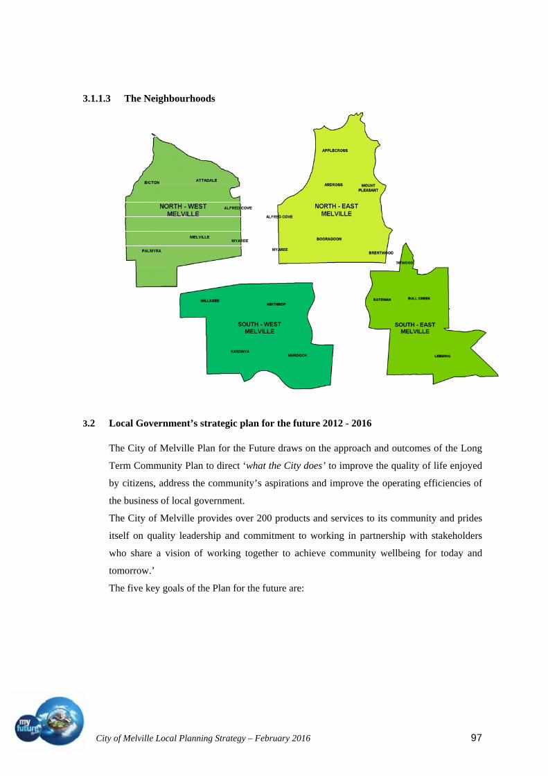
City of Melville Local Planning Strategy – February 2016 97
3.1.1.3 The Neighbourhoods
3.2 Local Government’s strategic plan for the future 2012 - 2016
The City of Melville Plan for the Future draws on the approach and outcomes of the Long
Term Community Plan to direct ‘what the City does’ to improve the quality of life enjoyed
by citizens, address the community’s aspirations and improve the operating efficiencies of
the business of local government.
The City of Melville provides over 200 products and services to its community and prides
itself on quality leadership and commitment to working in partnership with stakeholders
who share a vision of working together to achieve community wellbeing for today and
tomorrow.’
The five key goals of the Plan for the future are:
City of Melville Local Planning Strategy – February 2016 98
3.2.1 A City for people
Strategy: Contribute to a healthy and active community
Key informing Documents
City of Melville documents:
Public Health and Wellbeing Plan and Policy
Physical Activity Policy
Neighbourhood Development Policy
Bike Plan
State Government documents:
WA Bicycle Network Plan 2012-2021
Western Australian Sport and Recreation Industry Strategic Direction 2011-2015
Active Living for All: A Framework for Physical Activity in Western Australia 2012-
2016
Key Actions:
Progress long term strategic planning for community facilities infrastructure (indoor
and outdoor recreation facilities, passive recreation open space, libraries and
museums, and general community facilities) which includes focus strengthening
community hubs.
Strategy: Contribute to a safe and secure community
Key informing Documents:
Community Safety and Crime Prevention Plan
Crime Prevention through Environmental Design of Buildings Policy
Graffiti Management Plan
Local Emergency Management Plan
Key Actions:
Ensure urban environments and developments provide a sense of safety and security:
and
Activating commercial and public places to foster and promote vibrancy and
amenity.

City of Melville Local Planning Strategy – February 2016 99
Strategy: Contribute to a vibrant and connected community
Key informing Documents:
Directions from Young People 2010-2013
Directions from Seniors (Age Friendly Strategy) 2010-2012
Disability Access and Inclusion Plan and Policy (DAIP)
The four Neighbourhood Plans (North East, North West, South East and South West)
Future Plan for Libraries, Museums and Local History
Melville to 2050: Intergenerational Report
Cultural Vitality Plan
Reconciliation Action Plan
Volunteer Management Plan
Local Housing Strategy
Key Actions:
Progress integrated place planning for Canning Bridge, Murdoch Activity Centre,
Riseley Centre, Willagee and Booragoon Activity Centre (Garden City and
surrounds).
Strategy: Activating commercial and public places to foster and promote vibrancy and
amenity
Key informing Documents:
Neighbourhood Development Policy
Municipal Heritage Inventory
Reserves and Public Open Space Strategy
Streetscape Strategy
Key Actions:
Progress long term strategic planning for community facilities infrastructure (indoor
and outdoor recreation facilities, passive recreation open space, libraries and
museums, and general community facilities) which includes focus on strengthening
community hubs.
Develop an Infrastructure Strategy to prioritise future infrastructure requirements and
development opportunities.
Finalise Local Commercial and Activity Centre Strategy.

City of Melville Local Planning Strategy – February 2016 100
Finalise Local Parking Strategy.
Progress integrated place planning for Canning Bridge, Murdoch Activity Centre,
Riseley Centre, Willagee and Booragoon Activity Centre (Garden City and
surrounds).
Review and implement the Public Open Space Strategy.
Implement the Streetscape Strategy to ensure the preservation and enhancement of
the streetscape environment and maintain a high level of natural amenity.
Develop and implement a Commercial Centres Streetscape Strategy to enhance the
natural amenity and provide attractive setting that encourages economic
development.
Develop acquired public open space (including Mount Pleasant and Carawatha) to
ensure residents have access to quality public open space that promotes physical
activity and quality of life
3.2.2 Economic prosperity:
Strategy: Promote economic development, business growth and skilled employment
opportunities
Key informing Documents
City of Melville documents:
Community Planning Schemes
Local Planning Strategy
Melville to 2050: Intergenerational Local Government
State Government documents:
Directions 2031 and beyond
SPP4.2 Activity Centres Policy
Economic and Employment Land Strategy
Federal Government document:
Jandakot Airport Master Plan
Key Actions:
Finalisation of the draft Local Planning Strategy and Local Planning Scheme 6 to
City of Melville Local Planning Strategy – February 2016 101
provide clear long term strategic direction in land use planning in response to
demographic trends and State Government planning policy.
Structure planning for activity centres and redevelopment areas including:
Canning Bridge Activity Centre;
Murdoch Activity Centre;
Willagee Redevelopment Area;
Riseley Activity Centre;
Booragoon Activity Centre (Garden City and surrounds); and
Bull Creek Activity Centre
Enhance community amenity, create vibrancy, manage growth and minimise rate
increases.
Prepare a Local Economic Development Strategy to facilitate investment and
diversify business growth.
Strategy: Facilitate vibrant and diverse commercial and activity centres
Key informing Documents
City of Melville documents:
Local Commercial Strategy and Centre Plans
Riseley Centre Plans and vision
Melville City Centre Plan
Neighbourhood Development Policy
Joint State and City of Melville documents:
Canning Bridge Precinct Vision
Murdoch Activity Centre Structure Plan
State Government documents:
Moving Freight and Moving People
SPP4.2 Activity Centres Policy
Economic and Employment Land Strategy
Outline development plans and design guidelines
Key Actions:
a Local Economic Development Strategy to facilitate investment and diversify
business growth and maximise opportunities with the National Broadband Network
(NBN);
City of Melville Local Planning Strategy – February 2016 102
Review of the City’s Commercial Centres Strategy with a view to promoting
diversified business mix and synergies;
Finalise Local Parking Strategy to preserve amenity and to ensure sustainability of
commercial centres;
Develop a Local Housing Strategy to promote diversification and affordability of
housing stock in the appropriate areas and retain amenity;
Prepare a developer contribution policy linked to the Community Planning Scheme 5
/ Local Planning Scheme 6 to equitably distribute the cost of providing
infrastructure;
Develop an Integrated Transport and Land Use Plan, including transport linkages
between activity centres;
Review the City’s approach to place-making to provide vibrancy and high amenity at
the local level.
3.2.3 Environmental responsibility:
Strategy: Promote and develop a liveable and sustainable urban environment
Key Informing Documents
City of Melville documents:
Local Planning Strategy
Local Planning Scheme
Reserves and Public Open Space Strategy
Sustainable Living Manual
Sustainable Residential Design Policy and Guidelines
Streetscape Strategy
State Government documents:
Building Code of Australia Energy Efficiency Provisions
Directions 2031 and beyond
Moving Freight and Moving People
Public Transport for Perth 2031
WA Bicycle Network Plan 2012-2021
Key Actions:
Manage population growth impacts by considering the options for increasing
residential density at transit oriented development nodes, activity centres and along
major public transport corridors;

City of Melville Local Planning Strategy – February 2016 103
Review and implement the Reserves and Public Spaces Strategy to reduce impacts
on the Long Term Financial Plan;
Develop an integrated people movement and transport strategy, including light rail,
to encourage alternative transport options, minimise congestion and energy use and
maximise efficient movement of people;
Finalisation of the draft Local Planning Strategy and Local Planning Scheme 6 to
provide clear long term strategic direction in land use and transport planning in
response to demographic trends and State Government planning policy;
Continue to invest in existing infrastructure assets to minimise whole of life costs;
Investigate the application of an Environmental Levy, developer contributions and
environmental offsets;
Implement the Streetscape Strategy to ensure the preservation and enhancement of
the streetscape environment and maintain a high level of natural amenity with a view
to progressively increase annually the number of street trees allocated to residents to
increase the City’s green canopy;
Seek State and Federal funding to mitigate the impacts of growth through enhanced
transport infrastructure.
Strategy: Adapt to Climate change
Key Informing Documents
City of Melville documents:
Climate Change Adaptation Plan
Key Actions:
Ensure Local Planning Scheme provides for ground floor levels for new developments that are suitable for climate change scenarios
3.2.4 Business Excellence and Lead by Example:
Strategy: Visible leadership throughout the community
Key informing Documents
City of Melville documents:
Neighbourhood Development Policy
Melville to 2050: Intergenerational Local Government;
Community and Business Perceptions Surveys
Wellbeing survey
State Government document:
City of Melville Local Planning Strategy – February 2016 104
Directions 2031 and beyond
Key Actions
Finalise and implement Local Planning Scheme 6, the Local Planning Strategy and
Strategic Development Area Plans for Canning Bridge, Murdoch Activity Centre,
Willagee, Riseley Centre, Booragoon Activity Centre (Garden City and surrounds)
and Bull Creek, to guide City development.
Plan and create alignment between the business sector and residential sector so
activity centres develop into vibrant neighbourhoods. ensuring employment self-
sufficiency (local jobs for local people) via Local Planning Scheme 6, activity centre
developments and the activation of commercial centres to reduce local traffic
congestion.
Ensuring employment self-sufficiency (local jobs for local people) via Local Planning Scheme 6, activity centre developments and the activation of commercial centres to reduce local traffic congestion
Lobby government using cost-benefit analysis of Murdoch Activity Centre and Light
Rail Study to emphasise the need to improve the public transport network and reduce
congestion.
Illustrate the vision for the City to engage and inform stakeholders on the plans for
the City’s future.
Strategy: Lead the industry through excellence in stewardship
Key Informing Documents
Many long term State and Federal Government concepts, plans and strategies such as:
Australia to 2050
Perth 3.5 Million People
Directions 2031 and beyond
Energy 2031
Public Transport in Perth 2031
Key Actions:
Develop guiding principles of the desired future for the City to engage and inform
stakeholders on the key priorities to retain community wellbeing;
Work in partnership with other spheres of government and the private sector to seek
opportunities to eliminate duplication of services with a view to reducing costs to
citizens;
Promote higher employment self sufficiency through greater diversity in housing
City of Melville Local Planning Strategy – February 2016 105
choice to ensure a sustainable population mix; and
Ensure robust planning for future infrastructure and a high quality natural
environment to enhance the quality of life and well being of residents and visitors to
the City.
3.3 Local planning policies.
The following local planning policies were referred to in preparation of the Local Planning
Strategy. City of Melville Policies are reviewed on a rotational basis at least every two
years.
CP-002 – Stakeholder Engagement Policy (Nov 2015)
Policy objectives: To ensure City of Melville residents and all other relevant stakeholders
are provided a fair and meaningful opportunity to participate and contribute to problem
solving, planning and decisions made by the Council and its staff. Effective stakeholder
engagement provides the basis for productive relationships, improved dialogue and
deliberation, and ultimately, better democracy.
CP-028 – Physical Activity (Nov 2015)
Policy objectives: to increase opportunities for physical activity; leading to the improved
health and wellbeing of the community.
CP-029 - Street Tree Policy (Nov 2015)
Policy objective:To provide guidance and direction in the maintenance and management of
the City’s street trees.
CP-30 – Environmental Policy (Nov 2015)
Policy objective: To provide guidance and direction for the City to minimise our impact on
the environment and include climate change considerations in decision making.
CP-033 – Path Policy (Nov 2015)
Policy objective: To provide guidance and direction to the City in the provision, renewal
and maintenance of path and vehicle crossing assets.
CP-035 - School Parking Policy (Nov 2015)
Policy objectives: To provide guidance and direction to the City in the orderly provision of
new on-street car parking infrastructure within the road reserve, around schools, on a
shared cost basis.

City of Melville Local Planning Strategy – February 2016 106
CP-037 – Neighbourhood Development –Community Hub Policy (Nov 2015)
Policy objectives: To ensure a consistent approach to Neighbourhood Development to gain
the greatest community benefit through the facilitation or provision of:
appropriately located community facilities owned by the City;
facilities consolidated into identified community hubs – which aim to provide:
effective and efficient service coordination and delivery;
place making;
community building;
a localised approach to the delivery of services; and
a financially sustainable community asset.
Provision of services to support and develop community groups.
CP-040 - Public Health and Wellbeing Policy (Nov 2015)
Policy objectives: To enhance the health, wellbeing and quality of life for the City of
Melville community.
CP-045 - Exhibition display homes (Aug 2015)
Policy objectives: To address specific standards and controls for the development of
exhibition/display homes.
CP-049 - Child Minding Centres and Family Day Care (Aug 2015)
Policy objectives: to provide for the establishment of child minding centres and family day
care premises within the City of Melville, whilst ensuring that their location, siting and
design is compatible with, and avoids significant adverse amenity impacts.
CP-050 - Bed and Breakfast Accommodation (Nov 2014)
Policy objectives: To facilitate the development of appropriately located bed and breakfast
accommodation within te City in the interests of residential amenity.
CP-051 - Temporary Structures (Apr 2014)
Policy objectives: To allow the use of temporary structures for construction and storage
purposes where they are located so to minimise the amenity and safety impacts upon
adjoining properties and the surrounding area..

City of Melville Local Planning Strategy – February 2016 107
CP-053 - Market Uses (May 2014)
Policy objectives: To allow the operation of appropriately located and high quality markets
within the City; and to ensure that there is no detrimental impact upon the amenity of
surrounding properties resulting from the operation of markets.
CP-056 Planning Process and Decision Making. (Nov 2014)
Planning objectives: To promote a consistent approach by the City in the assessment and
public advertising of development applications.
To facilitate community input into the decision making process.
To provide information to both applicants and submitters regarding the planning
application assessment process.
CP-058 Flood and Security Lighting (Aug 2014)
Policy objectives: To control the impacts of outdoor flood and security lighting on the
amenity of the adjoining properties and the surrounding area.
CP-059 Home Occupation Relative to Sexual Services Business Policy (Mar 2014)
Policy objectives: This Policy is prepared to assist in the determination of applications for
Home Occupation or Home Business approval relative to Sexual Services Businesses. The
key objective is the protection of the City’s residential environment by prohibiting the
establishment of Sexual Services businesses within residential properties.
CP-060 Pulo Road Subdivision Development Standards (Mar 2014)
Policy objectives: To provide alternative standards of development on Pt Lot 28 Pulo Road
(now known as odd numbers between: 37-45 Pulo Road, 1-15 Spinaway Crescent and 17-
47 Moonlight Cove), Brentwood.
CP-061 Tennis Courts (Apr 2014)
Policy objectives: To control the impacts of tennis court developments in or adjacent to
residential areas

City of Melville Local Planning Strategy – February 2016 108
CP-064 Telecommunications Facilities and Communications Equipment (Mar 2014)
Policy objectives:
To promote the orderly and proper development of land by outlining suitable
provisions relating to the location and design of telecommunications facilities and
communications equipment that are not classified within legislation as low-impact
facilities.
To provide development standards to address the visual amenity impacts relating to
the location of telecommunications facilities and communications equipment; and
to provide additional acceptable development provisions for the assessment of
proposals for the installation of communications equipment to residential properties,
as governed by the provisions of the Residential Design Codes of Western Australia.
CP-065 Crime Prevention through Environmental Design of Buildings (Mar 2014)
Policy objectives:
To reduce the potential for crime and anti-social behaviour to occur within the City
of Melville through well designed buildings and places;
to raise awareness of key community safety, security and crime prevention issues,
designing out crime principles and solutions; and
to ensure that planning for development and redevelopment activity within the City
of Melville takes into consideration Designing out Crime principles.
CP-066 Height of Buildings (Apr 2014)
Policy objectives: To provide guidance regarding the interpretation and application of
building height controls throughout the City, in order to ensure that the height of buildings
is consistent with the desired character of the locality, in the interests of residential and
visual amenity.
City of Melville Local Planning Strategy – February 2016 109
CP-067 Amenity Policy (May 2014)
Policy objectives:
To ensure that when new development is proposed, due consideration is given to the
preservation of reasonable amenity for occupiers of adjoining properties and the
surrounding area;
To provide guidance in the consideration of amenity impacts arising from proposals
seeking assessment under the Design principles of the Residential Design Codes (R-
Codes).
CP-069 Architectural and Urban Design Advisory Panel (Apr 2014)
Policy objectives: To detail the administration of the City of Melville Architectural and
Urban Design advisory panel.
CP-070 Heathcote Heritage Precinct Signage Strategy (Mar 2014)
Policy objectives:
To provide guidance for a hierarchy of sign systems that may be considered for the
Heathcote Heritage Precinct;
To implement a series of signs to guide the visitor, providing them with information
and direction using minimal signage placed in strategic locations and
To present a coherent and standardised package of signage measures using a palette
of materials, finishes, detailing, sign types and placements to create a familiar user
experience.
CP-071 Reynolds Road Community Centre (Mar 2014)
Policy objectives: To prescribe additional development requirements for the Reynolds Road
Community Centre which are not addressed by other Council policies.
City of Melville Local Planning Strategy – February 2016 110
CP-075 Canning Highway Precinct Design Guidelines (Sep 2013)
Policy objectives:
To provide design guidelines for development within the Canning Highway precinct
acknowledging the location of the precinct adjacent to a regional road;
To ensure development within the precinct is to a high standard, consistent with the
surrounding area, and makes a positive contribution to the streetscape; and
To manage the potentially competing demands associated with non-residential and
residential development.
CP-076 Community Concept Plan (Mar 2014)
Policy objectives: To outline a vision for the land use and development of the district
CP-077 Chemists in Medical Centres (Mar 2014)
Policy objectives: To guide the approval and operation of chemists located within and
ancillary to medical centre land uses within the Service Commercial, Mixed Use zones of
the City of Melville and to ensure that the character and amenity of these precincts is not
prejudiced by the existence of retail chemist uses within them.
CP-078 Residential Development Policy (Nov 2013)
Policy objectives:
To enhance the character and amenity of existing residential areas;
To promote a high standard of residential development;
To ensure new residential development makes a positive contribution towards
attractive streetscapes;
To allow for innovative residential design providing the development is compatible
with the streetscape;
To accommodate increasing residential density without compromising streetscape
character;
To ensure that residential environments are safe and secure for owners, occupiers,
and the wider community; and to safeguard, protect and enhance the levels of
residential amenity enjoyed by existing and future owners and occupiers of
residential property.

City of Melville Local Planning Strategy – February 2016 111
CP-079 Car Parking and Access Policy (Aug 2014)
Policy objectives:
To facilitate the development of adequate, safe and convenient parking facilities that
meet the needs of users.
To ensure that development proposals incorporate an appropriate level of parking.
To ensure safe, convenient, and efficient access for pedestrians, cyclists and
motorists.
To promote alternative transport modes by incorporating flexibility to reduce parking
requirements where alternative transport options exist.
To enable the payment of a financial contribution in lieu of actual parking provision
for non- residential developments and to provide guidelines to ensure that the
calculation of cash-in-lieu is applied in a consistent and transparent manner.
To promote ‘shared’ or publicly available parking in preference to exclusive, single
user parking for non-residential developments..
CP-080 Energy Efficiency in Building Design (Mar 2014)
Policy objectives: To encourage the incorporation of environmentally sustainable and
energy efficient design principles as standard practice in the development of buildings.
CP-081 RAAFA Masterplan (Mar 2014)
CP-082 - Design Guidelines for Development of Lot 100 (109) North Lake Road and Lot 9
(241) Leach Highway Willagee (Mar 2014)
Policy objectives:
to protect and enhance the amenity of existing and future residents;
encourage mixed-use development;
provide for safe and efficient access to and egress from the site for vehicles, cars and
pedestrians;
promote best practice urban design that contributes positively to the streetscape and
public domain and support environmentally sustainable design and crime prevention
through environmental design principles.

City of Melville Local Planning Strategy – February 2016 112
CP-085 Provision of Public Art in Development Proposals Policy (Aug 2014)
Policy objectives:
To contribute to a sense of place through the provision of public art which provides
and interpretation and expression of the local area's natural, physical, cultural and
social values;
To enhance public enjoyment and understanding of places through the integration of
art into developments;
To add to the appearance, vibrancy, character and amenity of developments and their
surrounding environment;
To create local landmarks.
To provide increased public exposure to, and understanding of, public art.
CP-086: Verge Treatment Policy (Nov 2015)
Policy Objective - To enhance, maintain the visual amenity and safety of street verges
throughout the City of Melville.
CP-087 Non Residential Development (Sep 2014)
Policy objectives:
To promote high quality architectural form to maintain and enhance the visual
character of the City;
To ensure new buildings are designed to be of human scale to facilitate effective
movement and interaction between building and street;
To ensure building frontages at the street level assist in the creation of safe built
environments through use of internal and external lighting, encouraging visual
interest and ensuring passive surveillance;
To ensure that all buildings make a positive contribution to the streetscape, assisting
in the maintenance and creation of safe, secure and attractive places.

City of Melville Local Planning Strategy – February 2016 113
4 Local profile
4.1 Physical features, climate, natural heritage and natural resource management.
The City of Melville is located in Perth's southwest, around 8 kilometres from the Perth
GPO. It is bounded in the north by the Swan River, in the east by the Canning River and the
City of Canning, in the south by the City of Cockburn, and in the west by the City of
Fremantle and the Town of East Fremantle.
The City of Melville is a predominantly residential area, with some industrial and
commercial land uses. The City encompasses a total land area of about 52 square
kilometres, including around 18 kilometres of river foreshore and has a population density
of approximately 18.34 people per hectare.
The City of Melville includes the suburbs of Alfred Cove, Applecross, Ardross, Attadale,
Bateman, Bicton, Booragoon, Brentwood, Bull Creek, Kardinya, Leeming, Melville, Mount
Pleasant, Murdoch, Myaree, Palmyra, Willagee and Winthrop.
Melville Water was named by Captain James Stirling in 1827, although settlement was
minimal until the 1890s, due largely to isolation and the limitations presented by the
swampy foreshore. Growth was gradual from the late 1800s to the early 1900s, reaching a
population of about 2,000 in 1913. Significant development occurred in the post-war years,
particularly from the 1950s. A major land reclamation project along the Swan River
foreshore aided growth in the 1960s, and by 1968 the population of the City was 52,000.
The population continued to increase in the 1970s and 1980s, from 57,000 in 1976, to
72,000 in 1986. The population increased at a slower rate during the 1990s, from nearly
85,000 in 1991 to over 90,000 in 2001. The population was relatively stable from 2001,
rising marginally to over 91,000 in 2006. From 2006 the population has continued to grow
steadily with the Census population of the City of Melville in 2011 being 95,700, living in
40,111 dwellings with an average household size of 2.5.
Major features of the City include Murdoch University, Challenger TAFE (Heathcote and
Murdoch Campuses), Garden City Shopping Centre, Melville Glades Golf Course, Point
Walter Golf Course, Wireless Hill Park, Piney Lakes Reserve and several other bushland
areas and reserves, especially along the foreshores.
The resident population of the City of Melville has great diversity in ethnic background,
income level and educational qualification. For this reason, the City of Melville strives,
through the current Planning Scheme, to provide a balanced mix of housing choice and
opportunities for business (small and large) to thrive.

City of Melville Local Planning Strategy – February 2016 114
In an environmental capacity, the City of Melville has over 210 parks and reserves
comprising 600 hectares of public open space and 300 hectares of bushland. Significant
environmental sites include Blackwall Reach Reserve, the marine parks at Point Walter and
Pelican Cove, river foreshore rehabilitation sites along Burke Drive and at Bull Creek,
Piney Lakes, Booragoon Lake and Blue Gum Lake.
Educational resources include significant tertiary facilities (5 facilities including Murdoch
University), Challenger TAFE (Murdoch Campus including the WA Horticulture and
Environmental Science Skills Centre and WA Centre for Leadership and Community
Development and Heathcote Centre for Adult Education) and 11 secondary schools and 25
primary schools.
In an operational capacity, the City of Melville provides an extensive range of products and
services (over 200) to its community that include cultural and community programs for
youth, seniors and multicultural groups; a wide range of recreational opportunities both
passive and active; acts as a vehicle for knowledge and information allowing the
community to take part in business and personal development opportunities; provides
effective transport infrastructure and promotes alternative transport modes amongst many
other functions and services.
4.2 Water management
The City has an established infrastructure network relating to water, drainage and sewer.
All areas of the City are serviced by Water authority mains supply and are connected to
deep sewer. There is capacity for moderate increases in density along transport corridors
however more detailed investigation will need to be undertaken as part of the structure
planning process.
Public acceptance of the need to conserve water has encouraged the increased personal
uptake of water sensitive urban design. The Local Planning Scheme should encourage
further integration of water sensitive design into all developments both private and
commercial. More innovative approaches to recycling of water on site should be
encouraged through policy and design guidelines.
Water licenses for many reserves and open spaces are currently close to capacity. A review
of the use and purpose of parkland is being undertaken to provide a more efficient use of
the water that is available. The application of water sensitive design to Reserves and public
places is also a key objective of the City of Melville in respect to renovating current
reserves and designing new reserves.

City of Melville Local Planning Strategy – February 2016 115
4.3 Population and housing, including official forecasts
The City of Melville has embraced the suggested targets as proposed in Directions 2031
and beyond to increase our dwelling stock by at least 11,000 new dwellings by 2031. To
achieve this target it is proposed to concentrate initially on increasing the intensity in and
around activity centres, public transport nodes and along transport corridors. This will
allow better use of public transport, improve the self sufficiency and pedestrian
environment of the activity centres and reduce the demand on the private motor vehicle.
In order to better understand the impact of this scenario it is important to consider the
current demographics and distribution with in the City.
4.3.1 Melville community snapshot - ‘who we are’
The estimated resident population of the City of Melville on 30 June 2011 was 101,649.
(The census count was 95,700)
The following statistics provide an overview of the City of Melville resident population
between the 2006 and 2011 Census years as compared with the Perth Statistical Division.
For the purpose of the overview, census details are provided on
population number;
age structure;
where the population was born;
weekly income;
education qualifications;
occupations; and
household and family structure.
The tables below provide a summary overview and more detailed data is provided
thereafter.

City of Melville Local Planning Strategy – February 2016 116
4.3.2 Population
Source: Australian Bureau of Statistics, Regional Population Growth, Australia (3218.0). Compiled and presented in profile.id by .id (opens a new window), the population experts.
In 2011, the City of Melville had an estimated resident population of 102,135. This
indicates an increase of 5357 people or 5.5% since the 2006 Census. There was a period of
small increases between 2001 and 2003 and a small decrease in 2004. Since then there has
been a steady period of increases in population although only small. 2014 saw an estimated
resident population of 107,239. This is an increase of 5104 from the 2011 Census which is
only a 5% increase from 2011.
There has been a slight increase in the percentage of males in the population, though this is
still less than the metropolitan percentage and a slight drop in the percentage of Australian
Citizens.
Population City of Melville 2011 2006 Change
Number % Greater Perth
Number % Greater Perth
2006 to 2011
Population (excluding O/S visitors)
95,700 100.0 100.0 92,750 100.0 100.0 +2,950
Males 46,060 48.1 49.6 44,143 47.6 49.4 +1,917 Females 49,640 51.9 50.4 48,606 52.4 50.6 +1,033 Australian citizens 79,595 83.2 80.0 77,962 84.1 82.8 +1,632 Eligible Voters (citizens aged 18+)
62,119 64.9 60.6 60,134 64.8 62.3 +1,984
Source: Australian Bureau of Statistics, Census of Population and Housing 2006 and 2011. Compiled and presented by .id, the population experts. (Usual residence data)
Estimated Resident Population (ERP) City of Melville Year (ending June 30) Number Change in number Change in percent
2003 97,002 2004 96,776 -226 -0.232005 96,699 -77 -0.082006 96,778 +79 +0.082007 97,911 +1,133 +1.172008 98,607 +696 +0.712009 99,882 +1,275 +1.292010 100,764 +882 +0.882011 102,135 +1,371 +1.362012 104,393 +2,258 +2.212013 106,371 +1,978 +1.892014 107,239 +868 +0.82

City of Melville Local Planning Strategy – February 2016 117
4.3.3 Age structure
The Age Structure of the population is an indicator of an area’s residential role and function
and how it is likely to change in the future. The age structure of the City of Melville
population is generally indicative of an area’s era of settlement and provides key insights
into the level of demand for services and facilities (as most services and facilities are age-
specific).
Age structure - service age groups City of Melville 2011 2006 Change Service age group (years)
Number % Greater Perth %
Number % Greater Perth %
2006 to 2011
Babies and pre-schoolers (0 to 4)
4,925 5.1 6.6 4,517 4.9 6.1 +407
Primary schoolers (5 to 11)
7,580 7.9 8.7 7,675 8.3 9.1 -96
Secondary schoolers (12 to 17)
7,875 8.2 7.9 8,504 9.2 8.6 -629
Tertiary education & independence (18 to 24)
10,204 10.7 10.2 10,184 11.0 10.3 +20
Young workforce (25 to 34)
10,610 11.1 14.7 9,380 10.1 13.4 +1,229
Parents and homebuilders (35 to 49)
19,494 20.4 21.6 19,994 21.6 22.4 -501
Older workers & pre-retirees (50 to 59)
13,813 14.4 12.4 13,523 14.6 13.1 +290
Empty nesters and retirees (60 to 69)
9,974 10.4 9.2 8,224 8.9 8.2 +1,750
Seniors (70 to 84) 8,683 9.1 7.0 8,738 9.4 7.3 -55 Frail aged (85 and over)
2,542 2.7 1.6 1,999 2.2 1.5 +542
Total population 95,700 100.0 100.0 92,743 100.0 100.0 +2,957
Analysis of the age structure of the City of Melville in 2011 compared to the greater Perth
area shows that a there was a smaller proportion of people in the younger age groups
representing preschool and primary school children. Although the figures for Secondary
schoolers reflect the catchment for several sought after high schools, there has been a
decrease in numbers since 2006. The story is similar for 18 – 24 year olds however this
number has remained fairly constant between the two census years.
A noticeable change is the large increase in the young workforce. Although the percentage
of the population is still considerably smaller than the greater Perth region, the significant
increase is noticeable. Whether this relates to children staying at home longer or young
people buying or renting in the area needs to be investigated further.

City of Melville Local Planning Strategy – February 2016 118
The increase is a good counter though to the larger increase in empty nesters and retirees.
The proportion of population over the age of 60 continues to be higher than the percentage
in the greater Perth area.
4.3.4 Where we were born
Country of Birth data identifies where City of Melville residents were born and is indicative
of the level of cultural diversity in the area. The mix of Country of Birth groups is also
indicative of historical settlement patterns (although this is impacted by the redevelopment
opportunities and value of land in the area).
Birthplace - ranked by size City of Melville 2011 2006 Change
Country of birth Number % Greater Perth
Number % Greater Perth
2006 to 2011
United Kingdom 8,925 9.5 11.4 8,822 9.7 11.8 +103 Malaysia 3,026 3.2 1.4 2,735 3.0 1.3 +291 New Zealand 1,866 2.0 3.0 1,582 1.7 2.3 +283 South Africa 1,676 1.8 1.8 1,304 1.4 1.3 +371 Singapore 1,575 1.7 0.8 1,590 1.7 0.8 -15 Indonesia 1,555 1.7 0.5 1,645 1.8 0.5 -91 India 1,422 1.5 1.6 1,016 1.1 1.0 +405 China 1,075 1.1 0.9 826 0.9 0.5 +248 Italy 910 1.0 1.0 926 1.0 1.3 -17 Hong Kong 596 0.6 0.3 594 0.7 0.3 +1
Source: Australian Bureau of Statistics, Census of Population and Housing 2006 and 2011. Compiled and presented by .id, the population experts. Excludes ancestries with fewer than 20 responses, or less than 0.1% of the total population. (Usual residence data)
Analysis of the country of birth of the population in the City of Melville in 2011 compared
to the Perth Statistical Division shows that there was a similar proportion of people born
overseas but a larger proportion of people from a non-English speaking background.
Ancestry - ranked by size City of Melville
2011 2006 Change
Ancestry Number % Greater Perth
Number % Greater Perth
2006 to 2011
English 34,572 36.1 37.6 32,469 35.0 37.3 +2,102 Australian 28,940 30.2 30.1 31,391 33.8 33.6 -2,452 Chinese 8,946 9.3 4.2 8,260 8.9 3.6 +686 Scottish 8,679 9.1 8.3 7,812 8.4 7.9 +866 Irish 8,592 9.0 8.3 7,592 8.2 8.0 +1,000 Italian 5,888 6.2 5.4 5,556 6.0 5.7 +331 German 2,574 2.7 2.7 2,304 2.5 2.7 +269 Indian 2,190 2.3 2.2 1,633 1.8 1.4 +557 Dutch 1,726 1.8 2.1 1,656 1.8 2.1 +69 South African 1,244 1.3 1.3 991 1.1 0.9 +252
Source: Australian Bureau of Statistics, Census of Population and Housing 2006 and 2011. Compiled and presented by .id, the population experts. Excludes ancestries with fewer than 20 responses, or less than 0.1% of the total population. (Usual residence data).
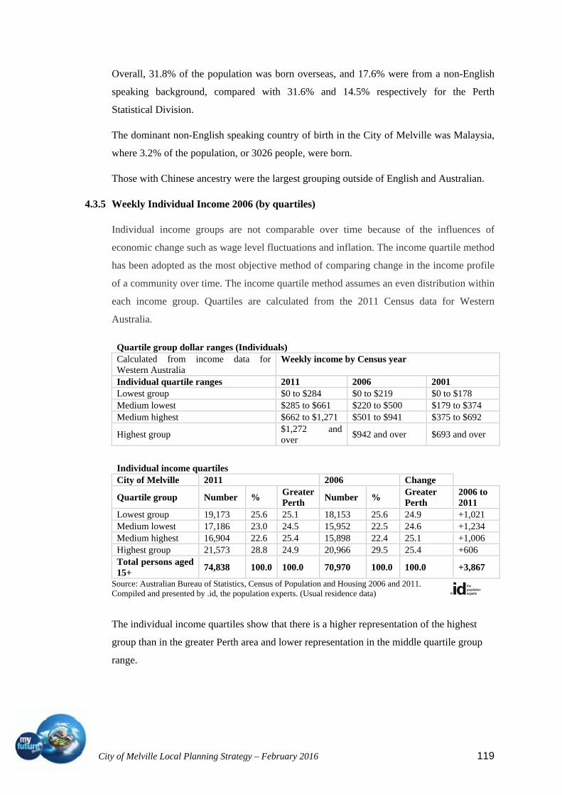
City of Melville Local Planning Strategy – February 2016 119
Overall, 31.8% of the population was born overseas, and 17.6% were from a non-English
speaking background, compared with 31.6% and 14.5% respectively for the Perth
Statistical Division.
The dominant non-English speaking country of birth in the City of Melville was Malaysia,
where 3.2% of the population, or 3026 people, were born.
Those with Chinese ancestry were the largest grouping outside of English and Australian.
4.3.5 Weekly Individual Income 2006 (by quartiles)
Individual income groups are not comparable over time because of the influences of
economic change such as wage level fluctuations and inflation. The income quartile method
has been adopted as the most objective method of comparing change in the income profile
of a community over time. The income quartile method assumes an even distribution within
each income group. Quartiles are calculated from the 2011 Census data for Western
Australia.
Quartile group dollar ranges (Individuals) Calculated from income data for Western Australia
Weekly income by Census year
Individual quartile ranges 2011 2006 2001 Lowest group $0 to $284 $0 to $219 $0 to $178 Medium lowest $285 to $661 $220 to $500 $179 to $374 Medium highest $662 to $1,271 $501 to $941 $375 to $692
Highest group $1,272 and over
$942 and over $693 and over
Individual income quartiles City of Melville 2011 2006 Change
Quartile group Number % Greater Perth
Number % Greater Perth
2006 to 2011
Lowest group 19,173 25.6 25.1 18,153 25.6 24.9 +1,021 Medium lowest 17,186 23.0 24.5 15,952 22.5 24.6 +1,234 Medium highest 16,904 22.6 25.4 15,898 22.4 25.1 +1,006 Highest group 21,573 28.8 24.9 20,966 29.5 25.4 +606 Total persons aged 15+
74,838 100.0 100.0 70,970 100.0 100.0 +3,867
Source: Australian Bureau of Statistics, Census of Population and Housing 2006 and 2011. Compiled and presented by .id, the population experts. (Usual residence data)
The individual income quartiles show that there is a higher representation of the highest
group than in the greater Perth area and lower representation in the middle quartile group
range.

City of Melville Local Planning Strategy – February 2016 120
4.3.6 Qualifications of the population
Educational qualifications are one of the most important indicators of socio-economic
status. With other data sources, such as income and occupation, educational qualifications
help to evaluate the economic opportunities and socio-economic status of the City of
Melville. Level of educational qualifications in a population relate to a number of factors
including:
the age of the population (e.g. older people tend to have more vocational
qualifications, while people in their twenties and thirties are more likely to have a
university degree);
the professional or working ambitions of people (to seek education as youth or
retraining as adults); and
the opportunities afforded to people to continue studying beyond compulsory
schooling.
Analysis of qualifications of the population in the City of Melville in 2006 compared to the
Perth Statistical Division shows that there was a larger proportion of people holding formal
qualifications (Bachelor or higher degree; Advanced Diploma or Diploma; or vocational
qualifications) and a smaller proportion of people with no formal qualifications. These
trends continued through 2011 with an increase in the population with degrees or diplomas.
Highest qualification achieved
City of Melville - Total persons (Usual residence)
2011 2006
Change
Qualification level Number % Greater Perth %
Number % Greater Perth %
2006 to 2011
Bachelor or Higher degree
23,005 28.9 19.6 18,338 24.0 16.1 +4,667
Advanced Diploma or Diploma
8,136 10.2 8.6 7,538 9.9 7.9 +598
Vocational 11,054 13.9 18.6 10,421 13.6 17.1 +633
No qualification 30,004 37.7 42.3 31,138 40.7 45.5 -1,134
Not stated 7,306 9.2 10.9 9,038 11.8 13.4 -1,732
Total persons aged 15+
79,505 100.0 100.0 76,473 100.0 100.0 +3,032
Source: Australian Bureau of Statistics, Census of Population and Housing 2006 and 2011. Compiled and presented by .id, the population experts. (Usual residence data)
City of Melville Local Planning Strategy – February 2016 121
Overall, 53% of the population held educational qualifications, and 37.7% had no
qualifications, compared with 46.8% and 42.3% respectively for the Perth Statistical
Division.
The major differences between the qualifications held by the population in the City of
Melville and the Perth Statistical Division were:
A larger percentage of people with Bachelor or Higher degrees (28.9% compared to
19.6%), and
A smaller percentage of people with no qualifications (47.7% compared to 42.3%).
The largest changes in the qualifications of the population in the City of Melville between
2006 and 2011 were in those with:
Bachelor or higher degrees (+4667 persons); and
no qualifications (-1732 persons).
4.3.7 Occupations of the population
The Occupation data identifies the occupations in which the residents of the City of
Melville work (this may be within the residing area or elsewhere). The occupational
structure of the work force is an important indicator of the characteristics of the labour
force. With other indicators, such as educational qualifications and income, occupation is a
key component of evaluating the socio-economic status and skill base of an area. The
occupations held by a workforce are linked to a range of factors including:
the economic base and employment opportunities available in the area;
the educational qualification levels of the population; and
the working and social aspirations of the population.
An analysis of the occupations held by the resident population in the City of Melville
shows the three most popular occupations were consistent between census years.
Professionals -12,800 (2006) / 14,400 (2011);
Clerical and Administrative Workers -7,274 (2006) / 7731 (2011); and
Managers 6,475 (2006) / 6919 (2011)
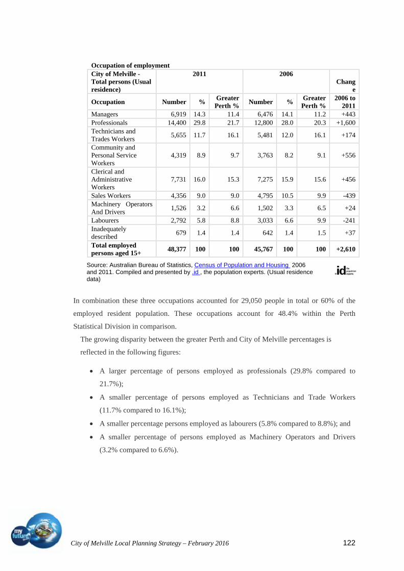
City of Melville Local Planning Strategy – February 2016 122
Occupation of employment City of Melville - Total persons (Usual residence)
2011 2006 Chang
e
Occupation Number %Greater Perth %
Number % Greater Perth %
2006 to 2011
Managers 6,919 14.3 11.4 6,476 14.1 11.2 +443Professionals 14,400 29.8 21.7 12,800 28.0 20.3 +1,600Technicians and Trades Workers
5,655 11.7 16.1 5,481 12.0 16.1 +174
Community and Personal Service Workers
4,319 8.9 9.7 3,763 8.2 9.1 +556
Clerical and Administrative Workers
7,731 16.0 15.3 7,275 15.9 15.6 +456
Sales Workers 4,356 9.0 9.0 4,795 10.5 9.9 -439Machinery Operators And Drivers
1,526 3.2 6.6 1,502 3.3 6.5 +24
Labourers 2,792 5.8 8.8 3,033 6.6 9.9 -241Inadequately described
679 1.4 1.4 642 1.4 1.5 +37
Total employed persons aged 15+
48,377 100 100 45,767 100 100 +2,610
In combination these three occupations accounted for 29,050 people in total or 60% of the
employed resident population. These occupations account for 48.4% within the Perth
Statistical Division in comparison.
The growing disparity between the greater Perth and City of Melville percentages is
reflected in the following figures:
A larger percentage of persons employed as professionals (29.8% compared to
21.7%);
A smaller percentage of persons employed as Technicians and Trade Workers
(11.7% compared to 16.1%);
A smaller percentage persons employed as labourers (5.8% compared to 8.8%); and
A smaller percentage of persons employed as Machinery Operators and Drivers
(3.2% compared to 6.6%).
Source: Australian Bureau of Statistics, Census of Population and Housing 2006 and 2011. Compiled and presented by .id , the population experts. (Usual residence data)
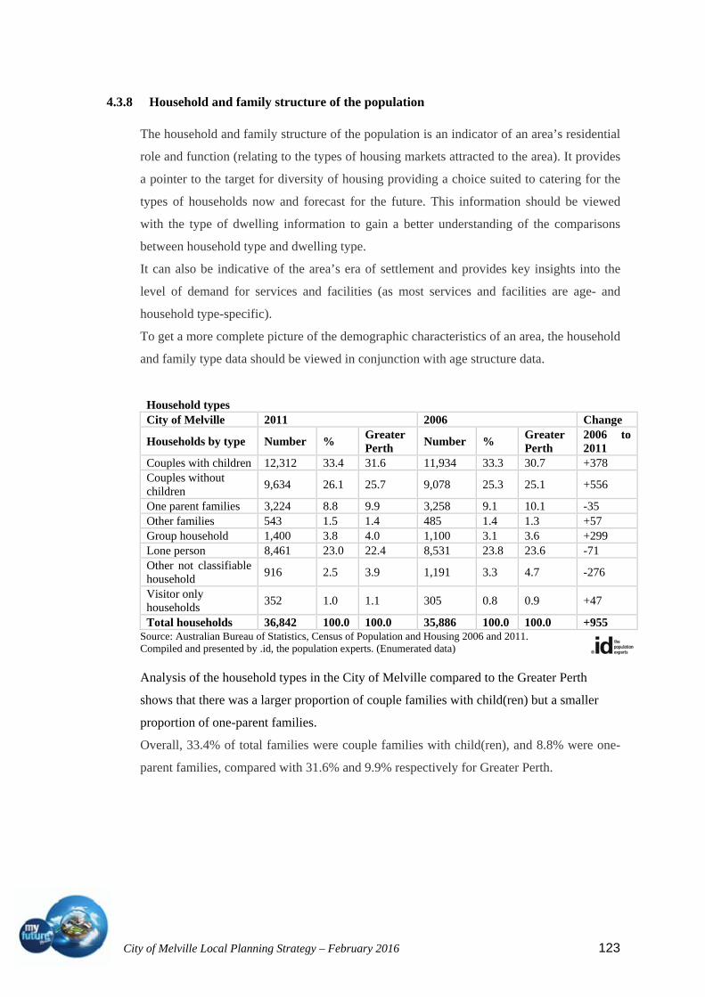
City of Melville Local Planning Strategy – February 2016 123
4.3.8 Household and family structure of the population
The household and family structure of the population is an indicator of an area’s residential
role and function (relating to the types of housing markets attracted to the area). It provides
a pointer to the target for diversity of housing providing a choice suited to catering for the
types of households now and forecast for the future. This information should be viewed
with the type of dwelling information to gain a better understanding of the comparisons
between household type and dwelling type.
It can also be indicative of the area’s era of settlement and provides key insights into the
level of demand for services and facilities (as most services and facilities are age- and
household type-specific).
To get a more complete picture of the demographic characteristics of an area, the household
and family type data should be viewed in conjunction with age structure data.
Household types City of Melville 2011 2006 Change
Households by type Number % Greater Perth
Number % Greater Perth
2006 to 2011
Couples with children 12,312 33.4 31.6 11,934 33.3 30.7 +378 Couples without children
9,634 26.1 25.7 9,078 25.3 25.1 +556
One parent families 3,224 8.8 9.9 3,258 9.1 10.1 -35 Other families 543 1.5 1.4 485 1.4 1.3 +57 Group household 1,400 3.8 4.0 1,100 3.1 3.6 +299 Lone person 8,461 23.0 22.4 8,531 23.8 23.6 -71 Other not classifiable household
916 2.5 3.9 1,191 3.3 4.7 -276
Visitor only households
352 1.0 1.1 305 0.8 0.9 +47
Total households 36,842 100.0 100.0 35,886 100.0 100.0 +955 Source: Australian Bureau of Statistics, Census of Population and Housing 2006 and 2011. Compiled and presented by .id, the population experts. (Enumerated data) Analysis of the household types in the City of Melville compared to the Greater Perth
shows that there was a larger proportion of couple families with child(ren) but a smaller
proportion of one-parent families.
Overall, 33.4% of total families were couple families with child(ren), and 8.8% were one-
parent families, compared with 31.6% and 9.9% respectively for Greater Perth.

City of Melville Local Planning Strategy – February 2016 124
The largest changes in family types in the City of Melville between 2006 and 2011 were:
Couples without child(ren) (+556);
Couples with child(ren) (+378); and
Group Households (+299).
Lone Person households have dropped slightly but still accounts for 23% of the households
in the City.
4.3.9 Population forecast
This summary of population statistics for the period 2006 to 2036, as the short to medium
term is most appropriate for planning purposes. Please note that these data are available for
all years between 2006 and 2036.
In 2031, the population of the City of Melville is anticipated to be 122,928 an increase of
20793 persons (20.3%) from 2006. This represents an average annual growth rate of 0.81%.
Murdoch is forecast to show the greatest percentage change in population to 2036 with an
average annual growth rate of over 3%. In contrast, Leeming is forecast to increase by only
.11% and Winthrop by .14% per annum.
Population summary City of Melville
Forecast year Change between 2011 and 2036
Area 2011 2016 2021 2026 2031 2036 Total change
Avg. annual % change
City of Melville
102,135 106,771 113,034 117,869 122,928 128,415 +26,280 +0.92
Alfred Cove - Myaree
4,427 4,573 4,900 4,905 4,961 5,155 +728 +0.61
Applecross 7,565 7,994 9,062 9,861 10,821 11,871 +4,307 +1.82 Ardross 4,147 4,474 4,941 5,552 6,036 6,304 +2,157 +1.69 Attadale 6,761 7,065 7,247 7,259 7,333 7,433 +672 +0.38 Bateman 4,010 4,068 4,059 4,060 4,103 4,203 +193 +0.19 Bicton 6,406 6,745 6,894 6,959 7,035 7,123 +718 +0.43 Booragoon 5,707 5,926 7,000 7,601 8,316 9,016 +3,309 +1.85 Bull Creek 8,073 8,504 8,570 8,802 8,828 9,042 +969 +0.45 Kardinya 9,384 9,667 9,868 10,337 10,528 10,680 +1,296 +0.52 Leeming 8,995 8,967 9,093 9,078 9,152 9,313 +318 +0.14 Melville 5,597 6,040 6,283 6,452 6,612 6,907 +1,310 +0.84 Mt Pleasant - Brentwood
8,765 9,359 10,810 10,736 10,711 10,740 +1,975 +0.82
Murdoch 3,543 3,883 4,287 5,644 6,635 7,599 +4,056 +3.10 Palmyra 7,040 7,355 7,557 7,596 7,823 8,045 +1,005 +0.54 Willagee 5,039 5,591 6,046 6,717 7,684 8,485 +3,446 +2.11 Winthrop 6,676 6,561 6,415 6,309 6,352 6,498 -178 -0.11

City of Melville Local Planning Strategy – February 2016 125
This following summary analyses data for the period 2006 to 2036, as the short to medium
term is likely to be the most accurate and useful forecast information for immediate
planning purposes. This summary shows an increase of 8936 dwellings to 2031 (not 11,000
as suggested in the Directions 2031). The main reason for this is that the studies for the
Strategic Development Areas at Murdoch has not reached a stage where projected dwelling
numbers can be estimated with confidence.
In 2006, the total population of City of Melville was estimated at 97,624 people. It is
expected to experience an increase of over 25,304 people to 122,928 by 2031 with a
population of 128,415 by 2036.
Forecast population, households and dwellings City of Melville Forecast year
Summary 2011 2016 2021 2026 2031 2036 Population 102,135 106,771 113,034 117,869 122,928 128,415 Change in population (5yrs)
4,636 6,263 4,835 5,060 5,486
Average annual change
1 1 1 1 1
Households 39,281 41,008 43,311 45,496 47,751 50,066 Average household size
3 3 3 3 3 3
Population in non private dwellings
1,084 1,262 1,412 1,572 1,712 1,812
Dwellings 40,521 41,867 44,425 46,960 49,457 51,938 Dwelling occupancy rate
97 98 97 97 97 96
4.3.10 Housing analysis and opportunity
The following summary of the Housing Analysis and Opportunity report by id (Informed
Decisions) was prepared prior to the release of Directions 2031. The basis of the report was
the premise of the Network City strategy that a 60/40 split of housing be provided between
established urban areas and new greenfield sites. Many of the assumptions of subdivision of
larger lots are contrary to the aspirations of the community expressed in the community
plan and Melville Visions. Although the background information is relevant, the summary
is provided as an alternative method of achieving the increases in population considered
necessary under Directions 2031. Subsequent research has shown that more emphasis on
increases of density and intensity in and around activity centres and transport corridors may
provide overall protection to the suburban areas whilst providing the opportunity to
transform the activity centres to a more urban environment. This provides more housing
diversity, opportunities for more affordable housing options and contributes to a more
sustainable transport system by improving access to public transport and reducing reliance
on the private motor vehicle.

City of Melville Local Planning Strategy – February 2016 126
The State Government’s Network City strategy established the principle of planning for a
‘liveable city’ that accommodates urban growth within a network city pattern incorporating
communities by:
Creating medium and high density activity centres (urban villages) to support viable
public transport corridors; and
Provide a wide range of affordable and quality housing options.
To action these ‘liveability’ factors the Network City Action Plan had 28 actions and 3
priority actions being:
1. foster land use and transport integration to form a Network City;
2. manage urban growth to limit urban sprawl through staging of development;
3. provide 60 percent of required dwellings in existing urban areas and 40 percent in
new growth areas.
The Department for Planning workshopped with local governments in inner and middle
regions of the Metro Area for the purpose of exploring the 60/40 target. Essentially, over
the next 25 years (from 2005) 366,000 dwellings are required to accommodate anticipated
population growth across the Metro Region. In order to meet the 60% target for existing
Urban areas, approx. 220,000 dwellings are required of which 122,000 dwellings (30%) are
planned for the Inner and Middle local government areas (inclusive of Melville). The
additional 100,000 dwellings will be provided for in other existing urban areas (outer ring
local governments). Source Dept. for Planning and Infrastructure Housing Target
Workshop 2007
With these principles as a basis, the City of Melville, through the Melville Visions process
and using the current planning scheme as a base, engaged consultants to analyse all the
potential forms of housing supply in the City of Melville and quantify the opportunities for
reasonable and acceptable growth (housing) across the City in order that the City of
Melville could accommodate ‘its’ share of the State Government’s growth target.
The study analysed all the potential forms of housing in the City of Melville with emphasis
on key activity locations. The end result provides the Council with the basis to develop an
overall framework for a housing policy that:
meets the needs of the City’s changing household types;
sustains the population and service base;
protects the City’s key residential areas from inappropriate development; and
meets the Network City objectives.

City of Melville Local Planning Strategy – February 2016 127
4.3.11 Dwelling types
The share of dwellings types in the City of Melville is similar to the Perth Statistical
Division with the exception of a higher proportion of larger separate dwellings and
significantly lower proportions of smaller, higher density dwellings than the metropolitan
area. Overall, over 80% of dwellings are separate houses. This reflects the finding that the
City of Melville largely plays a residential role as an area that historically provided housing
opportunities for family households (suburban). (NB: the metro average share of higher
density dwellings is impacted on by the inner city areas that fulfil a more urban function
with a relatively large share of higher density dwelling stock.
The City’s share of small and medium sized higher density dwellings mainly reflect the
dwelling stock in areas such as Applecross, Bull Creek, Murdoch and Melville City Centre.
These dwellings largely provide accommodation for older people, who are in retirement
villages or are downsizing into lower maintenance dwellings, and for students. In the wider
Perth region, these
housing types are also
important for younger
people/households
entering the housing
market who cannot
afford a separate house
or who may prefer a
low maintenance
option.
4.3.12 Migration patterns in the City of Melville
Top 10 LGAs ranked by net loss to the area City of Melville LGA In migration Out migration Net migration Cockburn (C) 2,014 3,298 -1,284 Gosnells (C) 547 877 -330 South Perth (C) 1,038 1,354 -316 Mandurah (C) 202 471 -269 Kwinana (T) 164 334 -170 Perth (C) 93 248 -155 Brisbane (C) 129 256 -127 Rockingham (C) 447 573 -126 Subiaco (C) 86 209 -123 Vincent (T) 169 281 -112
Source: Australian Bureau of Statistics, Census of Population and Housing, 2006 (Usual Residence Data). Compiled and presented by .id, the population experts.
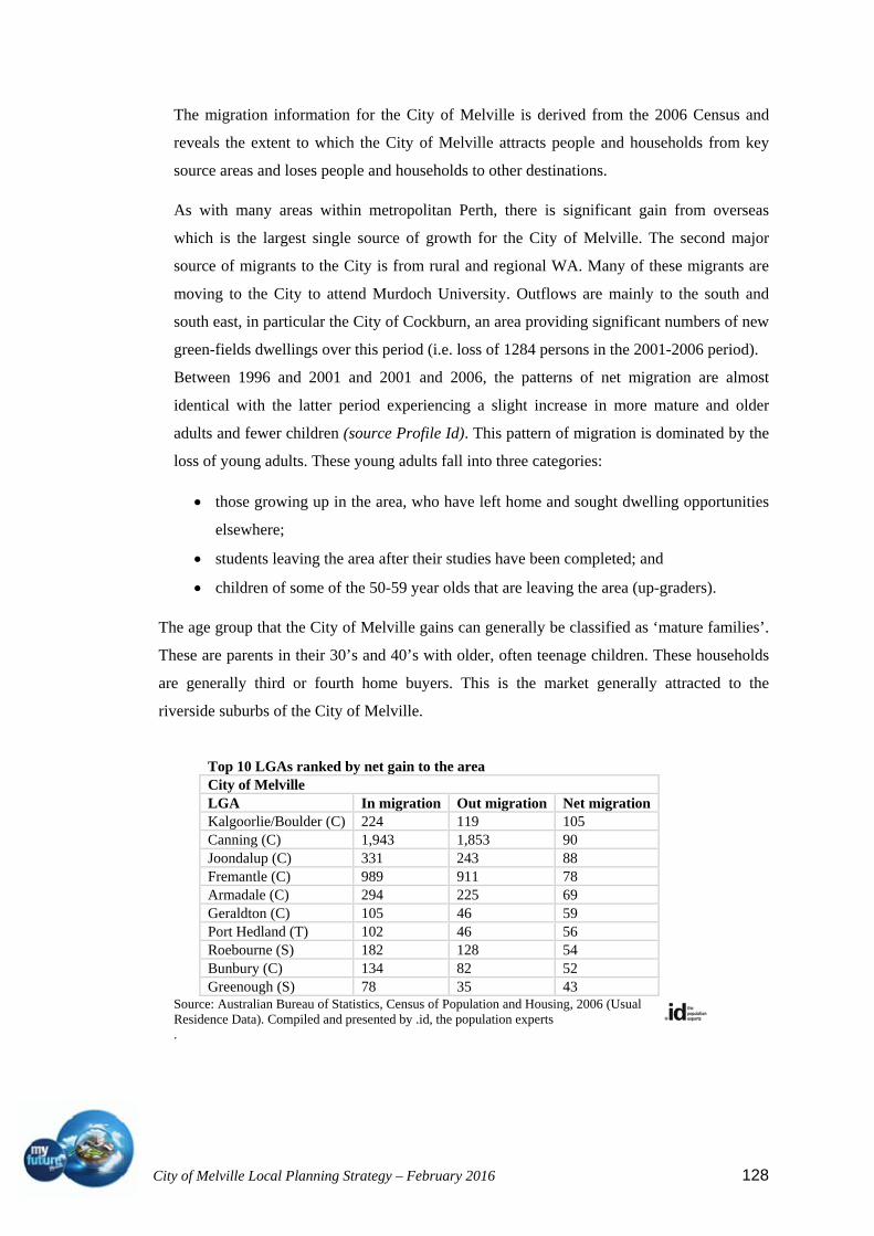
City of Melville Local Planning Strategy – February 2016 128
The migration information for the City of Melville is derived from the 2006 Census and
reveals the extent to which the City of Melville attracts people and households from key
source areas and loses people and households to other destinations.
As with many areas within metropolitan Perth, there is significant gain from overseas
which is the largest single source of growth for the City of Melville. The second major
source of migrants to the City is from rural and regional WA. Many of these migrants are
moving to the City to attend Murdoch University. Outflows are mainly to the south and
south east, in particular the City of Cockburn, an area providing significant numbers of new
green-fields dwellings over this period (i.e. loss of 1284 persons in the 2001-2006 period).
Between 1996 and 2001 and 2001 and 2006, the patterns of net migration are almost
identical with the latter period experiencing a slight increase in more mature and older
adults and fewer children (source Profile Id). This pattern of migration is dominated by the
loss of young adults. These young adults fall into three categories:
those growing up in the area, who have left home and sought dwelling opportunities
elsewhere;
students leaving the area after their studies have been completed; and
children of some of the 50-59 year olds that are leaving the area (up-graders).
The age group that the City of Melville gains can generally be classified as ‘mature families’.
These are parents in their 30’s and 40’s with older, often teenage children. These households
are generally third or fourth home buyers. This is the market generally attracted to the
riverside suburbs of the City of Melville.
Top 10 LGAs ranked by net gain to the area City of Melville LGA In migration Out migration Net migration Kalgoorlie/Boulder (C) 224 119 105 Canning (C) 1,943 1,853 90 Joondalup (C) 331 243 88 Fremantle (C) 989 911 78 Armadale (C) 294 225 69 Geraldton (C) 105 46 59 Port Hedland (T) 102 46 56 Roebourne (S) 182 128 54 Bunbury (C) 134 82 52 Greenough (S) 78 35 43
Source: Australian Bureau of Statistics, Census of Population and Housing, 2006 (Usual Residence Data). Compiled and presented by .id, the population experts .

City of Melville Local Planning Strategy – February 2016 129
With this in mind, the housing opportunities provided to the City of Melville in the future
will influence this migration profile. The two key factors that will influence what type and
how many people leave and arrive in the City of Melville are:
the extent to which there are net gains in the dwelling stock; and
the housing markets that the new dwelling stock is attracting.
4.3.13 Where residential development is occurring in the City of Melville
Development in the City of Melville has tended to focus in the suburbs north of Leach
Highway and this is consistent with ‘market popularity’ for the riverside suburbs. These are
also the older areas with grid street patterns that are generally more suited to redevelopment
than the newer suburbs to the south.
4.3.14 Opportunity for residential development in the designated activity centres
The following categories of supply are assessed to provide an estimate of residential
development opportunity for the City of Melville:
Opportunity for re-development in the designated centres;
Opportunity for development on major development sites;
Opportunity for demolition and replacement activity across the City based on a lot
size analysis; and
Opportunity for development on vacant lots outside activity centres.
The assessment considered potential in and around centres based on the following:
Access to public transport – the more important a centre is as a destination, the
higher the demand for floor space and the higher the value of land. In general, higher
land values attract higher density activity;
Level of service and retailing – the higher the level of services and retail in a centre
than there is generally a higher demand for space in that centre;
Access to major institutions – access to tertiary education or health facilities or other
major destination for employment;
Urban integration – how a centre integrates into the surrounding residential area.
Twelve centres have been identified.
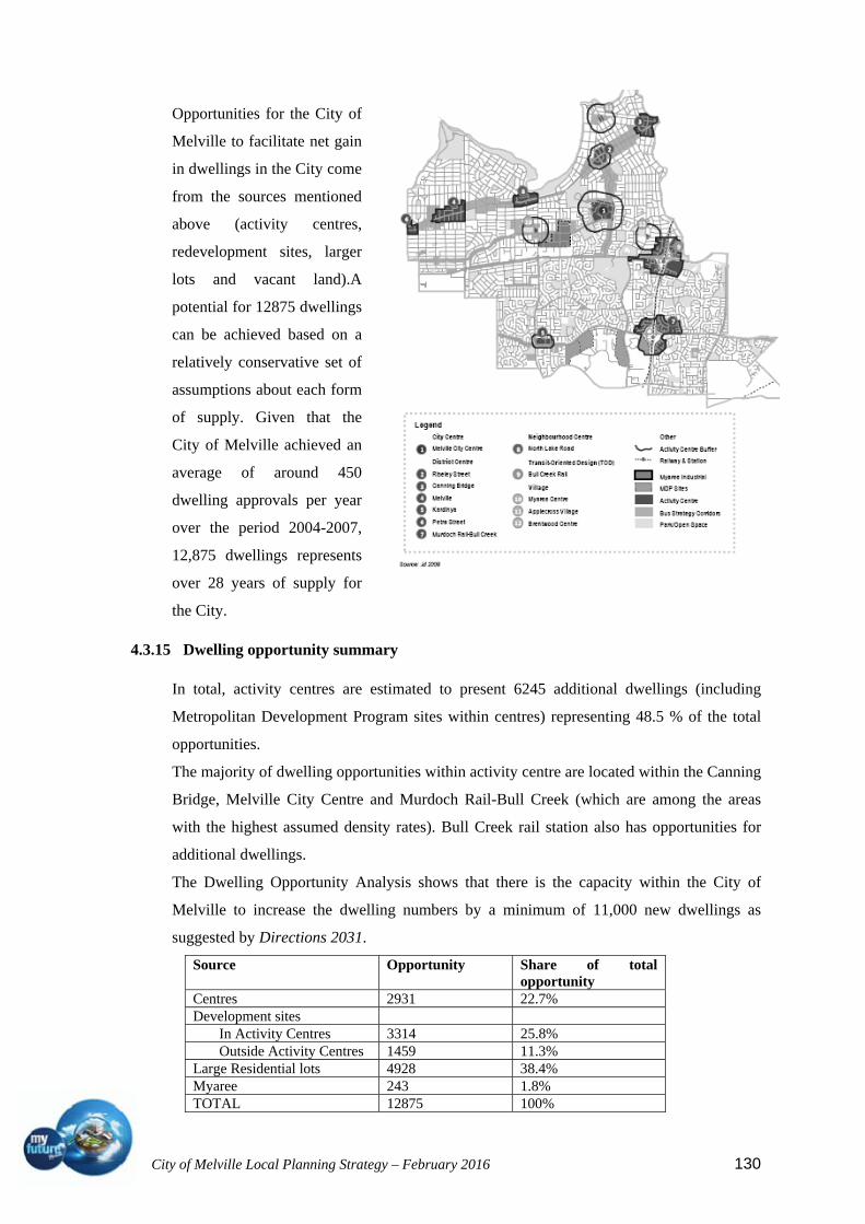
City of Melville Local Planning Strategy – February 2016 130
Opportunities for the City of
Melville to facilitate net gain
in dwellings in the City come
from the sources mentioned
above (activity centres,
redevelopment sites, larger
lots and vacant land).A
potential for 12875 dwellings
can be achieved based on a
relatively conservative set of
assumptions about each form
of supply. Given that the
City of Melville achieved an
average of around 450
dwelling approvals per year
over the period 2004-2007,
12,875 dwellings represents
over 28 years of supply for
the City.
4.3.15 Dwelling opportunity summary
In total, activity centres are estimated to present 6245 additional dwellings (including
Metropolitan Development Program sites within centres) representing 48.5 % of the total
opportunities.
The majority of dwelling opportunities within activity centre are located within the Canning
Bridge, Melville City Centre and Murdoch Rail-Bull Creek (which are among the areas
with the highest assumed density rates). Bull Creek rail station also has opportunities for
additional dwellings.
The Dwelling Opportunity Analysis shows that there is the capacity within the City of
Melville to increase the dwelling numbers by a minimum of 11,000 new dwellings as
suggested by Directions 2031.
Source Opportunity Share of total opportunity
Centres 2931 22.7% Development sites
In Activity Centres 3314 25.8% Outside Activity Centres 1459 11.3%
Large Residential lots 4928 38.4% Myaree 243 1.8% TOTAL 12875 100%

City of Melville Local Planning Strategy – February 2016 131
4.4 Economy and employment
The close proximity of the City of Melville to other major centres such as Perth and
Fremantle ensures its residents are well serviced from a trade and service perspective.
The City has numerous commercial precincts that sustain over 769,000sqm of commercial
floor space (1998) inclusive of Garden City shopping centre, Myaree mixed business area,
Kardinya and Palmyra industrial areas, six district centres and numerous smaller
neighbourhood and local centres. There are 10,574 businesses within the City (2012). As of
2012, 39,863 people were employed by businesses in the City of Melville. The largest
employer was the Retail sector followed closely by the Health Care and Social Assistance
sector
Activity Centres in the City of Melville
4.4.1 Policy considerations
The statement, ‘users define a place’, implies that it is the types, quality, concentration,
diversity and intensity of different user behaviours within a defined area that creates a place
experience. The user groups include residents, workers, visitors and enterprises.
These behaviours can be understood by examining the transactions that occur between
users, or between users and their environment.

City of Melville Local Planning Strategy – February 2016 132
Transactions can be broadly classified into three general typologies. These are:
Economic - activities that primarily result in a transfer of goods and services in
return for payment (e.g. retail trade, enterprises employing staff);
Social – activities that are primarily focussed on the informal exchange of
information and company (e.g. catching up with friends, parents playing with their
children); and
Environment – activities that are primarily focussed on users engaging with their
physical environment (e.g. users enjoying public art, reading a book in the park). In
reality every transaction has an element of each of these typologies, although one is
usually dominant.
Much of land development, urban design, land-use planning and indeed ‘place-making’ is
focused on developing unique and powerful place experiences, often in new or run-down
locations. This has led to any number of interventions and initiatives that range in scale
from ‘macro’ (e.g. built form guidelines, building setbacks, traffic management plans, and
community governance structures) to ‘micro’ (e.g. public art pieces, targeted public
infrastructure, and management of strategic sites). Some of these interventions can lead to
investment of significant capital without a strong understanding of a site’s users and their
transactions with a place.
Activity centre planning needs to consider the importance of ‘place’, its role in influencing
user behaviours, and its role creating value for stakeholders needs to mature. This requires a
focus on strategies, planning and investments for the overall performance of a place in the
context of a place vision, its users, and their transactions. For this to come about, a
comprehensive, performance oriented framework that facilitates the assessment of the
effectiveness of place-making initiatives is needed. This should to be clear, transparent,
systematic and able to be utilised to compare the predicted and actual impacts of different
initiatives (or bundles of initiatives).
The current performance of City of Melville activity centres has been assessed, using
reliable, replicable metrics. This information in the following sections provides an
understanding of the current potential for activity within centres, and provides a framework
to develop future expectations for activity centre performance.

City of Melville Local Planning Strategy – February 2016 133
4.4.2 Centres in the City of Melville
4.4.2.1 Murdoch Specialised Centre
Murdoch is classified as a specialised centre under SPP 4.2. This type of centre is unique in
the hierarchy and focused on regionally significant economic or institutional activities that
generate many work and visitor trips which require a high level of transport accessibility.
Specialised centres provide opportunities for the development of complementary activities,
particularly knowledge based businesses. A range of land uses that complement the primary
function of these centres will be encouraged on a scale that will not detract from other
centres in the hierarchy. Murdoch specifically has had its primary functions as a specialised
centre defined as health, education and research.
Within the background reports for the LCACS, Murdoch has been assessed using two
separate methodologies. The first is a standard approach to assess the current state of the
activity centre. The second assesses the projected future state, made possible due to the
existence of a completed structure plan. The future state assessment shows potential
performance at an optimal full build out as envisaged within the structure plan.
Intensity
Murdoch is located in a well-established suburb, but has large
tracts of undeveloped and under-developed land. Included
within the boundaries of the activity centre are a public and a
private hospital, a train station, Murdoch University,
Challenger TAFE and Wandoo Reintegration Facility.
Baseline analysis of the catchment indicated that the activity
centre currently (2012) has an employment density, or jobs per
hectare, score of 2.5. This is below the best of type as well as the average. It should be
noted that this is not unexpected given the large land area over which the centre is
dispersed. Current residential density scored 1.0. This is below the best of type of 6.50, as
well as the average of 3.17. The resulting overall current intensity score is 2.05.
The assessment for the future scores shows a good amount of improvement at the
envisioned full build out. The jobs per hectare score improved to 6.0, which remains below
best of type but above the average. Dwelling density improved to 6.0, with the additional
dwellings expected to be added from the development of the Mixed Use Precinct adjacent
to Murdoch train station, as well as other areas within the activity centre. In the full build
out scenario overall intensity improves to a score of 6.0, below the best of type score of 6.5
but above the average of 5.3.

City of Melville Local Planning Strategy – February 2016 134
Diversity
The baseline analysis for Murdoch showed it performed well
in the mixed use category. Despite this, its score of 0.41 on
the diversity index indicates the centre is relatively
homogenous. This is not unexpected given it is currently a
specialised centre focused on research, education and
healthcare. This translates to an overall current diversity
score of 6.5, below the best of type score acquired by Macquarie of 8.0. By the completion
of the full build-out the overall diversity score is anticipated to have increased to 7.0. This
is above the average of 6.5, and only slightly below the best of type score of 8.0.
Employment
The Murdoch Activity Centre has a current overall employment
score of 6.0. This is comprised of the current 4,378 jobs,
translating to an employment quantum score of 5.5, and a
strategic employment proportion of 12%, translating to an
employment quality score of 6.5. At full build out level it is
expected there will be a notable improvement to the
employment score. Total jobs are anticipated to increase to
14,500, and the percentage of strategic employment is estimated to increase to 15%. The
resultant overall score of 9.0 is well above the current average for a specialised centre, and
only just below the best of type score, indicating it will perform very well.
Accessibility
Murdoch contains a well-established regional train station and
bus interchange, which means it scores well in terms of
transport infrastructure (a score of 9 out of 10). In terms of
distance from the Perth CBD, Murdoch is relatively far away in
comparison to other specialised centres, so attained a score of
5.5. This is not necessarily a weakness as the vision for the
centre aspires to be an employment hub separate from the CBD. These categories result in
an overall accessibility score of 7.3, which is above the average score but below the best of
type score of 9.5. As the full build out results in no difference to either the distance from
the CBD or the type of major transport infrastructure available to the activity centre, there
is no change to the overall accessibility score as a result of its inclusion.

City of Melville Local Planning Strategy – February 2016 135
4.4.2.2 Booragoon (Melville City Centre) Secondary Centre
Booragoon is located approximately 15 km away from the
Perth CBD, putting it a significant distance from the centre of
activity in Perth. Booragoon has a strategic metropolitan
centre nearby, Fremantle, and is close to a number of nearby
district centres, including Riseley Street. In terms of transport
infrastructure, there are two train stations within several
kilometres at Canning Bridge and Bull Creek, but Booragoon
itself does not have its own. Booragoon has its own regional bus interchange that is
significantly underused at present. This generates a transport infrastructure score of 6.0 out
of 10. Booragoon would gain a significant improvement in terms of its value proposition if
its public transport connections were improved. This is of particular relevance given the
current traffic network constraints. This is especially important if Booragoon is to mature
into a diverse commercial, social and retail hub. Booragoon has an overall accessibility
score of 5.5.
Booragoon is classified as a Secondary Centre under SPP 4.2. This type of centre is a level
below strategic metropolitan centres in the hierarchy. Strategic Metropolitan centres are
defined as being multipurpose activity centres that provide a diversity of uses. Secondary
centres perform similar functions to Strategic Metropolitan centres but offer a more limited
range of services, facilities and employment opportunities and typically serve smaller
catchments. They perform an important role in the regional economy and provide essential
services to their catchments.
Melville City Centre current performance Principle Metric Metric Score Total Score
Activity Intensity Residential Density 2.5
5.0 Employment Density 7.5
Activity Diversity Mixed Use 2.0
3.8 Equitability 5.5
Employment Quantum 4.5
6.8 Quality 9.0
Accessibility
Distance from Perth CBD (kms)
5.0 5.5
Transport Infrastructure 6.0
Structure planning for Booragoon is currently underway, with the owner of Garden City
Shopping Centre, the primary focus of the centre, intending to expand the floorspace
significantly and introduce new land uses.
Booragoon scored 5.0 out of 10 for the overall intensity metric. Performance in terms of
residential density was relatively poor, with the centre attaining 7.5 dwellings per hectare
within an 800 m walkable catchment from the bus station designated as the central node.
City of Melville Local Planning Strategy – February 2016 136
The Centre performed well in terms of job intensity, scoring 7.5 out of 10, achieving over
90 jobs per hectare. There is significant variation in terms of job intensity for secondary
centres within Perth. For instance, Claremont scores poorly in comparison to Booragoon,
achieving 21.5 jobs per hectare equating to a score of 4.0 while Subic performs well with
101.5 jobs per hectare, equating to a score of 8.0
Due to the dominance of retail in Booragoon’s current form, its total diversity score is
relatively poor at 3.8. Booragoon scored a 2.0 in the mixed use category, indicating that the
amount of retail far exceeds all other types of land uses within the activity centre
boundaries. While this is currently low, it is expected that the mix of goods and services
that Booragoon offers will diversify in the future as it moves towards fulfilling the targets
set out for secondary centres under SPP 4.2. This will most likely include an increase in
commercial and entertainment type land uses which will significantly improve the diversity
of what if offers to its catchment as it moves away from a retail focus toward a community
and business hub.
Booragoon fared much better under the equitability index obtaining a 0.61, equating to a
score of 5.5. Interpreting this, it is apparent that while retail is the dominant land use within
the activity centre, the number of other land uses that the centre offers is still quite
significant. This falls in line with what would be expected of a secondary centre such as
this.
Booragoon activity centre, as of last census, had 3,117 employees across all industries. This
scale of employment equates to a score of 4.5. As with diversity this is expected to improve
as the centre grows especially as it begins to incorporate more commercial floor space into
its land use mix. Booragoon performs extremely well in terms of employment quality with
approximately 20% of the employment in the centre being strategic in nature which
translates to a score of 9.0 putting it at the upper echelons in terms of the quality of its
employment. As Booragoon grows and moves away from being purely retail focussed the
scale of employment should improve significantly. Similarly with an increased focus on
commercial as it grows we should see its strategic employment remain steady or improve.
These developments will enable Booragoon to compare more favourably to more mature
secondary centres, such as Subiaco, in terms of employment.

City of Melville Local Planning Strategy – February 2016 137
4.4.2.3 District Centres
The City of Melville has six district centres, defined in SPP 4.2 as:‘…having a greater
focus on servicing the daily and weekly needs of residents. Their relatively smaller scale
catchment enables them to have a greater local community focus and provide services,
facilities and job opportunities that reflect the particular needs of their catchments.’ In the
activity centres hierarchy, this type of centre is between a Secondary Centre and a
Neighbourhood Centre in terms of catchment population size, residential density targets,
and diversity and intensity of commercial activity.
District centres are therefore expected to function at a medium level in terms of:
Service to population catchment;
Accessibility and transport connectivity;
to its catchment as it moves away from a retail focus toward a community and
business hub
Full range of retail and office floor-space;
Residential density
Canning Bridge
Canning Bridge District Centre is located on Canning Highway,
directly east of Canning Bridge and on the western fringe of the City
of Melville. It is bordered by the Canning River and has a train
station within its walkable catchment. Canning Bridge is the best
performing district centre in the City of Melville, and performs similar to the best of type
centre assessed. It should be noted that Canning Bridge outperforms Booragoon in all areas
except intensity.
Canning Bridge scores highly in terms of diversity, with a score of
8.3 out of 10, equal to the best of type score. Retail was not the
dominant employment form within Canning Bridge as evidenced by
the high mixed use score. The relatively high equitability index
indicates a fairly even mix of employment types, though it is slightly
skewed towards professional, scientific and technical services as the
dominant employment category. This may indicate an emerging localisation economy.
As expected of a centre that has a high commercial user base and dominant employment
type of professionals, Canning Bridge scored extremely well in terms of the proportion of
strategic employment present, with a score of 9.5. This represents the highest proportion of
strategic employment present in a district centre among the benchmarked centres.
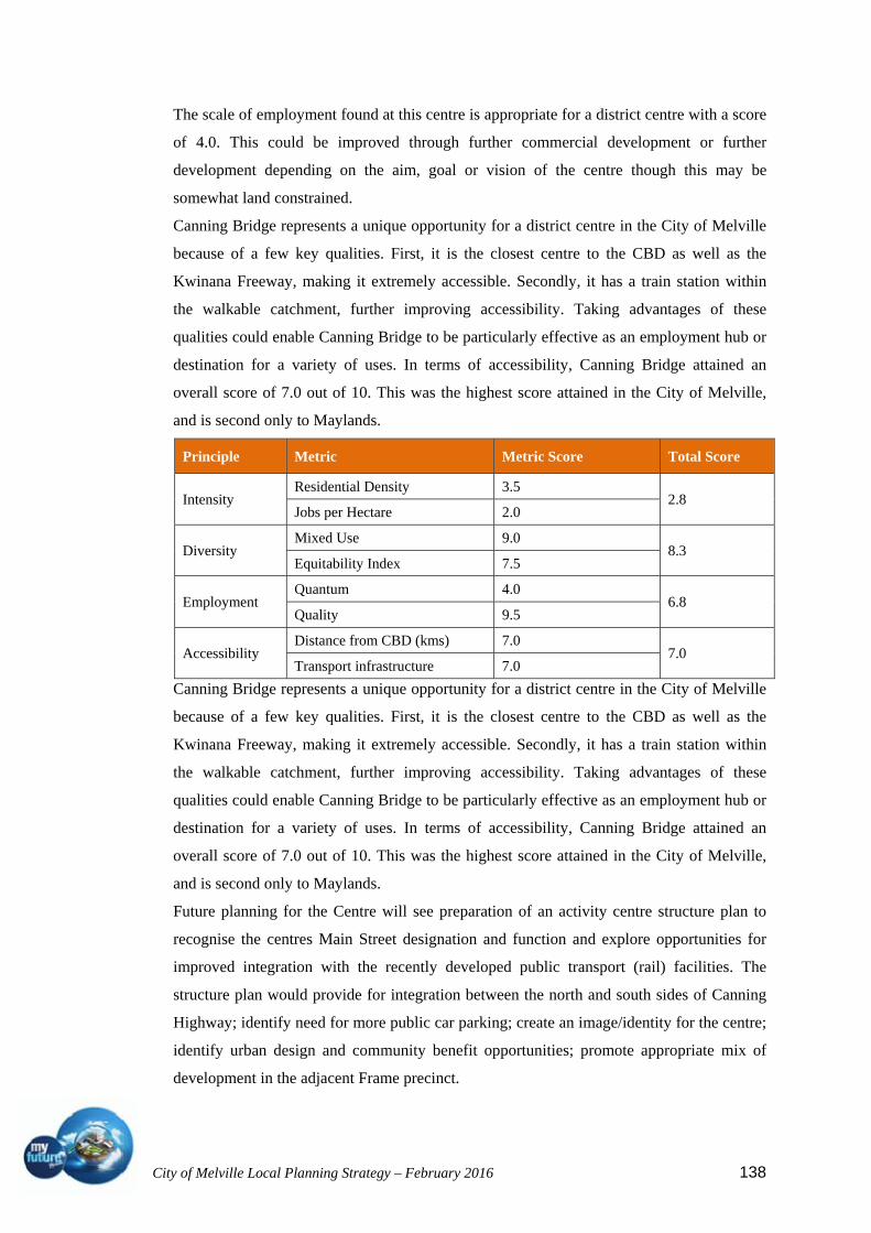
City of Melville Local Planning Strategy – February 2016 138
The scale of employment found at this centre is appropriate for a district centre with a score
of 4.0. This could be improved through further commercial development or further
development depending on the aim, goal or vision of the centre though this may be
somewhat land constrained.
Canning Bridge represents a unique opportunity for a district centre in the City of Melville
because of a few key qualities. First, it is the closest centre to the CBD as well as the
Kwinana Freeway, making it extremely accessible. Secondly, it has a train station within
the walkable catchment, further improving accessibility. Taking advantages of these
qualities could enable Canning Bridge to be particularly effective as an employment hub or
destination for a variety of uses. In terms of accessibility, Canning Bridge attained an
overall score of 7.0 out of 10. This was the highest score attained in the City of Melville,
and is second only to Maylands.
Principle Metric Metric Score Total Score
Intensity Residential Density 3.5
2.8 Jobs per Hectare 2.0
Diversity Mixed Use 9.0
8.3 Equitability Index 7.5
Employment Quantum 4.0
6.8 Quality 9.5
Accessibility Distance from CBD (kms) 7.0
7.0 Transport infrastructure 7.0
Canning Bridge represents a unique opportunity for a district centre in the City of Melville
because of a few key qualities. First, it is the closest centre to the CBD as well as the
Kwinana Freeway, making it extremely accessible. Secondly, it has a train station within
the walkable catchment, further improving accessibility. Taking advantages of these
qualities could enable Canning Bridge to be particularly effective as an employment hub or
destination for a variety of uses. In terms of accessibility, Canning Bridge attained an
overall score of 7.0 out of 10. This was the highest score attained in the City of Melville,
and is second only to Maylands.
Future planning for the Centre will see preparation of an activity centre structure plan to
recognise the centres Main Street designation and function and explore opportunities for
improved integration with the recently developed public transport (rail) facilities. The
structure plan would provide for integration between the north and south sides of Canning
Highway; identify need for more public car parking; create an image/identity for the centre;
identify urban design and community benefit opportunities; promote appropriate mix of
development in the adjacent Frame precinct.

City of Melville Local Planning Strategy – February 2016 139
Riseley Street
Riseley Street is located on the corner of Canning Highway and
Riseley Street, within 2 km to Booragoon Secondary Centre. This
near co-location means the centre is likely to be impacted by
future development at Booragoon. These impacts may be positive
or negative, or may simply drive a shift in focus for the centre.
Riseley Street currently performs extremely well across a range
of different categories. Diversity in Riseley Street is excellent,
with the high mixed use score of 8.5 indicating that the retail component does not
overpower the rest of the centre’s amenity. The high mixed use score, along with the
relatively high equitability index of 7.5, shows a reasonable distribution of employment
across a range of activities. This is evident from the broad mix
of retail located in the centre, including a grocer, supplement
store, hair dressing services, pharmacist, as well as a number of
entertainment uses and commercial activity.
Riseley Street performs exceptionally well in terms of its
strategic employment, with a score of 9.0. This was second only
to Canning Bridge, but is still well above the average score.
This can be largely attributed to the commercial activity component, with professional
services comprising a significant proportion of the employment distribution.
Accessibility is an issue for Riseley Street. Like many of the activity centres along Canning
Highway it is only serviced by buses and has no bus interchange or rail station. It does have
an added advantage as it is along a major route to service the Booragoon Secondary Centre,
so more bus routes service it than the other activity centres along Canning Highway.
Depending on how Booragoon evolves and its accessibility along with it, it is possible
accessibility to Riseley Street will improve as a secondary effect to an expansion at
Booragoon.
Principle Metric Metric Score Total Score
Intensity Residential Density 3.0
2.0 Jobs per Hectare 1.0
Diversity Mixed Use 8.5
8.0 Equitability Index 7.5
Employment Quantum 3.5
6.3 Quality 9.0
Accessibility Distance from CBD (kms) 6.5
5.3 Transport infrastructure 4.0
Riseley Street current performance Source: Pracsys 2013

City of Melville Local Planning Strategy – February 2016 140
Future planning for the Centre will see preparation of a structure plan that will encourage
the centre to gradually diversify and expand to the limit of its capacity through
development of an activity centre structure plan. An appropriate mix of uses in the Frame
should be promoted that extend the commercial functions of the centre whilst being
harmonious and compatible with the amenity of the adjoining residential area.
Bull Creek
Bull Creek District Centre is located on South Street, east of
Murdoch train station and Kwinana Freeway, and approximately
14 km away from the Perth CBD. The activity centre contains Bull
Creek Shopping Centre, a large retail-oriented shopping mall with
some entertainment uses. The centre also includes some
specialised activity on the opposite side of South Street including
medical and real estate services. Murdoch train station is within the 800 m walkable
catchment of the activity centre. There is some cross-over in the catchment for Bull Creek
and Murdoch activity centres.
The results of the economic sustainability performance of Bull Creek show the most
obvious weakness is in intensity of both residential and jobs.
Residential density is very low in the walkable catchment, at only 7.8 dwellings per
hectare. Similarly, jobs per hectare are very low, though this is in part due to the large area
coverage of the data used to calculate the score. The total employment or employment scale
for Bull Creek was low at 5.5 out of 10. This was relatively consistent with the other
district centres assessed, but reasonably strong in strategic employment as a result of the
pocket of medical, health and professional services that located
within the centre. It should be noted this result is high due to the
large area coverage of the data source. The overall intensity score
is 7.0. The mixed use score of 7.5 indicates that while there is a
significant presence of retail, it is not the sole focus and function
of the centre. The pocket of medical and other professional
services located within the centre, and the variety of cafes and
other food outlets make up a substantial amount of employment. The relatively low
equitability index score of 6.5, the worst of all City of Melville district centres, indicates
that the overall distribution of employment could be more evenly allocated across different
industries.
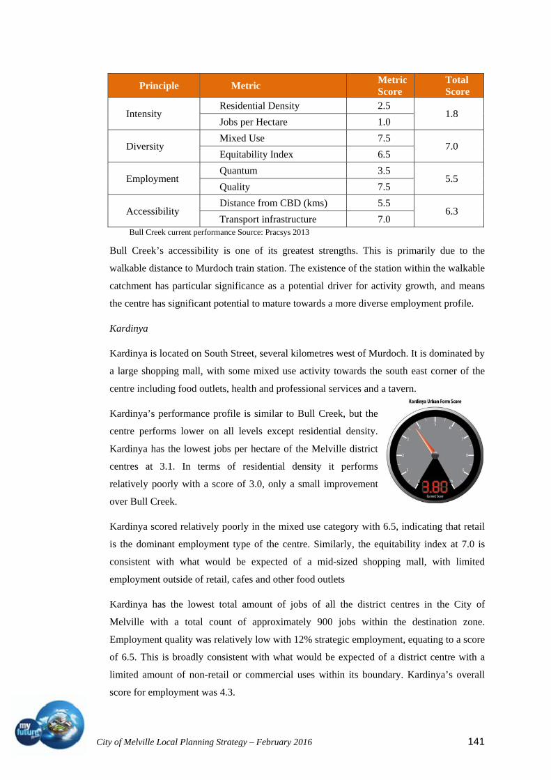
City of Melville Local Planning Strategy – February 2016 141
Bull Creek current performance Source: Pracsys 2013
Bull Creek’s accessibility is one of its greatest strengths. This is primarily due to the
walkable distance to Murdoch train station. The existence of the station within the walkable
catchment has particular significance as a potential driver for activity growth, and means
the centre has significant potential to mature towards a more diverse employment profile.
Kardinya
Kardinya is located on South Street, several kilometres west of Murdoch. It is dominated by
a large shopping mall, with some mixed use activity towards the south east corner of the
centre including food outlets, health and professional services and a tavern.
Kardinya’s performance profile is similar to Bull Creek, but the
centre performs lower on all levels except residential density.
Kardinya has the lowest jobs per hectare of the Melville district
centres at 3.1. In terms of residential density it performs
relatively poorly with a score of 3.0, only a small improvement
over Bull Creek.
Kardinya scored relatively poorly in the mixed use category with 6.5, indicating that retail
is the dominant employment type of the centre. Similarly, the equitability index at 7.0 is
consistent with what would be expected of a mid-sized shopping mall, with limited
employment outside of retail, cafes and other food outlets
Kardinya has the lowest total amount of jobs of all the district centres in the City of
Melville with a total count of approximately 900 jobs within the destination zone.
Employment quality was relatively low with 12% strategic employment, equating to a score
of 6.5. This is broadly consistent with what would be expected of a district centre with a
limited amount of non-retail or commercial uses within its boundary. Kardinya’s overall
score for employment was 4.3.
Principle Metric Metric Score
Total Score
Intensity Residential Density 2.5
1.8 Jobs per Hectare 1.0
Diversity Mixed Use 7.5
7.0 Equitability Index 6.5
Employment Quantum 3.5
5.5 Quality 7.5
Accessibility Distance from CBD (kms) 5.5
6.3 Transport infrastructure 7.0

City of Melville Local Planning Strategy – February 2016 142
The best performing district centre assessed, in terms of employment, was Canning Bridge
at 9.5, which had a higher component of strategic employment.
Principle Metric Metric Score Total Score
Intensity Residential Density 3.0
2.0 Jobs per Hectare 1.0
Diversity Mixed Use 6.5
6.8 Equitability Index 7.0
Employment Quantum 2.0
4.3 Quality 6.5
Accessibility Distance from CBD (kms) 4.5
4.3 Transport infrastructure 4.0
Kardinya current performance Source: Pracsys 2013
Accessibility suffered in Kardinya due to its distance away from the CBD and lack of any
sort of major bus or rail interchange, although numerous bus routes service it.
Any planned expansions of the Kardinya Centre should be based ‘on merit’ and should
endeavour to integrate the two parts of the centre and particularly
promote the refurbishment of the eastern part of the centre.
Petra Street
Petra Street is located on the eastern boundary of the City of
Melville; spread across Canning Hwy. Part of the centre catchment
is located within the City of East Fremantle. The centre contains a
major supermarket as well as a smaller independent grocer, along with a variety of cafes
and takeaway food shops. There is also a small pocket of non-retail and medical tenancies
in the south-western portion of the activity centre.
Petra Street scores relatively well in terms of diversity, attaining a
7.8 out of 10. It has a variety of different land use types ranging
from grocers to cafes, food outlets and medical. This mixture of
land use types is responsible for the high mixed use score. The
equitability index score of 7.5 is also an excellent result. To
improve this score there would need to be a more equitable
distribution of jobs away from retail and cafes and to some extent, away from health. This
could be achieved through an increased commercial presence in the centre.

City of Melville Local Planning Strategy – February 2016 143
Overall intensity, at 2.3, sits just below the average of 2.6 and well below the best of type
of 4.7. This can be attributed primarily to the jobs per hectare score of 1.0. This figure is
lower than expected due to the large spatial area the data source was spread over. In terms
of residential density, Petra Street is one of the better performing centres in the City of
Melville, achieving 3.5 out 10.
Residential density in Petra Street is particularly affected by the presence of reasonable
sized reserves. These reserves provide important recreational amenity to users of Petra
Street and can provide a visitor attractor that can benefit the centre’s expenditure capture.
In terms of accessibility, Petra Street lacks a public transport station of any kind, relying
primarily on the bus routes servicing it down Canning Highway. Without a significant
improvement in public transport infrastructure it is unlikely that Petra Street could reach the
residential and employment density levels experienced in Maylands or other high
performing district centres. However, the location of the centre on a major transport
corridor, Canning Highway, means there may be opportunity to capture incidental
expenditure from passing trade.
Principle Metric Metric Score Total Score
Intensity Residential Density 3.5
2.3 Jobs per Hectare 1.0
Diversity Mixed Use 8.0
7.8 Equitability Index 7.5
Employment Quantum 3.5
5.0 Quality 6.5
Accessibility Distance from CBD (kms) 5.0
4.5 Transport infrastructure 4.0
Petra Street current performance Source: Pracsys 2013
The City of Melville with the Town of East Fremantle should undertake a structure plan for
the centre with a view to promoting an appropriate mix of development in the Frame to
compliment and extend the commercial functions of the centre while being harmonious and
compatible with the adjacent residential area.
Melville
Melville is a shopping mall based activity centre separated by Canning Highway and near
Stock Road. The southern side of Canning Highway contains a selection of food outlets,
non-retail as well as a car yard. The northern side contains the mall section, which is a
fairly typical land use mix of a development of that type.
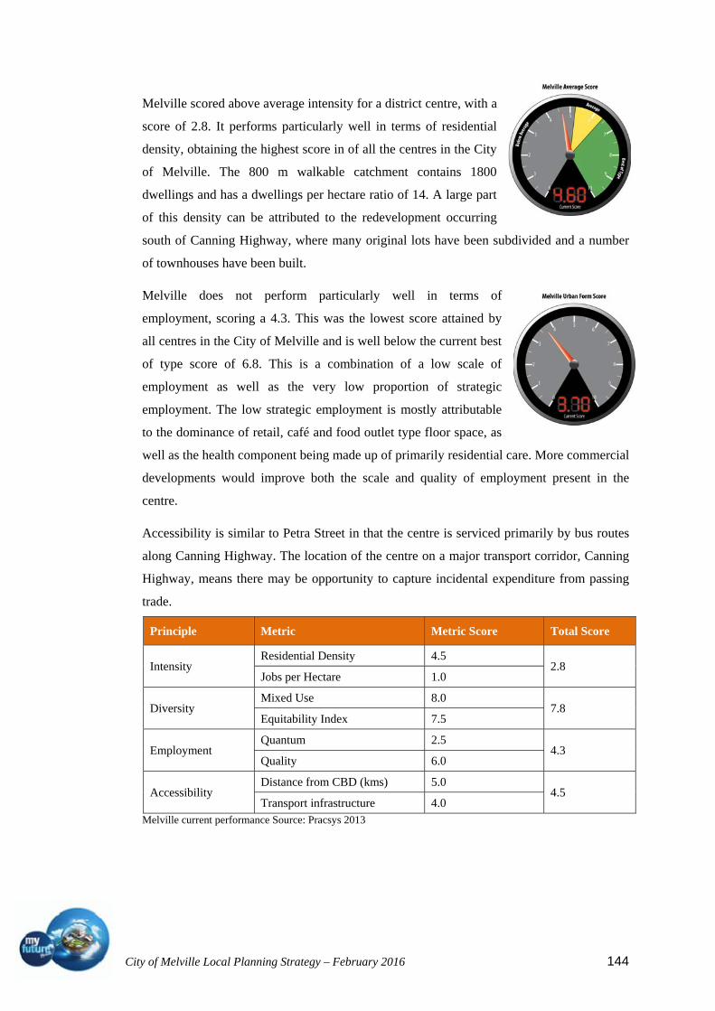
City of Melville Local Planning Strategy – February 2016 144
Melville scored above average intensity for a district centre, with a
score of 2.8. It performs particularly well in terms of residential
density, obtaining the highest score in of all the centres in the City
of Melville. The 800 m walkable catchment contains 1800
dwellings and has a dwellings per hectare ratio of 14. A large part
of this density can be attributed to the redevelopment occurring
south of Canning Highway, where many original lots have been subdivided and a number
of townhouses have been built.
Melville does not perform particularly well in terms of
employment, scoring a 4.3. This was the lowest score attained by
all centres in the City of Melville and is well below the current best
of type score of 6.8. This is a combination of a low scale of
employment as well as the very low proportion of strategic
employment. The low strategic employment is mostly attributable
to the dominance of retail, café and food outlet type floor space, as
well as the health component being made up of primarily residential care. More commercial
developments would improve both the scale and quality of employment present in the
centre.
Accessibility is similar to Petra Street in that the centre is serviced primarily by bus routes
along Canning Highway. The location of the centre on a major transport corridor, Canning
Highway, means there may be opportunity to capture incidental expenditure from passing
trade.
Principle Metric Metric Score Total Score
Intensity Residential Density 4.5
2.8 Jobs per Hectare 1.0
Diversity Mixed Use 8.0
7.8 Equitability Index 7.5
Employment Quantum 2.5
4.3 Quality 6.0
Accessibility Distance from CBD (kms) 5.0
4.5 Transport infrastructure 4.0
Melville current performance Source: Pracsys 2013

City of Melville Local Planning Strategy – February 2016 145
4.4.2.4 Neighbourhood Centres
The City Melville contains ten identified neighbourhood centres defined under SPP 4.2
neighbourhood centres as: '...providing for daily and weekly household shopping needs,
community facilities and a small range of other convenience services.' These centres have
some significance in terms of the overall commercial network, but are not expected to
provide comprehensive offerings of goods and services.
4.4.2.5 Local Centres
Local centres tend to be more focused on providing convenience shopping such as local
deli, takeaway food shop or entertainment offerings such as a cafe. The function of each
local centre may be fairly unique. Future visions for local centres should respond to this
character.
4.4.3 Local Commercial Activity Centre Strategy (LCACS)
The intent of Directions 2031 and SPP 4.2 is to provide an even distribution of jobs,
services and amenities in a hierarchy of activity centres. SPP 4.2 is mainly concerned with
the distribution, function, broad land use and urban design criteria of activity centres, and
with coordinating their land use and infrastructure planning.
The objectives of the LCACS essentially align with the policy objectives of SPP 4.2 in the
following areas:
1. Distribute activity centres to meet different levels of community need and enable
employment, goods and services to be accessed efficiently and equitably by the
community;
2. Apply the activity centre hierarchy as part of a long-term and integrated approach by
public authorities and private stakeholders to the development of economic and
social infrastructure;
3. Plan activity centres to support a wide range of retail and commercial premises and
promote a competitive retail and commercial market;
4. Increase the range of employment in activity centres and contribute to the
achievement of subregional employment self-sufficiency targets;
7. Maximise access to activity centres by walking, cycling and public transport while
reducing private car trips; and
9. Concentrate activities, particularly those that generate high numbers of trips, within
activity centres.

City of Melville Local Planning Strategy – February 2016 146
Potential opportunities for the future development of City of Melville activity centres are:
Promote a network of district, neighbourhood and local centres to support the
community;
Promote Booragoon to develop to its full employment potential as a Secondary
Centre under Directions 2031;
Promote Murdoch to further develop as a Specialised activity centre;
Promote opportunities for new business development through working with the
Chamber of Commerce, local traders and other community leaders, recognising the
changing nature of business precincts such as the Myaree Mixed Business Zone;
Encourage and plan for appropriate ‘Main Street’ development within activity
centres;
Align transport and activity centre functions;
Encourage increased employment within appropriate activity centres; and
Enable the regeneration of existing activity centres to improve their amenity,
attractiveness and social and cultural vitality.
Gaps and opportunities that would improve performance outcomes of activity centres are:
Increase the density and diversity of housing in and around activity centres to
improve land efficiency, housing variety and support centre facilities. A more
rigorous pursuit of higher-density housing should be incorporated within and
immediately adjacent to activity centres to establish a sense of community and
increase activity outside normal business hours. Targets for residential density as set
out in SPP 4.2 should be applied throughout the City of Melville activity centre
network, with regard to the capacity of each centre to meet set targets;
For Booragoon Secondary Centre, an average minimum residential density of R35 is
suggested, and for District Centres, an average minimum of R30. In some instances
pursuing average higher densities may be appropriate. The area over which the
average minimum density is to be calculated will need to be considered;
Ensure activity centres provide sufficient development intensity and land use mix to
support high-frequency public transport;
Where practical, activity centres should be planned in line with transit-oriented
development principles to make it convenient and practicable for residents,
employees and visitors to travel by public transport, cycling or walking instead of by
private car. Where this approach is not practical the future development of the
activity centre should consider the need to minimise private car use; and

City of Melville Local Planning Strategy – February 2016 147
Plan activity centre development around a legible street network and quality public
spaces.
Future urban design considerations for City of Melville activity centre are:
District centres and higher-order centres with a network of streets and public spaces
as principal elements;
Well-formed structure typically consists of small, walkable blocks that improve
accessibility within a centre;
Buildings and tenancies need to address streets and public spaces to promote vitality
and encourage natural surveillance;
Generally, activity centres should contain a mix of uses along street frontages, and
arrange key retail and other attractors to maximise pedestrian flows along streets;
New activity centre development or redevelopment should include ‘sleeving’ of
large-scale retail and car parks, more externally-oriented or ‘active’ building
frontages, and blank walls should be minimised; and
‘Town squares’, public and civic spaces, and parks need to be attractive, well-located
spaces and integrated into activity centres to provide quality meeting places for the
community and build the character of each centre.
As the current population ages, the diversity of stock offered within activity centres can
provide alternative housing options for older households, potentially encouraging the
release of 3 and 4 plus bedroom dwellings in the older residential neighbourhoods around
the City of Melville. This may provide increased opportunities for family households to
move to these areas and encourage the process of regeneration. Densification around
activity centres can offer lifestyle choice to a large range of different social groups given
the easy access to local facilities. The development of higher density dwellings in and
around activity centres should be complemented by other physical improvements to the
centres in terms of amenities and attractiveness in order to ensure that development is
occurring within an urban environment likely to prove attractive to a range of social groups.
The Melville City Centre and the rail based activity centres are likely to attract most of the
future higher density development and it is desirable to concentrate on developing policies
to encourage this, in addition to encouraging increased development along major transport
networks.

City of Melville Local Planning Strategy – February 2016 148
4.4.3.1 Retail Market Potential
The following tables set out the retail market potential for the aspirational and conservative
scenarios in terms of floorspace demand. A minimum and maximum floorspace demand
figure has been provided for both scenarios along with supply assumptions.
The floorspace demand numbers indicate the capacity of the catchment for each activity
centre in the City of Melville to support retail floorspace over the next ten years, given
current assumptions about household expenditure and household to floorspace ratios hold
true. Results are presented for all high level activity centres (district centres and above) in
terms of future retail floorspace minimum and maximum levels for each scenario modelled.
The minimum and maximum levels of floorspace reference the minimum and maximum
levels of productivity the floorspace can viably trade under. Trading below the minimum
floorspace productivity means demand is likely too low to keep the floorspace financially
viable. Trading above the maximum floorspace productivity means demand is likely to be
greater than the floorspace has the capacity to support without creating negative
externalities, such as parking congestion and poor service to customers. Any result in the
range between the minimum and maximum is considered ideal to ensure the viability of the
network as a whole.
These figures are intended to be used as a guide for planners, developers and the
community on the likely patterns and scale of retail development for the future. Retail
demand figures should not be used to restrict the scale of future development but to
understand the trends in retail growth or contractions across the City of Melville and the
implications for activity centres. If a proposed development results in retail floorspace
supply significantly higher than modelled maximum demand for an activity centre, the
reasons why the proposed supply can be supported should be explored. There are a range of
reasons why higher levels of supply may be appropriate if circumstances change, leading to
more favourable trading conditions. These include but are not limited to:
The additional floorspace is of sufficient scale to increase the size of the catchment,
therefore increasing the overall expenditure capture for the centre, enabling a larger
floor area to be supported;
The population within the catchment has increased more than predicted;
The population within the catchment has become more affluent, increasing the
potential expenditure at the centre;
The ratio of floorspace to population has increased due to changes in retail business
models and user behaviour;
Access to the centre is improved, increasing the catchment size and/or capture;
Changes to the tenancy mix or product mix offered result in greater expenditure
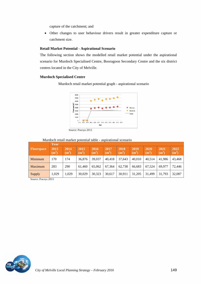
City of Melville Local Planning Strategy – February 2016 149
capture of the catchment; and
Other changes to user behaviour drivers result in greater expenditure capture or
catchment size.
Retail Market Potential - Aspirational Scenario
The following section shows the modelled retail market potential under the aspirational
scenario for Murdoch Specialised Centre, Booragoon Secondary Centre and the six district
centres located in the City of Melville.
Murdoch Specialised Centre
Murdoch retail market potential graph - aspirational scenario
Source: Pracsys 2013
Murdoch retail market potential table - aspirational scenario
Floorspace Year 2013 (m2)
2014 (m2)
2015 (m2)
2016 (m2)
2017 (m2)
2018 (m2)
2019 (m2)
2020 (m2)
2021 (m2)
2022 (m2)
Minimum 170 174 36,876 39,037 40,418 37,643 40,010 40,514 41,986 43,468
Maximum 283 290 61,460 65,062 67,364 62,738 66,683 67,524 69,977 72,446
Supply 1,029 1,029 30,029 30,323 30,617 30,911 31,205 31,499 31,793 32,087
Source: Pracsys 2013

City of Melville Local Planning Strategy – February 2016 150
Booragoon Secondary Centre
Booragoon retail market potential graph - aspirational scenario
Source: Pracsys 2013
Booragoon retail floorspace potential table - aspirational scenario
Floorspace Year 2013 (m2)
2014 (m2)
2015 (m2)
2016 (m2)
2017 (m2)
2018 (m2)
2019 (m2)
2020 (m2)
2021 (m2)
2022 (m2)
Minimum 77,158 78,987 75,614 39,307 40,142 225,818
232,901
235,895
240,967
245,973
Maximum 128,597
131,646
126,023
65,512 66,904 376,363
388,168
393,158
401,611
409,955
Supply 65,979 65,979 65,979 46,185 46,185 120,000
120,000
120,000
120,000
120,000
Source: Pracsys 2013
District Centres
Bull Creek retail market potential graph Canning Bridge retail market potential graph
-
Source: Pracsys 2013
Kardinya retail market potential graph Melville retail market potential graph
Source: Pracsys 2013 Petra Street retail market potential graph Riseley Street retail market potential graph
So

City of Melville Local Planning Strategy – February 2016 151
Source: Pracsys 2013
District centres retail floorspace potential table - aspirational scenario
4.4.4 Myaree mixed business area
The Myaree Mixed Business precinct provides the largest industrial/service commercial
area in the City of Melville (264,000m2 of floor area at 2002) and provides a diversity of
business, retail and light industrial functions. The Commercial Land Use Survey conducted
by the Department for Planning in 2002 identified that Myaree contained over 18,168m2 of
retail (shopping) floorspace.
The Myaree Mixed Business area is the only true multi-purpose commercial activity centre
in the City of Melville and is considered a zone in ‘transition’ like many other inner city
industrial zones. Myaree is currently zoned for Industrial purposes under the Metropolitan
Region Scheme. The City is planning to enhance the diversity and range of uses available
Centre Name
Floorspace
Year
2013 (m2)
2014 (m2)
2015 (m2)
2016 (m2)
2017 (m2)
2018 (m2)
2019 (m2)
2020 (m2)
2021 (m2)
2022 (m2)
Bull Creek
Minimum 8,168 8,357 7,352 7,638 7,765 7,256 7,570 7,538 7,676 7,811
Maximum 13,613 13,929 12,254 12,730 12,942 12,093 12,617 12,563 12,794 13,018
Supply 13,894 13,894 13,894 13,894 13,894 13,894 13,894 13,894 13,894 13,894
Canning Bridge
Minimum 3,991 4,086 33,773 35,507 36,581 34,466 35,977 35,590 36,136 36,656
Maximum 6,652 6,810 56,288 59,179 60,969 57,444 59,962 59,316 60,227 61,094
Supply 5,424 5,424 16,624 16,624 16,624 16,624 16,624 16,624 16,624 16,624
Kardinya
Minimum 10,532 10,789 9,760 10,167 10,345 9,386 9,797 9,748 9,926 10,099
Maximum 17,553 17,981 16,266 16,945 17,242 15,644 16,329 16,246 16,543 16,831
Supply 15,792 15,792 15,792 15,792 15,792 15,792 15,792 15,792 15,792 15,792
Melville
Minimum 11,885 12,142 11,039 11,398 11,544 10,727 11,195 11,074 11,242 11,405
Maximum 19,808 20,236 18,398 18,997 19,240 17,879 18,659 18,456 18,737 19,008
Supply 9,526 9,526 9,526 9,526 9,526 9,526 9,526 9,526 9,526 9,526
Petra Street
Minimum 10,470 10,698 9,780 10,089 10,223 9,570 9,998 9,899 10,059 10,215
Maximum 17,449 17,831 16,300 16,815 17,039 15,951 16,663 16,498 16,766 17,024
Supply 9,217 9,217 9,217 9,217 9,217 9,217 9,217 9,217 9,217 9,217
Riseley Street
Minimum 9,041 9,257 8,212 8,553 8,685 7,887 8,236 8,151 8,279 8,402
Maximum 15,069 15,428 13,686 14,254 14,474 13,145 13,727 13,585 13,799 14,004
Supply 8,277 8,277 8,277 8,277 8,277 8,277 8,277 8,277 8,277 8,277
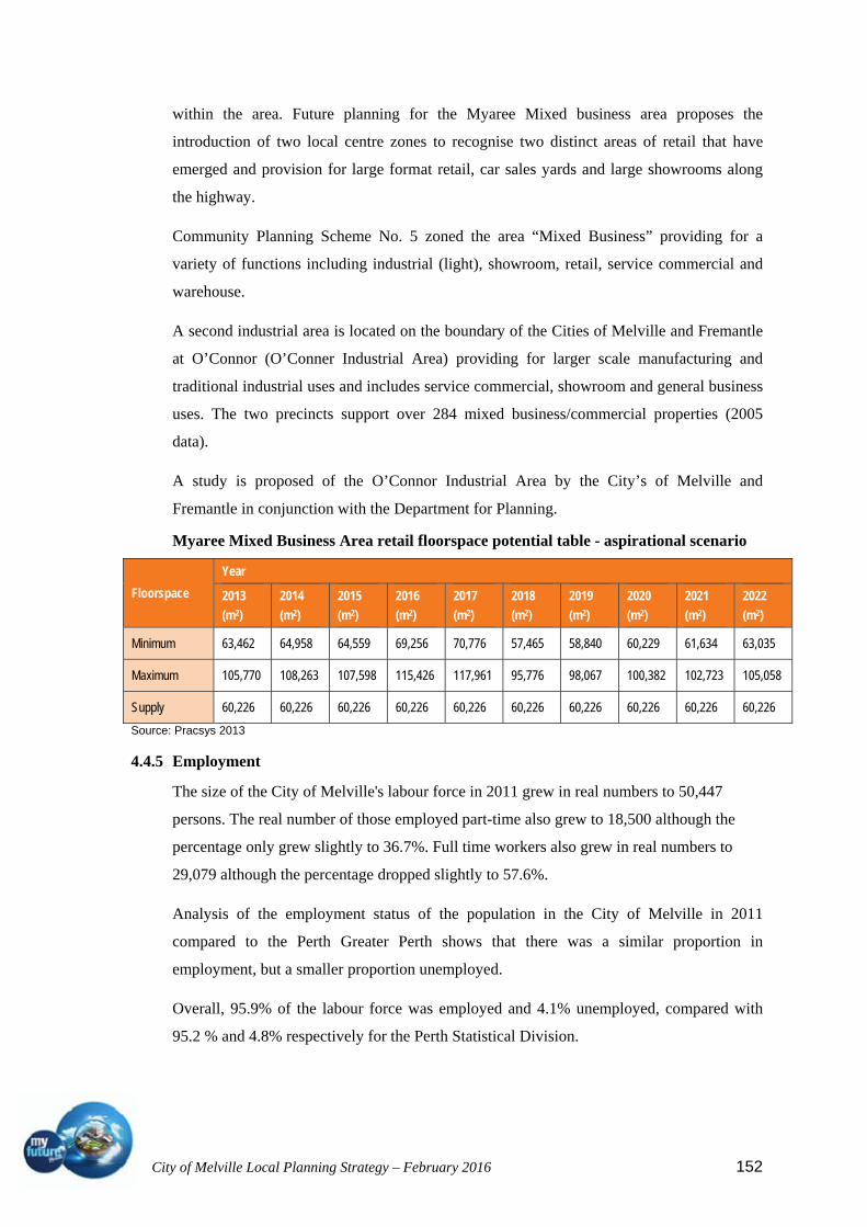
City of Melville Local Planning Strategy – February 2016 152
within the area. Future planning for the Myaree Mixed business area proposes the
introduction of two local centre zones to recognise two distinct areas of retail that have
emerged and provision for large format retail, car sales yards and large showrooms along
the highway.
Community Planning Scheme No. 5 zoned the area “Mixed Business” providing for a
variety of functions including industrial (light), showroom, retail, service commercial and
warehouse.
A second industrial area is located on the boundary of the Cities of Melville and Fremantle
at O’Connor (O’Conner Industrial Area) providing for larger scale manufacturing and
traditional industrial uses and includes service commercial, showroom and general business
uses. The two precincts support over 284 mixed business/commercial properties (2005
data).
A study is proposed of the O’Connor Industrial Area by the City’s of Melville and
Fremantle in conjunction with the Department for Planning.
Myaree Mixed Business Area retail floorspace potential table - aspirational scenario
Floorspace
Year
2013
(m2)
2014
(m2)
2015
(m2)
2016
(m2)
2017
(m2)
2018
(m2)
2019
(m2)
2020
(m2)
2021
(m2)
2022
(m2)
Minimum 63,462 64,958 64,559 69,256 70,776 57,465 58,840 60,229 61,634 63,035
Maximum 105,770 108,263 107,598 115,426 117,961 95,776 98,067 100,382 102,723 105,058
Supply 60,226 60,226 60,226 60,226 60,226 60,226 60,226 60,226 60,226 60,226
Source: Pracsys 2013
4.4.5 Employment
The size of the City of Melville's labour force in 2011 grew in real numbers to 50,447
persons. The real number of those employed part-time also grew to 18,500 although the
percentage only grew slightly to 36.7%. Full time workers also grew in real numbers to
29,079 although the percentage dropped slightly to 57.6%.
Analysis of the employment status of the population in the City of Melville in 2011
compared to the Perth Greater Perth shows that there was a similar proportion in
employment, but a smaller proportion unemployed.
Overall, 95.9% of the labour force was employed and 4.1% unemployed, compared with
95.2 % and 4.8% respectively for the Perth Statistical Division.

City of Melville Local Planning Strategy – February 2016 153
The labour force participation rate refers to the proportion of the population over 15 years
of age that was employed or actively looking for work. "The labour force is a fundamental
input to domestic production. Its size and composition are therefore crucial factors in
economic growth. From the viewpoint of social development, earnings from paid work are
a major influence on levels of economic well-being." (Australian Bureau of Statistics,
Australian Social Trends 1995).
Between 2001 and 2006 in the City of Melville the number of people in the labour force
showed an increase of 3276 people, or 6.9%.
Employment by industry sector, City of Melville Modelled data
Industry sector (2006 ANZSIC)
Jobs (number) financial year end June 2011
% of total financial year end June 2011
Perth SD % financial year end June 2011
Jobs (number) financial year end June 2006
% of total financial year end June 2006
Perth SD % financial year end June 2006
Change 2006 to 2011
Agriculture, Forestry and Fishing 160 0.4 0.7 322 0.9 1.1 -161 Mining 888 2.2 3.8 497 1.4 2.5 390 Manufacturing 1,716 4.3 7.8 2,124 5.9 9.8 -407 Electricity, Gas, Water and Waste Services 99 0.2 1.3 113 0.3 1.3 -14 Construction 4,237 10.6 9.6 3,255 9.1 9.8 981 Wholesale Trade 652 1.6 3.9 1,029 2.9 4.3 -376 Retail Trade 6,100 15.3 10.7 6,551 18.3 11.4 -451 Accommodation and Food Services 2,793 7 6.1 2,319 6.5 5.8 474 Transport, Postal and Warehousing 1,080 2.7 5.3 808 2.3 4.6 272 Information Media and Telecommunications 281 0.7 1.4 399 1.1 2.1 -118 Financial and Insurance Services 811 2 2.8 887 2.5 3.2 -76 Rental, Hiring and Real Estate Services 917 2.3 1.8 917 2.6 2 0 Professional, Scientific and Technical Services 3,051 7.6 9.1 2,353 6.6 8 698 Administrative and Support Services 949 2.4 3.7 917 2.6 3.7 32 Public Administration and Safety 839 2.1 6.1 975 2.7 6.8 -136 Education and Training 5,999 15 8.2 4,633 12.9 7.3 1,366 Health Care and Social Assistance 6,402 16 11 5,295 14.8 10.3 1,107 Arts and Recreation Services 544 1.4 2 438 1.2 1.8 105 Other Services 2,423 6.1 4.7 1,994 5.6 4.2 429 Total industries 39,949 100 100 35,834 100 100 4,115

City of Melville Local Planning Strategy – February 2016 154
Employment status City of Melville - Total persons (Usual residence)
2011 2006
Change
Employment status Number %Greater Perth
%Number %
Greater Perth %
2006 to 2011
Employed 48,372 95.9 95.2 45,777 97.0 96.3 +2,595Employed full-time 29,079 57.6 60.2 27,558 58.4 60.9 +1,521Employed part-time 18,500 36.7 33.1 17,169 36.4 32.8 +1,331Hours worked not stated 793 1.6 1.9 1,055 2.2 2.7 -262Unemployed (Unemployment rate)
2,075 4.1 4.8 1,394 3.0 3.7 +681
Looking for full-time work
966 1.9 2.7 641 1.4 2.1 +325
Looking for part-time work
1,109 2.2 2.0 752 1.6 1.6 +357
Total Labour Force 50,447 100.0 100.0 47,171 100.0 100.0 +3,276Source: Australian Bureau of Statistics, Census of Population and Housing 2006 and 2011. Compiled and presented by .id the population experts.(Usual residence data)
4.4.7. Housing Affordability
4.4.6.1 Housing rental payments
Housing rental payment quartiles City of Melville 2011 2006 Change
Quartile group Number % Greater Perth
Number % Greater Perth
2006 to 2011
Lowest group 1,426 17.8 17.6 1,164 16.4 18.6 +262 Medium lowest 1,245 15.5 23.4 1,129 15.9 25.0 +116 Medium highest 2,055 25.6 29.1 1,915 27.0 28.1 +140 Highest group 3,293 41.1 29.8 2,878 40.6 28.2 +416 Total households renting
8,021 100.0 100.0 7,087 100.0 100.0 +934
Source: Australian Bureau of Statistics, Census of Population and Housing 2006 and 2011. Compiled and presented by .id, the population experts. (Enumerated data) Rental payment quartiles allow us to compare relative rental liabilities across
time. Analysis of the distribution of households by rental payment quartiles in the City of
Melville compared to the Perth Statistical Division shows that there was a larger proportion
of households in the highest payment quartile. An interesting change between 2006 and
2011 is the increase in the proportion within the lowest quartile.

City of Melville Local Planning Strategy – February 2016 155
4.4.6.2 Housing loan repayments
Housing loan repayment quartiles City of Melville 2011 2006 Change
Quartile group Number % Greater Perth
Number % Greater Perth
2006 to 2011
Lowest group 2,604 23.5 23.2 2,038 19.4 23.0 +566 Medium lowest 2,245 20.3 24.5 2,103 20.1 24.6 +142 Medium highest 2,412 21.8 25.8 2,591 24.7 25.8 -179 Highest group 3,807 34.4 26.5 3,751 35.8 26.7 +55 Total households with a mortgage
11,070 100.0 100.0 10,485 100.0 100.0 +584
Source: Australian Bureau of Statistics, Census of Population and Housing 2006 and 2011. Compiled and presented by .id, the population experts. (Enumerated data) Housing loan repayment quartiles allow us to compare relative repayment
liabilities across time. Analysis of the distribution of households by housing loan
repayment quartiles in the City of Melville compared to the Perth Statistical Division shows
that there was a larger proportion of households in the highest repayment quartile, but a
smaller proportion in the other quartiles except the lowest repayment quartile.
The most significant change in the City of Melville between 2006 and 2011 was in the
lowest group quartile which showed an increase of 566 households.
4.4.6.2 Dwelling structures
Source: Australian Bureau of Statistics, Census of Population and Housing 2006 and 2011. Compiled and presented by .id, the population experts. (Enumerated data)
In 2011, there were 31,858 separate houses in the area and only 7,592 medium
density dwellings, with 596 high density flats and apartments.
Analysis of the types of dwellings of the households in the City of Melville compared to the
Greater Perth shows separate houses still made up 79.5.0% of dwellings in 2011; medium
density dwellings were 18.9%; while 1.5% were high density dwellings, compared with
76.7%, 17.9%, and 4.8% respectively in Greater Perth.
Dwelling structure City of Melville 2011 2006 Change
Dwelling type Number % Greater Perth
Number % Greater Perth
2006 to 2011
Separate house 31,858 79.5 76.7 30,829 79.8 77.4 +1,028 Medium density 7,592 18.9 17.9 7,244 18.7 17.8 +347 High density 596 1.5 4.8 518 1.3 4.1 +78 Caravans, cabin, houseboat
0 0.0 0.4 35 0.1 0.5 -35
Other 10 0.0 0.1 11 0.0 0.1 -1 Not stated 29 0.1 0.1 10 0.0 0.1 +19 Total Private Dwellings
40,085 100.0 100.0 38,648 100.0 100.0 +1,437

City of Melville Local Planning Strategy – February 2016 156
The largest changes in the type of dwellings occupied by households in the City of Melville
between 2006 and 2011 were:
Separate house (+1,028 dwellings);
High density dwelling (+78 dwellings), and;
Medium density dwelling (+347 dwellings).
Despite this growth, higher density dwellings are still well below the Perth average.
4.5 Tourism and visitors, including attractors and facilities
4.5.1 Tourism promotion of the City of Melville
The aim of a tourism component of a local planning strategy is to provide local government
and the community with direction on tourism development by establishing a land use
planning framework for tourism. It is recommended in WAPC Planning Bulletin 83 that the
tourism component of a local planning strategy will need to address current and future
demand, identify tourism sites and provide guidance on tourism development zones and
infrastructure needs.
There are no areas set aside specifically as tourism development areas nor is there seen as a
need for such a category within the City. Provision for mixed use developments within the
Canning Bridge, City Centre and Murdoch activity centres will allow for short term
accommodation and other facilities relevant to the local tourism market.
Sites attracting tourism identified in the City of Melville include those listed in the
following table:
4.5.2 Heritage tourism strategy
Through the South West Corridor Development and Employment Foundation (SWCDEF)
an investigation of current tourist activities and potential for development of this industry in
the south west region was conducted in September 2007. The overall outcome of the
investigation recognised that a co-ordinated approach to Tourism Development (inclusive
of heritage places) was strongly supported.
At the present time, the City of Melville does not have a strategy for promoting the heritage
and tourism assets of the City of Melville. The Corporate Plan recognises the need to
address this as a means of building community identity, connectedness and spirit. The
preparation of a Heritage and Tourism Strategy is scheduled for development in the near
future.

City of Melville Local Planning Strategy – February 2016 157
Attraction Natural Interpretation Built Heritage Commercial Recreation Eating Out Landscape Piney Lakes Reserve
Woodland remnants
Environmental centre and night walk
2001 Sustainable Development
Conference facilities
Sensory Playground Walk Trails
Open space, parks, lakes and bushland
Point Walter Limestone cliffs and river edge
Recreation camp Swimming and Jetty
Cafe Barbeques River and park Views
Heathcote Natural bushland and river edge
1929 Hospital buildings
Education and meeting facilities
Children’s Playground and park Gallery Walk and Cycle Paths
Bluewater Cafe Barbeques
River views
Wireless Hill Banksia woodland
Communications museum
1912 buildings
Wildflower Walk Barbeques River views
Atwell House 1933 homestead Art Gallery Deepwater Point
Boat launching ramp and ski area Beach
Café Barbeques
River and park views
RAAFA Aviation Museum
Air museum with world class collection of 30 aircraft and 165 displays
Miller Bakehouse Museum
Bakehouse Museum
National Trust classified 1935 residential bakery
Melville Discovery Centre
Social and natural history interactive displays
Raffles Hotel Remnants of 1896 building
1937 art deco building
Bars and restaurants
River views
Canning Bridge
Public Art 1934 art deco Applecross Hall 1939 Timber bridge,
Boutique Shops Cycling, Walking, Fishing, Rowing
Bars and Restaurants
River views, public art.

City of Melville Local Planning Strategy – February 2016 158
Attraction Natural Interpretation Built Heritage Commercial Recreation Eating Out Landscape Applecross Foreshore
Walk and cycling paths River and park views
South of Perth Yacht Club
Conference facilities
Sailing River views
Lucky Bay Foreshore
Sail boarding Kite boarding Cycling and walking paths
Alfred Cove Marine Park
Habitat for 140 bird species
Bird watching Cycling and walking paths
River edge
Ken Hurst Park
Grand Spider Orchids
Banksia woodland
Point Walter Golf Course
Banksia woodland
18 hole golf course River and park views
Melville Glades Golf Course
Kangaroos 18 hole golf course
Garden City Major shopping centre
Restaurants, food hall and cafes
Applecross Village
Shopping village Jacaranda Festival Restaurants and cafes
Riseley Centre Boutique shopping Restaurants and cafes
Fremantle Cemetery
Bon Scott’s memorial, Porecelli sculptures and genealogical resource
From 1899
Heathcote and Point Walter would be included as priority sites in this list.
City of Melville Local Planning Strategy – February 2016 159
4.6 Recreation and open space
Environmental issues which relate to land use and development within the City can be
focused around the following elements:
Parks and Open Space (Regional and Local)
Native bushland and wetlands
The Swan and Canning Rivers and foreshore
Streetscape vegetation
Global Warming and Climate Change with reference to built environment and
general land use issues: (Refer Sustainability Section)
Stormwater Disposal/Drainage
Water Usage
Water Wise Gardening
Solar Access
Recycling
4.6.1 Open space strategy review
The City’s Public Open Space Strategy was reviewed in 2004 taking into account
requirements for public open space under the Western Australian Planning Commissions
(WAPC) Policy DC 2.3 and the WAPC Liveable Neighbourhoods Community Design
Code.
This WAPC policy is based on a residential density of R20 (20 dwellings per ha). The City
presently has a lower average residential density of around R14.5. The review considered
all the landscaped closed roads, public parks and reserves and also considered the potential
of State school ovals for public use and focused largely on the issues of quantity and
walkability to open space.
The City has entered into agreements with a number of schools to allow joint use of school
ovals for local open space purposes and school use.
The study found that city wide distribution of open space including school ovals, local,
district and regional open space was 20% when compared with the standard 10% public
open space requirements as dictated under State policy.

City of Melville Local Planning Strategy – February 2016 160
Shortfalls in percentage of open space identified for sectors of older suburbs at north
Melville and Willagee under the study have been partly addressed with the acquisition of
land at the Melville Primary School site, Carawatha Primary School site in East Willagee,
Water Authority land in Clive Street, Mt Pleasant and Western Power land in Murray
Road, Bicton.
Some shortfall in quantity of open space will still remain in Melville southern sector (refer
inserted open space plans).
Within the suburbs of Bicton, Palmyra and Southern portion of Melville many residents do
not have access to POS within 400 metres walking distance of most dwellings.
Further, some parks in Palmyra may be considered to be undersized i.e. below 5000m2 in
area.
Opportunities may be available to ensure that additional public open space is available in
Palmyra with future proposals being considered for the residential development of the Egg
Board Site on Leach Highway.
A number of sites that are used as parks are not currently reserved for open space under
Community Planning Scheme number 5. There are also several parks that have previously
been reserved as Local Parks and Recreation which have been reclassified as Regional
Parks and Recreation.
It is proposed that some of these anomalies be rectified in the review of the Local Planning
Scheme. Further, Council wishes to reclassify portions of unused/closed road reserves as
parks and recreation reserve.
Overall the City has sufficient open space in accordance with the 10% standard or 33.6 m2
per head of population to cater for population growth from the current 100,000 person
approximately up to around 300,000 persons.
Careful consideration will need to be given to proposals for further increases in residential
densities in those suburbs with deficiencies in quantity of open space and more particularly
where a walkable catchment cannot be provided to most residences. It will also be
paramount to reconsider the use and classification of public spaces to recognise the
importance of other spaces apart from the traditional green reserves as areas of recreation,
especially ion an increasingly urban environment.
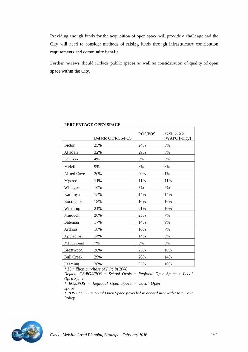
City of Melville Local Planning Strategy – February 2016 161
Providing enough funds for the acquisition of open space will provide a challenge and the
City will need to consider methods of raising funds through infrastructure contribution
requirements and community benefit.
Further reviews should include public spaces as well as consideration of quality of open
space within the City.
PERCENTAGE OPEN SPACE
Defacto OS/ROS/POS ROS/POS POS-DC2.3
(WAPC Policy)
Bicton 25% 24% 3%
Attadale 32% 29% 5%
Palmyra 4% 3% 3%
Melville 9% 8% 8%
Alfred Cove 20% 20% 1%
Myaree 11% 11% 11%
Willagee 10% 9% 8%
Kardinya 15% 14% 14%
Booragoon 18% 16% 16%
Winthrop 21% 21% 10%
Murdoch 28% 25% 7%
Bateman 17% 14% 9%
Ardross 18% 16% 7%
Applecross 14% 14% 5%
Mt Pleasant 7% 6% 5%
Brentwood 26% 23% 10%
Bull Creek 29% 26% 14%
Leeming 36% 35% 10% * $5 million purchase of POS in 2008 Defacto OS/ROS/POS = School Ovals + Regional Open Space + Local Open Space * ROS/POS = Regional Open Space + Local Open Space * POS - DC 2.3= Local Open Space provided in accordance with State Govt Policy
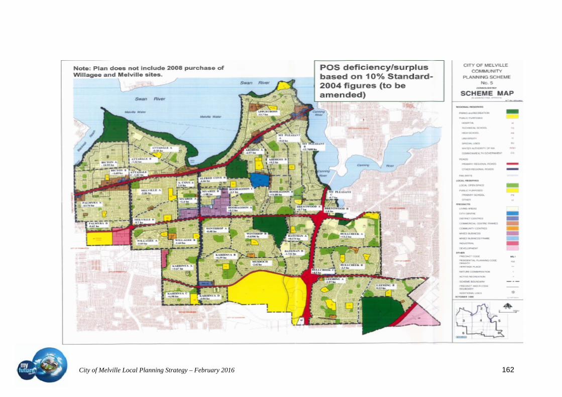
City of Melville Local Planning Strategy – February 2016 162

City of Melville Local Planning Strategy – February 2016 163
City of Melville Local Planning Strategy – February 2016 164
4.6.2 Green plan (City of Melville)
The development of a Green Plan for the City of Melville provides a strategy for bushland
conservation and management, amenity enhancement and a rationalised approach to the
enhancement and greening requirements of parks, bushland, major/ minor road reserves,
non council land and private land.
The City of Melville comprises 40 reserves of managed bushland, ranging from 0.5 to 68
hectares in size.
In addition the City maintains 155 parklands and partial bushland reserves including the
Swan and Canning River foreshore, which extends over 18 km along the northern and
eastern boundary of the municipality. Of the 155 parkland and partial bushland reserves,
131 are focused generally towards recreation based activities rather than bushland
conservation or landscape.
The objectives of the Green Plan are to:
Ensure the long term conservation of remnant bushlands, wildlife corridors and
significant habitat;
Attempt to establish ecological links between significant habitat areas;
Restore and rehabilitate vegetation communities and ensure the long term viability of
existing flora;
Establish a baseline environmental data set and overall vegetation inventory for the
City of Melville, which will act as a tool for environmental planning and
management, and will also provide important information on the conservation status
of vegetation communities; and
Educate the local community on vegetation management issues and foster its
involvement in maintaining remnant bushlands, whilst encouraging local residents to
participate in the regeneration or enhancement of public or private land.
4.6.3 Swan and Canning Rivers and foreshore
State Planning Policy 2.10: Swan - Canning River System provides:
a Vision statement for the future of the Swan - Canning River systems;
policies based on the guiding principles for future land use and development in
precincts along the river system; and
performance criteria and objectives for specific precincts.
The Swan River Trust also provides policies to control development around the river
foreshores.
City of Melville Local Planning Strategy – February 2016 165
4.6.4 Acid sulfate soils
The Planning Guidelines set out in the WAPC Planning Bulletin 64/2009 provide
information and advice on the relevant considerations to be taken into account in planning
decision making for land containing acid sulfate soils.
Relevant impacts of acid sulfate soils include the following:
Adverse changes to soils and water quality;
Deterioration of ecosystems;
Local and regional loss of biodiversity;
Loss of groundwater and surface water resources used for irrigation and other
purposes;
Human health concerns; and
Corrosion of engineering works and infrastructure.
The WAPC has produced mapping which identifies land in the City of Melville which is
susceptible to acid sulfate soils.
Areas of interest are located in selective locations on low lying foreshore areas in Alfred
Cove and Attadale and are described as having either high or moderate risk of acid sulfate
soils.
Development within these areas should be undertaken in accordance with ‘best practices’
relating to acid sulfate soil management.
4.7 Community facilities
The residents of the City of Melville are well supplied with community facilities. The
current facilities are adequate for the anticipated population growth in most areas.
The two areas that anticipate an increase in facilities is in the area of Child Care and aged
housing. There will be a need to consider opportunities to encourage both a diversity of
housing and innovation in the supply of housing to cater for the needs of the aging
population. It will also be important to consider the opportunities for Child Care within the
reviews of future Local Planning Schemes to ensure adequate facilities are available for the
growing number of families. Monitoring the population projections in these areas will
ensure the growth in facilities anticipates the growth in population.
The following facilities are currently offered in the City of Melville. The table shows the
number of facilities currently available and the number that will be required to service the
population in 2031.
The City, on a regular basis, undertakes an assessment of the provision of community
services, for a projected population base, against recognised Australian Standards such as

City of Melville Local Planning Strategy – February 2016 166
those set out in the Australian Model Code for Residential Development (AMCORD).
In 2003 the City achieved a 78% compliance with AMCORD, 2006 saw 85% compliance
and a more recent review indicates 89.5% compliance.
The review shows that facilities and services in the City were equal to or above the
recommended standards (for the projected population) in all areas with the exception of:
Nursing Home Beds (239 beds short);
Child Care not associated with schools ( 638 places short);
Out of School Child Care ( 2 facilities short); and
Fire and Rescue Services (1 facility short).
In terms of Commercial, Health, Recreation, Education and Community Development
facilities and services the residents of the City of Melville are well serviced in both public
and private facilities.
Further investigations will be undertaken with respect to community needs for facilities and
services in the Neighbourhood Planning and Community Needs surveys.
Community Development will develop, facilitate and support the community in the
following areas;
Neighbourhood Planning and Development;
Research, Support, Policy and Planning; and
Service Delivery.
Areas of focus include:
Neighbourhood Planning: Community Facility Management, Neighbourhood
Development, Community Engagement, and Relationship Building.
Research, Support, Policy & Planning: Research, Policy Development, Support for
Neighbourhood Planning, Arts, Festivals and Events, Grant Funding and Community
Engagement
Service Delivery: Financial Counselling and Emergency Relief Services, Museums and
Local History and Volunteering.
Neighbourhood planning is the next step in finding out in more detail what is important to
people in their local communities. A Neighbourhood is a collection of communities
determined by physical boundaries that include hubs such as libraries, community centres,
shopping areas and parks. Four Neighbourhoods have been identified to continue future
planning for our community.
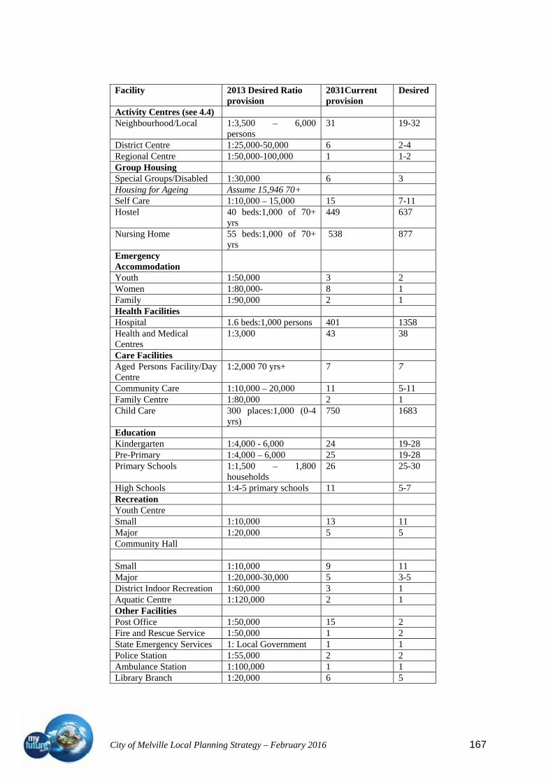
City of Melville Local Planning Strategy – February 2016 167
Facility 2013 Desired Ratio provision
2031Current provision
Desired
Activity Centres (see 4.4) Neighbourhood/Local 1:3,500 – 6,000
persons 31 19-32
District Centre 1:25,000-50,000 6 2-4 Regional Centre 1:50,000-100,000 1 1-2 Group Housing Special Groups/Disabled 1:30,000 6 3 Housing for Ageing Assume 15,946 70+ Self Care 1:10,000 – 15,000 15 7-11 Hostel 40 beds:1,000 of 70+
yrs 449 637
Nursing Home 55 beds:1,000 of 70+ yrs
538 877
Emergency Accommodation
Youth 1:50,000 3 2 Women 1:80,000- 8 1 Family 1:90,000 2 1 Health Facilities Hospital 1.6 beds:1,000 persons 401 1358 Health and Medical Centres
1:3,000 43 38
Care Facilities Aged Persons Facility/Day Centre
1:2,000 70 yrs+ 7 7
Community Care 1:10,000 – 20,000 11 5-11 Family Centre 1:80,000 2 1 Child Care 300 places:1,000 (0-4
yrs) 750 1683
Education Kindergarten 1:4,000 - 6,000 24 19-28 Pre-Primary 1:4,000 – 6,000 25 19-28 Primary Schools 1:1,500 – 1,800
households 26 25-30
High Schools 1:4-5 primary schools 11 5-7 Recreation Youth Centre Small 1:10,000 13 11 Major 1:20,000 5 5 Community Hall Small 1:10,000 9 11 Major 1:20,000-30,000 5 3-5 District Indoor Recreation 1:60,000 3 1 Aquatic Centre 1:120,000 2 1 Other Facilities Post Office 1:50,000 15 2 Fire and Rescue Service 1:50,000 1 2 State Emergency Services 1: Local Government 1 1 Police Station 1:55,000 2 2 Ambulance Station 1:100,000 1 1 Library Branch 1:20,000 6 5

City of Melville Local Planning Strategy – February 2016 168
4.8 Urban design, character and heritage
In 1994 the City of Melville first Municipal Heritage Inventory was prepared by
consultants Hocking Planning and Architecture Pty Ltd. In mid 2002, the City commenced
a review of the initial inventory in accordance with Section 45 of the Heritage of Western
Australia Act 1990. The outcome of that review produced a revised list of places of heritage
significance (largely made of the initial list plus new listings) and a review of the
management category system of listing places of significance.
The Australian Oxford Dictionary defines heritage as:
Anything that is or may be inherited; inherited circumstances, benefits etc.; a nations
historic buildings, monuments, countryside especially when regarded as worthy of
preservation.
Heritage may include natural and cultural heritage, the latter resulting from human activity.
Cultural heritage extends beyond buildings only, and can include landscapes, artefacts, and
cultural institutes. The City of Melville has chosen the broad definition of ‘buildings’ as
defined in the Act, and this allows for the recognition and/or conservation of places of
heritage interest, for example landscape features and parks as well as historic or significant
buildings or structures.
The intent of the heritage inventory process at a local level focuses on events and
developments in Melville’s history since the arrival of European settlers. It is not an
attempt to record the legacy of Aboriginal occupation prior to European settlement.
A review of the Municipal inventory was completed and adopted in June 2014 and will be
incorporated in the Local Planning Strategy and Local Planning Scheme prior to gazettal.
4.8.1 National Trust listing of classified places in the City of Melville
Sites listed with the National Trust include:
Applecross District Hall
Raffles Motor Hotel
Wireless Hill Park Museum Group (former Telecommunications Station)
comprising:
Operators Building (now Caretakers Cottage)
Engine House (now Museum)
Store
Wireless Masts (now lookout towers x3)
Village (2-8 Hickey Street)
Heathcote Hospital Precinct

City of Melville Local Planning Strategy – February 2016 169
Miller Bakehouse
Hotel Majestic (demolished)
Applecross Primary School (original school room and quarters)
Grasmere (Bateman Homestead)
4.8.2 Register of the National Estate places within the City of Melville
Sites listed on the National Estate Database include:
Grasmere (Bateman Homestead)
Ken Hurst Park and adjacent lands, Leeming – indicative place
Blue Gum Swamp, Mount Pleasant
Applecross Primary School and Teachers Quarters, Applecross
Alfred Cove/Point Waylen Area, Attadale
Point Walter Migration Reception Centre, Bicton
Wireless Hill Park, Ardross
Canning Bridge
Beelier Regional Park and Adjacent Areas, Beelier
4.8.3 Register of heritage places (State registered) within the City of Melville
Sites entered in the Register of Heritage Places pursuant to Section 51 of the Heritage of
Western Australia Act 1990 include:
Grasmere (Bateman Homestead)
Applecross Primary School (original buildings)
Miller Bakehouse Museum
Wireless Hill Park
Senior Telegraphist’s Residence – Wireless Hill Park
Operators Accommodation, “the Barracks” – Wireless Hill Park
Technicians House – Wireless Hill Park
Managers House – Wireless Hill Park
Raffles Hotel
Applecross District Hall
Heathcote Hospital
Canning Bridge
4.8.4 City of Melville municipal heritage list of sites of significance
As a result of the review finalised in 2014, 70 sites of significance are included in the City
of Melville list of significant places:

City of Melville Local Planning Strategy – February 2016 170
Name Location Reference Scheme
List Atwell House Arts Centre 586 Canning Highway, Alfred Cove AC01 Yes Alfred Cove Reserve Alfred Cove/Attadale Foreshore AC02 Yes Swan Estuary Marine Park Alfred Cove in Swan River AC06 Yes Heathcote Hospital Point Heathcote, Duncraig Road,
Applecross AP01 Yes
Point Dundas Jetty, Majestic Hotel Site, Boardwalk & Applecross Jetty
Point Dundas, Applecross AP02 Yes
Lemon Scented Gum Tree Verge 124 Kintail Road, Applecross AP03 Sir James Mitchell's Tree Verge, SE corner Kintail/Matheson
Streets, Applecross AP04
RSL Hall 98 Kintail Road, Applecross AP05 Yes Applecross Primary School, incl school house, pavilion & bell tower
65 Kintail Road, Applecross AP06 Yes
St George's Church 80 Kintail Road, Applecross AP07 District Hall/Tivoli Theatre 2 Kintail Road, Applecross AP08 Yes Raffles Hotel 67-71 Canning Beach Road,
Applecross AP09 Yes
German Jetty Site Foreshore Melville Beach Road/Cunningham Street, Applecross
AP11
Charabanc Terminus Site Verge 76 Ardross Street, Applecross AP13 Coffee Point Boatyard/Slipway/Wharf Site
Foreshore Canning Beach Road/Flanagan Street, Applecross
AP14 Yes
Canning Bridge Canning Highway, Applecross AP20 Jacaranda and Plane Street Trees Verges Applecross AP21 Point Heathcote Lower Land Point Heathcote, Duncraig Road,
Applecross AP22 Yes
South of Perth Yacht Club Coffee Point, Applecross AP23 Reserve Wireless Hill Park, Museum, 4 Houses, Trails, MB Fig & Eucalypt
Wireless Hill Park, Ardross AR01 Yes
Lemon Scented Gum Tree Verge 17 Hickey Street, Ardross AR10 Scar Tree Verge 131 Ardross Street, Ardross AR11 Yes Applecross Senior High School - Site and landscape only
Links Road, Ardross AR12
Norfolk Island Pine Trees Verge Corner Prinsep/Swan Roads, Attadale
AT01
Admin Building and Chapel Santa Maria College
21-38 Moreing Road, Attadale AT05 Yes
Attadale Reserve and Troy Park Attadale Foreshore AT06 The Cove restaurant (former house) 568 Canning Highway, Attadale AT07 RAAF Aviation Heritage Museum 12-18 Bull Creek Drive, Bull Creek BC01 Yes Dwelling 230 Preston Point Road, Bicton BN01 Yes Memorial Drive Honour Avenue, Bicton BN02 Bicton Foreshore and Reserves, incl Stam's Tearooms Site
4 Durdham Crescent, Bicton BN03 Yes
Fitzgerald & Son Panel beaters' Workshop
3 Point Walter Road, Bicton BN04 Yes
Point Walter Reserve, incl Point Walter Golf Course and Blackwall Reach Reserve
Honour Avenue/Carroll Drive, Bicton BN06 Yes
Point Walter former Army Camp Site and Watch House
Point Walter Recreation Camp, Stock Road, Bicton
BN07
Hammersmith House 62-64 Waddell Road, Bicton BN11 Booragoon Lake Booragoon Lake BO01 Yes Scar Tree Verge Davy Street Bushland, BO02 Yes

City of Melville Local Planning Strategy – February 2016 171
Booragoon Grasmere 9 Spinaway Crescent, Brentwood BR01 Yes Bateman Reserve Moonlight Cove, Brentwood BR02 Yes Rookwood Street Jetty Foreshore Esplanade/Rookwood Street,
Mount Pleasant MP01
Swan River Rowing Clubhouse The Esplanade, Mount Pleasant MP02 Blue Gum Reserve Canning Avenue, Mount Pleasant MP03 Yes Deepwater Point Reserve, Jetty and Sculpture Park
The Esplanade, Mount Pleasant MP04 Yes
Quenda Wetland South Street, Murdoch MU01 Yes Delicatessen & Antique Shop 58 Carrington Street, Palmyra PA02 Shop & Dwelling 61 Carrington Street, Palmyra PA03 Yes Original Roads Board Building 387 Canning Highway, Palmyra PA05 Yes Miller Bakehouse Museum and Park
59 Elvira Street, Palmyra PA10 Yes
Palmyra Primary School 60 McKimmie Street, Palmyra PA11 Yes Dwelling 60 Petra Street, Palmyra PA14 Yes Fremantle Cemetery and Cottage Carrington Street, Palmyra PA15 Yes Palmyra Police Station Lock Up 349 Canning Highway, Palmyra PA19 Yes Dwelling 27 Hammad Street, Palmyra PA21 Dwelling 25 Hammad Street, Palmyra PA22 Miller House 58 Hammad Street, Palmyra PA23 Yes Dwelling 19 McKimmie Road, Palmyra PA24 Dwelling 46 McKimmie Road, Palmyra PA25 Dwelling 46 Zenobia Street, Palmyra PA27 Old Corner shop and house 63 McKimmie Road, Palmyra PA28 Dwelling 33 Zenobia Street, Palmyra PA30 Dwelling 66 Zenobia Street, Palmyra PA31 Dwelling 54 Carrington Street, Palmyra PA32 Dwelling 5 Adrian Street, Palmyra PA33 Dwelling 3 Adrian Street, Palmyra PA34 Dwelling 26 Harris Street, Palmyra PA35 Dwelling 7 Palin Street, Palmyra PA36 Dwelling 32 Zenobia Street, Palmyra PA37 Piney Lakes Reserve Leach Highway, Winthrop WN01 Yes Lemon Scented Gum Trees North Lake Road/Leach Highway,
Winthrop WN03
List of Reserves and Small Parks - see Schedule 10.4 of LGI Yes
The adopted heritage list contains buildings old and new, natural as well as built sites plus
trees and trails all representative of the history and attributes of Melville. A review of the
list and compilation of a new Municipal Heritage Inventory is currently underway
expecting to be finalised in 2014.
Another means of ensuring the preservation of heritage and for continued recognition of the
community benefit of retaining the history of an area or place is through ‘incentives’
offered to owners of history and heritage. An incentive package would:
1. promote the retention of culturally significant places listed in the City of Melville
Municipal Inventory through incentives for preservation, maintenance and for the
benefit of future generations;
City of Melville Local Planning Strategy – February 2016 172
2. ensure that development and redevelopment of heritage places provides for a
sustainable and creative process of integrating the old with the new;
3. generate community awareness and ownership of local heritage and the development
of ‘sense of place’.
An incentive package could include the following:
Non-financial Incentives:
Heritage awards program;
Professional heritage advice;
Development bonuses/variations;
Transfer of plot ratio;
Directory of services and discounts.
Financial Incentives:
Rates, rebates or reductions,
Low interest loans,
Waiver of planning and building fees,
Design subsidies,
Heritage appeal,
Other Awareness Raising incentives:
Newsletters,
Feature articles in local media,
Heritage page on website,
Information brochure,
Information kits,
Community events linked to Heritage Week,
School education,
Displays,
Trails, walks and site markers.
4.9 Traffic and transport
The City has an established transport network servicing all aspects of transport. The
Kwinana freeway transects the city on a North South axis. Providing good access to and
from the CBD and southern suburbs. The east/west connections of South Street, Leach
Highway and Canning Highway provide local and regional access to and from the freeway.
Access is also provided north bound at Farrington Rd and Cranford Ave. Leach Highway
(east/west) and Stock Road (North/south) are part of the freight network to and from the
port at Fremantle.

City of Melville Local Planning Strategy – February 2016 173
The City is well serviced by public transport with over 98% of properties within 400 metres
of a bus stop. The Perth to Mandurah Rail line runs down the middle of the freeway reserve
and provides access through stations at Murdoch, Bull Creek and Canning Bridge. All these
stations have bus transfer facilities with strong bus connections to the surrounding suburbs.
Although Park and Ride facilities are provided at Both Bull Creek and Murdoch, the major
percentage of passengers arrive by bus. The local bus service through the City is also very
good with 2 high frequency routes to the CBD as well as the connections to the stations.
Many parts of the city are serviced by a frequency of 15 -30 minutes throughout the day.
The District Activity centres are all connected by major bus routes. The only disparity in
the service is a lack of direct connection from the majority of Bicton, Attadale and
Applecross to Garden City.
The City of Melville also has an excellent cycle and pedestrian network with both
commuter and recreation cyclists well catered for.
4.9.2 Transport framework
A number of key studies and policies
provide for a wide range of
guidelines and actions for the City to
consider in integrated transport
planning.
Strategies such as the City of
Melville Transport Strategy (2000)
and Travelling Together (Integrated
Regional Transport Plan for the South West Metropolitan Perth 2003) and the City of
Melville Bicycle Plan are due for revision particularly in light of new major project areas
within the City.
4.9.3 Directions 2031 and beyond – Movement Network
The day-to-day functioning of a city is highly dependent on the effectiveness of its
transport network. A significant amount of time, money and energy is consumed in the
movement of people and goods around the city, so it is important that the movement
network be as efficient as possible. The high frequency public transport connections in
Perth and Peel are an important component of both the movement and activity centres
networks. Directions 2031 intends that these routes, with the exception of those located on
high speed through traffic routes, will help to accommodate much of the region’s medium-
density residential infill needs while providing strong connections between centres.
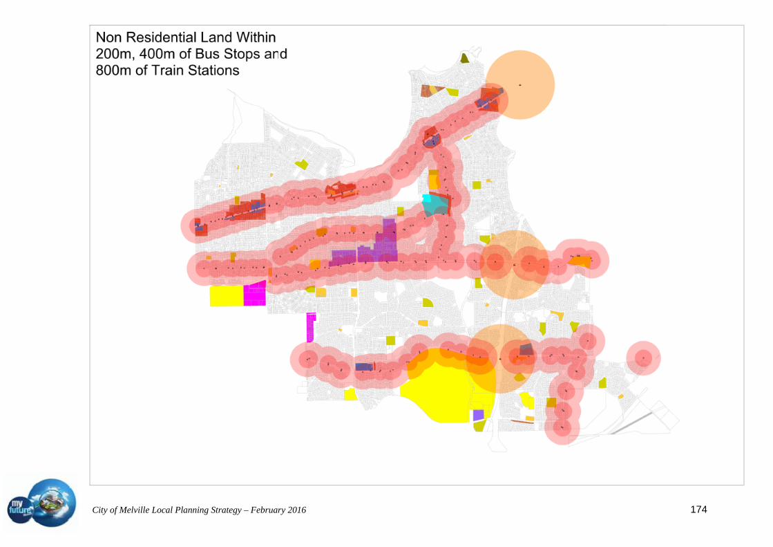
City of Melville Local Planning Strategy – February 2016 174

City of Melville Local Planning Strategy – February 2016 175
This network will need further strengthening in the future with the possible addition of new
public transport connections as indicated in Figure (below): Conceptual future public
transport connections. (Directions 2031 P39)
The routes shown along Canning Highway, Riseley Street, South Street, Marmion Street
and Leach Highway will be considered as the initial focus to increase to a medium density
residential environment. These will also be the focus of intensifying the activity centres and
ensuring the connections of activity centres to the public transport network are improved.
4.9.4 Melville Visions (Dialogue with the City 2006)
Specific issues arising from Melville Visions 2006 (Dialogue with the City of Melville
residents) relating to transport are that:
1. Safe crossings should be provided along all major roads and there is a need to create
more transport corridors to alleviate traffic problems;
2. Transport needs to be re-directed off South Street to ensure that it remains an activity
corridor; and
3. Specific traffic management recommendations put forward by the relevant agencies
during the stakeholder interviews include:
a four-lane carriageway on Kwinana Freeway;
investigation of land use options in light of the deletion of FEB and Roe
8;
exploring options for southern access To Fiona Stanley Hospital which is
seen as necessary for the success of the South Street Freeway
interchange; and
to manage pedestrian safety and access along major roads;
4.9.5 City of Melville Transport Strategy 2000
The City of Melville Transport Strategy July 2000 Vision is that:
“Transport will contribute to the quality of life and economic development in the City of
Melville with minimum adverse effects on residents and the natural environment.
A variety of safe, affordable and effective transport modes will be available for all sectors
of the community”. The strategy sets benchmarks for 2010.
Issues for City of Melville include:
Increase of traffic congestion especially on the major road system;
Thru traffic on major roads including freight from east to west to the ports and
industries on the coast;
Poor use of public transport;

City of Melville Local Planning Strategy – February 2016 176
Three new bus/train stations with parking and access problems;
Road crashes (black spots);
Parking demands in and around major Activity Centres and Bus/Rail Interchange
stations;
Poor pedestrian and cycling environments (quality and connectivity);
Unnecessary vehicle movements in residential streets;
Impact on residences and other uses e.g. Noise;
Poor accessibility for people without access to private cars; and
Poor access for people with disabilities.
Opportunities are presented for:
Integration of transport and land use; and
Complementary transport management.
E.g. Consider light rail or other high capacity options for some of the key bus routes
that may be freed up with introduction of the rail/bus interchange.
4.9.6 Development Control Policy 1.6 Planning to Support Transit Use and Transit
Oriented development
The City will, in accordance with WAPC policy, undertake structure planning around the
three rail/bus transfer stations servicing the City.
The affected precincts around the Canning Bridge, Bull Creek and Murdoch stations are
likely to contain land within approximately 10 -15 minutes walking time (a walkable
catchment) from the station.
The policy objective is to maximise the benefits to the community of an effective well used
public transport system by promoting planning and development that will sustain and
support public transport.
This can be achieved by promoting higher residential densities and mixed-use
developments, good access, employment opportunities and compatible land uses such as
community and recreation uses in close proximity to stations.
Precinct planning has been initiated for the Canning Bridge station precinct and the
Murdoch station precinct including the State Government owned land and the other three
quadrants surrounding the interchange.

City of Melville Local Planning Strategy – February 2016 177
4.9.7 State Planning Policy 5.4: Road and Rail Noise and Freight Considerations in Land
Use Planning
Leach Highway, South Street, Kwinana Freeway, Canning Highway and Stock Road south
of Leach Highway are roads within the City which are likely to be affected by traffic noise
issues which may require consideration of planning controls within the Scheme as
recommended by draft WAPC policy pertaining to Transport Noise.
The policy does not apply retrospectively to pre-existing land uses along existing roads,
however does:
establish noise criteria to be used in the assessment of proposals for new residential
or other noise-sensitive uses that is adjacent to an existing or proposed primary
distributor road or railway;
identifies measures that can be adopted to reduce road and rail traffic noise; and
describes the circumstances when such measures are required.
The extension of Roe Highway from The Kwinana Freeway to Stock Road is considered to
be an important factor in both access to the Murdoch Specialised Activity Centre and to
alleviate the impact of freight on residential areas along Leach Highway. Currently the
preferred freight route is from Roe Highway along Kwinana Freeway to Leach Highway
and along Leach Highway to the Fremantle Port through Stirling Highway. Stock Road is
considered the freight route from the south. This route still has a major impact on
residential areas of Bateman. Brentwood, Winthrop, Booragoon, Willagee and Palmyra.
Planning along this route should take into account the protection of the residential areas
from the impacts of the freight route especially in terms of noise and limiting access to the
highway; however the ultimate aim would be to reroute freight traffic along Roe Highway
and Stock Road.
South Street and Canning Highway should be discouraged as through routes for freight and
should instead be considered as public transport corridors.
4.9.8 Road hierarchy and access
Within the proposed Local Planning Strategy, the Primary distributor roads are those roads
as designated on the Main Roads Western Australia adopted road hierarchy. The District
distributor roads are the equivalent of District distributor A & B roads under the Hierarchy
and Local distributer roads have now been incorporated into the local Scheme maps. Local
Roads in the planning system are the equivalent to Access Roads in the Hierarchy.
Further investigation needs to be carried out to determine if Riseley Street and Murdoch
Drive need to be re-classified from District Distributor B to District Distributor A roads.

City of Melville Local Planning Strategy – February 2016 178

City of Melville Local Planning Strategy – February 2016 179

City of Melville Local Planning Strategy – February 2016 180

City of Melville Local Planning Strategy – February 2016 181
4.10 Infrastructure services.
An important consideration in planning for higher residential densities and increased
commercial activity will involve ensuring that utility providers have planned for such
development.
4.10.1 Waste disposal
The City as part of the South West Group uses waste disposal and waste recycling facilities in
the City of Canning.
4.10.2 Drainage
Southern areas are serviced by a more urbanised system.
Older sections of the City in the north are serviced by drainage sumps which are subject to
overflow during peaks.
There has been some rationalization and disposal of sumps.
The drainage capacity for those remaining sumps will be upgraded on a case by case basis to
meet drainage demand as required.
Proposals to increase density or new development in these precincts should be considered in
line with requirements to utilise water sensitive urban design measures in development and or
consideration of upgrading of the drainage system.
4.10.3 Telecommunications
The City administers a Telecommunications Strategy and Policy which is now over 5 years old
and is due for review particularly in light of changing technology, the potential for
proliferation of low impact facilities and the introduction of the National Broadband Network.
The current policy deals with location and approvals process for high impact (lattice pole or
mono pole) telecommunications development.
Telecommunication demands are being met within the City, however with increase in
residents, workers and visitors there will be pressures for further facilities either of low impact
or high impact nature.
4.10.4 Gas
The existing gas reticulation system within the City is sufficient to supply the needs of the
community into the future. Future upgrades to the system will be investigated as part of more
detailed planning for Strategic Development Areas.
City of Melville Local Planning Strategy – February 2016 182
4.10.5 Water
Water is distributed to the area via trunk mains in Canning Highway and Leach Highway.
There are no problems identified with the capacity of the existing water reticulation system
within the City however development along two major ridgelines may be affected by low
pressure difficulties.
Because of the possible need to upgrade older pipes any associated increases in residential
density and increased capacity will be subject to Water Authority headwork’s charges.
4.10.6 Alternative water sources
The main alternative water supply within the City is from bores however restrictions on water
availability and bore licences make this option less reliable in the future.
The City is encouraging the use of rainwater tanks and other water saving measures through its
sustainable design policy.
Design guidelines attached to the Strategic Development areas will explore water sensitive
design as well as grey water recycling and other opportunities for more sustainable catchment
and use of water.
4.10.7 Electricity
There are now 3 power substations located within the City. Additional land has been purchased
adjacent to the Myaree substation in order to facilitate expansion of capacity.
The need for extra capacity to cater for possible increases in density will be considered as part
of the more detailed planning required for Strategic Development Areas. Innovative options for
energy generation should be considered throughout the City but especially for development in
Activity Centres. .
4.10.7.1 Environmental concerns with transmission lines
Environmental concerns in relation to electrical fields emanating from high voltage
transmission lines and their affect on people is a concern raised in engagement with the
community. While this environmental health issue is best addressed at the national and state
levels, the City accepts that these lines will be a constraint to land use and development in
accordance with the WAPC Liveable Neighbourhoods policy.

City of Melville Local Planning Strategy – February 2016 183
4.10.7.2 Undergrounding of power lines
Much of the more recently developed southern suburbs within the City have been provided
with underground power supply and an undergrounding of power project has been undertaken
in Applecross one of the oldest suburbs in the City. To date the suburbs of Applecross, Mt
Pleasant, Bicton, Palmyra, Booragoon, Brentwood, Willagee, Winthrop, Murdoch, Leeming,
Attadale and Bull Creek have benefited from the undergrounding of power.
In recognising the benefits in providing and attractive streetscape and adding to the character
of a precinct the City can canvass interest from communities in providing underground power
during the upcoming Neighbourhood Planning process.
4.10.8 Sewerage
The entire City is serviced by reticulated sewerage.
Sewerage spill from pump stations along the river although remote has occurred and it is
important that protective measures are put in place to safeguard the environment should such
an event occur.
Further discussions will need to be entered into with the Water Corp to establish sewer
capacity for any increased development during the review of the Planning Scheme.
Liveable Neighbourhoods Community Design Code emphasizes that new infrastructure for
development should be sustainable and not impose additional costs on the community in the
long term.
As development within the City becomes more intensive, services may require increases in
capacity. An infrastructure planning review will be required by Water Corporation to assess the
impact on the existing Wastewater Pump Stations, to determine whether to enlarge them, with
considerations to land and also odour buffers sizes. Most of the existing Pump Stations are of
small size, with one of medium size."
The Bibra Lake Main Sewer, Kardinya Branch Sewer, and Cannington Main Sewer are routed
through the vicinity of Murdoch University, and then converge and head south towards the
Woodman Point Wastewater Treatment Plant, and is the main wastewater outfall for the City
of Melville."
City of Melville Local Planning Strategy – February 2016 184
5 Opportunities for and constraints upon development.
5.1 Opportunities
The anticipated increase in population for Western Australia and the strategic planning within
Directions 2031 to accommodate that population by encouraging infill development reflects
the concerns expressed by residents in the community plan about rethinking the extent of the
urban sprawl. Concentration on the intensification of Activity Centres will allow an increase in
the dwelling capacity of the City whilst also addressing the issues of housing diversity and
housing choice whilst also encouraging more sustainable transport options through
enhancement of pedestrian environments, live/work environments and access to public
transport.
The establishment and acceptance of the rail as a key transport mode and the integration of bus
transfers allows for a more integrated approach to land use planning both around the key
transport nodes and the key transport corridors. This allows for the concentration of higher
density in areas where there is a choice of transport modes and availability of facilities.
5.2 Constraints
The City of Melville has very little space for greenfield development. The existing road
structure and increasing congestion is a constant concern expressed in engagement with the
community. Concentration on development in areas that transport is easily accessible will
assist in encouraging the use of public transport and allow for less reliance on the private car.
The age of other infrastructure and the change of focus from suburban to inner urban
development mean that the services will inevitably need upgrading to achieve some of the
intensity of development required to achieve the desired population. An innovative approach to
power, water, waste and communication needs to be promoted to overcome some of the
obstacles that may be perceived or real.
6 Analysis of key issues.
Key issues have been discussed throughout the strategy under each of the headings. Following
is a brief summary of some of the key issues and their impact on planning for the City of
Melville. Many of these issues are intertwined and come from the gradual change of focus
within the city from suburban to inner city development and the inherent increases in density
and activity.
City of Melville Local Planning Strategy – February 2016 185
6.1 Population growth
The expected growth presented by Directions 2031 is generally accepted by the City as a goal
in planning for the future. The City can achieve a minimum of 11,000 new dwellings by 2031
through a mix of increased density within and surrounding activity centres combined with an
increased density along public transport corridors. This will provide a focus for a more
sustainable development
6.2 Employment self sufficiency
Providing the opportunity for the residents of the City of Melville to live and work within the
City allows a greater choice for our residents. The proximity to work also provides greater
opportunity to manage transport and congestion.
6.3 Housing diversity
One of the greatest challenges is seen as the provision of housing diversity and choice. The
City has a predominance of 4 and 5 bedroom homes on larger blocks, yet the predominance of
households is lone or double person. This provides the opportunity to have smaller lots and
smaller houses, apartments and town house developments that provide a greater choice. This
will provide opportunities for more affordable and appropriate housing for new home buyers
and those just leaving the family home; larger houses with larger backyards to be available for
families and older people being able to downsize within their local area.
6.4 Management of roads
Congestion on roads is becoming an issue in any discussion being held on development
opportunities. The importance of public transport as one of the tools in managing congestion is
recognised in this strategy as well as the need to provide opportunities for local residents to
reduce the number of journeys made by car through providing commercial, retail and
community infrastructure within easy walking distance of the majority of residents.
Part of the management of roads includes the availability of oil and the need to consider better
use of this diminishing resource. The increased use of public transport, better facilities for
cycling and walking and a planning regime that considers local interactions will assist in
planning towards an environment that is not reliant on fossil fuels.
6.5 Murdoch activity centre
The introduction of a major tertiary hospital and mixed use precinct with up to 1000 dwellings
and accompanying commercial areas would have a major impact on planning itself. Throw into
the mix the busiest rail/bus transfer retrofitted to a busy freeway intersection outside the CBD,
a major private hospital and a university and you have a recipe for chaos.
City of Melville Local Planning Strategy – February 2016 186
The key discussions taking place around this centre focus on how to introduce these land uses
and reducing the impact on surrounding areas and local and regional roads.
There is potential to provide an increased density in surrounding residential areas to support
the development. In the short term the transformation from suburban freeway/highway oriented
development to inner urban will need to be managed with great care.
6.6 Canning Bridge
Canning Bridge has grown to become a centre for office development rivalling West Perth.
The location is unique in it’s proximity to the river providing views from many angles and
access to recreation and transport.
The vision for the area has been incorporated into the planning for the City and provides an
opportunity to work closely with State and adjoining local governments to enhance
development in the area whilst also solving some of the issues that are present. These issues
include congestion on Canning Highway and Kwinana Freeway, transition from residential to
Activity Centre with an inherent increase in residential and supporting retail and commercial.
6.7 Civic places and recreation spaces
There appears to be a changing use of recreation space. Organised sport is still strong and
requiring larger parks. The need for other large active areas though is being questioned in light
of reducing water availability, growing obesity and a rethink in the way people recreate. Better
footpaths, smaller parks and recognition of civic spaces as recreation areas need to be
investigated in order to find a better way of ensuring relevant space is available for the
community.
6.8 Climate change
There are many issues that arise when the impacts of climate change are considered. These
range from rise in water levels to reduced availability of water and increases in temperature.
Many of the above key issues are part of the climate change scenario. Some of the issues that
will take prominence in the short term are energy consumption and generation, water wise
landscaping, water capture, sustainable transport, green buildings and green roofs and walls.
These key issues and other areas of concern will be researched and the strategy updated
accordingly as results of the studies come to hand.

City of Melville Local Planning Strategy – February 2016 187
Page intentionally left blank